Embed Size (px)
Citation preview

File No.DDMGKN-OMPOIOMP(AMP)/412017-00(0D)·DDMGKNL
GOVERN\1l:.''T OF ANDHRA I'RAOESII DEPARTMt~:O.'T OF \liNES & G EOLOGY
F"'m To P Raja Blbu. M.S. (recb), Sri M. Ga ndbl Dan, D<puty Director of Mines II. Geoloay. KURNOOL.
Slo. Sri M.D Munuswamy. D.No: 118. Monaihnoduvu (r),
Sir,
Ptnnaga.ntm Taluk. Ohannapuri District, Tamilnadu 636 810.
l.etterNg 4815/MP-ATMOI? dt· - 11-201 7
Sub:- Mines &. Qu.arries Approval or Mining Plan (ineludln1 Proc,res.ijve Mine Ctosure Plan) for a period of five yn:rs for Colour Granite o-.er an e""tent of 4.900 Hectares in S) 'lo. 7!lO!Il of Gudilw1d.1 Vilt.ge and Manda~ AnanllpUnlmu Dislri<t in fa,out of Sri M. Gaadbi Dass. prtpOI'<d b) Sri G. E»oar R<dd), M-Se., 8 .1 .. , R.Q.P • MononJ Plan· APP"''-.d- Repnlona.
Ref:· I) G.O.Ms.No: S6, lnd II. Comm. (MJI) Dept, dat<d: 30.04.2016. 2) Peodas.No: 28S94/P.RQPI2001, dt: 13.05.2016 of1he Dir«tor of Mines and
Geology, llyderabad. 3) Notice.No: 20132/R4·112016. dt: 28.06.2017 fl-om 1he Director of Mines
and Geology. lbruhimputnum ..cldresscd to the 11ppllcnnt/RQP. 4) Lcner Dated: 17.1 L2017, along wilh Drafl Minin& Plan from the lcuec
recch·cd inchi.sofficeon 17.11.2017. 5) Lr. No.48 1 S/MP-ATP/2017. dt: 28.1 1.2017 to the RQ P I API>Iiant of the
Deputy Director of Mones II. GeoloJiy, Kumool. 6) letter cbted 30.11.2011, alonJ with fN< sets Of flit <Opi<S Of mining plan
fiotn the applicant n:cch·ed in Ibis offtcC" on 01.12.2017 • ••••
In exercise of the powc11 coofen-cd as per amended Rule 7 A (I), (II~ (111) and (IV) of AI'MMC Rules, 1966 read with l'roeeedings No: 28594/P.RQP/2001, tit: 13.&5.2016 of the Director of Mines and Geology. GoAP, llyderabad and G.O.Ms.No: 56, Ind. & Comm. (M.II) Dept., dt&ted: 30.04.2016. I l1ereb)• npprotoe t11e Minlng Pl11n ( lnc:ludlng Prog rttsi\'e Mint: CIO.."'UJ'e Plan) for a period or 0 \le ytnrll for Colour Granite 0 \'Cr a n U ICil( or 4.00C) Rec.1:l res
ln Sy.No.700/B of G udibanda VUIIJ:e a nd Mandal .. Ananla i)Uramu Dl! trtcl ln favour of Sri M. Gandhi l>aS>.
This appro,-al is subject to the followin& conditions. I. Thb Mining Plan (includin& Procr<ssiYC Mine Closure Plan) Is appnw<d witbout
J)R'juclic:e 10 any ocher bws apphc:able 10 the mine an:a from time to time whether made by !he Cenu.l Co>cmmenL Sllte Co>cmmem or any other authont)
2. It is clarified that &his appt0\111 of lhe minin1 plan (includina Pfoare$5i\>e Mine Closure Plan) doc:s nol in an)' \\'1)' illlJ)Iy dte appro,•al or the Go'emmcm in tenns of any odu:r provisions of the Minc.s and Minerals {Deve&opmtnt and Rcaulntion) Act, 1957 or the Mineral Concession Rulcl. 1960, APMMC Rules. 1966 and any ocher laws including lhe Forest Con~rvntion Act, 1980 ftnd G.C.O.R, 1999.
3. This Mining Plnn was epproved as per the quarry lease cxc:culive !ketch of the s.u))jcct area. Any deviation found hner, approval authority does not ov. e re,ponsibility.
4 The upproval authority doeJ nol o"'-e responsibility with ~a.ard to recovery factor of panite and assessment of r'C.'kf"\o'CS. any erroneous cmiftcadon made b) the R.Q.P. if tny. s.ince che evaluation is done on random basis.
Pod: (2 eopies or ~t.P.) Yoo,. faithfUlly,
O.pul)' J)ireetor or Mineo & Geology, Kurnool.
Copy submitted to the Dire<:lor of Mines & Geology. Vijayawadu. alona with A.M.P. 10 Sri G. Eswar Reddy, RQP/Oeolo&iSI, D.No.l3·2·155·1. Shirdi Nognr,
qn:~·~~~~~;~~~~5i0~0,~1 : for lnrormation. < Con1roller of Mines, IBM. SultAn Blur, llydmbad for
Difl'Ctof" or M•ncs Safety, Bcllary for ra .. ·oor or infonnation. Kl4apl for fa"IOW of in formation.
Director ofMn~s & Ga)locY, Aa .. t.apuram• atona v-ilh A .M .P

( OVER AN
GUDIBANDA(V), GUll~ IN SY. NO. 700/ B nAI~u~'"~"~ DISTRICT,
~ith~!lfulation) Act, 1957
~t:.o·t~~t:.R., 1966
OTHERTHAN FULLY M 0 "8" CATEGORY MINE GOVT. REVENUE LAND
APPROVED OF
SRI.M.GANDHI DASS, S f o.Sri.M.D.Munuswamy,
D.No.l/8,Mongilmaduvu (Post), Pennagaram Taluq,
Dharmapuri District, Tamilnadu state-636810, Mobile No:9444312309.
9595312309.
Prepared by
G.ESWAR REDDY M.Sc., B L., RQP I Geologist,
" M / s. SAIGEOSERVICES" RQP/DMG/AP/07/2014'
RQP/IBM/HYD/302/20 13/ A' D .No.13-2-155-1, PAVANANILA YAM,
Shirdi Nagar, ANANTAPURAMU 515001. Mobile:09849132789. Phone No: 08554 222737.
Email:[email protected]
NOVEMBER - 2017

(
(
'
(
£0 r:tifij~ .(o%"'~1\11 >~~'"" ·~~ ;\- ~.~-=\ 'I ~ , · .. ,~,-:~ "':::~=', '"\,.1.'\
DEt;tfA#Atle}Ji,. . '· ' \ ·; ·.C, : .:·.··~1 ''' ··~··'t :·~ ",I; I
This mining plan for quarry lease a~~~~~~~~t%J~J: ·~nite over an extent
of 4.900Hects. in Sy. No.700/B dtl( ~i~.~~;fe;JGudibanda Mandai,
Ananthapuram District, Andhra Prade~-..:: ' <..l~i"r~-~ed'i~ consultation with me ~~·
and I understand its contents and agreed to implement the same in accordance
of APMMC Rule 28,
Date:30.11.2017. Signature of the Applicant
Place: Gudibanda.
(SR
CERTIFICATE
This is to certify that Mining Plan in respect of quarry lease applied area for
Colour Granite over an extent of 4.900Hects. in Sy. No. 700/B of Gudibanda
Village, Gudibanda Mandai, Ananthapuram District, Andhra Pradesh State,
prepared by G.Eswar Reddy Consultant Geologist & RQP from M/s.SAI GEO
SERVICES, Branch Office at Anantapramu. The applicant agrees to follow the
same in accordance to the provisions of law.
Date:30 .11.2017. Signature o f the Applicant
Place: Gudibanda.

(
(
(
(
(
(
CERTIFICATE
The provisions of Granite Conservation and Development Rules 1999 & APMMC
Rule 28 observed in preparation of Mining Plan for quarry lease applied area for
Colour Granite over an extent of 4.900 Hects. in Sy. No. 700/B of Gudibanda
Village, Gudibanda Mandai, Ananthapuram District, Andhra Pradesh State.
Wherever specific permissions are required the applicant will approach the
concerned authorities.
Certified that the information provided in the mining plan is correct to the best of
my knowledge.
Date:30.11.2017.
Place : Anantapuramu.
Signature of the RQP
--=-d~ (G.Eswar Reddy) G. rr: .. ,~~ ~t""~fYI£ ~.~-~-.n.l. f)t .. o
f' ~"~<>. ,n ;.._d CL ... !:l;)!::Ot r:•·u·c i IYC•.'ZQ;;_/20 13/A

(
(
(
(
(
(
(
(
(
'
,, <A,·;;;.·
//~ ~· ~7;;~~· ,;.- ~-~~~
(J.:. ~%~~ ~~.; .,g:;~l INDEX ~ v:. 'I; (;UJ\II I:NI S ~-1 2 ~~i:?l
I !NTRODUl:l !UN - C ..>./1 If ~ JTY 2 III 7 .
. 4 5 1 . ut:. fAILS OF .t.PPI 11:::1) AREA 5
2 ('l=f\1 OGY & EXPI f\P II UN 5
3 MINING Q1 'Yll'lb & c .~ 10
4 MINE M/'\"'";T ANALYSIS 14
5 WASTE MAN, ,HPLAN 14
6 USE OF . AND MINERAL REJECT 15
7 iOFROM :T 16
8 I OTHERS 16
PARI- B
1 II:N ~ fE~ r 1 nell DC P I 4N
ITAL BASE IN~UKMAnON 17
2 , t:N· 1ENTAL TMP.t.r:T .t.c II 17
3 I DC •vc Po:r-1 .t.M \IIUN PLAN 21
4 MINED OUT LAND 22
5 TOP SOIL 1ENT 23 .
-6 ~ ..... 1ENT 24 7 nrc Tt:K . AND RISK A~ 1 r 24 8 CARE AND MAINTENANCE DURING 24 ~ADV ''"NCE
9 JLINGFORABANDONMENT 24
10 o:tl\l.t.IIJ(""TAI AC:C:IIP.t.I\I{""O: 26
11 I Ct:Kl li'ICATt: 26
LI~I QE PLATES ~ PLATE-1 LOCATION CUM KEY PLAN 1:50000 PLATE-2 LEASE SKETCH 1cm=3 Chains PLATE-3 SURFACE GEOLOGICAL PLAN 1:2000 PLATE-4 GEOLOGICAL SECTIONS 1:1000 PLATE-S YEAR WISE WORKING PLAN & SECTIONS 1:2000 PLATE-6 CONCEPTUALPLAN & SECTIONS 1:2000 PLATE-7 ENVIRONMENT PLAN 1:6000
1.15! QE A~~ !:X!.! B.li~ ANNEXURE- I Photographs of the Area. ANNEXURE - II Copy of the NoticeNo.20132/R4-l/2016,
dated:28-06-2017 of DMG, IBRAHIMPATNAM. ANNEXURE- III Copy of the RQP Certificate.

(
(
(
(
t
(
(
(
• (
l
(_
(
(
I
•
PRE - FEASIBILITY I QUARRYING OPERATIONS MININGft~Jl! ·FOR COLOUR GRANITE OVER AN EXTENT OF 4.900Hccts. Lot'~ ' ~j{."SY.
N0.700fB,GUDIBANDA VILLAGE, GUDlBANDA MA ~. -~PUIMM DISTRICT, ANDHRA PRADESH
1 .... . -_~,:·:£..: ~.' ·~'\(~,
{ _.:t. ~:. · !..;. :t - ~.: .. \ 4~ \n\ APPLICANT: ~~\6 {·i·.~\'::;: )~·j i.~J{;)
Sri.M.Gandhi Dass ""'-~~ · ~-~--~_l'f'jE}. 1. INTRODUCTION ..:fQ ~~#,'::-,"/---
Sri.M.Gandhi Dass has filed an application for grant ~- ii 'i-~tllt r Granite
over an extent of 4.900 Hects., in Sy. No.700/B of Gudibanda(vi, Gudibanda (M),
Ananthapuram District in the office of the Assistant Director of Mines and Geology,
Ananthapuram on 27-09-2014.
The Assistant Director of Mines and Geolo~:IY, Anantapuramu submitted
proposals recommending for grant of quarry lease for Colour Granite over an
extent of 4.900 Hects,in Sy. No. 700/B of Gudibanda(V), Gudibanda (M),
Ananthapuram District.
After careful examination of the proposals of the Assistant Director of
Mines and Geology, Ananthapuram it is decided in principle to grant a Quarry
Lease for Colour Granite over an extent of 4.900Hects. , in Sy. No.700/B of
Gudibanda(V), Gudibanda (M), Ananthapuram District in favor of Sri.M.Gandhi
Dass for a period of 20 years subject to submission of Approved Mining Plan
within a period of 6 months from the date of issue of notice under Rule 12 (5)
(C) of Andhra Pradesh Minor Mineral Concession Rules, 1966 along with
consent for Establishment from APPCB & EC from MOE&F as per
Environment Impact Assessment Notification through S.O. 1533,
dated: 14-09-2006, vide notice No.20132/R4-l/2016, dated: 28-06-2017, of
DM&G, Govt. of A.P Jbrahimpatnam.
The submission of Mining plan is a pre requisite for Quarry lease as per
Rule 12 (5) (C) of A.P.M.M.C. & G.C.D.R. 1999. The proposed mining plan
covers a scientific and systematic assessment of the deposit which indicates
the details of conservation of the deposit and protection of environment in and
around the mining area. The survey comprises of Topographical Survey, Large
Scale Mapping with contours.
"Granite Conservation and Development Rules 1999" formulated by
Government of India under sectl on 18 of "Mines and Minerals" (Development \ ·•r~1td )Ub•e<liO the •
af!d110Rt!§tnatrCJn1 -/~~~~tif.f,6;~ aims at the conservat ion (.ondiuou<">itpol-oUoOS .ndl.>•< , '" ~b,~ h.. 19 Piau Appru,~l Letter ~o.~•';? ~'I•• f""
Ooto4.~;:-l~ l9-.,J

(
f
I I
(
(
(
(
' (
(
'
l
'
_ ... - ..........
development of Granite resources of India, and hence i9sists .on ·sub~iS"sion of ..,. .. -
mining plan prepared by a duly registered qualified person.- ·· ·~ .
Hence the Applicant has entrusted the work to ·,f:l-QP Dr.G.Eswar ,Redpy ' ' ' ....
for preparation of mining plan In systematic manner ,.under ·pr.ovislons.. of
rules. Accordingly, the mining plan Is prepared a~d sub'iriitt.~4~~der provisions of GCDR, 1999, in accordance with G.O.Ms. No!s6;:~f,In'dustrles & . . . Commerce (M.II), dated: 30-04-2016. In this connection it is to submit that
the mining plan is prepared for first five years.
This survey enables the applicant to take up the exploration of color
Granite In a systematic manner and plan for future expansion programme.
I. GENERAL SRI.M.GANDHI DASS, 5/o.Sri.M.D.Munuswamy, D.No.1/8,Mongilmaduvu (Post),
2.1 Name and Address of the Pennagaram Taluq, Applicant Dharmapuri District,
Tamilnadu state-636810, Mobile No:9595312309.
Status of the Applicant 2.2 (Individual/ Private Company I Individual
Firm)
2.3 Mineral (s) which are included in
COLOUR GRANITE the Letter of Intent
G.ESWAR REDDY M.Sc.,B L., RQP /Geologist, M/s.SAIGEOSERVICES
Name and Details of person RQP/DMG/AP/07/2014,
2 .4 employed for preparing Mining RQP/IBM/HYD/302/2013/A' D.No.13-2-155-1
Plan Shirdl Nagar, ANANTHAPURAM 515001 Moblle:09849132789. Phone No:08554 222737.
2.5 E-Mail & Website Emai l:[email protected].
2.6 RQP Registration No. & Validity DEC-2024
2

(
(
(
(
1._
(
(
(
(
(
(
(
/ II. Location and Accessibility - ;.: .~ ;· · The quarry lease area falls in the Survey of India, Topo sheet._~/~S(_:GJ.?·~cale ~: 50,000) and is bounded in below Latitudes and Longitudes. i' /:• ·.: ·, ·:· -;r-.:' :V·. ~·?
" ·• .. GCP Latitude \;tqn9itll.ch~ .· :r·· ~ .. : ... - ~\ ... ' .. . ... ., •; :!J '. ::- .-.-~
B 13 ° 58' 04.2" n• . qa·. ~-?t:.._ .. -~-- .! · ;: ·• < , ... ~/~ p-. ~ . .
w 13 ° 58' 05. 7" 77° oa'' iof4q; : -\-~ ' • • • 1 • • • •
c 13° 57' 05.6" n • 08' 13.4"
F 13° 57' 56.3" n • oa· 1s.s"
G 13° 57' 55.2" n • oa· 14.7"
H 13 ° 57' 55.3" 77° 08' 11. r Revenue Pillars
GCP Latitude Longitude
z 13° 58' 00.9" 77° 07' 58. 9"
y 13 ° 58' 02. 9" 77° 07' 59.8"
X 13° 58' 06.2" 77° 07' o2.1"
w 13° 58' OS. 7" n • 07' 10.4"
v 13° 58' 04.7" 77° 07' 22.0"
u 13 ° 58' 03.6" n • 07' 22.5"
The subject QL applied area is marked on Indian topo sheet No: 57 G/01 and
It is enclosed as "Location Cum Key Plan" (Plate -1). The village map,
showing the Sy.No. 700/B of the recommended for Quarry lease area is
enclosed as Plate -2. The QL applied area is located at a distance of 4.5 km
from Gudibanda due East and 1.5km from Kugenapalyam village. QL applied
area Is approached 500m left of road of Jambulabanda to Konkallu village
road which is in Madakasira to Amarapuramu Road. The village
Kugeanapalyam Is located at a distance of 1.5 km away from QL applied area
on the way to Madakasira to Gudibanda road via Jambula banda village.
Mandai head quarters Gudibanda is located at a distance of 6.5 km from
Jambulabanda cross, NH-234 Villupuram to Mangalore road is 32 km
crossing at Midigesi Village & NH 4 Sira - Tumkur road is 37 km from Q L
3

(
( applied area crossing at Sira and 420 Km from km from
{ Bangaluru.
( The details of the area are tabulated below:
(
r
(
(
r
(
(
(
(
(
r c
(
(
(
l
'
District State Vi llage Ma ndai of
sy. No.
Ananthapuram,
Andhra Pradesh Gudlbanda Gudlbanda 700/B 4.900Hects. Govt.Land
The Sketch approved by the ADM&G, Ananta puramu, in favor of
Sri.M.Gandhi Dass. is given as Plate No. II.
2.7 Period of quarry lease required = 20 years 2.8 Infrastructure and Communication
Availability of Water Is available near by the Quarry site in Bore Well
Water fitted with Submersible Pump. Power connections are available up to QL applied area.
Availability of Power connections are available up to Kugeanapalyam Electricity (v). The company will draw power lines from t he village.
Communication Tele communicat ion facility is available at Gudlbanda
Network which is at a distance of about 4.0 km and all networks can function in the site area. The QL applied area has got good accessibility to the Madakasira- Amarapuramu Road crossing at Jambulabanda
Road Network village & NH-234 Villupuram to Mangalore road is 32km crossing at Mldlgesl Vil lage and NH 4 Slra - Tumkur road is 37 km from 0 L applied area crossina at Sira.
Nearest Rail Head The nearest railway station is at Hindupur which is about 42 km.
Nearest Port facil ities are at Chennai, Krishnapatnam, Port Facility Mangalore and Tutlcorelne. The processing of the raw
blocks is not available at the mine site.
School High school is present in the Gudibanda cross village, Degree level Educational facilities exist at Gudibanda.
Medical Facility Hospital facility is available at Gudibanda which is 5 km. from the quarry.
4

(
(
(
r
f
( '
(
(
(
(
Boundaries . -<
1';....1.'.. ·,y-- :.•..-.,:.,.·;-~~. I (, I ~I ,,. .-'~~-- •.
North Govt.Land ~ ~~ e,-a~·ijMundlng 500 m · I ' · • I • ·~ I ' . ~-th -quarrying ·-~ ·
South Govt.Land \~ r. ~r Granite.
-~ 1 ,9::.,..}1 il' lease
East Q L applied area of Sri ' ~~~~-b · scertalned
Manjunath. frO'fil ::~o of the Asst.
Q L applied area of Sri Director of Mines & Geology, West
Manjunath. Anatapuramu.
Further good potential exists for the employment of unskilled labour In the
existing Quarries and allied Small-Scale Industries. The area experiences
Tropical Climatic Conditions; General Monsoons are SW & NE with an average
normal annual rainfall of 506.7 mm and 791.6 mm in the year 2010-2011.
The local day temperature varies from 25.0°C (Minimum In winter) to 47.0°C
( (Maximum In summer) in the Month. Total Population of this Gudibanda
( Village is around 3000 (Source :Census of India - 2011). (
III. Details of Approved Mining Plan, if any No Mining plan was approved earlier. The Present document is for
assessment of the quarry activity, Reserve Estimation, Proposed Method of
Mining, Environment Management Plan Including Reclamation and
Rehabilitation measures to be adopted. The Applicant will approach ADMG for
necessary Permissions to Start Quarry Operations.
PART- A 1. General Details of the applied area I Mining Lease: 1.1 Topography
The Granite quarry lease area is located on slightly elevated 705m-730m MSL
above ground level within the quarry lease area slightly elevated with 25 M
difference of Low to High Level.
Topographical Survey
The baseline is considered from the GPS reading in co-relation with Toposheet
contours, the levels were taken using total station of LEICA with 5 em
accuracy covering the total area.
5

(
(
r (
(
r (
(
(
(
(
(
(
r
' '
'
•
The geo co-ordinates were fixed using the 12 channi~~~~ ,....._,~r:-,.:
make. ··" ''-'-'·
MAP DATUM: WGS- 84
Position Format hddd - mm -
Map Datum WGS - 84
Units Metric
North Reference Magnetic
Variance 001° W
Angle Degrees
2. Geology and Exploration: Topographically the applied area proposed for grant is a pediment
hillock gently slopes towards North & South directions. Generally It is low
lying plain land with an average altitude from 705m to 730m above M.S.L.
and dendritic to sub dendritic drainage is observed. The area is elevated
towards Middle of the hi llock and sloping towards North & South directions.
The area is devoid of any forest or tree cover. It comprises shrubs only.
There are no prominent natural drainage channels in the area. In
general the area is plain land.
2.0 Regional Geology
The Geological formations in the Anantapuram District can broadly be
divided in two distinct and well marked groups and older group of
Metamorphic rocks belonging to Archean and Younger group of Sedimentary
rocks belonging to the Proterozoic age the later cover part of Kadiri Schist
block. The remaining parts of District are occupied by Archean Rocks which
consist of Schist, Gneisses, Quartz veins and basic dykes. The Archean rocks
have suffered considerable degree of tectonic disturbances, as a result of
which the rocks have been metamorphosed and recrysta llized.
Stratigraphic Sequences established in the area is as follows:-
6

(
r
r r
(
(
r r
l
(
(
r
' '
•
Geological age
Recent
Peninsular gneissic complex
(Migmatite group)
Archean
2.1 Geology of the Lease area
Feldspar
granite and syenite
Dolerite I Gabbro I Basalt dykes
Leuco Granite
Nebulitic to homophonous biotite
granite
Nebulitic to homophonous
Hornblende Granite and Leuco
Hornblende granite
Biotite Granite Gneiss, Hornblende
Granite Gneiss, Porphyritic
Hornblende Granite.
The Subject area belongs to a hillock with a height of 25-30 m gently
sloping towards North and South directions. The applied area is exposed with
multi Color Granite Rock intruded with Quartz veins. This subject area is
exposed with sheet rock of pink color granite which is locally named with
branded rock of "Classical Multi Colour Granite" of Anantapuram. Either side of
the area intruded in to the Granite Gneisses, it indicating it will be youngest
suits of Granitic rocks. The peninsular gneissic complex comprises gneisses
(migmatite), gray granite, and Pink Granite and Gneissic granite. The gneiss
in general show banding due to alteration of light colored quartzo- feldspathic
minerals and dark colored biotite or hornblende minerals. These rocks may be
separated in to two distinct groups namely the massive foliated types occur as
low dome shaped hillocks. The intrusive relationship of the granite rock is
7

' (
{
r r (
(
(
(
(
(
(
l
(
evident by the presence of tongues and apophyges within the older rocks and
the occurrence of xenoliths of the older rocks within the granite.
BRIEF PESCRIPTION OF LITHO UNITS;
Light Multi Color Granite Consists of Quartz, Orthoclase Feldspar and
Biotite Mica, low quantities of Olivine with Iron Oxide minerals. The Rock
belongs to Archean age. The gneiss In general show ba'ndlng due alteration of
light colored quartzo-feldspathic minerals and dark colored biotite hornblende
minerals. Due to crisscross jointing and quartz veins are less and it is useful
for dimensional stones.
Grey & pink Granite gneisses: These forms low to high elongated hill
ranges ridges and also occupy the low lying plain and the dolerite dyke are
intruded. The gneisses in general show banding due alteration of light colored
quartzo- feldspthlc minerals and dark colored biotite and hornblende minerals.
Due to crisscross jointing and quartz veins are less and it is useful for
dimensional stones and decorative stones.
The Q.L. applied area may yield a good deposit of Granite, which shows
( uniform in grain size less mafic and widely spaced joints. Geological plan of
applied area is given as Plate-III.
' r
, '
•
a) Texture and Grain size:- The inequigrannular Porphyritic Texture in towards North.
rock shows Course grained south side and gneissic texture
b) Colour and aesthetic beauty of the stone:- The fresh rock has shades of pink, light green and light grey. It takes good polish that is aesthetically appealing.
c) Hardness:-6-6.5. d) Mineralogical composition:- Petrologically, the rock has quartz,
Orthoclase feldspar (as phenocryst), plagioclase feldspar are the major minerals in this rock. Apatite, Zircon, olivine, biotites occured as zenolith patches and some opaque minerals constitute the miner minerals.
e) Density 1 Specific gravity:- 2.98. f) Water absorption Capacity:- 0.15%(kg/cm2)
g) Porosity:- 0.36. h) Compression Strength:- 1986kg/cm2 (in dry state) and tensile
strength 94kg/cm2• "The value given is based on the Physical tests
carried out for different rocks in the laboratories of the Geological Survey of India, and published by the Organization".
i) Abrasiveness:-6· 7. j) Permeability:- 0.55%.
8

r (
r (.
(
(
(
(
(
(
r l
l
(
r
( ,
' I
'
•
k) Rock quality designation:- Good RQD%ffijJ:~Ri I) Young Modules of Elasticity:-The roc•!Rl~ in the
presence of water and also it remains dur m) Degree of weathering under Hard(tj~:i~ ¥fl&'i~
layer of the sheet rock on the sloping ·"""·- ..
degree bringing it to grade 'B'. The fresh ~~~~~ mine is unweathered and it is categorized classification is grade 'A' only.
n) Glossiness:-The rock takes good polishing.
2.2 QUARRYING CARRIED OUT
Details of Quarrying Operations
Lease is yet to be granted. The Preliminary survey has been done. The
Q.L applied area does not contain any forest cover. The applied area does not
consist any wild life.
2.3 RESERVES
Geological traverses in the quarry and the study exposures in the vicinity of
quarries facilitated to access the shape and size of the deposit in the area. It
is a slightly elevated Deposit rising up to 35m above ground level within the
quarry lease applied area. The surface of sheet rock is wavy and irregular.
2.4 Method of Estimation of Reserves
The calculation of reserves of prospects, deposit of quarry Is done at every stage, right from preliminary to last stage of explorat ion and quarrying.
Exploltablllty of granite as being determined by structural characteristics such as orientation, family, extension, persistence, continuity and discontinuity densities- irrespective of whether the fractures or j oints are of primary or secondary origin, whi le the quality depends on various factors such as grain size, colour, the presence of black-knot flow structures, and weathering. The following defects which affect the quality and exploitabil ity of Granite deposit Colour variat ions. *Textura l characteristics and textural variation . * Structura l and macro-discontinuities.
• * Micro-discontinuities. * Intrusives. * Inclusions. * Accessory minerals. * Contact Zones. * Alterations.
9

\
(
(
r (
r (
{
(
(
(
(
(
(
(
(
(
r
(
•
•
The present exposure of the boulders & shE!et1'PfJ made In the existing Quarry, the reserves of thf!ll ai+W duly anticipating the recovery factor as 25% ( w~.~@a'f~~~ to place and depth) by the following parameters.
1. The proved zone is consideredlOm of deposit and probable and possible zones are 3m each.
2. The reserves are estimated by Cross Sectional M~:~~;;:';f Two Cross Sections (A-A', 8-8') is drawn perpendicular to the slope direction
for profile purpose.
Section Area (Sq. m) x Section Influence (m) =Volume of Geological Reserve (Cu. m) Volume of Geological Reserve (Cu. m) x Recovery percentage = Granite of Reserves 2.5 Total Mineable Reserves a) Total Geological Reserves
Influence Section Volume Reserves@ Rock Wastage Category Sections Area in Distance M' lnM' 25% lnM' @ 75% in M'
(A) (B) (AXB) (AxB)x0.25 (AxB)x0.75 Proved A-A' 110 3454 379940 94985 284955
8-B' 110 5310 584045 146011 438034 C·C' 111 5364 595404 148851 446553
1559389 389847 1169542 Probable A-A' 110 377 41448 10362 31086
B·B' 110 455 50061 12515 37546 C·C' 111 536 59540 14885 44655
151049 37762 113287 Possible A·A' 110 377 41448 10362 31086
B-8' 110 455 50061 12515 37546 C·C' 111 536 59540 14885 44655
151049 37762 113287 TOTAl 1861488 465372 1396116
After Buffer Zone 1770602 442650 1327951 After Bench Slope Deduction 1742966 435741 1307224
The recovery of the Granite from the quarry is 25% hence 75% waste is generated. b) Mineable Reserves
TOTAL MINEABLE RESERVES GRANITE Geological
Recoverable @25% Category Reserves
(m' ) Waste 75 •!o m 3
(m3)
Proved 1742966 1307224 Reserves 435741
c) Life of the Quarry = 435741m3 I 12840 m3= 33.93 YEARS
10

r ,
r
(
(
r
(
(
(
(
' , ,
\ J
•
3.0 MINING
(a ) Open Cast Mining
There are no public buildings, places
monuments. However, the applicant will operations
duly adopting the restrictions regarding the safety measures as per the
regulations 109 & 127 of Metalliferrous Mines Regulations '1961' and
Rules & regulations of APPCB and MOEF.
( i) Method of Mining (Open Cast other than fully Mechanized I Semi Mechanized)
The Granite in the quarry lease area is exposed on the surface . Hence,
it is proposed to mine the Colour Granite by open cast, semi
mechanized methods, by developing the benches of 6 M height with 1.5
M bench width & with shallow drilling and blasting. The development of
benches will be maintained @ 60° safety slopes.
Therefore, m ining operat ions are to be carried out in this area in 2
stages.
1) Development
2) Production
Stage - 1
The removal of big size and under sized boulders will be cleared in the
quarry lease area for the next five years by using excavator.
The Hard Rock exposed will be subjected to drilling, blasting and
splitting from mother rock.
Stage - 2
After removal of weathered and Semi Weathered Rock under sized
boulders .
The quarrying will be followed in the form of linear cut method. This
involves loosing of the primary block from mother rock. Hence primary
cutting will be done by line drilling method where close spaced parallel
holes along straight line wi ll be made. Line drill ing method is used for
separation of primary blocks.
i) Once the free face is developed in working place, the primary cuts are
taken up over a maximum length of 10 mtrs to a width of 3 mtrs and to a II
(
(
(
(
(
(
(
(
(
(
c
c ( ,. ' [
c
• ~
•
depth of 6 mts depends upon the joints
confirmed as for field studies. Primary
blocks by Jackhammer drill ing and wedge
dislodged from In-situ position by an excavator.
are
be
ii) Line drilling method will be used for cutting the primary blocks which
Involve drilling and blasting.
iii) The holes are charged with low explosive cartridge like gun powder
and non-delay detonators for smooth blasting.
iv ) The use of delay detonates causes fragmentation and cracks in rocks.
The non detonating cords are inserted into the holes and the holes
are stemmed with muck and plugged at the mouth and fired.
v) Thus the block will separate from the mother rock, which Is pulled off
from the face with cranes or shovel.
v i) The applicant has been proposed to size of blocks could be formed from the
ROM of this property will be In the following direction ranges In Gang saw
as well as cutter sizes.
Gang-saw sizes Cutter sizes Khandas
Length > 380 em > 200 em <70 em
Width > 200 em > 180 em <40 em
Height > 170 em > 70 em <40 em
vii) Production of Commercial Blocks:-
Major boulders exposed are used for small size marketable blocks.
After primary separation the rock mass will be carefu lly examined to
avoid hair line cracks, mineral segregations and veins etc., the dressing
of the rough blocks will be made by chipping the edges and
geometrically equating the edges of the block at the dressing yard. The
rough blocks obtained after primary cut it will be dressed for obtained
good geomet ric shape of granite. Thus t he commercial blocks are
produced .
vii i ) EXTENT OF MECHANISATION.;:,
a. Since it has been decided to undertake semi-mechanized mining
operations, the following mentioned mine machinery will be deployed .
i) Excavator- Two (Bucket capacity 1m3, Boom length, 7m Model: L&T Hitachi 210 Lc}.
12
' •
r
(
(
t
(
(
(
(
' (
(
(
(
(
(
l
(_
(
(
(
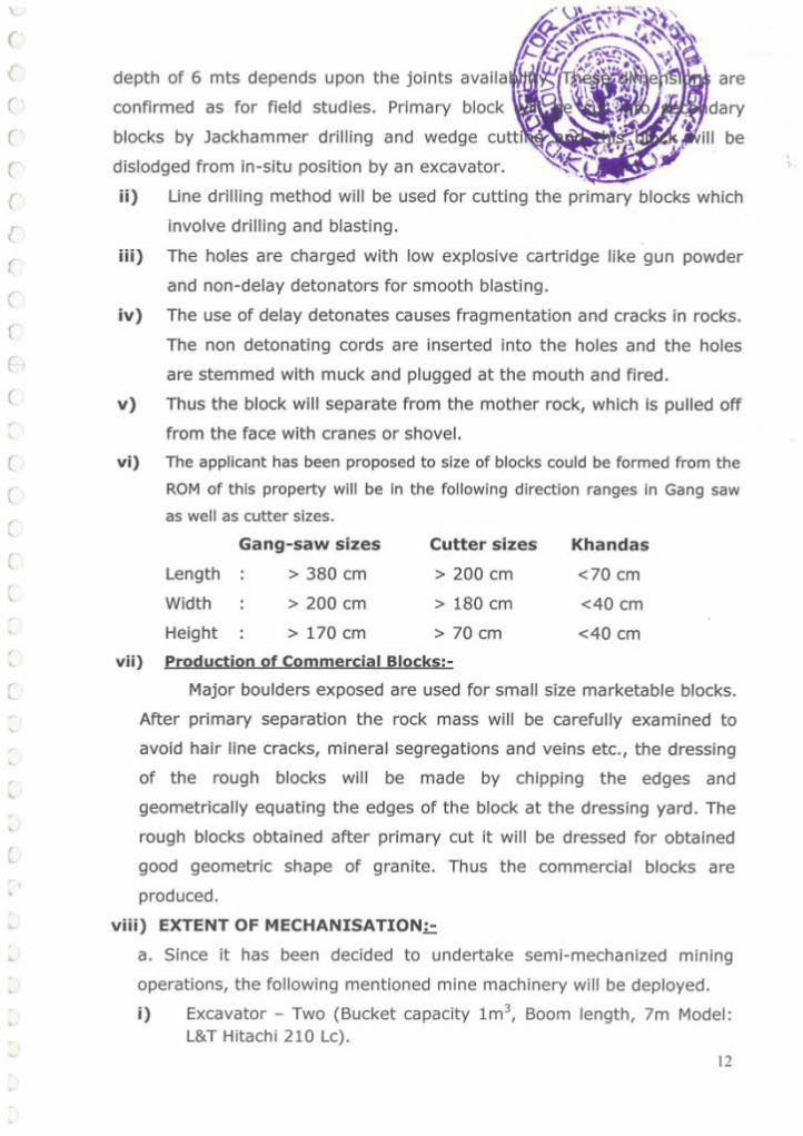
iii) Jack Hammers- 6 units. ,(.~·N·f ~~ 4 ,
ii) 300 CFM -AIR compressor- Two. ~~~"'?;
(!;., .. . ~. '~~ i v) 17 tones tippers - 4 Nos. /--: .r. ;./~· ~:;~.".·;\~ v) Wire Saw Machine- 1 No. t.i 1.!.1 /(,·'. ~~·1 \-.:r.-' • • , c 1 ) .,, ~·J . n ' Dr1t1mg t.r·t '- ·'A' :::_:·.- "i;1~.;.!' \ ~ ' ~~~;· '" . . \ m interval· ~ '7'->i d "". ",;y
. -'"~·~ i) Drill hole Diameter 32 mm up to 1.5-6.0 M long. -
ii) Depth and Inclination of drill hole.
Generally drilled vertically in an alignment, drilled.
Ill) Explosive Type.
Delayed detonators with cartridges.
b) Productjon of Commercial Bloc.ks:·
Major boulders exposed are used for small size marketable blocks. After
primary separation-ttle..,ock mass will be carefully examined to avoid hair line cracks,
mineral segregations and veins etc., the dressing of the rough blocks will be made by
chipping the edges and geometrically equating the edges of the block at the dressing
yard. The rough blocks obtained after primary cut It will be dressed for obtained good
geometric shape of granite. Thus the commercial blocks are produced.
c) Employment Potential:· Taking 25 working days In a month, there will be 300
working days in a year. The expected output of raw material per day Is about 42.8
CBM on an average. Based on the demands from the purchasers, labor force will be
increased.
d) Loading Equipment:
Loading of the blocks will be made by chain pulley with
the help of crane or procaine by the skilled laborers to the hired trucks to transport
the material to the nearest ports I destination of customer.
e) Organization Chart of the Quarry:-
The applicant will appoint following employees at this mine
a. Mines Manager, Diploma in Mining - with second class Mines Manager Certificate b. Blaster cum Mate sse with blaster certificate holder c. Excavator operator 4 No. d. Compressor operator e. Tipper operators f. Drillers g. Helpers h. Cutters I. Watchman
3 No. 6 Nos. 10 Nos. 10 Nos. 6 Nos. 2 No.
13

(
(
(
(
(
(
(
(
(
f)Machlnery to be Deployed): The expected machineryye:it~~~~~~~~ quarrying operation period may be 2 proclaim, 4 dump'
hammer drills 1 Wire Saw.
g) Details of production so far mined from beginning
It is a new Quarry. There is no production.
h) Labor Employed:
Dally 30 members of labors will employed In this Mine, Drinking water and next aid
facilities were provided in this area.
I) Production.;. It Is a new Quarry. There Is no production.
j) Quantum of Excavation (OB & Granite):
During this five years operations a total rock mass of 256800 nr' will be
excavated and 64200 m' of granite blocks will be recoverable from this rock mass
and remaining material of about 192600 m' will go as mineral waste.
(ii)Production Proposed for the next five years
In the present area there is a cluster of quarries of different sizes. For the
purpose of optimizing the production most of these quarries are operating
since long, As recent rules and regulations of DMG & APPCB & APPMC, all
Quarries should follow Mining Plan , EC, CFE & CFO, also be noted that DMG
issuing the permission based up on above all required Papers.
I t is proposed to produce 256800m3 of Granite during next five years
plan period with an average annual production of 12840m3 from an area of
18000m2. 2 benches of 6 m height and l.Sm width will be developed during
the plan period in depth of previous year workings successively.
The 75% Waste is generat ing in general in Granite quarry@ 192600m3 .
The Applicant proposes to take up quarrying operations in entire quarry lease
area between the grids The excavation activity wi ll be taken up in East of the
C. quarry lease area and then continue moves to North East.
(
l
l
'
1•tvear
In the first year mining will be carried out in the NS side of the quarry
lease applied area covering an area of 4500m2 two benches of 6m* 6m
height will be formed in FRL 710 to 698m.
The mining advances South wards. An area of 4500m2 will be excavated
producing 12840m3 of Market Grade Granite Blocks.
14

r
r
l
(
3rd Year
In the third year the mining will continue to the South of 2"" year
workings covering an area of 4500m2 two benches of 6m* 6m height
will be formed FRL 714 to 702m.
The mining advances down wards South wards of 2nd year workings. An
area of 4500m2 will be excavated producing 12840m3 of Market Grade
Granite Blocks.
4th Year
In the fourth year the mining will continue South of 3'd year workings
covering an area of 4500m2 two benches of 6m* 6m height with 1.5 m
bench width will be formed FRL 718 to 706m.
The mining advances South wards of 3rd year workings. An area of
4500m2 will be excavated producing 12840m3 of Market Grade Granite
Blocks.
5 th Year
In the fifth year the mm1ng will continue downwards of 4th year
workings covering an area of 4500m2 two benches of 6m* 6m height
with 1.5 m bench width will be formed.
The mining advances downwards of 41h year workings. An area of
4500m2 will be excavated producing 12840m3 of Market Grade Granite
Blocks.
In these five years an area of 18000m2 will be excavated producing
64200m3of Market Grade as given in the Table-1.
15

(
l
(
t
l
YEAR
t 111 Year
3"' Year
4"' Year
s••vear
Table-1
YEARWIS E W ORKINGS FOR
WORKING Area Bench Height in Volume in M2 (M)
Plate - V shows the Mine Layout Plan & Sections of Quarry lease area. Quantum of Excavation: A total of 64200m3 of Granite is being excavated which is 25% recovery of the mineral. 75% waste is generated @ 192600m3.
a) Production Schedule The production of Granite is continuous throughout year except during monsoon. That is 10 working months, 25 working days per month are considered. The average product ion of 12840m3 per year (250 days @ 51.36m3 per day) can be easily achieved in a single shift with sufficient men and machinery.
b) Magazine Type and Capacity The client does not need any explosive magazine. Applicant can utilize normal Explosive Detonators with permissions.
c) Stack Yard Temporary stocks will be maintained on South West side of applied area with an area of 1209 sq.mts. Entire ROM (Run of Mine) will be cleared within days (i.e. 10 to 15 days).
16

d)
e)
4.0
--%?:-. Handling of blocks within the quarry ~0!-~:,:...:::: ~\-~ Blocks ar~ separated from mother rock by excav . ~.:~e .. ~)~~f the ramp IS gentle. . trz:i:•· :·: .. r:.~:~..,~>v \ \". Transportation of Blocks from quarry to yardl~n~;f4'ne;~~-i,~-~t!6ri',:;; The rough blocks in the mine area will be handi~,~~Y-'. ,;~~~~-, ~':~~atb4. and transported to destinations by trucks. ~- ·~\~--- \.~~/.~/:-·"
• ~ ~;~•, .'<. .,. r •
MINE DRAINAGE . 'i.-.. '<~~~~ ~ --..:?-> The general direction of ground water f low Is towards".-~~-~fi~ of
Gudibanda from a part of the Upper Pennar River Basin. The height of
general area ranges from 710 - 705 m above MSL.
Ground water table is 100 m bgl in the surrounding areas. The mine
< lease is on littiP. P.IP.vatP.rl arP.a max. mining rlP.rth is /S m. HPnrP. grounrl
water table will not have any Impact due to the mining operations.
(
(
(
(
(
(
(
(
l (
(
l (
l
l
•
•
5.0 WASTE MANAGEMENT PLAN (SOLID & LIQUID)
5.1 Solid waste for the first five years
75% Solid waste of rocks 192600m3 is generated in this Granite quarry.
Solid waste generated year wise for first five years:
S.No. Year Total waste Generated M' 1 1" year 38520 2 2"" year 38520
3 3,.. year 38520
4 41" year 38520
5 stn year 38520 Total waste generated for five years 192600
5.2 Dumping Site Particulars
75% Solid waste of rocks is generated can be used for the development
of Internal roads and also dump in dump yard an area of 4787 m2 in South
side of appl ied area. Plate N0.7.
5.4 Liquid Waste
Mine Drainage:
The drainage system of mine in this area consists of surface run off
generated from rain fall and seepage.
The water that will generated in the mine pits will be pumped out for the
benefit for agriculture fields existing around.
a) Run off from waste dumps and measures proposed to arrest run off: 17

I '
(
r
(
(
(
Rainfall over the quarry lease applied area affe<cte~
dumps, mine pits roads etc. The rain cuts the d
there by a lot of runoff is generated wil l cumulate i
The following measure proposed to arrest surface
• Garland drains around pit and waste dump
• Retention wall at the foot of the dump
• Check dam construction against drainage channels to arrest silt.
• Growing vegetation on the slopes of the dumps.
b) Excavation drainage ditches ali around the quarry to direct surface
drainage:
Garland drains proposed around pit to divert the run off in to natural
drainage channels.
c) Utilization of run off for general surface use or discharge in to surface
drainage networks only after meeting with prescribed discharge
standards and further the agricultural purposes on the surface.
d) Surface run off general during rainfall event cannot be utilized for the
general use, hence through the garland drains proposed run off will be
diverted in to drainage network. Napa slabs mines or dumps have no
pollutants or toxic substances; hence, no contamination is expected,
except siltation.
e) Treating waste water to obtain the desired quality for industrial use as
may be required:
No industries exist in the vicinity of the quarry lease area. Hence, no
, treatment is required for the run off.
l
6.0 USE OF MINERAL AND MINERAL REJECT
The district has significant resources of Granite. Colour Granite blocks
can be used for Construction purpose as flooring material and wall tiles.
Some blocks are used as decorative stones of monumental purpose.
Waste Crushed stone or 'road metal' is used in landscape design and
gardening for gardens, parks, and municipal and private projects as
a mulch, walkway, path, and driveway pavement, and cell lnfili for
modular permeable paving units. As mineral mulch its benefits include
18

r
r
(
< \
(
[
7 .
8.
~. l •. • :: , ... ,_ -
erosion control, water conservation, weed suppression, a11d aes~h~tic
qualities. It is often seen used in rock gardens and ca~tus ·gat.den·s. \ · I , ·~ •
Processing of ROM and Mineral Reject (J..~\~ • ,: < ·- · · ._. • . '. . ' ' ' .·. _ , • I ... ~ .'
No processing is required. Only dressing of the rocK -and 'scre~i~g: t<).-,\ .. '\._ . -,.,_, .1"· ·.. ' . .:
the required sizes as per the market demand wi ll be P(~P-~~:;; .. ~~~:. y • ~.;,'!f .•. , ·. · . •
Others ~~- ·
(a) Site Services
The Applicant is well established in t his Quarry Operations since long ,
So Permanent Office, Rest Rooms, First Aid Room, Shelters and Water
for drinking will be provided in the quarry premises on make shift
arrangement.
(b) Employment Potential
A total of 42 persons shall be engaged to carry out the various operations at
the QL area. The man power required for the mining operations shall be as per
Table given below.
s. category No. of No. Persons 1. Foreman 1 2. Supervisors 2
3. Excavator and Tipper
4 Operators
4. Helpers 12
5. Drill Operators 12
6. Compressor Operators 3 7. Unskilled Labor 8
Total 42
19

r
r
r
8.
I)
II)
; 'fl" •o1lli7!/r'"~ PART - B ~.;:::--;;.>~"-
PROGRSSIVE MINE CLOSURE plAN_¢;..:..:_~~~:-.'~ -· '" '~ ~ . . , ~.,-;:... '\.. '\.--~ '. _,, f ,.....--•. .:::,.,,,Y \.; ;..o'l
ENVIRONMENTAL BASE LINE INFORMATI~N/ <~ ::: {t-f:;"l 1 '-k-1 -··1•1 ·-> ~~:..-:~ .. ·~'"- 'I '!~)1\1
Existing Land Use Pattern · .• · 0"\ ,,~·.-~ 'i<'jjft The Quarry area belongs to the Government a~~~i~Jio;'tei~~' for any ,.1, 1·.~ ... J ... :-,._.~
other use except for grazing. ~~~:,):•' Water Regime
The rain water flows through the slopes of the area and drained off through a
seasonal nalas. There are no perennia l water sources in and around the
applied area with 500m radius.
( Ill) Human Settlements
(
(
(
(
(
(
(
(
(
l
(
(
(
(
~ (
(.
(
(
(
(
The following villages are within 5km radius in the applied area. The
population, distance and location of these villages with respect to Applied Area
are given in the following table.
S.No. Name of the village Population Distance Directions in km
1 Kugenapalyam 250 1.5 NW -2 Gudibanda 5500 4.0 West
3 Javanaduku 200 1.8 NE
4 Kadupulapalyam 150 3.8 East -
5 Guddadahalli 650 2.0 sw-6 ' Goliahatti 100 1.5 sw-7 Jambulabanada 1200 3.0 NE
lv) Public Buildings, Places & Monuments
There are no public Buildings, Places of Worship and Monuments within or
near the area. Weather the area falls under the notified area of water act.
1974.
v) Sanctuaries and eco-sensitive areas
No Sanctuaries and eco-sensitive areas are seen in and around the quarry
lease area.
vi) Flora and Fauna
The subject area Is rocky terrain and does not consist any trees or major
vegetation. Except the presence of reptiles and other minor wild life like
rabbits, field rats etc., no major wild life exists In this area.
20

(
(
r
2.0 Environmental Impact Assessment
A. Landscape changes
Soil and Land Use Pattern
The Q.L area does not have any top soil cover. However some top soil will be
available between the slabs.
(b) Air Quality in Environment
The area is surrounded by Agricultural lands and there are no industries nearby.
Hence natural air is available In this area. There are chances for air pollution at
the time of Jackhammer drilling and at the time transportation of Mineral and
waste. But this air pollution will be controlled to the ambient air quality standards
{24hours)i.e,= SO, =120ug/ m', NO, =120ug/ m' ,Suspended Particulate Matter
(SPM) = SOOUG/ m1• Respirable Particulate Matter size < lOum) (RPM) = lSOug/
m', CO= Smg/ m' by keeping dust collector at the jackhammer drilling site. The
mine roads will be sprayed with water, before starting the transportation of
Mineral and Wastes to minimize air pollut ion.
(c) Water Quality
There are no chances for changes in quality of surface water or ground water the
quarry operations will be carried out on slope of the rocky terrain.
No water course is passing through the area excepting run off st.reams
during monsoon.
The quarrying of Granite has no adverse effect is anticipated on the water
regime In the area.
IS 10 500 - 1944
S.No. Characteristic Desirable Limit Maximum Permissible
Limit
1 Colour 5 25
2 Odour &. Taste Un Objectionable
3 Turbidity 5 NTU 10 NTU
4 pH Value 6.5 to 8.5 No Relaxation
5 TDS 500 mg. per ltr. 2000 mg. per ltr.
6 Total Hardness 300 mg. per ltr. 600 mg. Per ltr.
21

r
(
(
(
{
f
(
(
(
(
(
(
(
(
(
(
(
(
'
' (
(
•
•
(d) Noise Levels In the quarry, the machinery operations
compressor and excavators will generate <m~riii:Jhr
should be with in the limits of 90 dB. To mir>imi:UO
the permissible limits, the machinery will be
different times. The sound pollution can
periodical maintenance to the mining equipment. The pe1rmiissible limits of
noise are given below:-
Permissible noise exposure for different period of time is given below:
Duration oer dav (Hrs) SoundleveldBA 1/8 115 v. 110 'h 105 1 100 2 95 4 90 8 85
16 80
(e) Vibration Levels The vibrations may not be caused due to shot hole drilling and since the
operations are only for short duration. The impact of vibration will be
negligible.{ Vibration tolerance limit prescribed in DGMS circulars is 6922-
1973).Where maximum allowable limit of 70mm/sec. For soil and weathered
rock 100mm/sec. For hard rock as the peak particle velocity for safety and
design of the strata's.
(f) Water Regime
Mining Operations will be carried out on the slope of the Rocky terrain.
Hence neither ground water table nor the general surface drainage pattern is
affected.
(g) Acid Mine Drainage
Not Applicable
(h) Surface subsidence
Not Applicable
(i) Socio Economic Environment
The local inhabitants of the villages in surrounding villages of the mine
area are Agriculture. The mining activity In this belt will benefit the locals both
directly and indirectly. The directly beneficiaries will be those who get employed
In the mines as skilled and un-skilled workers. The indirect beneficiaries will be
those who open small business to sell goods required by the residents whose • 22

\
(
r, r
(
{
(
(
(
(
(
(
(
'
'
-- .. . ; • l
Per Capita " income will be enhanced by the mining aq~t')l)_;~~~thereby their
purchasing power will be Increased. In the long ru{.t-<f,~otl;( social go~ds.'is expected In the comparatively backward area when d~• inb1!tYitan.ts wltl be:able
(\' o_) l \ · • • • 'I ••
to sent their children to school. , · :·~ " -"'"- ::·. / . ~ ~ ·.~ .··' '1. •-.. • ~ · ,• • I
Positive effects: ',Jt~ · " ·_:: 1:_·,-;._ • 1. The locals get the employment. Some persons are found " o be"';b_~?rtg t;ucks
and renting to the quarry owners.
2. The locals get some job opportunities and especially the skill levels increase
due to their exposure to the machine environment.
3. Due to higher earnings their general status of living improves.
Negative effects:
1. The dust if not cont rolled can harm the inmates.
2. The worst problem Is due to dust generated during transport and the main
roads can be seen with this menace.
3. The rate of truck transport has increased the rate of accidents to locals and
the area Is found to have Increased number of accidents due to careless
driving.
4. Although the higher Noise levels may not harm persons working in quarry,
they will face the problem on a longer run.
(j) Occupation Health and Safety
The quarrying in this area does not involve any hazardous methods. The
quarrying Is simple and open cast mining method. In this, the possibilities of
small injuries are anticipated. The Applicant is providing First Aid facilities at
quarry site and Office room.
This also consists of issuing PPE ( Personal Protective Equipments) to all the
persons working, and those that are needed for the site specific operations.
The following PPE are proposed to be distributed.
• Helmets once in three years as needed under Mines Act
• Safety shoe to all the employees twice a year as per the same statute.
• Safety goggles to the Drill operators and Crusher operators which is a
site specific requirement.
• Nose masks once two months (Actually these are the cotton thin towels)
• Other step to improve safety conditions is to Inculcate the safety culture
among the persons working.
23

r
(
r 1
(
(
(
r r r
(
3.
="-
~!~'.0.0, ;,t-;· -~ N, · :!'-.'· ., (k) . His~orical Monuments . v ·~·{·;.~: .--<1-:-~~ No h1stoncal monuments are located 1n and aro .. ,, ~!~~.~~· \1[~~ · (!)Bio-Diversity ;,-:;_;.; 1 fl' .-:::.:::~_~'~'~ "C 'a}
~ ,, • ~ ·,j'\1 ~· ., f.t .. ·-· ffj Agriculture J/ ,' )\ .,;>{.r,, :.i.:;tj· .
The quarry lease area is an operating mine and f<l'r. ~;~~~?' · t.tf'yal
lands. Therefore, there is no adverse effect on agricult~~~;.ti;':)'iY• ' ·~,.,~'!'· " ' ··~~ -!/ Forest ' \::.: ""· ·
The quarry lease area is not falling under forest zone. (However, the Applicant
is proposing to undertake afforestation in the area).
Vegetation
The quarry lease area has operating mines, with an exception that, small
shrubs, herbs and thorny bushes have grown along the interspaces of boulders
and joints where some soil exists.
Progressive reclamation plan
The quarry lease area is just elevated 25 m above ground level. Reclamation
Is required in the life of the quarry as there are adjacent quarries that are
under operation. During next five years the progressive reclamation plan is
given in table below.
At the beginning of At the end of the
During Type of land use the plan period
plan period (ha.) Conceptual
( ha.) period (ha)
Mining 0.0000 1.8000 1.8000
Roads 0.0000 0.0150 0.0150
Green Belt Area - 0.1125 0.1125 Total Land
0.0000 1.9275 1.9275 Degradation Area which will
Remain 2.9725 2.9725 2.9725 Untouched
Total 2.9725 4 .900 4.900
24

(
(
(
(
(
r (
(
(
(
4 . Mined Out Land Land Use Pattern of the
To be Broken
TOTAL
7.5 M wide safety zone
Dumps/ Stock Yard
Existing
Proposed
lnfrdslrudure (Mines Offi~e & S ile Services)
Roads
TOTAL AREA
1.8000
0.3860
0.5996
0.0225
0.0150
2.8231
The land that will be broken in the successive conceptual periods {the Life of the quarry is anticipated to be 34.0 year as of present).
LAND USE The on-going mining and the downstream activities have covered the lease hold for about 2 5430 Hectares as detailed below·
1) Working Pit 18000 m2 1.8000Ha
2) Stock Yards/ Dump
1209 + 5996 m2 0.7205 Yard
3) Buildings 225 0.0225
4) Ramp Area, Internal
0.0150 Road Ways
Proposed for reclamation of land affected by quarrying activity during
and at the end of mining
No reclamation is envisaged in the life of the quarry as there are adjacent
quarries that are operation. This point will be dealt while the cluster guidelines
are received. Hence, no reclamation proposals are made.
Plantation Programme
The quarry lease area is scanty suitable for plantation as entire area is rocky.
There are absolutely no chances of any tree growing in the quarry area.
However it is proposed to plant a few trees in the nearby village area In the
25

(
('
(
(
(
(
(
(
(
(
(
(
l
(
(
r ,
l
..
, •
•
• ..
5 .
place shown by the village panchayat. The details ,...,, .•• .. ~.planfa~rin :~r e :ttt~E,- ; ~-~ • l'f' l'o • • ' ' ' ' \ Z •'""
shown below. ~ . .'/ .r..tt1~,··."•1~·:·· ·. ~, •. J !j~ ,r.,. · · •· ~c · k Details of Year wise Plantat · ·':!\;</ . ,,:~ · '1(i Gl
Planned ~~,-~ . .. ,< !LI' to ,·}i Year Location of Plantation Type !>~ ~ Plantation ~ :.1 .,. ':1'
1" Year 10 Five in buffer & Five In Neem~~ ~~\;T
village or road sides Mango, or f-~
Peepal
Five in buffer & Five In Neem, or
2"" Year 10 village or road sides
Mango, or Peepal
Five in buffer & Five in Neem, or
3"' Year 10 village or road sides
Mango, or 50% of
PE!epal Neem, or
survival is
4111 Year 10 Five in buffer & Five in
Mango, or envisaged.
village or road sides Pee pal
Five in buffer & Five in Neem, or
5111 Year 10 vil lage or road sides Mango, or
Pee pal
Five in buffer & Five in Neem, or
Total 50 v illage or road sides
Mango, or Pee pal
All around the quarry that is in the buffer/safety zone of 7.5 meters as per AP
PCB and MOEF rules, around the quarry attempts will be made to grow plants
with local arrangement of drums filled with mud. Thus it is envisaged that
around 10 plants will be planted and t aken care of in one year. Thus the area
available around the periphery will be sufficient for around 15 years.
Although the area in general Is fertile the location where the quarry is situated
is totally rocky. Expect for some wild growing medium sized plants that grow
in the cracks of boulders; there are no notable species In the area. However
trees like Neem, Ashoka, Mango, and local species Peepal are found in and
around. Therefore these three species are planned for plantation. Maintenance
of these plants that are grown in the buffer zone will be taken care by the
quarry management. The plants that will be grown in the vil lage will be taken
care by the management, in coordination with the panchayat members .
Top soil Managem ent
The Q.L area does not have any top soil cover. However some top soli will be
available between the weathered zone. The fertile soli available will be used for
26

r
r (
r (
(
r (
(
(
•
(
(
'
• '-
r
' r L
..
6.
7.
8 .
9.
plantation around site services and all along the roa ''-'" ' 'Jf
is unfertile which will be used for laying roads.
Tailing Dam Management
Not Applicable at this stage as it is progressive mine.
Disaster Management and Risk Assessment
To mitigate the emergency, planning is the first & four most thing, I.e.
recognizing the accident or possible, assessing the consequences of such
possible accidents and deciding on emergency planning I procedures in
advance both on site & off site that would necessary to be implemented , the
event of emergency without any delay and confusion.
Proper bench design in mines and observing safety measures for
transportation, storage, handling of explosives & fuels, etc, good maintenance
of vehicles, roads, fire prevention measures shall go in preventing disaster I
accidents .
Quarrying shall be carried out as per MMR 1961 & Rules and regulations
applicable the project in charge is having a mobile communication for quick
intimation of information if need arises.
The Applicant is committed to identify the possible causes for potential disaster
and draw a code of emergency measures and procedures to deal with such
disasters, which is otherwise also advised by DGMS through their Circulars.
The quarry is having good communication like telephone & mobile facility. In
case of any minor I major accidents within the quarry, the same will be
communicated to the Agent by the Mines Manager and intem he will inform to
the Revenue Authorities, Pollee, Fire Department, DGMS etc for action.
A vehicle is kept all the time at the quanry site for conveyance.
At quarry level first aid will provide and person(s) shall be shifted to nearby
hospital at Guntur which is having all basic amenities if in Serious Conditions.
Care and Maintenance during temporary discontinuance
The quanry workers are taken on contract basis on need based orders; the
workers always get Employment I Contract in similar quarries existing around.
Time Scheduling for Abandonment
As the quarrying in the lease hold is active proposal of abandonment is
proposed In next 5 years period .
27

(
(
(
c (
(
(
(
(
c (_
(
' (
(
(
(
'
' \
• '
r
' l
• / .. . " .\
9.1 Abandonment Costs FOR THE FIRST FIVE YEARS
Area (Ha) Quantity Expenditure
Items Details (Rs)
Proposed Proposed Proposed • ,
·.: Back filling Yes N.A ...., ·.
Afforestation &. back Nil filled Anea
Othe,.. (ErKti.ng tile Barbed Wire fence Nil N.A
Reclamation &. 1\ellabliitation
around the Ql area)
of mined out Pisckulture Nil
land
Converting Into water Ye5 reservoir
Picnic Spot Nil
Terradng Nil
PI telling Nil
ConstructJon of retaining wall at Toe ()( Ye5 Dumps
Stabilization & ConstructJon of Olec k Yeo Rehabilitation dams: of Dumps
(witl\ln !elise) Construction of garland drains
Yeo
Desiltlng of settling Yes
POndS, channels
Af'f~station on dumps N.A
Otl\efS (please Specify)
Rehabilitatk)n Green 8elt 0.1125 1125 m2 1\s. 25,000 of barren area within L.ease Otllers (Pielise Spedfy)
Ambient air quality
water quality Environmental Rs 30f000 per
Monitoring NOise Level SUfVf!Y per Annum) (Core zone&. ( For 5 years Buffer zone) Ground Vib~t1on Rs. 1,50,000)
Others (Piellse speo ty)
Total 0.1125 Rs 1,75,000
\
. •Remarks'
_, --Bod<fllling will not be
·• ~dQne during the firs:t rive year'plan periOd. So
cost is not included.
No cost i$ involved for converting the quaiT'y
pit into a water Harvesting Structu(e/
Pi$Ciculture tank. As t1>e pits gets fi lled during
rainy periods and rise In the water table If any In
ttle area
28

(
(
(
(
(
(
(
(
(
(
(
(
(
(
(
(
(
(
l
'
• (
(
• J
r
L
/~f:~-';:._?-. -~· /, a··,,- .._.,. /.. .·~>.~f.-;;.,__- ')/ '>
f .. ~~(/>~~ .. :;·-.:''. .• ~~~' I tlj •·i'· .-:~.~ ..... · \ ' ' _-.,..
Financial Assurance: Not applicable 10.
• .... : (!> _:' .:.:·.:. ;\:- ~'·
11.1 Certificate: · .. · ·· ~ ,;: : ,:: _:~;;_} , ( . ~ Certified that the above mentioned will be taken care irr the: 1'1ir)_e ,qgsure Plan
. . ;,.. ~':.:! .r. .. for Colour Granite over an extent of 4. 900tjeC!(.; _"';J!f.:: sv:. ':No. 700/B of
-~ .. ~ . .....;.;. -··-··· ...... Gudibanda Village,
Pradesh State.
Gudibanda Mandai, Ananttlafl~~' District, Andhra ... .:;.:'...-
All statutory organizations, courts etc. have been taken Into consideration and
wherever any specific permission is required, the Applicant only will approach
the concerned authorities.
All the measures proposed in this closure plan will be implemented In a time
bound manner as proposed.
11.2 PLANS & SECTIONS The plans and sections are enclosed.
APPUCANT
,..
SIGNATURE OF RQP
~~2 G.ESWAR REDDY RQP / GEOLOGIST,
G. ESWAR r.ft'DY, .......... L P".D
Rac:>!ir:I!:Z.d ecologiSt 18:/JRC>f'IH lC•I.302:2v13iA
29

ANNEXURE- I Photo of surface View of Granite af!;fil~ilPI~~
~~~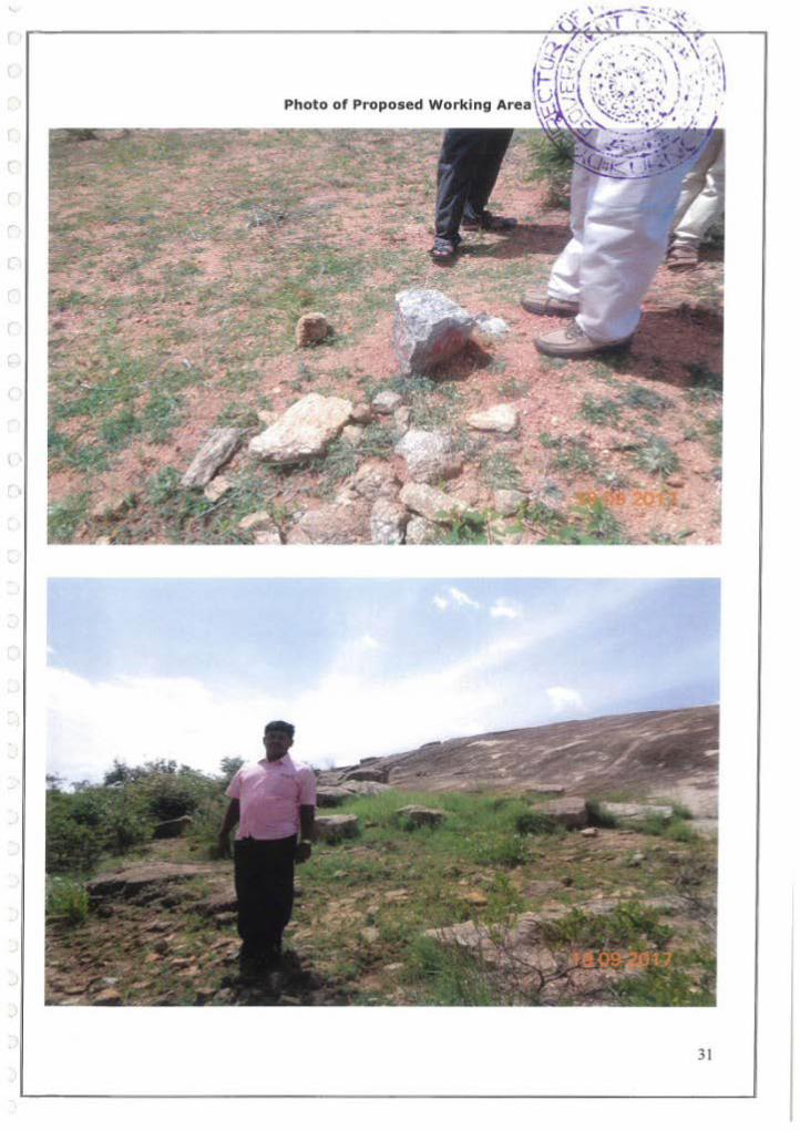
Photo of Proposed Working Area
31

(
(
(
(
(
(
{
(
(
(
(
(
ANNEXURE-II
GOVERNMENT OF ANDHRA PRADESH DEPARTMENT or MINES & GEOLOGY::IBRAHIMPATNAM
NOTICE No.20132/ R4-1/2016 D"ted : 28-06-2017.
Sub:· MINES AND QUARRIES - A pplication for- grant or Quer'T'y Lease ror Colour Granite over en extent of 4.900 Hectares in Sy.N o. 700/8 of Gudlbencre Vlllego. Gudlbenda Mandai# Ananthapur•mu District -Flied by Sr*l M . Gandhi Dass Approved M ining Plan arongwtth consent for establishment fr'Om A.P. Poltut,on <..ontrot I:::Soord tkEnvlronmentat C leorance from Ministry ot environment & Forest-S as per environment I 1npact Assessment Notification through 5.0.1533, dated: 14-09-2006/ DEIA Ananthepuramu - called fo r • Reg;~~rdfng.
Rof:- 1. Quarry Lease appllc.atlon deted.27.09.2014 of Sri M . Gandhi Oess.
2. ADM&G, Anenth.,puramu Flle.N o.43?9/GQL!CG/2014, dt: NII recei ved on 0~.12.2016.
Sri M . Gandhi Oos.s flied an application for grent or Quarry l...ea8e for Colour Granite over an e>etent or 4.910 Hectares In S y.No. 700/S of Gudibondi) VIllage# Gudibando Mandol, Anonthapur•mu District v1de r eference 1" clled. The said Quarry t..eese application wa• received by the Asslatant OJrect.or or Minos and Geology* Ananthapurarnu on 27.09.2014.
Through the reference 2,.. cited tho Assistant Director or M ines end Geology, Anenthepuramu submitted proposals recommending for g,.ont or Quony Leese for Colour G ranite ovc,. en e x tent of 4.900 HactorcG in S y . No. 700/8 or G u dlbande Villago, Gudibanda M•ndat, Ananthepuramu District lnf•vour or Sri M . Gandhi Dass.
At\er careful e >eamtnatlon or the proposals of the Assistant Olrector of Mines and Geology, A nanthepuremu It Is decided In prfndple t o orant a Quarry rea.se for Colour Granite over an extent or 4.900 Hectares In Sy N o. 700/8 o r Gudlbanda Village, Gud lbande Mendel, Anenthepurom u District In favour Sr1 M . Gandhi Da5s tor ~ period of (20) years subjoct to submission of' Approved M ining Plan within a period of (6) months from the d&te of Issue of this notice under 1\ulo 12(5) (c) or APMMC Rules. 1966 elongwlth con•ent: for C"at.ebllshment. from A.P. Pollution control Boord a.. Environmental C learance from Ministry of Environment & Forests as per Environment Impact Assessment Nouneation through S .O . 1533, dated: 14-09-2006.
t-luwevcr, the opp,.oved mlnfng plan ah•ll iiii~O t'ttll¥<;t- the re,:tr1ctlons tO be adopted by the applicant wh11e conduct•ng querry operatrons due to the ex•stence of any t:tructures, rl'lllway line, roada, water bodtos such oc river, lako etc., and the stlpulotod dlstancae os per tha verlous Regulations prescribed under Metalliferous Mines Regulations, 1961 .
In view or the above Sri M. Gandhi Oass IS hctreby raquested to submit Approved Mining Plan a longwlth consent for Establishment from A . P. Pollution Control Board & Environment~! Cfear-ence from Ministry of Envfronment & Forests 8S per environmont lr'npact Assessment Notification through 5.0. 1 533, dated: 14 .. QQ .. 2006 or fr"om Olstrlct Environment. Impact Assessment Authority es the coso may be for the proposed predse arc.e for grant of Q uerry Lcose within period of (6) rnontt"'S from the Gat:o of is,s;uo of this notice duly •pproved by the Ocputy Olrecror of Mines end Geoloov. Kurnool tO consider for grant ot quai"TY leaso fo,. Colour Grenite. If tho applicant fell• to subrrut the Approvf'd M1ning Plan within tho stipulated period, it will be pre•urnt.~d that the 411ppllcant. 1"' not lntere~tPd In getttng the querry lease over the subject «t cet e~nd further couNe of "c::tion wtll be initiated
32

Encl:· (As above) Sd/· B.SREEDHAR, I.A.S
DIRECTOR OF MINES AND GEOLOGY.
I/ ATTESTED/I
v·~~~{b/'" ASSISTANT DIRCCTOR OF t~INES AND GEOLOGY
To
Sri ~1. Gandhi Dass, S/o Sri M.D. Munuswamy, D.No.l/8, Mongllmaduvu Post, Pennagaram Taluq, Dharmapuri District, Tamllnadu-636810 [BY RPAD]
Copy to the Asst. Director of Mines and Geology, Ananthapuramu for Information. Copy to the Deputy Director of Mines and Geology, Kumool for information.
33

( .r--------------------------------------------
(
{
(
(
I
(
(
(
(
(
' '
ANNEXURE III
GOVERNMENT Of ANDHRA PRADESH
DEPARTMENT OF MINES AND GEOLOGY
C ERT IFIC ATE OF R EGIS TRATIO N
AS QUALIFIEO PERSON TO PREPARE MINING PLAN
{Under Rule ~4(2) of Granite Conservation and Development Rules 1999]
•• •• •
Sri (i c~<;~l~ R REDO Y. Slo G PttkJ.iri Redd1•. Rio No: 13-2-155-1.
f>cn·unaniluyum. Ncur R.i. C. Bus Stand. Ananlhapurom. whos€' photograph anti
.\I'Rnauo·~ ; .. tt(/ixed lwrein ahovt:>. /1(n•ing gn't'n el'itlt!IICt! ~~1 Ill\ qttuliflcall'on and
experience is hereby granted I'(!Jlt!wcd of recognitio11 tmder rule /4(2) of
c;rtmile Conservation & De,·efopment Rules 1999 (J\ Quali{it!d Per.HJII IO
prepare Mining Pion.
Rej:!i.Hrtltiun Nurnber i .v . [ RQP/DMG/AP/07/20~4 J
This Recognition is ntlid }Or tt period t~/ I 0 year.~ U'ith t:fli. .. ct from
22.12. 2014
/'l1i.\ cf>rrijicare wit/ liable to he Wl!ltdra,,.,, ,;, ,anc-etled ln the en~ut f?/
lurnisltln.~ th<! twvng in/ormatiQn ldocunwnl.\ in 1he A1hun.e, Plc.1n submillcd by
hun
P/a('e Hyde ruhtul Uatc .). Z,.. 12.2014
34

(
(
r
r
(
, '
'
ANNEXURE
l
atulllNt i'lffltff .-$ ~ tl f!Hfal lpffUf lp.f (<of.~'* R'ftlf<f .,.,....<1.11. ,.., 4J flllp, :124 4J .,.,
CERTIFICATE OF RECOGNITION AS QUAUAED PERSON (UnoMrRtde 2:IC tA Min...., Con-RllfM, 1t60)
'f<rctl\ ti v!l<l'l m<;;m ~ HU ....p.......nc~n number u
'
35

> 868 ~ - <i'
- 14-?- PLATE No.2
the Quany Lease applied & surveyed and demarcated area of M.Gandhi Dass Granite of Gudibanda M & (M)
7.11 1244
Signa~tcant
ill N
ur;;:--7-10 •
References FNo:4379/GQUCG/14 All Dimensions Are in Links Scale; 1 em &QOLinks Name of tho Applicant: Sri M.GANDHI DASS
Village Namo: GUDIBANDA Mandai N~me:GUDIBANDA
District Name: Anantapuramu sy.No:700 /e
=·~"'2"E~~es --Pe-ro-;uters of GPS W:N13' 58'06.7"E 77"Q8'10.4" Datum WGS 84 C:N13'58"05.6"E 77'08'13.4" North : True North F:N13'57'56.3"E 77'08'15.5" Locatlon:±5Mts
2"E 77'08'14. r . ~:=~~~~bt-tfo 77•08' 11.r Units: l)egrees,MmutesSeconds
1""-""l'S'I.......,-!l!I Revenue Pillars
CoiWCIO~ Gcck>g'f oOV:~~raduh Qbttf'fjl)PI'tt'ltm, Kri1hna Oi.ltti :;:.
Line W to C = 461 Links Line C to F ~ 1477 links Line F to G= 201 Links Line G to H - 457 Links Line H to B = 1528 Links
Z:N13'58'00.9''E 77"07"58.9" Y:N13' 58'02.9"'E 77"07"59.8'" X:N13' 58'06.2"E 77"08'02. 1" W:N13"58'05.7"E 77' 08'10.4" V:N13' 58'04.7"E 77"0fr'l2.0" U:N13' 58'03.6"E 77"08''12.5"
o.~o.J\.<... \\ Aj)pllod Area o1 M.GANDHI DASS r .. COlOUR Granito ·({a, «b:l""-~ ovoronextentoi4.9!3-Hoct
it<..~~ b~''''''-""')<)\<t-\17- (i NOC Atea&SU~E AREAol MGANOHIDASSior
B u.-w ~n . ./\ \J cOLouR G<anite r'"a?•xtef_•g~-"'Surveyor """'~r~"''' ASSIST ~TOROF 010 ADM&G GUDIBANDA MIN and GEOLOGY Anantapur ANANTAPUR
¢/1 z:; ,t: tM

--j
\ ' ..
....
--.. ;t*- ....
~.,.........
·-.a -·y --•
~ :.1 . . • ,_. ,_, ,. . ...._
t t t- +- t 0.0 l m 1.0 uu 2.0 l.m JOlm 4.0 lm
--·'F •
. --.~H '\..,-7--'~ . .· •
. .
• N
--• • '<
·-~ ,z.:.....
0
. . . t
• G U R o£ st 1:
PLATE NO -I
-::=\ <>~ Signature of R.O.P
G. tS'"' It r.root ~~~~~ .a..L. .., o J. •. 1 tl t l
! .. 11 H,..l.' J.. Jl3iA. • ' .. J ..
Ne. fOCIImJV '""' rtll!~l'(ftW Mlt""'ll! ., .... ..,_.,OOfllll!eTJOMtfll'OF~....-o UI'ON\IAil..w-~lro'fltlotiOWITAflOICM:-f!olf

1.
I
f I I I I I l I I I I
Geo Coordk1ales of lease eroe Dalum WGS.&4
POif>ITS LATITUDE LONGITUDE
8 Nts·w~ 2~ E7roe·o73"
w N13" woe r !7roe' t04"
c Nt3' 58'058" E7ror t34"
F Nt3" $TM3" err ortss·
G H13" 57 55.2" E7Tort•r
" Nt3"W&63" E7TO.ttr
N350 .----.----~----r---~----,
V:::. N200 1-------:. . . . . · .. . ·.
461
C'
A'
PLATE - Ill
APPROVED
MIHING PlAH FOR COLOUR GRANITE
TOPOGRAPHICAL CUM GEOLOGICAL PLAN
- · SRI M GANDHI DASS. 810 Sri M 0 Munuswa"", D Ho 118, MooglmiduYU Po5l. PtMIQe,.m T•lur+. ~ Dlslrt:t. T~tnllnldu · 835810
SCAlE ·1"2000
-~ Slgna~ur• of R.O.P
G. ,, •• rtr 'C ,.'!.1: a.L,.,o , - .
nill . TOCflinWVTHAT HINA:IIIIIIrM.nc:..IN THIS PlAT!:
• ~ A!HO COMICT TO n€11:ST Olt<HOWI EOOE BASED I# ON LIAII IMP MITW£NfiCATfD h"SlAT£0CJtlo'E'RNMENT

GEOLOGICAL CROSS SECTIONS
C' 730
7~~~~::~~::~~~~~~~~~----~--~ 720 71 710
72
710 ~ 700 ~ 690 §
670 A
730
720
• • • •
•
710 ! 700
690
680 1-
670
•
•
• •
... •
•
• • • ~
•
700
B' 740 730
• • • •
• • • • • • • • • • • • • •
720 > a:
• • 710 • • ~ 700 • •
• • • "' • • z • !I 690 • • • • ~ L ..-
• • • • • • • • • ~ • ~ ~
• • 680 • • • 670
A' 730
• 720 • • • > 710 • • a: • • • • 1 • • • • 700 • • • • • • • " • • • • 0 • • • • • • i 690 • • • • • •
~ • ~ t.- y-.L ;: .... .._ .... ;.- .....
. 680 • • • • • ·g 670 • • • •
PLATE -IV
APPROVED INDEX _...,..,._,. ............ ....... ,.., .....,.,... ...,._.,._
SRI lA GANDHI DASS IN ... No,.T004,E'III 4.tciCIHMis.,~ ......... ~o.,)..Anltn~
GEOlOGICAL CROSS SECTIONS
- · SRI M GANDHI DASS • Slo Sri M 0 M~mt • O..Ho H&, MoiQII•«<uw PosL PW~Mg•,.m T•IL.q. Dh8tmllpun Olsri::t, Tttnlrwclu • 63S810
SCAI.E.-11000
~ Slgre!ure of R.O.P
G.!" lf/1 •:~r\' u• • ~D
1o
• , .... e 'TO <:limN ~f T'l4 ~"11(»4 .. TMS"'-Aff 4 ftllUI NC) COI'III'IIC1' TO 'M lOT OII(H()lWI.fi)G( ..aD ~ON l iAII 1M# ~lfflCATll:l 1'1 ITATt GO"vUUIJrMHT

I I
' -! I l
I I I I
""'"'" • w
c
' G
H
~ARJ/1/LSE WDRKJ.NG.ELAN..& SECTJQNs_ "'·' FOR FIVE YEARS
\ .. : . .-:;.;::::-.. . . .·· .. ~ ·.
N 200 f----..., . · .. -.
'-"flTVDit L<»«lmlD< NU' SI"Oo'l" En' OI'013'
Hll" sros r rn•oriO<~ '
,..,y $1' 05f' rrror tl <~'
l'fl:)"$1":11.7 trror~ta·
HI.T fT IU" uror wr
ft1J" !5I' II..J" t-rrw " r
PLATE - V
, APPROVED
MINING PLAN FOR COLOUR GRMITE
YEAR WISE WORKING PLAN & SECTIONS FOR I YEARS
....,. .... SRI M GANDHI DASS, Slo Sri M D.Miii'UIWafn)', D Ho, til, Mongllmtdvvu Pot:~,
Pwwoge"'"' T_,, ON._., Olstricl T •"*"du • 636a 1 0
SCALE • 12000
~~ · -~~ Sigrel~.n ot R.O.P
G r~ · r '( ... -.. , ... ~ r
1JIJ\
'"-II fO Cl"'llN fWA f floC ~f'IJN.., l'ICSPUTE II ~ MID COMf!CT 1'0 'n41 111EST OF ICHICMLEOGE BASED \I'Oi LlA5I W# ~f'EO aY &TAft: ~t.erff
I
I i t ~ I 1
l \ I
! I
,l, I
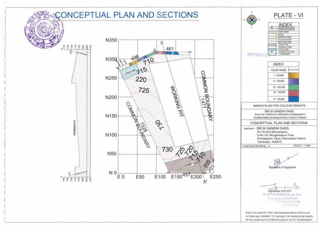
ONCEPTUAL PLAN AND SECTIONS
725
. ·... .
i
I .. · . . . . ·:. ·
x·
APPRO
MIHtNG PLAN fOR COLOUR GRANITE
.. ..,._, SRI M GANDHI DASS,
Slo Sri U,O.Munutwanry, O.No 118,~Po&t. Ponnegeram T alvQ, Ol'tannai)LI1 Disr~.
T~tnlll'lldu • 836810 •
'A
n.lll fO (81-,., JMAT THE ~T'IJN fr4 THISJI\ATE
• 1'IIIUI MilO ClQIIUIECT fO Tl41ST 0# IDICMUDOE MSED \,P(h !.VII WAIPioU'MHfiCATtDW'fSfATE ~

J I I I I l I I ., vvvvvv
vvv v
vv vvvv vvv
v
vvvvvv vvv
ENVIRONMENT PLAN
vvvvvv vvv
v
vvvvvv vvv
v
vvvvvv vvv
vvvvvv vvv
vvvvvv vvv
v v vvvvv v
vvv v
v
vvvvvv vvv
v vvvvv vvv
v v
vvv vvv vvv
vvvvvv vvv
v
11--..-.-~~v v v v v vvvvvv
vvv vvv vvv v vvvvvvv
vvv
v
vvvvvv vvv
v vvvvvv
vvv v vvvvvv
vvv v
v vvvvvv
vvv
vvvvvv vvv
v
v v
I
PLATE - VII
~~ 0. [:)''/U 1""" ., .,..,_ IH ,_ o ~
ICJ.ot.'R it A RO?Dr 1 1-1
n.11 • JOCllltTWV11-IAT MIHKIRW.fDI .. lM& PlAtt: • "lUU! NCI CQIIIIIIfCT TO ftC IIEST OF I(..,.. fDCT &ASlD
... O..I.lAa ltiJ# .MI'n4(NTICATtD t V STATE~