Embed Size (px)
Citation preview

TUMELO COAL MINES (PTY) LTD
PART 2: AMENDMENT REPORT
Application for Amendment of the Environmental
Authorisation and Environmental Management Plan Report
to include the partial pillar extraction of the No.2 Seam
LICENCE NUMBER: MP 30/5/1/2/2/10115MR
July 2020
FINAL FOR SUBMISSION
i
Prepared For Prepared by Independent EAP
Applicant Tumelo Coal Mines (Pty) Ltd Company Cabanga Environmental
Ref. No. MP 30/5/1/2/2/10115MR Author Jane Barrett
Contact Rowan Karstel Review Michelle Venter
Registered EAP (Reg. No. 2019/456)
Cert. Sci. Nat. (Reg. No. 114447)
Telephone 066 221 3596 Telephone 011 794 7534
E-Mail [email protected] E-Mail [email protected]
DISCLAIMER
This report has been prepared by Cabanga with all reasonable skill, care and diligence within the
terms of the contract with the client and taking into account of the resources devoted to it by
agreement with the client. We disclaim any responsibility to the client and any other in respect of
any matters outside the scope of the project.
This report is confidential to the client and we accept no responsibility of whatsoever nature to third
parties to whom this report, or any part thereof, is made known. Any such parties rely on the report
at their own risk.
DOCUMENT CONTROL
Version Date Reason for Change
Version 1 February 2020 Draft for Review and Comment
Version 2 July 2020 Final for Submission

ii
TABLE OF CONTENTS
1. INTRODUCTION ......................................................................................................................................... 10
1.1. Structure of this Report ......................................................................................................................... 10
1.2. Details of the Report Authors .............................................................................................................. 13
2. PROJECT DETAILS ...................................................................................................................................... 14
2.1. Project Location ................................................................................................................................... 15
2.2. Project Background ............................................................................................................................. 15
2.3. Project Scope ....................................................................................................................................... 16
2.4. Project Description ............................................................................................................................... 21
2.4.1. Mineral Reserve, Life of Mine and Mine Plan ............................................................................... 21
2.4.2. Coal Handling and Processing ...................................................................................................... 26
2.4.3. Mine Residue .................................................................................................................................... 26
2.4.4. Existing Services and Supporting Infrastructure ........................................................................... 27
2.4.4.1. Power Supply ............................................................................................................................... 27
2.4.4.2. Potable Water .............................................................................................................................. 27
2.4.4.3. Process Water .............................................................................................................................. 27
2.4.4.4. Sewage ......................................................................................................................................... 27
2.4.4.5. Waste Management ................................................................................................................... 28
2.4.4.6. Stormwater Management.......................................................................................................... 28
2.4.4.7. Roads and Transport ................................................................................................................... 28
2.4.4.8. Access Control ............................................................................................................................. 29
2.4.4.9. Administration, Workshop and Other Buildings ........................................................................ 29
2.4.4.10. Storage of Hazardous Goods .................................................................................................... 29
2.4.5. Emissions ........................................................................................................................................... 29
2.4.6. Operating Hours .............................................................................................................................. 29
2.4.7. Employment ..................................................................................................................................... 29
3. POLICY AND LEGISLATIVE CONTEXT ....................................................................................................... 30
3.1. Legislation Specific to Mining .............................................................................................................. 30
3.2. National Environmental Management Legislation .......................................................................... 32
3.2.1. The NEMA and EIA Regulations ..................................................................................................... 32
3.2.2. National Environmental Management Waste Act ..................................................................... 32

iii
3.2.3. National Water Act ......................................................................................................................... 33
3.2.4. National Environmental Management Air Quality Act .............................................................. 33
3.2.5. National Environmental Management Protected Areas Act .................................................... 34
3.2.6. National Environmental Management Biodiversity Act ............................................................. 34
3.2.7. Conservation of Agricultural Resources ....................................................................................... 34
3.2.8. National Heritage Resources Act .................................................................................................. 35
3.2.9. Other Relevant Legislation ............................................................................................................. 35
4. PUBLIC PARTICIPATION PROCESS............................................................................................................ 37
4.1. Identification of Stakeholders ............................................................................................................. 37
4.2. Notification of Stakeholders ................................................................................................................ 38
4.3. Document Review ................................................................................................................................ 38
4.4. Outstanding PPP ................................................................................................................................... 39
4.5. Summary of Issues Raised by I&APs .................................................................................................... 39
5. ENVIRONMENTAL ATTRIBUTES .................................................................................................................. 49
5.1. Climate and Meteorology .................................................................................................................. 49
5.2. Geology, Physiography and Topography ......................................................................................... 53
5.3. Soils, Land Use and Land Capability .................................................................................................. 55
5.4. Hydrology (Surface water) .................................................................................................................. 59
5.5. Geohydrology (Groundwater) ........................................................................................................... 64
5.6. Terrestrial Ecology ................................................................................................................................. 70
5.7. Freshwater Ecology .............................................................................................................................. 72
5.8. Air Quality and Noise ........................................................................................................................... 74
5.9. Sites of Archaeological and Cultural Significance .......................................................................... 76
5.10. Socio-Cultural Environment ............................................................................................................ 77
5.11. Environmental Sensitivity Map ....................................................................................................... 78
6. IMPACT ASSESSMENT ................................................................................................................................ 79
6.1. Impact Assessment Methodology ...................................................................................................... 79
6.2. Impact Identification ........................................................................................................................... 81
6.2.1. Geology Physiography and Topography ..................................................................................... 89
6.2.2. Soils, Land Use and Land Capability ............................................................................................. 90
6.2.3. Hydrology (Surface water) ............................................................................................................. 91
6.2.4. Geohydrology (Groundwater) ...................................................................................................... 91

iv
6.2.5. Terrestrial Ecology ............................................................................................................................ 95
6.2.6. Freshwater Ecology ......................................................................................................................... 95
6.2.7. Air Quality and Noise ...................................................................................................................... 95
6.2.8. Sites of Archeological and Cultural Significance ........................................................................ 98
6.2.9. Socio-Cultural Environment ............................................................................................................ 99
6.3. Impact Assessment .............................................................................................................................. 99
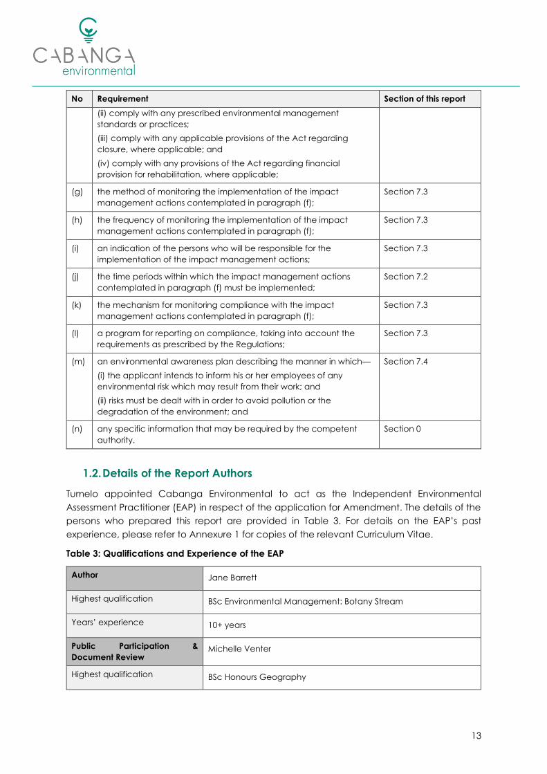
7. IMPACT MANAGEMENT ......................................................................................................................... 104
7.1. Impact Management Outcomes .................................................................................................... 104
7.2. Impact Management Actions .......................................................................................................... 107
7.3. Monitoring and Reporting Requirements ........................................................................................ 116
7.4. Environmental Awareness Plan ......................................................................................................... 118
7.5. Emergency Response ........................................................................................................................ 119
8. CLOSURE, REHABILITATION AND FINANCIAL PROVISION ................................................................... 124
8.1. Closure Objectives ............................................................................................................................. 124
8.2. Actions to Attain Closure Objectives ............................................................................................... 124
8.3. Financial Provision .............................................................................................................................. 125
9. ASSUMPTIONS, UNCERTAINTIES AND GAPS IN KNOWLEDGE ............................................................. 127
10. CONCLUSION AND RECOMMENDATIONS ....................................................................................... 127
10.1. Concluding Statement / Impact Statement ............................................................................. 128
10.2. Specific Conditions to be Included in the Amended Environmental Authorisation ............. 128
11. REFERENCES ......................................................................................................................................... 129
LIST OF TABLES
Table 1: Structure of this Report ..................................................................................................................... 11
Table 2: Structure of the EMP Report ............................................................................................................ 12
Table 3: Qualifications and Experience of the EAP ..................................................................................... 13
Table 4: Contact Details of the Applicant ................................................................................................... 14
Table 5: Properties included in the MRA (see Plan 2) ................................................................................. 17
Table 6: Summary details of project.............................................................................................................. 21
Table 7: Other Relevant legislation and guidelines ..................................................................................... 35
Table 8: Issues and Response Table .............................................................................................................. 40

v
Table 9: Description of Soils (Digby Wells and Associates, 2006) ............................................................... 55
Table 10: Summary flood (peak flows and flood volume) calculations (Letsolo Environmental and
Water Services, 2020) ...................................................................................................................................... 60
Table 11: Water quality of surface water surveyed on 23 October 2019 (Shangoni Aquiscience, 2020)
........................................................................................................................................................................... 62
Table 12: Water quality of hydrocensus boreholes surveyed on 23 October 2019 (Shangoni
Aquiscience, 2020) .......................................................................................................................................... 66
Table 13: Water quality of groundwater monitoring boreholes (June 2019) ......................................... 68
Table 14: Summary of results of the field assessment ................................................................................ 73
Table 15: Matrix used to determine likelihood ............................................................................................. 79
Table 16: Matrix used to rate duration .......................................................................................................... 79
Table 17: Matrix used to rate scale ............................................................................................................... 80
Table 18: Matrix used to rate Intensity .......................................................................................................... 80
Table 19: Impact Identification ................................................................................................................... 82
Table 20: Impact Assessment ...................................................................................................................... 100
Table 21: Impact Management Outcomes ............................................................................................. 104
Table 22: Impact Management Actions .................................................................................................. 108
Table 23: Monitoring, Auditing and Reporting Summary ....................................................................... 116
Table 24: Emergency Response .................................................................................................................. 119
Table 25: Quantum for Financial Provision ................................................................................................. 126
Table 26: Advantage and disadvantages associated with the proposed project changes ............. 127
LIST OF FIGURES
Figure 1: Illustration of Bord-and-pillar mining (Metallurgical Resources Consulting, 2019) ................... 22
Figure 2: LoM Production (Metallurgical Resources Consulting, 2019) ..................................................... 22
Figure 3: Plant and stockpile area ................................................................................................................. 26
Figure 4: Overburden stockpile...................................................................................................................... 26
Figure 5: Lined PCD ......................................................................................................................................... 27
Figure 6 & 7: Package sewage treatment plant (10m3/day capacity) ................................................... 28
Figure 8: Overview of the workshop and administrative complex (as taken from the overburden
stockpile) .......................................................................................................................................................... 29
Figure 9: Diesel storage facilities at the workshop area ............................................................................. 29
Figure 10: Rainfall and Evaporation Data (Letsolo Environmental and Water Services, 2020) .............. 50
vi
Figure 11: Temperature and Relative Humidity (Rayten Environmental and Engineering Consultants,
2020) .................................................................................................................................................................. 50
Figure 12: Period Wind Rose Plot, January 2016 to December 2019 (Rayten Environmental and
Engineering Consultants, 2020) ..................................................................................................................... 51
Figure 13: Morning (AM) (00:00 - 12:00) and Evening (PM) (12:00 - 23:00) Period Wind Rose Plots for
January 2016 - December 2018 (Rayten Environmental and Engineering Consultants, 2020) ............. 52
Figure 14: Seasonal Variation of Winds for the Period January 2016 - December 2018 (Rayten
Environmental and Engineering Consultants, 2020) ................................................................................... 52
Figure 15: Dust Fallout Results (January 2018 – September 2019) (Rayten Environmental and
Engineering Consultants, 2020) ..................................................................................................................... 75
Figure 16: Examples of the various Subsidence Classes (G-Ro Geotechnical Services) ........................ 90
Figure 17: Model simulated drawdown cone in 2021 (Shangoni Aquiscience, 2020) ............................ 93
Figure 18: Model simulated drawdown cone in 2023 (Shangoni Aquiscience, 2020) ............................ 94
Figure 19: Model simulated groundwater pollution plume 2022 (Shangoni Aquiscience, 2020) .......... 94
Figure 20: Predicted Dust-Fall Rates associated with Tumelo Colliery (Rayten, 2020) ............................ 96
Figure 21: Predicted Daily Average PM2.5 Concentrations associated with Tumelo Colliery (Rayten,
2020) .................................................................................................................................................................. 97
Figure 22: Predicted Daily Average PM10 Concentrations associated with Tumelo Colliery (Rayten,
2020) .................................................................................................................................................................. 97
Figure 23: Predicted Annual Average PM2.5 Concentrations associated with Tumelo Colliery (Rayten,
2020) .................................................................................................................................................................. 98
Figure 24: Predicted Annual Average PM10 Concentrations associated with Tumelo Colliery (Rayten,
2020) .................................................................................................................................................................. 98
LIST OF ANNEXURES
Annexure 1: Curriculum Vitae of EAP.......................................................................................................... 131
Annexure 2: Public Participation Report..................................................................................................... 132
Annexure 3: Groundwater Report ............................................................................................................... 133
Annexure 4: Surface Water Report ............................................................................................................. 134
Annexure 5: Freshwater Ecological Assessment ........................................................................................ 135
Annexure 6: Air Quality Impact Assessment............................................................................................... 136
Annexure 7: Archaeological Impact Assessment ..................................................................................... 137
Annexure 8: Desktop Palaeontological Assessment ................................................................................. 138

vii
ACRONYMS AND ABBREVIATIONS
ACRONYM: DESCRIPTION:
AEL Atmospheric Emissions License
AIA Archaeological Impact Assessment
AMD Acid Mine Drainage
AQIA Air Quality Impact Assessment
BID Background Information Document
Ca Calcium
CARA Conservation of Agricultural Resources Act, 1983 (Act No. 43 of 1983)
CBA Critical Biodiversity Area
CITES Convention on International Trade in Endangered Species of Wild Fauna and Flora
CM Continuous Miner
CSIR Council for Scientific and Industrial Research
CVB Channelled Valley Bottom Wetland
DARDLEA Department of Agriculture, Rural Development Land and Environmental Affairs
DEA Department of Environmental Affairs
DFA Development Facilitation Act, 1995 (Act No. 67 of 1995)
DMR Department of Mineral Resources
DHSWS Department of Human Settlements, Water and Sanitation
DWAF Department of Water Affairs and Forestry
DWS Department of Water and Sanitation
EA Environmental Authorisation
EAP Environmental Assessment Practitioner
EC Electrical Conductivity
EIA Environmental Impact Assessment
EMP Environmental Management Plan
ESA Ecological Support Area
F Fluoride
Fe Iron
GN Government Notice
GN704 Regulations on the use of water for mining and related activities aimed at the protection of
water resources
Ha Hectares
I&APs Interested and Affected Parties
IDP Integrated Development Plan`
viii
ACRONYM: DESCRIPTION:
IHAS Integrated Habitat Assessment System
IUCN International Union for Conservation of Nature
kV Kilovolt
IWUL Integrated Water Use License
IWULA Integrated Water Use License Application
IWWMP Integrated Water and Waste Management Plan
km Kilometre
LED Local Economic Development
LoM Life of Mine
m Metres
mamsl metres above mean sea level
MBSP Mpumalanga Biodiversity Sector Plan
mbgl meters below ground level
mg/l Milligrams per litre
mm Millimetres
MPRDA Mineral and Petroleum Resources Development Act (Act No. 28 of 2002)
MPRDAA Mineral and Petroleum Resources Development Amendment Act, 2008 (Act No. 49 of 2008)
MRA Mining Right Area
mS/m Millisiemens per metre
MTPA Mpumalanga Tourism and Parks Agency Act, 2005 (Act 5 of 2005)
MVA Mega Volt Amp
Na Sodium
NAAQS National Ambient Air Quality Standards
NAEIS National Atmospheric Emissions Inventory System
NEMBA National Environmental Biodiversity Act, 2004 (Act 10 of 2004)
NEMAQA National Environmental Management: Air Quality Act, 2004 (Act No 39 of 2004)
NEMWA National Environmental Management: Waste Act, 2008 (Act No 59 of 2008)
NEMA National Environmental Management Act, 1998 (Act No. 107 of 1998)
NEMPAA National Environmental Management: Protected Areas Act (Act No. 57 of 2003)
NFEPA National Freshwater Ecosystem Priority Area
NHRA National Heritage Resources Act, (1999 Act 25 of 1999)
NLTA National Land Transport Act, 2008 (Act No. 5 of 2008)
NO3 Nitrate
NRTA National Road Traffic Act, 1996 (Act No. 93 of 1996)

ix
ACRONYM: DESCRIPTION:
NWA National Water Act, 1998 (Act No 36 of 1998)
PCD Pollution Control Dam
PIA Palaeontological Impact Assessment
PO3 Phosphate
PPb Parts per billion
PPP Public Participation Process
Reg. No. Registration Number
RoD Record of Decision
RoM Run of Mine
SAHRA South African Heritage Resources Agency
SAHRIS South African Heritage Information System
SANBI South African National Biodiversity
SAPAD South African Protected Areas Database
SCC Species of Conservation Concern
SDF Spatial Development Framework
SLP Social and Labour Plan
SO4 Sulphate
SPLUMA Spatial Land Use and Management Act, 2013 (Act No. 16 of 2013
STLM Steve Tshwete Local Municipality
TDS Total Dissolved Solids
WMA Water Management Area
WML Waste Management License
WRC Water Research Commission

10
1. INTRODUCTION
Tumelo Colliery is an existing, operational mine located within the Nkangala District
Municipality and Steve Tshwete Local Municipality. The Mine has an approved Mining Right
(MP30/5/1/2/2/10115MR) and Environmental Management Plan (EMP) in terms of the Mineral
and Petroleum Resources Development Act, Act 28 of 2002 (MPRDA).
Further to this, Tumelo has Environmental Authorisation (EA) issued in terms of Section 24G of
the National Environmental Management Act, Act No. 107 of 1998 (NEMA), Reference:
17/2/10/24G NK03/2014, for auxiliary activities associated with the mining operations, including
the construction and operation of a package sewage plant.
The approved EMP addressed the underground mining (bord-and-pillar) of the reserves
associated with the No.2 Seam. Upon further assessment of the resource, Tumelo Coal Mines
(Pty) Ltd (“Tumelo”) now wish to amend the mine plan to include the partial pillar extraction
of the No.2 Seam (checkerboard layout).
No additional infrastructure is associated with the proposed project change and thus, no new
Listed Activities in terms of the NEMA; the Environmental Impact Assessment (EIA) Regulations,
2014 (as amended); and/or the National Environmental Management: Waste Act, Act No 59
of 2008 (NEMWA) will be triggered. However, as the partial pillar extraction of the No.2 Seam
will result in a change of Scope and possibly the nature of the environmental impacts, the
existing authorisation will need to be amended as per Regulation 31 of the EIA Regulations,
2014 (as amended) which states:
“An environmental authorisation may be amended by following the process
prescribed in this Part if the amendment will result in a change to the scope of a valid
environmental authorisation where such change will result in an increased level or
change in the nature of impact where such level or change in nature of impact was
not - (a) assessed and included in the initial application for environmental
authorisation; or (b) taking into consideration in the initial environmental
authorisation; and the change does not, on its own, constitute a listed or specified
activity.”
In light of the above, Tumelo submitted an application in terms of Regulation 31 of the EIA
Regulations, 2014 (as amended) to the Department of Mineral Resources (DMR) for a Part 2
Amendment on 11 December 2019.
1.1. Structure of this Report
This report has been compiled as per the requirements of Regulation 32 of the EIA
Regulations, 2014 (as amended) and aims to assess the impacts associated with the
proposed project changes.
11
Table 1: Structure of this Report
Requirement, as per the EIA Regulations 2014, as amended Section of this report
32(1) The applicant must within 90 days of receipt by the competent authority of the application made
in terms of Regulation 31, submit to the competent authority -
(a) a report, reflecting (i) an assessment of all impacts related to the
proposed change;
Section 6
(ii) advantages and disadvantages
associated with the proposed change; and
Table 26
(iii) measures to ensure avoidance,
management and mitigation of impacts
associated with such proposed change; and
Section 7
(iv) any changes to the EMPr; which report:
(aa) had been subjected to a public
participation process, which had been
agreed to by the competent authority, and
which was appropriate to bring the proposed
change to the attention of potential and
registered interested and affected parties,
including organs of state, which have
jurisdiction in respect of any aspect of the
relevant activity, and the competent
authority, and
(bb) reflects the incorporation of comments
received, including any comments of the
competent authority; or
Section 7
This report was
submitted to Interested
and Affected Parties
(I&APs) for review and
comment for an initial
period of 30 days (2
March – 1 April 2020),
this was however
suspended on 27
March 2020 due to the
COVID-19 lockdown.
These timeframes were
resumed on 5 June
2020, and extended by
an additional 21 days
(ending 2 July 2020) as
per the Directions
issued by the Minister
of Forestry, Fisheries
and the Environment1.
All comments received
during the review
period have been
included in Section 4.5.
(b) A notification in writing that the report will be submitted within 140 days
of receipt of the application by the competent authority, as significant
changes have been made or significant new information has been added
n/a
1 Directions regarding measures to address, prevent and combat the spread of COVID-19 relating to
permitting and licensing in terms of the National Environmental Management Act as issued by the
Minister of Forestry, Fisheries and the Environment on 5 June 2020 (Gazette No. 43412).

12
Requirement, as per the EIA Regulations 2014, as amended Section of this report
to the report, which changes or information was not contained in the
reported consulted on during the public participation process
contemplated in sub regulation (1)a and that the revised report will be
subjected to another public participation process of at least 30 days.
(2) In the event where sub regulation (1)b applies, the report, which reflects
the incorporation of comments received, including any comments of the
competent authority, must be submitted to the competent authority within
140 days of receipt of the application by the competent authority.
n/a
The required content of an EMP is provided in Appendix 4 of the EIA Regulations, 2014 (as
amended), and shown in Table 2 with cross-references to the relevant section(s) of this report.
Table 2: Structure of the EMP Report
No Requirement Section of this report
1 An EMP must comply with section 24N of the Act and include─
(a) details of–
(i) the EAP who prepared the EMP; and
(ii) the expertise of that EAP to prepare an EMP, including a
curriculum vitae;
Section 1.2 and
Annexure 1
(b) a detailed description of the aspects of the activity that are covered
by the EMP as identified by the project description;
Section 2
(c) a map at an appropriate scale which superimposes the proposed
activity, its associated structures, and infrastructure on the
environmental sensitivities of the preferred site, indicating any areas
that should be avoided, including buffers;
Plan 24
(d) a description of the impact management outcomes, including
management statements, identifying the impacts and risks that need
to be avoided, managed and mitigated as identified through the
environmental impact assessment process for all phases of the
development including —
(i) planning and design;
(ii) pre-construction activities;
(iii) construction activities;
(iv) rehabilitation of the environment after construction and where
applicable post closure; and
(v) where relevant, operation activities;
Section 7.1
(e) - (repealed) -
(f) a description of proposed impact management actions, identifying
the manner in which the impact management outcomes
contemplated in paragraph (d) will be achieved, and must, where
applicable, include actions to —
(i) avoid, modify, remedy, control or stop any action, activity or
process which causes pollution or environmental degradation;
Section 7.2
13
No Requirement Section of this report
(ii) comply with any prescribed environmental management
standards or practices;
(iii) comply with any applicable provisions of the Act regarding
closure, where applicable; and
(iv) comply with any provisions of the Act regarding financial
provision for rehabilitation, where applicable;
(g) the method of monitoring the implementation of the impact
management actions contemplated in paragraph (f);
Section 7.3
(h) the frequency of monitoring the implementation of the impact
management actions contemplated in paragraph (f);
Section 7.3
(i) an indication of the persons who will be responsible for the
implementation of the impact management actions;
Section 7.3
(j) the time periods within which the impact management actions
contemplated in paragraph (f) must be implemented;
Section 7.2
(k) the mechanism for monitoring compliance with the impact
management actions contemplated in paragraph (f);
Section 7.3
(l) a program for reporting on compliance, taking into account the
requirements as prescribed by the Regulations;
Section 7.3
(m) an environmental awareness plan describing the manner in which—
(i) the applicant intends to inform his or her employees of any
environmental risk which may result from their work; and
(ii) risks must be dealt with in order to avoid pollution or the
degradation of the environment; and
Section 7.4
(n) any specific information that may be required by the competent
authority.
Section 0
1.2. Details of the Report Authors
Tumelo appointed Cabanga Environmental to act as the Independent Environmental
Assessment Practitioner (EAP) in respect of the application for Amendment. The details of the
persons who prepared this report are provided in Table 3. For details on the EAP’s past
experience, please refer to Annexure 1 for copies of the relevant Curriculum Vitae.
Table 3: Qualifications and Experience of the EAP
Author Jane Barrett
Highest qualification BSc Environmental Management: Botany Stream
Years’ experience 10+ years
Public Participation &
Document Review Michelle Venter
Highest qualification BSc Honours Geography

14
Professional registration 8+ years
Years’ experience Registered EAP with the Environmental Assessment Practitioner’s
Association of South Africa (EAPASA) (Reg. No.: 2019/456)
Cert. Sci. Nat (Reg. No.: 114447)
GIS Lelani Claassen
Highest qualification BSc Honours Environmental Management
Professional registration Registered EAP (Reg. No.: 2018/153)
Pr.Sci.Nat. (Reg. No.: 121645)
Years’ experience 10+ years
Approval Ken van Rooyen
Highest qualification MSc Geography
Years’ experience 30+ years
Professional registration Pr.Sci.Nat. (Reg. No.: 121/93)
2. PROJECT DETAILS
The purpose of this section of the report is to provide details of the Location and Nature of the
Project and the proposed changes. Details of the Project Applicant are provided in Table 4
below.
Table 4: Contact Details of the Applicant
Applicant Tumelo Coal Mines (Pty) Ltd)
Registration No. 2003/003924/07
Primary Contact Rowan Karstel
Alternative Contact Kobie Badenhorst
Head Office Address 6 Dwars Street Krugersdorp
Mine Address Farm Boschmanskop 154 IS, Pullenshope
Central Coordinate of the Mine 26° 4'16.29"S
29°37'7.96"E
Postal Address P.O.Box 158, Krugersdorp, 1740
Telephone 066 221 3596
E-mail [email protected]

15
2.1. Project Location
Tumelo Colliery is situated near the town of Pullens Hope within the Mpumalanga Province. The
mine falls within the Steve Tshwete Local Municipality (MP313) of the Nkangala District
Municipality (DC31), see Plan 1.
The approved Mining Right Area (MRA) includes various portions of the farm Boschmanskop
154 IS and extends over an area of 462.2117 Ha, refer to Table 5 and Plan 2 overleaf for details
of the directly affected properties. Mine infrastructure is largely limited to Portions 6 and 10 (RE),
with the exception of the access road which traverses Portions 1 and 14(RE).
The mine is located south-east of the Hendrina Power Station and shares a boundary with
Optimum Colliery. The East Woes-Alleenspruit River traverses the western boundary of the MRA,
discharging into the Boschmanskop Dam.
2.2. Project Background
Tumelo Colliery is an existing underground coal mine with an approved Mining Right (MP
30/5/1/2/2/10115MR) and associated EMP (Digby Wells and Associates, 2006). It is understood
that construction of the operations commenced in 2008 prior to commencement of
production in 2010 (GCS Water and Environmental (Pty) Ltd, 2014).
Underground mining of the No.2 Seam is currently undertaken using mechanised bord-and-
pillar methods. The No.2 seam is accessed via a box-cut decline positioned slightly upslope of
the Boschmanskop Dam. Coal is conveyed to surface where it is crushed and screened on site
before being trucked to market. Supporting infrastructure on site (Plan 3), includes:
• Access and haul roads;
• Workshop area incl. stores, fuel storage, washbay and waste management areas;
• Administrative complex incl. offices, change house, laundry and lamproom;
• Sewage treatment plant (modular package plant);
• Crushing and screening plant;
• Coal stockpile area;
• Weighbridge;
• Clean and dirty water diversion drains;
• Pollution control dam (PCD);
• Overburden stockpile;
• Erikson dam;
• Pump station;
• Substation; and associated power lines.
Tumelo Colliery was placed under care and maintenance at the end of February 2014 after
contract renewal terms could not be agreed between Tumelo and the mining contractor.
Activities recently resumed in the first quarter of 2019.
16
2.3. Project Scope
This Application relates to the following interrelated aspects:
• Application for Amendment of the EA and associated EMP in terms of Regulation 31
and 32 of the EIA Regulations, as amended; and
• Application for Amendment of the approved EMP and Mine Works Programme, in
terms of Section 102 of the Mineral and Petroleum Resources Development Act, Act
No. 28 of 2002 (MPRDA).
There are no new Listed Activities associated with changes in mine plan. This report will focus
on the impacts associated with the partial pillar extraction, while the impacts from the current
and past mining activities of the No.2 Seam will be informative of the baseline conditions of
the site and the cumulative nature of some of the potential impacts associated with the
proposed project changes.

17
Table 5: Properties included in the MRA (see Plan 2)
Farm Name Portion Surface Right Owner SG Code Property Extent
(Ha)
Extent incl. in MR
(Ha)
Boschmanskop 154 IS 10 (RE) Tumelo Exploration
(Pty) Ltd
T0IS00000000015400010 135.0015 135.0015
Boschmanskop 154 IS 6 Tumelo Coal Mines
(Pty) Ltd
T0IS00000000015400006 161.6182 145.5447
Boschmanskop 154 IS Portion 21 (of
Portion 6)
Optimum Coal Mine
(Pty) Ltd
T0IS00000000015400021 29.3884 0.2857
Boschmanskop 154 IS 14 (RE) Tumelo Coal Mines
(Pty) Ltd
T0IS00000000015400014 150.0259 150.0259
Boschmanskop 154 IS Portion 23 (of
Portion 14)
Optimum Coal Mine
(Pty) Ltd
T0IS00000000015400023 30.4911 30.4911
Boschmanskop 154 IS Portion 26 (of
Portion 14)
Jan Hedrik Uys T0IS00000000015400026 257.8224 0.8628
Total Extent of Mining Right Area 462.2117 Ha

18
Plan 1: Locality Map

19
Plan 2: Mining right Area (Regulation 2(2) Plan) showing affected properties

20
Plan 3: Existing Infrastructure
21
2.4. Project Description
The purpose of this section is to provide the public with sufficiently detailed information
regarding the proposed project changes to facilitate meaningful public participation; and to
provide the relevant decision-making authorities with sufficiently detailed information to
enable informed consideration of the application, and decision-making.
Table 6: Summary details of project
Item Detail
Type of mineral Coal
Mining method Underground bord-and-pillar using continuous miners,
with partial pillar extraction
Depth of the mineral
below surface
The average depth of the 2 Seam to surface is
approximately 50 metres.
Geological formation
Tumelo is situated to the north of the Smithfield ridge on
the north-eastern edge of the Springs–Witbank Coal
field. The area is part of the Karoo basin.
Life of mine 4 Years (this includes the proposed pillar extraction)
Production rate 35 000 to 44,000 Run-of-Mine (RoM) tons / month
Market Domestic (Eskom) and Export .
2.4.1. Mineral Reserve, Life of Mine and Mine Plan
Plan 4 indicates the mining right area outlined in pink. The remaining No.2 seam reserves, which
are currently being mined are indicated in purple, whilst the previously mined out areas are
indicated in yellow.
Currently mining is undertaken via mechanised bord-and-pillar method using continuous
miners. In mechanised bord-and-pillar mining, extraction is achieved by developing a series of
roadways (bords) in the coal seam and connecting them by splits (cut-through) to form pillars
(Figure 1). These pillars are left behind as part of a primary roof support system. Later in the life
of mine these pillars will be partially extracted to optimize the reserve. The pillar extraction will
be undertaken on a checkerboard layout on retreat.
The proposed change in mine plan to include partial pillar extraction will maximise the
exploitation of the reserve extending the life of mine (LoM) by an additional one year.
Geotechnical Investigations were completed for the proposed pillar extraction in 2013 and
2019. These reports concluded that no pillar extraction should be undertaken at a depth of
less than 40m; within a horizontal distance of D/2.7 of any surface infrastructure or in areas
where the Safety Factor or width-to height ratio is below 1.6 or 2.2, as such pillar extraction in
these areas has been excluded from the final mine plan. Plan 5 shows the proposed pillar
extraction areas in red.

22
Figure 1: Illustration of Bord-and-pillar mining (Metallurgical Resources Consulting, 2019)
The mine is operational and requires no new development to maintain the current production.
The total production for the year 2020 will be 44 000 tons with two sections. The production will
decrease to 35 000 in 2021 with one continuous miner (CM) section. Partial pillar extraction will
commence once approvals are in place. The forecast for partial pillar extraction is during the
third quarter of 2022 (Metallurgical Resources Consulting, 2019). Plan 6 depicts the final mine
plan.
The mine is operational and Figure 2 below reflects the production expected. No build up or
ramp up of production is required.
Figure 2: LoM Production (Metallurgical Resources Consulting, 2019)

23
Plan 4: No.2 Seam Reserve as per the approved EMP and Mine Works Programme

24
Plan 5: Proposed Pillar Extraction

25
Plan 6: Mine Plan showing the proposed pillar extraction in relation to the 2 Seam Mine Plan

26
2.4.2. Coal Handling and Processing
The continuous miners cut the coal and load it onto shuttle cars which tram the coal to a
feeder breaker, from here the coal is crushed and loaded onto a conveyor belt system which
takes it to surface. On surface the coal is temporarily stockpiled before being crushed and
screened at the plant (80 000 tonnes per month capacity).
The RoM material is loaded into a hopper. A belt feeder extracts the material onto a conveyor
feeding a vibrating screen where the material is sized to -50mm before reporting to the product
conveyor. Oversized material (+50mm) is crushed before reporting to the same product
conveyor (Metallurgical Resources Consulting, 2019).
No changes to the coal handling and processing facilities are anticipated.
Figure 3: Plant and stockpile area
2.4.3. Mine Residue
Overburden from the construction of the existing boxcut has been stockpiled on site for reuse
during decommissioning and closure.
As outlined above, processing activities are limited to crushing and screening thus no
additional mine residue facilities are anticipated.
Figure 4: Overburden stockpile

27
2.4.4. Existing Services and Supporting Infrastructure
Existing services and infrastructure will continue to be utilized on site, these are briefly discussed
below.
2.4.4.1. Power Supply
Eskom supplies power to the Tumelo Colliery. Electricity is distributed to the mine via a
substation, mini-substation and 11 kV overhead powerlines.
The mine has an allocation of 4 MVA from Eskom, the total power requirement is 2 MVA. Thus,
no upgrades are required for the project.
2.4.4.2. Potable Water
Water for domestic and potable purposes is abstracted from a borehole, as per the
approved water use license. The proposed project changes will not result in an increase in
the number of employees and it is anticipated that the existing borehole will meet the
capacity requirements.
2.4.4.3. Process Water
Process water requirements are limited to that of dust suppression and for use in underground
mining processes.
Water found in the underground workings is pumped to the existing pollution control dam
(PCD) on surface which has a capacity of 3,200 m3, excluding freeboard. Once settled the
water within the PCD is pumped to the Erikson Dam (140 m3) for use underground (GCS Water
and Environmental Services (Pty) Ltd, 2018).
Water for dust suppression purposes is abstracted directly from the PCD.
Figure 5: Lined PCD
2.4.4.4. Sewage
Sewage from the administrative complex and change houses are managed via a system of
septic tanks. From here the water is pumped to a self-contained sewage treatment plant,
with a capacity of 10m3/day. Treated effluent from the sewage treatment plant is disposed
into the PCD for re-use (GCS Water and Environmental Services (Pty) Ltd, 2018).

28
The proposed project changes will not result in an increase in the number of employees and
it is anticipated that the existing sewage treatment plant will meet the capacity
requirements.
Figure 6 & 7: Package sewage treatment plant (10m3/day capacity)
2.4.4.5. Waste Management
Waste streams generated at Tumelo Colliery include sewage waste, general domestic
waste, hazardous waste and mineral waste. Sewage waste and mineral waste are discussed
in the preceding sections.
General domestic waste and hazardous waste bins are provided throughout the site to
ensure separation of general and hazardous waste at source. Bins are emptied into skips on
site (still separated as either general or hazardous waste). Skips are removed from site by
contractors for disposal to relevant recyclers / landfill (as the case may be).
No landfill sites have/will be constructed on site.
2.4.4.6. Stormwater Management
Clean and dirty stormwater on site is separated in terms of GN704 (Regulations on Use of
Water for Mining and Related Activities Aimed at the Protection of Water Resources). A
diversion berm has been constructed upslope of the mine infrastructure area to divert clean
water around the dirty footprint area. Water falling within the dirty footprint area is
channelled via a system of berms and trenches to the existing PCD. The existing PCD has
been designed to cater for a 1:50 year storm event and maintain a 0.8m freeboard (GCS
Water and Environmental Services (Pty) Ltd, 2018).
2.4.4.7. Roads and Transport
Tumelo Colliery is accessed via the D2539 just south of the Hendrina Power Station. The access
road is approximately 3km in length, tarred and in fair condition.
Internal vehicle movement at Tumelo Colliery is via a series of paved and unpaved roads. No
additional haul or access roads are associated with the project.
Product coal will continue to be transported off-site by truck to nearby power stations (local
market) and/or the Forzando North Colliery (international market).

29
2.4.4.8. Access Control
The mine surface infrastructure area is fenced off and access controlled via a security
checkpoint.
2.4.4.9. Administration, Workshop and Other Buildings
Ancillary infrastructure on site includes the administrative complex, change houses, parking
area, workshop, stores, weighbridge, wash bay and water reticulation for potable water
supply (jojo tanks). These will continue to be utilised for the life of mine.
2.4.4.10. Storage of Hazardous Goods
Diesel storage facilities (1 x 23m3 tank) are located at the workshop, and are appropriately
bunded.
Chemicals used in the workshop are stored in designated areas, the appropriate Material
Safety Data Sheets (MSDS) are kept on file.
Figure 8: Overview of the workshop and
administrative complex (as taken from the
overburden stockpile)
Figure 9: Diesel storage facilities at the
workshop area
2.4.5. Emissions
No scheduled gaseous emissions will take place on site. Vehicles and machinery emit fumes
but these will continue to be serviced and maintained regularly to keep these emissions
within the relevant vehicle/machine’s specifications.
Dust is and will continue to be monitored and managed on site to ensure these are within
the standards set by the Department of Environmental Affairs (DEA) as well as that of the
Mine Health and Safety Act, 1996.
2.4.6. Operating Hours
Tumelo Colliery operates two, ten-hour shifts per day, 5 days a week
2.4.7. Employment
Currently one hundred and twenty-five (125) people are employed at Tumelo Colliery. The
proposed project changes will not contribute to job creation but rather focus on the
retention of jobs by prolonging the LoM (MTS Holdings (Pty) Ltd, 2019).
30
3. POLICY AND LEGISLATIVE CONTEXT
Section 24 of the Constitution of the Republic of South Africa states that:
Everyone has the right to (a) an environment that is not harmful to their health or well-
being; and (b) to have the environment protected, for the benefit of present and future
generations, through reasonable legislative and other measures that –
• Prevent pollution and ecological degradation;
• Promote conservation; and
• Secure ecologically sustainable development and use of natural resources
while promoting justifiable economic and social development.
To give effect to Section 24 of the Constitution, several laws have been promulgated towards
realisation of these rights, which broadly speaking relates to:
• Development and Use of Resources (in this case, mining);
• Environmental Management; and
• Conservation and Protected Areas.
The following environmental legislation and guidelines were considered and integrated into
the EMP to ensure compliance and best practice:
3.1. Legislation Specific to Mining
This section refers to the MPRDA and its Regulations (GNR527, 23 April 2004 as amended by:
GN R.1288 dated 29 October 2004; GN R.1203 dated 30 November 2006; and GN R.349 dated
18 April 2011), as well as the Mineral and Petroleum Resources Development Amendment Act,
2008 (Act No. 49 of 2008) (MPRDAA).
The MPRDA is the predominant piece of legislation dealing with the acquisition of rights to
search for, extract and process mineral resources in South Africa. The MPRDA came into effect
on 1 May 2004. The MPRDA holds that mineral resources in South Africa belong to the nation
and that the State is the custodian thereof.
Any person may apply for a mining right by following the application procedure set out in the
MPRDA and administrated by the DMR. Applications for rights must be accepted if the
application requirements are met, and if no other person holds a prospecting right, mining
right, mining permit or retention permit for the same mineral on the same land. Once the DMR
accepts an application, the DMR will notify the applicant to conduct an EIA, and submit an
EMP to the DMR for consideration. The DMR will further instruct the applicant to consult with
I&APs.
In general terms, the Minister must grant a mining right if—
a. the mineral can be mined optimally in accordance with the mining work
programme;
b. the applicant has access to financial resources and has the technical ability to
conduct the proposed mining operation optimally;
c. the financing plan is compatible with the intended mining operation and the
duration thereof;

31
d. the mining will not result in unacceptable pollution, ecological degradation or
damage to the environment;
e. the applicant has provided financially and otherwise for the prescribed social
and labour plan;
f. the applicant has the ability to comply with the relevant provisions of the Mine
Health and Safety Act, 1996 (Act No. 29 of 1996);
g. the applicant is not in contravention of any provision of this Act; and
h. the granting of such right will further the objects referred to in section 2(d) and
(f)2 and in accordance with the charter contemplated in section 100 and the
prescribed social and labour plan.
Tumelo holds a valid Mining Right for its operations, Reference: MP 30/5/1/2/2/10115MR,
comprising of 462.2117 Ha over various portions of the farm Boschmanskop 154 IS.
Section 102 of the MPRDA states that:
A reconnaissance permission, prospecting right, mining right, mining permit, retention
permit, technical corporation permit, reconnaissance permit, exploration right and
production right work programme; mining work programme, environmental
management programme, and environmental management plan may not be
amended or varied (including by extension of the area covered by it or by the addition
of minerals or a share or shares or seams, mineralised bodies, or strata, which are not
at the time the subject thereof) without the written consent of the Minister.
The existing and approved EMP report (Digby Wells and Associates, 2006) pertains to
underground mining of the No.2 seam via bord-and-pillar methods. Upon further assessment
of the resource, Tumelo now wish to amend the mine plan to include the partial pillar
extraction of the No.2 Seam.
This constitutes a change in the approved EMP and Mine Works Programme, Tumelo must
therefore obtain the Minister’s consent in terms of Section 102 of the MPRDA prior to effecting
the change.
This report will be submitted to the DMR in respect of the application for amendment of the
approved EMP, to allow for the partial pillar extraction at Tumelo Colliery.
There are several other pieces of legislation which deal with such issues such as royalties (the
Mineral and Petroleum Resources Royalty Act, 2008), title registration (the Mining Titles
Registration Act, 1967), and health and safety (the Mine Health and Safety Act, 1996). These
issues constitute specialist fields on their own and will not be discussed in further detail.
The Mineral and Petroleum Resources Development Amendment Act, 2008 (Act No. 49 of
2008) (MPRDAA) amended certain sections of the MPRDA to make the Minister of Mineral
Resources the competent authority for implementing environmental matters in terms of the
NEMA as it relates to mining and prospecting operations and incidental activities, and to align
the MPRDA with NEMA.
2 Section 2(d)”and (f): The objects of this Act are to— (d) substantially and meaningfully expand
opportunities for historically disadvantaged persons, including women, to enter the mineral and
petroleum industries and to benefit from the exploitation of the nation’s mineral and petroleum resources;
(f) promote employment and advance the social and economic welfare of all South Africans.

32
3.2. National Environmental Management Legislation
The most prominent legislation dealing with environmental management and impact
assessment are discussed below.
3.2.1. The NEMA and EIA Regulations
The NEMA, as amended, was set in place in accordance with Section 24 of the Constitution of
the Republic of South Africa. Certain environmental principles under NEMA have to be
adhered to, to inform decision making for issues affecting the environment. Section 24 (1)(a)
and (b) of NEMA state that the potential impact on the environment and socio-economic
conditions of activities that require authorisation or permission by law and which may
significantly affect the environment, must be considered, investigated and assessed prior to
their implementation and reported to the organ of state charged by law with authorizing,
permitting, or otherwise allowing the implementation of an activity.
The Minister of Environmental Affairs published new EIA Regulations in 2014 and amendments
to the Regulations and Listed Activities in 2017. The undertaking of Listed Activities in terms of
the EIA Regulations requires Environmental Authorisation to be obtained prior to
commencement.
On the 2nd September 2014, the One Environmental System for mining came into effect
making the NEMA the overarching National environmental legislation. In terms of Section 12(4)
of the NEMA Amendment Act, 2008 (Act No. 62 of 2008) an EMP approved in terms of the
MPRDA, prior to the One Environmental System coming into effect, is regarded as having been
approved in terms of NEMA. The existing operations at Tumelo Colliery are therefore deemed
to have been approved in terms of NEMA, by virtue of alignment with the activities described
in the approved EMP.
Further to this, Tumelo has an EA issued in terms of Section 24G of NEMA (Ref. 17/2/10/24G
NK03/2014) for auxiliary activities associated with the mining operations, including the
construction and operation of a sewage treatment plant.
Changes to the approved activities (e.g. change in mine plan to include partial pillar
extraction) will be subject to an Amendment in terms NEMA and the EIA Regulations, 2014 (as
amended).
There are no new Listed Activities associated with the proposed project changes.
A Part 2 Amendment as per Regulation 31 of the EIA Regulations, 2014 (as amended) is
therefore relevant to the application. Regulation 32 further set out the requirements for
Reporting, Timeframes, and Public Participation.
3.2.2. National Environmental Management Waste Act
The National Environmental Management Waste Act, Act 59 of 2008 (NEMWA) provides for
national norms and standards for regulating the management of waste, and the licensing and
control of waste management activities.
Regulations to the NEMWA identifies a number of activities which require a Waste
Management License (WML) prior to being undertaken, this includes the establishment of a
residue stockpiles and/or deposits resulting from activities which require a mining right in terms
of the MPRDA. It is noted, however that Tumelo already has an approved Mining Right and

33
EMP and that an EMP approved in terms of the MPRDA shall be deemed to have been
approved and issued in terms of the NEMWA (according to the transitional provisions of GN
R.633 – Amendments to the list of waste management activities that have or are likely to have
a detrimental effect on the environment). The existing stockpiles at Tumelo Colliery are
therefore deemed to have been approved in terms of NEMWA, by virtue of alignment with the
activities described in the approved EMP.
3.2.3. National Water Act
The National Water Act, Act 36 of 1998 (NWA) provides for the sustainable and equitable use
and protection of water resources. It is founded on the principle that the National Government
has overall responsibility for and authority over water resource management, including the
equitable allocation and beneficial use of water in the public interest, and that a person is only
entitled to use water, without a license, if the use is permissible in terms of Section 22 of the
NWA.
The competent authority in respect of water use is the Department of Human Settlements,
Water and Sanitation (DHSWS, previously the Department of Water and Sanitation, DWS, and
the Department of Water Affairs and Forestry, DWAF).
Tumelo was issued with an Integrated Water Use License (IWUL) (Licence No.24090831) by the
Department of Water and Sanitation (DWS 3 ) on 1 October 2010. This was subsequently
amended on 4 September 2017. The IWUL was issued for a period of ten (10) years, expiring on
1 October 2020, as such an application to review and amend the IWUL will be compiled for
the operations.
Specific regulations made in terms of Section 26(1) of the NWA pertain to the use of water for
mining and related activities were published on 4 June 1999 (GNR 704). The provisions of GN704
have been incorporated into the EMP and surface water management plan where possible.
Where the implementation of provisions of GN704 is not possible, the Integrated Water Use
License Application (IWULA) must include application for exemption from the relevant
provisions, as per Regulation 3 of GN704.
Regulation 2 of GN704 stipulates the Mine’s obligations in terms of notifications to the DHSWS,
if changes take place at the Mine, or if incidents occur.
There are existing activities at Tumelo Colliery that require exemption from GN704, which are
not currently included in the approved WUL. These mainly relate to the existing infrastructure
area, which marginally encroaches on the 100m regulated zone of a Channelled Valley
Bottom wetland. The application to review and amend the WUL should therefore include
application for exemption of the relevant provisions of GN704, where necessary.
3.2.4. National Environmental Management Air Quality Act
The DEA, the provincial environmental departments and local authorities (district and local
municipalities) are separately and jointly responsible for the implementation and enforcement
of various aspects of National Environmental Management Air Quality Act, Act 39 of 2004
(NEMAQA). A fundamental aspect of the new approach to the air quality regulation, is the
establishment of National Ambient Air Quality Standards (NAAQS) (GN R.1210 of 2009). These
3 Currently the Department and Human Settlements, Water and Sanitation, DHSWS, and formerly the
Department of Water Affairs and Forestry, DWAF.
34
standards provide the goals for air quality management plans and also provide the
benchmarks by which the effectiveness of these management plans are measured.
Further to this, Activities that are identified in GN R.983 require an Atmospheric Emissions License
(AEL) to be issued in terms of NEMAQA. It is noted that the activities being undertaken at
Tumelo Colliery do not constitute a Listed Activity and the mine does not require an AEL in
terms of the NEMAQA. However, the site does fall within the Highveld Air Quality Priority Area,
and as such an Air Quality Impact Assessment (AQIA) has been completed for the operations
(refer to Annexure 6).
GN R.701 declared greenhouse gasses as priority air pollutants. The greenhouse gas reporting
regulations (GN R.275) identifies Mining and Quarrying as one of the industries who must report
their greenhouse gas emissions to the competent authority should they exceed the stipulated
threshold.
The National Atmospheric Emission Reporting Regulations, 2015 identifies all mines as a Group
C Emission Source, and requires the Mine to report to the National Atmospheric Emissions
Information System (NAEIS) on an annual basis.
3.2.5. National Environmental Management Protected Areas Act
The National Environmental Management Protected Areas Act, Act 57 of 2003 (NEMPAA) (as
amended) provides for the protection and conservation of ecologically viable areas of South
Africa’s biological diversity, natural landscapes and seascapes. It further provides for the
establishment of a register of protected areas (SAPAD), the management of those areas and
for intergovernmental co-operation and public consultation in matters concerning protected
areas.
There are no formally protected areas in the immediate vicinity of Tumelo Colliery. The closest
protected area is the Heyns Private Nature Reserve, located approximately 23km north-west
of the operations.
3.2.6. National Environmental Management Biodiversity Act
The National Environmental Biodiversity Act, Act 10 of 2004 (NEMBA) provides for the
management and conservation of South Africa’s biodiversity within the framework of the
NEMA. The Act relates to the protection of species and ecosystems that warrant national
protection, among others.
Certain Fauna and Flora Species of Conservation Concern (SCC) are known to occur in the
general vicinity of the site however, none were encountered during the vegetation surveys
completed prior to construction of the mine (Digby Wells and Associates, 2006). No new
infrastructure is proposed, and thus the footprint of disturbance will remain unchanged.
3.2.7. Conservation of Agricultural Resources
Conservation of Agricultural Resources Act, Act 43 of 1983 (CARA) provides for control over
the utilization of the natural agricultural resources of the Republic to promote the conservation
of soil, water sources and vegetation, and the combating of weeds and invader plants.
Measures for conservation have been included in the EMP where relevant.

35
3.2.8. National Heritage Resources Act
The National Heritage Resources Act, Act 25 of 1999 (NHRA) aims to promote good
management and preservation of the country’s Heritage Resources. Section 38 of the NHRA
sets out guidelines for heritage resource management and outlines the circumstances under
which a heritage impact assessment is required.
According to the approved EMP (Digby Wells and Associates, 2006) a site survey was
undertaken on 29 October 2002. More recently an Archaeological Impact Assessment (AIA)
was undertaken by Archaetnos Culture and Cultural Resources Consultants in April 2020. The
findings and recommendations of the AIA have been included in this report.
3.2.9. Other Relevant Legislation
In addition to the Laws and Guidelines discussed above, Table 7 summarises some of the
other key legislation and guidelines relevant to Tumelo.
Table 7: Other Relevant legislation and guidelines
APPLICABLE LEGISLATION AND GUIDELINES
USED TO COMPILE THE REPORT
HOW THIS DEVELOPMENT COMPLIES WITH THE
LEGISLATION AND GUIDELINES
NEMA: Public Participation Guidelines
(GNR807).
Guidelines have been and will be followed during the
Public Participation Process (PPP).
Department of Environmental Affairs (2017),
Public Participation guideline in terms of
NEMA EIA Regulations, Department of
Environmental Affairs, Pretoria, South Africa.
Department of Environmental Affairs,
Department of Mineral Resources,
Chamber of Mines, South African Mining
and Biodiversity Forum, and South African
National Biodiversity Institute. 2013. Mining
and Biodiversity Guideline: Mainstreaming
biodiversity into the mining sector. Pretoria.
The Mining and Biodiversity Guideline was considered
and acknowledged in the compilation of the EMP.
This Application relates to a Part 2 Amendment, mining
activities will be limited to the existing MRA. No new
infrastructure is proposed, and thus the footprint of
disturbance will remain unchanged.
Spatial Land Use and Management Act,
2013 (Act No. 16 of 2013) (SPLUMA)
SPLUMA aims to develop a framework to govern
planning permissions and the lawful use of land. In terms
of SPLUMA Tumelo should ensure that the surface right
areas where mining activities are undertaken is
approved as such.
Restitution of Land Rights Act, 1994; the
Restitution of Land Rights Amendment Act,
2014; the Land Reform (Labour Tenants)
Act, 1996; and the Extension of Security of
Tenure Act, 1997.
The Restitution of Land Rights Act, Act No. 22 of
1994 provided that all claims had to be lodged by 31
December 1998. The Amendment Act (Restitution of
Land Rights Amendment Act, Act No. 15 of 2014)
effectively sought to re-open submissions until 30 June
2019. The Validity of the Amendment Act was however
challenged in the Constitutional Court and
subsequently repealed on 28 July 2016.

36
APPLICABLE LEGISLATION AND GUIDELINES
USED TO COMPILE THE REPORT
HOW THIS DEVELOPMENT COMPLIES WITH THE
LEGISLATION AND GUIDELINES
The Constitutional Court ordered that claims lodged
between 01 July 2014 – 27 July 2016 are validly lodged
but prohibited the Commission from processing these
claims until such time that it has finalised all claims
lodged on or before 31 December 1998 (“old claims”);
or until Parliament passes a new law providing for the re-
opening of lodgement of land claims.
Consultation with the Commission has confirmed that a
“new claim” was lodged over the MRA in terms of the
Amendment Act but has not been processed as yet.
Local Government Municipal Systems Act,
2000 (Act No. 32 of 2000) as amended
The Act requires local government to compile spatial
development framework (SDF) which must include the
provision of basic guidelines for a land use
management system for the municipality. The
objectives of an SDF are to promote sustainable
functional and integrated human settlements, maximise
resource efficiency, and enhance regional identity and
unique character of a place. In addition, Municipalities
are required to develop Integrated Development Plans
(IDPs) which is a government co-ordinated approach to
planning that seeks to ensure the economic and social
enhancement of all within their jurisdiction. It provides a
land use framework, considers infrastructure
development, and the protection of the environment.
This application pertains to the continuation of activities
at the existing Tumelo Colliery. The projects will result in
an extended LoM and continuation of employment at
the mine.
Development Facilitation Act, 1995 (Act
No. 67 of 1995) (DFA)
The Act promotes the integration of the social,
economic, institutional & physical aspects of land
development and also promotes integrated land
development in rural and urban areas in support of
each other.
The Act encourages the availability of residential &
employment opportunities in close proximity to or
integrated with each other, while optimising the use of
existing resources including such resources relating to
agriculture, land, minerals, bulk infrastructure, roads,
transportation and social facilities.
This application pertains to the continuation of activities
at the existing Tumelo Colliery. The projects will result in
an extended LoM and continuation of employment at
the mine.
37
APPLICABLE LEGISLATION AND GUIDELINES
USED TO COMPILE THE REPORT
HOW THIS DEVELOPMENT COMPLIES WITH THE
LEGISLATION AND GUIDELINES
NEMA Regulations pertaining to the
financial provision for prospecting,
exploration, mining or production activities
(GNR1147 –20 November 2015) (as
amended).
Financial Provision has been calculated for the year
ending February 2020 and is discussed in Section 8.
National Road Traffic Act, Act No. 93 of
1996 (NRTA) and National Land Transport
Act, Act No. 5 of 2008 (NLTA)
These Acts relate specifically to the planning and
development of transport systems and the safe use of
roads.
This application pertains to the continuation of activities
at the existing Tumelo Colliery. No changes are
proposed to the infrastructure or operational activities
on surface and thus no additional impacts are
associated with regards to the traffic.
Mpumalanga Tourism and Parks Agency
Act, Act 5 of 2005 (MTPA Act) and
Mpumalanga Nature Conservation Act,
Act 10 of 1998
The Mpumalanga Nature Conservation Act was
considered, management measures to protect the
natural fauna and flora in line with the Act have been
included in the EMP, where relevant.
Nkangala District Municipality: Air Quality
Management By-law (Provincial Gazette
No. 2701 of 10 June 2016)
The by-law states that any person who is responsible for
causing air pollution or creating a risk of air pollution
within the municipality must take reasonable measures
to:
• Prevent any potential air pollution from
occurring; or
• Where the causing of any air pollution is
permitted, not prohibited, or cannot be
reasonably avoided or stopped, to minimise
that pollution.
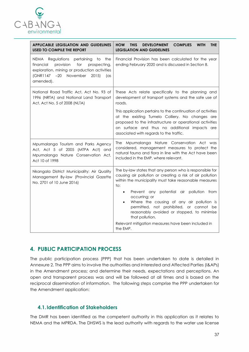
Relevant mitigation measures have been included in
the EMP.
4. PUBLIC PARTICIPATION PROCESS
The public participation process (PPP) that has been undertaken to date is detailed in
Annexure 2. The PPP aims to involve the authorities and Interested and Affected Parties (I&APs)
in the Amendment process; and determine their needs, expectations and perceptions. An
open and transparent process was and will be followed at all times and is based on the
reciprocal dissemination of information. The following steps comprise the PPP undertaken for
the Amendment application:
4.1. Identification of Stakeholders
The DMR has been identified as the competent authority in this application as it relates to
NEMA and the MPRDA. The DHSWS is the lead authority with regards to the water use license

38
application. Other Local and Regional authorities were identified and included in the I&AP
register, and notified of the proposed project changes by means of the Background
Information Document (BID).
Landowners of the directly affected and adjacent land portions were identified through deeds
office searches, previous I&AP databases and on-site consultations. Community
representatives, including the local Ward Councillors, community forums and resident
associations were identified and included in the I&AP register.
The Land Claims Commissioner was contacted to determine whether any land claims have
been registered over the MRA. The response from the Commission has been included in the
issues and response table overleaf, Table 8.
4.2. Notification of Stakeholders
BIDs were compiled in English, Afrikaans and Zulu and were distributed via e-mail and post to
all the identified stakeholders for whom contact information could be obtained.
Hard Copies were hand delivered on 07 February 2020 to affected parties (land owners and
users) where possible. In some cases, no one could be located on the property; in such a case
the BID was attached to the property gate or left in a post box (when available).
A Newspaper advertisement (in Zulu and English) was published in the Witbank News on 07
February 2020, conveying the same information as the BID (albeit abbreviated). The Witbank
News circulates 26,000 copies to areas including Arnot, Belfast, Bronkhorstspruit, Groblersdal,
Hendrina, Kriel, Loskop, Marble Hall, Middelburg, Ogies, Pullens Hope, Rietspruit, Stoffberg, Van
Dyksdrift, Witbank, Phola and Wonderfontein.
A2 posters, written in Zulu and English were placed on the site boundary fence and at other
public locations, including:
• Pullens Hope Public Library; and
• Nkangala District Municipality.
The purpose of the announcement documentation mentioned above was to:
• Invite members of the public to register as I&APs;
• Inform them of the proposed amendment application and associated regulatory
processes; and
• Initiate a process of public consultation to record perceptions and issues.
A public meeting, in the form of an open-day was held on the 04 March 2020 at the Eskom
Community Hall in Pullens Hope. All registered I&APs were invited to attend, the purpose of the
meeting was to discuss the impacts associated with the partial pillar extraction and the
proposed mitigation measures as outlined in this report. Refer to Annexure 2 for minutes of the
meeting.
4.3. Document Review
This report was made available to &APs for review and comment for an initial period of 30 days
(2 March – 1 April 2020), this was however suspended on 27 March 2020 due to the COVID-19

39
lockdown. These timeframes were resumed on 5 June 2020, and extended by an additional
21 days (ending 2 July 2020) as per the Directions issued by the Minister of Forestry, Fisheries
and the Environment4.
The report was made available online at www.cabangaenvironmental.co.za and at the
Pullens Hope Public Library. All registered I&APs were informed of the reports availability via e-
mail, fax and SMS. Further to this, electronic copies (Adobe PDF and CD) were made available
to I&APs upon request.
In addition, copies of the draft report were circulated to the following authorities for review
and comment:
• DMR;
• DHSWS;
• Mpumalanga Department of Economic Development, Environment and Tourism;
• Steve Tshwete Local Municipality;
• Nkangala District Municipality; and
• South African Heritage Resources Agency (SAHRA).
All comments and/or issues raised by I&APs to date have been included in the issues and
response table overleaf (Table 8).
4.4. Outstanding PPP
Notification of the record of decision (RoD) will be completed in terms of the NEMA EIA
Regulations as soon as a decision is received from the competent authority (the DMR). This will
include a note describing the outcome of the application and the appeal process that can
be followed.
4.5. Summary of Issues Raised by I&APs
Table 8 below summarises the issues and responses received from the various authorities,
organs of state and I&APs to date. Copies of all correspondence is included in the PPP report
attached as Annexure 2.
4 Directions regarding measures to address, prevent and combat the spread of COVID-19 relating to
permitting and licensing in terms of the National Environmental Management Act as issued by the Minister
of Forestry, Fisheries and the Environment on 5 June 2020 (Gazette No. 43412).

40
Table 8: Issues and Response Table
AFFECTED PARTY DATE
RECEIVED
ISSUE RAISED INITIAL RESPONSE FINAL STATUS AND REFERENCE TO THE
EIA/EMP
Justice Ramagoma
Environmental Manager for
Hendrina Power Station, Eskom
18-02-2020
BID
Questionnaire
Completed the PPP Questionnaire and
registered as an I&AP. Requested that
farmers and residents in the area be
notified of the project.
Notices were placed in the Witbank
News, on site and at the local library.
In addition, BIDs were delivered to
immediately affected landowners /
users.
Section 4 summarises the PPP
undertaken for the Amendment
application.
Please refer to Annexure 2 for a copy of
the PPP report and I&AP register.
Mr.E.S.Nkosi
Chief Director
Office of the Regional Land
Claims Commissioner
20-02-2020
Letter
No claims were lodged before the 1998
re-lodgement period in terms of the
Restitution of Land Rights Act, Act No. 22
of 1994 however, a new claim was
lodged terms of the Restitution of Land
Rights Amendment Act, Act No. 15 of
2014. As per the ruling of the
Constitutional Court this claim will not be
processed until such time that the
Commission has finalised all claims
lodged on or before 31 December 1998;
or until Parliament passes a new law
providing for the re-opening of
lodgement of land claims.
Noted. No change.
A copy of the correspondence is
included in the PPP report, attached as
Annexure 2.
Jan Uys
Farm Boschmanskop
04-03-2020
Public
Meeting
Concern for the groundwater quality
and quantity. Will any privately owned
boreholes be impacted on?
Dewatering activities will result in a
maximum drawdown cone of between
1 and 4 m in the shallow, weathered
aquifer. No privately owned boreholes
fall within the drawdown zone of
influence.
Two potential sources of pollution were
identified on surface in the Groundwater
study, being the overburden and coal
stockpiles. Modelling indicates that a
pollution plume could develop during
the operational phase however, the
Section 6.2.4 summarises the possible
impacts on the groundwater resource.
Please refer to Annexure 3 for a copy of
the specialist groundwater report.
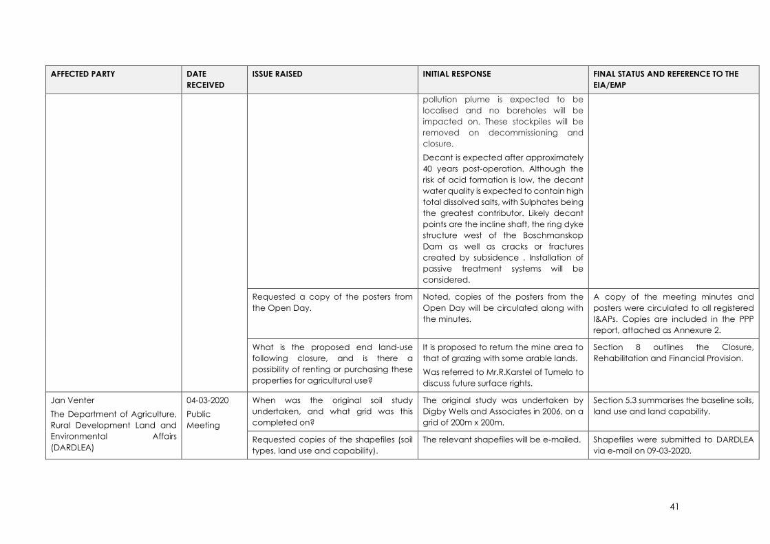
41
AFFECTED PARTY DATE
RECEIVED
ISSUE RAISED INITIAL RESPONSE FINAL STATUS AND REFERENCE TO THE
EIA/EMP
pollution plume is expected to be
localised and no boreholes will be
impacted on. These stockpiles will be
removed on decommissioning and
closure.
Decant is expected after approximately
40 years post-operation. Although the
risk of acid formation is low, the decant
water quality is expected to contain high
total dissolved salts, with Sulphates being
the greatest contributor. Likely decant
points are the incline shaft, the ring dyke
structure west of the Boschmanskop
Dam as well as cracks or fractures
created by subsidence . Installation of
passive treatment systems will be
considered.
Requested a copy of the posters from
the Open Day.
Noted, copies of the posters from the
Open Day will be circulated along with
the minutes.
A copy of the meeting minutes and
posters were circulated to all registered
I&APs. Copies are included in the PPP
report, attached as Annexure 2.
What is the proposed end land-use
following closure, and is there a
possibility of renting or purchasing these
properties for agricultural use?
It is proposed to return the mine area to
that of grazing with some arable lands.
Was referred to Mr.R.Karstel of Tumelo to
discuss future surface rights.
Section 8 outlines the Closure,
Rehabilitation and Financial Provision.
Jan Venter
The Department of Agriculture,
Rural Development Land and
Environmental Affairs
(DARDLEA)
04-03-2020
Public
Meeting
When was the original soil study
undertaken, and what grid was this
completed on?
The original study was undertaken by
Digby Wells and Associates in 2006, on a
grid of 200m x 200m.
Section 5.3 summarises the baseline soils,
land use and land capability.
Requested copies of the shapefiles (soil
types, land use and capability).
The relevant shapefiles will be e-mailed. Shapefiles were submitted to DARDLEA
via e-mail on 09-03-2020.

42
AFFECTED PARTY DATE
RECEIVED
ISSUE RAISED INITIAL RESPONSE FINAL STATUS AND REFERENCE TO THE
EIA/EMP
N.Sikhosana and P.Ndzulo
Onele Construction
04-03-2020
Public
Meeting
When did mining initially commence,
and when will the pillars be extracted?
Will all the pillars be extracted?
Construction of the operations
commenced in 2008 prior to
commencement of production in 2010.
Mining continued until 2014, at which
time the operation was put onto care
and maintenance. Mining recently
resumed in 2019. The proposed pillar
extraction will commence in 2022 once
the existing underground reserves are
depleted. Only partial pillar extraction
will be undertaken, this means that some
pillars will be left behind as support. Pillar
extraction will be in a checkerboard
layout.
Refer to Section 2.4 for the Project
Description, Plan 5 and Plan 6 indicate
the layout of the proposed pillar
extraction.
Are change houses provided on site? There are change houses and ablution
facilities on site. These will continue to be
utilised for the remainder of the life of
mine.
The existing infrastructure is indicated in
Plan 3.
Will there be a change in land use? Is
any additional surface infrastructure
proposed?
There will be no change in land use.
Existing surface infrastructure will
continue to be utilised for the remaining
life of mine, no additional infrastructure is
required for the change in mine plan.
Section 5.3 summarises the baseline soils,
land use and land capability.
Will any new jobs or contracts be
awarded as part of the project?
No new jobs are associated with the
proposed project changes however, the
pillar extraction will allow for the
continued employment of the current
workforce for an additional 1 year.
Currently 125 people are employed at
the mine.
Section 2.4.7 details the employment.

43
AFFECTED PARTY DATE
RECEIVED
ISSUE RAISED INITIAL RESPONSE FINAL STATUS AND REFERENCE TO THE
EIA/EMP
Clearance Mbatha
Councillor (Ward 5)
04-03-2020
Public
Meeting
Is water quality monitored on site, and
does this include drinking water?
Yes, water monitoring is undertaken by
Aquatico Services. The monitoring
programme includes drinking water,
which is obtained from a borehole on
site.
The monitoring and reporting
requirements are outlined in Section 7.4.
What is the life of mine? The remaining LoM, including the
proposed pillar extraction, is four years.
Table 6 summarises the details of the
project, refer to Section 2.4 for the
detailed project description.
Requested a copy of the posters from
the Open Day and queried the possibility
of conducting a site visit.
Noted, copies of the posters from the
Open Day will be circulated along with
the minutes.
The possibility of a site visit meeting can
be discussed with the mine’s
representative.
A copy of the meeting minutes and
posters were circulated to all registered
I&APs. Copies are included in the PPP
report, attached as Annexure 2.
Lily Sekuba
Pullens Hope Forum
04-03-2020
Public
Meeting
What are the timeframes of the
extraction, and overall life of mine?
The proposed pillar extraction will extend
the life of mine by one (1) year. It is
expected that mining of the current
reserves will be complete by September
2022.
Table 6 summarises the details of the
project, refer to Section 2.4 for the
detailed project description.
Z. Mahlangu
New Direction
04-03-2020
Public
Meeting
Will the mine supply Pullens Hope with
water?
The mine is not a water service provider,
and as such does not provide water to
the town or any other providers. The
water use license application is relevant
to the water uses at the mine.
No change.
What is the remaining life of mine? The remaining life of mine, including the
proposed pillar extraction, is four years.
Table 6 summarises the details of the
project, refer to Section 2.4 for the
detailed project description.

44
AFFECTED PARTY DATE
RECEIVED
ISSUE RAISED INITIAL RESPONSE FINAL STATUS AND REFERENCE TO THE
EIA/EMP
I&AP stated that they are often left in the
dark of the life of mine and employment
at the mines.
Noted. The purpose of the Open Day
meeting was to facilitate
communication between I&APs and the
mine.
The mine attends forums in both Pullens
Hope and Hendrina. Employment and
procurement opportunities will be
undertaken as per the approved S&LP.
A. Siyale
Resident of Pullens Hope
04-03-2020
Public
Meeting
Concerned about the future of Pullens
Hope, with Optimum on business rescue
and the proposed mothballing of power
plants in future. Will the proposed project
changes results in any new jobs?
The mine currently provides employment
for 125 people. The proposed project
changes to include pillar extraction, will
ensure continued employment of these
people for an additional 1 year. The
mine is involved with various forums in
the area, and is implementing the LED
projects as per the approved social and
labour plan
Phillip Hine and Nokukhanya
Khumalo
SAHRA
10-03-2020
Letter: Interim
comments
Please submit the original heritage
reports that were undertaken for the
original EIA. If there were no heritage
studies undertaken for the development,
then an assessment of the impacts to
heritage resources must be undertaken
as the proposed activity may cause
subsidence which is an indirect impact
to heritage resource.
As the proposed development area is
currently being mined, a letter of
recommendation for exemption may be
submitted if the specialist deems it
appropriate. The exemption letter should
include a map of the development,
photos and a track log.
A survey for heritage resources was
undertaken by Digby Wells and
Associates as part of the original EIA (
(Digby Wells and Associates, 2006).
Section 4.3, Page 70 of the approved
EIA/EMP states that no archaeological
artefacts or graves were identified in the
vicinity of the boxcut/infrastructure area.
It was noted however that a graveyard
containing approx. twenty (20) graves
was identified at the Spies family
farmstead, located west of the
Boschmanskop Dam. No underground
mining is proposed on the
aforementioned farm as this falls outside
the MRA. Subsidence from the proposed
mining and partial pillar extraction will
therefore not impact, directly or
indirectly, the aforementioned graves.
An Archaeological Impact Assessment
(AIA) has been completed for the
proposed project changes to include
partial pillar extraction. Refer to Section
5.9 for a summary of the findings, the full
report is attached as Annexure 7.
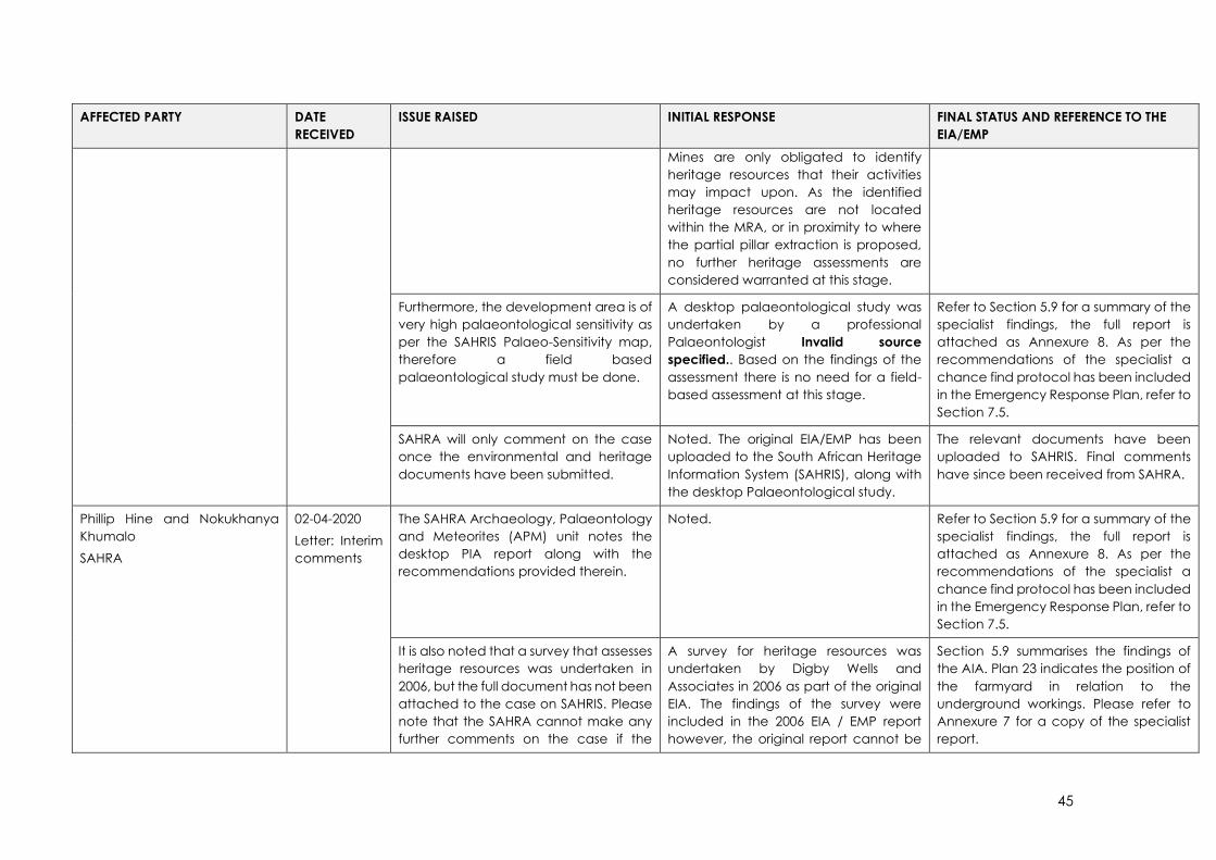
45
AFFECTED PARTY DATE
RECEIVED
ISSUE RAISED INITIAL RESPONSE FINAL STATUS AND REFERENCE TO THE
EIA/EMP
Mines are only obligated to identify
heritage resources that their activities
may impact upon. As the identified
heritage resources are not located
within the MRA, or in proximity to where
the partial pillar extraction is proposed,
no further heritage assessments are
considered warranted at this stage.
Furthermore, the development area is of
very high palaeontological sensitivity as
per the SAHRIS Palaeo-Sensitivity map,
therefore a field based
palaeontological study must be done.
A desktop palaeontological study was
undertaken by a professional
Palaeontologist Invalid source
specified.. Based on the findings of the
assessment there is no need for a field-
based assessment at this stage.
Refer to Section 5.9 for a summary of the
specialist findings, the full report is
attached as Annexure 8. As per the
recommendations of the specialist a
chance find protocol has been included
in the Emergency Response Plan, refer to
Section 7.5.
SAHRA will only comment on the case
once the environmental and heritage
documents have been submitted.
Noted. The original EIA/EMP has been
uploaded to the South African Heritage
Information System (SAHRIS), along with
the desktop Palaeontological study.
The relevant documents have been
uploaded to SAHRIS. Final comments
have since been received from SAHRA.
Phillip Hine and Nokukhanya
Khumalo
SAHRA
02-04-2020
Letter: Interim
comments
The SAHRA Archaeology, Palaeontology
and Meteorites (APM) unit notes the
desktop PIA report along with the
recommendations provided therein.
Noted. Refer to Section 5.9 for a summary of the
specialist findings, the full report is
attached as Annexure 8. As per the
recommendations of the specialist a
chance find protocol has been included
in the Emergency Response Plan, refer to
Section 7.5.
It is also noted that a survey that assesses
heritage resources was undertaken in
2006, but the full document has not been
attached to the case on SAHRIS. Please
note that the SAHRA cannot make any
further comments on the case if the
A survey for heritage resources was
undertaken by Digby Wells and
Associates in 2006 as part of the original
EIA. The findings of the survey were
included in the 2006 EIA / EMP report
however, the original report cannot be
Section 5.9 summarises the findings of
the AIA. Plan 23 indicates the position of
the farmyard in relation to the
underground workings. Please refer to
Annexure 7 for a copy of the specialist
report.

46
AFFECTED PARTY DATE
RECEIVED
ISSUE RAISED INITIAL RESPONSE FINAL STATUS AND REFERENCE TO THE
EIA/EMP
original heritage assessment document
is not submitted to the case. It should
also be noted that SAHRA only considers
recent heritage impact assessment's or
within the last 5 years. An addendum or
a letter of exemption must accompany
the 2006 report
The heritage impact assessment
document and a letter of exemption
must be submitted to the case on
SAHRIS before further comments can be
made.
located. As such, and in response to your
comments, Professor A.C.van
Vollenhoven of Archaetnos Culture and
Cultural Resources Consultants was
contracted to undertake a AIA with
regards to the Amendment application.
The findings of the AIA indicate that no
graves occur within the MRA, one farm
yard older than sixty years was identified.
It is noted that the cultural significance
of the farm yard is Low with a field rating
of Local Grade IIIC, in addition the farm
yard falls outside the area earmarked for
pillar extraction.
Mr.W.A.de Klerk
Farm Boschmanskop
13-05-2020
Currently rents the surface of Portion 6,
10(RE) and 14(RE) from Tumelo. Asked
whether he would be offered first right of
refusal to purchase the properties on
closure, and requested contact details
for the correct contact person in this
regard.
Contact details for Mr.R.Karstel of
Tumelo were forwarded via e-mail.
No change.
Phillip Hine and Nokukhanya
Khumalo
SAHRA
19-05-2020
Letter: Final
comments
The SAHRA APM unit has no objections to
the proposed development.
The recommendations of the specialists
are supported and must be adhered to.
Additional further specific conditions are
provided for the development as
follows:
• The draft Amendment Report
must be revised to include the
results of the 2020 AIA;
Noted. Section 5.9 summarises the findings of
the AIA. Plan 23 indicates the position of
the farmyard in relation to the
underground workings. It is noted that
the farmyard will not be mined, and thus
no permit applications are necessary at
this stage.

47
AFFECTED PARTY DATE
RECEIVED
ISSUE RAISED INITIAL RESPONSE FINAL STATUS AND REFERENCE TO THE
EIA/EMP
• If it is not possible to avoid the
identified historical structures,
and these resources are older
than 60 years but younger than
100, permits in terms of section
34(1) of the NHRA; and Chapter
II and III of the NHRA regulations
must be applied for from the
Mpumalanga Provincial
Heritage Authority (MPHRA).
If any evidence of archaeological sites
or remains (e.g. remnants of stone-made
structures, indigenous ceramics, bones,
stone artefacts, ostrich eggshell
fragments, charcoal and ash
concentrations), fossils or other
categories of heritage resources are
found during the proposed
development, SAHRA APM Unit
(Nokukhanya Khumalo/Phillip Hine 021
202 8654) must be alerted as per section
35(3) of the NHRA.
Non-compliance with section of the
NHRA is an offense in terms of section
51(1)e of the NHRA and item 5 of the
Schedule.
See section 51 of the NHRA for details on
Offences and Penalties.
Noted. A chance find protocol has been
included in the Emergency Response
Plan, refer to Section 7.5.
This has been updated to include the
contact details for SAHRA’s APM unit.
If unmarked human burials are
uncovered, the SAHRA Burial Grounds
and Graves Unit (Thingahangwi
Tshivhase/Mimi Seetelo 012 320 8490),
Noted. A chance find protocol has been
included in the Emergency Response
Plan, refer to Section 7.5.
48
AFFECTED PARTY DATE
RECEIVED
ISSUE RAISED INITIAL RESPONSE FINAL STATUS AND REFERENCE TO THE
EIA/EMP
must be alerted immediately as per
section 36(6) of the NHRA. Non-
compliance with section of the NHRA is
an offense in terms of section 51(1)e of
the NHRA and item 5 of the Schedule.
This has been updated to include the
contact details for SAHRA’s Burial
Grounds and Graves unit.
The following conditions apply with
regards to the appointment of
specialists:
• If heritage resources are
uncovered during the course of
the development, a
professional archaeologist or
palaeontologist, depending on
the nature of the finds, must be
contracted as soon as possible
to inspect the heritage
resource.
• If the newly discovered heritage
resources prove to be of
archaeological or
palaeontological significance,
a Phase 2 rescue operation may
be required subject to permits
issued by SAHRA.
Noted. A chance find protocol has been
included in the Emergency Response
Plan, refer to Section 7.5.
The revised Amendment Report must be
submitted to SAHRA for record purposes.
Noted. A copy of the final Report, as submitted
to DMR, will be uploaded to SAHRIS for
record purposes.
The decision regarding the EA
Application must be communicated to
SAHRA and uploaded to the SAHRIS
Case application.
Noted. As per the requirements of NEMA and
the EIA Regulations, 2014 (as amended)
all registered I&APs will be notified of the
RoD (see Section 4.4).
49
5. ENVIRONMENTAL ATTRIBUTES
Just as a project is associated with certain impacts on the environment where it is undertaken,
the existing environment can also influence a development in terms of design, location,
technology and layout. It is therefore important to define the environmental baseline
conditions (status quo) of the project area.
The information presented in this section was extracted from the relevant specialist reports,
and the approved EMP (Digby Wells and Associates, 2006) completed for the operations and
is referenced where possible.
5.1. Climate and Meteorology
Tumelo Colliery is located in the Eastern Plateau Highveld climate zone of the Mpumalanga
Province. The region generally experiences a sub-tropical climate with warm, rainy summers
and cold winters. The mean annual precipitation (MAP) for the project area is +700mm and
annual evaporation is 1,552mm/a (A-Pan) (Letsolo Environmental and Water Services, 2020).
Average monthly temperatures range from 8.4 – 20.2 ⁰C, with the highest temperatures
observed over spring and summer (September – February). Minimum temperatures are
observed during winter (July). Relative humidity is lowest during the spring and summer months
(Rayten Environmental and Engineering Consultants, 2020).
The predominant wind directions at Tumelo Colliery, as observed from January 2016 to
December 2018, are from the east (~12% of the time), east-north-east (~11% of the time) and
north-west (~10.3% of the time). Wind speeds for the three-year period were generally
moderate to fast with calm conditions, defined as wind speeds less than 1 m/s, observed for
10.25% of the time (Rayten Environmental and Engineering Consultants, 2020).
The morning (AM) and evening (PM) period wind rose plots, for the period January 2016 to
December 2018, show diurnal variation in the wind field data. During the morning (AM) period,
high frequency winds are observed from the east, east-north-east and north-north-west; as
opposed to the evening (PM) period, where winds are predominantly observed from the north-
west, east and east-north-east. During summer, prevailing east-north-easterly and easterly
winds are observed. In autumn, stronger easterly winds occur. During winter, easterly winds
continue to be observed, with prevailing winds originating from the easterly, east-south-
easterly and north-westerly directions. In spring, strong winds are observed from the north-
westerly directions. Wind speeds were generally higher during the winter and spring seasons
(Rayten Environmental and Engineering Consultants, 2020).

50
Figure 10: Rainfall and Evaporation Data (Letsolo Environmental and Water Services, 2020)5
Figure 11: Temperature and Relative Humidity (Rayten Environmental and Engineering
Consultants, 2020)
5 The DWS rainfall station used is B1E003 and the SAWB rainfall station used is 0479369 (Hendrina). Data
dating back from May 1979 and ending on May 2019 was used.
0
20
40
60
80
100
120
140
160
180
200
JAN FEB MAR APR MAY JUN JUL AUG SEP OCT NOV DEC
Rainfall & Evaporation 1979 - 2018
Rainfall (mm) Evaporation (mm)
51
January 2016 – December 2018
2016
2017
2018
Figure 12: Period Wind Rose Plot, January 2016 to December 2019 (Rayten Environmental and
Engineering Consultants, 2020)

52
Morning (AM) (00:00 – 12:00)
Evening
(PM) (12:00 – 23:00)
Figure 13: Morning (AM) (00:00 - 12:00) and Evening (PM) (12:00 - 23:00) Period Wind Rose Plots
for January 2016 - December 2018 (Rayten Environmental and Engineering Consultants, 2020)
Summer
Autumn
Winter
Spring
Figure 14: Seasonal Variation of Winds for the Period January 2016 - December 2018 (Rayten
Environmental and Engineering Consultants, 2020)

53
5.2. Geology, Physiography and Topography
The topography in the MRA ranges from 1,605 metres above mean sea level (mamsl) on the
western border, to 1,650 mamsl on the south-eastern border (Shangoni Aquiscience, 2020).
Based on the surface contours in Plan 7 below, Tumelo is located on a slight North-South water
divide, and flow which will follow the contours perpendicularly from high to low, will be towards
the Boschmanskop Dam and the drainage lines located to the immediate west and east of
the MRA (Shangoni Aquiscience, 2020).
The surrounding landscape is associated with other surface water features such as wetlands
and pans (Scientific Aquatic Services, 2019). Several man-made features are also of
significance, the most obvious being the ash disposal dams associated with the Hendrina
Power Station, immediately west of the MRA.
The site is underlain by rocks of the Vryheid Formation, belonging to the Ecca Group of the
lower Karoo Supergroup. This comprises mainly of a sedimentary succession of sandstone,
siltstone, shale, mudstone, coal, diamictite and tillite (Shangoni Aquiscience, 2020).
The MRA is situated in the north eastern extremity of the Highveld Coal field separated by the
pre-Karoo Smithfield ridge from the Witbank Coal field to the north (Metallurgical Resources
Consulting, 2019). At places, sediments of the Vryheid Formation overlie the uneven Dwyka
floor, which is controlled by the topography of the pre-Karoo platform upon which the Karoo
sediments were deposited (Shangoni Aquiscience, 2020). The Vryheid Formation, which is
present throughout the Witbank area, attains some 140 m at the thickest point and contains
five major coal seams, named from bottom upwards, namely:
• No. 1, No. 2, No. 3, No. 4 and No. 5. Seam splitting occurs of three of the seams due to
breaks in the plant formation process.
o No. 2 Seam may be split into the No. 2 Lower Seam and the No. 2 Upper Seam,
o No. 4 Seam into the No. 4 Lower Seam, No. 4 Upper Seam and the No. 4A Seam.
o No. 5 Seam into the No. 5 Lower Seam and the No. 5 Seam.
o The thickest and most consistent coals are contained in the No. 2 and No. 4
Seam zones. The No. 1 Seam is restricted to the palaeo-valley. The No. 3 seam
is not laterally consistent. The No. 5 seam is only present in topographically high
areas; elsewhere it has been removed by erosion.
Of the seams mentioned above, the No. 4 Lower and No. 2 Lower seams have been identified
as being potentially economically viable (Metallurgical Resources Consulting, 2019). However,
currently only the No. 2 seam is targeted.
The No. 2 Seam ranges in thickness from 0.45m to 5.31m, developed mainly in the palaeo-
valley. A uniform seam, the No. 2 is either thin or absent over the adjacent palaeo-ridges
(Metallurgical Resources Consulting, 2019). As a result, the thickest development of coal is
found along the flanks of the poloidally, that trends approximately north–south across the
eastern side of the property. The thinnest coals are associated with the palaeo- ridge found
along the western side of the property (Digby Wells, 2006 cited by Shangoni Aquiscience,
2020). Abundant dolerite intrusions are present in the Ecca sediments. These intrusions resulted
in the displacement of the seams and the devolatilisation (“burning”) of extensive areas of
coal (Metallurgical Resources Consulting, 2019).

54
Plan 7: Regional Topography and Drainage (Shangoni Aquiscience, 2020)
55
5.3. Soils, Land Use and Land Capability
The MRA falls within the Bb4 land type. Bb4 land type comprises of plinthic soils (with subsurface
accumulation of iron and manganese oxides due to fluctuating water table) with low to
intermediate base status. It is expected that the dominant soils will be of the Avalon and Ruston
forms.
A baseline assessment was completed for the MRA in 2006 (Digby Wells and Associates, 2006)
prior to commencement of the construction phase. The soils were augered on a 200m x 200m
grid, to a depth of 1.2m or shallower if a limiting layer was encountered. A total of 88 holes
were augered and positioned using a handheld GPS (Digby Wells and Associates, 2006).
Four soil forms were identified and mapped within the MRA namely Hutton, Clovelly, Avalon
and Longlands (Plan 9). Avalon soil forms were dominant, making up 84% of the soils in the
study area (Digby Wells and Associates, 2006). The soils are described below:
Table 9: Description of Soils (Digby Wells and Associates, 2006)
SOIL FORM DESCRIPTION AGRICULTURAL POTENTIAL
PROPERTIES IRRIGATION DRYLAND
Hutton
(Hu)
Reddish brown sandy
loam with gradually
increasing clay to red
sandy clay loam with
fairly frequent iron
nodules to 850mm.
Very
permeable,
deep soil with
no restricting
layers <850mm
Moderately
High
High (arable)
Clovelly
(Cv)
A brown sandy loam
overlies a yellowish
brown sandy clay loam.
Excellent
dryland
cropping soils.
Moderately
High
High (arable)
Avalon
(Av)
Dark brown sandy loam
overlies yellows brown
sandy clay loam
becoming mottled
reddish orange at about
600mm and very
frequent iron nodules at
800mm.
Under moist
climatic
conditions has
good potential,
however can
be fairly wet.
Moderately
High
Fairly Good
(arable)
Longlands
(Lo)
Dark greyish brown
sandy loam overlies
brown sandy loam
leached layer overlying
mottled reddish/orange
layer with high clay at
650mm.
Seasonally wet
soils.
Low Low
(wetland/grazing)

56
The majority of the pre-mining land capability was regarded as arable land (66%), with
remaining area identified as grazing land (34%), refer to Plan 10. The pre-mining land capability
to a large degree reflected the pre-mining land use, being grazing and maize cultivation
(Digby Wells and Associates, 2006).
The land use immediately surrounding Tumelo Colliery consists predominantly of grassland and
cultivated land to the east, west and south. Surface activities associated with the mining
operations are concentrated towards the north-west and north of the MRA (Rayten
Environmental and Engineering Consultants, 2020).
Hendrina Power Station is located approximately 3km north-west of Tumelo Colliery. Pullens
Hope is the nearest urban residential area to Tumelo Colliery and is located approximately
5km north-west of the MRA. The area surrounding Tumelo Colliery is classified as rural in nature,
with few informal residential areas located near the site (Rayten Environmental and
Engineering Consultants, 2020).
Plan 8: Surrounding Land Use (Rayten Environmental and Engineering Consultants, 2020)

57
Plan 9: Soil Types (as per the approved EMP)
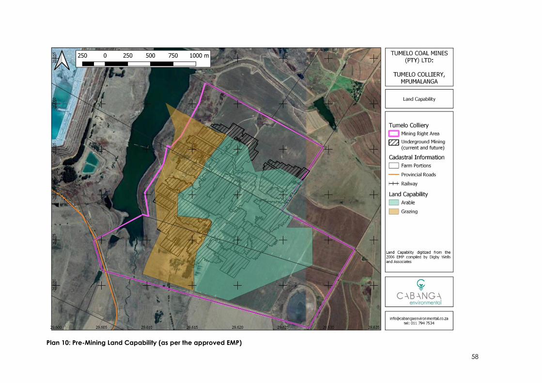
58
Plan 10: Pre-Mining Land Capability (as per the approved EMP)

59
5.4. Hydrology (Surface water)
The MRA falls within quaternary catchment B12B in the Olifants Water Management Area 2
(WMA 2). Several river systems drain the catchment area, the most prominent being the Klein-
Olifants River, Woes-Alleenspruit and Rietkuilspruit. In the immediate vicinity of the study area,
two smaller drainage systems, East Woes-Alleenspruit and an unnamed tributary, are located
to the immediate east and west of the mine (Shangoni Aquiscience, 2020). Refer to Plan 11.
The East Woes-Alleenspruit River flows in an easterly direction and discharges into the
Boschmaskop Dam which is located north-west of the mine infrastructure area (Letsolo
Environmental and Water Services, 2020). This dam was constructed to divert clean water from
a neighbouring opencast operation. Another dam, situated on a neighbouring mine’s
property, is in the valley of the western river and forms the boundary on that side of the MRA.
Along the south eastern boundary there is a steep drop into a basin containing a pan with an
endorheic drainage system (Shangoni Aquiscience, 2020).
Plan 11: MRA in relation to the B12B Quaternary Catchment (Shangoni Aquiscience, 2020)
Site specific catchments were delineated to provide site specific storm water management
measures for the project, these were delineated based on hydrological characteristics and
flood calculation methods (Letsolo Environmental and Water Services, 2020). Table 10 below
summarises the peak flow and flood volumes for these catchment areas, (as depicted in Plan
12 and Plan 13).

60
Table 10: Summary flood (peak flows and flood volume) calculations (Letsolo Environmental
and Water Services, 2020)
Description 1:50 Volume 1:100 Volume
Clean Catchment 1 1,047 1,288
Clean Catchment 2 172 212
Overburden Stockpile 31 38
Ancillary Area 176 217
Decline Shaft 93 115
Plant and ROM 108 133
1,714 2,110
Plan 12: Clean water catchments (Letsolo Environmental and Water Services, 2020)
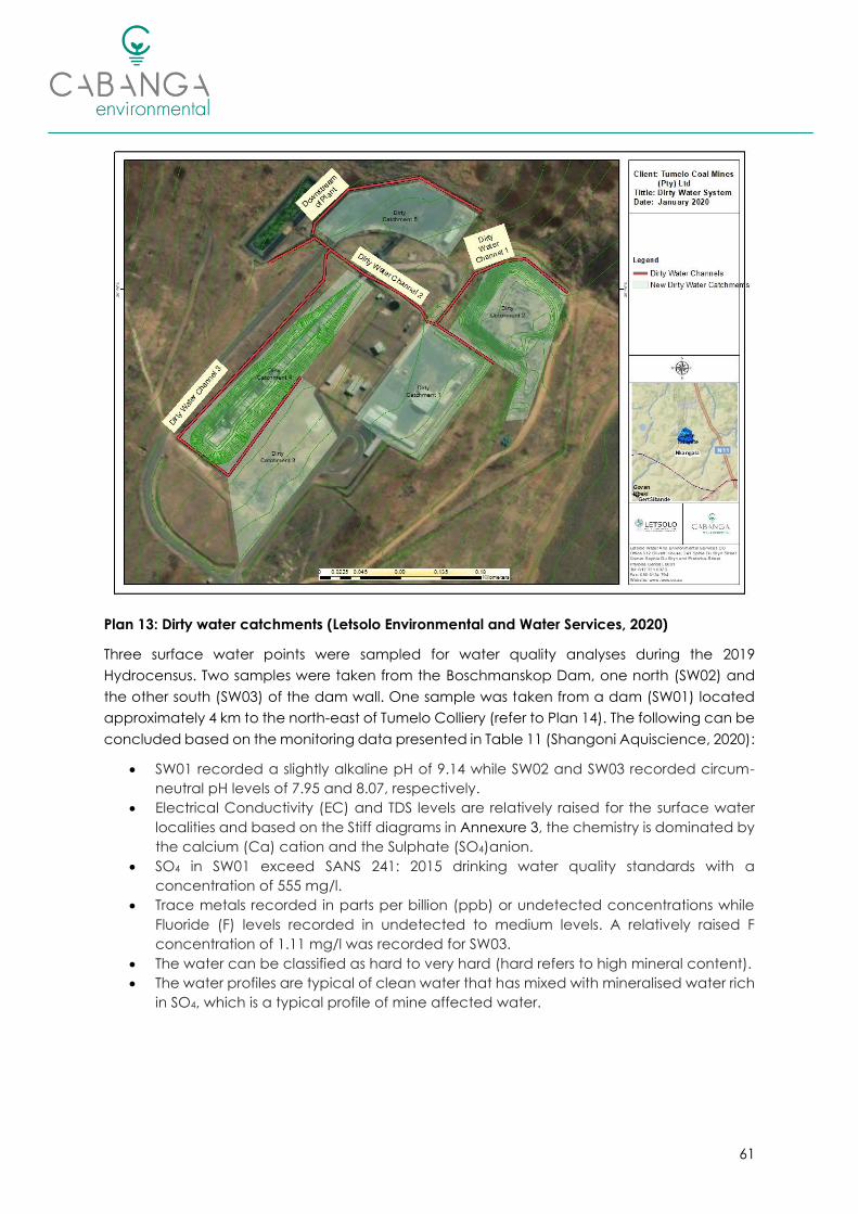
61
Plan 13: Dirty water catchments (Letsolo Environmental and Water Services, 2020)
Three surface water points were sampled for water quality analyses during the 2019
Hydrocensus. Two samples were taken from the Boschmanskop Dam, one north (SW02) and
the other south (SW03) of the dam wall. One sample was taken from a dam (SW01) located
approximately 4 km to the north-east of Tumelo Colliery (refer to Plan 14). The following can be
concluded based on the monitoring data presented in Table 11 (Shangoni Aquiscience, 2020):
• SW01 recorded a slightly alkaline pH of 9.14 while SW02 and SW03 recorded circum-
neutral pH levels of 7.95 and 8.07, respectively.
• Electrical Conductivity (EC) and TDS levels are relatively raised for the surface water
localities and based on the Stiff diagrams in Annexure 3, the chemistry is dominated by
the calcium (Ca) cation and the Sulphate (SO4)anion.
• SO4 in SW01 exceed SANS 241: 2015 drinking water quality standards with a
concentration of 555 mg/l.
• Trace metals recorded in parts per billion (ppb) or undetected concentrations while
Fluoride (F) levels recorded in undetected to medium levels. A relatively raised F
concentration of 1.11 mg/l was recorded for SW03.
• The water can be classified as hard to very hard (hard refers to high mineral content).
• The water profiles are typical of clean water that has mixed with mineralised water rich
in SO4, which is a typical profile of mine affected water.

62
Table 11: Water quality of surface water surveyed on 23 October 2019 (Shangoni Aquiscience,
2020)
LOCALITY / GUIDELINE UNIT SANS 241:2015 SW01 SW02 SW03
PARAMETER
pH - ≥ 5 and ≤ 9.7 9.14 7.95 8.07
EC mS/m ≤ 170 123 81.7 123
TDS mg/l ≤ 1200 838 530 762
Calcium (Ca) mg/l - 75.4 45.6 75.0
Magnesium (Mg) mg/l - 82.6 39.1 78.4
Sodium (Na) mg/l ≤ 200 54.7 56.5 57.7
Potassium (K) mg/l - 13.1 14.9 12.5
Alkalinity mg/l - 54.6 78.8 110
Chloride (Cl) mg/l ≤ 300 24.5 46.1 45.6
Sulphate (SO4) mg/l ≤ 500 555 280 426
Nitrate as N (NO3-N) mg/l ≤ 11 <0.35 <0.35 <0.35
Ammonium as N (NH4-N) mg/l ≤ 1.5 <0.45 <0.45 <0.45
Phosphate as P (PO4) mg/l - <0.03 <0.03 <0.03
Fluoride (F) mg/l ≤ 1.5 <0.09 0.47 1.11
Aluminium (Al) mg/l ≤ 0.30 <0.01 <0.01 <0.01
Iron (Fe) mg/l ≤ 2 0.01 <0.01 0.01
Manganese (Mn) mg/l ≤ 0.4 <0.01 0.02 <0.01
Chromium (Cr) mg/l ≤ 0.05 <0.01 <0.01 <0.01
Copper (Cu) mg/l ≤ 2.0 <0.01 <0.01 <0.01
Nickel (Ni) mg/l ≤ 0.07 <0.01 <0.01 <0.01
Zinc (Zn) mg/l ≤ 5.0 <0.01 <0.01 <0.01
Total Hardness mg CaCO3/l - 528 275 510
Floodline modelling was undertaken as part of the surface water impact assessment
(attached as Annexure 4), where it was determined that the existing mine infrastructure falls
outside of the 1:100-year floodline.
The infrastructure area in relation to the delineated floodline is shown in Plan 15 overleaf.

63
Plan 14: Surface water monitoring points surveyed on 23 October 2019
Plan 15: Mine Infrastructure in relation to the 1:100 year floodline (Letsolo Environmental and
Water Services, 2020)

64
5.5. Geohydrology (Groundwater)
A geohydrological assessment was completed by Shangoni Aquiscience (2020), the full report
is attached as Annexure 3 .
According to the 1:25,000 hydrogeological map (DHSWS Hydrogeological map series 2426
Johannesburg) the study area is predominantly located in a d2 aquifer class region. The
groundwater yield potential is classed as low, on the basis that most of the boreholes on record
in vicinity of the study area produce between 0.1 and 0.5 l/s (Shangoni Aquiscience, 2020).
Three aquifers were identified in the study area, and include:
1. Perched aquifer, mostly associated within wetlands;
2. Weathered aquifer; and
3. Fractured aquifer.
Mining of the coal seams has also resulted in the creation of an artificial aquifer system in the
underground workings (Shangoni Aquiscience, 2020).
Groundwater flow directions largely correlate with surface flow, and tends to follow relatively
similar gradients and flow patterns compared to surface topography. Groundwater flow is
largely towards the major drainage systems and the Boschmanskop Dam. Groundwater leaves
the aquifer as discharge contributing to flow within the bases of these systems (groundwater
contribution baseflow) (Shangoni Aquiscience, 2020).
Ferricrete underlies the study area at certain places and acts as a confining aquiclude or
aquitard that separates the weathered aquifer from the fractured aquifer resulting in
piezometric heads to form, some of which may be artesian. A dolerite sill ranging in thickness
from 5 to 13 m underlies the study area. The sill is generally confined to specific horizons and
will also act as a largely impermeable barrier for groundwater movement (Shangoni
Aquiscience, 2020).
A good correlation of 0.99 was achieved between static hydraulic heads and surface
elevation. Groundwater elevations therefore mimic surface topography. Nineteen (19)
boreholes and three (3) dams were surveyed during the field hydrocensus. The results of the
hydrocensus show that the measured depth to groundwater level ranges between 2.70 and
45.53 metres below surface (mbs). Hydraulic head elevations range between 1,540 and 1,634
mamsl. Of the boreholes recorded, the majority are used for farming purposes i.e. livestock
watering (Shangoni Aquiscience, 2020).
During the 2019 hydrocensus, samples were taken from nine groundwater points. The following
can be concluded based on the monitoring data presented in Table 12 (Shangoni
Aquiscience, 2020):
• A circum-neutral pH to slightly alkaline levels and non-saline groundwater were
measured.
• EC and TDS are in the low ranges and mineralisation of major cations and anions are
also low, although Ca is relatively raised in H-BH7 to H-BH10 and Na in HB-H01, H-BH02
H-BH03, HBH05 and HBH06. These slightly raised levels are geology related and/or
difference in borehole depths and remain well within domestic guidelines.
• Nutrients, including nitrate (NO3), ammonium (NH4) and phosphate (PO4) are low to
undetected and well within relevant use guidelines.

65
• A relatively raised iron (Fe) concentration of 0.53 mg/l was recorded for HBH01 but is
well within health-based domestic guidelines. It is not uncommon for Fe to be slightly
raised in groundwater due to reducing or low oxygen levels. All other trace metals
recorded in low to undetected levels.
A water monitoring programme, consisting of surface and groundwater quality, is currently
implemented at Tumelo Colliery. Monthly surface and quarterly groundwater monitoring are
conducted by Aquatico Scientific (Pty) Ltd. Groundwater monitoring data for June 2019 was
reviewed and is displayed in Table 13. Based on the data, the following can be concluded
(Shangoni Aquiscience, 2020):
• The pH levels are circum-neutral but substantial salinity (TDS & EC) variances exist. TDS
range between 150 and 639 mg/l and EC between 19 and 84 mS/m. The greatest
salinity was recorded for TC01, a monitoring borehole located downstream from the
PCD (referenced as BMKSW06 in the Aquatico monitoring reports), while a relatively
similar salinity concentration was recorded for DS3.
• Based on the Stiff diagrams and the Expanded Durov diagram in Annexure 3, both TC01
and DS3 are typical of affected groundwater displaying Ca-SO4 and Ca (Na)-SO4
water types, respectively.
• Nitrate (NO3) is raised in borehole BMKGW03 (deep borehole adjacent to pan) with a
concentration of 9.33 mg N/l.
• DS04 recorded relatively high Sodium (Na) concentrations. The profile is typical of
groundwater that has been in contact with a source rich in Na or old stagnant NaCl
dominated water that resides in Na rich host rock/material.
• All other groundwater profiles are typical of fresh, recently recharged water that has
undergone Mg or Na ion exchange.
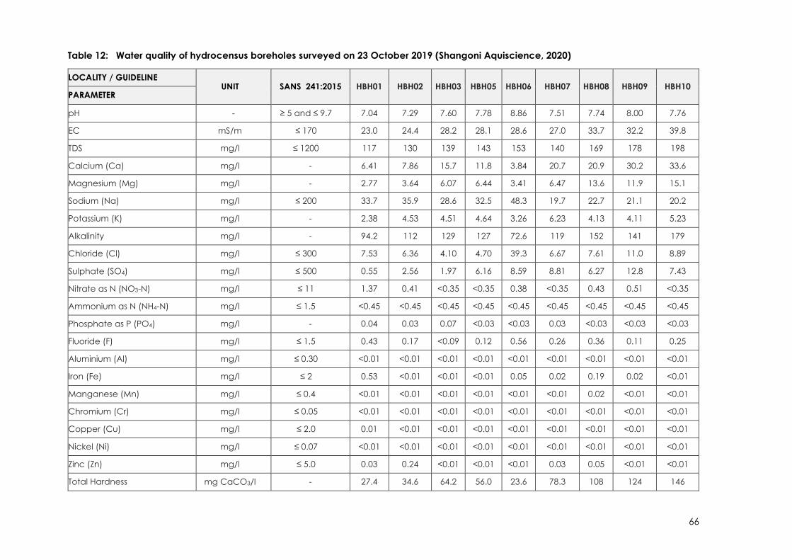
66
Table 12: Water quality of hydrocensus boreholes surveyed on 23 October 2019 (Shangoni Aquiscience, 2020)
LOCALITY / GUIDELINE UNIT SANS 241:2015 HBH01 HBH02 HBH03 HBH05 HBH06 HBH07 HBH08 HBH09 HBH10
PARAMETER
pH - ≥ 5 and ≤ 9.7 7.04 7.29 7.60 7.78 8.86 7.51 7.74 8.00 7.76
EC mS/m ≤ 170 23.0 24.4 28.2 28.1 28.6 27.0 33.7 32.2 39.8
TDS mg/l ≤ 1200 117 130 139 143 153 140 169 178 198
Calcium (Ca) mg/l - 6.41 7.86 15.7 11.8 3.84 20.7 20.9 30.2 33.6
Magnesium (Mg) mg/l - 2.77 3.64 6.07 6.44 3.41 6.47 13.6 11.9 15.1
Sodium (Na) mg/l ≤ 200 33.7 35.9 28.6 32.5 48.3 19.7 22.7 21.1 20.2
Potassium (K) mg/l - 2.38 4.53 4.51 4.64 3.26 6.23 4.13 4.11 5.23
Alkalinity mg/l - 94.2 112 129 127 72.6 119 152 141 179
Chloride (Cl) mg/l ≤ 300 7.53 6.36 4.10 4.70 39.3 6.67 7.61 11.0 8.89
Sulphate (SO4) mg/l ≤ 500 0.55 2.56 1.97 6.16 8.59 8.81 6.27 12.8 7.43
Nitrate as N (NO3-N) mg/l ≤ 11 1.37 0.41 <0.35 <0.35 0.38 <0.35 0.43 0.51 <0.35
Ammonium as N (NH4-N) mg/l ≤ 1.5 <0.45 <0.45 <0.45 <0.45 <0.45 <0.45 <0.45 <0.45 <0.45
Phosphate as P (PO4) mg/l - 0.04 0.03 0.07 <0.03 <0.03 0.03 <0.03 <0.03 <0.03
Fluoride (F) mg/l ≤ 1.5 0.43 0.17 <0.09 0.12 0.56 0.26 0.36 0.11 0.25
Aluminium (Al) mg/l ≤ 0.30 <0.01 <0.01 <0.01 <0.01 <0.01 <0.01 <0.01 <0.01 <0.01
Iron (Fe) mg/l ≤ 2 0.53 <0.01 <0.01 <0.01 0.05 0.02 0.19 0.02 <0.01
Manganese (Mn) mg/l ≤ 0.4 <0.01 <0.01 <0.01 <0.01 <0.01 <0.01 0.02 <0.01 <0.01
Chromium (Cr) mg/l ≤ 0.05 <0.01 <0.01 <0.01 <0.01 <0.01 <0.01 <0.01 <0.01 <0.01
Copper (Cu) mg/l ≤ 2.0 0.01 <0.01 <0.01 <0.01 <0.01 <0.01 <0.01 <0.01 <0.01
Nickel (Ni) mg/l ≤ 0.07 <0.01 <0.01 <0.01 <0.01 <0.01 <0.01 <0.01 <0.01 <0.01
Zinc (Zn) mg/l ≤ 5.0 0.03 0.24 <0.01 <0.01 <0.01 0.03 0.05 <0.01 <0.01
Total Hardness mg CaCO3/l - 27.4 34.6 64.2 56.0 23.6 78.3 108 124 146

67
Plan 16: Hydrocensus boreholes as surveyed on 23 October 2019

68
Table 13: Water quality of groundwater monitoring boreholes (June 2019)
LOCALITY / GUIDELINE UNIT SANS 241:2015 BKMGW3 BMKGW04 DS1 DS3 DS4 DS5 DS6 TC01
PARAMETER
pH - ≥ 5 and ≤ 9.7 7.34 8.35 8.33 7.78 8.09 8.45 8.5 8.27
EC mS/m ≤ 170 19 20.6 40.2 70.6 36.6 51.2 35 84.4
TDS mg/l ≤ 1200 150 191 294 507 277 371 248 639
Calcium (Ca) mg/l - 6.96 16.9 22.8 35.1 11.1 38.7 31.7 105
Magnesium (Mg) mg/l - 6.02 7.84 14.1 45.9 10.7 20.4 15.2 50.6
Sodium (Na) mg/l ≤ 200 8.88 13.6 52.2 59.9 46.2 47.2 26.2 28.9
Potassium (K) mg/l - 4.14 7.3 5.47 6.82 4.71 5.43 5.88 7.05
Alkalinity mg/l - 20.6 111 208 59.4 70.2 161 148 113
Chloride (Cl) mg/l ≤ 300 7.28 3.41 12.6 17.6 41.5 28.2 21.6 17.8
Sulphate (SO4) mg/l ≤ 500 5.94 3.46 28.7 294 45 97.5 23.5 346
Nitrate as N (NO3-N) mg/l ≤ 11 9.33 0.21 0.097 0.21 4.87 0.407 0.325 0.248
Ammonium as N (NH4-N) mg/l ≤ 1.5 0.76 0.20 <0.03 0.04 0.031 0.031 0.028 0.028
Phosphate as P (PO4) mg/l - 0.11 <0.003 <0.003 <0.003 <0.003 <0.003 0.006 <0.003
Fluoride (F) mg/l ≤ 1.5 0.13 0.53 0.27 0.13 0.60 0.33 0.48 0.56
Aluminium (Al) mg/l ≤ 0.30 0.022 <0.001 <0.001 <0.001 0.015 <0.001 <0.001 <0.001
Iron (Fe) mg/l ≤ 2 0.054 <0.002 <0.002 <0.002 <0.002 <0.002 <0.002 <0.002
Manganese (Mn) mg/l ≤ 0.4 0.02 0.116 0.006 0.015 <0.001 <0.001 <0.001 <0.001
Total Hardness mg CaCO3/l - 42 74 115 277 72 180 142 472
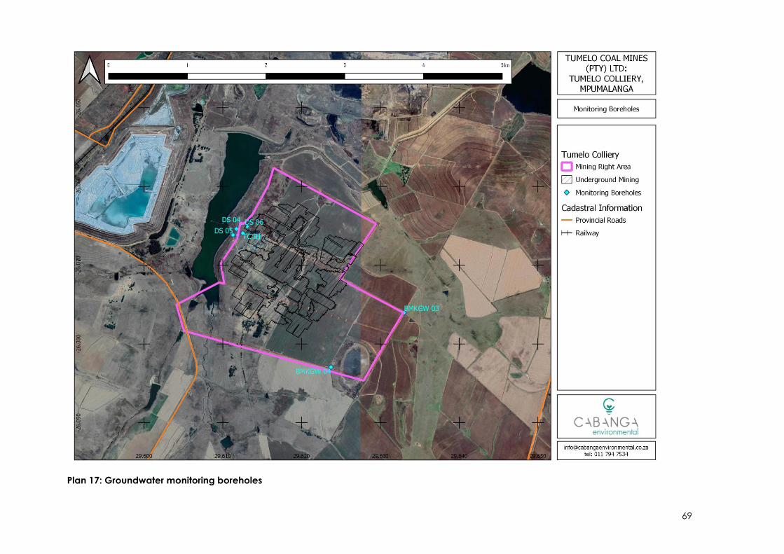
69
Plan 17: Groundwater monitoring boreholes

70
5.6. Terrestrial Ecology
The MRA is located within the Eastern Highveld Grassland national vegetation (Mucina and
Rutherford, 2006) of the Mesic Highveld Grassland Bioregion. The Eastern Highveld Grassland is
listed as Vulnerable on the National list of threatened ecosystems for South Africa and is
characterised by slightly to moderately undulating plains consisting of low hills and pan
depressions with scattered rocky outcrops (SANBI & DEAT, 2009).
Plan 18: Vegetation Type
According to the Mpumalanga Biodiversity Sector Plan (MBSP) the MRA consists largely of
heavily or moderately modified areas due to cultivation, and the existing mining operations.
As depicted in Plan 19 below, a portion of the MRA has been declared Critical Biodiversity
Area (CBA 2 Optimal) (terrestrial).
There are no formally protected areas in the immediate vicinity of Tumelo Colliery. The closest
protected area is the Heyns Private Nature Reserve, located approximately 23km north-west
of the operations.
According to the Mining and Biodiversity Guidelines Database the western portion of the MRA
is considered of Highest and Moderate Biodiversity Importance, while the majority of the MRA
is currently not ranked (Scientific Aquatic Services, 2019). Correlation is evident between the
highest biodiversity importance area and those demarcated as CBAs. No underground mining
or surface infrastructure activities are proposed in this area (refer to Plan 19 and Plan 20).

71
Plan 19: Terrestrial Critical Biodiversity Areas
Plan 20: National Mining and Biodiversity Guidelines

72
According to the approved EMP report (Digby Wells and Associates, 2006) the natural
vegetation in the MRA had largely been altered due to cultivation activities prior to the
commencement of the mining operations. Vegetation in the old cultivated lands consisted
mainly of weeds and annual forb species, dominated by Hpyarrhenia hirta, Hyparrhenia
tamba and Cynodon dactylon. Species such as Eragrostis gummiflua, Eragrostis cuvula and
Eragrostis plana were also prominent. The destruction of the natural vegetation and habitat
within the cultivated lands had in turn led to a decrease in available habitat for fauna. Only a
few mammals, birds, insects and butterflies were recorded during previous surveys. Please refer
to the original EMP for a detailed list of species identified during previous surveys (Digby Wells
and Associates, 2006).
Although no Species of Conservation Concern (SCC) were specifically identified during the
fauna and floral surveys completed by Digby Wells and Associates or on subsequent site visits;
the observation of an individual of Eulophia ovalis var. ovalis and Eucomis sp. indicates that
other unique floral species, including potential SCC, may be present within the overall MRA.
The depression wetland located to the east of the MRA may also provide suitable habitat for
protected fauna species such as the Pyxicephalus adspersus (Giant Bullfrog) (Scientific
Aquatic Services, 2019).
As there will be no change to the infrastructure area, and the proposed pillar extraction will be
limited to areas under cultivation no additional specialist studies were deemed necessary at
this time.
5.7. Freshwater Ecology
A freshwater resource assessment for the project was undertaken by Scientific Aquatic
Services, 2019 (Annexure 5). The freshwater resource assessment used a 500m “zone of
investigation” around the MRA to assess possible sensitivities of the receiving environment, the
results of which are briefly discussed below.
The MRA is located within a sub-WMA currently not considered important in terms of fish or
freshwater resource conservation.
Wetlands are defined in the NWA (Act 36 of 1998) as “land which is transitional between
terrestrial and aquatic systems where the water table is usually at or near the surface, or the
land is periodically covered with shallow water, and which land in normal circumstances
supports or would support vegetation typically adapted to life in saturated soil”.
“Watercourse” is defined in the Act as any river or spring, any natural channel in which water
flows regularly or intermittently, a wetland, lake or dam into which or from which water flows
and any other collection of water declared by the Minister to be a watercourse.
The National Freshwater Ecosystems Priority Areas (NFEPA) Project was a collaboration
between the Council for Scientific and Industrial Research (CSIR), South African National
Biodiversity (SANBI), the Water Research Commission (WRC), DHSWS and Department of
Environmental Affairs (DEA) and many other role-players and attempted to map the
freshwater ecosystem priority areas, including rivers and wetlands, throughout South Africa.
According to the NFEPA database, there are three natural unchanneled valley bottom
wetlands; one artificial unchanneled valley bottom wetland; one natural depression wetland;
and one artificial channelled valley bottom wetland situated within the MRA. The

73
aforementioned wetlands are classified as moderately modified (Class C) or heavily to
critically modified (Class Z1 – Z3) according to the NFEPA Database. None of the wetlands
associated with the MRA are classified as FEPA Wetlands. The field assessment however verified
that two of the ‘natural’ valley bottom wetlands indicated by NFEPA are areas of disturbance,
whilst one is a hillslope seep area associated with the valley bottom wetland identified on the
western boundary of the MRA (Scientific Aquatic Services, 2019).
Two wetland systems were groundtruthed and delineated within the MRA specifically, a
channelled valley bottom (CVB) wetland partially within and adjacent to the western
boundary of the MRA, and a depression wetland in the south-eastern corner of the MRA (Plan
21). The CVB wetland is deemed ‘largely modified’ whilst the depression wetland is considered
‘largely natural’, Table 14 below summarises the results of the field assessment (Scientific
Aquatic Services, 2019). Please refer to Annexure 5 for the detailed investigation.
Table 14: Summary of results of the field assessment
WETLAND PES6 ECOSERVICES EIS7 REC / RMO / BAS8
Channelled valley
bottom
D Intermediate Moderate D / C / C
Depression B Moderately low Moderate B / B / B
Plan 21: Wetland Delineation (Scientific Aquatic Services, 2019)
6 PES = Present Ecological Status 7 EIS = Environmental Importance and Sensitivity 8 REC = Recommended Ecological Category / RMO = Resource Management Objective / Best
Attainable State

74
The northern area of the existing mine infrastructure, specifically the overburden stockpile, coal
stockpile area, PCD and crusher and screening plant, encroaches marginally on the 100m
regulated zone in terms of GN704 as it relates to the NWA (Scientific Aquatic Services, 2019).
5.8. Air Quality and Noise
The MRA falls within the Highveld Air Quality Priority Area (HPA). Existing key sources of air
pollutants surrounding Tumelo Colliery include (Rayten Environmental and Engineering
Consultants, 2020):
• Neighbouring mining activities (north and north-west of the MRA);
• Vehicle dust entrainment on unpaved roads (surrounding areas);
• Commercial agricultural activities (surrounding areas); and
• Industrial activity, including the Hendrina and Komati coal fired power stations, and
associated activities (ash dams).
Air quality monitoring data was obtained from the South African Air Quality Information System
(SAAQIS) to determine background concentrations for PM10 and PM2.5 in the area. The closest
air quality monitoring station is located at the Kwazamokuhle High School in Hendrina (~14km
south-east of the MRA). Data for PM10 and PM2.5 concentrations was available for the period
01 February 2018 to 17 October 2019, based on this data the daily average PM10
concentrations ranged 1-111 μg/m3 and PM2.5 concentrations ranged 0-47 μg/m3. Several
exceedances (>4) of the South African National Standards for PM10 and PM2.5 daily
concentrations were recorded; which suggests that background ambient particulate matter
concentrations are relatively high in the area. This is however expected due to the existing
emission sources in the area, such as the Hendrina Power Station, coal mining activities, vehicle
dust entrainment on unpaved roads and commercial agricultural activities (Rayten
Environmental and Engineering Consultants, 2020).
Dust fallout monitoring is currently undertaken by Tumelo at four sites located within the MRA,
refer to Plan 22 overleaf. Based on available monitoring data (January 2018 to September
2019) dust fallout ranged between 52.60 – 1,751.00 mg/m2/day (Figure 15) compared to the
National Dust Control Regulations, 2013 (as amended) for non-residential sites of 1,200
mg/m2/day (Rayten Environmental and Engineering Consultants, 2020).
A total of two exceedances of the dust fallout limits are permissible in a year (not two
sequential months). In August 2018, the dust-fall rates at sites BMK 1 and BMK 2 exceeded the
non-residential limit of 1200 mg/m2/day, thus a total of two exceedances were recorded in
2018 but these occurred at two different dust bucket sites. For the period January – September
2019, there was one exceedance at site BMK 2 in August 2019 and two exceedances at site
BMK 4 which occurred over two sequential months (July – August 2019). Therefore, the dust-fall
rates at Tumelo Colliery are in non-compliance with the National Dust Control Regulations for
the period January 2019 – September 2019, specifically at site BMK 4 which is located south-
east of the boxcut (Rayten Environmental and Engineering Consultants, 2020). It is noted that
this dust bucket is adjacent to a farm road and agricultural field and thus dust fallout results
may also be influenced by agricultural activities in the area.

75
Plan 22: Dust Monitoring Points
Figure 15: Dust Fallout Results (January 2018 – September 2019) (Rayten Environmental and
Engineering Consultants, 2020)9
9 Site BMK1 was moved to a new location in July 2019. The co-ordinates for the previous location are 26o
04’ 41.2’’ S; 29 o 36’ 45.8’’ E. The dust fallout results at BMK1 for January 2018 to June 2018 are for the
previous location.

76
According to Digby Wells and Associates (2006) baseline ambient noise levels were well the
below the day and night time Rating Levels for Rural Districts, as stipulated by the South African
Bureau of Standards (SANS 10103). The main source of noise emanating from Tumelo Colliery
is associated with the existing crusher and screener; the proposed change in mine plan to
include partial pillar extraction is not expected to result in an increase in the ambient noise
levels.
Noise levels on site are currently managed in terms of the Occupational Health and Safety
Act. Considering the distance between Tumelo Colliery and surrounding land owners and
occupants, regular ambient noise monitoring is not considered necessary at this stage, though
the mine must maintain a complaints register and investigate any noise-related complaints.
5.9. Sites of Archaeological and Cultural Significance
According to the approved EMP (Digby Wells and Associates, 2006) a site survey was
undertaken on 29 October 2002. The survey indicated that no archaeological artefacts or
cultural sites were identified in the vicinity of the boxcut decline or infrastructure area. Two sets
of graves (twenty graves in total) were however identified at a neighbouring property, the
Spies family farmstead, located west of the Boschmanskop Dam (Digby Wells and Associates,
2006).
Following comments received from the SAHRA during the review period an AIA was
undertaken in April 2020 for the proposed project changes to include partial pillar extraction
(Annexure 7). The AIA identified one cultural heritage site, an old farmyard, within the MRA.
The farm yard is approximately 404m x 346m in size and contains several structures associated
with farming including two farmhouses. The one farmhouse is modern in design 31m x 40m,
and the other older house is 32m x 11m in size. The core of the older farmhouse could be older
than 60 years however modern alterations have been done. The cultural significance of the
site is Low and has a field rating of Local Grade IIIC (Archaetnos Culture and Cultural Resources
Consultants , 2020). Plan 23 depicts the position of the farmyard in relation to the underground
workings.
No graves were identified within the MRA.
The South African Heritage Resources Information System (SAHRIS) palaeo-sensitivity Map
(https://sahris.sahra.org.za/map/palaeo) identified areas of Insignificant and Very High
sensitivity within the MRA. As such, a desktop palaeontological impact assessment (PIA) was
completed as part of the feasibility assessment for the mining of the No. 4 seam and No. 2
seam partial pillar extraction (Annexure 7).
The findings of the PIA concluded that there is a small chance that fossil plants may be found
in the shales and mudstone associated with the coal seams. Their occurrence in the Vryheid
Formation (Ecca Group) is however sporadic and unpredictable. Fossil vertebrates are unlikely
to occur (Bamford, 2019).

77
Plan 23: Cultural Heritage Sites
5.10. Socio-Cultural Environment
Steve Tshwete Local Municipality (STLM) is located in the Nkangala District Municipality of the
Mpumalanga Province. The municipal area covers approximately 3,993 km2 and includes the
towns of Middelburg, Mhluzi, Hendrina, Kwazamokuhle, Rietkuil, Pullens Hope, Komati,
Presidentsrus, Naledi, Lesedi, Kranspoort, Blinkpan, Koornfontein, Kwamakalane, and
Doornkop (https://www.stevetshwetelm.gov.za/index.html).
Manufacturing, mining, finance, energy generation and agriculture are the main drivers of the
economy in the STLM. These industries generate mass employment in the rural areas,
specifically within the mining and manufacturing industries (i.e. steel and metal) (Steve
Tshwete Local Municipality, 2019/2020).
The Community Survey 2016 from Statistics South Africa indicated that the population for STLM
was 278,750. Of which 52,41% were male and 47,59% were female; this gender distribution
may be attributed to the prevalent economic activities in the area, being mining,
manufacturing and agriculture (MTS Holdings (Pty) Ltd, 2019).
There are approximately 64 971 households in the STLM, with an average household size of 3,3
persons per household. 29,4% of households are headed by females
(http://www.statssa.gov.za/?page_id=993&id=steve-tshwete-municipality). Of the households
59.7% have access to piped water in their dwelling, and a further 21.01% have access to piped
water in their yard. Basic services infrastructure appears to be somewhat formalised with

78
almost 82% of households within the STLM having access to flushable toilets, either connected
to a public sewage or septic tank (MTS Holdings (Pty) Ltd, 2019).
On average, less than 30% of the population in the Mpumalanga have completed primary
education and a mere 5,61% are cited to have higher qualifications (post-Grade 12) in the
whole province. Overall statistics at a district and local level reflect poor educational profiles
indicating similar trends as the Province. However, a significant percentage of the population
in Pullens Hope and Hendrina have completed some secondary education as well as attained
Grade 12 qualifications. The employment profile of the population in Pullens Hope and
Hendrina complements the education profile with employment levels of 44,76% and 36,98%,
respectively (MTS Holdings (Pty) Ltd, 2019).
5.11. Environmental Sensitivity Map
Plan 24 below summarises the environmental sensitive areas in relation to the underground
mine workings, proposed pillar extraction and surface infrastructure area.
Plan 24: Overall Environmental Sensitivity Map
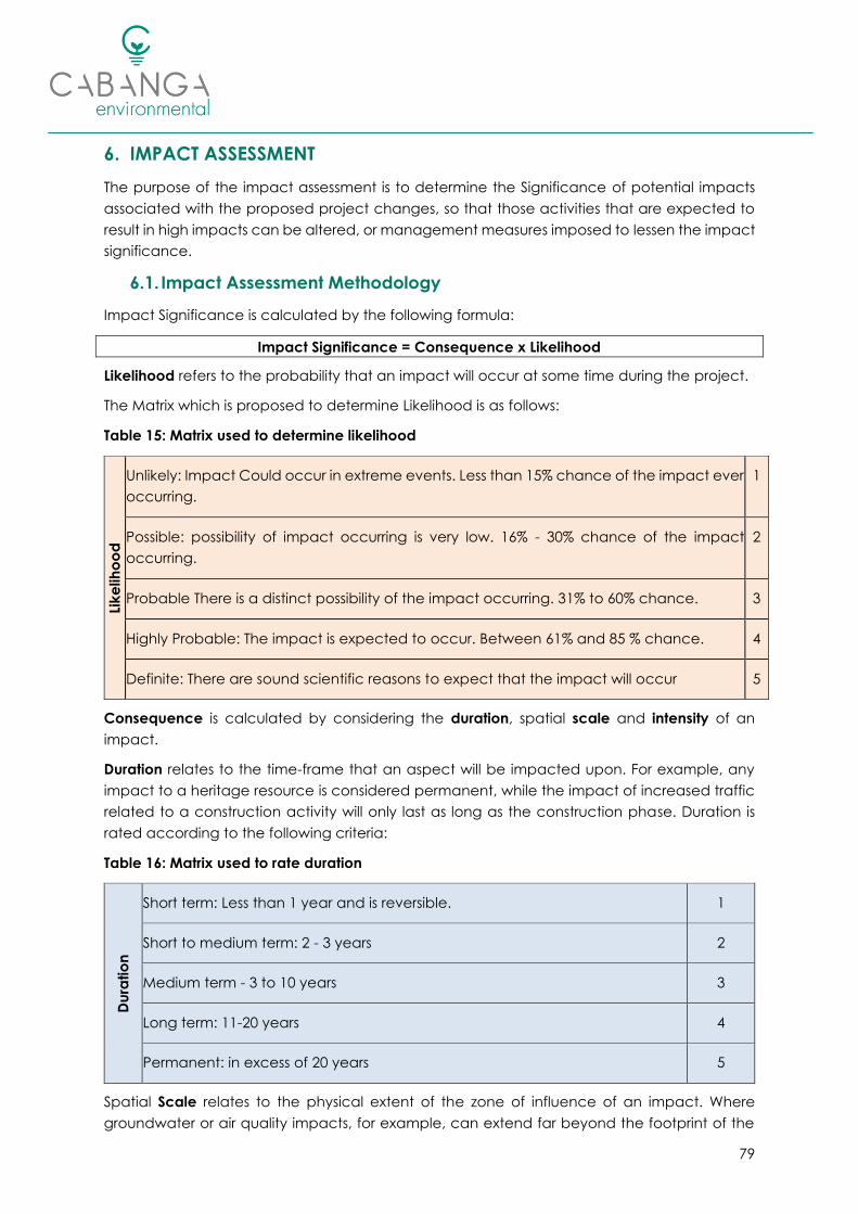
79
6. IMPACT ASSESSMENT
The purpose of the impact assessment is to determine the Significance of potential impacts
associated with the proposed project changes, so that those activities that are expected to
result in high impacts can be altered, or management measures imposed to lessen the impact
significance.
6.1. Impact Assessment Methodology
Impact Significance is calculated by the following formula:
Impact Significance = Consequence x Likelihood
Likelihood refers to the probability that an impact will occur at some time during the project.
The Matrix which is proposed to determine Likelihood is as follows:
Table 15: Matrix used to determine likelihood
Lik
elih
oo
d
Unlikely: Impact Could occur in extreme events. Less than 15% chance of the impact ever
occurring.
1
Possible: possibility of impact occurring is very low. 16% - 30% chance of the impact
occurring.
2
Probable There is a distinct possibility of the impact occurring. 31% to 60% chance. 3
Highly Probable: The impact is expected to occur. Between 61% and 85 % chance. 4
Definite: There are sound scientific reasons to expect that the impact will occur 5
Consequence is calculated by considering the duration, spatial scale and intensity of an
impact.
Duration relates to the time-frame that an aspect will be impacted upon. For example, any
impact to a heritage resource is considered permanent, while the impact of increased traffic
related to a construction activity will only last as long as the construction phase. Duration is
rated according to the following criteria:
Table 16: Matrix used to rate duration
Du
ratio
n
Short term: Less than 1 year and is reversible. 1
Short to medium term: 2 - 3 years 2
Medium term - 3 to 10 years 3
Long term: 11-20 years 4
Permanent: in excess of 20 years 5
Spatial Scale relates to the physical extent of the zone of influence of an impact. Where
groundwater or air quality impacts, for example, can extend far beyond the footprint of the

80
activity, it is not expected that the impact of vegetation removal should extend beyond the
footprint of the activity. Scale is rated according to Table 17:
Table 17: Matrix used to rate scale
Sc
ale
/ E
xte
nt
Isolated: Limited footprint within the site will be affected (less than 50% of the
site) 1
Site Specific: The Entire Site will be affected 2
Local: Will affect the site and surrounding areas 3
Regional: Will affect the entire region / catchment / province 4
National: Will affect the country, and possibly beyond the borders of the
country 5
The Intensity of an impact is calculated by considering the severity of the impact (how it will
change the aspect, will it be destroyed completely, or altered slightly?) and the sensitivity of
the aspect (is the aspect sensitive to change, and is the aspect important to ecosystem
processes or social dynamics?). For example, if the impact is anticipated to completely
destroy a local plant population, but the plant population is commonly found and protected
in nearby surroundings, the over-all intensity is lowered. If, however, the plant population in
question is unique or protected, the intensity increases proportionately.
The Matrix which is proposed to determine Intensity is as follows:
Table 18: Matrix used to rate Intensity
Inte
nsi
ty
2
Not
significant
Ma
gn
itu
de
Slight: Little effect, negligible disturbance / benefit 1
Slight to Moderate: Effects are observable but natural process
continue
2
3 Slight
Moderate: ecosystem processes / social dynamics are permanently
altered, but functioning.
3
4 Slight -
Moderate
Moderate - High: natural / social processes are altered to the point
where function is limited
4
5 Moderate
High: The aspect is affected so that its functioning is compromised
and this effect is irreversible
5
6
Moderate -
High
Se
nsi
tivity
The aspect is not sensitive to change (No irreplaceable loss of
resource)
1
7 High The aspect is of not of significant value but is sensitive to change 2
8 Very High
The affected aspect is of moderate value and is slightly resilient to
change
3

81
9
Extremely
High
The affected aspect is of significant value and only slightly resilient to
change
4
10 Fatal Flaw
The affected aspect is valued, irreplaceable and sensitive to
change. Irreplaceable loss of significant resource
5
Therefore, considering the formula:
Significance = Consequence x Likelihood
Where Consequence = Duration + Scale + Intensity
And Intensity = Severity of the Impact + Sensitivity of the Aspect
The over-all Significance rating can be calculated as a value between 4 and 100. The score is
then categorised as follows:
• 4 to 19 = Insignificant Impact, no mitigation is required beyond standard best practice;
• From 20 to 39 = Low Impact, specific mitigation should be included in the EMP and
monitoring should be undertaken;
• From 40 to 59 = Moderate Impact, specific mitigation with strict monitoring is required;
• From 60 to 79 = High Impact, mitigation should consider alteration of the design or
process to reduce the impact significance;
• >Higher than 80 (100 max) = The Impact is so Significant that the project design must
be reconsidered to avoid the impact.
Impacts will be rated as per the abovementioned methodology without consideration of
mitigation measures first, however there may be some mitigation already inherent in the design
of the Project.
Those impacts that are rated as having a moderate impact or above will be investigated
further and management measures identified to attempt to reduce the Consequence or
Likelihood of the impact. These impacts will then be rated again, while considering the
mitigation measures that have been imposed.
6.2. Impact Identification
Environmental and Social Impacts which may result from the project and the proposed
change in mine plan, to include partial pillar extraction, have been identified in Table 19. These
were identified from the approved EMP (Digby Wells and Associates, 2006) and subsequent
specialist studies completed for the mining operation.
It should be noted that since existing boxcut adit will be utilized and no further construction of
supporting infrastructure is required, activities and aspects relating to a construction phase
were not assessed. Each of the key impacts resulting from the proposed project activities are
discussed in the sections that follow.

82
Table 19: Impact Identification
Activity Aspect Description of Impact Phase
Continued mining of the underground
workings, with partial pillar extraction on retreat. Geology Alteration of geological nature and sequence. Operational
Continued mining of the underground
workings, with partial pillar extraction on retreat. Groundwater
Potential contamination plume of groundwater.
Coal surfaces exposed to the atmosphere within
underground workings can potentially generate
acid mine drainage (AMD).
All Phases
Continued mining of the underground
workings, with partial pillar extraction on retreat.
Topography
Soils
Surface water
Groundwater
Sub-surface cracking, subsidence, roof collapse
and sinkhole formation. Subsidence of surface
layers will also alter surface water flow dynamics
and possible ponding.
All Phases
Continued mining of the underground
workings, with partial pillar extraction on retreat. Social
Although the project is not expected to result in
any new job opportunities, the extended LoM will
result in the continued employment of mine
personnel.
Operational
Continued mining of the underground
workings, with partial pillar extraction on retreat. Social
Influx of unsuccessful job seekers which may
informally settle in area. Operational

83
Activity Aspect Description of Impact Phase
Dewatering of the underground workings for
the safe continuation of mining. Groundwater
During the operational phase the mining will be
active, this will require dewatering of the deep
aquifer(s). This could result in a cone of
depression and a decline in water levels with a
potential loss in resource for groundwater users.
Water level impacts are however, expected to
be localised and restricted to the site. No
privately owned boreholes were identified as
sensitive receptors as they are not overlying the
underground mining activities and are not
located within the predicted cone of depression.
Operational
Dewatering of the underground workings for
the safe continuation of mining. Wetlands
Potential creation of a cone of depression, which
may drain water from the adjacent CVB
wetland, thus resulting in desiccation of the
wetland. Water entering the underground
mining area as a result of ingress into
underground mine workings may necessitate
dewatering of the underground mining area,
which may result in the discharge of dirty water
into the adjacent wetland environment.
Operational
Stockpiling Activities (all material stockpiles) Groundwater
Seepages from the overburden and
RoM/product stockpiles could be highly
mineralised with mostly sulphate.
Operational
Stockpiling Activities (all material stockpiles)
Soils
Surface water
Biodiversity
Wetlands
Erosion via wind and water leading to
sedimentation and pollution of downstream
water resources.
Operational
Decommissioning

84
Activity Aspect Description of Impact Phase
Operation and maintenance of the existing
stormwater management system associated
with the existing mining activities.
Groundwater
Surface water
Potential for poor quality water impacting on
groundwater and/or surface water and
wetlands if pipelines or dams/trenches burst, spill
or leak. Due to the close proximity of the
Boschmanskop Dam, pollution incidents may
directly result in the deterioration of water quality.
Operational
Operation and maintenance of the existing
stormwater management system associated
with the existing mining activities.
Surface water
Wetlands
Reduction in Catchment yield due to
containment of dirty water on site, ponding,
infiltration and evaporation.
Operational
Operation and maintenance of the existing
stormwater management system associated
with the existing mining activities.
Soils
Surface water
Increased runoff volumes and velocity and
associated potential erosion and silt-loading of
drainage lines and downstream water bodies
and wetlands. The site is already established.
However, the clean water diversion channels
and culverts still pose a risk for erosion. Culvert
outlets can directly impact on sediment
transport. Loose particles are erodible. Stockpile
areas can also contribute to erosion.
Operational
Continued operation of mine surface
infrastructure.
Soils
Surface water
Groundwater
Impacts on water quality due to potential
hydrocarbon and other chemical spills.
Operational
Decommissioning
Continued operation of mine surface
infrastructure.
Wetlands
Biodiversity
Spread and/or establishment of alien invasive
plant species and resultant impacts on
surrounding natural vegetation.
All Phases

85
Activity Aspect Description of Impact Phase
Continued operation of mine surface
infrastructure.
Wetlands
Biodiversity
Potential leaks, discharges and pollutants from
mining activities leaching into the surrounding
environment.
Operational
Continued operation of mine surface
infrastructure. Biodiversity
Continued displacement and fragmentation of
the faunal community (including threatened
species) due to ongoing anthropogenic
disturbances (noise, dust and vibrations) and
habitat degradation (litter, road mortalities
and/or poaching).
Operational
Decommissioning
Continued operation of mine surface
infrastructure. Operation of machinery and
vehicle movement.
Soils Compaction and alteration of soil characteristics Operational
Decommissioning
Continued operation of mine surface
infrastructure. Operation of machinery and
vehicle movement.
Cultural Loss of and disturbance to archaeological /
heritage sites / fossils Operational
Continued operation of mine surface
infrastructure. Stockpiling activities. Visual
The plant and stockpile area may be visible to
neighbouring land users. Operational
Continued operation of mine surface
infrastructure. Operation of machinery and
vehicle movement. Crushing and screening
plant.
Noise Increased ambient noise levels. Operational
Decommissioning
Operation of machinery and vehicle
movement. Air Quality Gaseous emissions from machinery and vehicles. Operational
Decommissioning

86
Activity Aspect Description of Impact Phase
Operation of machinery and vehicle
movement.
Soils
Surface water
Groundwater
Wetlands
Potential hydrocarbon contamination as a result
of leaks / spills. All Phases
Crushing and screening, wind erosion on
exposed areas, material handling, loading and
offloading, and vehicle movement. Air Quality Dust generation and particulate matter.
Operational
Decommissioning
Hauling of coal. Traffic Deterioration of road conditions. Operational
Provision of Services: Abstraction of water Surface water
Groundwater Irresponsible use of water and waste of water. Operational
Domestic and industrial waste generation,
handling and disposal.
Surface water
Groundwater
Soil
Potential contamination through littering and/or
incorrect waste disposal. All Phases
Domestic and industrial waste generation,
handling and disposal. Visual Odours and visual impacts. All Phases
Decommissioning and Closure of the Mine and
associated infrastructure. Social Loss of job opportunities. Decommissioning
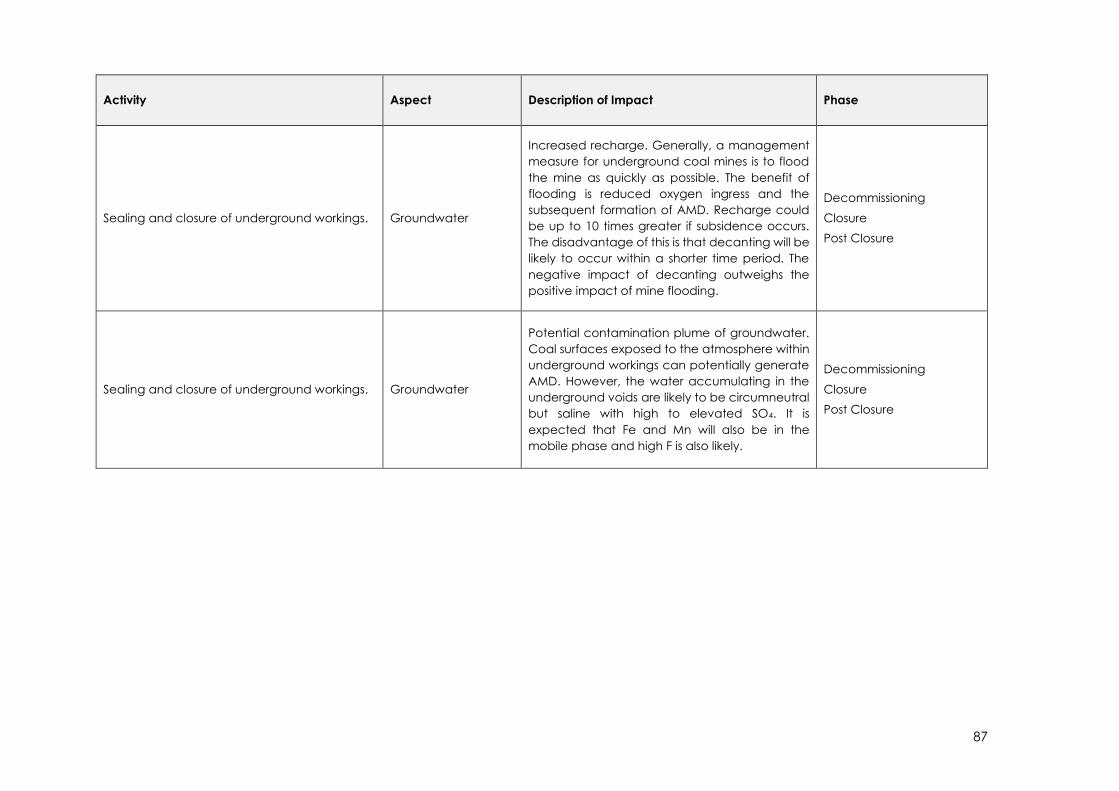
87
Activity Aspect Description of Impact Phase
Sealing and closure of underground workings. Groundwater
Increased recharge. Generally, a management
measure for underground coal mines is to flood
the mine as quickly as possible. The benefit of
flooding is reduced oxygen ingress and the
subsequent formation of AMD. Recharge could
be up to 10 times greater if subsidence occurs.
The disadvantage of this is that decanting will be
likely to occur within a shorter time period. The
negative impact of decanting outweighs the
positive impact of mine flooding.
Decommissioning
Closure
Post Closure
Sealing and closure of underground workings. Groundwater
Potential contamination plume of groundwater.
Coal surfaces exposed to the atmosphere within
underground workings can potentially generate
AMD. However, the water accumulating in the
underground voids are likely to be circumneutral
but saline with high to elevated SO4. It is
expected that Fe and Mn will also be in the
mobile phase and high F is also likely.
Decommissioning
Closure
Post Closure

88
Activity Aspect Description of Impact Phase
Sealing and closure of underground workings. Surface water
Wetlands
Decant is expected for Tumelo Colliery after
approximately 40 years post-operation. Although
the risk of acid formation is low, the decant water
quality is expected to contain high total
dissolved salts, with SO4 the greatest contributor,
as well as Ca, F and Mn and possibly other metals
such as As, B and Fe in solution. Likely decant
points are the incline shaft, the ring dyke structure
west of the Boschmanskop Dam as well as cracks
or fractures created by subsidence at an
elevation of approximately 1610 mamsl. The
decant quality will likely be unacceptable for
release to the environment until the contrary can
be confirmed through
measurement. Subsequent negative impacts on
biota and vegetation; altered flow regimes
(increased hydroperiod); and habitat
degradation.
Post Closure
Backfilling of boxcut adit, removal of surface
infrastructure and overall rehabilitation. Visual Improved aesthetics.
Decommissioning
Closure
Backfilling of boxcut adit, removal of surface
infrastructure and overall rehabilitation.
Topography
Soils
Surface water
Eradication of stockpiles and replacement of
material, profiling and restoration of free
drainage.
Decommissioning
Closure
Backfilling of boxcut adit, removal of surface
infrastructure and overall rehabilitation.
Soils
Land Capability
Biodiversity
Soil replacement, amelioration and seeding.
Vegetative cover and plant community
succession. Influx of animals to the area once
vegetation re-establishes.
Decommissioning
Closure

89
6.2.1. Geology Physiography and Topography
The approved EMP (Digby Wells and Associates, 2006) states that the impact on geology is “an
acceptable, definite, negative, permanent, local severe impact, with a moderate
significance”, however, if the impact assessment methodology is applied, it is clear that the
Impact Significance is high (the impact will definitely occur, is permanent and comprises the
majority of the site, and will affect the geology to the point where it is permanently changed).
The very nature of mining projects will inevitably result in altered geology. Despite the impact
rating as high, there is no mitigation for this impact as it is an inherent effect of mining. The
cumulative effect is of moderate to high significance, as coal reserves in South Africa are
diminishing and are non-renewable.
When coal, rock and minerals are removed from an underground mine, the overlying earth
can sink, i.e. subsidence can occur. The extent of mine subsidence depends on the mining
method, local geology, depth of mining and amount of material extracted.
All of the panels mined in the past at Tumelo Colliery have been designed for primary
extraction with maximum extraction on advance, however due to the variability of the No. 2
Seam as well as the frequency of the dolerite intrusions within the reserve limit, optimal
extraction on the advance has been extremely difficult which has resulted in larger than ideal
pillars, from a reserve optimisation perspective. This in turn has resulted in a higher than required
Safety Factor, and the potential for pillar extraction in a checkerboard layout in these areas
(G-Ro Geotechnical Services). In future mine areas, where mining has not yet commenced,
the pillars will be designed to allow for pillar extraction on retreat (Geomech Consulting (Pty)
Ltd, 2019).
Pillar failure and/or roof failure may occur in some areas as mining progresses, and in other
areas pillars could fail over time. In the short to medium term it is unlikely that subsidence will
occur, due to the bridging effect of the massive sandstone layers in the overburden, however
in the long term this sandstone beam may fail resulting in surface subsidence. Sinkhole
formation is also deemed possible but unlikely (G-Ro Geotechnical Services).
Should surface subsidence occur this will create fractures and cracks that will not only increase
recharge into the underground workings, but also increase the risk of decant due to the
creation of preferential flow paths linking the deeper fractured aquifer to surface. Additional
consequences resulting from surface subsidence are disturbances of the flow drivers into the
wetlands and loss of post-closure land uses. The impact significance related to subsidence and
the formation of sinkholes is therefore rated as high (Shangoni Aquiscience, 2020).
The topography of the surrounding area is constantly changing due to the increase of mining
and industrial activities. Should subsidence occur, this will permanently change the
topographical nature of the affected area. According to the 2013 Geotechnical Investigation
(G-Ro Geotechnical Services) should surface subsidence occur this is expected to fall into
either a Class C or Class D Subsidence Class:
• Class C can be described as: “Noticeable in flat terrain, smooth, cracks 2 – 10cm wide,
compression ridges 1 – 5 cm high’’

90
• Class D can be described as: “Noticeable in most terrain, visible vertical displacements
across cracks, cracks 10 – 50cm wide, compression ridges 5 – 50cm high”.
The various possible Subsidence Classes, as well as the Surface Profile, which they can be
expected to be associated with are indicated in Figure 16. The cumulative impact is therefore
considered to be of Moderate significance, as the area can be rehabilitated to ensure the
area blends into the natural environment and to ensure that storm water flow is re-established
from the subsided area and returned to the catchment.
Figure 16: Examples of the various Subsidence Classes (G-Ro Geotechnical Services)
6.2.2. Soils, Land Use and Land Capability
The mine is already established, existing infrastructure will continue to be utilised and no new
surface areas will be disturbed. Soil stripped during the construction phase in 2008 has been
used to construct diversion berms around the mine property, these are vegetated and thus
the possibility of erosion occurring has been minimised. However, the probability of erosion
occurring during decommissioning and closure phase is highly probable.
The main impact associated with checkerboard pillar extraction, and possible subsidence, will
be associated with the change in surface water flow dynamics and potential ponding which
may result in the potential creation of new wetlands and/or the disruption of existing wetlands.
This will change soil forms and their location in the landscape.
The soils and land capability in the area have been affected by several activities including
power generation, mining and agricultural activities such as the ploughing of lands for crops.
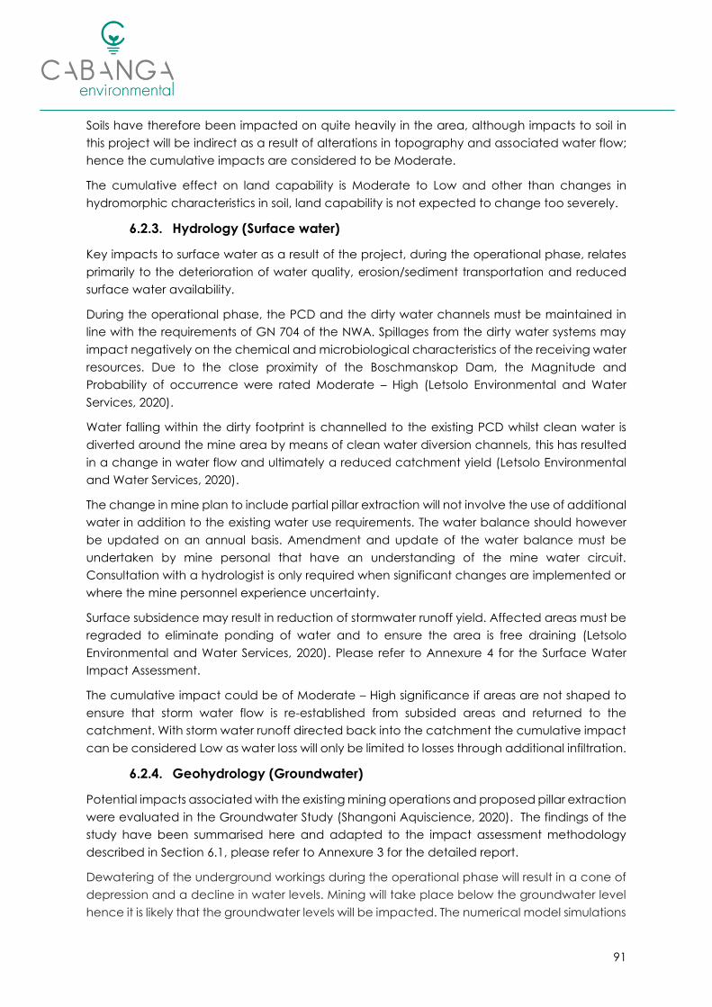
91
Soils have therefore been impacted on quite heavily in the area, although impacts to soil in
this project will be indirect as a result of alterations in topography and associated water flow;
hence the cumulative impacts are considered to be Moderate.
The cumulative effect on land capability is Moderate to Low and other than changes in
hydromorphic characteristics in soil, land capability is not expected to change too severely.
6.2.3. Hydrology (Surface water)
Key impacts to surface water as a result of the project, during the operational phase, relates
primarily to the deterioration of water quality, erosion/sediment transportation and reduced
surface water availability.
During the operational phase, the PCD and the dirty water channels must be maintained in
line with the requirements of GN 704 of the NWA. Spillages from the dirty water systems may
impact negatively on the chemical and microbiological characteristics of the receiving water
resources. Due to the close proximity of the Boschmanskop Dam, the Magnitude and
Probability of occurrence were rated Moderate – High (Letsolo Environmental and Water
Services, 2020).
Water falling within the dirty footprint is channelled to the existing PCD whilst clean water is
diverted around the mine area by means of clean water diversion channels, this has resulted
in a change in water flow and ultimately a reduced catchment yield (Letsolo Environmental
and Water Services, 2020).
The change in mine plan to include partial pillar extraction will not involve the use of additional
water in addition to the existing water use requirements. The water balance should however
be updated on an annual basis. Amendment and update of the water balance must be
undertaken by mine personal that have an understanding of the mine water circuit.
Consultation with a hydrologist is only required when significant changes are implemented or
where the mine personnel experience uncertainty.
Surface subsidence may result in reduction of stormwater runoff yield. Affected areas must be
regraded to eliminate ponding of water and to ensure the area is free draining (Letsolo
Environmental and Water Services, 2020). Please refer to Annexure 4 for the Surface Water
Impact Assessment.
The cumulative impact could be of Moderate – High significance if areas are not shaped to
ensure that storm water flow is re-established from subsided areas and returned to the
catchment. With storm water runoff directed back into the catchment the cumulative impact
can be considered Low as water loss will only be limited to losses through additional infiltration.
6.2.4. Geohydrology (Groundwater)
Potential impacts associated with the existing mining operations and proposed pillar extraction
were evaluated in the Groundwater Study (Shangoni Aquiscience, 2020). The findings of the
study have been summarised here and adapted to the impact assessment methodology
described in Section 6.1, please refer to Annexure 3 for the detailed report.
Dewatering of the underground workings during the operational phase will result in a cone of
depression and a decline in water levels. Mining will take place below the groundwater level
hence it is likely that the groundwater levels will be impacted. The numerical model simulations
92
indicated a drawdown of between 1 and 4 m at the LoM (max drawdown) in the shallow,
weathered aquifer. From Figure 17 and Figure 18 it is evident that the drawdown zone of
influence is confined to the mining area. Groundwater boreholes are also indicated in the
figure and while limited drawdown may be expected in mine’s monitoring boreholes10, the
cone of depression does not extend to privately owned boreholes (Shangoni Aquiscience,
2020).
The localised dewatering of the deep aquifer cannot be prevented, the probability of the
impact occurring is Definite however, due to the confining nature of the aquifer at depth the
magnitude is rated as Slight to Moderate.
Coal material contains pyrite and exposure to atmospheric oxygen and rainwater ingress
could result in the formation of acidic, saline and metal rich water. However, during the
Operational Phase the underground workings will be dewatered to allow for safe working
conditions. This water will be pumped to surface and stored in the PCD for re-use. The residence
time underground will, therefore, be limited, and water quality is expected to be good to fair
(Shangoni Aquiscience, 2020).
Two potential sources of pollution were identified on surface, being the overburden and coal
stockpiles. Modelling of the sources revealed that a pollution plume could develop during the
operational phase. The pollution plume will be localised due to the low hydraulic conductivity
of the aquifer (Shangoni Aquiscience, 2020). Refer to Figure 17.
The probability of groundwater pollution occurring during the operational phase of mining is
Highly Probable, but the magnitude is expected to be Slight to Moderate due to the localised
nature of pollution. No receptor boreholes will be impacted on (Shangoni Aquiscience, 2020).
During the decommissioning and closure phase, the mine will no longer remove water from
the underground workings and dewatering will cease. Water from recharge will begin to the
fill the underground voids. Generally, a management measure for underground coal mines is
to flood the mine as quickly as possible. The benefit of flooding the workings is reduced
oxidation and subsequently the formation of AMD. It must be noted however, that the
recharge could be up to 10 times greater if surface subsidence occurs. The disadvantage of
this occurring is that decanting will be likely to occur within a shorter time period. The negative
impact of decanting outweighs the positive impact of mine flooding (Shangoni Aquiscience,
2020).
Decant is expected to occur approximately 40 years post-operation. Although the risk of acid
formation is low, the decant water quality is expected to contain high TDS, with SO4 as the
greatest contributor, including Ca, F and Mn and possibly other metals such as As, B and Fe in
solution. Likely decant points are the incline shaft, the ring dyke structure west of the
Boschmanskop Dam, as well as cracks or fractures created by subsidence at an elevation of
approximately 1,610 mamsl. The decant quality will likely be unacceptable for release to the
environment until the contrary can be confirmed through measurement. Facilities should be
constructed to contain or treat the decant. A decant rate of approximately 80 m3/d is
10 The groundwater model was based on a worst-case scenario and the presence of dolerite sills may
render certain boreholes isolated from effects of dewatering, but this would need to be confirmed with
monitoring.
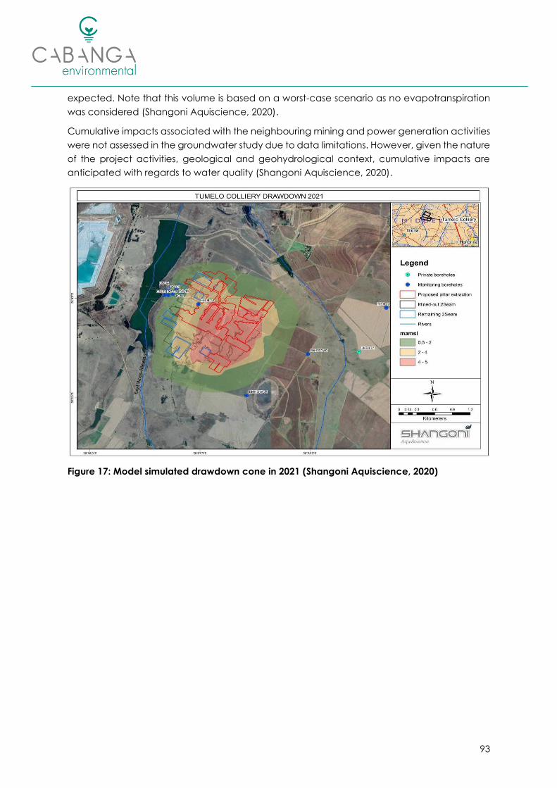
93
expected. Note that this volume is based on a worst-case scenario as no evapotranspiration
was considered (Shangoni Aquiscience, 2020).
Cumulative impacts associated with the neighbouring mining and power generation activities
were not assessed in the groundwater study due to data limitations. However, given the nature
of the project activities, geological and geohydrological context, cumulative impacts are
anticipated with regards to water quality (Shangoni Aquiscience, 2020).
Figure 17: Model simulated drawdown cone in 2021 (Shangoni Aquiscience, 2020)
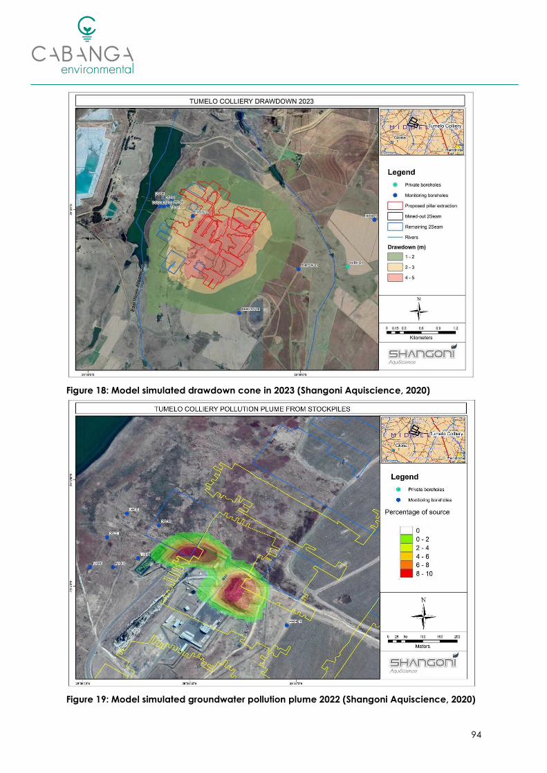
94
Figure 18: Model simulated drawdown cone in 2023 (Shangoni Aquiscience, 2020)
Figure 19: Model simulated groundwater pollution plume 2022 (Shangoni Aquiscience, 2020)

95
6.2.5. Terrestrial Ecology
The approved EMP (Digby Wells and Associates, 2006) identifies impacts from mining activities
to include habit loss and displacement of animals due to noise, machinery and fences. Due
to the site-specific impact the significance was rated as Moderate.
The proposed partial pillar extraction is not expected to have a direct impact on the fauna
and flora. Although indirect impacts associated with the change in surface water flow
dynamics and ponding, should subsidence occur, could result in potential changes in soil and
wetland characteristics.
Impacts identified in the decommissioning and closure phase are largely positive as the
disturbed surface area will be rehabilitated, fertilized and vegetated. Biodiversity in the area
should increase as animals begin to return back to the area. Other impacts identified include
those associated with environmental pollution as a results of hydrocarbon spillages/leaks and
the potential encroachment of alien invasive species.
6.2.6. Freshwater Ecology
Two wetland systems were identified with the MRA, specifically a CVB wetland partially within
and adjacent to the western boundary of the MRA, and a depression wetland in the south-
eastern corner of the MRA. Generally, the conversion of natural areas to largely agricultural
and mining-related land-uses have impacted on the overall hydrological and
geomorphological functioning of both wetlands (Scientific Aquatic Services, 2019).
Taking into consideration the locality of the depression wetland, approximately 1.7km from the
existing and proposed mining activities, and the presence of a catchment divide between the
wetland and the mining activities, no impacts on the depression wetland are anticipated as
result of Tumelo’s planned activities (Scientific Aquatic Services, 2019).
The CVB wetland is however, located downgradient of the existing mine infrastructure area. In
addition to this some of the remaining No. 2 seam reserves are located under the CVB wetland,
the area is however not targeted for pillar extraction (Scientific Aquatic Services, 2019).
Changes to the hydrological regime as a result of potential subsidence, impaired water quality
and the establishment of alien vegetation is likely to present a Moderate risk prior to mitigation.
The significance of potential decant and the impact on the receiving environment is
considered to be High (Scientific Aquatic Services, 2019).
6.2.7. Air Quality and Noise
Dust-fall, PM10 and PM2.5 are key pollutants of concern associated with operations at Tumelo
Colliery and are emitted from the following key sources:
• Particulate Emissions:
o Wind erosion from exposed areas: the coal product stockpile and ROM stockpile;
o Front-end loaders used to load trucks with coal and load the hopper;
o Conveyor transfer points; and
o Crushing and screening.
The following conclusions are made based on the Air Quality Impact Assessment (AQIA) and
dispersion model compiled for the operations (Rayten Environmental and Engineering
Consultants, 2020), attached as Annexure 6:

96
• Predicted incremental dust-fall rates and PM2.5 concentrations comply with the
applicable standards over most of the areas surrounding Tumelo Colliery (Figure 20).
• Higher daily average PM2.5 concentrations and dust-fall rates are predicted west of the
mine, but in near proximity to the mining right area boundary, and emission sources
(Figure 21). Predicted daily average PM10 concentrations comply with the daily
standard of 75 µg/m3 over areas situated east, west and south of the mine (Figure 22).
• Higher PM10 concentrations are projected north-west and north of the mine.
Exceedances of the daily standard are predicted near the MRA boundary (within
~5km) and south-west of Pullens Hope.
• Predicted annual average PM10 concentrations comply with the annual standard of 40
µg/m3 over most of the project area.
• Maximum predicted incremental PM10 and PM2.5 concentrations and dust-fall rates at
the identified nearby sensitive receptors (represented as discrete receptors)
surrounding the mine are mostly low and comply with the applicable standards. Higher
concentrations and dust-fall rates are predicted around discrete receptors 2 (mine
building), 7 (dwelling), 23 (farmhouse/dwellings) and 26 (Hendrina Power Station)
which are located in close proximity to the western and northern parts of the mining
right boundary.
In conclusion the dispersion modelling results indicate relatively low incremental dust-fall rates,
PM2.5 concentrations and annual average PM10 concentrations. On the other hand, high
incremental daily average PM10 concentrations with exceedances are projected over areas
situated north-west and north of the mine (Rayten Environmental and Engineering Consultants,
2020).
Figure 20: Predicted Dust-Fall Rates associated with Tumelo Colliery (Rayten, 2020)

97
Figure 21: Predicted Daily Average PM2.5 Concentrations associated with Tumelo Colliery
(Rayten, 2020)
Figure 22: Predicted Daily Average PM10 Concentrations associated with Tumelo Colliery
(Rayten, 2020)

98
Figure 23: Predicted Annual Average PM2.5 Concentrations associated with Tumelo Colliery
(Rayten, 2020)
Figure 24: Predicted Annual Average PM10 Concentrations associated with Tumelo Colliery
(Rayten, 2020)
6.2.8. Sites of Archaeological and Cultural Significance
One cultural heritage site, an old farmyard, was identified in the MRA. It is noted that the
farmyard will not be undermined (Plan 23) and thus no direct or indirect impacts to the site is
expected.
It should be noted that the subterranean presence of archaeological artifacts and/or remains
is always a distinct possibility. It is possible that some sites may only become known later on. In

99
such cases a qualified archaeologist should be called in to investigate the occurrence. The
‘Chance Find’ protocol and monitoring programme as outlined in the EMP should be followed.
The MRA is underlain by the highly fossiliferous Vryheid formation and unfossiliferous Jurassic.
The Vryheid Formation is known to be rich in coal deposits, while the coal itself does not contain
any recognisable fossil plant material the mudstone and shales associated with the coal
deposits are known to host plant fossils. The underground mining will be undertaken by
continuous miners, as such only the coal seam, and not the shales, will be targeted. Taking this
into account, the potential impact to fossil heritage resources is low. In the event fossils are
found, these should be rescued and a palaeontologist called to assess and collect a
representative sample. The ‘Chance Find’ protocol and monitoring programme as outlined in
the EMP should be followed.
6.2.9. Socio-Cultural Environment
In terms of socio-economic impacts of the Mine, the approved EMP (Digby Wells and
Associates, 2006) identified the development and operation of the mine as a benefit to local
trade and industry, the EMP rated the impact as “highly significant, definite, regional, medium
term beneficial and positive”.
The positive impact of employment (both direct and indirect) is acknowledged and included
in this impact assessment. It must be noted however, that the change in mine plan to include
partial pillar extraction will not contribute to job creation but rather focus on the retention of
jobs by prolonging the Life of Mine (LoM) (MTS Holdings (Pty) Ltd, 2019).
The potential negative socio-economic impacts associated with Mining operations includes
the influx of job-seekers to the area, resulting in increased unemployment and poverty in the
local communities, and an increased risk in criminal activities.
6.3. Impact Assessment
The summary impact assessment is presented in Table 20. The most significant anticipated
impacts, without mitigation, include:
• Potential for subsidence, and altered surface water flow dynamics;
• Alteration of groundwater flow due to dewatering; and
• Reduction in water quality as a result of decant and subsequent loss of biodiversity of
the CVB wetland.

100
Table 20: Impact Assessment
Description of Impact Phase Nature of
Impact
Lik
elih
oo
d
Se
nsi
tivity
Ma
gn
itu
de
Du
ratio
n
Sc
ale
/
Exte
nt
Significance
(without
Mitigation)
Lik
elih
oo
d
Se
nsi
tivity
Ma
gn
itu
de
Du
ratio
n
Sc
ale
/
Exte
nt
Significance (with
Mitigation)
Alteration of geological nature and sequence. Operational Negative 5 5 3 5 2 75 High 5 5 3 5 2 75 High
Potential contamination plume of groundwater. Coal surfaces exposed to the
atmosphere within underground workings can potentially generate acid mine
drainage (AMD).
All Phases Negative 4 4 2 4 3 52 Moderate 3 4 2 4 3 39 Low
Sub-surface cracking, subsidence, roof collapse and sinkhole formation.
Subsidence of surface layers will also alter surface water flow dynamics and
possible ponding.
All Phases Negative 4 4 5 5 2 64 High 3 4 5 5 2 48 Moderate
Although the project is not expected to result in any new job opportunities, the
extended LoM will result in the continued employment of mine personnel. Operations Positive 5 3 5 2 4 70 High 5 3 5 2 4 70 High
Influx of unsuccessful job seekers which may informally settle in area. Operational Negative 3 3 3 2 4 36 Low 2 3 3 2 3 22 Low
During the operational phase the mining will be active that will require
dewatering of the deep aquifer(s).This will result in a cone of depression and a
decline in water levels with a potential loss in resource for users. Water level
impacts are however, expected to be localised and restricted to the site. No
privately owned boreholes were identified as sensitive receptors as they are not
overlying the underground mining activities and are not located within the
predicted cone of depression.
Operational Negative 5 4 2 3 2 55 Moderate 5 4 2 3 2 55 Moderate
Potential creation of a cone of depression, which may drain water from the
adjacent CVB wetland, thus resulting in desiccation of the wetland; and water
entering the underground mining area as a result of ingress into underground
mine workings may necessitate dewatering of the underground mining area,
which may result in the discharge of dirty water into the adjacent wetland
environment.
Operational Negative 4 4 4 3 3 56 Moderate 4 4 4 3 2 52 Moderate
Seepages from the overburden and RoM stockpiles could be highly mineralised
with mostly sulphate. Operational Negative 4 4 2 4 3 52 Moderate 3 4 2 4 2 36 Low

101
Description of Impact Phase Nature of
Impact
Lik
elih
oo
d
Se
nsi
tivity
Ma
gn
itu
de
Du
ratio
n
Sc
ale
/
Exte
nt
Significance
(without
Mitigation)
Lik
elih
oo
d
Se
nsi
tivity
Ma
gn
itu
de
Du
ratio
n
Sc
ale
/
Exte
nt
Significance (with
Mitigation)
Erosion via wind and water leading to sedimentation and pollution of
downstream water resources.
Operational
Decommissioning Negative 4 4 3 3 3 52 Moderate 3 4 3 3 3 39 Low
Potential for poor quality water impacting on groundwater and/or surface
water and wetlands if pipelines or dams/trenches burst, spill or leak. Due to the
close proximity of the Boschmanskop Dam and CVB wetland, pollution
incidents may directly result in the deterioration of water quality.
Operational Negative 4 4 4 3 3 56 Moderate 3 4 2 3 3 36 Low
Reduction in catchment yield due to containment of dirty water on site,
ponding, infiltration and evaporation. Operational Negative 4 4 3 3 4 56 Moderate 2 4 2 3 1 20 Low
Increased runoff volumes and velocity and associated potential erosion and
silt-loading of drainage lines and downstream water bodies and wetlands. The
site is already established. However, the clean water diversion channels and
culverts still pose a risk for erosion. Culvert outlets can directly impact on
sediment transport. Loose particles are erodible.
Stockpile areas can also contribute to erosion.
Operational Negative 4 4 3 3 3 52 Moderate 2 4 3 3 2 24 Low
Impacts on water quality due to potential hydrocarbon and other chemical
spills.
Operational
Decommissioning Negative 4 3 4 3 3 52 Moderate 3 3 3 3 1 30 Low
Spread and/or establishment of alien invasive plant species and resultant
impacts on surrounding natural vegetation. All Phases Negative 4 2 4 4 3 52 Moderate 3 2 4 4 2 36 Low
Potential leaks, discharges, pollutant from mining activities leaching into the
surrounding environment. Operational Negative 4 2 3 4 3 48 Moderate 2 2 3 4 2 22 Low
Continued displacement and fragmentation of the faunal community
(including threatened species) due to ongoing anthropogenic disturbances
(noise, dust and vibrations) and habitat degradation (litter, road mortalities
and/or poaching).
Operation
Decommissioning Negative 5 2 2 3 2 45 Moderate 4 2 2 3 2 36 Low
Compaction and alteration of soil characteristics Operational
Decommissioning Negative 3 3 3 3 2 33 Low 2 3 3 3 2 22 Low
Loss of and disturbance to archaeological / heritage sites / fossils Operational Negative 2 5 3 5 3 32 Low 2 5 3 5 2 30 Low

102
Description of Impact Phase Nature of
Impact
Lik
elih
oo
d
Se
nsi
tivity
Ma
gn
itu
de
Du
ratio
n
Sc
ale
/
Exte
nt
Significance
(without
Mitigation)
Lik
elih
oo
d
Se
nsi
tivity
Ma
gn
itu
de
Du
ratio
n
Sc
ale
/
Exte
nt
Significance (with
Mitigation)
The plant and stockpile area may be visible to neighbouring land users. Operational Negative 3 3 2 3 2 30 Low 2 3 2 3 2 20 Low
Increased ambient noise levels. Operational
Decommissioning Negative 5 2 2 3 3 50 Moderate 3 2 2 3 3 30 Low
Gaseous emissions from machinery and vehicles. Operational
Decommissioning Negative 4 4 3 3 3 52 Moderate 4 4 3 3 3 52 Moderate
Potential hydrocarbon contamination as a result of leaks / spills. All Phases Negative 4 3 2 3 2 40 Moderate 3 3 2 3 1 27 Low
Dust generation and particulate matter. Operational
Decommissioning Negative 4 4 4 3 3 56 Moderate 4 4 3 3 3 52 Moderate
Deterioration of road conditions. Operational Negative 4 3 3 3 3 48 Moderate 4 3 2 3 2 40 Moderate
Irresponsible use of water and waste of water. Operational Negative 4 4 2 3 3 48 Moderate 3 4 2 3 2 33 Low
Potential contamination through littering and/or incorrect waste disposal. All Phases Negative 4 3 3 3 2 44 Moderate 3 3 3 3 1 30 Low
Odours and visual impacts. All Phases Negative 2 3 2 3 2 20 Low 2 3 1 3 1 16 Insignificant
Increased recharge. Generally, a management measure for underground
coal mines is to flood the mine as quickly as possible. The benefit of flooding is
reduced oxygen ingress and the subsequent formation of AMD. Recharge
could be up to 10 times greater if subsidence occurs. The disadvantage of this
is that decanting will be likely to occur within a shorter time period. The negative
impact of decanting outweighs the positive impact of mine flooding.
Decommissioning
Closure
Post Closure
Negative 4 4 4 4 3 60 High 3 4 4 4 3 45 Moderate

103
Description of Impact Phase Nature of
Impact
Lik
elih
oo
d
Se
nsi
tivity
Ma
gn
itu
de
Du
ratio
n
Sc
ale
/
Exte
nt
Significance
(without
Mitigation)
Lik
elih
oo
d
Se
nsi
tivity
Ma
gn
itu
de
Du
ratio
n
Sc
ale
/
Exte
nt
Significance (with
Mitigation)
Potential contamination plume of groundwater. Coal surfaces exposed to the
atmosphere within underground workings can potentially generate acid mine
drainage (AMD). However, the water accumulating in the underground voids
are likely to be circumneutral but saline with high to elevated SO4. It is expected
that Fe and Mn will also be in the mobile phase and high F is also likely.
Decommissioning
Closure
Post Closure
Negative 4 4 4 4 3 60 High 3 4 3 4 3 42 Moderate
Potential for poor quality leachate from decant or plume day lighting
impacting on nearby water bodies. Decant is expected for Tumelo Colliery
after approximately 40 years post-operation. Although the risk of acid formation
is low, the decant water quality is expected to contain high total dissolved salts,
with SO4 the greatest contributor, as well as Ca, F and Mn and possibly other
metals such as As, B and Fe in solution. Likely decant points are the incline shaft,
the ring dyke structure west of the Boschmanskop Dam as well as cracks or
fractures created by subsidence at an elevation of approximately 1610 mamsl.
The decant quality will likely be unacceptable for release to the environment
until the contrary can be confirmed through
measurement. Subsequent negative impacts on biota and vegetation; altered
flow regimes (increased hydroperiod); and habitat degradation.
Post Closure Negative 4 4 4 5 3 64 High 3 4 3 5 3 45 Moderate
Improved aesthetics. Decommissioning
Closure Positive 5 3 4 4 2 65 High 5 3 4 4 2 65 High
Eradication of stockpiles and replacement of material, profiling and restoration
of free drainage.
Decommissioning
Closure Positive 4 3 4 4 2 52 Moderate 4 3 4 4 2 52 Moderate
Soil replacement, amelioration and seeding. Vegetative cover and plant
community succession. Influx of animals to the area once vegetation re-
establishes.
Decommissioning
Closure Positive 5 3 4 4 2 65 High 5 3 4 4 2 65 High
Loss of job opportunities. Decommissioning Negative 5 4 2 4 3 65 High 5 4 2 4 3 65 High

104
7. IMPACT MANAGEMENT
The significance of impacts associated with the project is discussed in Sections 6.2 and 6.3 in
terms of the probability of the impact occurring, the intensity, the duration and the spatial
scale of the impact.
Impact Management should be proportionate to the significance of an impact prior to the
implementation of mitigation measures and will aim to reduce either the probability of an
impact occurring, or the consequence of an impact (in terms of its duration, scale and
intensity).
7.1. Impact Management Outcomes
For each activity associated with the proposed project, a set of impact management
outcomes and associated management actions have been identified and are described in
this section.
Table 21: Impact Management Outcomes
Impact Description Impact Management Outcomes
Alteration of geological nature and sequence. No management required – this is the nature of
mining.
Potential contamination plume of groundwater.
Coal surfaces exposed to the atmosphere within
underground workings can potentially generate
acid mine drainage (AMD).
Measures aim to reduce the likelihood of AMD
formation and ensure adequate rehabilitation is
implemented.
Sub-surface cracking, subsidence, roof collapse
and sinkhole formation.
Measures aim to reduce the potential for roof /
pillar failure and surface subsidence.
Altered flow dynamics due to subsidence of
surface layers as pillars are removed on retreat.
Management measures seek to ensure the
surface areas are restored to free-draining, self-
sustaining systems
Influx of unsuccessful job seekers which may
informally settle in area.
Management measures aim to ensure effective
communication regarding opportunities, and
the prevention of informal settlement formation,
as well as to provide an emergency plan in the
event of people settling illegally in the area.
Reduction of local groundwater and alteration of
groundwater flow due to dewatering.
The impact can only be mitigated by ensuring
affected water users are appropriately
compensated should dewatering result in loss of
access to their lawful water use.
Potential creation of a cone of depression, which
may drain water from the adjacent CVB wetland,
thus resulting in desiccation of the wetland. Water
entering the underground mining area as a result
of ingress into underground mine workings may
necessitate dewatering of the underground mining
area, which may result in the discharge of dirty
water into the adjacent wetland environment.
Management measures aim to protect wetland
habitats by containing potential pollution
sources within the dirty water footprint.

105
Impact Description Impact Management Outcomes
Seepages from the overburden and RoM /product
stockpiles could be highly mineralised with mostly
sulphate.
The management measures aim to prevent
groundwater contamination.
Erosion of stockpiles via wind and water leading to
sedimentation and pollution of downstream water
resources.
The aim of the management measures is to
prevent erosion from occurring, thereby
preventing siltation of downstream water bodies
Potential for poor quality water impacting on
groundwater and/or surface water and wetlands if
pipelines or dams/trenches burst, spill or leak. Due
to the close proximity of the Boschmanskop Dam
and CVB wetland, pollution incidents may directly
result in the deterioration of water quality.
Management measures aim to prevent leaks
from dirty-water containment facilities and
ensure leak detection and repair is implemented
timeously if leaks do occur, to prevent
contamination
Reduction in catchment yield due to containment
of dirty water on site, ponding, infiltration and
evaporation.
The impact is unavoidable as water is contained
on site to prevent pollution downstream.
Management measures aim to keep the dirty
water footprint as small as possible.
Increased runoff volumes and velocity and
associated potential erosion and silt-loading of
drainage lines and downstream water bodies and
wetlands.
The aim of the management measures is to
prevent erosion from occurring, thereby
preventing siltation of downstream water
bodies.
Impacts on water quality due to potential
hydrocarbon and other chemical spills.
The objective of the management measures is
firstly to prevent the spillage of hydrocarbons,
and to ensure that contamination is contained
and remedied in the event of accidental spills in
such a manner as not to cause contamination.
Spread and/or establishment of alien invasive
plant species and resultant impacts on surrounding
natural vegetation.
Management measures aim to limit the spread
of alien invasive species and other problem
weeds.
Potential leaks, discharges, pollutant from mining
activities leaching into the surrounding
environment.
Management measures aim to ensure that
pollution sources are contained within the dirty
water areas on site.
Continued displacement and fragmentation of
the faunal community (including threatened
species) due to ongoing anthropogenic
disturbances (noise, dust and vibrations) and
habitat degradation (litter, road mortalities and/or
poaching).
Activity footprint is limited to the approved
areas, limiting residual impacts caused by creep
and edge-effects. The CVB wetland associated
with the Boschmanskop Dam will provide an
ecological corridor for fauna movement.
Management measures aim to create
awareness amongst staff.
Compaction and alteration of soil characteristics
Compaction is limited to the approved footprint
areas and remediated by ripping / scarifying as
soon as an area is no longer required.
Loss of and disturbance to archaeological /
heritage sites / fossils
During the course of the project activities, no
heritage sites are affected / damaged in any
way.
The plant and stockpile area may be visible to
neighbouring land users.
The management measures aim to improve
housekeeping, and limit the potential for dust
fallout.

106
Impact Description Impact Management Outcomes
Increased ambient noise levels. To keep noise generation to a minimum.
Gaseous emissions from machinery and vehicles.
The management measures seek to limit and
minimise the gaseous emissions associated with
vehicles and machinery.
Potential hydrocarbon contamination as a result of
leaks / spills from vehicles and machinery.
Management measures aim to prevent
hydrocarbon spills and ensure effective clean-
up in emergency situations to prevent
contamination.
Dust generation and particulate matter
The management measures intend to ensure
that dust generation is minimised and managed
on site, and that ongoing monitoring is
undertaken to ensure compliance to the
relevant legislation.
Deterioration of road conditions. To ensure the safety and security of other road
users.
Irresponsible use of water and waste of water. Management measures aim to promote
awareness and prevent water wastage.
Potential contamination through littering and/or
incorrect waste disposal.
The measures prescribed in terms of general
waste management aim to ensure compliance
with the Norms and Standards for the storage
and handling of waste, to prevent wind-blown
waste dispersion, to promote awareness among
staff to prevent littering and to ensure that waste
management areas are neat and well-
managed.
Odours and visual impacts
Management measures aim to ensure waste
storage areas are well-managed and that waste
does not remain on site for excessive periods.
Increased recharge in the event of subsidence
could result in decant occurring within a shorter
time period.
The management measures seek to minimise the
amount of recharge from rainfall.
Potential for poor quality leachate from decant or
plume impacting on nearby water bodies.
Management measures aim to contain
contamination should decant occur.
Reduced risk of silt loading on downstream water
bodies (due to clearing of stockpiles). Free
drainage restored to area.
The impact Is positive. Management measures
aim to prevent potential erosion from occurring
from rehabilitated surface areas.
Create adequate environment for flora to establish
and reduce risk of erosion and associated
sedimentation of water courses.
The impact is positive. Management measures
are aimed at effective amelioration of topsoil as
required.
Loss of employment at closure.
Management measures aim to ensure that job-
losses are communicated well in advance and
that mine workers had received adequate
experience and training while employed at the
mine to improve their chances of finding
alternative employment after closure.

107
7.2. Impact Management Actions
Specific management actions for each of the identified impacts are described in Table 22
overleaf along with the time-periods for implementation of the mitigation measures, the
monitoring methods (monitoring of implementation of mitigation measures and monitoring of
compliance to standards where relevant), monitoring frequency and the person(s) responsible
for monitoring.
Monitoring and reporting requirements are further detailed in Section 7.3.

108
Table 22: Impact Management Actions
Activity Impact / Risks Management Actions / Mitigation Measures
Time periods for
implementation of
Mitigation
Monitoring Method
(Implementation & Compliance)
Monitoring
Frequency
Person(s) Responsible for
Monitoring
Continued mining of the
underground workings, with
partial pillar extraction on
retreat
Alteration of geological
nature and sequence. No mitigation possible. This is the nature of mining. - - - -
Continued mining of the
underground workings, with
partial pillar extraction on
retreat
Potential contamination
plume of groundwater. Coal
surfaces exposed to the
atmosphere within
underground workings can
potentially generate acid
mine drainage (AMD).
Minimize residence time in underground workings
by pumping groundwater seepage to surface.
Maintain water pumped from underground in a
closed circuit.
Operational
Groundwater Monitoring.
Routinely refine, update and
validate the conceptual and
numerical models by incorporating
ongoing monitoring data.
Quarterly
Every 2 years
SHE Manager
Geohydrologist
Continued mining of the
underground workings, with
partial pillar extraction on
retreat
Sub-surface cracking,
subsidence, roof collapse and
sinkhole formation.
Subsidence of surface layers
will also alter surface water
flow dynamics and possible
ponding.
Avoid mining in areas where subsidence is likely to
occur (i.e. areas shallower than 40m or areas where
surface infrastructure exists). Apply reasonable
mining techniques with appropriate safety factors.
Should cracks be identified, these are to be filled
and rehabilitated. Should subsidence occur, this
must be made to be free draining.
Throughout LoM
Mining tell-tales to be
systematically installed to monitor
for real time roof movement. In
addition to this convergence
monitoring between the mining
roof and floor could be conducted
by installing monitoring
instrumentation in strategic
locations before commencing with
mining.
Daily Mine Engineer / Rock
Mechanic
Continued mining of the
underground workings, with
partial pillar extraction on
retreat
Although the project is not
expected to result in any new
job opportunities, the
extended LoM will result in the
continued employment of
mine personnel.
No mitigation required. Implement the approved
Social and Labour Plan. Manage job-seeker
expectations and ensure clear communication.
Operational Community liaison officer and
forum reports. Monthly
Community liaison officer / HR
Manager
Continued mining of the
underground workings, with
partial pillar extraction on
retreat
Influx of unsuccessful job
seekers which may informally
settle in area.
Implement the approved Social and Labour Plan.
Manage job-seeker expectations and ensure clear
communication.
Operational Community liaison officer and
forum reports. Monthly
Community liaison officer / HR
Manager
Dewatering of the
underground workings for the
safe continuation of mining.
During the operational phase
the mining will be active that
will require dewatering of the
deep aquifer(s).This will result
in a cone of depression and a
decline in water levels with a
potential loss in resource for
users. Water level impacts are
however, expected to be
localised and restricted to the
site. No privately owned
boreholes were identified as
sensitive receptors as they are
not overlying the
underground mining activities
and are not located within
the predicted cone of
depression.
No specific management measures are proposed
other than to continue with water level and quality
monitoring in source and receptor monitoring
boreholes. If impact is confirmed by monitoring,
impacts to the community’s and farmers’ water
supply must be mitigated by the client providing an
alternative reliable, clean water supply.
Operational
Flow meters to be installed on the
dewatering point and abstraction
Volumes to be recorded monthly.
Groundwater Monitoring (incl.
levels).
Routinely refine, update and
validate the conceptual and
numerical models by incorporating
ongoing monitoring data.
Monthly
Quarterly
Every 2 years
SHE Manager
Geohydrologist
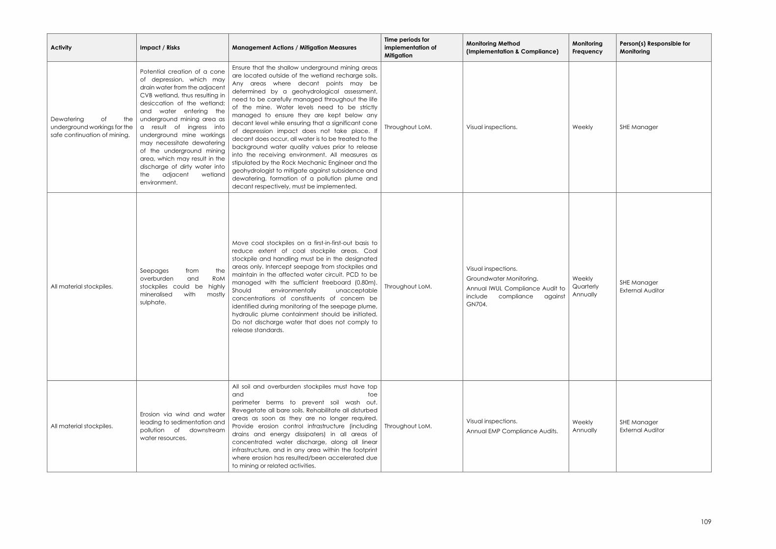
109
Activity Impact / Risks Management Actions / Mitigation Measures
Time periods for
implementation of
Mitigation
Monitoring Method
(Implementation & Compliance)
Monitoring
Frequency
Person(s) Responsible for
Monitoring
Dewatering of the
underground workings for the
safe continuation of mining.
Potential creation of a cone
of depression, which may
drain water from the adjacent
CVB wetland, thus resulting in
desiccation of the wetland;
and water entering the
underground mining area as
a result of ingress into
underground mine workings
may necessitate dewatering
of the underground mining
area, which may result in the
discharge of dirty water into
the adjacent wetland
environment.
Ensure that the shallow underground mining areas
are located outside of the wetland recharge soils.
Any areas where decant points may be
determined by a geohydrological assessment,
need to be carefully managed throughout the life
of the mine. Water levels need to be strictly
managed to ensure they are kept below any
decant level while ensuring that a significant cone
of depression impact does not take place. If
decant does occur, all water is to be treated to the
background water quality values prior to release
into the receiving environment. All measures as
stipulated by the Rock Mechanic Engineer and the
geohydrologist to mitigate against subsidence and
dewatering, formation of a pollution plume and
decant respectively, must be implemented.
Throughout LoM. Visual inspections. Weekly SHE Manager
All material stockpiles.
Seepages from the
overburden and RoM
stockpiles could be highly
mineralised with mostly
sulphate.
Move coal stockpiles on a first-in-first-out basis to
reduce extent of coal stockpile areas. Coal
stockpile and handling must be in the designated
areas only. Intercept seepage from stockpiles and
maintain in the affected water circuit. PCD to be
managed with the sufficient freeboard (0.80m).
Should environmentally unacceptable
concentrations of constituents of concern be
identified during monitoring of the seepage plume,
hydraulic plume containment should be initiated.
Do not discharge water that does not comply to
release standards.
Throughout LoM.
Visual inspections.
Groundwater Monitoring.
Annual IWUL Compliance Audit to
include compliance against
GN704.
Weekly
Quarterly
Annually
SHE Manager
External Auditor
All material stockpiles.
Erosion via wind and water
leading to sedimentation and
pollution of downstream
water resources.
All soil and overburden stockpiles must have top
and toe
perimeter berms to prevent soil wash out.
Revegetate all bare soils. Rehabilitate all disturbed
areas as soon as they are no longer required.
Provide erosion control infrastructure (including
drains and energy dissipaters) in all areas of
concentrated water discharge, along all linear
infrastructure, and in any area within the footprint
where erosion has resulted/been accelerated due
to mining or related activities.
Throughout LoM. Visual inspections.
Annual EMP Compliance Audits.
Weekly
Annually
SHE Manager
External Auditor

110
Activity Impact / Risks Management Actions / Mitigation Measures
Time periods for
implementation of
Mitigation
Monitoring Method
(Implementation & Compliance)
Monitoring
Frequency
Person(s) Responsible for
Monitoring
Operation and maintenance
of the existing stormwater
management system
associated with the existing
mining activities.
Potential for poor quality
water impacting on
groundwater and/or surface
water and wetlands if
pipelines or dams/trenches
burst, spill or leak. Due to the
close proximity of the
Boschmanskop Dam and CVB
wetland, pollution incidents
may directly result in the
deterioration of water quality.
Dirty water channels should be designed and
upgraded to collect contaminated water and to
dispose it into the PCD. PCD to be managed with
the sufficient freeboard (0.80m) at all times. Regular
inspections to be conducted of all pipelines,
trenches and berms. Should any spills or leaks be
detected, these should be attended to
immediately. Ensure the clean and dirty water
diversion systems are maintained and regularly
cleaned. Emergency response measures must be
put in place. Dirty water should be prioritised for re-
use. Stormwater Management Plan (SWMP) must
be adhered to throughout the project. All
discharges should be managed according to the
Direct Estimation of Ecological Effect Potential
(DEEEP) method if unavoidable.
Throughout LoM.
Visual inspections.
Surface water Monitoring.
Annual IWUL Compliance Audit to
include compliance against
GN704.
Weekly
Quarterly
Annually
SHE Manager
External Auditor
Operation and maintenance
of the existing stormwater
management system
associated with the existing
mining activities.
Reduction in catchment yield
due to containment of dirty
water on site, ponding,
infiltration and evaporation.
Dirty water footprint to be maintained as small as
possible. No new areas to be disturbed. All clean
water to be diverted around site. SWMP must be
adhered to throughout the project.
Throughout LoM GN704 audits to be undertaken
annually as part of IWUL Audits. Annual External Auditor
Operation and maintenance
of the existing stormwater
management system
associated with the existing
mining activities.
Increased runoff volumes and
velocity and associated
potential erosion and silt-
loading of drainage lines and
downstream water bodies
and wetlands. The site is
already established.
However, the clean water
diversion channels and
culverts still pose a risk for
erosion. Culvert outlets can
directly impact on sediment
transport. Loose particles are
erodible. Stockpile areas can
also contribute to erosion.
Implement clean and dirty water separation
throughout the site in accordance with GN704.
Install silt traps where necessary. Prevent erosion
and remedy eroded areas immediately if erosion is
detected despite preventative measures. The
necessary flood attenuation and erosion control
structures to be put in place at each outlet.
Throughout LoM
Visual inspections.
Annual IWUL Compliance Audit to
include compliance against
GN704.
Monthly
Annually
SHE Manager
External Auditor
Continued operation of mine
surface infrastructure.
Impacts on water quality due
to potential hydrocarbon and
other chemical spills.
All diesel storage must be within concrete bunded
areas that contain 110% of storage capacity if
roofed or 120% storage capacity if not roofed. Re-
fuelling must take place on a sealed surface area
to prevent ingress of hydrocarbons into the topsoil.
Bunds in the workshop, wash bay and fuel storage
facility will be fitted with an outlet valve and drain
to an oil trap. The outflow will flow through an oil
trap and water component will be treated and
recycled as process water. Oil from oil traps will be
removed to the used hydrocarbon drums which will
be temporarily stored in concrete bunded areas
prior to removal from site by a reputable
hydrocarbon waste contractor. Spills should be
reported and cleaned up immediately. Spill kits
must be available on site and personnel trained to
utilise these.
Throughout LoM Visual inspections Daily Workshop Manager

111
Activity Impact / Risks Management Actions / Mitigation Measures
Time periods for
implementation of
Mitigation
Monitoring Method
(Implementation & Compliance)
Monitoring
Frequency
Person(s) Responsible for
Monitoring
Continued operation of mine
surface infrastructure.
Spread and/or establishment
of alien invasive plant species
and resultant impacts on
surrounding natural
vegetation.
The mine must compile and implement an Alien
Invasive Species management plan. Throughout LoM
Visual Inspections.
EMP Compliance Audit.
Quarterly
Annual
SHE Manager
External Auditor
Continued operation of mine
surface infrastructure.
Potential leaks, discharges,
pollutant from mining
activities leaching into the
surrounding environment.
Good housekeeping will be implemented to
prevent spills and leaks from occurring. The site will
be managed in accordance with GN704, to ensure
accidental spills are contained in dirty areas.
Throughout LoM
Visual inspections.
Annual IWUL Compliance Audit to
include compliance against
GN704.
Monthly
Annually
SHE Manager
External Auditor
Continued operation of mine
surface infrastructure.
Continued displacement and
fragmentation of the faunal
community (including
threatened species) due to
ongoing anthropogenic
disturbances (noise, dust and
vibrations) and habitat
degradation (litter, road
mortalities and/or poaching).
Ensure activities are limited to the surface
infrastructure area, and that no new areas are
disturbed. Prohibit the harvesting of indigenous
trees for firewood
and indigenous flora in general. Do not hinder,
harm, and trap animals.
Maintenance of wetlands and associated natural
vegetation will provide ecological corridors and
refuges for animals.
Throughout LoM Visual inspection of
all demarcations/barriers. Monthly SHE Manager
Continued operation of mine
surface infrastructure.
Operation of machinery and
vehicle movement.
Compaction and alteration of
soil characteristics
Only designated / approved roads to be used and
driving outside of these areas will not be allowed.
Rehabilitate all disturbed areas as soon as they are
no longer required. Revegetate all bare soils.
Ameliorate soils as needed to establish stable
vegetation communities on stockpiles / berms. Soils
must not be trafficked if wetter than the plastic limit.
Rip or disc any compacted soils as needed.
Throughout LoM Visual inspection of
all demarcations/barriers. Monthly SHE Manager
Continued operation of mine
surface infrastructure.
Operation of machinery and
vehicle movement.
Loss of and disturbance to
archaeological / heritage
sites / fossils
A chance find procedure will be implemented on
site, for archaeological and palaeontological
resources that may occur on site and are as yet
undiscovered. If any fossiliferous material such as
leaf impressions, stems, seeds, wood, insect wings, is
identified, the palaeontologist will be consulted. If
potential heritage resources are discovered, all
work in the area will stop and an archaeologist will
be consulted.
Throughout LoM, Chance
find procedure to be
included in induction
Training records. Annual SHE Manager
Continued operation of mine
surface infrastructure. All
material stockpiles.
The plant and stockpile area
may be visible to
neighbouring land users.
Apply dust control measures and other
environmental measures to ensure impact area is
contained. Apply good housekeeping practices. All
berms and soil stockpiles will be vegetated.
Throughout LoM
Maintain communication with
I&APs and provide a platform for
I&APs to lodge any comments
and/or complaints. Complaints
register to be inspected weekly.
Weekly Mine Manager
Continued operation of mine
surface infrastructure.
Operation of machinery and
vehicle movement.
Increased ambient noise
levels.
Machinery and equipment will be regularly
serviced. Noise control measures will be considered
such as soundproofing of point sources, use of
silencers, using strobe lights rather than beepers
where feasible and where this won't compromise
safety of people on site. Machinery will be
maintained within operational noise limits and will
be switched off when not in use.
Throughout LoM Ambient noise monitoring. Annual SHE Manager

112
Activity Impact / Risks Management Actions / Mitigation Measures
Time periods for
implementation of
Mitigation
Monitoring Method
(Implementation & Compliance)
Monitoring
Frequency
Person(s) Responsible for
Monitoring
Operation of machinery and
vehicle movement. Gaseous emissions from
machinery and vehicles.
Vehicles and machinery will be regularly serviced.
Implement a strict speed limit on all roads. Where
possible, use cleaner fuels.
Throughout LoM. Servicing
of vehicles as per
manufactures
recommendations.
Inspect vehicle servicing logs. Monthly Workshop Manager
Operation of machinery and
vehicle movement.
Potential hydrocarbon
contamination as a result of
leaks / spills.
Trucks, machinery and equipment will be regularly
serviced, as per maintenance schedule, to reduce
the risk of leaks. Spill kits and drip trays must be
available on site and personnel trained on utilising
these. Any leakages should be reported and
treated immediately. Implement good
housekeeping practices. Ensure vehicles are
serviced timeously.
Throughout LoM Visual inspections. Daily Workshop Manager
Crushing and screening,
wind erosion on exposed
areas, material handling,
loading & offloading, and
vehicle movement.
Dust generation and
particulate matter.
Implement dust suppression measures (e.g. water
sprays on unpaved roads and other dust-
generating areas). Reduce height of material
transfer. Immediate clean-up of any material (i.e.
coal) spillages. Trucks transporting coal product
offsite must use covers (e.g. tarpaulin covers) to
prevent windblown dust during transportation.
Throughout LoM Dust Fallout Monitoring. Monthly SHE Manager
Hauling of coal. Deterioration of road
conditions.
Regular inspections by the Mine of the main routes
to and from the site, along with regular reporting to
and liaison with the relevant roads authorities.
Maintain a complaints register and record
community complaints regarding the state of
roads. Resolve complaints in consultation with the
roads authorities.
Throughout LoM.
Remediation as required. Visual inspections Monthly SHE Manager
Provision of Services:
Abstraction of water
Irresponsible use of water and
waste of water.
Water saving initiatives to be included in the
environmental awareness training. Utilise water on
site responsibly. Water use at the Mine must be
measured and recorded. Inspect all water
management facilities and pipelines for leakages
and immediately repair.
Throughout LoM
Flow meters to be installed on all
abstraction points, and volumes
recorded.
Update water balance.
Monthly
Annually SHE Manager
Domestic and industrial
waste generation, handling
and disposal.
Potential contamination
through littering and/or
incorrect waste disposal.
Waste will be managed to comply with norms and
standards and be stored in a designated area
protected from runoff. Environmental awareness
training will be implemented to all employees and
visitors to the site. Regular clean-up campaigns will
be undertaken if necessary. Bins with covers will be
provided in all necessary areas where waste is
generated. Reputable contractors will be used to
remove waste off site for disposal, and records of
disposal will be kept.
Throughout LoM
Visual inspections, review of waste
manifest as part of the Annual EMP
Compliance Audit.
Monthly
Annually
SHE Manager
External auditor
Domestic and industrial
waste generation, handling
and disposal.
Odours and visual impacts. Good housekeeping and regular removal of waste
off site for safe disposal. Throughout LoM
Visual inspections, review of waste
manifest as part of the Annual EMP
Compliance Audit.
Monthly
Annually
SHE Manager
External auditor

113
Activity Impact / Risks Management Actions / Mitigation Measures
Time periods for
implementation of
Mitigation
Monitoring Method
(Implementation & Compliance)
Monitoring
Frequency
Person(s) Responsible for
Monitoring
Sealing and closure of
underground workings
Increased recharge.
Generally, a management
measure for underground
coal mines is to flood the mine
as quickly as possible. The
benefit of flooding is reduced
oxygen ingress and the
subsequent formation of
AMD. Recharge could be up
to 10 times greater if
subsidence occurs. The
disadvantage of this is that
decanting will be likely to
occur within a shorter time
period. The negative impact
of decanting outweighs the
positive impact of mine
flooding.
Minimise recharge of rainwater into underground
voids by creating free draining slopes. No ponding
should be allowed. Installation and testing of
additional groundwater monitoring boreholes
(cluster of shallow and deep piezometers) to
monitor the shallow and fractured aquifer.
Rehabilitate all high recharge footprints as soon as
possible. If subsidence occurs and sinkholes are
formed during operation or after closure, they
should be rehabilitated as soon as possible to
minimise water and oxygen inflow from the surface.
Through LOM and 5 years
post closure
Visual inspections for subsidence.
Groundwater monitoring Quarterly SHE Manager, Mine Manager
Sealing and closure of
underground workings
Potential contamination
plume of groundwater. Coal
surfaces exposed to the
atmosphere within
underground workings can
potentially generate acid
mine drainage (AMD).
However, the water
accumulating in the
underground voids are likely
to be circumneutral but saline
with high to elevated SO4. It is
expected that Fe and Mn will
also be in the mobile phase
and high F is also likely.
The deterioration of groundwater within the deep
aquifer cannot be prevented. Sealing of the adit to
prevent free recharge of the adit. The final surface
needs to be free draining to minimize recharge. A
rehabilitation plan must be compiled and
implemented in line with NEMA and NWA.
Abstraction from deep boreholes that are close to
the mine workings should be avoided so that
contaminants will not migrate towards the
abstraction boreholes, and away from the mine
voids. If impact is confirmed by monitoring, impacts
to the community’s and farmers’ water supply must
be mitigated by the client providing an alternative
reliable, clean water supply.
Through LOM and 5 years
post closure Groundwater Monitoring Quarterly SHE Manager, Mine Manager
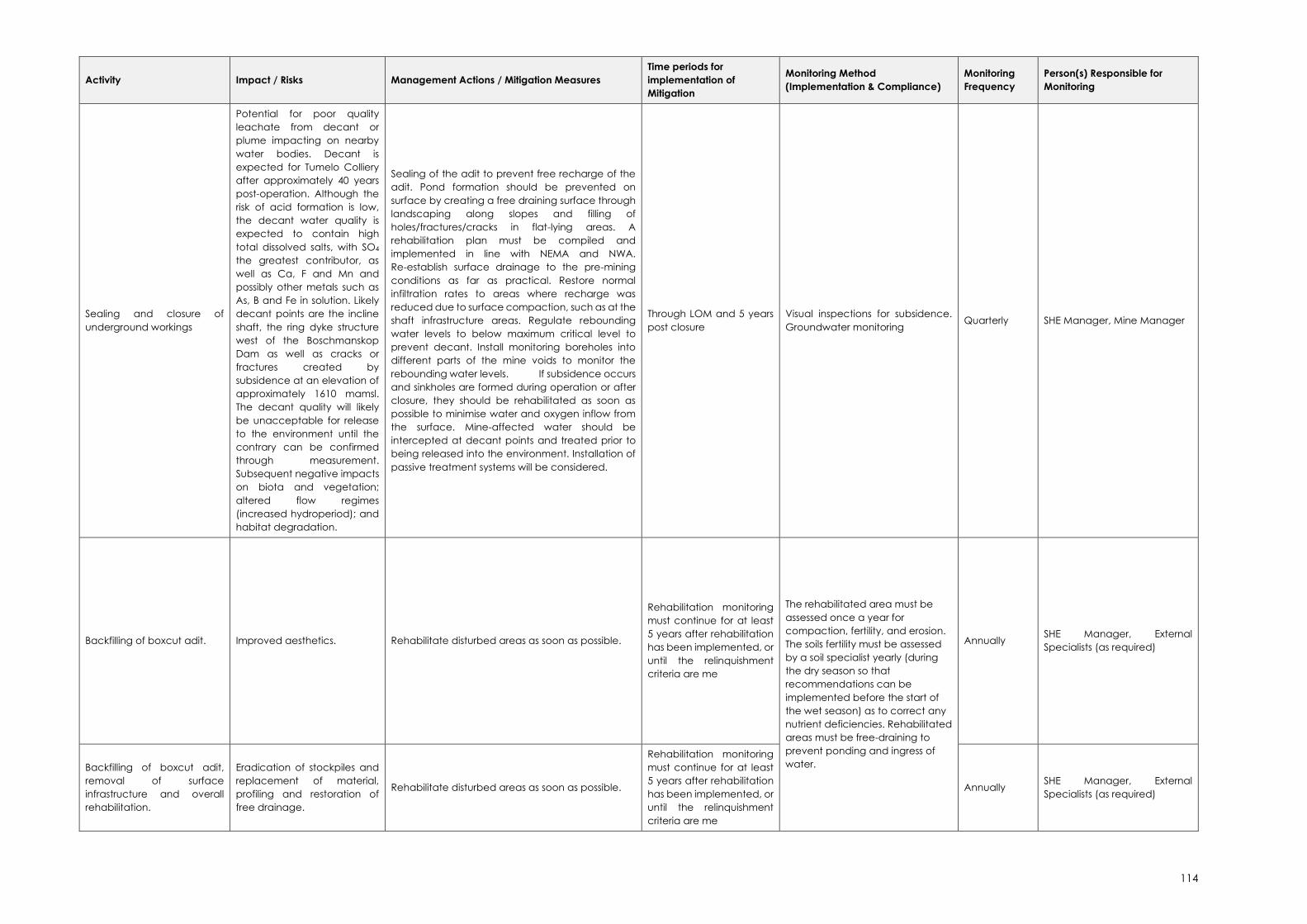
114
Activity Impact / Risks Management Actions / Mitigation Measures
Time periods for
implementation of
Mitigation
Monitoring Method
(Implementation & Compliance)
Monitoring
Frequency
Person(s) Responsible for
Monitoring
Sealing and closure of
underground workings
Potential for poor quality
leachate from decant or
plume impacting on nearby
water bodies. Decant is
expected for Tumelo Colliery
after approximately 40 years
post-operation. Although the
risk of acid formation is low,
the decant water quality is
expected to contain high
total dissolved salts, with SO4
the greatest contributor, as
well as Ca, F and Mn and
possibly other metals such as
As, B and Fe in solution. Likely
decant points are the incline
shaft, the ring dyke structure
west of the Boschmanskop
Dam as well as cracks or
fractures created by
subsidence at an elevation of
approximately 1610 mamsl.
The decant quality will likely
be unacceptable for release
to the environment until the
contrary can be confirmed
through measurement.
Subsequent negative impacts
on biota and vegetation;
altered flow regimes
(increased hydroperiod); and
habitat degradation.
Sealing of the adit to prevent free recharge of the
adit. Pond formation should be prevented on
surface by creating a free draining surface through
landscaping along slopes and filling of
holes/fractures/cracks in flat-lying areas. A
rehabilitation plan must be compiled and
implemented in line with NEMA and NWA.
Re-establish surface drainage to the pre-mining
conditions as far as practical. Restore normal
infiltration rates to areas where recharge was
reduced due to surface compaction, such as at the
shaft infrastructure areas. Regulate rebounding
water levels to below maximum critical level to
prevent decant. Install monitoring boreholes into
different parts of the mine voids to monitor the
rebounding water levels. If subsidence occurs
and sinkholes are formed during operation or after
closure, they should be rehabilitated as soon as
possible to minimise water and oxygen inflow from
the surface. Mine-affected water should be
intercepted at decant points and treated prior to
being released into the environment. Installation of
passive treatment systems will be considered.
Through LOM and 5 years
post closure
Visual inspections for subsidence.
Groundwater monitoring Quarterly SHE Manager, Mine Manager
Backfilling of boxcut adit. Improved aesthetics. Rehabilitate disturbed areas as soon as possible.
Rehabilitation monitoring
must continue for at least
5 years after rehabilitation
has been implemented, or
until the relinquishment
criteria are me
The rehabilitated area must be
assessed once a year for
compaction, fertility, and erosion.
The soils fertility must be assessed
by a soil specialist yearly (during
the dry season so that
recommendations can be
implemented before the start of
the wet season) as to correct any
nutrient deficiencies. Rehabilitated
areas must be free-draining to
prevent ponding and ingress of
water.
Annually SHE Manager, External
Specialists (as required)
Backfilling of boxcut adit,
removal of surface
infrastructure and overall
rehabilitation.
Eradication of stockpiles and
replacement of material,
profiling and restoration of
free drainage.
Rehabilitate disturbed areas as soon as possible.
Rehabilitation monitoring
must continue for at least
5 years after rehabilitation
has been implemented, or
until the relinquishment
criteria are me
Annually SHE Manager, External
Specialists (as required)

115
Activity Impact / Risks Management Actions / Mitigation Measures
Time periods for
implementation of
Mitigation
Monitoring Method
(Implementation & Compliance)
Monitoring
Frequency
Person(s) Responsible for
Monitoring
Backfilling of boxcut adit,
removal of surface
infrastructure and overall
rehabilitation.
Soil replacement,
amelioration and seeding.
Vegetative cover and plant
community succession. Influx
of animals to the area once
vegetation re-establishes.
Rehabilitate disturbed areas as soon as possible.
Rehabilitation monitoring
must continue for at least
5 years after rehabilitation
has been implemented, or
until the relinquishment
criteria are me
Annually SHE Manager, External
Specialists (as required)
Decommissioning and
Closure of the Mine and
associated infrastructure.
Loss of job opportunities.
Before closure, communicate with employees the
downscaling process to manage expectations.
Assist with reference letters etc. where possible.
Implement the SLP.
Throughout LoM Community liaison officer and
forum reports. Monthly
Community liaison officer / HR
Manager
116
7.3. Monitoring and Reporting Requirements
This section of the report contains the monitoring, auditing and reporting requirements relevant
to the mine with specific emphasis on the proposed projects.
Table 23 contains a summary of the monitoring plans that must be implemented and identifies
the person responsible for undertaking the audit / monitoring and the frequency of each
monitoring / auditing and reporting exercise.
All monitoring that requires the analysis of laboratory results must only be associated with
SANAS accredited laboratories. Surface and groundwater monitoring must be undertaken
according to the Mine’s approved Water Use License. Air Quality and dust monitoring should
be undertaken in accordance with the National Environmental Management Air Quality Act
and the Regulations promulgated thereunder. Auditing will be in accordance with the EIA
Regulations, 2014 (as amended).
Table 23: Monitoring, Auditing and Reporting Summary
Impact that
requires
monitoring
Monitoring description Person
responsible for
monitoring
Frequency
of
monitoring
Reporting
requirements
General
compliance – all
EMPr
commitments
Visual inspections SHE Manager11 Weekly Internal
Internal audits SHE Manager Monthly
during
operations
Internal –
maintain register
External Regulation 34
Audits
Independent
External Auditor
Annually DMR
(note: PPP to be
undertaken if
audit findings
result in the
need for EMPr
Amendment)
Hazardous
excavations and
structures
Visual inspections to ensure
that safety measures
including barriers, fencing
etc. are in place.
SHE Manager Weekly Internal
Mine Engineer Monthly Internal –
maintain register
Mine Manager Bi-Annually Mine Health &
Safety
Pillar failure,
surface
subsidence and
/ or cracking
During operations: Mining
tell tales to be systematically
installed to monitor for real
time roof movement. In
addition to this
convergence monitoring
between the mining roof
and floor could be
Mine Engineer Daily Mine Health &
Safety
11 Note, the responsible person indicated here as the Safety Health and Environmental Manager (SHE
Manager) is the person responsible for the management of environmental matters on the Mine, as
designated by the Mine Manager.

117
Impact that
requires
monitoring
Monitoring description Person
responsible for
monitoring
Frequency
of
monitoring
Reporting
requirements
conducted by installing
monitoring instrumentation
in strategic locations before
commencing with mining.
Post closure field surveys to
identify areas of surface
subsidence and / or
cracking, compare to
previous surveys.
Mine Engineer &
Mine Manager
Bi-Annually Mine Health &
Safety
Physical
destruction and
general
disturbance of
biodiversity
Visual inspections to ensure
that EMPr commitments with
respect to biodiversity are
complied with
SHE Manager Monthly Internal
Rehabilitation monitoring. SHE Manager Monthly Internal
Independent
Specialist
Annually Report to DMR
(Financial
Provision & EMPr
Compliance)
Monitoring the
establishment and spread
of Alien Invasive Plant
Species.
SHE Manager Quarterly Internal
Independent
Specialist
Annually Report to DMR
(Financial
Provision & EMPr
Compliance)
Aquatic Biomonitoring Independent
Specialist
As per IWUL Annual Report
to DHSWS
Deterioration of
soil quality or loss
of soils
Soil monitoring of
rehabilitated areas.
Independent
Specialist
Annually
for fertility
Report to DMR
(Financial
Provision & EMPr
Compliance)
SHE Manager Bi-annually
for erosion
Report to DMR
(Financial
Provision & EMPr
Compliance)
Pollution of
surface water
resources
Surface Water Monitoring. Samples: SHE
Manager;
Analysis: SANAS
accredited
laboratory;
Reporting:
suitably qualified
independent
specialist
Monthly Report to DHSWS

118
Impact that
requires
monitoring
Monitoring description Person
responsible for
monitoring
Frequency
of
monitoring
Reporting
requirements
Contamination
of groundwater
The water monitoring
programme should be
assessed and updated by a
professional geohydrologist
on an annual basis.
Effectiveness of existing
monitoring borehole
positions should be re-
evaluated on closure.
Samples: SHE
Manager;
Analysis: SANAS
accredited
laboratory;
Reporting:
suitably qualified
independent
specialist
Quarterly Report to DHSWS
Groundwater
quantity
Dipping of groundwater
levels.
SHE Manager Quarterly Report to DHSWS
Increase in air
pollution
Monthly Dust Fallout
Monitoring must continue at
the existing 4 buckets.
SHE Manager /
Independent
Specialist
Monthly Annual
Reporting to the
National
Atmospheric
Emissions
Inventory System
(NAEIS)
Greenhouse Gas (GHG)12 SHE Manager Annually Annual
Reporting to the
National
Atmospheric
Emissions
Inventory System
(NAEIS)
Increase in noise
levels
Occupational noise
monitoring.
SHE Manager Monthly Internal
Ambient noise monitoring. Independent
Specialist
Annually Internal Report
and conflict
resolution
7.4. Environmental Awareness Plan
Environmental awareness training is critical for two primary reasons:
a) the workforce must understand how they can play a role in achieving the objectives
specified in the EMP, and
b) the workforce must understand their obligations in terms of the implementation of the
EMP and adherence to environmental-legislative requirements.
A training needs analysis is to be performed through all levels of the organization including
those within the administration, plant, workshop and underground sectors. Each of the
12 GHG Emissions Reporting is also required to also comply with the Carbon Tax Act.
119
categories/levels of the organization have different responsibilities and roles, accordingly
different knowledge requirements are applicable.
The Training Department in conjunction with the SHE Manager are responsible for ensuring job
specific training for personnel performing tasks, which can cause significant environmental
and social impacts (e.g. receipt of bulk hazardous chemicals/fuel, hazardous materials
handling, responding to emergency situations etc.).
The SHE Officer responsible for environmental awareness training will keep records of the
persons who attended the training sessions and these sessions must incorporate methods to
test the training attendee’s understanding of the subject matter presented. The SHE Officer
must, on the basis of evidence, determine that the employees are competent in the training
material and learning outcomes.
Effectiveness of the environmental awareness training will be done by the management
through task observations and during internal and external audits. All training material for
presentation to personnel and contractors will be reviewed annually to ensure consistency
with organizational requirements and best practice guidelines. In addition to this, annual
monitoring reports, audit results and all incident reports will be reviewed; any short comings
and non-compliancy will be highlighted and management measures incorporated or
improved upon within the training material.
7.5. Emergency Response
Though every effort has been made to identify the potential impacts and risks associated with
the Tumelo Colliery and to prescribe management and mitigation measures associated with
each impact, emergency situations can arise for which the Mine has to prepare.
Procedures that the Mine has to implement in response to certain emergency events are
detailed in the table below.
Table 24: Emergency Response
No Situation Response procedure
1 Spillage of chemicals,
hydrocarbons or waste
If there is a risk of a spillage of any substance migrating outside of
the dirty-water containment areas on the Mine, the Mine
Management will immediately notify residents/users downstream of
the pollution incident. The Mine will further identify and provide
alternative resources should contamination impact adversely on
the existing users.
In the event of a spill occurring on site:
• Cut off the source if the spill is originating from a pump,
pipeline or valve and ensure the infrastructure is ‘made
safe’.
• Contain the spill (e.g. construct temporary earth bund
around source).
• Pump excess hazardous liquids on the surface to temporary
containers (e.g. 210 litre drums, mobile tanker, etc.) for
appropriate disposal.

120
No Situation Response procedure
• Remove hazardous substances from damaged
infrastructure to an appropriate storage area before it is
removed/repaired.
Spill kits will be available at all areas where hydrocarbons,
chemicals etc are stored and/or handled. Access to these areas
will be restricted to those personnel who have received training in
the storage and handling of hazardous substances, and the
emergency clean-up procedure (including the use of spill kits and
the appropriate disposal of contaminated soils as hazardous
waste).
All spill incidents must be reported to the SHE Manager
immediately, who will assess the incidents and set up an
investigation team if deemed necessary.
Reportable incidents must be reported to the DMR, DHSWS and all
other relevant authorities.
2 Discharge of dirty water to
the environment (Dam
Wall Failure, burst dirty
water pipes / trenches,
overtopping)
Turn off supply to the Dam / Pipeline.
Dispatch necessary emergency services.
All reasonable measures must be implemented to stop the spread
of contaminated water (berms / channels can be placed around
the spillage area).
All incidents must be reported to the SHE Manager immediately,
who will assess the incidents and set up an investigation team if
deemed necessary.
As a preventative measure, all water containment facilities should
be operated with a freeboard of at least 0.8 m.
Reportable incidents must be reported to the DMR, DHSWS and all
other relevant authorities.
3 Pollution of surface water Personnel discovering the incident must inform the SHE
department of the location and contaminant source
(immediately).
Apply the principals listed for Item 1 and 2 above.
Absorbent brooms will be used to absorb surface spills of
hydrocarbon contaminants.
Contamination entering the surface water drainage system should
be redirected into the dirty water system.
The SHE Manager will collect in-stream water samples downstream
of the incident to assess the immediate risk of contamination.
4 Groundwater
contamination
Use the groundwater monitoring boreholes as scavenger wells to
pump out the polluted groundwater for re-use in the process water
circuit (hence containing the contamination and preventing
further migration).
Investigate the source of contamination and implement
control/mitigation measures.
5 Evacuate the area downstream of the failure (if relevant).

121
No Situation Response procedure
Flooding (from failure of
surface water control
infrastructure and/or
extreme rainfall events)
Using the emergency response team, rescue/recover and
medically treat any injured personnel.
Temporarily reinstate/repair storm-water diversions during the storm
event (e.g. emergency supply of sandbags).
Close the roads affected by localised flooding or where a storm-
water surge has destroyed crossings/bridges.
The use of emergency pumps should occur if the water floods the
opencast areas or boxcut adits.
6 Risk of drowning from
falling into water dams
Attempt rescue of individuals from land.
Get assistance of emergency response team whilst attempting
rescue or to carry out rescue of animals and/or people as relevant.
Ensure medical assistance is available to recovered individual.
Prevent this situation by ensuring adequate access control to water
containment facilities.
7 Veld fires Evacuate mine employees (as well as contractors, visitors etc.) from
areas at risk.
Notify downwind residents and industries of the danger.
Assist those in imminent danger/less able individuals to evacuate
until danger has passed.
Provide emergency firefighting assistance with available trained
mine personnel and equipment.
8 Falling into hazardous
excavations
Personnel discovering the fallen individual or animal must mobilise
the emergency response team to the location of the incident and
provide a general appraisal of the situation (e.g. human or animal,
conscious or unconscious, etc.).
The injured party should be recovered by trained professionals such
as the mine emergency response team.
A doctor (or appropriate medical practitioner)/ambulance should
arrive at the scene to provide first aid and transport individual to
hospital.
A nearby vet should be consulted in the case of animal injury.
9 Road traffic accidents (on
site)
The individual discovering the accident (be it bystander or able
casualty) must raise the alarm giving the location of the incident.
Able personnel at the scene should shut down vehicles where it is
safe to do so.
Access to the area should be restricted and access roads cleared
for the emergency response team.
Vehicles must be made safe first by trained professionals (e.g.
crushed or overturned vehicles).
Casualties will be moved to safety by trained professionals and
provided with medical assistance.

122
No Situation Response procedure
Medical centres in the vicinity with appropriate medical
capabilities will be notified if multiple seriously injured casualties are
expected.
A nearby vet should be consulted in the case of animal injury.
10 Development of informal
settlements
The mine will inform the local authorities (municipality and police)
that people are illegally occupying the land and ensure that action
is taken within 24hrs.
11 Explosions Explosions can occur in the workshop areas when working with gas
cylinders and chemicals. Explosives are also present on site for
blasting. Underground coal mining operations without proper
ventilation can also lead to underground explosions. These could
result in employees being injured and requiring medical assistance.
The procedure to be followed is:
Safe evacuation routes should be devised in the event of an
uncontrolled explosion and all staff trained on relevant evacuation
routes and assembly points
Once safe to do so first responders may provide first aid to injured
parties.
All relevant emergency response units must be notified and
hospitals informed of incoming patients.
DMR to be notified of the incident.
12 Uncovering of graves,
archaeological / historical
sites
Upon finding any archaeological or historical material all work at
the affected area must cease.
Personnel discovering the site must inform the SHE Manager
immediately.
The area should be demarcated in order to prevent any further
work there until an investigation has been completed.
An archaeologist should be contacted immediately to provide
advice on the matter.
• Should it be a minor issue, the archaeologist will decide on
future action. Depending on the nature of the find, it may
include a site visit.
• Should the find prove to be of archaeological significance
a Phase 2 rescue operation may be required subject to
permits issued by SAHRA.
SAHRA’s APM unit must be notified (Phillip Hine, Tel: 021 202 8654). In
the event that unmarked human burials are uncovered, the SAHRA
Burial Grounds and Graves unit should be notified (Mimi Seetelo, Tel:
012 320 8490).
Prior to the relocation of any graves, permission for the exhumation
and relocation of graves must be obtained from the relevant
descendants (if known), SAHRA, the National Department of
Health, the Provincial Department of Health, the Premier of the
Province and the local Police.

123
No Situation Response procedure
The exhumation process must comply with the requirements of the
relevant Ordinance on Exhumations, and the Human Tissues Act, 65
of 1983 (and the NHRA if relevant).
Work on site will only continue after the archaeologist/ SAHRA has
agreed to such.
13 Uncovering of fossils
Personnel discovering the fossil must inform the SHE Manager
immediately.
Any fossiliferous material (plants, insects, bone, coal) should be
rescued, and put aside in a suitably protected place. This way the
mining activities will not be interrupted.
A professional palaeontologist should be contacted immediately
to provide advice on the matter.
Photographs of the putative fossils can be sent to the
palaeontologist for a preliminary assessment.
Fossil plants or vertebrates that are considered to be of good
quality or scientific interest by the palaeontologist must be
removed, catalogued and housed in a suitable institution where
they can be made available for further study. Before the fossils are
removed from the site a SAHRA permit must be obtained.
124
8. CLOSURE, REHABILITATION AND FINANCIAL PROVISION
8.1. Closure Objectives
The closure objectives for Tumelo Colliery, can be summarised as follows:
• To limit the possible health and safety threats to humans and animals. Ensure the area
is made safe and that the backfilled boxcut adit is stable over time. Undertake suitable
corrective actions in areas where surface subsidence may develop due to pillar
extraction activities, integrating these into the surrounding topography, and ensuring
they are free draining.
• To ensure post-mining land capability is at least similar to pre-mining which is grazing
and some arable lands.
• To ensure that the land capability is self-sustaining.
• To ensure that pre-mining land uses can continue.
• To ensure that no dirty water from the site enters the surrounding surface water systems.
• To maintain flow in downstream rivers to prevent deterioration of downstream
ecological status.
• To ensure that possible plumes originating from the mining areas do not impact
significantly on the surface water features or surrounding users’ boreholes.
• To ensure that groundwater users that are impacted have alternative sustainable
water sources of the similar quality and quantity.
• To ensure that vegetation growth and cover on the rehabilitated areas is sustainable.
• To ensure that alien invasive growth is eradicated until the closure certificate is granted.
• To encourage surrounding animals to return into the rehabilitated areas to maintain the
surrounding biodiversity.
• To ensure that aquatic ecosystems are maintained as close as possible to that of the
pre-mining environment.
• To minimise the disturbance on wetlands.
• To ensure that the adjacent wetland conditions are similar to that of the current Present
Ecological State.
• To ensure that residual impacts after closure of the mine are adequately managed.
• To ensure appropriate closure certification is obtained.
8.2. Actions to Attain Closure Objectives
Closure and rehabilitation of the Tumelo Colliery will involve the following activities:
• During decommissioning, infrastructure no longer required by the future land
owner/user will be demolished or removed.
• Non-leaching building waste, such as concrete foundations, can be placed in the
boxcut adit if additional material is required.
• Plant and processing infrastructure will be re-used at other sites or sold to other mining
companies before being considered as scrap.
• All scrap metal will be removed and sold where possible, or disposed of at an
appropriate site.
• All other waste will be separated and removed from site. These will be recycled where
possible or removed by reputable contractors to appropriate waste facilities for that
particular waste type.

125
• All fences will be dismantled and either disposed of at a permitted disposal site or sold
as scrap. Fences erected to cordon off dangerous areas will remain in place and
maintained, and will only be removed once such sites are considered safe and stable.
• The underground mine will be sealed as per standard mining practices and the boxcut
adit filled with the overburden and subsoil stockpile material.
• Roads or sections of roads no longer required after completion of mining will be
identified. These roads will be ripped down and rehabilitated, as will all compacted
infrastructure areas.
• The pollution control dam will remain on site to ensure the protection of the surrounding
environment. This will only be rehabilitated once the area is stable and runoff water
from the area is of a quality suitable for discharge into the environment.
• The entire site will be appropriately graded and contoured and the topsoil will be
spread over site using agricultural equipment to prevent compaction of soils.
• The soil fertility status should be determined by soil chemical analysis after levelling
(before seeding/re-vegetation), and soil amelioration should be done as
recommended by a soil specialist, in order to correct the pH and nutritional status
before re-vegetation.
• The rehabilitated sections should be re-vegetated with a grass mixture dominated by
local climax species in early summer to stabilize the soil.
• A short-term fertilizer program should be based on the soil chemical status after the first
year in order to maintain the fertility status for 2 to 3 years after rehabilitation until the
area can be declared as self-sustaining.
• Once the seed mixture is sown, the land must be rolled using a Cambridge roller to
ensure consolidation around the seeds and effective moisture retention. Seeded lands
are to be checked after germination has occurred, via soil sample analysis and visual
surveys conducted on a monthly basis. Following the results of this sampling, post
dressing of fertiliser should be considered. Where poor germination or cover is noted,
these areas will be reseeded or hand-planted with seedling plugs. Once the area has
been rehabilitated and seeded, access to the area should be restricted (to prevent
grazing / trampling preventing effective vegetation establishment).
• A floral assessment should be completed on an annual basis during decommissioning
and closure to ensure plant communities are well established.
8.3. Financial Provision
The estimated financial provision required for rehabilitation of the Tumelo Colliery is
R12,477,858.42 (ex. Vat). These costs are based on estimated areas and average rates for the
activities provided by three different contractors, refer to Table 25. This estimate further
assumes that no rehabilitation is undertaken during the operational life of the facility.

126
Table 25: Quantum for Financial Provision
Environmental Consultant:
K.van Rooyen
(Pr.Sci.Nat) Mine Manager:
Client: Tumelo Coal Mines (Pty) Ltd Signed: Surveyor:
Site: Location: CPI 4,5%
Date: Co-ord SE: 26° 4'3.08"S 29°36'48.81"E VAT 15%
Total 1 Total 2 Total 3 Total FP
Current Impacts Annual Opex Expected Disturbance Latent Risks and Impacts[((Total1-Annual
Opex)+Total2+Total3)*(1+CPI+2%)*
VAT]
Concrete R 0,00 R 0,00 R 0,00 R 0,00 R 0,00
Material handling R 3 867 744,29 R 0,00 R 0,00 R 0,00 R 4 737 019,82
Mining R 837 342,14 R 0,00 R 0,00 R 0,00 R 1 025 534,79
Parking Area R 0,00 R 0,00 R 0,00 R 0,00 R 0,00
Rail R 0,00 R 0,00 R 0,00 R 0,00 R 0,00
Rehabilitation R 562 489,35 R 0,00 R 0,00 R 195 000,00 R 927 735,08
Roads R 0,00 R 0,00 R 0,00 R 0,00 R 0,00
Structures and Buildings R 0,00 R 0,00 R 0,00 R 0,00 R 0,00
Waste facilities R 0,00 R 0,00 R 0,00 R 0,00 R 0,00
Water Management R 0,00 R 0,00 R 0,00 R 0,00 R 0,00
Concrete R 36 710,13 R 0,00 R 0,00 R 0,00 R 44 960,74
Material handling R 56 363,34 R 0,00 R 0,00 R 0,00 R 69 031,00
Mining R 0,00 R 0,00 R 0,00 R 0,00 R 0,00
Parking Area R 0,00 R 0,00 R 0,00 R 0,00 R 0,00
Rail R 0,00 R 0,00 R 0,00 R 0,00 R 0,00
Rehabilitation R 174 731,28 R 0,00 R 0,00 R 0,00 R 214 002,13
Roads R 0,00 R 0,00 R 0,00 R 0,00 R 0,00
Structures and Buildings R 2 143 133,70 R 0,00 R 0,00 R 0,00 R 2 624 803,00
Waste facilities R 291 500,00 R 0,00 R 0,00 R 0,00 R 357 014,63
Water Management R 0,00 R 0,00 R 0,00 R 0,00 R 0,00
Concrete R 59 933,19 R 0,00 R 0,00 R 0,00 R 73 403,17
Material handling R 0,00 R 0,00 R 0,00 R 0,00 R 0,00
Mining R 0,00 R 0,00 R 0,00 R 0,00 R 0,00
Parking Area R 0,00 R 0,00 R 0,00 R 0,00 R 0,00
Rail R 0,00 R 0,00 R 0,00 R 0,00 R 0,00
Rehabilitation R 0,00 R 0,00 R 0,00 R 0,00 R 0,00
Roads R 0,00 R 0,00 R 0,00 R 0,00 R 0,00
Structures and Buildings R 1 329 077,30 R 0,00 R 0,00 R 0,00 R 1 627 787,42
Waste facilities R 0,00 R 0,00 R 0,00 R 0,00 R 0,00
Water Management R 0,00 R 0,00 R 0,00 R 0,00 R 0,00
Concrete R 2 327,20 R 0,00 R 0,00 R 0,00 R 2 850,24
Material handling R 0,00 R 0,00 R 0,00 R 0,00 R 0,00
Mining R 0,00 R 0,00 R 0,00 R 0,00 R 0,00
Parking Area R 6 315,00 R 0,00 R 0,00 R 0,00 R 7 734,30
Rail R 0,00 R 0,00 R 0,00 R 0,00 R 0,00
Rehabilitation R 72 498,30 R 0,00 R 0,00 R 0,00 R 88 792,29
Roads R 0,00 R 0,00 R 0,00 R 0,00 R 0,00
Structures and Buildings R 65 800,00 R 0,00 R 0,00 R 0,00 R 80 588,55
Waste facilities R 0,00 R 0,00 R 0,00 R 0,00 R 0,00
Water Management R 0,00 R 0,00 R 0,00 R 0,00 R 0,00
Concrete R 29 320,72 R 0,00 R 0,00 R 0,00 R 35 910,55
Material handling R 0,00 R 0,00 R 0,00 R 0,00 R 0,00
Mining R 0,00 R 0,00 R 0,00 R 0,00 R 0,00
Parking Area R 0,00 R 0,00 R 0,00 R 0,00 R 0,00
Rail R 0,00 R 0,00 R 0,00 R 0,00 R 0,00
Rehabilitation R 0,00 R 0,00 R 0,00 R 0,00 R 0,00
Roads R 0,00 R 0,00 R 0,00 R 0,00 R 0,00
Structures and Buildings R 37 748,91 R 0,00 R 0,00 R 0,00 R 46 232,98
Waste facilities R 0,00 R 0,00 R 0,00 R 0,00 R 0,00
Water Management R 0,00 R 0,00 R 0,00 R 0,00 R 0,00
Concrete R 0,00 R 0,00 R 0,00 R 0,00 R 0,00
Material handling R 0,00 R 0,00 R 0,00 R 0,00 R 0,00
Mining R 0,00 R 0,00 R 0,00 R 0,00 R 0,00
Parking Area R 0,00 R 0,00 R 0,00 R 0,00 R 0,00
Rail R 0,00 R 0,00 R 0,00 R 0,00 R 0,00
Rehabilitation R 0,00 R 0,00 R 0,00 R 0,00 R 0,00
Roads R 420 051,23 R 0,00 R 0,00 R 0,00 R 514 457,74
Structures and Buildings R 0,00 R 0,00 R 0,00 R 0,00 R 0,00
Waste facilities R 0,00 R 0,00 R 0,00 R 0,00 R 0,00
Water Management R 0,00 R 0,00 R 0,00 R 0,00 R 0,00
Concrete R 0,00 R 0,00 R 0,00 R 0,00 R 0,00
Material handling R 0,00 R 0,00 R 0,00 R 0,00 R 0,00
Mining R 0,00 R 0,00 R 0,00 R 0,00 R 0,00
Parking Area R 0,00 R 0,00 R 0,00 R 0,00 R 0,00
Rail R 0,00 R 0,00 R 0,00 R 0,00 R 0,00
Rehabilitation R 0,00 R 0,00 R 0,00 R 0,00 R 0,00
Roads R 0,00 R 0,00 R 0,00 R 0,00 R 0,00
Structures and Buildings R 0,00 R 0,00 R 0,00 R 0,00 R 0,00
Waste facilities R 0,00 R 0,00 R 0,00 R 0,00 R 0,00
Water Management R 0,00 R 0,00 R 0,00 R 0,00 R 0,00
Current Liability (Ex Vat) R 9 993 086,08 R 0,00 R 0,00 R 195 000,00 R 12 477 858,42
PullenshopeTumelo Colliery
Year ending 29 February 2020
Pla
nt
Wo
rksh
op
Off
ice
s S
ec
urity
A
cc
ess
En
viro
nm
en
tal
Quantum for Financial Provision
Tum
elo
Areas
Ad
it A
rea
Item

127
9. ASSUMPTIONS, UNCERTAINTIES AND GAPS IN KNOWLEDGE
• All specialist studies are conducted to certain levels of confidence, and in all instances
known and accepted methodologies have been used and confidence levels are
generally high. This means that in most cases the situation described is accurate at high
certainty levels, but there exists the probability that some issues have not been
identified. Specific assumptions, limitations and gaps in knowledge are discussed in the
specialist reports contained in Annexure 3 – Annexure 7.
• There are inherent errors in GPS and mapping programmes which must be considered
when transferring plans to on-site activities.
• Statistical analyses and mathematical models are merely tools that assist the
researcher in assessing field observations and have innate assumptions which can
reduce objectivity of the results obtained. This is not seen as a major flaw but should
always be considered when assessing results.
• Impact assessment is a predictive tool to identify aspects of a development that need
to be prevented, altered or controlled in a manner to reduce the impact to the
receiving environment, or determine where remediation activities will need to be
incorporated into the overall development plan. This does not mean that the impact
will occur at the predicted significance, but provides guidance on the formulation of
the management and monitoring requirements which need to be incorporated into
the EMP.
• This report was made available for a public review and comment period of 30 days,
extended by an additional 21 days as per the Directions published on 5 June 2020.
• The level of project detail presented in this report is sufficient to ensure a realistic
identification of potential impacts associated with the proposed project changes. In
assessing the potential significance of those impacts, the precautionary principle was
implemented and a worst-case scenario assessed in each instance.
10. CONCLUSION AND RECOMMENDATIONS
The application relates to a change in mine plan to include the partial pillar extraction of the
No. 2 seam on retreat (checkerboard layout). No additional surface infrastructure is proposed.
Thus, no new Listed Activities are triggered by the proposed project changes, and a Part 2
Amendment is relevant.
This report has been compiled as per Regulation 32 of the EIA Regulations, 2014 (as amended).
The advantages and disadvantages associated with the proposed project changes are
summarised in Table 26 below.
Table 26: Advantage and disadvantages associated with the proposed project changes
Advantages Disadvantages
Economically viable
Maximum exploitation of the Reserve
Continued employment of mine personnel
Continued support of local businesses, contractors
and suppliers
Risk of subsidence
Potential decrease in groundwater quantity
and quality
Possible disturbance of flow drivers to CVB
wetland
128
Advantages Disadvantages
Contribution to GDP
10.1. Concluding Statement / Impact Statement
The impact assessment in Section 6 above discusses impacts in terms of the specialist findings
and the approved EMP; and provides an overall impact assessment associated with the
proposed project changes.
Although some impacts of high significance have been identified, no fatal flaws have been
identified for the project. Impacts of high significance (pre-mitigation) are largely associated
with post-closure groundwater quality (potential decant) and the change of surface flow
regimes as a result of potential surface subsidence. Additional consequences resulting from
surface subsidence are disturbances of the flow drivers into the wetlands and loss of post-
closure land usages (Shangoni Aquiscience, 2020).
The risk of subsidence is rated as high during the post-operational phases.
Surface subsidence will create fractures and cracks that will not only increase recharge into
the underground voids but also increase the risk of decant due to the creation of preferential
flow paths linking the deeper fractured aquifer to surface. It is however unlikely that decant
water from the mine will be acidic, but it will potentially be high in TDS, contributed largely by
sulphate (SO4) (Shangoni Aquiscience, 2020).
10.2. Specific Conditions to be Included in the Amended Environmental
Authorisation
• Upon finding any archaeological, cultural or historical material all work at the affected
aera must cease and the chance find protocol as outlined in the Emergency Response
Plan followed (Section 7.5).
• It should not be necessary to encroach on the CVB wetland, since no new surface
infrastructure is planned. Therefore, the CVB wetland and applicable zone of
regulation as defined by GN704 as it relates to the NWA must be demarcated and
marked as a no-go area.
• Underground mining closer to the surface should be carried out with extreme caution
to ensure that the subsurface process sustaining the CVB wetland system are not
impaired. In this regard, safety factors as determined by the Rock Mechanic Engineer
(GeoMech Consulting (Pty) Ltd (2019) must be implemented.
• Clean and dirty water systems must be kept separate in line with GN704 as it relates to
the NWA.
• The adit must be sealed on closure to prevent free recharge of the adit.
• If decant does occur, all water is to be treated to the background water quality values
prior to release into the receiving environment.
129
• A rehabilitation plan must be implemented, and the plan should be done in the line
with the contents of the NWA and NEMA, to avoid subsequent negative environmental
impacts that may occur.
• Continuation of the water monitoring programme for a period of 5 years post
operations, to establish trends.
11. REFERENCES
Archaetnos Culture and Cultural Resources Consultants . (2020). Archaeological impact
assessment for the Tumelo Colliery application for Amendment to include partial pillar
extraction, Report No. AE02019V. Pretoria.
Bamford, P. M. (2019). Palaeontological Impact Assessment for the Section 102 Amendment
Application for the existing Tumelo Colliery, located on Farm Boschmanskop 154 IS,
between Pullenshope and Hendrina, Mpumalanga Province.
Delta Water Systems Modelling. (2013). Tumelo Coal, Numerical Flow and Transport Model.
Digby Wells and Associates. (2006). Environmental Impact Assessment Report and
Environmental Management Programme, Boschmanskop Coal Mine, Pullenshope,
Mpumalanga.
GCS Water and Environmental (Pty) Ltd. (2014). Application form for the rectification of
unlawful commencement or continuation of a listed activity in terms of S24G of the
National Environmental Management Act , 1998 (Act No. 107 of 1998) , as amended.
GCS Water and Environmental Services (Pty) Ltd. (2018). Tumelo Coal Mine, 2017 Integrated
Water and Waste Management Plan Update.
Geomech Consulting (Pty) Ltd. (2019). Tumelo No.2 Seam Pillar Design Criteria Comparison on
the No.2 Seam Future Secondary Extraction and No Secondary Extraction.
G-Ro Geotechnical Services. (n.d.). Geotechnical Report on the Feasibility of
Checkerboarding the mined out areas at Tumelo Coal Mine.
Home. (2020, February 25). Retrieved from Steve Tshwete Local Municipality:
https://www.stevetshwetelm.gov.za/index.html
Letsolo Environmental and Water Services. (2020). Tumelo Coal Mines (Pty) Ltd, Hydrological
Impact Assessment, Ref No.: LWES 873.
Metallurgical Resources Consulting. (2019). Tumelo Coal Mine, Mine Works Programme.
MTS Holdings (Pty) Ltd. (2019). Social and Labour Plan, Mmakau Mining (Pty) Ltd for Tumelo
Coal Mines (Pty) Ltd, MP30/5/1/2/2/10115 MR.
Mucina, L. a. (2006). The vegetation of South Africa, Lesotho and Swaziland. Strelitzia 19.
Pretoria: South African National Biodiversity Institute.
Rayten Environmental and Engineering Consultants. (2020). Tumelo Colliery Air Quality Impact
Assessment.

130
Scientific Aquatic Services. (2019). Freshwater Ecological Assessment as part of the
Environmental and Water Use Authorisation Process for the proposed Amendment to
the Mine Plan of the Tumelo Colliery.
Shangoni Aquiscience. (2020). Geohydrological Impact Assessment for Underground Mining
Activities at Tumelo Colliery.
Steve Tshwete Local Municipality. (2019/2020). Integrated Development Plan, 2017 - 2022
Cycle.

Annexure 1: Curriculum Vitae of EAP

Annexure 2: Public Participation Report

Annexure 3: Groundwater Report

Annexure 4: Surface Water Report

Annexure 5: Freshwater Ecological Assessment

Annexure 6: Air Quality Impact Assessment

Annexure 7: Archaeological Impact Assessment

Annexure 8: Desktop Palaeontological Assessment