Embed Size (px)
Citation preview

Liberia Forest Mapping
World BankJanuary 2012

Scope of presentation
1. Overview (5 min)
2. Service presentation (20 min)
3. Operational scenario (10min)
4. Service Utility Review (45 min)
5. Wrap-up and outlook (10)

Products delivered by
Metria AB, Sweden
- Type of business- Maps and mapping, cadastral services,
Earth observation data, geodataprocessing and analysis
- Location- Sweden, 35 Offices, staff about 300
- Operational service provider– Land cover mapping and monitoring – Specialised in forestry applications – Provider of nationwide forest mapping
and monitoring services since 10 years– Experienced in Earth Observation data
since more than 30 years- Clients
- Environmental and forestry agencies, forest companies
GeoVille GmbH, Austria
- Type of business- Earth observation and Geographic
Information (GI) System applications
- Company locations- Austria & Luxembourg
- Operations- In business since 1998 with projects in
over 70 countries - Clients
- Public: International Organizations, National & Regional Governments, Federal Institutes and Research Centers
- Private: Financial & market research, telecommunication, transport and infrastructure
- Quality assurance- ISO certified 9001:2008
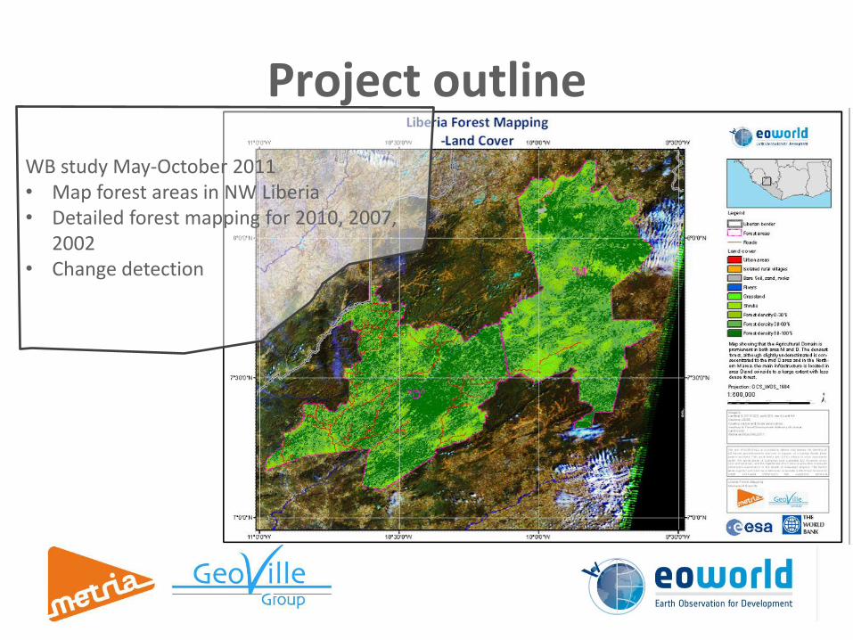
Project outline
WB study May-October 2011• Map forest areas in NW Liberia• Detailed forest mapping for 2010, 2007,
2002• Change detection

• Two forest areas in north-western Liberia– D -Gbarpolu
– M -Gbarpolu & Grand Cape Mount
• Land Cover Classification
• Forest cover Mapping– Density
– Change
• DEM generation
• Decision support– Harvestable area
– Remote areas
– Untouched areas
– Etc.
• Monitoring background
• Benchmark
Project outline

Landsat Imagery from 22 January 2010
Dense forest
Open forest
Grass-/crop land
Bare soil
Open dense forest

National level assessment and planning

Local level planning
Regional and national level assessment

• Forest resource planning at local level
• Forest resource assessment at regional and national level
• Benchmark for conservation areas and local level change detection
• Agricultural land assessment
Local level classification


Harvestable areas with current road network

Analyses
• Forest resources close to rural communities
• Resources close to infrastructure
• Inaccessibility analysis
• Forest resources in no harvest areas
• Etc…


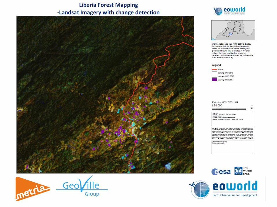

Change detection
• High accuracy
• Available over large areas
• Mostly taking place in degraded or rotated forest areas
• Highlight the need to separate the “agricultural forest” from the high forest


Digital Elevation Model
• Slope calculations– Non harvestable areas
– Terrain constraints
• Watershed calculations
• Ortho rectification of satellite imagery
• Preliminary road planning
• Land slide Hazard areas
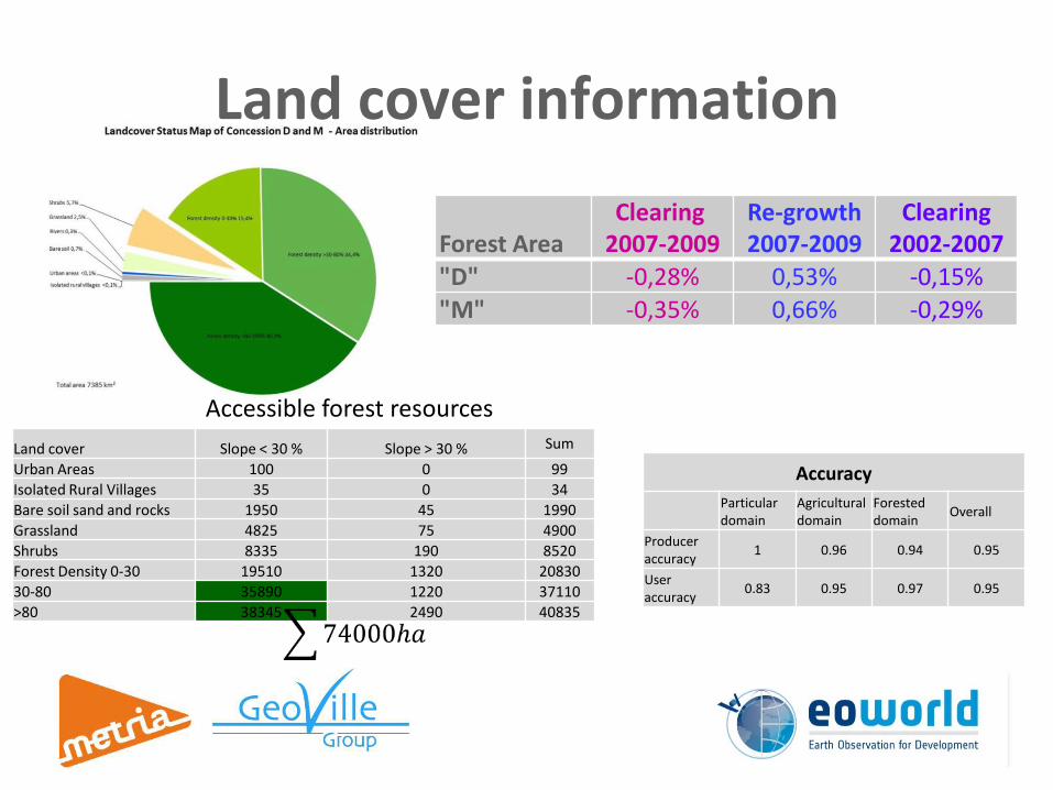
Land cover information
Forest AreaClearing
2007-2009Re-growth2007-2009
Clearing2002-2007
"D" -0,28% 0,53% -0,15%"M" -0,35% 0,66% -0,29%
Land cover Slope < 30 % Slope > 30 % Sum
Urban Areas 100 0 99
Isolated Rural Villages 35 0 34
Bare soil sand and rocks 1950 45 1990
Grassland 4825 75 4900
Shrubs 8335 190 8520
Forest Density 0-30 19510 1320 20830
30-80 35890 1220 37110
>80 38345 2490 40835
Accessible forest resources
Accuracy
Particulardomain
Agricultural domain
Forested domain
Overall
Producer accuracy
1 0.96 0.94 0.95
User accuracy
0.83 0.95 0.97 0.95

Conclusions
• Products suitable for local level planning and regional statistics
• Benchmark for forest monitoring
• Large areas with low impact from forestry activities
• ~10 % available by current infrastructure
• Most forest cover changes in “agricultural forest” close to settlements
• <10 % in areas with a slope over 30 %
• 17 % of the forest area is 0-30 % crown cover and are predominantly part of the agricultural rotation

How much of Liberia is covered?
Forest area
• 7000 square kilometers offorest, 20 % of 34400 according to Bayol havebeen mapped in this project
Agricultural area
• 1000 square kilometers ofagricultural land, 3 % of34800 have been mapped
• 0-30% forest in the present classification, 1550 square kilometers, represents 7 %, of the degraded and mixed forest classes, 22600 square kilometers
Degraded and mixed area
Totally10%

Earth
Observation
Services
EO services gives input for Active Adaptive Management
Integrate
•Policies
•Regulations
Plan
•Desiredconditions
Implement
•Management activities
Monitor
•Economic, social, environmental
Change
•Adaptation

How to ContinueMetria and GeoVille
• Production environment adjusted (ready to start)
• Experienced staff giving high quality outcome
• Service delivery within 2012
World Bank and FDA
• National Forest Inventory– The NFI is essential for classification
• Ground data
• Accuracy assessment
• Volume estimates
– The NFI will benefit from the classification
• Stratification of samples
• Extrapolation (e.g. volume estimates)
– Capacity building
• Forest monitoring– Forest cover benchmark
– High resolution change detection
– Enhanced forest management

Utility review
Contact informationErik WillénDepartment manager
Metria ABPO Box 24154, SE-104 51 Stockholm, SwedenKarlavägen 108Phone: +46 10-121 85 26 Mobile: +46 [email protected]
Christian HoffmannManaging Director
GeoVille Information Systems GmbHSparkassenplatz 2, 3rd floor, A - 6020 Innsbruck, AustriaTel: +43 512-562021-18 Fax: +43 512-562021-22www.geoville.com
Tobias Edman PhD
Project Manager
Metria ABPO Box 24154, SE-104 51 Stockholm, SwedenKarlavägen 108Phone: +46 10 - 121 85 04 Mobile: +46 703-71 33 [email protected]
Jürgen WeichselbaumTechnical Director
GeoVille Information Systems GmbH Sparkassenplatz 2, 3rd floor, A - 6020 Innsbruck, AustriaTel: +43512-562021-17 Fax: +43512-562021-22 www.geoville.com


