Embed Size (px)
Citation preview

Horaires sauf indication contraire / Timetables unless otherwise specifiedAIP France : UTC HIV ; HOR ETE : - 1HR / UTC WIN ; SKED SUM : - 1HR
AIP CAR SAM NAM, AIP PAC-P, AIP PAC-N, AIP RUN: UTC
Indicateur d'emplacement - nom de l'aérodrome Aerodrome location indicator - nameAD 2 LFMI.1
LFMI - ISTRES LE TUBE
Données géographiques et administratives de l'aérodrome Aerodrome geographical and administrative dataAD 2 LFMI.243°31'21"N 004°55'27"EPosition GEO ARP1Intersection de/of RWY 15/33 et/and bretelle/ramp D.Situation de l'ARP / ARP location3.3 Km NNW ISTRES (13 - BOUCHES DU RHONE)Direction, distance de la ville
Direction, distance from city2
82 ftAltitude de référence / Reference elevation329.2 ° CTempérature de référence / Reference temperature162 ftOndulation du géoïde / Geoid undulation41°EDéclinaison magnétique / Magnetic variation52015Année (variation annuelle) / Year (annual change)
MINISTRY OF DEFENCE (FAF)MINISTERE DES ARMEES (FAF)Gestionnaire de l'AD / AD administration6BA125 - 8 route du camp d'aviation - BP20099 - 13128 ISTRES CedexAdresse / AddressStandard/Switchboard : 04.42.41.81.25 - 811.125.2012DV : 04.42.56.13.49 - 811.125.8195 (ou/or 4455)Chef CMC/CMC Chief : 04.42.41.82.20-04.42.41.84.97Chef quart CMC/CMC duty officer : 04.42.41.84.91-811.125.29.11Chef OPS CMC/CMC OPS Chief : 04.42.41.81.01 - 811.125.8101Chef BIA/AIS Office Chief : 04.42.41.80.88-811.125.37.06BIA/AIS Office : 04.42.41.80.88 - 811.125.4045 (ou/or 4052)DGA/EV Standard : 04.42.48.30.00DGA/EV BTO : 04.42.48.35.01DGA/EV CCER CQ : 04.42.48.36.02
Telephone
Standard/Switchboard : 04.42.41.81.25DV/OPO : 04.42.41.82.27Chef CMC/CMC Chief : 04.42.41.80.68Chef quart CMC/CMC duty officer : 811.125.4325Chef OPS CMC/CMC OPS Chief : 04.42.41.80.68BIA/AIS Office : 04.42.48.33.88DGA/EV BTO : 04.42.41.80.68DGA/EV CCER CQ : 04.42.48.33.91CCI : 04.42.41.80.68
FAX
TELEXLFMIZPZXAFSIFR, VFRType de trafic / Type of traffic7
Night VFR approved) / military air trafficMain assigning entity: Air ForceTraining: subject to permission on eve, BTO TPH04.42.41.81.01 and to be confirmed on the day offlight,CDQ TPH 04.42.41.84.91Absence of IAC approach procedure
Agrée VFR de nuit) / CAMAffectataire principal : Armée de l'airEntraînement : soumis à accord la veille TPH BTO04.42.41.81.01 et à confirmer le jour du vol TPH CDQ04.42.41.84.91Absence de procédure d'approche IAC
Observations / Remarks8
AIRAC AMDT 01/18© Service de l'Information Aéronautique, France
AIP FRANCE ~~~RIGHT~~~ AD-2.LFMI~~~END~~~-1~~~eaip-amdt~~~A-2018-0104 JAN 2018

Horaires Operational hoursAD 2 LFMI.3HOR ATSGestionnaire de l'AD / AD administration1
Customs : on requestPolice : H24
Douanes : sur demandePolice : H24Douanes et police / Customs and immigration2
ATS HORHOR ATSServices de santé / Health and sanitary3AIS office : ATS HORCentral flight Information office : H24 - Cinq Mars LaPile - PNIA : 811 927 6339 - 02.47.96.13.39Connected to BRIA Marseilles : 04.42.31.15.65 /04.42.14.22.90 Fax : 04.42.31.15.69
BIA : HOR ATSBIVC : H24 - Cinq Mars la Pile - PNIA : 811 927 6339- 02.47.96.13.39BRIA de rattachement : Marseille : 04.42.31.15.65 /04.42.14.22.90 Fax : 04.42.31.15.69
BIA, BRIA / AIS briefing office4
ATS HORHOR ATSBDP / ARO5ATS HORHOR ATSBureau MET / MET briefing office6(MIL/CIV ):MON : 0715-1600 TUE-THU : 0700-1600FRI: 0700-1400O/T and SAT-SUN-HOL: O/R depending on AD alertstatusPPR LFMIZPZX or 04.42.56.13.49 - 04.42.41.81.25 -Extension 24 455 - 811.125.8195
(MIL/CIV) :LUN : 0715-1600MAR-JEU : 0700-1600VEN : 0700-1400O/T et SAM-DIM-JF : O/R en fonction du positerPPR LFMIZPZX ou 04.42.56.13.49 - 04.42.41.81.25 -Poste ext 24 455 - 811.125.8195
ATS7
H24 - PN 1 h (outside HO)H24 - PN 1h (hors HO)Avitaillement / Fueling8ATS HORHOR ATSServices de manutention / Handling9ATS HORHOR ATSSûreté / Safety10ATS HORHOR ATSDégivrage / De-icing11The service rendered will be announced by RAI or bythe managing organism on 127.925 MHz
Service rendu annoncé par RAI ou organismegestionnaire sur 127.925 MHzObservations / Remarks12
Services d'escale et d'assistance Handling services and facilitiesAD 2 LFMI.4Modern handling installationsInstallations modernes de manutentionMoyens de manutention de fret
Cargo handling facilities1
F34O133 - O135 - O138 - O150 - O156
Types de carburants et lubrifiantsFuel and oil types2
F34 : 3300 m3 - 70 m3/hMoyens et capacités d'avitaillementFueling facilities and capacities3
YESOUIMoyens de dégivrage / De-icing facilities4NILHangar pour aéronefs de passage
Hangar space for visiting aircraft5
NILRéparations pour aéronefs de passageRepair facilities for visiting aircraft6
LHOX - LOXTurnaround possibility for all foreign ACFT
LHOX - LOXPossibilité de mise en oeuvre pour tous ACFT étrangersObservations / Remarks7
Services aux passagers Passenger facilitiesAD 2 LFMI.5AD : MIL lodging onlyCity : hotels
AD : hébergement pour MIL seulementVille : hôtelsHôtels1
AD : food service for MIL only - PPR 1 h outside mealHORCity : numerous restaurants
AD : restauration pour MIL seulement - PPR 1 h horsHOR repasVille : nombreux restaurants
Restaurants2
AD : MIL buses per working hoursCity : TaxisEntry BA125 : Bus line 'Ulysse' n° 6
AD : cars MIL selon HOR de travailVille : TaxisEntrée BA 125 : Ligne de Bus "Ulysse" n°6
Moyens de transport / Transportation facilities3
AD : health care unit available: HO MON-THU 0700-1600 / FRI 0700-1400 Outside working hours - WE -HOL : according to directivesCity : clinic at 5 km - MIL hospital at Marseilles (50 km)
AD : infirmerie présente : HO LUN-JEU 0700-1600 VEN0700-1400 HNO - WE - JF selon directivesVille : clinique à 5 km - hôpital MIL à Marseille (50 km)Services médicaux / Medical facilities4
Cash dispenser opposite non-commissioned officer'smessPost Office : in the city
Distribanque face au mess sous-officierServices postaux : en villeServices bancaires et postaux
Bank and Post Office5
ISTRESOffice de tourisme / Tourist office6SNCF automatic ticketing office, building B1 (SAP)Billeterie SNCF automatique bâtiment B1 (SAP)Observations / Remarks7
Services de sauvetage et de lutte contre l'incendie Rescue and fire fighting servicesAD 2 LFMI.69Niveau RFFS de l'AD
AD level for fire fighting1
Disincarceration equipmentMatériel de désincarcérationMoyens de sauvetage / Rescue equipment2Combat aircraft crash kitLot de crash chasseurMoyens d'enlèvement des aéronefs accidentés
Capability for removal of disabled aircraft3
AD level for fire fighting NATO : 7Contingency plan prepared by the PrefecturePSSA in course of drafting
Niveau SSLIA de l'AD : OTAN 7Plan de secours établi avec la préfecturePSSA en cours d'élaboration
Observations / Remarks4
© Service de l'Information Aéronautique, FranceAIRAC AMDT 10/17
~~~LEFT~~~AD-2.LFMI~~~END~~~-2 AIP FRANCE14 SEP 2017~~~eaip-amdt~~~A-2017-10

Disponibilité saisonnière, déneigement Seasonal availability, clearingAD 2 LFMI.73 sweepers type P30002 angle blades2 ice removing product spraying kits and one snowremoval kit1 hot air blowing system
3 balayeuses types P30002 lames biaises2 KITS d'épandage produit déverglassant et un balaide déneigement1 thermosoufflante
Type d'équipements / Type of clearing equipment1
NILPriorités de dégagement / Clearance priority2Usable in all seasonsUtilisable en toutes saisonsObservations / Remarks3
AIRAC AMDT 08/16© Service de l'Information Aéronautique, France
AIP FRANCE ~~~RIGHT~~~ AD-2.LFMI~~~END~~~-3~~~eaip-amdt~~~A-2016-0821 JUL 2016

Aires de trafic,TWY et emplacements de vérification Aprons,TWY and check locationsAD 2 LFMI.8PRKG/APRON FAS - AST A,B BH (1)PRKG/APRON MARINE - AST C BH (1)PRKG/APRON ESCALE - AST D BH (1)PRKG/APRON ESCALE - AST F BB (2)PRKG/APRON ESCALE - AST I BH (1)PRKG/APRON DGA/EV - AST L,M BB (2)PRKG/APRON AIRBUS BH (1)PRKG/APRON EDSA BB (2)PRKG/APRON MERCURE BB (2)(1) BH : Béton hydraulique/Hydraulic concrete(2) BB : Asphalte/Asphalt
Revêtement de l'aire de trafic / Apron surface
1
PRKG/APRON FAS - AST A,B 15 à/to 32 t/RSIPRKG/APRON MARINE - AST C Non disponible / Not availablePRKG/APRON ESCALE - AST D 18 R/C/W/TPRKG/APRON ESCALE - AST E,F,G,H 29 F/C/W/TPRKG/APRON ESCALE - AST I Non disponible / Not availablePRKG/APRON DASSAULT - AST J,K Non disponible / Not availablePRKG/APRON DGA/EV - AST L,M 16,8 t/RSIPRKG/APRON AIRBUS 46 R/B/W/TPRKG/APRON EDSA 28 F/A/W/TPRKG/APRON MERCURE 27 t/RSI
Résistance de l'aire de trafic / Apron strength
Largeur TWY / TWY width2TAXIWAY PRINCIPAL/MAIN TWY A --> B BH (1)TAXIWAY PRINCIPAL/MAIN TWY B --> D BB (2)TAXIWAY PRINCIPAL/MAIN TWY D --> G BH (1)Bretelle/Ramp A BH/BB (1)(2)Bretelle/Ramp A1 BH (1)Bretelle/Ramp A2 (AIRBUS) BB (2)Bretelle/Ramp B BB (2)Bretelle/Ramp B1 BH (1)Bretelle/Ramp C BB (2)Bretelle/Ramp C1 BB (2)Bretelle/Ramp C2 BH (1)Bretelle/Ramp C3 (ETAA-DASSAULT) BB (2)Bretelle/Ramp D BH/BB (1)(2)Bretelle/Ramp D1 (EDSA) BB (2)Bretelle/Ramp E BH (1)Bretelle/Ramp E1 (MERCURE) BH (1)Bretelle/Ramp F BH (1)Bretelle/Ramp G BH (1)PA NORD/NORTH SWY BH/BB (1)(2)RAQUETTE NORD/NORTH U-TURN PAD BH (1)(1) BH : Béton hydraulique/Hydraulic concrete(2) BB : Asphalte/Asphalt
Revêtement des TWY / TWY surface
TAXIWAY PRINCIPAL/MAIN TWY A --> B 45 R/A/W/TTAXIWAY PRINCIPAL/MAIN TWY B --> D 32 F/B/W/TTAXIWAY PRINCIPAL/MAIN TWY D --> G 39 R/B/W/TBretelle/Ramp A 27 R/B/W/TBretelle/Ramp A1 Non disponible/Not availableBretelle/Ramp A2 (AIRBUS) 32 F/C/W/TBretelle/Ramp B 23 t/RSI 29 t/RJ 50 t/BBretelle/Ramp B131 t/BBretelle/Ramp C 29 F/B/W/TBretelle/Ramp C1 33 F/B/W/TBretelle/Ramp C2 Non disponible/Not availableBretelle/Ramp C3 (ETAA-DASSAULT) 35 F/C/W/TBretelle/Ramp C4 (ETAA-MARINE) Non disponible/Not availableBretelle/Ramp D 27 R/B/W/TBretelle/Ramp D1 (EDSA) 33 F/A/W/TBretelle/Ramp E 38 R/B/W/TBretelle/Ramp E1 (MERCURE) Non disponible/Not availableBretelle/Ramp F 37 R/B/W/TBretelle/Ramp G 38 R/B/W/TPA NORD/NORTH SWY 31 R/B/W/TRAQUETTE NORD/NORTH U-TURN PAD 65 R/B/W/T 30F/C/W/T(1) BH : Béton hydraulique/Hydraulic concrete(2) BB : Asphalte/Asphalt
Résistance des TWY / TWY strength
Vers/To QFU 15 : CV 332,6° - entrée/entrance RWY 33 : 19 m (62,3ft)Vers QFU 33 : CV 152,6° - entrée/entrance RWY 15 : 23 m (75,4 ft)PRKG : 22,5 m (73,8 ft)
Emplacement des ACL / ACL location3
Altitude des ACL / ACL elevationPoints de vérification VOR / VOR checkpoints4
MI 60 43°30'41.72"N 004°56'13.59"EMI 61 43°31'51.03"N 004°55'25.91"E
MI 500 43°31'03.81"N 004°56'24.87"EMI 51 43°31'01.89"N 004°56'33.35"EPoints de vérification INS / INS checkpoints5
Lighted panels and axes materialised in yellow on TWYTaxi with caution on all aprons, limited visibility fromTWR
Panneaux éclairés et axes matérialisés en jaune surTWYRoulage de précaution sur tous parkings, absence deportée visuelle à partir de la TWR
Observations / Remarks6
© Service de l'Information Aéronautique, FranceAIRAC AMDT 08/16
~~~LEFT~~~AD-2.LFMI~~~END~~~-4 AIP FRANCE21 JUL 2016~~~eaip-amdt~~~A-2016-08
Guidage et contrôle des mouvements à la surface, balisage / Surface movement guidance and control system, markingAD 2 LFMI.9NILID postes de stationnement
Aircraft stands ID signs1
Yellow central marks on the groundMarques d'axe au sol de couleur jauneLignes de guidage TWY / TWY guide linesNILSystèmes de guidage pour l'accostage des
aéronefsVisual docking/parking guidance system
Threshold combs, distance marks, RWR NR, RWYaxes
Peignes de seuil, marques de distance, NR RWY, axesRWYMarquage RWY et TWY / RWY and TWY marking2
Voir/see AD 2 LFMI .14/15Balisage RWY et TWY / RWY and TWY lightingNILBarres d'arrêt / Stop bars3
Indicator panels, central lines, safety reflectorsPanneaux indicateurs, lignes médianes, catadioptresObservations / Remarks4
Obstacles aux abords de l'aérodrome Aerodrome obstaclesAD 2 LFMI.10Voir carte d'aérodrome OACI et cartes d'obstacles / See aerodrome ICAO chart and obstacle charts
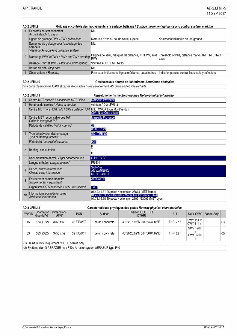
Renseignements météorologiques Meteorological informationAD 2 LFMI.11Marseille ProvenceCentre MET associé / Associated MET Office1voir/see AD 2 LFMI .3Horaires de service / Hours of service2MIL : CMOA Lyon Mont VerdunCIV : Nice Côte d'Azur
Centre MET hors HOR / MET Office outside HOR
Marseille ProvenceCentre MET responsable des TAFOffice in charge of TAF
3
2403-09-15-21
Période de validité / Validity period
SC - TRENDType de prévision d'atterrissageType of landing forecast
4
H24Périodicité / Interval of issuancePTD
Briefing, consultation5
C-PL TB-CRDocumentation de vol / Flight documentation6FR-ENLangue utilisée / Language usedS-U-P-WAD WARNINGMETAR AUTO
Cartes, autres informationsCharts, other information7
AEROWEBEquipement complémentaireSupplementary equipment8
TWROrganismes ATS desservis / ATS units served904.42.41.81.25 poste / extension 26614 (MET Istres)04.42.46.03.25 (Marseille / Marseilles Provence : H24)04.78.14.65.89 poste / extension 23091/23092 (MET Lyon)
Informations complémentairesAdditional information10
Caractéristiques physiques des pistes Runway physical characteristicsAD 2 LFMI.12
Bande StripSWY CWYALTPosition GEO THR(DTHR)SurfacePCNDimensions
RWYOrientationGeo (MAG)RWY ID
(1)SWY 114 mCWY 114 mTHR: 77 ft43°32'15.96"N 004°54'47.85"Ebéton / concrete32 F/B/W/T3750 x 59153 (152)15
(2)
SWY 1208m
CWY 1208m
THR: 62 ft43°30'28.02"N 004°56'04.62"Ebéton / concrete32 F/B/W/T3750 x 59333 (332)33
(1) Freins BLISS uniquement / BLISS brakes only(2) Système d'arrêt AERAZUR type F40 / Arrestor system AERAZUR type F40
AIRAC AMDT 10/17© Service de l'Information Aéronautique, France
AIP FRANCE ~~~RIGHT~~~ AD-2.LFMI~~~END~~~-5~~~eaip-amdt~~~A-2017-1014 SEP 2017
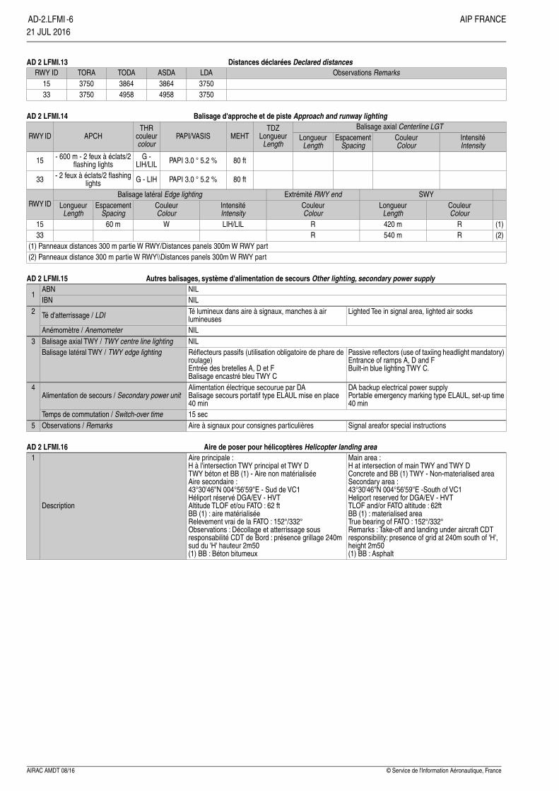
Distances déclarées Declared distancesAD 2 LFMI.13Observations RemarksLDAASDATODATORARWY ID
375038643864375015375049584958375033
Balisage d'approche et de piste Approach and runway lightingAD 2 LFMI.14Balisage axial Centerline LGTTDZ
LongueurLength
MEHTPAPI/VASISTHR
couleurcolour
APCHRWY ID IntensitéIntensity
CouleurColour
EspacementSpacing
LongueurLength
80 ftPAPI 3.0 ° 5.2 %G -LIH/LIL
- 600 m - 2 feux à éclats/2flashing lights15
80 ftPAPI 3.0 ° 5.2 %G - LIH- 2 feux à éclats/2 flashinglights33
SWYExtrémité RWY endBalisage latéral Edge lightingRWY ID Couleur
ColourLongueur
LengthCouleurColour
IntensitéIntensity
CouleurColour
EspacementSpacing
LongueurLength
(1)R420 mRLIH/LILW60 m15(2)R540 mR33
(1) Panneaux distances 300 m partie W RWY/Distances panels 300m W RWY part(2) Panneaux distance 300 m partie W RWY\\Distances panels 300m W RWY part
Autres balisages, système d'alimentation de secours Other lighting, secondary power supplyAD 2 LFMI.15NILABN
1NILIBN
Lighted Tee in signal area, lighted air socksTé lumineux dans aire à signaux, manches à airlumineusesTé d'atterrissage / LDI2
NILAnémomètre / AnemometerNILBalisage axial TWY / TWY centre line lighting3
Passive reflectors (use of taxiing headlight mandatory)Entrance of ramps A, D and FBuilt-in blue lighting TWY C.
Réflecteurs passifs (utilisation obligatoire de phare deroulage)Entrée des bretelles A, D et FBalisage encastré bleu TWY C
Balisage latéral TWY / TWY edge lighting
DA backup electrical power supplyPortable emergency marking type ELAUL, set-up time40 min
Alimentation électrique secourue par DABalisage secours portatif type ELAUL mise en place40 min
Alimentation de secours / Secondary power unit4
15 secTemps de commutation / Switch-over timeSignal areafor special instructionsAire à signaux pour consignes particulièresObservations / Remarks5
Aire de poser pour hélicoptères Helicopter landing areaAD 2 LFMI.16Main area :H at intersection of main TWY and TWY DConcrete and BB (1) TWY - Non-materialised areaSecondary area :43°30'46''N 004°56'59''E -South of VC1Heliport reserved for DGA/EV - HVTTLOF and/or FATO altitude : 62ftBB (1) : materialised areaTrue bearing of FATO : 152°/332°Remarks : Take-off and landing under aircraft CDTresponsibility: presence of grid at 240m south of 'H',height 2m50(1) BB : Asphalt
Aire principale :H à l'intersection TWY principal et TWY DTWY béton et BB (1) - Aire non matérialiséeAire secondaire :43°30'46''N 004°56'59''E - Sud de VC1Héliport réservé DGA/EV - HVTAltitude TLOF et/ou FATO : 62 ftBB (1) : aire matérialiséeRelevement vrai de la FATO : 152°/332°Observations : Décollage et atterrissage sousresponsabilité CDT de Bord : présence grillage 240msud du 'H' hauteur 2m50(1) BB : Béton bitumeux
Description
1
© Service de l'Information Aéronautique, FranceAIRAC AMDT 08/16
~~~LEFT~~~AD-2.LFMI~~~END~~~-6 AIP FRANCE21 JUL 2016~~~eaip-amdt~~~A-2016-08

Espaces ATS ATS airspaceAD 2 LFMI.17
Observations RemarksOrganisme Indicatif d'appel (langue)ATS unit Call-sign (language)
Limites verticalesVertical limits
ClasseClass
Identification et limites latéralesIdentification and lateral limits
CTR ISTRES partie 1.1Activable H24.Espace défini à l'exclusion de la portioninterférente de la LF-R 191A lorsqu'elle estactive.Espace commun avec la LF-R 217/1.1 et desportions interférentes des LF-R 108 AF1 etAF2 ISTRES lorsqu'elles sont actives.LF-P 13 FOS SUR MER, LF-P 41 ISTRES :pénétration interdite.Cf ENR 5.1-0 paragraphe 1.2.Airspace set excluding interfering section ofLF-R 191 A when active.Airspace shared with LF-R 217/1.1 andinterfering sections of LF-R 108 AF1 and AF2ISTRES when active.LF-P 13 FOS SUR MER, LF-P 41 ISTRES :entry prohibited.Cf ENR 5.1-0 paragraph 1.2.
CENTRE MILITAIRE DECONTRÔLE ISTRES
3500ft AMSL------------
SFCD
43°48'00"N , 004°38'38"E - 43°42'37"N ,004°47'16"E - 43°37'05"N , 004°55'51"E -43°34'17"N , 005°00'12"E - arc horaire de 5 NMde rayon centré sur 43°31'00"N , 004°55'00"E -43°31'25"N , 005°01'52"E - 43°24'45"N ,005°01'50"E - 43°23'14"N , 005°03'09"E -43°15'10"N , 005°02'11"E - 43°15'10"N ,004°41'17"E - 43°15'10"N , 004°29'10"E -43°26'02"N , 004°29'40"E - 43°28'12"N ,004°29'46"E - 43°33'41"N , 004°30'01"E -43°48'00"N , 004°38'38"E
CTR ISTRES partie 1.2Activable H24.Espace commun avec la LF-R 217/1.2ISTRES : voir ENR 5.1.Activité connue de CAMARGUE Contrôle ouannoncée par RAI 127.925.Airspace shared with LF-R 217/1.2 ISTRES :see ENR 5.1.Activity known on CAMARGUE CTL orannounced by RAI 127.925.
CENTRE MILITAIRE DECONTRÔLE ISTRES
3000ft AMSL------------
SFCD
43°23'14"N , 005°03'09"E - 43°15'10"N ,005°10'47"E - 43°15'10"N , 005°02'11"E -43°23'14"N , 005°03'09"E
CTR ISTRES partie 1.3Activable H24.Espace commun avec la LF-R 217/1.3ISTRES : voir ENR 5.1.Activité connue de CAMARGUE Contrôle ouannoncée par RAI 127.925.Airspace shared with LF-R 217/1.3 ISTRES :see ENR 5.1.Activity known on CAMARGUE CTL orannounced by RAI 127.925.
CENTRE MILITAIRE DECONTRÔLE ISTRES
2100ft AMSL------------
SFCD
43°31'25"N , 005°01'52"E - 43°24'00"N ,005°03'30"E - 43°20'46"N , 005°05'29"E -43°23'14"N , 005°03'09"E - 43°24'45"N ,005°01'50"E - 43°31'25"N , 005°01'52"E
AIRAC AMDT 11/16© Service de l'Information Aéronautique, France
AIP FRANCE ~~~RIGHT~~~ AD-2.LFMI~~~END~~~-7~~~eaip-amdt~~~A-2016-1113 OCT 2016
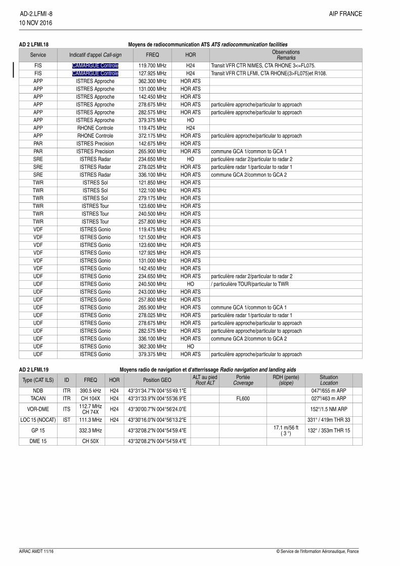
Moyens de radiocommunication ATS ATS radiocommunication facilitiesAD 2 LFMI.18Observations
RemarksHORFREQIndicatif d'appel Call-signService
Transit VFR CTR NIMES, CTA RHONE 3<=FL075.H24119.700 MHzCAMARGUE ControleFISTransit VFR CTR LFMI, CTA RHONE(3>FL075)et R108.H24127.925 MHzCAMARGUE ControleFIS
HOR ATS362.300 MHzISTRES ApprocheAPPHOR ATS131.000 MHzISTRES ApprocheAPPHOR ATS142.450 MHzISTRES ApprocheAPP
particulière approche/particular to approachHOR ATS278.675 MHzISTRES ApprocheAPPparticulière approche/particular to approachHOR ATS282.575 MHzISTRES ApprocheAPP
HO379.375 MHzISTRES ApprocheAPPH24119.475 MHzRHONE ControleAPP
particulière approche/particular to approachHOR ATS372.175 MHzRHONE ControleAPPHOR ATS142.675 MHzISTRES PrecisionPAR
commune GCA 1/common to GCA 1HOR ATS265.900 MHzISTRES PrecisionPARparticulière radar 2/particular to radar 2HO234.650 MHzISTRES RadarSREparticulière radar 1/particular to radar 1HOR ATS278.025 MHzISTRES RadarSREcommune GCA 2/common to GCA 2HOR ATS336.100 MHzISTRES RadarSRE
HOR ATS121.850 MHzISTRES SolTWRHOR ATS122.100 MHzISTRES SolTWRHOR ATS279.175 MHzISTRES SolTWRHOR ATS123.600 MHzISTRES TourTWRHOR ATS240.500 MHzISTRES TourTWRHOR ATS257.800 MHzISTRES TourTWRHOR ATS119.475 MHzISTRES GonioVDFHOR ATS121.500 MHzISTRES GonioVDFHOR ATS123.600 MHzISTRES GonioVDFHOR ATS127.925 MHzISTRES GonioVDFHOR ATS131.000 MHzISTRES GonioVDFHOR ATS142.450 MHzISTRES GonioVDF
particulière radar 2/particular to radar 2HOR ATS234.650 MHzISTRES GonioUDF/ particulière TOUR/particular to TWRHO240.500 MHzISTRES GonioUDF
HOR ATS243.000 MHzISTRES GonioUDFHOR ATS257.800 MHzISTRES GonioUDF
commune GCA 1/common to GCA 1HOR ATS265.900 MHzISTRES GonioUDFparticulière radar 1/particular to radar 1HOR ATS278.025 MHzISTRES GonioUDFparticulière approche/particular to approachHOR ATS278.675 MHzISTRES GonioUDFparticulière approche/particular to approachHOR ATS282.575 MHzISTRES GonioUDFcommune GCA 2/common to GCA 2HOR ATS336.100 MHzISTRES GonioUDF
HO362.300 MHzISTRES GonioUDFparticulière approche/particular to approachHOR ATS379.375 MHzISTRES GonioUDF
Moyens radio de navigation et d'atterrissage Radio navigation and landing aidsAD 2 LFMI.19SituationLocation
RDH (pente)(slope)
PortéeCoverage
ALT au piedRoot ALTPosition GEOHORFREQIDType (CAT ILS)
047º/655 m ARP43°31'34.7"N 004°55'49.1"EH24390.5 kHzITRNDB027º/463 m ARPFL60043°31'33.9"N 004°55'36.9"EH24CH 104XITRTACAN
152°/1.5 NM ARP43°30'00.7"N 004°56'24.0"EH24112.7 MHzCH 74XITSVOR-DME
331° / 419m THR 3343°30'16.0"N 004°56'13.2"EH24111.3 MHzISTLOC 15 (NOCAT)
132° / 353m THR 1517.1 m/56 ft( 3 °)43°32'08.2"N 004°54'59.4"E332.3 MHzGP 15
43°32'08.2"N 004°54'59.4"ECH 50XDME 15
© Service de l'Information Aéronautique, FranceAIRAC AMDT 11/16
~~~LEFT~~~AD-2.LFMI~~~END~~~-8 AIP FRANCE10 NOV 2016~~~eaip-amdt~~~A-2016-12
AD 2 LFMI.20 Règlements de circulation locaux Local traffic regulationsGENERAL INFORMATION20.1GENERALITES20.1AD open to public air traffic (CAP).AD ouvert à la CAP.AD inhibited to ACFT not equipped with radio and to gliders and ULMs.Fly-over of base installations prohibited H 24 below 300 m (1000 ft) andaccording to the restrictions related to P41 area (cf AIP ENR 5.1).
AD interdit aux ACFT non munis de radio, aux planeurs et ULM.Installations de la base interdites de survol H 24 en dessous de 300 m(1000 ft) et conformément aux restrictions liées à la zone P41 (cf AIP ENR5.1) .
QFU 15 : RWY circuit on right.QFU 15 : circuit de RWY à droite.Due to a lack of visibility and no video surveillance mean, ground controlmay not be able to provide informations to crew concerning any obstacleslocated in stopover area (apron D, F and I and intersection between rampC1, C3 and C4). Captains will exercice special supervision to ensure thesafety of the aircrafts in that area.
En raison d'un manque de visibilité et de l'absence de surveillance vidéo,le contrôle au sol peut être dans l'impossibilité d'assurer l'information deséquipages concernant d'éventuels obstacles dans la zone d'escale (parkingD, F et I et intersection entre bretelles C1, C3 et C4). Les Cdt de bordexerceront une surveillance particulière pour assurer la sécurité desaéronefs dans cette zone.
SPECIAL ACTIVITY20.2ACTIVITES PARTICULIERES20.2- Due to special CCER activities and activation at short notice of LF-R108AF1 and LF-R108AF2 zones, radio contact is mandatory at 30NMfrom field (Vi 350Kts jet engine), comply with the instructions of Istres APP,Istres TWR or Rhône CTL.
- En raison d'activités particulières CCER et activation à bref délai deszones LFR108AF1 et LF-R108AF2, contact radio obligatoire à 30NM duterrain (Vi 350Kts réacteur), se conformer aux instructions d'Istres APP,Istres TWR ou Rhône CTL.
- AEM 9895 : 800m circle centered on the point of coordinates 43°32.255'N004°57.038'E - SFC/230ft. Activation known by Istres TWR and Istres APP.
- AEM 9895 : cercle de 800m centré sur le point de coordonnées43°32.255'N 004°57.038'E - SFC/230ft. Activation connue d'Istres TWRet Istres APP.
- LF-P41 : 3NM radius circle centered on LFMI ARP 43°31'20,62''N004°55'27,25''E - SFC/4500ft AMSL. Restrictions known by Istres APPand Istres TWR.
- LF-P41 : cercle de 3NM de rayon centré sur l'ARP LFMI 43°31'20,62''N004°55'27,25''E - SFC/4500ft AMSL. Restrictions connues d'Istres APP etIstres TWR.
RESTRICTIONS20.3RESTRICTIONS20.3Restriction on AD : MON-FRI : 1100-1300; 1800-1900 trainings PLNmandatory for all flights going to or departing from ISTRES: enter the PPRNR in box 18.
Restriction sur AD : LUN-VEN : 1100-1300; 1800-1900 entraînementsPLN obligatoire pour tous les vols à destination et au départ d’ISTRES :mentionner en case 18 le NR PPR.
Non-based aircraft, landing subject to PPR to be requested:From MON to FRI before 1500 on the eve,SAT-SUN-HOL before 1430 on last working day.PPR to be requested to LFMIYDYX or to : 04.42.41.81.41 - 04.42.41.81.25- Extension 24 455 -811 125 2012The PPR NR must be entered in box 18 of the PLN.
Avions non basés atterrissage soumis à accord PPR à demander : DuLUN au VEN avant 1500 la veille,SAM-DIM-JF avant 1430 le dernier JO.PPR à demander à LFMIZPZX ou au : 04.42.56.13.49 - 04.42.41.81.25 -Poste ext 24 455 -811 125 2012Le numéro de PPR devra figurer en case 18 du PLN.
FREQUENCIES20.4FREQUENCES20.4- OPS Freq "Loader" 143.850 (on ground)- Freq OPS : "Chargeur" 143.850 MHz (au sol)- CCER Freq "ISTRES TEST" 112.9 MHzMON-FRI : 0745-1510 - Extended according to in-flight test requirements.
- Freq CCER : "ISTRES ESSAI" 112.9 MHzLUN-VEN : 0745-1510 - Etendue selon les besoins des essais en vol.
Procédures antibruit Noise abatement proceduresAD 2 LFMI.21Take-offs are made on priority in QFU 33, as soon as the following conditions aremet:
Les décollages sont effectués prioritairement en QFU 33, dès lors que les conditionssuivantes sont réunies :
• Tail wind component less than or equal to 10 Kt ; Composante de vent arrière inférieure ou égale à 10 Kt ; • During low-activity periods, i.e.: • En période de moindre activité, soit : • Between 18h00 and 08h00 local, on working days, • Entre 18h00 et 08h00 locales les jours ouvrés, • On weekends and holidays. • Le week-end et les jours fériés.
During summer (21 June/07 September):En période estivale (21 juin/07 septembre) :insofar as possible, during approaches or visual field returns in QFU33 for aircraftcoming from the North or the West, a direct tail wind report for final visual approachis recommended.
Dans la mesure du possible, lors des approches ou des retours terrain à vue enQFU33 pour les aéronefs en provenance du Nord ou de l’Ouest, un report directen vent arrière pour une finale à vue est préconisé.
Procédures de vol Flight proceduresAD 2 LFMI.22Nil
AIRAC AMDT 09/18© Service de l'Information Aéronautique, France
AIP FRANCE ~~~RIGHT~~~ AD-2.LFMI~~~END~~~-9~~~eaip-amdt~~~A-2018-0916 AUG 2018

AD 2 LFMI.23 Renseignements supplémentaires Additional informationAIRFIELD CLOSURE23.1FERMETURE TERRAIN23.1Airfield closed from 0545 to 0715 UTC every monday morning formaintenance.
Terrain fermé de 0545 à 0715 UTC tous les lundi matin pour maintenance.
CTA RHONEAIR TRAFFIC CONTROL UNIT :23.2ORGANISME CHARGE DU CONTROLE DE LA CIRCULATION
AERIENNE :23.2
The inter-defence control center (CCI) provides the air traffic serviceswithin the CTA RHONE whose limits are defined in ENR 2.1.2.
Le centre de Contrôle Interdéfense (CCI) assure les services de lacirculation aérienne à l’intérieur de la CTA RHONE dont les limites sontdéfinies en ENR 2.1.2.
- Within the CCI, ISTRES APPROACH provides the air traffic serviceswithin CTA RHONE 1, 2, 3, 3.1, 4 and 5.
- Au sein du CCI, ISTRES APPROCHE assure les services de la CirculationAérienne dans les CTA RHONE 1, 2, 3, 3.1, 4 et 5
- Within the CCI, the terminal sector, call sign : RHONE CONTROL,provides services to IFR GAT within CTA ISTRES limits out of AWY B16and Y25.
- Au sein du CCI, le secteur terminal indicatif : RHONE CONTROLE, assureles services de la CAG IFR dans les limites des CTA d’Istres hors desAWY B16 et Y25.
- Air traffic services for test and acceptance flights are provided by ISTRESESSAIS (tests).
- ISTRES ESSAIS assure la délivrance des services de la Circulationd’Essai et de Réception.
AIRSPACE CLASS23.3CLASSE D’ESPACE23.3The whole CTA RHONE is of class : D.La totalité de la CTA RHONE est de classe : D.ALTIMETER SETTING23.4CALAGE ALTIMETRIQUE23.4- The transition altitude for the CTA is 5000 ft.- The transition level is calculated by : RHONE CONTROL
- L’altitude de transition pour la CTA est de 5000 ft.- Le niveau de transition est calculé par : RHONE CONTROLE
SPECIFIC PROCEDURES23.5PROCEDURES PARTICULIERES23.5Arrival/Departure routes at ISTRES Aerodrome.23.5.1Trajectoires arrivées / départs de l’Aérodrome d’ISTRES.23.5.1- SOUTH-SOUTH/EAST : ----> MTG ----> SALIN ----> ITRif FL < 095, clearance according to agreement letter from MARSEILLEPROVENCE / CCI.- EAST : clearance according to agreement letter from MARSEILLEPROVENCE / CCI.
- SUD-SUD/EST : ----> MTG ----> SALIN ----> ITRsi FL < 095 clairance selon lettre d’accord MARSEILLE PROVENCE / CCI.- EST : clairance selon la lettre d’accord MARSEILLE PROVENCE / CCI.
Transit flights in CTA RHONE23.5.2Transits en CTA RHONE23.5.2Because of defence activites, transit flights in CTA RHONE are subject toa prior agreement of the CCI (inter-defence control center) obtained throughRHONE CONTROL.
En raison des activités défense les transits en CTA RHONE sont soumisà accord préalable du CCI obtenu auprès de RHONE CONTROLE.
HAND-OVER23.6TRANSFERT DE COMMUNICATION23.6Frequency changes are performed on instruction of the appropriate controlunit responsible for aircraft control, one minute maximum after thefrequency change instruction has been given.
Les changements de fréquence ont lieu sur instruction de l’organismeresponsable du contrôle de l’aéronef, au plus tard une minute aprèsl’instruction de changement de fréquence.
COMMUNICATION FAILURE23.7PANNE DE COMMUNICATION23.7Squawk code 7600.Comply with national regulations.
Afficher code 7600.Appliquer la règlementation nationale.
RADAR SERVICE23.8SERVICE RADAR23.8The inter-defence control center (RHONE CONTROL - CAMARGUECONTROL - ISTRES APPROACH - ISTRES ESSAIS (tests) provides thefollowing services :- radar information- radar surveillance- control and guidance according to national regulations within the CTA,using the following call signs : “RHONE CONTROL or ISTRESAPPROACH”- radar control and guidance for test and acceptance flights (ISTRESESSAIS).
Le Centre de Contrôle Interdéfense (RHONE CONTROLE - CAMARGUECONTROLE - ISTRES APPROCHE - ISTRES ESSAIS) assure les services:- d’information radar- de surveillance radar- du contrôle et guidage radar conformément à la règlementation nationaleà l’intérieur de la CTA qu’il gère avec l’indicatif : “RHONE CONTROLE ouISTRES APPROCHE”- du contrôle et guidage radar à la circulation d’essai et réception (ISTRESESSAIS).
SPECIFIC ACTIVITIES AND PERVIOUSNESS23.9ACTIVITES SPECIFIQUES ET PERMEABILITE23.9LF-R217 is linked to CTA RHONE due to specific activities :La LF-R217 RHONE est associée à la CTA RHONE en raison d’activités
spécifiques :- test flights- procedure airspaces- tactical flights- aerobatics- training of any of aircraft and in any conditions.
- vols d’essais- espaces de procédures- vols tactiques- voltige- entraînement d’aéronefs de tous types et en toutes conditions
The attention of airmen is drawn on the presence of a firing area LF- R190(see ENR 5).When activated, some flying sectors are impervious.
L’attention des usagers est attirée sur la présence d’une zone de tirs LF-R190 (voir ENR 5).Pendant leur activation certains secteurs de travail sont imperméables.
Cartes relatives à l'aérodrome Charts related to the aerodromeAD 2 LFMI.24
© Service de l'Information Aéronautique, FranceAIRAC AMDT 09/18
~~~LEFT~~~AD-2.LFMI~~~END~~~-10 AIP FRANCE16 AUG 2018~~~eaip-amdt~~~A-2018-09

��
����
����
����
�� �� ����
���������������
�� �������
�� ����� �
��!���
"��
����#�����#���
�$
������ �
���"%�
&��'���
����!���()��*�(�+,
��&"�-)
���.
/��./��
����*0�,
1-*�2,
$���������33����/�!��$����4��
��!��/�/��*��!����!,
��*�0,
��
$��
����!���()��*�(�+,
��&"�-)
�� ���!����!���!���
��!���
55
�
�
�
$ $�
�
�)))�6��)�3�5�)�6��1�3
������)-3
7
�
�
$�"�
&
&
8
0
�
����
�
��� ��"
6 6 6
9������!����!�����:�;���<����
9����!��=����>�#?��!������������!����!������:�;���<����
0���)@ ))0����@
0����@
�/"��/�/�����'��:���A����(-�)���51(�5��"/�A��B �A�)-��>�2))C����>8�B�A�)5))>�2))C��� �A�)5))>�0))C���"��!�/��>���>87�A��������D���!�����:��?'�3���E����!��*�"�A�>�&�,(����������������������������������������������������� �����������!������� "#"� $�%�&���'"( �) � *)�+����������,-�$���A�&����"/�A��������)0(0�(0�(-)(--C� ���A��������-��(���(0)0��0)��C�$����A����/������*;����)""� � ,��"�A�7�0��:F��D���!�A�����>����>���->���)>���2(��&�����"�A�&�0C�&����&���:;��F�������=(�.�����/��!*0($1�� )����//���/����/���������-�������.����������� "(�&#"�$�%�2&*()�33���2-
�:;��!�G�����
�#"�� &�#*0'$1��$(� (���$1
��������"B$H0�������� �>�))0�����5��
���� ���� ����"(& (&4"�12�( �!���5�����+/�23�,
�����7������)��-�����2
��7�� �
I���"�)���2������ ��3�����!���(
������*��,
�!����& "�A�D! B ��A��2��D!
�����������������>�/�:����%J����A�;��!�&���!�$���������67������%(""������ �8�->�/�:����%J����A�;��!�&���������67�//���%(""����->��6!�?3�!?����#��!������!����A���:'���&�����67�"� ����� �//���(" )���-
����"/��� �����"�� ��/�������5���9�����!�5�3�������
�������������� ����>�����:!�����F�����G��7��99K�*&��3���;�����?':�����(,����&(�9�.�:$ 2�33��� �!���;3;<�+���"��&(�)12" *'" �'$%2 )-,>���G��7��99K���:�!?��A�)0(0�(�2(��(01�>�)0(0�(0�(-�(1����33��� �!���;3;<�&(�#2&�"��*40"(����-��-��-�/-�����-��-��-�-��>��"�:�����#��!��G�����!���:�L7B���(����$%2 �2�� �1$(1*$ �=�����->�*�,�� ��"��7�A�8�:����5�>�����)�3
���������� :�!����$%2 �M�-))�3
�%J����A�3��!�����������N:�O:@G���*0�-,C�#:���3��!?�������!��N:�O:@G��@��!�!:�������?�:��!?������:!�(� ��#���!�:������;��!�������(�%J����A�3��!�����������G��C0+�N:�O:@G���*0�-,C�#:�����:!�������!�����3��!?��G��C0+�N:�O:@G����*���-,�*�,�#:���3��!���N:�O:EG��@��!�!:�������?�:��!?������:!�(� ��#��!�:������;��!�������(*�,���!��!=?���O:�����3��!?�C��F�!�����#?�������!�A�!�:�����':�!�����2�2�D!�G��10�)�3�����������G�����!������E�6�(�/���3#����F���!?����3���!�������!!��#��!��#�?;������"(�67������1'$40���?��(�1@����A�*#� &���+��,�� 2"�� $("1 �(&* "�*#� &�"��(&* "�)��" >��' $ * "-�5&�B � *(��0"�&("�5��-�67�//���1'$40�� �/��C���?��(�1@�//�A�*#� &���+��,�� 2"�� $("1 �(&* "�1'$40$�%�� �/��C�*#� &����+���,�+�,�� 2"��1'$40�*#� &�"��(&* "�)��" >��' $ * "-�5&�B � *(��0"�&("5��-+�,� 2"&(" $1�'�1'$40$�%�)'&#"��4&) �#"��'$D$�%�&0) �1'"��� &:"(���/��� �� ������4��(&4�5����� �($%2 �&���67��E$)-����$4#&))$0'"��� F$)"���9-GG
$���/� ��!$%2 $�% �� ��B�/�"��7�*����A�3,��/�/"(� ("�% 2�& �%J
"��� "��� �/�� ����"�� �"�$ �"�
�%J �"B���*(��1"
&��$�2))�3 ��
�����
�"��
��
��
&��$�
&��$�
�5�)
�5�)
�-20
01�-
�-20
01�-
�5�)
�5�)
��;P!:�
3�F" ���7�$�%�"
*�,
*�,
*�,
*�,
*�,
*�,
*�,
*�,
"J� ��"�"B�� �� �"B��
"&���� 0�����E���(12Q� ))0���0E�05(-�Q��
"&���� 0����)E��-()�Q� ))0���2E�)0(2�Q��
�)))�3)
��/�
���B��
$��!�������
$��!�������
$��!������
$��!�����
"
"
��//�B�"
���$B/
AIP AD 2 LFMI DATA 01FRANCE 26 APR 18
DATA ISTRES LE TUBÉ
DIRCAM AMDT 05/18 CHG : Création. ©
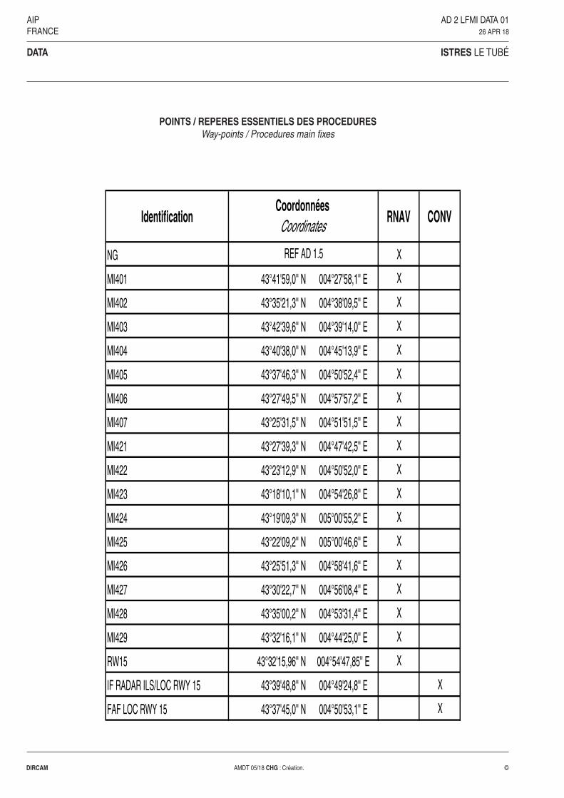
POINTS / REPERES ESSENTIELS DES PROCEDURESWay-points / Procedures main fixes
Identification RNAV CONV
NG X
MI401 43°41'59,0'' N 004°27'58,1'' E X
MI402 43°35'21,3'' N 004°38'09,5'' E X
MI403 43°42'39,6'' N 004°39'14,0'' E X
MI404 43°40'38,0'' N 004°45'13,9'' E X
MI405 43°37'46,3'' N 004°50'52,4'' E X
MI406 43°27'49,5'' N 004°57'57,2'' E X
MI407 43°25'31,5'' N 004°51'51,5'' E X
MI421 43°27'39,3'' N 004°47'42,5'' E X
MI422 43°23'12,9'' N 004°50'52,0'' E X
MI423 43°18'10,1'' N 004°54'26,8'' E X
MI424 43°19'09,3'' N 005°00'55,2'' E X
MI425 43°22'09,2'' N 005°00'46,6'' E X
MI426 43°25'51,3'' N 004°58'41,6'' E X
MI427 43°30'22,7'' N 004°56'08,4'' E X
MI428 43°35'00,2'' N 004°53'31,4'' E X
MI429 43°32'16,1'' N 004°44'25,0'' E X
RW15 43°32'15,96'' N 004°54'47,85'' E X
IF RADAR ILS/LOC RWY 15 43°39'48,8'' N 004°49'24,8'' E X
FAF LOC RWY 15 43°37'45,0'' N 004°50'53,1'' E X
Coordonnées Coordinates
REF AD 1.5
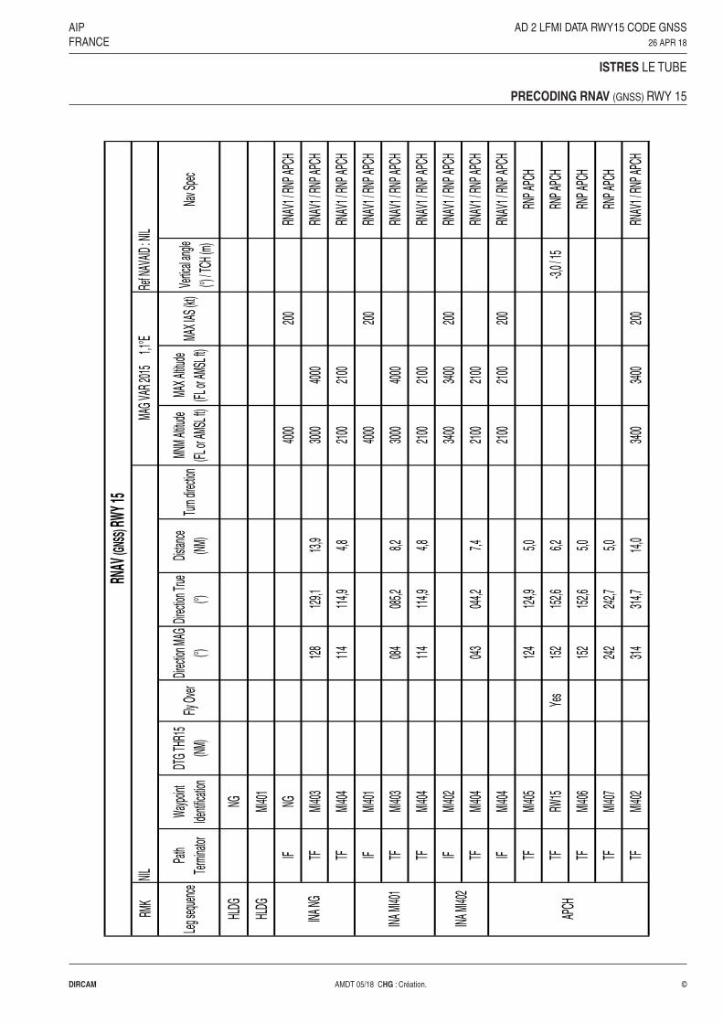
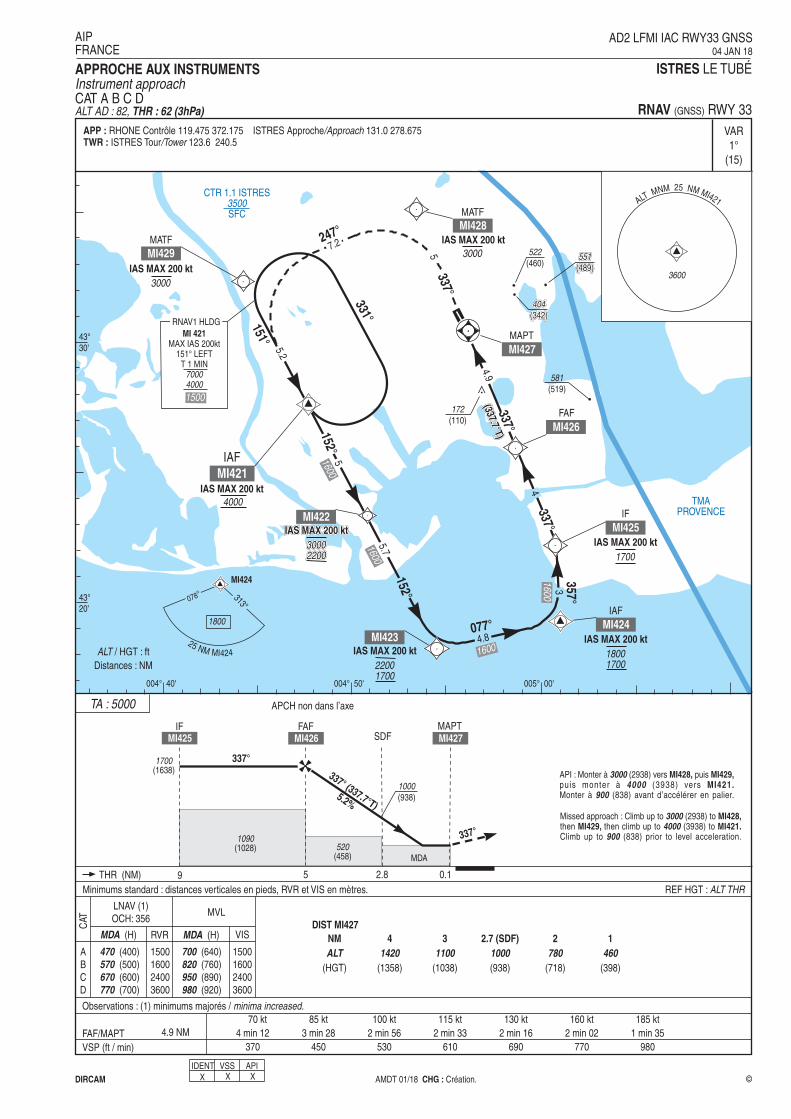
AIP AD 2 LFMI DATA RWY15 CODE GNSSFRANCE 26 APR 18
ISTRES LE TUBE
PRECODING RNAV (GNSS) RWY 15
DIRCAM AMDT 05/18 CHG : Création. ©
RMK
Leg s
eque
nce
Path
Term
inator
Wayp
oint
Identi
ficati
on
DTG
THR1
5
(NM)
Fly O
ver
Direc
tion M
AG
(°)
Direc
tion T
rue
(°)
Distan
ce
(NM)
Turn
direc
tion
MNM
Altitu
de
(FL or
AMSL
ft)
MAX A
ltitud
e
(FL or
AMSL
ft)MA
X IAS
(kt)
Vertic
al an
gle
(°) / T
CH (m
)Na
v Spe
c
HLDG
NG
HLDG
MI40
1
IFNG
4000
200
RNAV
1 / R
NP AP
CH
TFMI
403
128
129,1
13,9
3000
4000
RNAV
1 / R
NP AP
CH
TFMI
404
114
114,9
4,821
0021
00RN
AV1 /
RNP
APCH
IFMI
401
4000
200
RNAV
1 / R
NP AP
CH
TFMI
403
084
085,2
8,230
0040
00RN
AV1 /
RNP
APCH
TFMI
404
114
114,9
4,821
0021
00RN
AV1 /
RNP
APCH
IFMI
402
3400
3400
200
RNAV
1 / R
NP AP
CH
TFMI
404
043
044,2
7,421
0021
00RN
AV1 /
RNP
APCH
IFMI
404
2100
2100
200
RNAV
1 / R
NP AP
CH
TFMI
405
124
124,9
5,0RN
P APC
H
TFRW
15Ye
s15
215
2,66,2
-3,0 /
15RN
P APC
H
TFMI
406
152
152,6
5,0RN
P APC
H
TFMI
407
242
242,7
5,0RN
P APC
H
TFMI
402
314
314,7
14,0
3400
3400
200
RNAV
1 / R
NP AP
CH
APCH
RNAV
(GNS
S) R
WY 15
NIL
INA M
I402
INA N
G
MAG
VAR
2015
1,
1°ERe
f NAV
AID : N
IL
INA M
I401

AIP AD 2 LFMI DATA RWY33 CODE GNSSFRANCE 29 MAR 18
ISTRES LE TUBE
PRECODING (GNSS) RWY 33
DIRCAM AMDT 04/18 CHG : Corrections ©
Iden
tifica
tion
Pro
cédu
re
RN
AV(G
NSS
) 33
M
AG
VA
R 2
015
1.
1°E
Leg
sequ
ence
P/T
IDFl
y O
ver
Dire
ctio
n M
AG
°D
irect
ion
True
°D
ista
nce
(NM
or m
in)
Turn
MN
M le
vel
(FL
or A
MSL
ft)
MA
X le
vel
(FL
or A
MSL
ft)
IAS
MA
X (k
t)ve
rtic
al a
ngle
(°
) / T
CH
(m)
Nav
Spe
c
INA
MI4
21
IFM
I421
4000
4000
200
RN
P A
PC
H
TFM
I422
152
152.
65.
022
0030
0020
0 R
NP
AP
CH
TFM
I423
152
152.
65.
717
0022
0020
0 R
NP
AP
CH
TFM
I424
077
078.
24.
817
0018
0020
0 R
NP
AP
CH
TFM
I425
357
358.
03.
017
0017
0020
0
INA
MI4
24IF
MI4
2417
0018
0020
0 R
NP
AP
CH
TFM
I425
357
358.
03.
017
0017
0020
0 R
NP
AP
CH
AP
CH
IFM
I425
1700
1700
200
RN
P A
PC
H
TFM
I426
33
733
7.7
4.0
17
0017
00R
NP
AP
CH
TFM
I427
Yes
337
337.
74.
9
-3
,0 /
15R
NP
AP
CH
TFM
I428
337
337.
75.
030
0020
0R
NP
AP
CH
TFM
I429
247
247.
67.
230
0020
0R
NP
AP
CH
TFM
I421
151
152.
55.
240
0040
0020
0R
NP
AP
CH
HLD
GH
MM
I421
Yes
R
NAV
1
3000
4500
1500
4500
4500
1500
1500
15003000
4500
3000
3000
1500
3000
4500
3000
004° 00�
43°
00�
005° 00�
44°
00�
40NM
SREIS
TRES
40NM
SREIS
TRES
10 NM
44 12 39 N004 16 24 E44 12 39 N004 16 24 E
43 42 37 N004 47 01 E
43 42 37 N004 35 23 E43 42 37 N004 35 23 E
43 24 01 N005 03 29 E43 24 01 N005 03 29 E
43 51 06 N003 52 29 E
43 24 01 N005 00 00 E43 24 01 N005 00 00 E
43 15 10 N005 00 00 E
20 NM
30 NM
40 NM
50 NM
60 NM
70 NM
80 NM
50NM
SREIS
TRES
14000
9000
43 43 23 N004 02 59 E43 43 23 N
004 02 59 E
5800
44 07 18 N004 31 03 E
2600
2100
1600
1700
43 10 00 N004 32 59 E
43 09 58 N004 28 56 E
5739
51352260
1057
2158
LUMID
LUNEL
MARRIRHONE
SALIN
ALES
MONTPELLIER. MMONTPELLIER. M
N. GARONS
ISTRESVARES
5078
2359
2409
6262
2386
1572
4741
MTL
DA
NG
ITR
ITS
FGFJR
M. PROVENCEBADET
ESERA
MOLENMOLEN
RADAR
NAKIS
SIMARSIMAR
ESPIG
ASTEG
ROVOT
ZEBRA
MAZETNG
BEZIERS
SALON
AVIGNON C.
MENDE
AUB
BX
MS
MRMMTG
MJ
MAR
AVN
SAL
ORG
CM
ORANGE C.
ZR
5387
614
719
936
Les altitudes minimales publiées intègrentune correction pour basses températuresThe minimum altitudes published integrate
a correction for low temperature
AMSR correspondant au mode de fonctionnementnominal du système de surveillance d�ISTRES
AMSR corresponding to nominal operating modeof ISTRES surveillance system
AMSR correspondant au mode de fonctionnementnominal du système de surveillance d�ISTRES
AMSR corresponding to nominal operating modeof ISTRES surveillance system
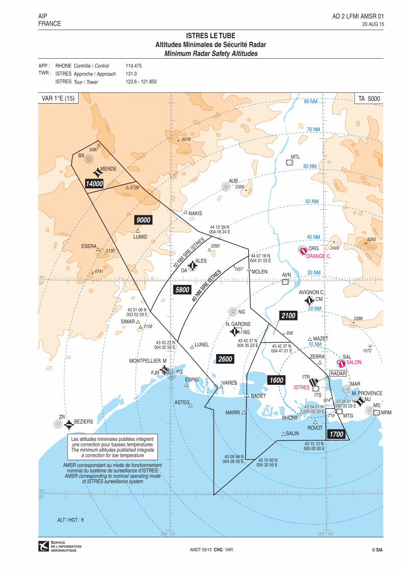
AD 2 LFMI AMSR 0120 AUG 15
AIPFRANCE
ISTRES LE TUBE
Altitudes Minimales de Sécurité Radar
Minimum Radar Safety Altitudes
ALT / HGT : ft
TA 5000VAR 1°E (15)
AMDT 09/15 CHG : VAR.
APP :
TWR :
119.475
131.0
123.6 - 121.850
RHONE
ISTRES
ISTRES
Contrôle / Control
Approche / Approach
Tour / Tower
© SIA

1500
1500
1500
3000
005° 00�
43°
30�
44°
00�
005° 30�
42°
30�
43°
00�
004° 30�
132° FJR
343°
29
23N
MLU
C
18N
M
273° LUC
223°
M
TG
077° PPG
176°
086° 28
223°
26
223°
10
78
257°
214°
214°
MTG
93 2236
20
132°
TINOT 7DSO
SU
R 7D
MAM
ES 7
D
PPG 7D
LUC 7D
AVN
7D
MR
M
23
LUC 7D
NASIK 7D
23NASIK 7D093°093°
TINOT
SOSUR
MAMES
BORGO
PPG
SUBIL
SALON
DME 115.15
AVIGNON C.
CAUMONT
AVIGNON
N. GARONS
DME 115.7 ISTRES
M. PROVENCE
NG 354
AVN 114.6Ch 93 X
MAR 383ALM 413
MJ 406
MS 343
MRM 108.8Ch 25 X
OB 3951854
2395
2556
3317
3766
641
1572
2386
3691
TRETS
ITR 390.5Ch 104 X
SAL 334 Ch 98 Y
MTG 117.3Ch 120 X
CM 369
2117
4121
LUC
NASIKITS 112.7Ch 74 X
AD 2 LFMI SID RWY ALL -RNAV CONV20 AUG 15
AIPFRANCE
© SIAAMDT 09/15 CHG : VAR, orientations.
ALT / HGT : ft
ISTRES LE TUBE
SID
(Protégés pour / Protected for CAT A, B, C, D)
TA 5000VAR 1°E (15)
CCI RHONE Contrôle / Control :
APP ISTRES Approche / Approach :
APP PROVENCE Approche /Approach :
TWR ISTRES Tour / Tower : Sur clairance du CTL
On ATC clearance
RNAV119.475
131.0
131.225 (Secteur Nord/North sector) 120.2 (Secteur Sud/South sector) 129.475 (s)
123.6 121.850
SID 1

AMDT 09/15 © SIA
CONSIGNES GENERALES
Les aéronefs devront se conformer aux spécifications de montée fixées pour
chaque itinéraire normalisé de départ.
Les trajectoires normalisées de départ sont à rejoindre :
- RWY 33 : par virage à gauche à l’exception du SID AVN 7D (par virage à
droite).
- RWY 15 : par virage à droite.
PANNE DE RADIOCOMMUNICATION
Afficher le code 7600
En VMC, faire demi-tour pour atterrir sur l'aérodrome
En IMC :
- SID LUC 7D : rejoindre et suivre le RDL 176° ITR (RM 176°) jusqu’à 13
NM ITR en montée vers 2500 ft. A 13 NM ITR, tourner à gauche vers
MTG. A MTG, suivre le RDL 086° MTG (RM 086°) vers TRETS en montée
vers le FL 110 jusqu’aux limites de la zone déléguée à l’approche.Monter ensuite vers le FL du plan de vol en vigueur vers LUC.
- Autres SID :
. Cheminements : suivre le cheminement du SID assigné. Si la panne sur-
vient au cours d'un départ guidé radar, rejoindre au plus tôt le SID assi-
gné.
. Niveau de vol : monter en respectant les niveaux du SID (ignorer la men-
tion « sur clairance de l’approche ») ou vers le dernier FL assigné jus-
qu'aux limites de la zone déléguée à l'approche. Monter ensuite vers le
FL du plan de vol en vigueur.
ITINERAIRES
AVN 7D Tourner à droite pour rejoindre et suivre le QDR 343° ITR (RM
343°) vers AVN. Sur clairance PROVENCE Approche, monter
vers le FL 140.
PPG 7D Rejoindre et suivre le QDR 176° ITR (RM 176°) pour intercepter et
suivre le RDL 223° MTG (RM 223°) vers SUBIL. A SUBIL, tourner
à droite et suivre le RDL 077° PPG (RM 257°) vers PPG. Monter
initialement vers 2500 ft jusqu’à 17 NM ITR (8 NM MTG). Sur clai-
rance de PROVENCE Approche, monter vers le FL 140.
MAMES 7D Rejoindre et suivre le QDR 176° ITR (RM 176°) pour intercepter et
suivre le RDL 214° MTG (RM 214°) vers MAMES. Monter initiale-
ment vers 2500 ft jusqu’à 17 NM ITR (8 NM MTG). Sur clairance
de PROVENCE Approche, monter vers le FL 140.
SOSUR 7D Rejoindre et suivre le QDR 176° ITR (RM 176°) vers SOSUR.
Monter initialement vers 2500 ft jusqu’à 17 NM ITR (8 NM MTG).
Sur clairance de PROVENCE Approche, monter vers le FL 140.
TINOT 7D Rejoindre et suivre le QDR 176° ITR (RM 176°) pour intercepter et
suivre le RDL 132° FJR (RM 132°) vers TINOT. Monter initiale-
ment vers 2500 ft jusqu’à 17 NM ITR (8 NM MTG). Sur clairance
de PROVENCE Approche, monter vers le FL 140.
LUC 7D Rejoindre et suivre le QDR 176° ITR (RM 176°) en montée vers
RFL < 145 2500 ft. Sur clairance de PROVENCE Approche, tourner à gauche
vers MTG. A MTG suivre le RDL 086° MTG (RM 086°) vers
TRETS. A TRETS, suivre le RDL 273° LUC (RM 093°) vers LUC.
Sur clairance de PROVENCE Approche, monter vers le FL 120.
NASIK 7D Rejoindre et suivre le QDR 176° ITR (RM 176°) en montée vers
RFL > 155 2500 ft. Sur clairance de PROVENCE Approche, tourner à gauche
vers MTG. A MTG suivre le RDL 086° MTG (RM 086°) vers
TRETS. A TRETS route RNAV 086° vers NASIK. Sur clairance de
PROVENCE Approche, monter vers le FL 120.
GENERAL INSTRUCTIONS
The aircraft must conform to fixed climbing specifications for each SID.
These outgoing routeings are to be joined:
- RWY 33: by proceeding left turn except for the SID AVN 7D (by procee-
ding right turn).
- RWY 15: by proceeding right turn.
RADIOCOMMUNICATION FAILURE
Squawk code 7600
In VMC, turn back to land on the aerodrome
In IMC:
- SID LUC 7D: Join and follow RDL 176° ITR (MAG 176°) till 13 NM ITR
climbing to 2500 ft. When crossing 13 NM ITR, turn left to MTG. At MTG,
follow RDL 086° MTG (MAG 086°) to TRETS climbing to FL 110 till the
limits of area controlled by the approach. Then, climb to the flight level
indicated on the flight plan in force to LUC.
- The other SID:
. Routings: Follow the assigned SID. If the failure occurs during a radar vec-
tored departure, join as soon as possible the assigned SID.
. Flight level: Climb in complyance with SID flight level (ignore the mention «
under approach clearance ») or to the last assigned FL till the limits of
area controlled by the approach. Then, climb to FL indicated on the
flight plan in force.
ROUTINGS
AVN 7D Turn right to join and follow QDR 343° ITR (MAG 343°) to AVN.
Under PROVENCE Approach clearance, climb to FL 140.
PPG 7D Join and follow QDR 176° ITR (MAG 176°) to intercept and follow
RDL 223° MTG (MAG 223°) to SUBIL. At SUBIL, turn right and fol-
low RDL 077° PPG (MAG 257°) to PPG. Initially climb to 2500 ft till
17 NM ITR (8 NM MTG). Under PROVENCE Approach clearance,
climb to FL 140.
MAMES 7D Join and follow QDR 176° ITR (MAG 176°) to intercept and follow
RDL 214° MTG (MAG 214°) to MAMES. Initially climb up to 2500
ft till 17 NM ITR (8 NM MTG). Under PROVENCE Approach clea-
rance, climb up to FL 140.
SOSUR 7D Join and follow QDR 176° ITR (MAG 176°) to SOSUR. Initially
climb up to 2500 ft till 17 NM ITR (8 NM MTG). Under PROVEN-
CE Approach clearance, climb up to FL 140.
TINOT 7D Join and follow QDR 176° ITR (MAG 176°) to intercept and follow
RDL 132° FJR (MAG 132°) to TINOT. Initially climb up to 2500 ft
till 17 NM ITR (8 NM MTG). Under PROVENCE Approach, climb
up to FL 140.
LUC 7D Join and follow QDR 176° ITR (MAG 176°) climbing up to
RFL < 145 2500 ft. Under PROVENCE Approach clearance, turn left to MTG.
At MTG follow RDL 086° MTG (MAG 086°) to TRETS. At TRETS,
follow RDL 273° LUC (MAG 093°) to LUC. Under PROVENCE
Approach clearance, climb up to FL 120.
NASIK 7D Join and follow QDR 176° ITR (MAG 176°) climbing up to
RFL > 155 2500 ft. On PROVENCE Approach clearance, turn left to MTG. At
MTG follow RDL 086° MTG (MAG 086°) to TRETS. At TRETS,
route RNAV 086° to NASIK. On PROVENCE Approach clearance,
climb up to FL 120.
AIP SID 1a AD 2 LFMI SID RWY ALL -RNAV CONV-INSTR 01
FRANCE 20 AUG 15
ISTRES LE TUBESID
(Protégés pour/Protected for CAT A, B, C, D)

AD 2 LFMI STAR RWY ALL CONV20 AUG 15
AIPFRANCE
© SIAAMDT 09/15 CHG : VAR, orientations.
ALT / HGT : ft
ISTRES LE TUBE
STAR
(Protégées pour / Protected for CAT A, B, C, D)
TA 5000VAR 1°E (15)
CCI RHONE Contrôle / Control :
APP ISTRES Approche / Approach :
APP PROVENCE Approche / Approach :
TWR ISTRES Tour / Tower :Réservé ACFT avec FL croisière < FL 195
For ACFT with cruising FL < FL 195 only
119.475
131.0
131.225 (Secteur Nord/North sector) 120.2 (Secteur Sud/South sector) 129.475 (s)
123.6 121.850
STAR 1
1500
1500
1500
43°
30�
005° 30�
42°
30�
43°
00�
004° 30� 005° 00�
20
10
78
138°
318°
130°
30
11
320°
44 NMIT
R
267° TLN
132°
284°
296°
155000
3500
12
37NM
ITR
24 NM ITR
33 NM ITR 077° PPG043°
077°
043°
270° STP
179°
MR
M
41N
MS
TP
020°
84
004°
58 NM ITR
50
43
345°
53 NM ITR
33
ITR
NDB ITR 2600/5000RAP 138° Droite/Right 1 min
IAS 210 kt MAX
OB 3DJULEE 3D
TIN
OT
3D
SO
SU
R 3
D
PPG 3D
DIB
ER
3D
NG 3D
ISTRES
TINOT
SOSUR
BORGO
PPG
SUBIL
N. GARONS
DME 115.7
M. PROVENCE
NG 354
MAR 383ALM 413
MJ 406
MS 343
OB 3951854
2395
2556
3317
3766
641
1572
2386
3691
ITR 390.5Ch 104 X
MTG 117.3Ch 120 X
POMEG
JULEE
DIBER
2117
SALON
DME 115.15
SAL 334 Ch 98 Y
ITS 112.7
Ch 74 X
MRM 108.8Ch 25 X

���������
��� �������
���� ������
���������
�������������
��������������������
����
����
����
���
��������
������ ��� ���������������
���� ����
����
����
� ������
��������������������
�����
����
����
���
���������������� !"�#�$�"�����
����
�%� �
� �� � �����
��&
��������������
����
��&
���������������
����
����
��� ����
����
��&
���������������
���
�&�������
����������
��������% ����
��'���������(�����������������������������
��������% ���
��'���������(������%&������������������
� �������)
�����)
��������) ��������)��������)��������) ��������) ��������)
�����)
�����)
����� !"��#����$�#"�$���������������������������*��� ���������� ������������ ��
�����+��,
��$�"��%��-*
���������+���,��./���
%� � 0
����1������2��345��6� �����!��������������������������������7732$8��6�����������������������9��$���1��������2:3�6���"�������9������
����
�%� �
� �� � �
�� &���
'�� �
� ��%&��������./���;�������9�� ����
�� ����6���� !�����3<#�!2�

�����������
����� ���
���
����
����
���
���
�������
����� ��
������������
������������
�������������� �� ��
�������
�
���� ���������������� ��������� ������!"# ������!"# ��������������������$����%�%���&'%(()*��������!%*#��
��������
��������
�������
+��+��+������,�����,�����,�
���������
+����+����+��������,������,������,�����������
�����������������-.,+,���-.,+,���-.,+,�������
+��+��+������,�����,�����,�
���������
�����������������-.,+,���-.,+,���-.,+,����
�����������������-.,+,���-.,+,���-.,+,�$$$
�������
����
�/
��������
����
����
����
����
����0�
�������
�����/�
���������/ ��/ ��/ ��
���
����
�����������/���/���/�
��������������
����������������
����������������
�����������������
��������������
�����������������������
�������
������������������
�/
�� �/
����
�1��� 2 �1��� 2 �1��� 2 �1��� 2 �1��� 2 �1��� 2 �1��/ 2 �1��/ 2 �1��/ 2 /1�� 2 /1�� 2 /1�� 2
��1��1��1� 2� 2� 2
��1��1��1� 2� 2� 2
������+,
�������������� ������ ���� ����� ���������+�����3�+���������������������� ������������-,�+����4*������� �� ���0���/��������/ ����,���!!��(5��6������������� ����$���/����������,����"������!������������ �/
�������7,��83,
"#����.�9�����:;��/.���1,�/�
�3+�
+����
-< ���%�#�� 6$����%��������#�#="= �=%>��) �6��������&��'�'����(
����� /6�$����!���+�)%�#�� ?
�,���9���������)$��������&# �%�(� �����#(%*� ����!#�& @��.�����.������=A��� �6*�� '�� �&'� ������'��+�� ��$*$���&�*,�'���� ���(
"�����
����7������+��:;�/����9����������$
� �B� $/�B� � �B� ��/�B� �� �B� �/ �B� �$/�B�/�=#���0 ��=#���� ��=#���� ��=#���� ��=#��/� ��=#���0 ��=#�� �
�� �/ /� �� �0 $ 0$ ����C���������������.���D�6=#��
� � � � � ���� ���� ���� ���� ���� ��� ����9�� �0��� ����� ����� � �� �$�� ����
"��������
7�.-+������/
�.7
������ �.���� ������ .��
������ ������� �����$� �����0 �
�/ �� �� ��
���,� .�� ���E EE
���������
������ �����/� ������� ������� �
�/ �� �� ��
����������� ����������������������������������������� ����� � ���� � ������� ����� ��������� ����� ������ ���� ������������ �� ������
�����!"���
������������������������������������������#�$%$���%�&����'��� $()�*+,��������
���������
,*$���-��
�� ����� ������
���,
�
���������
. / !� �
���� )�)�����
�)&0)
�� �
�� ��� ��!/���
�0�
��1*����������2�
����3.��
��������������4���1���5��������������������������4���������4������5������������������������1���5� ��� ������ ������ ������ �� ������ ����������
,���$6%(-1(
1,$�! !��&,$(&����&)1
����
����
��������������
��
���
��� ������ ������ ���
�3 ��� �
�� �
��������������
�� �
� �
�� �
�3�7 �
�. �
�3 �
��
�.�� �
�.
�. -� ��3�3
����
�����
����
)�)
���,
�)
����
��)
����
��������������
�����������3����3����3��
����3"/�
����������3����3����3���
��,)
��,)
����.!��
��������������
��)
��������
����������������������
����!!/�
��������������
���
�����������������������������������������������
������������������������
���
�. 7
����
����
����
����
�������8���&��//9
!.!:�;(),,�!���-��������
�$-�%!�*;0+
����
//3:��3/< //3:��./< //.:��//<
3�:�/<
3�:�/<
����%&&�0(-,
���)$�-1(
�������;(�,=>?
������$*6-(�1��@���!!� 37.��7� !7.�����&,$(&�������4�����������!�! /��7� "7.�������&,$(&�,����������!�� "���3/ .
���� !"���#���$���#��$������� !������������1�,���>�1�0�����"�����#������ �����
%�$!:
�!.�
�0��;)�����1�$AB���+-&&/3�C�-�!�
�$�%��+-&&��$AB���
D��0,�/!E!���!"&���1����� '��!��
)�)E���,%&���F�E����
3 ��-�
'��������
����E�*+,���F0���������-�
8 88
1�,
�>10
%�&������*�
;-�%��!�61*���."
������*� $%$
!.//!"//�3//�"//
������"3/�������7"/���������/���������/�
65������������!������������G�����E�!$�$!��$�������%&����7/�9 �.�9 !//�9 !!.�9 !�/�9 !"/�9 !�.�93����!� ������� �����." ������� �����!" �����/� !�����.
�7/ 3./ .�/ "!/ "�/ 77/ ��/
�%;
!.//!"//�3//�"//
������3//�������.//�������"//�������7//�
����
�;,�-� �. -� ��3�!
/7�: �!�:
�����
����������
�����
�����
����
�����
�����
$� � � � ���'(� � ��� ���� ���� ���� ��� ���
�*+,� �!�.�� �!/��� ����� �7!�� �����