Embed Size (px)
Citation preview

Level 1 Strategic Flood Risk
Assessment for Greater
Manchester - Update
Final Report
March 2019
Manchester City Council
Town Hall
Albert Square
Manchester
M60 2LA

2021s0741 GMCA Level 1 SFRA Update Final Report WCAG v1.0 i
JBA Project Manager
Mike Williamson
JBA Consulting
Mersey Bank House
Barbauld Street
Warrington
WA1 1WA
Revision History
Revision Ref / Date
Issued
Amendments Issued to
V1.0 / March 2019 /
Draft
GMCA comments Alex McDyre
V1.0 / March 2019 /
Final
Additional GMCA
comments
Alex McDyre
Contract
This report describes work commissioned by David Hodcroft, on behalf of Greater
Manchester Combined Authority Planning and Housing Team, by email dated 28
August 2018. The lead representative for the contract was David Hodcroft. Mike
Williamson of JBA Consulting carried out this work.
Prepared by ...................................... Mike Williamson BSc MSc EADA FRGS
CGeog
Principal Flood Risk Analyst
Reviewed by ..................................... Rachel Brisley BA Dip TRP MCD MBA
AMBA
Associate Director

2021s0741 GMCA Level 1 SFRA Update Final Report WCAG v1.0 ii
Purpose
This document has been prepared as a Final Report for Greater Manchester
Combined Authority. JBA Consulting accepts no responsibility or liability for any
use that is made of this document other than by the client for the purposes for
which it was originally commissioned and prepared.
JBA Consulting has no liability regarding the use of this report except to Greater
Manchester Combined Authority.

2021s0741 GMCA Level 1 SFRA Update Final Report WCAG v1.0 iii
Acknowledgements
JBA would like to thank all Greater Manchester Combined Authority, all Greater
Manchester local authorities, Environment Agency, United Utilities and Natural
England staff for their time and commitment to providing data and discussing the
issues identified during the course of this study.
Copyright
© Jeremy Benn Associates Limited 2021
Carbon Footprint
A printed copy of the main text in this document will result in a carbon footprint of
503g if 100% post-consumer recycled paper is used and 640g if primary-source
paper is used. These figures assume the report is printed in black and white on
A4 paper and in duplex.
JBA is aiming to reduce its per capita carbon emissions.

2021s0741 GMCA Level 1 SFRA Update Final Report WCAG v1.0 iv
Executive Summary
Greater Manchester Combined Authority (GMCA) commissioned JBA Consulting
by email dated 28 August 2018 for the undertaking of an update to the Level 1
Strategic Flood Risk Assessment (SFRA) and Strategic Flood Risk Management
Framework (SFRMF) to cover the ten Greater Manchester (GM) councils that
make up GMCA.
GMCA requires this updated Level 1 SFRA and SFRMF to support the Greater
Manchester Spatial Framework (GMSF). This commission updates the original
SFRA and SFRMF, completed in August 2018. It accounts for updates to the
Greater Manchester Spatial Framework (GMSF) allocations and each of the ten
GM district council's land supply sites for housing, office space and industrial /
warehousing space.
GMCA is acting on behalf of each of the ten councils; these are all designated
Lead Local Flood Authorities (LLFA) as well as LPAs.
In August 2014, the ten Local Planning Authorities (LPA) in GM agreed to prepare
a joint Development Plan Document to set out the approach to housing and
employment growth for the next 20 years. This is known as the GMSF (2019).
This SFRA is required to:
• initiate the sequential risk-based approach to the allocation of land
for development and
• identify whether application of the Exception Test is likely to be
necessary using the most up-to-date information and guidance.
This will help to inform and provide the evidence base for the GMSF and
each individual council's local plan.
The SFRA has been carried out in accordance with Government’s latest
development planning guidance, namely:
• the revised National Planning Policy Framework1 (NPPF) (updated
February 2019) and
1 National Planning Policy Framework

2021s0741 GMCA Level 1 SFRA Update Final Report WCAG v1.0 v
• the flood risk and planning guidance the Flood Risk and Coastal Change
Planning Practice Guidance2 (FRCC-PPG) (last updated March 2014, at
the time of writing).
The commission consists of three phases:
1. Existing and future flood risk screening of potential development sites
under the following categories:
a. GMSF allocations (2019);
b. Baseline land supply (2018);
c. Call for sites (2018).
2. Level 1 SFRA as per the requirements set out in the NPPF and FRCC-
PPG;
3. Strategic Flood Risk Management Framework - GMCA requires a spatial
framework to manage flood risk and development in GM. This will be used
to set out the most significant areas of flood risk at the GMCA level.
It will include for cross-boundary issues within and outside GMCA and
recommend key priorities for intervention taking account of previous,
existing and planned interventions delivered or to be delivered by all Risk
Management Authorities (RMAs).
The Framework will be informed by a review of relevant strategies, FRM
governance and flood risk funding mechanisms. The SFRMF will be
informed by this SFRA and in turn will inform the development of the
GMSF.
Phase’s 1 and 2 outcomes
Development viability assessments for all potential sites are summarised through
a number of strategic recommendations (see
The outcomes of phase’s 1 and 2, based on existing risk, are summarised in
Table 1-1 to Table 1-3. The effects of climate change on future development has
also been assessed and is discussed in Sections 6.9, 7.2.2 and 7.3.3 of this
report.). These are formulated from strategic assessments of flood risk and
2 Flood Risk and Coastal Change Planning Practice Guidance

2021s0741 GMCA Level 1 SFRA Update Final Report WCAG v1.0 vi
development vulnerability. The results of these assessments are included within
Appendix B and C.
The strategic recommendations broadly entail the following:
• Strategic Recommendation A - consider withdrawal of site if development
cannot take place outside of Flood Zone 3b;
• Strategic Recommendation B - Exception Test required if site passes
Sequential Test;
• Strategic Recommendation C - consider site layout and design around the
identified flood risk if site passes Sequential Test, as part of a detailed FRA
or drainage strategy;
• Strategic Recommendation D - site-specific FRA required; and
• Strategic Recommendation E - site permitted on flood risk grounds due to
little perceived risk, subject to consultation with the LPA / LLFA.
The outcomes of phase’s 1 and 2, based on existing risk, are summarised in
Table 1-1 to Table 1-3. The effects of climate change on future development has
also been assessed and is discussed in Sections 6.9, 7.2.2 and 7.3.3 of this
report.

2021s0741 GMCA Level 1 SFRA Update Final Report WCAG v1.0 vii
Table 1-1: Summary of strategic recommendations for GM allocations (2019)
Authority
Number of strategic recommendations applied
A B C D E
Bolton 0 0 1 2 0
Bury* 0 0 3 3 0
Manchester 0 0 1 2 0
Oldham^ 0 2 5 10 0
Rochdale^* 1 1 5 6 0
Salford 1 0 0 3 0
Stockport 0 0 2 6 0
Tameside 0 0 1 3 0
Trafford 0 0 2 0 0
Wigan 0 0 4 1 0
GM 2 3 24 36 0
^Two sites overlap between Oldham and Rochdale
*Two sites overlap between Rochdale and Bury
• Only two allocations are recommended for withdrawal if development
cannot take place outside of FZ3b, based on the proportion of the site
areas being within the functional floodplain. These allocations are in
Rochdale and Salford.
• Three allocations will have to be subject to and pass the Exception Test if
the site boundaries cannot be altered to remove the high risk areas. Two
of these sites are in Oldham and one is in Rochdale.
• These five sites should be further investigated by the LPA and LLFA to
ascertain developability.
• 24 allocated sites require careful consideration of site design and layout
with regards to avoiding or accommodating the flood risk. This should take
place as part of a detailed site-specific FRA and drainage strategy used to
inform the design and layout of the proposed site.

2021s0741 GMCA Level 1 SFRA Update Final Report WCAG v1.0 viii
Table 1-2: Summary of strategic recommendations to baseline land supply (2018)
sites
Authority
Number of strategic recommendations applied
A B C D E
Bolton 2 9 44 215 131
Bury 3 5 29 84 83
Manchester 3 9 53 281 272
Oldham 1 4 62 225 154
Rochdale 7 18 43 141 110
Salford 0 17 36 156 93
Stockport 2 5 31 197 176
Tameside 3 7 29 134 81
Trafford 1 4 23 211 105
Wigan 5 13 50 196 156
GM 27 91 400 1840 1361
• The majority of the baseline land supply sites, in Table 7-7, will require
site-specific FRAs as a minimum (Strategic Recommendation D).
• Many sites are also at very low risk and may not require any further
assessment of flood risk (Strategic Recommendation E), though this is at
the discretion of the LPA.
• 27 land supply sites are recommended for withdrawal if the functional
floodplain cannot be avoided, the majority being in Rochdale followed by
Wigan. No land supply sites in Salford are recommended for withdrawal.
• 91 sites will require the undertaking and passing of the Exception Test if
development is to be permitted. Most of these sites are in Rochdale,
Salford and Wigan.

2021s0741 GMCA Level 1 SFRA Update Final Report WCAG v1.0 ix
Table 1-3: Summary of strategic recommendations for call for sites (2018) sites
Authority
Number of strategic recommendations applied
A B C D E
Bolton 2 1 32 90 4
Bury 4 1 32 92 2
Manchester 2 2 13 24 11
Oldham 1 8 45 83 11
Rochdale 11 4 38 79 4
Salford 1 4 18 30 1
Stockport 6 3 53 208 27
Tameside 4 1 22 82 5
Trafford 6 2 21 41 2
Wigan 10 2 32 83 4
GM 47 28 306 812 71
Included within this Level 1 SFRA, along with this main report, are:
• Detailed interactive GeoPDF maps showing all available flood risk
information together with the potential development sites - Appendix A;
• Development Site Assessment spreadsheets for each council detailing the
risk to each potential development site with subsequent strategic
recommendations on development - Appendix B;
• Site assessment summary reports for each council, detailing the
assessment process, outcomes and subsequent strategic
recommendations – Appendix C;
• Functional floodplain delineation notes for each council – methodology
note on how the functional floodplain has been defined – Appendix D;
• Climate change modelled watercourses – list of GM watercourses which
have been modelled for climate change – Appendix E; and
• Sustainable Drainage Systems (SuDS) selection summary –
documentation on various available SuDS techniques (Appendix F1) and
SuDS suitability for GM (Appendix F2) – Appendix F.

Contents
2021s0741 GMCA Level 1 SFRA Update Final Report WCAG v1.0
Executive Summary .................................................................................... iv
1 Introduction ...................................................................................... 1
1.1 Commission ..................................................................................... 1
1.2 Greater Manchester Spatial Framework (GMSF) ............................ 1
1.3 GMCA Level 1 SFRA ....................................................................... 2
1.4 SFRA future proofing ....................................................................... 7
2 Study area ....................................................................................... 9
3 Understanding flood risk .................................................................. 12
3.1 Sources of flooding .......................................................................... 12
3.2 Likelihood and consequence ........................................................... 13
3.3 Risk .................................................................................................. 17
4 The planning framework and flood risk policy .................................. 20
4.1 Introduction ...................................................................................... 20
4.2 Legislation........................................................................................ 21
4.3 Flood and water focused policies and plans .................................... 32
4.4 Other related plans and policies ...................................................... 37
4.5 Planning legislation .......................................................................... 43
4.6 Planning policy ................................................................................. 44
4.7 Flood Risk Management policy ........................................................ 47
4.8 Roles and responsibilities in planning and flood risk management .. 59
5 Greater Manchester Spatial Framework (GMSF) ............................ 63
6 Flood risks in Greater Manchester ................................................... 69
6.1 Introduction ...................................................................................... 69
6.2 Flood risk datasets ........................................................................... 69
6.3 Fluvial flooding ................................................................................. 71
6.4 Surface water flooding ..................................................................... 82
6.5 Groundwater flooding ...................................................................... 91
6.6 Canal and reservoir flood risk .......................................................... 96
6.7 Historic flooding ............................................................................... 105

Contents
2021s0741 GMCA Level 1 SFRA Update Final Report WCAG v1.0
6.8 Flood Risk Management .................................................................. 116
6.9 Taking climate change into account ................................................. 131
7 Development and flood risk ............................................................. 136
7.1 Introduction ...................................................................................... 136
7.2 Site screening process .................................................................... 136
7.3 Summary of sites screening process outcomes ............................... 142
7.4 The Sequential Approach ................................................................ 157
7.5 Sequential and Exception Test for the GMSF and local plans ......... 159
7.6 Summary of strategic recommendations ......................................... 163
7.7 Integrated Assessment and flood risk .............................................. 170
7.8 Cumulative impacts ......................................................................... 171
7.9 Guidance for developers .................................................................. 173
7.10 Property Flood Resilience (PFR) ..................................................... 179
7.11 Sustainable Drainage Systems (SuDS) ........................................... 182
8 Emergency planning ........................................................................ 188
8.1 Civil Contingencies Act .................................................................... 189
8.2 Flood Warning and evacuation plans ............................................... 192
9 Conclusions and recommendations ................................................. 197
9.1 Conclusions ..................................................................................... 197
9.2 Planning policy and flood risk recommendations ............................. 199
9.3 Recommendations for further work .................................................. 205
9.4 Data gaps ........................................................................................ 206
Appendices ................................................................................................. I
A SFRA Maps ..................................................................................... I
B Development Site Assessment Spreadsheets ................................. II
C Development Site Assessment Summary Reports .......................... III
D Functional Floodplain Delineation .................................................... IV
E EA Climate Change Modelling ......................................................... V

Contents
2021s0741 GMCA Level 1 SFRA Update Final Report WCAG v1.0
F SuDS Selection Summary ............................................................... VI
2021s0741 GMCA Level 1 SFRA Update Final Report WCAG v1.0
List of Figures Figure 2-1: SFRA study area ...................................................................... 11
Figure 3-1: Flooding from all sources ......................................................... 13
Figure 3-2: Source-Pathway-Receptor Model ............................................ 14
Figure 4-1: Key documents and strategic planning links with flood risk ...... 21
Figure 4-2: EU Floods Directive ................................................................. 22
Figure 4-3: River Irwell catchment (extracted from NW RBD FRMP Part
B report) ....................................................................................... 25
Figure 4-4: Upper Mersey catchment (extracted from NW RBD FRMP
Part B report)................................................................................ 26
Figure 4-5: Mersey Estuary catchment (extracted from NW RBD FRMP
Part B report)................................................................................ 27
Figure 4-6: Douglas catchment (extracted from NW RBD FRMP Part B
report) .......................................................................................... 28
Figure 4-7: Main goals and policy areas the Plan is intended to help work
towards ........................................................................................ 33
Figure 4-8: WFD Cycle 2 waterbody classification (2016) .......................... 36
Figure 4-9: Management Catchment Partnership Leads ............................ 42
Figure 4-10: Defra wheel (taken from SWMP Technical Guidance) ........... 49
Figure 4-11: Priority GI network and strategic GI opportunity areas ........... 58
Figure 5-1: Flood Risk and the Water Environment (Policy GM-S 5) ......... 66
Figure 6-1: Main Rivers and other rivers in GM .......................................... 72
Figure 6-2: Flood Zone 3 across GM .......................................................... 76
Figure 6-3: Surface water flood risk across GM (RoFSW 1 in 100 AEP
event) ........................................................................................... 85
Figure 6-4: Mapped OAFCDMs .................................................................. 90
Figure 6-5: SPZs in GM .............................................................................. 95
Figure 6-6: GM canal network .................................................................... 98

2021s0741 GMCA Level 1 SFRA Update Final Report WCAG v1.0
Figure 6-7: GM LLFA historic flood incidents .............................................. 107
Figure 6-8: UU historic sewer flooding incidents and GM SWMP Hotspots 110
Figure 6-9: HFM and RFO outlines............................................................. 113
Figure 6-10: Geographical scale and extent of flooding across GM (from
GM FIR) ....................................................................................... 115
Figure 7-1: Main River where climate change has / has not been
modelled prior to this SFRA ......................................................... 139
Figure 7-2: Allocations and land supply sites with strategic
recommendations A and B ........................................................... 149
Figure 7-3: Sites at further risk from climate change .................................. 156
Figure 7-4: Flood Risk Management hierarchy ........................................... 158
Figure 7-5: Local Plan sequential approach to site allocation ..................... 160
Figure 7-6: Development management Sequential Test process ............... 177
Figure 7-7: SuDS Management Train Principle .......................................... 185

2021s0741 GMCA Level 1 SFRA Update Final Report WCAG v1.0
List of Tables Table 1-1: Summary of strategic recommendations for GM allocations
(2019) ........................................................................................... vii
Table 1-2: Summary of strategic recommendations to baseline land
supply (2018) sites ....................................................................... viii
Table 1-3: Summary of strategic recommendations for call for sites
(2018) sites .................................................................................. ix
Table 3-1: FRCC-PPG Flood Zones ........................................................... 15
Table 4-1: Key LLFA Duties under the FWMA ........................................... 29
Table 4-2: GM SWMP generic actions ....................................................... 51
Table 4-3: CDA policy for each GM authority ............................................. 53
Table 5-1: GMSF Strategic Objectives (January 2019) .............................. 64
Table 6-1: Flood source and key datasets .................................................. 69
Table 6-2: Areas of considerable fluvial risk in GM .................................... 77
Table 6-3: Existing residential areas within Flood Zone 3 .......................... 78
Table 6-4: Opportunity Areas for Further Critical Drainage Management ... 88
Table 6-5: Canal flooding mechanisms ...................................................... 96
Table 6-6: EA flood defence condition assessment grades ........................ 117
Table 6-7: WwNP measures and data ........................................................ 125
Table 6-8: Recommended peak river flow allowances for the North
West RBD .................................................................................... 132
Table 6-9: Peak rainfall intensity allowance in small and urban
catchments for England ............................................................... 133
Table 6-10: UKCP09 High++ allowances for peak river flow ...................... 134
Table 7-1: Strategic recommendations ....................................................... 137
Table 7-2: Major watercourses not modelled for climate change ............... 140
Table 7-3: Summary of GMSF allocation sites (2019) at existing risk
across GM .................................................................................... 143

2021s0741 GMCA Level 1 SFRA Update Final Report WCAG v1.0
Table 7-4: Summary of baseline land supply sites (2018) at existing risk
across GM .................................................................................... 144
Table 7-5: Summary of call for sites submissions (2018) at existing risk
across GM .................................................................................... 145
Table 7-6: Summary of strategic recommendations for GM allocations
(2019) ........................................................................................... 146
Table 7-7: Summary of strategic recommendations to baseline land
supply (2018) sites ....................................................................... 147
Table 7-8: Summary of strategic recommendations for call for sites
(2018) sites .................................................................................. 148
Table 7-9: Large GMSF allocations that will influence flood risk in GM ...... 150
Table 7-10: GMSF allocations at possible risk from climate change .......... 152
Table 7-11: Baseline land supply sites at possible risk from climate
change ......................................................................................... 153
Table 7-12: Call for sites exercise sites at possible risk from climate
change ......................................................................................... 154
Table 7-13: Development types and application of Sequential and
Exception Tests for developers .................................................... 175
Table 8-1: Flood warning and evacuation plans ......................................... 193
Table 9-1: Recommended further work for GMCA, local councils or
developers based on identified data gaps .................................... 206

2021s0741 GMCA Level 1 SFRA Update Final Report WCAG v1.0
Abbreviations ABD ......................... Areas Benefitting from Defences
ACDP ...................... Area with Critical Drainage Problems
AEP ......................... Annual Exceedance Probability
AStGWF .................. Areas Susceptible to Groundwater Flooding
CaBA ....................... Catchment Based Approach
CC ........................... Climate change
CCA ......................... Civil Contingencies Act
CDA ......................... Critical Drainage Area
CFMP ...................... Catchment Flood Management Plan
CIL ........................... Community Infrastructure Levy
CSO ......................... Combined Sewer Overflow
DAZ ......................... Drainage Area Zone
DCLG ...................... Department for Communities and Local Government
DPD ......................... Development Plan Documents
DTM ......................... Digital Terrain Model
EA ............................ Environment Agency
FAA ......................... Flood Alert Area
FCA ......................... Flood Consequence Assessment
FCDPAG ................. Flood and Coastal Defence Project Appraisal Guidance
FCERM .................... Flood and Coastal Erosion Risk Management Network
FDGiA ...................... Flood Defence Grant in Aid
FEH ......................... Flood Estimation Handbook
FMP ......................... Flood Map for Planning (Rivers and Sea)
FRA ......................... Flood Risk Assessment
FRCC-PPG .............. Flood Risk and Coastal Change Planning Practice Guidance
FRM ......................... Flood Risk Management

2021s0741 GMCA Level 1 SFRA Update Final Report WCAG v1.0
FRMP ...................... Flood Risk Management Plan
FRMS ...................... Flood Risk Management Strategy
FRR ......................... Flood Risk Regulations
FSA ......................... Flood Storage Area
FWA ........................ Flood Warning Area
FWMA ..................... Flood and Water Management Act
GI............................. Green Infrastructure
GIS .......................... Geographical Information Systems
GM ........................... Greater Manchester
GMCA ...................... Greater Manchester Combined Authority
GMSF ...................... Greater Manchester Spatial Framework
HFM ......................... Historic Flood Map
IDB .......................... Internal Drainage Board
LA ............................ Local Authority
LASOO .................... Local Authority SuDS Office Organisation
LDF .......................... Local Development Framework
LFRMS .................... Local Flood Risk Management Strategy
LLFA ........................ Lead Local Flood Authority
LPA .......................... Local Planning Authority
LRF .......................... Local Resilience Forum
MAFRP .................... Multi-Agency Flood Response Plan
MBC ........................ Metropolitan Borough Council
MHCLG ................... Ministry of Housing, Communities and Local Government
MSC ........................ Manchester Ship Canal
NFM ......................... Natural Flood Management
NGO ........................ Non-Governmental Organisation
NPPF ....................... National Planning Policy Framework

2021s0741 GMCA Level 1 SFRA Update Final Report WCAG v1.0
OAFCDM ................. Opportunity Area for Further Critical Drainage Management
PCPA ....................... Planning and Compulsory Purchase Act
PFRA ....................... Preliminary Flood Risk Assessment
RBD ......................... River Basin District
RBMP ...................... River Basin Management Plan
RFCC ...................... Regional Flood and Coastal Committee
RFM ......................... Reservoir Flood Map
RFO ......................... Recorded Flood Outlines
RoFSW .................... Risk of Flooding from Surface Water map
RMA ........................ Risk Management Authority
RoFRS ..................... Risk of Flooding from Rivers and the Sea Map
SA ............................ Sustainability Appraisal
SEA ......................... Strategic Environmental Assessment
SFRMF .................... Strategic Flood Risk Management Framework
SFRA ....................... Strategic Flood Risk Assessment
SHLAA ..................... Strategic Housing Land Availability Assessment
SoP .......................... Standard of Protection
SPD ......................... Supplementary Planning Documents
SuDS ....................... Sustainable Drainage Systems
SWMP ..................... Surface Water Management Plan
UDP ......................... Unitary Development Plan
UKCP09 .................. UK Climate Projections 2009
UKCP18 .................. UK Climate Projections 2018
UU ........................... United Utilities
WCS ........................ Water Cycle Study
WFD ........................ Water Framework Directive
WwNP ..................... Working with Natural Processes

2021s0741 GMCA Level 1 SFRA Update Final Report WCAG v1.0 1
1 Introduction
1.1 Commission
Greater Manchester Combined Authority (GMCA) commissioned JBA Consulting
by email dated 28 August 2018 for the undertaking of an update to the Level 1
Strategic Flood Risk Assessment (SFRA) and Strategic Flood Risk Management
Framework (SFRMF) to cover the ten Greater Manchester (GM) councils that
make up GMCA.
GMCA requires this updated Level 1 SFRA and SFRMF to support the Greater
Manchester Spatial Framework (GMSF). This commission updates the original
SFRA and SFRMF, completed in August 2018, to account for updates to the
Greater Manchester Spatial Framework (GMSF) allocations and each of the ten
GM district council's land supply sites for housing, office space and industrial /
warehousing space.
GMCA is acting on behalf of each of the ten councils; these are all designated
Lead Local Flood Authorities (LLFA) as well as LPAs.
1.2 Greater Manchester Spatial Framework (GMSF)
In August 2014, the ten Local Planning Authorities (LPA) in GM agreed to prepare
a joint Development Plan Document to set out the approach to housing and
employment growth for the next 20 years. This is known as the GMSF (2019).
The GMSF will:
• Set out how Greater Manchester should develop over the next two
decades up to the year 2035;
• Identify the amount of new development that will come forward across the
ten districts, in terms of housing, offices, and industry and warehousing,
and the main areas in which this will be focused;
• Support the delivery of key infrastructure, such as transport and utilities;
• Protect important environment assets across the conurbation;
• Allocate sites for employment and housing outside the urban area;
• Define a new Green Belt boundary for Greater Manchester.

2021s0741 GMCA Level 1 SFRA Update Final Report WCAG v1.0 2
This Level 1 SFRA and the SFRMF will inform and support the continuing
development of the GMSF. The GMSF is described in more detail in Section 5.
1.3 GMCA Level 1 SFRA
This SFRA is required to
• initiate the sequential risk-based approach to the allocation of land
for development and
• identify whether application of the Exception Test is likely to be
necessary using the most up-to-date information and guidance.
This will help to inform and provide the evidence base for the GMSF and
each individual council's local plans.
This SFRA has been carried out in accordance with Government’s latest
development planning guidance including:
• the National Planning Policy Framework (NPPF) and
• flood risk and planning guidance called the Flood Risk and Coastal
Change Planning Practice Guidance (FRCC-PPG).
The latest guidance, at the time of writing, is available online via:
Flood Risk and Coastal Change Planning Practice Guidance
A revised version of the NPPF was published on 24 July 2018 with a further
revision released on 19 February 2019, setting out Government’s planning
policies for England and how these are expected to be applied. The revised
Framework replaces the original NPPF first published in March 2012 and can be
viewed online or downloaded via:
National Planning Policy Framework
This SFRA assesses the spatial distribution of current and future flood risk across
GM. It provides the discussion and guidance required to put this information into
practice when taking account of flood risk in development plans and the level of
detail required for site specific Flood Risk Assessments (FRA).

2021s0741 GMCA Level 1 SFRA Update Final Report WCAG v1.0 3
The original Level 1 SFRA for GM, which was the first SFRA to cover all of GM,
was completed in 2008. Since that time a number of Level 1 and Level 2 SFRAs
have been prepared by individual or groups of GM LPAs.
The 2018 GMCA SFRA updated all the individual SFRAs, using the most up-to-
date flood risk datasets, at the time of submission. It assessed the extent of risk,
at a strategic level, to potential development allocations, existing land supply sites
and other Green Belt sites suggested for development by landowners and
developers.
This 2019 update accounts for updates to the GMSF allocated sites and each
council's land supply sites. There have not been any updates to the flood risk
data since the 2018 SFRA was completed in August 2018.
As per the Project Brief, the Level 1 SFRA is split into three phases of work:
1.3.1 Phase 1 - screening of potential development sites
GMCA provided several GIS datasets containing the following potential
development sites information:
• Revised Draft GMSF allocations. These sites are the proposed site
allocations within the Revised Draft GMSF for 2019. These sites are in
Green Belt and are proposed to be removed from Green Belt and allocated
for development in the GMSF. They are the sites that are needed to meet
the shortfall in housing and employment land needs up to 2037.
• 2018 GM baseline housing, industry and warehousing and office land
supply, which show the potential supply of new housing and employment
land for each GM council up to 31 March 2037.
• 2018 GMSF Call for Sites Submissions. A Greater Manchester-wide call
for sites exercise was completed in 2018. The purpose of the exercise
was to identify through a transparent and open process, potential sites that
could be technically assessed for their suitability, availability, and
achievability (including viability) for housing and economic development to
meet development needs.
Sites can be put forward by anyone or any organisation and typically have
been promoted by land owners, developers, agents, local businesses.

2021s0741 GMCA Level 1 SFRA Update Final Report WCAG v1.0 4
residents. This information was then used to identify whether there are
areas of land available for development that individual districts or GMCA
were not aware of. The sites have not been endorsed by the GMCA or the
individual districts and they have no formal planning status. These sites
are currently in Green Belt though developers and landowners have
suggested they should be taken out of Green Belt and allocated for
development through the GMSF. However, the majority of these sites are
not proposed for allocation in the GMSF.
Approximately, 5,600 potential development sites are assessed, using GIS
software, to screen all sites against the Environment Agency's (EA) Flood Map for
Planning (Flood Zones 2 and 3), the functional floodplain (Flood Zone 3b), fluvial
climate change (based on the EA's February 2016 allowances) and the surface
water flood zones of the EA's Risk of Flooding from Surface Water (RoFSW)
dataset. All sites are also screened against the EA's Working with Natural
Processes (WwNP) datasets (see Section 6.8.5) and Rivers Trust Irwell
Catchment project to gauge the potential of sites for future flood storage functions
to support Natural Flood Management (NFM).
NOTE: further potential development sites may come forward at some stage
in the future that will require assessment against flood risk. Were this to be
the case, this SFRA will be updated with the new sites information.
The screening of sites and allocations will enable GMCA to:
• Demonstrate that the most up-to-date flood risk information has been used
to determine the suitability of potential housing and employment
development sites in GM;
• Undertake the Sequential Test, using the Sites Assessment spreadsheet in
Appendix B, and identify sites or allocations that are not suitable for
development; or that will need to pass the Exception Test; or that should
change development layout or boundaries to avoid risk; or that may be
permitted subject to a suitable FRA; or that may be permitted without the
requirement for an FRA;
2021s0741 GMCA Level 1 SFRA Update Final Report WCAG v1.0 5
• Identify the existing GM council's housing and employment sites and
GMSF allocations which may require a Level 2 SFRA to assess the
likelihood of passing the second part of the Exception Test.
The primary output of this work will be the Development Site Assessment
spreadsheet (Appendix B). This will identify and summarise the extent to which
sites are affected by the flood risk, including a response to the level of flood risk
via strategic development viability recommendations. The spreadsheets are split
per local authority.
This assessment will enable the LPAs to steer development away from
those areas where flood risk is considered greatest. Thus ensuring that
areas allocated for development can be developed in a safe, cost effective
and sustainable manner.
1.3.2 Phase 2 - Level 1 SFRA
This Level 1 SFRA will use the most up-to-date information to strategically assess
flood risk in the conurbation of GM.
The first stream of the Level 1 SFRA, as stated in the Project Brief, will include,
but not be limited to, the following:
• A short overview of planning and flood risk legislation, policy (the NPPF
(2019) and FRCC-PPG), strategies and good practice, including web links
to documents and web pages.
• An overview of current and future flood risk in Greater Manchester - fluvial,
surface water, sewer, groundwater and residual risk (canals, reservoirs,
defence infrastructure failure), including:
o The standard of protection provided by existing flood risk
management infrastructure
o A review of historic flooding incidents
o An overview of asset management including current LLFA asset
registers and critical flood risk management infrastructure that may
need to be considered for future remedial works and / or
replacement

2021s0741 GMCA Level 1 SFRA Update Final Report WCAG v1.0 6
o A review of the applicability of the spatial nature of the existing GM
Critical Drainage Areas (CDAs)
• To present a thorough and updated understanding of flood risk, based on
the most up-to-date EA modelling.
• Strategic recommendations on development viability for all sites assessed
as an evidence base for the GMSF and local plans (provided as a site
summary report for each authority in Appendix C).
• To identify land required for current and future flood risk management that
should be safeguarded as set out in the NPPF.
• An overview of the 2016 climate change allowance on river flows and
advice on the implications and appropriate responses to manage potential
increases in flood risk.
• To adopt a catchment-based approach to flood risk assessment and
management to help inform potential catchment-wide approaches and
solutions to flood risk management.
• To assist GMCA in identifying specific areas where further and more
detailed flood risk data and assessment work may be required.
• To provide guidance for developers and local authority planning officers on
planning requirements in relation to flood risk.
• An overview of emergency planning flood risk procedures.
• To provide a reference document (this report) to which all parties involved
in development planning and flood risk can reliably turn to for initial advice
and guidance.
• To develop a report that forms the basis of an informed development
management process that also provides guidance on the potential risk of
flooding associated with future planning applications and the basis for site-
specific FRAs where necessary.
The appendix to this Level 1 SFRA includes:
• interactive GeoPDF Maps (Appendix A) showing the potential development
sites overlaid with the latest, readily available flood risk information;

2021s0741 GMCA Level 1 SFRA Update Final Report WCAG v1.0 7
• the Development Site Assessment spreadsheet from Phase 1 (Appendix
B);
• site reports summarising the level of flood risk to each site following a
strategic assessment (Appendix C);
• technical methodology notes on the updating of the functional floodplain for
GM (Appendix D);
• a summary table of the GM watercourses that have been modelled for
future risk using the EA's most recent climate change allowances from
2016 (Appendix E); and
• Sustainable Drainage Systems (SuDS) suitability and selection techniques
(Appendix F).
1.3.3 Phase 3 - Strategic Flood Risk Management Framework
As per the Project Brief, GMCA requires a spatial framework to manage flood risk
and development in GM.
Following discussion with the GM SFRA Steering Group, it has been agreed that
this should take the form of a Strategic Framework. This will be used to set out
the most significant areas of flood risk at the GMCA level including cross-
boundary issues within and outside GMCA.
It will recommend key priorities for intervention taking account of previous,
existing, and planned interventions delivered or to be delivered by all Risk
Management Authorities (RMAs). The Framework will be informed by a review of
relevant strategies, FRM governance and flood risk funding mechanisms.
The SFRMF will be informed by this Level 1 SFRA and in turn will inform the
development of the GMSF.
1.4 SFRA future proofing
This SFRA has been developed using the most up-to-date data and information
available at the time of submission.
This SFRA has been future proofed as far as possible though the reader should
always confirm with the source organisation (GMCA) that the latest information is

2021s0741 GMCA Level 1 SFRA Update Final Report WCAG v1.0 8
being used when decisions concerning development and flood risk are being
considered.
The FRCC-PPG, alongside the NPPF, is referred to throughout this SFRA, being
the primary development and flood risk guidance information available at the time
of the finalisation of this SFRA.
The EA would usually recommend updating an SFRA every three to four years,
unless there is a significant flood affecting the area or a change in policy, in which
case an immediate review should be undertaken.
As discussed, this SFRA will be updated as and when new potential development
sites come forward that are required to be assessed against flood risk. This
SFRA therefore remains a 'live document' that can be updated at any time.
This SFRA uses the EA's Flood Map for Planning version issued in February
2018 to assess fluvial risk to potential development sites.
The Flood Map for Planning is updated at quarterly intervals by the EA, as and
when new modelling data becomes available. The reader should therefore refer
to the online version of the Flood Map for Planning to check whether the flood
zones may have been updated since February 2018, via the following link:
Flood Map for Planning
2021s0741 GMCA Level 1 SFRA Update Final Report WCAG v1.0 9
2 Study area GM is one of the country's most successful city-regions. It is home to more than
2.7 million people and with an economy bigger than that of Wales or Northern
Ireland.
The GMCA is made up of the ten GM councils and Mayor, who work with other
local services, businesses, communities, and other partners to improve the city-
region. The ten councils (Bolton, Bury, Manchester, Oldham, Rochdale, Salford,
Stockport, Tameside, Trafford and Wigan) have worked together voluntarily for
many years on key issues for the region such as transport, regeneration, and
inward investment.
As can be seen in Figure 2-1, there is a large network of main rivers running
through GM. There are also many canals, such as the Manchester Ship Canal
(MSC), and ordinary watercourses (generally smaller scale watercourses than
main rivers) flowing through the conurbation.
The hydrology of GM is influenced by natural variations in topography and
geology and by man-made factors such as canals, reservoirs, and large
urbanised areas. As a result, its hydrology is complex with multiple sources of
flood risk.
Reservoirs in the Tame, Goyt and Etherow catchments have an influence on
flows within the catchments, particularly in the upper reaches. The MSC receives
waters from both the Upper Mersey and River Irwell catchments and provides an
important drainage and flood alleviation function.
Many large watercourses in GM have been culverted and/or diverted, such as
parts of the River Medlock, River Irk and Corn Brook. This was mainly to
accommodate the large-scale rapid development phase of the industrial
revolution.
There are many unknown watercourses that flow through old culverts and tunnels
beneath Manchester City Centre with the condition and exact route of such
underground conduits unknown. This lack of knowledge can present a potential
flood risk to local areas. A lot of work is being undertaken to map and to better
understand these hidden watercourses.

2021s0741 GMCA Level 1 SFRA Update Final Report WCAG v1.0 10
Several watercourses flow into GM from outside the GM boundary whilst several
also flow out of GM into neighbouring authority areas downstream. The River
Irwell for example rises in Rossendale to the north before flowing southwards
through Bury before entering Bolton district and then Salford district. It then
deposits into the MSC on the boundary of Salford and Manchester. Bolton and
Salford districts also have many other main rivers and tributaries.
The River Roch rises in the uplands of Rochdale, north of Littleborough, and
flows directly through the town of Rochdale before entering the Irwell near
Radcliffe in Bury district.
Other notable main rivers include the River Tame, which is a tributary to the River
Mersey in Stockport having risen at New Years Bridge Reservoir in Denshaw,
Oldham and flowed south through Tameside and into Stockport.
The River Goyt rises in the Peak District, near Buxton, to the south east of
Stockport before flowing generally north westerly into the Mersey at Stockport.
The Mersey flows through Manchester district to the south of Didsbury.
Gore Brook and Cringle Brook also flow westerly through south Manchester and
into the Mersey and the River Medlock flows through the city centre before
entering the Ship Canal.
The Mersey carries on west through Trafford district before exiting GM into
Warrington. The River Bollin form the southern boundary of Trafford to Cheshire
East. In Wigan there are numerous main rivers that act as tributaries.
Just over half of GM is urban and serviced by urban drainage systems. This is
based on the spatial coverage of United Utilities' (UU) Drainage Area Zones
(DAZ). There are 176 UU DAZ's draining the urban areas of GM totalling around
68,140 hectares.
There is a risk of localised flooding associated with the drainage infrastructure of
the urban areas due, in part, to undersized existing drainage capacity and sewer
systems and possible blockages of the network. UU is responsible for the
management of the adopted sewerage system, including surface water and foul
sewerage. Section 6.4 includes information on surface water flood risk in GM.

2021s0741 GMCA Level 1 SFRA Update Final Report WCAG v1.0 11
Figure 2-1: SFRA study area

2021s0741 GMCA Level 1 SFRA Update Final Report WCAG v1.0 12
3 Understanding flood risk
3.1 Sources of flooding
Flooding is a natural process and can happen at any time in a wide variety of
locations. It constitutes a temporary covering of land not normally covered by
water and presents a risk when people and human or environmental assets are
present in the area that floods.
Assets at risk from flooding can include housing, transport and public service
infrastructure, commercial and industrial enterprises, agricultural land, and
environmental and cultural heritage.
Flooding can occur from many different and combined sources and in many
ways. Major sources of flooding (also see Figure 3-1) include:
• Fluvial (main rivers and ordinary watercourses) –
o inundation of floodplains from rivers and watercourses;
o inundation of areas outside the floodplain due to influence of
bridges, embankments and other features that artificially raise water
levels;
o overtopping or breaching of defences; blockages of culverts;
o blockages of flood channels/corridors.
• Tidal (not applicable to GMCA) - sea; estuary; overtopping of defences;
breaching of defences; other flows (e.g. fluvial surface water) that could
pond due to tide locking; wave action.
• Surface water - surface water flooding covers two main sources including
direct run-off from adjacent land (pluvial) and surcharging of piped
drainage systems (public sewers, highway drains, etc.)
• Groundwater - water table rising after prolonged rainfall to emerge above
ground level remote from a watercourse; most likely to occur in low-lying
areas underlain by permeable rock (aquifers); groundwater recovery after
pumping for mining or industry has ceased.
• Infrastructure failure - reservoirs; canals; industrial processes; burst
water mains; blocked sewers or failed pumping stations.

2021s0741 GMCA Level 1 SFRA Update Final Report WCAG v1.0 13
Different types and forms of flooding present a range of different risks and the
flood hazards of speed of inundation, depth and duration of flooding can vary
greatly. With climate change, the frequency, pattern, and severity of flooding are
expected to change and become more damaging.
Figure 3-1: Flooding from all sources
3.2 Likelihood and consequence
Flood risk is a combination of the likelihood of flooding and the potential
consequences arising. It is assessed using the source – pathway – receptor
model as shown in Figure 3-2 below.
This is a standard environmental risk model common to many hazards and
should be the starting point of any assessment of flood risk. However, it should
be remembered that flooding could occur from many different sources and
pathways, and not simply those shown in the illustration below.

2021s0741 GMCA Level 1 SFRA Update Final Report WCAG v1.0 14
Figure 3-2: Source-Pathway-Receptor Model
The principal sources are rainfall or higher than normal sea levels, the most
common pathways are rivers, drains, sewers, overland flow and river and coastal
floodplains and their defence assets and the receptors can include people, their
property, and the environment.
All three elements must be present for flood risk to arise. Mitigation measures
have little or no effect on sources of flooding, but they can block or impede
pathways or remove receptors.
The planning process is primarily concerned with the location of receptors, taking
appropriate account of potential sources and pathways that might put those
receptors at risk. It is therefore important to define the components of flood risk
to apply this guidance in a consistent manner.
3.2.1 Likelihood
Likelihood of flooding is expressed as the percentage probability based on the
average frequency measured or extrapolated from records over many years. A
1% probability indicates the flood level that is expected to be reached on average
once in a hundred years, i.e. it has a 1% chance of occurring in any one year, not
that it will occur once every hundred years.
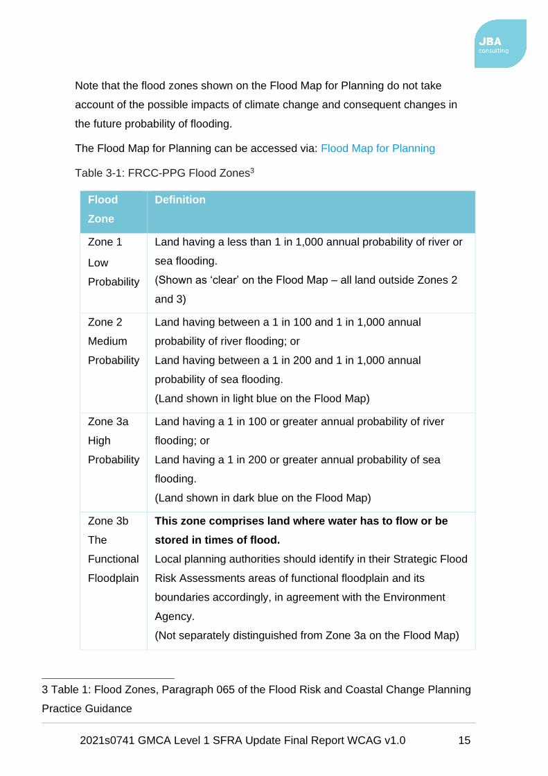
Table 3-1 provides an example of the flood probabilities used to describe the
fluvial and tidal flood zones as defined in the FRCC-PPG and as used by the EA
in the Flood Map for Planning (Rivers and Sea).
2021s0741 GMCA Level 1 SFRA Update Final Report WCAG v1.0 15
Note that the flood zones shown on the Flood Map for Planning do not take
account of the possible impacts of climate change and consequent changes in
the future probability of flooding.
The Flood Map for Planning can be accessed via: Flood Map for Planning
Table 3-1: FRCC-PPG Flood Zones3
Flood
Zone
Definition
Zone 1
Low
Probability
Land having a less than 1 in 1,000 annual probability of river or
sea flooding.
(Shown as ‘clear’ on the Flood Map – all land outside Zones 2
and 3)
Zone 2
Medium
Probability
Land having between a 1 in 100 and 1 in 1,000 annual
probability of river flooding; or
Land having between a 1 in 200 and 1 in 1,000 annual
probability of sea flooding.
(Land shown in light blue on the Flood Map)
Zone 3a
High
Probability
Land having a 1 in 100 or greater annual probability of river
flooding; or
Land having a 1 in 200 or greater annual probability of sea
flooding.
(Land shown in dark blue on the Flood Map)
Zone 3b
The
Functional
Floodplain
This zone comprises land where water has to flow or be
stored in times of flood.
Local planning authorities should identify in their Strategic Flood
Risk Assessments areas of functional floodplain and its
boundaries accordingly, in agreement with the Environment
Agency.
(Not separately distinguished from Zone 3a on the Flood Map)
3 Table 1: Flood Zones, Paragraph 065 of the Flood Risk and Coastal Change Planning
Practice Guidance
2021s0741 GMCA Level 1 SFRA Update Final Report WCAG v1.0 16
Considered over the lifetime of development, such an apparently low frequency or
rare flood has a significant probability of occurring. For example:
• A 1 in 100 (1%) annual probability flood has a 1 in 4 (26%) chance of
occurring at least once in a 30-year period - the period of a typical
residential mortgage
• And a 1 in 2 (49%) chance of occurring in a 70-year period - a typical
human lifetime
3.2.2 Consequence
The consequences of flooding include:
• fatalities,
• property damage,
• disruption to lives and businesses,
with severe implications for people (e.g. financial loss, emotional distress, health
problems).
Consequences of flooding depend on the hazards caused by flooding:
• depth of water,
• speed of flow,
• rate of onset,
• duration,
• wave-action effects,
• water quality
and the vulnerability of receptors:
• type of development,
• nature, e.g. age-structure, of the population,
• presence and reliability of mitigation measures etc.

2021s0741 GMCA Level 1 SFRA Update Final Report WCAG v1.0 17
Flood risk is then expressed in terms of the following relationship:
Flood risk = Probability of flooding x Consequences of flooding
3.3 Risk
Flood risk is not static; it cannot be described simply as a fixed water level that
will occur if a river overtops its banks or from a high spring tide that coincides with
a storm surge. It is therefore important to consider the continuum of risk carefully.
Risk varies depending on the severity of the event, the source of the water, the
pathways of flooding (such as the condition of flood defences) and the
vulnerability of receptors as mentioned above.
3.3.1 Actual risk
This is the risk 'as is' considering any flood defences that are in place for extreme
flood events (typically these provide a minimum Standard of Protection (SoP)).
Hence, if a settlement lies behind a fluvial flood defence that provides a 1 in 100-
year SoP then the actual risk of flooding from the river in a 1 in 100-year event is
generally low. However, the residual risk may be high in that the impact of flood
defence failure would likely have a major impact.
Actual risk describes the primary, or prime, risk from a known and understood
source managed to a known SoP. However, it is important to recognise that risk
comes from many different sources and that the SoP provided will vary within a
river catchment. Hence, the actual risk of flooding from the river may be low to a
settlement behind the defence but moderate from surface water, which may pond
behind the defence in low spots and is unable to discharge into the river during
high water levels.
3.3.2 Residual risk
Defended areas, located behind EA flood defences, remain at residual risk as
there is a risk of overtopping or defence breach during significant flood events.
Whilst the potential risk of failure may be reduced, consideration of inundation
and the impact on development needs to be considered.

2021s0741 GMCA Level 1 SFRA Update Final Report WCAG v1.0 18
Paragraph 041 of the FRCC-PPG defines residual risk as:
"…those remaining after applying the sequential approach to the location of
development and taking mitigating actions. Examples of residual flood risk
include:
• The failure of flood management infrastructure such as a breach of a
raised flood defence, blockage of a surface water conveyance system,
overtopping of an upstream storage area, or failure of a pumped drainage
system;
• failure of a reservoir, or;
• a severe flood event that exceeds a flood management design standard,
such as a flood that overtops a raised flood defence, or an intense rainfall
event which the drainage system cannot cope with.
Areas behind flood defences are at particular risk from rapid onset of fast-flowing
and deep water flooding, with little or no warning if defences are overtopped or
breached."
Even when flood defences are in place, there is always a likelihood that these
could be overtopped in an extreme event or that they could fail or breach. Where
there is a consequence to that occurrence, this risk is known as residual risk.
Defence failure can lead to rapid inundation of fast flowing and deep floodwaters,
with significant consequences to people, property, and the local environment
behind the defence.
Whilst the actual risk of flooding to a settlement that lies behind a fluvial flood
defence that provides a 1 in 100-year SoP may be low, there will always be a
residual risk from flooding if these defences overtopped or failed that must be
taken into account. Because of this, it is never appropriate to use the term "flood
free".
Developers must be able to demonstrate that development will be safe for the
entirety of its existence. To that end, Paragraph 042 of the FRCC-PPG states:
"Where residual risk is relatively uniform, such as within a large area protected by
embanked flood defences, the Strategic Flood Risk Assessment should indicate
the nature and severity of the risk remaining, and provide guidance for residual
2021s0741 GMCA Level 1 SFRA Update Final Report WCAG v1.0 19
risk issues to be covered in site-specific flood risk assessments. Where
necessary, local planning authorities should use information on identified residual
risk to state in Local Plan policies their preferred mitigation strategy in relation to
urban form, risk management and where flood mitigation measures are likely to
have wider sustainable design implications".

2021s0741 GMCA Level 1 SFRA Update Final Report WCAG v1.0 20
4 The planning framework and flood risk policy
4.1 Introduction
The main purpose of this section of the SFRA is to provide an overview of the key
planning and flood risk policy documents and legislation that have shaped the
current planning framework.
This section also provides an overview and context of the LLFA's and LPA's
responsibilities and duties in respect to managing local flood risk. This includes
but is not exclusive to the delivery of the requirements of the Flood Risk
Regulations (FRR) 2009 and the Flood and Water Management Act (FWMA)
2010.
Figure 4-1 illustrates the links between legislation, national policy, statutory
documents, and assessment of flood risk. The figure shows that whilst the key
pieces of legislation and policy are separate, they are closely related. Their
implementation should therefore aim to provide a comprehensive and planned
approach to asset record keeping and improving flood risk management within
communities.
It is intended that the non-statutory SWMPs and SFRAs can provide much of the
base data required to support the delivery of each LLFA's statutory flood risk
management tasks.
They should also help support the local authorities in developing capacity,
effective working arrangements and in informing the Local Flood Risk
Management Strategies (LFRMS), local plans and GMCA's Publication GMSF.
This in turn will help deliver flood risk management infrastructure and sustainable
new development. This SFRA should be used to support the GMSF and
individual local plans to help inform planning decisions.

2021s0741 GMCA Level 1 SFRA Update Final Report WCAG v1.0 21
Figure 4-1: Key documents and strategic planning links with flood risk
4.2 Legislation
4.2.1 EU Floods Directive & the Flood Risk Regulations
The European Floods Directive (2007) sets out the EU’s approach to managing
flood risk and aims to improve the management of the risk that floods pose to
human health, the environment, cultural heritage, and economic activity.
The Directive was translated into English law by the Flood Risk Regulations which
require LLFAs and the EA to produce Preliminary Flood Risk Assessment (PFRAs)
and Flood Risk Management Plans (FRMPs).
The Directive puts in place a six year cycle of producing PFRAs with the aim of
identifying significant Flood Risk Areas; preparing flood hazard and risk maps; and

2021s0741 GMCA Level 1 SFRA Update Final Report WCAG v1.0 22
preparing FRMPs. The first six year cycle was completed in December 2015 and
the second six year cycle began in December 2015.
Figure 4-2: EU Floods Directive
PFRAs should cover the entire LLFA area
for local flood risk (focusing on ordinary
watercourses, surface water and
groundwater flooding).
Where significant Flood Risk Areas are
identified using the national approach
(and locally reviewed), the LLFA is then
required to undertake flood risk hazard
mapping and to produce FRMPs, as
illustrated in Figure 4-2. FRMPs are also
completed for each River Basin District in England and Wales by the EA.
The FRMP should consider objectives for flood risk management (reducing the
likelihood and consequences of flooding) and measures to achieve those
objectives.
The EA implemented one of the exceptions for creating PFRAs for Main Rivers and
coastal flooding for the first PFRA cycle. This was because they already had
mapping (i.e. EA Flood Map for Planning (Rivers and Sea), Risk of Flooding from
Rivers and Sea Map) and plans (i.e. Catchment Flood Management Plans
(CFMPs), Shoreline Management Plans (SMPs)) in place to deal with this.
However, this exemption is not available for the second cycle, and therefore the
EA is starting to prepare the necessary preliminary assessment maps and report
for the second cycle period 2016-21.
4.2.2 Preliminary Flood Risk Assessments
In 2011, during the first PFRA cycle, the EA, using the EA 'Final PFRA Guidance'
and DEFRA's 'Guidance on selecting Flood Risk Areas', identified a total of ten
indicative Flood Risk Areas in England. One of these covered a large area of GM,
including areas of each of the ten LPAs.

2021s0741 GMCA Level 1 SFRA Update Final Report WCAG v1.0 23
Following this identification by the EA, a strategic PFRA was carried out for all of
GM. This was given the geographical nature of the indicative Flood Risk Area,
together with separate, more focused PFRAs carried out by each of the ten LLFAs.
In 2017, during the second cycle, the EA, using updated guidance, produced an
updated indicative Flood Risk Area to supersede the 2011 version, using the most
current data at the time. The 2017 indicative Flood Risk Area is considerably
smaller than the 2011 area, covering only a small area of Tameside.
This, at the time, was challenged by GMCA due to the considerable reduction in
area, though has since been accepted. GMCA accepted that the PFRA is not used
as evidence to inform the planning process, unlike this SFRA. By accepting the
reduced indicative Flood Risk Area, there should be no impact on the planning
process.
The reduction in area was based on a change in the EA methodology used to define
indicative Flood Risk Areas. This included improvements to the national surface
water risk map (Risk of Flooding from Surface Water - see Section 6.4.1.1) that
includes improved digital terrain modelling and property counting methodology.
The new methodology will have influenced the results of applying the clustering
methodology and the LLFAs were also able to contribute local modelling to the
national surface water risk map to improve local accuracy.
4.2.3 Catchment Flood Management Plans (CFMPs)
The CFMPs were produced by the EA in 2009 and were designed to establish flood
risk management policies that will deliver sustainable flood risk management for
the long term. The CFMPs were used by the EA to help direct resources to the
areas of greatest risk.
The CFMPs contain useful information about how catchments work, previous
flooding, and the sensitivity of the river systems to increased rainfall. The EA used
the evidence and previous measures and proposals set out in the CFMPs to help
develop FRMPs for River Basin Districts (RBDs).

2021s0741 GMCA Level 1 SFRA Update Final Report WCAG v1.0 24
GM is within the North West RBD and is included within four CFMPs, namely the
Irwell4, Upper Mersey5, Mersey Estuary6 and Douglas7.
4.2.4 Flood Risk Management Plans
Following on from the CFMPs, FRMPs are designed to set out the risk of flooding
from rivers, sea, surface water, groundwater and reservoirs, within each RBD.
They should detail how RMAs will work with communities to manage flood risk up
to 2021 for this cycle.
Both the River Basin Management Plans (RBMP) and FRMPs have been
developed by the EA in tandem to ensure that flood defence schemes can provide
wider environmental benefits during the same six-year cycle.
Both flood risk management and river basin planning form an important part of a
collaborative and integrated approach to catchment planning for water. Each EU
member country must produce FRMPs as set out in the EU Floods Directive 2007.
The River Irwell catchment dominates the majority of GM (see Figure 4-3) with the
Upper Mersey, Lower Mersey and Douglas catchments draining smaller areas (see
Figure 4-3 to Figure 4-6). Policies within the Irwell catchment will therefore have
the greatest effect on flood risk within GM, given the large area of GM within it.
The proposed SFRMP reviews the main policies and measures of the FRMP.
The full suite of reports on the North West RBD FRMP (split into six documents),
including detail on the River Irwell, Upper and Lower Mersey and Douglas
catchments can be accessed via: North West River Basin District Flood Risk
Management Plan
4 Irwell Catchment Flood Management Plan
5 Upper Mersey Catchment Flood Management Plan
6 Mersey Estuary Catchment Flood Management Plan
7 Douglas Catchment Flood Management Plan

2021s0741 GMCA Level 1 SFRA Update Final Report WCAG v1.0 25
Figure 4-3: River Irwell catchment (extracted from NW RBD FRMP Part B report)

2021s0741 GMCA Level 1 SFRA Update Final Report WCAG v1.0 26
Figure 4-4: Upper Mersey catchment (extracted from NW RBD FRMP Part B
report)

2021s0741 GMCA Level 1 SFRA Update Final Report WCAG v1.0 27
Figure 4-5: Mersey Estuary catchment (extracted from NW RBD FRMP Part B
report)

2021s0741 GMCA Level 1 SFRA Update Final Report WCAG v1.0 28
Figure 4-6: Douglas catchment (extracted from NW RBD FRMP Part B report)
4.2.5 Flood and Water Management Act (FWMA)
The FWMA was introduced in April 2010. It aims to improve both flood risk
management and the way we manage our water resources.
The FWMA has created clearer roles and responsibilities and helped to define a
more risk-based approach to managing flooding. This included the creation of a
lead role for LAs, as LLFAs, designed to manage local flood risk (from surface
water, groundwater, and ordinary watercourses) and to provide a strategic
overview role of all flood risk for the EA.
The content and implications of the FWMA provide considerable opportunities for
improved and integrated land use planning and flood risk management by LAs
and other key partners.
The integration and synergy of strategies and plans at national, regional, and
local scales, is increasingly important to protect vulnerable communities and
deliver sustainable regeneration and growth.

2021s0741 GMCA Level 1 SFRA Update Final Report WCAG v1.0 29
Table 4-1 provides an overview of the key LLFA responsibilities under the FWMA.
The Act recognises that "maintaining or restoring natural processes" is a way of
managing flood risk and therefore permits the designation of natural features that
can reduce this risk.
Table 4-1: Key LLFA Duties under the FWMA
FWMA
responsibility
Description of duties and powers
Local Strategy
for Flood Risk
Management
Each LLFA has a duty to develop, maintain, apply and monitor a
local strategy for flood risk management in its area.
The local strategies should build on information such as national
risk assessments and use consistent risk-based approaches
across LA areas and catchments.
The local strategy should not be secondary to the national
strategy; rather it should have distinct objectives to manage local
flood risks important to local communities.
Duty to
contribute to
sustainable
development
Each LLFA has a duty to contribute towards the achievement of
sustainable development.
Duty to
comply with
national
strategy
Each LLFA has a duty to comply with national flood and coastal
risk management strategy principles and objectives in respects
of its flood risk management functions.
Investigating
Flood
Incidents
Each LLFA, on becoming aware of a flood in its area, has (to the
extent it considers necessary and appropriate) to investigate and
record details of "locally significant" flood events within their
area.
This duty includes identifying the relevant risk management
authorities and their functions and how they intend to exercise
those functions in response to a flood.
The responding risk management authority must publish the

2021s0741 GMCA Level 1 SFRA Update Final Report WCAG v1.0 30
FWMA
responsibility
Description of duties and powers
results of its investigation and notify any other relevant risk
management authorities.
Asset
Register
Each LLFA has a duty to maintain a register of structures or
features, which it considers having a significant effect on flood
risk, including details on ownership and condition as a minimum.
The register must be available for inspection and the Secretary
of State will be able to make regulations about the content of the
register and records.
Duty to
cooperate and
Powers to
Request
Information
Each LLFA must co-operate with other relevant authorities in the
exercise of their flood and coastal erosion management
functions.
Ordinary
Watercourse
Consents
Each LLFA has a duty to deal with enquiries and determine
watercourse consents where the altering, removing or replacing
of certain flood risk management structures or features that
affect flow on ordinary watercourses is required.
It also has provisions or powers relating to the enforcement of
unconsented works.
Works Powers The Act provides the LLFAs with powers to undertake works to
manage flood risk from surface runoff, groundwater and ordinary
watercourses, consistent with the local flood risk management
strategy for the area.
Designation
Powers
The Act provides the LLFAs with powers to designate structures
and features that affect flooding or coastal erosion.
The powers are intended to overcome the risk of a person
damaging or removing a structure or feature that is on private
land and which is relied on for flood or coastal erosion risk
management.
Once a feature is designated, the owner must seek consent to

2021s0741 GMCA Level 1 SFRA Update Final Report WCAG v1.0 31
FWMA
responsibility
Description of duties and powers
alter, remove, or replace it.
Emergency
Planning
Each LLFA is required to play a lead role in emergency planning
and recovery after a flood event.
Community
Involvement
Each LLFA should engage local communities in local flood risk
management issues.
This could include the training of community volunteers, the
development of local flood action groups and the preparation of
community flood plans, and general awareness raising around
roles and responsibilities plans.
Planning
Requirements
for SuDS
SuDS are a planning requirement for major planning applications
of ten or more residential units or equivalent commercial
development schemes with sustainable drainage.
The LLFA is now a statutory planning consultee and it will be
between the LPA and the LLFA to determine the acceptability of
these proposed sustainable drainage schemes subject to
exemptions and thresholds.
Approval must be given before the developer can commence
construction.
LPAs should use planning conditions or obligations to make sure
that arrangements are in place for ongoing maintenance of any
SuDS over the lifetime of the development.
For latest updates to FWMA legislation8
8 Flood & Water Management Act 2010
2021s0741 GMCA Level 1 SFRA Update Final Report WCAG v1.0 32
4.3 Flood and water focused policies and plans
4.3.1 25 Year Environment Plan9
This Plan sets out Government action to help the natural world regain and retain
good health. It aims to deliver cleaner air and water in our cities and rural
landscapes, protect threatened species and provide richer wildlife habitats. It
calls for an approach to agriculture, forestry, land use and fishing that puts the
environment first.
The Plan also sets out how Government will tackle the effects of climate change,
considered to perhaps be the most serious long-term risk to the environment
given higher land and sea temperatures, rising sea levels, extreme weather
patterns and ocean acidification.
The Plan aims to show that Government will work with nature to protect
communities from flooding, slowing rivers and creating and sustaining more
wetlands to reduce flood risk and offer valuable habitats.
Focusing on flood risk, Government will look to update the national flood and
coastal erosion risk management strategy, looking to strengthen joint delivery
across organisations.
In terms of funding, Government will look at current partnership arrangements
ahead of a review of funding needs beyond 2021. This will seek to attract more
non-public sector investment, and make sure all relevant agencies are able to
respond quickly and effectively to support communities when flooding does occur.
The Plan states that the EA will use its role in statutory planning consultations to
seek to make sure that new developments are flood resilient and do not increase
flood risk.
For flood mitigation, Government will focus on using more natural flood
management solutions; increasing the uptake of SuDS, especially in new
development; and improving the resilience of properties at risk of flooding and the
time it takes them to recover should flooding occur.
9 25 Year Environment Plan
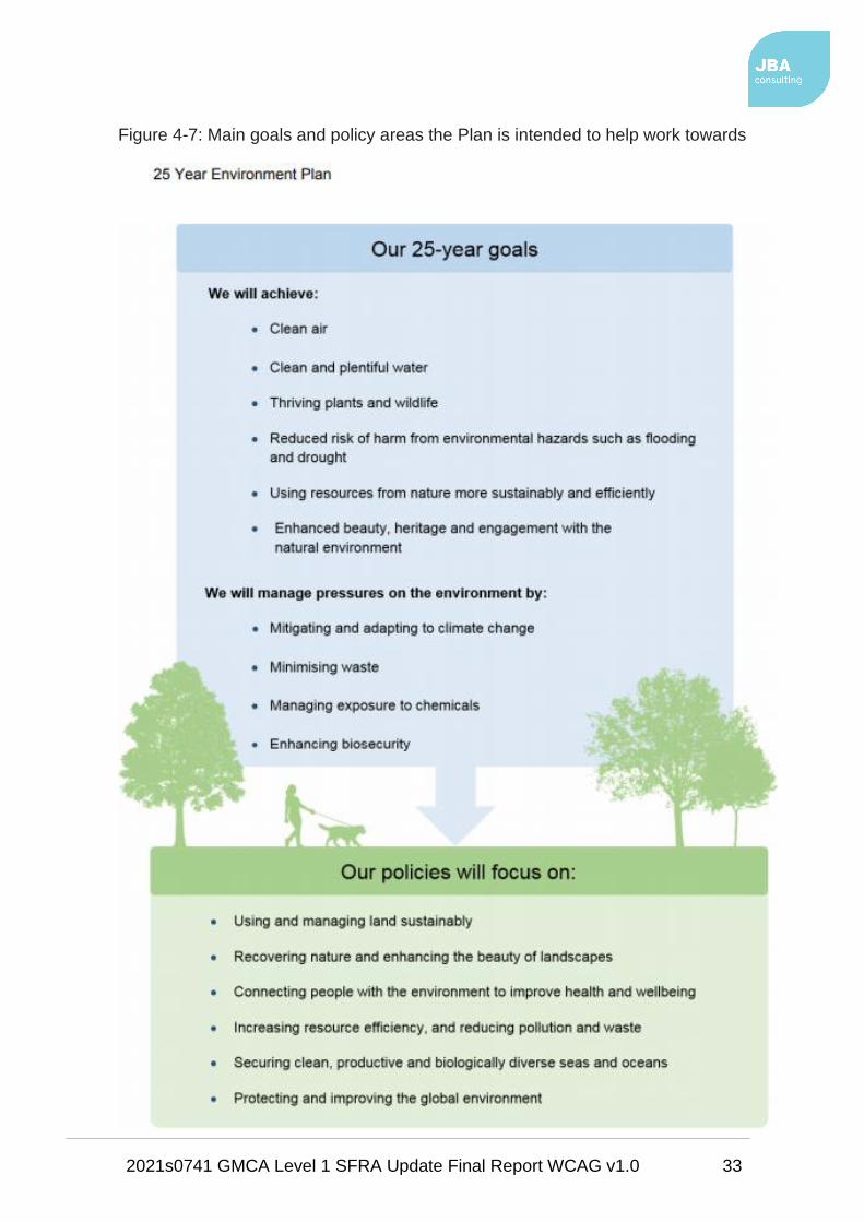
2021s0741 GMCA Level 1 SFRA Update Final Report WCAG v1.0 33
Figure 4-7: Main goals and policy areas the Plan is intended to help work towards
2021s0741 GMCA Level 1 SFRA Update Final Report WCAG v1.0 34
4.3.2 Water Framework Directive & Water Environment Regulations
The Water Framework Directive (WFD was transposed into English Law by the
Water Environment Regulations (2003). Its purpose is to deliver improvements
across Europe in the management of water quality and water resources through
the RBMPs.
The EA is responsible for monitoring and reporting on the objectives of the WFD
on behalf of Government. The second management cycle of the WFD10 has
begun and the second RBMPs were completed in 2015, building upon the first set
completed in 2009.
RBMPs are designed to address the pressures facing the water environment in
the RBMP districts and identify the actions to address them. The plans set out
required objectives and measures to protect and improve the water environment
over the next 20 years and aim to achieve WFD targets from 2015 to 2021.
GM is included within the North West RBMP11.
10 Water Framework Directive timetable
11 North West River Basin Management Plan

2021s0741 GMCA Level 1 SFRA Update Final Report WCAG v1.0 35
Figure 4-8 shows the WFD second cycle Main River classifications. The majority
of Main Rivers in GM are classed as having Moderate status.
Moderate status is defined as: Moderate change from natural conditions as a
result of human activity. No restriction on the beneficial uses of the waterbody.
No impact on amenity. Some impact on wildlife and fisheries.
Wince Brook, flowing from Oldham into the River Irk in Rochdale is the only
watercourse with Bad status.
Bad status can be defined as: Severe change from natural conditions as a result
of human activity. Significant restriction on the beneficial uses of the waterbody.
Major impact on amenity. Major impact on wildlife and fisheries with many
species not present.
A number of Main Rivers in Stockport are classed as having Poor status. This
includes the rivers Etherow and Goyt; Torkington Brook; Poise Brook; and Micker
Brook. Also, Shaw Brook, Stirrup Brook, Whitehead Brook and Moss House
Farm Brook, flowing from Salford into Wigan are of Poor status.
Poor status is defined as: Major change from natural conditions as a result of
human activity. Some restrictions on the beneficial uses of the waterbody. Some
impact on amenity. Moderate impact on wildlife and fisheries with many species
not present.
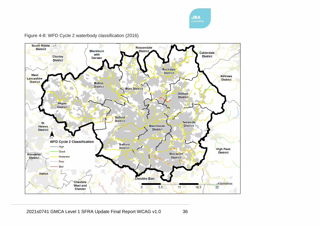
2021s0741 GMCA Level 1 SFRA Update Final Report WCAG v1.0 36
Figure 4-8: WFD Cycle 2 waterbody classification (2016)
2021s0741 GMCA Level 1 SFRA Update Final Report WCAG v1.0 37
The EA has stated that just over 90% of waterbodies in GM are failing their
objectives under WFD. The North West RBMP Part 1 document12 states that the
priorities for the Irwell catchment are to address diffuse urban pollution, physical
modification, and contamination from sewage treatment.
The Irwell catchment partnership’s three key objectives are: cleaner water, more
naturally functioning and resilient waterbodies that are better connected, and
managed habitats. In terms of flood risk, the partnership has mapped areas in
the catchment where green infrastructure can be used to help address surface
water flooding.
The RBMPs, like the CFMPs, are important for the development of the SFRA.
The SFRA should consider the wider catchment flood cell aims and objectives
and understand how it can potentially contribute to the achievement of them for
example, with regards to Working with Natural Processes (WwNP).
The main responsibility for GMCA is to work with the EA to develop links between
river basin management planning and the development of local authority plans,
policies, and assessments. In particular, the general programme of actions
(measures) within the RBMPs highlight the need for:
• Water Cycle Studies (WCS) to promote water efficiency in new
development through regional strategies and local development
frameworks;
• SWMP implementation (see Section 4.7.2.1 for the GM SWMP, 2013);
• Consideration of the WFD objectives (achieving good status or potential as
appropriate) in the spatial planning process, including Local Development
Documents and Sustainable Community Strategies; and
• Promoting the wide scale use of SuDS in new development.
4.4 Other related plans and policies
4.4.1 EU Funded (Life Integrated) Natural Course Project
Natural Course is an EU LIFE Integrated Project aimed at integrated water
management through accelerating delivery towards the objectives of the EU WFD
12 North West River Basin Management Plan Part 1
2021s0741 GMCA Level 1 SFRA Update Final Report WCAG v1.0 38
and improved flood risk management. The project spans the North West
England River Basin District, with an early focus on the River Irwell catchment.
Natural Course is delivered by a partnership comprising the EA, UU, the GMCA
(with Salford City Council acting as lead authority), the Rivers Trust and Natural
England.
Because of the scale, complexity and in some cases the high cost of WFD
delivery, Natural Course focuses on integration; both between the project
partners and more widely among organisations and sectors that can contribute to
integrated water management.
Natural Course promotes an integrated catchment approach, working through the
established network of Catchment Partnerships and employs a Natural Capital
approach to tackling the challenges presented by the WFD and increased flood
risk management where possible.
Natural Course began in October 2015 and will run for 10 years with budgets and
work programmes split into four equal phases of 2.5 years.
The first phase of Natural Course is the development of an integrated water
management framework through a series of “Preparatory Actions” including:
• A desk top collection and analysis of existing data, or evidence, from the
River Irwell catchment and development of a programme of works, or
measures to address the challenges presented by the WFD (Irwell
Evidence and Measures Report, APEM Ltd 2017).
• Collation and sharing of ecological and environmental information about
the River Irwell catchment working with volunteers to conduct surveys
aimed at filling gaps in knowledge about the ecology of the catchment.
• Modelling the River Irwell catchment to understand the potential value and
impact of Natural Flood Risk Management (NFRM) interventions to
contribute to reduced flood risk across the catchment (Irwell Natural Flood
Management Mapping, JBA Consulting / Rivers Trust 2017).
• Understanding and mapping the opportunities to restore and re-naturalise
“heavily-modified” waterbodies so as to provide maximum ecosystem
service benefits across the River Irwell catchment (A Natural Capital

2021s0741 GMCA Level 1 SFRA Update Final Report WCAG v1.0 39
Account and Ecosystem Services Opportunities Mapping for the Irwell
Management Catchment, TEP / Vivid Economics - finalised April 2018).
• Identifying and understanding the synergies between water management
challenges and sources of investment from different sectors and
opportunities to align investment to enhance and accelerate delivery of
multiple water management benefits for the River Irwell catchment.
The development of the GMSF provides an opportunity to set an integrated water
management approach in the wider economic, social, growth and infrastructure
plans for the conurbation.
4.4.2 Catchment partnerships
The Catchment Based Approach13 (CaBA) embeds collaborative working at a
river catchment scale to deliver cross cutting improvements to our water
environments. The CaBA partnerships drive cost-effective practical delivery on
the ground, resulting in multiple benefits including reduced flood risk and
resilience to climate change.
Catchment partnerships are groups of organisations with an interest in improving
the environment in the local area and are led by a catchment host organisation.
The partnerships work on a wide range of issues, including the water environment
but also address other concerns that are not directly related to river basin
management planning.
Government is also working to strengthen or establish partnerships in the areas
most affected by the December 2015 floods to encourage a more integrated
approach to managing risk across all catchments.
The National Resilience Review aligns closely with Defra’s work on integrated
catchment-level management of the water cycle in Government’s 25 year
Environment Plan (see Section 4.3).
Government’s aspirations for the next cycle of planning (now to 2021) is for more
integrated catchment planning for water, where Flood and Coastal Risk
13 Catchment Based Approach

2021s0741 GMCA Level 1 SFRA Update Final Report WCAG v1.0 40
Management, River Basin Management, nature conservation and land
management are considered together.
Catchment partnerships relevant to GM:
• Rivers Return - the Irwell Catchment Partnership; hosted by Groundwork
Manchester, Salford, Tameside, and Trafford.
A strategic plan has been developed, identifying key issues, and an action
plan is under development. The partnership is helping to identify the
location and details for priority projects, seeking funding and consulting
and engaging with local people to encourage their involvement in identified
projects.
At the time of writing, such projects include:
o River stewardship; commissioned by the EA. This work led to
successful application of Defra's Payment for Ecosystem Services
(PES14) pilot expanding work with businesses in the market
research and development project.
o Little and often Maintenance of the riparian corridor; commissioned
by the EA. It was found that the third sector and social enterprises
could provide maintenance and improvements to assets at a high
quality and lower cost and could also provide greater social benefits
than through other teams.
• Upper Mersey Catchment Partnership; hosted by Mersey Rivers Trust.
At the time of writing, this partnership is forming a vision for the catchment
and the steering group is developing a catchment plan.
Key projects include:
• Mersey Starts Well (aim to improve the ecological health and
amenity value of the Mersey at its source by focusing on the Tame,
improving the potential for it to be 'opened up' in the future),
• Returning Rivers,
• Slow the Flow,
14 Payments for ecosystem services

2021s0741 GMCA Level 1 SFRA Update Final Report WCAG v1.0 41
• Gravel Management Plan,
• Community SCAMP,
• Cheshire Meres and Brooks,
• Misconnection Hotspots,
• Making the most of Construction Opportunities,
• Etherow Bundle and
• Bollin Bundle.
• Lower Mersey Catchment Partnership; hosted by Mersey Rivers Trust.
At the time of writing, this partnership is forming a vision for the catchment
and the steering group is developing a catchment plan.
• Douglas Catchment Partnership; hosted by Groundwork Lancashire, West
and Wigan.
Figure 4-9 shows the spatial nature of the catchment partnerships within GM.
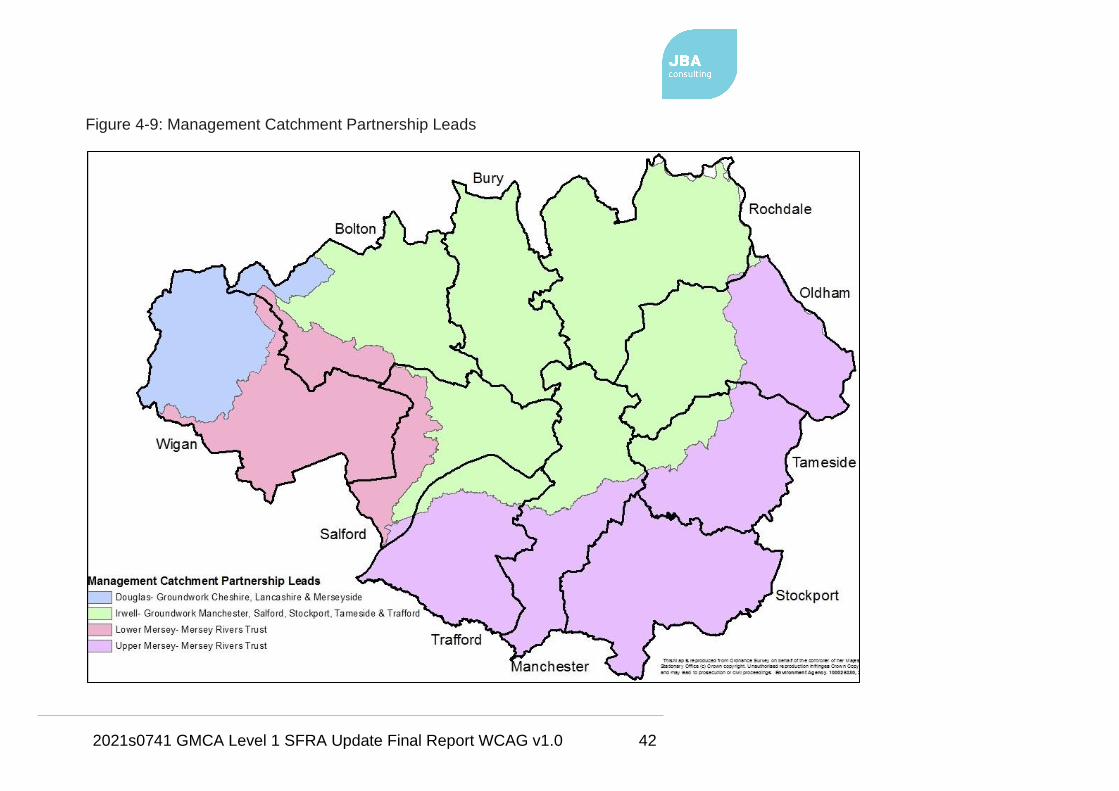
2021s0741 GMCA Level 1 SFRA Update Final Report WCAG v1.0 42
Figure 4-9: Management Catchment Partnership Leads
2021s0741 GMCA Level 1 SFRA Update Final Report WCAG v1.0 43
4.5 Planning legislation
4.5.1 Housing and Planning Act, 2016
This Act provides the statutory framework to build more homes that people can
afford, expand home ownership, and improve housing management. The Act
places a duty on local authorities to promote the development of starter homes,
custom and self-build homes.
The Act simplifies and speeds up the neighbourhood planning process to support
communities that seek to meet local housing and other development needs
through neighbourhood planning.
In addition, the Act seeks to ensure that every area has a Local Plan whilst also
giving the Secretary of State further powers to intervene if Local Plans are not
effectively delivered.
4.5.2 Localism Act 2011
The Localism Act was given Royal Assent in November 2011 with the purpose of
shifting power from Central Government back to local councils, communities, and
individuals.
Government abolished Regional Spatial Strategies, aiming to provide the
opportunity for councils to re-examine the local evidence base and establish their
own local development requirements for employment, housing and other land
uses through the plan making process.
Additionally, this act places a duty to cooperate on local authorities, including
statutory bodies and other groups, in relation to the planning of sustainable
development.
This duty to cooperate requires local authorities to:
“...engage constructively, actively and on an ongoing basis in any process by
means of which development plan documents are prepared so far as relating to a
strategic matter.” (Provision 110).
This act, together with the Neighbourhood Planning (General) Regulations 2012,
also provides new rights to allow Parish or Town Councils to deliver additional
development through neighbourhood planning (Neighbourhood Plans).

2021s0741 GMCA Level 1 SFRA Update Final Report WCAG v1.0 44
This means local people can help decide where new homes and businesses
should go and what they should look like.
LPAs can provide technical advice and support as neighbourhoods draw up their
proposals. Neighbourhood Plans have several conditions and requirements as
set out in the NPPF.
Paragraphs 061-064 of the FRCC-PPG provide information on neighbourhood
planning and flood risk. In terms of flood risk, neighbourhood planning qualifying
bodies should (Paragraph 061):
• Seek to ensure neighbourhood plans and neighbourhood development /
community right to build orders are informed by an appropriate
assessment of flood risk;
• Ensure policies steer development to areas of lower flood risk as far as
possible;
• Ensure that any development in an area at risk of flooding would be safe,
for its lifetime taking account of climate change impacts;
• Be able to demonstrate how flood risk to and from the plan area /
development site(s) will be managed, so that flood risk will not be
increased overall, and that opportunities to reduce flood risk, for example,
through the use of SuDS, are included in the plan / order.
4.6 Planning policy
4.6.1 National Planning Policy Framework (NPPF), 2019
The revised NPPF was published in July 2018, replacing the previous version
published in March 2012. This was further updated in February 2019. The NPPF
sets out Government's planning policies for England and how these are expected
to be applied.
The Framework is based on core principles of sustainability and forms the
national policy framework in England, also accompanied by several Planning
Practice Guidance (PPG) notes. It must be considered in the preparation of local
plans and is a material consideration in planning decisions.

2021s0741 GMCA Level 1 SFRA Update Final Report WCAG v1.0 45
The PPG documents will, where necessary, be updated in due course to
reflect the changes in the revised NPPF.
Section 14 Paragraph 156 of the 2019 NPPF states that…
“...Strategic policies should be informed by a strategic flood risk assessment and
should manage flood risk from all sources. They should consider cumulative
impacts in, or affecting, local areas susceptible to flooding, and take account of
advice from the Environment Agency and other relevant flood risk management
authorities, such as lead local flood authorities and internal drainage boards.”
The key changes in the revised 2019 NPPF include:
• Strategic policies should also now consider the ‘cumulative impacts in, or
affecting, local areas susceptible to flooding’ (para 156), rather than just to
or from individual development sites (see Section 7.8);
• Future risk from climate change. The ‘sequential approach should be used
in areas known to be at risk now or in the future from any form of flooding’
(para 158) (see Sections 6.9.1, 7.2.2, 7.3.3 and Appendix B);
• Natural Flood Management. 'Using opportunities provided by new
development to reduce the causes and impacts of flooding (where
• The Sequential Test must be performed when considering the
placement of future development and for planning application
proposals.
• The Sequential Test is used to direct all new development (through the
site allocation process) to locations at the lowest probability of flooding.
• Development should not be allocated or permitted if there are
reasonably available sites appropriate for the proposed development in
areas with a lower risk of flooding.
• The strategic flood risk assessment will provide the basis for applying
this test.
• The sequential approach should be used in areas known to be at risk
now or in the future from any form of flooding.

2021s0741 GMCA Level 1 SFRA Update Final Report WCAG v1.0 46
appropriate through the use of natural flood management techniques)'
(para 157c) (see Sections 6.8.5, 7.3.4 and Appendix B);
• SuDS. 'Major developments should incorporate sustainable drainage
systems unless there is clear evidence that this would be inappropriate'
(Para 165) (see Section 7.11.1 and Appendix F); and
• Emergency planning. Emergency plans are required as part of an FRA
that includes the inclusion of safe access and egress routes (para 163e)
(Section 8).
As explained, the FRCC-PPG sits alongside the NPPF and sets out detailed
guidance on how this policy should be implemented.
4.6.2 Flood Risk and Coastal Change Planning Practice Guidance (FRCC-PPG),
At the time of writing, the current FRCC-PPG was published on 6 March 2014
and is available online via:
Flood Risk and Coastal Change Planning Practice Guidance
Following the revision of the NPPF, Government will, where necessary be
updating the FRCC-PPG to reflect the changes discussed above in Section
4.6.1. It is advised that any hyperlinks within the FRCC-PPG that direct
users to the previous 2012 NPPF should be disregarded.
Whilst the NPPF concentrates on high level national policy, the FRCC-PPG is
more detailed. The practice guidance advises on how planning can take account
of the risks associated with flooding and coastal change in plan making and the
development management process. This is in respect of:
• local plans,
• SFRAs,
• the sequential and exception tests,
• permitted development,
• site-specific flood risk,
• Neighbourhood Planning,
• flood resilience and resistance techniques and

2021s0741 GMCA Level 1 SFRA Update Final Report WCAG v1.0 47
• the vulnerability of development to make development safe from flooding.
As discussed, the FRCC-PPG may in the future be updated in places to reflect
the revised NPPF.
4.7 Flood Risk Management policy
4.7.1 National and Local Flood Risk Management Strategies
As presented in Figure 4-1, the FWMA establishes how flood risk will be
managed within the framework of the National Strategy for England and local
strategies for each LLFA area.
The National Strategy for England has been developed by the EA with the
support and guidance of Defra. It sets out principles for how flood risk should be
managed and provides strategic information about different types of flood risk and
which organisations are responsible for their effective management.
The FWMA requires risk management authorities (local authorities, EA, sewerage
companies and highways authorities) to work together and act consistently with
the National Strategy in carrying out their flood and coastal erosion risk
management functions.
These functions should be carried out effectively, efficiently and in collaboration
with communities, businesses, and infrastructure operators to deliver more
effective flood risk management. This was published in 2011 and is, at the time
of writing, being reviewed with the intention for a new Strategy to be issued in
2019.
LLFAs are responsible for developing a LFRMS for their area covering local
sources of flooding, as stated in Table 4-1. The local strategy produced must be
consistent with the National Strategy.
The local strategy should set out the framework for local flood risk management
functions and activities and should raise awareness of local organisations with
responsibilities for flood risk management in the area.
The strategy should also facilitate partnership arrangements to ensure co-
ordination between local organisations and an assessment of flood risk and plans
and actions for managing risk, as set out under Section 9 of the FWMA.

2021s0741 GMCA Level 1 SFRA Update Final Report WCAG v1.0 48
The following link provides links to guidance for RMAs and local authorities on
various subjects of flood risk management, including tools to support LLFAs in
developing their LFRMS:
Flood risk management: information for flood risk management authorities, asset
owners and local authorities
Each of the ten GM authorities has produced a LFRMS; measures and
objectives from which have been considered in the development of the GM
SFRMF.
4.7.2 Surface Water Management Plans
In June 2007, widespread extreme flooding was experienced in the UK.
Government review of the 2007 flooding, chaired by Sir Michael Pitt
recommended that…
“…Local Surface Water Management Plans (SWMPs) … coordinated by local
authorities, should provide the basis for managing all local flood risk.”
Government's SWMP Technical Guidance document15, 2011, defines a SWMP
as:
• A framework through which key local partners with responsibility for
surface water and drainage in their area, work together to understand the
causes of surface water flooding and agree the most cost-effective way of
managing surface water flood risk.
• A tool to facilitate sustainable surface water management decisions that
are evidence based, risk based, future proofed and inclusive of
stakeholder views and preferences.
• A plan for the management of urban water quality through the removal of
surface water from combined systems and the promotion of SuDS.
As a demonstration of its commitment to SWMPs as a structured way forward in
managing local flood risk, Defra announced an initiative to provide funding for the
highest flood risk authorities to produce SWMPs.
15 Surface Water Management Plan Technical Guidance

2021s0741 GMCA Level 1 SFRA Update Final Report WCAG v1.0 49
Defra's framework for carrying out a SWMP is illustrated by the SWMP wheel
diagram, as shown in Figure 4-10.
The first three phases involve undertaking the SWMP study, whilst the fourth
phase involves producing and implementing an action plan which is devised
based on the evidence gained from the first three phases.
Figure 4-10: Defra wheel (taken from SWMP Technical Guidance)

2021s0741 GMCA Level 1 SFRA Update Final Report WCAG v1.0 50
4.7.2.1 Greater Manchester Surface Water Management Plan, 2013
The GM SWMP was completed in February 2013 and included all four phases of
the Defra wheel.
Stage 1 of the GM SWMP related to the first two phases of the Defra wheel, from
which, partnerships were formed and a strategic assessment of surface water
flood risk across GM was carried out.
This strategic assessment of risk used sub-regional surface water modelling to
produce hazard outputs, which were then overlaid with the location of local critical
and vulnerable receptors to identify potential areas of significant surface water
flood risk, known as surface water ‘Hotspots’.
A total of 580 Hotspot locations were identified. These locations are shown on
Figure 6-8 for historic surface water flooding indications. For those areas within
the Hotspots a more detailed understanding of surface water flood risk was
required, and an action plan was put in place to address this.
The fourth phase, the preparation of the Action Plan for GM, translates the
recommendations made during the first three phases into a series of distinct and
measurable actions. These are designed to facilitate further investigation and
management of surface water flood risk across GM in the future. These actions
are listed in Table 4-2 which is a direct extract from the GM SWMP report16.
The Action Plan was designed to be a living document that would continue to
grow and evolve as additional stages of the SWMP process were completed, and
further investigations and works were carried out either across GM as a whole or
at individual locations through each LLFA's LFRMS.
The idea was that Local Strategies would integrate these actions into the
frameworks for which each authority would manage future flood risk.
16 Greater Manchester Surface Water Management Plan, Overarching Report, February
2013

2021s0741 GMCA Level 1 SFRA Update Final Report WCAG v1.0 51
Table 4-2: GM SWMP generic actions
Recommended Action Reason for Action Lead organisation
and Likely Partner
Organisations
Carry out surveys to inform
and complete sewer maps
together with providing
understanding on location and
condition of assets
Filling gaps in the sewer
networks across areas provides
confidence in sewer capacity
and flow routes. Provides
information on asset locations
UU (United Utilities)
with LLFA
Update asset plans and
registers with collected data
from this study
Update names and routes of
culverted watercourses and
proved connectivity on asset
plans
UU and LLFA
Carry out regular
maintenance of features
conveying surface water
The sewer networks have been
designed specifically for carrying
water and if the network is
partially blocked then the
available capacity isn't being
used effectively or efficiently
UU
Carry out regular
maintenance of features
collecting surface water
Highway gulley maintenance is
important to allow surface water
to enter the sewer network
LLFA
Improving the maintenance
regime of watercourses may
have both environmental and
ecological benefits to the
watercourse and public open
spaces
There could be links to WFD
and alternative funding sources
for this work
LLFA with EA
Carry out design reviews of
sewer network capacity
Understanding where there are
'pinch points' in networks can
allow focus for both
UU with EA, LLFA
and Local Businesses
2021s0741 GMCA Level 1 SFRA Update Final Report WCAG v1.0 52
Recommended Action Reason for Action Lead organisation
and Likely Partner
Organisations
maintenance and future planned
refurbishment or replacement
schemes
Gaining a better
understanding land ownership
Knowing the locations where
water can be stored or safely
conveyed overland can relieve
pressure on existing
overwhelmed sewer networks
LLFA with EA, UU
Local Businesses
Better recording of flood
incidents
Keeping flood locations, dates,
maps of flooded areas,
photographs and suggested
reasons for flooding help future
analysis understand
mechanisms and provide
justification for future schemes
LLFA with EA and UU
Approach Emergency
services for their
records
Increase technical capacity of
LLFAs responsible for
managing local flood risk
Capacity building, recruitment,
education and training.
LLFAs possible
secondment
opportunities from EA
Use Planning to promote
SuDS in appropriate new
developments and as integral
part of highway resurfacing
and refurbishment
Reduce surface water runoff and
increase storage at source.
Reduce the amount of surface
water ending up in the sewer
network during high flows.
LLFAs

2021s0741 GMCA Level 1 SFRA Update Final Report WCAG v1.0 53
4.7.3 Critical Drainage Areas (CDA)
CDAs can be designated by LPAs or LLFAs for their own purposes with several
having been drafted as part of previous SFRAs carried out by the GM authorities.
Each GM council has developed policy to attach to the CDAs.
Such policy can include:
• minimum requirements for runoff volumes from development sites;
• a preference for a certain type of SuDS;
• drainage strategies to be in place for larger development sites;
• stricter requirements on site-specific FRAs i.e. lowering the requirement for
FRAs to sites greater than half a hectare in size rather than one hectare.
Table 4-3 states the policy each authority is using.
Table 4-3: CDA policy for each GM authority
Authority
CDA Policy
Brownfield
sites Greenfield sites Other
Bolton
50% less than
pre-
development
No worse than
existing
Policy applies on a borough-wide
scale and not just to development
within a CDA
Bury
50% less than
pre-
development
Current runoff up
to 1 in 100 AEP
event + climate
change
Development should be designed
so that there is no flooding to the
development in a 1 in 30 AEP event
and no property flooding in a 1 in
100 year plus climate change event
Manchester
50% less than
pre-
development
Current runoff up
to 1 in 100 AEP
event + climate
change
FRAs required for all development
over 0.5 ha in CDAs and to have
regard to recommended runoff
rates; development should be
designed so that there is no
flooding to the development in a 1
in 30 AEP event and no property

2021s0741 GMCA Level 1 SFRA Update Final Report WCAG v1.0 54
Authority
CDA Policy
Brownfield
sites Greenfield sites Other
flooding in a 1 in 100 year plus
climate change event
Oldham
50% less than
pre-
development
Current runoff up
to 1 in 100 AEP
event + climate
change
FRAs required for all development
over 0.5 ha in CDAs and to have
regard to recommended runoff
rates; development should be
designed so that there is no
flooding to the development in a 1
in 30 AEP event and no property
flooding in a 1 in 100 year plus
climate change event
Rochdale
50% less than
pre-
development
Current runoff up
to 1 in 100 AEP
event + climate
change
Any site within a CDA requires
regard to SFRA and full compliance
with any strategy for CDA areas
Salford
50% less than
pre-
development
Current runoff up
to 1 in 100 AEP
event + climate
change
FRAs required for all development
over 0.5 ha in CDAs and to have
regard to recommended runoff
rates; development should be
designed so that there is no
flooding to the development in a 1
in 30 AEP event and no property
flooding in a 1 in 100 year plus
climate change event
Stockport
50% less than
pre-
development Unknown FRAs for sites over 0.5 ha
Tameside
50% less than
pre- Unknown
Policy applies on a borough-wide
scale and not just to development

2021s0741 GMCA Level 1 SFRA Update Final Report WCAG v1.0 55
Authority
CDA Policy
Brownfield
sites Greenfield sites Other
development within a CDA
Trafford
50% less than
pre-
development
Current runoff up
to 1 in 100 AEP
event + climate
change
FRAs required for all development
over 0.5 ha in CDAs and to have
regard to recommended runoff
rates; development should be
designed so that there is no
flooding to the development in a 1
in 30 AEP event and no property
flooding in a 1 in 100 year plus
climate change event
Wigan
50% less than
pre-
development
Current runoff up
to 1 in 100 AEP
event + climate
change
FRAs required for all development
over 0.5 ha in CDAs and to have
regard to recommended runoff
rates; development should be
designed so that there is no
flooding to the development in a 1
in 30 AEP event and no property
flooding in a 1 in 100 year plus
climate change event
As stated in the Project Brief, the CDA boundaries were to be reviewed as part of
this SFRA. A high-level review has therefore been carried out.
However, given data restrictions, the decision has been taken by GMCA that the
existing CDAs should remain alongside new 'Opportunity Areas for Further
Critical Drainage Management' (OAFCDM), drafted based on historic surface
water flood incidents.
The policy stated in Table 4-3 should still apply to proposed developments within
a CDA, though the OAFCDMs should also be considered alongside the CDAs, by
the applicable LLFA and LPA, for further critical drainage management.

2021s0741 GMCA Level 1 SFRA Update Final Report WCAG v1.0 56
Section 6.4.3 provides information on how the OAFCDMs have been delineated.
It is recommended that both the CDAs and OAFCDMs are reviewed and
refined using more detailed information as part of any future investigation /
study i.e. Level 2 SFRA, surface water flood risk assessment.
4.7.4 UU Water Resources Management Plan (2015-2040)
There is very little reference to flooding other than issues in Cumbria (Thirlmere
reservoir). The issue of flooding is not directly related to the Water Resources
Management Plan process. It is primarily concerned with maintaining adequate
water supplies to customers over the coming 25 years.
The EA is responsible for flooding (e.g. river and coastal) and have a programme
of measures in place to protect communities from flooding. To minimise the
impact of flooding it is possible to construct purpose-built flood storage basins or
to implement controlled flooding measures (e.g. where lowlands are permitted to
flood).
UU water supply reservoirs are built for the purpose of water supply however they
do provide some flood attenuation. However, this is often a minimal impact due
to the comparative volume of water arriving in a flood and the available storage in
a reservoir.
4.7.5 Greater Manchester Green Infrastructure
The most up-to-date and available report regarding priority green and blue
strategic infrastructure is the Updated Priority Green Infrastructure
Study produced in May 2018.
This report describes the approach to identifying and mapping the Priority Green
Infrastructure (GI) of GM. These areas of Priority GI, and also several broad
strategic GI opportunity areas, are shown in Figure 4-11 and included on the
SFRA Maps in Appendix A.
The mapped Priority GI areas represent existing GI assets and not those that
provide opportunities for the development of GI and NFM. The focus was on
identifying Strategic Priority GI for GM. However, it does not ignore the fact that
small areas of GI can have value at a more local level and does not imply that

2021s0741 GMCA Level 1 SFRA Update Final Report WCAG v1.0 57
more local GI is unimportant; all areas of GI should be considered on merit when
considering development.

2021s0741 GMCA Level 1 SFRA Update Final Report WCAG v1.0 58
Figure 4-11: Priority GI network and strategic GI opportunity areas

2021s0741 GMCA Level 1 SFRA Update Final Report WCAG v1.0 59
The document suggests GI policies for the GMSF:
• Policy for Nature Conservation (existing designated sites)
• Policy for the Protection of the Strategic Green and Blue Infrastructure
Network
• Policy for the Protection of Nature Improvement Areas
• Policy for Protection of Blue Infrastructure
• Policy for the Conservation of Species Protected by Law
• Policy for the Protection of Green Belt.
4.8 Roles and responsibilities in planning and flood risk management
RMA responsibilities under the FWMA and the FRR, as summarised by
Government17, include the following:
4.8.1 EA as a RMA
• Has a strategic overview role for all forms of flooding;
• Provides and operates flood warning systems;
• Carries out works to manage flood risk from the sea and main rivers;
• Carries out works in estuaries to secure adequate outfalls for main rivers;
• Carries out surveys to inform FCERM works and has the right to enter
private land to carry out such works;
• Issues consent for works on or near main rivers, and works affecting
watercourses, flood and sea defences and other structures protected by its
byelaws;
• Designates structures and features of the environment that affect flood or
coastal erosion risk
• Has the power to request information from any partner in connection with
its risk management functions;
• Must exercise its flood or coastal erosion risk management functions in a
manner consistent with the National Strategy and local strategies;
17 Flood and coastal erosion risk management authorities

2021s0741 GMCA Level 1 SFRA Update Final Report WCAG v1.0 60
• Must be consulted on local strategies, if affected by the strategy, by the
LLFA; and
• Must help advise on sustainable development.
4.8.2 LPA as a RMA
• Has a duty to act in a manner that is consistent with the National Strategy
and have regard to local strategies;
• Must be consulted on local strategies, if affected by the strategy, by the
LLFA;
• Has a duty to be subject to scrutiny from the LLFA; and
• Has a duty to cooperate and share information with other RMAs.
4.8.3 LLFA as a RMA
• Must develop, maintain, apply and monitor a strategy for local flood risk
management. This must be consulted on with all RMAs, the public and all
other partners with an interest in local flood risk, and must comply with the
National Strategy;
• Should prepare and maintain a preliminary flood risk assessment, flood
hazard maps, flood risk maps and flood risk management plans;
• Is required to coordinate and share information on local flood risk
management between relevant authorities and partners;
• Is empowered to request information from others when it is needed in
relation to its flood risk management functions;
• Must investigate significant flooding incidents in its area where it considers
it necessary or appropriate;
• Has a duty to establish and maintain a record of structures within its area
that it considers to have a significant impact on local flood risk;
• Is empowered to designate structures and features that affect flooding;
• Has powers to undertake works to manage flood risk from surface runoff,
groundwater and ordinary watercourses;
• Can grant consents for culverts, dams and weirs on ordinary watercourses;

2021s0741 GMCA Level 1 SFRA Update Final Report WCAG v1.0 61
• Must exercise its flood and coastal erosion risk management functions in a
manner consistent with the National Strategy and the applicable Local
Strategy;
• Can carry out work that may cause flooding or coastal erosion in the
interests of nature conservation, preservation of cultural heritage or
people’s enjoyment of the environment or cultural heritage;
• Can acquire land in or outside of their district for use in flood risk
management if necessary;
• Is permitted to agree the transfer of responsibilities for risk management
functions (except the production of a local strategy) to other RMAs;
• Can take the lead on preparing SWMPs;
• Must aim to contribute to sustainable development; and
• Should consider flooding issues that require collaboration with
neighbouring LLFAs and other RMAs.
4.8.4 UU as a RMA
• Has a duty to act in a manner that is consistent with the National Strategy
and have regard to local strategies when:
• Must be consulted on Local Strategies, if affected by the strategy, by the
relevant LLFA;
• Has a duty to be subject to scrutiny from LLFAs;
• Has a duty to cooperate and share information with other RMAs; and
• Is responsible for managing the risks of flooding from surface water and
foul or combined sewer systems providing drainage from buildings and
yards.
4.8.5 Highways Authority and Highways England as RMAs
• Has a duty to act in a manner that is consistent with the National Strategy
and have regard to local strategies when:
o carrying out highway drainage works,
o filling in roadside ditches,
o diverting or carrying out works on part of a watercourse;

2021s0741 GMCA Level 1 SFRA Update Final Report WCAG v1.0 62
• Have responsibility for ensuring effective drainage of local roads in so far
as ensuring drains and gullies are maintained;
• Must be consulted on local strategies, if affected by the Strategy, by the
LLFA; and
• Have a duty to be subject to scrutiny from LLFAs.
4.8.6 The Local Community
• Must be consulted on local strategies by the LLFA; and
• Has a key role in ensuring local strategies are capable of being
successfully delivered within the community. They should actively
participate in this process and be engaged by the LLFA.
4.8.7 Riparian owners
A riparian owner is someone who owns land or property alongside a river or other
watercourses. A watercourse is any natural or artificial channel through which
water flows including flow through a culvert, ditch, drain, cut, dyke, sluice or
private sewer.
Riparian owners have statutory responsibilities, including:
• Maintaining watercourses;
• Allowing the flow of water to pass without obstruction; and
• Controlling invasive alien species.
Further guidance for riverside property owners can be found online via:
https://www.gov.uk/guidance/owning-a-watercourse
4.8.8 Developers
Have a vital role in ensuring effective local flood risk management by avoiding
development in areas at risk of flooding. The local strategies and the proposed
GM Strategic Framework for Flood Risk Management should form key elements
of local planning guidance, along with consultation of this SFRA.

2021s0741 GMCA Level 1 SFRA Update Final Report WCAG v1.0 63
5 Greater Manchester Spatial Framework (GMSF) The SFRMF is intended to support and inform the 2019 GMSF18 and in turn is
informed by the GM SFRA. The GMSF is a joint plan for Greater Manchester that
will provide the land for jobs and new homes across the city region, setting out
ambitious plans seeking 'to make Greater Manchester one of the best places in
the world'.
The Framework is being produced by the 10 local authorities working together in
partnership. It is intended to support Greater Manchester's growth ambitions by
ensuring that the right time and amount of land is available in the right places to
deliver the homes and jobs required by 2037. It will also identify the new
infrastructure required to achieve this.
By working in a coordinated way, it is hoped that the GMSF can achieve joined up
decision making both locally and at a Greater Manchester level.
The draft GMSF proposes to deliver a minimum of 201,000 homes by 2037. It
identifies 14 strategic locations as being significant in terms of their economic
importance and role in meeting future development needs. These are:
• Manchester City Centre - lies at the heart of Greater Manchester,
straddling the boundary between Manchester and Salford
• Main town centres - Altrincham, Ashton-Under-Lyne, Bolton, Bury,
Oldham, Rochdale, Stockport and Wigan
• The Quays - located just to the south-west of the City Centre, in Salford
and Trafford, focused around the Manchester Ship Canal and a series of
bays and basins
• Port Salford - will be the UK’s first tri-modal inland waterway port, located
on the Manchester Ship Canal
• M62 North East Corridor - from M62junction 18 (the confluence with the
M60 and M66) to junction 21 (Milnrow), extending across parts of Bury,
18 Greater Manchester's Plan for Homes, Jobs and the Environment. Greater
Manchester Spatial Framework Revised Draft - January 2019

2021s0741 GMCA Level 1 SFRA Update Final Report WCAG v1.0 64
Rochdale and Oldham. Will ensure a more balanced pattern of growth
across the north of GM
• Wigan-Bolton Growth Corridor - will complement the M62 North-East
Corridor to ensure that there are significant investment opportunities
across the northern areas, helping to boost the competitiveness of all parts
of the north
• Manchester Airport
The strategic location boundaries are included on the SFRA Maps in Appendix A.
The first draft of the GMSF was consulted upon in 2016 and consultation
responses highlighted several concerns. In particular in relation to the amount of
greenfield land allocated for development purposes and the lack of affordable
housing.
The GMSF has since been redrafted, in January 2019, with a focus on a
brownfield first approach together with a new drive to protect the Green Belt.
There is also a new priority on the town centres for more residential development.
Revised GMSF Strategic Objectives are set out in Table 5-1:
Table 5-1: GMSF Strategic Objectives (January 2019)
1) Meet our housing need by increasing the number of affordable homes with
a diverse mix of housing.
2) Create neighbourhoods of choice by prioritising the use of brownfield land,
primarily within town centres and close to public transport hubs, whilst
ensuring no increase in homes at risk of flooding.
3) Ensure a thriving and productive economy i.e. by ensuring there is enough
land to meet employment needs whilst also facilitating the development of
high value employment such as advanced manufacturing; business and
financial services; and healthcare innovations.
4) Maximise the potential arising from GM's national and international assets
i.e. focusing on development in the Core Growth Area, Manchester Airport and
other key economic locations; and improving City Centre visitor facilities.
5) Reduce inequalities and improve prosperity by ensuring access to skills
training and employment opportunities; making the transport network more

2021s0741 GMCA Level 1 SFRA Update Final Report WCAG v1.0 65
accessible; and reducing the proportion of GM wards within the 10% most
deprived nationally.
6) Promote the sustainable movement of people, goods, and information by
improving the transport network; focusing new development near to transport
hubs; and expanding the transport network to create new areas of sustainable
growth.
7) Ensure GM is a more resilient and carbon neutral city-region.
8) Improve the quality of our natural environment and access to green spaces.
9) Ensure access to physical and social infrastructure i.e. by ensuring
communities and businesses are supported by infrastructure; by improving the
capacity of digital, energy, telecoms, transport and water; and ensuring new
development is properly served by schools, health and social care and sports
and recreation facilities.
The 2019 draft policy on 'Flood Risk and the Water Environment' (Policy GM-S 5)
is detailed below in Figure 5-1. The policy focuses on a catchment-based
approach.

2021s0741 GMCA Level 1 SFRA Update Final Report WCAG v1.0 66
Figure 5-1: Flood Risk and the Water Environment (Policy GM-S 5)
5.1.1 Integrated Assessment
As part of the GMSF, an Integrated Assessment (IA) is being carried out, which
involves:
• The Sustainability Appraisal (SA),
• The Strategic Environmental Assessment (SEA),
• The Equality Impact Assessment (EqIA),
• The Health Impact Assessment (HIA).

2021s0741 GMCA Level 1 SFRA Update Final Report WCAG v1.0 67
The structure of the IA is based upon the process contained in the Office of the
Deputy Prime Minister (ODPM) best practice guidance from 2005 on SEA and
Planning Practice Guidance on SEA and SA, updated in 2015.
Through integration of equalities and health considerations, the IA framework (the
central component of the IA) ensures that all four assessment types are
considered and completed.
The following sub-sections summarise the different elements being undertaken as
part of the IA.
5.1.1.1 Sustainability Appraisal
The SA is a key component of the Local Plan evidence base (or the GMSF, in the
case of GMCA), ensuring that sustainability issues are addressed during the
preparation of local plans.
The SA is a technical document which must meet the requirements of the
Strategic Environmental Assessment Directive 2001/42/EC which assesses and
reports on a plan’s potential impact on the environment, economy, and society.
The SA carries out an assessment of the draft policies at various stages
throughout the preparation of the Local Plan. It does this by testing the potential
impacts, and consideration of alternatives are tested against the plan's objectives
and policies.
This ensures that the potential impacts from the plan on the aim of achieving
sustainable development are considered, in terms of the impacts, and that
adequate mitigation and monitoring mechanisms are implemented.
Paragraph 010 of the FRCC-PPG states that the SFRA should be used by a LPA
to: "inform the sustainability appraisal of the Local Plan, so that flood risk is fully
taken into account when considering allocation options and in the preparation of
plan policies, including policies for flood risk management to ensure that flood risk
is not increased."
5.1.1.2 Strategic Environmental Assessment
The SEA is a EU requirement that is designed to be integrated within Local Plans
to provide a high level of protection of the environment by integrating

2021s0741 GMCA Level 1 SFRA Update Final Report WCAG v1.0 68
environmental considerations into the Local Plan process. Government has a
SEA regulations requirements checklist available via: Strategic Environmental
Assessment Regulations requirements checklist
5.1.1.3 Equality Impact Assessment
The EqIA is designed to ensure that discrimination does not occur in the drawing
up of plans and policies, and that such plans or policies meet the requirements of
equality legislation in the UK, most notably the Equality Act 2010. It is being used
as part of the IA to add value and depth to the assessment process.
5.1.1.4 Health Impact Assessment
A HIA aims to ensure that plans and policies minimise negative and maximise
positive health impacts. Consideration of the determinants of health and the
broad requirements of the Department of Health HIA screening questions have
been integrated into the IA Framework. As such, by including consideration of
health, alongside the other environmental, sustainability and equality
considerations, the GMSF IA covers the scope of a HIA.

2021s0741 GMCA Level 1 SFRA Update Final Report WCAG v1.0 69
6 Flood risks in Greater Manchester
6.1 Introduction
This section of the SFRA provides a strategic overview of flood risk from all
sources within GM. The information contained is the best available at the time of
publication and is intended to provide an overview of current and future flood risk.
6.2 Flood risk datasets
Table 6-1 provides a summary of the key datasets used in this SFRA according to
the source of flooding.
Table 6-1: Flood source and key datasets
Flood source Datasets / Studies
Fluvial EA Flood Map for Planning (Rivers and Sea)
(February 2018 version)
EA Risk of Flooding from Rivers and Sea map
(February 2018 version)
Latest available EA Flood Risk Mapping studies -
current and future fluvial. Future fluvial related to
modelled climate change flood outlines as per the
EA's 2016 allowances for peak river levels (see
Section 6.9.2)
Catchment Flood Management Plans (2009)
Pluvial
(surface water
runoff)
EA Risk of Flooding from Surface Water map
(RoFSW)
GM SWMP Hotspots dataset
Critical Drainage Areas
Opportunity Areas for Further Critical Drainage
Management
LLFA Preliminary Flood Risk Assessments
Sewer UU historic hydraulic flooding incidents
Critical Drainage Areas
2021s0741 GMCA Level 1 SFRA Update Final Report WCAG v1.0 70
Flood source Datasets / Studies
Opportunity Areas for Further Critical Drainage
Management
UU Drainage Area Zones
Groundwater EA Source Protection Zones (note that SPZs relate to
groundwater abstraction and may not give a
particularly good indication of groundwater flood risk,
particularly in areas where groundwater rebound is a
problem)
Canal Canal hazard mapping (previous SFRAs where
available)
Canal & River Trust overtopping and breach incidents
Reservoir EA Reservoir Flood Maps (available online)
All sources LLFA Local Flood Risk Management Strategies
EA Historic Flood Map (HFM) (February 2018
version)
EA Recorded Flood Outlines (RFO) (February 2018
version)
LLFA historic flood incident registers, where available
North West RBD Flood Risk Management Plan
(2016)
Previous local authority SFRAs
Flood risk
management
infrastructure
EA spatial flood defence data (February 2018
version)
EA NFM / WwNP mapping
Rivers Trust Irwell Catchment NFM mapping
LLFA FRM asset register including critical condition
assets

2021s0741 GMCA Level 1 SFRA Update Final Report WCAG v1.0 71
6.3 Fluvial flooding
Fluvial flooding is associated with the exceedance of channel capacity during
higher flows. The process of flooding from watercourses depends on several
characteristics associated with the catchment including:
• geographical location and variation in rainfall;
• steepness of the channel and surrounding floodplain; and
• infiltration and rate of runoff associated with urban and rural catchments.
The SFRA Maps in Appendix A present the EA's Flood Map for Planning which
shows the fluvial coverage of flood zones 2 and 3 across GM.
Figure 6-1 shows the Main Rivers, and other rivers (non-main i.e. ordinary
watercourses). The River Irwell is highlighted as the Irwell catchment, including
tributaries, covers a significant area of GM, as mentioned in Section 4.2.4, and is
therefore a strategically important watercourse for GMCA.
The Irwell tributaries include the rivers Spodden, Roch, Beal, Irk, Medlock and
Croal. The MSC is also of strategic importance in that the risk associated with it
is modelled by the EA and included within the Flood Map for Planning. The MSC
drains the Irwell, Upper Mersey and Glaze Brook catchments thus has a
significant influence on flood risk in GM.
The other notable main rivers and their catchments include the Upper Mersey
catchment, which covers a significant area of southern GM, including the main
rivers of the rivers Mersey, Tame, Goyt and Etherow.
The River Douglas catchment in Wigan and Bolton includes the Main River
tributaries of Smithy Brook and Ince Brook.
The Glaze Brook catchment drains large parts of Wigan including the main rivers
Hey Brook and Carr Brook whilst the Glaze Brook tributary of Shaw Brook drains
parts of Salford.
The smaller Main River catchments of the River Bollin and Sinderland Brook are
in the south of GM draining parts of Manchester, Trafford and Stockport.

2021s0741 GMCA Level 1 SFRA Update Final Report WCAG v1.0 72
Figure 6-1: Main Rivers and other rivers in GM

2021s0741 GMCA Level 1 SFRA Update Final Report WCAG v1.0 73
6.3.1 Main River
The EA decides which watercourses are Main Rivers. It consults with other
RMAs and the public before making these decisions.
The EA describes Main Rivers as usually being larger rivers and streams with
other rivers known as ordinary watercourses. The EA carries out maintenance,
improvement, or construction work on Main Rivers to manage flood risk and will
carry out flood defence work to Main Rivers only.
6.3.2 Ordinary watercourses
Ordinary watercourses are any watercourse not designated as Main River.
These watercourses can vary in size considerably and can include rivers and
streams and all ditches, drains, cuts, culverts, dikes, sluices, sewers (other than
public sewers within the meaning of the Water Industry Act 1991) and passages,
through which water flows.
LLFAs, district councils and internal drainage boards carry out flood risk
management work on ordinary watercourses.
6.3.3 EA Flood Map for Planning (Rivers and Sea)
The EA's Flood Map for Planning is the main dataset used by planners for
predicting the location and extent of fluvial (from Main River) and tidal flooding.
This is supported by the CFMPs and FRMPs along with several detailed hydraulic
river modelling reports which provide further detail on flooding mechanisms.
There is no tidal flood risk within GM.
The Flood Map for Planning provides flood extents for the 1 in 100 AEP fluvial
event (Flood Zone 3), the 1 in 200 AEP tidal event (also Flood Zone 3) and the 1
in 1000 AEP fluvial and tidal flood events (Flood Zone 2).
Flood zones were originally prepared by the EA using a methodology based on
the national digital terrain model (NextMap), derived river flows from the Flood
Estimation Handbook (FEH) and two-dimensional flood routing. Since their initial
release, the EA has regularly updated its flood zones with detailed hydraulic
model outputs as part of their national flood risk mapping programme.

2021s0741 GMCA Level 1 SFRA Update Final Report WCAG v1.0 74
The Flood Map for Planning is precautionary in that it does not take account
of flood defence infrastructure (which can be breached, overtopped or may
not be in existence for the lifetime of the development) and, therefore,
represents a worst-case scenario of flooding.
The flood zones do not consider sources of flooding other than fluvial and tidal,
and do not take account of climate change. Climate change is covered in
Sections 6.9 and 7.3.3.
As directed by the FRCC-PPG, this SFRA subdivides Flood Zone 3 into Flood
Zone 3a and Flood Zone 3b (functional floodplain - see Section 6.3.4).
The EA also provides a ‘Risk of Flooding from Rivers and Sea Map’. This map
shows the EA’s assessment of the likelihood of flooding from rivers and the sea,
at any location, and is based on the presence and effect of all flood defences,
predicted flood levels and ground levels.
This dataset is not used in the assessment of flood risk for planning applications
but is a useful source of information to show the presence and effects of flood risk
management infrastructure. This dataset is further discussed in Section 6.3.5.
This SFRA uses the Flood Map for Planning version issued in February 2018 to
assess fluvial risk to potential development sites, as per the NPPF and the
accompanying FRCC-PPG (see Appendix B and C for the details on the sites
assessment).
The Flood Map for Planning is updated at quarterly intervals by the EA, as and
when new modelling data becomes available. The reader should therefore refer
to the online version of the Flood Map for Planning to check whether the flood
zones may have been updated since February 2018: Flood Map for Planning

2021s0741 GMCA Level 1 SFRA Update Final Report WCAG v1.0 75
6.3.3.1 Flood Zone 3 in GM
Figure 6-2 presents a small-scale map of Flood Zone 3. It provides a high-level
view of the areas of GM within Flood Zone 3 and therefore those areas
considered to be at significant risk from fluvial flooding, not accounting for flood
defence infrastructure.
Visually, the districts of Manchester, Trafford, Wigan, Bolton and Rochdale
appear to have the most risk. The large areas of Flood Zone 3 apparent in these
districts, indicated on Figure 6-2 by green circles, are summarised in Table 6-2.
The smaller red circles highlight the locations of existing residential development
that are within Flood Zone 3 and therefore at significant risk. Table 6-3 lists these
locations. Table 6-3 does not list all residential areas, only those where there are
a significant number of properties at risk.
The River Mersey and River Irwell have a significant effect on flood risk in GM. In
contrast to the Irwell, the large areas of risk from the Mersey tend to cover what
would be natural floodplain were it not for the flood defence embankments in
place to protect the areas that are used for golf courses or have other commercial
/ leisure uses. Risk from the Irwell affects several residential areas in Salford,
Manchester and further upstream in Bury.
15 residential areas of Wigan are shown to have considerably sized residential
areas within Flood Zone 3 whilst there are seven in Manchester; six in Bolton; five
in Rochdale; four in Stockport; three in Bury and Trafford; two in Oldham and
Tameside; and one in Salford.
The residential area at risk in Salford is large and includes much of Lower
Broughton and Lower Kersal that are shown to be at risk from the River Irwell.
A key location shown to be at risk is Rochdale Town Centre. The River Roch is
shown to come out of bank through much of the Town Centre and also upstream
in the town of Littleborough.
Another key location includes that of Brunswick and Hume, just south of
Manchester City Centre. The risk here all comes from Corn Brook which is
concealed underground. There are likely to be considerable capacity issues
within this constrained underground channel.
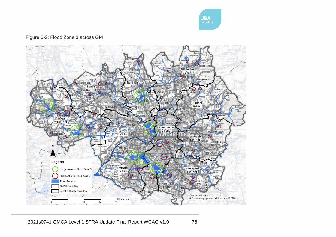
2021s0741 GMCA Level 1 SFRA Update Final Report WCAG v1.0 76
Figure 6-2: Flood Zone 3 across GM

2021s0741 GMCA Level 1 SFRA Update Final Report WCAG v1.0 77
Table 6-2: Areas of considerable fluvial risk in GM
Reference to
Error! Not a
valid result for
table.
District Location Watercourse Land use at risk
1 Manchester Between
Didsbury and
Northenden
River Mersey Mainly
undeveloped land;
M60 and M56
motorways; other
roads; developed
parts of Sharston
2 Manchester;
Trafford
Between
Chorlton-cum-
hardy and Sale
River Mersey Undeveloped land;
minor roads
3 Trafford North Sale and
Ashton upon
Mersey
River Mersey
and
Stromford
Brook
Undeveloped land;
residential areas of
Sale and Ashton
upon Mersey
4 Salford;
Manchester
Lower
Broughton;
Lower Kersal
River Irwell Residential areas;
roads
5 Bury Redvales;
Barlow Fold
River Irwell Residential areas;
roads;
undeveloped land
6 Wigan Plank Lane;
Firs Lane;
Pennington
Hey Brook;
Westleigh
Brook;
Common
Lane Brook
Residential; roads;
undeveloped land
7 Wigan Wallgate;
Newtown
River Douglas Non-residential;
undeveloped land

2021s0741 GMCA Level 1 SFRA Update Final Report WCAG v1.0 78
Table 6-3: Existing residential areas within Flood Zone 3
District Location Watercourse
Manchester Sharston River Mersey; culverted ordinary
watercourse
Northern Moor Baguley Brook
Fallowfield Cringle Brook; Leigh Brook
(culverted)
Brunswick/Hulme Corn Brook (underground)
West Gorton Corn Brook (underground)
Manchester;
Trafford
Brooklands Baguley Brook; Fairywell Brook
Trafford Altrincham Timperley Brook
Salford Lower Broughton River Irwell
Lower Kersal River Irwell
Wigan Worthington River Douglas
Bolton Road culvert Culverted Main River
Hawkley Hawkley Brook (culverted)
Spring View Ince Brook
Hindley Borsdane Brook; Dog Pool Brook;
Hockery Brook (culverted)
Ashton Millingford Brook; Jack Brook
(culverted)
Lowton Crow Wood Avenue (culverted);
ordinary watercourse (culverted)
Lilford Lilford Park Brook/Atherton Lake
Brook
Blackmoor Ellenor Brook
Atherton Carr Brook

2021s0741 GMCA Level 1 SFRA Update Final Report WCAG v1.0 79
District Location Watercourse
Bolton Horwich Pearl Brook (culverted); Pearl Brook
Tributary (culverted)
Lostock Bessy Brook (culverted)
Heaton Culverted Main River
Smithills Dean Brook; Dean Brook (culverted)
Sharples / Astley Bridge Culverted Main River; Astley Brook
Prestolee River Irwell
Rochdale Littleborough River Roch
Wardle Wardle Brook (partially culverted)
Newbold Brow River Roch
Town Centre River Roch
Norden Caldershaw Brook (culverted)
Stockport Hazel Grove Unnamed Main River
North of Hazel Grove Poise Brook
Cheadle Chorlton Brook
Wilmslow Road
(Cheadle)
Micker Brook; ordinary watercourse
Oldham Lower Rushcroft Culverted Main River
Goats Old Brook; River Beal
Tameside Carrbrook Ordinary watercourse (partially
culverted)
Fernbank/Copley Culverted Main River
Bury Ramsbottom River Irwell

2021s0741 GMCA Level 1 SFRA Update Final Report WCAG v1.0 80
6.3.4 Functional Floodplain (Flood Zone 3b)
The functional floodplain forms an important planning tool in making space for
flood waters when flooding occurs. Development should be directed away from
these areas.
Table 1, Paragraph 065 of the FRCC-PPG defines Flood Zone 3b as:
"…land where water has to flow or be stored in times of flood. Local planning
authorities should identify in their Strategic Flood Risk Assessments areas of
functional floodplain and its boundaries accordingly, in agreement with the
Environment Agency."
Paragraph 015 of the FRCC-PPG explains that
"…the identification of functional floodplain should take account of local
circumstances and not be defined solely on rigid probability parameters.
However, land which would naturally flood with an annual probability of 1 in 20
(5%) or greater in any year, or is designed to flood (such as a flood attenuation
scheme) in an extreme (0.1% annual probability) flood, should provide a starting
point to help identify the functional floodplain.
The area identified as functional floodplain should take into account the presence
and effect of all flood risk management infrastructure including defences. Areas
which would naturally flood, but which are prevented from doing so by existing
defences and infrastructure or solid buildings, will not normally be identified as
functional floodplain. If an area is intended to flood, e.g. an upstream flood
storage area designed to protect communities further downstream, then this
should be safeguarded from development and identified as functional floodplain,
even though it might not flood very often."
To map the functional floodplain outline as part of this SFRA, a GIS exercise was
carried out whereby all existing functional floodplain outlines from each LPA were
appended together to form one outline covering GM. This appended outline was
then updated using up-to-date data.
The methodology is described in a technical note (Appendix D) for each LPA
explaining the methodology used in updating the functional floodplain outline.

2021s0741 GMCA Level 1 SFRA Update Final Report WCAG v1.0 81
The methodology remains consistent across all ten LPAs to produce one robust
functional floodplain for all of GM and not separately for each GM LPA.
The outline has been subject to scrutiny and review, before being agreed upon,
by the LPAs, the LLFAs and the EA, based on their local knowledge. Any future
Level 2 SFRAs or site-specific FRAs should further assess the areas of functional
floodplain through detailed investigation and assessment of the actual risk and
extent of the functional floodplain.
The final functional floodplain outline for GM is displayed on the SFRA
Maps in Appendix A and is to be used by GMCA for strategic planning and
the LPAs for development management.
6.3.5 EA Risk of Flooding from Rivers and the Sea Map
This Risk of Flooding from Rivers and Sea map (RoFRS) shows the likelihood of
flooding from rivers and the sea based on the presence and effect of all flood
defences, predicted flood levels and ground levels and is shown on the Appendix
A maps.
The RoFRS map splits the likelihood of flooding into four risk categories:
• High – greater than or equal to 1 in 30 (3.3%) chance in any given year
• Medium – less than 1 in 30 (3.3%) but greater than or equal to 1 in 100
(1%) chance in any given year
• Low – less than 1 in 100 (1%) but greater than or equal to 1 in 1,000
(0.1%) chance in any given year
• Very Low – less than 1 in 1,000 (0.1%) chance in any given year
The RoFRS map is included on the SFRA Maps to act as a supplementary piece
of information to assist the LPA in the decision-making process for site allocation.
This dataset is not suitable for use with any planning application nor should
it be used for the sequential testing of site allocations. The EA's Flood Map
for Planning should be used for all planning purposes, as per the FRCC-
PPG.
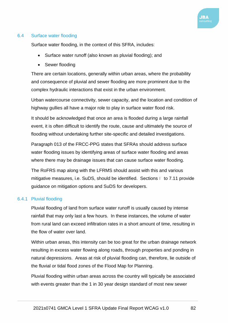
2021s0741 GMCA Level 1 SFRA Update Final Report WCAG v1.0 82
6.4 Surface water flooding
Surface water flooding, in the context of this SFRA, includes:
• Surface water runoff (also known as pluvial flooding); and
• Sewer flooding
There are certain locations, generally within urban areas, where the probability
and consequence of pluvial and sewer flooding are more prominent due to the
complex hydraulic interactions that exist in the urban environment.
Urban watercourse connectivity, sewer capacity, and the location and condition of
highway gullies all have a major role to play in surface water flood risk.
It should be acknowledged that once an area is flooded during a large rainfall
event, it is often difficult to identify the route, cause and ultimately the source of
flooding without undertaking further site-specific and detailed investigations.
Paragraph 013 of the FRCC-PPG states that SFRAs should address surface
water flooding issues by identifying areas of surface water flooding and areas
where there may be drainage issues that can cause surface water flooding.
The RoFRS map along with the LFRMS should assist with this and various
mitigative measures, i.e. SuDS, should be identified. Sections to 7.11 provide
guidance on mitigation options and SuDS for developers.
6.4.1 Pluvial flooding
Pluvial flooding of land from surface water runoff is usually caused by intense
rainfall that may only last a few hours. In these instances, the volume of water
from rural land can exceed infiltration rates in a short amount of time, resulting in
the flow of water over land.
Within urban areas, this intensity can be too great for the urban drainage network
resulting in excess water flowing along roads, through properties and ponding in
natural depressions. Areas at risk of pluvial flooding can, therefore, lie outside of
the fluvial or tidal flood zones of the Flood Map for Planning.
Pluvial flooding within urban areas across the country will typically be associated
with events greater than the 1 in 30 year design standard of most new sewer

2021s0741 GMCA Level 1 SFRA Update Final Report WCAG v1.0 83
systems. Some older sewer and highway drainage networks will have a lower
capacity than what is required to mitigate for the 1 in 30 year event.
There is also a residual risk associated with these networks due to possible
network failures, blockages or collapses.
6.4.1.1 Risk of Flooding from Surface Water
Flooding from surface water is difficult to predict as rainfall location and volume
are difficult to forecast. In addition, local features can greatly affect the chance
and severity of flooding.
The Risk of Flooding from Surface Water (RoFSW), formally referred to as the
updated Flood Map for Surface Water (uFMfSW) is the third-generation national
surface water flood map, produced by the EA. It is aimed at helping to identify
areas where localised, flash flooding can cause problems even if the Main Rivers
are not overflowing.
The RoFSW, used in this SFRA to assess risk from surface water, has proved
extremely useful in supplementing the EA Flood Map for Planning by identifying
areas in Flood Zone 1 that may have critical drainage problems.
The RoFSW includes surface water flood outlines, depths, velocities, and hazards
for the following events:
• 1 in 30 AEP event (high risk)
• 1 in 100 AEP event (medium risk)
• 1 in 1000 AEP event (low risk)
The RoFSW is much more refined than the second-generation map in that:
• More detailed hydrological modelling has been carried out using several
design rainfall events rather than one for the second generation,
• A higher resolution Digital Terrain Model (DTM) has been used – 2 m,
compared to 5 m for the second generation,
• Manual edits of DTM to improve flow routes at over 91,000 locations
compared to 40,000 for the second generation,
• DTM edited to better represent road network as a possible flow pathway,
this was not done for the second generation,
2021s0741 GMCA Level 1 SFRA Update Final Report WCAG v1.0 84
• Manning’s n roughness (used to represent the resistance of a surface to
flood flows in channels and floodplains) values varied using the MasterMap
Topography layer compared to blanket values for urban and rural land use
applied in the second generation surface water flood map.
The RoFSW does not contain sufficient information for it to be used to
determine flood risk to individual properties or potential development sites.
However, it does give an indication of whether an area may be affected by
surface water flooding and to what extent.
The RoFSW is displayed on the SFRA Maps.
6.4.1.2 Surface water flood risk in GM
Figure 6-3 shows a small-scale map of the medium risk 1 in 100 AEP event of the
RoFSW dataset. Visually, the majority of urban GM is at risk from surface water
flooding, according to the RoFSW.
Only the upland areas of the north and east of GM i.e. in Bury, Rochdale,
Oldham, Tameside and Stockport are not covered in 'the blue' of surface water
flood risk. Surface water flood risk is clearly therefore an issue for all of GM,
according to the RoFSW.
The RoFSW is however a national broad scale dataset therefore more
detailed surface water / drainage modelling may be required at the
community or development level.
In order to narrow down and focus on urban areas at particularly significant
surface water flood risk, CDAs were mapped, as part of previous GM SFRAs.
OAFCDMs have also been mapped as part of this GMCA SFRA using UU DAZ
boundary data and historic records of surface water flooding as discussed in
Sections 4.7.3 and 6.4.3.

2021s0741 GMCA Level 1 SFRA Update Final Report WCAG v1.0 85
Figure 6-3: Surface water flood risk across GM (RoFSW 1 in 100 AEP event)
2021s0741 GMCA Level 1 SFRA Update Final Report WCAG v1.0 86
6.4.2 Sewer flooding
Combined sewers spread extensively across urban areas serving residential
homes, business, and highways, conveying waste and surface water to treatment
works.
Combined Sewer Overflows (CSOs) provide an EA consented overflow release
from the drainage system into local watercourses or large surface water systems
during periods of high flows.
Some areas may also be served by separate waste and surface water sewers
that convey wastewater to treatment works and surface water into local
watercourses.
Flooding from the sewer network mainly occurs when flow entering the system,
such as an urban storm water drainage system, exceeds its available discharge
capacity. The system then becomes blocked or it cannot discharge due to a high
water level in the receiving watercourse.
Pinch points and failures within the drainage network may also restrict flows.
Water then begins to back up through the sewers and can surcharge through
manholes, potentially flooding highways, and properties.
It must be noted that sewer flooding in 'dry weather' resulting from blockage,
collapse, or pumping station mechanical failure (for example), is the sole concern
of the drainage undertaker.
UU is the water company responsible for the management of most of the
drainage network across GM.
6.4.3 Areas with Critical Drainage Problems, Critical Drainage Areas and Opportunities
for Further Critical Drainage Management
The EA can designate Areas with Critical Drainage Problems (ACDPs). ACDPs
may be designated where the EA is aware that development within a certain
catchment / drainage area could have detrimental impacts on fluvial flood risk
downstream, and / or where the EA has identified existing fluvial flood risk issues
that could be exacerbated by upstream activities. In these instances, the EA
would work with the LLFA and LPA to ensure that adequate surface water
2021s0741 GMCA Level 1 SFRA Update Final Report WCAG v1.0 87
management measures are incorporated into new development to help mitigate
fluvial flood risk.
EA guidance on carrying out Flood Risk Assessments19 states that a FRA should
be carried out for sites in Flood Zone 1 that are…
"…in an area with critical drainage problems as notified by the Environment
Agency."
This statement refers to sites within an ACDP, not a CDA. At the time of
writing there are no ACDPs in GM.
As discussed in Section 4.7.3, CDAs can be designated by LPAs or LLFAs for
their own purposes. The EA do not have to be consulted on sites that are within
a CDA if such sites are in Flood Zone 1.
Opportunity Areas for Further Critical Drainage Management (OAFCDM) have
been drafted as part of this SFRA using:
• UU DAZ data,
• surface water flood 'Hotspots' generated from the 2013 GM SWMP and
• historical surface water flooding data provided by the LLFAs and UU.
The OAFCDMs are listed in Table 6-4 along with the Wastewater Treatment Works (WwTW) that the area covered by each OAFCDM is drained by.
19 Flood risk assessment in flood zone 1 and critical drainage areas

2021s0741 GMCA Level 1 SFRA Update Final Report WCAG v1.0 88
Figure 6-4 shows a GM scale map of the OAFCDM boundaries. The OAFCDM s
along with the CDAs are also included on the SFRA Maps in Appendix A.
No policy is attached to the OAFCDMs, though the councils should use them
alongside the CDA boundaries to possibly extend CDA policy into the OAFCDMs
if thought to be beneficial.
Table 6-4: Opportunity Areas for Further Critical Drainage Management
OAFCDM name WwTW GM Authority
Altrincham ALTRINCHAM WwTW Trafford
Ashton-Under-Lyne ASHTON-U-LYNE WwTW Tameside
Dukinfield DUKINFIELD WwTW Tameside
Hazel Grove and
Foggbrook
HAZEL GROVE WwTW Stockport
Horwich HORWICH WwTW Bolton
Leigh LEIGH WwTW Wigan
Marple Bridge LOW MARPLE WwTW Stockport
Mossley MOSSLEY WwTW Tameside
Oldham OLDHAM WwTW Oldham
Saddleworth SADDLEWORTH WwTW Oldham
Salford SALFORD WwTW Salford
Stockport STOCKPORT WwTW Stockport
Tyldesley TYLDESLEY WwTW Wigan
Ashton-In-Makerfield WARRINGTON NORTH
WwTW
Wigan
Carrington DAVYHULME WwTW Trafford
Westhoughton WESTHOUGHTON
WwTW
Bolton
Lees OLDHAM WwTW Oldham
Thorp ROYTON WwTW Oldham

2021s0741 GMCA Level 1 SFRA Update Final Report WCAG v1.0 89
OAFCDM name WwTW GM Authority
Prestwich BOLTON WwTW Bury
Oldfield Brow DUNHAM MASSEY
WwTW
Trafford
Hindley WIGAN (HOSCAR) WwTW Wigan
Wigan WIGAN (HOSCAR) WwTW Wigan
Platt Bridge WIGAN (HOSCAR) WwTW Wigan
Radcliffe BOLTON WwTW Bury
Bury BURY WwTW Bury
Hyde HYDE WwTW Tameside
Bolton BOLTON WwTW Bolton
Manchester DAVYHULME WwTW Manchester;
Rochdale
South Manchester DAVYHULME WwTW Stockport;
Manchester;
Trafford
Swinton and Walkden ECCLES WwTW Salford
Rochdale ROCHDALE WwTW Rochdale; Oldham

2021s0741 GMCA Level 1 SFRA Update Final Report WCAG v1.0 90
Figure 6-4: Mapped OAFCDMs

2021s0741 GMCA Level 1 SFRA Update Final Report WCAG v1.0 91
6.4.4 Locally Agreed Surface Water Information
EA guidance on using surface water flood risk information recommends that the
LLFA, should:
"…review, discuss, agree and record, with the Environment Agency, Water
Companies, Internal Drainage Boards and other interested parties, what surface
water flood data best represents their local conditions. This will then be known as
locally agreed surface water information".
Following on from the LLFA consultation on the RoFSW in 2013 before its
release, the EA stated that the Flood Map for Surface Water (2010) and the
Areas Susceptible to Surface Water Flooding (2008) maps do not meet the
requirements of the Flood Risk Regulations and are not compatible with the 2013
RoFSW mapping. Consequently, these datasets cannot be used as 'locally
agreed surface water information'.
Locally agreed surface water information either consist of:
• The RoFSW map, or
• Compatible local mapping if it exists i.e. from a SWMP, or
• A combination of both these datasets for defined locations in the LLFA
area.
Each GMCA LPA should consider the RoFSW to be its locally agreed surface
water flood information as this is the latest, most robust surface water flood map
available for GM.
6.5 Groundwater flooding
Groundwater flooding is caused by the emergence of water from beneath the
ground, either at point or diffuse locations. The occurrence of groundwater
flooding is usually local and unlike flooding from rivers and the sea, does not
generally pose a significant risk to life due to the slow rate at which the water
level rises.
However, groundwater flooding can cause significant damage to property,
especially in urban areas, and can pose further risks to the environment and
ground stability.

2021s0741 GMCA Level 1 SFRA Update Final Report WCAG v1.0 92
There are several mechanisms that increase the risk of groundwater flooding
including:
• prolonged rainfall,
• high in-bank river levels,
• artificial structures,
• groundwater rebound and
• mine water rebound.
Properties with basements or cellars or properties that are located within areas
deemed to be susceptible to groundwater flooding are at particular risk.
Development within areas that are susceptible to groundwater flooding will
generally not be suited to SuDS; however, this is dependent on detailed site
investigation and risk assessment at the FRA stage.
The EA has produced a guidance document which may be used by developers
and homeowners to help reduce the impacts caused to property by groundwater
flooding: Flooding from Groundwater: Practical advice to help you reduce the
impact of flooding from groundwater
Detailed groundwater information has not been made available for this
SFRA. Groundwater information will be very localised and may differ
significantly across GM. EA Source Protection Zones have been assessed,
however.
6.5.1 Source Protection Zones (SPZ)
The EA has defined SPZs for groundwater sources such as wells, boreholes and
springs used for public drinking water supply. These zones show the risk of
contamination from any activities that might cause pollution in the area. The
closer the activity, the greater the risk.
The EA uses the zones in conjunction with the Groundwater Protection Policy to
set up pollution prevention measures in areas which are at a higher risk, and to
monitor the activities of potential polluters nearby.
This includes consideration of new development which can have major impacts
on the groundwater source.

2021s0741 GMCA Level 1 SFRA Update Final Report WCAG v1.0 93
The SPZ maps show three main zones: namely, the inner, outer and total
catchment zones:
Zone 1 - Inner Protection Zone
Zone 1 is closest to the site of the well or borehole and therefore the area of
highest risk to the groundwater source.
This zone is designed to protect against the effects of human activities which
might affect the groundwater source.
Zone 1 is defined by a 50 day travel time from any pollution below the water table
to the groundwater source and has a minimum radius of 50 m around the source.
The 50 day travel time is based on the time it takes some biological contaminants
to decay.
Zone 2 - Outer Protection Zone
Zone 2 is defined by a 400 day travel time from any pollution below the water
table to the groundwater source.
This travel time is the minimum period over which the EA considers that
pollutants need to be diluted, reduced in strength, or delayed by the time they
reach the source.
SPZ 2 is defined as the minimum recharge area required to support 25% of the
protected yield and has a minimum radius of 250-500 m around the groundwater
source, depending on the size of the abstraction.
Zone 3 - Total Catchment Zone / Final Source Catchment Protection Zone
Zone 3 is defined as the area around a groundwater source within which all
groundwater recharge is presumed to be discharged at the abstraction source.
This zone largely depends on the volume abstracted and the effective rainfall. It
covers the whole of the catchment area of a source based on the area needed to
maintain abstraction if all water will eventually reach the abstraction point. For
heavily exploited aquifers, Zone 3 can be defined as the whole aquifer recharge
area.

2021s0741 GMCA Level 1 SFRA Update Final Report WCAG v1.0 94
Figure 6-5 shows the SPZs in GM with Wigan, Salford, Manchester, Stockport,
Rochdale and Oldham the districts containing SPZs.
The EA doesn’t permit the mapping of SPZs on any scale Ordnance Survey map
greater than 1:50,000, as the data was only modelled to this level and is not
considered accurate beyond this scale.
The SPZs have therefore not been included on the SFRA Maps in Appendix A.

2021s0741 GMCA Level 1 SFRA Update Final Report WCAG v1.0 95
Figure 6-5: SPZs in GM

2021s0741 GMCA Level 1 SFRA Update Final Report WCAG v1.0 96
6.6 Canal and reservoir flood risk
6.6.1 Canals
The risk of flooding along a canal is residual and is dependent on a number of
factors. As canals are manmade systems that are heavily controlled, it is unlikely
they will respond in the same way as a natural watercourse during a storm event.
Flooding is more likely to be associated with residual risks, similar to those
associated with river defences, such as overtopping of canal banks, breaching of
embanked reaches or asset (gate) failure as highlighted in Table 6-5.
Canals can also have a significant interaction with other sources, such as
watercourses that feed them and minor watercourses or drains that cross
underneath.
Table 6-5: Canal flooding mechanisms
Potential Mechanism Significant Factors
Leakage causing erosion and rupture
of canal lining leading to breach
Embankments
Sidelong ground
Culverts
Aqueduct approaches
Collapse of structures carrying the
canal above natural ground level
Aqueducts
Large diameter culverts
Structural deterioration or
accidental damage
Overtopping of canal banks Low freeboard
Waste weirs
Blockage or collapse of conduits Culverts
The risks associated with these events are also dependent on their potential
failure location with the consequence of flooding higher where floodwater could
cause the greatest harm due to the presence of local highways and adjacent
property. The focus should be on areas adjacent to raised embankments.

2021s0741 GMCA Level 1 SFRA Update Final Report WCAG v1.0 97
The pound length of the canal also increases the consequence of failure, as flows
will only cease due to the natural exhaustion of supply. Stop plank20 (log)
arrangements, stop gates and the continued inspection and maintenance of such
assets by the Canal & River Trust help to manage the overall risk of a flood event.
A considerable canal network runs through GM that is owned and maintained by
the Canal & River Trust. Such canals include the:
• Leeds Liverpool Canal,
• Manchester, Bolton and Bury Canal,
• Rochdale Canal,
• Ashton Canal,
• Huddersfield Narrow Canal,
• Peak Forest Canal and
• the Macclesfield Canal.
The MSC and the Bridgewater Canal, however, are privately owned by the Peel
Group. Due to the risks associated with the MSC the EA incorporates it into the
Flood Map for Planning.
The canal network is shown below on Figure 6-6 and also on the SFRA Maps
which also include available modelled canal hazard zones for selected canals, as
described below in Section 6.6.1.1.
20 Wooden boards for dropping into grooves at a narrows; to permit drainage for
maintenance work on a canal section or to isolate a leaking section

2021s0741 GMCA Level 1 SFRA Update Final Report WCAG v1.0 98
Figure 6-6: GM canal network
2021s0741 GMCA Level 1 SFRA Update Final Report WCAG v1.0 99
6.6.1.1 Canal flood hazard zones
The previous combined Bury, Rochdale, Oldham Level 1 SFRA (2009); Oldham
Level 2 SFRA (2010); Wigan Level 2 SFRA (2010); and combined Manchester,
Salford and Trafford (MST) Level 2 SFRA (2011) assessed potential flood risk
associated with canals.
These SFRAs assessed risk from the following canals:
• Bridgewater Canal;
• Rochdale Canal;
• Ashton Canal; and
• Huddersfield Narrow Canal.
Bridgewater Canal
The MST SFRA produced canal overtop hazard zones and canal breach hazard
zones for targeted locations along the Bridgewater, Rochdale and Ashton canals.
The risk of flooding from the Bridgewater Canal is higher than that from the
Ashton and Rochdale canals, since it receives natural inflows from the River
Medlock. There is hydraulic connection between the River Medlock and the
Bridgewater Canal.
An estimation of the potential flow along the canal is relevant when estimating the
overtopping risk from the Bridgewater Canal. The greater the potential flow, the
greater is the potential for overtopping and consequent flood risk. For the
Bridgewater Canal some estimation of flood conditions can be made because of
the influence of the River Medlock.
The upstream part of the canal is likely to be the most heavily affected by the
River Medlock; however, after the canal splits at Stretford the impact will be
rapidly reduced as the flood wave dissipates in two directions.
For extreme flood events, water levels in the MSC may also have some impact on
water levels in the Bridgewater Canal.
Overtopping zone
In locations where surrounding ground levels (using LIDAR) are the same as or
lower than canal level water levels, flooding from canal overtopping was

2021s0741 GMCA Level 1 SFRA Update Final Report WCAG v1.0 100
considered to be possible. HEC-RAS software was used to model a possible
overtopping of the Bridgewater Canal. Two spill overflow hydrographs were
measured at the two extreme ends of the canal model in order to represent the
potential overtopping in two sections of the canal:
• the upstream section which is immediately fed by the River Medlock and
• the sections downstream of the split at Stretford.
Only the upstream section of the canal, where the overflow was significant, was
then modelled using two-dimensional hydraulic software to produce a canal
overtopping zone for this section of canal, south west of Salford Quays and
Ordsall. This overtopping hazard zone is shown on the SFRA Maps.
The low flows recorded at the downstream end of the model confirm that the flood
wave from the River Medlock would be expected to dissipate and that, although
overtopping in this section of the canal is possible, the risk is likely to be much
lower.
The reduced hydrograph yields a flood volume that would be small compared to
likely surface water runoff volumes in an actual storm event. Hence, for this
section of the canal, the surface water flood maps (now the RoFSW dataset) are
perhaps the best indicator of the locations of low embankments and where flood
water could overtop the canal bank.
Those considering development in the vicinity of canals should refer to this zone
in the first instance in order to assess whether flood risk from canal overtopping
should be included within a FRA. If the development is within the zone, then the
developer will need to quantify this risk. In some cases, this may simply mean
that some topographic survey of the local area is required, which may indicate
that overtopping at the specific site under consideration is highly unlikely.
Breach zone
Canal breaches can be caused by overtopping of the canal embankments and
erosion of the embankment face. In general, they are more commonly caused by
failure of the canal lining and erosion within the embankment slope until failure
occurs.

2021s0741 GMCA Level 1 SFRA Update Final Report WCAG v1.0 101
Flooding from a breach of a canal embankment is largely dictated by canal and
ground levels, canal embankment construction, breach characteristics and the
volume of water within the canal that can discharge into the lower lying areas
behind any breach.
Possible breach locations were identified using a conservative approach. Areas
in the vicinity of the canal that are more than approximately 0.3 m lower than the
estimated canal water level were assumed to be at potential risk from a canal
breach. Canal water levels and hinterland levels were determined using LIDAR
data.
A breach hydrograph was fed into the two-dimensional JFLOW model to assess
flood inundation extents along the length of the canal. Inflows were included in
the JFLOW model at 100 m intervals along the canal at potential breach
locations. The modelled extents from the individual inflows were combined, with
a small buffer zone, to provide a canal breach hazard zone for the Bridgewater
Canal.
The potential breach locations / areas were then sub-divided into two Canal
Breach Zones (each shown on the SFRA Maps):
• Zone A - those areas that would be affected by a breach of an
embankment. In this zone a detailed examination of canal breach flood
risks is required.
• Zone B - less likely breach locations, such as at wide, low or very low
embankments. At such locations it is more likely that this source of risk
could be scoped out within any site-specific FRA.
Breach Zone A on the Bridgewater Canal covers several developed areas in
Salford, namely; Alder Forest Westwood Park, Winton, Dumplington, Stretford,
Sale, Timperley and Old Trafford.
Rochdale and Ashton canals
Overtopping zone
The Rochdale and Ashton Canal are controlled waterbodies and generally the
overtopping risk was considered to be low. However, historic canal bank

2021s0741 GMCA Level 1 SFRA Update Final Report WCAG v1.0 102
overtopping has been recorded on the Rochdale Canal at Holland Street and it
was considered that this area warranted a more detailed assessment.
British Waterways were able to advise that the overtopping in the area was
caused by lowered freeboards from mining subsidence along the pound
stretching, approximately, from Butler Street to Great Ancoats Street.
The modelled flow hydrograph output was distributed for spill locations at Holland
Street in a two-dimensional JFLOW model where ground levels are lower than
the canal water level. The resultant flood extents were combined with a 5 metre
buffer zone to produce an Overtopping Hazard Zone for the Rochdale Canal at
Holland Street, as shown on the SFRA Maps.
Breach zone
Compared to the Bridgewater Canal, the pound lengths for the Rochdale and
Ashton canals are much shorter and therefore the available flood volume is much
smaller. In breach conditions it was considered likely that only a single pound
length would be likely to drain.
The actual volume of water leaving a canal after a breach has occurred would in
practice be dependent on the local pound length, which varies throughout the
canal network.
As part of the MST SFRA, a breach hydrograph was developed using a one-
dimensional HECRAS model with an average pound length of 1.3 km applied to
the model. Breach hydrographs were fed into a two-dimensional JFLOW model
to assess potential flood inundation extents as per the Bridgewater Canal
method.
The Oldham Level 2 SFRA modelled breach locations on the Rochdale Canal
within the Oldham authority area and produced a Canal Hazard Zone (shown on
the SFRA Maps).
It was found that the locations where canal breaches are most likely to occur are:
• The lower lying areas of Chadderton and Failsworth;
• The aqueduct across the River Irk (breaches have occurred in 1923 and
2003;
• Surrounding farmland.
2021s0741 GMCA Level 1 SFRA Update Final Report WCAG v1.0 103
As with the Bridgewater Canal, Hazard Zones A and B have also been produced
for the Rochdale and Ashton canals. Zone A covers a large part of Ancoats in
Manchester City Centre.
Huddersfield Narrow Canal
A Canal Hazard Zone was also produced for the Huddersfield Narrow Canal in
Oldham (see SFRA Maps). It was found that:
• A breach of raised embankments would result in canal flood water flowing
towards the River Tame and southwards along the Tame Valley;
• Immediately downstream of the Standedge Tunnel, at Diggle Works, the
canal passes approximately 9 metres above Diggle Brook. A breach in
this location would result in large volumes of water entering Diggle Brook;
• A breach in Uppermill could cause flooding to areas between the canal and
the River Tame, Churchill fields, parts of Frenches Wharf and the sewage
works at Greenfield.
6.6.2 Reservoirs
A reservoir can usually be described as an artificial lake where water is stored for
use. Some reservoirs supply water for household and industrial use, others serve
other purposes, for example, as fishing lakes or leisure facilities.
Like canals, the risk of flooding associated with reservoirs is residual and is
associated with failure of reservoir outfalls or breaching. This risk is reduced
through regular maintenance by the operating authority.
Reservoirs in the UK have an extremely good safety record with no incidents
resulting in the loss of life since 1925.
The EA is the enforcement authority for the Reservoirs Act 1975 in England and
Wales. All large reservoirs must be regularly inspected and supervised by
reservoir panel engineers. LAs are responsible for coordinating emergency plans
for reservoir flooding and ensuring communities are well prepared.
GMCA should work with other members of the Greater Manchester Resilience
Forum (GMRF) to develop these plans. See Section 8.1.1 for more information
on the GMRF.
2021s0741 GMCA Level 1 SFRA Update Final Report WCAG v1.0 104
Paragraph 014 of the FRCC-PPG states that, in relation to development planning
and reservoir dam failure,
"the local planning authority will need to evaluate the potential damage to
buildings or loss of life in the event of dam failure, compared to other risks, when
considering development downstream of a reservoir. Local planning authorities
will also need to evaluate in Strategic Flood Risk Assessments (and when
applying the Sequential Test) how an impounding reservoir will modify existing
flood risk in the event of a flood in the catchment it is located within, and/or
whether emergency draw-down of the reservoir will add to the extent of flooding."
There are several reservoirs located across GM and also outside of GM which
may have an effect on risk to communities in GM.
6.6.3 Reservoir Flood Maps
The EA has produced reservoir flood maps (RFM) for all large reservoirs that they
regulated under the Reservoirs Act 1975 (reservoirs that hold over 25,000 cubic
meters of water).
The FWMA updated the Reservoirs Act and targeted a reduction in the capacity
at which reservoirs should be regulated from 25,000m³ to 10,000m³. This
reduction is, at the time of writing, yet to be confirmed meaning the requirements
of the Reservoirs Act 1975 should still be adhered to.
The maps were originally produced for Local Resilience Forums to use for
emergency planning, however The Pitt Review, 2007, recommended that the
maps be made available to the public online as part of wider flood risk
information.
The maps show the largest area that might be flooded if a reservoir were to fail
and release the water it holds, including information about the depth and speed of
the floodwaters.
In September 2016, the EA produced a RFM guide ' Explanatory Note on
Reservoir Flood Maps for Local Resilience Forums – Version 521' that provides
information on how the maps were produced and what they contain.
21 Reservoir Flood Map Guide

2021s0741 GMCA Level 1 SFRA Update Final Report WCAG v1.0 105
The RFM outlines are included on the SFRA Maps (Appendix A), however they
can also be viewed online at: Reservoir Flood Map
The RFM shows that a there are several large reservoirs / impounded
waterbodies within GM that may affect populated areas, in the unlikely event of a
breach. Manchester, including the City Centre, and the town centres of Wigan,
Bury and Bolton could be significantly flooded were a dam breach to occur at
certain upstream reservoirs in GM.
6.7 Historic flooding
As stated in Table 4-1, under the FWMA, LLFAs are required to investigate and
record details of what are considered to be locally significant flood events within
their areas.
Records should be stored as part of a digital database or spatial GIS dataset
which can be mapped. The records should contain details such as:
• date and time;
• flood source;
• location;
• people, property or infrastructure affected;
• RMA response; and
• works carried out afterwards.
However, the provision of spatial datasets of historic flood events will depend on
specific LLFA resources and priorities.
Each GM LLFA was requested to provide a copy of its historic flood incidents database for use in the evidence base for this SFRA.
2021s0741 GMCA Level 1 SFRA Update Final Report WCAG v1.0 106
Figure 6-7 shows the historic records provided.
Given that many of these incidents are at the property level and therefore
considered as sensitive information, they have not been included on the detailed
large scale SFRA Maps.

2021s0741 GMCA Level 1 SFRA Update Final Report WCAG v1.0 107
Figure 6-7: GM LLFA historic flood incidents

2021s0741 GMCA Level 1 SFRA Update Final Report WCAG v1.0 108
The scale and content of each LLFA's historic records is variable, as can be seen from Figure 6-7.
The absence of incidents in Manchester and Trafford and the low numbers in
Oldham and Rochdale does not mean that flood incidents have not occurred, it
just means that past incidents have not been recorded or are not available
spatially and cannot therefore be mapped. It is also unknown as to how far back
the records go relative to each council.
Each LLFA should ensure that its flood incident register is up to date and
attempt to make the register available spatially.
Each LLFA's LFRMS also summarise historical flood events that have occurred
across their areas.
6.7.1 Historic surface water flooding
UU provided information on historic incidents of flooding from the sewer network,
due to hydraulic failure. Due to the sensitivity of the data being out in the public
domain, UU were unable to provide the data at the exact locations of the
incidents.
Incidents have therefore been aggregated into 100 m2 grid squares and are
shown at the GM level on Figure 6-8. The incident squares are also shown on
the SFRA Maps. The dates of the incidents are unknown however by far the
most incidents have occurred in the east of Foggbrook in Stockport.
For those areas outside of the incident squares, this does not indicate that
flooding has never occurred, only that there are no records of a flood having
occurred.
Figure 6-8 also shows the Hotspots generated from the GM SWMP in 2013 (see
Section 4.7.2.1), of which there are 580 identified, based on the spatial
relationship between modelled flood hazard outputs and local critical and
vulnerable receptors.
Manchester District has by far the most Hotspots of 105 whilst Bury has the
lowest at 37. This is to be expected given the highly urbanised land use of
Manchester compared to the more rural and undeveloped areas that exist in
Bury, particularly in the uplands. Salford and Oldham have 63 and 60

2021s0741 GMCA Level 1 SFRA Update Final Report WCAG v1.0 109
respectively followed by Stockport, Tameside, Rochdale and Wigan with between
53 and 58 Hotspots identified. Bolton has 49 and Trafford 43.
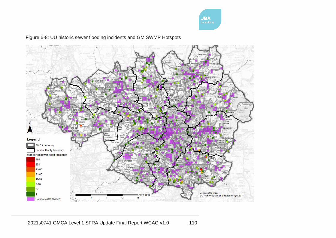
2021s0741 GMCA Level 1 SFRA Update Final Report WCAG v1.0 110
Figure 6-8: UU historic sewer flooding incidents and GM SWMP Hotspots

2021s0741 GMCA Level 1 SFRA Update Final Report WCAG v1.0 111
6.7.2 EA Historic Flood Map / Recorded Flood Outlines
The Historic Flood Map (HFM) is a spatial dataset showing the maximum extent
of all recorded historic flood outlines from river, sea, and groundwater, and shows
areas of land that have previously been flooded across England. Records began
in 1946 when predecessor bodies to the EA started collecting information about
flooding incidents.
The HFM accounts for the presence of defences, structures, and other
infrastructure where such existed at the time of flooding. It includes flood extents
that may have been affected by overtopping, breaches, or blockages.
It is also possible that historic flood extents may have changed and that some
areas would not flood at present i.e. if a flood defence has been built.
The HFM does not contain any information regarding flood source, return period
or date of flooding, nor does the absence of the HFM in an area mean that the
area has never flooded, only that records of historic flooding do not exist. The
Recorded Flood Outlines (RFO) dataset however does include details of the flood
events.
The difference between the two datasets is that the HFM only contains flood
outlines that are 'considered and accepted' by the EA following adequate
verification using certain criteria. For those areas not within a HFM or RFO
outline, this does not mean these areas have never flooded, only that the EA
does not have records of flooding in this area.
There are 74 historic flood outlines included within the HFM in GM. The most
notable areas of HFM include a large area of Salford, covering Lower Broughton
and Lower Kersal, where flooding has occurred from the River Irwell. Also, there
are several HFM outlines within Wigan Town Centre at Newtown and Wallgate.
Only Oldham, Tameside and Trafford authority areas do not have any areas of
HFM within them.
There are 478 outlines within the RFO dataset with 404 of these not included with
the HFM and therefore not considered and accepted by the EA. The most
notable RFO areas, not within the HFM, include a large area in Manchester,

2021s0741 GMCA Level 1 SFRA Update Final Report WCAG v1.0 112
south of Didsbury and north of the M60 motorway. Much of this land is
undeveloped natural floodplain of the River Mersey.
Also, in Bury around the areas of Redvales and Barlow Fold and also
Ramsbottom, there are outlines relating to flooding from the River Irwell.
Littleborough in Rochdale also has a large RFO area due to flooding from the
River Roch and also surface water in December 2015.
In terms of flood source, there are 197 records of flooding from Main River, 15
from drainage failure, 13 from ordinary watercourse, 4 from sewers, 12 from other
sources and 237 unknowns.
The HFM and RFO datasets are shown in detail on the large scale SFRA maps in Appendix A and are also shown in Figure 6-9 at the GM scale.

2021s0741 GMCA Level 1 SFRA Update Final Report WCAG v1.0 113
Figure 6-9: HFM and RFO outlines

2021s0741 GMCA Level 1 SFRA Update Final Report WCAG v1.0 114
On Boxing Day, 2015 Storm Eva led to one of the most widespread flooding
events that affected communities in nine of the ten GM LAs (all but Trafford). The
Greater Manchester Flood Investigation Report (FIR), as required by Section 19
of the FWMA, identifies the causes and impacts of the flooding and sets out
recommendations of the future.
37 of 44 gauges in the River Irwell, Roch and Croal catchments recorded their
highest ever levels. Heavy rainfall commenced on Christmas Day lasting 36
hours and falling on already saturated ground due to high rainfall in the preceding
month.
Approximately 2,350 properties flooded internally with 80% of the flooding from
main rivers. Around 2,450 properties were protected from flooding by raised
defences along main rivers, culvert clearance and pumping station operation.
Surface water and ordinary watercourse flood alleviation also protected
properties. Significant impacts resulted with the flooding of key infrastructure
causing widespread travel disruption and over 31,200 properties initially left
without power. The most seriously affected areas were Salford, Radcliffe /
Redvales, Littleborough and Rochdale Town Centre.
Flood defence improvements have since been completed or are being
progressed in these areas.

2021s0741 GMCA Level 1 SFRA Update Final Report WCAG v1.0 115
Figure 6-10: Geographical scale and extent of flooding across GM (from GM FIR)
2021s0741 GMCA Level 1 SFRA Update Final Report WCAG v1.0 116
The GM FIR provides detailed recommendations regarding flood warning,
emergency responses, flood alleviation interventions and ways of working and
identifies the responsible RMAs for each recommendation.
Continued cooperation and collaboration between GMCA, the ten LLFAs, the EA,
UU and the MSC company are identified as crucial to minimise the chance of
such an event recurring and manage the impacts if it should.
6.8 Flood Risk Management
The aim of this section of the SFRA is to summarise FRM assets and previous /
proposed FRM schemes within GM. The location, condition and design standard
of existing assets will have a significant impact on actual flood risk mechanisms.
Whilst future schemes in high flood risk areas carry the possibility of reducing the
probability of flood events and reducing the overall level of risk. Both existing
assets and future schemes will have a further impact on the type, form and
location of new development or regeneration.
6.8.1 EA assets (Spatial Flood Defences)
The EA maintains a spatial dataset called the Spatial Flood Defences dataset.
This national dataset contains such information as:
• Asset type (flood wall, embankment, high ground, demountable defence,
beach, dunes);
• Flood source (fluvial, tidal, fluvial and tidal);
• Design standard (SoP);
• Asset length;
• Asset age;
• Asset location; and
• Asset condition. See Table 6-6 for condition assessment grades using the
EA's Condition Assessment Manual22 (CAM).
22 Environment Agency. (2012). Visual Inspection Condition Grades. In: EA Condition
Assessment Manual. Bristol: Environment Agency. p9.
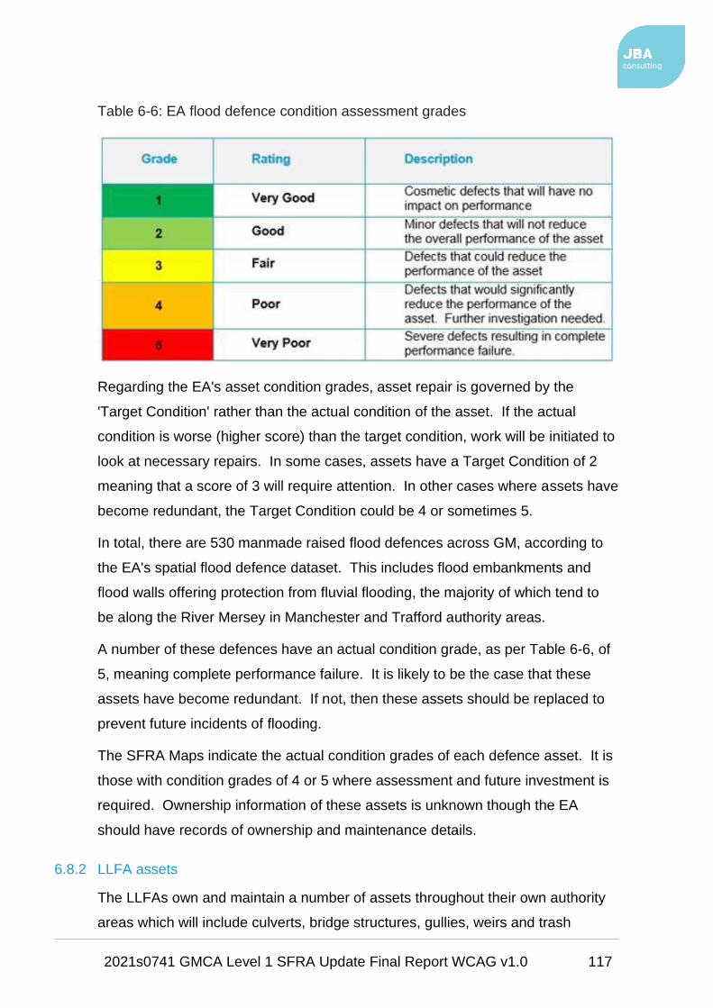
2021s0741 GMCA Level 1 SFRA Update Final Report WCAG v1.0 117
Table 6-6: EA flood defence condition assessment grades
Regarding the EA's asset condition grades, asset repair is governed by the
'Target Condition' rather than the actual condition of the asset. If the actual
condition is worse (higher score) than the target condition, work will be initiated to
look at necessary repairs. In some cases, assets have a Target Condition of 2
meaning that a score of 3 will require attention. In other cases where assets have
become redundant, the Target Condition could be 4 or sometimes 5.
In total, there are 530 manmade raised flood defences across GM, according to
the EA's spatial flood defence dataset. This includes flood embankments and
flood walls offering protection from fluvial flooding, the majority of which tend to
be along the River Mersey in Manchester and Trafford authority areas.
A number of these defences have an actual condition grade, as per Table 6-6, of
5, meaning complete performance failure. It is likely to be the case that these
assets have become redundant. If not, then these assets should be replaced to
prevent future incidents of flooding.
The SFRA Maps indicate the actual condition grades of each defence asset. It is
those with condition grades of 4 or 5 where assessment and future investment is
required. Ownership information of these assets is unknown though the EA
should have records of ownership and maintenance details.
6.8.2 LLFA assets
The LLFAs own and maintain a number of assets throughout their own authority
areas which will include culverts, bridge structures, gullies, weirs and trash

2021s0741 GMCA Level 1 SFRA Update Final Report WCAG v1.0 118
screens. Most of these assets will lie along ordinary watercourses within smaller
urban areas where watercourses may have been culverted or diverted, or within
rural areas. All these assets can have flood risk management functions as well
as an effect on flood risk if they become blocked or fail. In most cases
responsibility lies with the riparian / landowner.
As part of its FWMA duties, the LLFA has a duty to maintain a register of
structures or features, which are considered to have a significant effect on flood
risk, including details on ownership and condition as a minimum.
The Asset Register should include those features relevant to flood risk
management function including:
• feature type,
• description of principal materials,
• location,
• measurements (height, length, width, diameter) and
• condition grade.
The Act places no duty on the LLFA to maintain any third-party features, only
those for which the authority has responsibility as land/asset owner.
Each LLFA was requested to provide a spatial dataset of its flood risk
management assets that are in the most critical condition and therefore in need of
remedial works or replacement to maintain FRM performance.
Bolton Council provided a list of 11 assets that are in critical condition, mainly
relating to culverts and trash screens.
Wigan Council provided a list of its top 20 culverts that are in critical condition.
The locations of these assets are shown on the SFRA Maps.
The other eight authorities did not provide a spatial dataset of critical assets.
That is not to say these authorities do not have a list of critical assets, it may just
be the case that they have not yet been mapped.
Each LLFA should carry out a strategic assessment of structures and
features on its FRM Asset Registers to inform the capital programme and

2021s0741 GMCA Level 1 SFRA Update Final Report WCAG v1.0 119
prioritise maintenance works. Critical assets (i.e. culverts in poor
condition) should be prioritised for designated works and funding for future
FRM should be directed towards these assets.
6.8.3 Water company assets
The sewerage infrastructure of the urban areas of GM is likely to be based on
Victorian sewers from which there is a risk of localised flooding associated with
the existing drainage capacity and sewer system.
The drainage system may be under capacity and / or subject to blockages
resulting in localised flooding of roads and / or property. UU is responsible for the
management of the adopted sewerage system. This includes surface water and
foul sewerage.
There may however be some privately owned surface water sewers as only those
connected to the public sewer network that were transferred to the water
companies under the Private Sewer Transfer in 2011 are likely to have been
constructed since this transfer date. Surface water sewers discharging to
watercourses were not part of this transfer and would therefore not be under the
ownership of UU, unless adopted under a Section 104 adoption agreement.
Water company assets include:
• Wastewater Treatment Works,
• Combined Sewer Overflows,
• pumping stations,
• detention tanks,
• sewer networks and
• manholes.
6.8.4 Green Infrastructure assessment
Open space, or Green Infrastructure (GI), should be designed and managed as a
multifunctional resource. It should be capable of delivering a wide range of
environmental and quality of life benefits for local communities. It should be

2021s0741 GMCA Level 1 SFRA Update Final Report WCAG v1.0 120
provided as an integral part of all new development, alongside other infrastructure
such as utilities and transport networks.
Open space can provide many social, economic and environmental benefits close
to where people live and work including:
• Places for outdoor relaxation and play;
• Space and habitat for wildlife with access to nature for people;
• Environmental education;
• Local food production - in allotments, gardens and through agriculture;
• Improved health and well-being – lowering stress levels and providing
opportunities for exercise;
• Climate change adaptation - for example flood alleviation and cooling
urban heat islands.
The NPPF explains that open space can perform many functions, including flood
risk mitigation, and that Local Plans should account for increased flood risk,
resulting from climate change, through the planning of Green Infrastructure.
GI can have an important role to play in reducing the likelihood of flooding by
providing space for flood storage, reducing runoff, and increasing infiltration,
whilst also providing other benefits as stated above.
Alongside GI should be the implementation of SuDS, specifically within potential
development sites, where possible. The suitability of GI and SuDS can be
informed by this SFRA through utilisation of open space for water in the areas of
greatest flood risk, which would be key to helping deliver sustainable
development. Examples include:
• Restoration of the natural character of floodplains;
• Keeping and preserving of areas of existing natural floodplain;
• Introduction of new areas and enhancing existing areas of greenspace
whilst incorporating sustainable drainage within new development; and
• Reduction of downstream flood risk.
Natural England recommend the use of the online tool Local Action ToolKit:
Local Action Toolkit

2021s0741 GMCA Level 1 SFRA Update Final Report WCAG v1.0 121
This tool can be applied to urbanised environments to identify how SuDS as well
as GI can be most effectively applied in a constrained urban setting, whilst
considering the benefits of biodiversity and natural capital.
Natural England advise that the GM councils utilise this tool when making specific
decisions within their Local Plan areas.
The Town and Country Planning Association together with The Wildlife Trusts
produced a guidance document for Green Infrastructure23. The guidance states
that local plans should identify funding sources for GI and provision should be
made for GI to be adequately funded as part of a development's core
infrastructure.
For new developments, GI assets can be secured from a landowner's 'land value
uplift' and as part of development agreements. LPAs may include capital for the
purchase, design, planning and maintenance of GI within the Community
Infrastructure Levy (CIL) programme.
6.8.5 Natural Flood Management / Working with Natural Processes
Natural Flood Management (NFM) or Working with Natural Processes (WwNP) is
a type of flood risk management used to protect, restore, and re-naturalise the
function of catchments and rivers to reduce flood and coastal erosion risk.
WwNP has the potential to provide environmentally sensitive approaches to
minimising flood risk, to reduce flood risk in areas where hard flood defences are
not feasible and to increase the lifespan of existing flood defences.
NFM and WwNP are used interchangeably in the UK though the term WwNP is
mainly used throughout this report.
A wide range of techniques can be used that aim to reduce flooding by working
with natural features and processes in order to store or slow down floodwaters
before they can damage flood risk receptors (e.g. people, property, infrastructure,
etc.).
23 Planning for a Healthy Environment - Good Practice Guidance for Green
Infrastructure and Biodiversity, Published by the Town and Country Planning Association
and The Wildlife Trusts, July 2012

2021s0741 GMCA Level 1 SFRA Update Final Report WCAG v1.0 122
WwNP involves taking action to manage flood and coastal erosion risk by
protecting, restoring, and emulating the natural regulating functions of
catchments, rivers, floodplains and coasts.
Techniques and measures, that may be applicable to GM, include:
• Peatland and moorland restoration in upland catchments
• Re-meandering streams
• Targeted woodland planting
• Reconnection and restoration of functional floodplains
• Restoration of rivers and removal of redundant structures
• Installation or retainment of large woody material in river channels
• Improvements in management of soil and land use
• Implementation of rural and urban SuDS
Both the European Commission and UK Government are actively encouraging
the implementation of WwNP measures within catchments and coastal areas.
The idea is to assist in the delivery of the requirements of various EC Directives
relating to broader environmental protection and national policies.
It is fully expected that the sustained interest in WwNP implementation across the
UK will continue in the post-Brexit era as a fundamental component of the flood
risk management tool kit.
GMCA actively promotes NFM and is proposing measures within the uplands of
GM to manage fluvial water across the main river catchments, such as the Irwell
(see Section 4.4.1). The EA is also exploring the use of upland reservoirs to
store floodwater.
6.8.5.1 Evidence base for WwNP to reduce flood risk
The EA recently produced the WwNP evidence base that includes three
interlinked projects:
• Evidence directory
• Mapping the potential for WwNP
• Research gaps
2021s0741 GMCA Level 1 SFRA Update Final Report WCAG v1.0 123
The evidence base can be accessed via: Working with natural processes to
reduce flood risk
The evidence base can be used by those planning projects that include WwNP
measures to help understand:
• Their potential FCRM benefits and multiple benefits
• Any gaps in knowledge
• Where it has been done before and any lessons learnt
• Where in a catchment they might be most effective.
The evidence directory presents the evidence base, setting out the underpinning
scientific evidence. Its purpose is to help FRM practitioners and other
responsible bodies access information that explains what is known and what is
not known about the effectiveness of the measures from a flood risk perspective.
There is also a guidance document that sits alongside the evidence directory and
maps that can help make the case for implementing WwNP when developing
business cases.
6.8.5.2 Mapping the potential for WwNP
JBA Consulting has been working with the EA and Lancaster Environment Centre
(LEC) to update national maps of the Potential for Working with Natural
Processes. LEC has developed a new spatial model of slowly permeable soils.
This is used to identify areas where shrub or tree-planting could increase
hydrological losses and slow the flow based on British Geological Survey (BGS)
1:50k maps. BGS has agreed to an open Government license for use of the
maps.
The new national maps for England make use of different mapping datasets and
highlight potential areas for tree-planting (for three different types of planting),
runoff attenuation storage, gully blocking, and floodplain reconnection.
The maps are high level and can be used to signpost areas of potential.
They do not take into account issues such as landownership and drainage
infrastructure. They may however help start the conversation and give
indicative estimates of, for example, additional distributed storage in
upstream catchments.

2021s0741 GMCA Level 1 SFRA Update Final Report WCAG v1.0 124
Interactive mapping showing the potential for WwNP is available for all river basin
districts, including the North West, via: Potential for Working with Natural
Processes interactive map
These maps are intended to be used alongside the evidence directory to help
practitioners think about the types of measure that may work in a catchment and
the best places in which to locate them.
There are limitations with the maps, however it is a useful tool to help start
dialogue with key partners. The maps are provided as spatial data for use in all
GIS platforms and interactive GeoPDF format, supported by a user guide and a
detailed technical guide.
Table 6-7 is extracted from the technical report for mapping the potential for
Working with Natural Processes, January 2018, and includes the technical detail
on which the WnWP data is based.

2021s0741 GMCA Level 1 SFRA Update Final Report WCAG v1.0 125
Table 6-7: WwNP measures and data24
24 Working with Natural Processes mapping technical report

2021s0741 GMCA Level 1 SFRA Update Final Report WCAG v1.0 126
This SFRA has screened this data against the potential development sites data,
as mentioned in Section 1.3.1. The datasets included in the sites screening
include the following:
• Floodplain Reconnection:
o Floodplain Reconnection Potential - areas of low or very low
probability based on the Risk of Flooding from Rivers and Sea
dataset (Section 6.3.5), which are in close proximity to a
watercourse and that do not contain properties, are possible
locations for floodplain reconnection. It may be that higher risk
areas can be merged, depending on the local circumstances.
• Runoff Attenuation Features (Runoff attenuation features are based on the
premise that areas of high flow accumulation in the RoFSW) maps are
areas where the runoff hydrograph may be influenced by temporary
storage if designed correctly):
o Runoff Attenuation Features 1% AEP
o Runoff Attenuation Features 3.3% AEP
• Tree Planting:
o Floodplain Woodland Potential and Riparian Woodland Potential -
woodland provides enhanced floodplain roughness that can
dissipate the energy and momentum of a flood wave if planted to
obstruct significant flow pathways.
Riparian and floodplain tree planting are likely to be most effective if
close to the watercourse in the floodplain, which is taken to be the
0.1% AEP flood extent (Flood Zone 2), and within a buffer of 50
metres of smaller watercourses where there is no flood mapping
available.
There is a constraints dataset that includes existing woodland.
o Wider Catchment Woodland Potential - slowly permeable soils have
a higher probability of generating ‘infiltration-excess overland flow’
and ‘saturation overland flow’. These are best characterised by
gleyed soils, so tree planting can open up the soil and lead to higher
infiltration and reduction of overland flow production.

2021s0741 GMCA Level 1 SFRA Update Final Report WCAG v1.0 127
These datasets are included in the SFRA Maps in Appendix A and are also
screened against the potential development sites to highlight any sites were the
potential for WwNP should be investigated further as a means of flood mitigation
(see Section 7.3.4 and in particular Appendix B).
6.8.5.3 Irwell Strategic NFM Targeting Mapping (2017)
Continuing the Rivers Trust work, discussed in Section 4.4.1, this project maps
the changes that NFM (or WwNP) measures are predicted to have on surface
water runoff, in terms of peak surface runoff reduction and timing of the peak
runoff.
The Targeting Maps and accompanying User Guide are based on strategic
modelling and should only form part of the picture for helping to show where and
how we can work better with natural processes to slow and store flows.
It must be remembered that modelling the effects of NFM comes with inherent
uncertainties, partly due to gaps in the evidence base.
One of the aims of the project was to identify WwNP intervention opportunities
and assess the benefits in terms of flood risk regulation considering the whole
Irwell catchment.
Strategic surface water flood risk modelling across the Irwell has been completed
using the design rainfall events of 1 in 30 AEP and 1 in 100 AEP events. The
difference in the runoff generation with and without WwNP has been compared
around the catchment.
The scenarios modelled included:
• Runoff Attenuation Features (RAFs) - extra storage opportunities in areas
predicted to collect surface runoff during flood events were modelled.
Such opportunities include natural depressions and small channels
between 100-5,000 m2 which can be created through river improvement or
bunds. These features tend to reduce peak runoff if they are designed
carefully to fill at high flows and drain away between events;
• Tree-planting and roughening-up the landscape - woodland and scrubland
creation in areas identified in the Woodlands for Water (WfW) opportunity
mapping was modelled as additional enhanced surface roughness. This

2021s0741 GMCA Level 1 SFRA Update Final Report WCAG v1.0 128
has less impact on the volume of the runoff peak but can significantly delay
the timing of the peak runoff in headwater catchments. Further
downstream in the catchment, roughening up the landscape can both
delay and reduce runoff peak as it desynchronises flows from headwater
catchments; and
• Enhanced urban and rural losses - improved soil structure, resulting in
enhanced soil moisture storage capacity, has been simulated for rural
landcover designated as 'improved grassland' in the Land Cover Map
2007. In addition, for urban areas, it is assumed that green spaces are
increased, and the overall landscape made more permeable. UU figures
for impervious surfaces were used as a baseline and the percentage runoff
was reduced from around 70% to 65%. This intervention reduces peak
runoff but has less impact on the timing of peak flow. In urban areas the
reduction in runoff of 5% for SuDS is a conservative estimate.
The maps should be used to identify where SuDS could make a significant
contribution. Intensive delivery of SuDS could reduce runoff further.
The modelled interventions are shown on the SFRA Maps in Appendix A. They
are also screened against the potential development sites to highlight any sites
were the potential for WwNP should be investigated further as a means of flood
mitigation (see Section 7.3.4).
6.8.5.4 Limitations
Users of the WwNP datasets should bear in mind that these datasets are
high level and exist on a national scale. They can only provide an
indication of whether an area may have potential for WwNP.
The effectiveness of WwNP measures is site-specific and depends on many
factors, including the location and scale at which they are used.
It may not always be possible to guarantee that these measures alone will deliver
a specified standard of defence.
Consequently, FRM measures should be selected from a series of options
ranging from traditional forms of engineering through to more natural systems.

2021s0741 GMCA Level 1 SFRA Update Final Report WCAG v1.0 129
The research gaps that need to be addressed to move WwNP into the
mainstream are identified in the evidence directory.
6.8.6 EA Flood Risk Management Activities and Flood and Coastal Erosion Risk
Management Research and Development
As well as the ownership and maintenance of a network of formal defence
structures, the EA carries out other FRM activities that help to reduce the
probability of flooding, whilst also addressing the consequences of flooding.
These include:
• Maintaining and improving existing flood defences, structures and Main
River channels.
• Enforcement and maintenance where riparian owners unknowingly carry
out work that may be detrimental to flood risk.
• Identifying and promoting new flood alleviation schemes (FAS) where
appropriate.
• Working with LPAs to influence the location, layout and design of new and
redeveloped property and ensuring that only appropriate development is
permitted relative to the scale of flood risk, i.e. through this SFRA.
• Operation of Floodline Warnings Direct and flood warning services for
areas within designated Flood Warning Areas (FWA) or Flood Alert Areas
(FAA). EA FWAs and FAAs are shown on the SFRA Maps in Appendix A
and more information is provided in Section 8.2.
• Promoting awareness of flooding so that organisations, communities, and
individuals are aware of the risk and are therefore sufficiently prepared in
the event of flooding.
• Promoting resilience and resistance measures for existing properties that
are currently at flood risk or may be at risk in the future because of climate
change.
The Flood and Coastal Erosion Risk Management (FCERM) Research and
Development programme is run by the EA and Defra. It aims to serve the needs
of all flood and coastal operating authorities in England.

2021s0741 GMCA Level 1 SFRA Update Final Report WCAG v1.0 130
The programme provides the key evidence, information, tools, and techniques to:
• Inform the development of FCDRM policy and strategy.
• Understand and assess coastal and flood risks and the processes by
which these risks arise.
• Manage flood and coastal erosion assets in a sustainable way.
• Prepare for and manage flood events effectively.
Based on information publicly available from the EA, there are several completed,
ongoing and proposed flood risk management work programmes applicable to
GM.
Follow the link below for the latest news:
Environment Agency Flood and Coastal Erosion Risk Management works
There are 130 FRM projects planned for GM through the EA's Investment
Programme from the period 2017/18 to 2025/26.
The locations of these projects can be seen on the SFRA Maps and further
details on the projects is provided in the proposed SFRMF.

2021s0741 GMCA Level 1 SFRA Update Final Report WCAG v1.0 131
6.9 Taking climate change into account
Climate change will increase flood risk over the lifetime of a development and
therefore must be accounted for when planning development. The NPPF sets out
how the planning system should help minimise vulnerability and provide resilience
to the impacts of climate change.
GMCA and the GM local authorities should refer to this when preparing the
GMSF and local plans respectively, when considering planning applications.
6.9.1 Planning for climate change (NPPF, 2019)
In relation to flood risk and climate change in the planning system, the 2019
NPPF states:
"All plans should apply a sequential, risk-based approach to the location of
development – taking into account the current and future impacts of climate
change – so as to avoid, where possible, flood risk to people and property." (para
157).
Local plans should do this by safeguarding land from development that is
required, or likely to be required, for current or future flood management; and to
seek opportunities for the relocation of development, including housing, to more
sustainable locations from areas where climate change is expected to increase
flood risk.
Also, it is stated that
"the sequential approach should be used in areas known to be at risk now or in
the future from any form of flooding" (para 158).
See Sections 7.2.2 and 7.3.3 for information on the screening of potential
development sites against modelled climate change data, the results of which
have been included in the sites assessment spreadsheets in Appendix B.
GMCA and the individual councils should use this information in the sequential
testing of their sites.
6.9.2 EA climate change allowances
The EA revised the climate change allowances in February 2016 and further
updated them in February 2017, for use in FRAs and SFRAs, and will use these

2021s0741 GMCA Level 1 SFRA Update Final Report WCAG v1.0 132
revised allowances when providing advice: Environment Agency climate change
allowances
The revised climate change allowances are predictions of anticipated change for:
• Peak river flow by RBD;
• Peak rainfall intensity;
• Sea level rise; and
• Offshore wind speed and extreme wave height.
Deciding on which of the peak river flow allowances to use is based on the flood
zone the development is within and the associated vulnerability classification (see
Table 2 of the FRCC-PPG).
Climate change allowances for river flows are based on which River Basin District
the river is located within. As discussed, GM is within the North West RBD.
Table 6-8: Recommended peak river flow allowances for the North West RBD
RBD Allowance
Category
Total Potential Change Anticipated for…
2020s (2015-
2039)
2050s (2040-
2069)
2080s (2070-
2115)
North
West
Upper end +20% +35% +70%
Higher central +20% +30% +35%
Central +15% +25% +30%
The peak rainfall intensity allowance applies to the whole of England. SFRAs and
FRAs should assess both the central and upper end allowances to gauge the
range of impacts.

2021s0741 GMCA Level 1 SFRA Update Final Report WCAG v1.0 133
Table 6-9: Peak rainfall intensity allowance in small and urban catchments for
England
Allowance
Category
Total Potential Change Anticipated for…
2015-2039 2040-2069 2070-2115
Upper end +10% +20% +40%
Central +5% +10% +20%
The EA will also require consideration, if appropriate, of the 'high++ allowances'
for peak river flows and mean sea level rise. This would usually be where a
development is considered to be very sensitive to flood risk and with lifetimes
beyond the end of the century. This could include infrastructure projects or
developments that significantly change existing settlement patterns.
The high++ allowances can be found in the EA's Adapting to Climate Change:
Advice for Flood and Coastal Erosion Risk Management Authorities25, which uses
science from UKCP09. This guidance is based on Government’s policy for
climate change adaptation and is specifically intended for projects or strategies
seeking Government Flood Defence Grant in Aid (FDGiA) funding.
However, RMAs in England may also find it useful in developing plans and
making Flood and Coastal Erosion Risk Management (FCERM) investment
decisions even if there is no intention of applying for central Government funding.
This is important for any future large-scale infrastructure used to support the
delivery of strategic sites such as flood defence schemes.
Although, it is anticipated that increases in river flows will lie somewhere within
the range of the central to upper end estimates of the allowances, more extreme
change cannot be discounted. The high++ allowances can be used to represent
more severe climate change impacts and help to identify the options that would
be required.
25 Environment Agency Adapting to Climate Change: Advice for Flood and Coastal
Erosion Risk Management Authorities
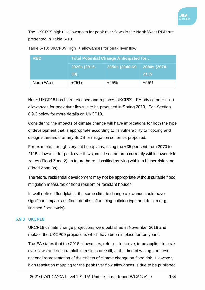
2021s0741 GMCA Level 1 SFRA Update Final Report WCAG v1.0 134
The UKCP09 high++ allowances for peak river flows in the North West RBD are
presented in Table 6-10.
Table 6-10: UKCP09 High++ allowances for peak river flow
RBD Total Potential Change Anticipated for…
2020s (2015-
39)
2050s (2040-69 2080s (2070-
2115
North West +25% +45% +95%
Note: UKCP18 has been released and replaces UKCP09. EA advice on High++
allowances for peak river flows is to be produced in Spring 2019. See Section
6.9.3 below for more details on UKCP18.
Considering the impacts of climate change will have implications for both the type
of development that is appropriate according to its vulnerability to flooding and
design standards for any SuDS or mitigation schemes proposed.
For example, through very flat floodplains, using the +35 per cent from 2070 to
2115 allowance for peak river flows, could see an area currently within lower risk
zones (Flood Zone 2), in future be re-classified as lying within a higher risk zone
(Flood Zone 3a).
Therefore, residential development may not be appropriate without suitable flood
mitigation measures or flood resilient or resistant houses.
In well-defined floodplains, the same climate change allowance could have
significant impacts on flood depths influencing building type and design (e.g.
finished floor levels).
6.9.3 UKCP18
UKCP18 climate change projections were published in November 2018 and
replace the UKCP09 projections which have been in place for ten years.
The EA states that the 2016 allowances, referred to above, to be applied to peak
river flows and peak rainfall intensities are still, at the time of writing, the best
national representation of the effects of climate change on flood risk. However,
high resolution mapping for the peak river flow allowances is due to be published

2021s0741 GMCA Level 1 SFRA Update Final Report WCAG v1.0 135
in Spring 2019 and high resolution (daily and sub daily) rainfall projections are
due to be published later in 2019.
When the EA's climate change allowances are updated, the supporting
guidance26 will also be updated and will seek to address user feedback collated
since February 2016 when the allowances were published.
Updates to climate change scenarios in flood risk models will follow on over time
and will be made available for planners (for SFRAs) and developers (for site-
specific FRAs) once available.
Refer to Section 7.2.2 for more information regarding climate change in GM
and what it could mean for future development aspirations.
26 Environment Agency climate change allowances

2021s0741 GMCA Level 1 SFRA Update Final Report WCAG v1.0 136
7 Development and flood risk
7.1 Introduction
This section of the SFRA provides guidance on the Sequential Approach and on
the application of the Sequential Test and the Exception Test.
The information and guidance provided in this chapter is also supported by the
SFRA Maps in Appendix A, the Development Site Assessment spreadsheets in
Appendix B and the sites summary reports in Appendix C.
Together, they can be used by GMCA and the individual councils to inform the
GMSF and local plans and provide the basis from which to apply the Sequential
Approach in the development allocation and development management process.
7.2 Site screening process
To inform the sequential approach to the allocation of development through the
GMSF and local plans, this review entails a high-level GIS screening exercise.
The screening involves overlaying the potential development sites against flood
risk data.
The main output of this process is the production of a Development Site
Assessment spreadsheet for each GM local authority. These spreadsheets can
be viewed in Appendix B.
Each spreadsheet contains a column of strategic recommendations applied to
each potential development site. The strategic recommendations are based on
Tables 1 to 3 of the FRCC-PPG: Flood Zone and flood risk tables
• Table 1 refers to the EA flood zones, as presented previously in this report
in Table 3-1;
• Table 2 refers to the vulnerability of different types and uses of
development; and
• Table 3 includes a matrix of tables 1 and 2 presenting flood risk
vulnerability and flood zone compatibility.
Table 7-1 of this report provides the definitions of each strategic recommendation.
Refer to the individual authority sites assessment summary reports in Appendix
C.

2021s0741 GMCA Level 1 SFRA Update Final Report WCAG v1.0 137
Table 7-1: Strategic recommendations
Strategic
Recommendation Definition
A
Consider withdrawal if development cannot take place outside
of Flood Zone 3b
B
Exception Test required if site passes Sequential Test. For
development to proceed, the site must be subject to and must
pass the Exception Test
C
Consider site layout and design around the identified flood
risk. It may be possible to deal with the flood risk through
careful design and layout planning at the start of the site
design phase
D
FRA required. Flood risk to site is low however an FRA is
required to show risk can be mitigated
E
Site permitted on flood risk grounds. Flood risk to the site is
assessed as very low and the site area is less than one
hectare
7.2.1 Fluvial flood risk screening
Flood Zones 1, 2 and 3a are sourced from the EA's Flood Map for Planning
(Rivers and Sea). Flood Zone 3b (functional floodplain) was updated as part of
this SFRA, as discussed in Section 6.3.4 and in the technical notes in Appendix
D. Each of these flood outlines were screened against the potential development
sites provided by each LPA.
7.2.2 Fluvial climate change screening
Following the release of the revised EA climate change allowances in February
2016 (see Section 6.9.2), the EA was commissioned by GMCA to go about
modelling these allowances for critical main rivers across GM. 66 of these
watercourses are in GM and are listed in Appendix E.
2021s0741 GMCA Level 1 SFRA Update Final Report WCAG v1.0 138
The climate change modelling involved the modelling of two scenarios, namely,
• the current 1 in 100 AEP flood event +35% on the peak flow and
• +70% on the peak flow,
as per the allowances shown in Table 6-8 for the higher central and the upper
end allowance categories.
For this SFRA, the modelled 1 in 100 AEP event +70% flood outlines have been
screened against the sites, where they are available.
The +70% allowance is the upper end limit expected to occur in 100 years' time
and is advised when assessing more vulnerable development, such as
residential. Residential development is considered to have a lifetime of 100
years.
As with the present-day fluvial flood outlines, the climate change outlines were
screened against the potential development sites.
A broad assessment of climate change risk to sites has been carried out whereby
any site within 100 metres of a modelled watercourse was screened against the
climate change flood outlines. This provides a rough estimate of sites that are in
the vicinity of climate change modelled watercourses but are shown to be at no
additional risk from climate change. The results of this assessment are shown in
the Site Assessment spreadsheets (Appendix B) and in Section 7.3.3.
Figure 7-1 provides a schematic of the main rivers in GM that have been
modelled for climate change (coloured blue), at the time of writing, and have
therefore been made available to assess climate change in this SFRA.
The EA is to continue to model climate change for the remaining watercourses
(coloured red) though these outputs have not been completed in time for this
SFRA.

2021s0741 GMCA Level 1 SFRA Update Final Report WCAG v1.0 139
Figure 7-1: Main River where climate change has / has not been modelled prior to this SFRA

2021s0741 GMCA Level 1 SFRA Update Final Report WCAG v1.0 140
Table 7-2 lists the most notable watercourses that are still to be modelled for
climate change, at the time of writing. Parts of these watercourses listed in Table
7-2 may have been modelled i.e. upstream section of Baguley Brook has been
modelled for climate change yet the downstream section has not.
Wigan, at the time of writing, has the largest number of watercourses not modelled
for climate change.
Table 7-2: Major watercourses not modelled for climate change
Watercourse Authority
Manchester Ship
Canal
Trafford; Salford;
Manchester
Sinderland Brook Trafford
Lady Brook Stockport
Timperley Brook Trafford
Baguley Brook Manchester; Trafford
River Tame Tameside; Oldham
Chorlton Brook Manchester
Gore Brook Manchester
River Irk Manchester; Rochdale
Whit Brook Manchester
Glaze Brook Salford; Wigan
Westleigh Brook Wigan
Carr Brook Wigan
Shakerley Brook Wigan
Smithy Brook Wigan
Ince Brook Wigan
Pennington Brook Wigan; Bolton

2021s0741 GMCA Level 1 SFRA Update Final Report WCAG v1.0 141
Watercourse Authority
Diggle Brook Oldham
River Etherow Stockport
Moston Brook Manchester
Where modelled climate change outlines are not available, a precautionary
approach should be considered. It is often the case that modelled 1 in 1000 year
AEP event outlines are similar to modelled climate change scenarios for the 1 in
100 year AEP event.
Therefore, Flood Zones 2 and 3 of the EA's Flood Map for Planning have been
used as a climate change proxy to provide an indication of risk to sites in the
future.
For this SFRA therefore, the assumption should be that the current day Flood
Zone 2 will become Flood Zone 3a in 100 years' time and the current functional
floodplain could become Flood Zone 3a.
Predicting future expansion of the functional floodplain is however more difficult
as the functional floodplain extent is based on a number of different criteria, as
discussed in Section 6.3.4 and Appendix D.
This approach to climate change is precautionary though is the most pragmatic
methodology available. This approach is also consistent with other SFRAs and
professional modelling experience. As such, for any sites within Flood Zone 2,
the possibility of these sites being within Flood Zone 3a within 100 years' time
should be considered.
7.2.3 Surface water flood risk screening
Surface water risk to sites is assessed by way of the EA's RoFSW flood zones,
namely:
• the high risk 1 in 30 AEP zone;
• the medium risk 1 in 100 AEP zone; and
• the low risk 1 in 1000 AEP zone.

2021s0741 GMCA Level 1 SFRA Update Final Report WCAG v1.0 142
Surface water flood risk should be afforded the equivalent level of
importance as fluvial risk in terms of decision making for new development.
However, as the Level 1 SFRA uses the high level national RoFSW to
assess surface water risk, firm decisions on whether development can
proceed or not cannot be made using this dataset.
For this SFRA it is suggested that for those sites with significant coverage
of the 1 in 100 AEP surface water flood zone, detailed surface water
modelling should be carried out to determine development viability.
This may be carried out through site-specific FRAs, Level 2 SFRAs or
drainage strategies for large sites or clusters of sites.
7.3 Summary of sites screening process outcomes
Following the flood risk screening of the potential development sites carried out
for each GM authority, Table 7-3 to Table 7-5 show the percentage of sites, by
category, for each GM authority within flood zones 3b and 3a and also the high
and medium risk surface water flood zones.
It may be the case that these sites can still be developed as, for some sites,
there may only be nominal areas at risk which can be dealt with through
mitigation or through amendment of site boundaries.
The strategic recommendations take this into account i.e. where a small
proportion of a site is within the functional floodplain, it may be that
consideration of site layout and design around the flood risk may mean the
development can avoid the risk areas and therefore fall under Strategic
Recommendation C as opposed to Strategic Recommendation A (see Table
7-1).

2021s0741 GMCA Level 1 SFRA Update Final Report WCAG v1.0 143
7.3.1 Flood zones
Table 7-3: Summary of GMSF allocation sites (2019) at existing risk across GM
Authority
Percentage of sites at risk…
Flood
Zone 3b
(%)
Flood
Zone 3a
(%)*
High risk
surface
water (%)
Medium risk
surface water
(%)**
Bolton N/A N/A N/A N/A
Bury+ 50 0 100 0
Manchester 33 0 67 33
Oldham^ 35 0 94 0
Rochdale^+ 54 0 100 0
Salford 25 0 100 0
Stockport 25 0 100 0
Tameside 0 0 100 0
Trafford 100 0 100 0
Wigan 60 20 100 0
GM 38 2 92 2
*No part of site within Flood Zone 3b
**No part of site within in the high risk outline
^Two sites overlap between Oldham and Rochdale
+ Two sites overlap between Rochdale and Bury
Table 7-3 suggests that there is a considerable number of allocations at high risk
of flooding. These figures do not take account of the proportion of each site at
risk. This is accounted for in Table 7-6 through the strategic recommendations.
Many of the allocations are large strategic sites therefore the total area at high
risk is in most cases nominal, reflected in the fact that only two allocations are
recommended for withdrawal if Flood Zone 3b cannot be avoided (Strategic
Recommendation A).

2021s0741 GMCA Level 1 SFRA Update Final Report WCAG v1.0 144
Table 7-4: Summary of baseline land supply sites (2018) at existing risk across
GM
Authority
Percentage of sites at risk…
Flood
Zone 3b
(%)
Flood
Zone 3a
(%)*
High risk
surface
water (%)
Medium risk
surface water
(%)**
Bolton 4 3 20 13
Bury 4 4 33 12
Manchester 6 2 17 14
Oldham 5 1 29 14
Rochdale 13 2 35 13
Salford 7 6 23 16
Stockport 4 1 14 13
Tameside 8 4 22 15
Trafford 7 1 13 15
Wigan 6 5 30 12
GM 6 3 23 14
*No part of site within Flood Zone 3b
**No part of site within in the high risk outline

2021s0741 GMCA Level 1 SFRA Update Final Report WCAG v1.0 145
Table 7-4 shows that Rochdale has the highest proportion of baseline land supply
sites within the functional floodplain, followed by Tameside.
Nearly a quarter of all baseline land supply sites across GM are at high risk from
surface water (within the 3% AEP event outline). Again, these figures do not
reflect the actual risk at the sites. The strategic recommendations account for this
in Table 7-7.
Table 7-5: Summary of call for sites submissions (2018) at existing risk across
GM
Authority
Percentage of sites at risk…
Flood
Zone 3b
(%)
Flood
Zone 3a
(%)*
High risk
surface
water (%)
Medium risk
surface water
(%)**
Bolton 13 2 64 6
Bury 15 4 82 5
Manchester 27 6 13 2
Oldham 24 3 71 7
Rochdale 35 3 96 0
Salford 33 11 74 11
Stockport 15 2 61 12
Tameside 16 0 71 10
Trafford 38 3 81 10
Wigan 22 5 92 2
GM 21 3 73 7
*No part of site within Flood Zone 3b
**No part of site within in the high risk outline

2021s0741 GMCA Level 1 SFRA Update Final Report WCAG v1.0 146
7.3.2 Strategic recommendations
Table 7-6 Table 7-8 list the number of strategic recommendations in place for
each site, per site category, for each GM authority.
Table 7-6: Summary of strategic recommendations for GM allocations (2019)
Authority
Number of strategic recommendations applied
A B C D E
Bolton 0 0 1 2 0
Bury* 0 0 3 3 0
Manchester 0 0 1 2 0
Oldham^ 0 2 5 10 0
Rochdale^* 1 1 5 6 0
Salford 1 0 0 3 0
Stockport 0 0 2 6 0
Tameside 0 0 1 3 0
Trafford 0 0 2 0 0
Wigan 0 0 4 1 0
GM 2 3 24 36 0
^Two sites overlap between Oldham and Rochdale
*Two sites overlap between Rochdale and Bury
Only two allocations are recommended for withdrawal based on the proportion of
the site areas being within the functional floodplain. These allocations are in
Rochdale and Salford.
Three allocations will have to be subject to and pass the Exception Test if the site
boundaries cannot be altered to remove the high risk areas. Two of these sites
are in Oldham and one is in Rochdale.
These five sites should be further investigated by the LPA and LLFA to ascertain
developability.
24 allocated sites require careful consideration of site design and layout with
regards to avoiding or accommodating the flood risk. This should take place as

2021s0741 GMCA Level 1 SFRA Update Final Report WCAG v1.0 147
part of a detailed site-specific FRA and drainage strategy used to inform the
design and layout of the proposed site.
Table 7-7: Summary of strategic recommendations to baseline land supply (2018)
sites
Authority
Number of strategic recommendations applied
A B C D E
Bolton 2 9 44 215 131
Bury 3 5 29 84 83
Manchester 3 9 53 281 272
Oldham 1 4 62 225 154
Rochdale 7 18 43 141 110
Salford 0 17 36 156 93
Stockport 2 5 31 197 176
Tameside 3 7 29 134 81
Trafford 1 4 23 211 105
Wigan 5 13 50 196 156
GM 27 91 400 1840 1361
The majority of the baseline land supply sites, in Table 7-7, will require site-
specific FRAs as a minimum (Strategic Recommendation D).
Many sites are also at very low risk and may not require any further assessment
of flood risk (Strategic Recommendation E), though this is at the discretion of the
LPA.
27 land supply sites are recommended for withdrawal if the functional floodplain
cannot be avoided, the majority being in Rochdale followed by Wigan. No land
supply sites in Salford are recommended for withdrawal.
91 sites will require the undertaking and passing of the Exception Test if
development is to be permitted. Most of these sites are in Rochdale, Salford and
Wigan.
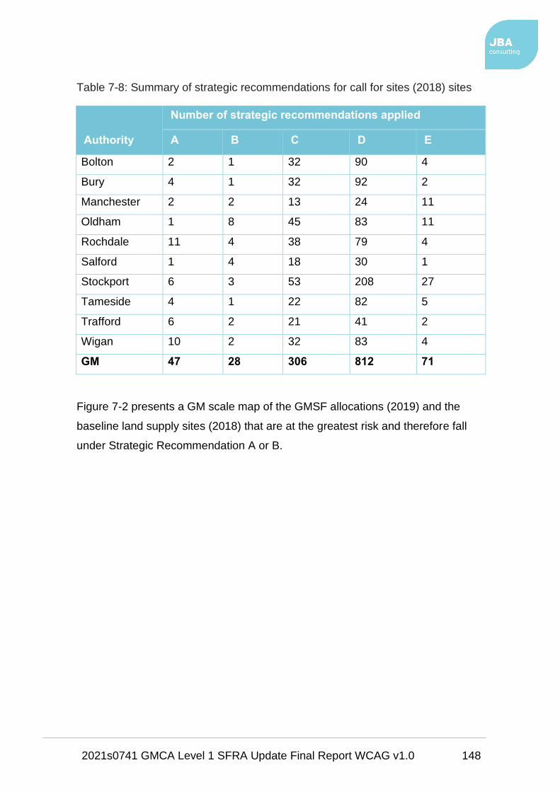
2021s0741 GMCA Level 1 SFRA Update Final Report WCAG v1.0 148
Table 7-8: Summary of strategic recommendations for call for sites (2018) sites
Authority
Number of strategic recommendations applied
A B C D E
Bolton 2 1 32 90 4
Bury 4 1 32 92 2
Manchester 2 2 13 24 11
Oldham 1 8 45 83 11
Rochdale 11 4 38 79 4
Salford 1 4 18 30 1
Stockport 6 3 53 208 27
Tameside 4 1 22 82 5
Trafford 6 2 21 41 2
Wigan 10 2 32 83 4
GM 47 28 306 812 71
Figure 7-2 presents a GM scale map of the GMSF allocations (2019) and the
baseline land supply sites (2018) that are at the greatest risk and therefore fall
under Strategic Recommendation A or B.

2021s0741 GMCA Level 1 SFRA Update Final Report WCAG v1.0 149
Figure 7-2: Allocations and land supply sites with strategic recommendations A and B

2021s0741 GMCA Level 1 SFRA Update Final Report WCAG v1.0 150
Many of the GMSF allocations are considerably large strategic sites which, when
developed, may have a significant impact on flood risk across GM. Such sites will
require their own drainage strategies for post development with a view to
containing water on-site and where possible reducing risk off-site.
Some of the largest allocations are listed in Table 7-9.
Table 7-9: Large GMSF allocations that will influence flood risk in GM
Site Authority Area
(ha)
Comments
New Carrington Trafford 1,138 Very large strategic site; adjacent to
MSC and River Mersey; upstream of
Warrington Town Centre
Timperley Wedge Trafford 225 Timperley Brook runs through; upstream
of Hale and Altrincham
Elton Reservoir Bury 252 Several watercourses; Manchester,
Bolton and Bury Canal runs through the
site; upstream of Radcliffe
Land at Jct 21, M62 Oldham 279 Upstream of Shaw, Royton and
Chadderton
Godley Green
Garden Village
Tameside 124 East of Hyde; a number of drains /
ponds on-site
Land west of
A627(M)
Oldham /
Rochdale
200 East of Middleton and the Rochdale
Canal; waterbodies on-site
Northern Gateway Bury /
Rochdale
858 East of Simister Island on M62 and M60;
south of Whittle Brook; waterbodies on-
site
Port Salford
Extension
Salford 109 West of Eccles and Urmston; several
drains on-site
West of Wingates /
M61 Junction 6
Bolton 184 West of Westhoughton; rural
surrounding; waterbodies on-site

2021s0741 GMCA Level 1 SFRA Update Final Report WCAG v1.0 151
Site Authority Area
(ha)
Comments
Woodford Aerodrome Stockport 120 Rural location south-west of Poynton;
Red Brook and River Dean run along
boundary
7.3.3 Climate change screening
As discussed in Section 6.9.2, considering the impacts of climate change will
have implications for both the type of development that is appropriate according
to its vulnerability to flooding and design standards for any SuDS or mitigation
schemes proposed.
This section summarises the outcomes of the climate change screening
discussed in Section 7.2.2 and recorded in the Site Assessment spreadsheets in
Appendix B.
Table 7-10 to Table 7-12 summarise the sites potentially at increased risk in the
future from climate change.

2021s0741 GMCA Level 1 SFRA Update Final Report WCAG v1.0 152
Table 7-10: GMSF allocations at possible risk from climate change
Authority
Number of sites…
within 100m of a
watercourse modelled
for climate change
at no increased
risk
at increased
risk
Bolton 0 N/A N/A
Bury 2 1 1
Manchester 0 N/A N/A
Oldham 6 0 6
Rochdale 4 0 3
Salford 1 1 0
Stockport 1 1 0
Tameside 0 N/A N/A
Trafford 0 N/A N/A
Wigan 2 1 1
GM 16 4 11

2021s0741 GMCA Level 1 SFRA Update Final Report WCAG v1.0 153
Table 7-11: Baseline land supply sites at possible risk from climate change
Authority
Number of sites…
within 100m of a
watercourse modelled
for climate change
at no increased
risk
at increased
risk
Bolton 77 44 33
Bury 40 21 19
Manchester 25 15 10
Oldham 34 21 13
Rochdale 68 37 31
Salford 62 22 40
Stockport 22 14 8
Tameside 19 9 10
Trafford 2 1 1
Wigan 72 41 31
GM 421 225 196

2021s0741 GMCA Level 1 SFRA Update Final Report WCAG v1.0 154
Table 7-12: Call for sites exercise sites at possible risk from climate change
Authority
Number of sites…
within 100m of a
watercourse modelled
for climate change
at no increased
risk
at increased
risk
Bolton 11 5 6
Bury 22 9 13
Manchester 1 0 1
Oldham 30 4 26
Rochdale 25 2 23
Salford 23 8 15
Stockport 35 17 18
Tameside 1 1 0
Trafford 4 3 1
Wigan 9 1 8
GM 160 63 97
As only around 10% of GMSF allocations and baseline sites are near
watercourses modelled for climate change, there is a heavy reliance on the use of
Flood Zone 2 as a proxy for Flood Zone 3 in the longer term.
47% of allocations and baseline sites together (near modelled watercourses) are
unlikely to be subject to increased risk whilst 53% are identified as having some
increased risk. However, these only represent a small proportion of sites, so it is
not possible to be conclusive.
All sites that have been identified as requiring an FRA through this SFRA should
consider climate change as part of the FRA process. The sites identified as being
at additional risk from climate change (see Site Assessment spreadsheets in
Appendix B for specific sites) should also be subject to further investigation for
the effects of climate change at the FRA stage.

2021s0741 GMCA Level 1 SFRA Update Final Report WCAG v1.0 155
Figure 7-3 presents a GM scale map of the potential development sites at further
risk from climate change, based on watercourses modelled for climate change.

2021s0741 GMCA Level 1 SFRA Update Final Report WCAG v1.0 156
Figure 7-3: Sites at further risk from climate change

2021s0741 GMCA Level 1 SFRA Update Final Report WCAG v1.0 157
7.3.4 WwNP and Irwell Strategic NFM screening
The EA's WwNP datasets, discussed in Section 6.8.5.2, and the Irwell catchment
NFM work (Section 6.8.5.3) are screened against the sites to provide a high level
indication of those sites that may be appropriate to leave undeveloped and use
for flood alleviation.
Much more detailed investigation is required before making decisions on
sites that may have potential for WwNP.
Using the Development Sites Assessment spreadsheets in Appendix B, GMCA
and each council are able to filter the sites that have large enough areas within
the WwNP datasets and that are large enough in total area to be able to provide
effective flood mitigation.
These filtered sites could then be assessed further through more detailed site-
specific investigations on whether it would be possible in reality to use these sites
for flood alleviation. Also, to check whether there would be any real benefits to
surrounding areas and areas downstream.
7.4 The Sequential Approach
The FRCC-PPG provides the basis for the Sequential Approach. It is this
approach, integrated into all stages of the development planning process, which
provides the opportunities to reduce flood risk to people, property, infrastructure,
and the environment to acceptable levels.
The approach is based around the FRM hierarchy, in which actions to avoid,
substitute, control and mitigate flood risk is central. For example, it is important to
assess the level of risk to an appropriate scale during the decision-making
process, (starting with this Level 1 SFRA). Once this evidence has been
provided, positive planning decisions can be made, and effective FRM
opportunities identified.
Figure 7-4 illustrates the FRM hierarchy with an example of how these may
translate into each authorities' management decisions and actions.

2021s0741 GMCA Level 1 SFRA Update Final Report WCAG v1.0 158
Figure 7-4: Flood Risk Management hierarchy
Using the EA's Flood Map for Planning, the overall aim of the Sequential
Approach should be to steer new development to low risk Flood Zone 1. Where
there are no reasonably available sites in Flood Zone 1, the flood risk vulnerability
of land uses and reasonably available sites in Flood Zone 2 should be
considered, applying the Exception Test if required.
Only where there are no reasonably available sites in Flood Zones 1 or 2 should
the suitability of sites in higher risk Flood Zone 3, be considered. This should
consider the flood risk vulnerability of land uses and the likelihood of meeting the
requirements of the Exception Test, if required.
There are two different aims in carrying out the Sequential Approach depending
on what stage of the planning system is being carried out i.e. LPAs allocating land
in local plans (or in the case of GMCA, the GMSF) or determining planning
applications for development. This SFRA does not remove the need for a site-
specific FRA at a development management stage.
The following sections provide a guided discussion on why and how the
Sequential Approach should be applied, including the specific requirements for
undertaking Sequential and Exception Testing.

2021s0741 GMCA Level 1 SFRA Update Final Report WCAG v1.0 159
7.5 Sequential and Exception Test for the GMSF and local plans
As required by the NPPF, GMCA should seek to avoid inappropriate development
in areas at risk of flooding. This should be done by:
• directing development away from areas at highest risk,
• ensuring that all development does not increase risk, and
• where possible can help reduce risk from flooding to existing communities
and development.
Figure 7-5 illustrates the Sequential and Exception Tests as a process flow
diagram. It uses the information contained in this SFRA to assess potential
development sites against the EA’s Flood Map for Planning flood zones and
development vulnerability compatibilities.
This is a stepwise process, but a challenging one, as several the criteria used are
qualitative and based on experienced judgement. The process must be
documented, and evidence used to support decisions recorded.
This can be done using the Development Site Assessment spreadsheets in
Appendix B for each LPA. Each LPA has its own spreadsheet.
At a strategic level, this should be carried out through the GMSF and the
individual council's local plans. This should be done broadly by:
1. Applying the Sequential Test and if the Sequential Test is passed,
applying the Exception Test, if required;
2. Safeguarding land from development that is required for current and future
flood management (i.e. using potential for WwNP data);
3. Using opportunities offered by new development to reduce the causes and
impacts of flooding;
4. Identifying where flood risk is expected to increase with climate change so
that existing development may not be sustainable in the long term;
5. Seeking opportunities to facilitate the relocation of development including
housing to more sustainable locations.

2021s0741 GMCA Level 1 SFRA Update Final Report WCAG v1.0 160
This spreadsheet will help show that each LPA has applied the Sequential
Test, through this SFRA, and thus considered development viability options
for each potential development site.
Figure 7-5: Local Plan sequential approach to site allocation27
(Tables 1, 2, 3 refer to the Flood Zone and flood risk tables of the FRCC-PPG
Paragraphs 065-067).
The approach shown in Figure 7-5 provides an open demonstration of the
Sequential Test being applied in line with the NPPF and the FRCC-PPG.
The EA works with local authorities to agree locally specific approaches to the
application of the Sequential Test and any local information or consultations with
the LLFA should be considered.
This SFRA provides the main evidence required to carry out this process. The
process also enables those sites that have passed the Sequential Test, and may
require the Exception Test, to be identified.
27 Applying the Sequential Test in the preparation of a Local Plan

2021s0741 GMCA Level 1 SFRA Update Final Report WCAG v1.0 161
Following application of the Sequential Test, the LPAs and developers should
refer to 'Table 3: Flood risk vulnerability and flood zone 'compatibility'' of the
FRCC-PPG (Paragraph 067) when deciding whether a development may be
suitable or not.
The NPPF para 160 states:
"The application of the exception test should be informed by a strategic or site-
specific flood risk assessment, depending on whether it is being applied during
plan production or at the application stage.
For the exception test to be passed it should be demonstrated that:
a. the development would provide wider sustainability benefits to the
community that outweigh the flood risk; and
b. the development will be safe for its lifetime taking account of the
vulnerability of its users, without increasing flood risk elsewhere, and,
where possible, will reduce flood risk overall.
Both elements of the exception test should be satisfied for development to be
allocated or permitted." (para 161).

2021s0741 GMCA Level 1 SFRA Update Final Report WCAG v1.0 162
Where it is found to be unlikely that the Exception Test can be passed due to:
• few wider sustainability benefits,
• the risk of flooding being too great, or
• the viability of the site being compromised by the level of flood risk
management work required,
then the LPA should consider avoiding the site altogether.
Once this process has been completed, the LPAs should then be able to allocate
appropriate development sites through the GMSF. They should also be able to
agree flood risk policy including the requirement to prepare site-specific FRAs for
all allocated sites that remain at risk of flooding or that are greater than one
hectare in area (see Section 7.6.4).
Although passing the Exception Test will require the completion of a site-
specific FRA, the LPAs may be able to assess, for a number of sites, the
likelihood of passing the test at the GMSF and local plan level by using this
Level 1 SFRA to broadly answer the questions below. Based on the
information contained in this Level 1 SFRA:
a. Can development within higher risk areas be avoided or substituted?
b. Is the flood risk associated with possible development sites considered too
high and could this mean that the criteria for passing the Exception Test
are unachievable?
c. Does it appear likely that risk can be sustainably managed through
appropriate development techniques (resilience and resistance) and
incorporate SuDS without compromising the viability of the development?
(i.e. is the site large enough? are the ground conditions suitable?)
d. Is it likely that the site, and any identified residual risks to the site, can be
safely managed to ensure that its occupiers remain safe during times of
flood if developed?
To fully answer questions b to d, further, more detailed assessment may
be required.

2021s0741 GMCA Level 1 SFRA Update Final Report WCAG v1.0 163
7.6 Summary of strategic recommendations
There are several outcomes which could come out of the sequential testing
process and the surface water risk assessment. Each outcome is discussed
below.
Also, as stated in Section 7.1, each LPA should refer to Appendices A to C, for
details on the sites assessments carried out for this SFRA.
7.6.1 Rejection of site
• A site which fails to pass the Sequential Test, and / or the Exception Test
would be rejected.
• Rejection would also apply to any highly (gypsy and traveller sites), more
(residential, mixed use inclusive of residential) or less vulnerable
(employment) sites within Flood Zone 3b where development should not
be permitted.
• The FRCC-PPG flood risk vulnerability classification states that only water-
compatible uses and essential infrastructure should be permitted in Flood
Zone 3b. Any essential infrastructure must pass the Exception Test and
clearly demonstrate that it does not increase or exacerbate flood risk
elsewhere.
• If the developer can avoid Flood Zone 3b, part of the site could still be
delivered.
7.6.2 Exception Test required if site passes Sequential Test
• Applies to those sites that, according to the FRCC-PPG vulnerability
tables, would require the Exception Test, having already passed the
Sequential Test.
• Only water-compatible and less vulnerable uses of land would not require
the Exception Test in Flood Zone 3a.
• More vulnerable uses, including residential, and essential infrastructure are
only permitted if the Exception Test is passed and all development
proposals in Flood Zone 3a must be accompanied by a Flood Risk
Assessment.

2021s0741 GMCA Level 1 SFRA Update Final Report WCAG v1.0 164
• To avoid having to apply the Exception Test, the developer / LPA should
attempt to avoid the risk area altogether.
7.6.3 Consideration of site layout and design
• Site layout and site design is important at the site planning stage where
flood risk exists.
• The site area would have to be large enough to enable any alteration of
the developable area of the site to remove development from the functional
floodplain, or to leave space for on-site storage of flood water.
• Careful layout and design at the site planning stage may apply to such
sites where it is considered viable based on the level of risk.
• As discussed in Section 4.6.1, the revised NPPF (2019) states that safe
access and escape routes should now be established as part of an
emergency plan. This should be factored into early site design and should
be assessed through the FRA.
• Depending on local circumstances, if it is not possible to adjust the site
boundary to remove the site footprint from Flood Zone 3b to a lower risk
zone then development should not be permitted.
• If it is not possible to adjust the developable area of a site to remove the
proposed development from Flood Zone 3a to a lower risk zone or to
incorporate the on-site storage of water within site design, then the
Exception Test would have to be passed as part of a site-specific Flood
Risk Assessment.
• Any site layout and design options should take account of the 8 metre
buffer along watercourses, from the top of the bank or the landward toe of
a defence on main rivers, where development is not permitted. This buffer
is recommended by the EA to allow ease of access to watercourses for
maintenance works.
• Any site redesign, where Flood Zone 3a is included within the site footprint,
should allow water to flow naturally or be stored in times of flood through
application of appropriate SuDS techniques (see Section 7.11).

2021s0741 GMCA Level 1 SFRA Update Final Report WCAG v1.0 165
• As per the NPPF, where development must be located in an area of flood
risk, the design and layout of the development must include consideration
of appropriate flood resilience and resistance measures.
For sites identified to be at significant surface water flood risk by way of the
RoFSW dataset, detailed surface water flood modelling should be carried
out. This is to ascertain the viability of the development and to investigate
the feasibility of on-site storage and opportunities for suitable SuDS.
See Section 7.11 for information on SuDS and the SuDS hierarchy.
Also, Appendix F details different SuDS techniques and suitability.
7.6.4 Site-specific Flood Risk Assessment
According to the FRCC-PPG (Para 030), a site-specific FRA is:
“…carried out by (or on behalf of) a developer to assess the flood risk to and from
a development site. Where necessary (see footnote 50 in the National Planning
Policy Framework), the assessment should accompany a planning application
submitted to the local planning authority.
The assessment should demonstrate to the decision-maker how flood risk will be
managed now and over the development’s lifetime, taking climate change into
account, and with regard to the vulnerability of its users (see Table 2 – Flood Risk
Vulnerability of FRCC-PPG).”

2021s0741 GMCA Level 1 SFRA Update Final Report WCAG v1.0 166
The objectives of a site-specific FRA are to establish:
Whether a proposed development is likely to be affected by current or future
flooding (including effects of climate change) from any source. This should
include referencing this SFRA to establish sources of flooding.
Further analysis should be performed to improve understanding of flood risk
including agreement with the council on areas of functional floodplain that
have not been specified within this SFRA.
Key objectives:
• Whether the development will increase flood risk elsewhere;
• Whether the measures proposed to deal with these effects and risks are
appropriate;
• The evidence for the local planning authority to apply (if necessary) the
Sequential Test; and
• Whether the development will be safe and pass the Exception Test, if
applicable.

2021s0741 GMCA Level 1 SFRA Update Final Report WCAG v1.0 167
• Paragraph 031 of the FRCC-PPG contains information regarding the level
of detail required. It explains that FRAs should always be proportionate to
the degree of flood risk whilst making use of existing information, including
this SFRA.
When is a site-specific FRA required?
According to the NPPF (2019) footnote 50, a site-specific FRA should be
prepared when the application site is:
• Situated in Flood Zone 2 and 3; for all proposals for new development
(including minor development and change of use);
• 1 hectare or greater in size and located in Flood Zone 1;
• Located in Flood Zone 1 on land which has been identified by the EA as
having critical drainage problems (i.e. within a ACDP);
• Land identified in the SFRA as being at increased flood risk in future (see
Appendix B and various sections throughout this report);
• At risk of flooding from other sources of flooding, such as those identified
in this SFRA; or
• Subject to a change of use to a higher vulnerability classification which
may be subject to other sources of flooding.
Optionally, the LPA may also like to consider further options for stipulating
FRA requirements, such as:
• Situated in an area currently benefitting from defences;
• Within a council designated CDA or OAFCDM; or
• Situated over a culverted watercourse or where development will require
controlling the flow of any river or stream or the development could
potentially change structures known to influence flood flow.
These further options should be considered during the preparation and
development of the GMSF and local plans.

2021s0741 GMCA Level 1 SFRA Update Final Report WCAG v1.0 168
• Paragraph 068 of the FRCC-PPG contains an easy to follow FRA checklist
for developers to follow.
• Together with the information in the FRCC-PPG, there is further detail and
support provided for the LPA and developers in the EA’s FRA guidance28
and the EA guidance for FRAs for planning applications29.
• CIRIA’s report 'C624 Development and Flood Risk30' also provides useful
guidance for developers and the construction industry.
• Section 7.6.4 of this report provides further guidance on FRAs for
developers.
7.6.5 Sites passing the Sequential and Exception Tests
• Development sites can be allocated or granted planning permission where
the Sequential Test and the Exception Test (if required) are passed.
• In addition, a site is likely to be allocated without the need to assess flood
risk where the proposed use is for open space only. Assuming the site is
not to include any development and is to be left open then the allocation is
likely to be acceptable from a flood risk point of view.
• However, for sites where there is potential for flood storage, options should
be explored as part of an FRA.
• In terms of opportunities for reducing flood risk overall as a requirement of
the Exception Test, the FRCC-PPG states:
“Local authorities and developers should seek opportunities to reduce the overall
level of flood risk in the area and beyond. This can be achieved, for instance,
through the layout and form of development, including green infrastructure and
the appropriate application of sustainable drainage systems, through
28 Review individual flood risk assessments: standing advice for local planning
authorities
29 Flood risk assessments if you're applying for planning permission
30 CIRIA C624 Development and Flood Risk - guidance for the construction industry.
2004

2021s0741 GMCA Level 1 SFRA Update Final Report WCAG v1.0 169
safeguarding land for flood risk management, or where appropriate, through
designing off-site works required to protect and support development in ways that
benefit the area more generally.” (Paragraph 50).
7.6.6 Surface water risk to potential sites
For sites at surface water flood risk the following should be considered:
• Critical Drainage Areas - is the site within a CDA or OAFCDM? If so what,
if any, are the requirements of the LPA for sites within a CDA or
OAFCDM? (see Sections 4.7.3 and 6.4.3);
• A detailed site-specific FRA incorporating surface water flood risk
management or drainage strategy for larger strategic sites or clusters of
sites;
• A FRA may want to consider detailed surface water modelling for sites at
significant risk, particularly for larger sites which may influence sites
elsewhere;
• The size of development and the possibility of increased surface water
flood risk caused by development on current Greenfield land (where
applicable), and cumulative impacts of this within specific areas;
• Management and re-use of surface water on-site, assuming the site is
large enough to facilitate this and achieve effective mitigation. Effective
surface water management should ensure risks on and off site are
controlled;
• Larger sites could leave surface water flood prone areas as open
greenspace, incorporating social and environmental benefits;
• SuDS should be used where possible:
o Appropriate SuDS may offer opportunities to control runoff to
Greenfield rates or better.
o Restrictions on surface water runoff from new development should
be incorporated into the development planning stage.
o For brownfield sites, where current infrastructure may be staying in
place, runoff should attempt to mimic that of Greenfield rates,
2021s0741 GMCA Level 1 SFRA Update Final Report WCAG v1.0 170
unless it can be demonstrated that this is unachievable or
hydraulically impractical.
o Developers should refer to the national 'non-statutory technical
standards for sustainable drainage systems' and other guidance
documents cited in Section 7.11 of this report;
• Runoff up to and including the 1 in 100 AEP event should be managed on
site where possible;
• Measures of source control should be required for development sites;
• Developers should be required to set part of their site aside for surface
water management, to contribute to flood risk management in the wider
area and supplement green infrastructure networks;
• Developers should be required to maximise permeable surfaces; and
• Flow routes on new development where the sewerage system surcharges
as a consequence of exceedance of the 1 in 30 AEP design event should
be retained.
7.7 Integrated Assessment and flood risk
The Integrated Assessment (see Section 5.1.1) should help to ensure that flood
risk is taken into account at all stages of the planning process with a view to
directing development away from areas at flood risk, now and in the future, by
following the sequential approach to site allocation, as shown in Figure 7-5.
By avoiding sites identified in this SFRA as being at significant flood risk,
or by considering how changes in site layout can help to avoid those parts
of a site at flood risk, the Combined Authority would be demonstrating a
sustainable approach to development.
In terms of surface water, for those sites at highest risk, more detailed and site-
specific modelling of the risk will be required to determine the viability of
development.
For all sites at risk from surface water, site design and layout should be tailored to
ensure sustainable development. This should involve investigation into
appropriate SuDS techniques (see Section 7.11 and Appendix F).

2021s0741 GMCA Level 1 SFRA Update Final Report WCAG v1.0 171
Appendix C contains the site summary reports on development viability
recommendations for each LA.
Once the LPAs have decided on a final list of sites following application of the
Sequential Test and, where required, the Exception Test following a site-specific
FRA, a phased approach to development should be carried out to avoid any
cumulative impacts that multiple developments may have on flood risk.
For example, for any site where it is required to develop in Flood Zone 3, detailed
modelling would be required to ascertain where water displaced by development
may flow and to calculate subsequent increases in downstream flood volumes.
The modelling should investigate scenarios based on compensatory storage
techniques to ensure that downstream or nearby sites are not adversely affected
by development on other sites.
Using a phased approach to development, based on modelling results of
floodwater storage options, should ensure that any sites at risk of causing
flooding to other sites are developed first. This will help to ensure flood storage
measures are in place before other sites are developed, thus ensuring a
sustainable approach to site development.
Also, it may be possible that flood mitigation measures put in place at sites
upstream could alleviate flooding at downstream or nearby sites.
Large strategic multiple development sites should also carry out development
phasing within the overall site boundary to avoid cumulative impacts within the
site, as well as off the site.
7.8 Cumulative impacts
The NPPF (2019) states that strategic policies…
"…should consider cumulative impacts in, or affecting, local areas susceptible to
flooding, and take account of advice from the Environment Agency and other
relevant flood risk management authorities, such as lead local flood authorities
and internal drainage boards". (para 156)
Previous policies have relied on the assumption that if each individual
development does not increase the risk of flooding, the cumulative impact will
also be minimal.
2021s0741 GMCA Level 1 SFRA Update Final Report WCAG v1.0 172
However, if there is a lot of development occurring within one catchment,
particularly where there is flood risk to existing properties or where there are few
opportunities for mitigation, the cumulative impact may be to change the flood
response of the catchment.
This SFRA considers cumulative impacts of new development through much of
the advice provided on mitigation throughout Section 0 of this report and also
through the accompanying SFRMF.
Consideration is given to the following:
• The importance of phasing of development, as discussed in Section 7.7;
• Cross boundary impacts (see Figure 3-7 of the SFRMF) i.e. there should
be dialogue between the GMCA and the authorities upstream of GM such
as Rossendale; Kirklees; High Peaks; Cheshire East; Blackburn with
Darwen; and Chorley.
Decisions on flood risk management practices and development in these
authorities should involve discussion with GM given the possible
downstream impacts of development of flood risk in GM.
The same also applies to the downstream authorities of Warrington; St
Helens; West Lancashire; and Calderdale which may be affected by flood
risk management and development in GM.
Section 3.5 of the SFRMF document covers cross boundary impacts more
fully;
• Leaving space for floodwater, utilising greenspace for flood storage and
slowing the flow, as discussed in Sections 4.4, 6.8.4, 6.8.5, 7.3.4 and
Appendix B; and
• SuDS and containment of surface water on-site as opposed to directing
elsewhere (see Section 7.11).
However detailed conclusions on cumulative effect would require certainty on:
• which potential development sites would be likely to be allocated,
• the size/density of the plots within a development, and
• potentially hydraulic modelling to test impacts downstream.

2021s0741 GMCA Level 1 SFRA Update Final Report WCAG v1.0 173
7.9 Guidance for developers
This SFRA provides the evidence base for developers to assess flood risk at a
strategic level and to determine the requirements of an appropriate site-specific
FRA.
Before carrying out an FRA, developers should check with the relevant LPA
whether the Sequential Test has been carried out. If not, the developer must apply
the Sequential Test as part of their FRA by comparing their proposed development
site with other available sites to ascertain which site has the lowest flood risk.
The EA provides advice on this via: Flood risk assessment: the sequential test for
applicants

2021s0741 GMCA Level 1 SFRA Update Final Report WCAG v1.0 174
When initially considering the development options for a site, developers
should use this SFRA, the NPPF and the FRCC-PPG to:
• Identify whether the site is
o A windfall development, allocated development, within a
regeneration area, single property or subject to a change of
use to identify if the Sequential and Exception Tests are
required.
• Check whether the Sequential Test and / or the Exception Test
have already been applied (see Figure 7-6)
o Request information from the LPA on whether the Sequential
Test, or the likelihood of the site passing the Exception Test,
have been assessed;
o If not, provide evidence to the LPA that the site passes the
Sequential Test and will pass the Exception Test.
• Consult with the LPA, the LLFA and the EA and the wider group
of flood risk consultees, where appropriate, to scope an
appropriate FRA if required
o Guidance on FRAs provided in Section 7.6.4 of this SFRA;
o Also, refer to the EA Standing Advice, CIRIA Report C624, the
NPPF and the FRCC-PPG;
o Consult the relevant LLFA.
• Submit FRA to the relevant LPA and the EA for approval, where
necessary

2021s0741 GMCA Level 1 SFRA Update Final Report WCAG v1.0 175
Table 7-13 identifies, for developers, when the Sequential and Exception Tests are
required for certain types of development and who is responsible for providing the
evidence and those who should apply the tests if required.
Table 7-13: Development types and application of Sequential and Exception
Tests for developers
Development Sequential
Test
Required?
Who Applies
the Sequential
Test?
Exception
Test
Required?
Who Applies the
Exception Test?
Allocated Sites No (assuming
the
development
type is the
same as that
submitted via
the allocations
process)
LPA should
have already
carried out the
test during the
allocation of
development
sites
Dependent on
land use
vulnerability
LPA to advise on the
likelihood of test being
passed. The developer
must also provide
evidence that the test
can be passed by
providing planning
justification and
producing a detailed
FRA
Windfall Sites Yes Developer
provides
evidence, to
the LPA that
the test can be
passed. An
area of search
will be defined
by local
circumstances
relating to the
catchment and
for the type of
development
Dependent on
land use
vulnerability
Developer must provide
evidence that the test
can be passed by
providing planning
justification and
producing a detailed
FRA

2021s0741 GMCA Level 1 SFRA Update Final Report WCAG v1.0 176
Development Sequential
Test
Required?
Who Applies
the Sequential
Test?
Exception
Test
Required?
Who Applies the
Exception Test?
being
proposed
Regeneration
Sites Identified
Within Local
Plan
No - Dependent on
land use
vulnerability
LPA to advise on the
likelihood of test being
passed. The developer
must also provide
evidence that the test
can be passed by
providing planning
justification and
producing a detailed
FRA
Redevelopment
of Existing
Single
Properties
No - Dependent on
land use
vulnerability
Developer must provide
evidence that the test
can be passed by
providing planning
justification and
producing a detailed
FRA
Changes of
Use
No (except for
any proposal
involving
changes of use
to land
involving a
caravan,
camping or
chalet site)
Developer
provides
evidence to the
LPA that the
test can be
passed
Dependent on
land use
vulnerability
Developer must provide
evidence that the test
can be passed by
providing planning
justification and
producing a detailed
FRA
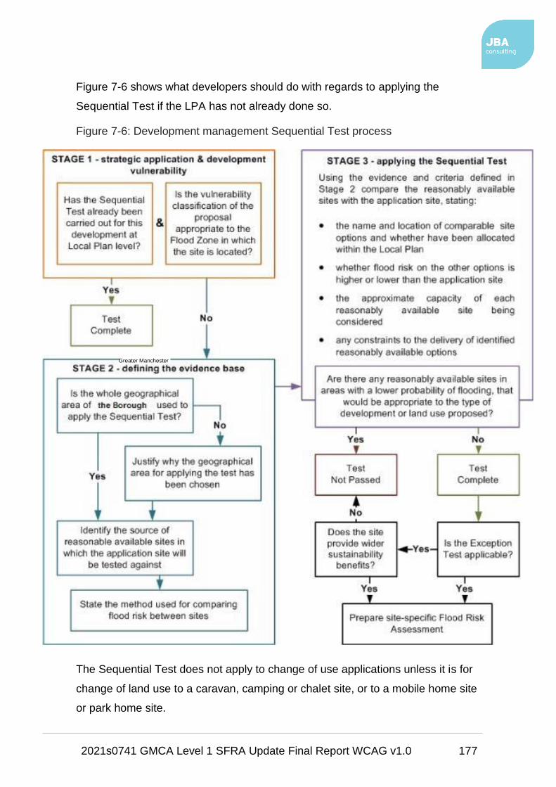
2021s0741 GMCA Level 1 SFRA Update Final Report WCAG v1.0 177
Figure 7-6 shows what developers should do with regards to applying the
Sequential Test if the LPA has not already done so.
Figure 7-6: Development management Sequential Test process
The Sequential Test does not apply to change of use applications unless it is for
change of land use to a caravan, camping or chalet site, or to a mobile home site
or park home site.
Greater Manchester

2021s0741 GMCA Level 1 SFRA Update Final Report WCAG v1.0 178
The Sequential Test can also be considered adequately demonstrated if both of
the following criteria are met:
• The Sequential Test has already been carried out for the site (for the same
development type) at the strategic level (GMSF); and
• The development vulnerability is appropriate to the Flood Zone (see Table
3 of the FRCC-PPG).
If both these criteria are met, reference should be provided for the site
allocation of the GMSF and the vulnerability of the development should be clearly
stated.
When applying the Sequential Test, the following should also be
considered:
• The geographic area in which the Test is to be applied;
• The source of reasonable available sites in which the application site
will be tested against; and
• The evidence and method used to compare flood risk between sites.
Sites should be compared in relation to flood risk; GMSF status; capacity; and
constraints to delivery including availability, policy restrictions, physical problems
or limitations, potential impacts of the development on the local area, and future
environmental conditions that would be experienced by the inhabitants of the
development.
The test should conclude if there are any reasonably available sites in areas with
a lower probability of flooding that would be appropriate to the type of
development or land use proposed.
The LPA should now have sufficient information to be able to assess whether the
proposed site has passed the Sequential Test. If the Test has been passed, then
the developer should apply the Exception Test in the circumstances set out by
tables 1 and 3 of the FRCC-PPG.
In all circumstances, where the site is within areas at risk of flooding and where a
site-specific FRA has not already been carried out, a site-specific FRA should be
completed in line with the NPPF and the FRCC-PPG.

2021s0741 GMCA Level 1 SFRA Update Final Report WCAG v1.0 179
More detailed guidance on site-specific FRAs is provided in Section 7.6.4.
In addition to the formal Sequential Test, the NPPF sets out the requirement for
developers to apply the sequential approach to locating development within the
site.
As part of their application and masterplanning discussions with applicants, the
LPAs should seek whether:
• Flood risk can be avoided by substituting less vulnerable uses or by
amending the site layout;
• Less vulnerable uses for the site have been considered; or
• Density can be varied to reduce the number, or the vulnerability, of units
located in higher risk parts of the site.
7.10 Property Flood Resilience (PFR)
• Flood resilience and resistance measures are designed to mitigate flood
risk and reduce damage and adverse consequences to existing property.
• Resistance and resilience measures may aim to help residents and
businesses recover more quickly following a flood event.
• It should be noted that it is not possible to completely prevent flooding to
all communities and business.
• The then Department for Communities and Local Government (DCLG),
now the Ministry of Housing, Communities and Local Government
(MHCLG), and the EA carried out joint research.
• This research recommended that the use of resistance measures should
generally be limited to a nominal protection height of 600 millimetres above
ground level. Ground level being the lowest point of ground abutting the
external property walls. This is because the structural integrity of the
property may be compromised above this level.
• It should be noted that PFR measures would not be expected to cause an
increase in flood risk to other properties or other parts of the local
community. They will help mitigate against flood risk but, as with any flood
alleviation scheme, flood risk cannot be removed completely. Emergency

2021s0741 GMCA Level 1 SFRA Update Final Report WCAG v1.0 180
plans should, therefore, be in place that describe the installation of
measures and residual risks.
• As the flood risk posed to a property cannot be removed completely, it is
recommended that PFR products are deployed in conjunction with pumps
of a sufficient capacity. Pumps will help manage residual flood risks not
addressed by resistance measures alone such as rising groundwater.
7.10.1 Definitions
• Flood resilience measures aim to reduce the damage caused by
floodwater entering a property.
• Flood resilience measures are based on an understanding that internal
flooding may occur again and when considering this eventuality, homes
and businesses are encouraged to plan for flooding with an aim of rapid
recovery and the return of the property to a habitable state.
• For example:
o tiled floors are easier to clean than carpets,
o raised electricity sockets and high-level wall fixings for TVs /
computers may mean that that power supply remains unaffected,
o Raising kitchen or storage units may also prevent damage that may
not require replacement after a flood.
• There is a lot of information available about what items get damaged by
floodwater and features that are considered to provide effective resilience
measures that can be installed at a property.
• Flood resistance measures aim to reduce the amount of floodwater
entering the property.
• Obvious inflow routes, such as through doors and airbricks may be
managed, for example, by installing bespoke flood doors, door flood
barriers and automatic closing airbricks.
• However, the property’s condition and construction are also key to
understanding how floodwater may enter and move between buildings.
For example, flood water can also flow between properties through

2021s0741 GMCA Level 1 SFRA Update Final Report WCAG v1.0 181
connecting cavity walls, cellars, beneath suspended floors and through
internal walls.
• Flood resistance measures alone may not keep floodwater out. Building
condition is a critical component of any flood mitigation study.
7.10.2 Property Mitigation Surveys
To define the scale and type of resistance or resilience measures required, a
survey will need to be undertaken to ascertain:
• property threshold levels,
• air brick levels,
• doorways, historic flood levels and
• several ground spot levels required to better understand the flood
mechanisms for flood water arriving at the property (e.g. along road,
pavements, etc.).
The depth of flooding at each property will help guide the selection of resistance
measures proposed. Surveys will need to include consideration of issues such
as:
• Detailed property information
• An assessment of flood risk, including property (cross) threshold levels
• Routes of water ingress (fluvial, ground and surface water flooding)
• An assessment of impact of flood waters
• A schedule of measures to reduce risk (resistance and resilience)
• Details of recommendations (including indicative costs)
• Advice on future maintenance of measures
• Advice on flood preparedness
All sources of flooding will need to be considered, including a comprehensive
survey of openings (doors, windows and air bricks), as well as potential seepage
routes through walls and floors, ingress through service cables, pipes, drains and
identify possible weaknesses in any deteriorating brickwork or mortar.

2021s0741 GMCA Level 1 SFRA Update Final Report WCAG v1.0 182
The NPPF (2019) states that, where development must be located in an area
of flood risk, following application and passing of the Sequential and
Exception Tests (if applicable), the development must be appropriately
flood resistant and resilient (para 163b).
7.11 Sustainable Drainage Systems (SuDS)
Development has the potential to cause an increase in impermeable area, an
associated increase in surface water runoff rates and volumes, and consequently
a potential increase in downstream flood risk due to overloading of sewers,
watercourses, culverts, and other drainage infrastructure.
Managing surface water discharges from new development is therefore crucial in
managing and reducing flood risk to new and existing development downstream.
Carefully planned development can also play a role in reducing the amount of
properties that are directly at risk from surface water flooding.
The then DCLG (now MHCLG) announced, in December 2014, that local
planners should be responsible for delivering SuDS.
Changes to planning legislation gave provisions for major applications of ten or
more residential units or equivalent commercial development to require
sustainable drainage within the development proposals in accordance with the
'non-statutory technical standards for sustainable drainage systems', published in
March 2015.
A Practice Guidance document has also been developed by the Local Authority
SuDS Officer Organisation (LASOO) to assist in the application of the non-
statutory technical standards.
7.11.1 SuDS and the revised NPPF, 2019
The Revised NPPF (2019), para 165, states:
"Major developments should incorporate sustainable drainage systems unless
there is clear evidence that this would be inappropriate. The systems used
should:
a. take account of advice from the lead local flood authority;
b. have appropriate proposed minimum operational standards;

2021s0741 GMCA Level 1 SFRA Update Final Report WCAG v1.0 183
c. have maintenance arrangements in place to ensure an acceptable
standard of operation for the lifetime of the development; and
d. where possible, provide multifunctional benefits".
As since 2014, the NPPF still states only 'major' developments should
incorporate SuDS. However, all developments, both major and minor, can
include SuDS, providing multiple benefits that contribute to many other
NPPF policies, including climate change.
Where site conditions may be more challenging, the type of SuDS may need
to be adapted to the site’s opportunities and constraints. At a strategic
level, this should mean identifying SuDS opportunities according to:
• geology,
• soil type,
• topography,
• groundwater / mine water conditions,
• their potential impact on site allocation, and
• setting out local SuDS guidance and opportunities for adoption and
maintenance.
In terms of what kind of evidence would show SuDS to be inappropriate for
a certain site, it is possible that clarity on what evidence is required may be
subsequently set out in the revised FRCC-PPG, and that these
circumstances would be exceptional.
Maintenance options:
• must clearly identify who will be responsible for SuDS maintenance,
• funding for maintenance should be fair for householders and
premises occupiers; and,
• should set out a minimum standard to which the sustainable
drainage systems must be maintained.

2021s0741 GMCA Level 1 SFRA Update Final Report WCAG v1.0 184
Sustainable drainage should form part of an integrated design methodology
secured by detailed planning conditions to ensure that the SuDS to be
constructed is maintained to a minimum level of effectiveness.
Appendix F provides details on SuDS options and suitability.
7.11.2 SuDS hierarchy
The runoff destination should always be the first consideration when considering
design criteria for SuDS including the following possible destinations in order of
preference:
1. To ground;
2. To surface water body;
3. To surface water sewer;
4. To combined sewer.
Effects on water quality should also be investigated when considering runoff
destination in terms of the potential hazards arising from development and the
sensitivity of the runoff destination.
GMCA has carried out a site suitability assessment on the GMSF allocations and
Call for Sites submissions to consider whether a site is in or near to a SPZ (see
Section 6.5.1).
Developers should also establish that proposed outfalls are hydraulically capable
of accepting the runoff from SuDS through consultation with the LLFA, EA and
UU.
The non-statutory technical standards for sustainable drainage systems (March
2015) sets out appropriate design criteria based on the following:
1. Flood risk outside the development;
2. Peak flow control;
3. Volume control;
4. Flood risk within the development;
5. Structural integrity;
6. Designing for maintenance considerations;
7. Construction.
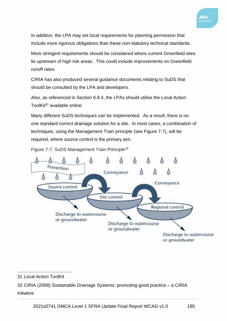
2021s0741 GMCA Level 1 SFRA Update Final Report WCAG v1.0 185
In addition, the LPA may set local requirements for planning permission that
include more rigorous obligations than these non-statutory technical standards.
More stringent requirements should be considered where current Greenfield sites
lie upstream of high risk areas. This could include improvements on Greenfield
runoff rates.
CIRIA has also produced several guidance documents relating to SuDS that
should be consulted by the LPA and developers.
Also, as referenced in Section 6.8.4, the LPAs should utilise the Local Action
ToolKit31 available online.
Many different SuDS techniques can be implemented. As a result, there is no
one standard correct drainage solution for a site. In most cases, a combination of
techniques, using the Management Train principle (see Figure 7-7), will be
required, where source control is the primary aim.
Figure 7-7: SuDS Management Train Principle32
31 Local Action ToolKit
32 CIRIA (2008) Sustainable Drainage Systems: promoting good practice – a CIRIA
initiative

2021s0741 GMCA Level 1 SFRA Update Final Report WCAG v1.0 186
The effectiveness of a flow management scheme within a single site is heavily
limited by land use and site characteristics including (but not limited to)
topography; geology and soil (permeability); and available area.
Potential ground contamination associated with urban and former industrial sites
should be investigated with concern being placed on the depth of the local water
table and potential contamination risks that will affect water quality.
The design, construction and ongoing maintenance regime of any SuDS scheme
must be carefully defined as part of a site-specific FRA.
A clear and comprehensive understanding of the catchment hydrological
processes (i.e. nature and capacity of the existing drainage system) is essential
for successful SuDS implementation.
7.11.3 Drainage for new developments
Development has the potential to cause an increase in impermeable area, an
associated increase in surface water runoff rates and volumes, and a consequent
potential increase in downstream flood risk due to overloading of sewers,
watercourses, culverts, and other drainage infrastructure.
Managing surface water discharges from new development is crucial in
managing and reducing flood risk to new and existing development.
Carefully planned development can also play a role in reducing the amount of
properties that are directly at risk from surface water flooding.
The Planning System has a key role to play in setting standards for sustainable
drainage from new developments and ensuring that developments are designed
to take account of the risk from surface water flooding.
Sustainable drainage plays an important part in reducing flows in the sewer
network and in meeting environmental targets, alongside investment in
maintenance by the water companies on their assets.
Water companies plan their investment on a five-year rolling cycle, in consultation
with key partners, including the EA.

2021s0741 GMCA Level 1 SFRA Update Final Report WCAG v1.0 187
7.11.4 Overland flow paths
Underground drainage systems have a finite capacity and regard should always
be given to larger events when the capacity of the network will be exceeded.
Hence there is a need to design new developments with exceedance in mind.
This should be considered alongside any surface water flows likely to enter a
development site from the surrounding area.
Masterplanning should ensure that existing overland flow paths are retained
within the development.
As a minimum, the developer should investigate, as part of a FRA, the likely
extents, depths and associated hazards of surface water flooding on a
development site, as shown by the RoFSW dataset. This is an appropriate
approach to reduce the risk of flooding to new developments.
Green infrastructure should be used wherever possible to accommodate such
flow paths. Floor levels should always be set a minimum of 300 mm above
adjacent roads to reduce the consequences of any localised flooding.
The effectiveness of a flow management scheme within a single site is heavily
limited by:
• site constraints including (but not limited to) topography; geology and soil
(permeability);
• development density;
• existing drainage networks both on-site and in the surrounding area;
• adoption issues; and
• available area.
The design, construction, and ongoing maintenance regime of such a scheme
must be carefully defined at an early stage and a clear and comprehensive
understanding of the catchment hydrological processes (i.e. nature and capacity
of the existing drainage system) is essential.

2021s0741 GMCA Level 1 SFRA Update Final Report WCAG v1.0 188
8 Emergency planning The provisions for emergency planning for local authorities as Category 1
responders are set out by the Civil Contingencies Act, 2004 and the National
Flood Emergency Framework for England, December 201433.
This framework is a resource for all involved in emergency planning and response
to flooding from the sea, rivers, surface water, groundwater, and reservoirs.
The Framework sets out Government's strategic approach to:
• Ensuring all delivery bodies understand their respective roles and
responsibilities when planning for and responding to flood related
emergencies;
• Giving all players in an emergency flooding situation a common point of
reference which includes key information, guidance and key policies;
• Establishing clear thresholds for emergency response arrangements;
• Placing proper emphasis on the multi-agency approach to managing
flooding events;
• Providing clarity on the means of improving resilience and minimising the
impact of flooding events;
• Providing a basis for individual responders to develop and review their own
plans; and
• Being a long-term asset that will provide the basis for continuous
improvement in flood emergency management.
Along with the EA flood warning systems, there are a range of flood plans at a
sub-regional and local level, outlining the major risk of flooding and the strategic
and tactical response framework for key responders.
This SFRA contains useful data to allow emergency planning processes to be
tailored to the needs of the area and be specific to the flood risks faced. The
SFRA Maps in Appendix A and accompanying GIS layers should be made
available for consultation by emergency planners during an event and throughout
the planning process.
33 The national flood emergency framework for England

2021s0741 GMCA Level 1 SFRA Update Final Report WCAG v1.0 189
8.1 Civil Contingencies Act
Under the Civil Contingencies Act (CCA, 2004)34, the LLFA and LPAs are
classified as Category 1 responders and thus have duties to assess the risk of
emergencies occurring, and use this to:
• Inform contingency planning;
• Put in place emergency plans;
• Put in place business continuity management arrangements;
• Put in place arrangements to make information available to the public
about civil protection matters;
• Maintain arrangements to warn, inform and advise the public in the event
of an emergency;
• Share information with other local responders to enhance coordination;
and
• Cooperate with other local responders to enhance coordination and
efficiency and to provide advice and assistance to businesses and
voluntary organisations about business continuity management.
During an emergency, such as a flood event, the local authority must also co-
operate with other Category 1 responders (such as the emergency services and
the EA) to provide the core response.
8.1.1 Greater Manchester Resilience Forum
The ten GM authorities (LPAs and LLFAs), are partners of the Greater
Manchester Resilience Forum (GMRF)35.
The role of the GMRF is to ensure an appropriate level of preparedness to enable
an effective multi-agency response to emergency incidents that may have a
significant impact on the communities within GM.
The GMRF consists of Category 1 and Category 2 responders.
34 Civil Contingencies Act
35 Greater Manchester Resilience Forum

2021s0741 GMCA Level 1 SFRA Update Final Report WCAG v1.0 190
Category 1 responders include representatives from:
• the Emergency Services,
• the GM local authorities,
• Department for Communities and Local Government,
• the EA,
• NHS England and
• Public Health England.
Category 2 responders include:
• Highways England,
• Network Rail,
• United Utilities and
• National Grid.
8.1.1.1 GM Community Risk Register
As a strategic decision-making organisation, the GMRF prepared a Community
Risk Register (CRR)36, last updated in September 2015.
The CRR considers the likelihood and consequences of the most significant risks
and hazards the area faces, including fluvial and urban flooding. This SFRA can
help to inform this.
The CRR is considered as the first step in the emergency planning process and is
designed to reassure the local community that measures and plans are in place
to respond to the potential hazards listed within the CRR.
8.1.1.2 Community Emergency Planning
Communities may need to rely on their own resources to minimise the impact of
an emergency, including a flood, before the emergency services arrive.
Many communities already help each other in times of need, but experience
shows that those who are prepared cope better during an emergency.
36 Community Risk Register

2021s0741 GMCA Level 1 SFRA Update Final Report WCAG v1.0 191
Communities with local knowledge, enthusiasm and information are a great asset
and a Community Emergency Plan can help.
Details on how to produce a community emergency plan, including a toolkit and
template, are available from Government's website37.
The UK Government has produced several useful guidance documents to enable
individuals, communities and organisations to be more resilient and support one
another: Community resilience: resources and tools
These online resources have been developed to enable individuals, communities
and the organisations that support them to take part in emergency preparedness
activities, in a way that complements the work of emergency responders.
The Met Office have also produced some useful information on how communities
can be better prepared for extreme weather events: Community resilience
8.1.1.3 Post flooding guidance
The GMRF provides some useful information and guidance for both residents and
businesses that may have been affected by flooding: Know your risks: flooding
8.1.2 Local Flood Plans
This SFRA provides several flood risk data sources that should be used when
producing or updating flood plans. GMCA will be unable to write their own
specific flood plans for new developments at flood risk. Developers should write
their own.
Generally, owners with individual properties at risk should write their own
individual flood plans, however larger developments, or regeneration areas, such
as retail parks, hotels and leisure complexes, should consider writing one
collective plan for the assets within an area.
This SFRA can help to:
• Update these flood plans if appropriate;
• Inform emergency planners in understanding the possibility, likelihood and
spatial distribution of all sources of flooding (emergency planners may
37 Community resilience

2021s0741 GMCA Level 1 SFRA Update Final Report WCAG v1.0 192
however have access to more detailed information, such as the EA's
Reservoir Flood Maps, which have not been made available for this
SFRA);
• Identify safe evacuation routes and access routes for emergency services;
• Identify key strategic locations to be protected in flooding emergencies,
and the locations of refuge areas which are capable of remaining
operational during flood events;
• Provide information on risks in relation to key infrastructure, and any risk
management activities, plans or business continuity arrangements;
• Raise awareness and engage local communities;
• Support emergency responders in planning for and delivering a
proportionate, scalable, and flexible response to the level of risk; and
• Provide flood risk evidence for further studies.
8.2 Flood Warning and evacuation plans
Developments that include areas that are designed to flood (e.g. ground floor car
parking and amenity areas) or have a residual risk associated with them, will
need to provide appropriate flood warning and instructions so users and residents
are safe in a flood.
This will include both physical warning signs and written flood warning and
evacuation plans. Those using the new development should be made aware of
any evacuation plans.
In relation to new development it is up to the LPA to determine whether the flood
warning and evacuation plans, or equivalent procedures, are sufficient or not. If
the LPA is not satisfied, taking into account all relevant considerations, that a
proposed development can be considered safe without the provision of safe
access and exit, then planning permission should be refused.
Whilst there is no statutory requirement on the EA or the emergency services to
approve evacuation plans, LPAs are accountable under their Civil Contingencies
duties, via planning condition or agreement, to ensure that plans are suitable.
This should be done in consultation with development management officers.
2021s0741 GMCA Level 1 SFRA Update Final Report WCAG v1.0 193
Given the cross cutting nature of flooding, it is recommended that further
discussions are held internally in GMCA between emergency planners and policy
planners / development management officers, the LLFAs, drainage engineers and
also to external stakeholders such as the emergency services, the EA, UU, any
Internal Drainage Boards, the Peel Group and Canal & River Trust.
It may be useful for both the LLFAs and spatial planners to consider whether, as
a condition of planning approval, flood evacuation plans should be provided by
the developer which aim to safely evacuate people out of flood risk areas, using
as few emergency service resources as possible.
The application of such a condition is likely to require policy support in the GMSF,
and discussions within the GMRF are essential to establish the feasibility /
effectiveness of such an approach, prior to it being progressed.
It may also be useful to consider how key parts of agreed flood evacuation plans
could be incorporated within local development documents, including in terms of
protecting evacuation routes and assembly areas from inappropriate
development.
Once the development goes ahead, it will be the requirement of the plan owner
(developer) to make sure the plan is put in place, and to liaise with GMCA
regarding maintenance and updating of the plan.
8.2.1 What should the Plan Include?
Flood warning and evacuation plans should include the information stated in
Table 8-1. Advice and guidance on plans are accessible from the EA website
and there are templates available for businesses and local communities.
Table 8-1: Flood warning and evacuation plans
Consideration Purpose
Availability of existing
flood warning system
The EA offers a flood warning service that
currently covers designated Flood Warning Areas
in England and Wales. In these areas, they are
able to provide a full Flood Warning Service.
Rate of onset of The rate of onset is how quickly the water arrives

2021s0741 GMCA Level 1 SFRA Update Final Report WCAG v1.0 194
Consideration Purpose
flooding and the speed at which it rises which, in turn, will
govern the opportunity for people to effectively
prepare for and respond to a flood. This is an
important factor within Emergency Planning in
assessing the response time available to the
emergency services.
How flood warning is
given and occupants
awareness of the
likely frequency and
duration of flood
events
Everyone eligible to receive flood warnings
should be signed up to the EA flood warning
service. Where applicable, the display of flood
warning signs should be considered. In
particular sites that will be visited by members of
the public on a daily basis such as sports
complexes, car parks, retail stores. It is
envisaged that the responsibility should fall upon
the developers and should be a condition of the
planning permission. Information should be
provided to new occupants of houses concerning
the level of risk and subsequent procedures if a
flood occurs.
The availability of
staff / occupants /
users to respond to a
flood warning and the
time taken to respond
to a flood warning
The plan should identify roles and responsibilities
of all responders. The use of community flood
wardens should also be considered.
Designing and
locating safe access
routes, preparing
evacuation routes
and the identification
of safe locations for
Dry routes will be critical for people to evacuate
as well as emergency services entering the site.
The extent, depth and flood hazard rating,
including allowance for climate change, should
be considered when identifying these routes.

2021s0741 GMCA Level 1 SFRA Update Final Report WCAG v1.0 195
Consideration Purpose
evacuees
Vulnerability of
occupants
Vulnerability classifications associated with
development as outlined in the FRCC-PPG. This
is closely linked to its occupiers.
How easily damaged
items will be
relocated, and the
expected time taken
to re-establish normal
use following an
event
The impact of flooding can be long lasting well
after the event has taken place affecting both the
property which has been flooded and the lives
that have been disrupted. The resilience of the
community to get back to normal will be
important including time taken to repair / replace
damages.
8.2.2 EA Flood Warning Areas
The EA monitors levels within main rivers and the sea, based upon weather
predictions provided by The Met Office. The EA then assesses the anticipated
maximum water level that is likely to be reached within the proceeding hours
(and/or days).
Where these predicted water levels are expected to result in the inundation of a
populated area, the EA will issue a series of flood warnings within defined Flood
Warning Areas (FWA). The warnings will alert people that flooding is expected
to occur and that they should take action to protect themselves and their property.
Severe Flood Warnings are issued for FWAs when there is a danger to life or
widespread disruption is expected.
More information on flood warning is provided by the EA via: Flood warnings:
what they are and what to do
There are several FWAs in operation across GM which are shown on the SFRA
Maps in Appendix A.

2021s0741 GMCA Level 1 SFRA Update Final Report WCAG v1.0 196
8.2.3 EA Flood Alert Areas
Conversely to Flood Warnings, a Flood Alert is issued to warn people of the
possibility of flooding and to encourage them to be alert, stay vigilant and make
early / low impact preparations for flooding.
Flood Alerts are issued earlier than Flood Warnings to provide advance notice of
the possibility of flooding and may be issued when there is less confidence that
flooding will occur in a FWA.
A single Flood Alert Area (FAA) may cover a large portion of a floodplain, may
contain multiple river catchments of similar characteristics, and may contain
several FWAs.
A FAA may also match a single corresponding FWA and warn for the possibility
of flooding in that area. In some coastal locations, a Flood Alert may be issued
for spray or overtopping and be defined by a stretch of coastline.
The FAAs within GM are also included on the SFRA Maps.
8.2.4 EA flood information service
Live information on Flood Warnings and Flood Alerts is available via: Flood
warnings for England
As discussed, emergency planners may also use the outputs from this SFRA to
raise awareness within local communities. This should include raising awareness
of flood risks, roles and responsibilities and measures that people can take to
make their homes and businesses more resilient to flooding from all sources.
At risk local communities should be encouraged to sign up to the EA’s Flood
Warning service online via: Sign up for flood warnings
It is also recommended that Category 1 responders (see Section 8.1.1) are
provided with appropriate flood response training to help prepare them for the
possibility of a major flood. As there is an increased number of people living
within flood risk areas, to ensure that adequate pre-planning, response and
recovery arrangements are suitably in place.
2021s0741 GMCA Level 1 SFRA Update Final Report WCAG v1.0 197
9 Conclusions and recommendations
9.1 Conclusions
This Level 1 SFRA provides a single repository planning tool relating to flood risk
and development in Greater Manchester.
Key flood risk stakeholders namely the LPAs and LLFAs within GM, the EA, UU
and the Canal & River Trust were consulted to collate all available and relevant
flood risk information on all sources into one comprehensive assessment.
Together with this report, this SFRA also provides:
• a suite of interactive GeoPDF flood risk maps (Appendix A);
• Development Site Assessment spreadsheets (Appendix B) illustrating the
level of risk to sites with subsequent strategic recommendations;
• site summary reports (Appendix C) summarising the strategic
recommendations.
The flood risk information, assessment, guidance and recommendations of the
SFRA will provide GMCA with the evidence base required to apply the Sequential
Test. It will also provide information on the application of the Exception Test, as
required under the NPPF.
It will help demonstrate that a risk based, sequential approach has been applied
to achieve sustainable development through the GMSF.
Whilst the aim of the sequential approach is the avoidance of high flood risk
areas, where GMCA are looking for continued growth, this will not always be
possible.
This SFRA, together with the proposed GM Strategic Framework for Flood Risk
Management, therefore, provides the necessary links between:
• spatial development,
• wider flood risk management policies,
• local strategies / plans and
• on the ground works
2021s0741 GMCA Level 1 SFRA Update Final Report WCAG v1.0 198
by combining all available flood risk information together into one single
repository.
As this is a strategic study, detailed local information on flood risk is not fully
accounted for. For a more detailed assessment of specific areas or sites, a Level
2 SFRA may be carried out following on from this Level 1 assessment.

2021s0741 GMCA Level 1 SFRA Update Final Report WCAG v1.0 199
9.2 Planning policy and flood risk recommendations
The following planning policy recommendations relating to flood risk are designed
to enable GMCA to translate the information provided in this Level 1 SFRA into
meaningful policy for flood risk and water management within the GMSF:
Policy Recommendation 1: No development within Flood Zone 3b…
…as per the NPPF and FRCC-PPG, unless in exceptional circumstances
such as for essential infrastructure, which must still pass the Exception Test,
or where development is water compatible.
Development must not impede the flow of water within Flood Zone 3b nor
should it reduce the volume available for the storage of floodwater.
Sites within Flood Zone 3b may still be developable if the site boundary can
be removed from the floodplain or the site can accommodate the risk on site
and keep the area free from development.
Refer to tables 1 to 3 of the FRCC-PPG.
2021s0741 GMCA Level 1 SFRA Update Final Report WCAG v1.0 200
Policy Recommendation 2: Consider surface water flood risk…
…with equal importance alongside fluvial risk including possible withdrawal,
redesign, or relocation for sites at significant surface water risk.
However, given the limitations of the RoFSW map, decisions on
withdrawal or relocation of sites due to surface water risk can only
take place following more detailed investigation / modelling after this
Level 1 SFRA.
All new development should adhere to the applicable runoff rate allowances
stated by the LLFA.
Any new development within a CDA or a OAFCDM (at the discretion of the
LPA) should adhere to runoff restrictions specified by the applicable LPA.
FRAs should always consider surface water flood risk management and
options for on-site flood storage.

2021s0741 GMCA Level 1 SFRA Update Final Report WCAG v1.0 201
Policy Recommendation 3: Sequential approach to site allocation and
site layout…
…must be followed by GMCA and the LPAs to ensure sustainable
development when either allocating land through the GMSF and local plans
or when determining planning applications for development.
The overall aim of the Sequential Approach should be to steer new
development to low risk Flood Zone 1. Where there are no reasonably
available sites in Flood Zone 1, the flood risk vulnerability of land uses and
reasonably available sites in Flood Zone 2 should be considered, applying
the Exception Test if required.
Only where there are no reasonably available sites in Flood Zones 1 or 2
should the suitability of sites in higher risk Flood Zone 3, be considered.
This should consider the flood risk vulnerability of land uses and the
likelihood of meeting the requirements of the Exception Test, if required.
This SFRA and its appendix, the NPPF and FRCC-PPG should be
consulted throughout this process.

2021s0741 GMCA Level 1 SFRA Update Final Report WCAG v1.0 202
Policy Recommendation 4: Requirement for a site-specific Flood Risk
Assessment…
…from a developer when a site is:
• Within Flood Zone 3a or Flood Zone 2
• Within Flood Zone 1 and 1 hectare or greater in size
• At risk from surface water flooding or on land which has been identified
by the EA as having critical drainage problems (i.e. within an ACDP)
• Within a council designated CDA
• Situated in an area currently benefitting from defences
• Land identified as being at increased flood risk in future
• At risk of flooding from other sources than fluvial, or at residual risk
• Subject to a change of use to a higher vulnerability classification which
may be subject to other sources of flooding
• Situated over a culverted watercourse or where development will
require controlling the flow of any river or stream or the development
could potentially change structures known to influence flood flow.
Before deciding on the scope of the FRA, this SFRA should be consulted
along with the LPA, LLFA and EA. The FRA should be submitted to and be
approved by the LPA including suitable consultation with the LLFA and the
EA and any other applicable parties.
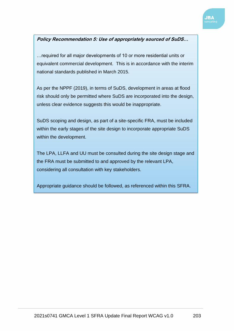
2021s0741 GMCA Level 1 SFRA Update Final Report WCAG v1.0 203
Policy Recommendation 5: Use of appropriately sourced of SuDS…
…required for all major developments of 10 or more residential units or
equivalent commercial development. This is in accordance with the interim
national standards published in March 2015.
As per the NPPF (2019), in terms of SuDS, development in areas at flood
risk should only be permitted where SuDS are incorporated into the design,
unless clear evidence suggests this would be inappropriate.
SuDS scoping and design, as part of a site-specific FRA, must be included
within the early stages of the site design to incorporate appropriate SuDS
within the development.
The LPA, LLFA and UU must be consulted during the site design stage and
the FRA must be submitted to and approved by the relevant LPA,
considering all consultation with key stakeholders.
Appropriate guidance should be followed, as referenced within this SFRA.

2021s0741 GMCA Level 1 SFRA Update Final Report WCAG v1.0 204
Policy Recommendation 6: Natural Flood Management techniques…
…should be considered, where possible, to aid with flood alleviation and
implementation of suitable SuDS, depending on the location.
The national NFM / WwNP mapping and River Irwell data (included in this
SFRA) should be checked in the first instance, followed by local
investigation into whether such techniques are appropriate and whether the
benefits are proportionate to the work required to carry out the identified
NFM approaches.
Policy Recommendation 7: Phasing of development…
…should be carried out by the LPA to avoid any cumulative impacts of
flood risk (reinforced by the revised NPPF (2019). UU's preference is for
developers to provide a detailed surface water strategy for large sites to
avoid piecemeal infrastructure provision.
Using a phased approach to development, should ensure that any sites at
risk of causing flooding to other sites are developed first in order to ensure
flood storage measures are in place before other sites are developed, thus
contributing to a sustainable approach to site development.
It may be possible that flood mitigation measures put in place at sites
upstream could alleviate flooding at downstream or nearby sites.
Development phasing within large strategic sites of multiple developments
should also be considered where parts of such sites are at flood risk.

2021s0741 GMCA Level 1 SFRA Update Final Report WCAG v1.0 205
9.3 Recommendations for further work
The SFRA process has developed into more than just a planning tool. Sitting
alongside the proposed SFRMF for GM, the various local strategies and PFRAs,
it can be used to provide a much broader and inclusive vehicle for integrated,
strategic, and local flood risk management and delivery.
There are a number of plans and assessments listed in Table 9-1 that may be of
benefit to GMCA in developing their flood risk evidence base to support the
Policy Recommendation 8: Planning permission for at risk sites…
…can only be granted by the LPA where a site-specific FRA shows that:
• The NPPF and FRCC-PPG have been referenced together with
appropriate consultation with the relevant LPA, LLFA, the EA, and UU,
where applicable
• The effects of climate change have been considered using the latest
allowances developed by the EA
• There is no loss in floodplain storage resulting from the development
• The development will not increase flood risk elsewhere
• There is no adverse effect on the operational functions of any existing
flood defence infrastructure
• Proposed resistance / resilience measures designed to deal with current
and future risks are appropriate
• Appropriate SuDS techniques have been considered and are to be
incorporated into the design of the site, where applicable
• Whether the development will be safe for its lifetime and has passed the
Exception Test, if applicable
• An appropriate Emergency Plan is included that accounts for the
possibility of a flood event and shows the availability of safe access and
egress points accessible during times of flood.
2021s0741 GMCA Level 1 SFRA Update Final Report WCAG v1.0 206
delivery of the GMSF and the individual local plans or to help fill critical gaps in
flood risk information.
9.4 Data gaps
Throughout the SFRA process it has become apparent that there are several
gaps in flood risk information and data. These gaps have been noted throughout
this report.
Table 9-1 lists several studies that could be carried out by GMCA, the local
authorities or by private developers in future to help fill these gaps.
Table 9-1: Recommended further work for GMCA, local councils or developers
based on identified data gaps
Type Study Explanation Timeframe
Understanding
of local flood
risk
Level 1 SFRA
update
As and when new potential
development sites, flood risk
information or policy becomes available
Short - medium
term
Level 1 SFRA
update; Level 2
SFRA; site-
specific FRA
Reviewing of EA flood zones in those
areas not covered by existing detailed
hydraulic models i.e. the Flood Map for
Planning does not cover every
watercourse such as those <3 km2 in
catchment area or Ordinary
Watercourses.
If a watercourse or drain is present on
OS mapping but is not covered by the
Flood Map for Planning, this does not
mean there is no potential flood risk. A
model may therefore be required to
ascertain the flood risk, if any, to any
nearby sites
Short term
EA Flood Risk
Mapping updates
/ Level 1 SFRA
EA model updates of older / less
detailed models, i.e. conversion of 1D
to 2D models. Subsequent updates to
Medium term
2021s0741 GMCA Level 1 SFRA Update Final Report WCAG v1.0 207
Type Study Explanation Timeframe
update this Level 1 SFRA by GMCA once
models are finalised
Level 2 SFRA Further, more detailed assessment of
flood risk to high risk sites, as notified
by this Level 1 SFRA. More specific to
the individual district authorities
Short term
SWMP / drainage
strategy
Update of the 2013 SWMP for those
high surface water risk sites / areas as
notified by this Level 1 SFRA
Short term
Climate change
assessment for
Level 1 update or
Level 2 SFRA
Modelling of climate change, using
EA's latest allowances for those
watercourses not yet modelled and
taking account of updated EA
allowances in late 2019 based on
UKCP18
Short term
CDAs /
OAFCDMs review
Establish more robust CDA boundaries
using more detailed data along with
existing CDA and OAFCDM
boundaries
Short term
SuDS Identification of SuDS opportunities
according to geology, soil type,
topography, groundwater / mine water
conditions, etc, their potential impact
on proposed development sites, and
setting out of local SuDS guidance and
opportunities for adoption and
maintenance.
Short term
Groundwater /
mine water
Groundwater or mine water information
has not been made available for this
SFRA. Information on groundwater will
be very localised and should be used
Short term

2021s0741 GMCA Level 1 SFRA Update Final Report WCAG v1.0 208
Type Study Explanation Timeframe
to inform on SuDS suitability.
Flood storage
and attenuation
Community
Infrastructure
Levy (CIL).
WwNP and GI
Assessment
For new developments, GI assets can
be secured from a landowner's 'land
value uplift' and as part of development
agreements. GMCA could include
capital for the purchase, design,
planning and maintenance of GI within
its CIL programme. Continue WwNP
proposals in upper catchments. (GM
SFRMF document contains more
details).
Short term
Data collection Flood incident
data to be
spatialised
Each LLFA has a duty to investigate
and record details of locally significant
flood events. General data collected
for each incident should include date,
location, weather conditions, flood
source (if apparent without an
investigation), impacts (properties
flooded, or number of people affected)
and response by any RMA.
This data should be available spatially.
Several GM councils should look to
spatially represent their historic flood
incident data.
Short term
FRM Asset
Register
Each LLFA should continue to update
and maintain its flood risk management
register of structures and features,
which are considered to influence flood
risk.
Short term

2021s0741 GMCA Level 1 SFRA Update Final Report WCAG v1.0 209
Type Study Explanation Timeframe
Risk
assessment
Asset Register
Risk Assessment
Each LLFA should carry out a strategic
assessment of structures and features
on the FRM Asset Register to inform
capital programme and prioritise
maintenance programme. Critical
assets (i.e. culverts in poor condition)
to be prioritised for assessment and
any subsequent designated works.
Short term
Capacity SuDS review /
guidance
GMCA and / or the districts should
identify internal capacity required to
deal with SuDS applications, set local
specification and set policy for adoption
and maintenance of SuDS.
Short term
Partnership UU GMCA should continue to work with
UU on sewer and surface water
projects and data sharing.
Ongoing
EA GMCA should continue to work with the
EA on fluvial flood risk management
projects. GMCA should also identify
potential opportunities for joint
schemes to tackle flooding from all
sources.
Ongoing
Canal & River
Trust
GMCA should continue to work with the
Canal & River Trust to understand the
residual risks associated with the canal
network and also asset owners of
reservoirs.
Ongoing
Peel Group GMCA should continue to work with the
Peel Group to understand the residual
risks associated with the MSC and
Bridgewater Canal.
Ongoing

2021s0741 GMCA Level 1 SFRA Update Final Report WCAG v1.0 210
Type Study Explanation Timeframe
Community Continued involvement with the
community through GMCA's existing
flood risk partnerships.
Ongoing
9.4.1 Level 2 SFRA
Each GM Council should review the sites where they expect the main housing
numbers and employment sites to be delivered, using the SFRA Maps in
Appendix A, the Development Site Assessment spreadsheets in Appendix B and
the site summary reports in Appendix C.
A Level 2 SFRA will be required if a large site, or group of sites, are within Flood
Zone 3 and have strategic planning objectives, which means they cannot be
relocated or avoided.
A Level 2 SFRA may also be required if most sites are within Flood Zone 2 or are
at significant risk of surface water flooding, based on the RoFSW map. Residual
flood risk should also be taken account of when considering options for future
work.
A Level 2 SFRA should build on the source information provided in this Level 1
assessment and should show that a site will not increase risk to others and will be
safe, once developed, and will pass the Exception Test, if required.
A Level 2 study may also assess locations and options for the implementation of
open space, or Green Infrastructure, to help manage flood risk in key areas.
GMCA will need to provide evidence through the GMSF to show that the
housing numbers (and other sites) can be delivered, as will the individual
LPAs through their local plans.
The GMSF and local plans may be rejected if large numbers of sites require
the Exception Test to be passed but with no evidence that this will be
possible.
Once all sites within this Level 1 assessment have been reviewed by each LPA
then further advice or guidance should be sought to discuss possible next steps.

2021s0741 GMCA Level 1 SFRA Update Final Report WCAG v1.0 I
Appendices
A SFRA Maps
Interactive GeoPDF Maps

2021s0741 GMCA Level 1 SFRA Update Final Report WCAG v1.0 II
B Development Site Assessment Spreadsheets

2021s0741 GMCA Level 1 SFRA Update Final Report WCAG v1.0 III
C Development Site Assessment Summary Reports

2021s0741 GMCA Level 1 SFRA Update Final Report WCAG v1.0 IV
D Functional Floodplain Delineation

2021s0741 GMCA Level 1 SFRA Update Final Report WCAG v1.0 V
E EA Climate Change Modelling
2021s0741 GMCA Level 1 SFRA Update Final Report WCAG v1.0 VI
F SuDS Selection Summary
F.1 SuDS Techniques
F.2 SuDS Suitability

Offices at
Coleshill
Doncaster
Dublin
Edinburgh
Exeter
Glasgow
Haywards Heath
Isle of Man
Limerick
Newcastle upon
Tyne
Newport
Peterborough
Saltaire
Skipton
Tadcaster
Thirsk
Wallingford
Warrington

Registered Office
1 Broughton Park
Old Lane North
Broughton
Skipton
North Yorkshire
BD23 3FD
t:+44(0)1756
799919
e:info@jbaconsulti
ng.com
Jeremy Benn
Associates Ltd
Registered in
England 3246693
JBA Group Ltd is
certified to:
ISO 9001:2015
ISO 14001:2015
ISO 45001:2018
Visit our website
www.jbaconsulting.
com