Embed Size (px)
Citation preview

Let WaterBe the Ligament of Peace in the
Himalayan Region
Let WaterBe the Ligament of Peace in the
Himalayan Region
Shaofeng Jia
Dr. Prof.Center for Water Resources Research, CAS
Institute of Geographic Sciences and Natural Resources Research , CAS
Shaofeng Jia
Dr. Prof.Center for Water Resources Research, CAS
Institute of Geographic Sciences and Natural Resources Research , CAS

Contents
1. Water Situation in the Himalayas2. Is Great West Route Diversion
naccesary and feasible?3. Make water peace ligament in
Himalaya regions

32005-5-31
Location and landform
Himalaya
Indian Ocean
Pacific Ocean

Nepal
IndiaBangladesh
Bhutan
China
Countries in Himalaya Region
Pakistan
Burma
Afghanistan
Thailand
The rainfall in east Himalaya region
In South Asia, the west is the driest

Tibet is relatively drier(mm)

The rainfall in east Himalaya region: two rain center

How much water?
Especially how much from every country? We don’t have enough data because of sparse
gauge station in high mountain. We try to apply GIS tool to obtaining water
resources and other related information by means of open data.

Data concerned
Indus
Ganges
Brahmaputra
River length
Basin area
Precipitation
Surface runoff
Population
Cultivated area
GDP
natural resources
social resources

Data sourceData Item
Data Source
Data Specification
GDP http://data.worldbank.org/ 2007
Population http://sedac.ciesin.columbia.edu/gpw/ 2000
Land cover https://lpdaac.usgs.gov/ 2007
National boundaries ARCVIEW software
Line of Control adopted
Water system http://eros.usgs.gov
Basin boundaries http://eros.usgs.gov/
Precipitation http://wwdrii.sr.unh.edu/index.html 1950-2000 annual
Surface runoff http://wwdrii.sr.unh.edu/index.html 1950-2000 annual
River basic information
http://www.cws.net.cn/riverdata/ China public data

blended river flow
Surface Runoff here is blended river flow that represents a composite of observed and modeled river flow. (See details in Fekete, B. M., C. J. Vorosmarty, W. Grabs. 2002. High-resolution fields of global runoff combining observed river discharge and simulated water balances).
For mountain area, it close to natural runoff. For plain area, it close to actual runoff.

Rivers and Basins in Himalaya Region

Basic information of the three large rivers
Indus
Ganges
Brahmaputra
CountriesChina Afghanistan
Pakistan IndiaChina Nepal India
BangladeshChina Bhutan India
Bangladesh
River lengthkm
3086 2664 2916
Basin areakm2
1019150 971423 532068
Precipitationmm·a-1 459 1127 1569
Natural runoff109m3·a-1
207 550 828
Blended runoff109m3·a-1
104 388 618
Population 210522677 395984410 61062639
Cultivated Areakm2
285261 551119 55161
GDP106 of USD
202310 254554 23483

Indicators in riparian countries-Indus
China Afghanistan Pakistan India
Total
River nameSengge
riverIndus river Indus river
River lengthkm
384 2320 382 3086
Basin areakm2
69671 71916 561895 315668 1019150
Precipitationmm·a-1
549 573 372 571
Blended runoff109m3·a-1
10 17 25 52 104
Population 60710 7431079 122290656 80740232 210522677
Cultivated Areakm2
8 2539 168593 114121 285261
GDP106 of USD
25 31481 112108 58696 202310

China India Nepal Bangladesh
Total
River name Gangesriver
Gangesriver
River lengthkm
2022 642 2664
Basin areakm2
44042 745439 146877 35065 971423
Blended runoff109m3·a-1
14 178 191 5 388
Population 204804 341203840 24058366 30517400 395984410
Cultivated Areakm2
86 511751 13576 25706 551119
GDP106 of USD
157 235071 10023 9303 254554
Information in riparian countries-Ganges

Information in riparian countries- Brahmaputra
China Bhutan India Bangladesh
Total
River nameYarlung Tsangpo
riverBrahmaputra
riverJamuna
river
River lengthkm
1905 740 271 2916
Basin areakm2
345083 38458 125312 23215 532068
Precipitationmm·a-1
1076 2232 2494 2139
Blended runoff109m3·a-1
121 33 429 35 618
Population 2371835 2197184 31841148 24652472 61062639
Cultivated Areakm2
1225 160 33521 20255 55161
GDP106 of USD
4341 1093 9325 8724 23483

The percentages of natural runoff in China
Total naturalrunoff
Natural runoff
in China
Percentage%
Indus 207 10 4.83
Ganges 550 14 2.55
Brahmaputra 828 121 14.61
Ganges-Brahmaputra-Meghna 1520 135 8.88

China’s percentages of Brahmaputra
River length65.33%
GDP18.49%
Basin area64.86%
Natural runoff14.61%
Cultivated area2.22%
Population3.88%
Brahmaputra in China
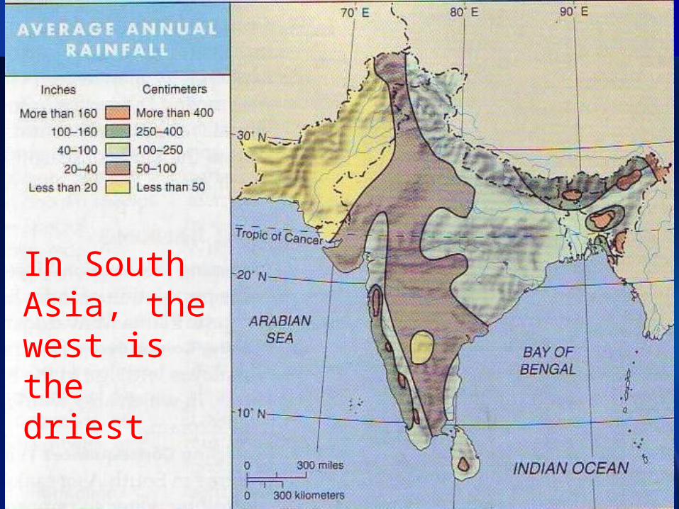
2. Water use trend of China vs GWRDP
Why talk about this? There are worry that China will divert
water from Yaluzangbu!
Great West Route Diversion Project (GWRDP)
‘Water of Tibet save China’ Li Ling, Guokai
Some others

Changjiang
Zhujiang
Huanghe
Huaihe
South to North Water Transfer Project and GWRDP
East Rout
MiddleWest
GWRDP???

Is GWRDP Feasible?
For Tibet Autonomous Region, it use very little water: only 1% of runoff withdrawn for human use, mainly for irrigation.
But North China is lacking of water. Will or not North China divert Yaluzangbu? For answer this, we should see the water use
trend of China!

1949 1980 1993 1997 1998 20000
1000
2000
3000
4000
5000
6000
Total
Industrial
Urban living
Agricutural
100 mcm
Water use of China

0
100
200
300
400
500
600
1975 1985 1995 2005
grai
n ou
tput
(m.t
)
3400
3500
3600
3700
3800
3900
4000
agri
cult
ural
wat
erus
e(10
0 mi
llio
n t)
grai n output ari cul tural water use

24
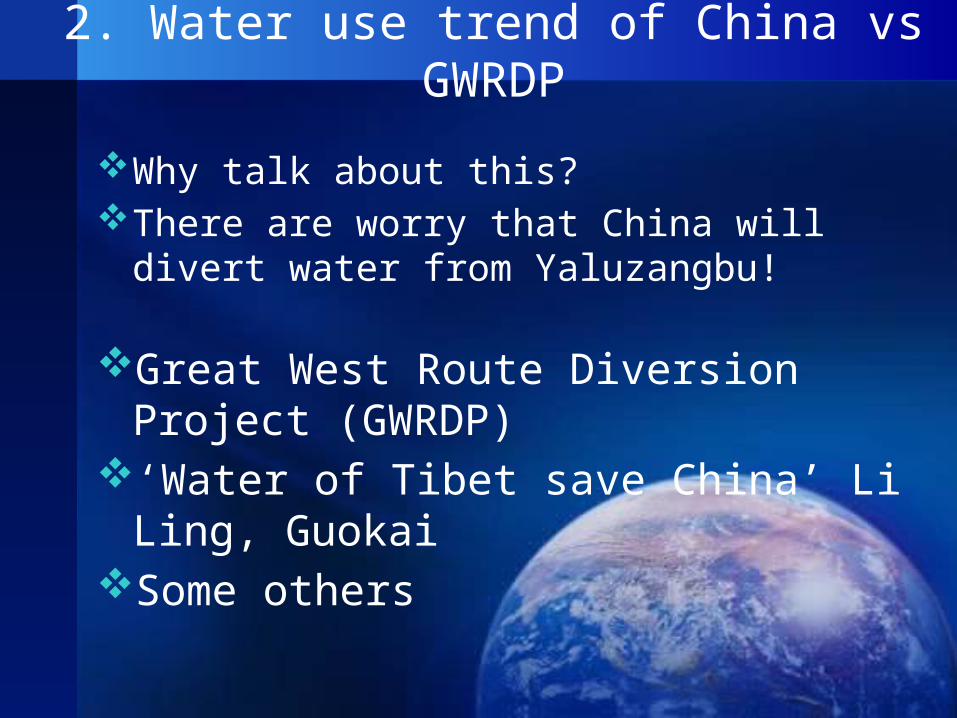
Case: Hai Basin, Basins under Water Conservancy
Commission

25
Administrative units of Hai basin
Beijing
TianjinHebei
Henan
Shandong
Shanxi
Inner MongoliaLiaoning
26
Water scarcity situation of Hai basin
Per capita water resources is less than 300 cubic meters
Water use/Water available ratio higher than 80%
The destination of South-North Water Transfer Projects
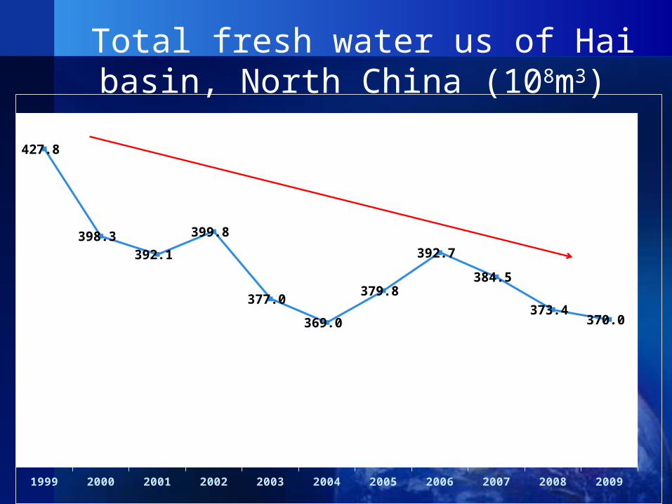
1999 2000 2001 2002 2003 2004 2005 2006 2007 2008 2009
427.8
398.3 392.1
399.8
377.0
369.0
379.8
392.7
384.5
373.4 370.0
Total fresh water us of Hai basin, North China (108m3)

Industrial water use of Hai Basin(108m3)
4 图 海河流域工业用水量变化过程
40
50
60
70
80
1980 1990 2000 2010
工业
用水
量(
亿方
)

292005-5-31
Water use up and down along with the growth of Per Capita GDP of USA
0. 20
0. 40
0. 60
0. 80
1. 00
2. 00 7. 00 12. 00 17. 00 22. 00
Per Capi ta GDP(1, 000US$)
Idus
tria
l Fr
esh
Wate
rWi
thdr
aw I
ndex

3 /图 日本工业淡水取水量变化(亿方 年)
0
50
100
150
200
250
1960 1970 1980 1990 2000

The Kuznets curve law of industrial water use evolution
There is a turning point of water use form increasing to decreasing
Per capita GDP
Industrial water use
Turning point

Conclusion about water use trend of China
Water use is closing the climax!
Not only for whole China, but also/especially for North China
So China has no need to divert water from Yaluzangbu!

Long term water supply and demand planning of China
Set up total water use limitation for Whole China and every province!
For year 2020, it should be less than 670 billion m3;
For year 2030, it should be less then 710 billion m3!
Compared to recent 598 m3, it’s permitted to increase about 100 billion. And engineering projects has been planned to provide those added supply, while no project of diverting water from Yaluzangbu is considered.
For my personal opinion, it’s not possible for water use of China to reach high to 650 billion!

GWRDP not only not necessary, also not feasible!
Too far: 2000km away Too high the lifting of water: more than 1000m Too difficult: high elevation, new technical
movement, too complex geological condition Too dangerous: too frequent geological disaster,
such as land sliding, earthquake Too expensive!
The Chinese government has never support and planned it!

Bo sea to Xinjiang Diversion Project: use salt water to harness desert, and let increased vapor to rain and change the desert to oases!
Romanticism of engineering

Hydropower station will come!
Not mega-dam! Only Small reservoir, canals and pipeline It’s sure there will be some disturbing to
ecosystem, but hydropower is greener compared to coal and sustainable. The key point is to look for the balance point between hydro-energy development and ecological protection.

3. Make Water Peace linkage
Will really water substitute for oil as the reason of war?
Will be a water war between India and China?

Terrible: 18,600,000 information!

Long history of exchange
From ancient time, China had very strong linkage with South-East Asia and South Asia!
Buddha Silk Road Sea Silk Road Ancient Tea and Horse Road Shannxi, Sichuan,
Yunnan, Tibet to India

Follow the example of EU!
See each other as friend, not enemy. Attitude may auto-prove!
Seek for the truth! Take care of data and the fact; avoiding misunderstanding
Maintain exchange! Show good will for cooperation! China has no intention, no will to use water as
weapon to India! Even China want to do so, it’s not feasible! Pakistan and Bangladesh also located in the lower reach, if China flood India, can these two friend countries be saved?

What can we do by ourself?
Personal and civil exchange Knowledge sharing Professional explanation and propaganda to
media Cooperative research Suggestions to the government to promote
official cooperation


Shaofeng Jia
Dr. Prof.
Vice Director, Center for Water Resources Research, CAS
Chair, Department of Water&Land, Institute of Geographical Sciences and Natural Resource Research, CAS
[email protected], [email protected]
Shaofeng Jia
Dr. Prof.
Vice Director, Center for Water Resources Research, CAS
Chair, Department of Water&Land, Institute of Geographical Sciences and Natural Resource Research, CAS