Embed Size (px)
Citation preview

Land Use Lesson 1
Observing Land Use
Michigan Environmental Education Curriculum Support Lesson 1 Land Use �
Subject/Target GradeSocial Studies and Science/ Upper Elementary (4-6)
Duration50 minutes – Classroom setting
Materials per class• A Bird’s-eye View (optional teacher resource)• Understanding Air Photographs
(transparency master)• 1980 A-1 Air Photo Discussion in Pairs
(answer key)• 1995 A-2 Air Photo Discussion in Pairs
(answer key)• Google Maps (Internet access)
per pair of students• Kite View Air Photograph (student resource)• Shelby Township, MI, 1980 Air Photo
(student resource)• 1980 A-1 Air Photo Discussion in Pairs
(student activity)• Shelby Township, MI, 1995 Air Photo
(student resource)• 1995 A-2 Air Photo Discussion in Pairs
(student activity)
per student• Keeping Track (student activity)• hand lens (optional)
Michigan Grade Level Content Expectations
• Generate questions about the world based on observation. S.IP.04.11; S.IP.04.12
• Develop strategies and skills for information gathering and problem solving. S.IA.04.14
• Use sources of information in support of scientific investigations. S.RS.04.11; S.RS.04.14
• Describe positive and negative effects of humans on the environment. S.RS.04.18; SS 4–G5.0.1
• Describe ways in which humans alter the environment. S.RS.04.18; SS 4–G5.0.1
• Describe major features of the earth’s surface. SS 4–G1.0.5; SS 4–G2.0.2
• Organize social science information to make maps, graphs, and tables. SS 4–G1.0.3
Lesson OverviewStudents are introduced to air photos. They first view a neighborhood from a bird’s-eye view, a photo taken from a kite. They next compare two air photos of Shelby Township, MI. The air photos show the land use change during the period from 1980 to 2010. The students compare, contrast, and use evidence from the air photos to explore the changes.
Students answer these essential questions: How was the air photo taken? What does the air photo show?
Objectives Students will be able to:1. Interpret an air photo.2. Compare and contrast land use using air photos.
For P
revie
w O
nly

Lesson 1 Observing Land Use
� Land Use Lesson 1 Michigan Environmental Education Curriculum Support
Background InformationAir photos of local communities have been taken since the early part of the twentieth century. A Michigan company, Abrams Aerial Survey Corporation, pioneered the photo optical developments that made aerial photography practical. (Note: Abrams Planetarium at Michigan State University is named after the company founder.) The archive of photographs taken from balloons during the Civil War and later from airplanes and satellites are available for the study of land use. The photos of Shelby Township, MI, used in this lesson are an example of the archival collection. In your community, the local courthouse, city hall, agricultural extension office, or Soil Conservation Service office may have early photo displays on exhibit.
The Role of Air Photos in Making Land Use DecisionsPeople in communities make land use decisions every day. Look at areas surrounding large cities, in redeveloping downtown areas of older cities, and in the countryside, and you’ll see land use changes. The impact that humans have and continue to have on the land is a challenge to most communities, including urban, suburban, and rural communities. The issue they face is future growth and the land required for growth. How to plan for continued growth is a question facing many communities. Communities are searching for ways to accommodate growth as well as to avoid negative impacts on the environment (Wisconsin Department of Natural Resources, 2005).
People should consider what factors are involved when they make various land use decisions. They should consider both present and future land use changes that may occur and suggest ways these changes may be implemented in order to reduce negative impacts on wildlife habitat, water quality, and quality of life (Wisconsin Department of Natural Resources, 2005).
What Air Photos ShowPhotographs of Earth taken from the air and from space show a great deal about landforms, vegetation, cities, farm fields, and resources. Known as remotely sensed images, air photos permit accurate mapping. Seasonal vegetation, contaminant discharges from rivers, and transportation developments can be studied by comparing images acquired at different times for the local region or community (U.S. Geological Survey, 1997).
“Aerial photographs are an important source of information for maps, especially land cover and land use maps. The amount of land used for a specific purpose may be determined from an air photo (e.g., measuring the area of land used for parks). In addition, a map showing general patterns may be easier to read and understand than a photograph” Environmental Systems Research Institute, 2003, p. 1). Lesson 2 features an air photo and a map of the same place to offset the greater complexity of the air photo and help with the air photo interpretation.
Air photos are often used to evaluate past land use changes and assess the impact of the changes on the land. Land uses in communities are recorded for posterity when a photo is taken. Historical collections of air photos may be compared with more recent ones and the changes are apparent, as it is with the two air photos of Shelby Township, MI.
The Science of Air Photo UseInterpreting air photos is a fundamental skill of environmental scientists. It requires the use of visual and interpretive skills.
First, you must know the appropriate vocabulary for identifying what a photograph shows and classifying land use. This unit helps students experience these steps.
It is also important to identify detailed information from the air photo. For an urban air photo, a suitable site for a factory or a housing development could be identified. On air photos, the placement of traffic
For P
revie
w O
nly

Observing Land Use Lesson 1
Michigan Environmental Education Curriculum Support Lesson 1 Land Use �
control measures, traffic problem areas, and various elements of the transport infrastructure may also be identified. Air photos have many applications to basic questions about land and how it is used.
Land use planners study the layout, the land use, and the presence of activities in a town or city. Photo interpretation of urban, suburban, and rural land use is a skill that students may apply years later when they make career choices (Skoool.ie, 2005).
How to Obtain Air PhotosAir photos are available for purchase, and sometimes free to schools. They can be obtained from most regional planning offices. Most offices have photos going back to the 1960s or 1970s as well as more recent air photos from the 1990s and later. Other sources of air photos are the county Land Conservation District or U.S. Department
of Agriculture offices. There are many hundreds of air photos available from web sites, CDs and DVDs that are furnished by governmental and non-governmental organizations (WI DNR, 2005).
If you would like to provide either preparatory or additional follow-up study of air photo perspectives, A Bird’s-eye View (Freeman, 1999) is a very appropriate resource. Students are often not experienced in viewing the ground from a vertical perspective. Looking out the window of a school two or three stories high or another tall building is a good way to introduce students to the vertical or bird’s eye perspective. The bird’s-eye view that students develop may be enhanced by viewing the photos in the Rand McNally Big Book, A Bird’s-eye View, or by using air photos of the landmarks in the local community.
Procedure
1. Vocabulary development.
Throughout this Land Use Unit, students will be introduced to a variety of specialized vocabulary terms. A Glossary is provided as an aid to vocabulary development.
Two terms are key to Lesson 1—air photo and land use. Both are phrases that students can begin to decipher by considering the meaning of each word in the phrase. However, particularly with the term air photo, students could easily develop an alternative meaning not relevant to the lesson (a picture of the sky). Thus, it may be helpful to explain to students that phrases are often a “shorthand” version of a longer phrase. For example, the term video game is shorthand for “game in which players manipulate images on a video screen.” Similarly, air photo is shorthand for “photograph taken from the air.”
What might be shorthand for a photograph taken from ground level? [Ground photograph.] Land use is shorthand for “how people use the land in an area.”
Encourage students to create illustrated dictionaries of words learned in the unit. They can draw illustrations or find examples in newspapers or magazines or on the Internet.
2. Develop an understanding of air photos.
Organize the students into pairs and distribute the Kite View Air Photo student resource to each pair of students. Lead a discussion focused on the following questions. Have students answer (as a class) the questions on Understanding Air Photographs transparency master.
What was used to take this photograph? [Camera.]
Where was the camera? [Suspended from a kite.]
For P
revie
w O
nly

Lesson 1 Observing Land Use
� Land Use Lesson 1 Michigan Environmental Education Curriculum Support
What does the photograph show? [Roads, houses, trees.]
What living things see this view of the Earth? [Squirrels, birds, butterflies.]
Why is it important to have air photographs? [Air photos record where things are located so accurate maps can be drawn. They also permit scientists to record change when two air photos of the same place have been taken at two different times.]
To further develop this concept, obtain a copy of the Rand McNally Big Book entitled A Bird’s-eye View. Read and discuss the concepts and air photo views presented in Big Book format.
3. Investigate Shelby Township, MI, 1980 air photo.
Distribute the 1980 air photo of Shelby Township, MI, and the 1980 A-1 Discussion in Pairs student activity sheet. Follow the work by pairs of students with a general guided classroom discussion of the questions. The students may use a hand lens to observe greater detail on the air photo. Note, however, the objective is not to look for detail, but to look for patterns and large classifications of land use/land cover.
What was used to take this photograph? [Camera.]
Where was the photographer? [In the sky/in the air/in an airplane.]
What does the photograph show? [Roads, houses, trees.]
What living things see this view of the earth? [Squirrels, birds, butterflies, etc.]
Why is it important to have air photographs? [They record where things are located so maps can be drawn. They permit scientists to record change when two air photos of the same place have been taken at two different times.]
4. Investigate Shelby Township, MI air photo 1995 and most recent.
Distribute the 1995 Air Photo and the 1995 A-2 Air Photo Discussion in Pairs and the Most
Recent Air Photo Discussion In Pairs student activity (see CD) and have the student pairs answer the questions. Open Shelby Township Map in Google Maps. Follow the work in pairs with a general guided classroom discussion of the questions.
Besides the title, how do you know that both photos are of Shelby Township? [Both show the same features on the Earth’s surface such as highways, property lines, and bodies of water.]
How are they the same? [Streets/roads are the same, same amount of land, same name, same location.]
How are they different? [There are more houses, buildings, bodies of water, more land used, fewer trees, and looks more like a city in 1995.]
Why did land use changes occur from 1980 to 1995 to 2010? [More people came in later years therefore, more houses, factories, and stores were needed.]
What caused these changes? [More people, area became more popular.]
Do you think that these changes are positive or negative? Why? [Positive changes: people needed more houses and more room, they grew more plants. Negative changes: crops were destroyed, trees were chopped down, more pollution.]
When did the greatest land use change occur: 1980–95 or 1995–most recent? Why? [1980-95; Available land]Fo
r Prev
iew
Only

Observing Land Use Lesson 1
Michigan Environmental Education Curriculum Support Lesson 1 Land Use �
Assessment Options1. Have each student point to three objects on
either the 1980, the 1995, or most recent air photo to demonstrate that they comprehend what air photos show and how objects appear.
2. Have each student write one sentence that states how the 1980, 1995 and 2010 air photos are different and how are they similar. Begin with the stem:a. The air photos are different since they ________________________.b. The air photos are similar since they _________________________.
5. Review the concept of air photos.
How would you take an air photo? [Answers will vary. It is important that students understand that this is a photograph taken from a position in the air above something. It is not a photograph of the air. In the lesson extensions, there is a page from the Green Gold coloring book (Note: entire book can be found on the MEECS Land Use CD) that shows an airplane flying over the land with the caption indicating that it is taking
3. To show an understanding of the content of air photos and the comparison of different years, students can respond to the question: Why do you think there were changes in Shelby Township’s land use?
4. Using the 1980, 1995, and most recent air photos, how do you expect land use in Shelby Township to change by the time you are 15 years old?
photographs. This may be used to develop the concept that air photos are taken from above the ground looking down.]
Why are air photos important for studying land use? [They record changes over time. They show the relationship between features of the land and where people live. They give many people a unique perspective of an area that is very difficult to get unless you are high in the sky in an airplane or hot air balloon.]
Adaptations/Extensions/Enhancements
Enhancements1. Practice Interpreting Air Photos. Practice
using air photos of a variety of landscapes will improve students’ ability to use these geographic tools. A Bird’s-eye View from Rand McNally is one source of such photos. The Internet site TerraServer (http://terraserver.microsoft.com/) allows users to generate an air photo for virtually any address in the United States, including their own homes or the school. By beginning with the closest view, students will more readily be able to identify objects they know; as they gradually zoom out, they can begin to see patterns based on their knowledge of the area.
Extensions1. My Neighborhood: How Has It Changed?
This lesson from the curriculum This Land Is Your Land: Lesson Plans for Land Use (United Growth for Kent County and the Michigan State University Extension) engages students in examining an air photo and comparing two photos of the same area, photographed at least 10 years later. They locate and identify changes that have taken place in the area and then write several compare and contrast statements. If local photographs are unavailable, they can use the Fruitland images provided with the lesson. This lesson can be found at http://www.msue.msu.edu/portal/default.cfm?pageset_id=27672&page_id=158096&msue_portal_id=25643.
For P
revie
w O
nly

Lesson 1 Observing Land Use
� Land Use Lesson 1 Michigan Environmental Education Curriculum Support
2. Creating a Bird’s-eye View of My House and Yard. Encourage students to draw a picture showing their house and yard or the school and schoolyard as they would look to a flying bird, butterfly, or bat. Help students think about how objects would look from the bird’s-eye view by having them consider how classroom objects would look from above. In fact, they might begin their drawing with a fly’s-eye view of the classroom and then move on to a bird’s-eye view of the school or home.
3. Identifying “Land Uses” at Home. This lesson introduces the concept of land use, which will be developed throughout the unit. To give students some firsthand experience with the concept, ask them to brainstorm a list of different ways that space is used in a home (categories might include food preparation and eating, sleeping, doing homework and reading, watching television, bathing, etc.). As homework, have students create a map showing how space is used in their home (if they have a multi-story home, they might only do one floor). What use requires the most “land”? What use requires the least “land”? Would students change the use of “land” in their home if they could?
4. Land Use/Land Cover Interpretation Quiz. This quiz allows students to challenge their air
photo interpretation skills by identifying how the land is being used. This quiz could be done as an assessment option to this lesson or completed in class either in small groups or as a class. This quiz can be found at: http://www.rsgis.msu.edu/lulc/quiz.htm.
5. Air Photos from Airplanes. This extension allows students to color a picture of an airplane flying over an area of forest and farmland with intersecting roads. The picture is called Keeping Track because it demonstrates that air photos are a good way to determine and analyze what is happening with land use on the Earth’s surface. To give students some firsthand experience with air photos from airplanes, ask them to brainstorm a list of different things that the pilot or passengers on the plane would see on the ground from the plane. Continue by asking: What would be included on a picture of the ground if it were taken from the airplane? After the discussion ends, provide the students with coloring pencils and/or crayons and have them color the picture.
6. Google Earth Image of Shelby Township. Recent satellite images of Shelby Township are available from Google Maps (http://maps.google.com). When viewing Shelby Township on Google Maps use the print air photos to orient the image. One way to orient the Google Map image is to use the highways and interchange on the west side of the image. This will permit the identification of Shelby Township nearly the same as is presented in the print material. To give students some first-hand experience using Google Maps to study land use have them compare and contrast the Google image with the most recent print image in the materials. Continue by asking “Where have the most recent changes in land use occurred in Shelby Township?”; “Does it appear there are places where further land use changes can be made?”; “Where on the Google image might a sports stadium with a large amount of car parking spaces be located?” and “How might that affect other land used on the image?”
ReferencesGoogle Maps (http://maps.google.com) and type in Shelby township, MI
Botti, William B. (Ed.) Green Gold: Michigan Forest History. Ann Arbor: Michigan Forest Association. (Can be found on the MEECS Land Use CD.)
Freeman, M. (1999). A Bird’s-eye View. Skokie, IL: Rand McNally & Co.
For P
revie
w O
nly

Observing Land Use Lesson 1
Michigan Environmental Education Curriculum Support Lesson 1 Land Use �
Skoool.ie. (2005). Aerial Photography. Retrieved March 9, 2005, from http://www.skoool.ie/skoool/examcentre_sc.asp?id=486.
U.S. Geological Survey. (1997). Aerial Photographs and Satellite Images. Retrieved March 9, 2005, from http://erg.usgs.gov/isb/pubs/booklets/aerial/aerial.html.
Wisconsin Department of Natural Resources. (2005). Changing the Land. Retrieved March 9, 2005, from http://www.dnr.state.wi.us/org/caer/ce/eek/teacher/landuse.htm.
Additional ResourcesThere are a large number of local, state, and national resources for land use. The ones listed in this section were selected because they demonstrate air photos at a local scale or with particular reference to Michigan.
Haefner, S. (2011). Kite Aerial Photography: Photo Gallery. Retrieved May 3, 2011, from http://scotthaefner.com/photos/kap/.
KitesEyeView.com. (2011). Kite Aerial Photography. Retrieved May 3, 2011, from http://www.kiteseyeview.com/gallery.asp.
Malina, G. (2011). My Perspective of Kite Aerial Photograph. Retrieved May 3, 2011, from http://www.kitekam.com/kap_main.htm.
Michigan State University. (2011). Michigan Natural Features Inventory. Accessed May 3, 2011, from http://web4.msue.msu.edu/mnfi/.
United Growth for Kent County and the Michigan State University Extension. This Land Is Your Land: Lesson Plans for Land Use. Retrieved May 3, 2011, from http://www.msue.msu.edu/portal/default.cfm?pageset_id=27672&page_id=158096&msue_portal_id=25643.
Children’s Trade Books for the UnitBaker, J. (2004). Home. New York: HarperCollins Publishers.
Baker, J. (1988). Window. New York.: Greenwillow Books.
Burton, V. L. (1942). The Little House. Boston: Houghton Mifflin Company.
Caseley, J. (2002). On the Town: A Community Adventure. New York: HarperCollins Publishers.
Fleming, D. (1996). Where Once There Was A Wood. New York: Henry Holt and Company.
Kinsey-Warnock, N. (2002). From Dawn till Dusk. Boston: Houghton Mifflin Company.
Provensen, A., and M. Provensen. (1987). Shaker Lane. New York: Viking Kestrel.
For P
revie
w O
nly

� Land Use Lesson 1 Michigan Environmental Education Curriculum Support
STU
DENT RESOURCE
Kite View Air Photograph
The camera is hanging from the kite.
Source: Used with permission from George K. Malina (http://www.kitekam.com).
For P
revie
w O
nly

Michigan Environmental Education Curriculum Support Lesson 1 Land Use �
TR
AN
SPARENCY MAST
ER
UnderstandingAir Photographs
1. What was used to take this photograph?
2. Where was the camera?
3. What does the photograph show?
4. What living things see this view of the earth?
5. Why is it important to have air photographs?
For P
revie
w O
nly

�0 Land Use Lesson 1 Michigan Environmental Education Curriculum Support
STU
DENT RESOURCE
Shelby Township, MI,1980 Air Photo
ShelbyTownship,MacombCounty,���0,alongM-��
N
For P
revie
w O
nly

Michigan Environmental Education Curriculum Support Lesson 1 Land Use ��
ST
UDEN
T ACTIVITY
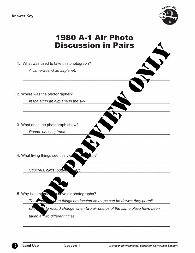
1980 A-1 Air Photo Discussion in Pairs
1. What was used to take this photograph?
_____________________________________________________________________
_____________________________________________________________________
2. Where was the photographer?
_____________________________________________________________________
_____________________________________________________________________
3. What does the photograph show?
_____________________________________________________________________
_____________________________________________________________________
4. What living things see this view of the earth?
_____________________________________________________________________
_____________________________________________________________________
5. Why is it important to have air photographs?
_____________________________________________________________________
_____________________________________________________________________
_____________________________________________________________________
_____________________________________________________________________
Name_______________________
For P
revie
w O
nly
�� Land Use Lesson 1 Michigan Environmental Education Curriculum Support
1980 A-1 Air Photo Discussion in Pairs
1. What was used to take this photograph?
_____________________________________________________________________
_____________________________________________________________________
2. Where was the photographer?
_____________________________________________________________________
_____________________________________________________________________
3. What does the photograph show?
_____________________________________________________________________
_____________________________________________________________________
4. What living things see this view of the earth?
_____________________________________________________________________
_____________________________________________________________________
5. Why is it important to have air photographs?
_____________________________________________________________________
_____________________________________________________________________
_____________________________________________________________________
_____________________________________________________________________
AnswerKey
Acamera(andanairplane).
Intheair/inanairplane/inthesky.
Roads,houses,trees.
Squirrels, birds, butterflies, etc.
Theyrecordwherethingsarelocatedsomapscanbedrawn;theypermit
scientiststorecordchangewhentwoairphotosofthesameplacehavebeen
takenattwodifferenttimes.For P
revie
w O
nly

Michigan Environmental Education Curriculum Support Lesson 1 Land Use ��
STU
DENT RESOURCE
Shelby Township, MI,1995 Air Photo
ShelbyTownship,MacombCounty,����,alongM-��
N
For P
revie
w O
nly

�� Land Use Lesson 1 Michigan Environmental Education Curriculum Support
ST
UDEN
T ACTIVITY
Name_______________________
1995 A-2 Air Photo Discussion in Pairs
1. Besides the title, how do you know they are both Shelby Township?
_______________________________________________________________________
_______________________________________________________________________
2. How are they the same?
_______________________________________________________________________
_______________________________________________________________________
3. How are they different?
_______________________________________________________________________
_______________________________________________________________________
4. Why did land use changes occur from the 1980 to 1995?
_______________________________________________________________________
_______________________________________________________________________
5. What caused these changes?
_______________________________________________________________________
_______________________________________________________________________
6. Do you think these changes are positive or negative? Why?
_______________________________________________________________________
_______________________________________________________________________
_______________________________________________________________________
_______________________________________________________________________
For P
revie
w O
nly

Michigan Environmental Education Curriculum Support Lesson 1 Land Use ��
1995 A-2 Air Photo Discussion in Pairs
1. Besides the title, how do you know they are both Shelby Township?
_______________________________________________________________________
_______________________________________________________________________
2. How are they the same?
_______________________________________________________________________
_______________________________________________________________________
3. How are they different?
_______________________________________________________________________
_______________________________________________________________________
4. Why did land use changes occur from the 1980 to 1995?
_______________________________________________________________________
_______________________________________________________________________
5. What caused these changes?
_______________________________________________________________________
_______________________________________________________________________
6. Do you think these changes are positive or negative? Why?
_______________________________________________________________________
_______________________________________________________________________
_______________________________________________________________________
_______________________________________________________________________
See CD for most recent air photo discussion page
AnswerKey
BothshowthesamefeaturesontheEarth’ssurfacesuchashighways,propertylines
andwaterbodies.
Streets/roadsarethesame;sameamountofland;samename;samelocation.
Therearemorehouses,buildings,waterbodies,morelandused,fewertrees,
andlooksmorelikeacityin1995.
Morepeoplecamein1995;therefore,morehouses,factories,andretailstores
wereneeded.
Morepeople,areabecamemorepopular.
Positive–peopleneededmorehousesandmorespace,theygrewmorehouseplants;
Negative–farmlandwaslost,treeswerechoppeddown,morepollution.For P
revie
w O
nly

�� Land Use Lesson 1 Michigan Environmental Education Curriculum Support
Source: Botti, W. (2004). GreenGold:MichiganForestHistory.Ann Arbor, MI: Michigan Forest Association. (Can be found on the MEECS Land Use CD.)
ST
UDEN
T ACTIVITY
Name_______________________
For P
revie
w O
nly