Embed Size (px)
Citation preview

MODULE - 2
121
Major Landforms and their Economic SignificanceChanging face of the
Earth
Notes
GEOGRAPHY
You have learnt in the previous lesson that the landforms found on the earth’ssurface are the result of interplay between internal and external forces. Thesoft rocks are easily worn down by these forces. While the relatively harderrocks are not so easily worn down. Therefore, rocks have a great influenceon the landforms developed in an area. The internal forces are perpetuallyelevating the earth’s surface and the external forces about which you willstudy in the next lessons are constantly wearing down such elevations tomake ,the surface level. This is how various landforms are formed by constantaction of agents of gradation. These landforms are not only the physicalfeatures of the earth’s surface but also the basis of human civilization. Themajor landforms found on the earth’s surface are mountains, plateaus andplains. In this lesson, we will study the major landforms of the earth andtheir economic importance for us.
OBJECTIVES
After studying this lesson you will be able to :
differentiate among the three major landforms found on the earth’ssurface;
explain the process of formation of various landforms with the help ofillustrations;
classify mountains on the basis of their mode of formation; discuss the usefulness of mountains to man; list different types of plateaus and describe their economic significance;
7
MAJOR LANDFORMS ANDTHEIR ECONOMIC
SIGNIFICANCE

MODULE - 2 Major Landforms and their Economic Significance
122
Notes
Changing face of theEarth
GEOGRAPHY
enumerate major types of plains and explain their influence on humanlife;
locate major mountains, plateaus and plains on the outline map of theworld.
7.1 MOUNTAINS
Mountain, plateau and plain are broad by present day land features of theearth’s surface produced by the deformation of its crust. Among them,mountains are the most awe-inspiring landform. About 27% of the earth’ssurface is covered by the mountains. Generally, they are uplifted portions ofthe earth’s surface which are much higher in contrast to the surroundingareas. But all uplifted or elevated areas are not mountains. In fact height andslope together give rise to a particular form of land which we identify as alandform. For example, the elevated portion in Tibet, which is about 4500metres high above sea level, is called a plateau and not a mountain.
It may also be remembered that the formation of a mountain range takesmillions of years. During these years, the internal forces of the earth upliftingthe land are fighting against erosion wearing it down. In order to form oneMt. Everest, internal forces must push up the land faster than the externalforces constantly eroding it. Therefore, mountains are those uplifted portionsof the earth’s surface which have steep slopes and small summit area risingmore than thousand metres above the sea level. Mountains have the maximumdifference of height between their high and low portions.
The uplifted portions of the earth’s surface with steep slopes andsmall summit area rising above 1000 metres and formed over a periodof million of years are called mountains.
7.2 CLASSIFICATION OF MOUNTAINS
On the basis of their mode of formation, the mountains have been classifiedas:
(a) Fold Mountains(b) Block Mountains(c) Volcanic Mountains(d) Residual Mountains
(a) Fold Mountains
We have studied in the last lesson how folds are formed in the rock strata bythe internal earth movements. Mountain range mainly consisting of upliftedfolded sedimentary rocks are called fold mountains. When these rocks aresubjected to horizontal compressional forces for millions of years, they get

MODULE - 2
123
Major Landforms and their Economic SignificanceChanging face of the
Earth
Notes
GEOGRAPHY
bent into up and down folds. This leads to the formation of anticlines andsynclines. Such earth movements occur from time to time and lift the foldsto a considerable height which result in the formation of fold mountains.
The mountains which have been formed by the uplift of mainlythe folded sedimentary rock strata under compressional forces arecalled fold mountains.
Fig. 7.1 Distribution of Important Fold Mountains of the World
The Himalayas in Asia, the Alps in Europe, the Rockies in North Americaand the Andes in South America are the most prominent fold mountains ofthe world, (See fig. 7.1). Since these mountain ranges were formed duringthe most recent mountain building period, they are known as young foldmountains. Some of these mountain ranges, for example, Himalayas, arestill rising.(b) Block MountainsBlock mountains are also formed by the internal earth movements. When theforces of tension act on the rocks, they create faults in them. When the landbetween the two almost parallel faults is raised above the adjoining areas, itforms a block mountain. It may also occur when land on the outer side of thefaults slips down leaving a raised block between them. The rocks composingthe fault levels may be flatlying or even folded. Block mountain is also calledhorst (see fig. 7.2). The Vosges in France, Black Forest Mountains in Germanyand Sierra Nevada in North America are the typical examples of blockmountains.
Fig. 7.2 Block Mountain or Horst

MODULE - 2 Major Landforms and their Economic Significance
124
Notes
Changing face of theEarth
GEOGRAPHY
The mountain formed by the uplift of land between faults or by thesubsidence of land outside the faults is known as block mountain.
(c) Volcanic Mountains
We have learnt in the previous lesson that the interior of the earth is extremelyhot. Due to high temperature deep inside the earth rocks turn into a moltenmagma. When this molten rock material is ejected to the earth’s surface duringvolcanic eruption, it accumulates around the vent and may take the form of acone. The height of the cone increases with each eruption and it takes theform of a mountain. As these mountains are formed by the accumulation ofvolcanic material, they are known as volcanic mountains or mountains ofaccumulation (see fig.7.3). Mount Mauna Loa in Hawaii Islands, Mount Popain Myanmar, Vesuvius in Italy, Cotopaxi in Equador and Fuji Yama in Japanare examples of volcanic mountains.
Fig. 7.3 Volcanic Mountains
The mountains formed by the accumulation of volcanic materialare called volcanic mountains or mountain of accumulation
(d) Residual Mountains
The weathering and different agents of erosion – rivers, winds, glaciers etc.are constantly acting on the earth’s crust. As soon as an elevated mountainrange appears on the earth’s surface, the agents of gradation begin their workof leveling it down. To a large extent, the process of wearing down dependson the shape and structure of the rocks. After thousands of years, soft rocksare worn down into sand and the hard rocks are left standing up in the areathat has been reduced in height. These are called residual mountains (fig.7.4).Hills like the Nilgiris, the Parasnath, the Rajmahal and the Aravalis in Indiaare examples of residual mountains.

MODULE - 2
125
Major Landforms and their Economic SignificanceChanging face of the
Earth
Notes
GEOGRAPHY
Fig. 7.4 Residual Mountains
The elevated regions that have escaped weathering and erosionand appear in the form of mountains are called residual mountains.
On the basis of their mode of formation, the mountains can beclassified as Fold Mountains, Block Mountains, VolcanicMountains and Residual Mountains.
7.3 THE ECONOMIC SIGNIFICANCE OF MOUNTAINS
Mountains are useful to us in the following ways :
(a) Storehouse of Resources
Mountains are the storehouse of natural resources. Large resources ofminerals are found in mountains. The Appalachian range in the UnitedStates is well-known for coal and limestone deposits. We get timber,lac, medicinal herbs and wood for making pulp from the forests of themountains. Tea and coffee plantations and some fruits orchards havebeen developed on mountain and hill slopes.
(b) Generation of Hydro-electricity
Hydro-electricity is generated from the waters of perennial rivers in themountain regions. The mountainous countries like Japan, Italy andSwitzerland, which suffer from the shortage of coal have developedhydro-electricity.
(c) Abundant Sources of Water
Perennial rivers rising in the snow fed or heavily rain fed mountains arethe important source of water. They help in promoting the irrigationand provide water for many other uses.
(d) Formation of Fertile Plains
The rivers that originate in the high mountain region bring silt alongwithwater to the lower valleys. This helps in the formation of fertile plains.

MODULE - 2 Major Landforms and their Economic Significance
126
Notes
Changing face of theEarth
GEOGRAPHY
The great alluvial plain of northern India has been formed by the riversGanga, Sutlej and the Brahmaputra.
(e) Natural Political Frontiers
The mountain ranges do act as natural political frontiers betweencountries and protect them from invasions to some extent. The Himalayahave formed a political frontier between India and China.
(f) Effect on Climate
Mountainous areas have lower temperatures. They serve as climaticdivide between two adjoining regions. The Himalaya for example forma barrier to the movement of cold winds from Central Asia towards theIndian subcontinent. They also force the South West Monsoons to ascendand cause rainfall on their southern slopes.
(g) Tourist Centres
The pleasant climate and the beautiful scenery of the mountains haveled to their development as centres of tourist attraction. The tourist andhotel industries get an additional encouragement in such regions. Shimla,Nainital, Mussorie and Srinagar are some of the important hill stationsof India which attract tourists all over the world.
INTEXT QUESTIONS 7.1
1. Name the three major landforms found on the earth’s surface.
(i)_______________ (ii)_________________ iii) _______________2. Answer in brief
(a) From which rock type have the fold mountains been formed?____________________________________________________
(b) By which forces are the fold mountains formed?____________________________________________________
(c) Name the four important hill stations of India.(i) _______________________ (ii)_____________________(iii) ______________________ (iv) _____________________
3. Write the type of mountain in the brackets:(a) The Black forest ( )(b) The Nilgiris ( )(c) The Fuji Yama ( )
(d) The Andes ( )
MODULE - 2
127
Major Landforms and their Economic SignificanceChanging face of the
Earth
Notes
GEOGRAPHY
7.4 PLATEAUS
The plateaus cover about 18% of the earth’s surface. This landform has alarge elevated area on its top unlike a mountain and has nearly even surfaceout there.Very often rivers or streams cut out deep valleys and gorges in aplateau region. In place of its original smooth topography, it then changesinto a disected plateau. A plateau, however remains much higher above thesea level of the nearby areas. Though normally 600 metres above sea level,there are plateau of Tibet and Bolivia, more than 3600 metres above sealevel.
A plateau is an elevated area of more or less level land on its top. It has alarge area on its top and steep slope on its side.
7.5 CLASSIFICATION OF PLATEAUS
On the basis of their geographical location and structure of rocks, the plateauscan be classified as:(a) Intermontane Plateaus(b) Piedmont Plateaus(c) Continental Plateaus(a) Intermontane Plateau
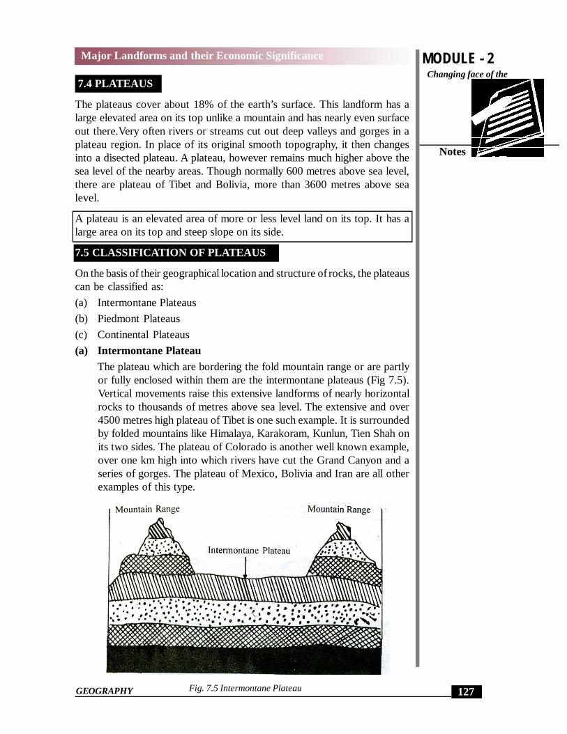
The plateau which are bordering the fold mountain range or are partlyor fully enclosed within them are the intermontane plateaus (Fig 7.5).Vertical movements raise this extensive landforms of nearly horizontalrocks to thousands of metres above sea level. The extensive and over4500 metres high plateau of Tibet is one such example. It is surroundedby folded mountains like Himalaya, Karakoram, Kunlun, Tien Shah onits two sides. The plateau of Colorado is another well known example,over one km high into which rivers have cut the Grand Canyon and aseries of gorges. The plateau of Mexico, Bolivia and Iran are all otherexamples of this type.
Fig. 7.5 Intermontane Plateau

MODULE - 2 Major Landforms and their Economic Significance
128
Notes
Changing face of theEarth
GEOGRAPHY
(b) Piedmont Plateau
The plateaus that are situated at the foot of the mountains and arebounded on other sides by a plain or an ocean are called piedmountplateau Fig. 7.6. The plateau of Malwa in India, those of Patagoniafacing the Atlantic ocean and the Appallachian situated between theAppalachian Mountain and the Atlantic Coastal Plain in U.S.A are theirexamples. In their case, the areas once high have now been reduced byvarious agents of erosion. For this reason, these are also called theplateaus of denudation.
Fig. 7.6 Piedmont Plateau
(c) Continental plateau
These are formed either by an extensive continental uplift or by thespread of horizontal basic lava sheets completely covering the originaltopography to a great depth. The volcanic lava covered plateau ofMaharashtra in India, Snake River Plateau in North West USA are theexamples of this type. These are also, called the ptateau of accumulation.
All continental plateaus show an abrupt elevation in contrast to thenearby lowland or the sea (fig.7.7). As compared to other, these plateaus,cover a vast area like the Great Indian Plateau and those of Arabia,Spain, Greenland, Africa and Australia. They may be tilted on one sidewithout any disturbance in the horizontal nature of underlying rock strataas in the case of Great Indian plateau.
Fig. 7.7 Continental Plateau

MODULE - 2
129
Major Landforms and their Economic SignificanceChanging face of the
Earth
Notes
GEOGRAPHY
The plateau which are bordering or are enclosed within high mountainranges are called intermontane plateau.
The plateaus formed by the uplift of large areas or by the gradual spreadand acumulation of basic lava sheets are called continental plateau.
The plateaus which are situated at the foot of mountains and arebounded by a plain or an ocean on the other side are called piedmontplateaus.
7.6 ECONOMIC SIGNIFICANCE OF PLATEAUS
Due to continuous erosion of their surface, we observe the prevalence of apatchy or the slow development of agriculture and building of roads on theplateaus. This factor also explains why the plateaus are sparsely populated.Nevertheless plateaus are extremely useful to mankind in the following ways:
(1) Storehouse of Minerals
Most of the minerals in the world are found in the plateaus. Besides, theextraction of minerals is relatively easier on plateaus. These minerals areindispensable as raw material for our industries. We get gold from the Plateauof Western Australia; copper, diamonds and gold from the Plateaus of Africaand coal, iron, manganese and mica from the Chota Nagpur Plateau in India.
(2) Generation of Hydel-power
Rivers falling down the edges of plateaus form water-falls. These water-falls provide ideal sites for generating hydel-power.
(3) Cool Climate.
The higher parts of the plateaus even in tropical and sub-tropical regionshave cool climate. Hence they have attracted Europeans to settle there anddevelop their economy e.g. South and East Africa.
(4) Useful for Animal-rearing and Agriculture
Plateaus have large grassland areas suitable for animal-rearing specially sheep,goat and cattle. They provide a veriety of products such as wool, milk, meatand hides and skin. The lava plateaus as compared to all other plateau arericher in agriculture since their soil is very fertile.
Plateaus are useful because of the presence and easier way of ex-tracting minerals and favouring generation of hydro-power. Theirsuitable climate and sometimes fertile soils are helpful for develop-ing animal-rearing and agriculture.
INTEXT QUESTIONS 7.2

MODULE - 2 Major Landforms and their Economic Significance
130
Notes
Changing face of theEarth
GEOGRAPHY
1. Answer briefly
(a) Name the three types of plateaus.
(i) ____________ (ii) ______________ (iii) _______________
(b) Name three natural resources for which plateaus are well known
(i) _____________ (ii) _______________ (iii) ________________
(c) Write against each of the following the type of plateaus to which itbelongs:
(i) The plateau of Patagonia _______________________________
(ii) The plateau of Bolivia ________________________________
(iii) The Decean plateau __________________________________
7.7 PLAINS
Plains are the most important landforms found on the earth’s surface. A low-lying relatively flat or slightly rolling land surface with very gentle slope andminimum local relief is called a plain. Plains occupy about 55% of the earth’ssurface. Most of the plains have been formed by the deposition of sedimentsbrought down by rivers. Besides rivers, some plains have also been formedby the action of wind, moving ice and tectonic activity. Plains have an averageheight of less than 200 metres.
A low-lying relatively flat or slightly rolling land surface with verygentle slope and minimum local relief is called a plain:
7.8 CLASSIFICATION OF PLAINS
On the basis of their mode of formation, plains can be classified into thefollowing types:
(a) Structural plains,
(b) Erosional plains and
(c) Depositional plains:
(a) Structural plains
These plains are mainly formed by the uplift of a part of the sea-floor orcontinental shelf. These are located on the borders of almost all themajor continents. The south eastern plain of the United States formed

MODULE - 2
131
Major Landforms and their Economic SignificanceChanging face of the
Earth
Notes
GEOGRAPHY
by the uplift of a part of the Gulf of Mexico is an example of this type ofplain. The structural plains may also be formed by the subsidence ofareas. One such plain is the central low-lands of Australia.
(b) Erosional Plains
These plains are formed by the continuous and a long time erosion ofall sorts of upland. The surface of such plains is hardly smooth. Theseare therefore also called peneplains which means almost a plain. TheCanadian shield and the West Siberian plain are examples of erosionalplains.
The plains formed by uplift or subsidence of an area are calledstructural plains.
The plains formed by the continuous long term erosion of uplandsare called erosional plains.
(c) Depositional plains
Fragments of soil, regolith, and bedrock that are removed from the parentrock mass are transported and deposited elsewhere to make on entirelydifferent set of surface features–the depositional landforms. When plains areformed by river deposits, they are called riverine or alluvial plains. The IndoGangetic plain of the Indian sub-continent, the Hwang-Ho Plain of NorthChina, the Lombardy Plain of the Po river in Italy and the Ganga-BrahmaputraDelta Plain in Bangladesh are examples of alluvial plains.
The deposition of sediments in a lake gives rise to a lacustrine plain or a lakeplain. The Valley of Kashmir and that of Manipur are examples of two mostprominent lacustrine plains in India.
When plains are formed by glacial deposits they are called glacial or driftplains. Plains of Canada and North-Western Europe are examples of glacialplains.
When wind is the major agent of deposition, they are called loess plains.Loess plains of North- Western China are formed by the deposits of loess-air-borne fine dust particles.
depositional plains are formed by the deposition of sediments broughtdown by rivers, glaciers and winds.
depositional plains are sub-divided into alluvial, lacustrine, glacialand loess plains.
7.9 ECONOMIC SIGNIFICANCE OF PLAINS

MODULE - 2 Major Landforms and their Economic Significance
132
Notes
Changing face of theEarth
GEOGRAPHY
The plains have influenced the human life in the following ways:
(1) Fertile Soil
The plains generally have deep and fertile soil. Since the plains have a flatsurface, the means of irrigation are easily developed. Both these factors havemade the plains agriculturally so important that they are often called ‘foodbaskets of the world’.
(2) Growth of Industries
The rich agricultural resources especially of alluvial plains have helped inthe growth of agrobased industries. This has given employment to millionsof people and has registered a marked increase in the national productionand per capita income. Since the plains are thickly populated, plenty of labouris available for the intensive cultivation and for supplying work force forindustries.
(3) Expansion of Means of Transport
Since the plains have an even surface it favours the building of roads, airportsand laying down of railway lines.
(4) Centres of civilization
The plains have been the centres of many modern and ancient civilizations.The major river valley civilizations of the world have flourished in the plainsonly. Hencs, they are aptly referred to as the cradles of civilization. Forexample, there are the civilization of the Indus and the Nile Valley.
(5) Setting-up of Cities and Towns
Easy means of transport on land, the growth of agriculture and industries inplains have resulted in the setting-up and expansion of cities and towns. Themost developed trade-centres and ports of the world are found in the plainsonly. Rome, Tokyo, Calcutta, Yangoon (Rangoon), Varanasi, Paris and otherfamous cities are situated in the plains. As much as 80% of the world’spopulation lives in the plains.
Plains are useful to man due to their fertile soils, growth ofindustries, development of transport, setting up of cities & townsand making them attractive as craddles of human civilisation.
INTEXT QUESTIONS 7.3
1. Answer briefly:
(a) Name the three major types of plains.
(i) _______________(ii) _______________(iii) _______________

MODULE - 2
133
Major Landforms and their Economic SignificanceChanging face of the
Earth
Notes
GEOGRAPHY
(b) To which category do the following plains belong?
(i) Lombardy Plain of Italy _________________
(ii) The Plain of North-Western China _______________
(iii) The Plain of Northern Canada _________________
2. Name two civilizations that flourished in the river valleys.
(i) __________________________(ii) _______________________.
3. Give two examples of lacustrine plains?
(i) ________________________ (ii)____________________________
WHAT YOU HAVE LEARNT
The major landforms found on the earth’s surface are the mountains, theplateaus and the plains. Besides the structure of rocks, the external and internalforces acting on the earth’s surface also play a significant role in thedevelopment of these landforms. The landforms on the earth’s surface haveinfluenced human life in different ways. Fertile plains have been formed bythe rivers originating in the mountains. These rivers are our perennial sourceof water for irrigation and other purposes. The plateaus are often describedas the storehouse of minerals. Many of our major industries are dependenton the constant supply of these minerals. Besides this, the density of populationis also influenced by the landforms. The plains including some of the valleyslocated in the mountain are teeming with people. Compared to the plains,the mountains and the plateaus have an uneven surface that is why they aregenerally sparsely populated.
TERMINAL QUESTIONS
1. Name the four types of mountains found in the world anddescribe the formation of each type.
2. Describe how plateaus are useful to man.
3. Why are the plains called ‘cradles of civilization’?
4. Describe the significance of mountains.
5. Distinguish between the following:
(i) The intermontane plateau and the continental plateau.
(ii) The block mountain and the volcanic mountain.

MODULE - 2 Major Landforms and their Economic Significance
134
Notes
Changing face of theEarth
GEOGRAPHY
(iii) The structural plain and the depositional plain.
6. Locate and label the following on the outline map of the world.
(a) Rockies and Alps mountain ranges;
(b) Patagonia and Tibetan plateaus;
(c) Central low land of Australia and Hwang-Ho plains.
ANSWER TO INTEXT QUESTIONS
7.1
1. (a) Mountain (b) Plateau (c) Plain
2. (a) Sedimentary rocks (b) Horizontal compressional force (c) (i) Shimla(ii) Nainital (iii) Mussorie (iv) Sri nagar.
3. (a) Block mountain (b) Residual mountain (c) Volcanic mountain (d)Fold mountain .
7.2
(a) (i) Intermontane plateau (ii) Piedmont plateau (iii) Continental plateau
(b) (i) Mineral resources, (ii) water & soils, (iii) grassland
(c) (i) Piedmont plateau (ii) Intermontane plateau (iii) continental plateau.
7.3
1. (a) (i) Structural, (ii) Erosional and (iii) Depositional
(b) (i) Alluvial plain, (ii) Loess plain and (iii) Erosional plain
2. (i) The Indus valley civilization (ii) The Nile valley
3. (i) Valley of Kashmir (ii) Manipur plain
HINTS TO TERMINAL QUESTIONS
1. See para 7.2 - classification of Mountains. Give examples of each typeof mountain and illustrate your answer with diagram.
2. See para 7.6
3. Expand on the following points-availability of fertile soil, developmentof means of transport, growth of industries, development of tradingcentre. Give examples of different civilization which flourished onplains.
4. See para 7.3.

MODULE - 2
135
Major Landforms and their Economic SignificanceChanging face of the
Earth
Notes
GEOGRAPHY
5. (i) See para 7.5 (a) and (c)
(ii) See para 7.2 (b) and (c)
(iii) See para 7.8 (a) and (c)
6. See Maps.


![IPOS08 - Clinical Significance of DSMIV Major, Minor & Subsyndromal Depression [June2008]](https://img.dokumen.tips/doc/110x75/54bee2794a79598e4b8b45a0/ipos08-clinical-significance-of-dsmiv-major-minor-subsyndromal-depression-june2008.jpg)