Embed Size (px)
Citation preview

1
MINING PLAN
WITH
PROGRESSIVE MINES CLOSURE PLAN
OF
GUJARAT MINOR MINERAL CONCESSION
(AMENDMENT) RULES, 2015
AMBLIYARA ORDINARY SAND, SURVEY NO. 580 ADJOING MAZUM RIVERBED,
TALUKA-BAYAD, DISTT-ARAVALLI, STATE-GUJARAT
AREA = 01.00.00 HACTER (NON FOREST)
PERIOD OF MINING PLAN -05 YEAR
(SUBMITTED UNDER RULE GMMCR,2015)
LESSEE
VINIDKUMAR BHOGILAL PANDYA
3460, VILLGE – DHALKUWA, TALUKA – KAPADAVANJ.
DISTRICT - KHEDA
-: PREPARED BY :-
PATEL JITUBHAI HATHIBHAI
504, ABHISHEK COMPLEX, OPP.HOTEL HAVELI,
SECTOR - 11, GANDHINAGAR, GUJARAT
RQP/UPD/379/2014/A,VALID UP TO : 16/11/2024

2
C O N T E N T S
CHAPTER HEADING PAGE
NO.
INTRODUCTION 3
1 GENERAL 4
2 LOCATION & ACCESIBILITY 5
3 DETAILS OF APPROVED MINING PLAN/SCHEME 6
PART - A
1 GEOLOGY & EXPLORATION 7 to 11
2 MINING 12 to 16
3 MINES DRAINAGE 17 to 18
4 STACKING OF MINERAL REJECTS/SUB GRADE MATERIAL
AND DISPOSAL OF WATES
19
5 USE OF MINERAL AND MINERAL REJECT 20
6 PROCESSING OF ROM AND MINERAL REJECT 21
7 OTHER 22
8 PROGRESSIVE MINES CLOSURE PLAN 23 to 29
PART - B
9 CERTIFICATE/UNDERTAKING/CONSENTS 30 to 31
10 LIST OF THE PLANS AND SECTION SUBMITTED 32
11 LIST OF DOCUMENTS ANNEXED 32
12 LEASE AREA PHOTO 33 to 34

3
I N T R O D U C T I O N
The Mining Plan of AmbliyaraOrdinary Sand deposit (Survey No. 580
AdjoingMazum Riverbed, area 01-00-00 Hect.) has been prepared on the request of Minerals
Ordinary Sand Village - Ambliyara, Taluka - Bayad,District - Aravalli, State Gujarat of
VinodkumarBhogilalPandya,3460, Village - Dhalkuwa, Taluka - Kapadwanj, District -
Kheda, State Gujarat.
The letter of intent is for mineral Ordinary Sand in Village - Ambliyara, Taluka -
Bayad, District - Aravalli, (Gujarat) in favor of Shri Patel JitubhaiHathibhai, 504,Abhisek
Complex, Opp.Hotel Haveli, Sector No.11, Gandhinagarby Gujarat Government.

4
1.0 GENERAL
a) Name of the lessee VinodkumarBhogilalPandya
Address 3460, Village - Dhalkuwa, Taluka -
Kapadwanj.
District Kheda
State Gujarat
Pin code 387620
Phone No
Fax No
Mobile No +91-9427389507
E-Mail Id No
b) Status of Lessee VinodkumarBhogilalPandya is
aIndividualAuthorised signatory.
Private Individual Government
Public limited Company -
Public Sector Undertaking -
Other (Please specify) Government
c)Mineral (s) which are including in the
prospecting license (for fresh grant)
Ordinary Sand
d)Mineral (s) which are included in the letter
of Intent/lease deed
Ordinary Sand
e)Minerals (s) which is the applicant / lessee
intends to mine
Ordinary Sand
f)Name & address of RQP under rule 22C of
MCR, 1970 or a person employed under
clause (c) of sub rule (1) of rule 42 of
MCDR, 1988 (Application for Mining Plan
Only) Preparing mining plan.
Patel JitubhaiHathibhai.
RQP/UPD/379/2014/A
Valid up to 16.11.2024 RQP Certificate
attached. Following two Key persons are
authorized prepare the mining plan.
Address :504, Abhisek Complex, Opp.Hotel
Haveli, Sector No.11, Gandhinagar.
Phone No
Fax No
Mobile No. +91-9909718109
E-Mail ID [email protected]
Registration No. RQP/UPD/379/2014/A
Date of grant / renewal Valid up to 16.11.2024

5
2.0 LOCATION AND ACCESSIBILITY.
a) Lease Details (Existing Mines)
Name of Mines Ambliyara OrdinarySand Mines
Lat/long of any boundary point Corner latitude and longitudes of lease area.
Sr. No. LATITUDE LONGITUDE
1 2567002.57 297997.56
Date of grant of lease The mining was executed which has been granted
was executed on 18.07.2014 for a period of 03
years.
Period/Expiry Date Mining lease will expire on 17.07.2017
Name of lease holder VinodkumarBhogilalPandya
Postal Address 3460, Village - Dhalkuwa, Taluka - Kapadwanj,
Telephone No
Fax No
Email ID No
Mobile No. +91-9427389507
b) Details of applied / lease area with location
map (Fresh area / Mines)
Forest Non-forest Non forest Government land
Forest (specify) Area (ha) NA
(i) Waste land 01-00-00 Hect.
(ii) Grazing land 0
(iii) Agriculture land 0
(iv) Others (Specify) -
Area (ha) 01-00-00 Hect.
Total lease area / applied area 01-00-00 Hect.
District & State Aravalli& Gujarat
Taluka Bayad
Village Ambliyara
Whether the area falls under Coastal Regulation
Zone (CRZ) ?
No, The Mines area does not fall under Coastal
regulation zone.
If yes, Details therefore -
Existence of public road/railway line, if any
nearby & approximate distance
Railway - Rakhiyal 14.65 km.
Airport - Ahmedabhad 50.00 km.
Highway - NH 69 01.30 km.
Toposheet No. with Latitude and Longitude of
all corner boundary point/pillar
Topo sheet No.45 E/14, 04 Boundary Pillar.
Sr. No. LATITUDE LONGITUDE
1 2567002.57 297997.56
2 2566999.46 298073.61
3 2566867.10 298067.34
4 2566869.89 297992.72
c) Location & Key plan attached? Yes
(Attach a general location map showing area
and access routes. It is preferred that the area be
marked on a Survey of India topographical map
or a cadastral map or forest map as the case
may be. However, if none of these are available,
the area may be shown on an administrative
map.)
It is attached Plate No.1
6
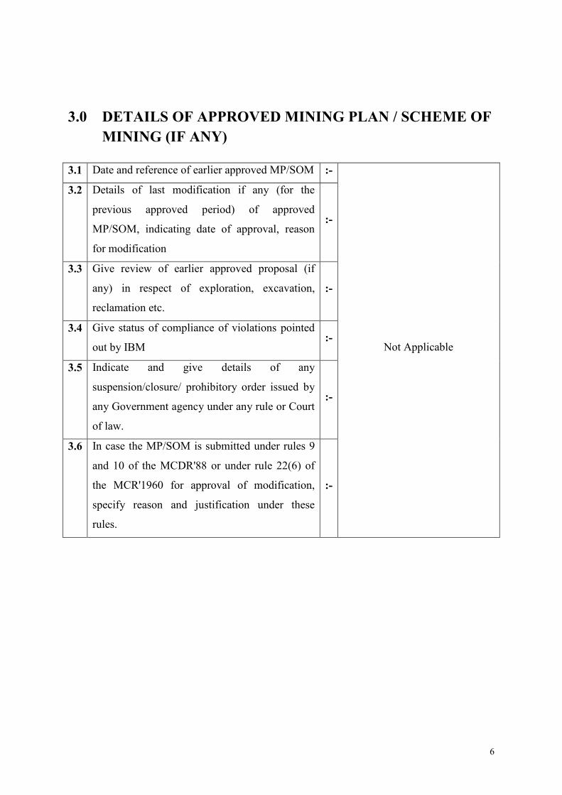
3.0 DETAILS OF APPROVED MINING PLAN / SCHEME OF
MINING (IF ANY)
3.1 Date and reference of earlier approved MP/SOM :-
Not Applicable
3.2 Details of last modification if any (for the
previous approved period) of approved
MP/SOM, indicating date of approval, reason
for modification
:-
3.3 Give review of earlier approved proposal (if
any) in respect of exploration, excavation,
reclamation etc.
:-
3.4 Give status of compliance of violations pointed
out by IBM :-
3.5 Indicate and give details of any
suspension/closure/ prohibitory order issued by
any Government agency under any rule or Court
of law.
:-
3.6 In case the MP/SOM is submitted under rules 9
and 10 of the MCDR'88 or under rule 22(6) of
the MCR'1960 for approval of modification,
specify reason and justification under these
rules.
:-

7
1.0 GEOLOGY AND EXPLORATION. (a) Brief description of the topography, general geology and local geology of the
Mineral deposit including drainage pattern.
Topography & Drainage pattern.
The Mines area falls in ToposheetNo.45E/14. The Ordinary Sand outcrops occur as massive
hillocks. The highest and lowest point of the applied area are70.60 and 68.28 meters
respectively. The area falls on the slope of the hill, with 20 degree average inclination towards
N-S.
The Mines is fully Government land, which is flat terrain.
River bed exists within the area, Rain water flows through river slope towards North to south,
during rainy season.
Vegetation
The area is in Aravalli which falls under arid climate. Consequently, it is characterized
bysandy plain, more of less barren of vegetation expect in rainy season when multitudes of
ephemeral come un and transform the bare land into a green carpet, These ephemeral
complete their life cycle before the advent of summer heat and bulk of the area is once more
transformed into open sandy and stony plane, desolate and barren.
In general the vegetation in arid region is sparse. Plants with xerophytes adaptation are able
to establish themselves. The bulk of vegetation at the study area consists of stunted, thorny or
prickly shrubs or perennial herbs capable of brought resistance, Distanly scattered trees of
stunted growth are found in this part of the country. Such vegetation is known as desert scrub.
The dominant tree species are Neem, Baval, Sagvan, Pipal, Mango, Banyan tree etc.
Climate conditions
The climate is moderate and temperature ranges from 35-370C during summer to about 12
0C
during winter. The average annual rainfall is 250 to 350 mm which received during monsoon
season from June to September. Predominant wind direction is NE-SW. Generally wind
blows with a velocity of 10-12 Km/hr in all seasons. Relative humidity varies from 37%.
(b) Brief description of Regional Geology with reference to location of lease/applied
area. Regional Geology:
The Aravalli District deriving its name from the river Sabarmati covers an area of
7390 Km2. The district has 13 talukas namely Khedbrahma, Vijaynagar, BayadBhiloda,
Malpur, Meghraj, Vadali, Talod, Dhansura and Bayad with a population of 1760 086
Physiographically, the district can be divided into two zones viz the hilly regions and the
plains. The hill ranges cover the northern topography are confined towards west and
southwest Sabarmati, the major river of the district, flows from north to south along the
western border of the district. The area is mainly drained by the southwesterly flowing rivers
namely the Hathmati the Khari the Meshwa the Majham and the Vatrak. The area is well
connected by State and national highways Ahmedabad-Bayad-Khedbrahmametregauge
railway line passes through the area. The district receives 69 cm of annual rainfall.

8
The rocks of the Aravalli Super group occupy mainly the eastern part of the district
and are represented by the Goran and the Samlaji Formations of the Jharol Group and Kadana
Formation of the Lunavada Group. These comprise highly foledphyllite chlorite-micaschist
quartzite garnetiferous mica schist. calc amphibolite schist feldspathic mica schist and
metasubgraywacke. At places serpentinite and talc-carbonate rocks of the Rakhabdev
ultramafic suite are seen. The northern part of the district is mainly occupied by the rocks
belonging to the KewaraandAntalia Formation of the Gogunda Group and Todgarh
Formation of the Kumbhalgarh Group of Delhi Super Group. They Comprise quartzite,
biotite schist, calc-biotite schist, phyllite, calc-gneiss, calc schist, marble and
biotitegnesis/mighmatite. The rocks belonging to the Aravalli and Delhi Super Groups are
strongly deformed under atlest three phases of deformation. The regional trend of beds and
foliations vary from NNE-SSW to NE-SE with steep dips on either sideEpidiorite,
hornblende schist, amphibolites, pyroxene granultre and gabbro of the phuladophiolite Suite
are found north of Songarh. The area in the north is intruded by the Sendra-Ambaji Granite
Godhra Granite (CA 995 Ma) is exposed in the eastern part where as in the central part.
Granite quartz porphyry, quartz vein and dolerite belonging to the Malani igneous suite (CA
740 Ma) are observed around Bayad conglomerate variegated sand stone shale claystone and
chert belonging to the Bayad Formation of Mesozoic age are found near BayadLameta
Formation consisting variegated clay, banded chart and limestone of upper Cretaceous age
are seen in the southerner and southeastern parts of the district Basaltic flows with associated
minor inter tripping horizons grouped under the Deccan Traps, are limited to the southern and
south western parts Matanomadh Formation, consisting of ferruginous sandy bed sandstone
clay late rite and conglomerate of Paleocene age are found exposed in the western part of the
district Rest of the area is occupied by the wind blow sands of the Akhaj Formation and
Younger flock plain and channel fill deposits of varahi Formation of Holocene soil types
developed over geomorphic units have been shown in map.
GEOLOGY:
The geological formations of Aravalli area are as follows.
Litho logy Formation Group Super group Age Flood plain and channel-fill
Deposit
Sand sheet and dune deposits
Ferruginous sandy bed, sanstone
Varahi Formation (FE)
Katpur Formation (FE)
Jantral Formation (AE)
Matanomadh Formation
Holocene
Palaeocene
Porphyritic and amygdular basalt
flow with interappean sediments
Deccan Traps Cretaceous to
Eocene
Variegated clay, banded chart
and limestone
Conglomerate, variegated
sandstone shale clay stone and
chart
Lameta Formation
Bayad Formation
Upper Cretaceous
Lower Cretaceous
Olivine delerite
Granite
Bayad Granite
Godhra Granite
Malani Igneous
Suite
Upper Proterozoic
Granite and leucogranite with
quartzofeldspathicvenis
Epidioritehornblends schist
amphibolite pyroxene granulite
and gabbro
Sendra- Ambaji Granite
PhuladOphiplite Suite
Middle
Proterozoic
A Calc-gneiss calc schist B calc-
gneiss impure marble C
calciticmarbel D biotite schist
calcbiotite schist E biotite gneiss
mighmatites
Todgarh Formation Kumbhalgarh
Group
Biotite schist calc biotite schist
and phyllite
A Quartzite and quart-sericite
schist B biotite schist and calc
Kelwara Formation
Antalia Formation
Gogunda Group
Delhi Super
group
Lower to middle
procterozoic

9
biotite schist
A mica schist and metasubgra
wacke B quartzite
Serpentinite and talc carbonate
rock
Kadana Formation
Rakhabdev Ultamafic
Suite
Lunavada Group
Intrusive
Aravalli Super
group
A Graniteferous mica schist B
quartzite C calc amphibiotite D
feldspathised mica schist
A phyllite chlorite mica schist
B quartzite
Samlaji Formation
Goran Formation
Jharol Group
Lower Proterozoic
(c) Detailed description of Geology of the lease area (Such as Shape and size of the
Mineral/Ore Deposit, disposition Various litho-units indicating structural
features if any etc.)
Brief Description of the area are as
Alluvium - Recent
Ordinary Sand - Recent
Ordinary Sand:-
- It is mainly used in the building construction, roads and walls etc.
(d) DETAILS OF LESSEE
(i) Name of Prospecting/exploration agency VinodkumarBhogilalPandya
(ii) Address 3460, Village - Dhalkuwa, Taluka - Kapadwanj,
(iii) E mail Address No (v) phone No. No (vi) Fax No Mobile No. +91-9427389507
(e) Details of the exploration already carried out.
The area is explored by digging within the area and can find out the thickness of
Ordinary Sand, quantity and quality of the Ordinary Sand.
(f) Surface Plans.
Surface plan of the area has been prepared on a scale of 1:1000 with 1 m Contour
interval (Please see plate No.2A)
(g) Geological Plans.
Geological plan of the area has been prepared on a scale of 1:1000 with 1 m Contour
interval (Please see plate No.2B).
(h) Geological Section.
A Geological section passing through the pits has been drawn on a scale of 1:1000
(horizontal) & 1:200 (vertical) (plate No.2B).

10
(i) Yearwise Future Program of Exploration.
No need of future program of exploration, because part of the area has been explored
up to a depth of 6m. Even though, when we will go to depth side we can find out the
quality and quantity of the Ordinary Sand position
(j) Reserves and Resources as per UNFC with respect to the threshold value notified
by IBM may be furnished in a tabular from as given below:
The quality of Ordinary Sand position is improved in the deep portion. So we calculate
the reserve of Ordinary Sand depends upon the position which may vary from level to
level & lateral wise. The occurrence of uniforms & massive reserves.As per Geological
Plan with section A’-A’’, B’-B’’ & C’-C’’.
Proved Reserves (111)
The proved reserves can be estimated taking 1m interval continuity around the pits i.e.
about 01-00-00sqm. & the depth is considered up to the 3m i.e. 3 m below the actual
depth of the because by drilling. It is proved that Ordinary Sand is continuing in depth
& quality is also improved.
= 10000 x 3 x 2.6
Total Proved Reserves = 78000 Tons
Probable Reserves (121 & 122)
An additional depth of 3m from the horizon of proved reserves have been taken under
probable reserves. The area of influence some change i.e. 01-00-00Sqm.
= 10000 x 3 x 2.6
Total Probable Reserves = 78000 Tons
Classification Code Quantity in tonnes Grade
Total Mineral Resources (A+B)
-
A. Mineral Reserve
1. Proved Mineral Reserves 111 78000
2. Probable Mineral Reserves 121 & 122 78000
B. Remaining Resources
1. Feasibility Mineral Reserves 211
2. Prefeasibility Mineral Reserves 221 & 222
3. Measured Mineral Reserves 331
4. Indicated Mineral Reserves 332
5. Inferred Mineral Reserves 333
6. Reconnaissance Mineral Reserves 334
(k) Furnish detailed calculation of reserves /resources section wise.
As Above.

11
(l) Mineral Reserves/Resources
Demonstrated Reserves
= proved
= 156000 MT
Mineral likely to be left under boundary barriers -
= 2896x6 x2.6
= 45178 MT.
Therefore Mineable Reserves of Ordinary Sand
= 156000 – 45178 MT.
= 110822 MT /26000 MT
As the mineral reserves estimated as per mining plan was based mainly on Open pit in mines
area and on geological consideration. The details of mineral reserves estimation as per UNFC
Guidelines has to be furnished with the justification of rewarding codes of Economic axis,
Feasibility axis and Geological axis under various categories. The reference to prescribed
threshold values of mineral is to be made for computation of reserves.
Classification Code Quantity in tonnes Grade
Total Mineral Resources (A+B)
-
A. Mineral Reserve
1. Proved Mineral Reserves 111 78000
2. Probable Mineral Reserves 121 & 122 78000
B. Remaining Resources
1. Feasibility Mineral Reserves 211
2. Prefeasibility Mineral Reserves 221 & 222
3. Measured Mineral Reserves 331
4. Indicated Mineral Reserves 332
5. Inferred Mineral Reserves 333
6. Reconnaissance Mineral Reserves 334
Total Reserves + Resources 156000
Life of mine
Life of mine at the planned rate of production at 26000 TPA Shall be 1 years (as per present
reserves)Life of the mines 4 years
Reserves estimated can be carried out based on exploration proposed.

12
2.0 MINING
A. OPEN CAST MINING
(a) Brief description of the existing as well as proposed method for excavation with
alldesign parameters indicating on plans / sections.
(i) Existing method for excavation: Design Parameters :
The deposit is in form of flat surface. So far of mining, Ordinary Sand exposed in
applied lease area, opencast is the only method which can be followed to work the
deposits.
The Mines plan is designed to use the existing natural parameter optimally for the
recovery of Ordinary Sand . The bench height has been kept at 5 meters to make it
convenient for easy handling of primary and for safety purpose
(ii) Proposed method for excavation design parameters :
No change in method of mining is proposed.
(b) Year wise tentative Excavation in m3 indicated development, ROM, pit wise as in
table below.
Inset Tentative Excavation
Year Pit No. Total
tentative
Excavation
(sqm)
Topsoil
(cum)
OB/SB/IB
(cum)
ROM (cum) Mineral
reject Ore
Ratio
(cum)
Mineral
reject
Ratio
(cum)
2016-17 - 2000 0 0 26000 -- --
2017-18 - 2000 0 0 26000
2018-19 - 2000 0 0 26000
2019-20 - 2000 0 0 26000
2020-21 - 2000 0 0 26000
Total 130000 -- --

13
Estimated available material (cum)
Dump
Identification/No
Year wise handling
(cum)
Estimated recovery of
saleable material (cum)
Reject (cum)
No dump existing
'A' Category Mines No
Individual year wise development plans and
sections showing pit layouts, dumps, stacks of
Mineral reject attached ?
No
'B' Category Mines Yes
Composite development plans showing pit
layouts, dumps, stacks of Mineral, reject, if any
etc. and year wise sections attached?
Yes
(c) Brief description giving salient features of the proposed method of working
indicating category of Mines.
It is proposed to adopt the semi-mechanized open cast method of mining by using
Excavator. As stated earlier the Ordinary Sand mining is entirely different from
conventional type of mining.
The Mining suggested is semi mechanized at present and subsequently based on
market it is planned to improvement to mechanized operations.
(d) Brief description of the layout of Mines working, pit road layout, the layout of
faces and sites for disposal of O/B, waste along with ground preparation prior to
disposal of waste, reject etc. A reference to the plans and sections may be given.
UPL or ultimate size of the pit is to be shown for identification of the suitable
dumping site.
Area is devoid of over burden so no Development works will be proposed. Bench
height will be 5m and targeted production will be 130000 tones per five year (with
Mineral reject) Details of year wise bench wise production is given in the tables
below.
First Year (2016-17)
During the first year the production from this applied lease area will be 26000tones.During
the first year entire production of Ordinary Sand.The likely positions of the benches, roads &
plantation etc. In this Mines are at the end of first year are shown in the plate no.3.
Surface area in Sq.m. Avg. Height of bench
in m
Volume in cu.m. Tonnage
2000 5.0 10000 26000
10000 26000
14
Second Year (2017-18)
During the Second year the production from this applied lease area will be 26000tones.
During the Second year entire production of The likely positions of the benches, roads &
plantation etc. In this Mines are at the end of first year are shown in the plate no 3.
Surface area in Sq.m. Avg. Height of bench
in m
Volume in cu.m. Tonnage
2000 5.0 10000 26000
10000 26000
Third Year (2018-19)
During the third year the production from this applied lease area will be 26000tones.During
the third year entire production of Ordinary Sand.The likely positions of the benches, roads &
plantation etc. In this Mines are at the end of first year are shown in the plate no 3.
Surface area in Sq.m. Avg. Height of bench
in m
Volume in cu.m. Tonnage
2000 5.0 10000 26000
10000 26000
Fourth Year (2019-20)
During the fourth year the production from this applied lease area will be 26000tones.During
the fourth year entire production of Ordinary Sand.The likely positions of the benches, roads
& plantation etc. In this Mines are at the end of first year are shown in the plate no.3.
Surface area in Sq.m. Avg. Height of bench
in m
Volume in cu.m. Tonnage
2000 5.0 10000 26000
10000 26000
Fifth Year (2020-21)
During the fifth year the production from this applied lease area will be 26000tones. During
the fifth year entire production of Ordinary Sand.The likely positions of the benches, roads &
plantation etc. In this Mines are at the end of first year are shown in the plate no 3.
Surface area in Sq.m. Avg. Height of bench
in m
Volume in cu.m. Tonnage
2000 5.0 10000 26000
10000 26000
(e) Conceptual Mines planning up to the end of lease period taking into consideration the
present available reserves and resources describing the excavation, recovery of ROM,
Disposal of waste, Backfilling of voids, reclamation and rehabilitation showing on a
plan with few relevant sections.

15
Exploration:
Massive deposit of Ordinary Sand occurs is in the form of a lose, having exposure of all
sides up to bottom of River bed. The huge quantity of material to sustain production more
than 4 years is visible under proved category. Therefore further exploration is not
required.
Mines development:
As such very nominal development work for proposed road making work will be required
to start production from this area. The proposed mining has been selected along strike
direction covering maximum width up to ultimate depth. Therefore, the development &
production plan have been described.
Optimum Exploitation and utilization of Mineral:
Ordinary SandMineral in the lease area has been excavated up to 7.5 m statutory barrier
all along the lease boundary with the restriction of mining width, under the present
scenario mining cannot proceed below 68.28mRL.
� Lessee should apply to DGMS for mining in 7.5 barrier.
� In the present pit design final pit slope is considered at 450. In the fifth year of mining the
present reserves are likely to exhaust, hence company can approach DGMS for steeper
final slope of the pit and recover the blocked Mineral to possible maximum limit.
Disposal of Waste
0% waste of ROM from Ordinary Sand will be generated during mining. Total 130000
tone&0 swelled waste will be generated. Initially during Mining Plan (1st to 5
th year)
waste will be dumped on ground level as shown in plate no.3.
During the proposed five years period year wise barbed wire fencing will be done around
the plantation area wire fencing will prevent any inadvertent entry.
Year Waste in cum
2016-17 --
2017-18 --
2018-19 --
2019-20 --
2020-21 --
Total --
Environmental Aspects:
Due to mining, envisaged land degradation will be in the form of open pit and area
covered will be about 0.7104 hectares out of 1.0000 hectares. By the end of life of
Mines0.2896ha.will be developed as green belt along the statutory barrier.
Machinery in use at the Mines will generate dust and noise and all preventive measures as
per consent to operate will be strictly implemented. Negative impact on land degradation
will be reduced by way of green belt along the lease boundary. Air pollution will be
controlled by way of providing fully automatic drilling machine from where continuous
supply of water during drilling flows down to suppress any dust generated during drilling.
Sprinkling of water over haul roads, loading and unloading points will be provided. Dust
masks will be provided to workers engaged in drilling and working in dusty environment.
No Mineral beneficiation is proposed hence, no water treatment is required. However any

16
water flowing from the Mines to outside will be circulated through the sumps and settlers,
so arrest any silt. Sumps and settlers will be periodically cleaned.
Regular Air, water and noise quality will be monitored as per the guide lines from SPCB.
� SPM level of 500 ug/m3in ambient air will be achieved. Standard of 600 ug/m
3 will be
applicable within 3-10 m of any equipment.
� Day time noise level shall be kept below 75d B A (Leq) and night time at 70 dB A
(Leq)
Other conditions as per consent operate will be followed
Plantation :
Plantation will be carried out along the lease boundary over 7.5 m statutory barrier
(0.2896 hectares) by the end of mining plan period.
Year wise plantation program for the mining planperiod is given below.
SN Site Area 16-17 17-18 18-19 19-20 20-21
1 Green
belt
along
statutory
barrier
0.2896
(25 No. of Plant)
25 28 28 28 28
Species to be planted:
Neem, Sagwan, Banyan, Pilu, Baval etc.
Expected rate of Survival : Expected rate of survival is anticipated at 80 %
Proper care maintenance will be done as proposed in the chapter on environment
management in the mining plan.
Post Mining land use:
The applied lease area at the end of mining when Mineral will be fully exhausted, will be
backfilled by waste from ROM generated during mining. However at the end of lease
period total plantation area will be 0.2896hectares.This will enhance the aesthetic beauty
of the area. This work should be taken up in consultation with Horticulturist and
landscape designers.
Reclamation &Rehabilitation:
At the end of mining plan period, about 1.0000 hectares area will be cover under mining.
Ordinary SandMineral will continue in strike for further mining. Thus no reclamation is
proposed at this plan period. The plantation will be done along lease boundary in next
five years. At the end of mining plan period total 0.2896 hectares area will be planted.
Backfilling has proposed in next five year plan period. Total 0tone of waste will be
generated from Ordinary Sand, total waste will be generated during plan period will be
dumped on the ground level.
(f) System of Drilling & Blasting
Not Applicable
(g) Under Ground Mining
Not Applicable

17
3.0 MINES DRAINAGE
(a) Minimum and maximum depth of water table based on observation from rear by
wells and water bodies.
Minimum depth of
water table
Maximum depth of
water table
Source Remark
50.75mRL 58.75mRL - -
(b) Indicate maximum and minimum depth of workings.
Year Maximum depth of working Minimum depth of working
2016-17 63.75mRL 68.75mRL
2017-18 63.75mRL 68.75mRL
2018-19 63.75mRL 68.75mRL
2019-20 63.75mRL 68.75mRL
2020-21 63.75mRL 68.75mRL
(c) Quantity and quality likely to be encountered, the pumping arrangements and
places where the Mines water is finally proposed to be discharged.
Year Quantity of
water likely to
be encountered
Quality of water likely
to be encountered
pumping
arrangements
Final place
of discharge
of Mines
water
Remark
Not applicable Ordinary Sand is non
toxic and hence no
chemical treatment of
Mines water is required.
Periodical quality
monitoring will be
carried out and reports
submitted to concerned
authorities.
Any excess water
will be pumped out
after passing
through settlers and
sump.
Used for
plantation
purpose.

18
Surface water Quality:
No mining activities shall be carried out during rainy season.
Though the pits are on ground level, there is always some accumulation of water
during rainy season in the pits. So it proposed to use 5 Hp diesel engine operated
pump rainy season to dewater the pits, as and used for plantation.
(d) Description of regional and local drainage pattern indicating annual rain fall,
catchments area, and likely quantity of rain water to flow through the lease area,
arrangement for arresting solid wash off etc.
The average annual rainfall is 250 to 350 mm which received during monsoon season
from June to September. There are no nalla exist within lease area.
Mazumriver is nearer to Mines site approximate 80m.

19
4.0 STACKING OF MINERAL REJECT / SUB
GRADE MATERIAL AND DISPOSAL OF WASTE
(a) Brief description of the nature and quantity of top soil, overburden/waste and
Mineral reject to be disposed off.
Initially in first year beck filling will be not possible because mining will be not reach
on ultimate depth.
(b) Location of proposed dumping ground within the lease area weather proved for
presence or absence of Mineral and be outside the UPL unless simultaneous back
filling is proposed or purely temporary dumping for a short period is proposed
in Mineralized area with technical constrains & justification.
None Area will be dumped.
(c) Note indicating the manner of disposal of waste, configuration and sequence of
year wise build up of dumps along with the proposals for protective measured.
Total 0 cum waste will be generated.

20
5.0 USE OF MINERAL AND MINERAL REJECT
(a) Brief description of the requirement of end use industry specifically in terms of
physical & chemical composition.
Ordinary sand is mainly used in the building construction, roads and walls. Ordinary
Sand is used in water harvesting, bore well, water filtration systems, landscaping
projects, custom concrete mixes, interlocks for good compaction, drainage to all
concrete projects, building roads in making concrete etc.
.
(b) Brief description of requirement of intermediate industry involved in up
gradation of Mineral before its end use.
The Ordinary Sand Ambliyara extracted from lease area will be directly used in next
five year.
(c) Details of requirements for other industries, captive consumption, export,
associated industrial use etc.
Ordinary Sandfind extensive use for Building Construction, Buildup road and other
major industries.
(d) Precise physical and chemical specification stipulated by buyers.
100% Of ROM will be produced. Therefore,100% ROM will be sold to buyers.
(e) Details of processes adopted to upgrade the ROM to suit the use requirements.
Ordinary Sandnot further processed after mining.

21
6.0 PROCESSING OF ROM AND MINERAL
REJECT
(a) If processing / beneficiation of the ROM of Mineral Reject is planned to be
conducted briefly description of nature of processing / beneficiation, indicating
size and grade of feed material and concentrate, recovery etc.
The Ordinary Sand is in the area produced in form of under grade etc. So any manual
will not be required.
(b) Material balance chart with a flow sheet of schematic diagram of the processing
producer indicating feed, product, recovery, and its grade at each stage of
processing.
No Generated waste during the mining Scheme period. 100% Rom will be sold out
(c) Disposal method for tailing or reject from the processing plant.
Not applicable
(d) Quantity and quality of tailing / rejecting proposed to be disposed, size and
capacity of tailing pond, toxic effect of such tailing , if any with process adopted
to neutralize any such effect before their disposal and dealing of excess water
from the tailing dam.
Not applicable
(e) Quantity and type of chemicals in any to be used in the processing plant.
Not applicable
(f) Specify quantity and type of chemicals to be stored on site / plant.
Not applicable
(g) Quantity (cum per day) of water required for mining and processing and sources
of supply of water, disposal of water and extent of recycling along with water
balance chart.
Not applicable

22
7.0 OTHERS
Brief description of the following:
(a) Site Services
The site Services i.e. workshop, power supply, water supply, office, store fuel storage,
first aid station, canteen etc. Have been provided outside lease area, close to the
Mines.
Other infrastructure facilities are provided at the mining site.
There is no proposal for closure of Mines in the next five years, hence no
decommissioning of infrastructure is proposed. Building will be dismantled and
reusable material sold of used elsewhere. Transmission line will be de-energized and
dismantled. No live electric supply line will be left.
(b) Employment potential:
(i) Workers:
As stated earlier will be done by semi mechanized opencast method with drilling. The
Mines will work for only one shift during day time from 8 a.m. to 5 p.m. with one
hour recess. Considering 300 working days in a year excavation shall be as follows :
Year Rom (in
tones)
ROM (In
cum)
Daily
excavation (In
cum)
*Proposed labors
First 26000 10000 26 5
Second 26000 10000 26 5
Third 26000 10000 26 5
Fourth 26000 10000 26 5
Fifth 26000 10000 26 5
Total 130000 50000 26 (Average) 5 (Average)
Out of the total 8 manpower to be engaged in the Mines, one man will be allocated for
proper care and maintenance of plantation, one for office work shall be employed.
One tractor driver with helper shall also employ. One for JCB operator & one drives
for tipper, thus total labors/workers shall be 8.
(ii) One drivers for tipper, thus total labors/workers shall be 8.
A provision is made for employment of following statutory personnel
Mines Manager under MMR’ 1970 - 1
Mining Engineer part time Under MCDR’ 1988 - 1
Mining Geologist part time under MCDR’ 1988 - 1

23
8.0 PROGRESSIVE MINES CLOSURE PLAN
UNDER RULE 3H OF GMMCR 2015
8.1 Environment Base Line Information:
Topography & Drainage
The Mines area falls in ToposheetNo.45E/14. The Ordinary Sand outcrops occur as
massive hillocks. The highest and lowest point of the applied area are 70.60 and 68.28
meters respectively. The area falls on the slope of the hill, with 20 degree average
inclination towards N-S.
The Mines is fully Government land, which is flat terrain.
River bed exists within the area, Rain water flows through river slope towards North
to south, during rainy season.
Existing Land use Pattern:
The lease area is a Government land of 580 AdjoingMazum Riverbed, which falls
under Ambliyara Village. No agriculture land exist the lease area. (Refer plate No.2A) Activity Present In Hec At the end of plan Period In
Hec
Mining 0.0 0.0
Pits/Activity
Mining Area
0.0 0.7104
Dumps 0.0 0.0
Haul Road 0.0 0.0
Infrastructure 0.0 0.0
Mineral Stock 0.0 0.0
Plantation 0.0 0.2896
Remaining virgin
area
01.0000 0.0
01.0000 01.0000
(i) Water regime
Surface and Ground Bodies :
S.No. Name of the water Body Date of Sampling Sampling Location
1 Mining Site - -
(ii) Quality of air
The entire area is very calm and quiet and free form air pollution. The quality of air
level appears to be within permissible limits (No Survey has been conducted for the
preparation of mining plan of small area). The source of pollution as regard air area
the surrounding small Mines which contribute mainly for the pollution.

24
(iii) Ambient noise level
The entire area is very calm and quiet and free from noise pollution. The quality of
ambient noise level appears to be within permissible limit (no survey has been
conducted for the preparation of mining plan of small area) the source of pollution as
regard noise area the surrounding small Mines which contribute mainly for the
pollution.
(iv) Flora and fauna
The area lies in Aravalli, which falls under arid climate. Consequently, it is
characterized by sandy plain, more of less barren of vegetation except in rainy season
when multitudes of ephemeral come up and transform the bare land into a green
carpet. These ephemeral complete their life cycle before the advent of summer heat
and bulk of the area is once more transformed into open sandy and stony plane,
desolate and barren.
In general the vegetation in arid region is sparse. Plants with xerophytes adaptation
are able to establish themselves. The bulk of vegetation at the study area consists of
stunted, Thorny of prickly shrubs of perennial herbs capable of drought resistance.
Distantly scattered trees of stunted growth are found in this part of the country. Such
vegetation is known as desert scrub. The dominant tree species are neem, Baval,
Sagvan, Pipal, Mango, Banyan tree etc.
The terrestrial fauna of the region mainly comprises of domestic animals and burrow
dwellers. During the study period no endangered of rare species was found within the
study area.
(v) Climatic conditions
The climate is moderate and temperature ranges from 35-370C during summer to
about 120C during winter. The average annual rainfall is 250 to 350 mm which
received during monsoon season from June to September. Predominant wind direction
is NE-SW. Generally wind blows with a velocity of 10-12 Km/hr in all seasons.
Relative humidity varies from 37%.
(vi) Human settlements
There is no village within the lease area. Lease area is situated in the revenue
boundary of Ambliyara,Ambliyara village is situated in north direction of the lease
area.
(vii) Public buildings, places of worship and monuments
Area is free from any public building and monuments. The lease area is free from sink
hole having any connection to any cave system and perennial river is far way from the
lease area as such not going to effect any way.
(viii) Weather any Sanctuary is located in the vicinity of lease hold?
No any Sanctuary is located in the vicinity of lease hold area.
8.2 Impact Assessment:
The Mining operation will have some impact on the existing environment, both
adverse and beneficial. Considering the nature and scale of operation, on the other
hand impact on socio-economic will be largely beneficial. The possible impacts are
enumerated below:

25
(i) Land Environment
At the end of five years, damage to the landscape in the form of pit & road etc., about
0.7104 hectares will be pit. The area influence of mining at the end of 5th
year & end
of the Mines life is given below:
Activity Present In Hec At the end of plan Period
In Hec
Mining 0.0 0.0
Pits/Activity Mining
Area
0.0 0.7104
Dumps 0.0 0.0
Haul Road 0.0 0.0
Infrastructure 0.0 0.0
Mineral Stock 0.0 0.0
Plantation 0.0 0.2896
Water Storage 0.0 0.0
Backfilled area 0.0 0.0
Remaining virgin
area
01.0000 0.0
01.0000 01.0000
(ii) Air Quality
Air quality gets affected due to mining, blasting and movement of earth moving
equipment etc.However, the impacts area localized and is not continuous. Overall
effect for mining of Ordinary Sand from this 1.0000hect. Area is insignificant. To
reduce such impacts measures will be adopted from the inception by spraying water
all along the haul road. Further a forestation all along the lease boundary and haul
road will arrest a major quantity of dust. In blasting use of delay/non electric system
will result reduction of vibration as well as dust.
(iii) Water Quality
The mining excavation of which will never touch the ground water table. Hence no
question of ground water pollution arises.
(iv) Noise levels
Operation of equipment will emit noise. To have control on noise level within 80 db
adherence to strict schedule maintenance, monitoring of noise will be carried out.
Blasting-Noise & Vibration during blasting is momentary but needs proper planning
to reduce the same.
(v) Water regime
Unaffected
(vii) Acid Mines drainage
This is not applicable to the Ordinary Sand area.

26
(vii) Surface subsidence
This is not applicable to the Ordinary Sand area.
(viii) Socio-economic environment
Mining in this lease area will gave more job opportunity to the local people
thus,Ordinary Sand mining will not create any adverse effect to the local people.
Ordinary Sand mining will not generate hazardous dust, which may cause health
problem to Mines workers. The nearest human settled village is Ambliyara which is
nearby from lease area. Thus mining will not have any impact on the village human
settlement.
(ix) Historical monuments etc.
No Historical monument lies within the core and 5 Km. buffer zone.
8.3 Progressive reclamation plan:
8.3.1 Mine out land
Description of the proposals to be implemented for reclamation and rehabilitation of
Mine out land including the manner in which the actual site of the pit will be restored
for future use, supported with yearly plans and section depicting yearly progress in the
activities for land restoration/reclamation/rehabilitation, a forestation etc., called
“Reclamation plan”
Land use pattern at present and at the end of plan period is given above:
Reclamation & Rehabilitation
At the end of mining plan period, about 0.7104 hectares area will be cover under
mining up to depth 334.5mRL. Ordinary SandMineral will continue is strike for
further mining after approved applet Authority. Thus no reclamation is proposed at
this exiting mining area. The plantation will be done along lease boundary in next five
year. At the end of mining plan period total 0.2896hectares area will be planted.
Plantation:
Plantation will be carried out along the lease boundary over 7.5 m statutory barrier
(0.2896 hectares) by the end of plan period.
Year wise plantation program for the mining plan period is given below:
Year No.of plants Area (in Hect.,) Survival Rate
2016-17 10 0.05792 50%
2017-18 10 0.05792 50%
2018-19 10 0.05792 50%
2019-20 10 0.05792 50%
2020-21 10 0.05792 50%
Total 0.2896
Expected rate of survival :Expected rate of survival is anticipated at 80%
Proper care maintenance will be done as proposed in the chapter on Environment
management in the mining plan.
27
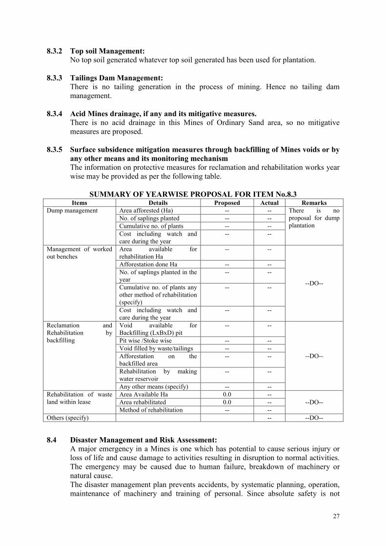
8.3.2 Top soil Management:
No top soil generated whatever top soil generated has been used for plantation.
8.3.3 Tailings Dam Management:
There is no tailing generation in the process of mining. Hence no tailing dam
management.
8.3.4 Acid Mines drainage, if any and its mitigative measures.
There is no acid drainage in this Mines of Ordinary Sand area, so no mitigative
measures are proposed.
8.3.5 Surface subsidence mitigation measures through backfilling of Mines voids or by
any other means and its monitoring mechanism
The information on protective measures for reclamation and rehabilitation works year
wise may be provided as per the following table.
SUMMARY OF YEARWISE PROPOSAL FOR ITEM No.8.3 Items Details Proposed Actual Remarks
Dump management Area afforested (Ha) -- -- There is no
proposal for dump
plantation No. of saplings planted -- --
Cumulative no. of plants -- --
Cost including watch and
care during the year
-- --
Management of worked
out benches
Area available for
rehabilitation Ha
-- --
--DO--
Afforestation done Ha -- --
No. of saplings planted in the
year
-- --
Cumulative no. of plants any
other method of rehabilitation
(specify)
-- --
Cost including watch and
care during the year
-- --
Reclamation and
Rehabilitation by
backfilling
Void available for
Backfilling (LxBxD) pit
-- --
--DO--
Pit wise /Stoke wise -- --
Void filled by waste/tailings -- --
Afforestation on the
backfilled area
-- --
Rehabilitation by making
water reservoir
-- --
Any other means (specify) -- --
Rehabilitation of waste
land within lease
Area Available Ha 0.0 --
--DO-- Area rehabilitated 0.0 --
Method of rehabilitation -- --
Others (specify) -- --DO--
8.4 Disaster Management and Risk Assessment:
A major emergency in a Mines is one which has potential to cause serious injury or
loss of life and cause damage to activities resulting in disruption to normal activities.
The emergency may be caused due to human failure, breakdown of machinery or
natural cause.
The disaster management plan prevents accidents, by systematic planning, operation,
maintenance of machinery and training of personal. Since absolute safety is not

28
achievable the essential part of hazard control is to be aimed at mitigating the effects
of all accident.
The measures include recognizing the possibilities of accidents, assessing
consequence, decide on steps to be implemented in case of emergency. The
emergency plan both offsite and onsite to be consistent with each other. The
objectives of emergency plan includes:
� To localize emergency and eliminate hazards
� To minimize the effects on people and property
� Elimination of hazards by local / supervisory personnel and minimizing effects
includes rendering first aid, evacuation, hospitalization, rehabilitation.
� To seek help from outside sources if required.
� Notice / information to authorities.
It is a hard rock area and as such no serious disaster is foreseen. However accidents
cannot be ruled out in the Mines. Following risks are anticipated:
� Failure of benches.
� Fall of machinery / person from benches.
� Failure of transport machinery.
� Heavy rainfall.
� Accidents due to blasting / explosive
� Accidents due to fire
The Onsite Emergency plan is already in place and will be followed strictly in case of
any emergency. If required help will be sought from district authorities and DGMS.
8.5 Care and maintenance during temporary discontinuance:
In case of any temporary discontinuance due to court order or due to statutory
requirement or any other unforeseen circumstance following measures for care and
maintenance and monitoring of status shall be taken.
• Notice of temporary discontinuance of work in Mines shall be given to the controller
General, Controller of Mines and the Regional controller of Mines, IBM and DGMS
officials under Rule 24 of MCDR 1988 and Reg.6 of MMR 1961 respectively.
• All the mining machinery shall be shifted to a safe place.
• Competent persons shall inspect the area regularly.
• Air, water and other environment monitoring shall be carried out.
• Care and upkeep of plantation shall be carried out on regular basis.
• Measures of care, maintenance and monitoring of status of unplanned, discontinued
mining operations shall be followed in case of any temporary discontinuance of
Mines.
• Entrance to Mines working shall be properly fenced as per the DGMS circular.
No temporary discontinuance is anticipated during the closure plan period.

29
8.6 Financial Assurance:
The lessee is required to submit the financial Assurance for the area to be put to use
for mining and allied activities at the end of Mining Plan period. Following table
shows the calculation as per the CCOM’s circular No. 4/2006.
S.
No
Item Area
put on
use at
Start of
plan
(Ha)
Additional
requirement
during plan
period (Ha) (B)
Total
(Ha) C
=
(A+B)
Area considered
as fully reclaimed
and rehabilitation
(Ha) (D)
Net area
considered
(Ha) E = (C-
D)
1 Area to be excavated 0 0.7104 0.7104 0 0.7104
2 Storage for topsoil 0 0 0 0 0
3 Overburden/dumps 0 0 0 0 0
4 Mineral storage 0 0 0 0 0
5 Infrastructure
(Workshop, Adm.
Building)
0 0 0 0 0
6 Haul Roads 0 0 0 0 0
7 Railways 0 0 0 0 0
8 Green belt 0 0.2896 0.2896 0 0.2896
9 Tailing pond 0 0 0 0 0
10 Effluent treatment
plan
0 0 0 0 0
11 Mineral separation
plan
0 0 0 0 0
12 Township area 0 0 0 0 0
13 Others (private land) 0 0 0 0 0
Total 0 1.0000 1.0000 0 1.0000
Proposed area to be put to use at the end of plan period is 1.0000 hectares. Financial
assurance for semi mechanized Mines is calculated at the rate of Rs.50,000/- per hectares for
area to be put to use. For 1.0000 hectares it works out to Rs. 50,000/- Butas per rule 3 (K)
GMMCR – 2015 minimum financial assurance for B category Mines is Rs.1,00,000/- FA in
the form of FDR will be submitted at the time of submission of five copies of the Mining
Plan.
Date :-
Place :-Gandhinagar.
(Patel JitubhaiHathibhai)
RQP/UPD/379/2014/A
Valid up to 16.11.2024

30
CONSENT LETTER / UNDERTAKING / CERTIFICATE
1. The Mining Plan in respect of Ambliyara Ordinary Sand mine, over an area of 1.0000 Ha
in Village -Ambliyara, Taluka–Bayad,District - Aravalli, State - Gujarat under rule
GMMCR(Amendment)-2015 has been prepared by JitubhaiHathibhai Patel, RQP.
This is to request the CGM, Gandhinagar to make further correspondence regarding any
correction of the Mining Plan with the said recognized person at his address below:
Mr. JitubhaiHathibhai Patel
RQP/UPD/379/2014/A(Valid up to 16.11.2024)
Office Address : 504, Abhisek Complex, Opp.Hotel Haveli, Sector No.11, Gandhinagar.
We hereby undertake that all modifications/updating as made in the said Mining Plan by
the said recognized person be deemed to have been made with our knowledge and shall
be acceptable to us and binding in all respects.
2. It is certified that CCOM circular no.2/2010 will be implemented and complied with
when an authorized agency is approved by the State Government.
3. It is certified that the Progressive Mine Closure Plan of Ambliyara Ordinary Sand mine,
over an area of 1.0000 Ha complies with all Statutory rules, regulations, Orders made by
the Central or State Government, Statutory organizations, Court etc., which have been
taken into consideration and wherever any specific permission is required, the lessee will
approach the concerned authorities. The information furnished in the Progressive Mine
Closure Plan is true and correct to the best of our knowledge and records.
4. The provisions of Mines Act, Rules and Regulations made there under have been
observed in the Mining Plan over an area of 1.0000 Ha in Village– Ambliyara, Taluka -
Bayad,District - Aravalli, State - Gujarat belonging to Ambliyara Ordinary Sand mine,
and where specific permissions are required, the lessee will approach the D.G.M.S
Further, standards prescribed by D.G.M.S in respect of Miner's health will be strictly
implemented.
Place :
Date :
(VinodkumarBhogilalPandya)
Village -Ambliyara, Taluka - Bayad,
District - Aravalli

31
CERTIFICATE FROM RQP
The Provision Of The Mineral Conservation and Development Rules 1988 Have Been
Observed In The Preparation Of Mining Plan Under rule GMMCR(Amendment)-2015 for
Ambliyara OrdinarySandMine Over an area of 1.0000 Ha, Village -Ambliyara, Taluka -
Bayad,District - Aravalli, Gujarat of VinodkumarBhogilal Pandya,3460, Village - Dhalkuwa,
Taluka - Kapadwanj,District - Kheda,Gujarat and Whenever Specific Permission are
Required, the Lessee Will approach the concerned authorities of Commissioner &
Commissioner ate of Geology and Mining, Gandhinagar, Gujarat.
The information furnished in the Mining Plan is true and Correct to the best of our
Knowledge.
Date :-
Place :-Gandhinagar.
(Patel JitubhaiHathibhai)
RQP/UPD/379/2014/A
Valid up to 16.11.2024

32
LIST OF PLATE
S.no. Plates Plate
No. Scale
1 Location &KeyPlan 1 1 : 1000
2 Surface Plan 2A 1 : 1000
3 Geological Plan& Sections 2B 1 : 1000
4 Five Years Development Plan and Section (2016-17 to 2020-
21)
3 1 : 1000
5 Conceptual Plan & Section 4 1 : 1000
6 Mine Layout & Section 5 1 : 1000
7 Environment Plan 6 1 : 5000
8 DILR Map 7 1 : 1000
L I S T O F DOCUMENTS ANNEXED
S.no. Annexure Annexure
no.
1 RQP Certificate 1
2 Photo ID with Address Proof 2
3 Letter of Intent 3
4 4

33
Lease Area Photograph
Photo - 1
Photo - 2

34
Photo - 3
Photo - 4