Embed Size (px)
Citation preview
Leica PRO600
The market-leading mapping
software for the Bentley
MicroStation V8 Generation
A state-of-
the-art
package for
3D feature
collection
and editing
Copyright © 2005 Leica Geosystems. All rights reserved. Powering Geospatial Imaging is a trademark, service mark and property of Leica Geosystems GIS & Mapping, LLC. Other brand and product names are the properties of their respective owners. Part No. PRO600 Flyer cc 4/05.
Information subject to change without notice.
Leica PRO600PRO600 is a highly sophisticated, function-rich and robust packagefor accurate three-dimensional stereo photogrammetric featureand digital terrain model (DTM) collection and editing.
Developed by Authorized Bentley Partner Leica Geosystems, PRO600provides a wealth of cartographic tools to maximize feature collectionand editing efficiency in photogrammetric production. PRO600operates entirely within the Bentley MicroStation V8 environment.
Key features include:
• High performance photogrammetric stereo viewing engine
• Sophisticated data collection and editing tools
• Easy-to-edit feature definition library
• Collection, editing and display of digital terrain models
• Flexible and easy-to-learn user interface
• Annotation and manuscript preparation tools
• Support for Leica TopoMouse™ and other 3D input devices
• Close integration with Leica Photogrammetry Suite (LPS)
• Also available for analog and analytical photogrammetric systems
PRO600 has become the system of choice for MicroStation users.
Feature collection and editing is central to photogrammetricproduction. For photogrammetry professionals, delivering geographic data to clients in a cost-effective, timely and consistentfashion is a top priority. Having the right software for featurecollection and editing is vital to success.
CAD-based systems have proven tremendously popular and playa leading role in modern photogrammetric production. The CADsystem preferred by many users in the photogrammetric communityis Bentley MicroStation. PRO600 from Leica Geosystems is themarket leader in the effective integration with MicroStation.
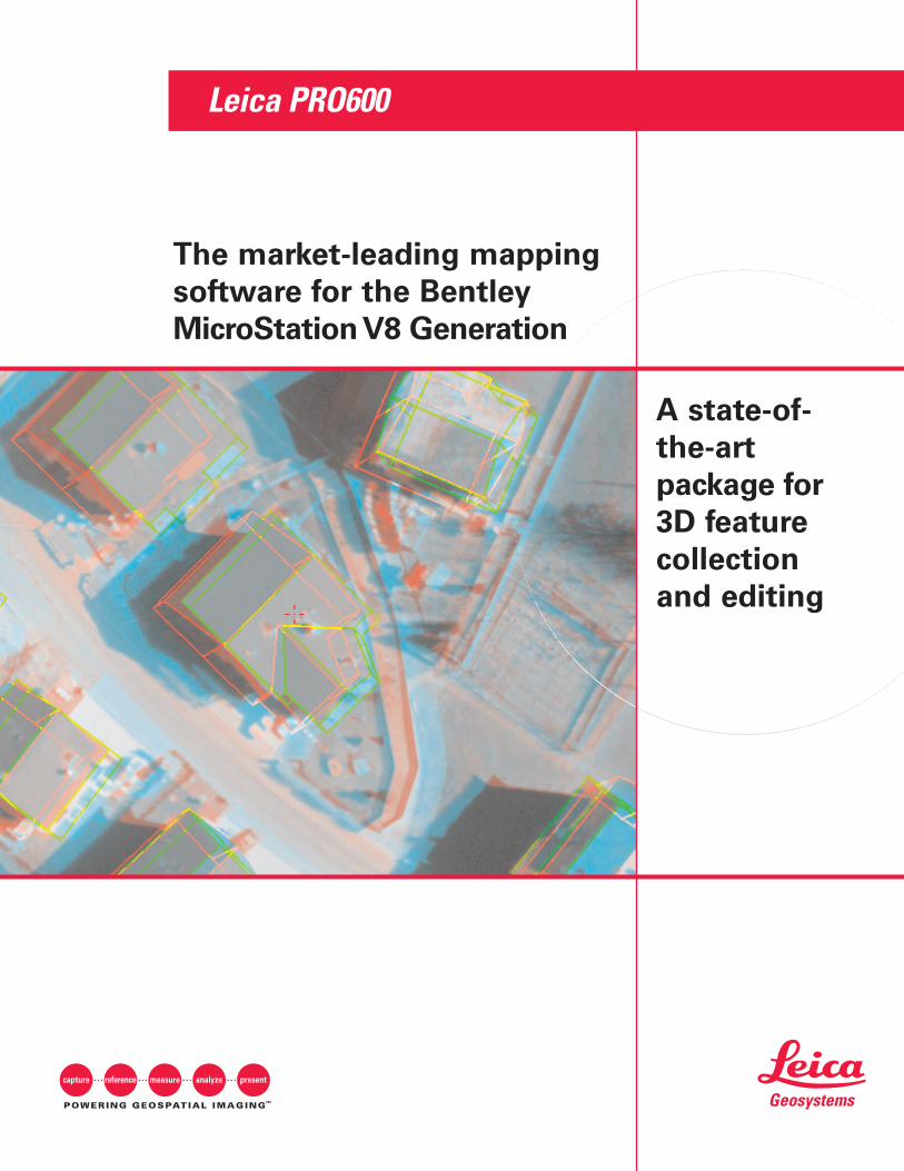
MicroStation design file graphics are displayed by PRO600 in full 3D stereo.
PRO600 offers powerful quality assurancetools to allow for checks on data integrity.
Parallel line generation rules are definedin the PRO600 feature definition library.
Copyright © 2005 Leica Geosystems. All rights reserved. Powering Geospatial Imaging is a trademark, service mark and property of Leica Geosystems GIS & Mapping, LLC. Other brand and product names are the properties of their respective owners. Part No. PRO600 Flyer cc 4/05.
Information subject to change without notice.
Benefits and Features
PRO600 integratesseamlessly into theMicroStation environment,making it an efficient andeasy-to-learn system forboth the novice andexperienced MicroStationuser alike.
This state-of-the-art systemalso features a host ofother benefits, including:
• High Productivity- Symbology settings stored in feature definition library- Choice of input accelerator devices for one-touch command activation- Fast switching between data collection modes- Sophisticated tools for building squaring and parallel line generation- Automatic snapping and feature intersection- Maintenance of topological relationships during data editing- Fast quality assurance tools for visual checks of data integrity
• Integration with Leica Photogrammetry Suite (LPS)- Real-time stereo image viewer with full-color graphics overlay- Support for various image types, including standard aerial frame
cameras and the Leica ADS40 Airborne Digital Sensor- Refinement of digital terrain models extracted automatically in LPS- User-definable buttons with the Leica TopoMouse
• Geographic Information Systems Interoperability- Provides stereo editing environment for MicroStation GeoGraphics- Oracle Spatial and ESRI Geodatabase access using Bentley ProjectWise- Data exchange with standard GIS formats using Bentley and other
third-party translators
• Compatibilitiy with Other MicroStation Solutions- Choice of domain-specific add-ons from Bentley and other
third parties- TerraSolid TerraModeler for advanced terrain modeling and analysis- Bentley GEOPAK and InRoads suites for civil engineering applications
• Full Compatibility Across Photogrammetric Systems- Versions for analog and analytical stereoplotters- Also available for BAE Systems SOCET SET- Minimal re-training for upgrading technology
• Customization Across Skill Levels- User-definable menus, icons and function keys- Create macros using Visual Basic for Applications (VBA)- Advanced applications using MDL and C/C++- Libraries provided for access to PRO600 functionality
For more information about PRO600 from Leica Geosystems, call +1 404 248 9000, toll free +1 877 463 7327.
Available Modules
PRO600 consists of several add-on modules to MicroStation.All modules may be used together as a fully integratedpackage, or in various combinations to create targetedsolutions for specific tasks.
PROCART
PROCART provides core cartographic functions for feature collection and editing. Its feature definition librarycombines with a variety of sophisticated tools to maximizeproductivity. These tools may be used in a 3D stereo pho-togrammetric environment or for “offline” 2D editing.Cartographic presentation tools include line patterning,polygon hatching, contour annotation and manuscript gridplacement.
PROLPS
PROLPS provides the link between MicroStation and theLPS Stereo module. MicroStation design file graphics arevisualized in full 3D using the LPS stereo viewer.Coordinate measurements in X, Y and Z provide input to theactive editing tool in MicroStation. PROLPS can be used toprovide a stereo editing environment for any MicroStationadd-on.
PRODTM
PRODTM provides a variety of tools that can be combinedto create productive workflows for terrain modeling applications. Terrain models can be generated by directmeasurement. Existing models may be edited and refinedusing the vector features in the MicroStation design file.PRODTM operates on all terrain file formats supported byLeica Photogrammetry Suite, and also serves as an interfaceto TerraModeler for advanced terrain analysis operations.
TerraModeler
This is a third party MicroStation add-on package fromTerraSolid Ltd, offering more sophisticated digital terrainmodel display and analysis for engineering and other appli-cations.
Leica Photogrammetry Suite
Leica Photogrammetry Suite (LPS) is a versatile softwareproduct for digital photogrammetric workstations, providingaccurate, production-oriented photogrammetric tools for abroad range of geospatial imaging applications. It allowsusers to work with imagery from a wide variety of sourcesand formats including black and white, color or multispec-tral, with up to 16 bits per band. LPS also generates thewhole range of deliverables photogrammetrists demand,from raw imagery to line-of-sight analyses.
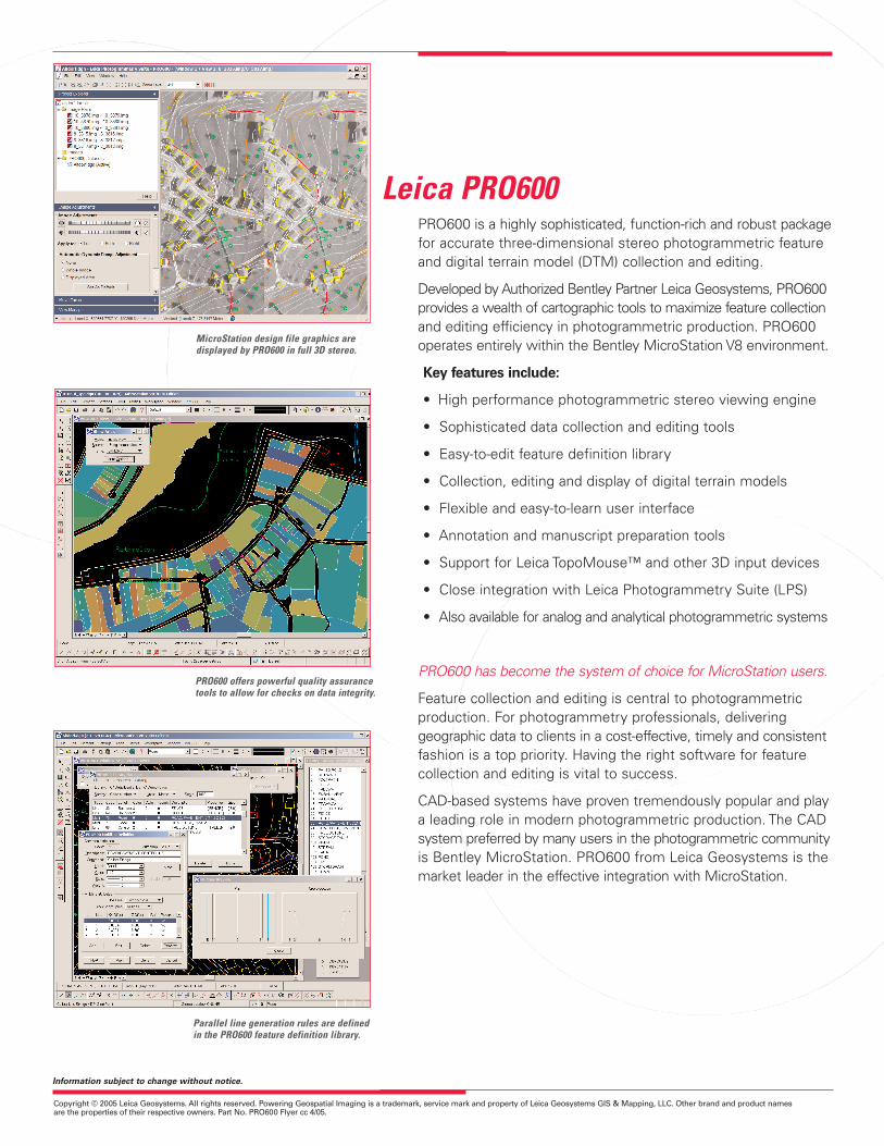
PRO600 provides tools that aid the extractionof 3D building models from imagery.