Embed Size (px)
Citation preview
Legislative Plan – House and Senate Districts September 20, 2021
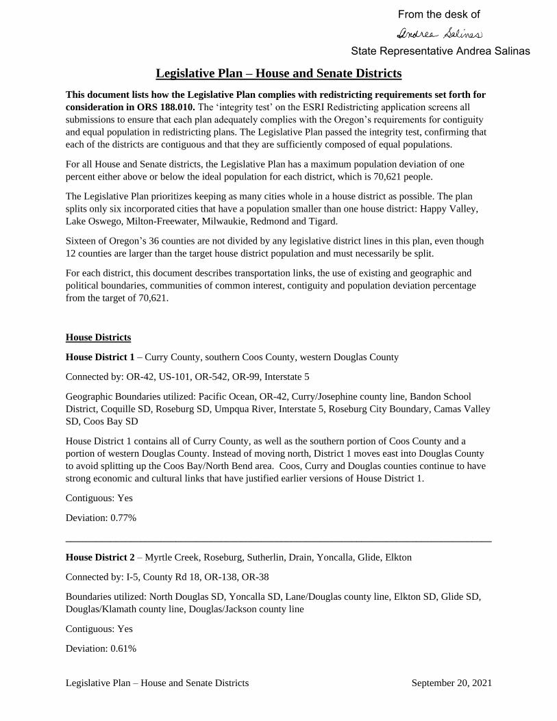
Legislative Plan – House and Senate Districts
This document lists how the Legislative Plan complies with redistricting requirements set forth for
consideration in ORS 188.010. The ‘integrity test’ on the ESRI Redistricting application screens all
submissions to ensure that each plan adequately complies with the Oregon’s requirements for contiguity
and equal population in redistricting plans. The Legislative Plan passed the integrity test, confirming that
each of the districts are contiguous and that they are sufficiently composed of equal populations.
For all House and Senate districts, the Legislative Plan has a maximum population deviation of one
percent either above or below the ideal population for each district, which is 70,621 people.
The Legislative Plan prioritizes keeping as many cities whole in a house district as possible. The plan
splits only six incorporated cities that have a population smaller than one house district: Happy Valley,
Lake Oswego, Milton-Freewater, Milwaukie, Redmond and Tigard.
Sixteen of Oregon’s 36 counties are not divided by any legislative district lines in this plan, even though
12 counties are larger than the target house district population and must necessarily be split.
For each district, this document describes transportation links, the use of existing and geographic and
political boundaries, communities of common interest, contiguity and population deviation percentage
from the target of 70,621.
House Districts
House District 1 – Curry County, southern Coos County, western Douglas County
Connected by: OR-42, US-101, OR-542, OR-99, Interstate 5
Geographic Boundaries utilized: Pacific Ocean, OR-42, Curry/Josephine county line, Bandon School
District, Coquille SD, Roseburg SD, Umpqua River, Interstate 5, Roseburg City Boundary, Camas Valley
SD, Coos Bay SD
House District 1 contains all of Curry County, as well as the southern portion of Coos County and a
portion of western Douglas County. Instead of moving north, District 1 moves east into Douglas County
to avoid splitting up the Coos Bay/North Bend area. Coos, Curry and Douglas counties continue to have
strong economic and cultural links that have justified earlier versions of House District 1.
Contiguous: Yes
Deviation: 0.77%
_____________________________________________________________________________________
House District 2 – Myrtle Creek, Roseburg, Sutherlin, Drain, Yoncalla, Glide, Elkton
Connected by: I-5, County Rd 18, OR-138, OR-38
Boundaries utilized: North Douglas SD, Yoncalla SD, Lane/Douglas county line, Elkton SD, Glide SD,
Douglas/Klamath county line, Douglas/Jackson county line
Contiguous: Yes
Deviation: 0.61%
State Representative Andrea Salinas
From the desk of

Legislative Plan – House and Senate Districts September 20, 2021
_____________________________________________________________________________________
House District 3 – Grants Pass, Redwood, Cave Junction, Takilma
Connected by: US-199, OR-99, OR-260, OR-238, OR-46
Boundaries utilized: Josephine/Curry county line, Josephine/Jackson county line, Grants Pass city
boundary, Rogue River, Grants Pass SD
Contiguous: Yes
Deviation: 0.07%
District 3 contains most of the cities and communities in Josephine County, including Grants Pass and
Cave Junction. The district now includes all of the Illinois Valley area along US-199. All of Josephine
County is reunited in Senate District 2.
_____________________________________________________________________________________
House District 4 – Central Point, Gold Hill, Rogue River, Merlin, Canyonville, Wimer, Tiller, Riddle
Connected by: I-5, OR-99, Evans Creek Rd, OR-234, OR-227, County Rd 39, County Rd 27, OR-238
Contiguous: Yes
Deviation: 0.7%
Boundaries utilized: Riddle School District, Central Point School District, Rogue River School District,
Central Point city boundary
House District 4 unites smaller communities in the Rogue Valley as well as in southern Douglas County
and northern Josephine County. Instead of splitting the cities of Medford or Grants Pass, HD 4 brings
together the communities of Central Point, Rogue River, Gold Hill, Merlin, Canyonville, Riddle, Wimer
and Tiller.
_____________________________________________________________________________________
House District 5 – Ashland, Talent, Phoenix, southern Medford, Jacksonville, Ruch, Applegate
Connected by I-5, OR-99, OR-238, OR-66
Boundaries Utilized: Jackson/Josephine county line, Jackson/Klamath county line, Ashland School
District, Pinehurst School District, Medford School District, Phoenix Talent School District, Medford city
boundary
Contiguous: Yes
Deviation: 0.85%
House District 5 contains the southern portion of the City of Medford that could not fit in House District
6, as well as many communities in southern Jackson County.
_____________________________________________________________________________________
House District 6 – Medford

Legislative Plan – House and Senate Districts September 20, 2021
Connected by I-5, OR-99, OR-62, city roads
Boundaries utilized: Medford city boundary
Contiguous: Yes
Deviation: 0.94%
House District 6 contains as much of the City of Medford as possible in a House District.
_____________________________________________________________________________________
House District 7 – Springfield
Connected by: I-5, OR-126, city roads, Lane Transit District
Boundaries utilized: McKenzie River, Middle Fork Willamette River, I-5
Contiguous: Yes
Deviation: 0.73%
House District 7 contains the entire City of Springfield and includes enough of the city’s vicinity to meet
the population target.
_____________________________________________________________________________________
House District 8 – south Eugene, University of Oregon
Connected by: city roads, I-105, I-5, OR-126, Lane Transit District
Boundaries utilized: Eugene School District, Bethel School District, South Lane School District, Creswell
School District
Contiguous: Yes
Deviation: 0.96%
House District 8 contains most of south Eugene and all of the University of Oregon main campus. This
district changed from previous versions and drafts in response to extensive public testimony that
expressed the desire for the entire university community to be contained within one house district as a
community of common interest.
_____________________________________________________________________________________
House District 9 – Charleston, Coos Bay, North Bend, Reedsport, Dunes City, Florence, Mapleton
Connected by: US-101, OR-38, OR-126, OR-540
Boundaries utilized: Siuslaw School District, Mapleton School District, Fern Ridge School District,
Elkton School District, Umpqua River, Coos Bay School District, North Bend School District, Reedsport
School District, Crow-Applegate-Lorane School District, Blachly School District, Florence city
boundary, Pacific Ocean

Legislative Plan – House and Senate Districts September 20, 2021
Contiguous: Yes
Deviation: -0.59%
Coos Bay and North Bend are kept together in District 9 and joined by Charleston, Reedsport and
Florence to maintain a south coast district. The district adds some population in the Fern Ridge and
Lorane areas to achieve the population target. These communities are connected to the rest of the district
through OR-126 and OR-36.
_____________________________________________________________________________________
House District 10 – Lincoln County; portions of west Lane County; portions of Benton County including
Philomath and Monroe
Connected by: US-101, US-20, OR-34, OR-229, OR-223, OR-99W, Territorial Hwy, OR-36
Boundaries Utilized: Blachly School District, Lincoln County School District, Alsea School District,
Willamette River, Philomath School District, Benton/Polk county line, Benton/Lincoln county line,
Lincoln/Tillamook county line, Pacific Ocean
Contiguous: Yes
Deviation: -0.61%
District 10 includes all of Lincoln County and adds much of Benton County and some of west Lane
County. Benton County and Lincoln County share many transportation links and intergovernmental
connections at the state level, and instead of dividing Tillamook County by going to the north or Florence
by going south, District 10 can find population by following US-20 and OR-34 into Philomath. In the
Lane County part of the district, the boundary moves to avoid splitting up the City of Florence and the
communities of Mapleton, Triangle Lake and Blachly, which are all in District 9.
_____________________________________________________________________________________
House District 11 – Lebanon, Sweet Home, Scio, Shedd, Halsey, Brownsville, Jefferson
Connected by: I-5, US-20, OR-34, OR-22, OR-126, OR-99E, OR-226
Boundaries utilized: Linn/Lane county line, Linn/Deschutes county line, Linn/Jefferson county line,
Linn/Marion county line, Willamette River/Benton/Linn county line, North Santiam River
Contiguous: Yes
Deviation: -0.8%
District 11 includes much of Linn County and its smaller cities. Lebanon and Sweet Home are the larger
cities in the district, while Brownsville, Halsey and Shedd are among the smaller communities included.
Instead of including some of the cities in the Santiam Canyon or in the Albany area, which are in separate
districts, District 11 includes the community of Jefferson in Marion County to achieve the population
target.
_____________________________________________________________________________________
House District 12 – eastern portion of Lane County, Dexter, Lowell, Cottage Grove, Creswell, Pleasant
Hill, Jasper, Leaburg, Blue River, Marcola, Coburg, Junction City, Cheshire, portion of southeast Eugene
Legislative Plan – House and Senate Districts September 20, 2021
Connected By I-5, OR-99, OR-58, OR-222, OR-126, E 30th Ave
Boundaries utilized: Lane/Linn county line, Lane/Deschutes county line, Lane/Douglas county line,
Creswell School District
Contiguous: Yes
Deviation: 0.91%
House District 12 includes smaller and rural communities in south and east Lane County, including
Cottage Grove, Creswell and Oakridge. The district also includes Junction City and Coburg in northern
Lane County, and a small portion of southeast Eugene to reach the population target.
_____________________________________________________________________________________
House District 13 – northern Eugene, Santa Clara and River Road areas
Connected by: I-5, OR-569 aka Beltline, US-105, OR-99, OR-126, city roads, Lane Transit District
Boundaries utilized: Willamette River, McKenzie River, I-5, Eugene city boundary
Contiguous: Yes
Deviation: -0.39%
District 13 includes north Eugene and nearly the entire neighborhoods of Santa Clara and River Road in
west Eugene. Public testimony identified these neighborhoods as communities of common interest, and as
a result they share one district.
_____________________________________________________________________________________
House District 14 – west and south Eugene, Bethel-Danebo, Elmira and Veneta
Connected by: Beltline Hwy, OR-99, River Road, OR-126, Territorial Hwy, city roads
Boundaries utilized: Eugene city boundary, Fern Ridge School District, OR-200, OR-99
Contiguous: Yes
Deviation: 0.62%
District 14 includes the Bethel-Danebo neighborhood, west Eugene, the Churchill neighborhood, and the
Industrial Corridor with Elmira and Veneta, which are connected via OR-126.
_____________________________________________________________________________________
House District 15 – Albany, Millersburg, Tangent
Connected by: I-5, OR-99E, US-20, city roads, OR-164
Boundaries utilized: Willamette River, Albany city boundary, Corvallis School District, Jefferson city
boundary, Benton/Linn county line
Contiguous: Yes
Deviation: 0.8%

Legislative Plan – House and Senate Districts September 20, 2021
House District 15 is designed to ensure that its boundaries did not divide a community of common
interest between Albany, Millersburg and Tangent. Public testimony identified that these three cities
should be included in a single house district because of their connections and the shared Greater Albany
Public School District.
_____________________________________________________________________________________
House District 16 – Corvallis, Lewisburg, Adair Village
Connected by: US-20, OR-99, city roads
Boundaries utilized: Willamette River, Albany city boundary, Corvallis School District, Corvallis city
boundary, Benton/Polk county boundary, Benton/Linn county boundary
Contiguous: Yes
Deviation: -0.08%
District 16 joins the City of Corvallis with communities that live in unincorporated areas in north Benton
County as well as the City of Adair Village. Corvallis and Philomath do enjoy strong connections;
however, District 10 uses the strong links between Lincoln County and Benton County and that district
needed Philomath to get to its population target.
____________________________________________________________________________________
House District 17 – east Marion County; Turner, Aumsville, Stayton, Sublimity, Lyons, Mehama, Gates,
Mill City, Detroit, Idanha, portions of eastern Salem
Connected by: OR-22, OR-214, I-5, Delaney Rd, Mill Creek Rd, Cordon Rd, Turner Rd, Aumsville Hwy
Boundaries utilized: Salem city boundary, Salem-Keizer School District, Cascade School District, North
Santiam School District, Santiam Canyon School District
Contiguous: Yes
Deviation: 0.26%
District 17 connects east Marion County communities, including Turner, Aumsville, Stayton, Sublimity
and communities in the Santiam Canyon that extend into north Linn County. The district follows OR-22
east to include Lyons, Mehama, Gates, Mill City, Detroit and Idanha. A portion of east Salem is included
to meet the population target.
_____________________________________________________________________________________
House District 18 – Silverton, Scotts Mills, Mount Angel, Hubbard, Aurora, Saint Paul, Butteville,
Barlow, Molalla
Connected by: OR-99E, OR-214, OR 211, OR-213, OR-219, Kropf Rd, Lone Elder Rd, Ehlen Rd
Boundaries utilized: Willamette River, St Paul School District, Woodburn city boundary, Marion/Yamhill
county line, Canby city boundary, Estacada School District
Contiguous: Yes
Deviation: 0.94%

Legislative Plan – House and Senate Districts September 20, 2021
_____________________________________________________________________________________
House District 19 – southeastern portion of Salem
Connected by: I-5, State Street, city roads, Cherriots Transit
Boundaries utilized: Salem city boundary, Salem N/S dividing line (State St), I-5
Contiguous: Yes
Deviation: 0.66%
District 19 includes a substantial area of south and southeast Salem, bounded by State Street to the north
and I-5 to the east. South Salem is shared by District 20 and is entirely united in Senate District 10. State
Street is a well-known dividing line in Salem, as addresses to the north are “N” or “NE,” while addresses
south of State Street are “S” or “SE.” It makes sense to use State Street as a house district boundary.
_____________________________________________________________________________________
House District 20 – Monmouth, Independence, West Salem, portion of south Salem
Connected by: OR-51, OR-22, OR-221, River Rd, city roads, Cherriots Transit
Boundaries utilized: Monmouth city boundary, Monmouth urban growth boundary, Independence city
boundary, Willamette River, Salem-Keizer School District, Marion/Polk county line, Salem city boundary
Contiguous: Yes
Deviation: 0.84%
District 20 keeps West Salem with south Salem as well as the nearby cities of Monmouth and
Independence. These communities are connected by the Center St Bridge, River Rd, Independence Hwy
and OR-22.
_____________________________________________________________________________________
House District 21 – Keizer, north and central Salem
Connected by: OR-99E, River Rd, Commercial St, Liberty St, Center St, Market St, Lancaster Rd, other
city roads, Cherriots Transit
Boundaries utilized: Willamette River, Keizer city boundary, Salem N-S dividing line (State St)
Contiguous: Yes
Deviation: 0.91%
Keizer and Salem share many connections as cities in the same metropolitan area, most notably the
Salem-Keizer School District. District 21 places Keizer with north and central Salem, using River Road,
Commercial Street, Market Street, Center Street and State Street as key transportation connections.
_____________________________________________________________________________________
House District 22 – Woodburn, Gervais, Brooks and Northeast Salem
Connected by: I-5, OR-99E, Portland Rd, OR-219, River Rd, Lancaster Rd, other city roads, Cherriots

Legislative Plan – House and Senate Districts September 20, 2021
Boundaries utilized: Willamette River, Woodburn city boundary, Gervais city boundary, Gervais School
District, Salem city boundary
Contiguous: Yes
Deviation: 0.53%
The House and Senate Redistricting Committees received extensive public testimony that defined the
Woodburn and northeast Salem areas as a strong economic and cultural community of common interest.
District 22 keeps this community in one district with the transportation links of I-5 and OR-99E.
_____________________________________________________________________________________
House District 23 – Polk and Yamhill counties, Dallas, Falls City, Rickreall, Dayton, Dundee, Newberg
Connected by: OR-99W, OR-18, OR-22, OR-223, OR-194, OR-47, OR-240, OR-221
Boundaries utilized: Polk/Benton county line, Polk/Lincoln county line, Polk/Linn county line, Polk/
Marion county line, Polk/Tillamook county line, Monmouth city boundary, Independence city boundary,
Salem city boundary, Willamette River, Newberg city boundary, Yamhill/Marion county line
Contiguous: Yes
Deviation: 0.83%
Public testimony strongly indicated that the existing District 23, created in 2011, broke up too many
counties and communities without strong transportation links. The new District 23 is composed of
communities in just two counties: Polk and Yamhill. The district includes Dallas, Falls City, and
Perrydale, then follows OR-221 to include Dayton, Dundee and Newberg.
_____________________________________________________________________________________
House District 24 – McMinnville, Yamhill, Carlton, Sheridan, Willamina, Grand Ronde
Connected by: OR-99W, OR-18, OR-47, city roads
Boundaries utilized: McMinnville city boundary, Lafayette city boundary, Willamette River, Newberg
city boundary, Dayton School District
Contiguous: Yes
Deviation: -0.42%
District 24 includes communities in Polk and Yamhill counties that are connected by OR-47, OR-18 and
OR-99W. The district brings together Yamhill, Carlton, Lafayette, McMinnville, Amity, Sheridan,
Willamina, Grand Ronde and the Confederated Tribes of Grand Ronde Reservation.
_____________________________________________________________________________________
House District 25 – Tigard, Metzger, South Beaverton
Connected by: Scholls Ferry Rd, I-5, OR-99W, Bull Mountain Rd, city roads, TriMet
Boundaries utilized: Tigard city boundary, Durham city boundary, Tualatin River,
Washington/Clackamas county line, Washington/Multnomah county line

Legislative Plan – House and Senate Districts September 20, 2021
Contiguous: Yes
Deviation: 0.87%
House District 25 includes most of the City of Tigard, as well as Metzger and part of south Beaverton.
Tigard is one of the incorporated cities that area split in the Legislative Plan that have a population
smaller than the size of a house district. Keeping Tigard entirely whole would have had substantial
impacts on population targets and likely would split cities in other house districts. Finding a way to
connect the new River Terrace neighborhood to the rest of Tigard is particularly challenging.
_____________________________________________________________________________________
House District 26 – Bull Mountain, King City, Sherwood, Wilsonville
Connected by: Roy Rogers Rd, Beef Bend Rd, OR-99W, SW 124th Ave, I-5, Tri-Met, SMART
Boundaries utilized: Wilsonville city boundary, Clackamas/Marion county line, Washington/Yamhill
county line, Washington/Clackamas county line, Tualatin city boundary, Sherwood city boundary, King
City city boundary, Molalla River
Contiguous: Yes
Deviation: -0.89%
House District 26 keeps the cities of King City, Sherwood and Wilsonville in a single house district and
also now includes the Charbonneau community south of the Willamette River, which is a part of the City
of Wilsonville. The district also includes the unincorporated Bull Mountain community and the newly-
constructed River Terrace neighborhood of Tigard, which is connected to Bull Mountain, King City and
Sherwood through Roy Rogers Rd and Beef Bend Rd.
_____________________________________________________________________________________
House District 27 – Central Beaverton, West Slope, Cedar Hills, Cedar Mill
Connected by: Scholls Ferry Rd (OR-210), Farmington Rd (OR-10), Murray Blvd, OR-217, Canyon Rd,
Walker Rd, city roads, Fanno Creek Greenway, TriMet
Boundaries utilized: Beaverton city boundary, Multnomah/Washington county line
Contiguous: Yes
Deviation: -0.45%
House District 27 includes neighborhoods in Beaverton as well as a large part of the unincorporated
Cedar Hills neighborhood and part of the unincorporated Cedar Mill area.
_____________________________________________________________________________________
House District 28 – Southwest Portland, Raleigh Hills, Garden Home, Portland State University
Connected by: US-26, I-405, I-5, Barbur Blvd, Broadway Dr, Beaverton Hillsdale Hwy (OR-10),
Vermont St, Multnomah Blvd, Taylors Ferry Rd, Scholls Ferry Rd (OR-210), TriMet, SW Trails
Boundaries utilized: Tigard city boundary, Beaverton city boundary, US-26, I-5
Contiguous: Yes

Legislative Plan – House and Senate Districts September 20, 2021
Deviation: -0.46%
District 28 includes communities southwest of downtown Portland, including many SW Portland
neighborhoods and the closely connected unincorporated Washington County communities of Raleigh
Hills and Garden Home. The district also includes Portland State University in downtown Portland.
_____________________________________________________________________________________
House District 29 – Forest Grove, Cornelius, Central and Western Hillsboro, Fern Hill
Connected by: OR-8, TriMet, OR-219, OR-47
Boundaries utilized: Hillsboro city boundary, Gaston city boundary, Washington/Yamhill county line
Contiguous: Yes
Deviation: -0.77%
District 29 maintains the connections between the western Washington County cities of Forest Grove,
Cornelius and Hillsboro along OR-8/Tualatin Valley Highway.
_____________________________________________________________________________________
House District 30 – North and East Hillsboro, Helvetia
Connected by: US-26, TriMet (Blue Line), SW 185th Ave, OR-8, city roads
Boundaries utilized: Hillsboro city boundary, Washington/Multnomah county line
Contiguous: Yes
Deviation: -0.15%
Rapid population growth in the Hillsboro area had the result of making the Hillsboro-area house districts
smaller geographically. The Committee considered including the North Plains community into House
District 30, but ultimately decided to include more of the City of Hillsboro and the Helvetia area instead.
_____________________________________________________________________________________
House District 31 – Columbia County, rural Washington County, rural Multnomah County, Rainier,
Columbia City, Saint Helens, Warren, Scappoose, Sauvie Island, North Plains, Banks, Gales Creek,
Gaston
Connected by: US-30, OR-47, US-26, OR-6, OR-8, Sauvie Island Bridge, OR-202, Stringtown Rd, Patton
Valley Rd
Boundaries utilized: Columbia River, Willamette River, Portland city boundary, Gaston city boundary,
Washington/Yamhill county line, Washington/Tillamook county line, Clatsop/Columbia county line,
Clatskanie city boundary
Contiguous: Yes
Deviation: 0.92%
District 31 includes almost all of Columbia County, as well as rural northwest Multnomah County and
western Washington County. Highway 47 connects Vernonia to Banks and around Forest Grove to

Legislative Plan – House and Senate Districts September 20, 2021
Gaston and the Patton Valley. North Plains is included in District 31 because it is outside the Portland
Metro urban growth boundary and shares strong transportation connections to other parts of District 31.
______________________________________________________________
House District 32 – Clatsop County, Tillamook County, Clatskanie
Connected by: OR-30, OR-101, OR-26, OR-6, OR-202, OR-53, OR-22
Boundaries utilized: Pacific Ocean, Tillamook/Lincoln county line, Tillamook/Polk county line,
Tillamook/Yamhill county line, Tillamook/Washington county line, Clatsop/Columbia county line,
Columbia River, Clatskanie city boundary
Contiguous: Yes
Deviation: 0.84%
House District 32 includes all of Tillamook and Clatsop Counties, as well as the City of Clatskanie in
Columbia County to achieve the population target. Clatskanie is connected to Clatsop County through
US-30.
_____________________________________________________________________________________
House District 33 – Northwest Portland, Northwest District, Pearl District, Old Town, Downtown, Goose
Hollow, Arlington Heights, Sylvan Highlands, Barnes Rd, Forest Park, Linnton, Cathedral Park
Connected by: US-26, US-30, I-405, Burnside Rd, Naito Parkway, Skyline Rd, city roads, Cornell Rd,
TriMet, St. Johns Bridge
Boundaries utilized: Willamette River, Washington/Multnomah county line, Portland city boundary,
Portland neighborhood boundaries, Multnomah Channel
Contiguous: Yes
Deviation: -0.15%
District 33 generally includes the northwest area of the City of Portland, as well as downtown and a
portion of North Portland. The Cathedral Park neighborhood is included in District 33 because of a need
to achieve the population target and is connected through the St. Johns Bridge.
_____________________________________________________________________________________
HD 34 – Bethany, Oak Hills, Cedar Mill
Connected by: US-26, Cornell Rd, McDaniel Rd. Thompson Rd, Bethany Blvd, Kaiser Rd, TriMet
Boundaries utilized: Washington/Multnomah county line, CPO 7 boundary
Contiguous: Yes
Deviation: -0.79%
Over the past decade, the Bethany community has rapidly developed and experienced rapid population
growth and new home construction. District 34 includes North Bethany with the rest of Bethany and
brings in the Bonny Slope area to reach the population target. The Washington/Multnomah county line is
crossed very often by residents in this area, and many of the area roads such as NW Thompson Rd weave

Legislative Plan – House and Senate Districts September 20, 2021
in and out between the two counties. This explains why District 34 includes a small portion of Forest
Heights in Portland and Multnomah County.
_____________________________________________________________________________________
HD 35 – Aloha, part of central Beaverton
Connected by: OR-8, OR-10, TriMet (Blue Line), Walker Rd, SW 185th Ave
Boundaries utilized: Beaverton city boundary, Hillsboro city boundary, Beaverton School District
Contiguous: Yes
Deviation: -0.66%
District 35 includes most of the unincorporated community of Aloha, as well as part of Central Beaverton.
These communities are closely connected through OR-8/Tualatin Valley Highway, Farmington Road, and
the TriMet light rail and bus systems.
_____________________________________________________________________________________
HD 36 – Southern Hillsboro, Western Beaverton, Cooper Mountain, Scholls and Farmington
Connected by: OR-8, OR-10, OR-210, OR-219, Roy Rogers Rd, city and county roads
Boundaries utilized: Washington/Yamhill county line, Hillsboro city boundary, Beaverton city boundary
Contiguous: Yes
Deviation: -0.71%
This district unites the rapidly growing communities near the edges of the Portland Metro urban growth
boundary (UGB). South Hillsboro and South Cooper Mountain have already experienced a substantial
amount of population growth and new home construction, which will continue throughout the next
decade. The district also includes the Scholls and Farmington areas, which are closely connected to
Hillsboro and Beaverton communities through Scholls Ferry Road, Farmington Road, and River Road.
_____________________________________________________________________________________
HD 37 – Tualatin, Rivergrove, Stafford, West Linn, Durham
Connected by: I-205, I-5, OR-43, Stafford Rd, SW 65th Ave, TriMet, city roads
Boundaries utilized: Tualatin River, Willamette River, Tualatin city boundary, Lake Oswego city
boundary, West Linn city boundary, Clackamas/Washington county line
Contiguous: Yes
Deviation: -0.89%
District 37 includes communities that are connected by the Tualatin River, the Willamette River, and I-
205. The smaller cities of Rivergrove and Durham are included in District 37 along with a small portion
of southwest Lake Oswego that could not fit in District 38, but is reunited with Lake Oswego in Senate
District 19.
_____________________________________________________________________________________

Legislative Plan – House and Senate Districts September 20, 2021
HD 38 – Lake Oswego, South and Southwest Portland
Connected by: I-5, OR-43, Boones Ferry Rd, Terwilliger Blvd, Kerr Pkwy, SW Trails
Boundaries utilized: Willamette River, Clackamas/Washington county line, Lake Oswego city boundary
Contiguous: Yes
Deviation: 0.13%
House District 38 includes most of the City of Lake Oswego, as well as portions of southwest and south
Portland. Lake Oswego is one of the four incorporated cities that are split in the Legislative Plan that have
a population smaller than the size of a house district. Keeping Lake Oswego whole would have had
substantial impacts on population targets and likely would split cities in other house districts.
_____________________________________________________________________________________
HD 39 – Happy Valley, unincorporated Milwaukie
Connected by: I-205, OR-212, 82nd/OR-213, OR-224, TriMet, 172nd
Boundaries utilized: Clackamas/Multnomah county line, Milwaukie city boundary, Happy Valley city
boundary, Gladstone city boundary, Oregon City city boundary, I-205
Contiguous: Yes
Deviation: 0.1%
House District 39 includes most of the City of Happy Valley, as well as portions of unincorporated
Clackamas County. Happy Valley is one of the incorporated cities that are split in the Legislative Plan
that have a population smaller than the size of a house district. Keeping Happy Valley whole would have
had substantial impacts on population targets and likely would split cities in other house districts.
_____________________________________________________________________________________
HD 40 – Oregon City, Gladstone, Johnson City, Jennings Lodge, Oatfield
Connected by: OR-99E, OR-213, I-205, TriMet
Boundaries utilized: Oregon City city boundary, Oregon City School District, Willamette River,
Gladstone city boundary, OR-213, I-205
Contiguous: Yes
Deviation: 0.8%
District 40 brings together southern parts of the Portland Metro urban area that are on the east side of the
Willamette River. Oregon City, Gladstone and Jennings Logde share strong transportation links along
OR-99E, while Oatfield and Johnson City are connected to the Oregon City area through I-205.
_____________________________________________________________________________________
HD 41 – Oak Grove, Milwaukie, Southeast Portland
Connected by: OR-99E, OR-224, city roads, TriMet (Orange Line)

Legislative Plan – House and Senate Districts September 20, 2021
Boundaries utilized: Willamette River, Milwaukie city boundary, Multnomah/Clackamas county line, city
neighborhood boundaries
Contiguous: Yes
Deviation: 0.01%
House District 41 includes most of the City of Milwaukie, as well as portions of southeast Portland and
unincorporated Clackamas County. Milwaukie is one of the incorporated cities that are split in the
Legislative Plan that have a population smaller than the size of a house district. Keeping Milwaukie
whole may have had substantial impacts on population targets and could have split cities in other house
districts.
_____________________________________________________________________________________
HD 42 – Southeast and Northeast Portland
Connected by: US-26, I-84, I-5, TriMet, Portland Streetcar, city roads
Boundaries utilized: Willamette River, city neighborhood boundaries (Kerns, Creston-Kenilworth,
Richmond)
Contiguous: Yes
Deviation: -0.87%
District 42 includes neighborhoods in the southeast area of Portland, as well as the Kerns and Laurelhurst
neighborhoods in northeast Portland.
_____________________________________________________________________________________
HD 43 – North and Northeast Portland
Connected by: I-5, I-84, city roads, TriMet (Blue/Red/Green lines), Portland Streetcar
Boundaries utilized: Willamette River, city neighborhood boundaries (Eliot, Boise, Woodlawn,
Concordia, Alameda)
Contiguous: Yes
Deviation: 0.19%
District 43 includes neighborhoods in the north and northeast area of Portland.
_____________________________________________________________________________________
HD 44 – North and Northeast Portland
Connected by: I-5, Columbia Blvd, US-30, city roads, TriMet (Yellow Line)
Boundaries utilized: Willamette River, Columbia River, city neighborhood boundaries
Contiguous: Yes
Deviation: 0.98%
District 44 includes neighbhorhoods in the north and northeast area of Portland.

Legislative Plan – House and Senate Districts September 20, 2021
_____________________________________________________________________________________
HD 45 – Northeast Portland, Maywood Park, Parkrose
Connected by: I-84, I-205, Marine Dr, Columbia Blvd, Sandy Blvd, NE 82nd Ave, TriMet, city roads
Boundaries utilized: Columbia River, Parkrose School District, I-84, I-205, city neighborhood boundaries
(Parkrose, Argay/Wilkes), NE Sandy Blvd
Contiguous: Yes
Deviation: -0.93%
District 45 includes neighborhoods in the northeast and southeast area of Portland, as well as Maywood
Park, a city that is surrounded by northeast Portland.
_____________________________________________________________________________________
HD 46 – Southeast Portland
Connected by: SE 82nd Ave, I-205, US-26, Foster Rd, Division St, TriMet
Boundaries utilized: Multnomah/Clackamas county line, city neighborhood boundaries (Brentwood-
Darlington, Lents, Foster-Powell, Mt. Tabor)
Contiguous: Yes
Deviation: -0.97%
House District 46 includes neighborhoods in the southeast area of Portland.
_____________________________________________________________________________________
HD 47 – East Portland
Connected by: I-205, I-84, Halsey St, Stark St, 122nd Ave, TriMet
Boundaries utilized: David Douglas School District boundary, city neighborhood boundaries (Parkrose
Heights, Russell, Hazelwood)
Contiguous: Yes
Deviation: -0.96%
House District 47 includes neighborhoods in east Portland between I-205 and Gresham, north of Division
St.
_____________________________________________________________________________________
HD 48 – Southeast Portland, Damascus, Boring
Connected by: US-26, 122nd Ave, Foster Rd, Tillstrom Rd, OR-212, 174th Ave, Division St, TriMet,
Springwater Corridor
Boundaries utilized: Centennial School District boundary, Multnomah/Clackamas county line, city
neighborhood associations (Pleasant Valley, Powellhurst-Gilbert)

Legislative Plan – House and Senate Districts September 20, 2021
Contiguous: Yes
Deviation: -0.81%
District 48 contains neighborhoods in southeast Portland as well as the Damascus and Boring area.
Instead of splitting up more of Happy Valley to include additional population, District 48 follows Foster
Rd, SE 172nd Ave, and Tillstrom Rd into the Damascus area, which recently disincorporated but remains
inside of the Portland Metro urban growth boundary. The district stops short of the Eagle Creek area to
allow that community to be connected to Sandy and other Clackamas County communities.
_____________________________________________________________________________________
HD 49 – East Multnomah County, including Fairview, Wood Village, Troutdale and northern Gresham
Connected by: I-84, Stark St, Halsey St, TriMet, city roads
Boundaries utilized: Columbia River, Sandy River, Troutdale city boundary, Gresham city boundary
Contiguous: Yes
Deviation: -0.26%
District 49 retains the communities of East Multnomah County, including the smaller cities of Wood
Village, Fairview and Troutdale and the north part of the bigger city of Gresham. Instead of using the
inconsistent western Gresham city boundary on the, th follows 160th Ave and 162nd Ave to provide a more
reliable marker.
_____________________________________________________________________________________
HD 50 – Gresham
Connected by: Burnside Rd, US-26/Powell, TriMet, city roads
Boundaries utilized: Gresham city boundary, Multnomah/Clackamas county line
Contiguous: Yes
Deviation: -0.29%
District 50 includes the majority of the City of Gresham, including the City Central neighborhood. The
district uses SE 174th Ave as its western boundary for consistency.
_____________________________________________________________________________________
HD 51 – Canby, Sandy, Estacada, Beavercreek, Redland, Springwater, Fischers Mill
Connected by: OR-223, OR-213, OR-211, Springwater Rd, Redland Rd, New Era Rd
Boundaries utilized, Oregon City city boundary, Sandy city boundary, Canby city boundary, Oregon Trail
School District, OR-211, Willamette River, Clackamas River
Contiguous: Yes
Deviation: 0.85%
District 51 contains Clackamas County communities that are outside the Portland Metro urban growth
boundary, such as the cities of Canby, Estacada, and Sandy. There are also many unincorporated

Legislative Plan – House and Senate Districts September 20, 2021
communities between these cities, such as Beavercreek, Redland, Fischers Mill, Eagle Creek and
Springwater. Public testimony during the Legislative Session identified rural Clackamas County as a
community of common interest, and District 51 brings together these communities in a single district.
_____________________________________________________________________________________
HD 52 – Hood River County; portions of Clackamas County including Cottrell and Mount Hood
Villages; portions of Multnomah County including Springdale, Corbett, eastern Gresham; and portions of
Wasco County including Mosier, The Dalles
Connected by: I-84, US-26, OR-35, US-30
Boundaries utilized: Columbia River, The Dalles city boundary, Sandy city boundary, Troutdale city
boundary, Oregon Trail School District, Hood River/Wasco county line, Sandy River
Contiguous: Yes
Deviation: -0.64%
The Legislative Redistricting Committees received extensive testimony that identified the Columbia
River Gorge as a community of common interest, particularly the area near Hood River County and The
Dalles. To avoid dividing this community of common interest, District 52 extends east along the
Columbia River and Interstate 84 to include Mosier and The Dalles. To achieve the population target, the
City of Sandy moves into District 51 where it shares connections with other Clackamas County
communities outside the Portland Metro area. Sandy is reunited with the greater Mount Hood region in
Senate District 26.
_____________________________________________________________________________________
HD 53 – Portion of Bend, Black Butte Ranch, Sisters, Tumalo and part of Redmond
Connected by: US-20, US-97, OR-126, city roads, Bend Transit
Boundaries utilized: Jefferson/Deschutes county line, Deschutes/Linn county line, Deschutes/Lane county
line, Cascades Range summit, Redmond School District boundary
Contiguous: Yes
Deviation: -0.34%
District 53 contains the north part of the City of Bend, which at a population of about 100,000 is too large
to fit within one house district. Sisters, Black Butte Ranch and Tumalo join this part of Bend due to their
shared county and strong transportation link along US-20. Bend is completely contained within Senate
District 27.
_____________________________________________________________________________________
HD 54 – Portion of Bend
Connected by: US-97, city roads, Bend Transit
Boundaries utilized: Bend city boundary
Contiguous: Yes

Legislative Plan – House and Senate Districts September 20, 2021
Deviation: -0.95%
The majority of the City of Bend is contained in District 54.
_____________________________________________________________________________________
HD 55 – Portions of Klamath County, including Chiloquin and Altamont; portions of Deschutes County
including La Pine and Sunriver.
Connected by: US-97, US-20, OR-126, Powell Butte Hwy, OR-27, OR-140, OR-380, Knott Rd, Millican
Rd, Sprague River Rd, Bliss Rd
Boundaries utilized: Bend city boundary, Klamath/Douglas county line, Klamath/Lane county line,
Deschutes/Lane county line, Prineville city boundary, Klamath Falls city boundary
Contiguous: Yes
Deviation: -0.83%
House District 55 connects Deschutes and Klamath Counties along US-97. The district contains most of
the southern portion of Deschutes County and the northern area of Klamath County. The district includes
the unincorporated Altamont community as well as Beatty and Bly. Instead of splitting a portion of the
City of Klamath Falls to be included in District 55, the district only includes unincorporated areas and
allows Klamath Falls to be wholly within District 56.
_____________________________________________________________________________________
HD 56 – Portions of Klamath County, including Klamath Falls; and portions of Jackson County,
including Shady Cove, Eagle Point, White City, Trail
Connected by: OR-140, US-97, OR-62, OR-227, OR-66, OR-39, OR-70, Keno Springs Rd, Gerber Rd,
Langell Valley Rd
Boundaries utilized: Klamath Falls city boundary, Medford city boundary, Klamath/Jackson county line,
Jackson/Douglas county line, Eagle Point School District boundary
Contiguous: Yes
Deviation: -0.34%
District 56 joins all of the City of Klamath Falls with other communities in southwestern Klamath County
and northeastern Jackson County. Klamath Falls is connected to communities to the west due to the
strong transportation links between Klamath and Jackson counties, especially OR-140, but also OR-62.
The structure of District 56 also allows for District 55 to stay entirely east of the Cascade Range summit.
_____________________________________________________________________________________
HD 57 – Confederated Tribes of Warm Springs Reservation; Sherman County; Gilliam County; Morrow
County; Wheeler County; portions of Wasco County including Dufur; and portions of Umatilla County
including Hermiston, Umatilla, Stanfield, Helix, Athena and part of Milton-Freewater
Connected by: I-84, I-82, US-395, US-26, US-30, OR-19, OR-74, US-730, OR-206

Legislative Plan – House and Senate Districts September 20, 2021
Boundaries utilized: Columbia River, Gilliam/Sherman county line, Wheeler/Jefferson county line,
Wheeler/Crook county line, Grant/Harney county line, Grant/Malheur county line, Morrow/Umatilla
county line, Milton-Freewater city boundary
Contiguous: Yes
Deviation: -0.57%
District 57 adds Wheeler County to achieve the population target.
_____________________________________________________________________________________
HD 58 – Wallowa County; Union County; Grant County; portions of Umatilla County, including Echo,
Pendleton, Weston, Adams, Pilot Rock, Ukiah
Connected by: I-84, US-395, OR-82, OR-3, OR-11
Boundaries utilized: Snake River, Umatilla/Morrow county line, Union/Baker county line,
Wallowa/Baker county line, Umatilla/Grant county line, Pendleton city boundary, Milton-Freewater city
boundary
Contiguous: Yes
Deviation: -0.83%
District 58 contains all of Wallowa County, all of Union County, and a major portion of Umatilla County.
___________________________________________________________________________________
HD 59 – portions of Jefferson County; portion of Deschutes County, including Terrebonne, Redmond;
and Crook County
Connected by: US-97, I-84, US-26
Boundaries utilized: Confederated Tribes of Warm Springs Reservation boundary, Wasco/Hood River
county line, Wasco/Clackamas county line, Jefferson/Marion county line, Jefferson/Linn county line,
Jefferson/Wheeler county line, Jefferson/Deschutes county line, Redmond city boundary
Contiguous: Yes
Deviation: -0.23%
District 59 includes communities along US-26, US-97 and US-197 in central Oregon. The district
includes most of Jefferson County outside of the Confederated Tribes of Warm Springs Reservation,
including Madras. The district also includes Terrebonne and part of Redmond in Deschutes County as
well as all of Crook County.
_____________________________________________________________________________________
HD 60 – Malheur County; Harney County; Baker County; Lake County; Grant County; portion of
Deschutes County.
Connected by: I-84, US-26, US-20, US-95, US-395, OR-31, OR-140

Legislative Plan – House and Senate Districts September 20, 2021
Boundaries utilized: Malheur/Grant county line, Harney/Grant county line, Prineville city boundary,
Lake/Deschutes county line, Lake/Klamath county line, Baker/Grant county line, Baker/Union county
line, Baker/Wallowa county line
Contiguous: Yes
Deviation: 0.83%
District 60 includes all of Baker County, Malheur County, Harney County, Lake County, and Grant
County with a small portion of Deschutes County that is in the Crook County School District. Public
testimony for this area indicated a preference for Grant County to be included in District 60, specifically
to join with Harney County in a district.

Legislative Plan – House and Senate Districts September 20, 2021
Senate Districts
Senate District 1: House District 1 and House District 2
Senate District 2: House District 3 and House District 4
Senate District 3: House District 5 and House District 6
Senate District 4: House District 7 and House District 8
Senate District 5: House District 9 and House District 10
Senate District 6: House District 11 and House District 12
Senate District 7: House District 13 and House District 14
Senate District 8: House District 15 and House District 16
Senate District 9: House District 17 and House District 18
Senate District 10: House District 19 and House District 20
Senate District 11: House District 21 and House District 22
Senate District 12: House District 23 and House District 24
Senate District 13: House District 25 and House District 26
Senate District 14: House District 27 and House District 28
Senate District 15: House District 29 and House District 30
Senate District 16: House District 31 and House District 32
Senate District 17: House District 33 and House District 34
Senate District 18: House District 35 and House District 36
Senate District 19: House District 37 and House District 38
Senate District 20: House District 39 and House District 40
Senate District 21: House District 41 and House District 42
Senate District 22: House District 43 and House District 44
Senate District 23: House District 45 and House District 46
Senate District 24: House District 47 and House District 48
Senate District 25: House District 49 and House District 50
Senate District 26: House District 51 and House District 52
Senate District 27: House District 53 and House District 54

Legislative Plan – House and Senate Districts September 20, 2021
Senate District 28: House District 55 and House District 56
Senate District 29: House District 57 and House District 58
Senate District 30: House District 59 and House District 60