Embed Size (px)
Citation preview

1 | P a g e
Legatus Group Road and Transport Infrastructure Advisory Committee
Friday 14 May 202110:00am – 12.00pm
Clare Council Chambers
Zoom:
https://us02web.zoom.us/j/81632929028?pwd=KzVZR0xKNDZOUWRUcGlKenZIU2p1dz09
Meeting ID: 816 3292 9028
Passcode: 228934
Agenda
Item Page
1 Welcome and apologies 2
2 Previous Minutes 2
3 Actions 6
4 Road Transport Plan
4.1 Road Deficiency Action Plan
4.2 2021/2022 SLRP Priorities
4.3 Data collection (and data storage tools) to validate Socio-
economic Impact Study
6
24
26
5 General items
5.1 Legatus Group Business Plan 21/22
5.2 Advocacy
5.3 Feedback from roads Forum 2021
5.4 Proposed webinar and forums
5.5 Silica in Rubble
5.6 DIT Progress and upcoming programs
5.7 LGA relevant notices
5.8 RAVRAT modifications
5.9 DIT last mile projects
5.10 Other grant funding opportunities
5.11 Infrastructure Australia Survey
5.12 SA Freight Council Forum
5.13 Road Safety Week (May)
27
28
29
35
35
36
36
37
39
46
47
47
48
6 Other Business 48
7 Next meeting details 48

2
1. Welcome and apologies
2. Minutes of the committee meeting held 12 February 2021
Dr Helen Macdonald the Chair of the committee provided a report to the March 2021 Legatus
Group meeting which contained the notes of their meeting held 12 February 2021.
The Legatus Group noted the report and reappointed Dr Helen Macdonald as Chair to the Legatus
Road and Transport Infrastructure Advisory Committee for a further 2-year term.
Legatus Group Road and Transport Infrastructure Advisory Committee
Friday 12 February 2021Clare and Gilbert Valleys Council Chamber and Zoom
Unconfirmed Minutes
1. Welcome and attendance
The meeting was opened at 10:30am by Chair Dr Helen Macdonald
In person:
Committee members: Dr Helen Macdonald (Clare and Gilbert Valley), Steven Kaesler (Barossa),
Michael McCauley (Yorke Peninsula), Dylan Strong (Orroroo-Carrieton), Kelly-Anne Saffin (RDA
YMN from 10.55am), Mitchell Foote (Flinders Ranges)
Others: Simon Millcock, Moira Coffey (Legatus), Tim Neumann (Copper Coast)
Zoom:
Committee members: Tom Jones (Adelaide Plains), Mike Wilde (DPTI), Stuart Robert (Wakefield),
Others: Toni Clarke (LGASA Heavy Vehicle Access Liaison Officer)
Others: Tim Viner-Smith (HDS) for section 5.1.1 only
Apologies:
Lee Wallis (Goyder)
2. Minutes of the committee meeting held 18 November 2020 held via Zoom
The meeting noted that minutes of the meeting held on 18 November 2020 were presented to
the Legatus Group. The meeting resolved that the minutes were a true and accurate record of
the meeting.
Moved: Dylan Strong, Second: Michael McCauley CARRIED
3. Progress on actions from previous meetings
Moira provided a report on the actions and new actions are included into the table at the end of
the minutes.
Meeting Action Progress Comments
18/11/20 Meet with Lea Bacon on
whether the RAVRAT
project progresses
In progress Moira to provide feedback
on RAVRAT use and Toni
to discover NSW
adaptations
Toni is still awaiting info
so we can have another
meeting with Lea
18/11/20 Toni to provide briefing on
bridges pilot study

3
4. Items for decisions:
4.1 Committee
The meeting noted the first term for Dr Helen Macdonald was ending and Helen advised that she
would be happy to continue for a second term as per the terms of reference. The meeting
discussed maintaining the continuity of the progress of the Roads Advisory Committee and
supports the recommendation that Dr Helen Macdonald remains as a member of the committee
for another two-year term in the position of Chair. Dr Helen Macdonald accepted this nomination.
Motion: That the Committee recommends to the Legatus Group that Dr Helen Macdonald
continues for a two year on the Legatus Group Road and Transport Infrastructure Advisory
Committee and that she continues to Chair the Committee.
Moved: Dylan Strong, Second: Steve Kaesler CARRIED
In addition to the membership, the committee discussed ways to ensure that all the councils are
engaged and can provide feedback to the Roads Advisory Committee. The meeting discussed the
value of having 2-3 forums and an annual conference and working with neighbours on an as needs
basis rather than adding more events at this stage. The meeting suggested that having a common
person to channel the information through helps members. Mike and Toni added that it is valuable
to be able to present to this collective group of representatives.
The recommendation of the committee is to 1) Keep the standing committee as it is at the high
level; 2) Keep an annual conference and a few forums a year and 3) Create an invitation for the
unrepresented councils to attend committee meetings to raise the issues that are relevant for
them that aren’t being addressed and other items to be channelled via LGA.
4.2 Bridges Renewal Program
The meeting discussed that the different councils have different positions with respect to their
strategy on addressing deficiencies with bridges/culverts (i.e.: some councils do not have a strategy
and others have a clear pipeline of works). Funding bridge assessments and project works is a
challenge for many councils and Kelly-Anne provided that industry matching was a successful
strategy in the Northern Areas that could be explored with other industry partners such as the
windfarms. Additionally, it was discussed that bridges are currently not in the scope of the Regional
Transport Plan. The recommendation of the committee is to support a RFQ (following a review
of the scope) for an assessment of bridges and culverts.
4.3 Objectives for 2021/22
The Legatus Group Strategic Plan Review workshop will be held on the 5th March 2021. The draft
discussion paper for this planning day is noted.
The key discussion on the objectives is summarised below:
• Public transport: The committee questioned whether “public transport” fits within the
Regional Transport Plan and recommends that it sits better with Community Services and
this committee’s scope will be that the infrastructure is fit-for-purpose only. The RDA
provided that recently (and unusually), they were asked to investigate workforce
transportation around the region.
• Cycleways: The committee supports objectives for cycleways to 1) to get people off the
roads (Barossa and YP) and 2) for community connectivity for services and 3) this achieves
tourism, safety and community objectives. Kelly-Anne provided that DEW are preparing
a trails strategy for SA at the moment.
• Airstrips: The committee agreed that it would be good to have a better understanding of
what air infrastructure is across the region and that it would be better to have a regional
approach to airstrips.
• Infrastructure for electric vehicles

4
Additionally, the committee recommends that the scope of the Regional Transport Plan (and action
plans), includes all the infrastructure funding needs to support the strategic freight, tourism and
community transport networks.
The meeting discussed the resourcing needed to support this work and recommends continuing
to fund the Roads Coordinator Role in the short-term noting that subject to the success then
councils may need to consider contributing to this role in the future.
The committee suggested creating staged objectives with a focus to improve the quality and
consistency of the Regional Transport Plan and to advocate for increased funding success:
Objective Outcomes
Year 1 Get it right and get on
board • Fill pipeline with all roads
projects that support the
Regional Transport Plan
objectives from all the councils
• Achieve consistent
understanding of what the plan
is and isn’t across all the councils
• Identify the data we need to
have to gain a competitive
advantage regionally to increase
funding opportunities (IRI, SR?)
• Identify other projects to add to
the Regional Transport Plan
(bridges, cycleways)
• Get data (case studies)
Year 2 Get more funding • Identify equity issues and
understand funding landscape
• Create advocacy action plan
Year 3 Get onto it • Implement advocacy plan
In the meeting, the committee discussed how equity is being addressed in funding and Mike
provided that the recent review of the SLRP focussed more on competence that equity and the
state is more concerned that projects are not “shovel ready” and that some bigger projects are
not getting off the ground when small ones could have been.
5. Items for discussions:
5.1 Silica in Rubble
The meeting recommends that as a region we request that LGA mutual provides guidance on this
matter.
5.2 Roads Forum 2021
Action: All committee members are to encourage Roads Managers, CEO’s and elected members
to attend.
5.3 Feedback from Roads Forums 3rd/4th December 2020
The meeting notes the feedback provided from the forums held in December 2020.
5.4 Socio-economic Study feedback
The meeting notes the feedback provided on the progress of this assessment and that the working
group will meet with AEC next Tuesday 16th February for a preliminary summary of the findings.
5.5 Grant Funding opportunities to support 2030 Legatus Group Regional Transport
Plan FY 2020/21
The committee recommends that a short advocacy video (as requested by the LGA), is created to
support the continuation of the supplementary roads funding.
5
5.5.1 SLRP Program
Tim Viner-Smith (HDS) joined via zoom for this part of the meeting and provided that all councils
were approached and that half have not responded. Tim is working on a deadline to collate
changes for the Regional Transport Plan by the end of February.
5.5.2 Community Infrastructure Grant (27th Jan)
The meeting discussed that a few councils applied for this including: YP Alliance and Barossa.
5.5.3 Heavy Vehicle Safety Initiative (HVSI)
This closed on 12 February 2021 and was more orientated at training opportunities. We do not
believe anyone applied for this.
5.5.4 Building Better Regions
Applications for Round 5 of the Building Better Regions Fund Infrastructure Stream will close on
the 5th March. The meeting discussed that they do not apply to this grant for roads related
grants.
5.6 DIT feedback – State-wide Regional South Australian Local Government Roads
Priority List
Mike provided a summary on the progress of DIT works and this will be included in his
presentation at the roads conference. The meeting requested that Mike provides an update on
the projects announced last year in this presentation. Additionally Mike provided that the Australia
infrastructure list will open on 26th February 2021.
5.7 LGA feedback
Toni provided that she is working with the LGA mutual teams on clarifying what is the councils’
liability on access decisions and is working towards providing training for this from late March in
addition to assessment guidelines
6. Other Business
Dylan requested a discussion at the next meeting on the local government disaster recovery fund
and the criteria attached to it.
Key dates:
• 26th February 2021 Roads Forum (Balaklava)
6. Close and date of next meeting
Friday 14 May 2021 10.30am Clare & Gilbert Valleys Council
Meeting closed at 12:25pm

6
3. Progress on actions
Meeting Action Progress Comments
18/11/20 Meet with Lea Bacon/Toni Clarke
on whether the RAVRAT project
progresses
complete Section 5.8
18/11/20 Toni Clarke to provide briefing on
bridges pilot study
12/2/21 Moira to create invitation space at
roads advisory committee
meetings for the councils not on
the advisory group
complete At end of document
12/2/21 All road managers to provide any
information required in the scope
for the bridges RFQ
complete
12/2/21 Kelly-Anne and Moira to catch up
and discuss the transport between
the three cities situations
12/2/21 Michael, Helen, Kelly-Anne to put
together script and locations for
advocacy video
complete
12/2/21 Moira to create a database that
support the Regional Transport
Plan (including other roads
infrastructure)
Section 4.3 touches on
what tool do you want to
use?
12/2/21 Dylan and Moira to develop a paper
on how challenging the disaster
recovery funding criteria was
4. Regional Transport Plan
4.1 Road Deficiency Action Plan
Recommendation
That the Committee receives the updates to the 2030 Regional Transport Plan and
recommends that the Legatus Group adopts the variations to the Road Deficiencies Action
Plan.
Background
HDS Australia provided the following summary:
Stage 1 Minor Update This year’s minor update of the 2030 Regional Transport Plan has not included any
major call for changes to the regional routes or regional action plans. As per our outlined scope of works,
councils were originally advised that updates needed to be submitted in time for consideration at the
scheduled 12 February RTIA Committee meeting. At that time, no requests had been received in relation
to urgent regional route changes and only a limited number of changes to the action plans had been
proposed. As per Tim’s brief update at the meeting, additional time was granted for councils to finalise
action plan amendments, with the deadline postponed to 31 March.
Following the workshop on 26 February, several councils have approached Tim requesting changes to the
regional routes. As advised to the assembled group, it is too late for the RTIA Committee to consider such
changes in this year’s update. As a minor update year, such changes should only have been related to
urgent variations in road condition. However, as part of the learning and development process, several
councils have submitted changes which include roads that have not only deteriorated in condition, but some
that have been improved by capital works completed over the past two years. These changes are normally
only made during an intermediate update, which comes around every three to five years. However, because

7
they were submitted, and because many council reps are still learning the methodology for updating of the
2030 Regional Transport Plan, Tim has accepted all regional action plan updates for consideration in this
year’s minor update.
These include:
1. Adelaide Plains Council – Three road segments with deteriorating pavement have been transferred
into Action Plan 1 (one from Action Plan 3 and two from Compliant Roads), while two recently improved
road segments have been transferred to Compliant Roads. The Wasleys Road segment in Action Plan 1
has also been split into two segments to better facilitate future capital works planning.
2. District Council of Barunga West – Two road segments with deteriorating pavement have been
transferred into Action Plan 1 (both from Compliant Roads), while a recently improved road segment has
been transferred to Compliant Roads.
3. The Flinders Ranges Council – One road segment has been transferred into Action Plan 1 (from
Action Plan 2) as it is now on Council’s funded forward works program.
4. Light Regional Council – Five road segments have been transferred into Action Plan 1 (all showing
major deficiencies in strength/durability), while all 14 road segments previously in Action Plan 1 have been
transferred to Action Plan 2 (i.e. still with major deficiencies, but no longer on Council’s funded forward
works program) or to Compliant Roads (i.e. no longer any deficiency). Changes also include the assessment
of a number of road segments in the Compliant Roads list which were showing as “Not Assessed” in the
previously endorsed version of the regional action plans. Effectively, this is a total re-structure of Council’s
entries in the regional action plans.
5. District Council of Orroroo Carrieton – One road segment has been transferred from Action Plan
1 to Compliant Roads.
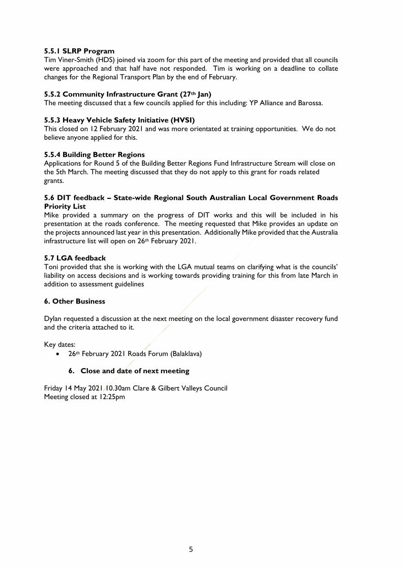
6. Yorke Peninsula Council – Four recently improved road segments have been transferred from
Action Plan 1 to Compliant Roads.
The above and other minor changes are highlighted in the following table:

8 | P a g e
Legatus Group 2030 REGIONAL TRANSPORT PLAN
ROAD DEFICIENCY ACTION PLAN 1
(For RTIA Committee Endorsement - 9 Apr 21)
HDS Australia Pty Ltd
Road Segment Description (from/to) Regional Routes(s)
F/T/C or Combo
Segment Length
(nearest 0.1 km)
Speed
Environment
Dimensions Geometry Strength /
Durability
Action Plan Cost for
Action Plan 1
Only (nearest
$0.1 million)
Adelaide Plains Council
Aerodrome Road Balaklava Road to Mallala Motor Sport Park T 2.2 Compliant Minor Compliant Major 1 0.7
Germantown Road Gawler Road to Kenner Road F 3.6 Compliant Compliant Compliant Major 1 0.6
Old Port Wakefield Road Gawler Road to Brooks Road C 1.1 Compliant Compliant Compliant Major 1 0.4
Wasleys Road Marshman Street to Cheek Road F 7.1 Compliant Minor Major Major 1 1.6
Wasleys Road Cheek Road to Woolsheds Road F 5.2 Compliant Minor Major Major 1 1.4
Sub-Total 19.2
The Barossa Council
Basedow Road Murray Street to Light Pass Road F, C 3.5 Minor Minor Compliant Major 1 1.1
Bethany Road Menge Road to Thiele Road T, C 1.1 Compliant Minor Minor Major 1 0.4
Calton Road Lucks Road to Council Boundary (Sunnydale Avenue) C 0.7 Minor Minor Minor Major 1 0.2
Carrara Hill Road Sturt Highway to Stockwell Road F 1.1 Compliant Minor Major Minor 1 0.5
Hurns Road Long Gully Road to Eden Valley Road T 1.3 Compliant Major Minor Compliant 1 0.3
Mengler Hill Road Light Pass Road to Tanunda Creek Road T, C 4.1 Major Compliant Minor Compliant 1 0.1
Moculta Road Murray Street to Truro Road C 8.8 Minor Major Minor Compliant 1 2.8
Para Wirra Road Yettie Road to Humbug Scrub Road C 2.9 Minor Compliant Major Compliant 1 0.2
Stockwell Road Penrice Road to Carrara Hill Road F, C 4.7 Compliant Major Compliant Major 1 3.5
Sub-Total 28.2
District Council of Barunga West
Bay Street McKay Street to Harvey Street C 0.1 Compliant Compliant Compliant Major 1 0.1
Mundoora Road Upper Yorke Road to Railway Terrace C 14.0 Compliant Compliant Minor Major 1 1.2
Ninnes Road Upper Yorke Road to Council Boundary (Green Road) F, C 6.3 Compliant Minor Minor Major 1 1.3
Sub-Total 14.0
Clare and Gilbert Valleys CouncilAlma Road Giles Corner Road to Range Road F, C 3.2 Compliant Compliant Minor Major 1 1.0
Burra Street Burton Street to Merildin Road F 0.6 Compliant Major Compliant Major 1 0.5
Copper Ore Road Merildin Road to Wookie Creek Road F 2.8 Compliant Minor Minor Major 1 0.3
Giles Corner Road Vandeleur Road to Alma Road F 1.2 Compliant Major Compliant Major 1 0.4
Burra Street (formerly Leasingham Road) Jacka Road to Burton Street F, T 0.8 Compliant Major Compliant Minor 1 0.4
Main Road 45 North of Steelton Road (end of seal) to Waterloo Road F, C 6.3 Compliant Minor Minor Major 1 1.9
Mount Rufus Road Farrell Flat Road to Ystalyfera Avenue F 4.9 Compliant Major Compliant Major 1 1.5
Quarry Road Horrocks Highway to Edwards Road F 4.7 Minor Major Major Compliant 1 0.8
Vandeleur Road Horrocks Highway to Giles Corner Road F 3.9 Compliant Compliant Minor Major 1 1.2
Ystalyfera Avenue Mount Rufus Road to Edwards Road F 2.5 Compliant Compliant Compliant Major 1 0.8
Sub-Total 30.9
Copper Coast Council
Bay Road Frances Terrace to 167 Bay Road (carpark) C 2.5 Compliant Compliant Compliant Major 1 10
Frances Terrace Blyth Terrace to Milne Terrace C 0.6 Compliant Compliant Compliant Major 1 3
Ninnes Road Copper Coast Highway to Pine Forest Road F, C 1.1 Compliant Compliant Compliant Major 1 0.1
Wallaroo Plain Road Snodgrass Road to Council Boundary C 7.2 Compliant Compliant Compliant Major 1 0.4
Sub-Total 11.4
Page 1 of 16

9

10

11

12
13

14

15

16

17

18

19

20

21

22

23

24 | P a g e
4.2 21/22 SLRP Priorities
Recommendation
That the Committee receives the Stage 1 Assessment from HDS and undertakes the Stage
2 Assessment and recommends the Legatus Group endorses the final priority list.
Background
The application process for the SLRP funding changed this year with the introduction of the
smartygrants tool with further changes expected after this year. The Legatus Group CEO is
attending a meeting with the LGA Secretariat and Regional LGA EOs on 13 May to gain greater
clarity on proposed changes after this year.
On the 9 April the Legatus Group CEO advised all councils for the following:
That applications for the 2021-22 Special Local Roads Program will need to be submitted via the LGA’s
online grant application service, powered by SmartyGrants.
The Legatus Group Road and Transport Infrastructure Advisory Committee will be considering a draft
priorities list and any updates to the Regionally Significant Roads, Action Plans, Database. They will then
endorse a final list of regional priorities for SLRP funding applications which will be provided to the 11
June 2021 Legatus Group meeting for ratification. Note the timelines:
• Councils: applications are to be lodged electronically in SmartyGrants by 28 May 2021. Regional
LGA’s will be provided with access to the online applications and this information will be
communicated by email.
• Legatus Group: recommendations to be provided by 11 June 2021
HDS will be assisting with preparing the 2021/2022 Legatus Group SLRP Regional Priorities List and as
such I require advise not later than Monday 19 April on which of your road upgrade proposals are
ready to start (if funded) in 2021-22 and that have received Council approval for a SLRP funding
application to be submitted. Eligible projects are based upon the endorsed regional roads database from
last year (see attached), together with three additional projects that councils indicated would be ready for
21/22 - Stockwell Road (BC), Gray Street (LRC) and Claremont Road (RCG).
WRC Angle Grove Road Full length Freight
YPC North Coast Road Point Turton Township to Point Souttar
Road
Community
Access
CCC Bay Road, Moonta
Bay
Coast Road to Frances Tce Community
Access
WRC Koolunga Road From 1.3km S of Mallee Corner Rd to
Boucat Rd
Community
Access
CCC Frances Tce, Moonta
Bay
Milne Terrace to Blythe Terrace Community
Access
BC Moculta Road Murray Street to Truro Road Community
Access
CCC Snodgrass Road Port Rilet Road to Wallaroo Plain Road Community
Access
CCC Wallaroo Plain Road Snodgrass Road to north of Council
Boundary
Community
Access
HDS had been contracted on the basis that this year was due to be a “minor update” year as far
as the 2030 Regional Transport Plan review and update methodology is concerned.

25
The Legatus Group CEO recommended that due to several factors including recent grants such
as the state government partnerships program then all roads submitted by councils should be
assessed and recommendations made by the Legatus Group based on all the applications
submitted.
As such the contract with HDS was varied for this year to be an intermediate update” not a
“minor update”. This has placed an extra time requirement on HDS to achieve this as such
there is a delay in getting the committee required information. Note this was due to the Legatus
Group CEO’s request and the variations and timing by LGA re the call for applications. As such
there should be no adverse comments re HDS who have been flexible to include this extra work
into their workload.
The process for recommending the priorities for this year considered a variation to this
methodology and is summarised in the diagram below:
The following list of roads are being submitted by councils for consideration:

26
Main Road 45 – C&GVC
Orroroo Bypass - DCOC
Roach St – CCC
Mudla Wirra Rd – LRC
Gerald Roberts Rd - LRC
North Coast Road - YPC
Stockwell Rd – Barossa
HDS will provide a report for the meeting which will include the Stage1 Assessment as per
previous years and the meeting will then undertake the Stage 2 Assessment which HDS will
facilitate.
4.3 Data collection (and data storage tool) to validate Socio-economic Impact Study
Background
Additional data (and a data storage tool) is required to allow the Legatus Region to enable capturing
of critical data and reporting on the progress of improving the regional local roads and related
infrastructure. Currently the Councils have different providers and different arrangements for
storing and accessing their asset information. A central tool that captures the critical regional
roads and roads related data is needed that is owned by a regional organisation. The kind of
information that could be captured includes: the regional road network, summary of grant funding
and programs supporting information, data such as safety statistics, vehicle counts and road surface
data. The risk is that this data is not centralised and harmonised and is in the hands of consultant
who charge to access it. Additionally, the recent socio-economic impact study suggested that the
region could improve the estimate of the true cost of not investing in maintaining local roads
through the collection of additional data listed below: (The decision to capture this additional data
and to establish as tool will be subject to approval of the 21/22 Legatus Business Plan and Budget
and securing additional funding),
• Data Needed
Vehicle operating costs, travel time costs, costs of accidents, air pollution and greenhouse gas
emissions were identified as quantifiable impacts of insufficient investment in roads infrastructure.
A hypothetical example was presented in the socio-economic impact assessment report and
further investigation into key data for the region is required. In particular, annual traffic counts by
vehicle type, IRI and SN estimates to lift the IRI and reduce in SN for each road.
• Cost benefit analysis
Most commonly, cost benefit analysis is conducted on a project-by-project basis, rather than
across large geographical areas. A selection of key roads known to be problem zones within the
region could be identified and analysed individually. These assessments would enable the
quantification of a baseline (a scenario in which infrastructure maintenance investment is
sufficient over the assessment period, and the quality of the road is maintained) and a scenario of
insufficient road infrastructure investment (in which the quality of the road deteriorates over
time) which can be compared. Such an assessment would limit the scope and scale of the
required data gathering exercise, whilst providing proof of concept case studies for other roads
in the region. Development of a cost-benefit analysis for each identified case study would be
estimated to cost approximately $10,000.
• Contextual information
Contextual information regarding social impacts or perceptions of the state (or future state) of
road infrastructure in the region could be collected (via a community and business survey) to
develop a more comprehensive understanding of costs unable to be quantified.

27
Discussion/Decision Required:
Note: Any recommendations will be subject to the Legatus Group 21/22 Business Plan and Budget.
• Decide the database tool and who will collate the data (Contractor or internal)?
• Decide on which roads IRI and SN will be gathered and by whom (Contractor/
University):
o Option 1: Suggested roads from Roads Managers include:
▪ Copper Coast: Ninnes Rd and Wallaroo Plain Rd
▪ Light Regional Council: nil
▪ Yorke Peninsula: first 3.9km of Northern Coast Road
▪ Barossa Valley: Hermann Thumm Drive, Moculta Road, Stockwell Road
▪ Clare Gilbert Valley: Vandeleur/Giles Corner/Alma Road. This is part of
the regional network that connects three councils (Light, CGVC and
Wakefield) carrying considerable freight and Main Road 45.
o Option 2: Roads nominated for SLRP 21/22
• Decide on cost/benefit analysis Y/N?
• Decide on whether contextual information will be gathered Y/N and by Whom
(Contractor or internal)?
5. General items
5.1 Legatus Group 21/22 Business Plan
The Legatus Group 21/22 Draft Business Plan and Budget has been submitted to Councils for
feedback and then for a decision at the 11 June 2021 Legatus Group meeting and relevant
recommendations include:
1. Resources: Include to extend the contract for the Roads Coordinator
Income via possible grant $12,500 from LGA R&D
Expenses: (1) Roads Forum $2,500 (2) SA Regional Road Priority $5,000 (3) Socio-
Economic Impacts Road Deficiency $25,000 (subject to above grant) (4) SLRP and Roads /
Bridges Database updates $50,000
2. Focus Area: This Business Plan is developed with an effort to increase the advocacy
role of the Legatus Group and for 2021/2022 with a focus in the areas of:
• Roads
• Waste / Wastewater
• Wellbeing – Regional Health
• Water
• Attraction and retention of population including education and housing.
3. Key Priorities and Actions: 2021/2022 Action Plan (this is the third year of the
Action Plan July 2019 – June 2022)
Road
Network
Q1
• Identify partners and roads for assessing and apply for funding to assist with next
stage of the Socio-Economic Impacts report on local road deficiencies
• Progress with the Bridges deficiency report
Q2 – Undertake investigation into and collation of several key datapoints for the
region will be required to facilitate such an assessment. In particular, annual traffic

28
counts by vehicle type, IRI and SN estimates for local roads are identified as
prominent data gaps
Q3 – Progress with updates for the Legatus Group Transport Plan and develop
priority listings for the 22/23 SLRP
Q4 – Review the progress and commence an extended lobby campaign based on the
reports and submit regional prioritising for SLRP
5.2 Advocacy
Key activities:
• Input for LGA supplementary road funding video by 5th March 2021 provided by the
Council of Clare and Gilbert Valley (https://youtu.be/71M-XHW_op8)
• Legatus Group Video
(https://www.facebook.com/107553917635408/videos/198310948570861and media brief
to advocacy for additional roads funding (election strategy).
• Key messages for the media brief:
o Why we need to advocate: A fair funding model should consider the identified
significant roads infrastructure requirements (findings from Transport Plans)
rather than competitive or formulaic based on demographics.
o More investment is needed in the road transport infrastructure in the Legatus
region to grow the region through improving the freight productivity, reducing
the socio-economic cost to the community and increasing visitation through
improving access.
o The lack of sufficient investment in the transport infrastructure is costing the
region – at least 2.5x cost of investment as per the findings of the recent socio-
economic impact assessment, and increasing the risk of road incidents and
accidents that cost our region over $488M between 2015-2019
o This region is an important NS and EW transport corridor for Australian freight
movement.
o This region has the #3 and #5 most visited destinations in SA
o What do we need: More funding (at least $80M over the next 3 years).
o Thankyou for the current programs. We are able to make use of an average of
$18M per year from: Black Spot, Bridges for Renewal, Heavy Vehicle Safety
Initiative, Supplementary Road Funding, Local Government Investment
Partnership, Local Government Community Investment Program, and Roads to
Recovery.
o However, the gap between what we can attract and what we need is large.
o Some of the current funding programs are competitive and other are based on a
capita and kilometre formula. This is not a fair system – our region is
characterised by small, low socio-economic populations and has large kilometres
of road networks.
o We need $80m to address the 454km deficiencies in the key freight, tourism and
community access roads that is in the forward works plans and Action Plan 1. An
additional 1005km of roads with deficiencies are identified in Action plan 2&3
(not in councils forward works plans), that are yet to be evaluated.
o What and How: We’ve got a process and a plan to identify and improve our
regionally significant roads infrastructure, the “Legatus Group Regional Transport
Plan 2030” . This plan identifies 2137km of regional freight, tourism and
community access roads. Of these significant local government roads, 1459km
(68%) of these have at least 1 major deficiency identified. *Note: bridges and
other transport infrastructure are excluded from this plan at the moment.

29
Media Brief:
Funding equity for local road upgrades
The Central Local Government Region of SA trading as the Legatus Group are seeking to
increase the level of productivity, safety and community connectivity through increased funding
for local significant roads.
The Legatus Group 15 member councils extend from the Adelaide Plains to the Flinders Ranges
and Barossa Valley to the Yorke Peninsula and are seeking support for fairer funding models to
address the regions local roads infrastructure deficiencies.
Mayor Peter Mattey Chair of the Legatus Group says, “Our member councils need at least $80
Million over the next 3 years to address the regionally significant roads. These roads have at least
one major deficiency and are in our councils forward works plans. We are appreciative of the
Federal and State Government assistance, but this is insufficient and disproportionate to the
costs experienced in the region. Without this assistance it is limiting growth and productivity for
the increases in freight transport and visitation by tourists. “
The Legatus Group have released a report into the socio-economic impacts by not funding these
roads and it is estimated that the cost to the community of not addressing roads deficiencies
costs at least 2.5 times the cost of investment. The continuing degradation of the roads is also
increasing the risk of road accidents that has cost the region over $488M (between 2015-
2019).
The Legatus Group councils are making good use of the current limited funding
programs. However, the gap between what is gained and what is needed is large. The current
funding programs are either competitive or based on a capita and kilometre formula and reduce
the equity for a region characterised by several smaller, low population and with massive road
networks.
The Legatus Group have a process and a plan to identify and improve these regionally significant
local roads infrastructure, the “Legatus Group Regional Transport Plan 2030”. This plan
identifies 2,137km of regionally significant freight, tourism and community access roads. Of these
significant local government roads, 1,459km (68%) have at least 1 major deficiency identified. At
least $80 million is needed to address the 454km deficiencies in the key freight, tourism and
community access roads that are already in the forward works plans. An additional 1,005km of
roads with deficiencies are identified which are not in councils forward works plans, that are yet
to be evaluated.
Mayor Mattey says, “We have identified the significant local road infrastructure needed to
support the regional, state and nation but Councils cannot afford to fund this alone and
significant additional funding is sought to address the imbalance between the costs experienced
and the investment levels by the Federal Government.
The media release and video were distributed to all regional media, MPs, Member Councils, LGA
and Regional Partners.
Discussion: What further recommendations could go to the Board for consideration
5.3 Feedback from Roads Forum 2021
Objective:
• Update on issues impacting the Legatus Group Road Transport Plan
• Workshop to raise engagement and awareness of the 2030 Legatus Regional Transport
Plan at a Council level.

30
Attendance:
• 86% of Councils represented (Orroroo and Mount Remarkable did not have
representatives at the forum)
• 52 total attendees. Some did not respond to the Eventbrite tickets.
Workshop:
• Light did not stay for workshop. All other Councils (Other than Orroroo-Carrieton and
Mount Remarkable), participated in the workshop activities.
Feedback from participants:
Plus (good) Delta (change) Priorities/ Other
Thanks Simon and Moira At the opening of the day,
introduce who has attended
broadly so that everyone
knows who’s attended
Workshop: How can recently acquired
roads be added to the RRTP?
Great day – provided
good information
Don’t see a lot of this
information passed through
council
Unsealed Roads manual is a priority
(ARRB)
Matthew was very
informative – liked his
presentation
Remind people to provide
feedback for any comments
Regional Road Hierarchy
Workshop has been
informative and assisted
in my general knowledge
Microphone not working in
the morning was an issue
Adelaide Plains is urgently waiting for DIT
to build roundabouts at Two Wells (700
new houses just approved, primary
school now open, huge risk to public
safety on freight routes – Malala Road ,
Two Wells
A good regional forum
today. Keep thinking
regionally and connecting
regionally
Unify Road categories and have levels
breaking down sealed and unsealed
Catering was great Wakefield interested in the unsealed
roads review
Good space for the event Workshop: Can roads be reassessed in
our region (Copper Coast) Agery Road
and Arthurton Road?
Any risk roles around R&D (RE: data).
Partner with Unis-NHVR-Councils and
DIT
Top challenges: not enough time
Council roads in the state to be
categorized the same
Approach to roads. Less bodies planning
and more focus on road upgrade delivery
View the CGV video for advocacy work
Workshop – The Pirie tourism and
freight maps have changed since this
version. The spreadsheet is out of date.
Tourism - cycling
Changes to Traffic Management Training
– 20 hours training before being
accredited – what a load of ####!
Would like a greater involvement in the
proposals side of things

31
Notes from workshop
1) Mike Wilde (DIT)
Key take-away messages:
• Roads of strategic importance
• Barrier HWY, Stuart HWY, Eyre HWY, Terowie, Horrocks HWY
• Move to 3A bridges on these routes
• The strategic network development will focus on projects that drive economic activity
and growth, boost productivity and enhance liveability and land values (food, wine and
agribusiness, red meat, wool, energy and mining)
• Historically dealt with councils on issues at a local level haven’t necessarily had a regional
perspective, and hence now want to get to know the regional transport plans.
Questions:
Questions/comments to Speaker Speakers Response
What do you think about land use planning Think about where you want industry to grow and
infrastructure costs, lengthy first/last mile
connections challenging to fund. Need to avoid
constraining existing businesses – think about new
opportunities. Conversations about the right
access on right roads in right places
New announcement today, Infrastructure
Australia Infrastructure Priority List update.
This is the most initiatives in SA for a while
High priority initiative to address SA road network
(know there is a backlog of maintenance and
recognise there is a problem with SA roads
Priority initiative SA High Productivity Vehicle
access network
Priority initiative Barossa Valley water network
Shoulder widening – concerned that they are
breaking up already (Koolunga) - don’t think
we’ve got it right.
Agreed shoulder sealing vs widening, line marking
critical to ensure vehicles are running on formed
ground – reforming road maintenance works and
strategy to optimise outcomes
Strzelecki track – bigger picture – what is the
northern pastoral route (cattle movement
from QLD via our councils to Thomas food -
What is going on with the broader route?
Recently announced network initiative addresses
broader north south and east-west connectivityis
something The challenge is getting value and
identifying opportunities for key anchor points in
the mid north – where to from Orroroo? How do
get from Orroroo to Half Way House)
PBS level 4a network will be for the high volume
movements, need to managing expectations as need
to optimise vehicles to supply chains. A good
example is b-doubles in the Adelaide hills where
Lobethal integrated well for abattoir but produce
supply chains were more effective with semi
trailers.
Important to remember that almost everything that
we touch in our daily lives, needs roads transport
There is a new grain player in the market –
now new directions for grain movements on
Eyre Peninsula– now shifting west rather than
south…..major impact on network
It is a challenge and proponents are starting a
conversation in government about this The shift
away from rail to road was due to cost. Need to
understand why Gladstone works on rail and
Crystal Brook doesn’t. Complex sector with
different owners/ -bulk handlers and traders.

32
We have an equity issue… what are the ways
we can work with the department ?
How do we help to argue for more
resources?
Do you see value in the work – road
hierarchy?
Build on existing engagement at a Council/DIT level
as well as forums such as today and the ongoing
Legatus interaction.
Develop the evidence to support investment
decisions, particularly productivity improvement
and economic growth.
Definitely, opportunity to align with National and
State activity in this area, improve alignment across
road managers.
2) Toni Clarke (LGA)
Key take-away messages:
• What we are working on:
o Webinar road managers training, ARRB, NHVR portal or can come out
o Compliance and enforcement. Educational approach for operators
o Developing maturity model – please get in touch if you want to be involved –
like the AM cycle
o Notice development - lots of notices coming this year – particularly for
emergency movements
o Webinars – not embraced – can be useful
o Looking at forums with LGA mutual from May - risk tools
o Looking at guidelines from LGA. Please share any internal ones you have.
Questions:
Questions/comments to Speaker Speakers Response
Permits – consented routes
We assisted NAR to gazetted routes – d-double
routes gazetted. Ravnet doesn’t have this ability
(national spatial program) – need to do a permit
for now. Feedback from operators have to still
apply. All councils should have access to high
density maps - permits – Matthew to help
3) Matthew Matricciani (DIT)
Key take-away messages:
• Lots of technical information for Road Managers in the Presentation and useful links to
share.
Questions:
Questions/comments to Speaker Speakers Response
Road Access responsibility (Local government
vs state)?
30m from highway centre line is the state road
manager and state provides access, after this is the
local road manager
Is there research opportunities with DIT?
4) Jacqui Quarton (JLT)
Key take-away messages:

33
• Investigating what training information needs changing e.g.: unsealed roads, workzone
(CD Rom – looking at new delivery techniques that are non-CD) – who is using (Goyder
only),
• Web-based tools – workzone -will be harmonised across Australia – course will be split
into 2 courses:
o (1) people doing the traffic management in the field and 2) the auditor and
planner)
o Training will have 3 levels based on the volumes of traffic per day
o Big difference will be the requirement for 20 hours competency training - may
have to share across councils/worksites
• Looking for a working group for developing the training.
Questions:
Questions/comments to Speaker Speakers Response
Can JLT engage with SAROC representatives
rather than council by council
Have you thought about synergise with DIT
tools state wide tools
VIT (DIT tool and app called adminsite? that shows
roadworks)?
Some tools don’t work with access vehicles that
don’t have steering wheels (e.g.: graders, excavators)
5) Steven Kaesler (Barossa Council)
Key take-away messages:
• Has 96 bridges and still finding more!
• Issues and initiatives
o NHVR applications
o Bridges audits – our definition is something that is 2.1m wide – others say 6m
wide
• Lessons learned in successfully attracting grant money for bridge works:
o 2a to 2b improvement would improve productivity 23% and over $250kpa
o Identify your risks (e.g.: not wide enough for 2 way trucks and knee height
guardrails are not safe enough
o Should you seek the design or a grant first? - believe should design first
o consider improving the mix of users – this is key to the application (e.g.: social
aspects such as cyclists)
o use each peak representative bodies,
o convincing councillors to long term vision,
o consultants don’t know your bridge as well as you – your community outcomes
– close guidance needed
o Bridges for renewal – difficult to get (tried many) but a good one to get
o Other initiatives that are good:
▪ NHVR STRATEGIC LOCAL GOVERNMENT ASSEST ASSESSMENT
PROJECT (SLGAAP)
o LOAD LIMITS – DON’T JUST LOAD LIMIT to manage access to bridges – there
are other ways to manage.
Questions:
Questions/comments to Speaker Speakers Response
Environmental considerations - did you keep
one lane open during construction?

34
Cost - did you look at replacement vs
widening
6) Lee Wallis (Goyder Council)
Key take-away messages:
• Local commodity freight network review
o Kept this basic as not a lot of funds to work with - Started with where do we
need to go? Now we have more data
o We reviewed our data on the portal and used HDS to assess
o Challenge – removing 400km of gazetted network that wasn’t fit for purpose.
We didn’t have commodity database and had to rely on DIT– there were roads
we couldn’t event find that were in the DIT system. We also found our
maintenance practices were not compatible with the standards needed (such as
width weren’t right).
• Key findings: we needed to improve intersections, signages, carriageway width, and tree
trimming
• What we’ve done- added extra width each year in stages, added $200kpa to the road
works program
• Category 4 were removed from gazette – now dealt with using permits for those who
actually need to use it – not suitable for a permanent network. There was very little
objection from locals – weren’t actually being used
• Looking to removed B/C classifications
Questions:
Questions/comments to Speaker Speakers Response
How do you do you plan your re-sheeting
program
5 year plan
7) John Olsen (HDS Australia)
Key take-away messages:
• We want to develop a database of critical projects for any funding – not just SLRP to
allow councils to progress with 5 year vision of projects
• Want to establish some common standards about what a regionally significant road is.
You know what is important in your council
• The action plans include roads with major deficiencies:
• Action plan 1: funded liability – on 5 year forward plan but need funds (major
deficiency)
• Action plan 2: unfunded liability – not on our 5 year plan (major deficiency)
• Action plan 3: minor deficiency
• Regional roads hierarchy – recommend reviewing the Murraylands LGAs work in this
area
• Take a regional approach when it comes to funding:
• SLRP, HVSPP, Bridges for renewal, Road Safety Program, Financial Assistance Grants,
Local Roads and Community Infrastructure , Better regions fund
• Local MP lobbying
Activities: Maps were provided to each council with the freight, tourism and community access
routes marked. Participants worked together through the following activities:

35
Activity 1: Freight routes: Is the freight routes right and key freight centres? Does that road have
a major deficiency? And would council fund this?
Activity 2: Tourism routes: Are the primary destinations from major roads identified in your
council. We also need to identify the multi-use roads, these have increased risks (i.e.: if harvest
and tourist use same road, we need to increase the width of the road to 8m. We also need to
add projects that are proposed. Does that road have a major deficiency? And would council fund
this?
Activity 3: Community Access routes: Are these reliable all weather road that connects every
community to essential services for the permanent populations? Other considerations for
Community Access Roads – are all connection points identified (i.e.: where farms roads might
merge to access a community town)? Does that road have a major deficiency? And would council
fund this?
5.4 Proposed webinar and forums
The suggested webinars and forums for the remainder of this year:
When Who Format What
Wednesday 26 May
10am-11:30am
Riverlands
Murraylands LGA
Tim Smyth
Webinar Harmonised local roads
classification scheme
Thursday 27th May
10am
Eric Mc Inerney
from the Mining
and Quarrying
OHS Committee
Zoom Silica in Rubble
August? ARRB Sub regional forums New local government
roads best practices guide
November? Councils Face to face sub
regional forums
Sharing best practices /
innovations / grant success
stories
Eg; grants strategy –
Richard Dodson
5.5 Silica in Rubble
Stevie Sanders (WHS and Risk Manager LGA) provided in response to the action from last
meeting:
“The Time Weighted Average (TWA) for Silica has been halved from 0.1 mg/m3 to 0.05
mg/m3. This when combined with the requirement of Regulation 50 of the WHS regulations; for
a PCBU to;
“ensure that air monitoring is carried out to determine the airborne concentration of a
substance or mixture at the workplace to which an exposure standard applies if—
(a) the person is not certain on reasonable grounds whether or not the airborne concentration
of the substance or mixture at the workplace exceeds the relevant exposure standard; or
(b) monitoring is necessary to determine whether there is a risk to health; would seem to point
to a need to do some monitoring of the activities that the councils undertake that involves
materials that may contain silica.
This seems to be reinforced by the results of the monitoring that Onkaparinga have conducted,
which while not necessarily directly transferable to the Legatus councils (Type and constitution
of material used, work methods etc. will all be specific to each council and will potentially

36
generate a different outcome in terms of the potential concentration/exposure), would also
seem to support the need for monitoring.
In relation to the position “The Legatus members discussed that for the amounts of work they
do involving silica is not long enough (exposure times). While it is entirely possible that the
work practices may not need to change, I am unable to comment, without having specifics of the
work they do and how they do it, what controls they employ and whether any monitoring has
been undertaken before (and the results), beyond stating the following two points;
· It would not take a long exposure time in a respirable silica rich environment to
exceed this new exposure level (as an example, in the Onkaparinga tests conducted in
November 2019, The operator performed 62 cuts on pavers in a 29 minute period and
the level of Respirable Quartz was 0.08 mg/m3 i.e significantly above the “new” 8 Hour
TWA)
· The requirement to monitor airborne contaminants is not conditional on your
controls, it is a requirement where you are not certain of the concentration on
reasonable grounds of whether or not the concentration of the substance at the
workplace will exceed the exposure limit.
(Reasonable grounds - I.E. you have some evidence other than monitoring that points
strongly to the level of material that will be in the workplace, some things that might
meet this criteria are;
o previous monitoring reports, or reports from other workplaces that have the
same material, from the same supplier and that use the same operational
methods and equipment in relation to the material
o a statement from the material supplier explicitly declaring the material to be free
of silica, or at such a low level that given your operational activities the exposure
limit would be impossible to exceed)
In summary, I would suggest that some air monitoring will be required in order to meet the
requirement of Regulation 50. However, I am aware that the RRC’s for your region have
arranged for a representative from the Mines and Queries OHS Committee (MAQOSHC) to
attend their next forum in your region to discuss this amongst other things mines and quarries
related, so you could approach Jacqui Quarton to see if you can attend and discuss the issue with
the MAQOHSC rep.
Opportunity:
• Eric Mc Inerney from the Mining and Quarrying OHS Committee ( MAQOHSC) booked
to do a presentation on occupational dust and silica exposure at our Central Regions
WHS& Risk practitioner forum Thursday 27 May via Zoom at 10am.
5.6 DIT Progress and upcoming programs
Mike Wilde to present.
5.7 LGA relevant notices
5.7.1 Toni Clark to present.
5.7.2 Other
John Olson (HDS Australia) provided the following information from the most recent report by
the LGA to SAROC:
▪ Regional local roads – mapping and priorities SAROC Actions in 2020-21 (ongoing)
▪ Facilitate coordination between regional LGAs to prepare a SAROC SA Regional Local Road
Priorities report that will enable a cross regional approach to support funding applications to
State and Federal Government based on an agreed priority list. It has $15,000 set aside in its
2020-21 budget to progress this work, which is anticipated to be supplemented by regional
LGAs.

37
▪ Potential Actions in 2021-22
• Continue to prepare a SAROC ‘SA Regional Local Road Priorities’ report.
• Development of a SAROC ‘SA Regional Local Road Priorities’ report has yet to
progress, however discussions between the LGA Secretariat, the Legatus CEO, and
officers within the Department for Infrastructure and Transport and the SA Local
Government Grants Commission have confirmed there is broad support for the concept
and scope of the project, with recognised benefits including harmonisation of individual
regional transport plans, and centralised information and database with streamlined
reporting. In 2021-22, SAROC will maintain this issue in its Annual Business Plan to be
ready to progress the action as informed by the following:
• During 2021-22 it is anticipated that work being progressed at the State Government
level to accommodate the transfer of the Office of Local Government and the SA Local
Government Grants Commission to the Attorney General’s Department, while
exploring hosting the Commission’s GIS data with the relevant departments.
• Further discussions may be forthcoming regarding a broader proposal for a centralised
local roads database, to which SAROC and its member councils would be critical
stakeholders. Further progression of any SAROC commissioned work would be best
informed and timed with some meaningful progression by the state government agencies.
Further potential ‘Financial Sustainability and Governance’
5.8 RAVRAT modifications
Background:
In March 2020, the SAROC committee resolved to “note that the LGA secretariat will liaise with
other state and territory local government associations and the Australian Local Government
Association regarding the possibility of coordinating a discussion with Australian Road Research
Board and the National Heavy Vehicle Regulator the further development of the Restricted
Access Vehicle Route Assessment Tool for unsealed roads”.
Having liaised with LGAs in other state/territories, I can advise that there has been very limited
feedback from their member councils on the use and application of the RAVRAT tool in its
current form. There isn’t any interest from councils across Australia in investment to broaden
RAVRAT for unsealed roads, at least to the point where it is being raised with their LGAs. Also
within South Australia there are a limited number of councils that use RAVRAT regularly to
inform their decisions.
RAVRAT is intended to allow heavy vehicle route assessments to be completed in line with the
Performance Based Standards network classification guidelines and designed to primarily assess
the geometric requirements for heavy vehicles. In 2020, a number of enhancements were
undertaken
Enhancement
options
Implementation
Land widths
and curve
widening
• Added a rural unsealed roads option to the Route Editor to classify
the road type.
• Aligned the assessment of carriageway widths for rural
unsealed roads with the NTC (2007) guidelines to provide
the correct PBS classifications.
• Aligned the assessment of curve widening requirements for
rural unsealed roads with the NTC (2007) guidelines to
provide the correct PBS classifications.
• Created a distinction between carriageway widths for
straight road sections and curved road sections to allow for

38
independent assessment, using the lowest PBS classification
between the two for the Carriageway Width attribute.
• Allowed for multiple curves on a single road to be assessed
through the carriageway width attribute. PBS classification of
carriageway width will be determined using the lowest
classification of all curves.
Vegetation • Added a Vegetation attribute in the Local Considerations
assessment to identify areas that may be restricted due to
vegetation overgrowth
Verge Heights • Added a Verge Height attribute in the PBS Expert to identify
rural unsealed roads where verges may restrict overtaking
and passing opportunities.
Sight distance
(due to dust)
• At present time this is considered as an amenity issue in the
PBS guidelines and no updates will be made
Grades on
unsealed roads
• Currently RAV RAT aligns with the guidance provided in the
PBS local guidelines for maximum grades, however it may be
worth further investigation in a separate project to
determine if this is suitable for use on unsealed roads
Vehicle
tracking on
unsealed
corners
• The tracking of heavy vehicles is not a criteria for
assessment under the PBS guidelines and is instead a
requirement of the vehicle itself. No updates where made
and would require a separate technical project to be
undertaken.
A number of amenity issues or requirements that are outside the scope of the PBS guidelines
were not implemented. In some circumstances there are manual work arounds that can be used
to record the local considerations. ARRB have also advised that there have been enhancements
to RAVRAT that were implemented in mid-April to assist with sight distance and the inclusion of
a clearance time calculator.
There are a number of projects that are currently being progressed that will impact on RAVRAT
and assessments including:
• National Heavy Vehicle Assessment System Study:
o WSP has been engaged by Austroads to develop the research report
‘Options Evaluation for a National Heavy Vehicle Access Assessment
System (NHVAAS)’. The proposed system would:
o Provide a platform to support road managers in their heavy vehicle
access assessment role under national and jurisdictional legislation
o Effectively integrate operator vehicle inputs, infrastructure data and the
analysis tools needed to complete assessments
o Increase the level of automation for access decisions working towards
transparent and near-real time access decisions
It is anticipated that the study will report on the analysis and results of the research in
September 2021
• National Spatial Program
o The NHVR are undertaking a project to improve the accuracy,
consistency and timeliness of route planning for the industry and to
enable road managers access to mange their own networks.
The program will:
▪ address data quality issues in the existing route planner
▪ deliver a single national map that will display all gazetted and pre-
approved networks nationally and allow industry to route against
those networks in the first instance
▪ upgrade the existing Route Planner to enable intelligent routing
and mapping capabilities. This will give road managers access to a
39
centralised tool to update their networks based on changing
conditions, and allow the NHVR to provide instant alerts (e.g.
natural disaster alerts) and near real-time spatial route data
directly to industry via in-cab devices and mobile phones
▪ allow the NHVR to share data sets directly to councils and
jurisdictions
▪ provide road managers with self-service capabilities to update
gazetted and pre-approved routes with local conditions in near
real-time.
For noting:
Between the projects mentioned above and the limited appetite to undertake further
investigations, technical research and associated implementation at this point in time, the LGA
Secretariat recommends that no further development of RAVRAT for unsealed roads be
pursued.
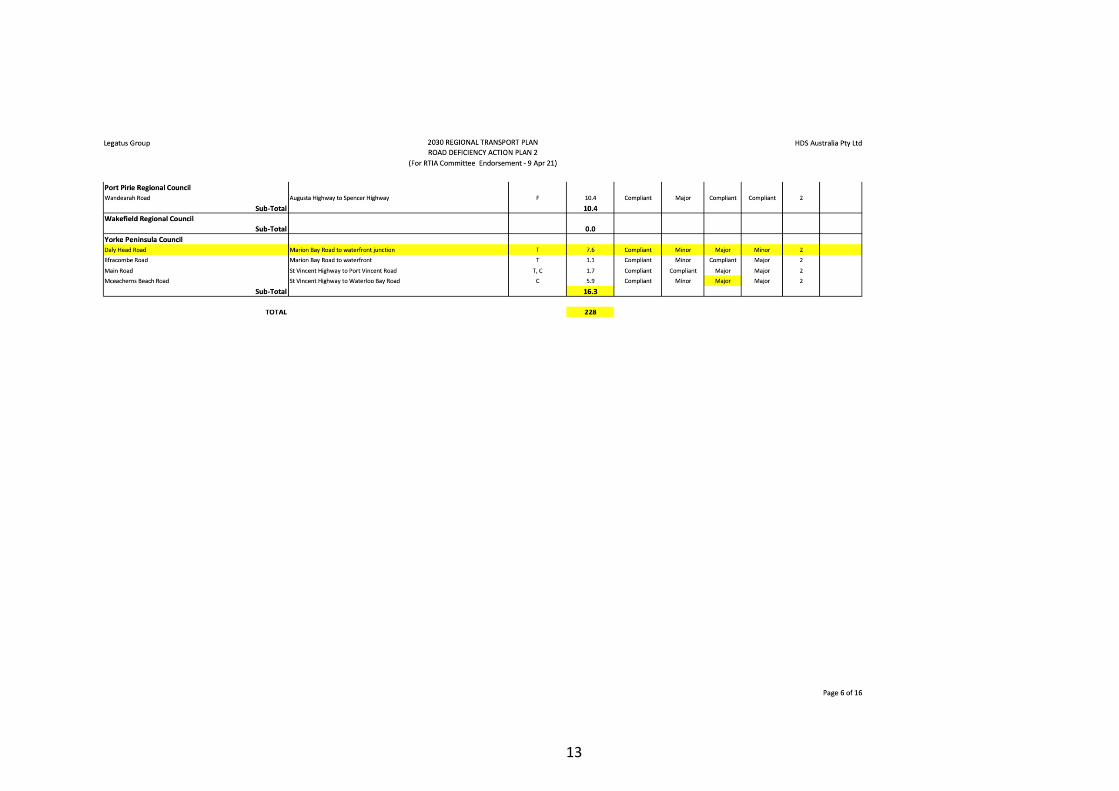
5.9 DIT last mile projects
Matthew Matricciani (Principal Policy Officer for Heavy Vehicle Policy and Strategy Department
for Infrastructure and Transport) approached Legatus informally to identify potential projects
with:
▪ “last mile” issues where the state-owned road network can be improved/upgraded to
facilitate higher productivity vehicle access on local roads specifically intersections (state
roads adjoining council roads) that are prohibiting heavy vehicle access to the local council
road network or
▪ any deficient bridges/culverts on state-owned roads that are giving rise to heavy vehicle
detours through council roads.
The information received will be collated into a register and evaluated by Matthews team and
shared to various areas within the Department to create awareness about the issues and
hopefully create an approach to address them over time.
Council Location Type of improvement
required (intersection
upgrade, line marking
amendment, bridge
strengthening/widening)
Productivity
improvement
(access
expanded to
PBS L3
vehicles etc)
Priority
Peterborough Cotton Road Upgrade Compliant swept path for
road trains.
The Orroroo
HV Bypass will
see 53.5m road
trains come
into our area
High –
bypass will
be finished
within a
year
Light
Regional
Council
John Eden Road at Shea-
Oak Log (between Thiele
highway and the Stuart
Highway)
Seal John Eden Road and
upgrade junction with
Thiele Highway to enable
better turning paths
PBS L3 Medium -
Identified
in Year 2
2022/2023
of
Councils
4 year
Cpaital
Program
subject to
receiving
HVSPP
funding

40
Goyder Whyte Road / Barrier
Highway Intersection,
Whyte Yarcowie
Compliant swept path for
road trains.
Improvement
to 36.5m
access to
Barrier
Highway
Goyder section
(eastern end) is
currently
limited to 26m
B Double
commodity and
Northern Area
(western end)
gazetted for
26m freight B
D double.
Gazette as 26m
general freight
route. Potential
for 30m or
36.5
commodity
Goyder Claremont Rd and Farrell
Flat Rd, Farrell Flat
Claremont Rd not gazetted
for general or commodity
freight, numerous permits
issued for 35/36.5m
combinations. Compliant
swept path for road
trains. Extensive damage to
existing edge of sealed
highway. Sight distance?
Access needed
for commercial
quarry. Gazette
as 26m general
freight route.
Continue to
manage 30/36.5
under permit.
Future
increasing
approved heavy
vehicle gazette
of Farrell Flat
Rd?
Flinders
Ranges
Intersection of Flinders
Ranges Way / Silo Road /
West Terrace and Arden
Vale Road
Intersection upgrade,
widening and traffic
control, roundabout
HV access, B
Double access
to Arden Vale
Road
Med-High
1-2 years
Barossa
Valley / Light
Regional
Council
Greenock Road/ Samuel
Road
Intersection / Roundabout High
Barossa
Valley
Angaston Road /
Stockwell Road
Intersection upgrade Not sure if
30m A-
Doubles will be
able to safely
cross this
intersection
even when
80/50 km/h
VSLS are
implemented in
June by DIT.
High -
june
Barossa
Valley
Eden Valley Road / Hurns
Road
Intersection upgrade Medium

41
Barossa
Valley
Eden Valley Road / Lovers
Lane and Stott Highway
Intersections upgrades Medium
Copper
Coast
Kadina / Copper Coast
Hwy from Thrington Road
to the entrance of Kadina
(this section wasn’t
upgraded on last upgrade)
Reconstruction of
undulated road 3km in
length
Safe access for
all HV and
tourists
High
Wakefield Balaklava Road/ Hudson
Road access to Agfert
Intersection upgrade Left in and right
our for 30m
road trains and
no access to
36.5m road
trains/PBS
Level 3A
High
Wakefield Balaklava Road/
Whitwarta access to
Viterra site
Intersection upgrade Right in and left
out or straight
on Gwy Tce
for 30m and
36.5m
High
Adelaide
Plains
Calomba Road/Balaklava
Road at Mallala
Intersection upgrade, line
marking amendment, bridge
strengthening/widening.
On the intersection –
protect turning lanes north
and south on Balaklava
Road
Access
expanded to
PBS L3 vehicles
etc) –
Currently
illegally used as
a township
bypass, not
gazetted as a
heavy vehicle
route due to
safety issues on
Balaklava Road
and the train
line. Upgrade
to allow for
PBS L3 vehicles
Medium
Yorke
Peninsula
1x GML P1 project
17x commodity route
projects as per network
summary risk assessment
document
Clare and
Gilbert Valley
Junctions within the low
speed zones in the 50kmh
zones are:
Auburn:
• Junction of King St
• Junction of Balaklava
Road
• Junction of
Saddleworth Road
Rhynie:
• Junction of Horrocks
and Riverton Road
Clare and
Gilbert Valley
Entrance to Clare on the
Farrell Flat Road in
particular for the
Intersection Currently
creates issues

42
intersection with Pioneer
avenue.
Additionally the narrow
bridge on Farrell Flat Road
for 30m road
trains.
This could be
an option to
open the
Farrell Flat
Road for major
freight
Clare and
Gilbert Valley
*general
concern is
the lack of
maintenance
and general
deterioration
of
intersections
with DIT
roads
There are a number of
DIT Roads crossing
through the CGVC
district that need to be
inspected by DIT:
Horrocks Highway,
Barrier Highway, RM
Williams Way, Blyth Road,
Farrell Flat Road, Jolly
Way, Balaklava Road,
Saddleworth Road,
Riverton Road, Tarlee
Road, Marrabel Road and
Curio Road
Port Pirie Abattoirs Road/National
Hwy
Intersection upgrade Restricting HV
use
Wont gazette
due to stacking
issues are rail
intersection
HV use will
increase due to
construction
activities on
this road and
ADM grain
High
Port Pirie Abattoirs/Spencer Hwy Intersections Turning
restrictions in
place on
intersection
HV use will
increase due to
construction
activities on
this road and
ADM grain
High
Port Pirie Other
HV detours for accident on
the national hwy – some of
the bridges have load limits
Medium
Orroroo-
Carrieton
Orroroo crossing (1km of
Orroroo on RM Williams
Way)
S bends with old rail
corridors. Poor shoulders
– need realignment
(remove S bends)
Medium -
high

43
Black Rock on RM
Williams Way (priority) –
8inch drop
High
Mount
Remarkable
Pine Creek Bridge
Bridge Bridge is unable
to be used by
B-Double and
above.
It is not on a
State Road
(Northern
Areas Council).
This has
created a major
issue for us as
all vehicles
from north of
our Council
area and west
of our Council
area use this
road to
transport to
Gladstone. This
means a large
amount of
vehicles that
are not rate
payers of the
DCMR who
are using a
bypass route
(Gladstone
Road). We
cannot
currently keep
up with the
maintenance on
this road.
We require
either the Pine
Creek Bridge
be improved to
cater for
vehicles or
funding for the
upgrade of our
roads for
carrying state
traffic.

44
Mt
Remarkable
Horrocks Highway Bridge
(Geddes Bridge) situated
south of Wirrabara
Bridge cannot cater
for the vehicles
the Horrocks
Highway is
being upgraded
for.
The upgrade to
PBS3 vehicles
and $55 million
upgrade can
not be achieved
as this bridge
makes the
whole system
impassable. DIT
had considered
a bypass
around the
bridge using
Councils roads
as a suitable
solution to this
issue. Council
has now taken
the measure of
closing this
bypass for
vehicle types as
we have a
bridge on this
route that is in
worst
condition than
the DIT Bridge.
Northern
Areas
Jamestown – Bridge
across Belalie Creek on
Ayr Road
Bridge
Trucks have
trouble turning
left onto (B79)
Wilkins
Highway when
coming from
the (B80) RM
Williams Way
(Spalding
Road), bridge is
not wide
enough to be
able to turn
into one lane
often take the
2 lanes to turn
over the
bridge. Bridge
is often
damaged.
Northern
Areas
Jamestown – Trucks
coming from Port Augusta
using Appila – Jamestown
Intersection The
intersections
need improving

45
Road (B79) then onto OD
5 (which is the Jamestown
town detour) then onto
the B78 Wilkins Highway
Hallett Road to Burra
to allow easier
access for the
trucks.
Barunga
West • Upper Yorke
Road between
Port Broughton
• Upper Yorke
Road between
Kulpara and
Melton
• Spencer Highway
between Alford
and Wallaroo
some segments far
worse than others
(near Wenberley
Boundary,
Brucefield Roads
Undulating Roads Very undulating
and difficult to
negotiate for
trucks
Barunga
West • Turning lane at
Kulpara –
intersection of
Upper Yorke
Road and Copper
Coast Highway
Kulpara
• Turning lane at
intersection of
Ninnes Road and
Upper Yorke
Road heading to
both Paskeville
and Lochiel
Install turning lanes
Barunga
West • Mundoora Road
and Upper Yorke
Road – traffic
rumble blocks for
safety
• Willamulka/Lanner
Park Road and
Bute Road
• Sandy Garfield &
Upper Yorke
Roads – this one
we receive
complaints about,
road rises and
obstructs
oncoming traffic
view (most
complaints)
• Moyses & Upper
Yorke Roads
(corner)
Intersections

46
• Wards Hill Road
& Spencer
Highway –
northern end near
Port Broughton
• Summerton Road
& Spencer
Highway – near
corner coming in
to PB from Pt
Pirie
5.10 Other Grant Funding opportunities to support 2030 Legatus Group Regional
Transport Plan FY 2020/21
Other grant and other funding opportunities for roads and roads related infrastructure projects:
Scope Co-
contribution
Application
status
Other criteria
Bridges
Renewal
Program
Annual upgrade
and replacement
to enhance access
for higher
productivity
vehicles to 23/24
Round 6 not
decided
Limit $2M
Reports <3years
Engineers impact of
natural disaster
5 proposals per
proponent
Bridges for replacement,
up-grade, approach road
associated with bridge,
to replace water
crossing (culvert or
causeway)
Black Spot
Program
Annual program
to 23/24
Typically July-
October
DPTI
33%-50%
contribution
Not open yet
June-August for
following year
$20k-$2M
Criteria:
• 3 casualties in last 5
years
• 0.2 crashes/km/yea
in last 5 years
• Benefit:cost >2
Local Roads
and
Community
Infrastructure
Program
Federal Govt
funding approved
by Deputy PM
LGA
Goal create jobs
through
construction
Not required *formula considers 1/3
LRCI formula (road
length) and 2/3
population.
Local
Government
Infrastructure
Partnership
Program
50%
contribution
(reserves or
borrowing) or
other
organisations
Can leverage
other funding
Closed 29 Jan
2021
Must be in 12 month
council budget and
shovel ready within 12
months
Already funded federal
or state programs not
eligible
Projects at least $1M

47
Financial
Assistance
Grants
Federal Govt
provides untied
funding to local
government
bodies
(General purpose,
local roads and
SLRP)
At least 30%
contribution
required
SLRP - 28 May
Priority
Projects loaded
into
Smartygrants
Heavy Vehicle
Safety and
Productivity
Program
Round 8 not
yet decided
Heavy Vehicle
Safety Initiative
Alignment with
National Road
Safety Strategy i.e.:
safer road use
Administered by
NHVR
Not required Closed 12
February 2021
Roads to
Recovery
Program
Annual allocation
to 23/24 based on
local government
grant commission
Direct funding
to councils
based on
formula (road
length and
population)
Drought
Futures Fund
Through to 2024
Enhance public
good….strengthen
resilience to
droughts and
encourage
innovation into
profitable
agricultural sector
Future Drought
Fund Bill 2019
Competitive
grant
5.11 Infrastructure Australia Survey and Report.
(Kelly-Anne to provide feedback).
5.12 SA Freight Council Forum
The Roads Coordinator and Steve Kaesler attended the Regional Freight Forum in the Barossa
on Thursday 29th April. This was facilitated by Evan Knapp from the SA Freight Council.
The purpose of this forum was to identify the top freight issues in the Barossa Region (Light-
Clare-Adelaide Plains and Barossa Councils) that are not already recognised. A cross section of
RDA, Councils and businesses were present
Key issues raised:
• Long time to complete tailgate inspections
• Carslake road upgrade – will it really meet the need for PBS4 vehicles
• DIT doesn’t publish what council’s want to gazette in the portal
• Roads being used in unauthorised manner
• Need road train staging sites in the Barossa – infrastructure is not OK for 36m road
trains – especially roundabouts that are still being built to specification for 26m vehicles
• Short term needs from Stockwell Road vs long term

48
• Safety/rest areas will be as per the standard at every 50m but wont include facilities
because of disagreement in who manages and pays for these
• Will rail be revitalised (due to greenhouse reduction targets)
• E-vehicles – current position is that e-trucks will not be sold into Australia (5cm too
wide), additionally what will the pace of e-cars be? Issues with sales volumes and
penalties to makers
• Port costs are going up significantly and many ships are bypassing Adelaide. Additionally,
there is a glut of containers at the moment. It is being explored if airlines can offer a
more reliable transportation mode – currently a problem under IFAM
• The YMN Forum is planned to be an online survey – It would be better in person!
5.13 Road Safety Week (May)
National Road Safety Week
6. Other Business
7. Close and date of next meeting
Friday 6 August 2021 10.30am Clare & Gilbert Valleys Council
Invitation for non-member Councils:
Meeting Date Council
February 2021 Copper Coast
May 2021 Peterborough
August 2021 Port Pirie
November 2021 Light Regional Council
February 2022 Mount Remarkable
May 2022 Northern Areas
August 2022 Barunga West