Embed Size (px)
Citation preview

LEED-ND: A Tool to Retrofit the Suburbs
Sophie Lambert, AICP
Makeover MontgomeryApril 15, 2011


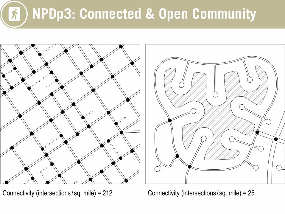
Connectivity (intersections /sq. mile) = 212 Connectivity (intersections /sq. mile) = 25


Opportunities for Suburban Retrofitting
Prototypes of suburban form that are low density, single-use, and car dependent:
• Residential subdivisions & garden apartments
• Strip corridors & vacant big box stores
• Regional shopping malls
• Infilling edge city
• Industrial and office parks

Transformation of Large Suburban Sites
• Re-development
• Re-inhabitation
• Re-greening

campustissues
statictissues
elastictissues
Residential subdivisions
Shopping malls, office parks or apartment complexes
Arterial strips See Brenda Case Scheer, “The Anatomy of Sprawl,” Places 14:2 (Fall 2001): 28–-37.
Suburban Morphology

Benefits of Pursuing LEED-ND in the Suburbs
• Stamp of approval for challenging projects
• Gain approvals from local government or community
• Reduce VMT and increase walkability
• Absorb growth in served areas rather than greenfields
• Support existing or planned transit
• Increase housing choice and amenities
• Diversify and reinvigorate the tax base
• Establish urban nodes and corridors within a region

Twinbrook Station – Transit-Focused Living
Rockville, MD
26 Acres
Stage 2 – Certified Plan
Gold
Greyfield
Twinbrook Station, Fishers Lane at Night – Courtesy of JBG Companies

Before Redevelopment


Thornton Place, Seattle


Excelsior and Grand – Retrofitting Suburbia
St. Louis Park, MN
17.5 Acres
Stage 3 – Certified Neighborhood
Certified
Previously Developed
Courtesy of George Heinrich

Excelsior and Grand – Retrofitting Suburbia

St. Louis Park, MN 55426
Population: 44,028
Med. Hshld Income: $58,073
Avg. Hshld. Size: 2.1
Cost of living index: 99.6
Elevation: 880
Land Area: 10.7 sq mi

10,000 JOBS
6,000 HOUSING UNITS


1953 aerial


1971 aerial


1991 aerial

1991 aerial

1996 watercolor by Peter Musty for Town Planning Collaborative and the City of St Louis Park.

1991 aerial

Excelsior & Grand
Land Area 15 acres
Residential Units 660
(including affordable/subsidized)
Retail 91,000 s.f.
Parking 1,650 spaces
Park land 1.5 acre
Bus Transit
(metro transit and local circulator)


Carbon Emission Savings
• 1419 lbs/yr/capita for Buildings
• 611 lbs/yr/capita for Transportation
• 12.3% below the St Louis Park Baseline
LEED-ND Certification (Stage 3 – certified level)
SLL – 17 points
NPD – 23 points
GCT (now GIB) – 2 points