Embed Size (px)
Citation preview

Latest News…• Michigan Severe
Weather Awareness Week March 24-30.
Welcome from all of us at the NWS Detroit/Pontiac office! It is the beginning of a new year across Southeast Michigan and time for the spring edition of the SKYWARN Spotter Newsletter!
Be sure to check out our website for the latest information and forecasts, as well as follow us on Facebook and Twitter.
In this Issue• September 25, 2018
Tornado Event – pg. 2-4
• January Winter Storm January 28, 2019 – pg. 5
• Spotter Training Schedule –pg. 6-7
• Local Events – pg. 7
• Weather Story Graphics –pg. 8-9
• How to submit and format a spotter report – pg. 10

2National Weather Service Spring 2019 Spotter Newsletter
After a very benign year in terms of severe weather, the 2018 severe weather season ended with a tornado event. Specifically, three tornadoes hit Southeast Michigan during the evening of September 25th.
A robust upper trough approached the western Great Lakes on September 25, while low pressure developed over northern Lower Michigan along a cold front draped over the region. Ahead of this cold front, southwest winds brought warm and moist air (dew points exceeding 70 degrees in a few areas) to Southeast Michigan during the daytime and evening hours. This air mass paired with ample wind shear (bulk wind shear of greater than 40 kt and low level helicity exceeding 100 m²/s²) was sufficient for a couple rounds of thunderstorms to move through the area. One round of storms developed over West Michigan in the afternoon and moved northeast into the Tri-Cities area by early evening. No damage was reported from these storms, but almost 2 inches of rain fell around Midland.
Another round of storms formed near the Michigan/Ohio border in the evening and moved through our southeastern counties. These storms strengthened quickly and produced three tornadoes over northern Monroe and southern Wayne Counties in addition to heavy rainfall.
Here are a couple photos from the damage in Frechtown Township
September 25, 2018 Monroe and Wayne County Tornadoes
Map of tornado tracks
Rating: EF-1Estimated peak wind: 95-100 mphPath length /Statute/: 4.3 milesPath width /Maximum/: 520 yardsFatalities: 0Injuries: 0Start date: SEP 25 2018Start time: 823 PM EDTStart location: 41.9562 / -83.4321End date: SEP 25 2018
End time: 832 PM EDTEnd location: 42.0099 / -83.3892
SURVEY SUMMARY: The path began as weak EF0 damage, mainly to trees, until near Reinhardt and Heissroads where it became a solid EF0. The tornado reached EF1 strength near Toben and South Stony Creek roads where roofing material was removed leaving exposed trusses and windows that were blown out of homes in the area. Garage doors were also blown in and many trees were damaged and uprooted. EF0 damage to siding and tree limbs was noted before the tornado dissipated near North Stoney Creek road and the railroad tracks.
Frenchtown Township tornado in Monroe County (Tor 1)
Storm relative velocity image from the Frenchtown Twp tornado; Note the circulation
associated with the tornado is circled.
Rating: EF-0Estimated peak wind: 60-65 mphPath length /Statute/: 3.8 milesPath width /Maximum/: 200 yardsFatalities: 0Injuries: 0Start date: SEP 25 2018Start time: 845 PM EDTStart location: 42.0356 / -83.264End date: SEP 25 2018End time: 852 PM EDTEnd location: 42.0870 / -83.225
SURVEY SUMMARY: An EF0 tornado began in Berlin Township in Monroe County just south of Sigler Road on North Dixie Highway. The tornado remained at EF0 strength throughout the entire path length, beforedissipating near the intersection of Meadow Lane and Ostreich Road in Wayne County near the border of Brownstown Charter Township and the city of Gibraltar. Damage included multiple limbs and large trees downed,along with missing shingles to a house near the end of the tornado path.
South Rockwood/Rockwood tornado in Monroe/Wayne Counties (Tor 2)
Tor 1
Tor 2
Tor 3
September 25, 2018 Tornadoes… continued
3National Weather Service Spring 2019 Spotter Newsletter

Rating: EF-1Estimated peak wind: 95-100 mphPath length /Statute/: 3.5 milesPath width /Maximum/: 250 yardsFatalities: 0Injuries: 0Start date: SEP 25 2018Start time: 855 PM EDTStart location: 42.0914 / -83.2059End date: SEP 25 2018End time: 902 PM EDTEnd location: 42.1079 / -83.1462
SURVEY SUMMARY: An EF1 tornado began just to the west of W Jefferson Ave and south of Gibraltar Road. The tornado remained at EF1 strength up to the Navarre Street and Young Drive area, before weakening to EF0strength for the remainder of the path. The tornado then crossed the Detroit River before dissipating at the north end of Elba Island in Grosse Ile Township. Damage included multiple large limbs and trees downed, a roof partially blown off and powerlines downed.
Gibraltar tornado in Wayne County (Tor 3)
For Reference: EF Scale: The Enhanced Fujita Scale Classifies Tornadoes into the following categories.
EF0...Weak......65 to 85 mphEF1...Weak......86 to 110 mphEF2...Strong....111 to 135 mphEF3...Strong....136 to 165 mphEF4...Violent...166 To 200 mphEF5...Violent...>200 mph
This storm system also produced three tornadoes on the other side of the Detroit River in Canada on the evening of the 25th. Below is a maps of where these tornadoes occurred.
September 25, 2018 Tornadoes… continued
4National Weather Service Spring 2019 Spotter Newsletter

January 28, 2018 Winter StormA strong low pressure system brought
several inches of snow to many portions of the Great Lakes region,
with Southeast Michigan seeing that snow throughout the day on Monday, January 28. This snow quickly exited the area Monday evening, with only
some locations seeing additional snowfall overnight on
Monday. Snowfall totals across Southeast Michigan ranged from 2
inches in Monroe County to 10 inches over Bay and Huron Counties. The
coldest air of the season then filtered in behind the departing system, bringing
dangerous cold wind chills for the couple of days following this event.Storm Total Snowfall through this event
Record Cold Temperatures Jan 30 – January 31
Winter Events Thus Far…
5National Weather Service Spring 2019 Spotter Newsletter
An arctic blast followed the snow storm that occurred
earlier in the same week and brought record cold the Great Lakes region and parts of the
northern plains.
This cold air outbreak set eight low temperature records Wednesday and Thursday at
our official climate sites.

2019 Skywarn Spotter Schedule
DATE COUNTY CITY ADDRESS TIME
February 27 Livingston Hamburg Twp Fire Department3666 M-36, Pinckney, MI 48169 7 PM – 830 PM
February 28 Washtenaw Ypsilanti Ypsilanti Township Civic Center7200 S Huron River Dr, Ypsilanti, MI 48197 7 PM – 830 PM
March 5 Oakland Novi Novi City Hall45175 W 10 Mile Rd 7 PM – 830 PM
March 6 Oakland Pontiac/Waterford Oakland County Executive Office Building2100 Pontiac Lake Rd, Waterford Twp, MI 48328 7 PM – 830 PM
March 7 Midland Midland Yet to be determined 7 PM – 830 PM
March 8 Wayne Wyandotte Wyandotte Copeland Center2306 4th St, Wyandotte, MI 48192 7 PM – 830 PM
March 9 Wayne Garden City Garden City Presbyterian Church 1841 Middlebelt Rd, Garden City, MI 48135 10 AM – 12 PM
March 13 St Clair Port Huron St Clair County Building200 Grand River Ave #203, Port Huron, MI 48060 7 PM – 9 PM
March 14 Macomb Warren Warren Civic Center Library1 City Square, Warren, MI 48093 6 PM – 8 PM
March 20 Wayne Livonia Livonia Civic Center Library32777 Five Mile Road, Livonia, MI 48154 7 PM – 9 PM
March 21 Washtenaw Ann Arbor Yet to be determined 1 PM – 230 PM
March 23 Oakland Pontiac/Waterford Oakland County Executive Office Building2100 Pontiac Lake Rd, Waterford Twp, MI 48328
10 AM – 1130 AM
1 PM – 230 PM
March 23 Oakland Pontiac/Waterford Oakland County Executive Office Building2100 Pontiac Lake Rd, Waterford Twp, MI 48328 1 PM – 230 PM
March 25 Oakland Southfield Southfield Library26300 Evergreen Rd, Southfield, MI 48076 6 PM – 730 PM
March 26 Sanilac Sandusky Firebird Theater280 E Sanilac Road 7 PM – 9 PM
March 28 Wayne DearbornUniversity of Michigan-Dearborn
Fairlane Center North - Room Quad E19000 Hubbard Drive
9 AM – 1030 AM
March 28 Lapeer Lapeer PIX Theater172 W Nepessing St, Lapeer, MI 48446 7 PM – 830 PM
March 30 Genesee Flint Genesee County Building – 3rd Floor Auditorium1101 Beach St #29, Flint, MI 48502
10 AM – 1130 AM
Training dates are also posted on our homepage. Check our web page periodically for additional updates to this schedule. In some cases, class size is limited. Please contact the local Emergency Management Office for more
information.
6National Weather Service Spring 2019 Spotter Newsletter
February to March Dates

Schedule continued and Local Events
DATE COUNTY CITY ADDRESS TIME
April 2 Monroe Temperance Bedford Branch Library8575 Jackman Rd, Temperance, MI 48182 630 PM – 8 PM
April 4 Oakland Rochester Rochester Fire Department277 E 2nd St, Rochester, MI 48307 7 PM – 830 PM
April 6 Macomb Clinton Twp Macomb Intermediate School District37623 Garfield Rd # 110, Clinton Twp, MI 48036 10 AM – 12 PM
April 8 OaklandHolly/Groveland
TownshipGroveland Twp Fire Department
14645 Dixie Hwy # B, Holly, MI 48442 7 PM – 9 PM
April 10 Oakland Canton Canton Twp Police Department1150 S Canton Center Rd, Canton, MI 48188 7 PM – 830 PM
April 11 Lenawee AdrianSienna Heights University – Dominican Hall
Reuckert Auditoriam1247 E Siena Heights Dr, Adrian, MI 49221
7 PM – 830 PM
April 13 Washtenaw Ann Arbor Pioneer High School601 W Stadium Blvd, Ann Arbor, MI 48103
10 AM – 1130 AM
April 23 Bay Bay City To Be Determined 7 PM – 830 PM
7National Weather Service Spring 2019 Spotter Newsletter
April Dates
Come visit the NWS at the 61st Annual Spring Boating
Expo at the CoBo Center! detroitboatshow.net/
State Wide Tornado DrillWednesday, March 27 1:00 PM – 1:30 PM
WeatherFestDate: May 13 Location: Southfield Public Library Time: 1 PM to 6 PM
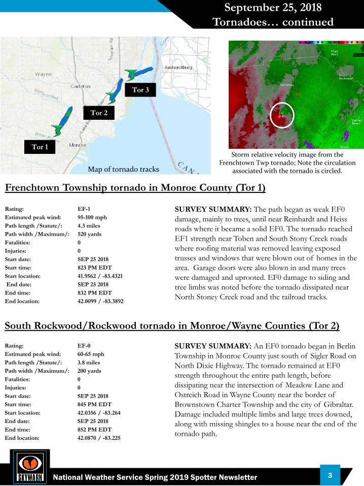
Weather Story Graphics
Many of you have likely noticed the Graphical Forecast page link near the bottom left on the NWS Detroit Homepage (just to the left of the radar image link). This is the Weather Story link. When clicking on this page, you will find a graphical forecast. In some instances, especially during busy weather, there will be multiple tabs each with a graphical forecast element.
Some information that can be found under these weather story tabs, in addition to general forecast information and outlooks include:
Winter Weather• Location and time of watches, warnings and
advisories.• Forecast snowfall totals and start/end times of
accumulating snow.• Forecast ice accumulations during freezing
rain.• Main hazards associated with the winter
weather.• Below is an example from this past November.
Severe Weather• Storm prediction center convective outlooks
(zoomed in over Michigan).• Severe Thunderstorm or Tornado Watches
(warnings are too short fused to place in a graphics but do automatically populate on the map on the front of the NWS Detroit website).
• Most likely time period of severe weather.• Main hazards expected with the severe
weather.• Below is an example from this past September.
8National Weather Service Spring 2019 Spotter Newsletter

Other Hazardous Weather• Flooding; timing and location.• Rainfall amounts during heavy rain.• Dense fog potential, location and any
advisories• Lake shore flooding; areas impacted.• Hazardous marine conditions on Lake
Huron, St Clair and western Lake Erie; storm force winds, gales, small craft advisories (during boating season).
Short Term Forecasts Valid 1 to 4 hours:• A radar image followed by a short fused
forecast.• Potential hazards over the next couple
hours.• Locations to be impacted as a result of
short fused weather.• Below is an example of a thunderstorm
complex advancing across the area.
SitRep (Situation Report):• Issued during forecast high impact weather conditions.• When one is in effect, the link will be located in the
top right corner on the NWS Detroit Homepage and will be a yellow rectangle box with the words Situation Report on it.
• The link takes you to another page which gives a quick overview of the forecast and potential hazards.
• These will typically be issued for forecast winter storms, larger scale severe weather events and with potential for significant flooding.
Weather Story Graphics
9National Weather Service Spring 2019 Spotter Newsletter

How To Format and Submit A Spotter Report
NWSDetroit
1-800-808-0006Reports ONLY – answered 24/7
Amateur Radio
Contact local net control for info
@NWSDetroit#miwx
Send photos if you can
Communicate the 3 W’s!
“Hello, my name is _____ and I have a storm report for you. At 5:35pm, we had golf ball size hail near the intersection of Eleven Mile and
Woodward Ave in Royal Oak. It lasted for about 5 minutes and caused some damage to
siding and cars.”
WHAT
WHEN
WHERE Also try to include other important info –damage, injuries, etc.
Example Report
10National Weather Service Spring 2019 Spotter Newsletter
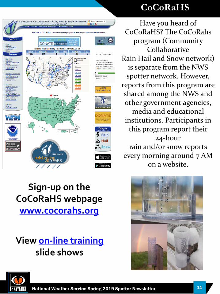
CoCoRaHS
Communicate the 3 W’s!
Example Report
11National Weather Service Spring 2019 Spotter Newsletter
Have you heard of CoCoRaHS? The CoCoRahs
program (Community Collaborative
Rain Hail and Snow network) is separate from the NWS spotter network. However,
reports from this program are shared among the NWS and other government agencies,
media and educational institutions. Participants in
this program report their 24‐hour
rain and/or snow reports every morning around 7 AM
on a website.
Sign-up on the CoCoRaHS webpagewww.cocorahs.org
View on-line training slide shows
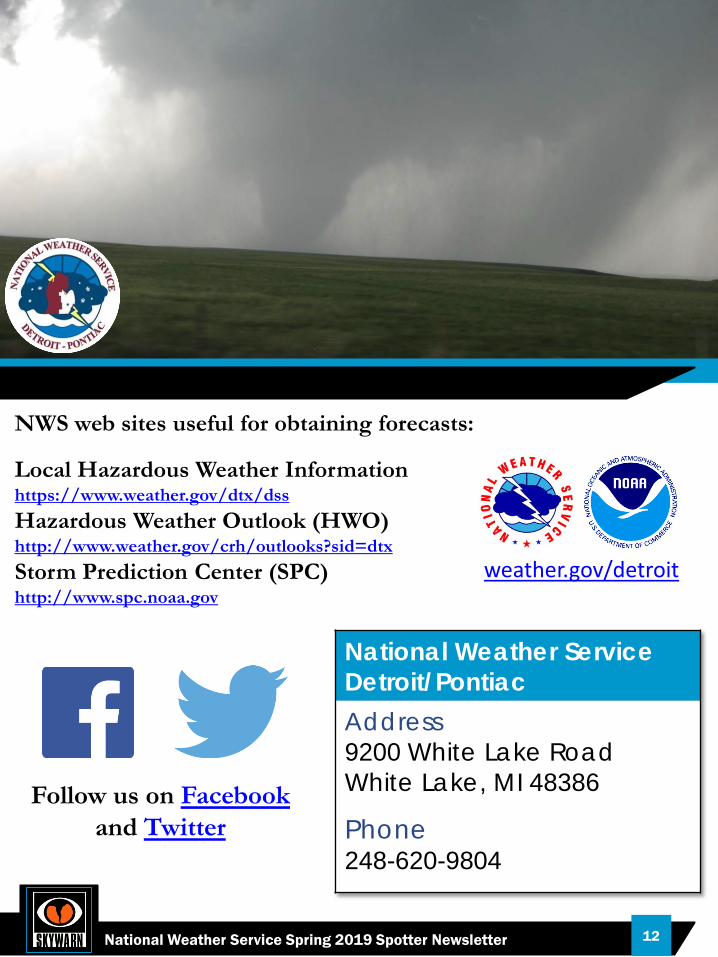
NWS web sites useful for obtaining forecasts:
Local Hazardous Weather Information https://www.weather.gov/dtx/dssHazardous Weather Outlook (HWO) http://www.weather.gov/crh/outlooks?sid=dtxStorm Prediction Center (SPC) http://www.spc.noaa.gov
weather.gov/detroit
National Weather ServiceDetroit/PontiacAddress9200 White Lake RoadWhite Lake, MI 48386
Phone248-620-9804
Follow us on the Social Media’s
Follow us on Facebookand Twitter
12National Weather Service Spring 2019 Spotter Newsletter