Embed Size (px)
Citation preview

LARGE DAMS FOR HYDROPOWERIN NORTHEAST INDIA
A DOSSIERCompiled by Manju Menon
with Kanchi Kohli
KalpavrikshSouth Asia Network on Dams, Rivers and People
June 2005
Cover.p65 6/3/2005, 8:02 PM1

Design and Layout: Ashish Fernandes
Illustrations: Madhuvanti A
Map of Large Dams in Northeast India: Ecollage(the plate first appeared in Whitaker, R.W. and Captain,A.S. (2005) Snakes of India, The Field Guide.Draco Books, Chennai, 2005)
Suggested contribution: Rs 150/- for individualsRs 300/- for institutions
Contact SANDRP for copies.
KalpavrikshEnvironmental Action GroupApt. 5, Shree Dutta Krupa,908, Deccan Gymkhana,Pune 411 004Tel: +91 020 2565 4239
Delhi office: 134, Tower 10,Supreme Enclave, Mayur Vihar Phase I,New Delhi 110 091Tel: +91 011 2275 3714www.kalpavriksh.org
Author’s e-mail: [email protected]
South Asia Network on Dams,Rivers and People (SANDRP)86-D, AD Block, Shalimar Bagh,New Delhi 110 088Tel: +91 011 2748 4654/5E-mail: [email protected]://www.narmada.org/sandrp/
Published by:
Cover.p65 6/3/2005, 8:01 PM2

3
Acknowledgment
The preparation of this Dossier would not have been possible without the
significant contribution of several individuals from within and outside the
Northeast. Ashish Kothari and Himanshu Thakkar, for generously offering all
their files that they’ve been meticulously maintaining over the last two decades;
Bittu Sahgal’s thought provoking e-mails which got me started; Dr. Anwaruddin
Choudhury, Dr. D. C Goswami, Abdhesh Gangwar, Ajay Rastogi, Ruchi Pant,
Walter Fernandes, Roy Laifungbam, Ravindranath and his team at RVC-Akajan
and Sanat Chakraborty for helping to frame a perspective; Soumen Dey, Firoz
Ahmed, Partha Das and others at Aaranyak, Bikul Goswami, Jarjum Ete,
W. Ramananda and Salam Rajesh, splendid individuals with ‘fire in the belly’
who have helped whenever asked! Goutam Narayan, Nandita Hazarika and
family, whose generosity is now common knowledge since they appear in the
acknowledgments of most people who have worked in the region in recent
years. Many thanks for being there to chat and teach, and of course for all
those heavenly meals.
Several people whom I’d rather not name here, have extended invaluable
support by providing classified information and ‘inside’ stories. To all of them,
many thanks and best wishes. I’ve been humbled by your complete acceptance to
be part of these conversations irrespective of whether our opinions agreed.
SANDRP and Bombay Natural History Society, who I consider partners in
this collective work, have extended the much needed logistical support by way of
quick disbursals of funds to undertake work. My gratitude to them for this and
also for making extensive efforts at integrating these NE issues into their other
projects and for taking these issues to new audience.
Back home, I still need to apologise adequately to Ashish for having ditched
him on a project to begin work on NE dams. And to Pankaj for letting me take
over his computer, coffee breaks and whatever else I needed, our time together
being the most contested of these all. It seems inadequate to thank Neeraj just
yet, there’s still much that we have to do. My gratitude to all at KV, always, for
a list of things that’s just too long.
Manju MenonMarch 2005
Section 1.p65 3/15/05, 9:01 PM3
Black

Large Dams for Hydropower in Northeast India4
About the Dossier
Our concern about the large dams being proposed for the Northeast (NE) region was sparked off by e-mailsfrom Bittu Sahgal, editor Sanctuary Asia, who had also been a member of MOEF’s Expert Appraisal Committeefor river valley projects (1998-2000). Back then, there was little news in the public domain about projects proposedfor the region. The few groups in the region that we were familiar with had close to no information on them either.It was clear that all the planning and decision-making was taking place in Delhi and NGOs or citizens’ groups inthe region had no clue of it. We spent the summer of 2001 trying to reach organisations, groups, networks andindividuals to communicate the random, incomplete and sometimes inconsistent information that we stumbledupon from various sources. South Asia Network on Dams, Rivers and People (SANDRP), New Delhi, which wasthen in the process of disseminating the findings of the World Commission on Dams, saw the relevance of bringingsome of these groups together for an initial brainstorming on the issue of dams in Northeast India. The meeting,called the ‘Regional Consultation on Dams and Development’, held at Mawlein, Meghalaya, in July 2001, gaveus our first opportunity to present the findings of our research to groups from the NE. Friends and colleagues atthe meeting also suggested that the preparation of a Dossier on Large Dams in Northeast India would be useful.The dossier was to bring together all the information that could be accessed regarding large dam projects thatwere proposed for Northeast India as well as some thematic papers relevant for the region into one publication,which could then be made easily available to groups and individuals who may be interested in further investigatingthese issues. A draft of the dossier was prepared in 2003 and circulated to groups and individuals interested in theissue. This final version of the dossier has been updated substantially with information from 2003 to 2005 byKanchi Kohli of Kalpavriksh.
Since that meeting in 2001, there have been several others and the information base and number of organisationsand individuals involved in this issue has grown tremendously. Kalpavriksh and several other groups have undertakendetailed investigations, organised press meets, community level discussions, made presentations to governmentofficials, NGO networks and students. Several groups from the region are clearly committed to continuing thisprocess until an informed public opinion on this issue is built UP and local communities and indigenous peoples’groups are allowed to participate in the decision making process for these projects. We do hope that this compilationof information will help these groups to achieve this purpose.
Compiling this Dossier was not an easy task due to a severe lack of adequate and consistent informationregarding these projects in the public domain. Basic information on some of these projects is available in newspaperreports, websites of state/central departments/ministries and project proponents. However, more detailed andcritical information, especially those related to negative environmental and social impacts of the project, unfavourablecost-benefit ratios, impacts of conservation offsets such as compensatory afforestation and such are difficult tofind. An attempt has been made here to draw out these aspects of the proposed projects from voluminous projectreports, official correspondence between departments and ministries and notes made by members of the RiverValley Expert Committee, most of which are ‘classified’ documents and difficult to access.
The information in the Dossier could be used for further investigations and understanding on impacts ofcommissioned and proposed projects in the Northeast. Impacts of a project on the people and the environmentboth upstream and downstream of the dam site, impacts of transmission lines, project housing colonies and otherallied infrastructure development, impacts of the clearance conditions for projects like resettlement of communities,catchment area treatment, bringing newer areas under the Forest Department and declaring of new ProtectedAreas are some of the examples of what needs to be investigated to understand the full range of the impacts ofthese dam projects. Further investigations are also needed on basin-wise impacts, for example, what will be thecumulative impact of constructing three large dams in the Subansiri basin? Some of the case studies and thematicnotes in the Dossier could help to understand the relevance of these questions and concerns.
The Dossier also contains information regarding some central and local legislations that govern environmentaldecision-making for river valley projects. Knowledge of these could help citizens understand the process ofdecision-making and thereby utilise the opportunities available for participating in it. It could also help groupsand individuals seek greater space for people’s involvement in formal decision-making processes if the existingspaces are found to be inadequate or ineffective.
Section 1.p65 3/22/05, 2:10 PM4
Black

5
CONTENTS
SECTION I: Power Sector in Northeast India1.1 National Policy on Hydropower Development1.2 Complete List of Hydroelectric Projects for Northeast India1.3 Power Sector in Northeast India
1.4 Large Hydel Projects in Northeast India: Issues and Concerns
SECTION II: Case Studies and Short Notes2.1 Ecological and Social Impacts of the Ithai Barrage2.2 Environmental Impact Assessment Report of Lower Subansiri Hydroelectric Project2.3 Environmental Public Hearing for the Lower Subansiri Hydroelectric Project
2.4 Environmental Concerns Regarding the Kameng Hydroelectric Project2.5 Environmental Public Hearing for the Kameng Hydroelectric Project2.6 Tripura’s Gumti Dam Must Go2.7 Downstream Impacts of the Ranganadi Dam
SECTION III: Thematic Papers3.1 Strategic Priorities – A New Policy Framework3.2 Environmental Aspects of Large Dams in India3.3 Geodynamic Perspective of Arunachal Pradesh3.4 Reassessing the Role of Large Dams in Meeting Power Demand3.5 Water Resource Management in the Hindu Kush Himalaya3.6 Dams and Floods
SECTION IV: Official Documents for Some Projects4.1 Environmental Clearance – Kameng Hydroelectric Project4.2 MoU Between Government of Manipur and NEEPCO, Tipaimukh Hydroelectric Project4.3 Environmental Clearance – Myndtu Hydroelectric Project4.4 MoU Between Government of Mizoram and NEEPCO, Tuirial Hydroelectric Project4.5 Summary Records of the Public Hearing held for Bairabi Hydroelectric Project.4.6 Environmental Clearance – Tuivai Hydroelectric Project4.7 Forest (Diversion) Clearance – Tuivai Hydroelectric Project4.8 Environmental Clearance – Rangit Hydroelectric Project4.9 Forest (Diversion) Clearance – Rangit Hydroelectric Project
4.10 Environmental Clearance – Teesta Stage V Hydroelectric Project4.11 Forest (Diversion) Clearance – Teesta Stage V Hydroelectric Project4.12 Forest (Diversion) Clearance – Lower Subansiri Hydroelectric Project4.13 Environmental Clearance – Lower Subansiri Hydroelectric Project
SECTION V: News Reports
SECTION VI: Citizens’ Responses6.1 Report on the Northeast Region Consultation on the World Commission on Dams6.2 Statement of the North-Eastern Regional Workshop of National Biodiversity Strategy And Action Plan6.3 Proceedings of a Public Hearing on Biodiversity Conservation with reference to Hydel Projects, Aizawl6.4 Letter to Assam Pollution Control Board on Lower Subansiri Hydroelectric Project6.5 Letter to Supreme Court Chief Justice on Lower Subansiri Hydroelectric Project6.6 Letter to Secretary, MoEF on Resolutions of a Public Meeting on Lower Subansiri Hydroelectric Project6.7 Letter to NHPC Chairman from Subansiri Valley Indigenous Peoples Forum
SECTION VII: Spaces for People’s Participation in Decision Making for Hydroelectric Projects
Section 1.p65 3/15/05, 9:01 PM5
Black

7
SECTION I
Power Sector in Northeast India
Power Sector in Northeast India
Section 1.p65 3/15/05, 9:01 PM7
Black

Large Dams for Hydropower in Northeast India8
NEED FOR A HYDEL POLICY Hydro power is a renewable economic, non polluting and environmentally benign source
of energy. Hydro power stations have inherent ability for instantaneous starting, stopping,load variations etc. and help in improving reliability of power system. Hydro stations arethe best choice for meeting the peak demand. The generation cost is not only inflation freebut reduces with time. Hydroelectric projects have long useful life extending over 50years and help in conserving scarce fossil fuels. They also help in opening of avenues fordevelopment of remote and backward areas.
Our country is endowed with enormous economically exploitable and viable hydropotential assessed to be about 84,000 MW at 60% load factor (1,48,700 MW installedcapacity). In addition, 6781.81 MW in terms of installed capacity from small, mini andmicro hydel schemes have been assessed. Also, 56 sites for pumped storage schemes withan aggregate installed capacity of 94,000 MW have been identified. However, only 15%of the hydroelectric potential has been harnessed so far and 7% is under various stages ofdevelopment. Thus, 78% of the potential remains without any plan for exploitation.
Despite hydroelectric projects being recognised as the most economic and preferred sourceof electricity, share of hydro power has been declining steadily since 1963. The share ofhydro power has been continuously declining during the last three decades. The hydro sharehas declined from 44 per cent in 1970 to 25 per cent in 1998. The ideal hydro thermal mixshould be in the ratio of 40:60. Because of an imbalance in the hydel thermal mix especiallyin the Eastern and Western regions, many thermal power stations are required to back downduring off peak hours. The capacity of the thermal plants cannot be fully utilised resulting ina loss of about 4 to 5 per cent in the plant load factor. Even if the share of hydro power is tobe maintained at the existing level of 25 per cent, the capacity addition during the 9th and10th Plan would work out to 23,000 MW. If the share were to be enhanced to 30 per cent, itwould require a further addition of 10, 000 MW of hydro capacity.
The constraints which have affected hydro development are technical (difficultinvestigation, inadequacies in tunnelling methods), financial (deficiencies in providing longterm financing), tariff related issues and managerial weaknesses (poor contractmanagement). Hydro projects are also affected by geological surprises (especially in theHimalayan region where underground tunnelling is required), inaccessibility of the area,problems due to delay in land acquisition, and resettlement of project affected families,law & order problem in militant infested areas.
OBJECTIVESThe programmed capacity addition from hydel projects during the 9th Plan is 9815
MW, of which Central Sector and State Sector will contribute 3455 MW and 5810 MWrespectively and the balance 550 MW will be contributed by the Private Sector. Sanctionedand ongoing schemes under implementation will enable a capacity addition of 6537 MWduring the 10th Plan, of which 990 MW, 4498 MW and 1050 MW will be the contributionof Central, State and Private Sectors respectively. In addition, 12 projects (5615 MW)have been identified for advance action in the 9th Plan for benefits in the 10th Plan.
The Government of India has set the following objectives for accelerating the pace ofhydro power development:-
National Policy onHydropower Development
1.1
“The programmedcapacity addition fromhydel projects during
the 9th Plan is 9815MW, of which Central
Sector and StateSector will contribute
3455 MW and 5810MW respectively andthe balance 550 MW
will be contributed bythe Private Sector.”
Section 1.p65 3/15/05, 9:01 PM8
Black

9
(i) Ensuring targeted capacity addition during 9th Plan: The 9th Plan programme envisages capacity addition of 9815 MW from hydel projectsin the total capacity addition of 40245 MW. The Central Sector hydel projects wouldcontribute 3455 MW, State Sector would add 5810 MW and Private Sector 550MW. Keeping in view that the achievement in 8th Plan had been dismal, theGovernment is determined to ensure that no slippage is allowed to occur and thetargeted capacity addition in the 9th Plan is achieved in full.
(ii) Exploitation of vast hydroelectric potential at a faster pace: The Government would initiate advance action for taking up new hydro projectssince the ongoing projects will contribute a very small percentage of the desired capacityaddition envisioned for 10th Plan and beyond. Towards this end, Government wouldtake up for execution all the CEA cleared projects, and take steps to update andobtain clearances for pending DPRs. Measures for vigorously starting survey andinvestigations for new green field sites would also be implemented shortly. In addition,Government is keen to restart and activate the hydro projects which are either languishingfor want of funds or are remaining dormant due to unresolved inter-State issues.
(iii) Promoting small and mini hydel projects Small and mini hydel potential can provide a solution for the energy problems inremote and hilly areas where extension of grid system is comparatively uneconomicaland also along the canal systems having sufficient drops. The small hydro potentialcould be developed economically by simple design of turbines, generators and thecivil works. Small and mini hydel capacity aggregating to about 340 MW is inoperation, and Government is determined to provide thrust for developing the assessedsmall hydel potential at a faster pace henceforth.
(iv) Strengthening the role of PSUs/SEBs for taking up new hydel projects: In view of the poor response of the private sector so far in hydro development whichmay persist for some more years, the involvement of public sector in hydel projectswould not only have to continue but will also have to be enlarged. There are categoriesof projects such as multi-purpose, projects involving inter-State issues, projects forpeaking power and those involving rehabilitation and resettlement which may betaken up and implemented more easily in public sector. Similarly, mega hydro projectsin the North and North Eastern region would also have to be executed by CPSUs incase the State or the private sector is not in position to implement these projects.
(v) Increasing private investment: Even though public sector organisations would play a greater role in the developmentof new schemes, this alone would not be adequate to develop the vast remaininghydro potential since it will require huge investments which are difficult to be supportedfrom the budget/plan assistance in view of competing demands from the varioussectors. A greater private investment through IPPs and joint ventures would beencouraged in the coming years and required atmosphere, incentives and reliefs wouldbe provided to stimulate and maintain a trend in this direction.
POLICY INSTRUMENTSPOLICY INSTRUMENTSPOLICY INSTRUMENTSPOLICY INSTRUMENTSPOLICY INSTRUMENTSTo achieve the above stated objectives for faster development of hydro potential, the
Government proposes to take the following steps and measures: - 3.1 Funding
All the ongoing Central Sector hydroelectric projects namely Nathpa Jhakri (1500 MW),Tehri Stage I (1000 MW), Ranganadi Stage I (405 MW), Dulhasti (390 MW), Dhauliganga(280 MW), Doyang (75 MW) and Rangit (60 MW) would be provided with full budgetary
Power Sector in Northeast India
Section 1.p65 3/15/05, 9:01 PM9
Black

Large Dams for Hydropower in Northeast India10
support till completion. Government of India will also provide budgetary support for thenew projects to be taken up by the CPSUs during the 9th Plan. The actual utilisation of thefunds on the ongoing Central Sector hydel projects has been Rs. 1616.87 crores in 1997-98 and the budget provision for 1998-99 has been increased to Rs. 2070 crores. Thereforethe remaining three years of the 9th Plan would require about Rs. 5896 crores on theongoing Central Sector projects (excluding NEC projects). Having regard to the largecapacity addition envisaged in the State Sector (5810 MW) it is necessary to(a) provide a mechanism for funding hydro projects by earmarking funds in the planallocation of the State Governments by the Planning Commission; and (b) organisingsupplementary funding of hydel projects where more than 50 per cent of the expenditurehas already been incurred.
The monitoring of all the ongoing projects will be intensified and a task force would beconstituted for this purpose. The progress of important projects in the State and CentralSector would be reviewed at the level of Minister/Secretary (Power) and all measures willbe taken so that there is no slippage in the schedule for completion of the ongoing projects.
3.2 Power Development Fund The survey and investigation of hydro projects have been discontinued since long in the
States due to paucity of funds. As a result, there are not enough projects right now thatcould be taken up in the next 2 to 3 years and get completed in the 10th Plan or early 11thPlan. It is necessary to carry out survey and investigations continuously and prepare ashelf of projects for execution over a decade and more.
In case fully investigated projects with Detailed Project Reports are offered to privatedevelopers, their response could be more favourable. If pre-construction activities andenabling works could be completed and these sites offered to IPPs the chances of IPPsopting to invest in these projects would further improve. Further this would reduce thegestation period which would make investment in hydro projects more attractive.
The above approach is possible and successful only if a dedicated fund is available forthis purpose.
It is proposed to levy a Power Development Cess at 10 paise per kwh of electricityconsumed in the country. The levy of cess was recommended by the Sub Committee of theNDC Committee on Power which gave its report in January, 1994. The cess would belevied on the electricity billed by SEBs/Electricity Departments/Bulk licensees/Distributionlicensees. The State/UT Governments would be responsible for the collection of the cess.The amount would thereafter be credited to a “National Power Development Fund”. It isexpected that about Rs. 3000 crores per annum can be realised by levying a cess of 10paise per kwh.
It would be necessary to establish a legal and organisational frame work for levy of acess. Electricity being a Concurrent Subject, the Central Government is empowered tolegislate on all aspects of electricity including the levy of cess, the proceeds of which isto be utilised for power development. In order to levy a Power Development Cess, itwould be necessary for Parliament to enact a legislation on the subject. The cess will beimposed on the consumption of electricity throughout the country. The State ElectricityBoards will be the responsible agencies for the collection of cess. The proceeds of thecess will be shared with the State/UT Governments and the Central Government. Two-thirds of the amount realised from the State/UT Government will be allocated to therespective government to be utilised for power development. This amount would bereleased from the National Power Development Fund for financing schemes/projectsrecommended by the State Government. The remaining one-third will be utilised by the
“It is proposed tolevy a Power
Development Cessat 10 paise
per kwh of electricityconsumed in the
country [to generatea Power
Development Fund].”
Section 1.p65 3/15/05, 9:01 PM10
Black

11
Central Government for promoting hydel projects in the Central Sector and for investmentin transmission lines for evacuation of power from mega hydel projects which will benefitmore than one State.
3.3 Basin-wise Development of Hydro Potential The assessment of hydro potential in 845 identified conventional hydro projects and 56
pumped storage projects is on the basis of desk studies using topo sheets and dischargedata. Further, detailed studies to firm up the parameters of the projects as identified byCEA would be taken up on the basis of development of hydro potential in a basin as awhole for maximising benefits and prioritising execution of projects. These studies will bedone in close coordination with CWC and Planning Commission and in harmony withdevelopment for other uses of water like irrigation, drinking water etc. While CEA wouldcarry out these studies, CPSUs/other Central Government Organisations and Stateauthorities would do the investigations and prepare the detailed project reports, by adoptingan integrated approach towards planning and development of the various projects, evacuationarrangement and environmental impact assessment. This would enable an optimalharnessing of hydro potential in each river basin
3.4 Advance Action for Capacity Addition in the 10th Plan and beyond Government will take immediate steps to tie up funding, execution agencies and convey
investment decision for schemes already accorded techno economic clearance of CEA.As far as Central Sector is concerned, NHPC would take up Chamera Stage II (300 MW),Parbati Stage-II (800 MW), and Kol Dam (800 MW) in HP; Teesta Stage V (510 MW) inSikkim, Loktak Downstream (90 MW) in Manipur and NEEPCO will take up Tuivai(210 MW) in Mizoram, Lower Kopili (150 MW) in Assam, Kameng (600 MW) and Ranganadi Stage II (160 MW) in Arunachal Pradesh (after the consent of the State Govt.has been obtained). In addition THDC would take action to start activities on Tehri StageII (1000 MW) and Koteshwar (400 MW) in UP. Similarly NJPC would also take upRampur Project (535 MW) in HP. These projects would require budgetary support ofabout Rs. 2000 crores in the 9th Plan.
3.5 Survey & Investigations As a long term strategy efforts will be made to ensure that DPRs which are under various
stages of processing for accord of TEC by CEA are finalised and cleared so that a start couldbe made on these projects in the next one or two years. Survey and investigation of thepotential hydro sites on an advanced scientific basis would be essential requirement for thefuture. The progress on this front has been dismal given the funds constraint and outdatedtechnology. The funding agencies like World Bank and ADB have shown their interest towardsfunding the survey and investigation activities for hydroelectric projects. Concerted effortswould be made towards availing the funds quickly. This would not only help in preparationof the bankable DPRs for large hydroelectric projects but would also bring in advancedtechnology by involving reputed international consultants. The Central organisations likeCWC, Brahmaputra Board, NEEPCO and NHPC, besides SEBs would be provided withfunding support from the proposed Power Development Fund for the purpose of carrying outsurvey and investigations and preparation of bankable DPRs.
Since the private sector has so far been hesitant and cautious to invest in hydroprojects, it is proposed that new projects will initially be taken up by CPSUs/SEBs forinvestigations, updatation of DPRs, obtaining the necessary clearances and pre-construction activities. After these stages, the projects could be offered to the privatesector for execution either on ‘stand alone’ basis or for joint venture participation
Power Sector in Northeast India
“Funding agencieslike World Bank and
ADB have shown theirinterest towards
funding the surveyand investigation
activities forhydroelectric
projects.”
Section 1.p65 3/15/05, 9:01 PM11
Black

Large Dams for Hydropower in Northeast India12
with the CPSU/SEB. The expenditure incurred by CPSUs/SEBs on these activitieswould be adjusted in the project cost to be recovered from the executing agency to bedecided at a later stage. The Government expects that more private investment wouldbe possible with this approach. In case for a particular project no such privateinvestment is forthcoming, it will be executed entirely by the concerned CPSU/SEBwhich initiated its development.
3.6 Inter-State Projects A substantial hydel power potential has remained locked up and many mega hydel
projects could not be taken up for implementation, even though these projects are wellrecognised as attractive and viable, because of unresolved Inter-State issues. Govt. ofIndia recognises the need for evolving an approach to ensure that the available hydroelectricpotential is fully utilised without prejudice to the rights of the riparian States as determinedby the Awards of the Tribunals/Agreements arrived at among the party States for a givenriver basin with regard to water sharing. The selection and design of project would bebased on integrated basin wise studies, so as to arrive at an optimal decision and care willbe taken that such projects do not in any way prejudice the claims of basin states or affectbenefits from the existing projects. A consensus would be evolved amongst the basinstates regarding the location of such project, basic parameters involved and mechanismthrough which each project would be constructed and operated. As far as possible, therewould be preference to take up simple run-of-the-river schemes that do not involve anymajor storage or consumptive uses.
3.7 Renovation, Modernisation & Uprating Renovation, Modernisation & Uprating of old hydro power plants is being accorded
priority as it is a faster and cheaper way of capacity addition than installing new capacity.As per recommendations of National Committee set up in 1987 and based on the subsequentreviews, 55 hydro schemes with an aggregate capacity of 9653 MW were identified forRM&U. Out of these, 20 hydro schemes have been completed providing a benefit of971.5 MW and work on 27 schemes is in progress. In order to provide a greater thrust forRM&U, Government would set up a Standing Committee, to identify the new schemes andfor tying up technology, funding and executing agencies.
3.8 Promoting Small and Mini Hydel Projects The Ministry of Non-Conventional Energy Sources (MNES) deals with all matters
related to Small Hydel Projects (up to 3 MW capacity). These projects are being providedwith the following incentives. (i) Incentives for detailed survey & investigation and preparation of DPR. (ii) Incentives during the execution of the project in the form of capital/ interest subsidy. (iii) Special incentives for execution of small hydro projects in the North Eastern Region
by the Government departments/SEBs/State agencies. (iv) Financial support for renovation, modernisation and uprating of old small hydro power
stations. The Small Hydel Projects are site specific and depending on the hydrology, typically
the plant load factor varies from 40 to 60%. The Small Hydel Projects up to 25 MWwill also be transferred to MNES in order to provide greater thrust for its development. Government of India proposes to provide soft loans to these projects (up to 25 MW)through IREDA/PFC/REC and other financial institutions and Ministry of Non-conventional Energy Sources would announce a suitable package of financial incentivesfor the accelerated development of Small Hydel Projects up to 25 MW station capacity.
Section 1.p65 3/15/05, 9:01 PM12
Black

13
The State Government and Central and State Hydro Corporations like NHPC/NEEPCOetc. would be encouraged to take up a cluster of small/mini hydel schemes on Build,Operate and Transfer basis, and other suitable arrangements.
3.9 Simplified Procedures for Transfer of Clearances As stated in the foregoing, the CPSUs and the private sector would need to play a
greater role in hydro development. The immediate requirement would be to transfer theclearances already accorded to non-starting hydro projects in the State Sector in favour ofCPSU/IPP/Joint Venture of IPP and CPSU. Government would evolve a simple procedureso that the transfer of CEA’s techno economic clearance would be facile as only updationof project estimate would be examined by CEA. In the case of Environment and Forestclearances these could be transferred to CPSU/IPP etc. within a prescribed time limit onacceptance of conditionalities stipulated in the MOEF clearances accorded for executionin the State Sector by the above executing agencies. Another inhibiting factor discouragingIPPs is the need for notification of the scheme as per Section 29 of ES Act in newspaperand Gazette afresh even if this was done earlier for execution by SEBs. Governmentintends to do away with this requirement. The simplified procedure as proposed would bean encouraging factor for IPP to evince greater interest in hydro development. Governmentwould initiate action right away towards this end.
3.10 Rationalisation of Hydro Tariff The tariff formulation and norms for hydro projects as per existing Government notification
are viewed by CPSUs and IPPs as unfavourable compared to those for thermal projects andthe IPPs tend to prefer thermal projects for investment. There is a need to reformulate theprinciples on the basis of which tariff is determined for hydel generation. The objective is tofix a rate which will be reasonable to the consumer, to ensure adequate internal resources torepay the loan and also to provide a reasonable rate of return on investment. Recognising thedifficulties in execution of hydro projects, the Government has decided to rationalise theexisting hydro tariff norms, improve the incentives for better operation and evolve a solutionto the contentious issue of computing the completion cost in the face of geological uncertaintiesand surprises and natural incidents of rock slide etc.
In January 1995, the Government issued a notification providing for a two part tarifffor hydel generation stations. The first part of the tariff, denominated as capacity chargescovers (a) interest on loan capital; and (b) depreciation reckoned at an annual amount notexceeding 1/12 of the loan amount and limited to the actual loan liability of the year as perapproved financial package. The second part of the tariff denominated as energy chargescovers (a) return on equity calculated at 16% (b) O&M charges; (c) tax on income; and (d)any other variable charge.
Hydro projects provide valuable peak power and have inherent capability forinstantaneous starting and stoppage based on variation of load. The peaking powerstations generally operate at a very low load level. Recognising the value of peakpower to the system and resultant improvement in operation of thermal stations, it isproposed to allow a premium on the sale rate for hydro generation during peakperiod. The formulation of peak tariff and the premium to be allowed would bedecided by the Central Electricity Regulatory Commission and the State ElectricityRegulatory Commissions. Under the present notification, the rate for incentive forsecondary energy has to be fixed at a rate mutually agreed between the State ElectricityBoard and the generating company. However, the maximum payment on this accountis restricted to an amount not exceeding 10% return on equity. In order to providean additional incentive for attracting investment in hydel projects, it is proposed to
Power Sector in Northeast India
Section 1.p65 3/15/05, 9:01 PM13
Black
Large Dams for Hydropower in Northeast India14
allow the sale rate for secondary energy at the same rate which is applicable for aprimary energy.
Recognising the problems in operation of hydro power stations in the initial yearsespecially in project with silt laden water, the normative availability factor is proposed tobe reduced from 90% to 85%.
3.11 Estimates on Completion Cost (Geological Risks) During the implementation of hydro power projects specially underground power stations,
there is a likelihood of coming across geological surprises which are not anticipated at thetime of preparation of Detailed Project Report. This results in increase in capital cost.The developer would need to be compensated for this kind of eventualities.
In the existing tariff notification for hydro projects, there is no provision for increasein project cost arising due to geological risks. A realistic estimate of completion costhas to take into account the geological and hydrological risks, cost escalation and naturaloccurrences of land slides, rock falls etc. In such cases, the developer will be allowed tosubmit his proposal for the enhanced cost to the Government. Expert Committee wouldbe constituted at the State and Central level who would evaluate and recommend thecost increases for acceptance by the Government. The expert committee at the StateGovernment level would recommend the cost increase proposal upto certain percentageand beyond that the cost increase would be recommended by the expert committee at theCentral Government level.
3.12 Promoting Hydel Projects with Joint Ventures With a view to bring in additional private investment in the hydel sector there would
be a greater emphasis to take up schemes through the joint ventures between the PSUs/SEBs and the domestic and foreign private enterprises. The joint venture company willbe an independent legal entity to be registered under the Companies Act and would actas an independent developer. The joint venture agreement between the two partners willbring clearly the extent of participation by each partner and sharing of risks relating toimplementation and operation of the project. It will also provide for arrangement insuch cases where the joint venture partner would not be associated with the operationand maintenance of the project. While the selection of a joint venture partner would bein accordance with the policy of the Government, there would be an option for the PSUto either select the joint venture partner together with their financial and equipmentpackage or to select a joint venture partner wherein the EPC contract is decided by boththe partners after they have formed the joint venture company. The associated transmissionline connected with the scheme will be constructed by the Powergrid Corporation ofIndia. The power from joint venture hydel projects will be purchased by the PowerTrading Corporation (PTC) proposed to be formed with equity participation fromGovernment/CPSUs/Financial Institutions. The security for payment of power purchasedfrom the joint venture projects would be through a LC to be provided by the SEBS andrecourse to the State’s share of Central Plan Allocation and other devolution. Thissecurity package would enable to raise finances for these projects. As far as the newschemes to be developed under the joint venture route are concerned, the power sharingformula as applicable to the Central Sector Projects shall not apply and joint venturecompany would be totally guided by the commercial interest. The State Government(home State/States) will be compensated by way of 12% free power as per the presentpolicy applicable for Central Sector hydel projects.
3.13 Selection of Developer and Techno Economic Clearance of CEA
“With a view to bringin additional private
investment in thehydel sector therewould be a greater
emphasis to take upschemes through the
joint venturesbetween the PSUs/
SEBs and thedomestic and foreignprivate enterprises.”
Section 1.p65 3/15/05, 9:01 PM14
Black

15
As per Government notification of September, 1996, all the schemes estimated to involvea capital expenditure above Rs. 100 crores are to be submitted to CEA for techno economicclearance and in respect of schemes prepared by a generating company and selected througha process of competitive bidding by the competent Government or Governments, theexemption from CEA’s techno-economic clearance is applicable if the capital cost is Rs.1000 crores or less.
Considering the capital intensive nature of hydel projects especially those of mediumsize being executed in the State Sector, it is proposed to increase the limit for exemption ofCEA clearance from the present Rs.100 crores to Rs. 250 crores if the projects are takenin the MOU route. In case of projects through competitive bidding the existing limit ofRs. 1000 crores for CEA techno economic clearance will continue. However, irrespectiveof the capital cost or capacity, all hydel projects having inter-State aspect will require amandatory clearance from the CEA. Keeping in view the need for transparency and costassessment by an accepted mechanism as well as the uncertainties that are inevitable in thedevelopment and execution of hydel projects, the Government proposes to allow the selectionof developer through MOU route for the hydel projects upto 100 MW instead of the existinglimit of Rs.100 crores. However, these projects would require CEA techno economicclearance if their capital cost exceeds Rs.250 crores. This would enable more developersto evince interest in medium size hydro projects due to ease of execution and resourceraising and due to exemption in obtaining clearances.
3.13 Govt. Support for Land Acquisition, Resettlement & Rehabilitation, CatchmentArea Development
The acquisition of requisite Government, forest and private land involves cumbersomeprocedure and difficult negotiations with land owners to part with the land. Demands foremployment in lieu of the land cost, land for land at places of land owners choice etc. hasresulted in contractual problems for several projects. There is, therefore, a need that projectauthorities are insulated from the problems arising out of land acquisition and R&R. It willbe the responsibility of the State Govt. to acquire the land (Government/Private/Forest) forthe project and also negotiate at its own terms with land owners as per the policy adopted byrespective State Governments. Similarly, all the issues of resettlement and rehabilitationassociated with projects have to be addressed by the State Govt. The State Governments.may consider to form Authorities to address the problems of land acquisition and R&R forall infrastructure projects. In case of mega projects the project specific Authorities may becreated not only for land acquisition and R&R but for comprehensive development of thearea including catchment area. The project developer may not be involved in execution andimplementation of works by these Authorities, but will be required to contribute for fundingtheir plans. All such costs incurred by the developer shall be considered as cost to theproject and allowed to be passed through tariff.
(Source: http://www.nhpcindia.com/english/policy.htm)
Power Sector in Northeast India
“There is a need thatproject authorities are
insulated from theproblems arising out
of land acquisition andR&R. It will be the
responsibility of theState Govt. to acquire
the land for the projectand also negotiate...with land owners as
per the policy adoptedby respective State
Governments.”
Section 1.p65 3/15/05, 9:01 PM15
Black

Large Dams for Hydropower in Northeast India16
River Basin/State Name of scheme River Probable I.C. Category Status of(MW) Project
LUHIT
Luhit/Ar. Pr. Hutong* Luhit 3000.0 B New
Luhit/Ar. Pr. Gimliang Dau 31.0 A New
Luhit/Ar. Pr. Raigam Delai 32.0 A New
Luhit/Ar. Pr. Tidding-I Tidding 31.0 A New
Luhit/Ar. Pr. Kalai* Luhit 2600.0 B New
Luhit/Ar. Pr. Demwe Luhit 3000.0 C S&I
Luhit/Ar. Pr. Noa-Dihing Noadihing 75.0 B S&I
DIHANG-DIBANG
Dihang-Dibang/Ar. Pr. Etalin* Dibang 4000.0 B New
Dihang-Dibang/Ar. Pr. Emra-II* Emra 390.0 B New
Dihang-Dibang/Ar. Pr. Amulin* Matun 235.0 A New
Dihang-Dibang/Ar. Pr. Emini* Matun 500.0 A New
Dihang-Dibang/Ar. Pr. Agoline* Dibang 375.0 A New
Dihang-Dibang/Ar. Pr. Malinye Tangon 335.0 B New
Dihang-Dibang/Ar. Pr. Emra-I Emra 275.0 B New
Dihang-Dibang/Ar. Pr. Tato-II* Siyom 700.0 B New
Dihang-Dibang/Ar. Pr. Naying* Siyom 1000.0 B New
Dihang-Dibang/Ar. Pr. Siang Lower Dihang 1700.0 A S&I
Dihang-Dibang/Ar. Pr. Siang Middle Siyom 700.0 B S&I/DPR
Dihang-Dibang/Ar. Pr. Mihumdon* Dibang 400.0 B New
Dihang-Dibang/Ar. Pr. Attunli* Angon 500.0 B New
Dihang-Dibang/Ar. Pr. Elango* Ahi 150.0 B New
Dihang-Dibang/Ar. Pr. Siang Upper Dihang 11000.0 B S&I
Dihang-Dibang/Ar. Pr. Rigong Rigong 130.0 A New
Dihang-Dibang/Ar. Pr. Mirak* Sigong 141.0 B New
Dihang-Dibang/Ar. Pr. Minnying Sigong 195.0 B New
Dihang-Dibang/Ar. Pr. Pauk Yarjap 50.0 B New
Dihang-Dibang/Ar. Pr. Heo Yarjap 90.0 B New
Dihang-Dibang/Ar. Pr. Jarong Siyom 85.0 B New
Dihang-Dibang/Ar. Pr. Hirong* Siyom 500.0 B New
Dihang-Dibang/Ar. Pr. Tato-I Yarjap 80.0 B New
This includes projects listed in the preliminary ranking study for hydro potential. Brahmaputra River System –basinwise (schemes above 25 MW IC) and projects listed under the 50,000 MW scheme.1
1 The Preliminary Ranking Study list has been updated based on additional information available in the CEA document listing the‘Preparation of the Preliminary Feasibility Reports (PFRs) Under the 50,000 MW Hydroelectric Initiative; information available onhttp://powermin.nic.in/information_center/pdf/50000_MW_Hydroelectric_Initiatives.pdf as well as additional web based search.
As part of this initiative of the Central Electricity Authority, Pre-feasibility Reports of 162 schemes in 16 states have been completedby seven CPSUs/State agencies as Consultants. These PFRs are to serve the purpose of fixing the inter-se priority for implementation ofthe schemes as also be a basis and reference for taking up Survey and Investigations as well as preparation of DPRs of HydroelectricSchemes. The complete document is available at ttp://www.cea.nic.in/PFRhydro1.pdf. For more details see Section 1.3
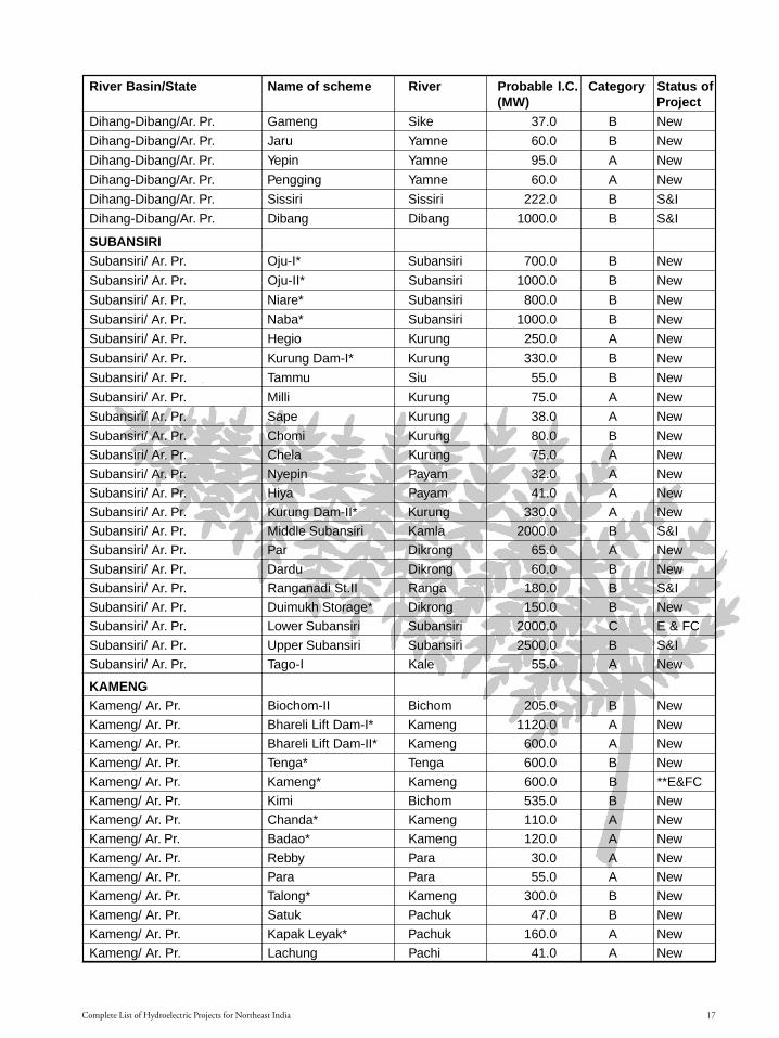
1.2Complete List of Hydroelectric Projects for Northeast India
Section 1.p65 3/15/05, 9:01 PM16
Black
17
River Basin/State Name of scheme River Probable I.C. Category Status of(MW) Project
Dihang-Dibang/Ar. Pr. Gameng Sike 37.0 B New
Dihang-Dibang/Ar. Pr. Jaru Yamne 60.0 B New
Dihang-Dibang/Ar. Pr. Yepin Yamne 95.0 A New
Dihang-Dibang/Ar. Pr. Pengging Yamne 60.0 A New
Dihang-Dibang/Ar. Pr. Sissiri Sissiri 222.0 B S&I
Dihang-Dibang/Ar. Pr. Dibang Dibang 1000.0 B S&I
SUBANSIRISubansiri/ Ar. Pr. Oju-I* Subansiri 700.0 B New
Subansiri/ Ar. Pr. Oju-II* Subansiri 1000.0 B New
Subansiri/ Ar. Pr. Niare* Subansiri 800.0 B New
Subansiri/ Ar. Pr. Naba* Subansiri 1000.0 B New
Subansiri/ Ar. Pr. Hegio Kurung 250.0 A New
Subansiri/ Ar. Pr. Kurung Dam-I* Kurung 330.0 B New
Subansiri/ Ar. Pr. Tammu Siu 55.0 B New
Subansiri/ Ar. Pr. Milli Kurung 75.0 A New
Subansiri/ Ar. Pr. Sape Kurung 38.0 A New
Subansiri/ Ar. Pr. Chomi Kurung 80.0 B New
Subansiri/ Ar. Pr. Chela Kurung 75.0 A New
Subansiri/ Ar. Pr. Nyepin Payam 32.0 A New
Subansiri/ Ar. Pr. Hiya Payam 41.0 A New
Subansiri/ Ar. Pr. Kurung Dam-II* Kurung 330.0 A New
Subansiri/ Ar. Pr. Middle Subansiri Kamla 2000.0 B S&I
Subansiri/ Ar. Pr. Par Dikrong 65.0 A New
Subansiri/ Ar. Pr. Dardu Dikrong 60.0 B New
Subansiri/ Ar. Pr. Ranganadi St.II Ranga 180.0 B S&I
Subansiri/ Ar. Pr. Duimukh Storage* Dikrong 150.0 B New
Subansiri/ Ar. Pr. Lower Subansiri Subansiri 2000.0 C E & FC
Subansiri/ Ar. Pr. Upper Subansiri Subansiri 2500.0 B S&I
Subansiri/ Ar. Pr. Tago-I Kale 55.0 A New
KAMENGKameng/ Ar. Pr. Biochom-II Bichom 205.0 B New
Kameng/ Ar. Pr. Bhareli Lift Dam-I* Kameng 1120.0 A New
Kameng/ Ar. Pr. Bhareli Lift Dam-II* Kameng 600.0 A New
Kameng/ Ar. Pr. Tenga* Tenga 600.0 B New
Kameng/ Ar. Pr. Kameng* Kameng 600.0 B **E&FC
Kameng/ Ar. Pr. Kimi Bichom 535.0 B New
Kameng/ Ar. Pr. Chanda* Kameng 110.0 A New
Kameng/ Ar. Pr. Badao* Kameng 120.0 A New
Kameng/ Ar. Pr. Rebby Para 30.0 A New
Kameng/ Ar. Pr. Para Para 55.0 A New
Kameng/ Ar. Pr. Talong* Kameng 300.0 B New
Kameng/ Ar. Pr. Satuk Pachuk 47.0 B New
Kameng/ Ar. Pr. Kapak Leyak* Pachuk 160.0 A New
Kameng/ Ar. Pr. Lachung Pachi 41.0 A New
Complete List of Hydroelectric Projects for Northeast India
Section 1.p65 3/15/05, 9:01 PM17
Black

Large Dams for Hydropower in Northeast India18
River Basin/State Name of scheme River Probable I.C. Category Status of(MW) Project
Kameng/ Ar. Pr. Phanchung* Pachi 60.0 B New
Kameng/ Ar. Pr. Utung* Bichom 100.0 B New
Kameng/ Ar. Pr. Nazong Bichom 65.0 B New
Kameng/ Ar. Pr. Dibbin* Bichom 100.0 B New
Kameng/ Ar. Pr. Khuitam Digen 29.0 B New
Kameng/ Ar. Pr. But Digen 26.0 B New
Kameng/ Ar. Pr. Mathithing Digen 40.0 B New
Kameng/ Ar. Pr. Bichom Storage-I Bichom 190.0 B New
Kameng/ Ar. Pr. Pichang Bichom 31.0 B New
Kameng/ Ar. Pr. Tarang Warang* Pacha 30.0 A New
Kameng/ Ar. Pr. Sepla Pacha 46.0 A New
Kameng/ Ar. Pr. Pasar Pasar 32.0 B New
Kameng/ Ar. Pr. Pakke* Pakke 110.0 A S&I
Kameng/ Ar. Pr. Seba* Pakke 80.0 A New
Kameng/ Ar. Pr. Papu* Papu 200.0 B New
UPPER BRAHMAPUTRA
U.Brahmaputra/Nagaland Dikhu Lift Dam* Dikhu 140.0 C S&I/DPR
U.Brahmaputra/Nagaland Yangnyu Storage* Yangnyu 40.0 B New
U.Brahmaputra/Nagaland Jhanji Storage Jhanji 75.0 C New
U.Brahmaputra/Nagaland Dikhu Dam P.H. Dikhu 470.0 C New
U.Brahmaputra/Assam Dilli Storage Disang 33.0 C New
U.Brahmaputra/Ar.Pr. Yangman Storage Burhi Dihing 60.0 B New
U.Brahmaputra/Ar.Pr. Tipang Tirap 80.0 C New
KALANG
Kalang/ Assam Jamuna Dam P/H Jamuna 28.0 B New
Kalang/ Assam Diyung Dam P/H Diyung 47.0 B New
Kalang/ Assam Langey Borpani 37.0 A New
Kalang/ Assam Lower Kopili Kopili 150.0 A S&I
Kalang/ Assam Amring Amring 33.0 B S&I
Kalang/ Assam Upper Borpani Borpani 60.0 A S&I
Kalang/ Meghalaya Umlamphang Umiam 28.0 A New
Kalang/ Meghalaya Umiam Umtru-V Umrtru 27.0 B New
Kalang/ Meghalaya Umiam Umtru-VI Umrtru 145.0 B New
BARAK AND OTHERS
Barak and others/Mizoram Lunglang Storage* Tyao 815.0 C New
Barak and others/Mizoram Boinu Storage* Kaldan 640.0 C New
Barak and others/Mizoram Kaldan Storage Kaldan 545.0 C New
Barak and others/Mizoram Kolodyne Storage I Mat 120.0 B DPR
Barak and others/Mizoram Deh Deh 26.0 B New
Barak and others/Mizoram Tuivawi Tuivawi 48.0 B S&I
Barak and others/Nagaland Sakhai-II Tizu 31.0 A New
Barak and others/Nagaland Khuzami Tizu 32.0 B New
Barak and others/Nagaland Rurrur Zangki 36.0 B New
Large Dams for Hydropower in Northeast India18
Section 1.p65 3/15/05, 9:01 PM18
Black

19
River Basin/State Name of scheme River Probable I.C. Category Status of(MW) Project
Barak and others/Nagaland Zungki Zangki 48.0 B New
Barak and others/Nagaland Laruri Tizu 80.0 A New
Barak and others/Nagaland Tizu* Tizu 150.0 C New
Barak and others/Manipur Laniye-II Laniye 27.0 A New
Barak and others/Manipur Laniye-I Laniye 34.0 B New
Barak and others/Manipur Khongnem Chakha-II* Barak 67.0 B New
Barak and others/Manipur Khongnem Chakha–III Barak 48.0 A New
Barak and others/Manipur Irang* Irang 60.0 A New
Barak and others/Manipur Nungliban* Lei Matek 105.0 B New
Barak and others/Manipur Tuivai Tuivai 51.0 B EC&FC
Barak and others/Manipur Sinjal Tuivai 39.0 C New
Barak and others/Manipur Tipaimukh* Barak 1500.0 C S&I/DPR
Barak and others/Manipur Irang Irang 75.0 B S&I
Barak and others/Manipur Pabaram Storage* Barak 190.0 C New
Barak and others/Meghalaya Someshwari Dam Someshwari 130.0 B S&I
Barak and others/Meghalaya Kynshi-I Storage Kynshi 295.0 C New
Barak and others/Meghalaya Sushen* Myntdu 65.0 A New
Barak and others/Meghalaya Umjaut* Umtrew 69.0 B New
Barak and others/Meghalaya Umduna* Umtrew 57.0 B New
Barak and others/Meghalaya Manhu Umtrew 90.0 B New
Barak and others/Meghalaya Nonglyngkien Umtrew 47.0 B New
Barak and others/Meghalaya Umngi Storage* Umngi 54.0 C New
Barak and others/Meghalaya Rangmaw Umngi 42.0 B New
Barak and others/Meghalaya Nongkolait* Umngi 120.0 B New
Barak and others/Meghalaya Nongnam* Umngi 50.0 B New
Barak and others/Meghalaya Mawpat* Umngi 21.0 B New
Barak and others/Meghalaya Kynshi-II Umrilang 175.0 B New
Barak and others/Meghalaya Nongmawlar Kynshi 29.0 B New
Barak and others/Meghalaya Mawsyrpat Kynshi 45.0 B New
Barak and others/Meghalaya Mawthaba Kynshi 70.0 C New
Barak and others/Meghalaya Mawblei Storage* Kynshi 140.0 B New
Barak and others/Meghalaya Jadukata Kynshi 450.0 S & I
Barak and others/Meghalaya Amagam Storage Rongdi 35.0 B New
Barak and others/Meghalaya Umngot Storage Umngot 265.0 C New
TEESTATeesta/West Bengal Teesta High Dam Teesta 2505.0 C New
Teesta /West Bengal Ramam-III Ramam 100.0 A New
Teesta /Sikkim Kalep Teesta 41.0 A New
Teesta /Sikkim Talem* Teesta 75.0 A New
Teesta /Sikkim Jedang Lhonak 185.0 B New
Teesta /Sikkim Teesta Storage I* Teesta 320.0 B New
Teesta /Sikkim Serum Sebokung 50.0 B New
Teesta /Sikkim Lachung Lachung 30.0 A New
Teesta /Sikkim Ringpi* Ringpi 70.0 B New
Complete List of Hydroelectric Projects for Northeast India 19
Section 1.p65 3/15/05, 9:01 PM19
Black

Large Dams for Hydropower in Northeast India20 Complete List of Hydroelectric Projects for Northeast India
River Basin/State Name of scheme River Probable I.C. Category Status of(MW) Project
Teesta /Sikkim Lingza* Ringpi 120.0 B New
Teesta /Sikkim Rukel* Tolung 33.0 B New
Teesta /Sikkim Rangyong* Tolung 141.0 B New
Tista/Sikkim Dikchu* Dikchu 105.0 A New
Tista/Sikkim Chhota Pathing Rongpo 55.0 B New
Tista/Sikkim Rongni Storage* Rongni 195.0 B New
Tista/Sikkim Mana G. Rangit 37.0 B New
Tista/Sikkim Yoksam Rathong 44.0 B New
Tista/Sikkim Namlum G. Rangit 175.0 A New
Tista/Sikkim Gompa G. Rangit 46.0 A New
Teesta /Sikkim Teesta Storage II Teesta 450.0 A S&I
Teesta /Sikkim Panan* Tolung 200.0 A New
Teesta /Sikkim Teesta Storage IV Teesta 495.0 A DPR
Tista/Sikkim Teesta Storage VI Teesta 360.0 A DPR
OTHERSArunachal Pradesh Ashupani* 30.0 New
Arunachal Pradesh Dengser* 552.0 New
Arunachal Pradesh Etabue* 165.0 New
Arunachal Pradesh Nalo* 360.0 New
Arunachal Pradesh Ringong* 150.0 New
Arunachal Pradesh Simang* 90.0 New
Meghalaya Mawhu* 120.0 New
Meghalaya Selim* 170.0 New
Meghalaya Kulsi 36.0 S&I
Mizoram Tlwang* 45.0 New
Mizoram Bairabi E & FC
Nagaland Dzuza 7.0 S & I
Sikkim Lachen* 210 New
Sikkim Rolep 32.0 S &I
Sikkim Chakung 24.0 S &I
Sikkim Ralang 40.0 S &I
KeyIC: Installed CapacityNew: Identified schemes yet to be taken up for preliminary survey and investigation.DPR: Identified schemes for which Detailed Project Report has been preparedS&I: Identified schemes under Survey and InvestigationE&FC: granted environmental and forest clearance* Indicates Project Listed Under the 50,000 MW Scheme, PFRs for which have been completed** Kameng was earlier envisaged as a 1,100 MW project, but the project was redesigned to its present form,which is two dams on the Bichom and Tenga rivers for generating 600 MW each.
Section 1.p65 3/15/05, 9:01 PM20
Black

21
BASINWISE AND STATEWISE SUMMARY OF RANKING STUDY
Basin Luhit Dihang- Subansiri Kameng Upper Lower Kalang Barak Tista TotalDibang Brahmaputra Brahmaputra and other
rivers
Arunachal 7 29 22 29 2 0 0 0 0 89
Assam 0 0 0 0 1 0 6 0 0 7
Meghalaya 0 0 0 0 0 0 3 20 0 22
Manipur 0 0 0 0 0 0 0 11 0 11
Mizoram 0 0 0 0 0 0 0 6 0 6
Tripura 0 0 0 0 0 0 0 0 0 0
Nagaland 0 0 0 0 4 0 0 6 0 10
W. Bengal 0 0 0 0 0 0 0 0 2 2
Sikkim 0 0 0 0 0 0 0 0 21 21
Total 7 29 22 29 7 0 9 43 23 168
(Source: Preliminary Ranking Study of Hydro electric Schemes. Volume- IV, Brahmaputra Basin, Central Electricity Authority. October2001, with updated information from the CEA document listing the ‘Preparation of the Preliminary Feasibility Reports (PFRs) Under50,000 MW Hydroelectric Initiative)
India Complete List of Hydroelectric Projects for Northeast India
Section 1.p65 3/15/05, 9:01 PM21
Black

Large Dams for Hydropower in Northeast India22
1.3
Power Sector in Northeast India“The hydroelectric power potential in the North Eastern Region is enormous. Out of an exploitable potential of
63,257 MW as assessed by the Central Electricity Authority (CEA), only 1,011 MW has been developed so far.Thus, out of the available exploitable hydroelectric power potential in the region, only about 1.6% has beendeveloped.” Below is state-wise information on of hydro power potential and its development (excluding hydropower units below 3 MW capacity):
STATE POTENTIAL POTENTIALASSESSED (MW) DEVELOPED (MW)
Arunachal Pradesh 50,328 281
Assam 674 250
Manipur 1,784 105
Meghalaya 2,394 185
Mizoram 2,196 0
Nagaland 1,574 91
Tripura 21 15
Sikkim 4,286 84
TOTAL 63,257 1,011
(Source: Website of Department of Development of North Eastern Region, http://northeast.nic.in/power.htm)
This scenario is likely to have changed with the addition of projects proposed under the 50,000 MW initiative.The Prime Minister launched a programme for preparation of these reports on 24.5.2003. It was formulated byCentral Electricity Authority (CEA) and sanctioned by the Ministry of Power on 31st March 2003 at a costamounting to Rs. 24.95 crores. PFRs prepared under the programme are to serve the purpose of fixing the inter-se priority for implementation of the schemes as also be a basis and reference for taking up on Survey andInvestigations as well as preparation of DPRs of Hydroelectric Schemes.
As part of this initiative, the work of preparation of Pre-feasibility Reports (PFRs) of 162 schemes in 16 stateswas awarded to seven CPSUs/State agencies as Consultants. These consultants include, National Hydro PowerCorporation (NHPC), Water and Power Consultancy services (WAPCOS), Satluj Jal Vidyut Nigam Ltd. (SJVNL),North Eastern Electric Power Corporation (NEEPCO), Karnataka Power Corporation Ltd (KPCL), Himachal PradeshState Electricity Board (HPSEB), Uttaranchal Jal Vidyut Nigam Ltd (UJVNL). One set of each PFRs is available inCentral Electricity Authority Library at Sewa Bhavan, R.K. Puram, New Delhi - 110066.
The PFRs are based on the input data on topography, hydrology, geology, and meteorology collected from theconcerned Government of India organizations viz. Survey of India, Ministry of Water Resources CWC, GeologicalSurvey of India and Indian Metereological Department. The work also included utilization of Satellite Imageriesas available from National Remote Sensing Agency. The CEA has examined project planning aspects of eachscheme in the context of overall development of water resources of the river basin. The analysis of assessment ofpower benefits from the project was carried out for alternative options.
For the North East India, PFRs have been completed for 6 states. The details are as follows:
State Number of Schemes Installed Capacity (MW)
Arunachal Pradesh 42 27293Manipur 3 362Meghalaya 11 931Mizoram 3 1500Nagaland 3 330Sikkim 10 1469
(Source: Preparation of PreliminaryFeasibility Reports (PFRs): Under50,000 MW Hydroelectric Initiative,Central Electricity Authority, http://www.cea.nic.in/PFRhydro1.pdf)
Section 1.p65 3/15/05, 9:01 PM22
Black

23
1. Commissioned projects (generating power)
Name State Managing Agency Installed capacity
Ranganadi Arunachal Pradesh NEEPCO 405
Kopili I Assam NEEPCO 250
Doyang Nagaland NEEPCO 75
Loktak Manipur NHPC 105
Rangit Sikkim NHPC 60
Likimro Nagaland State 24
Gumti Tripura State 15
Khandong Meghalaya NEEPCO 50
Lower Lagyap Sikkim State 12
Umiam-Umtru (Sumer) I Meghalaya State 36
Umiam-Umtru (Sumer) II Meghalaya State 18
Umiam-Umtru III Meghalaya State 60
Umtru Meghalaya State 11.2
Umiam-Umtru IV Meghalaya State 60
Umiam-Umtru V Meghalaya State 36
Umiam- Umtru VI Meghalaya State 120
2. Projects under construction
Name State Project Propnent Power to be generated
Kameng Arunachal Pradesh NEEPCO 600
Kopili II Assam NEEPCO 25
Dhansiri Assam State 20
Karbi Langpi Assam State 100
(Lower Borpani)
Myntdu- Laishka Meghalaya State 84
Likim-Ro Unit-III Nagaland State 8
Tuirial Mizoram State 60
Teesta V Sikkim NHPC 510
3. Projects granted environmental and forest clearance, yet to begin construction
Name State Project Propnent Power to be generated
Tuivai Mizoram NEEPCO 210
Loktak Downstream Manipur NHPC 90
Pagladiya Assam Brahmaputra Board 5.5
(the project is mainly to meet
irrigation needs and flood control)
Bairabi (Dhaleshwari) Mizoram State 80 MW
Lower Subansiri Arunachal Pradesh NHPC 2000 MW
Power Sector in Northeast India
Section 1.p65 3/15/05, 9:01 PM23
Black

Large Dams for Hydropower in Northeast India24
4. Projects at various stages of clearance (site, forest and environmental clearances)
Name State Project Propnent Power to be Stagegenerated
Tipaimukh Manipur NEEPCO 1500 MW Awaiting environmental
and forrest clearance
Upper Siang Arunachal Pradesh NHPC 11000 MW1 Stage I site clearance(also called Dihang)
Middle Siang (Siyom) Arunachal Pradesh NHPC 700 MW Stage I site clearanceRecommended for
Environment ClearanceLower Siang Arunachal Pradesh NHPC 1600 MW Stage I site clearance
Upper Subansiri Arunachal Pradesh NHPC 2500 MW Stage I site clearanceMiddle Subansiri (Kamla) Arunachal Pradesh NHPC 2000 MW Stage I site clearance
Rolep Sikkim Karnataka Power Corp. Ltd 32 MW Public Hearing conducted,(KPCL) and Amalgamated awaiting clearance
Transpower Ltd
[Note: projects that have been granted Stage I site clearance are undergoing detailed surveys and investigation.]1 According to a report in Business Line on 20th February 2005, this project is likely to be scaled down to 5000 MW mainly due to
environmental concerns raised by China (http://sify.com/finance/equity/fullstory.php?id=13675163)
5. Projects under investigation
Name State Power to be generated Project proponent
Lower Kopili Assam 150 MW NEEPCO
Ranganadi II Arunachal Pradesh 130 MW NEEPCO
Debang Arunachal Pradesh 1000 MW Brahmaputra Board
Teesta III Sikkim 1200 MW NHPC
Pakke Arunachal Pradesh 105 MW NEEPCO
Dikrong Arunachal Pradesh 100 MW NEEPCO
Papumpam Arunachal Pradesh 100 MW NEEPCO
Irang Manipur 60 MW State
Jadukata Meghalaya 450 MW Brahmaputra Board
Someswari Meghalaya 130 MW Brahmaputra Board
Umngot Meghalaya 150 MW Brahmaputra Board
Kulsi Meghalaya 36 MW Brahmaputra Board
Dikhu Nagaland 140 MW NEEPCO
6. Proposed projects
Name State/ River Basin Project proponent
Sissiri Arunachal Pradesh NEEPCO
Kolodyne Arunachal Pradesh NEEPCO
Lohit Arunachal Pradesh Detailed Project Report done by Brahmaputra Board
Demwe Arunachal Pradesh Pre-feasibility Report completed by NHPC
Noa- Dehing Arunachal Pradesh Brahmaputra Board
Etalin Arunachal Pradesh Pre-feasibility Report completed by NHPC
Agoline Arunachal Pradesh Pre-feasibility Report completed by NHPC
Amulin Arunachal Pradesh Pre-feasibility Report completed by NHPC
Ashupani Arunachal Pradesh Pre-feasibility Report completed by NHPC
Attunli Arunachal Pradesh Pre-feasibility Report completed by NHPC
Badao Arunachal Pradesh Pre-feasibility Report completed by NEEPCO
Bhareli-I Arunachal Pradesh Pre-feasibility Report completed by NEEPCO
Large Dams for Hydropower in Northeast India
Section 1.p65 3/15/05, 9:01 PM24
Black

25
Name State/ River Basin Project proponent
Bhareli-II Arunachal Pradesh Pre-feasibility Report completed by NEEPCO
Chanda Arunachal Pradesh Pre-feasibility Report completed by NEEPCO
Dengser Arunachal Pradesh Pre-feasibility Report completed by NHPC
Dibbin Arunachal Pradesh Pre-feasibility Report completed by NEEPCO
Elango Arunachal Pradesh Pre-feasibility Report completed by NHPC
Emini Arunachal Pradesh Pre-feasibility Report completed by NHPC
Emra-II Arunachal Pradesh Pre-feasibility Report completed by NHPC
Etabue Arunachal Pradesh Pre-feasibility Report completed by NHPC
Hirong Arunachal Pradesh Pre-feasibility Report completed by NHPC
Hutong Arunachal Pradesh Pre-feasibility Report completed by WAPCOS
Kalai Arunachal Pradesh Pre-feasibility Report completed by WAPCOS
Kameng Dam Arunachal Pradesh Pre-feasibility Report completed by NEEPCO
Kapakleyak Arunachal Pradesh Pre-feasibility Report completed by NEEPCO
KurungI&II Arunachal Pradesh Pre-feasibility Report completed by NHPC
Mihumdon Arunachal Pradesh Pre-feasibility Report completed by NHPC
Mirak Arunachal Pradesh Pre-feasibility Report completed by NHPC
Naba Arunachal Pradesh Pre-feasibility Report completed by NHPC
Nalo Arunachal Pradesh Pre-feasibility Report completed by NHPC
Naying Arunachal Pradesh Pre-feasibility Report completed by NHPC
Niare Arunachal Pradesh Pre-feasibility Report completed by NHPC
Oju-I Arunachal Pradesh Pre-feasibility Report completed by NHPC
Oju-II Arunachal Pradesh Pre-feasibility Report completed by NHPC
Papu Arunachal Pradesh Pre-feasibility Report completed by NEEPCO
Phanchung Arunachal Pradesh Pre-feasibility Report completed by NEEPCO
Ringong Arunachal Pradesh Pre-feasibility Report completed by NHPC
Sebu Arunachal Pradesh Pre-feasibility Report completed by NEEPCO
Simang Arunachal Pradesh Pre-feasibility Report completed by NHPC
Talong Arunachal Pradesh Pre-feasibility Report completed by NEEPCO
Tarangwarang Arunachal Pradesh Pre-feasibility Report completed by NEEPCO
Tato-II Arunachal Pradesh Pre-feasibility Report completed by NHPC
Tenga Arunachal Pradesh Pre-feasibility Report completed by NEEPCO
Utung Arunachal Pradesh Pre-feasibility Report completed by NEEPCO
Khongnum Chakka st.-II Manipur Pre-feasibility Report completed by WAPCOS
Nunglieban Manipur Pre-feasibility Report completed by WAPCOS
Pabaram Manipur Pre-feasibility Report completed by WAPCOS
Mapithel Manipur State
Mawblei Meghalaya Pre-feasibility Report completed by WAPCOS
Mawhu Meghalaya Pre-feasibility Report completed by WAPCOS
Mawput Meghalaya Pre-feasibility Report completed by WAPCOS
Nongkolait Meghalaya Pre-feasibility Report completed by WAPCOS
Nongnam Meghalaya Pre-feasibility Report completed by WAPCOS
Rangmaw Meghalaya Pre-feasibility Report completed by WAPCOS
Selim Meghalaya Pre-feasibility Report completed by WAPCOS
Sushen Meghalaya Pre-feasibility Report completed by WAPCOS
Umduna Meghalaya Pre-feasibility Report completed by WAPCOS
Umjaut Meghalaya Pre-feasibility Report completed by WAPCOS
Umngi Meghalaya Pre-feasibility Report completed by WAPCOS
Boinu Mizoram Pre-feasibility Report completed by WAPCOS
Lungleng Mizoram Pre-feasibility Report completed by WAPCOS
Power Sector in Northeast India 25
Section 1.p65 3/15/05, 9:02 PM25
Black

Large Dams for Hydropower in Northeast India26
Name State/ River Basin Project proponentTlawng Mizoram Pre-feasibility Report completed by WAPCOS
Dzuza Nagaland State
Tizu Nagaland Pre-feasibility Report completed by NEEPCO
Yangnyu Nagaland Pre-feasibility Report completed by NEEPCO
Tizu-Zungki Nagaland State
Chakung Sikkim Karnataka Power Corporation Ltd (KPCL)
and Amalgamated Transpower Ltd
Ralang Sikkim Amalgamated Transpower Ltd
Dikchu Sikkim Pre-feasibility Report completed by NHPC
Lachen Sikkim Pre-feasibility Report completed by NHPC
Lingza Sikkim Pre-feasibility Report completed by NHPC
Panan Sikkim Pre-feasibility Report completed by NHPC
Rangyong Sikkim Pre-feasibility Report completed by NHPC
Ringpi Sikkim Pre-feasibility Report completed by NHPC
Rongni Storage Sikkim Pre-feasibility Report completed by NHPC
Rukel Sikkim Pre-feasibility Report completed by NHPC
Talem Sikkim Pre-feasibility Report completed by NHPC
Teesta-I Sikkim Pre-feasibility Report completed by NHPC
Teesta IV Sikkim Not known. NTPC has expressed interest
Teesta VI Sikkim Not known. NTPC has expressed interest
Section 1.p65 3/15/05, 9:02 PM26
Black

27
Large Hydel Projects in Northeast IndiaIssues and Concerns1
1.4
Northeast India, consisting of the eight states ofAssam, Arunachal Pradesh, Manipur, Meghalaya,Mizoram, Nagaland, Tripura and Sikkim, is known forits biological and cultural diversity and the uniqueBrahmaputra river system. The region is home to overone hundred tribal communities and a large percentageof the population is dependent on traditional naturalresource-based livelihoods. Its strategic location at theconfluence of south, southeast and east Asia made it animportant gateway between the peoples of the region.British annexation was the beginning of definedterritorial boundaries, as it became the frontier of theBritish Raj. The partition of the country in 1947intensified the northeast’s isolation. The creation of EastPakistan (now Bangladesh) not only disrupted road andriver communications with commercial centres inundivided Bengal and beyond, but also left the northeasthemmed in by a long chain of international borders.Today the 2,62,000 sq. km. region (including Sikkim)is linked to the Indian mainland through a slender 21km. corridor through north Bengal.
While this enforced isolation may have, for decades,protected the region’s biodiversity from the destructivelarge-scale development seen elsewhere in the country, ithas also been one of the reasons for the northeast’seconomic and political neglect. Northeast India is markedby socio-political complexities, which include strugglesfor political autonomy and resulting armed conflicts. TheIndian constitution has attempted to deal with thenortheast’s unique nature by having a system ofadministration that differs from the rest of the country.The sixth schedule and other constitutional provisionsrelevant to the northeast offer different degrees of autonomyand self-management (including natural resourcemanagement) to indigenous communities. Despite this,there seems to be little opportunity for participation in theplanning of large developmental projects. Faced with amultitude of challenges, the region is currently charting a
course for ‘development’ and large hydel projects for powerexport are a part of the development plan.
LARGE DAMS IN THE REGIONThe July 2002 press release of the Department of
Development of the North Eastern Region (DONER),presented the NE region’s “potential to be India’s futurepowerhouse.” The October 2001 Central ElectricityAuthority (CEA) ‘Preliminary Ranking Study’ of thepotential of hydroelectric schemes conducted for all riverbasins in the country gave the highest marks to theBrahmaputra river system. 149 schemes were rankedfor viability for this region. Schemes, which would bedeveloped by agencies such as National Hydro PowerCorporation (NHPC), North Eastern Electric PowerCorporation (NEEPCO), the Brahmaputra Board andState Electricity Boards.
The government and proponents of large dams inthe region paint a win-win picture: exploiting thecountry’s largest perennial water system to producecheap, plentiful power for the nation, economic benefitsthrough power export, employment generation, the endof militancy, flood control and little direct ‘displacement’of local communities. Dams are made out to be thepanacea for all the problems of the northeast. However,northeast India’s unique characteristics and past lessonsfrom large dams are enough reason to critically examinethese promised benefits. A close look at some of theprojects reveal planning based on inaccurate andinadequate information, legal violations by projectauthorities, lack of transparency and little scope foreffective people’s participation in decision-making.
ENVIRONMENTAL ASPECTSThe Brahmaputra river system is unique in many
ways. Its glacial origins, location in a highly seismiczone, high, intense rainfall resulting in ‘flashy’ rivers,a high sedimentation rate and an intricate link with theecology of the beels (wetlands) in the plains pose
1 Based on ‘Large Dams in the Northeast- a bright future?’ by Manju Menon, Neeraj Vagholikar, Kanchi Kohli and Ashish Fernandesin The Ecologist Asia Vol. 11 No.1 January- March 2003
Large Hydel Projects in Northeast India – Issues and Concerns
Section 1.p65 3/15/05, 9:02 PM27
Black
Large Dams for Hydropower in Northeast India28
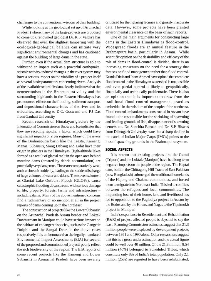
challenges to the conventional wisdom of dam building.While looking at the geological set up of Arunachal
Pradesh (where many of the large projects are proposedto come up), renowned geologist Dr. K.S. Valdiya hasobserved that even the slightest tampering with theecological-geological balance can initiate verysignificant environmental changes and has cautionedagainst the building of large dams in the state.
Further, even if the actual dam structure is able towithstand an impact such as a powerful earthquake,seismic activity-induced changes in the river system mayhave a serious impact on the viability of a project itselfas several basic parameters concerning rivers. Analysisof the available scientific data clearly indicates that theneoctectonism in the Brahmaputra valley and thesurrounding highlands in the Eastern Himalayas haspronounced effects on the flooding, sediment transportand depositional characteristics of the river and itstributaries, according to D.C. Goswami and P.J Dasfrom Gauhati University
Recent research on Himalayan glaciers by theInternational Commission on Snow and Ice indicates thatthey are receding rapidly, a factor, which could havesignificant impacts on river regimes. Many of the riversof the Brahmaputra basin like the Teesta, Kameng,Manas, Subansiri, Siang Debang and Lohit have theirorigin in glaciers in the Himalayas, High-altitude lakesformed as a result of glacial melt in the open area behindmoraine dams (created by debris accumulation) arepotentially very dangerous. These are comparatively weakand can breach suddenly, leading to the sudden dischargeof huge volumes of water and debris. These events, knownas Glacial Lake Outburst Floods (GLOFs), causecatastrophic flooding downstream, with serious damageto life, property, forests, farms and infrastructure –including dams. Many of the above mentioned concernsfind a rudimentary or no mention at all in the projectreports of dams coming up in the northeast.
The construction of projects like the Lower Subansirion the Arunachal Pradesh-Assam border and LoktakDownstream in Manipur could have serious impact onthe habitats of endangered species, such as the GangeticDolphin and the Sangai Deer, in the above casesrespectively. It is unfortunate that the legally mandatedEnvironmental Impact Assessments (EIA) for severalof the proposed and commissioned projects poorly reflectthe rich biodiversity of the region. The EIA reports ofsome recent projects like the Kameng and LowerSubansiri in Arunachal Pradesh have been severely
criticised for their glaring lacunae and grossly inaccuratedata. However, some projects have been grantedenvironmental clearance on the basis of such reports.
One of the main arguments for constructing largedams in the Eastern Himalayas is flood-control.Widespread floods are an annual feature in theBrahmaputra basin, particularly in Assam. Whilescientific opinion on the desirability and efficacy of therole of dams in flood-control is divided, there is anincreasing consensus on the need for a strategy thatfocuses on flood management rather than flood control.Kunda Dixit and Inam Ahmed have opined that completeflood control in the Himalayan watershed is not possibleand even partial control is likely to geopolitically,financially and technically problematic. There is alsoan opinion that it is important to draw from thetraditional flood control management practicesembedded in the wisdom of the people of the northeast.Flood control embankments constructed in Assam havefound to be responsible for the shrinking of spawningand feeding grounds of fish, disappearance of spawningcenters etc. Dr. Sanchita Boruah and Dr. S.P. Biswasfrom Dibrugarh University state that a sharp decline inthe catch of Indian Major Carps (IMCs) points to theloss of spawning grounds in the Brahmaputra system.
SOCIAL ASPECTSIt is known that existing projects like the Gumti
(Tripura) and the Loktak (Manipur) have had long termnegative impacts on the people of the region. The Kaptaidam, built in the Chittagong Hill Tracts of East Pakistan(now Bangladesh) submerged the traditional homelandsof the Hajong and Chakma communities, and forcedthem to migrate into Northeast India. This led to conflictsbetween the refugees and local communities. Theimpending loss of their home, land and livelihood hasled to opposition to the Pagladiya project in Assam bythe Bodos and by the Hmars and Nagas to the Tipaimukhproject in Manipur.
India’s experience in Resettlement and Rehabilitation(R&R) of project-affected people is abysmal to say theleast. Planning Commission estimates suggest that 21.3million people were displaced by development projectsbetween 1951 and 1990 alone. Other researchers suggestthat this is a gross underestimation and the actual figurecould be well over 40 million. Of the 21.3 million, 8.54million (40%) belonged to Scheduled Tribes, whichconstitute only 8% of India’s total population. Only 2.1million (25%) are reported to have been rehabilitated;
Section 1.p65 3/15/05, 9:02 PM28
Black

29
the rest were left to fend for themselves. Despite this,India does not yet have a national R&R policy and law!There exists a detailed law and procedure for landacquisition by the state, the Land Acquisition Act, 1894.This Act has provisions for monetary compensation butR&R is not a part of it. Much of R&R today is in therealm of administrative discretion, directions and draftpolicies. Unless strengthened by specific provisions oflaw and policy guidelines, these do not acquire the forceof law. Since the mid-1980s, several drafts of a nationalR&R policy have been doing the rounds but it still awaitsfinalisation. While some state governments have R&Rpolicies and laws, this is not the case in the northeast.There might be stray cases where rehabilitation may havebeen done sensitively, but since the basic framework itselfis missing, such cases are fortunate exceptions.
While the direct displacement of communitiesupstream of existing and proposed dams in the northeastmay be small in numerical terms as compared to otherparts of the country, there are likely to be substantialdownstream impacts. The Ranganadi Stage-I projectin Arunachal Pradesh, commissioned in 2002, divertswater from the Ranganadi River into the Dikrong River.This is likely to have considerable social consequences,including livelihood impacts, primarily because of thechange in flow regimes of both rivers (a reduced flowin the Ranganadi and increased flow in the Dikrong).The EIA of the project did not address downstreamimpacts. Impacts of the construction were evident inthe early stages of the project itself; heavy sedimentationdownstream, with silt deposits being as much as 15- 45cms in the river bed, the fish catch had dropped.
It is more than livelihoods when it comes to theRounglevaisuo, the confluence of the Tuiruong andTuivai rivers, held sacred by the Hmar and otherindigenous peoples in Manipur. The threat of culturalloss looms large here in the form of the Tipaimukh dam.Obviously, no lessons have been learnt from theopposition to a project in the sacred valley of Rathongchu in Sikkim, in the early 90s. The project was finallyrejected in 1997 to honour the sentiments, religion andculture of the people of Sikkim.”
Many project documents of dams in the Northeastemphasise that parts of the submergence area are inany case ‘degraded’, as local communities practicejhumming (shifting cultivation) on these lands. However,shifting cultivation plays a critical role in the livelihoodsof people and in maintaining agrobiodiversity.According to P.S. Ramakrishnan, the shortening of jhum
cycles (the length of the fallow period between twocropping phases) due to a variety of reasons has raisedconcerns regarding the ecological viability of thisfarming system. However, farmers have rejected theoption of sedentary farming as a long-term solution onboth ecological and socio-cultural grounds. Rights tothese lands exchanged for simplistic compensationpackages like money or small plots of land is bound toaffect the food security of these communities. Thisaspects needs careful consideration in the planning ofany development project in the NE, whether it is withreference to its use, per se, or that of compensation.
LARGE DAMS IN INDIAIn India, the movements against the Narmada, Tehri,
Silent Valley and Koel Karo projects have brought tolight the social and ecological costs of large dams. Theseand many other lesser-known movements haveaddressed the tribulations of local communities andecological losses, and have also raised pertinentquestions about technical viability, economic feasibilityand the long-term sustainability of such projects
We do have provisions such as the EnvironmentImpact Assessment (EIA) Notification, 1994, which aremandatory for large hydel projects and form a “valuabletool and process that can assist in incorporatingenvironmental concerns in the planning, implementationand maintenance stages of any developmental activity”.(Darlong, V., 1998). But the actual quality of EIAreports, which form the basis of environmental decision-making, remains shoddy, to put it mildly. In this issue,the EIA reports of some recent projects such as Teesta,Kameng and Lower Subansiri have been severelycriticised for their glaring lacunae and grossly inaccuratedata. What is more unfortunate is that some of theseprojects have been granted environmental clearance onthe basis of such reports. For people’s groups andconcerned citizens, obtaining information and project-related documents from project proponents has been amatter of luck. Even today, citizens are denied accessto information about projects proposed to come up intheir areas. Information sharing has so far mostly beenthrough “unofficial” means.
Ashish Kothari, former member of the ExpertCommittee for river valley projects appointed by theMinistry of Environment and Forests (MoEF), says thathis committee’s recommendations for improving theenvironmental clearance process for dam projects hadlaid emphasis on greater public (especially local
Large Hydel Projects in Northeast India – Issues and Concerns
Section 1.p65 3/15/05, 9:02 PM29
Black

Large Dams for Hydropower in Northeast India30
community) involvement in the process throughcompulsory public hearings, mandatory disclosure ofall information in local languages, the search foralternatives to each project, monitoring of conditions,etc., but laments that most remain unimplemented.
The June 13, 2002, amendment to the EIAnotification now makes the EIA report a publicdocument. It is imperative that concerned individualsand groups access this and other project documents andreview them critically. The environmental public hearingprocess, a mandatory part of the environmentalclearance procedure, offers an important space forpeople’s participation in decision-making. Despite theprocedural problems in most public hearings, thisprovision remains a valuable tool and needs to be usedto the fullest.
CONCLUSIONThere were two regional consultations on ‘Dams and
Development’ were held in the Northeast andneighbouring areas. The first one was organised by theConcerned Citizens for Dams and Development(CCDD), Manipur, in July 2001 at Mawlein,Meghalaya, and the other by NESPON in April 2002at Siliguri, North Bengal. Most of the participants inthese consultations were of the view that decisionsregarding future dam projects in the region must bepreceded by answers to fundamental questions like:§ Have the development needs and objectives been
formulated through an open and participatoryprocess at local and regional levels?
§ Has a comprehensive options assessment for waterand energy resource development been done?
§ Have the social and environmental factors been giventhe same significance as techno-economic aspectsin assessing options?
§ Do we have a basin-wide understanding of theecology of the rivers and the dependence of localcommunities on them?
At least two-dozen large dams in the northeast areat an advanced stage of planning or clearance. Theabove questions need to be asked and answers foundwithout compromising on detail. Ushering in theseprojects without adequately addressing thesefundamental concerns cannot justifiably be a way outof the northeast’s development dilemmas. Decisionstaken at this stage will determine how bright the futureof the northeast – its people and its environment – willreally be.
Section 1.p65 3/15/05, 9:12 PM30

31Large Hydel Projects in Northeast India – Issues and Concerns
This plate first appeared in Whitaker, R.W. and Captain, A.S. (2005) Snakes of India, The Field Guide, Draco Books, Chennai, 2005. Basedon the M.E.S.S.I.A.H. database by Ecollage.
Section 1.p65 3/15/05, 9:12 PM31

33
SECTION II
Case Studies and Short Notes
Section 2.p65 3/16/05, 11:04 AM33
Black

Large Dams for Hydropower in Northeast India34
“The uninterrupted flow of power radiating fromLoktak is transforming pastoral Manipur into anemergent industrialized state. Power so vital foreconomic and industrial growth, will play a catalyticrole in Manipur’s overall development and in raisingthe quality of life of the people.”– National Hydro-Electric Power Corporation Ltd.2
“We prefer to use kerosene lamp than suffer likethis. Please find a way to destroy the Ithai dam, LoktakLairembi is angry”.– Angry residents from Thanga island andNingthoukhong.
In many parts of India, particularly in the Northeast,access to and control and management of land, landbased resources, and water bodies were linked with thecommunities that lived on it. With the coming of theState, such rights became the property of the State.More often than not, such rights are not recognized orare suppressed by the state. There is even a generalfeeling among State functionaries that de facto
communal resource holding systems have stagnateddevelopment activities in these areas (Roy Burman, B.K. 1999). The new ownership has led to a ‘take-over’of the more productive resources by powerful individualsand groups and opened access to resources that werepreviously managed by communities (Swallow andBromley, 1995; Moorehead, 1998). A closer look atthe land acquisition at the local level reveals the State’srole in dismantling the common property resource usesystem and its effect on the people and the eco-systemmanaged by these communities.
The Manipur Land Revenue and Land Reforms Actwas enacted in 1960 to establish the State’s right overthe entire landed area in Manipur. The Act declares that“All lands, public roads, lanes and paths and bridges,ditches, dikes and fences on or the same, the beds ofrivers, streams, nallahs, lakes and tanks and all canalsand water courses, and all standing and flowing waterand all rights in or over the same or appertaining theretowhich are not the property of any person and are herebydeclared to be the property of the Government”3 . In
Ecological and Social Impacts ofthe Ithai Barrage
2.1
Ramananda Wangkheirakpam1
1 This article is primarily based on the author’s M.PhilDissertation submitted to the Center for Social Medicine andCommunity Health, JNU, New Delhi, which attempted to lookat the impact of Ithai barrage on people who live on floatinghuts. Few studies have been carried out on the impact of thebarrage on the ecology of the wetland, but no proper assessmenthas yet been conducted on the affected people.
Large Dams for Hydropower in Northeast India34
2 Undated publication of NHPC regarding the project.3 It is clearly visible here that the state has totally disregardedthe existence of wetlands systems, and instead calls themditches or Nallahs which removes them of them of theirimportance.4 Is also known as the Manipur River.
Section 2.p65 3/16/05, 11:04 AM34
Black

35Ecological and Social Impacts of the Ithai Barrage 35
Manipur, waterways and water-bodies have traditionallybeen held as community property. This clause has beenspecifically inserted to invalidate community rights thathave been customarily held by specific clans/villages.Women have traditional inheritable fishing rights in thecommunity. With the State de-recognizing these rightsand enforcing individual ownership system, thetraditional indigenous systems seem to be in disarray.
THE WETLAND AND THE PEOPLEThe Imphal valley, originally a wetland fed by the
numerous rivers from the encircling hills is drained bya single river, the Imphal river4 . Over a period of time,according to the oral histories of the Meitei, the valleypartially dried itself out and was settled in permanentlyby some of the peoples of the surrounding hills, wholater evolved into the Meitei people. The settlers thenproceeded to harness the waters of the valley, channellingthe major rivers into more permanent courses by theconstruction of massive earthwork dikes. Some landswere reclaimed as permanent dry land for agricultureand habitation, some were left open to seasonal floodingso as to facilitate wet rice agriculture, and some areaswere retained as pat5 or reservoirs of water or wetland,with the capacity to absorb the annual monsoon floodsand conserve the source of water through the dry months.The greatest such reservoir is the Loktak-pat to the Southof the valley, from where the Imphal river drains theentire valley. Regretfully, this is now almost the onlysuch reservoir left, the rest having fallen prey toreclamation of land for unplanned urban expansion inthe last few decades, or fallen into neglect by thedisintegration or deliberate disconnection of the feederchannels that replenished them.
Moirang principality, now Moirang Sub-division ofBishnupur District, in southwest Manipur near theLoktak Pat was the homeland of the Moirang clan. Assome historians suggest, the people who came from the
east and west settled here primarily for ecologicalreasons. There were abundant resources for Moirangto build and sustain an independent principality forseveral centuries (Kabui, 1991). The surrounding hillsin the west and the south with its vast forest resourcesgave protection, and the Loktak offered its varied floraand fauna, especially fish, easy means of water transportand rich agricultural lands. The Moirang NingthourolLambuba, the chronicle of Moirang, records the diggingof Nongangkhong canal to connect the Loktak withKhordak River; this was to drain away the excess waterfrom the Loktak (Kabui, 91.p.184). The word Loktakis suspected to have been derived from loklou, theMoirang word for water. (Singh, W.I.1986. p.202).
THE LOKTAK WETLAND SYSTEMLoktak is situated 38 km. south of Imphal and
between longitude 93.46 degree, 93.55 degree east, andlatitude 24.25 degree to 24.442 degree north. Isotopicdata indicates that this wetland may date from the middleof the last glacial period, about 25,000 thousand yearsago (NEC, 88.p. 4.01). The accepted version is thatonce the entire Manipur valley, which is some 2,000sq. km. (9% of the area of the total area of the state)was one vast wetland. With natural eutrophication,human settlement and agriculture what remained waspatches of water bodies, with Loktak being the largest.It is reported that the present Loktak has shrunk from495 sq. km. in 1971 to just 289 sq.km. in 1990. As partof this system, there are other marshy and water bodieson the other side of the Manipur river, the major onesbeing Ikop Pat (2,600 ha.), Lousi Pat (450 ha.) WaithouPat (275 ha.) and Phumlen Pat (3500 ha.). The pre-dam natural water rhythm of the Loktak ecosystemspreads over an area of 82.9 sq. km. during leanseason and expands to 275.52 Sq. Km duringthe rainy season (Sarat, L., 1999).Existing at 768.5 m above sea level, the area
5 The word pat is a Meitei word for natural water bodies,differentiated from pukhri which are stagnant and artificial waterreservoirs. Pat can vary in sizes and shape or depth.
Section 2.p65 3/16/05, 11:04 AM35
Black

Large Dams for Hydropower in Northeast India36
comes under the sub-tropical monsoons, and the annualrainfall varies from 982.21 mm to 1980.8 mm. Therainy season is mostly from April to September, withthe maximum rainfall recorded in the month of July.The mean daily minimum and the maximum temperaturerecorded were 1 degree centigrade and 29 degreecentigrade respectively (Singh, R.N. et al 99). TheLoktak pat acts as the only natural reservoir of waterfrom the different rivers and streams of the valley, andthe hills of Manipur. Some of the main rivers that flowinto the pat are the Nambul River, Yangoi River, TagjoiMacha, Thongjarok, Ningthoukhong, and Khuga River.Loktak is the largest freshwater inland natural reservoirin the eastern region of the country and has beenidentified as a major wetland of India by the WorldConservation Union (IUCN). An important feature ofthis wetland is the aquatic vegetation; 86 speciesrecorded (Sharma, B M., p.14, 1999) that cover a largeportion. Bhatia et al. (1979) listed 172 macro species:14 floating, 15 submerged, and 5 rooted-floating.
The areas around this wetland include Moirang,Lammangdong (Bisnupur), and Mayang Imphal, andthe islets of Thanga, Karang, Sendra and Ithing. Theseareas include 65 villages and an almost contiguousstretch of Phumdi land of about 40 Sq. Km. formingthe present Keibul Lamjao National Park. The park isthe only natural floating National Park in the world,and also the only habitation of the endangered deerknown locally as Sangai (Cervus eldi eldi). Thoughthe government has de-reserved some areas of the patfor distributing it to the local people who are nottraditional holders, much of it continues to be held, inpractice, under the traditional system.
Understanding the pat and the effect of the Ithaibarrage on the pat and the people requires anunderstanding of the larger ecosystem that surroundsit. Other than the various streams, the other pats situatednearby are particularly filled by monsoon water fromthe Manipur River, which is connected by the Khordakchannel making Loktak a natural reservoir. Theimportance of the pat to the people of Manipur is suchthat without this wetland the densely populated valleywill be under water during monsoon and will facedrought during dry period (De Roy, R. 1992)6 . TheManipur River further downstream is blocked by SugnuHump, an 8 m. high rocky barrier at Sugnu, which
reflects the water back to Loktak again. During leanseason Khordak channel also acts as an outlet fromLoktak, maintaining a delicate balance of water. Thisis the time when one can identify the various pats thatotherwise make the vast water of the Loktak.
THE BARRAGE AND THE PATThe Ithai Barrage was constructed in 1979 at the
downstream of the Manipur River as a part of the LoktakMultipurpose Hydroelectric Project, to maintainsufficient water volume in an artificial reservoir. Thisriver is connected to Loktak by Khordak River and isthe only inlet/outlet for the Loktak. The water stored istransferred through a mountain range, west of Manipurvalley to the narrow Leimatak River, which is at anelevation of 312 meters lower than Loktak (NHPC,1994). “ The main aim of the project was to regulatethe water of Loktak where the rocky hump rises in theriver bed near Ithai village” (ibid.). The report for theconstruction of the project was prepared in 1967 andthe actual construction work commenced in 1971 underthe control of Ministry of Irrigation, as a central sectorproject. The project was handed over to the NationalHydroelectric Power Corporation on 1st January 1977.The construction was taken up under the Ministry ofIrrigation and Power in 1971. It was executed by theNational Hydro Power Corporation and commissionedin 1983 at an estimated cost of Rs. 115 crore, with acapacity of 105 MW of power by 3 units (eachproducing 35 MW) and to provide lift irrigation facilitiesfor 24,000 hectares of land. (Singh, T.H., 1993)
This dam has ‘permanently’ raised the water levelof this wetland to 769.12 meters (measured at park area),and has blocked the natural flow of water to and/orfrom the wetland, and has altered the hydrologic cycleof this delicately balanced system. Before theconstruction of the Ithai barrage, the natural dredgingprocess continuously cleared the silt that is broughtdown by the various streams and rivers from the valleyand the hills. The roots of phumdi and other aquaticvegetation during lean season, i.e., when the water levelreduces, touches the bottom for nutrients. Duringmonsoon water level rises and with this the vegetationrises up bringing up the silt with them. Much of thissilt gets washed by the current of the rivers, which flowsout through the Manipur River. Along with these waters,
6 Annual flooding in the valley has increased in severity, inundating lands. In 1997, the floods affected over 50,000 hectares of paddy-land and thousands were made homeless.
Section 2.p65 3/16/05, 11:04 AM36
Black

37Ecological and Social Impacts of the Ithai Barrage
some of the vegetation or the phumdi flows out throughthe river itself, serving as a natural control device to getrid of extra vegetation. This is the natural decay andregeneration, the life and death, of the Loktak. In thepost-barrage scenario the water level is maintained, orat least sought to, at a particular level all throughoutthe year resulting in silting up of the wetland at anunprecedented rate. Other changes include gradualthinning of the floating phumdi (vegetation),endangering original aquatic vegetation, extinction offish species, destruction of fish migration and theincreased spread of phumdi now covering almost halfof the total area of the present water body. RemoteSensing studies conducted jointly by the ManipurRemote Sensing Application Center and the SpaceApplication Center, Ahmedabad (1999) shows that thearea under phumdi has increased from 10499 ha. in1990 to 13506 ha. in 1994. Presently deposition ofapproximately 336,325 tons of silt annually is reportedand as in other reservoirs this is ‘more than the siltationrate expected when the project was conceived’ (NEC,88). According to the Loktak Lift Irrigation Project(Revised) Vol.1, May 1980, it will take about 160 yearsto reach the dead storage level. But considering thehigh rate of siltation, the life expectancy of the reservoiris feared to be much lower. The other problem associatedwith siltation, weed infestation and proliferation of thephumdi is the gradual reduction of the water holdingcapacity, which results in reduction of power generating
capacity of the project.The water pollution is due to the ‘inflow of organo-
chlorine pesticides and chemical fertilizers used inagricultural practices around the wetland. Further,municipal waste brought by Nambul River, soil nutrientsfrom the denuded catchment areas and domestic sewagefrom the city settlements contributes to the slow deathof this wetland. But recent study under the aegis ofGovernment of Manipur indicates that the water is foundto be chemically ‘unpolluted’. It is instead microbialpollution that has exceeded in Keibul Lamjao area,beyond the permissible limits of drinking water. Thisfinding indicates major health implications for the peoplewho directly depend on the on the water for their dailyneed of water.
On the degree of inundation it is reported that some20,000 to 83,000 hectares of cultivable lands gotsubmerged after the construction of Ithai Barrage. TheGovernment’s estimate of 20,000 hectares is consideredan under statement, on the other hand the estimate doneby S. Ibomcha of an area of 83,000 hectares seems tobe slightly exaggerated. (Singh, N. L., 1993) Howeverproper survey and estimation has not been conductedon the total inundated area, either by the Governmentor by others. One reason for the discrepancy in figurescould be because the Loktak does not have a definiteshoreline and its extent is primarily determined byrainfall pattern (N. Randhir Singh et. al. 1999).Nevertheless, it will be possible to come to a reliable
If dams are ‘temples’, some were definitely laid at the altar as sacrificial lambs. When the impacts of the project started becomingvisible, there were reports of the government handing out rice to some of those who are affected by the dam in order to appease the locals.The residents did accept the rice because they are powerless. As the wetland gradually deteriorated the effect became alarming, even tomany who supported the dam.Various organizations and groups were formed to look into the problem.
In July 1985 elected MLAs of the fifteen affected constituencies in the 3 districts of Imphal, Bishnupur, and Thoubal formed the LoktakFlood Control Demand Committee (LFCDC) to protest against the inundation of the cultivable land. As a response to this development,the Government of Manipur constituted the ‘Loktak Development Authority (LDA)’* in 1986 (Singh, N. L., 1993). Efforts of de-silting andde-weeding by LDA did not satisfy the affected people. On 5th December 1990, representatives of some of the voluntary organizationsfrom the three districts submitted a memorandum to the then Governor of Manipur to look into the problems created by the inundation ofpaddy fields and to take corrective measures (ibid.). Response from the social scientists and activists and the local people was theformation of Action Committee- Loktak Project Affected Areas, Manipur in 1991. The fishing community of Thanga village also formed anassociation called the Loktak Khangpok Fisherman Association in 1992 to protect the social, economic, and cultural life of the inhabitantsat Thanga Island (ibid.). In the same year, in view of the increasing deterioration of the socio-economic problems of the affected people,various organizations and academicians of the state constituted the All Manipur Ithai Barrage Peoples Organization (AMIBPO).The mainaim stated was ‘mobilizing the people to pressurize the government to formulating a means to mitigate the hardships of the affectedpeople’. Recent developments include demand for compensation for inundated patta land by the peoples’ organizations.**
* LDA was established under the Ministry of Law, Irrigation, Food Control, and Minor Irrigation to oversee the Management of Loktak.** Under their initiative the Gauhati High Court directed the Government of Manipur to constitute a Committee of experts to assess thelosses/damages suffered by ‘persons who interested for reliefs’.The directive was carried out by but the petitioners claimed it was a farceand conducted without their participation, and they latter petitioned again for proper survey.This author participated informally in one of thepre-survey meeting by government authorities, and found that the Committee was only concerned in surveying loss of patta lands.
COMMUNITY RESPONSES
Section 2.p65 3/16/05, 11:04 AM37
Black

Large Dams for Hydropower in Northeast India38
estimate through an understanding of the dynamics, landuse system and the cropping pattern of the populationthat surrounds the wetland. De Roy (1992) estimatesthat 30 % of them along the wetland got submerged andsome 12,000 local people are now no longer able to useshallow fishing techniques”.
THE LOKTAK KHANGPOK7 PEOPLEHuman habitation on the floating phumdi is claimed
to have started many centuries back. The Gazetteer ofManipur of 1886 records that this wetlands is dottedwith floating islands used by the inhabitants for fishing.In 1986 Singh, K.H. observed 207 Khangpok, and in1993 the number of Khangpok increased to 688 (DRDA,1993). Present estimate by the Loktak DevelopmentAuthority (1999) is around 800 Khangpok. It shouldbe noted here that this phenomenal increase occurredduring the post-dam scenario.
Among the Khangpok people, ownership of fishinggrounds is based on the inheritance from their ancestors.Such grounds are collectively held and sale ofthese grounds is prohibited (Singh Ch. B, 1978). It isbelieved that disposing off the fishing grounds will invitethe wrath of their ancestors. A non-member fishermancan legally fish on such areas, only by getting thepermission of the elders of the descent group. But notall parts of the wetland are under the control of suchpatrilineal groups.
Loktak was the source for the indigenous species offish for the valley population of Manipur. In 1992 itwas estimated that almost 60% of the fish catch ofManipur came from Loktak alone8 , and more than 75%of the state’s population consume fish, which is the mainsource of protein in Manipur. But of course the scenariohas changed, as the ‘indigenous’ varieties are non-existent in the post dam scenario. (Singh, K.S. 97; LDA,99; De Roy, R. 1992). In turn the Government ofManipur has introduced exotic species. With the lossof the indigenous varieties of fish species9 one also findsthe degradation of the original varieties of aquaticvegetation, which in turn is substituted by alien varieties,much to the concern of the people who depend on thesefor their livelihood.
The conversion of the Loktak into an artificialreservoir resulted in a series of ecological changes and inthe process marginalising the subsistence users of thepat. With the water level kept at a constant level andwith the proliferation of the aquatic vegetation thetraditional tools and method of fishing have changed. Forexample, the fishing nets were small and made of simplecotton threads but they now they are larger and made ofnylon. The pressure to use bigger nets may have arisendue to increase in population of the fishing families andincreased demand for fish. Over this, the need to use‘better’ methods and tools is claimed by the fisherman,as the quantum of fish catch in the post-dam period hasreduced tremendously. In order to sustain their livelihoodthey have to exploit more than they used to. To add tothis, many of the displaced families from the inundatedagricultural lands had to take up fishing, many of themby permanently living on floating huts now. Recent surveyshows a two-fold increase of Loktak-Khangpok, whichis indicative of such a shift in profession.
The pressure felt by the Khangpok people due to theenvironmental groups can be observed from the protestsby local population against demarcating a large portionof the wetland as Keibul Lamjao National Park. Anundated and unsigned leaflet supposedly released bythe Government of Manipur (A Note On Vandalism InKeibul Lamjao National Park) reports that about 600villagers from Thanga Island attacked the patrollingofficers and burnt down the Khangadong-Khuningthekwildlife check post when being treated as encroachers.What was not acknowledged by the state is that reedswith other vegetation found inside the demarcated zoneare used for various purposes, and keeping out thetraditional users resulted into conflict with thegovernment. The resultant conflict between thecommunities living on and around the pat with thoseinterested in ‘conserving’ the wetland is yet to bemanifested at a larger level.
Living perpetually or at least most of the year onwater evolves a waste disposal system very differentfrom what is practised on land. There is no spaceprovided for toilet or for bath, and other waste from thekitchen. The wetland acts both as a vast space for wastethat comes from different sources and as well as the
7 A hut or a shed.8 Present estimate is that Loktak produces about 1500 Metric Tonnes (7% approximately) against the requirement of around 22,000Metric Tonnes. (December 17 2001, www.manipuronline.com, by Bit Irom).9 Among the varieties reported extinct are Labeo Dera, Labeo Angra, Labeo Bata and Cirrhina (locally known as Ngaton or Khabak),Osteobrama Belangui (locally known as Pengba or Tharak).
Section 2.p65 3/16/05, 11:04 AM38
Black

39Ecological and Social Impacts of the Ithai Barrage
source of drinking water. Before the construction of thedam the natural movement of water took care of waterquality. Even the waste brought down by rivers fromthe city were largely taken care by the same process.But with the dam, stagnant water, which accumulatesthe waste, both from the Loktak based people and ofthe city dwellers, become hazardous for consumption.
Because of dwindling natural resources, variouschanges are taking place in the political economy ofLoktak-Khangpok people. The phenomenal increase ofKhangpok population between 1986 and 1999 occurredtogether with the sharp increase in the number of fishfarms10 in the district of Bishnupur. There are no reliableavailable data on the number of families whose land havebeen inundated, yet an approximate figure can be arrivedat by observing the increase in number of Khangpokpopulation and the people now engaging in fish farms inthe inundated areas. Many of the new fishers andKhangpok dwellers at Loktak are those displaced by theproject. This increasing population of Loktak-Khangpokfamilies may create further demand on the alreadydepleted resources (as a result of the barrage).
It is also known both from experiences of fishersand also from previous research, that fish populationon the wetland has decreased tremendously, and alsothat traditional aquatic vegetation which was once mainsource of food and income has largely vanished fromthe wetland. The result is that fishers have to market allthe fish they catch in order to buy essential householditems, leaving little or nothing for householdconsumption. The gravity of the problem is such thatchildren in these communities are found to be sufferingfrom protein malnutrition. According to a research doneby Yaima (1989) it was found that children below theage of 12 years were suffering from moderate to severemalnutrition.
The wetland is not ‘free access’ for everyone butare ‘commons’ and is governed by community laws andethics. However, there are signs of degeneration of thecommons, which are partly a result of government lawson common property and partly as a result of the project.There are various symptoms visible in the presentpractices of the local people that can be interpreted aserosion of traditional water use system. One prominent
shift is theindividual effort tocatch and market fish asmuch as possible. Traditionally, it wasan accepted norm that fishers do not catchfingerlings, but now nobody cares about other peopleor about the pat. Anything and everything that can beconsumed or taken to the market is extracted using anymeans. In any commons, when community laws breakdown, resource use can become unsustainable anddestructive. It is not intended here to paint a picture oftotal breakdown of community life among thefisherpeople. There are still unwritten and commonlyaccepted laws in managing the wetland. Helping eachother, which is a must in such a terrain, for laying largenets or for repair of the Khangpok is still seeneverywhere on the wetland. The formation of a fishermenassociation at Karang can be interpreted as a responseto this degeneration, and also an effort to defendthemselves from further onslaught by the governmentor other vested interests.
Floating vegetation on the wetland is of immenseimportance to Loktak people. Not only that manybuild their huts on the phumdi, but also some of thevegetation are main food items. The vegetation isalso breeding ground for fish. The eutrophicationof the pat has increased to the extent of coveringhalf of the surface area of the wetland. And thisincrease of aquatic vegetation has createdtremendous problem for both the wetland and thepeople. It is not that there was no problem of phumdibefore the barrage, but the accumulation of phumdiduring the monsoon season used to get carried downwhen the water from Loktak drained out throughthe Khordak Channel.
Residents of floating huts report blocking of thenavigation path by the vegetation, sometimes gettingstranded for hours at one area unable to reach theirdestinations. More areas covered by phumdi means lessbreathing water area for fish, depletion of dissolvedoxygen, suppression of phytoplankton and the releaseof methane11 consequent to the anaerobic decay of weeds
10 Seasonal agricultural lands that were inundated as a result of the dam gradually got converted into small farms by those who werecultivating rice in the area.11 World Commission on Dams’ findings indicate that Green House Gas gross emission from reservoirs due to rotting vegetation and carboninflows from catchment account for between 1% and 28% of the global warming potential; requiring an emission estimate from the Pat.
Section 2.p65 3/16/05, 11:04 AM39
Black

Large Dams for Hydropower in Northeast India40
resulting into slower growth and decreased fish directlyaffect the fisherpeople.
It is difficult to establish an income differentialby taking into account the inflation over time i.e.,of pre 1979 and the present, as these are reports ofperceived income in the past by individuals/families.Nevertheless, the average of all the incomes of pre1979 compared to the average of the present incomereveals that the earning capacity of the Loktakpeople has reduced to a considerable extent. Theaverage earning per day of a family before theconstruction of the dam is estimated to be Rs. 903while the present average income of the familiescomes out to Rs. 355 a day. These incomes do notrepresent the earning of these families for all thedays of the year but of the lean season only, whichis during the month of December to March/April.The rest of the months, and particularly during themonsoon, the catch is relatively reduced comparedto the lean season. The income during these seasonsis difficult to estimate, as the respondents did notspecify the catch. Another aspect of this pre 1979income is that it comprises not only the income fromselling fish but also from edible aquatic vegetation.In the post-dam scenario, income from the secondis absent as the vegetation has been taken over byalien vegetation.
The knowledge of the Loktak-Khangpok peopleabout the wetland is vast. They have an intricateknowledge of the life cycle of fish, how different speciesfrom the river migrate to the wetland, what kind of foodthey consume, and in what season they grow up to theright sizes for catch. The dwellers can predict the winddirection, which helps in their navigation. They havealso identified each of the vegetation Loktak supports,and the names of birds that feed on the water. Anychanges or any new external introduction, whethervegetation or waterfowl is easily identified. After thebarrage was constructed the face of the wetland hastransformed so much that many of the fishers reckon itas an alien and not the one they once knew.
There are no available pre-barrage data on thequality of water making it difficult to arrive at adefinite conclusion on the deterioration of waterquality and the diseases associated with it. However,frequent complaints of getting sick after drinking
water or skin rashes by lake dwellers confirmpollution12 . Residents fear that their only source ofwater is getting too contaminated. Available data onthe incidence rate of the major diseases (Enteric fever,Gastroenteritis etc.) in the district of Bishnupur pointsto this too. For a community where life is centred onwater, the degeneration of quality and quantity ofwater could mean an end point.
With the reduction of fish population in Loktak, it isknown from the residents that they have to spend moretime and resources to eke out their living. As aconsequence of this, they have less and less time to attendto health needs. The major health complaints of womenare muscle pull on their thighs and back pain. Womenuse a kind of fishing net in which the thigh muscle actsas fulcrum. As result of reduction of fish, the frequencyof using the net has increased to a considerable amount.So they have recurrent muscle pulls and lower backpain. For men, the problem is restricted to back paindue to more time spent on fishing. Parents also havelittle time to attend to their children and to other aspectsof community life.
The thinning nature of the phum results in peopledrowning when they step on it. This happens particularlyto children. Residents complain that as a result ofdestruction of natural cycle of the lake, the thickness ofthe phum vegetation recedes at a fast pace, making itdifficult for residents to repair it.
Malnutrition, overexertion, deterioration of waterquality, water-borne diseases, unavailability of medicine,bad government health services and most importantlythe acute reduction of earning capacity are the immediatecause of health problems among the residents. Otherthan these there are other indicators of psychologicalstress associated with increased insecurity of future andpresent impoverishment. Increased alcoholism amongresidents and at the islands and high dropout rates fromschools point to some of the psychosocial impact of theconditions created by the dam.
Women have suffered more because of changes inthe pat. The woman’s role of taking care of thehousehold, fishing and marketing of fish has heightenedas a result of the decreasing resource base. Anotherimplication for women relates to their productivecapacity. The traditional fishing equipment used bywomen has not seen much change despite the fact that
12 Water sample tested at some spots found 500-600 strands of Coliform bacteria which is beyond the permissible limits ofdrinking water.
Section 2.p65 3/16/05, 11:04 AM40
Black

41Ecological and Social Impacts of the Ithai Barrage
the gears used by men has changed in order to adjustto the new environment. With their ‘unsuited’ and non-adaptive’ technology they invest more time and energy,while taking care of the household at the same time.
REFERENCES AND BIBLIOGRAPHYJournals and Newspapers
1. ‘A Note on Vandalism in Keibul Lamjao National Park’,Undated, Government of Manipur Note.
2. ‘Convention on Wetlands of International Importance especiallyof Waterfowl Habitat’, Ramsar, (1987), England.
3. ‘Loktak Hydroelectric Project’ (undated), National HydroelectricPower Corporation Limited New Delhi.
4. ‘Loktak’, (1999), Newsletter, LDA, October, Vol-1. Imphal.
5. ‘Statistical Abstract of Manipur’ (1998), Directorate ofEconomics and Statistics. Government of Manipur, Imphal.
6. ‘Strategic Options Study’, (1999), PWD. Government ofManipur.
7. Fairhead, J. and Leach, M. (2000), ‘ Webs of power: forest lossin Guinea’ in Seminar, Feb. 2000, No. 486.
8. Gaur, R. and Singh, N. Y. (1994), ‘Nutritional Status AmongRural Children of Manipur, India’. American Journal of HumanBiology, pp. 731-740.
9. Rajesh, S. (1999), ‘The Deer on the Lake’. The Sangai Express.Imphal. 4th October. pp.3.
10. Roy, A. (1999), ‘The Greater Common Good’ Outlook, May24th pp 52-72
11. Sharma, K. (1994), ‘Gender, Environment and StructuralAdjustment’. EPW, April 30, ppWS5-11.
12. Singh, K. S. (1997), ‘Ecology of the Loktak Lake of Manipurand its Floating Phoom Hut Dwellers’. Journal of Human Ecology,Kamla-Raj, No. 6, pp. 255-259.
13. Spinner-Havlev, J. (2000), Land, Culture and Justice: AFramework for Group Rights and Recognition. The Journal ofPolitical Philosophy: Vol.8, No.1. pp 8-1-4.1-24.
Books and Reports1. Anne Devlin, R and Grafton, R. Q. (1998), ‘Economic rightsand Environmental wrongs’ Edward Elgar Publishing,Inc. Massachusetts.2. Barry, J. (1999), ‘Marxism and Ecology’, in Gamble et al. (ed.),Marxism and Social Science, Macmillan Press Ltd. London.Pp. 259-279.3. Baviskar, A. (1995), ‘ In the Belly of the River’ OxfordUniversity Press, New Delhi.4. Carr-Harris, J. and Menon, G. (1994), ‘Assessing the EcosystemHealth Standing of Tribal Populations in India’, South-SouthSolidarity, Eco-Health Series, Vol-1.5. Cruickshank, R. (1969), ‘The Spread and Control of Water-and Food -Borne Infections’, in W. Hobson (ed.), The Theory andPractice of Public Health.6. De Roy, R. (1992), ‘Case Study of Loktak Lake of Manipur’,in Chatrath, K.J. S. (ed.) Wetlands of India., Ashish PublishingHouse, New Delhi.
7. Deom, J. (1976), ‘Water Resources Development and Health’.A Selected Bibliography. (MPD/76.6) WHO, Geneva.8. District Statistical Handbook of Bishnupur District,(1995), Directorate of Economic and Statistics, Government ofManipur, Imphal.9. Dogra, B. (1986), ‘The Indian Experience with Large Dams’,in Hildyard, N. (ed.), The Social and Environmental Effectsof Large Dams, Vol. 2- Case Studies, Wadebridge EcologicalCenter, U.K.10. Eyles, J. and Smith, D. M. (ed.) (1988), ‘Qualitative Methodsin Human Geography’, Polity press, Oxford.11. Guha, R. (Ed), (1994), ‘Social Ecology’, Oxford UniversityPress, Oxford.12. Guha, R. and Martinez-Alier, J. (1998), ‘Varieties ofEnvironmentalism’, Essays North and South, Oxford UniversityPress, New Delhi.13. Hardin, G. (1970), ‘The Tragedy of the Commons’, inProshansky, H. M. et al. (ed.), Environmental Psychology, Holt,Rinchart and Winston Inc.14. Harrison, P. (1992), ‘The Third Revolution’, I.B. Tauris & CoLtd. London.15. Jodha, N. S. (1994), ‘Common Property Resources and theRural Poor’, in Ramachandran Guha (ed.), Social Ecology, OxfordUniversity Press, Oxford.16. Kothari, A. (1999), ‘Dams, Bombs and Development’, inHindu, 17th August. P-10.17. Kumar, A. K. Shiva, (1995), ‘Women’s Capabilities andInfant Mortality: Lessons form Manipur’, in Monica DasGupta, Lincoln C. Chen and T. N. Krishnan (ed.), Oxford UniversityPress, Bombay.18. Manipur State Remote Sensing Center, (1990), ‘Report onLand Use Survey Project of Manipur’. Directorate of Science,Technology and Environment, Government of Manipur.19. Mankad, D. (1986), ‘Issues in Environmental Health: the caseof pesticides’. Papers for the Medico Friends Circle annual meet.CED Publication.20. Mankodi, K. (1992), ‘Resettlement and Rehabilitation ofDam Oustees: A Case Study of Ukai Dam’, in Thukral, (ed.),Big Dams, Displaced People: Rivers of Sorrow, Rivers ofChange, Sage, New Delhi.21. Moorehead, R. (1998), ‘ Changes taking Place inCommon-Property Resource Management in the InlandNiger Delta of Mali’ in F. Berkes (ed), Common PropertyResources: Ecology and Community-Based SustainableDevelopment, London: Bellhaven Press, pp. 256-272.22. Nayyar, K. R. (1998), ‘Ecology and Health, A systemapproach’, APH Publishing Corporation, New Delhi.23. Oomen, J. M. V. (1981), ‘Monitoring Health in African Dams’.Geboren te Tomohon, Indonesia.24. Phillips, D.R. and Verhassett, Y. (ed.) (1994), Health andDevelopment, Routledge, New York.25. Proceedings of the Meeting in Connection with CivilRule No.32/94, Loktak Project Affected Area Action Committee-VS-NHPC & State of Manipur Held in NHPC Guest House,Kom-Keirap at 11 Am on 2-4-2002 with Secretary (Revenue)in Chair.
Section 2.p65 3/16/05, 11:04 AM41
Black

Large Dams for Hydropower in Northeast India42
26. Prabhakar, R. and Gadgil, M. (1994), ‘Biodiversity andPopulation Growth’, in Survey of the Environment. The Hindu,pp. 31-37.27. Renu, B. and Singh, M. (1992), ‘The oustees of thePong Dam: Their search for a home’, in Thukral, (ed.), Big Dams,Displaced People: Rivers of Sorrow Rivers of Change, Sage,New Delhi.28. Roy Burman, B.K. (1999), ‘Note on Communal Land Systemand Problems of Survey and Settlement and of Flow of InstitutionalFinance’ Unpublished note on Communal Land Holding System.29. Sharma, B. M. (1999), ‘Wetland Ecosystems of Manipur: AnEcological Appraisal’, in Wetlands of Manipur (Vol. 1), ManipurAssociation for Science and Society, Imphal.30. Singh, Ch. B. (1978), ‘Social Factors and EconomicDevelopment in Manipur. A case study of Thanga Fisherman’, inS. M. Dubey (ed.), North East India: A sociological Study, ConceptPublishing Company, Delhi.31. Singh, H. T. and Shyamananda, R. K. (1988), ‘Status Reporton the Environment of Manipur’. Manipur University.
32. Singh, N. S. et al (1999), ‘Loktak Notified Wetland Ecosystemand its Catchment, in Wetlands of Manipur’ (Vol. 1), ManipurAssociation for Science and Society, Imphal.33. Singh, S. (1976), ‘Taming the Waters. The political Economyof Large Dams in India’. Oxford University Press, Delhi.34. Singh, S. et al.(1992), ‘Evaluating Major Irrigation Projectsin India’, in Thukral, (ed.) Big Dam Displaced People, E. G. Sagepublication, New Delhi.35. Swallow, B.M. and Bromley, D.W. (1995), ‘Institutions,Governance and Incentives in Common Property Regimes for AfricanRangelands’, Environmental and Resource Economics, 6, 99-118.36. UNDP (United Nations Development Program), (1999), ‘HumanDevelopment Report’. Oxford University Press: New York.37. Young, G. L. (1986), ‘Environment: term and concept in thesocial sciences’. Social Science Information. Sage, London,Beverly Hills and New Delhi, 25, Pp. 83-124.
Section 2.p65 3/16/05, 11:04 AM42
Black

43
2.2
Environmental Impact Assessment Report ofLower Subansiri Hydroelectric Project
substandard on many fronts1
1 This note has been prepared with inputs from Neeraj Vagholikar, Dr. Anwaruddin Choudhury and FirozAhmed. A detailed article titled ‘Tracking a Hydel Project- the story of Lower Subansiri’ authored byNeeraj Vagholikar and Firoz Ahmed appeared in The Ecologist Asia, Vol. 11 No 1 January-March 2003.
The Subansiri is one of the principal tributaries of the Brahmaputra river and formsone of its largest sub-basins. It is sustained by snowmelt run-off, the ablation of glaciersand monsoon rainfall. The Subansiri originates in Tibet beyond the Greater Himalayanranges at an altitude of 5,340 m., then flows west before cutting through the GreaterHimalayan ranges on the Indo-Tibet border and taking a southeasterly course as it descendsalong the Lesser Himalayan ranges. After traversing the Miri hills of the outer Himalayanzone (the Shivalik foothills), the Subansiri enters the Brahmaputra plains at Dulangmukh.A major portion of the river’s catchment in Tibet and some areas in India lie above thesnowline. Several glaciers form part of its catchment and hydrological system. Around60% of the catchment area lies in India and except for the upper stretches, this portion isclothed with forests.
According to the Central Electricity Authority’s (CEA) ‘Preliminary ranking study ofhydroelectric schemes’ in the Brahmaputra basin published in October 2001, 22 schemes(each greater than 25 MW) have been identified in the Subansiri basin with a cumulativeinstalled capacity of 15,191 MW. The Brahmaputra Board’s earlier plans envisaged buildinga single dam on the Subansiri to meet an installed capacity of 4,520 MW, but this projectwas opposed by the Arunachal Pradesh government as it would have submerged a hugearea. The project was subsequently divided into 3 stages: the Upper, Middle and LowerSubansiri projects. The planning and execution of projects in the Subansiri basin has nowbeen transferred to the National Hydro Power Corporation (NHPC).
The Lower Subansiri inter-state hydroelectric project proposes to harness the hydelpotential of the lower reaches of the Subansiri river. The left bank of the dam would be inAssam and the right bank of the dam, the powerhouse – and most of the submergence –would be in Arunachal. The proposed dam site is 2.3 km. upstream of Gerukamukh villagein the Dhemaji district of Assam, about 70 km. from North Lakhimpur. The 116 m. highdam would submerge 3,436 hectares (ha.) of forests. The total requirement of forestlandfor the project is 4,039.30 ha., out of which 3,183 ha. is in Arunachal Pradesh and 856.3ha. in Assam.
The Subansiri is an extremely flashy river (great variation in minimum and maximumflows and prone to sudden increased water flows due to intense precipitation in a veryshort time). We see growing incidences of ‘dam-induced floods’ across the country (eg.Orissa), where after sudden and intense rainfall upstream, the waters of the dam are releasedto protect the dam structure and this causes great havoc downstream. Such risks areheightened in such areas in the Eastern Himalayas which receive high intense rainfall.
The present dam site is located in an important biodiversity spots of this region. Thereservoir will submerge primary forests, which are also important wildlife habitats. The
Environmental Impact Assessment Report of Lower Subansiri Hydroelectric Project
Section 2.p65 3/16/05, 11:04 AM43
Black

Large Dams for Hydropower in Northeast India44
submergence area will include parts of Tale Valley Sanctuary, Tale Reserved Forest (RF)and Panir RF in Arunachal Pradesh and Subansiri RF in Assam. The project is to come upin the midst of a rich biodiversity zone comprising Kakoi, Dulung and Subansiri RFs ofAssam and Tale Valley Wildlife Sanctuary, Tale RF, and Panir RF of Arunachal Pradesh.
The area is also part of an important elephant corridor. Dr. Anwaruddin Choudhury, anoted wildlifer from Northeast India says that the presence of over 15,000 workers atGerukamukh will seriously hamper elephant movement. From Dulangmukh, the animalscross the Subansiri and move along the southern edge of the Gerukamukh housing complex.In fact, the housing complex built in the 1980s and subsequent road construction hasalready disturbed the elephants. This forest belt in Assam-Arunachal Pradesh has over500 elephants and blocking this corridor through further development and disturbanceswill be disastrous. Other notable endangered species that Dr. Choudhury has recorded inthe last decade in the vicinity of the dam site and submergence area are tiger, leopard,clouded leopard, marbled cat, golden cat, dhole (wild dog), gaur, serow, capped langur,slow loris and gharial, all listed in Schedule I of the Indian Wildlife (Protection) Act, 1972.A skin recovered from the Dirpai village in the region proved to be the world’s largestknown specimen of the marbled cat.
The low to mid-altitudes of this region are dominated by tropical semi-evergreen andsemi-evergreen forests with Terminalia myriocarpa, Duabanga grandiflora, Steriosermumchelenoides, Canarium strictum, Ailanthus grandis, Ficus spp. etc., tending towards hotsub-tropical broad-leaved forests and montane temperate broad-leaved forests at the upperreaches. The threatened plant species near the dam site include Heritiera acuminata (tree),Bambusa mastersii (bamboo) and Cyathia spinulosa (fern). Although the project talks ofex situ conservation of these species, an important in situ conservation area, particularlyfor Bambusa mastersii will be affected by the submergence. The area is also likely to bevery rich in amphibians and reptiles. Evidence suggests that northeast India (includingthese parts of Arunachal Pradesh) is very rich in amphibians and reptiles and that much ofthis diversity is yet undiscovered.
While the Environmental Impact Assessment report prepared for National HydroelectricPower Corporation (NHPC) admits the serious impact of the dam on the Mahseer and thesnow trout, it makes no mention of the impacts of the dam on the river dolphin. The lowerreaches of the Subansiri river has been proposed to be declared a dolphin sanctuary by Dr.Lal Mohan and his colleagues at the Ganges River Dolphin Protection Committee, in thecourse of their research on the dolphin in the Brahmaputra river system. The natural flowsof the river affected by the dam could have a serious impact on the resident population ofriver dolphins in this region. It is important to note that lower reaches of the Subansiri isone amongst only two areas recommended by dolphin expert, Dr. R.S. Lal Mohan his teamto be declared as dolphin sanctuaries for their resident populations in the Brahmaputrariver system.
The wetlands of the Brahmaputra valley are fed by the river and its tributariesthrough feeder channels. These wetlands (beels) have great ecological importance andare an important source of livelihood for local people (fishing being an importantoccupation). The report does not indicate what could be the impact of damming andthe subsequent reduction in downstream flows on the recharging of wetlands and itsconsequent ecological impact.
In the Brahmaputra valley fishing is one of the main traditional livelihoods of the localpeople. The studies for the project have not indicated the impacts of the dam on downstreamlivelihoods. It has been observed that very often the drop in downstream fish and otheraquatic diversity and numbers as a result of building dams has had a serious impact on the
While theEnvironmental Impact
Assessment reportprepared for NationalHydroelectric PowerCorporation (NHPC)admits the serious
impact of the dam onthe Mahseer and thesnow trout, it makes
no mention of theimpacts of the dam on
the river dolphin.
44
Section 2.p65 3/16/05, 11:04 AM44
Black

45
livelihoods of people staying downstream. This needs to reflect in the cost-benefit analysisof the project. While the report refers to reservoir fisheries and its benefits, it is silent onthe economic and social impacts due to loss of fisheries downstream.
According to information provided by Bikul Goswami of Green Heritage fromLakhimpur, the downstream impacts have been very poorly covered in the studies for theLower Subansiri report. The waters of the Subansiri in the lower reaches charge wetlands.These wetlands are crucial for both fisheries and ‘deep water rice’ cultivation’ (calledBaodhan in Assamese) and a substantial population of local communities are dependentfor their livelihoods on this. The studies for the project totally neglect these aspects andthere is no enumeration of populations downstream whose livelihoods will be affected. Aconsiderable population here belongs to the Mishing tribe and a small group of thesepeople have come together to form the Subansiri Bachao Committee. They are primarilyconcerned with the downstream impacts of the dams, but have very little informationregarding the project itself.
The section on ‘landuse pattern’ in the EIA report describes how this has been studiedthrough digital satellite imagery data supported by ground-truthing. The section statesthat: “The major landuse cover category is dense mixed forest, which accounts for nearly60% of the submergence area”. Subsequently in the section on ‘terrestrial ecology’ thereport says of the areas surveyed under the study: “The forests were mainly ‘Open forests’having 10-40 % forest cover.” How can one extrapolate results of ecological studiesconducted in ‘open forests’ for the entire submergence area where the main landuse is‘dense mixed forest’? The three sampling sites for terrestrial ecology are primarily locatedin areas which have greater disturbance and as such cannot be used to extrapolate theresults to the entire submergence. There is an urgent need for more representative samplingsites in between the earlier three sites.
The report states that catchment area of the river Subansiri is approximately 34,900 sq.kms. About 14, 000 sq. kms. (40%) of the catchment falls in Tibet and the rest 20, 900 sq.kms. (60%) is in India. The report states that the Subansiri catchment is in good conditionand that as per helicopter surveys “barren patch is a rare sight in the Indian portion of theLower Subansiri catchment”. But what about the catchment of the river in Tibet? A totalunderstanding of the catchment area is crucial to judge the viability of the project. Weknow very little about the status of the 40% catchment area of the river which lies in Tibet.
It is important to note that in this part of the Eastern Himalayas the erodibility of thecatchment is not just dependent on the status of the catchment forests but is largely influencedby the tremendous geophysical forces in the region, irrespective of the status of thesurrounding forests. This is a serious concern, which can greatly affect the viability of anyproject. This is not reflected in the project EIA. In fact the calculations for erosion andsedimentation yield have been done using the Universal Soil Loss Equation (USLE), whichhas been developed by the US Department of Agriculture (USDA) for agriculturalwatersheds in temperate conditions. A serious concern is whether these equations can beapplied to tropical conditions with extremely unique conditions like the Brahmaputra riversystem which carries the second highest sedimentation load in the world, and is located inthe Eastern Himalayas, an extremely fragile zone.
The EIA report has mentioned the various quarry sites identified for extraction of claymaterial for construction purposes (Gerukamukh Nallah bed, Subansiri shoal bed, Dolungriverbed, Dirpai- Sapari riverbed, Gerukamukh clay quarry). The ecological impacts ofthese quarries could be really serious (such as the impacts on microhabitat on aquaticflora and fauna) and has not been adequately addressed in the report. It has also beenstated that the Dirpai – Sapari riverbed and Dolung riverbed quarries lie in the elephant
The section on‘landuse pattern’...
states that: “...densemixed forest...
accounts for nearly60% of the
submergence area”.Subsequently in the
section on ‘terrestrialecology’ the report
says of the areassurveyed under thestudy: “The forestswere mainly ‘Open
forests’ having 10-40 %forest cover.” How can
one extrapolateresults of ecologicalstudies conducted in‘open forests’ for theentire submergencearea where the main
landuse is ‘densemixed forest’?
Environmental Impact Assessment Report of Lower Subansiri Hydroelectric Project
Section 2.p65 3/16/05, 11:04 AM45
Black

Large Dams for Hydropower in Northeast India46
migratory route and it is quite ‘unlikely’ that these will be used since the Subansiri shoalbed has enough reserves. What about the impacts of extensive quarrying in the Subansirishoal bed itself on the aquatic flora and fauna?
The unique geo physical environment of the region (steep slopes and gorges) and thehigh intensity rainfall (6000 mm in Southern Himalayas, there has been a recording of4000 mm of rainfall in a few hours) make the region susceptible to landslides. The EIAreport states “Landslides are commonly observed in the project area.” The impacts oflandslides include increased sedimentation load and the formation of landslide dams. Theselandslide dams can have serious impacts on human-made hydrological structures, bothupstream and downstream, during their existence and after their breakage. This couldseriously affect the viability of the proposed dam itself and also magnify the hazards due tothe natural landslide dams.
In 2000, a land slide dam breach on the Tsang-po river in Tibet, caused flash floodsand wreaked havoc in Arunachal Pradesh2 . Bridges were washed away and there wasgreat damage caused to human populations and wildlife. Such an event could have hadan even more serious impact had there been a dam downstream. During the 1950earthquake, a dyke formed as a result of a landslide blocked the Subansiri river. Thisbroke after eight days and the wave, seven metres high, caused severe damage to lifeand property3.
The EIA report states “A statistical study of the incidence of landslides indicates thatthese are most extensive in the Miri formation and fairly common in the Upper Tertiaryformations. Most of the landslides have taken place or are initiated along one or the otherjoint sets during the earthquake”.
Usually when seismicity is discussed in relation to dams, the only factors discussed arereservoir induced seismicity and direct damage to the dam structure due to an earthquake.However, seismic activity may cause changes in the geophysical environment and the riversystem which may indirectly have a serious impact on the functioning and viability of theproject. After the 1950 earthquake mentioned above, the river changed it course moving10 km towards the west. Following the earthquake, a substantial increase in the minimumflows in the Brahmaputra river system were observed. Lack of this understanding of theimpacts of seismicity on the river system is a serious lacuna in the planning of projects onthe Brahmaputra.
The CEA has identified 22 schemes in the Subansiri river basin. A basinwideunderstanding of the ecosystem’s functions, values and requirements and how communitylivelihoods depend on and influence them is required before taking decisions on any projecton a river system. If multiple projects are proposed on a river system as in the case of theSubansiri, the decision making on any of these projects should be preceded and influencedby cumulative impact assessment studies.
The EIA report has been very poorly prepared. Considering the importance of majorhydroelectric projects including their consequences, it is expected that such reports willcontain accurate information. But the report reflects clearly the lack of adequate field-work, secondary data collection, careless drafting, and spelling errors. It mentions namesspecies which do not occur in the area in the annexed lists in the report, and makes manyillogical assumptions based on inadequate data.
2 References: News reports on Tibet dam bursta) Radha Das, “14 killed in floods in the Northeast”, Rediff News, June 20, 2000b) AFP, “Chinese officials confirms a China dam break caused India floods”. July 10, 20003 National Earthquake Information Centre (NEIC), USA
In 2000, a land slidedam breach on the
Tsang-po river inTibet, caused flashfloods and wreakedhavoc in Arunachal
Pradesh. Bridges werewashed away and
there was greatdamage caused to
human populationsand wildlife. Such anevent could have hadan even more serious
impact had there beena dam downstream.
During the 1950earthquake, a dyke
formed as a result of alandslide blocked the
Subansiri river. Thisbroke after eight days
and the wave, sevenmetres high, caused
severe damage to lifeand property.
Section 2.p65 3/16/05, 11:04 AM46
Black

47
More than 50 species of mammals have been recorded in the area by researchers in theNortheast (and many more species are likely to be present in the region). The list in theEIA report covers only 10 species! Manis crassicaudata and Hystrix indica which arementioned in the annexures do not even occur in the entire NE India (except for a fewreports from western Assam), how could these then occur in the project sites? The pangolinsand porcupines which are found in the area and are also common are Manis pentadactylaand Hystrix brachyura. In the list of endangered animals, Manis crassicaudata, which isnot found in the region, has again been listed
The authors have specifically stated that “during field survey, none of the abovementioned rare or endangered species were observed” but strangely they could elaborate ingreat detail the relationship of those animals with plants and with other animals.
It has been clearly mentioned that a part of Tale Valley Sanctuary is going to besubmerged. However, some careless statements have also been made such as ‘the animalsin the sanctuary are not dependent on river Subansiri. Such statements put the credibilityof entire report into question. In fact, the golden cat is snared when it comes to riverbank.
This area is very rich in biodiversity and is part of a large contiguous forest habitatcovering Taley Wildlife Sanctuary, and Taley, Panir and Drupong RFs in Arunachal Pradeshand Subansiri, Dulung, Kakoi and Ranga RFs in Assam.
The area is home to more than 200 species of birds. The area has an interesting breedingcolony of Great Cormorants on the cliffs of the Subansiri river that will be submerged andlost forever.
The CEA has identified22 schemes in the
Subansiri river basin.A basinwide
understanding of theecosystem’s
functions, values andrequirements and
how communitylivelihoods depend onand influence them is
required beforetaking decisions on
any project on ariver system.
Environmental Impact Assessment Report of Lower Subansiri Hydroelectric Project
Section 2.p65 3/16/05, 11:04 AM47
Black

Large Dams for Hydropower in Northeast India48
2.3
of the hearing must be publicised inat least two newspapers. Communitiesliving in Gerukamukh have no accessto newspapers. So they were notinformed of the public hearing priorto the date of the hearing. Thisrendered the objective of the hearingunfulfilled as the communitymembers or others were not preparedwith their comments, objections orsuggestions about the project.
For the purpose of reaching outto the community members of theregion, it would have helped todistribute handouts giving basicinformation about the project andseeking the participation of thecommunity members in thediscussion on impacts of the project.This could have been done a monthin advance so they could have hadenough time to prepare or gatherdata which may have helped themform their opinions.
Medium of communication: TheNHPC made their presentationgiving details of the project in Hindiand English It is obvious that unlessthe proceedings take place in thelocal language it is impossible for amajority of the community membersto understand and participate. It alsohelps to put up diagrams and writtenmaterial (in the local language) inthe form of charts which can be readby those who come for the hearing.
Inadequate Executive summary:As per the notification, an executivesummary containing salient featuresof the project must be madeavailable for reference by interestedparties. The objective of this is tomake the findings of the survey and
investigation and the study on theprobable impacts of the projectknown to everybody concerned.However, in the case of this project,the Executive Summary is a veryinadequate document of 4 pageswith absolutely no informationwhatsoever about environmental orsocial impacts of the project. It onlyhas information on the physicaldimensions of the project andnumerical figures related to theengineering aspects.
If a public hearing is to takeplace, the Executive Summarywhich is the only document madeavailable to the public needs to becomprehensive and give relevantinformation about every aspect ofthe project like environmental, socialand cultural impacts, proposedmitigation measures, cost benefitanalysis, etc. A number of groupswho have attended such hearingsand who are keen on making it ameaningful process have alsoproposed that a non-technicalsummary be made available to thepublic which has technical detailsexplained in simple language.
When the issue of no informationbeing available through the ExecutiveSummary was mentioned at thepublic hearing, the project authoritiesstated that those interested shouldlook at the EIA. However, this is acontradiction because, as per the law,the Pollution Control Board is onlybound to allow the public to refer tothe Executive Summary and not thefull EIA report1 . To overcome thislimitation, Pollution Control Boardofficials of some states have used
Environmental Public Hearing for the LowerSubansiri Hydroelectric Project
The Public Hearing for theLower Subansiri Hydel Project tookplace on September 4th, 2001. Thiswas done in keeping with themandatory requirement under theEnvironment Impact Assessment(EIA) Notification, 1994, whichstates that certain set of industries/operations/ activities (As mentionedin Schedule I of the Notification)need an environmental clearanceform the Central Government.
The process of Public Hearingwas made mandatory for theactivities mentioned in Schedule I byan amendment to the EIAnotification in 1997. Since then,public hearings have been held byproject proponents for manyprojects of different kinds in variousparts of the country. NGOs,environmentalists, local communitygroups and even governmentofficials have developed ways andmeans of ensuring that thesehearings serve the objective forwhich they are held. Yet, a lotremains to be improved and madeeffective. One glaring loophole in thenotification is that it does not laydown clear guidelines for theconducting of a public hearing.Neither does it state what exactlyhappens before and after a hearingand how the project needs to beviewed/reviewed viz. the hearing.
Following is a critique of thepublic hearing that took place onSeptember 4th.
Information dissemination aboutthe Public Hearing: Schedule IV ofthe EIA notification states that theannouncement of the date and venue
1 On June 13, 2002, an amendment was made to the EIA notification making EIA reports available to the public, prior to the public hearing.
Section 2.p65 3/16/05, 11:04 AM48
Black

49
their discretion and allowed groupsand individuals to look at the EIAreports before the hearing so that theycan present informed opinions aboutthe project at the hearing.
Public Hearing Panel: ScheduleIV of the EIA notification also laysdown the constitution of the panel.The panel for this hearing wasincomplete, as the representative ofthe Department of Environment(Assam) was not present at thepublic hearing panel.
Also, the panel members werenot given adequate prior informationabout the date of the hearing. Theywere neither informed about the rolethey were meant to play in thisimportant process. One of themembers of the panel, Mrs. Pegu,even stated that a panel cannotperform its function unless it isinformed of its role and theobjectives of such an exercise.Another member Mr. Medok statedthat he did not even know he was apanel member till he was called uponby the authorities and asked to takea seat on the dais. In fact, he hadcome for the hearing to participateas a local citizen.
It is important that the panelmembers be informed well in advanceabout the public hearing so that theycan be present at the venue. Also,information regarding the project, theExecutive Summary, the DetailedProject Reports and the EIA reportmust be made available to them inadvance so that they are well awareof the project and its proposedimpacts. The list of the panelmembers must be circulated widelyand even placed at all the local officesand meeting places within the areaso that local people can havediscussions with them over the periodof sixty days rather than only on theday of the public hearing. This helpsin giving the communities enoughtime to make collective opinions. Italso helps the panel members togenerate their thoughts through their
interaction during the sixty daysrather than from just thepresentations made at the hearing.This would also help everyone tostate their opinions to one/ some ofthe panel members. Everyone maynot get a chance to state their opinionsdue to the limitation of time and thepresentations cannot be detailed.
Lying at the Public Hearing: Thepublic hearing was conducted at thesite of the project and it was evidentthat construction was taking place onthe right bank of the river. One of theparticipants brought up the issue thatthe construction activity is illegal asper law as it is stated in the EIAnotification that “no constructiontemporary or permanent is allowed tillthe site and environmental clearanceis obtained”. To this, the projectauthorities stated that construction isnot taking place. This was a blatantlie when it was evident to everyonewho had gathered there, thatconstruction was indeed taking place.
Poor presentations and nosatisfactory answers to questionsraised: A number of questions aboutcritical issues were raised to theconsultants of the EIA report, butthe answers to them were ratherunsatisfactory as indicated by someexamples below.
The consultants agreed on thenegative impacts on the richbiodiversity. But this was despite thefact that out of the entire 70+ kms. thatwill be submerged only 1 km. upstreamof the dam site had been surveyed!
When the issue of siltation and itsimpact on the life of the dam wastaken up, the reply from the projectconsultants was that they areexpecting the life of the dam to be30-50 years! They could not producedata on the siltation rate. What ismore interesting is that 40% of thecatchment area of the river is in Tibetand beyond our control. Despite thesefactors they said that they plan tominimise the siltation in the 60%.This seems rather impossible.
One of the participants, who hadalso been invited by the StatePollution Control Board to reviewthe EIA report on their behalf statedvery clearly that it did not have anymention about the imminentlandslides and neither did thedisaster management plans take thisinto serious account.
It was also stated that the EIAreport had no mention about impacton thermal regimes. Although it doesrecognise the presence of theMahseer population and that theproject will adversely impact it,there is no mention of compensationfor the communities livingdownstream who are dependent onthe availability of fish for theirlivelihoods and survival.
Abuse of authority: A publichearing is a forum for all interestedparties to state their opinions aboutthe project in front of the panel. It isnot a decision-making forum. All thestated opinions of the public are to besynthesised by the panel and submittedin the form of a report. Audio andvisual recording of the proceedings arealso useful. The objective is to carrythe suggestions and objections of thelocal people and other participants asaccurately as possible to thegovernment officials who would thenrelook into the project.
At this public hearing, the projectauthorities abused their authorityand got the participants to sign aresolution saying that there was noopposition to the project from thepeople there as it had noenvironmental impacts. This wasdone despite the comments made bysome people that they were notsatisfied with the informationpresented to them by the authorities.Some participants and even a panelmember refused to sign theproceedings, but most people didsign it as they thought they wereexpected to sign it because they hadattended the hearing.
Environmental Public Hearing for the Lower Subansiri Hydroelectric Project
Section 2.p65 3/16/05, 11:04 AM49
Black

Large Dams for Hydropower in Northeast India50
2.4
“There is enormous hydro power potential inArunachal Pradesh. But we must also keep in mindthat it is the biodiversity hot spot of not only Indiabut the whole world. By building a dam or hydelproject we can ruin the whole ecology. And eventuallyif we cannot store water then the whole project willbecome unviable,” said Shri Suresh Prabhu, a littleafter inaugurating the Kameng Hydro electric projectthat is to come up in a few months in one of the mostecologically rich areas of the country, the West Kamengdistrict of Arunachal Pradesh.
This statement comes late in the day for the regionthat houses abundant biodiversity including endangeredplants and the globally threatened bird species, like theRufous-necked Hornbill and the nuthatch. The Ministryof Environment and Forests cleared the Kameng Hydroelectric Project (HEP), which involves the constructionof two dams – one 96.5 m high dam across Bichom riverand another 60.5 m high dam across Tenga river. Waterfrom Bichom reservoir will be led to the Tenga reservoirthrough 8.75 km. long 6.70 m dia., Bichom – Tengatunnel. The combined waters will be diverted to the Kimipower house through a 5. 75 km long tunnel. The totalland requirement for the project is 710 ha. All of whichis forest land. 74 households of two villages will bedirectly affected due to this project.
The power house is located in Tenga ReservedForest, which is the only Reserved Forest in thecatchment area of the Kameng river. All other forestsare under Unclassified State Forest category, open touse by village communities and have little protectionfrom the state forest department. The power house ofthe project borders one of the finest wildlife sanctuaries,Pakhui (Pakke).
The bird checklist for Pakhui lists 245 species. Pakhuihas also been identified as an Important Bird Area (IBA)under Birdlife International’s Important Bird AreaProgramme, being conducted by the Bombay NaturalHistory Society (BNHS) in India. IBAs are sites ofinternational significance for bird conservation and thePakhui Sanctuary has been identified as an IBA undertwo criteria of the programme: A1 (globally threatened
species) and A2 (restricted - range species). Althoughthe Pakhui- Nameri tiger reserve was formed in 1999-2000 and the Kameng project was cleared in March 2001,there is no mention at any stage of the Tiger Reserve.
Environmental Concerns in the EnvironmentalImpact Assessment (EIA) report:
The EIA report of Kameng HEP prepared by theAgricultural Finance Corporation Ltd., Mumbai onbehalf of NEEPCO is yet another example of the factthat environmental considerations in project planning isstill an administrative formality and the decisionregarding a project does not give due importance to theassessment.
Describing an area, which boasts of such highdiversity of bird species as mentioned above, the EIAreport states that, the “avifauna was surprisingly poor”.The report identifies only 15 species of birds in the areabeing diverted for the project! It also refers to an oldbirdlist for the sanctuary and lists the species number as144.
Although the Kimi area is rich in wildlife, the reptilianand amphibian listing is very poor in the EIA. The onlyreptilian fauna that have been recorded in the EIA forthe area are the pit viper and the python. It reports ofspecies which are not found in the area like the MonalPheasant and states red panda, pangolin and porcupineas herbivorous animals.
The report admits that the area is rich in orchids andmedicinal plants and makes the followingrecommendation to deal with those in the submergencearea: “It may be worthwhile recovering orchids fromfelled trees and transport them to nearby Tipi OrchidCentre of the Forest Department or to a new fieldorchidarium to be opened in the semi-evergreen forestclose-by. Rare medicinal plants, if any, may receivesimilar treatment.” This suggestion seems impractical,as the total submergence zone of the two reservoirs is370 hectares. How do the authorities plan to recoverorchids and medicinal plants from entire submergencezone of these reservoirs?
The report says that “as the activities of the powerhouse will be confined only in an area of 0.45 sq. km.,
Environmental Concerns Regardingthe Kameng Hydroelectric Project1
1 A modified version of this write-up titled ‘Kameng Underestimated!’appeared in The Ecologist Asia, Vol 11 No. 1, January- March2003. It was authored by Dr. Anwaruddin Choudhury and Manju Menon
Section 2.p65 3/16/05, 11:04 AM50
Black

51
as against the vast sanctuary area of 861 sq. km., nodisturbances are expected as the animals will naturallyrelocate themselves in suitable habitations in the deeperpart, out of their instinct.” On what basis has thisconclusion been reached? There is no mention of whetherany carrying capacity studies of the surrounding forestswere done to reach such a conclusion.
It is a well-known fact that in an eco-sensitive region,the worst damage occurs during the period ofconstruction of a project. The development of the 28km-long road from Khuppi to Kimi and the labourers’camps will be a major threat to the surroundingremaining forests and wildlife. A researcher during hisvisit to the area in January 2002, found that the roadlabourers are already snaring Red Jungle fowl, KaleejPheasant, Peacock-pheasant, Rufous-throated HillPartridge and Common Hill Partridge by setting up crudesnares everyday. Serow and muntjac are also hunted. Theroad development also includes felling. It is notuncommon for some labourers to fell extra trees whichcould be sold in nearby markets. Although in a numberof projects the labour camps are provided with LPG sothat they do not cut forests for fuelwood, due to verypoor on site monitoring regarding environmentalsafeguards, the damage is invariable done. The reportsubstantiates this fact as it states that large scale damageto adjacent forest by floating populations of labourersand movement of vehicles and machinery is commonlynoticed at project sites. Here it is likely to be greater dueto the fact that the adjacent forests are under USF withno government protection.
It is important to note that 4 alignments for theBichom dam and 5 alignments for the Tenga dam wereconsidered and the various alternative sites were rejectedon grounds such as: topographic conditions, submersionof vital road link/ defence installations etc. But as far asbiodiversity is concerned, clearance has been given onthe basis of poor reports.
Environmental Clearance conditions:One of the conditions in the letter issued by MoEF
granting environmental clearance is: “ A study onbiodiversity and the habitat conservation with referenceto the submergence zone should be undertaken to obtaininformation on micro flora and fauna. Efforts shouldalso be made to identify migratory routes of the wildlifein the vicinity. An Environmental Management Planshould be prepared for conservation and the reporton flora and fauna requires updating. The updatedreport should be submitted to the Ministry and anyadditional mitigation measures would be stipulatedby the Ministry.”
It defeats the purpose of the environment assessmentprocedure if these studies are commissioned after theproject has been cleared!
Shifting cultivation which is held by many as animportant reason for biodiversity loss in the NE isinsignificant in the Kameng catchment area as per thereports of the project authorities. Land use mapping revealedthat the entire catchment area is densely forested to the extentof 66%. The researchers of the EIA team have found thatplots that were earlier being cultivated have good growthof grasses on them and the DFO even mentioned to themthat shifting cultivation is on the decline.
Permanent settled agriculture takes place only in 1.4%of the Bichom catchment area of a total area of 2277 sqkms. and 8.4% is currently under shifting cultivationand 5.5% is abandoned jhum lands. The EIA reportidentifies that settled cultivation is difficult and may bepossible only in the easy slopes and good land in thevicinity of the rivers and springs. Thus the reportcontradicts itself as in one place they suggest terracingto stabilise shifting cultivation and at another place theysay that terracing is difficult in the area
Despite this the project was cleared on thecommitment from NEEPCO that jhum cultivation willbe replaced by settled cultivation on an area of 36830ha. in a phased manner. This is to be done in consultationwith the State Government.
What will these families do for a living if land forsettled cultivation is limited and jhumming is not allowedso as to protect the catchment for the sake of the project?The EIA report recommends horticulture on these lands.However, it needs to be confirmed at the outset if thepeople practising subsistence cultivation throughjhumming will benefit from this move or will they loseeven the little that they presently have?
The Kameng project is only one of the many largeprojects that are to come up in the northeast region inthe coming years. The Central Electricity Authority hasidentified 149 projects for the northeast and ranked themon the basis of reform and restructuring aspects,international aspects, inter-state aspects, potential of thescheme, type of scheme, height of dam, length of tunnel/channel, accessibility to site, status of the project andstatus of upstream or downstream hydro development.However, impacts on the biological diversity of the regiondue to the project have been given no considerationwhatsoever in this process. This coupled with thedecision-making authorities’ total apathy towardsseeking at least a realistic assessment of the biologicalimpacts and a serious attempt at mitigating most of them,leaves little scope for the protection of this biologicalwonderland in the years to come.
Environmental Concerns Regarding the Kameng Hydroelectric Project
Section 2.p65 3/16/05, 11:04 AM51
Black

Large Dams for Hydropower in Northeast India52
Environmental Public Hearing was made a mandatory part of the environmental clearanceof certain developmental project in the year 1997. The process was added to the EnvironmentImpact Assessment (EIA) Notification, 1994 (issued under the Environment ProtectionAct, 1986), in the year 1997 and apply to the 30 categories of industries specified withinthe notification. Development projects are often undertaken in environmentally sensitiveareas and they have direct impacts on the traditional livelihoods of the people of the regionas well as the ecosystem. Be it power generation, infrastructure, tourism or any other kindof activity, it often demands for ‘sacrifices’ to be made by those people who have longestablished relationships with the region in the form of their traditional lands, customs aswell as livelihoods. The involvement of these stakeholders is integral to any planning exercisein that region. Prior to this, there was no mechanism by which local residents; concernedindividuals/groups could voice their views about any developmental project proposed tocome up in their region. Though this process is ridden with own set of discrepancies, itclearly provided a legal space for people of an area to come face to face with projectauthorities and government officials.
Public Hearing for Kameng Hydro electric projectThe Public Hearing for the Kameng Hydro electric project was conducted on November
17th, 1999 in the Deputy Commissioner’s office in Bomdila, West Kameng.As per the notification, information regarding the proposed public hearing was advertised
through two newspapers, Echo and The Arunachal Times. The advertisements appearedon the September 11 and 12, 1999, respectively. In effect, individuals and groups had morethan two months of prior notice to prepare their comments and views regarding the project.However, without access to all project related documents it is impossible for citizens toeffectively participate in the public hearing and give their opinions and views. Till June2002, it was not mandatory for the authorities to make public the Environmental ImpactAssessment reports of the project. Therefore, in a number of cases all around the country,local citizens and concerned groups did not have access to information regardingenvironmental and social impacts that the project may have. They also are not awarewhich offices they should approach to obtain such information. As a result they wereunable to present informed opinions regarding the project.
The recorded proceedings of the public hearing clearly indicate that only questionswere raised and no opinions were voiced. The project authorities answered these questionsone by one. And at the end of this first question and answer session in public, the publichearing panel is reported to have ‘cleared the project’. Thus the Kameng public hearingwas far, far from the ideal. Public hearings ought to be a forum where diverse agencies,interest groups and individuals can articulate their opinions or grievances as inputs in thedecision-making process. If this was to have happened, all the information should havebeen shared prior to the hearing and the opinions and conclusions that people arrive atafter analysing this information should have been voiced.
The recorded proceedings of the hearing state that the public hearing panel comprisedof the Deputy Commissioner of West Kameng, Additional Deputy Commissioner of West
2.5
Environmental Public Hearing forthe Kameng Hydroelectric project
Section 2.p65 3/16/05, 11:04 AM52
Black

53
Kameng, one Deputy Conservator of Forests and the Divisional Forest officer of WestKameng. However a letter from the Secretary, Pollution Control Board, which is the authorityin charge of conducting the hearing, reports that it was an officer from Bomdila ElectricalDivision who was on the panel and not the Additional D.C. The EIA report of the projectfurther states that “the hearing was attended by all concerned officials of the State…”.
The EIA notification very clearly states what the constitution of the public hearingpanel should be. Both the Pollution Control Board and the project authorities shouldnecessarily be aware of this constitution. As per the norms of the notification, the Kamengpublic hearing panel is grossly inadequate. The composition of the Public hearing panel asstated in the Notification is as follows:
(i) Representative of State Pollution Control Board;(ii) District Collector or his nominee;(iii) Representative of State Government dealing with the subject;(iv) Representative of Department of the State Government dealing with
Environment;(v) Not more than three representatives of the local bodies such as Municipalities
or panchayats;(vi) Not more than three senior citizens of the area nominated by the District
Collector.The recorded proceedings make a special mention that “ no one could represent the
panel under Clause 3 (v) (of the public hearing composition which is: Not more than threerepresentatives of the local bodies such as Municipalities or panchayats) as no bodies arenot in existence at present in Arunachal Pradesh”. Do the authorities mean to say thatpanchayats were not in existence in the state in 1999?!
These are few discrepancies that are reflected in the recorded proceedings of the publichearing. Going by the experience that groups have had at such hearings, it is very likelythat the discrepancies may have been many more and these may have not been documentedin the proceedings.
It is crucial for interested groups and individuals to develop their capacities in the useof this legal space if they are to participate effectively in the planning process fordevelopmental projects.
Kameng River
Kameng River
Kameng River
Pakke Wildlife Sanctuary andTiger Reserve
Nameri National Park
and Tiger Reserve
A S S A MSonai Rupai Wildlife SanctuaryDoimara Reserved Forest
Eagle Nest WIldlife Sanctuary
Sessa OrchidSanctuary
Tenga Reserved Forest
Bichom Dam
Tenga Dam
Kimi PowerHouse
ARUNACHAL PRADESH
Cartography: Anwaruddin Choudhury
Environmental Public Hearing for the Kameng Hydroelectric Project
Section 2.p65 3/16/05, 11:04 AM53
Black

Large Dams for Hydropower in Northeast India54
2.6
Tripura, with a geographical area of 10,039 sq. km.– most of it hills – is northeast India’s smallest state. Atvarious moments in history, Tripura’s Manikya kingshave controlled large parts of Eastern Bengal(Bangladesh) and ruled over tens of thousands of Bengalisubjects. Even after the advent of the British, when theTripura kingdom was restricted to its present hillconfines, Bengalis and indigenous tribes lived in peace.Indian ballot box democracy, in which numbers andvote banks matter more than grassroot development orcommunity concerns, accentuated the ethnic divide asthe influx from East Pakistan continued unabated.
The influx intensified the land alienation of the tribesand added to their collective sense of loss andmarginalisation. Almost all writers on the Tripurainsurgency have identified land alienation amongst thetribespeople as the major cause for the violence thathas eaten into the vitals of a once vibrant state.
The Sengkrak movement, Tripura’s firstmanifestation of overt ethnic militancy, commenced in1967 as a direct fall-out of the large scale alienation oftribal lands, accentuated through state patronage. Theruling Congress government backed the forcibleoccupation of tribal lands in the Deo valley by the SwastiSamity, an organisation of Bengali settlers. The Reangtribesmen organised themselves into a militant group toretaliate against the alien settlers.
In settled agricultural areas such as Khowai andSadar, all within 100 km. of the state’s capital Agartala,between 20 to 40% of the tribal lands had been alienatedby the end of the ’70s, when tribal insurgency gatheredmomentum. In some parts of south Tripura district, asmuch as 60% of the tribal lands were alienated andsold in distress conditions as a result of unequaleconomic competition with Bengali settlers. The unrestcaused by the steady land loss was further exacerbatedby the submergence of a huge swathe of arable landowned by the tribals in the Raima valley as a result ofthe commissioning of the Gumti hydel project in south
Tripura’s Gumti dam must go1
Subir Bhaumik2
Tripura. This project not only disturbed the fragileecology of the Raima valley, it also left a permanentscar on the tribal psyche. All tribal organisationsincluding the communist-backed Gana Mukti Parishadfiercely protested the commissioning of the Gumtihydroelectric project in 1976. But the Congressgovernment crushed the protests. It was determined toaugment Tripura’s power supply but only succeeded inaugmenting tribal unrest by dispossessing thousands,denying them of their only economic resource andcollective symbol – their land.
A 30 m. high gravity dam was constructed acrossthe Gumti river about 3.5 km. upstream ofTirthamukh in south Tripura district, for generating8.60 MW of power from an installed capacity of 10MW. The dam submerged a valley area of 46.34 sq.km. This was one of the most fertile valleys in anotherwise hilly state, where arable flatlands suitablefor wet rice agriculture make up a mere 28% of thetotal land area. Official records suggest that 2,558tribal families were displaced from the Gumti projectarea, but this only includes families who couldproduce land deeds and were thus ‘official’ ownersof land. Unofficial estimates vary between 8,000 to10,000 families or about 60 to 70,000 tribespeopledisplaced by the project. In the tribal societies of thenortheast, land ownership is rarely personal and thesystem of recording land deeds against individualnames is only a recentphenomenon.
Most of those oustedby the Dumbur damfailed to get anyrehabilitation grant andwere forced to settle inthe hills around theproject, returning toslash-and-burn (jhum)agriculture. The dam
1 This article is reproduced with permission from The Ecologist Asia, Vol.11, No.1 January- March 20032 The author is BBC’s Eastern India correspondent and author of the acclaimed Insurgent Crossfire – Northeast India.
Section 2.p65 3/16/05, 11:04 AM54
Black

55
destroyed the once bountiful tribal peasant economyof the state. Tripura’s leading economist MalabikaDasgupta has shown in her study of the Gumti hydelproject that “attempts either to protect theenvironment to the exclusion of considerations forthe well-being of the people or to improve their levelof well-being without consideration for theenvironmental impact of such policies can neitherprotect the environment nor improve the standard ofliving of the people.” (EPW, October 7, 1989)
The Gumti, Tripura’s principal river, is formed bythe confluence of two small rivers, the Raima and theSarma, the former flowing out of the Longtharai range,the latter originating from the Atharamura range. Beforethe dam was built, the Gumti river flowed southwardthrough a gorge in the Atharamura range beyond theconfluence of the Raima and the Sarma. It spilled overa series of rapids, which were locally known as theDumbur falls at Tirthamukh (Pilgrim’s Point), a placeconsidered holy by the tribals and also by Bengalisettlers, who bathe here during the Pous Sankrantifestival every winter. Beyond Tirthamukh, the Gumtiflows westward up to Malbassa village and then changesdirection again, cutting through the Deotamura range.After crossing the Deotamura, it flows for another 60km. before it enters Bangladesh. After flowing about80 km. through eastern Bangladesh, it joins the Meghnariver and then flows into the Bay of Bengal.
The upper catchment of the Gumti consists ofeleven Gaon Sabhas – nearly sixty villages – inthe Gandacherra block of Tripura’s newly formedDhalai district.
The upper reaches of the catchment area are steepand hilly, located on the east of the river. But towardsTirthamukh, the river is flanked by small flat-toppedhills, locally called tillas with many lungas or lowlandsbetween them. As it comes down to Tirthamukh, theGumti waters huge flatlands all the way along its courseinto Bangladesh. Prior to the hydel project’scommissioning, the upper catchment supported a smalltribal population. A small Bengali population practisedwet rice cultivation around Boloungbassa and Raimaand some were into trading while the tribals, originallyalmost all slash-and-burn agriculturists called jhumias,had begun to settle down to wet rice cultivation, havinglearnt it from the Bengalis. The kings of Tripura hadsettled some Bengali farmers in remote areas toencourage tribals to pick up wet rice cultivation andabandon jhumming, which is ecologically damaging.
Before the construction of the dam, the hills aroundthe present project area were sparsely populated andthe area was almost wholly under dense forest coversupporting a rich and varied wildlife population. TheTripura Gazetteer of 1975 talked of sighting “largeherds of Indian elephants in the Raima-Sarma regionalong with some tigers and bears in the dense forests.”Dasgupta says the area “was an abode of deer, bear,wild boar, tiger, elephant and a wide variety junglecats”. The vegetation was rich, so was the fauna.
But after the hydel project was commissioned,almost half of the tribal families displaced by the dammoved into the hills in the river’s upper catchment. Inaddition, the roads built to first transport constructionmaterial and then to support the project opened upthese rich forests to illegal loggers. The surplus-producing tribal peasantry was not only angry at theloss of their rich flatlands and lungas, they were alsoforced to revert back to the slash-and-burn jhumcultivation that has, in Dasgupta’s opinion, “causedirreparable damage to the ecology of the uppercatchment of the Gumti”. Illegal logging bybusinessmen backed by politicians has further damagedthe area. During two extensive trips into the Gumtivalley in 1985 and 1998, this writer found extensivefelling of trees, which was going on unchecked in theabsence of any forest personnel.
The insurgent National Liberation Front ofTripura (NLFT) has not banned tree-felling as someother northeast rebel groups such as the NationalDemocratic Front of Bodoland have. Rather, theyhave encouraged it. In large parts of the Gumti valleyupstream of Tirthamukh, tribal villagers told thiswriter that the NLFT had allowed loggers to operatefreely as long as they paid the rebels a percentage oftheir profits. Relatives of some insurgent leaders wereeven in the business, entering into partnership withBengali-owned saw mills of Amarpur, Udaipur andSonamura. So the tribal insurgents who hadcapitalised on the community’s anger at the large-scale displacement at Gumti were now collaboratingwith the most exploitative segments of the settlersociety to raise funds.
Why the Gumti dam must goThe Gumti hydel project must be decommissioned
for four reasons:(a) The Gumti hydel project is now not producing morethan seven megawatts of power even in the peak season
Tripura’s Gumti Dam Must Go
Section 2.p65 3/16/05, 11:04 AM55
Black

Large Dams for Hydropower in Northeast India56
when the reservoir is full during the monsoon. However,the state government says that by investing Rs. 1.18crores, it has been able to restore the output to theoriginal installed capacity of 10 MW. It also says thatwhile the running cost of the project is around threecrore rupees per annum, it rakes in nearly Rs. 21 croresthrough the sale of electricity. Officials in the TripuraPower Department describe the project as “veryprofitable”. However, siltation levels continue toincrease and unless the reservoir can be dredged, therewill be no rise in output.(b) With the discovery of huge natural gas reservesin Tripura and major gas thermal power projects in thepipeline (including one with the capacity to generate500 MW against the state’s current peak demand of125 MW!), it is a waste to invest further funds in theGumti hydel project. If the state can produce three timesmore electricity than it now uses, there is a strong casefor decommissioning the dam. This will free a huge areafor other pressing uses. An ideal power strategy forTripura would be to produce around 500-600 MW ofelectricity, feed half of that into the northeastern grid,use 150 to 200 MW within the state keeping in mindthe rising demand, and sell the balance of 100 MW toBangladesh as North Eastern Electric PowerCorporation’s former chairman, P.K. Chatterji hadsuggested. In the long run, as Bangladesh augments itsown capacity, surplus power could be fed into theregional grid for use by neighbouring power deficit statessuch as Mizoram.(c) If more than 45 sq. km. can be reclaimed fromunderwater after so many years in the Gumti projectarea, at least 30,000 tribal families, perhaps the wholeof its landless population, can be gainfully resettledin this fertile tract. Before the dam, this area’s fertilitywas legendary. Tripura faces a food deficit andturning this area into a modern agrarian zone willsolve the state’s food problem. The problem of triballand alienation, believed to be the root cause of tribalinsurrections in the state, can be tackled in one go,and the injustice done to the tribals can in somemeasure be rectified. Conflict resolution needs bothsymbol and substance – this gesture could provideboth. Never before has an existing developmentproject been dismantled to preserve the interests ofindigenous peoples. Since this project is proving tobe a white elephant, it is easy to justify its
decommissioning in view of its potential to solve theproblem of tribal landlessness.(d) If almost the entire tribal landless population canbe gainfully resettled in the project area, it will free thehilly forest regions from human pressure. Since mostof these landless tribals practice jhum, which is harmfulfor the ecology of the hills and the forests, it is essentialto settle this entire population in wet plains such as theGumti area. Unlike the plains, the hills cannot sustainthe high pressure of human settlements. From anecological viewpoint, the resettlement of the landlesstribals of Tripura in the Gumti project area will bewelcome. The state’s forest cover, presently receding,will improve. I must stress, however, that the areareclaimed from beneath the waters of the Gumti reservoirmust be used only for resettling landless tribals – acompact area in keeping with Maharaja Bir Bikram’stribal reserve concept.
This decommissioning proposal should beimplemented before ethnic polarisation between theBengali settlers and indigenous tribes reaches illogicallimits. The state is still ruled by the CPI (M)-led LeftFront, a left-of-centre coalition, which has the supportof both Bengalis and tribespeople. Tribal parties andmilitant groups will support the dam’s decommissioningand Bengali extremist groups are not yet powerfulenough to resist it. A political dialogue can be initiatedto create the proper climate for decommissioning andsuggest an alternative economy. Even the securityagencies will benefit from this settlement – a happily-settled tribal population is less volatile than one withempty stomachs and angry minds.
Peace can be brokered through this method, as theroot cause of the tribal insurgency will be addressed.The tribal peasantry will be substantially empoweredthrough this relocation of priorities. If the dam goes,some of the Bengali fishermen in the area may feelupset at the loss of the Dumbur lake (as the Gumtireservoir is popularly known). But in the largerinterests of ethnic reconciliation, the dam must go. Thetribal insurgency movements in Tripura have focussedonly on power-sharing concerns or resorted to mafia-style extortions, ignoring grassroots developmentissues and strategies for the empowerment of the tribalpeasantry. Only such empowerment can lead to thepercolation of the fruits of development, making it anequitable process.
Section 2.p65 3/16/05, 11:04 AM56
Black

57
Downstream Impacts of the Ranganadi Damwith Special Emphasis on the Hydrological Impact
of the Flow Diversion Planby Partha J. Das and Firoz Ahmed1
2.7
1 The authors are members of Aaranyak, a society for biodiversity conservation in NE India. This article is based on the report of arapid survey undertaken by them with support from Bombay Natural History Society, Mumbai in 2002.2 Panyor is the name of the Ranganadi river at its upper reaches in Arunachal.
The North Eastern Region (NER) of India isendowed with bountiful water resources carried by itstwo main river systems viz. the Brahmaputra and theBarak and their numerous tributaries. A third river, theIrrawaddy, also drains the eastern most parts of theregion through some of its tributaries. The Brahmaputraarises from a Trans-Himalayan glacier in Tibet (China)and traverses 2880 km through such diverse geo-ecological zones as the cold dry plateau in Tibet, thesteep rain-drenched slopes of the Himalayas, thelandlocked alluvial plains in Assam and the vast deltaicflats in Bangladesh before emptying in to the Bay ofBengal. The river Barak rises in the Manipur hills andflows for a total length of 902 km to its outfall with theMeghna in Bangladesh which later joins theBrahmaputra, and then merges with the Bay of Bengal.
Most of the tributaries of the Brahmaputra and theBarak originate mainly from the sub-Himalayan hillranges on the north, Patkai-Purbachal hills on the north-east and east and Karbi-Jaintia-Meghalaya-Garo hillson the southern fringe. The high discharge and flurriedflow in these rivers rolling down steep gorges and slopesin the hilly terrain create many ideal locations fordevelopment of hydroelectricity.
Consequently the NER has taken center stage withregard to future power development in the country. TheBrahmaputra and the Barak (Meghna) basins in Indiahave an estimated surface water resources of 537.2 km3
and 48.4 km3 respectively. Together these two rive basinareas claim 31.3 % of India’s total surface waterresources potential (CWC 1993). North East India hasbeen estimated with possessing hydropower potentialof 31857 MW, accounting for 37.91% of nationalhydroelectric potential. Out of this vast potential only a
meager 1.04% has been developed so far and another0.92 % is under development and 98.04% is still waitingto be tapped (Brahmaputra Board, 2000).
Recently, the Central Electricity Authority (CEA),an agency of the Ministry of Power, Government ofIndia, has come out with a list of probable sites forhydropower generation in the eight states of the NER(Arunachal Pradesh, Assam, Manipur, Meghalaya,Mizoram, Nagaland, Tripura and Sikkim). These aresought to be implemented in phases in the coming fivedecades in addition to those that are already operationalor are in different stages of execution to achieve a targetof producing almost 100,000 MW of electricity by theyear. 2050 (Brahmaputra Board, 2000).
THE RANGANADI HYDROELECTRIC PROJECTThe Ranganadi Hydroelectric Project (RHEP) was
conceived back in 1978 by the then Department ofPower, Ministry of Energy, Government of India as thePaynor-Dikrong Scheme2 to be executed in the LowerSubansiri District of Arunachal Pradesh The NorthEastern Council (NEC), the agency authorized toimplement the scheme, entrusted the North EasternElectric Power Corporation (NEEPCO) with theresponsibility of carrying out the investigation work onthe scheme from June 1978. After preliminary anddetailed investigations considerable modifications wereincorporated in the earlier scheme and it was reconceivedas the Ranganadi Hydroelectric Project (RHEP) to beimplemented in two stages on the river Ranganadi inthe Lower Subansiri District of Arunachal Pradesh.
RHEP Stage-I involves a concrete rockfill diversiondam constructed near the 41 km post of the Kimin-ZiroRoad near Yazali (27o 20' N latitude and 93o49´’ E
Downstream Impacts of the Ranganadi Dam
Section 2.p65 4/4/2005, 12:20 AM57
Black

Large Dams for Hydropower in Northeast India58
longitude). The project envisaged to produce 405 MWof power in three units at the power house to be built atHoz on the bank of the river Dikrong through inter-basin transfer of water by diverting the flow ofRanganadi through a tunnel 8.5 km long and 6.8 m indiameter to the Hoz power house to achieve a designhead of 300 meters.
In the second stage of the project (RHEP Stage-II) a112 m high rockfill storage dam would be built on theRanganadi near the 51 Km post of the Kimin-Ziro roadat Yazali, 10 km upstream of the diversion dam site ofstage –I to create a reservoir with effective storagecapacity of 370x106 cum (cubic meter). The regulateddischarge from the reservoir will be utilized to produce30 MW of electricity at the powerhouse to beconstructed at the toe of the dam to get a design head of86 meter. Work on the RHEP stage-I was started in1988 and was completed and then commissioned inMarch 2001.
The location and lay out plan of the two stages ofthe project are shown in the map.
BACKGROUND OF THE PRESENT STUDYThe RHEP-I became controversial right from its
commencement in 1990 on two counts. Firstly, therewas apprehension among people in the Dikrong valleythat the increased volume of water from Ranganadi willaggravate flood hazards in the valley which is alreadya chronically flood ravaged area. Secondly, riparianpeople in the valley of Ranganadi feared that there willbe a drought like situation in the valley because ofdamming and transfer of water from the Ranganadi.As the work on the project progressed, severalorganizations began to raise concerns about the possibleadverse impact of the project and demanded a halt onthe proposed inter basin transfer of water. The issuewas also highlighted by the local print media with dueimportance. However, neither the state government northe NEEPCO took these protests seriously. The Projectwas completed and commissioned in March 2001 withpartial generation of the installed capacity.
It was at this point that Aaranyak decided to investigatethe case on its own. A rapid survey was planned in theRanganadi-Dikrong valleys with an aim to find out theimpacts of the flow diversion scheme of NEEPCO on thetwo valleys. In the first phase, a rapid survey was conductedin the valleys of the Ranganadi and Dikrong to get apreliminary understanding of impacts that had already beenexperienced or could be expected in the near future.
Detailed assessment of impacts of dams requireslong-term survey and monitoring of changes in eco-hydrological behaviour of river regimes and socio-economic status of the people in the concerned riverbasin(s). It is more so because many of the expectedimpacts take time before becoming prominent enoughso as to be observed and measured both qualitativelyand quantitatively. Therefore, a second phase of thestudy was also conceived with an aim to assess thecomplete range of long term impacts of the project. Theobservations presented here are an outcome of the firstphase of study..
RANGANADI RIVER AND ITS CATCHMENTThe head stream of Ranganadi called the Niyarpung
Pabung originates at a location with an elevation of3,440 m above msl, latitude 27o33' N and longitude93o20'E bordering East Kameng and Subansiri districtsof Arunachal Pradesh. From its point of origin the riverflows eastward and after meeting a tributary called theNiyorke Nala, near the Mingo village at an altitude of1,263 m the river takes the name Panyor Pabung and asouthward turn. After it is joined by a few rivulets likethe Pering and the Pak, the river becomes known as thePanyor. A major tributary called the Kale merges withthe Panyor one km upstream of the proposed Yazalidam site. The catchment area of the river from its originup to the Yazali dam-site is 1,730 km2 and the river inthis reach has a slope of 1:26.5. The Panyor takes inthe Pit Nala, another major tributary before reachingthe site where the Diversion Dam is located. The slopeof the river between the sites of the Yazali dam and theDiversion dam is 1:92. It drains an area of 1894 km2
from its origin to the Diversion Dam-site. The riverfrom here flows eastward, takes a southern turn beforereaching Kimin and debouches into the plains of Assamnear Kimin and becomes known as the Ranganadi fromhere. The Ranganadi ultimately falls into the Subansiri,which is a major tributary of the Brahmaputra, atRanganadimukh.
The upper part of the Ranganadi basin is coveredwith mixed deciduous forests with thick vegetation, hasa cold climate with occasional frost while the lower parthas dense subtropical forests and a typical subtropicalclimate. Average rainfall in the basin is 1700 mm, 80%of it begin received during the rainy season from Mayto September. In its upper reaches the Ranganadi ismainly snow-fed while in the middle and lower reachesthe river is charged adequately by heavy rainfall and as
Section 2.p65 3/16/05, 11:04 AM58
Black

59
a result the river maintains an almost perennial flowthroughout the year. Average flow in the river in theflood season ranges between 1800-1900 cumec whichreduces to 170-180 cumec in the winter.
DIKRONG RIVER AND ITS CATCHMENTDikrong river, known as river Par in the upper
reaches, is one of the important north bank tributariesof Brahmaputra river in Assam. It rises in the Daflahills of the Arunachal Himalayas at an elevation ofabout 2580 m near the border of Lower Subansiridistrict and East Kameng district of ArunachalPradesh and debouches into the plains of Assam nearDuimukh. The Dikrong sub-basin has an area of1925.60 sq. km, a mean monthly rainfall of 244 mmand a mean annual rainfall of 2926 mm. Meanmonthly discharge in the river is 210.84 cumec. Theriver surges up in the rainy season with an averagedischarge of about 1200 cumec, while in the winter ameager 60-70 cumec are available in the river. Thecatchment area covers a part of the lower hills ofArunachal Pradesh and a part of Lakhimpur districtof Assam between latitude 26o55' N and 27o20' Nand longitude 93o15' E and 94o00' E. Out of the totalcatchment area of 1528 sq.km., 270 sq.km. lies in
Assam and remaining 1258 sq.km. lies in LowerSubansiri district of Arunachal Pradesh.
The basin areas of both these rivers are rich inbiodiversity and vulnerable to frequent earthquakes andlandslides.
HYDROLOGICAL IMPACT OF THE RHEPFlow-Diversion Scheme (Inter basin Transfer ofWater) of RHEP Stage-I
The RHEP Stage-I involves inter-basin transfer ofwater from the Ranganadi to the Dikrong using a flowdiversion plan to achieve the required head of 300 m togenerate 405 MW of electricity. According to thisscheme, from the pondage created by the Diversion Damat 41 Km near Yazali, a discharge of 160 cumec willbe diverted to the power house at Hoj on the left bankof the Dikrong River 10 km from Yazali south west ofthe dam-site through a tunnel 8.5 km long.. The sameamount of tail-race water (160 cumec) will be releasedfrom the power house to the Dikrong.
IMPACT ON THE DIKRONG RIVER AND ITS VALLEYAt present, the siltation is increasing consistently in
the Dikrong and as a result the riverbed is risingalarmingly throughout the stretch from Duimukh to
Downstream Impacts of the Ranganadi Dam
Section 2.p65 3/16/05, 11:04 AM59
Black
Large Dams for Hydropower in Northeast India60
Badati where it merges with the Subansiri. The overallwater carrying capacity of the river has drasticallydecreased over the years. In fact, during the survey donein late November and early December 2002, the riverbed could be seen through water at most of the downstream locations 1972, the year from which rise in bed-level became prominent, is taken as the base year andrise in subsequent years is measured with respect tothat of 1972 when the bed level is assumed to be at zero(0). There are studies to indicate that as compared tothe base year of 1972 the bed level of this river hasrisen by no less than 2.5 meter. The rise in bed levelwas steady from 1972 to 1987 after which it becameaccelerated during the period 1987-1992 and assumedan alarmingly high rate from 1992 onwards
Usually a high silt charge is a common feature ofthe north bank tributaries of the Brahmaputra which isattributed to the heavy rainfall in the hilly catchmentsof the north and easily erodible soil resulting in extensivelandslides and soil erosion. But persistent deposition ofthe sediment on the bed and consequent rise in bed levelis a recent phenomenon of tectonic as well asanthropogenic origin. The North Eastern Region ofIndia is one of the most seismically active zones of theworld. Recurring incidence of severe earthquakes areprimarily responsible for destabilizing the river regimesof the Brahmaputra and its tributaries. Increase insediment load and bed level in the Brahmaputra andmany of its tributaries has become exceedingly highcompared to normal rates of denudation of basin andconsequent aggradations of channel especially after theGreat Earthquakes of 1897 and 1950 (Goswami andDas, 2003).
Apart from such tectonic factors, exceptionally highrate of siltation in the Dikrong observed in the last twodecades can be attributed to intensive developmentactivity and associated construction works and massivedeforestation in Arunachal Pradesh. One can also seesan element of evidence of the same in the fact that sandquarrying has become a thriving commercial activityalong the Dikrong river between Harmotti and Badatiin last five years.
The Dikrong River has an average annual flow of60-70 cumec, which rises to 1200-1500 cumec in theflood season. Addition of another 160 cumec to theriver is sure to increase its flood level in coming years
which will inevitably lead to accelerated bank toppingand inundation of more areas on its two banks in theplains section between Harmotti and Badati. Anotherconsequence of this external contribution to the floodflow and flood level will be an extension of the periodof inundation, which will be all the more damaging tothe agricultural fields and human habitats that are inthe high flood zone and are regularly inundated by theriver every year.
These probable impacts have not been mentioned inthe Detailed Project Reports (DPR) of the project.. Infact no hydrological (or otherwise) investigation wasdone on the Dikrong River and its basin for the project.Interestingly, the amount of water to be diverted fromthe Ranganadi and released to the Dikrong is also notmentioned in the DPR. It was only at the time ofcommissioning of the Project in the early part of 2001when public demand for sharing of information on thewater transfer scheme peaked that NEEPCO served apublic notice divulging some information on thescheme3 . It is in keeping with the common practice ofthe Ministries such as Water Resources and Power tomark all important documents on water resource projectsas ‘classified’ thus denying public access to suchdocuments. But interventions like engineering changesin the natural flow regime of rivers and inter basintransfer of water are extremely crucial and sensitiveissues having far reaching implications for lives andlivelihoods of downstream people. Implementing suchplans without prior knowledge of stake holders,concealing crucial information from people who arepotential victims of such maneuverings is sign of utterdisregard and outright denial of basic human andenvironmental rights of citizens.
As the time for commissioning the projectapproached and news of the flow diversion plan becamepublic, widespread apprehension and fear gripped thepeople living in the flood prone banks of the Dikrong.Faced with strong public demand to divulge informationon the flow transfer plan, NEEPCO reportedly got astudy done by the Pune based Central Water and PowerResearch Station (CWPRS). It has never made theresults of the study public. Instead, what was given outwere a few figures regarding possible increase in waterlevel. According to NEEPCO, the planned inter basintransfer of water will result in an increase in water level
3 As reported widely in local newspapers.
Section 2.p65 3/16/05, 11:04 AM60
Black

61
by a mere 7 cm at Harmotti and 12 cm at Badati4 .NEEPCO’s refusal to make available the wholedocument for public appraisal causes one to believe thateither the document was fabricated or it contains factsthat go in line with public fears about the adverse affectsof diverting water. NEEPCO’s mysterious andsuspicious manner of operating the powerhouseadds tothis suspicion. Villagers of Solmari, Meragaon, and
Dikronghat reported to have noticed waterincreasing and decreasing between eveningand early morning on three-four days aweek for the last one year. Even in the dryseason they have seen water level risingslowly from late afternoon/eveningthroughout night and receding towards earlymorning. In dry seasons, sand-bars driedunder the sun are found to be submerged inthe night and completely wet in the morninghours. In the absence of rainfall for daysthe only plausible explanation is thatNEEPCO is releasing water from the Hojpowerhouse in the evening and night at aslow rate to generate power.The increases in water levels at Sisapathar
between 1975 and 2001 in the flood seasonand increase in average water level in the high flow seasonbetween 1974-76 and 1998-2001 (see figure) are clearevidence of rise in the riverbed due to siltation. At manyplaces like. Meragaon, Solmari, Dikronghat andSisapathar, water level in the river remains below 1-1.5feet from the bank-top even during the winter as a resultof rise in bed. At some stretches of the river its bed hasrisen to the level of paddy fields and roads on the banks.There is every possibility that addition of the 160 cumecwill lead to over-topping of banks in the dry season andcause winter floods in these extremely low lying areas.Many patches of cultivable lands and human habitatsmay slowly turn to marshy lands due to stagnation ofwater round the year. It appears that Dikrong’s waterlevel will rise to levels significantly enough to intensifyflood hazards in rainy season, cause inundation even inthe dry months and unleash a cascade of adverse fall-outs on the ecology and socio-economy of the local people.
Another probable consequence of the change in theflow regime of the Dikrong may be on two concretebridges on the river at Harmotti and Sisapathar andthe road network on its two banks. These bridges werebuilt nearly 35 years ago in relation to a particulardesign flood. Since then, the riverbed has risen sohigh in these areas. At present the thalweg (deepchannel) of the river is seen to shift to the left bank(eastern side) near the Sisapathar bridge in the lowflow season when the bridge hardly covers the width
4 Official letter (No. PLC/91-92/2341, dated 7.10.1992) from Sri B.P. Hazarika, Superintending Engineer, Public Works Department(PWD) , North Lakhimpur, Road Circle Government of Assam to the Chief Engineer PWD (Roads), Assam, Chandmari, Guwahati-781 003. It was later furnished to the Government of Assam by the Chief Engineer.
Downstream Impacts of the Ranganadi Dam
RISE IN AVERAGE WATER LEVEL IN THE DIKRONG RIVER BETWEEN 1974 TO
1976 AND 1998 TO 2001 IN THE FLOOD SEASON AT SISAPATHAR
Data Source: NEEPCO (1983) & DWR (GOA)
INCREASE IN TOTAL ANNUAL SUSPENDED LOAD (TASL) IN
THE RIVER DIKRONG AT DIKRONGMUKH
Source :Dept. of Water Resources, Government of AssamTASL :Total Annual Suspended Load
Section 2.p65 3/16/05, 11:04 AM61
Black

Large Dams for Hydropower in Northeast India62
of the channel. Any additional flow will surely changebed and channel configuration of the river, which mayaccelerate the eastward shift of the main channel andits rise in bed level rendering the entire bridgeredundant. This will necessitate extension andrestructuring of the two bridges as well as redesigningand reconstruction of the entire PWD road networkon the two banks of the river. The possibility of suchan event was anticipated in 1997 by the thenSuperintending Engineer (Roads), Public WorksDepartment (PWD), Lakhimpur in a letter written tothe Secretary of the Dikrong Ban Pratirodh-ParibeshSangrakshan Sangram Samiti, (referred to as theDikrong Sangram Samiti (DSS) also), an organizationof Bihpuria spearheading an agitation against theRHEP. In his letter he stated categorically ‘the interestof the district of Lakhimpur and hence the state ofAssam will be hampered if the proposal to lead theRanganadi’s flow in to the Dikrong river throughtunnels and canals is actually carried out at site byNEEPCO’. In this communiqué he requested the ChiefEngineer, PWD (Roads) to take up the matter withthe appropriate authority and /or NEEPCO, so thatexisting flow of the Ranganadi is maintained.5
IMPACT ON THE RANGANADI AND ITS VALLEYAverage discharge carried by the Ranganadi in the
lean season (November to March) is around 200 cumecs.Extraction of 160 cumecs by the diversion dam willleave the river with a meager flow of around 40 cumecsin the dry months. In the absence of any major tributaryin the 60 km long reach from the present damsite toRanganadimukh, the confluence of Ranganadi with theSubansiri, the river will flow only very thinly and maygradually even dry up in the valley in the dry months.The inevitable result will be lowering of local groundwater table and deposition of heavy amount of debris(silt, pebbles etc.) in the debouching zone between Kiminand Pahumaraghat. Deposition of sediment and lack offlow will make the channel shallow over years. The riverwill braid more and flow in multiple channels in thefollowing flood seasons and in the process engulf andinundate vast areas on its banks making floods moredisastrous. Thus the popular notion, one being promotedby the dam authority, that the dam will help control
floods actually may turn out to be false in the long run.The dam may actually cause the river to go wild andincrease flood hazards many folds.
Drastic reduction of flow and water level in the leanseason will have very serious implications for the forestand wetland ecosystems as well as livelihoods of localcommunities in the valley. The Ranganadi sustains ahost of wetlands in its flood plains which are highlyproductive, very rich in biodiversity and act as sourcesof natural resources like fish, cane, reeds on which localpeople – especially the fishing communities havetraditionally depended for their various needs andlivelihoods. In the lean season feeder channels thatusually link the wetlands (locally called beels) may dryup and the ground water table connecting the riverregime to the wetlands will recede. As a result the leveland amount of water in the wetlands will reduce leavingthese rich ecosystems degraded.
Villagers of the Ujani Miri Gaon categorically saythat the lean season flow is on the decrease over lastfive years and so are different varieties of fishes in themain river and the surrounding beels. Green Heritage,a local group provided us a list of fish varieties, whichwere once available in plenty in the river and nearbybeels and are now diminishing in population. Riverdolphins that were a common sight in the Pohumaraghatarea and further down are no longer seen. In fact theconstruction activities at the dam site has contributedconsiderably to increasing loads of silt and muck in theriver in the last ten years or so. High rate of siltdeposition coupled with reduction in flow have broughtabout subtle changes in physio-chemical parameterssuch as temperature, turbidity, dissolved oxygen (DO),biological oxygen demand (BOD) etc that control theriverine ecology and habitat suitability of the aquaticfauna. The consequence is the decease in population,distribution and diversity of fishes being observed inthe area for some time now.
The abandoned irrigation scheme near thePahumaraghat bridge standing in a dilapidated state tellsa story of the kind of changes taking place in the riverregime. Constructed about five years ago, the schemewas abandoned after a year due to unavailability ofsufficient flow in the Ranganadi. Sand quarrying in theriver that provides income sources to local people may
5 This was stated in an official communiqué of Mr. K. Kotoky the then Chairman and Managing Director of NEEPCO (letter no. CMD/401/84/4098, dated. 09.12.1997) addressed to Mr. G.K. Pillai, Joint Secretary, Ministry of Home Affairs, GOI which was later forwardedto Sri V.S. Jafa, Chief Secretary, Government of Assam who subsequently marked a copy to the President of DSS, Bihpuria.
Section 2.p65 3/16/05, 11:04 AM62
Black

63
come to a stop in the coming years with flow in theriver decreasing considerably in the dry season.
PUBLIC RESISTANCE AND MOBILISATIONAt present the Dikrong Ban Pratirodh-Paribesh
Sanrakshyan Sangram Samiti based at Bihpuria inLakhimpur district is mobilizing the people of Dikrongvalley on the issue of water diversion plan of NEEPCO.Its agenda is centered around the concern that the flowdiversion of the RHEP will exacerbate flood hazards inthe low lying and already flood prone areas of the Dikrongvalley and unleash a chain of ecological and socio-economic repercussions. Accordingly its main demandis to stop any kind of diversion of flow from the Ranganadito the Dikrong. This forum, with its activities confinedmainly to the Bihpuria and Narayanpur region, enjoysoverwhelming support and patronage of all sections ofthe urban and rural masses. Since 1992 the DSSorganized many public meetings, rallies and awarenesscampaigns at different areas of the Dikrong valley todisseminate awareness about the dam project and itsprobable adverse impact It has been pursuing the issuewith the district administration, state and centralgovernment, NEEPCO and the North East Council(NEC) relentlessly for last ten years. While NEEPCOhas persistently ignored all their requests and demands,its negotiations with the state and central governmentauthorities have remained reasonably successful in drivinghome their point of argument and establishing the validityof their demands. Activists of the DSS successfullyinteracted with former Prime Minister Sri Narasimha Raoand the former Chief Minister of Assam late HiteswarSaikia on their demands and the nuances of the issue andpersuaded them to take keen interest in the problem. Theorganisation has also prepared comprehensive brochures,in collaboration with Assam Science Society, a prestigiousNGO of the state, on the issue explaining scientificallythe probable adverse outcome of the Ranganadi dam.DSS leaders arelikely to participate in a final round of atripartite talk with the NEC/NEEPCO and governmentof Assam in the coming months.
CONCLUSIONSThe riverine ecology of the Dikrong river is fast degrading
due to natural processes and anthropogenic factors like soilerosion induced by landslides as well as forest denudationin the upper reaches and development activities in ArunachalPradesh as indicated by the high rate of sediment deposit.
Downstream Impacts of the Ranganadi Dam
The Dikrong valley is one of the most flood prone regionsof Assam. The flow diversion scheme of the RHEP-I hasthe potential to further intensify flood hazards and damageif and when implemented in full-scale. The river-regime ofthe Ranganadi too is witnessing significant disturbances sincethe commencement of construction of the dam in the early1980s. Construction activities at the dam-site has increasedthe amount of sediment and muck in the river. Temporarydiversion of the river course at the dam-site at Yazali resultedin erratic changes in the river course, which still continuesto sinuate on both sides. However, presently the river isshowing a tendency to carry much less flow resulting invirtual drying specially in the lean season compared to whatwas observed five years ago. Both Dikrong and theRanganadi have suffered from loss of innumerable aquaticfaunal species probably due to subtle but serious changesbrought to the riverine ecosystems by physio-chemicalalterations in the flow regime. A detailed study on the bioticresources supported by delicate ecology of the rivers in bothupstream and downstream sections may provide insight into the degradation pattern along a longitudinal profile.
REFERENCES1. Brahmaputra Board (2000). Water Vision: North East 2050.Report of the Brahmaputra Board, Ministry of Water Resources,Government of India.2. Brahmaputra Board (1986). Master Plan for the Mina Stem ofthe Brahmaputra River, Volume –I. Brahmaputra Board, Ministryof Water Resources, Government of India.3. CWC (1993). Reassessment of water resources potential riverbasins of India. March 1993.4. DSS(1997). A public document on Probable impact of theRanganadi Hydroelectric Project in Lakhimpur District of Assam.Published by the Redrawn from data provided by the DikrongBan Pratirodh-Paribesh Sanrakshyan Sangram Samiti, Bihpuria,Lakhimpur, Assam.5. Goswami D.C. and Das, P. J.(2002).Hydrological Impact ofearthquakes on the Brahmaputra river regime, Assam : A study inexploring some evidences. Proceedings of the 18th NationalConvention of Civil Engineers, November 9-10, 2002. Institutionof Engineers (India), Assam State Center-Guwahati. pp. 40-48.6. Goswami, D.C. and Das, P. J. (2003). The Brahmaputra River,Assam: A Hydrogeomorphological Appraisal . In : BandyopadhyayaS, et al. (editors) : Landforms, Processes and EnvironmentManagement, Prof. M.K. Bandyopadhyay Felicitation Volume,ACB Publishers., Kolkata : in press.7. Goswami, D.C. and Das, P.J. (2003). The Brahmaputra River,India: The eco-hydrological context of water use in one of world’smost unique river systems, Ecologist Asia. Special issue on largedams in north east India- rivers, forests, people and power. Vol.11. No. 1. Jan-Mar 2003. pp 9-14.8. NEEPCO (1983). Project Report for Ranganadi Hydro ElectricProject, Stage-I. 405 MW. Volume-III. Hydrological data andannexures. August 1983. NEEPCO Ltd., Shillong.
Section 2.p65 3/16/05, 11:04 AM63
Black

65
SECTION III
Thematic Papers
Section 3.p65 3/16/05, 11:40 AM65
Black

Large Dams for Hydropower in Northeast India66
3.1
The World Commission on Dams (WCD) has proposed a new approach to decision makingbased on recognising the rights of, and assessing the risks to, all stakeholders. This means thatall stakeholders whose rights might be affected, and all stakeholders who have risks imposedupon them involuntarily, should be included in decision making on development. The WCDdeveloped seven strategic priorities for new approach to development. Effective implementationof these strategic priorities depends on applying the respective policy principles.
Strategic Priority 1Gaining Public Acceptance
Public acceptance of key decisions is essential for equitable and sustainable water andenergy resources development. Acceptance emerges from recognising rights, addressing risks,and safeguarding the entitlements of all groups of affected people, particularly indigenous andtribal peoples, women and other vulnerable groups. Decision-making processes and mechanismsare used that enable informed participation by all groups of people, and result in the demonstrableacceptance of key decisions. Where projects affect indigenous and tribal peoples, such processesare guided by their free, prior and informed consent.
Policy Principles1.1 Recognition of rights and assessment of risks are the basis for the identification and inclusionof stakeholders in decision-making on energy and water resources development.1.2 Access to information, legal and other support is available to all stakeholders, particularlyindigenous and tribal peoples, women and other vulnerable groups, to enable their informedparticipation in decision-making processes.1.3 Demonstrable public acceptance of all key decisions is achieved through agreementsnegotiated in an open and transparent process conducted in good faith and with the informedparticipation of all stakeholders.1.4 Decisions on projects affecting indigenous and tribal peoples are guided by their free, priorand informed consent achieved through formal and informal representative bodies.
Strategic Priority 2Comprehensive Options Assessment
Alternatives to dams do often exist. To explore these alternatives, needs for water, food andenergy are assessed and objectives clearly defined. The appropriate development response isidentified from a range of possible options. The selection is based on a comprehensive andparticipatory assessment of the full range of policy, institutional, and technical options. In theassessment process social and environmental aspects have the same significance as economicand financial factors. The options assessment process continues through all stages of planning,project development and operations.
Policy Principles2.1 Development needs and objectives are clearly formulated through an open and participatory
Strategic PrioritiesA New Policy Framework
World Commission on Dams
Section 3.p65 3/16/05, 11:40 AM66
Black

67
process before the identification and assessment of options for water and energy resourcedevelopment.2.2 Planning approaches that take into account the full range of development objectives areused to assess all policy, institutional, management, and technical options before the decision ismade to proceed with any programme or project.2.3 Social and environmental aspects are given the same significance as technical, economicand financial factors in assessing options.2.4 Increasing the effectiveness and sustainability of existing water, irrigation, and energysystems are given priority in the options assessment process.2.5 If a dam is selected through such a comprehensive options assessment process, social andenvironmental principles are applied in the review and selection of options throughout thedetailed planning, design, construction, and operation phases.
Strategic Priority 3Addressing Existing Dams
Opportunities exist to optimise benefits from many existing dams, address outstanding socialissues and strengthen environmental mitigation and restoration measures. Dams and the contextin which they operate are not seen as static over time. Benefits and impacts may be transformedby changes in water use priorities, physical and land use changes in the river basin, technologicaldevelopments, and changes in public policy expressed in environment, safety, economic andtechnical regulations. Management and operation practices must adapt continuously to changingcircumstances over the project’s life and must address outstanding social issues.
Policy Principles3.1 A comprehensive post-project monitoring and evaluation process, and a system of longer-term periodic reviews of the performance, benefits, and impacts for all existing large dams areintroduced.3.2 Programmes to restore, improve and optimise benefits from existing large dams are identifiedand implemented. Options to consider include rehabilitate, modernise and upgrade equipmentand facilities, optimise reservoir operations and introduce non-structural measures to improvethe efficiency of delivery and use of services.3.3 Outstanding social issues associated with existing large dams are identified and assessed;processes and mechanisms are developed with affected communities to remedy them.3.4 The effectiveness of existing environmental mitigation measures is assessed and unanticipatedimpacts identified; opportunities for mitigation, restoration and enhancement are recognised,identified and acted on.3.5 All large dams have formalised operating agreements with time-bound licence periods;where re-planning or re-licensing processes indicate that major physical changes to facilities ordecommissioning, may be advantageous, a full feasibility study and environmental and socialimpact assessment is undertaken.
Strategic Priority 4Sustaining Rivers and Livelihoods
Rivers, watersheds and aquatic ecosystems are the biological engines of the planet. Theyare the basis for life and the livelihoods of local communities. Dams transform landscapes andcreate risks of irreversible impacts. Understanding, protecting and restoring ecosystems atriver basin level is essential to foster equitable human development and the welfare of allspecies. Options assessment and decision-making around river development prioritises theavoidance of impacts, followed by the minimisation and mitigation of harm to the health andintegrity of the river system. Avoiding impacts through good site selection and project design is
Strategic Priorities – A New Policy Framework
Section 3.p65 3/16/05, 11:40 AM67
Black

Large Dams for Hydropower in Northeast India68
a priority. Releasing tailor-made environmental flows can help maintain downstream ecosystemsand the communities that depend on them
Policy Principles4.1 A basin-wide understanding of the ecosystem’s functions, values and requirements, andhow community livelihoods depend on and influence them, is required before decisions ondevelopment options are made.4.2 Decisions value ecosystems, social and health issues as an integral part of project and riverbasin development and prioritise avoidance of impacts in accordance with a precautionaryapproach.4.3 A national policy is developed for maintaining selected rivers with high ecosystem functionsand values in their natural state. When reviewing alternative locations for dams on undevelopedrivers, priority is given to locations on tributaries.4.4 Project options are selected that avoid significant impacts on threatened and endangeredspecies. When impacts cannot be avoided viable compensation measures are put in place thatwill result in a net gain for the species within the region.4.5 Large dams provide for releasing environmental flows to help maintain downstreamecosystem integrity and community livelihoods and are designed, modified and operatedaccordingly.
Strategic Priority 5Recognising Entitlements and Sharing Benefits
Joint negotiations with adversely affected people result in mutually agreed and legallyenforceable mitigation and development provisions. These provisions recognise entitlementsthat improve livelihoods and quality of life, and affected people are beneficiaries of the project.Successful mitigation, resettlement and development are fundamental commitments andresponsibilities of the State and the developer. They bear the onus to satisfy all affected peoplethat moving from their current context and resources will improve their livelihoods.Accountability of responsible parties to agreed mitigation, resettlement and developmentprovisions is ensured through legal means, such as contracts, and through accessible legalrecourse at national and international level.
Policy Principles5.1 Recognition of rights and assessment of risks is the basis for identification and inclusion ofadversely affected stakeholders in joint negotiations on mitigation, resettlement and developmentrelated decision-making.5.2 Impact assessment includes all people in the reservoir, upstream, downstream and incatchment areas whose properties, livelihoods and non-material resources are affected. It alsoincludes those affected by dam related infrastructure such as canals, transmission lines andresettlement developments.5.3 All recognised adversely affected people negotiate mutually agreed, formal and legallyenforceable mitigation, resettlement and development entitlements.5.4 Adversely affected people are recognised as first among the beneficiaries of the project. Mutuallyagreed and legally protected benefit sharing mechanisms are negotiated to ensure implementation.
Strategic Priority 6Ensuring Compliance
Ensuring public trust and confidence requires that governments, developers, regulators andoperators meet all commitments made for the planning, implementation and operation of dams.Compliance with applicable regulations, criteria and guidelines, and project-specific negotiatedagreements is secured at all critical stages in project planning and implementation. A set of
Section 3.p65 3/16/05, 11:40 AM68
Black

69
mutually reinforcing incentives and mechanisms is required for social, environmental andtechnical measures. These should involve an appropriate mix of regulatory and non-regulatorymeasures, incorporating incentives and sanctions. Regulatory and compliance frameworks useincentives and sanctions to ensure effectiveness where flexibility is needed to accommodatechanging circumstances.
Policy Principles6.1 A clear, consistent and common set of criteria and guidelines to ensure compliance isadopted by sponsoring, contracting and financing institutions and compliance is subject toindependent and transparent review.6.2 A Compliance Plan is prepared for each project prior to commencement, spelling out howcompliance will be achieved with relevant criteria and guidelines and specifying bindingarrangements for project-specific technical, social and environmental commitments.6.3 Costs for establishing compliance mechanisms and related institutional capacity, and theireffective application, are built into the project budget.6.4 Corrupt practices are avoided through enforcement of legislation, voluntary integrity pacts,debarment and other instruments.6.5 Incentives that reward project proponents for abiding by criteria and guidelines are developedby public and private financial institutions.
Strategic Priority 7Sharing Rivers for Peace, Development and Security
Storage and diversion of water on transboundary rivers 13 has been a source ofconsiderable tension between countries and within countries. As specific interventions fordiverting water, dams require constructive cooperation. Consequently, the use andmanagement of resources increasingly becomes the subject of agreement between States topromote mutual self-interest for regional cooperation and peaceful collaboration. This leadsto a shift in focus from the narrow approach of allocating a finite resource to the sharing ofrivers and their associated benefits in which States are innovative in defining the scope ofissues for discussion. External financing agencies support the principles of good faithnegotiations between riparian States.
Policy Principles7.1 National water policies make specific provision for basin agreements in shared river basins.Agreements are negotiated on the basis of good faith among riparian States 14. They are basedon principles of equitable and reasonable utilisation, no significant harm, prior information andthe Commission’s strategic priorities.7.2 Riparian States go beyond looking at water as a finite commodity to be divided and embrace anapproach that equitably allocates not the water, but the benefits that can be derived from it. Whereappropriate, negotiations include benefits outside the river basin and other sectors of mutual interest.7.3 Dams on shared rivers are not built in cases where riparian States raise an objection that isupheld by an independent panel. Intractable disputes between countries are resolved through variousmeans of dispute resolution including, in the last instance, the International Court of Justice.7.4 For the development of projects on rivers shared between political units within countries,the necessary legislative provision is made at national and sub-national levels to embody theCommission’s strategic priorities of ‘gaining public acceptance’, ‘recognising entitlements’and ‘sustaining rivers and livelihoods’.7.5 Where a government agency plans or facilitates the construction of a dam on a shared riverin contravention of the principle of good faith negotiations between riparians, external financingbodies withdraw their support for projects and programmes promoted by that agency.
Strategic Priorities – A New Policy Framework
Section 3.p65 3/16/05, 11:40 AM69
Black

Large Dams for Hydropower in Northeast India70
3.2
ENVIRONMENTAL ASPECTS OFLARGE DAMS IN INDIA1
problems of planning, implementation and monitoring
Ashish Kothari
1 This submission to the World Commission on Dams, Public Hearing, Bhopal, September 21-22, 1998, should not be taken to be, inany way, a plea for foreign intervention in India’s river valley development planning. It is presented, rather, in the spirit of opennessand with the desire to benefit from mutual exchanges with all those affected by, or concerned about, the impacts of large dams in theworld. Ultimately, however, India’s communities need to chart their own course as regards the use of their water resources, whilelearning from the strengths and weaknesses of such use by other communities and countries.
Summary: Large dams in India, as elsewhere, haveentailed massive incursions into natural ecosystems andhuman settlements. Dam proponents assert that theimpacts of these incursions can be minimised byappropriate steps, including Environmental ImpactAssessment and preventive/ameliorative measures. Indiadoes in fact have a systems of environmental clearances,monitoring and evaluation, which should in theory beable to do what dam proponents are claiming.
Overwhelming evidence, however, points to thecontrary. Environmental impacts have rarely been fullyanticipated or understood, let alone prevented orameliorated. A national assessment of the state of damscleared in the 1980s and 1990s shows that in 90% ofcases, the environmental conditionalities under whichclearance was given by the central government, havenot been fulfilled by the project authorities. This is notjust a matter of lack of implementation, but points to aseries of systemic failures.
Such failures are part of India’s development planningprocess in general, but they have very seriousimplications in the case of large projects like big damsthan in the case of smaller projects. Analysis of theground situation with regard to environmental planning,implementation, and monitoring, suggests that thesesystemic faults may be inherent and difficult, if notimpossible, to remove. If this is the case, making bigdams environmentally viable may simply not be possible.
1. Environmental Impacts of Large Dams in IndiaLarge dams in India, as in several other countries of
the world, have been accompanied by significant
alterations in the upstream and downstream physicaland biological environment. There is no comprehensiveaudit of these impacts, but some available facts andfigures indicate the magnitude and severity:
� the creation of reservoirs in the more than 1,500 majorriver valley projects, has flooded over 500,000 ha.(5,000 sq. km.) of forest land;
� waterlogging and/or salinisation affects perhaps halfthe canal irrigated land in the country, with varyingdegrees of severity;
� malaria has seen a resurgence in the last decade orso, especially in the command areas of irrigation projectsand around reservoirs;
� several species of wild animals and plants (such asthe River dolphin Platanista gangetica and the fishHilsa ilisha) have been pushed into threatened statusby dams and associated impacts;
� saltwater ingress in the coastal areas of states with amajor dam-building history, such as Kerala, is severe,affecting drinking water and agricultural lands forseveral kilometres inland.
Supporters of large dams point out that big damsdo not have only negative impacts, but also positiveones. Once again, however, the evidence is scantyin this respect. The alleviation of water scarcitycould certainly lead to improvement in the healthstandards of people, including the reduction indiseases caused by a shortage of potable water.Availability of water can also lead to significantgreening of barren lands. Yet another benefit oftencited is the creation of habitats for water bodies;
Section 3.p65 3/16/05, 11:40 AM70
Black

71
many of India’s bird sanctuaries are located on andaround artificial reservoirs.
However, positive spin-offs of dams usually alsocome with negative consequences. Greater availabilityof water also entails the spread of waterborne diseases(as mentioned above in the case of malaria); the greeningof lands could come at the cost of the displacement ofdryland crops, farming systems, and flora/fauna species(e.g. in the deserts of western India); where today lakesanctuaries exist, there may have at one point beensignificant grassland or forest wildlife (the grasslandsof Corbett Tiger Reserve, today covered by theRamganga Reservoir, were once home to severalthreatened species such as the Bengal FloricanEupodotis bengalensis).
I will not dwell any longer on the environmentalimpacts of large dams per se in this submission, butrather on the conditions which perpetuate a faultyplanning process, which in the first place allows forprojects with such major impacts.
Whatever the negative and positive impacts, onestriking fact of India’s river valley projects is the absenceof comprehensive impact assessments, both pre- andpost-construction. No one in India is today in a positionto provide a balance sheet: dams have caused this muchdamage, brought this many benefits. When one bringsin the equity factor — who has paid the cost and whohas benefited — the database is even weaker. Why isthis so, and what are the implications for the future ofriver valley projects in India?
There are three essential steps that are necessary forany river valley project to be considered environmentallysensitive:
1. A complete environmental impact assessmentshould be conducted before the project is consideredfor clearance, and the results of the analysis should beused to judge the viability and desirability of the project;this would also entail the tentative costing of the impactsand of the preventive/ameliorative measures, as thiswould have a bearing on the economic/financial viabilityof the project.
2. If the project is considered viable and desirable onsocial, economic, environmental, and technical grounds,it is necessary to take preventive and ameliorativemeasures related to the negative environmental impacts.This requires the formulation of precise andcomprehensive work plans, and their implementation.
3. Finally, once the project is commissioned, it is critical
to monitor the environmental impacts, and the progressof the preventive and ameliorative measures being takento address these impacts. At this stage it may even benecessary to redesign the project, if environmental,social, or economic imperatives demand it.
Are India’s dam projects actually following thesesteps? Experience over the last decade and a half, sincethe system of environmental clearances was instituted,suggests strongly that they are not. Indeed, close analysissuggests that there are aspects of large projects whichmake it rather difficult to take these steps with anacceptable degree of adequacy. My analysis below isbased on the following:
1. A detailed pre-construction assessment of theenvironmental impacts of the Narmada River Valleyprojects, in particular the Sardar Sarovar Project inGujarat (see attached, Environmental Aspects of theSardar Sarovar Project, Kalpavriksh, 1994).2. A short-term post-construction evaluation of threeother major projects: Hirakud in Orissa, Ukai in Gujarat,and Indira Gandhi Canal in Rajasthan, conducted withtwo other colleagues (see attached, ‘Re-EvaluatingMulti-Purpose River Valley Projects’, Economic andPolitical Weekly, Vol. XXXIII No. 6, February 7, 1998).3. Involvement over a year and half (1994-95) as amember of the Environmental Assessment Committeefor River Valley Projects of the Ministry of Environmentand Forests, Government of India.
The last involvement was eye-opening, for it gaveme the opportunity to study data from across the country,for a large number of dams which had been givenenvironmental clearance by the MoEF. In particular,the EAC assessed information relating to the fulfillmentof the conditions under which clearance was given, andcame up with rather shocking results (see below, sectionon ‘Preventive and Ameliorative Measures’, andattached article, ‘Project Shocks: The EnvironmentalClearance Farce’, Frontline, August 11, 1995). Theanalysis below builds in some of these results, as alsoinformation from the other two studies mentioned above.
2. Planning and Environmental Impact AssessmentThe need to consider environmental aspects at the stage
of planning of river valley projects has been felt for wellover two decades now. In 1975, the Central WaterCommission (CWC), Government of India, issuedguidelines for conducting investigations regarding majorirrigation and hydroelectric projects (CWC 1975). Thechapter on environment in this document clearly states that:
Environmental Aspects of Large Dams in India
Section 3.p65 3/16/05, 11:40 AM71
Black

Large Dams for Hydropower in Northeast India72
“The planning, construction and operation ofirrigation/ hydroelectric/ multipurpose projects haveconsiderable impacts on navigation, fish culture, wildlife, recreational aspects and overall ecology of theaffected regions. Some of these aspects on the ecologyof the region as well as the overall environment areirreversible in nature. It is, therefore, necessary that acareful evaluation is made of these impacts, whethergood or bad….”
The CWC guidelines then demarcated the “minimumsurveys and investigations required”, including:�� Effects on fishing downstream;�� Area of reserve forest, as also the estimates of thewildlife population in the area proposed to besubmerged, and indications for the possible alternativeproposals for relocation of the affected wildlife;�� Waterlogging potential, and steps to be taken tomitigate this problem;�� Silting/scouring of the river bed;�� Impact of flood problems (presumably relating to flashfloods caused by sudden releases from the dam); and�� Salinity of flow in the river channel (including,presumably, saltwater ingress).
Though these directions existed, they were notbacked by any clear set of guidelines. Environmentalassessments of dams therefore remained haphazard andvague, and were purely incidental components of theplanning process.
In 1980, clearance of large projects from theenvironmental angle became an administrativerequirement, to the extent that the Planning Commissionand the Central Investment Board sought proof of suchclearance before according financial sanction. Five yearslater, the Department of Environment and Forests,Government of India, issued Guidelines forEnvironmental Assessment of River Valley Projects(DOE 1985). These guidelines specified the variousstudies which are necessary as part of an EIA, includingimpacts on forests and wildlife in the submergence zone,waterlogging potential, upstream and downstreamaquatic ecosystem and fisheries, water-related diseases,climatological changes, and seismicity.
However, the clearance procedure continued withoutany direct legal backing. It was only in 1994 that theMinistry of Environment and Forests (MoEF) issued anotification under the Environment Protection Act of1986, making environmental clearance mandatory forspecified kinds of projects. Large dams were amongstthose listed for clearance.
The MoEF set up, after this notification, anEnvironmental Appraisal Committee (EAC) to screenproposals for dams. The EAC is supposed to becomposed of eminent experts in the fields relevant tothe EIA of a river valley project. It considers all theavailable information on the proposed project, andrecommends it for clearance or rejection to the MoEF.If suggested for clearance, it may also recommendconditions which the project authorities have to complywith, such as compensatory afforestation for forests lostunder submergence, treatment of catchment areas ofthe proposed reservoir, mitigatory measures for wildlife,preventive measures against waterlogging, etc.
The MoEF then clears or rejects the proposed project(it may overrule the advice given by the EAC, if thereare sufficient grounds for doing so); if it clears, itimposes the conditions mentioned above, seeks detailedwork plans, and then institutes a systems of monitoringof the fulfillment of these conditions. Regional officesof the MoEF carry out such monitoring.
On paper, this procedure appears to be sound, andif properly fulfilled, it should result in adequateconsideration of environmental aspects in the planningof a river valley project. The true spirit of the exerciseis that environmental aspects of a proposed project areas important as the technical and financial, and thatthey should contribute to the decision on:�� whether a project should be built at all or not (i.e.whether it is viable and desirable or not);�� if it is to be built, what kind of measures would berequired to prevent or mitigate negative environmentalimpacts; and�� what costs have to be built into the project for theabove measures.
However, there are serious faults in the whole system,which undermine a sound procedure. These include thefollowing:
1. Inadequacy of data: In almost no instance is acomprehensive understanding of the ecosystems andspecies, which a dam might impact upon, available.Impact assessment of, say, the submergence of a forestis dependent on the availability of data regarding thespecies composition, ecological functioning, etc. of thatforest; such baseline data is scarce in India.
2. Inadequacy or non-availability of expertise:Presuming that the project authorities and thegovernment want a comprehensive EIA done, this isdependent on the availability of experts who can carry
Section 3.p65 3/16/05, 11:40 AM72
Black

73
such assessments out. While considerable expertise doesexist in India, it is perhaps not nearly enough for thescale and number of projects which at any given timeare needing assessments, and even where it exists, it isoften not easily available to project authorities, or theydo not make a serious attempt at locating such expertise.
3. Imperfection of the EIA approach: There is stillconsiderable lack of clarity about how a number of non-quantifiable, or essentially intangible impacts of a damare to be factored into an EIA. The forced rationality ofthe EIA process militates against the consideration ofimpacts such as the loss of ancestral homelands andspiritually valuable landscapes and landscape elements,the decline of a species, the loss of aesthetic values, etc.In the Narmada Valley, residents ask whether it is rightto chain “Mother Narmada”, which by ancient legendhas always resisted attempts to bind it down; in theparlance of modern ecological ethics, this wouldtranslate into the question of whether a river has theright to “run free”. (Of course, project proponents alsoargue that providing water to a water-deficient area is aspiritual act, and that the benefits of this cannot bequantified; however, this approach posits the benefit ofone section of society as being necessarily dependenton the sacrifice made by another section, a fundamentaldefect of the modern developmental paradigm. I willnot go into these questions here).
4. Doctored EIAs: In a distressing number of cases,project authorities simply get hold of a consultancyagency which is happy to prepare an EIA which gives aclean chit to the project. It was interesting that almostevery one of the EIAs that were submitted to theEnvironmental Appraisal Committee during the time Iwas a member, concluded that the proposed projectwould have a negligible effect on the environment; manyargued that the net effect would be beneficial. In virtuallyevery case, the EIAs stated that there were no threatenedwildlife species in the submergence or other impactzones, despite the fact that many of the proposed projectswere in ecologically sensitive areas like forests. Evenmore disturbing, project authorities managed to get therelevant government institution, such as the ZoologicalSociety of India or the Botanical Society of India, toalso certify that the project would have no adverseconsequences. The situation was considered so bad thatthe EAC actually discussed the need to blacklistconsultancy agencies, which were found to be providingdistorted EIAs to suit the project authorities. Another
suggestion made was to institute an independent fundfor conducting EIAs, so that the funding would not comefrom the project authorities. It is not known if the MoEFhas actually taken this advice subsequently.
5. Construction first, EIA later: In a large number ofcases, we found that the project authorities had startedconstruction or large-scale pre-construction works,before even obtaining clearance. When confronted withawkward questions regarding the environmental impact,these agencies would plead that already so much moneyhas been spent, how could they stop the project now?In the case of Sardar Sarovar Project, Gujarat,considerable expense had already been incurred in thefirst half of the 1980s, and the World Bank in a shockingviolation of its own guidelines had already agreed tofund the project, well before environmental clearancewas accorded (in late 1986). Even when clearance wasgiven, it was conditional to the completion of severalspecific environmental impact studies and theformulation of work plans; in other words, even theinformation necessary to take a sound decision on itsenvironmental viability did not exist at the time ofclearance (see attached booklet, Environmental Aspectsof the Sardar Sarovar Project). In the case of BisalpurProject, Rajasthan, construction was nearly completedwithout any environmental clearance; our EACrecommended complete halt to the construction andpunitive action against the project authorities, but thiswas never heeded. Such examples have made a mockeryof the environmental planning process for dams.
6. Vague EIA guidelines: The 1985 guidelines forEIA, issued by the MoEF, being the first detailed set ofguidelines on such projects, were full of loopholes andunclear instructions. For instance, they asked for anassessment of the impacts of a dam in the downstreamarea, without specifying exactly what is needed underthis. Project authorities have often interpreted this tomean an assessment of the impact on commercialfisheries downstream, and have ignored the effects onother fauna and on aquatic flora, on estuarine areas,and on land adjacent to the river. After receiving theEIA, the MoEF would ask for further details, and thisprocess would often go on for months, even years, tillthe state government simply gave up or applied politicalpressure and got the project cleared.
7. Inadequate capacity at the centre: Conditions inthe MoEF itself are hardly conducive to handling a largenumber of projects for clearance purposes. The EAC,
Environmental Aspects of Large Dams in India
Section 3.p65 3/16/05, 11:40 AM73
Black

Large Dams for Hydropower in Northeast India74
however expert its members, cannot possibly know theground situations in every project that they are screening,and have to per force rely on EIAs, independent accountsif available, and interviews with project authorities. Anoccasional field trip may be taken, but this is necessarilyvery short and cursory. The unit handling the clearancesin the MoEF itself, had at one point only two peoplehandling hundreds of projects; it has now reportedlybeen expanded, but is still woefully short of time andexpertise for the job.
8. Political interference: Even solid environmentalassessments and planning can be undermined by politicalforces. In the case of Sardar Sarovar and NarmadaSagar Projects in the Narmada Valley, for instance, theMoEF’s experts had cautioned against environmentclearance, as adequate studies had not been completedand there was considerable prima facie evidence ofnegative impacts. However, powerful chief ministersof the concerned states (in particular Gujarat) were ableto pressurise the then Prime Minister to accordclearance; the backdrop of a disastrous spell of droughtin 1985-86 added to this pressure.
9. Lack of indicative work plans: Even where EIAsare conducted, they often do not contain an indicationof the kind of inputs necessary to prevent/amelioratenegative environmental impacts, and of the costs theseinputs would need. This sort of exercise is obviouslynecessary to factor into the cost-benefit analysis of theproject. Too often, however, this is left to be done afterthe environmental clearance has been given, at whichstage the project proponents might find it moreconvenient to simply ignore or give less attention totackling the environmental impacts.
10.Mismatch between different clearances: At theMoEF itself, project authorities are required to take twoseparate clearances for projects which affect forest lands:a clearance for diversion of forest lands for non-forestpurposes (under the Forest Conservation Act), and theenvironmental clearance (under the EnvironmentProtection Act). There are instances where, havingobtained one, project construction starts without thesecond, thereby putting pressure on the MoEF to quicklygrant the second also even if expert opinion is against it.
The result of these systematic failures is that moreoften than not, indeed in perhaps the vast majority ofcases, the environmental viability of a large dam hassimply not been established before its constructionstarted. This is not to say that each of these dams is an
environmental disaster, but to assert that the planningfailure is very grave indeed, especially considering thepotentially large-scale impacts that big dams have.
The situation has undoubtedly improved over thelast few years, as greater expertise is available, publicscrutiny is increasing, donors are getting more sensitive,guidelines are improving, and so on. Our EAC finallyconvinced the MoEF of the need for a complete overhaulof the EIA guidelines, and drafted a new set. It is notclear whether this has been accepted or not as yet.However, the attitude (especially amongst projectproponents, but also amongst other governmentagencies, and most donors) still remains one of EIAbeing an irritating formality rather than an essential partof project planning, and critical systemic gaps remain.This attitude carries forward into the second step ofproject planning vis-a-vis the environment, that offormulating and implementing detailed, specificpreventive and ameliorative measures.
4. Preventive and Ameliorative Measures:The Conditional Clearance Eyewash
At the time of clearing a project, the MoEF mayimpose certain conditions, which would help to prevent,or at least minimise and ameliorate, the negativeenvironmental impacts of the project. Typically, theseare of the following kind (this is not an exhaustive list):� Compensatory afforestation where forest land is beinglost/diverted;� Treatment of the catchment areas, to preventpremature silting and other impacts;� Measures to prevent or minimise waterlogging andsalinisation in the command area and around thereservoir;� Measures to prevent or minimise negative healthimpacts;� Safeguards against the ill-effects of seismicity;� Provision of alternative fuels to project labour, toavoid cutting nearby forests;� Ways of saving and translocating wild plants andanimals;� Ladders for migrant fish to cross over the dam.
The planning process has come a considerable wayin the last couple of decades, in attempting to build suchwork plans and measures into the system. However, theenormity of the problem comes home when the followingfacts are considered.
Data emerging from the records of the Governmentof India, collected by the regional offices of the MoEF,
Section 3.p65 3/16/05, 11:40 AM74
Black

75
suggests that in a shocking 90% of cases, projectauthorities had not complied with the conditions whichtheir projects had been cleared under. In other words,preventive and ameliorative measures had not beentaken, or taken inadequately. This does not mean thatall such projects were violating all the conditions oftheir clearance; nor does it mean that the non-fulfillmentwas in every case serious. However, even if half of thecases of non-fulfillment were serious, the story is stillone of an epic scandal.
The most commonly violated conditions were:treatment of catchment areas, command areadevelopment, compensatory afforestation, and provisionof fuel to labourers on the project site. Of these, thefirst two are serious from the point of view of affectingthe direct viability of the project itself, and are shockinggiven the well-known facts that premature siltation andloss of effectivity affects a large number of India’s dams,and that lack of command area development has led tosevere instances of waterlogging and salinisation.
Some examples would be illustrative:� The Telegu Ganga Project of Andhra Pradesh, clearedin 1988, had till 1995 not implemented its resettlementand command area plans, and the constructionparameters had been changed without referring back tothe MoEF… a bit like a film-maker inserting someobjectionable sequences into a film after obtaining thecensor’s certificate!� The Chamera hydroelectric project authorities inHimachal Pradesh dumped 4 million cubic metres ofconstruction waste into the Ravi river, and refused toanswer the MoEF’s queries on why they did this.� At the Sharavathi Tail Race Project in Karnataka,project authorities unilaterally declared severalenvironmental conditions to be irrelevant, including theconstruction of a fish ladder, securing a corridor forwild elephants, and ensuring the ‘nistar’ (forest use)rights of local communities.� The Man Project authorities in Madhya Pradeshreduced, on their own without referring the matter tothe MoEF, the resettlement package for affected people,arguing that the Chief Engineer had the power to do so!
As in the case of planning and EIAs, there aresystemic faults which cause the above:
1. Work plans after clearance: As not only the detailedbut also the indicative work plans are usually made afterclearance is obtained, project authorities do not havethe same level of interest in completing them as they
have with completing EIAs to obtain clearance; workplan formulation is therefore often considerably tardy,or half-heartedly done;
2. Vagueness of conditions: Till recently, theconditions imposed on project authorities have oftenbeen vague, not specifying precise parameters or timeschedules. For instance, the compensatory afforestationproviso did not often specify the region in which theoperation was to be carried out, the kind of plantationto be done so as to approximate what was lost. Projectauthorities therefore interpreted this in their own way,often planting quick-growing exotics in monoculturesfar away from the submergence site, which can hardlybe called compensation for the loss of mixed naturalforests in an area. Nor was, often, the time limitspecified: by when was each condition to be met? Thishas now been rectified by the imposition of the paripassu clause, in which environmental measures arerequired to be taken simultaneously with theconstruction; but here too there is lack of clarity aboutwhat measure, in what amount, is to be taken up atwhat phase of construction. Successive EACs have triedto hone the conditions into more specific, time-boundones, but there is still a long way to go before a matchtakes place between what is expected by the MoEF andwhat the project authorities understand, or do.
3. Ignorance of conditions: Regional officers of theMoEF have often found that the project authorities onthe site are ignorant of the environmental conditionsimposed on their project. The clearance letters specifyingthese conditions have not reached the site; the northernregional office of MoEF reported that they had topersonally deliver the clearance letters to each of 30project sites, since the original letters from MoEF werenowhere to be found! Implementation of environmentalmeasures in such circumstances is obviously out of thequestion, or likely to be severely delayed and inadequate.
4. Lack of expertise/resources/coordination: Projectauthorities, even where serious about implementingenvironmental measures, often lack the relevantexpertise or experience, or the necessary resources.Severe problems exist in the level of coordination thatis required for such measures. For instance,compensatory afforestation is to be undertaken by theForest Department. Project authorities complain thatthe Department is uncooperative, stating that it has itsown priorities; the Department on its part complainsthat release of funds by the project authorities is tardy,
Environmental Aspects of Large Dams in India
Section 3.p65 3/16/05, 11:40 AM75
Black

Large Dams for Hydropower in Northeast India76
or that the provision of land by the revenue or otherauthorities for the afforestation takes a long time.Meeting time schedules is therefore impossible. Thereis little attempt by state governments to sort out theseinter-departmental problems, a reflection of the lowimportance given by these governments to environmentalaspects of development projects. Amongst the mostdifficult is catchment area treatment, as this involveshaving to coordinate and resolve differences betweendifferent government departments, several differentdistricts and sometimes states, and private parties.Finally, there is little attempt to tap non-governmentalexpertise and resources, due both to bureaucratic hurdlesand to sheer apathy or lack of imagination.
5. Unilateral changes in conditions: The EAC ofwhich I was a member came across shocking caseswhere project authorities had unilaterally changed theconditions under which they were granted clearance,without even informing the MoEF! Such acts came tolight only when the MoEF’s regional officers startedmonitoring the project. The examples of Sharavathi TailRace Project in Karnataka and Man Project in MadhyaPradesh, cited above, are illustrative. Such blatantdistortions are fortunately not common, but even a fewcases can be quite serious.
6. Impossible to compensate some losses: Even wherefull preventive and ameliorative measures are taken,there are some negative impacts of dams, which areimpossible to prevent or compensate for. Once again,compensatory afforestation is an example: where thedam is submerging a good natural forest (as statedabove, over 500,000 ha. of forests have been lost todams over the last 3 decades), a plantation of a fewspecies being grown in its place cannot really qualifyas ‘compensation’. The same can be said about the lossof a species of wild plant or animal (provided norehabilitation measures are possible). It is not yet a partof the developmental ethos of India that, if suchinevitable impacts are predicted, the dam’s viability isitself questioned.
7. Corruption, inefficiency, and lack of motivation:The ubiquitous problems plaguing governmentalfunctioning, such as corruption, inefficiency, and a lackof motivation, often undermine the implementation ofenvironmental work plans and measures too.
Given the above factors, it is not surprising that inthe overwhelming number of cases, fulfillment ofenvironmental conditions is simply not satisfactory, and
in many cases it is abysmal. Overall, less than half thecompensatory afforestation that was to be done in thecountry has been carried out; siltation in a large numberof reservoirs is far above the level anticipated duringproject planning, indicating that catchment treatment isnot working (or, as in earlier projects, was not done atall); project sites continue to ravaged for workers’ fueland other needs; etc.
5. Monitoring, Evaluation and ReappraisalThe final steps in the sound planning and
management of river valley projects are those ofmonitoring, evaluation, and reappraisal. After a projectis given the green signal, relevant central and stategovernment agencies have to monitor and evaluatewhether the project authorities are complying with thevarious conditions imposed on them or not. In theprocess of monitoring and evaluation, if certain projectparameters need reappraisal and revision to enableenvironmental conservation, these too must be enforced.
Our EAC assessed the state of monitoring andreappraisal of the dams cleared by the MoEF in the1980s and 1990s. As stated above, the MoEF hasregional offices, which are manned by scientists, andadministrators who are assigned the task of monitoringevery one of the developmental projects that are clearedby the MoEF. They regularly assess the progress withimplementation of environmental conditions, and reportback to the head office if irregularities are found. TheMoEF is then supposed to take action to bring the erringproject authorities to task. The most shocking fact thatour EAC found was that, despite being told of the hugescale of defaulting was taking place, MoEF rarely tookstringent action; indeed, on no occasion had it used itspowers to halt construction and prosecute concernedofficials even in cases of extreme violations ofconditions.
It is evident that the substantial and often heroicefforts put in by the monitoring teams at MoEF’s centraland regional units were often undermined by a host ofsystemic faults. These include the following:
1. Lack of humanpower: Both the central and theregional offices of the MoEF, which are mandated tocarry out monitoring, are substantially understaffed. Ahandful of staff has to handle literally dozens of casesat a given time. Field visits to verify the fulfillment ofconditions are therefore few and far between — at bestonce in six months; some projects get left out altogether.Queries from these offices to project authorities (or other
Section 3.p65 3/16/05, 11:40 AM76
Black

77
relevant government agencies) are often not respondedto, or given only vague responses. In the case of theSingur Irrigation Project, Andhra Pradesh, the Collectorin charge of rehabilitation of people never responded tothe regional office, so the latter had no basis to judgefulfillment of related conditions.
2. Lack of information: The general paucity ofinformation that afflicts the planning process also affectsmonitoring. It starts with the shocking fact that apartfrom the clearance letter, regional offices are notsupplied with the detailed project documents by theMoEF. All such documents remain in the MoEF’s Delhioffice, so regional officers have very little informationto base their monitoring on. Collecting furtherinformation, especially from uncooperative governmentagencies, can also be painfully slow and unproductive.The net result is that monitoring is often based onincomplete information, which makes its validitysomewhat suspect.
3. Lack of support from central office: Weaknessesof information flow are only one aspect of the poorsupport that regional offices often get from their centraloffice, or the feedback that the central office gets fromthe regional units. Another major shortcoming thatseveral regional officers reported to us is that after theysend in a report of violations to the central office, veryoften there is no response, or no positive action takenby the MoEF. Project authorities get emboldened bythis, and are able to ignore regional offices even more.Demoralisation amongst the regional officials is acommon result of such lack of central support.
4. No automatic withdrawal of clearance: It standsto reason that, in the case of conditional clearance, ifthe conditions are being consistently violated, theclearance should be withdrawn. There is however, noautomatic withdrawal procedure; it is entirely up to thediscretion of the MoEF whether clearance is revoked orsome other action taken.
5. Inaction by central government: Though it has themandate and power, the MoEF has almost neverexercised its right to revoke clearance, or punish theoffending project authorities and state governmentofficials/agencies, in cases of violation of environmentconditions. The few cases we came across where theMoEF had revoked clearance, were related to otherviolations or technical difficulties; but on environmentalgrounds, no project in the country had been stoppedand the appropriate agencies punished. Considering the
serious nature of some of the violations (e.g. pertainingto threatened species of wildlife, or to rehabilitation ofpeople, or the unilateral changes made in theenvironmental conditions), such inaction by the MoEFis inexcusable. At most, warning letters have been sentby MoEF to erring agencies, including the threat towithdraw clearance and halt construction. Yet this powerhas never been used. Such inaction or weak action onlyencourages project authorities to continue behaving inan irresponsible way.
The Environmental Appraisal Committee of whichI was a member recommended strong steps againsterring state governments and project agencies (includingcentral government agencies, if any). 10 projects withthe gravest violations were singled out for immediateaction, including revocation of clearance and haltingthe construction. Another list of projects, which requiredclose monitoring in the immediate future, was drawnup. Some members also felt that each defaulting stategovernment should be told that no further projects wouldbe cleared till the backlog of environmental measureson the ongoing projects is plugged. There was also astrong feeling that concerned officials in the case ofprojects with repeated and serious violations, should bepunished in some way.
Unfortunately, these recommendations, as far as Iknow (the EAC was reconstituted very soon after this,and I was not taken as a member for the new one, henceobtaining internal information has been hard in the last2-3 years), have not been followed up in letter and spiritby the MoEF. Warnings have been issued to severalproject authorities and state governments, but no sternaction, either in terms of revocation of clearance andhalting of work, or in terms of punishment of the erringofficials, appears to have been taken (I would standcorrected if any has in the last 2-3 years).
6. Conclusion: Is Environmental SustainabilityPossible For Large Dams?
Given the above situation, is it possible to make theprocess of river valley planning more environmentallysensitive and sustainable?
I believe that certain reforms are certainly possiblewithin the given system. These include the following(many of which were recommended by the EAC to theMoEF in 1995):
1. More precise and comprehensive EIA guidelines;2. Blacklisting of consultants known to distort EIAs tosuit project authorities, and listing of credible agencies
Environmental Aspects of Large Dams in India
Section 3.p65 3/16/05, 11:40 AM77
Black
Large Dams for Hydropower in Northeast India78
to whom independent EIAs could be commissioned withfunds which are independent of the project;3. Public hearings and other ways of involving thepotentially affected populations in the environmentalplanning and decision-making;4. Changes in the clearance letter format and contents,especially to introduce time-bound and more target-orientedconditions (and explanatory notes for these where necessary);5. Strengthening of the central and regional unitshandling environmental clearances and monitoring, byprovision of full information, increasing personnel,training in monitoring, etc.;6. Formulation of guidelines for monitoring andevaluation by regional offices of MoEF;7. Creation of panels of independent experts to help inassessment, monitoring, and evaluation, especially atstate/regional levels;8. Coordination of the clearance procedures under ForestConservation Act and Environment Protection Act;9. Automatic revocation of clearance if violationspersist, with stoppage of construction until conditionsare fulfilled.
While the above steps will go a certain way in makingriver valley projects more ecologically sensitive, thereare still some fundamental reasons why such steps maynever be taken, or why large dams may remain unviablefrom environmental points of view. Amongst thesereasons are the following:
1. All public expenditure such as is made on adevelopment project, should be made under publicscrutiny. It is an inherent feature of large, centralisedprojects such as big dams, that this scrutiny is difficultor even impossible. Affected populations in a countrylike India are more often than not already disprivileged,and would find it rather tough to follow the highly
technical details, which are part of an EIA process. Allthe problems of planning and implementation mentionedabove are significantly greater in the case of a largeproject than a small one, and hence more difficult forthe affected public or others to address.
2. As mentioned above, certain impacts of big damsare irreversible, and cannot be compensated for, oftenbecause of the sheer scale of the ecological interventionbeing made.
3. The information base on which to build an EIA, or awork plan, is very poor, and this will remain the situationin many project sites for a long time to come. Again, thescale of information required to make a sound decisionabout a big dam is much greater than that of smallerprojects, thus compounding the problem immensely. Localcommunity information is almost irrelevant in the caseof large-scale development projects, thus increasingreliance on outside, formal ‘expert’ knowledge.
For these and other reasons, the day whenenvironmentally sound planning and decision-making willtake place with regard to big dams in India does not seemto be near. Were these projects relatively innocuous interms of their environmental and social impacts, andoverwhelmingly beneficial for human communities, onecould argue that they should be allowed to carry onregardless, while attempts are made to improve theirenvironmental performance. However, neither are bigdams innocuous in their negative impacts, nor are theirbenefits so certain. And when it turns out that the negativeimpacts are often borne by either voiceless species andhabitats, or by poor people, and that the benefits largelyaccrue to those already privileged in society (as is oftenthe case), the justification for large dams becomes evenshakier. And I suspect this is not just for India, but formuch of the world.
Section 3.p65 3/16/05, 11:40 AM78
Black
79
Geodynamic Perspective of Arunachal PradeshBearing on Environmental Security and Planning for Development1
3.3
K.S. Valdiya2
Of the seven northeastern states, Arunachal Pradeshis slated to be the location of a large number of hydelprojects. The state has an extraordinary geological setup, with the entire Himalayan mountain system bendingacutely around a mountain knot. The knot, the 7,756m. high Namcha Bawa is growing fast in height, withthe River Tsangpo making a circumambulation aroundit before entering Arunachal Pradesh as the Siang. Threedifferent geological domains occur in juxtaposition ineastern Arunachal – the E-W trending ArunachalHimalaya, the NW-SE Mishmi Mountains and theNNE-SSW Patkai-Naga Ranges. The faults that dividethese domains are extremely active. An up-down andsideways movement of the mountain blocks iscontinuously taking place along these and the many otherfaults with which Arunachal is riddled. The ongoingmovements along faults are also manifest in earthquakesthat shake the province time and again – frequently andoccasionally devastatingly.
This situation is understandable as the northeastwardmoving Indian landmass is pushing and pressing theHimalaya very hard. Since India continues to move at therate of 54-62 mm. per year, the Himalayan ranges arebound to experience the force of the squeeze against theAsian continent. Consequently, the land of Assam is slidingnorthwards under the Arunachal Himalaya and eastwardsbeneath the Indo-Myanmarese ranges. Therefore verysevere deformation and attendant rupturing of the crust orfaulting and land displacement are taking place in thegeological province of Arunachal Pradesh.
There is thus a continual buildup of strains withinthe framework of the Arunachal geological province.Recurrent seismicity is the expression of relaxation ofthe accumulated strain. In this process, the mountainquivers in some segments and ruptures and twitchesspasmodically in other parts. Violent movements triggerlandslides in the belts cut by active faults, particularlywhere the rocks are in crushed, shattered and sheared
conditions, due to repeated movements in the past severalmillion years. As there are hundreds of faults alongwhich movements have been taking place repeatedlyand strongly, quite a large part of eastern Arunachalhas been affected or ravaged by mass-movements ofbewildering proportions. Consequently, the naturalenvironment is in a fragile state. These realities need tobe taken into consideration while planning thedevelopment of Arunachal.
Natural Hazards and Environment SecurityOwing to the extremely active geodynamic condition
of the terrain, even the slightest tampering with theecological-geological balance can initiate environmentalchanges, likely to assume alarming proportionseventually. There is also an imperative need forextraordinary care when it comes to modifyingtopography by excavation, placing loads of water andsediments in river impoundments, changing groundwatercirculation through road cutting, removing protectivecover of forests, etc. Only those programmes ofdevelopment should be embarked on which causeminimum adverse impact to the stability of hill slopesand the integrity of ecology. Alternatively, programmesof environmental security must be undertakensimultaneous with the implementation of developmentprojects. The two programmes are inseparably linked.The environmental security and hazard managementprogrammes must form an essential part of the paradigmof development of this mountain state.
Public Policy for Natural Hazard ManagementSuch a policy would entail formulating and enforcing
laws and regulations for preventing or restrictingdevelopment and use of lands prone to hazards asindicated in hazard-zoning maps. Since preventive andrestrictive measures have proved a failure, the mosteffective way of curbing the tendency to occupyhazardous tracts would be to impose a series of
1 This is an excerpt from the authors keynote address at the workshop organised by the Arunachal Unit of G. B Pant Institute ofHimalayan Environment & Development, Kosi-Katarmal - 2636432 Dr. K.S. Valdiya is Bhatnagar Research Professor at Jawaharlal Nehru Centre for Advanced Scientific Research, Jakkur, Bangalore 560064
Geodynamic Perspective of Arunachal Pradesh
Section 3.p65 3/16/05, 11:40 AM79
Black

Large Dams for Hydropower in Northeast India80
disincentives. Codes for building and civil structureswill need to be formulated. A distinction must be madebetween a critical structure and an ordinary structure.A critical structure, such as a power plant or a highdam, is one whose destruction or severe damage by anatural disaster would cause extensive damage that itshould not be built even if the chance of hazard isrelatively small. An ordinary structure (e.g. a buildingor bridge) might fail or cause property damage or lossof life but the destruction would not be catastrophic.
Problems of Excessive Sediment InfluxThe Namcha Barwa mountain is presently rising
up at the rate of 3 to 5 mm. per year. The mountainscurving around this knot are likewise uplifting at ratesno less than that of the pivotal point. The result of thefaster uplift is the denudation that is going on at anunrelenting pace. Escalated erosion combined with theoccurrence of widespread and severe landslides isgenerating a large volume of sediment. The erodedmaterials find their way through mountain torrents toriver valleys in the foothills, choking the river channels.The carrying capacity of these rivers consequentlydiminishes drastically, leading to frequent anduncontrollable flooding. Yet another serious outcomeis the waywardness of these rivers – they change theircourses unpredictably with destructive consequences.Roads cannot be laid and bridges cannot be built. Sincethe process of choking of channels (with excessivedebris) cannot be reversed at this moment of thegeological history, it would be prudent to allow thesefoothill rivers to flow freely in their undefinablefloodways, without interference of artificial structuresand occupation for settlement or cultivation.
Protecting Forest AssetsArunachal Pradesh is covered with forests of
exceptionally high biodiversity. There are 4,000 to5,000 species of vascular plants per 10,000 sq. km. –the second richest biodiversity zone in the globalcontext. However, a look at the map based on a recentsatellite picture show the appearance of manyexpanding patches deprived of vegetal cover. If thepeople and government look at this asset with greed intheir eyes – and the powerful who matter look away inindifference – Arunachal will be overtaken by the fatethat has befallen Nepal, Uttaranchal and Jammu. Therethe forest cover has gone down to far less than 30% ofthe geographic area against the minimum of 60 %
required for the integrity of a mountain environment. InKumaun in Uttaranchal, where the forests arereasonably well-managed, the forest cover by 1983 haddwindled to less than 29% of the ground surface – andonly 4% of the geographic area was left with forests oftrees having more than 60% foliage. Among the manyconsequences of forest degradation in Kumaun is thealarming decrease in spring discharges. The GaulaRiver in South-central Kumaun, for example showed25% to 75% decline in the discharge of springs and38% decline in river discharge in the period 1971 to1981. While I do not foresee this scenario in Arunachaljust yet, the acceleration of erosion and loss of soil isbound to be very high.
Water Resources PlanningNearly 455 billion cubic metres of water flows down
the Brahmaputra (at Barak) every year, most of it comingfrom the rivers of Arunachal. Long term engineeredtaming of rivers is not possible in the Himalayan terrains.Since high dams are known to generate environmentalimbalance and cause enormous socio-cultural problems,and as it would be imprudent to go in for high dams inArunachal’s highly earthquake-prone region of activefaults, smaller dams would better serve the purpose ofharnessing energy and storing water. Smaller dams costless, start giving benefits quite early, bring greater profitsand cause less damage to the environment and distressto human habitations. While the cost of production ofelectricity is high for small hydel projects, if one wereto consider the real (total) cost of the water resourcedevelopment project that includes the loss of naturalresources due to submergence, the expenditure onrestoring or repairing damaged land and the enormousfinancial implications for relocation of uprooted people,the higher costs of electricity generated by small hydelprojects is more than compensated. A network of smallhydel power projects could meet the needs of Arunachal.
The task of locating appropriate sites for such damsas would cause minimum damage must be assigned toenvironmental geologists. This calls for an organisationof environmental and engineering geologists, workingin conjunction with ecologists and hydrologists.
Arunachal is in somewhat unique position of beingable to forge its own path to development and avoid themistakes that other states have committed. I am surethat the people and government of Arunachal will notcountenance selling their future to finance the present.
Section 3.p65 3/16/05, 11:40 AM80
Black

81
Conventional power sectorplanning aims at providing reliablegrid supply to consumers all overthe country at the least cost. Toachieve this, it largely concentrateson mega projects, which areconsidered suitable for large gridsystems. Large hydro projects forman important part of the projectportfolio in conventional powersystems. Large hydro is said to beadvantageous for the followingreasons:� Clean (low social andenvironmental costs)� Renewable source of energy� High untapped potential(estimated at 60 GW in India)� Cheap
It is difficult to consider largehydro projects clean if we considertheir social and environmentalimpacts. This presentation morespecifically looks at two aspects,namely the costs and the potentialof large hydro.
Large hydro projects take morethan ten years to go through variousstages, from planning to execution.In the case of the Narmada valley,in spite of its planned potentialcapacity of over 2,140 MW, only 90MW had been added in the period
of 25 years before the popularopposition to the project and thelimitations on government supportbecame serious constraints. Thisindicates that there are a number ofpractical difficulties and limitationsfor the realisation of the techno-economic potential of hydropower.At the national level, even withoutconsidering the possible largedelays,2 only 1,900 MW of annualcapacity addition from hydro wasplanned for the ninth five-year plan(1997 to 2002), formulated by thegovernment of India (GoI), in 1997-98. This needs to be considered inthe context of official projections ofannual capacity addition needs ofmore than 8,000 MW andpossibilities of reduced demand bymore than 30,000 MW over the nextten years, from efficiency measures.Thus, though the potential of largehydro appears to be very large, inreality, its role in meeting powerdemands is constrained.
The second advantage claimed inthe case of large-hydro projects isits cost effectiveness. It is wellknown that the cost advantage ofhydro projects vary drastically fromcase to case, depending on the site,water availability, particular needs
of the power system and theavailability of other options intechnologies and fuels (such as gasand liquid fuels). Further, whileweighing the advantages of hydroprojects, one should be extracautious about the high probabilityof time and cost overruns (WorldBank (WB), 1996). These overrunsmake it problematic to compare theestimated cost of the hydro projectsat the design stage with those ofother projects. In India, during theeighth plan, the hydro power sectorrecorded the worst achievement incapacity addition in proportion tothe target – only 27%. In addition,in India, it is often found that hydroprojects are compared with optionsthat are not really comparable andthat the list of competing optionsconsidered is very limited. Forexample, one of the peaking hydroplants that we analysed was justifiedon the basis of a comparison with athermal plant that was assumed tobe operating at less than 20% PlantLoad Factor (PLF)! (MaheshwarD.P.R., 1989). Options such aspeaking gas turbine or pumpedstorage were not considered.Comparative costings, usually donewell before taking an investment
3.4
Reassessing the Role of Large Damsin Meeting Power Demand1
Prayas Energy Group
1 This is a reproduction of a paper presented to the World Commission on Dams in 1998 by Prayas, an NGO in Pune. The past work byPrayas’ Energy Group includes evaluation of the economics of the Sardar Sarovar Project and the Maheshwar hydropower projects,analysis of the Dabhol project, working out the least cost plan for the state of Maharashtra and several regulatory intervention cases.Prayas is comprised of professionals with a background in engineering, management and development studies. Prayas is on theadvisory committee of central and state Power Regulatory Commissions.2 Large delays in hydropower have been due to problems related to the availability of funds, geological surprises, inadequate R&Rplans, environmental issues, etc. In the eighth plan, despite proposed capacity addition of the same order, only 27% could be realised.
Reassessing the Role of Large Dams in Meeting Power Demand
Section 3.p65 3/16/05, 11:40 AM81
Black

Large Dams for Hydropower in Northeast India82
decision were not reworked whileactually executing the decision.
Hence, contrary to usualpractice, a rigorous and timelyanalysis is required to establish thecost-effectiveness of large hydropower even from the conventionalplanning perspective, leaving asidethe debate on “externalities”.
Most project assessment studiesdo not account for the full cost ofthe acceptable Resettlement andRehabilitation (R&R) package orthe full environmental cost.Incorporating these would radicallychange the economics of largehydro. Reworking the cost-effectiveness of hydro projects needsto account for these factors.
Thus, it is essential to look beyondthe usual arguments about the cost-effectiveness and potential of largehydro projects. The role of large hydroneeds to be reassessed in a widerperspective and through planningmethodologies that are more inclusiveas far as technological and fuel choicesas well as planning processes andmechanisms are concerned. Apartfrom these general factors, manyspecific factors will have to beconsidered in dealing with a particularpower system of a state or a country.In this article, we will elaborate onhow, in the Indian context, the role oflarge hydro is changing and the stepsthat we feel are needed for properlyassessing the role and viability of largehydro power.
The underlying logic and itscritiques
Underlying the claims of certainadvantages of hydro projects is thelogic that guides the planningmethodologies currently employedin the power sector. Theconventional logic for hydropower,in the case of India, is as follows:
There exist large peakingshortages (>18%) along with energyshortages (~10%). Simultaneously,the demand is increasing rapidly (ata rate of 7% p.a.). As a result, theemphasis on peaking plants isessential. Hydro power is consideredto be the one of the most appropriatepeaking sources. In this context, inthe case of India, it is pointed outthat the proportion of hydel powergeneration, which ideally should be40% of the total installed capacity,is falling steadily. The planningprocess then focusses on addressingthe capital crisis.
This logic, involving solereliance on supply throughcentralised generation with anemphasis on hydro projects, needsto be seen as an integral part of theparadigm that currently governs thepower sector. It is essential tounderstand this in order to be ableto investigate the role of hydropowerin the near future. This conventionalparadigm guiding the power sectorcould be visualised in terms of avicious cycle, as shown in thediagram above.
The vicious cyclePower sector planning starts with
a high demand forecast and a painfulrealisation of the capital crisis. Theplanners tend to concentrate only onmega generation projects, which areseen as the only means to bridge thewide gap between demand andsupply. In the process, several low-cost options receive insufficientattention, as each is said to be toosmall to bother about. Whileimplementing large projects, someget delayed due to a shortage offunds or, at times, due to problemsrelated to implementation. Theneglect of low-cost options leads tohigh cost of power. Due to severe
inequity in the Indian society, thereis a strong demand for subsidisedtariffs, especially for agriculturaland residential sectors. Because theyare politically convenient, large andill-targeted subsidies are offered.This leads to a disincentive forconsumers to use power in anefficient manner. At the same time,no action is taken to improve theefficiency of power utilisation. This,in turn, leads to rapidly risingdemand and increasing financiallosses in the sector. This situationreinforces the high demand forecastsand capital crisis, completing avicious cycle. If the power sector hasto come out of this vicious cycle, asubstantially different approachneeds to be adopted. Such anapproach would involve redefiningthe current emphasis and payingclose attention to the changingmandate of the power sector. Thefollowing section briefly explains thecomponents of this process.
The first step in the planningexercise, the energy demand forecast(EDF), assumes that all demandsthat are finally out on the grid arejustifiable demands that need
Section 3.p65 3/16/05, 11:40 AM82
Black
83
to be satisfied to bring aboutdevelopment. By adding them up,the planning exercise arrives at a“need-based” projection of demand,without accounting for even thetariff elasticity of demand.
The capacity addition plans thatfollow, restrict the list of optionsonly to large centralised projects.This leaves many cost-effectiveoptions to meet the demand forservices unattended. At times, evensome of the centralised supplyoptions are ignored. The highlyeconomical options aimed atimproving supply-side efficiency arerarely considered in the usualplanning exercise. In fact, severalplans consider the deterioration ofplant performance. For example, theWorking Group on Power (for theninth five-year plan) madeprojections of capacity additionrequirement on the assumption thatplant performance woulddeteriorate.3 This was despite thefact that measures to improvesupply-side efficiency have playeda major role in the recent past. The
over-projection of capacity additionneeds and the lack of sufficientemphasis on even the supply-sideefficiency improvements can beestablished using a quote from theninth five-year plan document. Itstates: “At the beginning of theeighth plan, the energy deficit was7.8% and the peak deficit was18.8%. With the targeted capacityaddition of 30,538 MW, a peakingdeficit of 20.7% and energy deficitof 9% was expected. However, atthe end of the eighth plan, with theactual capacity addition of 16,422MW, the peak deficit was restrictedto 18.0% and energy deficit to11.5% mainly due to a markedimprovement in the Plant LoadFactor of thermal plants.”
In addition to these limitations,the capacity addition projectionsmade during the planning exercisedo not consider limitations on theavailable finances. As a result, thenext level of planners (such as thePlanning Commission) have tolower the targets for capacityaddition. The planning then shifts tofinding sufficient financial resourcesto implement the plan. Earlier, itsimply meant asking for increasedgovernment budgetary support.Since the early 1990s, in the wakeof limitations on governmentfinances, a new route of allowingIPPs (Independent PowerProducers) has become popular. Buteven private developers are findingit difficult to obtain finances in theabsence of government guarantees.Hence, now, the central governmenthas proposed to impose a levy onall power generated as a means ofresource generation. All the while,the emphasis on building more largeprojects continues.
Despite the recent attention andaction to increase supply-sideefficiency, planning exercisesusually continue with their supplybias. At best, the capacity releasedthrough efficiency improvements isseen as a means to reduce the gapbetween the projected and the actualrealised capacity addition. Recently,the planning processes have beendecentralised to the state-level to alarge extent. Some of the state-levelplans have even more seriousproblems. One state having a largepeaking shortage has signedagreements for adding 1,300 MWof oil-fuelled power plants thatwould run as base load plants.Contracting them as peaking plantswould have been ideal and wouldhave also given substantial financialbenefit compared to the present plan.Similarly, most plans do notconsider the likely impact ofincreasing captive power generationin industries.
Some sanctioned projects getdelayed due to a lack of funds orimplementation problems. Suchdelays reinforce the shortagepsychosis. A few projects also getheld up due to popular opposition,because of problems related toR&R or serious environmentalimpacts (which are rarelyconsidered in full). These projectsthen become contentious issues.The ensuing heated debate, whichis usually portrayed as anenvironment versus developmentdebate, effectively sidelines realissues. Removing such anomaliesis essential for strengthening thefinancial health of the sector and itwould radically redefine the needfor added capacity as well as ouremphasis.
3 The reason for such anomaly is more closely related to the internal dynamics of planning than the knowledge of planners.
Reassessing the Role of Large Dams in Meeting Power Demand
Section 3.p65 3/16/05, 11:40 AM83
Black

Large Dams for Hydropower in Northeast India84
The recent contextIssues related to
commercialisation of thepower sector: Till the lastdecade, it was considered that“the basic responsibility of thepower sector is to provideadequate electricity at the leasteconomic cost, while ensuringreliability and quality of thesupply”. But, in the process,the power sector is makinglarge operating losses, over US$ 2.5 billion p.a. (estimate for1996-97) (PlanningCommission, 1997). Theselosses are increasing rapidlyand, at the same time, thecapability of the state to absorbthese losses is declining. Now,it would be impossible to addnew capacity, in any majorway, unless the power sector is ableto recover the cost. Hence,commercial viability has become animportant goal of the power sector.Already, in several states, the mainreason for power shortages is thelack of paying capacity of utilities.To make matters worse, in the nearfuture, the cost of supply is goingto increase rapidly due to theaddition of several IPP projects.State electricity boards will have topass on this tariff impact to theconsumers. Hence, despite beingpolitically difficult, it is becomingessential to rationalise tariff (whichincludes a tariff increase for somesections). This is especially criticalfor sectors such as agriculturewhich receives the bulk of thesubsidy and accounts for over 30%of total consumption. Changingfrom the connection-based tariffsystem to the consumption-basedtariff system and an increase inrevenue is essential. A tariffincrease of over 500% for the
agricultural sector is being talkedabout. This is expected to reduceagricultural consumption. But thedemand forecasts do not considerthe tariff sensitivity of demand.
Against this backdrop, the sectorhas three options. The first optionis to continue in the “business asusual” (BAU) mode, i.e. to continuewith: (a) the present emphasis onlarge projects and the related neglectof low-cost options and (b) irrationaltariffs. In the BAU scenario,industries will continue to opt outof the grid and agriculturalconsumption will rapidly increaseleading to high financial losses tothe sector making it impossible toadd new capacity in a major way.This will lead to an overall powershortage.
The second option involves tariffrationalisation and managementimprovements. This would helpimprove the financial situation of thesector along with some reduction in
demand. But this relief willcome at the cost of pricing outmany of the rural consumers.This needs to be seen in thecontext of the prevailing groundreality where more than 50% ofthe irrigated land is beingirrigated using electrical pumps(TERI, 1996-97). The pricingout can lead to substantialsocial tensions and associatedheavy social cost.
The third route, which is themost desirable one, involvescarrying out tariff andmanagement improvements,choosing the low-cost options(for demand-supply matching)and trying to improve, on apriority basis, the end-useefficiency and reducing peakloads. It is essential that instead
of planning projects to meet alldemands put on the grid, we shouldtry and prioritise the demands ofdifferent consumers. This route canlead to an increase in electricity billswithin manageable limits, while beingable to meet most of the reasonabledemands for power.
Private sector involvementThe limitations on public
resources combined with continuedlosses of the power sector hasresulted in an increasing role for theprivate sector in power generation.This has meant an increased cost ofcapital (because of the higher ratesof profits from the project). Theprivate sector is also unwilling (andunable) to take large risks.
This has several implicationsespecially for high-risk and long-gestation projects such as largehydro. The high cost of capitalimplies a preference for lowgestation projects. The powerdemand situation is highly uncertain
Section 3.p65 3/16/05, 11:40 AM84
Black

85
in several Asian countries. Theuncertainty of industrial growth andincreasing cost-effectiveness ofcaptive generation are some of thefactors driving these trends in India.Insufficiently worked out R&Rplans that lead to popular oppositionare also adding to the uncertainty ofhydro projects. As a result, theprivate sector is less keen on gettinginvolved in large hydro projects,unless a variety of risks are coveredby the government. The ninth five-year plan acknowledges the very lowinterest of the private sector in hydroprojects “on account of hydrologicaland geological risks”. The planrecommends that public sectorinvestments should be directed on apriority basis to hydro (along withtransmission and distribution(T&D) improvements andimprovement of power plantperformance). This implies thathighly cost-effective options ofsupply-side efficiency would have tocompete with large hydro foraccessing limited public funds.
Breaking the Vicious CycleAny effort to find a resolution for
the problems mentioned above andto reassess the role of large hydroprojects in overall power planningshould begin from an investigationof ways to break through the viciouscycle. The following sectionfocusses on two steps to break thevicious cycle: (a) expanding thechoice of technologies and fuelsconsidered during the planningexercise and (b) incorporating newermethods and mechanisms to planand build power projects.
Expanding the Choice ofTechnologies and Fuels: Supply as
well as demand-side efficiencyimprovements have a very large andcost-effective potential in India. Thefollowing three examples indicatethe range of options and theirsizeable potential:
It is estimated that agriculturalconsumption can be reduced bymore than 40% if suitableimprovements in pumps and pipingare made (Boothra K.C., BajajN.K., 1994; Jain P.C. 1994; PatelS.M. and Pandey M.K., 1993; SantGirish, Dixit Shantanu, 1996). Inaddition, simple improvements inirrigation practice that do not requiremajor investments can reduce water(and, hence, power) use by another20%. The cost of saved energy isusually less than a quarter of the costof supply.4
Similarly, the householdcontribution to peak (which is about30% of peak) can be substantiallyreduced by lighting improvements.Most utilities have not aggressivelypursued the time-of-day tariff forindustries, despite the availability oflow-cost electronic meters.
The national appliance standardsfor efficiency are not mandatory andthe existing standards need an urgentupgradation. The standards for pipesizing, for example, are optimum forthe electricity cost of Rs. 0.5/kWh,while the actual cost of supply is atleast four times higher. If thestandards were optimised and mademandatory for all new agriculturalpump connections since 1991, bytoday India could have saved powerequivalent to the production of an 800MW base load plant. Upgradation ofstandards (without making themmandatory) can also lead tosubstantial savings (Sant Girish,
Dixit Shantanu, 1996). Several otherexamples exist of means to collectsuch low-lying fruits.
The above list is not exhaustiveby any means. There are severalother low-cost options for meetingthe demand for more power. Thefollowing list gives the potential ofsome of the important ones.� The T&D losses are over 30%,which can be reduced to less than15%, implying a potential of avoidedcapacity addition of nearly 13,500MW.5
� A WB study in 1991 pointed outthat “...demand unserved in FY 89could have been reduced byapproximately 50% throughimproved coordination in systemsoperation.” The study furtherconcluded that “improvements in theefficiency of system operationscould provide approximately 10%of sector investment requirementsthrough the eighth and ninth plans.It is important to stress that thesavings could be obtained at verylittle cost (and without any increasein tariffs)”. Most of theseimprovements, including thedevelopment of a national grid areyet to be carried out.� The 12,000 MW oil-basedprojects that are planned can beconverted to peaking plants. Thiswould be an economic decision.� Studies by several researchershave shown the significant potentialof demand-side efficiencyimprovements. (Sant G., Dixit S.,1998,(a); Reddy Amulya Kumar N.,et. al. 1991; Nadel S. et. al., 1991).Even the WB study for the stateof Andhra Pradesh estimatesthat demand-side efficiencyimprovements can reduce the need
4 The sector is also important because the irrigation loads in the post-monsoon period coincide with the annual peak period.5 The savings are estimated as 15% of the present installed capacity.
Reassessing the Role of Large Dams in Meeting Power Demand
Section 3.p65 3/16/05, 11:40 AM85
Black
Large Dams for Hydropower in Northeast India86
for capacity addition to the tune of20% of present capacity in the nextdecade (ESMAP, 1998). Taking theconservative estimate of the WBstudy, a capacity addition of 18,000MW can be avoided nationwide inthe next decade.� The impacts of tariff rationalisationand plant performance improvementare not included here, but are likelyto be sizeable.
All these options aresubstantially low-cost options. Mostof them do not require majorinstitutional restructuring. Takentogether, they represent a potentialthat is much higher than what ishoped to be added in the form ofhydro power plants (30,000 to40,000 MW in next decade). Someof these would deliver primarilypeaking benefit.
Despite such a situation, theseoptions do not get the deservedpriority. Planning techniques such asintegrated resource planning (IRP)ensure that all available options aresystematically included in theplanning exercise and it ranks theseoptions in the order of their costs.Adoption of techniques and toolssuch as IRP will halt the undueemphasis on long-gestation,centralised, bulky and high-costprojects such as hydel powerprojects.
Beyond conventional processesand mechanisms
The integrated plan describedabove can potentially offer verylarge benefits. But when such a planis carried out along with peoples’participation, the benefits as well asthe ease of implementation can besubstantially increased.
One personal experience in thisregard will help clarify the point.Once, we were talking to a group of
villagers about energy conservation,when they were quick in pointing outone such opportunity forconservation that would be missedby most power planners. In a nearbyvillage, a small irrigation dam wasrendered useless due to minordefects in the gate and canal. Therepairs had been pending for a longtime. Helpless farmers in thecommand area of the dam dug wellsand started using electric pumpswith an estimated consumption of 4million kWh (Sant G., Dixit, S.1998,(b). The repair of the dam gatecould save all this. This example isindicative of the several inter-sectoral opportunities for efficiencyimprovement.
As mentioned earlier, theability of farmers to pay for poweris critical for sustainingagricultural development. It isargued that even paying for fueland the operational cost of gridpower is a big burden for mostfarmers. But surveys by someresearchers have shown thatfarmers are willing to pay in kind.For example, by delivering say 1.2kg. of woody biomass to the powerstation per kWh consumed (if thepower station is not too far). Toget the necessary amount ofelectricity, farmers can obtain therequired biomass from agro-residues or by allocating less than10% of land for biomassproduction. This is economical, asa farmer ’s net productionincreases despite allocating someland for biomass generation. Thisseems to be a very promisingsource for affordable power inIndia. And it can only be done withthe cooperation and participationof people. In such situations,small-sized biomass-based power
generation will play a major rolein providing affordable power tofarmers. Such opportunities forinvolving people in integratedpower planning to increase theaffordability of power for the ruralpopulation need to be looked into.
Steps in alternate planningConsidering these issues, we
feel that immediate action shouldbe taken to rationalise the powertariff (including metering of allelectricity supplies) andimplementation of proven low-costoptions such as supply-sideefficiency and some demand-sidemeasures (market as well as non-market based). An integrated least-cost plan should be worked out ina participatory manner. Such plansshould focus on maintaining theaffordability of power, especiallyfor rural consumers. The first twomeasures will give some breathingspace and will improve thefinancial position of the powersector. The projects that pass thetest of the least-cost plan shouldthen be taken up.
After re-evaluating the cost, risks,and implementability of hydroprojects, if they pass the test of theleast-cost techniques, they can betaken up in the next step. The nextstep involves testing the options forsocial and environmental costs. Thisis a very contentious arena as thereare no standardised methodologies toarticulate costs and benefits on whichconsensus has been arrived. In theabsence of such a consensual test, theonly way to ensure a just and rationaldecision is to adopt a just and rationalprocedure on which consensus couldbe arrived. Such procedures should bedemocratic, transparent andparticipative. The following should beimportant steps in such a procedure:
Section 3.p65 3/16/05, 11:40 AM86
Black

87
Complete and detailedinformation on the technical design,R&R plan and other importantaspects of the project should bemade public. This should befollowed by processes such as publichearings and open negotiations thatensure informed and genuineconsent of affected people.Considering the possibility ofdifferences, a dispute resolutionprocedure needs to be evolved.
This procedure should have theprior consent of persons affected bythe project. Until such mechanisms(for disseminating information,feedback and dispute resolution) areevolved, we should not go aheadwith the project.
Putting together such processesor arriving at an acceptable R&Rmechanism is going to take time. Itis not worth risking our money inbulky hydel projects until these stepshave been successfully taken.Fortunately, the low-cost optiondoes offer us the necessary timecushion. We should utilise it tocomplete detailed studies of variousdam projects, considering allaspects, starting from hydrology,environmental costs, a revisedcost-benefit analysis and possibleR&R plans.
To summarise, we feel thatthough hydro would continue to playa significant role in the power sector,new large dams seem to have seriouslimitations. If options suggested byrational, integrated planning areopted for, the role of hydro optionsother than large hydro projects willbe substantially more significantthan today. These options includepumped hydro schemes,augmentation of capacity at baseload hydro stations (to convert them
to peaking), river run-off plants andsmall hydro (with limited social andenvironmental impacts).
Challenges of the new paradigmUntil now, this presentation was
restricted largely within theconventional boundaries of thepower sector planning. But the dualcompulsion of reducing the overall(economic, social andenvironmental) cost of power whileaugmenting energy availabilityforces power planners to movebeyond conventional boundaries.They have to resort to newapproaches, which investigatehitherto neglected factors such as thenature of energy services requiredand pay attention to the quality ofvarious forms of energy and theircompatibility with the servicesrequired. These approachesnaturally lead power planners intothe ambit of not only energy policybut also development policy.Investigations into these factorsquestion conventional assumptionsabout the ‘power-energy-development’ linkages. The nextstep lies in seeking answers to thequestion: “what exactly is power orenergy required for?” Or, in otherwords, “what exactly isdevelopment?” In these changingtimes, power planners cannotoverlook these issues.
Based on our experiences, wefeel that work of a power plannershould begin with understanding thevery definition of development.Defining development in terms ofgross domestic product (GDP) oreven human development indices(HDI) is known to have seriouslimitations. These definitions and the
related polices mainly rely on the‘trickle-down’ mechanism ofdevelopment, whose total failurecould be witnessed in the rapidlyincreasing number of poor globallyand in India, in particular.Commensurate with the growingcompulsion that development shouldprovide immediate, tangible andsubstantial relief to those who needit most, development should now beessentially seen as ‘security oflivelihoods to all’. With this clearidea of development, the focus ofdevelopment policies should shift to‘strengthening, augmenting andenhancing livelihood opportunities’for all, especially for those whoselivelihoods are under threat or stress.This, in turn, requires that the energyand power policies should be aimedat providing, at affordable rates andwith top priority, the power andenergy necessary for thisstrengthening, augmenting andenhancing of livelihoods.
This new paradigm changes thearena of power and energy planningdrastically. It demands an integratedview towards planning for all inputsthat are necessary for livelihoodsecurity – water, land, energy andbiomass.6 This will have to be inline with the mainstay of the newdevelopment strategy which couldbe articulated in terms of:decentralisation, rural biomass andrenewable resource-basedindustrialisation, energy self-reliance, recycling of energy andmaterials and primacy of localinstitutions. This integrated viewwill create new opportunities formaking energy and power available,such as hybridised conventional andnon-conventional energy systems as
6 These inputs are essential especially for the rural poor and the disadvantaged.
Reassessing the Role of Large Dams in Meeting Power Demand
Section 3.p65 3/16/05, 11:40 AM87
Black

Large Dams for Hydropower in Northeast India88 Water Resource Management in the Hindu Kush Himalaya
well as centralised and de-centralised sources. It can also openup the possibility of using a part ofirrigation waters for energyplantations and repayment of theenergy cost through biomass. Butthe integrated view will also posenew challenges, for example, ofevolving new, appropriateinstitutional and financialmechanisms, technologicalinnovations (at times) anddeveloping new economicrelationships. In their routine work,power planners, even if they wantto, do not get opportunities to workon these challenges.
In this context, we now look tothe World Commission on Dams(WCD) process with a lot ofexpectation. We see WCD as a rarephenomenon that will help andfacilitate research and analysis onthe above-mentioned newopportunities and fundamentalchallenges. We sincerely hope thatthe WCD process will not take anarrow perspective and restrict itselfto limited issues such as acomparison of proved andachievable potentials of hydro
versus demand-side managementand Integrated Resource Planningwhile remaining within theconstraints of present institutionalstructures. Otherwise, its primeobjective of investigating‘development effectiveness of dams’will remain unfulfilled.
References:1. Boothra K.C., Bajaj N.K., December1994, Energy conservation in agriculturalelectric pumping system, National seminaron conservation of energy in agriculturalpumping systems, Organised by CentralInstitute for Rural Electrification,Hyderabad.2. UNDP/ESMAP, The World Bank, 1998,India: environmental issues in the powersector, Report No. 205/98.3. Ninth five-year plan, Volume II,Government of India, 1997-98.4. Jain P.C., December 1994, Energyconservation awareness through highefficiency of utilisation in pumpingsystems, National seminar on conservationof energy in agricultural pumping systems,Organised by Central Institute for RuralElectrification, Hyderabad.5. Maheshwar D.P.R., Vol. VI A, March1989, Narmada basin water developmentplan.6. Nadel S. et. al., 1991, Opportunities forimproving end-use electricity efficiency inIndia.7. Gopinath, S. and Kothari, V.,Washington DC, USAID, 1991.8. Patel S.M. and Pandey M.K., 1993,
Report on complete rectification ofagricultural pumps in Gujarat state,Institute of Cooperative Management,Ahmedabad, 1993.9. Planning Commission, 1997, Annualreport on the working of state electricityboards and electricity departments, powerand energy division.10. Reddy Amulya, Kumar N., et. al. 1991,A development-focussed end-use orientedelectricity scenario for Karnataka,Economic and Political Weekly (April 6and 13)11. Sant G., Dixit S., 1998,(a), Least-costpower planning: a case study ofMaharashtra state.12. Sant G. and Dixit S., Paper submittedto Energy for Sustainable Development.13. Sant G., Dixit, S. 1998, (b) Towards anefficient and low-cost power sector, draftchapter on energy, prepared for the taskforce on Narmada valley set up by theMadhya Pradesh state government.14. Sant G., Dixit S., May 1996,Agricultural pumping efficiency in India:the role of standards, Energy forSustainable Development, Vol. III, No.1.15. TERI Energy Data Directory andYearbook 1996-97, Tata Energy ResearchInstitute, New Delhi, India.16. India power sector efficiency review,Vol. I, Main Report 1989, The World Bank.17. India: long-term issues in the powersector, Executive Report, Vol. I, 1991, TheWorld Bank.18. Estimating construction costs andschedules: experience with powergeneration projects in developing countries,World Bank Technical Paper No. 325,Energy Series, The World Bank, 1996.
Section 3.p65 3/16/05, 11:40 AM88
Black

89
1 Chapter 2 of Waters of Life, Proceedings of the Regional Workshop on Local Water Harvesting for Mountain Households in the HinduKush-Himalayas Kathmandu, March 14-16, 1999.
Contents- Background- Overview of Water Resource Management Issues- Water and Climatic Variability and Climate Change- Transboundary Nature of Major River Systems
and Problems in Information/Data Exchange- Regional Cooperation in Sustainable Development
and Management of Water Resources- Ecohydrology of the Region and Water-induced
Disasters- Water for Mountain Households- Human Capacity and Status of Research- Regional Trends- Water as ‘Hope’ for the Future- Water, Women and Basic Rights of the People- Water as an Economic Commodity- Integrated Development and Management of Water- The ‘Big’ versus ‘Small’ Debate- Transboundary Water Issues- Conclusion- References
BackgroundExtending 3,500 km from Afghanistan in the west to
Myanmar in the east, the Hindu Kush-Himalayas (HKH)are home to nearly 150 million people and influence thelife of more than three times as many in the downstreambasins and plains. As the largest storehouse of fresh waterin the lower latitudes, these mountains and the Tibetanplateau are important water towers for nearly 500 millionpeople. They are also the sources of mighty rivers suchas the Indus, the Ganges, the Yarlung-Tsangpo, theBrahmaputra, the Nu-Salween, the Yangtze, the YellowRiver, and the Mekong.
The Hindu Kush-Himalayas are often referred to asthe ‘Third Pole’ as they contain the largest mass of ice
and snow outside the earth’s polar regions. The areasunder ice and snow are located at the highest elevationson earth, with the permanent snow line at about 5,000m. The mountain peaks of the HKH reach almost 9,000m; the highest Mt. Sagarmatha (Everest), also knownas Chomolongma, has an elevation of 8,848 masl. Manyglaciers are found in the HKH, including some of thelongest outside the polar regions (for example, Baturaglacier in Karakoram, Pakistan). They provide a uniquesituation in which vast, perennial sources of water areavailable at elevations higher than elsewhere on earth.The hydropower potential of the rivers and streams isenormous and one of the greatest in the world. Altitudeschange very rapidly within short horizontal distances:a feature that provides advantages as well as posingproblems for water resource management in the HKH.
The fact that water can be found at such great heightshas made human habitation possible at some of the highestelevations on earth. Human settlements can be found evenbeyond 4,000 m (for example, Khopagaon in Dolpadistrict of Nepal, located at 4,300 m, is considered to bethe highest permanent settlement and temporary/seasonalsettlements, each with their own unique cultures andtraditions, are found close to 6,000 m). People havesurvived at these high altitudes, practising pastoralismon the pastures above the treeline (about 4,000 m for theeastern and 3,000 m for the western HKH). They rearyaks, goats, and sheep. This has been possible becauseof the perennial supplies of water.
Water supplies in the HKH mountains are seasonal,mostly coming under the influence of the south-westmonsoon in summer and the western disturbances inwinter. The influence of the summer monsoon is strongin the east and diminishes gradually to the west, beingalmost insignificant in the Karakoram region. Similarly,the influence of the western disturbances is predominant
Water Resource Management inthe Hindu Kush Himalayas
An Overview1
Suresh R. Chalise
3.5
Section 3.p65 3/16/05, 11:40 AM89
Black

Large Dams for Hydropower in Northeast India90
in the west and becomes insignificant in the east. In theareas affected by the monsoon, mostly in the centraland eastern Hindu Kush-Himalayas, precipitation isconfined to the four months between June and September(about 80%) and the remaining months arecomparatively dry. In the western HKH precipitationcaused by the western disturbances occurs mostly duringfour months (late November to early March) in winterand early spring. Such a marked seasonal precipitationpattern greatly influences water supplies from seasonto season and, even in areas where precipitation isintense, scarcity of water is common during the dryperiods. Thus, people in the HKH mountains have hadto cope with either ‘too much’ or ‘too little’ water atdifferent times of the year. This seasonal characteristicof precipitation across the HKH also influences naturalhazard events in the region.
Very steep slopes and fragile geology have been bighurdles in terms of developing proper water storagesystems. Except for some mountainous areas of Sichuanand Yunnan in China, most of the HKH, particularlythe southern slopes of the main HKH range, have fewtraditional water storage systems. Notwithstanding,gravity irrigation using streams and snowmelt has beenin practice since ancient times and even now irrigationchannels that are several centuries’ old are managedand maintained by local people in many parts of theHKH. Another ancient and ingenious use of gravity flowis the water mill, and these abound in the HKHmountains, even in the most remote parts. Such ancientirrigation systems, although still in use, are rapidlydisappearing.
In the HKH countries a lot of hope is focussed onwater for economic transformation through harnessingits vast potential for power generation and irrigation aswell as for the control of floods by constructingmultipurpose storage dams on mega and small scales.According to the estimates available, the total theoreticalpower potential of the HKH countries (not includingAfghanistan) is nearly 429,000 MW (details and countrybreakdowns are given in Annex I of this paper). This isa substantial amount and naturally raises high hopes inthe Region. Although mega projects for power,irrigation, and flood control were preferred in the pastand are still priorities in many countries (e.g., the ThreeGorges’ project on the Yangtze River in China,Pancheswar/ Mahakali in India and Nepal, and Tehriin India), there is a growing and active campaign toshift the priority to ‘small’ projects. This campaign has
arisen out of concern about the environmentalconsequences of ‘mega’ projects, the fragile geologyand active seismicity of the Region, and the costs of bigprojects that are normally beyond the means of the HKHcountries.
In addition, the extreme variability of climatic andprecipitation patterns, the paucity of knowledge on thehydrology of the HKH rivers and streams, and thecomplex interrelationships between ecology andhydrology in the Region impose serious scientific andtechnical limitations on the development of waterresources. In general, access to hydrological data isrestricted and not made available freely for research inthe HKH; the exception being in Nepal where access tosuch data is not restricted. Even spatial data and mapsare not easily available for researchers. Again, thenormal variability of climate and precipitation is wideand uncertain in the HKH. Without increasingknowledge about the climate, it will be difficult to dealwith the exciting ‘uncertainty’ associated with climatic(and precipitation) variability. Whether it will bepossible to increase our knowledge or not will dependupon whether hydrological and meteorological data aremade available to researchers by the countries of theregion. In addition to this, the unknown ‘uncertainty’of the possible impacts of global warming and climatechange further complicates this problem. Consideringthat much of the environmental degradation andfrequently occurring disasters, such as landslides andfloods, are caused by precipitation, whether normal orabnormal or caused by global warming, the need for animproved understanding of the climate-ecology-hydrology relationship in the HKH does not requirefurther emphasis.
Overview of Water ResourceManagement IssuesWater and ClimaticVariability and Climate Change
A proper understanding of climatic variability andhydrological characteristics of the rivers and glaciersof the HKH is essential for translating the high ‘hopes’for water into reality. Lack of a reliable long-termdatabase on climate and hydrology and related bio-geophysical parameters influencing them for themountains makes this task difficult. The relationshipbetween human activities and hydroclimatic processeson sediment production and transport in the river basinsof the HKH is not easy to assess because there is nodatabase. This increases uncertainty in water supply
Section 3.p65 3/16/05, 11:40 AM90
Black

91
and use, as sedimentation is taking place in the reservoirsof large dams in the region much more rapidly thananticipated; for example in the Tarbela reservoir inPakistan and in the Kulekhani reservoir in Nepal.
Lack of a reliable database also makes it difficult tocategorise climatic events and their impact on thehydrology of the Himalayan waters. There is a verticalzonation of climate as a result of differences in altitudealong the north-south transect. Climate also changesfrom the east, which is very wet, to the west, which ismostly arid, in the HKH. Mountain topography and therain-shadow effect further complicate the precipitationpattern and even adjacent watersheds can be differwidely in terms of climate and hydrological regimes. Inaddition to such diversity in climates caused by physicalfactors, there is also an inter-annual variability inprecipitation and weather events. Hence, one can neverascertain whether any extreme weather event is amanifestation of normal climatic fluctuations or whetherit is caused by abnormal conditions such as globalwarming and climate change.
The region has suffered major climate-induceddisasters in recent years. Consecutive catastrophicmonsoon floods occurred in Bangladesh during 1987and 1988; there were floods in the Indus Basin inSeptember 1992; a disaster was caused by floods anddebris flows in south-central Nepal in July 1993; andthere were floods along the Yangtze in 1995 and 1999.Relating these events to the impacts of climate changein any given pattern is difficult. It has been claimed thatthe Pakistan flood was caused by the changing strengthand timing of summer monsoon incursions into theTrans-Himalayan region of the Karakoram. This wasearlier considered to be an event that occurred everyfifty years, although now it has been found to occurmore frequently.
Systematic studies are yet to be carried out onseasonal snow cover in the HKH. However, snow andglacier studies have received a lot of attention in manycountries of the region. Most of the studies indicate thatglaciers are retreating. A serious implication of glacierretreat is the possible increase in Glacial Lake OutburstFlood (GLOF) events in the region. Mayewski andJeschke (1979) have made local and regional synthesesof 112 records of such fluctuations in the HKH. Theirstudy shows that the glaciers in this region have been ina general state of retreat since AD 1850. Reports ofglacial retreat and accelerated ablation have also beengiven in Nepal. On the other hand, in the Karakoram
and Kunlun mountains, both advancing and retreatingglaciers have been reported.
It is difficult to determine the significance of thesefluctuations in terms of global warming, although theyindicate some kind of change in climatic pattern, andthis has implications for managing and developing waterresources in the region. Although a proper assessmentof the potential impacts of global warming and climatechange in the HKH region has yet to be made, it can beinferred from the Intergovernmental Panel on ClimateChange (IPCC) Impact Assessment (Houghton et al.1990) that, as a consequence of climate change, theHKH region will, in general, witness increased monsoonrainfall, increased precipitation, and shrinking of areasunder snow and ice and permafrost (Chalise 1994).Obviously such events induced by climate change wouldhave serious implications for food production; powergeneration; water supplies, particularly during the lean(dry) period; and on the frequency of natural hazards(floods and landslides) in the HKH.
Transboundary Nature of Major River Systems andProblems in Information/Data Exchange
Apart from the Yangtze, and the Yellow rivers, mostof the major rivers of the HKH (the Indus, the Ganges,the Yarlung-Tsampo-Brahmaputra, the Nu-Salween,and the Mekong) originate in one country and traversethrough other (one or more) countries before reachingthe ocean. The catchment areas of these rivers, therefore,extend beyond the boundaries of one nation. Despitethese realities dictated by nature, countries in the HKHdo not share hydrological data as a rule. In manycountries of the HKH, hydrological data and even spatialinformation and maps are classified and not availableeven for their own national researchers. There are,luckily, a few exceptions. There is an agreement betweenIndia and Pakistan on the Indus (its tributaries), dataare exchanged between China and Bangladesh on theBrahmaputra, and hydrological data are openlyavailable in Nepal. By not sharing hydrological data,the growth of knowledge on the hydrology of the regionhas been adversely affected and consequently the paceof development of water resources in the region. Sharinghydrological, climatological, and spatial data is aprerequisite for optimum use and management ofregional waters in order to provide full benefits to thepeople from this rich resource. Some regional initiativeshave been taken in this respect through the recentlylaunched Hindu Kush-Himalayan Flow Regimes from
Water Resource Management in the Hindu Kush Himalaya
Section 3.p65 3/16/05, 11:40 AM91
Black

Large Dams for Hydropower in Northeast India92
International and Experimental and Network Data(HKH-FRIEND) project. HKH-FRIEND is a part ofthe global FRIEND project of UNESCO’s InternationalHydrological Programme (ICIMOD/UNESCO-IHP1999 a and b). The costs of the ‘lost opportunities’ inhydropower generation, in irrigation development, andin flood control are enormous, at both national andregional levels.
Regional Cooperation in Sustainable Developmentand Management of Water Resources
Regional cooperation in the development andmanagement of water will help to realise full benefitsfrom various water resource development projects atboth national and regional levels. Except for India andChina in a few cases, for most of the countries of theHKH, realisation of full benefits from their resourceswill entail cooperating and sharing with neighbours. Thisis particularly true for ‘headwater countries’ likeAfghanistan, Bhutan, and Nepal. Similarly,‘downstream countries’ like Bangladesh, India, andPakistan, are dependent on their upstream neighboursfor developing effective flood control and irrigationsystems as well as for augmenting water supplies duringlean periods. For the HKH countries, regionalcooperation for optimum development and use of waterresources is an imperative dictated by the geography ofthe region. Such cooperation alone can ensure that ‘lostopportunities’ are transformed into real benefits.
Ecohydrology of the Region and Water-inducedDisasters
Because they are the most recently formed mountainson earth, the Hindu Kush- Himalayan ranges aretectonically active and hence inherently vulnerable tohazards. They are also exposed annually to intense,seasonal precipitation during the four months (June -September) of summer monsoon, particularly in theeastern areas. This acts as a trigger for natural hazardsat different elevations. If snow avalanches and glaciallake outburst floods predominate at very high elevations(>3,500 m), then landslides, debris flows, and flashfloods are common in the middle mountains (500-3,500m). Floods are the principal hazards in the lower valleysand plains. During extreme weather events, theconsequences are disastrous. Hundreds of lives andbillions of dollars’ worth of property and investmentsin infrastructure are lost in the region every year.Landslides, debris flows, and floods also destroy scarceagricultural lands. In China, for example, landslides
alone are estimated to cost US$ 15 billion and cause150 deaths annually (Li Tianchi 1996), and in Nepallandslides and floods destroy important infrastructureworth US$ 2.5 million and about 400 deaths annually(Khanal 1996).
Despite climate and hydrology being the principalcauses of and contributing factors to natural hazards inthe HKH, they have received insufficient attention.Management of hazards and disasters in the HKH willnot be possible without effective management of water(ICIMOD 1997), and this too has received insufficientattention.
Much of the discussion about environmentaldegradation in the HKH which started in the mid ’70sfocussed primarily on ecological concerns, particularlyon deforestation caused by rapidly growing human andanimal populations and the impacts on local and regionalecology and economics, particularly erosion andsedimentation. Since then, most research work, whetherfield-based or based on available data, has focussed onin quantifying the relative roles, impacts, andcontributions of human and natural processes in causingenvironmental degradation in the region. However, theimpact of climatic processes, particularly intense rainfallevents of short duration, on the ecology and onenvironmental degradation has not received sufficientattention. A recent study demonstrates that humanprocesses are more important for micro-basins, whereasnatural processes predominate in macro-basins. It hasalso demonstrated that without a better understandingof the processes occurring on the meso-scale and thelinkages between these processes on different scales, itwill not be possible to ascertain the actual roles of humanbeings and Nature (Myint and Hofer 1998).
Pollution of water bodies, both surface andgroundwater, is another problem that is growing rapidly,not only in urban areas (where it is mainly due tomismanagement of sewage and domestic and industrialwastes) but also in rural areas (where it is mainly due toindiscriminate and uncontrolled use of pesticides andchemical fertilizers) of the HKH. Althoughcomprehensive studies are yet to be carried out, data fromselected areas of the HKH show that deterioration in waterquality is quite alarming, particularly in small rivers,streams, and shallow groundwater. This has seriousimplications for poor and marginalised people in bothurban and rural areas, because they are dependent forwater supplies on openly accessible water bodies suchas rivers, streams, and shallow wells and springs.
Section 3.p65 3/16/05, 11:40 AM92
Black

93
Water for Mountain HouseholdsThe population of the HKH Region, which extends
over an area of 3.4 million square kilometres acrosseight countries, from Afghanistan to Myanmar, isgrowing rapidly and with it the demand for water. Thecurrent population of nearly 150 million is expected todouble within the next thirty-five years and hence thedemand for water will increase tremendously within thenext few decades, particularly because the pace ofdevelopment is accelerating in all the countries of theregion. Changes in life style, with greater consumptionof water at individual household level alone, will createhuge demands for fresh water in the region. Similarly,food production through increased use of high-yieldingvarieties of crops will mean additional and dependablesupplies of water for irrigation; water supplies will haveto be much greater than they are at present.
Recently the use of pumps (electric, or diesel) andPVC pipes for water supplies has increased in the ruralmountains. Although this has reduced the drudgery offetching water from long distances for women andchildren in some areas, most rural mountaincommunities are still left to their old methods ofprocuring water for domestic and agricultural needs.There are practically no data and information on waterquality at local sources. It is an important challenge tocombine modern methods and techniques withindigenous knowledge and traditional institutions forlocal water management: and such institutions areunfortunately disappearing (Agarwal and Narain 1997)
Human Capacity and Status of ResearchResearch skills and the state of research on water
resource development and hydrology vary a great dealin the HKH countries.
So far, there is no institution established by the regionalcountries for research and training in water resourcedevelopment. There are, nevertheless, institutions(particularly in India and China) that have been eithersponsored by UNESCO or run by UNESCO-sponsoredprogrammes for regional training and research on waterresource development, hydrology, and related fields. TheWater Resources’ Development Training Centre inRoorkee, India, and the International Centre for Researchand Training in Erosion and Sedimentation in Beijing,China, are among such institutions. A South AsianAssociation for Regional Cooperation (SAARC)Meteorological Research Centre, now located in Dhaka,Bangladesh, has begun functioning recently.
Sustainable development of water resources to thefullest extent possible depends not only on knowledgeof engineering but also on an adequate understandingof the hydrological behaviour of water sources and itsenvironmental consequences. Hydrology of waterresources in any particular region is principallycharacterised by the climate and partially by localgeology, topography, and land use (including agricultureand other economic activities affecting water).Unfortunately, as already stated, knowledge ofhydrology of HKH water sources is limited, and mostof the methods developed in entirely different climatic,geological, topographical, and land-use conditions ofEurope and North America that are used in the HKH inthe absence of reliable, regionally developed methodsof hydrological analysis, assessment, and modelling arenot entirely suitable.
In terms of scientific issues related to water resourcedevelopment in the region, priority areas for researchand training in the short term should include thefollowing.�� Management and optimum use of local waterresources for and by the local people: water harvestingand water quality assessment at the local level�� Development of appropriate methods and applicationof modern engineering and computer- based methods,technologies, and tools (including Remote Sensing andGIS) for hydrological regionalisation and assessmentof and decision-making about water resources (big orsmall) for different uses (irrigation, hydropower, andso on)�� Hydrometeorological database management�� Management of water for disaster prevention andhill and slope stabilisation (for example, floods, GLOFS,landslides, and debris flow control and management).�� Water laws and conflict resolution at local, national,and regional levels�� Impact assessment of water resource developmentprojects, particularly big and multipurpose projects�� Glacier and snow cover monitoring (field-based aswell as by using remote sensing/satellite data)
Regional TrendsWater as ‘Hope’ for the Future
In some countries of the HKH, water has caught theimagination of the people as ‘hope’ for the future(Verghese 1990). It is seen as a national endowmentthat, through regional cooperation in water resource
Water Resource Management in the Hindu Kush Himalaya
Section 3.p65 3/16/05, 11:40 AM93
Black

Large Dams for Hydropower in Northeast India94
development for power, irrigation, and flood control,can do much to improve the standards of living andcircumstances of the people of the HKH. However theseexpectations have been elusive. Such ‘hopes’ can berealised only if the countries concerned are willing tocooperate and take action. Some of the prevalent mythsand expectations need to be reviewed and examined inthe light of fresh evidence. For example, there is a widelyheld ‘myth’ that regular floods in Bangladesh are dueto the Ganges overflow from India and Nepal. However,it has been shown that it is Meghalaya and not theHimalayan waters that are responsible for such floods(Hofer and Messerli 1997). A chain of high dams in theheadwater regions of Nepal and India has been envisagedas a panacea to solve the problem of floods downstreamand to provide water for irrigation and power duringthe lean (dry) period. Yet, considering the fragile andhazardous nature of environments in the headwaterregions of Nepal and India, the ‘new uncertainty’concerning the possible impacts of global warming andclimate change, and the continuing uncertainty aboutthe impact of people and nature on the quantity andquality of water flowing out of mountain watersheds,how realistic are these ‘hopes’? This question shouldbe examined on scientific and technical grounds. Thereare also differences in perception in the political circlesof the regional countries about the way water resourcesshould be developed and managed. Hence a lot of groundwork has to be undertaken on scientific, technical, andsocioeconomic aspects of regional waters before ‘hopes’can really be translated into realities.
Water, Women and Basic Rights of the PeopleIn all the countries of the HKH, governments are
finding it difficult to meet the basic needs of the people;and this is an increasing concern. Basic needs includesafe drinking water not only in urban areas but also inrural areas. Many international programmes, such asthe International Decade for Drinking Water and theDublin conference (1992), and the growing awarenessof people about their basic right to have access to safewater have contributed to increased awareness at alllevels and renewed commitment on the part ofgovernments.
Many rural mountain households in the HKH donot have access to adequate supplies of safe water asyet. The use of polythene pipes and cement-lined storagesystems, however, is increasing; and these new materialsand systems have alleviated the problem of water
scarcity and reduced the drudgery for women to someextent. However, much more needs to be done,particularly in terms of ensuring that women andchildren do not have to travel long distances for waterin the rural mountains and hills of the HKH.
Water as an Economic CommodityA key shift in the global perspective on water is to
cease considering it as a free gift of nature but rather toconsider it as an economic good or commodity. The1992 Dublin Conference clearly enunciated this. Otherinternational water programmes, including those ofUNESCO, have emphasised this point recently.However, the perception of the average mountain dwellerin the HKH is still traditional in this respect and wateris still seen as a free gift of nature. With gradualincursion of the market economy, even in remotemountain areas, changes in this traditional perspectiveare becoming visible. Similarly, the possibilities of usingwater for power generation and using locally-generatedpower for economic activities or directly to producehigh-value, off-season vegetables or cash crops haveincreased awareness about the economic value of wateramongst local mountain communities. It is also true that,whereas, traditionally, conflicts about water amongneighbours or neighbouring communities were relatedto survival issues, such as drinking and irrigation, morerecently conflicts tend to be related to other uses suchas hydropower generation and diversion of water fromone watershed to another.
Integrated Development and Management of WaterThe recent emphasis on sustainable economic
development has encouraged thinking in terms ofsustainable management of water on a holistic basis,taking into consideration its relationship with othernatural resources as well as with other natural andhuman processes: processes that affect the quality andquantity of water in terms of long-term supply. People-oriented sustainable economic development has nowbecome, more or less, a global aim and objective. Thisperspective has received due priority and considerationin all the countries of the HKH. This perspective wasnot there in the 1960s and ’70s when governments didnot hesitate to move people from project sites.Governments also failed to consider the impacts of suchprojects on the local ecology and on aquatic life (forexample, the Bhakhra-Nangal in India, Tarbela andMangla in Pakistan, Kaptai in Bangladesh, and theKoshi, Gandaki, and Kulekhani in Nepal). The Chakma
Section 3.p65 3/16/05, 11:40 AM94
Black

95
problem in Bangladesh owes its origins to theconstruction of the Kaptai dam, and the Koshi Barragein Nepal could not deliver the promised benefits aserosion problems were ignored. Yet, recently, the ArunProject in Nepal and the Tehri Project in India havebeen either abandoned or have had to face public andjudicial trials on the grounds of their negative impactson local communities, their cultures, and the localecology and environment. In the contemporary world,there are also extreme cases in which older dams arebeing destroyed on ecological grounds (for example,dams on the Columbia River in Canada in order to savethe salmon) and new giga projects and dams are beingplanned or constructed such as the Three Gorges’ projectin China (on the Yangtze) and the Tehri project in India;both of which are controversial.
Concerns should not only be limited to thedevelopment of water for power and/or irrigation, nomatter how attractive economically, but it should alsofocus on development and management with a holisticand integrated approach. People-centred sustainabledevelopment of water resources that takes intoconsideration interlinkages with other resources, sectors,and processes (physical, biological, and human) withina basin is the most important priority.
The ‘Big’ versus ‘Small’ DebateAs elsewhere in the world, the ‘big’ versus ‘small’
debate is growing even about water resourcedevelopment projects in the HKH. The main issues withregard to mega-scale projects and in favour of ‘small’projects in the region are as follow.�� Impact on the lives and culture of the local people�� Environmental and ecological impacts of projects�� Absence of long-term hydrological and climatologicaldata for planning and design�� Inadequate knowledge about the climate andhydrology of major basins in the HKH (particularlyabout extreme weather events, their rates of return, andtheir impacts on hydrology and sediment generation andtransport)�� Uncertainty about the possible impacts of climatechange�� Risks associated with the inherent seismicity of theregion�� Inadequate knowledge about dam-induced seismicityrelated to mega projects�� Inadequate knowledge about the impacts of natureand people on mountain watersheds and on varying
scales (macro, meso, and micro) and the impacts on thequantity and quality (physical as well as chemical) ofout-flowing waters�� Lack of human capabilities, such as technical skillsand financial resources, in the countries of the HKH(with the exception, perhaps, of China and India) forplanning, designing, and implementing mega projects�� Related to the former—total dependency on externalcapital and technical know-how without taking long-term local and national interests and priorities intoconsideration and even discouraging local and nationalinitiatives in this sector in future
‘Small’ projects, on the contrary are consideredbetter than big ones as they can be planned and executed,both financially and technically, by the countriesthemselves without too much dependency on externalfactors. They are also considered to be moreenvironmentally and ecologically friendly; lessthreatening to local people and their culture; less risk interms of planning, designing, and managing with limiteddata; and more responsive to local and national interestsand priorities.
Transboundary Water IssuesAs mentioned earlier the main rivers in the region
are transboundary in nature, as they originate in onecountry and traverse through one or more countriesbefore they reach the ocean; with the exception of theYangtze which lies entirely in China. Almost all themajor rivers of the region (viz., the Indus, the Ganges,the Yarlung-Tsangpo-Brahmaputra, the Mekong, theNu-Salween, and the Yangtze all originate in Tibet andpass through different countries before reaching theocean. Hence, it is a practical necessity that, for realisticplanning and to derive full benefit from such rivers,closer dialogue and collaboration on the use of suchriver waters should be established. The importanttransboundary issues related to river waters in the HKHare as follows:1. Control of floods – including glacial lake outburst floods.2. Planning and management of large-scale water
resource development projects (single ormultipurpose) on transboundary or border rivers andsharing of water and benefits (mainly for irrigation,power, and flood control)
3. Management of upland watersheds/sub watershedsof the major river basins from a longer-termperspective.
4. Large-scale collection and storage systems in
Water Resource Management in the Hindu Kush Himalaya
Section 3.p65 3/16/05, 11:40 AM95
Black

Large Dams for Hydropower in Northeast India96
headwater regions (countries) to ensure suppliesduring lean periods for both upstream anddownstream areas within a country or even outsidein a neighbouring country.
5. Conservation and use of regional aquatic resources,particularly riverine aquatic resources, inconsideration of the potential impacts of futuredevelopment of water resources on their migrationand survival.
ConclusionWater in the HKH also provides a unique opportunity
for regional cooperation in which each partner will gainnet benefits and no one will really be the loser. A lot ofground work at both political and technical levels isstill needed to ensure that the full advantages of thisopportunity provided by nature are realised.There are clear indications that a crisis is building up inthe HKH in the context of the sustainable managementof water resources. The following are contributing tothis crisis.1. The rapidity with which the population is growing2. The rapidly-changing consumption pattern withincreasing demands for water and other naturalresources3. The breaking down or growing irrelevance oftraditional social, economic, and technological systemsand indigenous knowledge4. The rapid depletion of the natural resource basethrough internal and external pressures5. The inadequacy of knowledge about the naturalprocesses that govern the natural environment6. The uncertain but possible impacts of globalwarming and climate change
Already there is increasing evidence of glacier retreatand decrease in snow cover in many parts of the HKH.These could affect water supplies, particularly the lowflows of even perennial rivers, during lean periods ifsuch trends of rapid deglaciation continue.
If the crisis is to be averted, future researchprogrammes will have to take into account these factorsin order to develop the ability to respond to thechallenges. Obviously it is a complex problem, andsolutions are not going to be simple or easy to find. It isalso clear that, irrespective of all the existing unknownsand uncertainties with regard to water resourcedevelopment, massive investments are being made orwill be made in the region in water resource developmentprojects for power generation, irrigation flood control,
and urban supply. Whether such investments will bringthe returns estimated will depend on how reliable andadequate our knowledge is and how quickly we candevelop knowledge on hydrological responses to‘normal’ and ‘abnormal’ (due to global change) impactsof the climate in the HKH (Chalise 1998).
Another extremely important issue deserving theimmediate attention of the governments of the HKHcountries is reorientation of water policies. Withoutsuch reorientation the water supply problems of ruraland marginalised mountain farmers will not be solved.The water needs of poverty-stricken people living athigh altitudes are particularly critical as traditionalsources of water are either insufficient to meet thepresent needs, even for drinking water, or have driedup and no longer yield water. Insufficient winter rainsand an increase in the dry period, leading to drying upof local springs and small perennial streams, have beenobserved and experienced by mountain people in recentyears throughout the HKH. Contrary to the popularbelief that the drying of local springs and other watersources is linked to local deforestation, it appears thatpoor winter precipitation (rain or snow) is the principalcause of water scarcity in the hills and mountains ofthe HKH. This issue has not been studiedsystematically as yet.
The fundamental need is to provide water to thepeople in the hills and mountains who are totallydependent on rainwater or snow for water supplies fordrinking or for other domestic and irrigation needs. Sofar, national water policies in the HKH countries havefocussed on large-scale projects for power irrigation,flood control, and urban supplies, providing benefitsmainly to the people living in urban or plain areas. Thewater supply problem in the mountains has alreadyreached crisis proportions in many parts of the HKH.Thus scarcity of water adds to the already miserableeconomic circumstances and mass poverty that causethe constant out-migration of able-bodied men frommountain areas. There is an urgent need to avert suchcrises by introducing water harvesting, collection, andstorage systems at the household and local communitylevels with people’s participation.
A major policy shift is needed in water resourcedevelopment in the HKH countries. It should take careof water supplies for mountain households. It has beenalready seen in China that a favourable policy promotingwater harvesting and storage systems managed by the
Section 3.p65 3/16/05, 11:40 AM96
Black

97
people at household level on a mass scale can transformthe economy in poverty stricken areas within a veryshort time (Chalise et al, 1999). A similar approachwould also benefit mountain people in other countriesof the HKH. Guaranteeing domestic water supplies willlead to a sustainable improvement in the quality of life.
ReferencesAgarwal, A. and Narain, S. (eds), 1997. Dying Wisdom. NewDelhi: Centre for Science and Environment.Chalise, S.R.; Pradhan, P.; and Zhang, X. (eds), 1999. WaterHarvesting for Mountain Households in the Hindu Kush-Himalayas, A Compilation of Papers Presented at the RegionalConsultative Meeting held in Chengdu, Sischuan, People’sRepublic of China, April 9-14. Kathmandu: International Centrefor Integrated Mountain Development (ICIMOD) (Unpublished).Chalise, S.R. 1998. ‘Headwaters in Changing Climates: A Reviewof Hydrological and Related Issues in the Hindu Kush-Himalayas’.In Singh, R.B. (ed) Ecological Techniques and Approaches toVulnerable Environment: Hydrosphere Georphere Interaction, pp177-197. New Delhi: Oxford and IBH.Chalise, S.R., 1994. ‘Mountain Environments and Climate Changein the Hindu Kush-Himalayas’. In Beniston, M. (ed) MountainEnvironments in Changing Climates, pp 382-404. London andNew York: Routeledge.Chalise, S.R., Sheng-ji Pei, Bhatta, B.R., Shah, P.B. and Denholm,J., 1993. Natural Resources’ Management in a MountainEnvironment, Proceedings of the Tenth Anniversary Symposiumof ICIMOD, Part B (d), December 1-2. Kathmandu: ICIMOD.
Water Resource Management in the Hindu Kush Himalaya
Hofer, T. and Messerli, B., 1997. ‘Floods in Bangladesh’, ASynthesis Paper Prepared for the Swiss Agency for Developmentand Cooperation. Switzerland: Schlaefli and Maurer InterlakenPress.ICIMOD 1997. Management of Water for the Prevention ofEnvironmental Hazards, Issues in Mountain Development Series97/6. Kathmandu: ICIMOD.ICIMOD/UNESCO-IHP, 1999a. ‘Minutes of the InceptionWorkshop of Database Group, March 3-5, 1999, Kathmandu’.HKH-FRIEND Secretariat, MNR Division, ICIMOD, Kathmandu.ICIMOD/UNESCO-IHP, 1999b. ‘Minutes of the First SteeringCommittee Meeting held on May 11-12, 1998, ICIMOD,Kathmandu’. HKH-FRIEND Secretariat, MNR Division,ICIMOD, Kathmandu.IPCC, 1990. In Houghton, J.T.; Jenkins, G.J. and Ephraums, J.J.(eds) Climate Change. The IPCC Scientific Assessment.Cambridge; Cambridge University Press.IPCC, 1996. Climate Change 1995, Impacts, Adaptations andMitigation of Climate Change: Scientific-Technical Analyses,Contribution of Working Group 2 to the Second Assessment Reportof the IPCC. Cambridge: Cambridge University Press: IPCC.Khanal, N.R., 1996. Assessment of Natural Hazards in Nepal,Report submitted to Research Division, Tribhuvan University,Kathmandu, Nepal (unpublished).Li Tianchi, 1996. Landslide Hazard Mapping and Managementin China. Kathmandu: ICIMOD.Myint, A.K. and Hofer, T., 1998. Forestry and Key AsianWatershed. Kathmandu: ICIMOD.Verghese, B.G., 1990. Waters of Hope. New Delhi: Oxfordand IBH.
Section 3.p65 3/16/05, 11:40 AM97
Black

Large Dams for Hydropower in Northeast India98
For further information contact: Biksham Gujja, Head - Freshwater Programme, WWF International, Ave du
Mont-Blanc, 1196 Gland, Switzerland, Tel: +41 22 364 90 31, Fax: +4122 364 05 26, E-mail: [email protected]
SNATCHESMay 1998:Thawing snow pours down hillsides in the Suzak district of southern Kyrgyzstan, bursting a100-metre wide dam on the River Kugart. More than a thousand homes are swept away by theswollen river. [BBC]
July 1998:Water from melting glaciers smashes through a dam on the Kuban-Kel lake in the mountains ofcentral Asia. As the lake empties, water levels rise by 4 metres on the river below. Forty-threepeople in Uzbekistan are killed and six villages destroyed. [AP]
August 1998:Ten people die and 100 000 are evacuated after heavy rains topple the Benanga dam nearSamarinda in the Indonesian state of East Kalimantan. [DPA]
October 1998:A series of dam bursts and overflows in the hills around the Honduran capital Tegucigalpa addsignificantly to the 8000 death from Hurricane Mitch. [USGS]
September 1999:At least 48 people die during floods in northern Ghana after engineers in neighbouring BurkinaFaso open spillways to relieve water pressure on the Bagre Dam. Local reports say three otherdams burst their banks. Forty villages are reported completely submerged. [BBC]
September 1999:Thirty-nine die and 80 000 are made homeless as Nigerian authorities make emergency releasesfrom three dams, including the giant Kainji, during floods on the River Niger. [BBC]
October 1999:A hundred die and thousands are left homeless in floods in the Mexican state of Hidalgo. Asignificant cause is water released from the La Esperanza dam, which floods two rivers. [CINDI]
March 2000:Rushed water releases from the Kariba dam on the River Zambezi in southern Africa flood adistrict occupied after the dam’s construction made it “safe”. [New Scientist]
July 2000:Floodwaters swamp towns in central Luzon, Philippines. Parts of Manila are submerged afterpower authorities open the gates of four hydroelectric dams north of the capital to preventwater overflowing. {Dartmouth floods register]
August 2000:Monsoon floods in the Indian state of Andhra Pradesh crack the Roxsagar dam near the statecapital Hyderabad. Thousands of workers rush to mend the breach, but were forced to retreat
WWF INTERNATIONALResearch Paper
DAMS AND FLOODSFred Pearce
June 2001
3.6
Section 3.p65 3/16/05, 11:40 AM98
Black

99
as water gushes towards the capital. Nearly 40,000 people are evacuated from their floodedhomes. [BBC]
September 2000:Emergency releases from at least four dams in West Bengal add to floods that cross the borderinto Bangladesh, killing more than a thousand. [BBC]
INTRODUCTION – THE DOWNSIDE OF DAMSWorldwide there are an estimated 45 000 large hydroelectric dams more than 15 metres
high. Their reservoirs cover an area as large as France. A recent study suggests that the totalnumber of man-made reservoirs – whether used for electricity generation, irrigation, watersupply or other purposes — is much higher, covering an area three times larger than France.Collectively they hold back an estimated 5000 cubic kilometres of water, enough to raise sealevels worldwide by 13 millimetres. Most have been built in the past half-century — an era thathas seen the tributaries and main stems of most of the world’s largest rivers barricaded bydams. The largest yet, China’s massive Three Gorges dam now under construction on theRiver Yangtze, will plug the world’s third largest river.
In the early heroic years of dam construction, many environmentalists as well as engineershailed them as a new clean form of renewable electricity generation. Other dams improvedriver navigation, held back dangerous floods and supplied water to cities or new irrigationprojects to boost food production. But this enthusiasm has faltered as evidence has grown ofthe downside of large dams. Many do more harm than good – in social, environment andeconomic terms.
The charge sheet against large dams is long. They typically flood rich, fertile river valleys,forcing inhabitants — often tribal communities already marginalised in highland areas — intounsatisfactory resettlement programmes. They disrupt the natural downstream flows of waterand silt that sustain fisheries, fertilise soils and irrigated crops. They generate significantamounts of greenhouse gases — in some cases hydroelectric reservoirs may give off moregases than a fossil-fuel power plant of similar capacity. And as they grow older and theirreservoirs fill with silt, they do ever less good and run ever greater risks of catastrophic collapse.
Politically, they have become a weapon for the rich, urban and powerful to take control ofwater resources away from the poor, rural and dispossessed. The large contracts and draconianscale of dam construction has made them a favourite of dictatorial and corrupt regimes as wellas giving considerable power over national affairs to large international corporations.
And they have done considerable ecological harm to wetlands, rivers and estuaries. Damsare a major cause of the degradation of many of the world’s wetlands. A recent study of 91dams in 30 countries by the WWF identified 250 species, from sturgeon and dolphin to birdssuch as the Siberian crane, that have been directly harmed by dam construction — a figure thatis likely to be the tip of the iceberg.
THE FLOOD PROBLEM Events round the world in recent years have revealed another, largely unexpected, menacefrom large dams. Though most are built with the promise that they will reduce floodingdownstream, many have had the reverse effect. This is most marked during times of heavyrains, when reservoirs become swollen.
Initially, dam managers attempt to capture the water. This is their natural instinct, usuallybacked up by operating manuals. The primary purpose of their dams is to capture water in order togenerate hydroelectricity and/or provide water for cities and irrigation projects. To release the waterinto the river downstream is normally to “waste” it. As Bryan Davies, a river ecologist from theUniversity of Cape Town, puts it: “The tendency everywhere is to store like hell when you can.”
Dams and Floods
Section 3.p65 3/16/05, 11:40 AM99
Black

Large Dams for Hydropower in Northeast India100
Dam managers also often have a remit to guard against flooding downstream by capturingthe flood flows of rivers. During moderate floods this usually works well. But in times of veryhigh rainfall and exceptional river flows, the dam’s very capacity to capture water becomes amenace. As the reservoir becomes full, its operators are faced with the choice of risking thecatastrophic failure of their dam as it overfills, or of making emergency releases of water downspillways. Anxious not to cause downstream flooding, they often leave it too late to make thefateful decision. The result is emergency releases that are far greater and more sudden thanflows that would have occurred during the natural river flooding.
Moreover they are unexpected. People living below dams expect that the huge structureswill save them from flooding. Round the world, with or without official support, people invadefloodplains downstream of dams – in the expectation that with the dam in place they will besafe. All too often, they are not safe at all.
Dams are often designed on the basis of a very poor knowledge about the long-term hydrologyof the rivers they block. There is little historical data on rainfall or river flows in much of theworld. Hydrologists know little about the potential for extreme flood events. And where thereis data, it may not accurately reflect current risks.
River catchments that have been deforested or cleared of scrub, or where their wetlandshave been drained, develop very different hydrological regimes. The loss of these naturalsponges for floodwaters within the catchment increases the risk of extreme floods.
Moreover, climate change appears to be affecting rainfall patterns and timing and makingeventual rainfall more erratic. According to Mark Jury, a climatologist from the University ofNatal in South Africa, the maximum daily rainfall recorded in the catchment of the Limpopo, ariver badly hit by floods in 2000, has risen from 200 millimetres a day in the early 20th centuryto around 300 millimetres today. This, he says, “is attributable to global warming and locallyhigher sea temperatures which feed the rainbands of tropical cyclones”.
A frequent problem is that dams are often built without adequate spillways to cope withextreme floods. During a 1995 study of 25 Indian dams, World Bank engineers calculated theamount of water that the dams should have been able to release at the height of a flood. In eachcase, they found they expected floods were greater than those that the dams had been built todischarge over their spillways.
Two of the dams could cope with only one seventh of the expected peak discharge At twoothers – the Hirakud in Orissa and the Gandhi Sagar in Madhya Pradesh, both among India’slargest – the investigators wrote that “the consequences of dam failure during a major flood wouldhave to be described with some adjective beyond disastrous.” The risk is real. In India’s worstdam failure in 1979, the Machu II dam in Gujarat unleashed floodwaters in which 2,000 died.
There is no reason to believe Indian dams are unusual. The risks are if anything evengreater in China. In a series of articles in 1998, the China Daily, the country’s official newsagency, reported that thousands of the country’s dams were at risk of catastrophic failure.Quoting experts, the article said that “most of the old dams built in the ’50s and ’60s areseriously deformed [and] are all threatened by the hidden danger of dam collapse.” It suggestedthat politicians were too keen on building “new star dams dazzling people’s eyes” than inrepairing old ones, which “have been forgotten”.
“Since 1949, 322 [Chinese] dams have failed,” the agency said. As recently as 1993, some300 people died when a small reservoir in northwest China’s Qinghai province gave way duringfloods. But the worst case by far, which was not known about in the outside world for morethan a decade, was the collapse of the Banqiao dam during floods that followed a typhoon inAugust 1975. The catastrophe “killed more than 200 000 people”, it said.
During floods in 1998, many dykes collapsed along the River Yangtze, while dams failed tofulfil their flood protection role. While no dams are known to have failed, many had over the
Large Dams for Hydropower in Northeast India100
Section 3.p65 3/16/05, 11:40 AM100
Black

101
years lost much of the capacity to siltation and were forced to make emergency releases earlierthan they should have.
CASE STUDIESCASE STUDIESCASE STUDIESCASE STUDIESCASE STUDIESExcept during some catastrophic engineering failure, dams are rarely the sole cause of
floods. But in a number of recent flooding disasters round the world, dams have been heavilyimplicated in making the floods worse, and causing many deaths.
Nigeria, September 1999In late September 1999, large areas of central Nigeria were under water as the worst floods
in more than a generation surged down West Africa’s biggest river, the Niger, which drains sixcountries. The rains were heavy, certainly. They would have caused flooding at any time. Butwhat caused the massive devastation in Nigeria was that, at the height of the floods, the operatorsof three large dams were forced to open sluice gates to protect their structures.
Poor transmission from a local radio station meant that many villages received no warningas water surged from the Kainji, Shiroro and Jebba dams. The governor of Niger state,Abdulkadir Kure, told reporters: “The flooding is catastrophic. There are hundreds of villagesunder water.” He estimated 80 000 people were in need of food and shelter, including thepopulations of riverside towns such as Pategi and Lafiaji, and some 100,000 hectares of millet,rice and wheat were under water. The death toll, never finally established, was at least 39.
The UN’s West African office reported that “the disaster [was] caused largely by the spillageof water from the Kainji dam” — a vast concrete and rock structure 85 metres high and 5kilometres across. Two weeks later, with the waters still high, the BBC reported that villagersin one small part of the flood zone were demanding $16 million compensation from Nigeria’sNational Electricity Power Authority, responsible for the releases.
Kure said the operators of the dams had no choice but to release the water from the threedams. But, at least in the case of the 30-year-old Kainji dam, evidence soon emerged thatdefects in the dam were at least partly to blame. As the floods raged down the Niger in anextended monsoon season, the 136-kilometre long reservoir was full. It contained 15 cubickilometres of water. And its operators were worried. Just a year before, the dam had comeclose to a major disaster after spillways malfunctioned and water poured over the top of thedam running the risk of washing away the town of Kainji. Its engineers had said a record ofpoor maintenance meant that “it may soon give way”. When the floods returned in 1999, theytook no chances. They opened the spillways.
Bengal, September 2000Heavy monsoon rains in the rivers of West Bengal in western India filled reservoirs to
bursting point during September 2000. So much so that engineers organised emergency releasesfrom several dams, creating water surges into four rivers: the Damodar, Barakar, Mayurakshiand Ajoy. The floodwaters surged on into the giant river delta system that covers much of bothWest Bengal and neighbouring Bangladesh. They contributed to a disaster that left more thana thousand dead, washed away a million homes and, according to initial government estimates,damaged property worth more than £40 million.
But how much did the dam releases contribute to this? In the complex delta river system ofWest Bengal, it is impossible to be sure. But there are clues. Some of the worst flooding wasin Murshidabad, into which the River Mayorakshi, swollen by dam releases, flowed. Alsobadly hit was Burdwan district. This is in the lower reaches of the River Damodar, below tworeservoirs managed by the Damodar Valley Corporation, a body set up 50 years ago to electrifyand industrialise the valley using hydroelectricity.
India’s first prime minister Jawaharlal Nehru called the corporation’s dams “the temples ofmodern India”. Its engineers say that in the past the dams have helped hold back floods. But this
Dams and Floods 101
Section 3.p65 3/16/05, 11:40 AM101
Black

Large Dams for Hydropower in Northeast India102
time, faced with the risk of over-topping and structural damage at the height of the floods, thecorporation’s engineers released some 70,000 cubic metres a second from the Maithon dam and30,000 cubic metres a second from the Panchet dam. The water hurtled down the Damodar andover the Durgapur barrage, flooding towns such as Amta and Khanakul, as it headed towardsCalcutta. At the height of the floods, roughly 40 per cent of the 230,000 cubic metres of secondof water passing over the Durgapur barrage was a direct result of releases from the two dams. Suspicions were soon aroused. As news agencies reported that “the floodwaters have drownedmuch of the Indian-Bangladesh border under three metres of water”, Bengali opposition leaderand railways minister Mamata Banerjee described the flood as man-made — a product of theunplanned release of water from the dams. And water officials in Bangladesh said they wereflabbergasted by the floods. Parts of the country flooded while most of its main rivers wereflowing below danger levels. “We consider this flood unnatural and unprecedented,” said thedirector of the Bangladesh Water Development Board.
Honduras, October 1988Hurricane Mitch, which ripped through Central America in October 1998, was the most
destructive storm in the western hemisphere in 200 years. Its torrential rains brought havoc toHonduras in particular, killing some 10 000 people in floods and landslides. It was a disasterin which the collapse of dams played a small but significant part, particularly for the millioninhabitants of the Honduran capital of Tegucigalpa.
Mitch dumped record amounts of rain onto steep hillsides destabilised by tree-cutting andsaturated by a month of heavy rain. The resulting landslips were the primary cause of death.But flash floods that turned small mountain streams into torrents were not far behind. And inareas where these streams had been dammed, there was the extra danger of water surges causedby dam collapses.
There is some evidence that this is what happened to Tegucigalpa, when what many peopledescribed as a “wall of water” struck the inhabitants of poor low-lying shanty areas shortly beforemidnight on 30 October 1998, giving nobody time to escape. Investigators from the US GeologicalSurvey, who spent some weeks analysing the disaster, reported that shortly before this time threereservoirs on streams to the south of the city were breached or unleashed exception water flows.
The first to go, at 22.45, was the Los Laureles reservoir. The cascade of water appears tohave added significantly to flooding along the banks of the River Guacerique as far as the southernsuburbs of the capital, where 40 homes slid into the river and at least 20 people died that night.
The next to succumb was the Concepcion dam 10 kilometres south of the city on theRiver Choluteca, which flows through the heart of the capital. Its reservoir was alreadyfull before the rains started. According to the operators’ log, the dam overflowed at23.00, causing a “high-flow release” down its spillway that lasted for seven hours. Peakflow towards the capital was 760 cubic metres a second, enough according to the log torip up the spillway and gouge the downstream channel. What impact it had nearer thecity is not recorded.
Finally, came the failure of the Laguna de Pescado. This formed some years ago after alandslip blocked a tributary of the Choluteca, but the authorities never removed it. It was fullbefore Mitch struck. At around 23.00, locals told investigators of the USGS, “a large proportionof the natural dam failed, sending a flood wave” down the channel into the Grande River
Similar stories may explain other “walls of water” that hit other towns that night. Pespire,a town of 30 000 people in southern Honduras suffered 41 dead and lost more than 300 houseswhen the level of the river that runs beneath it rose by some 15 metres within a matter ofminutes. Nobody could remember anything remote like it from the normally placid river. It isjust downstream of a large dam that would normally have impounded floodwaters.
Section 3.p65 3/16/05, 11:40 AM102
Black

103
In the north of the country, the 220-metre high El Cajon hydroelectric dam, which suppliesmore than half Honduras’s electricity, narrowly survived Hurricane Mitch. At one point waterlevels were two metres above its design limit and the National Electric Energy Company evacuatedpeople from downstream while they made emergency releases. According to its engineers, onbalance the reservoir significantly reduced downstream floods. But the floods brought hugeamounts of silt into the reservoir. The resulting reduced capacity told a year later, when engineersagain had to make emergency water releases during floods caused by Hurricane Floyd. TheHonduran government ordered the evacuation of 50 000 people downstream as fears grew thatthe dam might be overwhelmed.
Southern Africa, March 2000The floods across southern Africa in March 2000 were among the worst ever experience in
a region known more for its droughts than downpours. Rivers such as the Limpopo and Zambezibecame choked with water, and broke banks, flooding farmland over a wide area before movingon down to the coastal floodplains of Mozambique, where the world watched in horror as hugeareas of the country went under water.
Nobody would claim that dams were responsible for all, or even most, of the flooding. Inmuch of the region five times more rain than usual fell in the first three months of the year. Andit is widely recognised that the effects of this heavy rain were accentuated by changes in landuse in recent decades. This included deforestation, the draining of wetlands, soil erosion andthe replacement of bush with bare soil. But dams, and particularly the way in which they weremanaged, did play a significant role in many places, say hydrologists. And there were realfears at the time that they could trigger a yet-worse disaster.
Mark Jury, a climate modeller at the University of Zululand in South Africa, produced someremarkably accurate forecasts of the likely extent of the heavy rains in the months beforehand.He says now that if dam managers had taken more notice of his warnings, the flooding couldhave been reduced. “Dam managers try to hang on to their water at all costs,” he says. Theywere keeping the reservoirs 80-per-cent full at the start of the wet season which even in anormal year produces 85 per cent of the year’s rain. When it became clear that they had amajor flood on their hands, the operators began to empty the reservoirs quickly. But it was toolate to do this without adding to the already severe flooding problems downstream. “Theyshould have started to empty them much earlier,” Jury says. But, he argues, after more than 20years of low rainfall and droughts, people had forgotten the devastation that floods can cause
The abrupt releases of water certainly worsened local flooding across the interior of theregion. And many dams simply failed. Dam breaks were reported in South Africa and on thecatchment of the River Save in Zimbabwe, where they helping spread floodwaters across thesoutheast of the country. In Botswana, the Nywane, Shashe, Letsibogo, Gaborone and Bokaadams were all reported to have been overtopped.
There is less certainty about the role of dams in the events in southern Mozambique. Thecountry suffered very heavy local rains downstream of any dams. And it is quite clear thatdams on rivers draining into the country, including the Limpopo, had nowhere near enoughcapacity to hold back the floodwaters reaching Mozambique from the interior. According toSouth African water officials, enough water flowed down the Limpopo in just eight days at theheight of the floods to fill all its 24 dams in the catchment five times. But if Jury’s warnings ofvery heavy rains had been heeded and the reservoirs emptied prior to the floods, the capture ofeven two days of floodwaters could have made all the difference in some places.
Events were equally fraught further north on the Zambezi river, the largest in southernAfrica. This river, which forms the border between Zambia and Zimbabwe, is interrupted bytwo massive hydroelectric dams, the British-built Kariba and the Cahora Bassa in Mozambique,
Dams and Floods
Section 3.p65 3/16/05, 11:40 AM103
Black

Large Dams for Hydropower in Northeast India104
which was built during the Portuguese colonial era and is still 80-per-cent owned by thePortuguese government.
The Kariba reservoir is more than 280 kilometres long. Through the early months of 2000 itfilled rapidly, until by 26 February engineers were forced to begin emergency releases of water.Three of the dam’s five floodgates were opened, discharging 4500 cubic metres a second downstream.People rushed from miles around to see the unique spectacle. But some 12 000 people living alongthe river bank downstream in Chiawa district saw the water surge through their fields, grain stores,schools and villages. The Mozambique town of Zumbo, just over the border, was also flooded.
The Zambezi River Authority said it had to act because water levels behind the dam were atthe highest level seen since the reservoir filled in 1963. Its chief executive has argued that thedischarge was lower than flows into the reservoir at the height of the storms. “If Kariba damhad not been there, the areas downstream would have been subjected to worse floods,” he said.
But critics argue that dams advertised for their ability to protect communities against floodsencourage people to build on the floodplain — something that before the dam’s construction theywould not have dared to do. Moreover, as the BBC reported at the time, “there seems to be nocontingency plan in place to help people or businesses... a year’s supply of food for thousands ofpeople who farm along the banks of the Zambezi was wiped out in just nine hours.”
In the midst of the crisis on the Zambezi, Bryan Davies from the University of Cape Town wroteto the South African government warning of even worse to come. He feared that the water floodingfrom Kariba could cause a disaster downstream at the 160-metre Cahora Bassa dam that might leadto “tens of thousands” of deaths. Portuguese engineers in charge of the Cahora Bassa dam haddropped their past practice of partially emptying its reservoir before the start of the rainy season, hesaid. And technical flaws in the dam meant that emergency discharges could result in “catastrophe”.
His fear arose from events during heavy rains in February 1997. Then, operators openingsluice gates to release water set off vibrations in the walls of the dam. This “extraordinarilydangerous state of affairs”, said Davies, could have weakened the rock in which the dam wasembedded and might have triggered a failure of the entire structure when the gates were nextoperated. The dam survived — though at the expense of widespread flooding downstream thatrendering homeless tens of thousands of people.
“It is a myth that dams protect against floods,” says Davies. “When the big beggar comesthey exacerbate floods by emergency releases.”
The case of the MekongAs the pace of large-dam construction has accelerated on rivers round the world over the
past half century, the Mekong has to date been an exception. Though the catchment containsnine sizeable dams, they are still a small element in the river’s hydrology. It is one of the last ofthe “living rivers”. Partly for this reason, its natural fecundity — measured in fish catches andthe natural fertility of soils along its banks — is almost unrivalled.
The Mekong has been spared the tyranny of dams by a half-century of political and militaryconflict, and more recently by the Asian economic crisis. But today, a new era of stability andeconomic growth in the region suggests that this may change. In 1995, the four nations of thelower Mekong signed an agreement for cooperation in the sustainable development of the Mekong,establishing a Mekong River Commission. Should that development include large dams?
While international aid agencies are today much more circumspect about funding dam projectsunless the benefits clearly outweigh the costs, many governments particularly in Asia remainkeen on their development. A further 12 dams are under construction or in the planning stagealong the Mekong, and many more have been suggested, including 18 in Laos alone. TheMekong River presents an important test case for whether governments can make rationaldecisions about the management of an international river.
Section 3.p65 3/16/05, 11:40 AM104
Black

105
The stakes are high. The Mekong contains 1300 species of freshwater fish — more thanany other river bar the Amazon. And there are undoubtedly more. Three new species of fish,each more than a metre long, were discovered in the river in the late 1990s. This diversity is ahuge economic resource. The fish are a prime source of protein for the 60 million people livingin the river’s lower basin. But it is perilously dependent on the river’s hydrological cycles —cycles that face disruptions if dams are built.
The path of the Mekong through Cambodia and Vietnam to its delta is a maze of seasonallyflooded pastures, woodlands and natural flood reservoirs known as bengs. These bengs cover20 000 square kilometres in all. They act like a natural flood regulator, absorbing part of themonsoon flood and, equally important, increasing dry-season flows in the river. Half of theircapacity is found in one extraordinary feature, the Tonle Sap or Great Lake in the heart ofCambodia. It is a large shallow expanse of water, linked to the Mekong by the River TonleSap. This river is almost unique in the world because it can flow in either direction. For mostof the year it drains south into the Mekong but at the height of the monsoon floods it reverses,bursting back into the Great Lake and spilling into the forests around. These flooded forestsact as a giant feeding and nursery ground for fish. When the monsoon abates the fish-ladenriver reverses again and the lake partially drains.
The Tonle Sap, the flooded forests around it, and the other wetlands along the Mekong arebelieved to be the spawning grounds for 90 per cent of the river’s fish. But large-scale damconstruction could threaten everything from the ubiquitous hilsa fish to the giant local catfish,which grows up to two metres long and weighs as much as a man.
The fear is that this fecundity could be damaged by dam schemes upstream. More electricityfor Laos and Thailand could mean fewer fish for Cambodia and less rice in Vietnam . Engineerswould like to use dams to hold back monsoon floods and release more water down the riverduring the winter dry season. That could maximise hydroelectric power generation. But itwould dry up the bengs and have a profound effect on the Tonle Sap’s unique hydrology — andperhaps also the fish that it nurtures.
And, as we have seen, large dams holding back monsoon floods are a recipe for a flooding disaster.The issue of course is not about dams alone. The entire Mekong catchment has to be developed
to maximise the benefit that the river and its attendant wetlands, watersheds and floodplain canoffer to the people of the region. Already there are worrying signs of how this process can gowrong. The floods in the Mekong basin in September and October 2000 caused hundreds ofdeaths and forced more than a million from their homes. The UN Economic and SocialCommission for Asia concluded that much of the flooding had been caused by the effects oframpant deforestation, which has seen forest cover reduced from 70% in 1945 to 25% today.Deforestation reduces the ability of soils to soak up heavy rains, triggers flash floods.
The fear is that an acceleration of the convention methods of economic development willworsen such disasters. And dams could play a major factor in that process.
Sustainable development need not require the total cessation of dam building. But it willrequire detailed assessment of the environmental and social impacts in advance, and in particulara clear understanding of the benefits of freshwater ecosystems, including wetlands andgroundwaters, and their dependence on hydrological flows. Where dams are built, their managementtoo will have to be sustainable, with water releases and impoundments attuned to the requirementsof the natural river system and downstream human beneficiaries of the river ecosystem, such asfishing communities, floodplain farmers and the users of wetlands. Above all, it will have to bedesigned on the precautionary principle so that disasters such as those seen around the world fromstructurally suspect and incompetently managed dams can never be repeated.
Dams and FloodsDams and FloodsDams and Floods
Section 3.p65 3/16/05, 11:40 AM105
Black

SECTION IV
Official documents for some projects
Section 4.p65 3/17/05, 1:49 AM107
Black

Large Dams for Hydropower in Northeast India108
ARUNACHAL: ENVIRONMENTAL CLEARANCE – KAMENG
F.No. J – 12011/17/2000-IA-ITo
North Eastern Electric Power Corp. Ltd.‘Brookland Compound’Lower New Colony, Laitumkhrah,Post Box No. 79,Shillong – 793003.
Subject: - Kameng Hydroelectric Project ( 4 X 150 MW), Arunachal Pradesh – Environmental clearance regarding.
Sir,
1. This has reference to your letter No. CP/ E&F – 7/98-99/697 dated 30.6.2000,7.8.2000 subsequent letter dated 23.1.2001on the subject.
2. The Ministry of Environment and Forests has carefully considered your application. It has been noted that the proposalinvolves construction of two dams – one 96.5 m high dam across Bichom river and another 60.5 m high dam across Tengariver. Water from Bichom reservoir is led to Tenga reservoir through 8.75 km. long 6.70 m dia., Bichom – Tenga tunnel.Total land requirement is 710 ha. The entire land is forestland. Forest clearance was accorded on 3.8.2000. 74 householdswith total population of 355 are likely to be affected due to this project.
3. The Ministry of Environment and Forests hereby accords environmental clearance as per the provisions of EnvironmentalImpacts Assessment Notification, 1994, subject to the strict compliance of the terms and conditions mentioned below –
Specific Conditions – Ai) Sector-wise and year-wise physical targets for implementation of environmental management plan as proposed videletter No. DGM©/ Planning/ Kameng/3E – part III/ 699 dated 22.1.2001 should be implemented in toto.ii) Suitability of specific fish pass applicable to this project is being studied by the Central Institute of Fisheries Technology(CIFT), Kochi. The report should be submitted to the Ministry along with plan for implementation of recommendationswhich should include physical milestone and financial outlays.iii) NEEPCO in their communication has agreed to introduce settled cultivation by replacing jhum cultivation on an areaof 36830 ha. in a phased manner. This may be done in consultation with the State Government.iv) A study on biodiversity and the habitat conservation with reference to the submerged area should be undertaken toobtain information on micro flora and micro fauna. Efforts should also be made to identify migratory routes of the wildlifein the vicinity. An Environmental Management Plan should be prepared for conservation & the report on flora and faunarequires updating. The updated report should be submitted within a year. The completed report should be submitted to theMinistry and any additional mitigation measures required would be stipulated by the Ministry.v) Proposed biological treatment for 14,000 ha. in degraded catchment area and engineering measures – (a) Gully controlstructures on 2,461 ha and (b) contour and staggered trenches along with development of pasture and fodder grasses on3,157 ha. should be completed within seven years as proposed.
Year-wise breakup of physical targets of plantation programme
Sl. No. Items of 1st 2nd 3rd
4th
5th
6th
7th
Totalwork
1. Intensive Afforestation Adv. 1,000 1,000 2,000 2,000 2,000 2,000 10,000/Reforestation
2. Enrichment Planting 250 250 300 300 300 300 300 2,000
3. Fuel and Fodder 100 100 160 160 160 160 160 1,000Plantation
4. Social Forestry 100 100 160 160 160 160 160 1,000
5. Total Plantation 450 1,450 1,650 2,620 2,620 2,620 2,620 14,000
4.1
Section 4.p65 3/17/05, 1:49 AM108
Black
109
Part B-General Conditions1) Adequate free fuel arrangement should be made to the labour force engaged in the construction work at project cost sothat indiscriminate felling of trees is prevented. Fuel depot should be open at the site to provide the fuel (kerosene/woodetc.)2) Medical facilities as well as recreational facilities should be provided to the labourers. All the labourers to be engagedfor construction work should be thoroughly examined by the health personnel and adequately treated before issuing themwork permit.3) Restoration of construction area including dumping site of excavated materials at dam site should be ensured bylevelling, filling up burrow pits, landscaping etc. The areas should be properly afforested with suitable plantation.4) Downstream of the dam, flood-zoning approach should be done. No settlement should be allowed within flood zone.5) Six monthly monitoring reports should be submitted to the Ministry and its Regional Office, at Shillong for review.
4. Officials from Regional Office MOEF, Shillong, who would be monitoring the implementation of environmentalsafeguards should be given full cooperation , facilities and documents/data by project proponents during their inspection.
5. The responsibility of implementation of environmental safeguards rests fully with the North Eastern Electric PowerCorporation Ltd.
6. In case of change of the scope of the project, project would require a fresh appraisal.
7. The Ministry reserves the right to add additional safeguard measures subsequently if found necessary and to take actionincluding revoking of the clearance under the provisions of the Environmental (Protection) Act, 1986, to ensure effectiveimplementation of the suggested safeguard measures in time bound satisfactory manner.
8. This clearance letter is valid for a period of 5 years from the date of issue of this letter.
9. State Pollution Control Board should display a copy of this clearance at the regional office, district industries centre andcollector’s office/tehsildar’s office for 30 days. They should also send a copy to gram panchayat.
10. The project proponent should advertise in at least two local newspapers widely circulated in the region around theproject site, one of which shall be in the vernacular language of the locality concerned informing that the project has beenaccorded environmental clearance and copies of the clearance letter are available with the State Pollution Control Board,may also be seen at the Website of the Ministry of Environment and Forests (http://envfor.nic.in/). The advertisementshould be made within seven days from the date of issue of the clearance letter and a copy of the same should be forwardedto the Regional Office of the Ministry of Environment and Forests.
(Dr. S. Bhowmick)Additional Director
Copy to :-
1. Secretary, Ministry of Power, Shram Bhavan, Rafi Marg, New Delhi.2. Secretary, Deptt. Of Power, Govt of Arunachal Pradesh, Itanagar.2. Secretary, Deptt. Of Environment, Govt of Arunachal Pradesh, Itanagar.4. Adviser (Power), Planning Commission, Yojana Bhavan, New Delhi.5. The Chief Engineer, Project Appraisal Directorate, Central Electricity Authority, Sewa Bhavan ,R.K. Puram, New Delhi66.6. Regional Office ,MOEF, Shillong (NEZ).7. EI Division, MOEF, New Delhi.8. Guard file.
(Dr. S. Bhowmick)
Environmental Clearance – Kameng
f f f f
Section 4.p65 3/17/05, 1:49 AM109
Black

Large Dams for Hydropower in Northeast India110
4.2MOU BETWEEN GOVERNMENT OF MANIPUR AND NORTH EASTERN
ELECTRIC POWER CORPORATION LIMITED FOR EXECUTION OF TIPAIMUKHHYDRO ELECTRIC (MULTIPURPOSE) PROJECT
(6x250=1500 MW)
This agreement made on this 9th day of January 2003 between the Government of Manipur,hereinafter referred as “State Government’ which expression shall, unless repugnant to the contextof meaning thereof, include its successors and assignees, on ONE PARTAND
The North Eastern Electric Power Corporation Ltd, Shillong, hereinafter referred to as“NEEPCO”, a Generating Company set up by the Government of India under Electricity (Supply)Act, 1948 on the OTHER PART
Whereas, the Government of India has approved setting up a Hydro Electric Project atTipaimukh in the Churachandpur district of Manipur, the scheme called the “Tipaimukh HydroElectric (Multipurpose) Project” consisting of a power station with 6x250 MW Hydro Turbines.
And whereas, the Government of India decided that the said power project should be set upunder the Central Sector.
And whereas, the state Government has decided that the NEEPCO should set up the saidproject in the state.
And whereas, the Government of India has approved the engagement of the NEEPCO toexecute the said power project.
Now, therefore, it is hereby agreed between the State Government on one hand and the NEEPCOon the other, that the latter shall execute the said project on the terms and conditions set outherein below:-
i) That, subject to the approval by the Government of India, the State Government would nominateone Director on the Board of NEEPCO who will represent the State Government in the mattersrelating to the project.
ii) That, the power generated from the Tipaimukh HEP will be shared as per formula of sharingof power that may be applicable at the time of commissioning of the project at bus bar rates. Theexisting formula, inter-alia provide that the 12% of power from energy generated from the projectwould be supplied free of cost to the States in the Region (including the State where the project islocated) where distress is caused by the setting up of the Project at specific site, like submergence,dislocation of population, the allocation being made in proportion to extent of such distress. Asassessed in the Detailed Project Report (DPR) approx 94 % of submergence falls in the State ofManipur. The extent of distress caused would be assessed by the Central Electricity Authority(CEA) in consultation with the concerned states in N.E Region. However, any additionalrequirement of power for Manipur over the allocated share, if any, shall be met by the Project atthe bus bar rates. Further the power generated in the Tipaimukh H.E (M) P to the extent surplusof the requirement of N.E. Region comprising Assam, Manipur, Tripura, Meghalaya, Nagaland,Arunachal Pradesh and Mizoram shall be transmitted out of the region.
iii) That, the power generated in the plant and allocated to the other States in the Region, shall bereallocated to the State of Manipur at the usual price for the State’s consumption in case any ofthe States of the North Eastern Region, does not require the allocated quota or part thereof. Theunutilised power from the project shall be transmitted out of the N.E Region through bulk transferagreement. Further, subject to the approval of the Central Govt., the allocated free power toManipur could be resold to NEEPCO at the prevailing price of NEEPCO to the extent of thequantity not utilized by the State of Manipur.
iv) That, except for the Major and Special Type of Works, as will be determined by the NEEPCO,all other works will be kept open for the local contractors of Manipur subject to their fulfillingthe eligibility criteria for execution as per norms of the Corporation and on competitive bidding.
v) That, recruitment against the strength for the project in the categories of Grade-C and Grade-D shall be made at the minimum of 50% for Grade-C and 60 % for Grade-D through the localEmployment Exchanges of Manipur State only, as per requirement from time to time. However,
Section 4.p65 3/17/05, 1:49 AM110
Black

111
persons actually affected &/ or displaced by the Project, the requirement for sponsoring throughlocal employment Exchange would not be insisted upon.
vi) That, NEEPCO shall also utilize the services of suitable qualified Engineers, having at least3 (three) years experience, in phases from the State Government on deputation, as per selectionto be made by NEEPCO. The deputation terms applicable shall be as per the Government ofIndia rules issued from time to time. The deputation of the Officers shall be within the sanctionedposts against the project.
vii)That, the total land required for the Construction, Operation and Maintenance of the projectand for the associated works as will be assessed by the NEEPCO shall be acquired by the StateGovernment and transferred in the name of NEEPCO. That the land acquisition and payment tothe land owners (directly or through their authorized legal representatives) against the landacquired for the project and the associated works mentioned the provisions of the Land AcquisitionAct, 1984. NEEPCO shall bear all expenditure by way of payment of compensation as per theprovisions of Land Acquisition Act, 1894.
viii) That, the Rehabilitation and Resettlement Plan for the project will be prepared byNEEPCO, associating the representatives of the affected villages and the connected Departmentsof the State Government. The execution of the Rehabilitation and Resettlement Plan will becarried out Jointly by the State Government, NEEPCO and the Local Representatives as per theapproved Rehabilitation and Resettlement Plan for the affected areas falling within the State ofManipur to be financed by NEEPCO, keeping in view the latest guidelines issued by theGovernment of India on the subject.
That, the alternate land required for Rehabilitation and Resettlement of the affected villageswill be jointly identified by NEEPCO, State Govt. and the affected village representatives and thesame will be provided by the State Govt. on payment of necessary fees or cost of the land byNEEPCO.
For the WRC land affected by the project, NEEPCO will make efforts to work out arehabilitation pan in lieu of cash compensation, wherever feasible.
ix) That, NEEPCO shall maintain water level in the reservoir within 172.50-m (Top conservationlevel) under normal condition. Also that, NEEPCO will develop the Barak fall area as a highclass Tourist Resort within project cost and hand over to State Government for operation andmaintenance.
x) That, the inspection and approval of the works and electrical accidents will be as per theprovisions of the Indian Electricity Act, 1910, as amended from time to time, and the Rulesframed thereunder.
xi) That, the pre-construction activities of the project are to be started within 18 (eighteen) monthsfrom the date of signing of this M.O.U., Subject to receipt of all statutory clearances. The entireconstruction works are to be completed within 7 (seven) years, including pre-construction period.
xii) That, the Government of Manipur has agreed, in principle, in accordance with decision ofthe GOI for engagement of Security Forces for the project by raising and deployment dedicatedCentral Forces for security and safety of (1) properties of the Project, (2) life of the workers andthe Experts/Engineers/Officers during investigation, execution, operation & maintenance of theProject charging the cost to the Project.
It will be the endeavor of Govt. of Manipur, NEEPCO and GOI to find out funding of the Costof Security outside the project cost to keep the tariff affordable and competitive.
xiii) Security to project personnel including its cost shall be decided by the Government of Indiain consultation with Government of Manipur.
xiv) That, NEEPCO will set up a permanent office at Imphal for monitoring during the constructionperiod of the Project.
xv) That, as required by the Govt. of Manipur and accepted by CEA and Ministry of Power, Govt.of India 400 KV Transmission line from Tipaimukh to Misa via Imphal and Dimapur with a400/220 KV sub-station at Imphal will be constructed by Power Grid Corporation of India Ltd.(PGCIL) and the cost thereof could be included in the cost estimate of the Tipaimukh Transmission.
MoU – Tipaimukh
Section 4.p65 3/17/05, 1:49 AM111
Black

Large Dams for Hydropower in Northeast India112
xvi) All disputes, questions or differences etc., arising in connection with this Agreement shallbe referred to the Ministry of Power, Govt. of India, whose decision shall be binding on all partiesto this agreement.
Having understood the implications of the terms and conditions above mentioned, we set outhand on this agreement on the day herein above written.
Signed by: Signed by:Dr. RAJESH KUMAR (signature illegible)
Designation: Designation:
Secretary (Power) Chairman and ManagingGovernment of Manipur Director
NEEPCO LTD.Date: 09/01/2003 Date: 09.01.2003
On behalf of the Govt. of Manipur On behalf of the North EasternElectric Power Corporation
a a a a
Section 4.p65 3/17/05, 1:49 AM112
Black

113
MEGHALAYA: ENVIRONMENTAL CLEARANCE – MYNDTU
ToThe ChairmanMeghalaya State Electricity BoardLum Jingshai, Short Round RoadShillong – 793001Meghalaya. Subject: - Myntdu (Leshka) Hydroelectric Project (2x42 MW), in Meghalaya - Environmental clearance Sir,
This has reference to your letter No. CE/ C/ MISC-23/97/144 dated 7.1.2000, 13.3.2000 and subsequent letter dated3.7.2001on the subject.
The Ministry of Environment and Forests has carefully considered your application. It has been noted that the projectenvisages construction of a 59m high concrete gravity storage cum diversion dam, The proposed dam will be located 100metre downstream of Leshka, the tri-junction of Umshaking, Myntdu and Lamu rivers, at a distance of 40 Kms fromJowai, the district headquarter. Total land requirement is 181.16 ha. Out of this 102 ha. is forestland. Forest clearance hasbeen issued on 19.6.2001. There will be no displacement of population due to this project.
The Ministry of Environment and Forests hereby accords environmental clearance as per the provisions of EnvironmentalImpact Assessment notification, 1994 subject to the strict compliance of the terms and conditions mentioned below –
Specific Conditions – A2500 ha. degraded catchment area shall be treated within five years at a cost of Rs.26.545 lakhs as proposed. Year wise
break up of physical targets of CAT plan is as follows -
Sl.No. Items 1stYear 2nd Year 3rd Year 4th Year 5th Year
I. Biological Measures:-1700 ha
a. Barren land(100 ha.) 10% 15% 20% 25% 30%
b. Forest land(400 ha) 10% 15% 20% 25% 30%
c. Water shed management(200 ha) 10% 15% 20% 25% 30%
II. Engineering Measures:-350 ha.
a. Bench Terracing(Control bund) 10% 15% 20% 25% 30%
b. Nalla bunding and gully plugging-80 Nos. 10% 15% 20% 25% 30%
c. Brash Dam – 100 Nos. 10% 15% 20% 25% 30%
d. Check Dam - 5 Nos. 10% 15% 20% 25% 30%
e. Half Moon Terracing 10% 15% 20% 25% 30%
f. Stream bank stabilisation –20 Km. 10% 15% 20% 25% 30%
III. Agronomic Techniques:- 450 ha. 10% 15% 20% 25% 30%(Subtropical fruits tree planting)Orange, lemon, sapata, jackfruit, etc.
An annual report on the achievement of targets vis a vis funds spent should be provided to our regional office.
Awareness among public as well as the miners through Govt. agencies/NGO’s/Local bodies should be created aboutthe ill effects of unscientific coal mining and haphazard dumping.
Govt./Autonomous Bodies should be persuaded undertake some pilot projects for scientific mining. Successfuldemonstration will help in promoting scientific mining.
Dumping area should be identified and proper care should be taken for storage of coal. The dumping yard should havesuitable cover to prevent the rainwater from coming into contact with the dumped coal.
4.3
Environmental Clearance – Myndtu
Section 4.p65 3/17/05, 1:49 AM113
Black

Large Dams for Hydropower in Northeast India114
Some of the tributaries are carrying water with pH value as low as 3.1. Possibility of extracting sulphuric acid fromsuch water may be explored. If found commercially viable, it will reduce the acidic inflow into the river besides providingemployment opportunity.
The Environmental Cell needs to be restructured to make it fully multidisciplinary by including one biologist andchairman of the village panchayat .
It is proposed to treat mine water and the Acid Mine Drainage (AMD) with lime before releasing into the streams.Simply treating it with lime will not serve the purpose. AMD contains a number of metal sulphides like Ferrous sulphide(FeS), Zinc sulphide (ZnS), Manganese sulphide, etc. So, AMD can be oxidised to corresponding oxides (FeO, ZnO,MnO
2, Al
2O
3 etc.) which are hydrolysed to form corresponding hydroxides i.e. Fe(OH)
3 , Al(OH)
3etc. . These hydroxides
are precipitated out at pH more than 9. These metals are thus removed by removing the precipitate; otherwise the solublemetals (like Fe++, Zn++, etc.) will interfere with plant nutrition when such water from tailrace goes for irrigation ofagricultural land. As such AMD should be allowed to undergo the above reaction during treatment.
Monitoring of grasses in the project area should be done periodically and the existing types should be surveyed & kepton record & intimated to the MOE&F . Conservation of the rare grasses along with other rare species as mentioned in theBSI report, if needed should be done in other adjacent areas around the project area.
As the animals are expected to move to new habitat within the catchment area of the lake, as suggested by the ChiefWildlife warden, 250 metres from the shore be declared as protected area where there will be no human activities.
Long-term permanent cultivation may be encouraged and financial support given by MeSEB to the villagers so thatthey do not indulge in shifting cultivation any longer. This will prevent soil erosion and vegetation will ensure moistureretention for the dam.
To minimise the adverse effects on wildlife, project authorities would ensure that minimal damage is done even duringthe construction period, taking care to see that remedial measures are taken for any damage done.
Revised cost estimates of project covering appropriate funds requirements for the proposed management plan forimproving water quality should be included in the revised cost and brought it to the notice of CEA.
Beside the existing P.H.C. at Pdengrakap village, as additional health infrastructure, an hospital is to be establishednear the vicinity of the Dam site as proposed in the action plan. The hospital should have all facilities for adequate healthcare covering emergencies, casualties, prevention and control of vector borne diseases like malaria, Japanese encephalitis,maternity, child health, obstetrics and of gynaecology etc.
General conditions – B
Adequate free fuel arrangement should be made to the labour force engaged in the construction work at project cost sothat indiscriminate felling of trees is prevented. Fuel depot should be open at the site to provide the fuel(kerosene/wood etc.).
Medical facilities as well as recreational facilities should also be provided to the labourers. All the labourers to beengaged for construction works should be thoroughly examined by health personnel and adequately treated before issuingthem work permit.
Restoration of construction area including dumping site of excavated materials at dam site should be ensured bylevelling, filling up of burrow pits, landscaping etc. The area should be properly afforested with suitable plantation.
Downstream of the dam, flood-zoning approach should be done. No settlement should be allowed within flood zone.
Six monthly monitoring reports should be submitted to the Ministry and its Regional Office, at Shillong for review.
Officials from Regional Office MOEF, Shillong would be monitoring the implementation of environmental safeguardsshould be given full cooperation, facilities and documents/data by project proponents during their inspection.
The responsibility of implementation of environmental safeguards rests fully with the Meghalaya State ElectricityBoard.
In case of change in the scope of the project, project would require a fresh appraisal.
The Ministry reserves the right to add additional safeguard measures subsequently if found, necessary and to takeaction including revoking of the clearance under the provisions of the Environmental (Protection) Act, 1986, to ensureeffective implementation of the suggested safeguard measures in time bound and satisfactory manner.
This clearance letter is valid for a period of 5 years from the date of issue of this letter.
State Pollution Control Board should display a copy of the clearance letter at the regional office, district industry
Section 4.p65 3/17/05, 1:49 AM114
Black

115
centre and collector’s office/ tehsildar’s office for 30 days. They should also send a copy to gram panchayat.
The project proponent should advertise in at least in two local newspapers widely circulated in the region around theproject site, one of which shall be in the vernacular language of the locality concerned informing that the project has beenaccorded environmental clearance and copies of clearance letters are available with the State Pollution Control Boardmay also be seen at Website of the Ministry of Environment and Forests at http:// envfor.nic.in/. The advertisement shouldbe made within seven days from the date of issue of the clearance letter and a copy of the same should be forwarded to theRegional Office of the Ministry of Environment & Forests.
(Dr. S. Bhowmik)Additional Director
Copy to:-
Secretary, Ministry of Power, Shram Shakti Bhavan, Rafi Marg, New Delhi.Secretary, Department Of Power, Govt. of Meghalaya, Shillong.Secretary, Department of Environment, Govt. of. Meghalaya, ShillongAdviser (Power), Planning Commission, Yojana Bhavan, New Delhi.The Chief Engineer, Project Appraisal Directorate, Central Electricity Authority, Sewa Bhavan, R.K. Puram, New Delhi 66.Regional Office, MOEF, Shillong (NEZ).EI Division, MOEF, New Delhi.Guard File
(Dr. S. Bhowmik)Additional Director
f f f f
Environmental Clearance – Myndtu
Section 4.p65 3/17/05, 1:49 AM115
Black

Large Dams for Hydropower in Northeast India116
4.4AGREEMENT BETWEEN GOVERNMENT OF MIZORAM AND NORTH EASTERN ELECTRIC POWERCORPORATION LIMITED FOR EXECUTION OF TUIRIAL (60MW) HYDRO ELECTRIC PROJECT
1. This agreement is made on this 29th day of May. 1996 between the Governor of Mizoram on one hand and the NorthEastern Electric Power Corporation Ltd. Shillong, a Generating Company set up by the Government of India under theElectricity (supply) Act, 1948 on the other.
2. Whereas, the North Eastern Electric Power Corporation Ltd. with the approval of the Government of India and witha view to setting up a Hydro Electric Project at Tuirial in the district of Aizawl, Mizoram received from the Governmentof Mizoram a project report for the scheme called the “Tuirial Hydro Electric Project” consisting of a power station with2 x 30 Megawatts Hydro Turbines approved by the Central Electricity Authority.
3. And whereas, the Government of India decided that the said power project should be set up under the Central Sectorwith Japanese assistance.
4. And whereas, it has been decided by the Government of India to engage the North Eastern Electric Power CorporationLtd. to execute the said power project and the Government of Mizoram has agreed to it.
5. Now, therefore, it is hereby agreed between the Government of Mizoram on the one hand and the North EasternElectric Power Corporation Ltd., on the other that the latter shall execute the said generation project on the terms on theconditions set out herein below –
(1) That one Director nominated by the State Government of Mizoram shall be borne in the board of North EasternElectric Power Corporation Ltd.
(2) That the formula for sharing the power and benefits from Tuirial Hydro Electric project should include 12% freepower to Mizoram. Further, that the power generated in the Tuirial Hydro Electric project to the extent of surplusof the requirement of North Eastern Region of the country, comprising Assam, Tripura, Meghalaya, Arunachal
Pradesh, Manipur, Nagaland and Mizoram shall only be transmitted out of the region.(3) That the power generated in the plant and allocated to the other, States in the region, shall be reallocated to
Mizoram at the usual price, in case any of the states of the North Eastern Region, does not require the same.(4) That contracts regarding construction of the project shall be given to the local people as far as possible subject to
fulfilling the eligibility criteria fixed for award of contracts.(5) That after ensuring accommodation of all surplus staff of North Eastern Electric Power Corporation Ltd., from
their other completed projects, NEEPCO shall give preference to the local personnel’s at induction and higherlevels of non-technical posts subject to qualification and suitability as per requirement of the posts.
(6) That for all new appointments of Group D staff for the aforesaid project, NEEPCO shall reserve such posts forthe local candidates as far as practicable.
(7) That NEEPCO shall utilise the services of qualified Engineers from the State Government either on deputationor appointment as far as practicable.
(8) That the total land required for the construction and completion of the project shall be acquired by the StateGovt. and handed over to NEEPCO on payment of necessary fee to the State Govt. as assessed by the State Govt.
(9) That the inspection and approval of the works and accidents will be as per the provision of Indian Electricity Act,1910 read with latest amendments and rules framed thereunder.
(10) That the Govt. of Mizoram has agreed to make proper arrangement to maintain peace, law and order insidea n d
around the project area for security and safety of (1) properties of the Project, (2) life of the Workers and Experts/ Engineers / Officers for smooth execution and operation of the project.
6. Having understood the implication of the terms and conditions above mentioned we set our hands on this agreementon the day hereinabove written
Signed by Signed byDUNGLENADesignation : Secretary to the Govt. of Mizoram Designation :Power & Electricity DepartmentDate: 29-5-96 Date:
On behalf of the Governor of Mizoram On behalf of the North EasternElectric Power Corporation Limited.
p p p p
Section 4.p65 3/17/05, 1:49 AM116
Black

117
4.5
After due notices for public hearing were given in twolocal news papers both in English and local (i.e. Mizo)languages giving 30 days notice, public hearings were heldat the following places on such dates and times mentionedagainst each.
Sairang village : 5th March 2001; 12:00 noonHortoki village : 7th March 2001; 02:00 pmBairabi village : 8th March 2001; 12:00 noon
The total numbers of people who gather for the hearingsincluding the panel members and representatives of theconcerned department are as follows :-
Sairang village : 103Hortoki village : 101Bairabi village : 64
List of panel members in all the hearings is given atAnnexure.
All the three hearings were presided over by Mr. C.Lalduhawma, Environmental Engineer, Mizoram PollutionControl Board. The President of the meeting usually openedthe meeting by explaining the purpose of the meeting andthe procedure followed and made requests to the people toexpress their views freely during the hearings.
Then, the concerned department explained the salientfeatures of the projects and the possible impacts it couldhave on the people and the environment. After which views,comments, suggestions, questions and objections wereinvited from the public. The responses were overwhelming.The main concerned were mainly on the following lines :
1) That the proposal had been made long time ago. Was itreally relevant or necessary to consult the public atthis stage?
2) Where is it proposed to rehabilitate the village should itbe submerged ?
3) In the new village, will the facilities like roads/highway,schools, hospitals, playground, etc. be better than before.
4) How is it proposed to compensate our material loss andmental sufferings?
5) Is the project really feasible economically andenvironmentally considering the large number of peopleto be relocated and the vast agriculturally fertile land to
be destroyed?
6) Could the compensation be given to us exactly as per theexisting norms and equally without any discriminationunlike past experiences? How can this be ensured?
SUMMARY RECORDS OF THE PUBLIC HEARING HELD IN CONNECTION WITHTHE BAIRABI PROJECT
7) Why this particular project and why not choose anotherwhere there will be less impact?
The panel members citing the relevant rules and policiesthat were in force at the time answered these questions asbest as they could. After long hours of discussions, theChairman asked the public what decisions they made. Wasthe project agreed or not? The outcome of the final decisionmay be summarised as follows :
The Sairang village agreed to the project provided thatall the provisions in the National Policy for Package &Guidelines 1998 and other relevant rules that are in forceat the time are followed without any deviation. Should therebe any deviation, it cannot be agreed upon. The Hortokivillage was totally against the project whereas the Bairabivillage was completely in favour of the project.
Sd/-(C. LALDUHAWMA)Environmental Engineer,Mizoram Pollution Control Board. &President,Public Hearing on Bairabi Hydroelectric Project.
ANNEXURELIST OF PANEL MEMBERSAt Sairang villageSl.No. Name Designation1. C.L. Thangliana Addl. C.E., Power &
Electricity Deptt.2. H. Lianzela A.S.O./ADC,
representing D.C.Aizawl.
3. P.H. Rualzakhuma C.O., LocalAdministration Deptt.
4. Lalchhuanga V.C.P., Sairang.5. Lalhmachhuana President, YMA, Sairang.6. Biakdiki President, MHIP,
Sairang.7. C. Lalduhawma E.E., MPCB.
At Hortoki village1. K. Guite S.E., Hydel Circle, Power
& Electricity Deptt.2. H. Laizika EAC, representing
D.C. Kolasib.3. H. Lalthlangliana C.O., Local
Administration Deptt.4. C. Chawnghmingliana R.O., E & F Deptt.
Public Hearing Summary – Bairabi
Section 4.p65 3/17/05, 1:49 AM117
Black

Large Dams for Hydropower in Northeast India118
5. Sangluaia Varte V.C.P. Hortoki.6. V.R. Panmeka President, Jt. YMA.7. Rintluangi President, MHIP,
Hortoki.8. C. Lalduhawma E.E., MPCB.
At Bairabi village1. C.L. Thangliana Addl. C.E., Power &
Electricity Deptt.2. H. Laizika EAC, representing
D.C. Kolasib.
3. H. Lalthlangliana C.O., LocalAdministration Deptt.
4. Albina Thangkhuma DFO, Kolasib,E&F Deptt.
5. J. Ralkapthanga V.C.P., Bairabi.6. R. Rinawma President, Jt. YMA,
Bairabi.7. Chhingpuii President, MHIP,
Bairabi.8. C. Lalduhawma E.E., MPCB.
f f f f
Section 4.p65 3/17/05, 1:49 AM118
Black

119
4.6ENVIRONMENTAL CLEARANCE – TUIVAI
Telegram: ParyavaranNew Delhi
Telephone: & Fax : 436 2827Telex : W-00185 DOF IN
Fax : 4300078
Government of IndiaMinistry of Environment & Forests
Paryavaran Bhavan, C.G.O. Complex,Lodhi Road, New Delhi-110003
No. J-12011/12/98-TA-I 1.11.2001
Subject :Tuivai H.E. project (3x70 MW) in Aizwal District, Mizoram-Environmental clearance regarding.
North Eastern Electric Power Corporation Ltd. May refer to their letter No. NEEPCO/ND/GM/F-45/98/2488 dated18.9.98 and subsequent letters dated 12.11.99 and 15.11.99 on the subject.
2. The Ministry of Environment and Forests has carefully considered your application. It is noted that the proposalenvisages construction of a 155 m high rockfill dam across river Tuivai near village Ngopa. The net storage capacityof the reservoir would be 66.3000 ha m. The power house will be located on the right bank at a distance of about 13.4km downstream of the dam site near Phuibung village and will operate under a gross head of 232.7 mt. Total landrequirement for the project 2150 hec. out of which 1600 hectare is forest land. No village or population will bedisplaced.
3. The Ministry of Environment and Forests hereby accords environmental clearance as per the provision of EnvironmentalImpact Assessment notification 1994, subject to the strict compliance of the terms and conditions mentioned below:-
Part-A : Specific conditions
i) The scheme proposed by Govt. of Mizoram vide No.B 18013/1/90-P&E dated 5th November 1999, regarding measurestaken to implement ban on jhooming and alternative employment for those who will be affected by the ban should beimplemented in toto.
ii) To establish the presence of Copper Mahseer in Tuivai a detailed seasonal survey should be undertaken. If its presenceis established beyond doubt a proper conservation and management plan for this fish should be prepared. This studyshould be completed before starting the construction of dam.
iii) To check the siltation in the Tuivai dam the entire catchment area may be declared as ecologically fragile area underEnvironment (Protection) Act, 1986. All activities may be allowed in this area except mining and heavy industries. Aproposal to this effect should be submitted to the Union Ministry of Environment & Forests through the State Govt.within six months.
iv) Jhoom cultivation should be stopped on the upstream of the dam site, 3 years before reservoir starts to fill up.
v) Yearwise action plan for treatment of 24718 hectare degraded catchment area lying in Manipur and Mizoram shouldbe strictly implemented as proposed -
Environmental Clearance – Tuivai
Section 4.p65 3/17/05, 1:49 AM119
Black

Large Dams for Hydropower in Northeast India120
Unit Year 1st Year 2nd Year 3rd Year 4th Year 5th TotalEngineering Measures
1. Gulley Control Measuresa) Model Ha 270 360 450 450 228 1800b) Model II Ha 228 304 380 380 270 1520c) Model III Ha 60 80 100 100 60 400
2. Stream Bank protection Ha 700 934 1166 1166 701 4667a) Wire crates Nos 347 463 578 578 349 2315b) Vegetative spurs Nos 1042 1388 1736 1736 1042 694
3. Landslide Control measures Ha - 100 100 100 - 300
4. Bench Terracing / Contour Trenching Ha 875 1166 1458 1458 874 5831
Biological Measures Ha1. Restoration of Degraded Forest Areas
a) Afforestation Ha 1350 1350 1800 - - 4500b) Fuel/Fodder Plantations Ha 810 810 1080 - - 2700c) Horticulture Plantations Ha 255 255 340 - - 850d) Poleriding Plantations for Ha 300 300 400 - - 1000 controlling shifting cultivation
2. Maintenance of Plantation Ha - - - - - 9050
3. Pasture Development Ha 172 230 287 287 174 1150
Total 5020 5889 7561 3941 2307 24718
vi) Two clinical laboratories cum hospitals should be established near the dam and power house sites before the beginningof the construction work of the dam and power house site at the project cost. The clinical lab and the hospital shouldbe manned by well qualified medical staff under the supervision of State Health Department.
vii) A study on impact on wildlife of the project impact area should be got done by a competent agency and submitted tothe Ministry within 18 months from the date of issue of this letter. The study must also propose the remedial measures(if any required) to mitigate the impact.
Part B General conditions
i) Adequate free fuel arrangement should be made to the labour force engaged in the construction work at project cost sothat indiscriminate felling of trees is prevented.
ii) Fuel depot may be opened at the site to provide the fuel (kerosene/wood/LPG). Medical facilities as well as recreationalfacilities should also be provided to the labourers.
iii) All the labourers to be engaged for construction works should be thoroughly examined by health personnel andadequately treated before issuing them work permit.
iv) Restoration of construction area including dumping site of excavated materials at dam site & power house siteshould be ensured by levelling, filling up of burrow pits, landscaping etc. The area should be properly afforestedwith suitable plantation.
v) Downstream of the dam, flood zoning approach should be done. No settlement should be allowed within flood zone.
vi) A multidisciplinary committee should be constituted with representative from various disciplines of forestry, ecology,wildlife, soil conservation, NGO etc. to oversee the effective implementation of the suggested safeguard measures.
vii)Financial provision should be made in the total budget of the project for implementation of the above suggestedsafeguard measures.
viii) Six monthly monitoring reports should be submitted to the Ministry and its Regional Office, Shillong for review.
Section 4.p65 3/17/05, 1:49 AM120
Black

121
2. Officials from Regional Office MOEF Shillong would be monitoring the implementation of environmental safeguardsshould be given full cooperation, facilities and documents / data by the project proponents during their inspection.
3. The responsibility of implementation of environmental safeguards rests fully with the North Eastern Electric PowerCorporation.
4. In case change in the scope of the project would require a fresh appraisal.
5. The Ministry reserves the right to add additional safeguard measures subsequently if found necessary and to takeaction including revoking of the clearance under the provisions of the environmental (Protection) Act, 1986 to ensureeffective implementation of the suggested safeguard measures in a time bound and satisfactory manner.
6. This clearance letter is valid for a period of five years from the date of issue of this letter.
7. A copy of the clearance letter will be marked to concerned Panchayat / local NGO, if any, from whom any suggestion/representation has been received while processing the proposal.
8. State Pollution Control Board/Committee should display a copy of the clearance letter at the regional office, districtindustries centre and collector’s office/tehsildar’s office for 30 days.
9. The project proponent should advertise at least in two local newspapers widely circulated in the region around theproject, one of which shall be in the vernacular language of the locality concerned informing that the project has beenaccorded environmental clearance and copies of clearance letters are available with the State Pollution Control Board/Committee and may also be seen at Website of the Ministry of Environment and Forest at http://www.envfor.nic.in/.
(Dr. S. Bhowmik)Additional Director)
The Chairman cum Managing DirectorNEEPCOBrook Land CompoundLower New Colony,Shillong-793 003Meghalaya
Copy to :-
1. The Secretary, Ministry of Power, Shram Shakti Bhawan, Rafi Marg, New Delhi -110011.2. Chief Secretary, Govt. of Mizoram, Secretariat Aizawal, Mizoram.3. The Advisor (Energy) Planning Commission, Yogana Bhawan, New Delhi-110001.4. The Chief Engineer (HPA), Central Electricity Authority Sewa Bhawan, R.K. Puram, New Delhi.5. CCF, Regional Office, Ministry of Environment & Forests, North Eastern Zone, Shillong.6. Chairman, Mizoram State Pollution Control Board.7. EI Division MOEF.8. Guard file
(Dr. S. Bhowmik)Additional Director
Environmental Clearance – Tuivai
p p p p
Section 4.p65 3/17/05, 1:49 AM121
Black

Large Dams for Hydropower in Northeast India122
4.7File No. 8-34/99 – FCGovernment of India
Ministry of Environment and Forests(F. C. Division)
Paryavaran Bhawan,CGO Complex, Lodhi Road,
New Delhi – 110 003Dated 23rd October, 2001
To,The Secretary (Forests)Government of MizoramAizawl.
Subject: Diversion of 1600 ha./ of forest land for construction of Tuivai HydroelectricProject ( 3x70MW) by North Eastern Electric Power Corporation Ltd.,(NEEPCO) in Aizawl district of Mizoram.
Sir,
I am directed to refer the letter no. B11021/6/96-FST dated 31st March, 1999 of the Under Secretary,Environment and Forests Department, Government of Mizoram, on the above mentioned subject seekingprior approval of the Central Government under Section 2 of the Forest (Conservation) Act, 1980.
2. After careful consideration of the proposal of the State Government, the Central Government herebyagrees in principle for diversion of 1560 ha. (out of which 39 ha. is for temporary use and will revertback to the Forest Department after use) of forest land for construction of Tuivai HydroelectricProject ( 3x70 MW) by North Eastern Electric Power Corporation Limited ( NEEPCO) in Aizawldistrict of Mizoram subject to the fulfillment of following conditions :
i. The user agency will transfer the cost of compensatory afforestation over equivalent non-forestland i.e, 1560 ha. (revised as on date to incorporate existing wage structure) in favour of the
State Forest Department and State Government will place this fund at the disposal of the DFO/DCF responsible for raising and maintaining the compensatory afforestation.
ii. The biodiversity loss should be compensated by acquiring 40% of the riverine forest land underjhoom recommended for diversion i.e. (1560 x 0.4 = 625 ha.) This land should be as close to theproject site as possible. On this land right of shifting cultivation should be acquired by the
Government and they should be notified as Reserve Forests and put under the control of StateForest Department.
iii. The settlement of rights and privileges in the Lengteny Wildlife Sanctuary which was notified asa pre-condition for obtaining EPA clearance, should ;be completed within one year. Also, therecurring and non-recurring cost of development and management of this Wildlife Sancturaryfor 10 years, as intimated by the Chief Wildlife Warden of the state, should be borne by the project.
Section 4.p65 3/17/05, 1:49 AM122
Black
123
iv. All project roads should be constructed only after obtaining the requisite clearance under Forest(Conservation) act and E(P) Act and no such road should be constructed immediately above thesubmergible area upstream the dam to prevent landslides.
v. Catchment Area Treatment Plan should be community based and must be implemented at theproject cost.
vi. Stone quarrying for construction of dam and other structure should be confined within thesubmergible area 4 M below FRI.
3. After receipt of the compliance report on the fulfillment of the above condition no. (i) of para 2 fromthe State Government, formal approval will be issued in this regard under Section 2 of the Forest(Conservation) Act, 1980. Transfer of forest land to the user agency should not be effected by theState Government till formal order approving diversion of forest land are issued by the CentralGovernment. Also, the State Government will keep this Ministry apprised of the progress in respectof conditions no (ii) and (iii) of the para 2.
Yours faithfully,
(J. P. Misra)Asstt. Inspector General o Forests
Copy to:
1. The Principal Chief Conservator of Forests, Government of Mizoram, Aizawl.2. The Nodal Officer, Office of the PCCF. Govt. of Mizoram, Aizawl.3. The Chief Conservation of Forests (Central), Regional Office, Shillong,4. The user agency.5. RO (HQ), New Delhi.6. Guard File.
(J. P. Misra)Asstt. Inspector General of Forests.
Forest Diversion – Tuivai
f f f f
Section 4.p65 3/17/05, 1:49 AM123
Black

Large Dams for Hydropower in Northeast India124
No. 12/31/81-Env.5Government of India
Department of EnvironmentBikaner House,
Shahjahan Road,New Delhi – 110011.
Dated the 19th July, 1984.To,
The Secretary,Central Electricity Authority,West Block-VIII, R.K. Puram,New Delhi – 110066.
Subject:Rangit Hydro-Electric Stage-III (3x20 MV), Sikkim-Environmental Clearance for.
Dear Sir,This is to inform you that the above project has been considered by the Environmental Appraisal Committee andwe have no objection to the project from environmental angle subject to the following conditions.(i) Critically eroded areas in the catchment should be identified for undertaking soil conservation measures anda phased programme detailed for implementation.(ii) Restoration of the construction areas should be ensured to the maximum possible extent by- levelling and filling of borrow pits- Landscaping of open areas; and- Vegetation of exposed slopes.(iii) Necessary fuel arrangements should be made, at project cost, to prevent indiscriminate felling of trees bylabour force. For this fuel depots should be opened and adequate provision made in the budget estimate.
2. We will be happy to extend any cooperation from our end as may be needed for implementation of the safeguards.
Yours faithfully,
(D.K. Biswas)Director
Copy for information to:1. Chairman ) Central Electricity Authority,2. Member (HE) ) TE&C Directorate,3. Director (HEP) ) Sewa Bhavan, R.K. Puram,4. Director (TE&C) ) New Delhi – 110066.5. Shri. D.M. Saxena,
Deputy Adviser (Power)Power & Energy Division,Planning Commission,Sansad Marg, New Delhi-110001.
6. Shri. B.B. Karajagi,Director (TE-II), Central Water Commission,Sewa Bhavan, R.K. Puram, New Delhi-66.
7. Shri. H.C. Bhardwaj,Chief Engineer (CPW), National Hydro-Electric Power Corporation Ltd.,‘Manjusha’ 57, Nehru Place, New Delhi-110019
8. Copy for file No. 12/31/81-Env.5
(D.K. Biswas)Director
4.8
p p p p
Section 4.p65 3/17/05, 1:49 AM124
Black
125
4.9No. 8-241/84-FC
Government of IndiaMinistry of Environment & Forests(Department of Forests & Wildlife)
New Delhi, dated the 24th April, 1986.
To,The Chief Conservator of Forests-cum Secretary, ForestsGovt. of SikkimGangtok.
Subject :Release of 55 ha of forest land for Rangeet Hydro Electro Project.
Sir,I am directed to refer to your letter No. 347/FF dated 1.6.84 on the above subject seeking prior approval of the
Central Government under accordance with section ‘2’ of the Forest (Conservation) Act, 1980.
2. The proposal has been examined by the Advisory Committee constituted by the Central Government under Section‘3’ of the aforesaid Act.
3. After careful consideration of the proposal of the State Government and on the basis of the recommendations of theAdvisory Committee the Central Govt. hereby conveys its approval under Section ‘2’ of the Forest (Conservation) Act,1980 for diversion of 34.60 ha of Forest land (after reducing 5.4 ha of Forest land proposed for main colony and 4 haof the PH Colony – not to be diverted) for this purpose subject to the following conditions:
i) The legal status of the land to remain unchanged.
ii) Oustees should not be rehabilitated in the forest land.
iii) Tree planting to be done on either sides of the road and in the waste land/vacant land inside the project area atthe cost of the project.
Thanking you,Yours faithfully,
(A.C. Chaubey)Assistant Inspector General of Forest
Copy to the :-Chairman,NHPC, Nehru Place,NEW DELHI.
(A.C. Chaubey)Assistant Inspector General of Forest
Forest Diversion – Rangeet
f f f f
Section 4.p65 3/17/05, 1:49 AM125
Black

Large Dams for Hydropower in Northeast India126
4.10No.J-12011/198-IA-IGovernment of India
Ministry of Environment and Forests
Paryavaran Bhavan,C.G.O. Complex, Lodi Road,
New Delhi-110003.Dated the 19th May 1999.
Subject : Teesta Hydro electric project Stage-V 3 x 170 MW in East Sikkim District, Sikkim -Environmentalclearance reg.
National Hydroelectric Power Corporation may refer to their letter No. NH/PD/Env.67/184 dated 20.2.98 and subsequentletters dated 15/16-7-98, 6.10.98 and 8.2.1999.
2. The Ministry of Environment & Forests has carefully considered your application. It is noted that the proposal envisagesconstruction of a 55 m high (from river bed) dam on river Teesta and an underground power house on the left banknear Sirwani village. The dam site is located about 2 km. downstream of confluence of Teesta river and Dikchu nala.Total land involved for project construction is 326.662 hec. Out of which 122.173 hec. is forest land. 10 blocks/villagesconsisting of 204 families will be affected. Out of this 72 families will be affected fully (land & house both) and 132families partially (only land).
3. The Ministry of Environment and Forests hereby accords environmental clearance as per the provision of EnvironmentalImpact Assessment Notification, 1994, subject to the strict compliance of the terms and conditions mentioned below:-
Part-A: Specific Conditionsi) At present there is no breeding of mosquito in and around the Teesta river as the flow of river is very fast. But, once the
project starts, a major portion of water will be drawn through head race tunnel (18 Km Long) and therefore the flowof the river at this point will slow down substantially, which may give rise to breeding of mosquitoes. There are somemalaria vectors which can breed in slow moving streams Two approaches can be adopted to rectify this situation.a) The rate of flow of water should be more than 60 cm/sec.b) This part of the river should be properly channelised so that no small pools and poodles are allowed to be formed.Even after taking precaution due to unforeseen situations, breeding of mosquito and resultant malaria or mosquitoborne diseases can increase. If such a situation arises, it will be the responsibility of project authorities to take allcorrective steps i.e. residual insecticidal spray in all the project impact area and surrounding 3 Km area, keeping theflight range of mosquitoes in consideration.
ii) In addition, project authorities should organise a training workshop for all engineers who will be posted in thisproject, once it is started. Deptt. of National Malaria Eradication Programme can lend a helping hand by providing thefaculty for this training course.
iii) Yearwise action plan for treatment of degraded catchment area should be strictly implemented as proposed i.e.-
YEARWISE DETAILS OF CAT WORKS OF TEESTA HE PROJECT.
FOREST LAND (Hect.) Agriculture Land (Hect.)
Year Biological Engineering Biological Engineering Total1st 550 300 - 100 9502nd 450 250 - 100 8003rd 1970 250 300 100 26204th 1970 250 300 100 24205th 1960 100 300 100 24606th 1760 - 300 - 20607th 1770 - 300 - 20708th 30 - - 309th 70 - - 7010th 70 - - 70
iv) The faunal survey as reported in the EIA report was done for a shorter period. Merely listing of the species is inadequate.The impact of the proposed development on biodiversity and biohabitat must be thoroughly examined and remediationis to be proposed. The P.A. should submit the report within six months to this Ministry for approval. The completeplan giving details of the yearwise actions and yearwise fund allocation and agencies that will be involved inimplementing the management plans must be spelt out.
Section 4.p65 3/17/05, 1:49 AM126
Black

127
v) Butterfly species existing in the project area play an important role in maintenance of the ecosystem. A separatechapter should be kept in the biohabitat and biodiversity study report solely for butterflies indicating the impact due tothe proposed project on the butterfly species and management plans proposed for the conservation of the species andtheir habitat.
vi) The Ethnographic study report should be submitted within three months i.e. by 30th June, 1999.
vii) From the dam site to power house site the river travels a distance of 23 Km. Due to diverting water for powergeneration, the flow of river at this stretch will be reduced. A study related to aquatic ecology should be taken up toknow the impact of reduced water flow on aquatic ecology. The report should be submitted within six months i.e. by 31.7.99.
viii) The labour camps should not be located in protected / proscribed areas.
ix) On completion of the project, the workers brought from outside by the construction agencies should be sent out and notallowed to settle anywhere in Sikkim.
x) Full efforts must be made to employ maximum number of local people in not only unskilled category but also in semiskilled and skilled categories by making provision for imparting skills through training to selected locals. The objectiveis to integrate locals in the developmental activity. Detailed plans regarding the above are to be furnished.
xi) 204 families will be affected due to this project. Out of this 72 families will be affected fully (land and house both) and132 families partially (only land). The affected families would be resettled at lower Samdong and Dhudhyadhara ofKhamdung block. An amount of Rupees 545.51 lakh (Rs. 99.51 cost of resettlement land) has been kept in the budgetfor R&R package. The package as proposed should be implemented in toto. In brief the package is given below-
i) Land for construction of house @ 0.02 hec. (200 sq.m) per family for 45 families at lower Samdong and for 27families at Khandong.
ii) Land for agriculture @ 0.10 hec. (1000 sq.m.) per family for 72 families.iii) Special grant for house building for 72 families @ Rs. 30,000 per family.iv) Special grant for SC/ST/OBC for 45 families @ Rs. 10,000 per family.v) Transportation charges for cattle and house hold items for 72 families @ Rs. 10,000 per family.
xii) No other project in Sikkim will be considered for environmental clearance till the carrying capacity study iscompleted.
xiii) Over and above the stipulated compensatory afforestation, additional 10 hec. area should also be afforested. Areashould be identified in consultation with State Forestry department. Funds require for this purpose should be reflectedin the project budget. 1% the cost of the project to be spent on ecological conservation of the area for which the plansmay be submitted to the Ministry within three months.
Part-B: General Conditionsi) Adequate free fuel arrangement should be made to the labour force engaged in the construction work at project cost so
that indiscriminate felling of trees is prevented.
ii) Fuel depot may be opend at the site to provide the fuel (kerosene/wood). Medical facilities as well as recreationalfacilities should also be provided to the labourers.
iii) All the laboureres to be engaged for construction works should be thoroughly examined by health personnel andadequately treated before issuing them work permit.
iv) Restoration of construction area including dumping site of excavated materials at dam site & intake tunnel, Adit site
and power house site should be ensured by levelling, filling up of burrow pits, landscaping etc. The area should beproperly afforested with suitable plantation.
v) Downstream of the dam, flood zoning approach should be done. No settlement should be allowed within flood zone.
vi) A multi-disciplinary committee should be constituted with representatives from various disciplines to oversee effectiveimplementation of the suggested safeguard measures.
vii)Six monthly monitoring reports should be submitted to the Ministry and its Regional Office for review.
2. Officials from Regional Office, Shillong, MOEF, who would be monitoring the implementation of environmentalsafeguard, should be given full co-operation, facilities and documents/data by prefect proponents during theirinspection.
Environmental Clearance – Teesta Stage V
Section 4.p65 3/17/05, 1:49 AM127
Black

Large Dams for Hydropower in Northeast India128
3. The responsibility of implementation of environmental safeguards rests fully with the State Department/ ProjectAuthorities.
4. Any change in the scope of the project will require a fresh appraisal.
5. The Ministry reserves the right to add additional safeguard measures, if found, necessary and to take action includingrevoking of the clearance under the provisions of the Environment (Protection) Act, 1986 to ensure effective implementationof the suggested safeguard measures in a time bound and satisfactory manner.
(Satish C. Garkoti)Deputy Director (S)
The ChairmanNational Hydro-Electric Power Corporation Ltd.Sector-33Faridabad-121003Haryana
p p p p
Section 4.p65 3/17/05, 1:49 AM128
Black
129
4.11F. No.8-26/98-FC
Government of IndiaMinistry of Environment and Forests
(F.C. Division)Paryavaran Bhavan,
C.G.O. Complex, Lodhi Road,New Delhi-110003.
14th May 1999.To: The Secretary (Forests)
Government of Sikkim, GANGTOK.
Sub: Diversion of 147.4230 ha. of forest land for construction of Teesta Stage-V-Hydroelectric Project (NHPC) (170x3=510 MW) in East District of Sikkim.
Sir,I am directed to refer to your letter No. 53/F dated 4.5.99 on the above mentioned subject seeking prior approval of the
Central Government in accordance with Section-2 of the Forest (Conservation) Act, 1980 and to say that the proposal hasbeen examined by the Advisory Committee constituted under Section –3 of the Forest (Conservation) Act, 1980.
After careful consideration of the proposal of the State Government and on the recommendation of above mentionedAdvisory Committee, the Central Government hereby conveys its approval under Section-2 of the Forest (Conservation)Act, 1980 for diversion of 147.4230 ha. of forest land for construction of Teesta Stage-V Hydroelectric Project (NHPC)(170 x 3 = 510 MW) in East District of Sikkim subject to the following conditions:-
(i) Legal status of forest land shall remain unchanged.(ii) The Compensatory afforestation shall be carried out over 250 ha. of degraded forest land at the project cost.(iii) Apart from the above, compensatory afforestation shall also be carried out to improve all the major landslideareas for stabilisation, as per the revised compensatory afforestation scheme, at the project cost.(iv) The scheme for protection of the forests surrounding the project area shall be implemented at the project cost.(v) Felling of trees shall be confined to only such areas where it is obstructing project construction.(vi) Rehabilitation and Re-settlement of the persons affected by this project shall be done as per the plan at the
project cost and no forest land will be utilised for this purpose.(vii) The Catchment area shall be treated at the cost of user agency as per the Catchment Area Treatment Plan.(viii) Reclamation of quarry sites and borrow pits shall be done by the user agency at their own cost as per the approved plan.(ix) The excavated muck shall be dumped/utilised on specified sites only as per the plan and such areas (Spoil
Tips) shall be restored as per the Restoration Plan by the user agency at the project cost.(x) The Reservoir Rim shall be treated at the cost of user agency as per the Reservoir Rim Treatment Plan.(xi) Green belt with suitable plant species shall be created around the project area at the cost of user agency in
consultation with the Forest Department.(xii) Free fuel wood/alternate energy sources will be provided to the labourers working at the project site so as to
avoid any pressure on the forest areas.(xiii) Water to be made available free of cost for forestry and allied activities in the vicinity of the project.(xiv) The forest land shall not be used for any purpose other than that specified in the proposal.(xv) This approval is subject to the Environmental Clearance under the Environmental (Protection) Act, 1986.(xvi) Any other condition which the State Government or Chief Conservator of Forests (Central), Regional
Office, Bhubaneshwar may impose from time to time to the interest of afforestation and protection of forests.
Yours faithfully,
(J.P. Misra)Assistant Inspector General of Forests
Copy to :1. The Principal Chief Conservator of Forests, Government of Sikkim, Gangtok.2. The Nodal Officer, Office of the PCCF, Government of Sikkim, Gangtok.3. The Chief Conservator of Forests (Central), Regional Office, Bhubneshwar.4. Regional Office (Hq.), New Delhi.5. M/s. NHPC Ltd., Teesta Stage-V, Sikkim.6. Guard File
(J.P. Misra)Assistant Inspector General of Forests
Forest Diversion – Teesta Stage V
f f f f
Section 4.p65 3/17/05, 1:49 AM129
Black

Large Dams for Hydropower in Northeast India130
4.12No. 8-100/2002-FC
Government of IndiaMinistry of Environment &Forests
(F.C.Division)
Paryavaran Bhawan, CGO Complex,Lodhi Road, New Delhi-110003.
Dated the 10th June, 2003.To1. The Secretary (Forests),
Government of Arunachal Pradesh,Itanagar.
2. The Secretaty (Forests)Government of Assam,Dispur.
Sub: Diversion of 3999.3 ha. Of forest land (3183.00 ha. In Arunachal Pradesh & 816.3 ha. In Assam forconstruction of Lower Subansiri Hydro Electric Project by NHPC Ltd. In Arunachal Pradesh & Assam.
Sir,I am directed to refer letter No.FOR 10-34/CONS/2000/624-26 dated 04.07.2002 of Government of Arunachal Pradeshand FRS. 12/2002/3 dated 06.03.2002 of Government of Assam on the above mentioned subject seeking prior approvalof the Central Government in accordance with Section-2 of the Forest (Conservation) Act, 1980.
2. After careful consideration of the proposal of the State Government, the Central Government hereby agrees in principlefor diversion of 3739.3 ha. of forest and ( 3168.00ha in Arunachal Pradesh & 571.3 ha in Assam) (excluding quarryareas) for construction of Lower Subansiri Hydroelectric Project (2000MW) by NHPC Ltd. in Papum Pare, LowerSubansiri, Upper Subansiri, & West Siang districts of Arunachal Pradesh & Dhemaji district of Assam subject to thefulfillment of following conditions:-
i) The user agency will transfer the cost of compensatory afforestation over degraded forest land twice in extent tothe forest land being diverted i.e. 2 x3739.3=7478.6ha. (6336ha. in Arunachal Pradesh and 1142.6ha. in Assam)(revised as on date to incorporate existing wage structure) in favour of the State Forest Departments.ii) The user agency will transfer the cost of penal compensatory afforestation over degraded forest land twice in
extent to the forest land worked in violation for construction of road i.e.2x1.1=2.2 ha. in Assam (revised as ondate to incorporate existing wage structure) in favour of the State Forest Department of Assam.iii) The above mentioned area of 1.1 ha. used in Assam shall be adjusted within 131.3 ha. area after deleting
equivalent area.iv) Out of 131.3 ha. of Assam, 109.2 ha. is proposed for colony, township ,office, store and other structures (excluding
road). Such areas should be divided into 2 categories – (a) Permanent structures (b) Temporary structures neededat construction stage only. The 2nd category should be cleared and planted up by NHPC within 2 years ofcommissioning of the project and handed over back to the Assam Forest Department. NHPC should submitseparate requirements for these 2 categories prior to final approval.
v) Rights and privileges of the local people over this land recommended for diversion should be ascertained andalso to what alternatives have to be given to them in lieu of that.
vi) Quarrying shall be done in the submergence area only. Also crushers should be located near the dam site.vii)All the submergence area of this Project along with area upto the top ridges, which does not fall under a National
Park/Sanctuary, shall be declared as a National Park/Sanctuary.viii)Seasonal upstream movement of fishes for spawning should be studied and the scheme for compensating the
damage by this project shall be prepared and implement at the Project cost.ix) Wildlife Management Plan should be prepared by reputed organisation and in consultation with the Chief Wildlife
Warden of the States and implemented at the cost of NHPC.x) Cost of patrolling squads, additional guard post during construction phase, also the communication costs (wireless
equipments and patrolling vehicles/boats and arms, etc.) as per scheme prepared by the State Forest Departmentsof Arunachal Pradesh and Assam, should be borne by NHPC.
x) NHPC will supply the cooking gas/ kerosene oil free of cost to the labourers and staff working with the Project.xi) Half percent of the Project cost shall be transferred to the State Forest Departments for carrying out different
Section 4.p65 3/17/05, 1:49 AM130
Black

131
forestry / wildlife activities in addition to the compensatory afforestation, catchment area treatment plan etc.mentioned in the recommendations.
xii) No wood should be used for scaffolding, shuttering or centering in the construction of dam, power house, tunnelsand similar works. In buildings, plywood/ composite wood with steel/P.V.C. frames should be used. Wood, if anyrequired, should be purchased from Forest Department. NHPC should provide suitable clauses in its tenders andcontractual agreements.
xiii)Catchment Area Treatment Plan should be recasted in consultation with the State Forest Department andimplemented at the cost of user agency.
xiv)Before disposing muck in the area, NHPC need to construct the retaining wall first to prevent flowing of debrisand muck in to the river. Also muck to be stabilized fully and afforested before handing it over to the ForestDepartment at the end of construction phase.
xv)All diverted area for the project should be clearly demarcated by permanent RCC pillars prior to execution of the work.xvi) All the conditions imposed by the Standing Committee of the Indian Board for Wildlife while recommending
diversion of Tale Wildlife Sanctuary area for this project vide their letter F.No.6-1/2002 WL-I dated 27th May,2003must be complied.
3. After receipt of the compliance report on the fulfillment of the above mentioned conditions no. (i) to (v), (vii) of para2 from the State Government, formal approval will be issued in this regard under Section-2 of the Forest (Conservation)Act, 1980. Transfer of forest land to the user agency should not be effected by the State Government till formal orderapproving diversion of forest land are issued by the Central Government.
Yours faithfully,
(J.P.Misra)Assistant Inspector General of Forests.
Copy to:-1. The Principle Chief Conservator of Forest, Government of Arunachal Pradesh, Itanagar.2. The Principle Chief Conservator of Forest, Government of Assam, Rehabari, Guwahati - 83. The Nodal Officer, Forest Department, Government of Arunachal Pradesh, Itanager.4. The Nodal Officer, Forest Department, Government of Assam, Rehabari, Guwahati –8.5. The Chief Conservator of Forests (Central), Regional Office, Shillong.6. The Regional Office (Hq.), New Delhi.7. The Chief Engineer (Civil). Subansiri Lower Project, NHPC Ltd. North Lakhimpur –7870018. File No. 8-30/2002 –FC.9. Guard file.
(J.P.Misra)Assistant Inspector General of Forests.
p p p p
Forest Diversion – Lower Subansiri
Section 4.p65 3/17/05, 1:49 AM131
Black

Large Dams for Hydropower in Northeast India132
4.13Paryavaran Bhawan,
C.G.O. Complex, Lodi Road,New Delhi-110003
Dated: 16.07.2003.
To,The Chief (Environment),National Hydroelectric Power Corporation Ltd.,NHPC Office Complex,Sector-33,FARIDABAD – 121003HARYANA
Subject: Lower Subansiri Hydro Electric Project (2000 MW) in Districts Lower Subansiri (Arunachal Pradesh)& Dhemaji Assam – Environmental clearance reg.
Sir,This has reference to your letter No.NH/PD/Env83/864 dated 29.06.2001, 08.10.2001, 22.05.2002, 24.05.2002,
21.11.2002, 16.12.2002 & 31.12.2002, on the above subject.
2. The above-referred proposal was considered by the Expert Committee for River Valley & Hydroelectric projects at itsmeeting held on 28.08.2002 & 29.11.2002. The Lower Subansiri Hydroelectric project (2000 MW) on the river Subansiriand is located in Lower Subansiri District, Arunachal Pradesh , Dhemaji District Assam. Total land requirement is 4111ha. and out of this, 4039.9 ha. is forest land. Forest clearance has been issued on 10.06.2003. In all 325 persons will bepartially affected due to this project. The capital cost of the project is Rs. 7402.69 crores.
3. The Environmental Management Plan submitted by NHPC has been examined. The Ministry of Environment andForests hereby accords environmental clearance as per the provisions of Impact Assessment Notification, 1994, subject tostrict compliance of the terms and conditions as follows:
Part A: Specific Conditions
(i) 36 families of the 2 villages of Gengi & Siberite, comprising 325 numbers will be partially affected. The affectedfamilies should be rehabilitated as per R & R plan proposed in EMP report. A Monitoring Committee shall be setup for monitoring implementation of R & R plan. The committee should include a women representative from theproject-affected persons.
(ii) The catchment area identified for treatment of 1,663 ha. should be treated in three years. Year wise break up ofphysical targets of CAT plan as follows –
Year Afforestation (ha) Pasture Development Check Dam Total1st Year 763 - 15 7632nd Year 484 325 - 8093rd Year - 91 - 91Total 1247 416 15 1,663
(iii) The minimum flow of water should be 6 cusecs during the lean season in the pools immediately downstream ofthe dam.
(iv) Baseline data of coliform count shall be collected and monitored periodically as a part of the water qualityanalysis.
(v) Identification of the orchids at species level shall be carried out before the submergence of the area. Appropriateaction shall be taken to ensure that rare orchid flora along with host trees are not threatened.
(vi) A hatchery should be created in the vicinity of the proposed Subansiri reservoir. The hatchery should have all therequired aquaculture facilities for development of artificial seed production of migratory fishes for stocking in thereservoir and river stretch..
(vii) The local aquatic fauna of the river, particularly the fishes, snails, prawns and crabs should be documented andidentified scientifically. Possible impact of reservoir creation on the availability or otherwise, of these aquatic faunashould also be assessed to enable long term conservation of these fauna, as well as ensure their availability to the local population.
Section 4.p65 3/17/05, 1:49 AM132
Black

133
(viii) A comprehensive one year study on biodiversity and habitat conservation with reference to the submerged areashould be undertaken. Efforts should also be made to identify the migratory routes of wild life in the vicinity. Theproject authority should submit the report within one year to this Ministry for approval.
(ix) Efforts must be made to employ maximum number of local people in not only unskilled category but also in semiskilled and skilled categories by making provisions for imparting skills through training to selected locals. Detailedplans regarding the above should be submitted within three months.
(x) Once the construction of dam is completed the down stream water flow will be reduced. Specifically from headrace to tail race tunnel flow of the river will slow down substantially, which may give rise to breeding of mosquitoes.To check mosquito breeding in this portion a minimum rate of flow of water at 60 cm/sec should be maintained.This part of the river should be properly channelised so that no pools and poodles are allowed to be formed.Specific measures to alleviate the problems of malaria / mosquito breeding will have to be made a part ofthis project.
Part-B: General Conditions(i) Adequate free fuel arrangement should be made for the labour force engaged in the construction work at project
cost so that indiscriminate felling of trees is prevented.(ii) Fuel depot may be opened at the site to provide the fuel (kerosene/wood/LPG). Medical facilities as well as
recreational facilities should also be provided to the labourers.(iii) All the labourers to be engaged for construction works should be thoroughly examined by health personnel and
adequately treated before issuing them work permit.(iv) Restoration of construction area including dumping site of excavated materials should be ensured by leveling,
filling up of burrow pits, landscaping etc. The area should be properly treated with suitable plantation.(v) Financial provision should be made in the total budget of the project for implementation of the above suggested
safeguard measures.(vi) A Multidisciplinary committee should be constituted with representatives from various disciplines of forestry,
ecology, wildlife, soil conservation, NGO etc. to oversee the effective implementation of the suggestedsafeguard measures.
(vii) Six monthly monitoring reports should be submitted to the Ministry and its Regional Office, Shillong for review.
4. Officials from Regional Office MOEF, Shillong who would be monitoring the implementation of environmental safeguardsshould be given full cooperation, facilities and documents / data by the project proponents during their inspection.
5. The responsibility of implementation of environmental safeguards rests fully with the NHPC & Government of ArunachalPradesh.
6. In case of change in the scope of the project, project would require a fresh appraisal.
7. The Ministry reserves the right to add additional safeguard measures subsequently, if found necessary and to takeaction including revoking of the clearance under the provisions of the Environment (Protection) Act, 1986, to ensureeffective implementation of the suggested safeguard measures in a time- bound and satisfactory manner.
8. This clearance letter is valid for a period of five years from the date of issue of this letter for commencement ofconstruction work.
9. A copy of the clearance letter will be marked to concerned Panchayat / local NGO, if any, from whom any suggestion/representation has been received while processing the proposal.
10 State Pollution Control Board / Committee should display a copy of the clearance letter at the Regional Office, DistrictIndustries Center and Collector’s office/ Tehsildar’s office for 30 days.
11. The project proponent should advertise at least in two local newspapers widely circulated in the region aroundthe project, one of which shall be in the vernacular language of the locality concerned informing that the project hasbeen accorded environmental clearance and copies of clearance letters are available with the State Pollution ControlBoard / Committee and may also be seen at Website of the Ministry of Environment and Forests athttp:// www.envfor.nic.in.
(S. Shiva Kumar)Director (IA)
Copy to:1. The Secretary, Ministry of Power, Shram Shakti, Bhawan, Rafi Marg, New Delhi-110001.2. The Secretary, Power Development Department, Government of Arunachal Pradesh / Assam.
Environmental Clearance – Lower Subansiri
Section 4.p65 3/17/05, 1:49 AM133
Black

Large Dams for Hydropower in Northeast India134
3. The Secretary, Department of Environment, Government of Arunachal Pradesh / Assam.4. The Secretary, Ministry of Water Resources, Shram Shakti Bhawan, Rafi Marg, New Delhi-110001.5. The Adviser (Power), Planning Commission, Yojna Bhawan, New Delhi - 110001.6. The Chief Engineer, Project Appraisal Directorate, Central Electricity Authority, SewaBhawan, R.K. Puram, New Delhi 110066.7. The Regional Office, Ministry of Environment & Forests, Shillong.8. Member Secretary, Arunachal Pradesh State Pollution Control Board, Itanagar, Arunachal Pradesh.9. Member Secretary, Assam State Pollution Control Board, Guwahati, Assam 781021.10. EI- Division, Ministry of Environment & Forests, New Delhi-110003.11. Guard file.
(S. Shiva Kumar)Director (IA)
p p p p
Section 4.p65 3/17/05, 1:49 AM134
Black

135News Reports
SECTION V
News Reports
Dynamic monsoon, high water yield
behind Assam floods
GUWAHATI, Oct 3 (PTI): T
he single most im
portant
cause for the annual sc
ourge of floods in
Assam is
the extremely dynamic monsoon regime vis-a-vis th
e
unique physiographic setting of th
e Brahmaputra
basin whose water yield is among the highest in
world,
says world-renowned hydrologist D
C Goswami.
“The high rate of water yield of th
e basin with
the limited width of th
e valley and the greatly flattened
gradient lead to tremendous drainage congestio
n and
resultant flooding,” says Goswami on the
Brahmaputra.
“The unique geographic setting of th
e region,
highly potent monsoon rainfall regime, easily
erodible
geological formations in
the upper catchments, active
seismicity, accelerated rates of basin erosion, ra
pid
channel aggradation and massive deforestation are
some of the other dominant fa
ctors that cause or
intensify flo
ods,” he says.
The flow regime of the Brahmaputra and
tributaries is
dependent upon the seasonal rhythm of
the monsoons and the freeze-thaw cycle of glacial
mountains. Since these two natural processes of ra
in
and snow-melt coincide, the amount of water carrie
d
by the river-sy
stem during the summer m
onths of
monsoon is phenomenal, G
oswami says.
A study of th
e maximum water discharges at
various sites sh
ow that Pandu, near Guwahati, records
a peak discharge varying from 50,000 to 70,000 cubic
metre per second with the maximum recorded being
72,460 cubic metre per second.
“The extraordinary volume of water carrie
d by
it and the great velocity of its flo
w are responsible for
the high sediment yield from the basin which causes
drainage congestion in the valley,” Goswami sa
ys.
The annual flow and sediment discharge
hydrographs of the Brahmaputra riv
er show repetitiv
e
patterns of rise and fall o
f flow and sediment lo
ad in
the river in
accordance with the seasonal march of
the monsoonal precipitation regime and the freeze-
thaw cycle of Himalayan snow.
The daily discharge hydrograph shows high
fluctuation in flow discharge and the diffe
rent waves
of flood during the high flo
w seasons. Even more
striking are the hydrograph of some of th
e major
tributaries of th
e Brahmaputra like the Jia
Bharali or
Subansiri which are perhaps among the flashiest ri
vers
of the world, Goswami points o
ut.
It is this e
xcessive water yield and high sediment
deposition clogging up the drainage sy
stem of the
valley that has ensured that during few months of the
year, the Brahmaputra exhibits a wild, tu
rbulent,
uncontrollable nature and brings devastation to the
people in the shape of floods, h
e says.
Goswami has also pointed out that th
e impact
of earthquake on the regime of the riv
er, especially
on the morphology of the channel, also exerts
considerable influence on the flood potential of th
e
Brahmaputra.
“Due to heavy silting, th
e bed levels of the
Brahmaputra and some of its trib
utaries have risen
considerably reducing the conveyance capacity of the
channels and causing them to sp
ill over th
e ban
during the high flow summer m
onths and inun
the surrounding low lands,” he says.
The short-term ad hoc flood prot
measures so far adopted in the case
Brahmaputra, especially in the extensive
earthen embankments, had an adverse im
regime of the river thus contributi
intensification of th
e flood hazard
valley.
Section 5.p65 3/17/05, 11:01 AM135
Black

Large Dams for Hydropower in Northeast India136
NEWS REPORTS: NORTHEAST REGION NEWS REPORTS: NORTHEAST REGION NEWS
RANGANADI (Arunachal Pradesh), Dec 9 : In lessthan three months from now, power shortage couldwell be history in the North-east. Not only that, theregion will be in a position to export power to elsewherein India and to neighbouring nations like Bangladesh.
The first stage of the much awaited RanganadiHydro Electric project will be commissioned by theend of February 2002. Set to generate 405 MW ofpower, with three units of 135 MW each, the project—executed by the North Eastern Electric PowerCorporation Ltd (NEEPCO) with funds from the NorthEastern Council (NEC)—will produce enough powerto meet the demand in the North-east and sell thesurplus outside.
The river Ranganadi, known as Panyor inArunachal Pradesh, is one of the major tributaries ofthe Brahmaputra and originates near the border ofLower Subansiri and East Kameng districts at anapproximate elevation of 3440 metres above the sealevel. Although then Prime Minister late Rajiv Gandhilaid the foundation stone of the project way back onApril 4,1988, it faced rough weather in course of itsexecution.
Determination and a high level of motivation onthe part of the NEEPCO personnel were there for allto see. More than 40 persons, including engineers andgeologists engaged at the Ranganadi project site, havelost their lives till now. Nine persons were burnt alivewhile working. A workforce of 2,000 people is leavingno stone unturned to complete the entire three phasesof the project in time.
Evacuation of power from Ranganadi is being takenup by the Power Grid Corporation through a 400 KVtransmission system for distribution in all the northeastern states and connecting the project with the
National Grid. Arunachal Pradesh will be benefittedwith 12 per cent free power from Ranganadi. This willbe for evacuated by a 132 KV transmission systemthat is available.
The Ranganadi power project has also helped inproviding employment opportunities to the localpeople. More than hundred local educated youths areemployed while thousands of others are engaged incontractual jobs and in the running various businessestablishments in the project like a shopping complexdeveloped by the NEEPCO. The project site is todaya complete township with facilities like banking, postaland tele communication services. The lifestyle ofpeople along the Kimin-Ziro road have changeddrastically. Today they are getting electricity free ofcost supplied by the NEEPCO, and their children havestarted going to school.
The chief engineer of NEEPCO, Mr T.C.Buragohain, who has been posted at the project site formore than a decade, told this reporter that an amount ofRs 127099.20 lakh has been spent so far for completionof the first phase of the project. He said that while thetotal cost on completion would touch the figure of Rs1481.11 crore, the cost of generation of power wouldbe 83.15 paise per unit. He added that with thecommissioning of the first phase of the project withinthe Ninth Plan period, NEEPCO has set the target ofcompleting the next two phases within the Tenth Plan.
Mr Buragohain said that there has been no directdisplacement of local people due to the project. About34 families, he said, who were affected due to theproject have been rehabilitated with propercompensation package at Somebasti and Rupbastivillages. He said that most of the villagers haveextended their cooperation.
NE to have surplus power by FebDaulat Rahman, The Sentinel; December 10, 2001
5.1
Section 5.p65 3/17/05, 11:01 AM136
Black

137News Reports
N NEWS REPORTS: NORTHEAST REGION NEWS REPORTS: NORTHEAST REGION
Guwahati, May 3 — The Union Power Ministry hasmoved the Ministry of Home Affairs (MHA) to bearthe security expenditure of power projects ininsurgency-hit north-eastern region even as the focushas been shifted for setting up of community-ownedmini, micro and small power projects in the region tolight up rural households. During an interaction withdistinguished persons here, Union Minister of Power,Suresh Prabhu today informed that the security costof NE power projects used to be included in the totalproject cost often resulting in steep escalation of projectcost in the event of worsening of law-and-ordersituation in the project areas. The Power Ministry hasbeen prompted by bitter experience in the newTipaimukh project in Manipur to request the Ministryof Home Affairs to bear the security cost of powerprojects in the North East.
Meanwhile, on instruction from the Union PowerMinistry, the North Eastern Electric Power Corporation(NEEPCO) has identified total 914 potent mini, microand small hydro-power projects in seven NE States —492 in Arunachal Pradesh, 96 in Manipur, 98 inMeghalaya, 88 in Mizoram, 86 in Nagaland 46 in Assamand eight in Tripura — with total capacity to generate1845.72 MW of power. The Union Power Ministryrealising that mega hydro-power projects which arebasically for the purpose of exporting power from theNE region, will not benefit the common villagers in ruralareas of NE, has worked out a strategy to set up small,mini, micro hydro-power projects in the region forlocalised generation and consumption of electricity. ThePower Minister informed that these mini-micro and smallprojects would be handed over to the local communityfor maintenance after their completion. He said the Centreknowing that the NE States were not resourceful enoughto set up hydro-power projects on their own, was willingto provide the fund provided the State Governments tookthe initiative to set up these projects.
In the event of State Governments expressing theirinability to set up these projects, agencies like NEEPCOand NTPC would be asked to do the same on the States’behalf. According to the study carried out by theNEEPCO, the advantages of having such mini, micro
and small projects are : these are renewable and pollutionfree, have negligible impact on the environment, requireshort gestation period, are suitable for remote and hillyregions where extension of grid is uneconomical, requiresmall transmission system, posses flexibility ofutilisation, require lesser financial requirement and havenon-inflationary tendencies after completion.
Power Minister Prabhu today said that theGovernment of India was not for tapping the huge hydro-power potential of NE which is 38 per cent of the totalnational potential at the cost of rich biodiversity of theregion. Therefore, initiatives have been taken to conductdetailed study of the possible impact of hydro projectson the ecology and society of the region. Prabhu furthersaid those hydel projects which are feared to cost theenvironment very high, would never be developed inthe region.
Meanwhile, the Union Power Ministry has shiftedits focus from generation to the neglected area oftransmission and distribution in the power sectorrealising that all the three key areas should be interlinked.Prabhu informed that 70 per cent shortage in nationwidepeak hour demand could be met through generation,but the transmission and distribution system in thecountry would not be able to absorb the extra generation.He pointed out that the nationwide accumulatedtransmission and distribution loss of power wasestimated at Rs 30,000 crore. Under the AcceleratedPower Development Programme (APDP), the Centreis going to set up 400 distribution circle in the countryto pinpoint T&D loss in each circle and to takesubsequent preventive measures. At the first phase, 60such distribution circles would be set up with Centralfund as models all over the country.
Talking about the sorry state of affairs in the StateElectricity Boards (SEBs), the Union Power Ministerinformed that the accumulated loss of these Boards stoodat Rs 26,000 crore. To provide relief to these SEBs, theCentre will take off the Rs 41,000 crore dues from theSEBs from the balancesheet as per the recommendationof Montek Singh Ahluwalia Committee. Newaccounting norms for the SEBs will be worked out soonto help them streamline their performance.
Power Ministry moves MHA ‘Bear security cost of NE projects’The Assam Tribune; Guwahati, Tuesday, June 4, 2002
137News Reports
Section 5.p65 3/17/05, 11:01 AM137
Black

Large Dams for Hydropower in Northeast India138
GUWAHATI, June 3 (UNI): The Union Power Ministryhas done a gradation system of all the river basins withsatellite imageries while evaluating the hydro-potentialsof the river systems of the country.
Union power Minister Suresh Prabhu told UNI todaythat the gradation was done through GeographicalInformation Service (GIS) and Geo-Positional System(GPS) for exact evaluation of hydro power potential,water storage, human displacement as well as damageto the bio diversity.
“This gradation will be helpful to us in selecting thefuture hydro projects. This will be economically viableand reduce a lot of time for finding out a suitable riversystem,” he said.
The gradation system will also pin-pointedly evaluatethe amount of power to be generated from these megaprojects. This will remain in some sort of data bank for
GUWAHATI, Oct 3 (PTI): The single most importantcause for the annual scourge of floods in Assam isthe extremely dynamic monsoon regime vis-a-vis theunique physiographic setting of the Brahmaputrabasin whose water yield is among the highest in world,says world-renowned hydrologist DC Goswami.
“The high rate of water yield of the basin with thelimited width of the valley and the greatly flattenedgradient lead to tremendous drainage congestion andresultant flooding,” says Goswami on theBrahmaputra.
Dynamic monsoon, high water yieldbehind Assam floods
The Sentinel, October 4, 2002
“The unique geographic setting of the region,highly potent monsoon rainfall regime, easily erodiblegeological formations in the upper catchments, activeseismicity, accelerated rates of basin erosion, rapidchannel aggradation and massive deforestation aresome of the other dominant factors that cause orintensify floods,” he says.
The flow regime of the Brahmaputra andtributaries is dependent upon the seasonal rhythm ofthe monsoons and the freeze-thaw cycle of glacialmountains. Since these two natural processes of rain
Power Ministry undertakes gradationsystem of river basins
The Sentinel June 4, 2002
the Ministry, which has already mooted the India powerfund for financing the mega hydel power projects.
“There is enormous potential in ArunachalPradesh. But we must also keep in mind that it is thebiodiversity hot spot of not only India but the wholeworld. By building a dam or hydel project we canruin the whole ecology. And eventually if we cannotstore water then the whole project will becomeunviable,” he said.
The gradation system will solve this problem to agreat extent and the Ministry will be guided by thesystem while choosing the new projects. The top in thelist will always get the first priority and accordingly thePower Ministry’s investment will be made.
The new endeavour will give business proportionbetter preferences than the social obligations whilechoosing these huge projects.
NEWS REPORTS: NORTHEAST REGION NEWS REPORTS: NORTHEAST REGION NEWS
Section 5.p65 3/17/05, 11:01 AM138
Black

139News Reports
and snow-melt coincide, the amount of water carriedby the river-system during the summer months ofmonsoon is phenomenal, Goswami says.
A study of the maximum water discharges atvarious sites show that Pandu, near Guwahati,records a peak discharge varying from 50,000 to70,000 cubic metre per second with the maximumrecorded being 72,460 cubic metre per second.
“The extraordinary volume of water carried by itand the great velocity of its flow are responsible forthe high sediment yield from the basin which causesdrainage congestion in the valley,” Goswami says.
The annual flow and sediment dischargehydrographs of the Brahmaputra river show repetitivepatterns of rise and fall of flow and sediment load inthe river in accordance with the seasonal march ofthe monsoonal precipitation regime and the freeze-thaw cycle of Himalayan snow.
The daily discharge hydrograph shows highfluctuation in flow discharge and the different wavesof flood during the high flow seasons. Even morestriking are the hydrograph of some of the majortributaries of the Brahmaputra like the Jia Bharali orSubansiri which are perhaps among the flashiestrivers of the world, Goswami points out.
It is this excessive water yield and high sedimentdeposition clogging up the drainage system of thevalley that has ensured that during few months ofthe year, the Brahmaputra exhibits a wild, turbulent,uncontrollable nature and brings devastation to thepeople in the shape of floods, he says.
Goswami has also pointed out that the impact ofearthquake on the regime of the river, especially onthe morphology of the channel, also exertsconsiderable influence on the flood potential of theBrahmaputra.
“Due to heavy silting, the bed levels of theBrahmaputra and some of its tributaries have risenconsiderably reducing the conveyance capacity of thechannels and causing them to spill over the banksduring the high flow summer months and inundatethe surrounding low lands,” he says.
The short-term ad hoc flood protection measuresso far adopted in the case of the Brahmaputra,especially in the extensive network of earthenembankments, had an adverse impact on the regime
of the river thus contributing to further intensificationof the flood hazard potential in the valley.
Goswami says human intervention anddepredations in the watershed also aggravates theproblem to a certain extent as due to forest coverdenudation, the surface run-off has considerablyincreased while the time of concentration of flowconsiderably reduced.
“Encroachment of the large number of wetlandsthat serve as the natural reservoirs like the beels,swamps and marshes in the flood plain zone havealso reduced the retention capacity of the drainagesystem causing the flood levels to rise,” he adds.
Goswami also says that the improperly plannedroads and railway embankments, settlement areas andland use practices also affect the drainage system.
“All these anthropogenic activities contribute toa worsening flood scenario of increased intensity,greater extension and higher damage potential,”he says.
Floods, of course, have been a natural hazardfaced by the Brahmaputra valley communitysince primeval times and a great flood was recordedin 1570, which nearly reduced the region tofamine conditions.
In 1863, J Fergusson of the Geological Surveyof India called Assam “a region under the dominionof water.”
Goswami, however, believes that the character offloods in the valley has changed for the worse afterthe devastating earthquake of 1950 and statistics bearhim out as the area and population affected by thefloods in the last few decades is much higher thanthe previous decades.
Goswami suggests that long-term measures formanagement of floods through erection of multi-purpose reservoirs and adoption of sound watershedmanagement practices especially in the uppercatchments will definitely go a long way in reducingthe intensity of the present hazard.
“Use of appropriate disaster managementtechniques, improvement in the flood warning system,augmentation of the data-base through applicationof more sophisticated techniques are some of theimportant areas that need immediate attention toreduce flood hazards,” he adds.
N NEWS REPORTS: NORTHEAST REGION NEWS REPORTS: NORTHEAST REGION
Section 5.p65 3/17/05, 11:01 AM139
Black

Large Dams for Hydropower in Northeast India140
GUWAHATI, Sept 24 — The Central Government islaying much stress on the development of power sectorin the NE Region. For the region, the Central Governmenthas planned 67 power projects in recognition of theregion’s hydel potential of 50,560 MW against thecountry’s 8,00,000 MW, said Union Minister of Statefor Power Smt Jyawanti Mehta here yesterday. SmtMehta, who was addressing a press conference, washowever, seemed to be unhappy over the slow pace ofreforms initiated by the Government of Assam under theAccelerated Power Development and Reform Programme(APDRP) of the Central Government. She made an appealto the State Government to accelerate the pace of reformsin the power sector.
For, she said the Centre had been planning to investan amount of Rs 25, 000 crore for the development ofthe hydel power sector during the next five years. Bythe end of 2007 the country will be generating anadditional 41, 000MW of power on the top of the 1,60,000MW of power it is now generating, she said.Chairman-cum Managing Director (CMD) of the NorthEastern Electric Power Corporation (NEEPCO) S CSarma made a presentation on the performance of hisorganization on the occasion. He said that the NEEPCOhad achieved about 3, 000 Million Units (MU) in 2002-03 and its target for 2003-04 had been fixed at4,135MU. It is expected to achieve this target in thecurrent year, he said.
The NEEPCO has a total installed capacity of1105MW from its five power stations. The tariff of thesepower stations is varying from 70 paise per unit for theKopili HE Project to 225 paise per unit for the AssamGas-based Power Project. The average tariff of theNEEPCO power is 153 paise per unit, which is verycompetitive, compared to the all India average, he said.The NEEPCO is going ahead with five new projects—the60MW Turial HE Project, the 25MW Kopili HE ProjectStage-II, the 600MW Kameng HE Project the 1500MWTipaimukh HE Project in Manipur and the 180MW TripuraGas-based Power Project, Sri Sarma said.
While the preliminary works for all the projects havealready been started, the works of the Turial HE Projectand the Kameng HE Project are in full swing and early
clearance of the Kameng, Tipaimukh and Tripura GBPPprojects are also expected, he said. adding the TripuraProject is awaiting cheaper funding from the Japan Bankfor International Cooperation (JBIC). Decision on thematter is expected by October next, he said. Moreover,he said, the Central Government had entrusted theNEEPCO for preparation of pre-feasibility report of18 hydro projects with a total 4915MW of installedcapacity, out of the 50, 000MW of the Prime Minister’sinitiative, in Arunachal Pradesh and Nagaland.
Five more projects, Sarma said, had also been takenup by the NEEPCO for survey. These are –RanganadiStage-II HE Project, Lower Kopili HE Project, DikrongHE Project, Papumpam HE Project and Hirik HEProject, with a total installed capacity of 490MW, hesaid. But when drawn to his attention the allegation ofthe NEEPCO charging a discriminatorily higher tarifffrom the NE States, Sarma said that there was nodiscrimination. NEEPCO charges 75 paise for each unitof its hydel power, while it charges 225 paise for itsKathalguri thermal power. On an average, the totalcharge comes up to be 153 paise, he said.
On the issue of his organization supplying power tothe Power Trading Corporation (PTC), he said that theNEEPCO had been supplying power to the PTC at therate of 175 paise per unit and the ASEB had also beenasked to buy power at that rate. But when asked toclarify as to why the precondition of 25MU was slappedon the ASEB to avail power at that rate, he said that theAssam Board in fact had to buy 80MU of Kathalguripower as per the agreement, against that it had beenoffered a concession of 25MU.
Sarma also intervened when the Union Minister wasasked to explain as to why the Power Grid CorporationLtd (PGCL) was charging wheeling charge of 35 paiseper unit from the NE States against the 12 paise forother regions. He said that only one-fourth of thecapacity of the Power Grid was utilized in the NE region.If the actual charge is to be realized the NE States willhave to pay 80 paise per unit as wheeling charge, hesaid, adding it was because of the Central Government’sinsistence that the wheeling charge had been keptreduced at 35 paise for the NE States.
Centre laying stress on NE power sectorThe Assam Tribune, September 25, 2004
NEWS REPORTS: NORTHEAST REGION NEWS REPORTS: NORTHEAST REGION NEWS
Section 5.p65 3/17/05, 11:01 AM140
Black

141News Reports
GUWAHATI, Sept 8 – The Union Ministries of WaterResources, Power and Forest and Environment are notat all serious about the proper utilisation of the availablewater resources in the NE region. They are keen onlyon harnessing the hydel power potential of the region,which is estimated to be around 63,000 MW. Thisbecomes discernable when one compares the respectiveapproaches of the Brahmaputra Board and the NationalHydel Power Corporation (NHPC) towards the waterresources of the region. The approach of the CentralGovernment on the water resources of the region becameclear again during the visits of the Union WaterResources Minister and the Prime Minister on July 15and 20 respectively. Both of them laid stress oncompletion of the Subansiri and the Pagladiya projectsaddressing the mediapersons at the Borjhar Airport here.They were oblivious of the fact that the Subansiri, thatis, the Lower Subasnsiri project is not a multipurposeone and it had no provision for flood cushion. But theyviewed the project to be a panacea for the flood problemof the State.
The Lower Subansiri Power Project of the NHPChas been so planned that it will release 12,191 CubicMetres of water Per Second (Cumecs) against the 7,000Cumecs agreed to by the Brahmaputra Board. Theopinion of the Brahmaputra Board is such that in nocase the downstream release of water should exceed7,000 Cumecs. There should also be proper floodcushions for effective flood moderation of the river, saidBrahmaputra Board sources here. It needs mention thatthe Subansiri flows through a basin having a length ofabout 80 km down stream of the NHPC power projectproposed at Gerukamukh on the inter-state border ofArunachal Pradesh and Assam. The NHPC hasproposed 1,743 Million Cubic Metres (MCM) storagecapacity for its Upper Subansiri Project with a provisionof 215 MCM of flood storage. For the Middle SubansiriProject, it has proposed a storage capacity of 1,688MCM with a flood storage provision of 237 MCM.
For the Lower Subansiri Project the total storagecapacity proposed by the NHPC is 1,350 MCM withno provision for flood storage.
The issue assumes significance in the wake of therecent order of the Supreme Court of India, which statedthat if the Lower Subansiri Project of the NHPC wasimplemented no other project in its upstream should beundertaken. Moreover, the National Water Policy of thecountry has specified that flood moderation aspect mustbe taken into consideration in any hydroelectric project,specially in areas, which are flood prone. It is worthmentioning here that the Brahmaputra Board hadproposed a total storage capacity of 14,000 MCM forthe Subansiri Multipurpose Project with a provision of2,500 MCM of flood storage. Now, against the floodstorage capacity of 2,500 MCM, the NHPC haspractically proposed no flood storage provision on theriver. Thus the benefit of flood moderation has beendone away with by the NHPC for the people living inthe basin of the river, the sources said.
The Board initially indicated safe carrying capacityof the Subansiri to be 4,500 Cumecs basing on the findingsof the surveys carried out earlier. But, looking at thefindings of the present surveys and taking intoconsideration the raising and strengthening of theembankments, it is now of the view that 7,000 Cumecscan be considered as the safe carrying capacity of theriver. The NHPC, to justify its stand, has cited a flood of13,600 Cumecs of the river on July 28, 2002 and claimedthat it did not cause any flood as per ‘a survey carriedout by helicopter’. However, the fact remains that theCentral Water Commission (CWC) had noted the highestflood in 2002 to be on July 22, 2002. It was 7,653Cumecs. This exposes the manipulation of the flood databy the NHPC in their favour, the sources said.
And the loss caused by that flood? The AssamGovernment recorded considerable flood loss even due tothe 7,653 Cumecs of flood. Record shows that the riverhad experienced the flood of about 12,000 Cumecs only
Centre’s NE hydel policyignores floods
By Ajit Patowary, The Assam Tribune, September 9, 2004
N NEWS REPORTS: NORTHEAST REGION NEWS REPORTS: NORTHEAST REGION
Section 5.p65 3/17/05, 11:01 AM141
Black

Large Dams for Hydropower in Northeast India142
on two occasions since 1950, the sources said. When thesedevelopments are taking place concerning the NHPC’sLower Subansiri Project, it is significant to note that theMinistry of Power has not included any representative fromAssam in the consultative committee on the Siang and theSubasnsiri Basin Projects, the sources said.
The apathy of the Central Government towardsAssam in particular and the NE region in general, isalso clear from the fact that it had not considered allthese aspects connected with the NE projects whileclearing them. The best examples of such apatheticattitude of the Central Government are the Kopilli andthe Ranganadi Projects implemented by the NorthEastern Electric Power Corporation (NEEPCO). The
Central Government should have asked for floodcushions and thorough environmental impact studies onthe projects while clearing them.
The results of this attitude of the Central Governmentare there for all to see. The Kopilli created anunprecedented flood this year in Nagaon and Morigaondistricts of the State and the Ranganadi is sure to leadto a serious environmental disaster in the days to come.The Ranganadi Project has eliminated the lean flow ofthe river in its entire length in the plains. The Projectdemanded a detailed environmental impact assessmentas it involves inter-basin transfer of water. The relevantportion of the report of such assessment also neededpopular discussion, said the sources.
GUWAHATI, Sept 20 - Prime Minister Dr ManmohanSingh is considering a comprehensive approach throughthe National Water Mission, towards the flood anderosion problem of Assam. The approach will befinalised before the next session of the Parliament, saidUnion Water Resources Minister Priyaranjan Dasmunsihere today. He was addressing a press conference thisafternoon. The Union Minister, who is on a two-dayvisit to the State in connection with a meeting to reviewthe performance of the Brahmaputra Board, said thatthe MPs of the NE region with whom he had a discussiontoday in presence of the Brahmaputra Board officialsand Assam Ministers of Revenue and Water Resources,pleaded strongly for attaching national importance tothis problem of the region.
But the Union Government has now decided toincrease allocations to the States of the region for floodand erosion management, besides developing theapproach of the Prime Minister for the purpose,Dasmunsi said. The Brahmaputra Board would also berevamped and with that view in mind the CentralGovernment would not hesitate even to effectamendment to the statute concerned, he said, announcingboastfully, “You will get a strong Board in 2005 and
the process will begin after November next.” Time hascome to address afresh the structural functioning of theBrahmaputra Board, he said.
The full board meeting of the Board has not beenheld for a long time, he said and added that they wouldbe having another session of meeting with the MPs andState Governments of the region at New Delhi beforethe next session of the Parliament to decide the tasksahead. A review meeting with the NE CMs on thematters related to the Board would also be held InJanuary next, he said. The Minister will take stock ofthe plans and projects prepared by the BrahmaputraBoard and the response they received from theGovernment tomorrow. Then he will meet the PrimeMinister with the plea for priority planning for floodand erosion problem of the NE region, he said.
On the issue of the Lower Subansiri Hydel PowerProject being implemented by the National Hydel PowerCorporation (NHPC), which has been causing a lot ofconcerns among the people and the environment groupsas well of the region, he said that he had decided to holda meeting of the Brahmaputra Board, the NHPC andthe Union Ministry of Water Resources (MWR) shortlyto know as to how the NHPC has treated the issue of
Brahmaputra Board to be revampedThe Assam Tribune, September 21, 2004
NEWS REPORTS: NORTHEAST REGION NEWS REPORTS: NORTHEAST REGION NEWS
Section 5.p65 3/17/05, 11:01 AM142
Black

143News Reports
flood component in the project.The national policy is such that nothing that affects
the forests and environment, would be done. The UnitedProgressive Alliance (UPA) Government at the Centrehas attached top priority to it, he asserted. On the issueof the Pagladiya Dam Project being implemented bythe Brahmaputra Board, the Minister said that anotherround of technical and social discussions would be heldby the Board with the Assam Government and theleaders of the Bodoland Territorial Council (BTC). TheBTC leaders have been objecting to the project, theirdoubts should be cleared.
“The Pagladiya Project cannot be delayed, but atthe same time we should also hear to the objections ofthe people before taking the final decision”, he said andannounced that the next discussion on the project withthe State Government and the BTC leaders would bethe final round of discussion on the issue. On the issueof interlinking of the rivers, the Minister said that theCommon Minimum Programme (CMP) of the UPAGovernment had not abandoned the idea but it haddecided to ask the National Water DevelopmentAuthority (NWDA) for its complete feasibility studyreport by December 31, 2005.
Besides, an inter-Ministerial Committee will holdsecretary level and technical level meetings with the
NGOs etc and the up-to-date data status should alsobe placed on the issue before the National AdvisoryCouncil next month for a decision on the issue. A ChiefMinisters’ meeting on the issue will follow these steps,the Minister said. “Only after all these, we shallapproach the proposal for interlinking of the rivers,”he said.
Assam has received this year an amount of Rs 92crore from the Calamity Relief Fund (CRF) and anotheramount of Rs 55 crore from the National CalamityContingency Fund (NCCF) from the CentralGovernment. The Central Government appreciates thatthe above amounts are not enough and it is awaiting thereport of the Task Force constituted to go into the State’slosses and the requirements for resilience, he said.
The Centre is also allocating an amount of Rs81 crore to the State. Of this 90 per cent will comeas grant and 10 per cent as loan, the Minister said.The Government is also advised to approach theDepartment of Economic Affairs for facilitatingfund mobilisation from the international agencieslike the Asian Development Bank, the UnionMinister said. Meanwhile, the Union Governmentis in touch with the Bhutanese and ChineseGovernments on matters relating to floods anderosion, said the Union Minister
N NEWS REPORTS: NORTHEAST REGION NEWS REPORTS: NORTHEAST REGION
Section 5.p65 3/17/05, 11:01 AM143
Black

Large Dams for Hydropower in Northeast India144
5.2
NEW DELHI, August 20: The recent flash floods inArunachal Pradesh has left the experts clueless with apuzzled Ministry of Water Resources not ruling outdefence implications of the floods, while it is still tryingto figure out the cause of the floods, consideredunprecedented. Although news of floods in the distantNortheast is no news for Delhi, the flash floods that hitthe border state of Arunachal Pradesh in the month ofJune has made officials at the Central Water Commission(CWC) and the Ministry of Water Resources sit up andnotice. As officials pour over the technical data, a newdimension that the Chinese Army in Tibet as part of anexperiment may have deliberately blasted the dam hasbeen added to the already hazy picture. According toArunachal Pradesh MP, Nabam Rebia and confirmedby top officials here, puzzled by the nature of the floodsand equally mysterious response of China, theGovernment of India’s remote sensing agency hired aCanadian satellite to take a close look at the scene ofthe breach. “All the technical details and pictures of thearea are with us now and confirm that a breach on adam on the river Tsangpo had taken place leading tothe flash floods in the Northeastern region,” confirmeda senior official talking to this newspaper. Accordingto the official who had seen the technical data, the flashflood occurred because of a breach in a dam located inan area pinpointed as latitude 30.15 degrees north by94.50 degrees east, in China controlled Tibet. The riverruns 1625 km as Tsangpo in Tibet, 918 km in India and363 km in Bangladesh before falling into sea. In theNortheast, the river is known as Siang in ArunachalPradesh and Brahmaputra in Assam. The theory thatthe breach may have serious defence implications forthe country has gained credence because of severalunexplained events. Sources claimed that first unusualaspect that came to the notice of the official was thatthe water level of Siang in Arunachal Pradesh, suddenlyon June 11, recorded an increase of 30 meters within aspan of less than 10 hour, a phenomenon considered
NEWS REPORTS: ARUNACHAL PRADESH NEWS REPORTS: ARUNACHAL PRADESH NEWS
unprecedented in the history of floods in the region. Thencame the response of Government of China to the floods.Interestingly, news reports by foreign news agenciesquoted unnamed officials as confirming that a breachhad indeed occurred in a natural dam on the river inTibet region. But when the Ministry of External Affairscontacted China it was conveyed that there was no floodson the Chinese side on the river Brahmaputra and insteadattributed it to the occurrence of floods on the Indianside to natural causes, revealed the Minister of state forExternal Affairs, Ajit Panja in the Parliament last week.Officials suspect that the People Liberation Army ofChina may have blasted the dam to experiment theimpact of the flash floods in the sensitive Northeast andto study the potential such a flood may have to causedamage on the Indian side. The potential to causedamage, official concede, are enormous as the flash floodbesides destroying properties, crops and leaving over26 people dead, washed away three strategic bridges -Sagarm, Dite Dimea and Nubo, all three consideredcrucial from the defence point of view. The floods mainlyaffected the four districts of East Siang, Upper Siang,West Siang and Dibang Valley in Arunachal Pradesh.Then the officials came across publicity material of aGerman construction company that specialises in Damconstruction called Lurgi claiming in its site on theinternet as having built a pendulum dam in the areaunder adverse condition. However, the item wasmysteriously withdrawn soon after the floods occurredand all attempts made by the Ministry of WaterResources have been stone walled by the Company,sources disclosed. If the German Company as it claimedhad built the dam then it contradicts the version of theengineer who was quoted as having said that the damwas natural and was created by soil erosion. The sameengineer further stated that the dam was breachedfollowing rain in the area and despite massive attemptto canalise the river it could be saved. Sources saidthey have to take all this very seriously because it is
Chinese connection in Arunachalfloods confuses Centre
Kalyan Barooah, The Assam Tribune; Guwahati, August 21, 2000
Section 5.p65 3/17/05, 11:01 AM144
Black

145News Reports
SH NEWS REPORTS: ARUNACHAL PRADESH NEWS REPORTS: ARUNACHAL PRADESH
also the area where the Siang Hydel project is comingup. Impact of such a flood on the multi-purpose projecthas to be now factored in. In all, the Centre proposes tospend about Rs 25,000 crore on three multi-purposeprojects in the area, official said. Sources said a teamof officials drawn from various fields including the
CWC was going through the entire sequence of eventsand the technical data now in their possession to figureout exactly what happened. Meanwhile, the ArunachalPradesh Government too has drawn the attention of theCentral Government to the sudden floods that left thestate devastated, urging it to take up the issue with China.
GERUKAMUKH (Assam), November 25: Onthe surface it’s a picture of calm - lush greenhills flanking the Subansiri’s sparkling waters,tiny woods creating dark patches against themellow November sun. But for the NationalHydroelectric Power Corporation officials -battling the clock to prepare the project reportfor the Subansiri (Lower) hydel project - thatcalm has been shattered by the constantthreat from the locals. Whether they are fromArunachal Pradesh across the river, or fromAssam’s Dhemaji district on theBrahmaputra’s north bank - they all want jobsor contracts. “They think we carry around workorders in our pockets, to be given to anybodywho asks for one,” said a bemused RameshChandra, general manager of the SubansiriLower and Siang projects. A few days ago,Gogamukh police arrested five youths fromArunachal Pradesh after they damaged somebuildings in the NHPC colony while beingchased away by police. The young men hadcome to hand officials a charter of demands,which led to a quarrel, forcing police to stepin. A policeman was injured when one of theyouths hit him with a stone launched from asling. “Even yesterday, one of our officials wasthreatened,” Chandra said. The NHPC has tocomplete and submit a detailed project reportby March 2001, but the officials fear they maynot be able to meet the deadline if thedisturbances continue. The threats to theofficials and their harassment by locals is
Local youths muddy Assam river projectDipankar Roy, The Statesman; Calcutta; November 26, 2000
News Reports: Arunachal Pradesh
hampering the project, the general managersaid. Most of these job-seekers aren’t reallyinterested in working; they just want someeasy money, Chandra alleged. “Yet we aretrying to help them by giving out small jobs.But they continue to create problems.” Adistrict police officer said a police force hasbeen posted to the area to guard the officialsand the property. “But the terrain makesfoolproof security difficult.” The NHPC tookover responsibility for the three SubansiriRiver projects (Lower, Upper and Middle)from the Brahmaputra Board in June thisyear. The Board had failed to complete aproject report on the revisedrecommendations of the Union powerministry in 1996. The Board had submitted areport in 1983 for a single project on theSubansiri with a greater dam height. TheArunachal Pradesh government objected tothe report, saying large areas would besubmerged. So, in 1996 the Centrerecommended lowering the dam height andsplitting the project into three. The Boardworked for some time to prepare a detailedproject report according to the new formulabut could not complete it. The Centre thendecided to hand over the projects to theNHPC. Chandra said the main work on theproject would begin after the power ministrysanctioned the project report. “We arecontinuing to build the infrastructure in thehope that the project would be sanctioned”.
Section 5.p65 3/17/05, 11:01 AM145
Black

Large Dams for Hydropower in Northeast India146
From Our Staff CorrespondentNEW DELHI, Jan 15 – In adevelopment having widerramifications for Assam andArunachal Pradesh, India and Chinaon Monday signed a Memorandumof Understanding (MoU) to sharehydrological data on the riversincluding Brahmaputra and Siang,flowing through China into thecountry to aid flood forecasting. TheMoU was among number ofagreements signed between the twocountries to mark the visit of ChinesePremier, Zhu Rongji. The MoU onmaking available to Indiahydrological data has a specialbearing on the North-East and isexpected to go a long way in betterflood management in Assam andArunachal Pradesh. Announcing thesigning of the MoU a spokesman ofthe Ministry of External Affairs(MLA) described it as a significantdevelopment that will mark thebeginning in data sharing withChina.
The signing of the MoU is seenas a major achievement for theMinistry of Water Resources(MWR), which is often cluelessabout the recurring floods in theNorth-East. In absence of anyindication from China, from wherethe major river systemBrahmaputra-Siang and itstributaries originate, the Ministryis often caught unawares by thefloods that devastate Assam andArunachal Pradesh every year. TheMoU itself came after much hardwork by the MWR and MEA,
which had despatched a team oftop officials to Beijing to opennegotiations on sharing onhydrological data with India.Eager to improve relations withIndia, the Chinese side obliged.Although the signing of the MoUis unlikely to actually help incontrolling the floods, it would,however, go a long way in bettermanagement of floods preventingflood damages, said a MWRofficial.
The urgent need for signing ofthe MoU came in to sharp focusafter the devastating flash floodsof June 2000 that wreaked havocin four districts of East Siang,Upper Siang, West Siang andDibang Valley of ArunachalPradesh left 26 people dead besidesdestroying crops and propertiesworth crores of rupees. The causeof the flood that even nowremained a mystery for theofficials here was attributed byChina to natural causes. Butreports reaching India gave adifferent picture and according toone breaching of a dam in Tibetregion may have caused the floods.But China brushed off the reportand clarified that there was noheavy rainfall had occurred in Tibetregion and instead held that floodsin Arunachal Pradesh was becauseof heavy rainfall in India. Butofficials pointed out that on thefateful day of June 11, ArunachalPradesh recorded an increase inwater level of 30 metres in 10 hours,unlikely to be caused by rainfall.
Assam, Arunachal to benefitIndia, China sign MoU on river data
NEWS REPORTS: ARUNACHAL PRADESH NEWS REPORTS: ARUNACHAL PRADESH NEWS
The Assam Tribune, January 16, 2002
Bijoya visits Roing, inspectsDebang dam in ArunachalThe Sentinel, January 23, 2002
GUWAHATI, Jan 22: The UnionMinister of State for WaterResources Ms Bijoya Chakrabortyaccompanied by the GeneralManager Brahmaputra Board, MrA Barkatoki and other high officialsof the Board visited Roingyesterday, stated a press release.
The Union Minister was receivedat the helipad by Mr Mukut Mithi,Chief Minister of ArunachalPradesh and other high officials ofthe district.
The Union Minister held adetailed discussion with the chiefminister regarding WaterResources development in theState. The General MangerBrahmaputra Board briefed aboutthe implementation of the DebangDam Project by the BrahmaputraBoard. It was informed thatpreliminary works for preparationof the detailed project report is inthe final stage and the report willbe submitted by December 2002.Infrastructural works have alreadybeen started including constructionof the road commission. The UnionMinister expressed her satisfactionon the progress work and observedthat all works should be completedas targeted.
The Chief Minister Mukut Mithiexpressed his appreciation at theprogress of works by the Board andsaid that the Debang Project is veryimportant to the State. He assuredall possible help to the BrahmaputraBoard while implementing theproject. The Debang Project whencompleted will generate 3000 MWof hydel power and also willmoderate flow of the Brahmaputrariver in the Assam Valley.
Section 5.p65 3/17/05, 11:01 AM146
Black

147News Reports
SH NEWS REPORTS: ARUNACHAL PRADESH NEWS REPORTS: ARUNACHAL PRADESH
GUWAHATI, June 11— Concerned NGOs andmembers of the public from various corners ofArunachal Pradesh and other parts of the NE regionraised serious objections to the way the NationalHydroelectric Power Corporation (NHPC) isfunctioning in the region, at a public hearing onenvironmental issues on Wednesday. The NationalHydroelectric Power Corporation Ltd., in cooperationwith the Pollution Control Board (PCB), ArunachalPradesh and the office of the Deputy Commissionerof West Siang District of Arunachal Pradesh,organized the Environmental Public Hearing at theAalo Club in Aalo, the district headquarters of WestSiang in central Arunachal on the Siang Middle(Siyom) H. E. Project on Wednesday.
The hearing ended at sunset amidst wide publicprotest. Another public hearing is stated on August3 at the same venue. T. Milang (Member Secretary,Pollution Control Board, Arunachal Pradesh),chairman of the hearing panel apologised to thegathering for the serious procedural mistakes andoverstepping of the established mandate of the panel,stated a release. The town house, Along was packedwith more than 800 people including the gaonburasfrom the affected villages in their red coats, and publiceager to know more about the project and theproceedings of the hearing. Concerned NGOs andindigenous peoples’ organisations were present ingood number. The representatives of the NHPCintroduced the Corporation, its activities in the NorthEast region, and the Middle Siang (SIYOM) Project.Two video films were also screened at the beginningof the hearing by the NHPC.
During public participation, a few persons likeJarjum Ete, president of the Center for Environment,Development and Gender Empowerment (CEDGE)and spokesperson and former president of theArunachal Pradesh Women’s Welfare Society(APWWS) Itanagar, Domin Loya of the NEFA
Indigenous Human Rights Organisation (NIHRO),and Horsen Ete, secretary of the Siang Valley BachaoCommittee shared their understandings andinformation of the process of the mandatory publichearing as part of such large development projects.At the very outset, the speakers mentioned that theexperiences of existing NHPC projects in the region,especially the Loktak project in Manipur and Teesta-V project in Sikkim, were far from the impressionsconveyed in the promotional films that were shown.
These representatives from the non-governmentalsector informed the participants about the processesof a public hearing, the mandatory 30 days’ noticeof date, prior announcement of venue, time, namesof panelists. The public access to the documents likethe Application and Questionnaire of the NHPC,Environment Impact Assessment and EnvironmentManagement Plan (EIA & EMP) executed by Waterand Power Consultancy Services (WAPCOS), theDetailed Project Report (DPR), the ExecutiveSummary of the EIA & EMP or the DPR which mustbe made available to the concerned public 30 daysahead of the hearing were also clearly explained tothe public by them. These documents, especially theexecutive summary of the EIA and EMP should betranslated into local languages and dialects for thebenefit of the local, affected and concerned people,they said.
The NGO representatives also raised questionsabout the independence and authenticity of thesources of the report since some seriousmisinformation about the land rights and fishingrights of the local indigenous community, andterrestrial ecology had been noted in the EIA, a copyof which the NGOs could get only two days beforethe hearing after much running around. NGOrepresentatives also noted that the EIA and EMP fieldsurveys were totally inadequate as they wereconducted only in three seasons, leaving out the
NHPC faces public criticismover projects
The Assam Tribune June 12, 2004
Section 5.p65 3/17/05, 11:01 AM147
Black

Large Dams for Hydropower in Northeast India148
longest and most important monsoon season in theproject area.
During the day it also came to public knowledgethat even the members on the panel of the publichearing were not aware of the established mandateand objectives of such a hearing as required by theEIA Notification 1994 amended on June 13, 2002 ofthe Central Ministry of Environment and Forests, norhad any of the panel members seen the relevantdocuments in full. They also did not seem to be awareabout the discrepancies in the documents submittedby NHPC to the Ministry of Environment and Forests.Thus, during the public interaction session, the peopleexpressed their concern regarding the lack oftransparency on the part of the NHPC all these days.Some participants also alleged that NHPC seemedto have two faces – one for the public and anotherhidden from the public.
A majority of the speakers from the affected areassaid that they had learnt a lot more about the projectand its possible impacts for the first time after comingto the hearing, and the information raised manydoubts in their minds. Two gaonburas from Bogu andPayum said that their land had always sustained theirlives even if they had no jobs or salaries. They saidthat the land of the people were the only real assetleft for future generations and they did not want topart with their land because the compensation moneycannot sustain their families for too long.
Taponyaying, gaonbura of Bogu village said, “Letus forget about this dam, and let us live in peace.”Summing up the public opinions at the end of thehearing Jarjum Ete came down heavily on the panelmembers for conducting the hearing in violation ofestablished guidelines of the Ministry of Environmentand Forests. She said that such a public hearingshould have been organized by the State PollutionControl Board, and not by NHPC the projectapplicant.
Four organisations viz, the Center forEnvironment, Development and GenderEmpowerment (CEDGE), Siang Valley BachaoCommittee (SVBC), NEFA Indigenous HumanRights Organisation (NIHRO) and Brahmaputra andBarak Rivers Watch (BBW) jointly moved a widelysupported public motion requesting the authoritiesconcerned to schedule another Public Hearing afterobserving all the established norms and guidelinesof the MoEF, said the press release.
The Central Government has warnedArunachal Pradesh of the possibility of
a dam bursting at Doxong after a crackdeveloped at a dam on the Tsangpo riverin Tibet.
If the dam bursts, it would wreakwidespread damage and devastation inArunachal Pradesh and neighbouringAssam. The Chinese government onTuesday admitted that a crack haddeveloped in the dam.
The new apprehensions follow a similarflash flood threat along the Sutlej river inHimachal Pradesh.
When contacted, sources in theArunachal Pradesh Science & TechnologyDepartment told UNI on Wednesday thatthe dam had a 102-km-long reservoir fromTundor to Doxong at an altitude of 1,000metres to 2,000 metres above sea level.
River Tsangpo enters India at Gelling,along the Sino-Indian border around 253km from Doxong, and here it assumes thename Siang. It then becomes a part of themighty Brahmaputra in Assam after manytributaries merge with it. The accumulatedwater has formed a huge lake which isclearly visible in satellite imagery.
External Affairs Secretary Shyam Saranon Tuesday assured Arunachal PradeshChief Minister Gegong Apang in NewDelhi, that “there was no need to panicabout the crack on the dam across theChinese border”.
Ministry of External Affairs SpokesmanNavtej Sarna told mediapersons onTuesday that China was using a hotline toprovide inputs on the status of the artificialdam and lake.
Arunachal Pradesh suffered its worstever flash flood on June 11, 2000,following a dam burst in Yiong River, a
NEWS REPORTS: ARUNACHAL PRADESH NEWS REPORTS: ARUNACHAL PRADESH NEWS
Section 5.p65 3/17/05, 11:01 AM148
Black
149News Reports
tributary of Tsangpo, which caused massivedevastation in the Siang valley of the state. Thewater level of the Siang river had then risen to30 metres, submerging inhabited areas, killingmany people, destroying cultivable land andstanding crop, roads and buildings and wipingout livestock.
The State Remote Sensing ApplicationCentre in Itanagar has now, in a letter to theHyderabad-based National Remote SensingAgency, sought information about the status ofthe dam so as to take precautionary measuresin case of any eventuality.
Pareechu risk estimate
Meanwhile, a risk management companyhas estimated that some five lakh people wouldbe affected and property worth Rs 60 croredamaged if the lake formed along thePareechu river in Tibet breaches.
The flood damage, caused by the lake onthe Pareechu river, is expected to hit places asfar off as Rampur in Himachal Pradesh, 230 kmfrom the lake.
RMSI, a global IT services company, said onWednesday that flood depth on the banks atRampur would be about 5 metres. Noting thatflood depths would be very high, RMSI chiefhydrologist Dr Murthy Bachu said in the worstcase scenario, flood water would extend up to1.2 km across the river and have depths of upto 20 m, with a possible margin of error of 500m and 10 m respectively.
Mr Adityam Krovvidi, Head of RiskManagement services at RMSI, said the firmhas analysed the potential risk of the lakeand the impact of flash flooding along thebanks of the Sutlej (of which Pareechu is atributary). It was studied in terms of theextent and depth of flooding, populationaffected and property losses. Three potentialscenarios were analysed based on differentdepths of the breach including the worst caseof full breach of 60 m.
The study used Census 2001 data,published information on the lake and otheravailable in-house data.
RMSI has conducted similar studies in thepast including on the 2001 Gujaratearthquake and 1999 Orissa cyclone, apress release said. It has carried out floodrisk assessment for Andhra Pradesh,Gujarat, United Kingdom and Japan.
‘Construction not cause’
China has denied a report that a build-upof debris from road construction may be toblame for creating the lake along thePareechu river that Chinese officials say is indanger of bursting its banks, Reuters reportsfrom Beijing.
The lake developed late last month after alandslide blocked the Pareechu River, atributary of the River Sutlej, prompting theevacuation of 3,000 people from downstreamvillages.
Alert in Arunachal over fearsof dam burst
Deccan Herald, August 19, 2004
SH NEWS REPORTS: ARUNACHAL PRADESH NEWS REPORTS: ARUNACHAL PRADESH
Section 5.p65 3/17/05, 11:01 AM149
Black

Large Dams for Hydropower in Northeast India150
GUWAHATI, Aug 20 – If the apprehensions of thepeople and the environment groups come true, it seemsthat more misery is in store for the people of the Statein particular and the NE region in general. UnionGovernment’s stress on harnessing the region’s hydelpower potential ignoring the need to harness its entirewater resources is now viewed by the environmentactivists as the main source of such miseries.
Environment groups active in this part of the countrypoint out to the Ranganadi Project of the NEEPCO asone of the major sources of the woes for the NE peoplein the coming days. The project will dry up a part ofLakhimpur District in Assam in the lean seasons andwill simultaneously accentuate more the havoc of floodfor the entire District, they say.
The first phase of the Project was constructed in theLower Subansiri District of Arunachal Pradesh. It hasa concrete rock fill diversion dam near the 41 km postof the Kimin-Ziro Road near Yazali. The projectenvisaged generation of 405 MW of power in three unitsat Hoz on the bank of the Dikrong River through inter-basin transfer of water. Diverting the flow of theRanganadi through an 8.5 km long tunnel, which is 6.8metres in diameter, this transfer of water has been madepossible. This phase of the Project was commissionedin 2001.
The second phase of the Project has a 112-metrehigh rock fill storage dam. It is being built on theRanganadi near the 51 km post of the Kimin-Ziro Roadat Yazali, 10 km upstream of the phase-I diversion damsite. This is to provide a reservoir with effective storagecapacity of 370 by 106 cubic metres (cumec). Theregulated discharge from the reservoir will be used togenerate 30 MW of power.
People living in the basins of the two rivers havebeen voicing their opposition to the project since it wasproposed. While the people living in the Ranganadi basinhave been expressing the fear that the project will dryup their land in the lean seasons, the people living in theDikrong river basin are apprehensive of more floods.
Faced with the public concern over the project, city-based environment group Aaranyak conducted a rapidappraisal as part of a detail research study, of the project“to find out whether the flow diversion scheme of the
NEEPCO really augur ill for the two valleys”. TheBombay Natural History Society, Mumbai, sponsoredthe Aaranyak appraisal. The appraisal made by ParthaJ Das as the lead investigator and Firoz Ahmed as theCo-Investigator, was completed in December 2002.
It needs mention that Ranganadi, which has anestimated water discharge capacity of 1800-1900 cumecin the summer season and 170-180 cumec in the winter,is a tributary of the Subansiri. It falls at the Subansiri,a major Brahmaputra tributary in the north bank, atRanganadi Mukh. The Dikrong also meets the Subansiriat Dikrong Mukh. These two rivers flow throughLakhimpur District of the State.
The Aaranyak study found that the Dikrong bed hadgone up by 2.5 metres compared to its bed level in 1972.The trend of such a rise in the river’s bed level wasaccelerated since 1992 in an alarmingly high rate. Thisphenomenon has been attributed to the two factors oftectonic forces and anthropogenic activities, the study said.
“The Dikrong River has an average annual flowbetween 60 and 70 cumec. This flow rises to 1200 to1500 cumec during the flood season. Addition of another160 cumec to the river is sure to increase its flood levelin coming years which will inevitably lead to banktopping and inundation of more areas on its two banksin the plains section between Harmoti and Badati,” saidthe study report.
It also said that another consequence of this externalcontribution to the flood flow and flood level would bean extension of the period of inundation. This will beall the more damaging to the agricultural fields andhuman habitats that are in the high flood zone and areregularly inundated by the river every year, the studyreport said.
The environment group alleged that the NEEPCOwas callous and had made a criminal attempt todisregard and dilute the above issues. This was evidentform its not mentioning anything in the Detailed ProjectReports (DPR) about the possibility of adverse impactsof inter-basin transfer of water, the environment groupsaid.
“In fact, no hydrological (or otherwise) investigationwas done on the Dikrong River and its basin.Interestingly, the amount of water to be diverted from
Ranganadi project may bring woes to NEBy Ajit Patowary, The Assam Tribune, August 21, 2004
NEWS REPORTS: ARUNACHAL PRADESH NEWS REPORTS: ARUNACHAL PRADESH NEWS
Section 5.p65 3/17/05, 11:01 AM150
Black

151News Reports
the Ranganadi and released to the Dikrong was alsonever mentioned in the DPR. It was only at the time ofcommissioning of the project in the early part of 2001when public demand for outsourcing of information onwater transfer scheme peaked that NEEPCO served apublic notice divulging some information on thescheme,” said the environment group in its report.
The environment group said that implementing suchprojects without the prior knowledge of the people andconcealing crucial information from them was anoutright denial of citizens’ basic human andenvironmental right.
Significantly, the findings of the study the NEEPCOconducted through the Pune-based Central Water andPower Research Station (CWPRS) after tremendouspublic pressure were also not made public.
The villagers of Solmari, Meragaon and Dikronghatreported to have noticed water level increasing anddecreasing between evening and early morning onthree-four days a week since March 2001. In the dryseasons, the sand bars are found to be submerged inthe night and completely wet in the morning hours. Inthe absence of rainfall for days, the only plausibleexplanation for this is that of the NEEPCO releasingwater from the Hoz powerhouse in the evening andnighttime to maintain power generation, the report said.
Consider these facts against the backdrop of theDikrong water level remaining only 1 and 1.5 feet belowthe bank top even during the winter these days atMeragaon, Solmari, Dikronghat and Sisapathar etc places.
And what about the impact of the project on theRnaganadi basin? The report said that the riverRanganadi would braid more and flow in multiplechannels in the following flood seasons and in theprocess would engulf and inundate vast areas on itsbanks making floods more disastrous.
Moreover, the drastic reduction in the flow in thelean season will have very serious implications for theforest and wetland ecosystems as well as livelihoodsof local communities, the report said.
It referred to the list provided by a local environmentgroup Green Heritage, which recorded plenty of fishspecies available once in the Ranganadi and the nearbynatural water bodies. These varieties of fishes havenow been diminishing, the list said.
The Aaranyak report also stated that the riverdolphins, which were once a common sight in thePahumaraghat area and further down, were no longerseen nowadays.
Delhi eases rules fordam project
The Telegraph, November 16, 2004Guwahati, Nov. 15: Delhi has given its nod to the “diversion”of 3,999.30 hectares of forest land for the Lower Subansirihydroelectric project, which is being executed by theNational Hydroelectric Power Corporation (NHPC) Ltd inArunachal Pradesh and Assam.
The approval was given recently by the ministry ofenvironment and forests under the Forest(Conservation) Act, 1980, on the condition that thesites for colonies should be in places where minimumfelling of trees is required.
The clearance comes despite stiff opposition fromNGOs and environment activists, who have beenarguing that the site of the dam and the submergencezone are part of the eastern Himalayas. The site alsoincludes two endemic bird areas (EBAs) identified byBirdlife International.
The Rs 7,402.69-crore project will submerge parts ofTale Valley sanctuary, Tale Valley forest reserve, Panirforest reserve, Kamla forest reserve and Jiadhol forestreserve in Arunachal Pradesh and Subansiri forest reservein Assam. It will affect several thousands of people.
The ministry of environment and forests said theNHPC has deposited Rs 300 crore in the registry ofthe Supreme Court towards net value of the divertedforest land in pursuance of the court order datedSeptember 17.
While giving its approval, the ministry asked theNTPC to build a green belt, preferably of native species,around the reservoir and take measures to protect theenvironment.
It also directed the corporation to avoid any damageto the wildlife found in the area and take steps to minimisebiotic pressure over adjoining forests. The legal statusof the forest land, however, will remain unchanged.
The ministry also asked the NTPC to raisecompensatory afforestation over non-forest land, tobe identified and handed over to the state forestdepartments for this purpose at the project cost.
The Lower Subansiri project proposes to harness thehydel potential of the lower reaches of the Subansiri river.
The dam’s left bank would be in Assam while itsright bank, the powerhouse and most of thesubmergence area will be in Arunachal Pradesh.The dam site is 2.3 km upstream of Gerukamukhvillage, around 70 km from North Lakhimpur.The Supreme Court in its order stated that no damwould be constructed upstream of the Subansiri infuture. The reserve forest area, which forms part ofthe catchment of the Lower Subansiri, including thereservoir, should be declared as a national park orsanctuary and the NHPC will provide funds for thesurvey and demarcation of the same.
The court also asked the corporation to ensure thatthere is no siltation down the river during construction.
SH NEWS REPORTS: ARUNACHAL PRADESH NEWS REPORTS: ARUNACHAL PRADESH
Section 5.p65 3/17/05, 11:01 AM151
Black

Large Dams for Hydropower in Northeast India152
NEWS REPORTS: ASSAM NEWS REPORTS: ASSAM NEWS REPORTS: ASSAM NEW
5.3
KARBI LANGPI DAM SITE, June 27: Finally,the cloud of uncertainty over Karbi Langpi HydroElectric project is lifted after a long stalemateraising hopes for electricity consumers in thestate. State power minister, Hitendra NathGoswami, announced the resumption of work onthe 100 mega watt power project at a publicmeeting organised at the project site on Borpaniriver at Hatidubi in Karbi Anglong yesterday. Theminister informed that the remaining work onthe hydro-power project was proposed to becompleted within March, 2003, subject to thecondition that situation remains conducive forsmooth progress of work. The Power FinanceCorporation has agreed to provide loan of Rs125.79 crore to the ASEB to enable it to completethe balance work on the power project which wassanctioned by the Planning Commission way backin September 1979 at an estimated cost of Rs36.36 crore. Out of three major components ofthe project - concrete gravity dam, waterconductor system and power house - work onconcrete gravity dam ran into a stalemate due tovarious reasons. The power minister yesterdayinformed that failure of successive contractorsengaged by the ASEB for dam construction andinadequate cash flow were the key reason, forwhich the work on the project was stalled from1993. Then began a long-drawn legal battle withone of the contractors engaged in the project. Inthe meantime, the cost of the project has gone upto Rs 251.69 crore at the price level of 1998-99.Out of this amount Rs 125.90 crore has alreadybeen spent towards various works completed tillMarch 1993. For construction of the remainingpart of the project including the gravity dam, theASEB has engaged Gamon India Limited. Thechairman of the ASEB, JK Borah hoped that the
work on the project would be completed before time.It was informed that the work on the project wouldbe monitored after every two months in two separatemeetings of the monitoring committee at Guwahatias well as at the project site. The power ministersaid an advisory committee has been formedincluding representatives of Karbi AnglongAutonomous Council and technical experts tooversee the progress of the project work. The PowerFinance Corporation will engage a consultant tokeep a tab on the utilisation of funds meant forcompletion of project work. The power ministersaid Karbi Langpi project held the key forimprovement of grim power scenario in the state.Cost of generation for per unit of power in the hydroelectric project is estimated at Rs 1.55-1.65. Thepower minister called for cooperation from theKarbi Anglong Autonomous Council and the publicto ensure smooth progress of work on the powerproject. He assured that people of Karbi Anglongwould be directly benefited when generation startsin Karbi Langpi project. The chief executivemember of KAAC, Jotson Bey stressed oninvolvement of local people in the project work tothe extent possible. He said local villagers shouldbe engaged in non-technical works in the project.He also requested that the project site should notbe made a restricted area in such a way the evenlocal villagers are not allowed to carry out thetraditional community fishing in the river duringfestivals. It was learnt that as many as 301permanent staff would be required for completionof balance work on the project. Pre-constructionwork like building of residential complexes,hospital, school etc was completed long back. Eventhe power house is constructed where costlymachinery are gathering rust. Work on the tunnelin almost complete.
Stalemate over Karbi Langpi project endsBijay Sankar Bora, The Assam Tribune, Guwahati, June 28, 2000
Section 5.p65 3/17/05, 11:01 AM152
Black

153News Reports
AM NEWS REPORTS: ASSAM NEWS REPORTS: ASSAM NEWS REPORTS: ASSAM
Editorial
Pagladia DamThe Assam Tribune, Guwahati, Thursday, November 1, 2001
The opposition to the implementation of the Pagladia river multi-purpose dam project in Nalbaridistrict by a number of tribal political parties and groups on the plea that it would affect the interestof the tribal people living in the area has brought into sharp focus again the controversy surroundingthe construction of big dams. The demonstration staged by the activists of the All Bodo Students’Union (ABSU), Bodoland Demand Legislative Party (BDLD), All Rabha Students’ Union (ARSU)and the All Bodo Employees Federation (ABEF) at Dispur on Monday calling for a halt to theconstruction of the dam as it may create a serious flood problem in the tribal dominated TamulpurRevenue Circle has caught the Government and the people at large by surprise. Though the constructionof the Pagladia dam has been hanging fire since the Central Government conducted the first surveyfor the project in 1968, no protest or opposition to the dam had come up over the years. In fact, delayin implementation of the dam project had been one of the major grievances of the people in Nalbaridistrict who had to suffer due to the perennial floods which ravage the district every year. Significantly,the Central Government has earmarked a sum of Rs 600 crore for the project comprising a huge damcovering a stretch of 23 km. A sum of Rs 40 crore has been recently released by the Central Governmentto accelerate the construction work to complete the project as early as possible.
The issue of tribal interest which has now come into the picture is likely to push the entire projectinto a flux as the coming days may witness an emotional upsurge among the tribal people over theproject. According to the influential All Bodo Students Union (ABSU), altogether 27 villages ofTamulpur and Mushalpur Revenue Circle would be completely submerged if the dam is implemented.The ABSU leaders have raised a strong argument on the ground that the survey for the dam wasmade in 1968. Since then the environmental scenario in the area had undergone drastic changesmaking the construction of the dam now irrelevant. The ABSU has stressed that instead of going infor a big dam, the Central Government should explore the possibility of setting up small dams in thetributaries of Nalbari district which would also help the irrigation system in the district. The argumentsput forward by the tribal leaders sound reasonable and logical and there should not be any harm inexploring the suggestions they have made. The apprehension expressed by the tribal groups that theimplementation of the Pagladia dam in the present form would completely submerge 70,000 bighasof agricultural land cannot be ignored. A major dam like the Pagladia must be constructed keepingin view the interest of all sections of the people living in the area. It cannot be allowed to degenerateinto a tribal-non-tribal controversy. We would also like to appeal to the tribal groups to study thedam project from all aspects and take the assistance of experts if necessary so that they are notmislead to take up an emotional issue in the name of tribal interest. In view of the protest against theimplementation of the dam project, Chief Minister Tarun Gogoi would do well to request the CentralGovernment to conduct a fresh survey of the dam project to allay the misgivings of the tribal people.If the findings reveal that the dam project would do more harm than good then some alternate schemecould always be worked out.
Section 5.p65 3/17/05, 11:01 AM153
Black

Large Dams for Hydropower in Northeast India154
NEWS REPORTS: ASSAM NEWS REPORTS: ASSAM NEWS REPORTS: ASSAM NEW
GUWAHATI, Sept 2: To explore the possibility ofsetting up small and medium sized hydroelectric powerprojects in Assam’s Karbi Anglong and North CacharHills districts, the Alternative Hydro Energy Centre(AHEC) of IIT Roorkee will conduct a survey andinvestigation work in these two districts. The AssamScience Technology and Environment Council (ASTEC)has approached the AHEC to explore the potentialitiesand identify the possible sources for energy generationin the two hill districts which are rich in water resources.
Dr AK Baruwa, ASTEC Director, told The Sentinelthat the Department of Hill Areas Development, Assam,and the Assam State Electricity Board have shown keeninterest in identifying the possible sources ofhydroelectric energy generation to electrify remote andinaccessible villages in the State.
According to Central Electricity Authority sources,there are as many as 82,435 villages in the country whichare yet to be electrified. Out of these, a total of 18,000villages are remote and inaccessible. There are as manyas 2,777 such villages in the State.
GUWAHATI, July 12 - Members of the Takam MisingPorin Kebang (TMPK), the All Mising Students Union,today urged the people of the State to become awareof the perils involved in massive constructions on theregion’s rivers, and on hilly terrain across its borders.In a press meet in the city today, the students’ bodyexposed two major constructions, which oncecompleted would threaten the existence of a largenumber of population spread across Assam. Referringto the recent flash floods witnessed in several parts oflower Assam, spokesperson Ranoj Pegu described itas the effect of water being released by the BhutanGovernment to ensure the safety of the Kurichi dam.He said that while this measure had apparentlyprotected the dam, the misery caused to the flood-affected people has been overwhelming.
IIT Roorkee to study hydel potential in Karbi Anglong, NC Hills
Sentinel, September 3, 2003
Mr Baruwa said that the ASTEC has given stresson installation of non-conventional energy units suchas solar home lighting system, biomass gasification andsmall hydro electric projects.
The ASTEC has installed as many as 17,000 solarhome lighting systems in the State last year. The Councilhas submitted a proposal to set up 10,000 such lightingsystems in Assam in the next financial year to theMinistry of Non-Conventional Energy Sources.
The Director said that the ASTEC would carry on aseries of awareness programmes on health andsanitation, use of smokeless chulas, conservation ofbiodiversity, etc. from November 7, this year, in eightNorth-eastern States and three hill districts of WestBengal. The North Eastern Council has alreadysanctioned two projects for studies on horticulturedevelopment in two hills districts of Assam and twentymajor wetlands in the State for fishery development, headded. Strategically important wetlands like Soreswar,Dhir, Sonbeel, Bordoipar and Silsaku have beenincluded in the study.
Mising body warns against large damsThe Assam Tribune, July 13, 2004
He said that people of the State ought to learn fromthis disaster and raise a strong voice against the dam onthe Subansiri river. He said that the people are not yetaware of the threats that the 116 metre high dam wouldpossess for the people in the low-lying areas. “It is hightime that our people woke up to developments whichperil their land and lives. The proposed dam would belocated in a seismic zone, and once it is breached, orwater is suddenly released to ensure the protection ofthe dam, it would have a devastating effect on the areaslocated downstream. Damage in such a situation wouldbe significantly higher than what happened recently inlower Assam,” he asserted.
The student body reiterated their demand to abandonthe construction of large dam projects in the North-east,and instead approved the setting up of smaller, more
Section 5.p65 3/17/05, 11:01 AM154
Black
155News Reports
AM NEWS REPORTS: ASSAM NEWS REPORTS: ASSAM NEWS REPORTS: ASSAM
manageable dams so that major disasters could beavoided. Speaking about the probable environmentalcost of the dam over the Subansiri, Pegu remarked thatthe land affected by flash floods would lose all fertilityfor several years, and invaluable flora and fauna wouldalso be lost forever. Such a irreparable damage cannotbe equated with gains made from generating electricity.
According to the Mising student body, anotherdangerous situation is being created by the constructionof the Bogibeel bridge over the Brahmaputra. In theirview, the unprecedented flood experienced in Dhemajidistrict in recent times has been caused by the large-scale transfer of rocks from the riverbeds of severaltributaries of the Brahmaputra to meet requirements ofthe Bogibeel bridge. As a result, the water of the rivers
now has a faster flow rate and inundate larger tracts ofland. The reduction in the width of the river near thesite of the Bogibeel bridge also has the potential toendanger life and property, especially on the north bankof the river. Giving details of the situation, Pegu saidthat the confining the river to a narrower passage wouldincrease the river’s currents on the upper portion of theriver making it more turbulent.
“It is tragic that nobody cares about the poor tribalpopulation who stand to lose their lives and possessions,in the face of such developments. Every year, we sufferbecause of the floods, and now the situation is gettingeven more dangerous. But we still hope that our voiceis heard, and remedial measures are adopted by theconcerned quarters,” Pegu said.
The State government has expressed concern atpossible negative impact of mega-power river damprojects on rivers in neighbouring States, and has calledfor a proper assessment of the advantages and demeritsfor Assam, of such large projects.
The government’s concern about these projectscomes in the wake of the impact of excess waters fromdams in Subansiri, Siyang, Kameng and other rivers, aswell as the upper reaches of the Brahmaputra inArunachal Pradesh, contributing towards the terriblefloods this year in Assam.
The State government has already sent a letter to theCentre voicing its concern and weighing the obviousadvantages of the dam projects against theirdisadvantages. This was revealed by Minister in-chargeof Power and Environment Minister, Pradyut Bordoloi, inthe Assembly today.
“In several places across the world, where dams havebeen constructed, there have been serious imbalances inthe ecosystems, which has led to a rethink on the necessityof building dams” Bordoloi remarked in the House.
“It is true that dams are required, but so is theecological balance. So a safe middle path, a lakshmanrekha, is to be drawn to get the benefits of big dams,without the side-effects,” the minister added, whilewondering about the impact of the parsed damsdownstream in the Brahmaputra valley, as well asreduction of water levels of the rivers..
Bordoloi also informed the House that he had recentlywritten to the then environment minister T R Baalu,informing him about his concerns on possible overflowof water from the Subansiri dams, and how it would affectKaziranga and nearby areas.
“A panel of experts had been formed by the NationalHydroelectric Power Corporation (NHPC) to review theprojects along the Subansiri, but there was nobody from
Assam worried over mega hydel projects in ArunachalSentinel, August 3, 2004
Assam in the panel. We had opposed this move, since anexpert from Assam was required to understand the localproblems,” the Minister stated to the house. Bordoloi’sremarks on the dams came after AGP member GuninHazarika raised questions during Zero Hour, asking howserious the State government was about examining thenegative impact of the proposed dams.
Bordoloi, while, replying that the State governmenthad been in touch with the Centre over the matter, was >also thinking of asking a team of experts from the IIT toexamine the entire issue of large dams and their positiveand negative impacts. The minister in charge for Poweralso revealed that the hydel projects on the Subansiriwould generate a total of 25,000 MW of power, whereasthe Upper Siang project would generate 11,000 MW andthe Kameng project would produce 6,000 MW power.
“Whereas these huge quantities of power generationis a good sign, we must seek the benefits for the State aswell,” the minister remarked.
On the other hand, former Minister and Congressmember Ardhendu Dey, pointing out that the Hojai floodshad been caused by the NEEPCO suddenly releasingwater from its dam in Meghalaya, asked why no advanceinformation had been given to the State government.
To this, AGP member and former Power MinisterHitendranath Goswami responded that as far asinformation available with him was concerned, NEEPCOhad informed the State government about the release ofthe waters three days in advance.
To this Ardhendu Dey asked the government why noofficial action had been taken on the advance information,and that an inquiry should be ordered into the delay. Atthis point, the Deputy Speaker asked the members toresolve the matter in the Minister’s chamber, to whichDey rejoined that the matter was a public issue and shouldbe sorted out in the House itself.
Section 5.p65 3/17/05, 11:01 AM155
Black

PIL on Kopili dam floodsThe Assam Tribune, August 24, 2004
Karbi-Langpi hydel plant hurdles offSentinel, September 2, 2004
GUWAHATI, Aug 23: A public interest litigation(PIL) has been filed at the Gauhati High Court callingfor the appointment of a high power commission tosuggest appropriate ways and measures to keep theKopili dam, at Umrangshu in North Cachar district,intact so that it cannot create artificial floods anymore. The PIL has also demanded punishment to thepersons guilty for the havoc that the dam caused andfor adequate compensation to the affected people afterassessment by an independent committee and freerelief. It has additionally demanded repair of all roads,bridges and culverts while asking for promptafforestation of the areas that were made barren dueto the Kopili hydropower project.
The PIL was filed by Bimala Prasad Talukdar ofHojai, in Nagaon district, on the basis of a news
report in The Assam Tribune. The complainant saidthat incalculable damage has been caused by theartificial floods in Nagaon, Morigaon, and parts ofKarbi Anglong and Kamrup districts in the state dueto the “callous and negligent” release of confinedwater in the dam belonging to the North EasternElectric Power Corporation (NEEPCO).
Talukdar in his petition said that the Kopili dam,as long as it was scientifically managed and lookedafter by the authorities, not only generated power butalso helped in controlling floods. But in July this year,it said, there was a rush of water that led to heavyfloods. He claimed that the loss was above Rs 10,000crore. The floods were not natural, Talukdar argued,adding that there was no proper care of the dam thoughthere were facilities for the same.
GUWAHATI, Sept 1: With the State Governmentdeciding to become the guarantor for the PowerFinance Corporation’s (PFC) loan to the ASEB,the last hurdle has almost been cleared in the wayof the Board receiving the Rs 125 crore loan fromthe Corporation. It may be mentioned here that,nearly three years back, the PFC had agreed inprinciple to giving the loan, provided the Stategovernment on its part agreed to become theguarantor. However, the Government had sincethen not been able to decide whether to becomethe guarantor.
If the recent decision of the State Government ispassed by the Cabinet, the long-awaited 150 MWKarbi-Langpi hydel project will start generating powerby March 2006.
Official sources said that after the Cabinetapproval, a team of experts from Japan wouldexamine the turbines lying idle at the project site and
submit a viability report to the State Government.Nearly 80 per cent work on the dam, being constructedby Gamon India Limited, is over and work on theremaining 20 per cent is expected to begin in October,the sources added.
The sources said that the PFC wanted toadvance the loan three years ago, but the StateGovernment had not been willing to stand as aguarantor at that time.
The Karbi-Langpi project was started 20 years ago,but work on it got delayed for various reasons, resultingin the escalation of the original costs.
The State Government today also advised the ASEBto review the security at the project site with the HomeDepartment, the official sources added.
It may be mentioned here that the Chief Ministerhad convened a high-level meeting a few days back toexpedite work on the Karbi-Langpi project. All therelevant issues were settled in the meeting.
NEWS REPORTS: ASSAM NEWS REPORTS: ASSAM NEWS REPORTS: ASSAM NEW
Section 5.p65 3/17/05, 11:01 AM156
Black

SAM NEWS REPORTS: MANIPUR NEWS REPORTS: MANIPUR NEWS REPORTS:
The Imphal Free Press, December7, 2001: The state Governor-in-Council has given the green signalfor launching the controversialTipaimukh dam project. The councilhas also decided to bring the LoktakDevelopment Authority, which washitherto under the purview of theirrigation and flood controldepartment under the forestdepartment. These decisions weretaken during a meeting of the councilheld this afternoon at the RajBhavan with the governor VedPrakash Marwah in the chair. Theprocess of implementation of thedam construction had been initiatedduring the chief ministership ofWahengbam Nipamacha.
The Telegraph, Guwahati edition,December 11, 2001: The Manipurgovernment has finally agreed to theexecution of the Barak dam mega-hydel power project, a Centralgovernment scheme, at Tipaimukhat the revised cost of Rs. 3,200crore. The Manipur government wasdilly-dallying for the past 16 yearson clearing the multi-purpose projecton the plea that it would inundatenearly 286.2 square km area in theTipaimukh sub-division. Officials ofthe Shillong-based North EasternElectric Power Corporation Limited(NEEPCO) today said Union energyminister P. Prabhu will visit theproject on the Manipur border in thelast week of this month to lay thefoundation stone.
The Sangai Express, December 12,2001: Ten Naga voluntary
associations have decided to imposea one day Manipur bandh onDecember 15 in protest against thedecision of the Nipamacha ministryto give the green signal for theconstruction of Tipaimukh Dam. Ina statement released to the presstoday the president of the NagaWomen Union Manipur, GinaSangkham said the Nipamacha(ministry) has decided to go aheadwith the construction of the daminspite of heavy public opinionagainst the dam. The statementadded that the argument put forwardby the Geological Survey of Indiaand Zoological Survey of India arenot at all convincing as the regionlies in a seismic sensitive zone. Thepresident of the Naga women bodyfurther said that the constructionof the dam will sound the death knellof the many cultures and folkloresconnected with the Barak river. Thestatement also raised doubts that thepeople to be affected by the damwill be reasonably compensated.
The Telegraph, Northeast,February 1, 2002: NEEPCO hasassured those likely to be affectedby the proposed Tipaimukh powerproject in Manipur that they wouldbe adequately rehabilitated.NEEPCO executive director S.R.Nath yesterday said the powerproject would be of immense benefitto the state. The Manipurgovernment, which had opposed theproject, has finally decided to signthe MoU with the power company.The NEEPCO, however, is yet toobtain environment and forest
clearance from the Centre. Nathsaid the NEEPCO would conduct adetailed investigation only after theMoU is signed. The project needsclearance at three stages and can bewound up if found unfeasible. Hesaid the actual construction work ofthe dam would start after theministries and agencies at Centregave clearance after assessing theNEEPCO’s survey report.
The Imphal Free Press, February18, 2002: The Naga Women’sUnion, Manipur sent and open letteron February 15 last to the PrimeMinister of India saying no to theproposed Tipaimukh High Damproject. The open letter welcomingthe news report carried by ImphalFree Press, in its January 31 issuelast under the heading ‘No dam tillclearance from centre, villagers’,stated that NEEPCO authoritiesshould keep their word of notconstructing the Tipaimukh damwhich it maintained is against thewishes of the people of theTamenglong district. Expressingthat Tamenglong district has a highprospect of tourism with theexistence of the beautiful BarakRiver, its waterfalls associated withthe legendary tales of Asa andMikcharung, Zeilad lake etc, theunion stated that all the potential ofthe district is doomed once the regionis submerged by the dam.
March 1, 2002: Governor VedMarwah has stated that the UnionMinistry of Power is holding backits decision on the proposed
T I P A I M U K H5.4
Section 5.p65 3/17/05, 11:01 AM157
Black

Tipaimukh High Dam for atemporary period as the Ministry isfacing funding problems.
The Assam Tribune, April 1, 2002:Prime Minister Atal BehariVajpayee has assured MPs of thenorth-eastern region to take upimmediately the construction of thelong-pending Tipaimukh damproject. The Prime Minister gavethis assurance when a team of MPsfrom the NE led by Santosh MohanDev (Cong) called on him in NewDelhi today.
The Imphal Free Press, April 05,2002: The power ministerPhungzathang Tonsing, has said thatno concrete decision has been takenby the government regarding thecontroversial proposal forconstruction of the Tipaimukh hydroelectric (multipurpose) project onthe Barak River. The minister alsoadded that there has been noinstruction of any kind in this regardfrom the Centre.
www.e-pao.net, The SangaiExpress, June 12, 2002: The‘modified’ MoU draft of TipaimukhDam has been handed over to theState Government for furtherexamination. This was announcedby Planning Advisor of NorthEastern Council (NEC) PL Thangaat Shillong recently. Earlier, the PRGovernment under Ved Marwah hadsubmitted a MoU draft on theTipaimukh Dam to the Centre. TheCentre after a thorough perusalrecommended some modificationsin it. An extensive surveillance hasalso been conducted on the project.PL Thanga revealed that the 10thPlan of the NEC will be finalized onJune 27 and it will include severalambitious projects for Manipur.
August 8, 2002: The SangaiExpress: The Centre has given thegreen signal to start the constructionof the long awaited LoktakDownstream Hydro-Electric Projectand the Tipaimukh multi-purposeproject with installed capacity of 90MW and 1500 MW of powerrespectively. The Union PowerMinister Suresh Prabhu in a meetingheld today morning at Delhi withCM O Ibobi said that the PowerMinistry recognizes the problemsfaced by the State due to shortageof power and also the apprehensionof the State Government caused bythe delay in the construction of the1500 MW Tipaimukh multi-purposedam and the 90 MW LoktakDownstream Hydro-ElectricProject. Besides the Union Ministerand the CM, Power MinisterPhungzathang Tonsing, WorksMinister Gaikhangam, Union PowerSecretary, other officials of theministry and senior representativesof the NHPC and NEEPCO werepresent at the meeting.
Eastern Mirror, September 1,2002: Almost all the powerful Nagabodies of Manipur including itsapex organization United NagaCouncil (UNC) have once againcome out with their firm stand tothe controversial Tipaimukh Multi-Purpose Project. Reacting to thereports that the CentralGovernment had given a greensignal to start construction duringchief minister Okram Ibobi’s Delhitrip in the first week of August,UNC, Naga Women’s UnionManipur, All Naga StudentsAssociation Manipur, NagaPeople’s Movement for HumanRights, and Committee AgainstTipaimukh Dam have submitted amemorandum to Manipur
Governor Ved Marwah, urging hisimmediate intervention to stopsigning of Memorandum ofUnderstanding (MoU) for thecontroversial Tipaimukh project.,before seeking people’s free andprior consent.
The Naga bodies also castigatedthe lack of transparency andaccountability of the concernedauthorities into the project. Theywarned the government that theywould be compelled to take astringent stand of resisting theproject to the last if the concernedauthority failed to respond to theirdemand. The Zeliangrong UnionAssam, Manipur and Nagaland alsomade it clear its opposition to theproposed construction of the dam.During the meeting, the vice-president of the Union, KHengtangpou pointed out thatsustainable development on this landwould surely benefit the peoplebetter than to lose such a fertilehabitat. The Deputy Commissionerof Tamenglong district also attendedthe meeting.
Hentangpou further said that theproposed construction of theTipaimukh dam was being viewedas indirectly eliminating theZeliangrong Nagas’ rightfulinhabitation of their ancestral landand creating a division among thekindred community.
The then United Front Ministryheaded by Wahengbam NipamachaSingh in its cabinet meetings hadtaken an anti-dam decision a fewyears back.
The Imphal Free Press,September22, 2002: TheCommittee Against TipaimukhDam (CATD), a committee formedby various people’s organizations tocreate mass awareness on the
NEWS REPORTS: MANIPUR NEWS REPORTS: MANIPUR NEWS REPORTS: MANIPUR
Section 5.p65 3/17/05, 11:01 AM158
Black

negative impacts of big dams andto mobilize public opinion forresisting the construction of thecontroversial Tipaimukh High Damwhich is likely to cause massiveinvoluntary displacement (40,000approx.) Their release said variousrepresentatives from CATD,NWUM (Naga Women UnionManipur), NPMHR (Naga PeoplesMovement for Human Rights),UNC (United Naga Council),ANSAM (All Naga Students’Association Manipur) including ZU(Zeliangrong Union), ZWU(Zeliangrong Women Union), ZYF(Zeliangrong Youth Front) havecalled on the Governor and the ChiefMinister of Manipur to apprise themabout the feelings and stand of thepeople on the 18th and 19th of thismonth. According to the release, theGovernor Ved Marwah gave apatient hearing and assured thedelegation that he will forward theconcerns of the people to theconcerned authorities in New Delhiand Imphal. “You have theconstitutional right to preserve yourcultural identity. I know the Barakwaterfall and Zeliad lake are yourcultural heritage. If these are lostyour cultural identity is lost”, saidthe release quoting a reportedstatement of the Governor. Further,it said the Chief Minister O. IbobiSingh while listening to the people’sconcern shared that a project ofsuch magnitude should very muchbe undertaken after wideconsultations with the people whoare to be affected.
The Sangai Express, December 1,2002: As the countdown for theconstruction of Tipaimukh HydroElectric Project begins, chiefsecretary AP Sharma has left forNew Delhi today to attend a
meeting scheduled for tomorrow todeliberate on the securityarrangement, said an officialsource. The meeting scheduled fortomorrow will be presided by theSecretary (Ministry of Power) andwill be attended by NEEPCO andManipur Power Secretary RajeshKumar. The meeting will bedeliberating on the variousproblems confronting the projectand the finalisation of the date forthe construction as well as theproposed MoU to be signed withNEEPCO.
The source also informed thatthere is a possibility of securityforces arriving in Manipur as soonas the Gujarat elections are over.Meanwhile, it has been informedthat the recent North EasternElectricity Board meeting held inImphal had also allowed the buyingof power generated from the saidproject.
The Sangai Express, December 2,2002: The memorandum ofUnderstanding in connection withthe construction of the TipaimukhDam which is to be funded by UnionMinistry of Power and will beexceuted by the North EasternElectric power Corporation(NEEPCO) will be effected anytime this month. Officials howeverrefused to divulge the exact datewhen the MoU will be signed.
Poknapham News Service,December 20, 2002: T h eTipaimukh Dam and the LoktakDownstream Project will be startedby January next year, the ministerof state for power, MohammedAlauddin stated in a meeting withpressmen in his office chamberstoday. The minister said thatTipaimukh Dam will cost Rs. 5255.70
crores. The NEEPCO initiatedproject will generate 1500 MWelectricity and out of this 130 MWwill be allocated free to Manipur.In the MoU signed for the project,a clause for employing Grade IIIand Grade IV employees besideslabourers from the area wasincluded, and the project is targetedto be completed by 2008, he said.The Loktak Downstream projectwill be started from January nextand is expected to be completed by2007. The estimate cost of thisproject has risen from Rs.424 croresto Rs.667 crores. Whereas, theamount for land compensationearlier estimated at Rs.68.55 croreshas now been reduced to Rs.18crores only, the minister said.
The Sangai Express, December 28,2002: The Cabinet approved thememorandum of understandingsigned between State Governmentand NEEPCO regarding TipaimukhMulti Purpose Dam. Approval wasalso given on the MoU agreedbetween Ministry of Power andState Electricity Department on theTipaimukh Dam and LoktakDownstream Projects.
Poknapham News Service,August 12, 2003: Prime ministerAtal Bihari Vajpaye mayinaugurate the TipaimukhHydroelectric Project in Octobernext, the state power ministerPhungzathang Tonsing has said.
The Imphal Free Press, February4, 2004: Whatever little hopesManipur had for an end to theoppressive regime of power shortage,has dimmed further as the Centre hasdecided to back off from taking upLoktak Downstream Project andTipaimukh Hydro Electric Power
MANIPUR NEWS REPORTS: MANIPUR NEWS REPORTS: MANIPUR NEWS REPORTS:
Section 5.p65 3/17/05, 11:01 AM159
Black

Large Dams for Hydropower in Northeast India160
Project. The sources also said that theUnion Power Secretary hasexpressed the desire of the Centre toaltogether drop the power project.Citing reasons for the proposal toterminate the project, the Unionpower secretary stated that the projectwould not be cost effective as the lossincurred on completion could be wellbeyond 50 percent of the total cost.
The Imphal Free Press, September15, 2004: Power minister
Gaikhangam had said that the muchhyped Tipaimukh Multi-purposePower Project will be constructedconforming to all existing norms ofdevelopment and that those whoopposed the power project failed toreflect the views of the peopleresiding in the dam site.
The Imphal Free Press, December7, 2004: The public hearing conductedby the Mizoram Pollution ControlBoard last week over Tipaimukh dam
project has not gone in favour of thedam as the people to be affected havestrongly objected to it. The MPCB,in a report about the hearing, bluntlystated that people and organisationswhich attended the hearing objectedto the dam. Secretary of the board,when contacted today, said the peopleto be affected by the dam on theMizoram side were not satisfied withthe rehabilitation and implementingagency, NEEPCO and could not,therefore, agree to the dam coming up.
Imphal, August 23: The intensity of the flood thatravaged and continues to ravage the four valley districtsof Manipur may have been less if only the authority ofthe National Hydro Electric Project (NHPC), whichoperates the Loktak Project, had opened the Ithai barragea little earlier. Disclosing this, a highly placed sourcesaid that the State Irrigation and Flood ControlDepartment had asked the Chief Engineer of NHPC toopen the Ithai barrage in advance.
However for reasons best known to the NHPCauthority sluice gates of the Ithai barrage were notopened on time, said the source. Taking the rainfallrecord into consideration at the catchment areas andthe rising water level of the rivers, IFCD had askedNHPC to open the all the five sluice gates of Ithaibarrage on August 10 and 11. However the NHPCresorted to fully opening all the 5 sluice gates only onAugust 13, by which time it was already too late, thesource further said.
As per records available, three gates of the barragewere partly opened on August 12 at 8 am. Gate numbers2 and 4 were opened at 3.5 m level while gate number 3was opened at 5.5 m level. On the day, that is August13, the five gates of the barrage were opened, the water
L O K T A KFlood fury linked to late opening of Ithai barrage
www. e-pao.net [Source: The Sangai Express], August 24, 2002
level at Loktak Lake (power channel) was 768.9 m whilethe level at Ithai barrage was 769.01m.
Going further, the source said that there is lack ofproper coordination between the IFCD and NHPC onmatters pertaining to weather report. Even thoughDoordarshan had predicted heavy shower in the NorthEast on August 10, IFCD and NHPC authorities didnot deem it fit to discuss the matter together to take upjoint efforts.
The source further said that a Gate Opening Policyshould be struck up between the State Government andthe NHPC. The water discharge capacity from the Ithaibarrage, once the five sluice gates are fully openedtogether, is 566 cubic litre per second. If the sluice gateswere fully opened on August 10 or 11 the rising waterlevel at the rivers would have receded appreciably.
On the other hand there is the pressing need for theState Government to open its own MeteorologyDepartment, said the source. On August II the rainfallrecorded in Manipur was approximately 106.3 mm inthe morning while in the evening the rainfall wasrecorded at 27.4 mm. On August 12, the water level atall the major river was running above the danger mark.The next day, that is, August 13 the river embankments
NEWS REPORTS: MANIPUR NEWS REPORTS: MANIPUR NEWS REPORTS: MANIPUR
Section 5.p65 3/17/05, 11:01 AM160
Black

161News Reports
started breaching. By August 16 river banks caved inalong at 47 points in the 20 river flowing through theState leading to an unprecedented flood. Giving moredetails the source said that when the water level atLoktak touches the -768.5 m mark the water reservoircapacity is 518.75 million cubic litres. NHPC was soobsessed with maintaining the water level of Loktak
Imphal, August 25: The recent flood in the state thatcost 7 lives, damaged 40,002 hectares of theagricultural land and caused loss to the properties ataround Rs 600 crores was a blessing for environmentprotection of Loktak, the largest fresh water lake ineastern India.
Manipur minister for Loktak DevelopmentAuthority Wahengbam Leima Devi who had inspectedthe post flood situation at different locations in andaround the lake said that the situation is a blessing indisguise to cut and clear the ever increasing phumdi,the floating biomass of the Lake.
Loktak, is, at present, facing a syndrome ofecological disasters.
This wetland ecosystem is invarying stagesof degradation due to relentless human onslaughton nature and natural resources that have threatenedthe very equilibrium. Besides, the Governments atthe centre and state are appeared to have neglectedfor launching development works for saving thisdying lake.
Ramsay convention (1997) has declared thatLoktak is one the lakes in the world which is dyingdue to various reasons.
Loktak, lying in the central valley of Manipur state,produced about 6 MT of fish annually.
Loktak covers an area of about 286 sq. km. at theelevation of 768.5 m which is the normal reservoirlevel of the operation of National Hydro Electric PowerCorporation (105 MW) and (LLIP) lift irrigation ofover 40,000 hectare of paddy fields in the central valleyof Manipur.
Lake to generate power that it forget the potential dangerof flood, added the source. As of today the water levelat Loktak Lake (power channel) is 769.43 m while thelevel at Ithai barrage it is 769.09 m. The source furthersaid that IFCD was caught on its wrong foot when theriver banks started giving away and they failed to reactpromptly on a number of occasions.
“Flood a blessing for protection of dyingLoktak lake” Manipur Minister
Bit Irom, August 25, 2002
At present biomass have covered over 80 percentof the 286 sq. km. of the lake.
Inspecting the exercise taken up by the LDAemployees to clear the floating biomass from the lake,the lone women Minister said the dissected biomasswill be released through Manipur river in two separateroutes employing traditional methods.
While Laphupat and Thang Manungpat biomasswill be released through Khordak, Ungamelpat andKumbipat biomass will be released through Ungamelchannel.
Involving around 50 persons, works for releasingbiomass started from Sunday, she said adding thatprogrammes to spread awareness and seek assistancefrom seven voluntary organizations in the cleansingjob began from February.
Leima further said that keeping the Lake free ofbiomass will not only improve quality of water butenhance pisciculture activities which will furtheraugment the earning capacity of the people living onthe periphery of the Lake.
The catchments of streams/rivers that take off fromnorth and western hills of the state and drop into thelake, form the catchment of the Loktak lake.
Out of the total catchment area of 980 sq. km. ofthe lake, 430 sq. km. is under paddy cultivation, 150sq. km. under habitation and 400 sq. km. underunclassed forest areas to the west and north west ofthe lake.
Altogether, 83.35 lakh of cubic meters of Phumdi -the floating bio mass have been removed so far fromthe Loktak last year.
MANIPUR NEWS REPORTS: MANIPUR NEWS REPORTS: MANIPUR NEWS REPORTS:
Section 5.p65 3/17/05, 11:01 AM161
Black

Large Dams for Hydropower in Northeast India162
Imphal, November 28: Following the listing ofLoktak Downstream Project in thedevelopmental projects announced by thePrime Minister during his recent visit to theState, the authority of the National HydroElectric Corporation (NHPC), the implementingagency, has demanded adequate securitymeasures for the project to take off.
Speaking to The Sangai Express a topranking officer of the State Power Departmentsaid that a meeting will be held soon betweenthe Union Home Ministry and the StateGovernment to discuss the securityrequirements for the NHPC to take up theproject.
The new development comes even as theState Government has evinced an interest totake up the project itself.
NHPC was earlier entrusted with the taskof the taking up the project but it could nottake off as the compensation to be paid to thedisplaced persons was too high.
The Corporation had also demandedadequate security from the State Govt and hadeven stated that the project was noteconomically viable.
NHPC had also proposed that the StateGovt purchase its share of the powergenerated.
All these had hindered the smooth take offof the project.
The Loktak Downstream Project wasincluded amongst the projects identified by thethen NDA Government in its stated objectiveto generate 50,000 MW of power across thecountry.
Plans were on for Prime MinisterManmohan Singh to lay the foundation stoneof the project during his recent visit here, butthat was aborted at the last minute due to sometechnical hitches.
NHPC rider for Loktak DownstreamThe Sangai Express, November 29, 2004
To enable the PM to lay the foundationstone, a high level meeting was held onNovember 4 at New Delhi between officials ofthe Union Home Ministry, NHPC, PowerFinance Corporation and representatives of theState Power Department and Chief SecretaryJarnail Singh.
The meeting however did not yield anypositive results as the price of power per unit,as estimated by NHPC, in the light of the hugecompensation, came out to about Rs 6/7, saidthe source.
The other demands of NHPC, includingadequate security arrangements were alsodiscussed at the meeting.
A probable meeting between officials of theUnion Home Ministry and State Governmentat a later date was also discussed at themeeting.
For the meeting to materialise, the StateGovernment has to despatch a writtenintimation to the Union Home Ministry, said thesource adding that the State Govt has takenup the necessary procedures to submit thewritten intimation.
To meet the demands of the NHPC thatapproach roads including the road from Toupulto Thangal Downside Power house be built,the construction of the said roads has beenincluded in the State Plan of the NEC.
The estimated cost of the Project is Rs 400crores of which 50 pc will be forwarded asgrants by the Centre, while the remaining 50pc will be forwarded as loans.
The Centre has already agreed to thisproposal.
However the long delay has shot up theestimated cost and it has been agreed inprinciple between the Centre and the State toincrease the cost of the Project to Rs 700crores, added another source.
NEWS REPORTS: MANIPUR NEWS REPORTS: MANIPUR NEWS REPORTS: MANIPUR
Section 5.p65 3/17/05, 11:01 AM162
Black

163News Reports
CHURACHANDPUR, Jan 19: The state chief minister,O Ibobi Singh, has set a target date of March-April2006 within which to complete the long-held-up Khugamultipurpose project, being taken up in Churachandpurdistrict.
The chief minister, who toured the dam site locatedat Mate village, some ten kilometres fromChurachandpur town this morning to take stock of theprogress of the construction work, gave strictinstructions to this effect to the officials of the NationalProject Construction Corporation, NPCC, and therelevant government departments.
The CM has also pledged that the government wouldmeet all requirements of manpower, machinery, securityetc. necessary to achieve the target.
The CM, accompanied by the IFCD minister,Phungzathang Tonsing, deputy chairman of the stateplanning board Dr. Chaltonlien Amo, chief secretaryJarnail Singh, and other senior officials, as well as ateam of mediapersons, toured the spill-way constructionsite as well as the main dam worksite, taking a closelook at the progress of the work.
Later, speaking to mediapersons, the chief ministersaid he had instructed the officials to ensure thatconstruction work of all components is completed byMarch/April 2006.
While he did not say anything critical about the work,he stressed the need to speed up and to closely monitor thework being taken up by the workers under variouscontractors and sub-contractors.
The CM further said any necessity that is required forthe completion of the project in the earliest possible timewould be provided. If fund is required, we shall see it is
April 2006 target set for Khuga dam completionThe Imphal Free Press, www.kanglaonline.com/index.php?template=headline&newsid=21848&typeid
provided, he said.He further said law and order problems created by
various elements would not be allowed to be a deterrent tothe progress of the work, and if necessary the governmentwould provide security. He also stressed that cooperationof the people is of paramount importance, and all must tryto give this.
On being asked as to how many times the contract forthe project with various companies had been rescinded, hesaid a contract had earlier been signed with M/s Amrapallifollowed by the NPCC, which is now undertaking the work.
Answering queries regarding compensation, IFCDminister Phungzathang Tonsing said due to court cases,some claimants could not be given compensation.
However, for those families which are not embroiledin such cases, compensation will be given latest by Marchnext. In all other cases, compensation payment will bemade sooner or latter, he asserted.
It may be mentioned that the Khuga-dam projectwas initially launched in 1983, with the project costinitially estimated at Rs 15 crores. However, owing tovarious problems, work on the project remainedsporadic, and even stopped completely during theperiod 1997-2002. In the meantime,after repeated costrevision,.the cost of the project is now estimated atRs. 299.47 crores.
According to information provided by the projectauthorities, work on the main earthern dam is 70%complete, while work on the spill-ways and canals is 85%and 70% complete respectively. The hydro-powercomponent is 60% complete, while the water supplycomponent is 95% complete.
Imphal, May 30: In keeping with the Prime Minister’sannouncement of “Mission 2012, Power for All”, 8schemes for Manipur has been included in the nationaltarget of 50,000 megawatt to be produced during the11th five year plan under the National Hydro ElectricIncentive programme. This national target wasannounced on May 24 last in the Capital with the vision
“Nine Schemes for Manipur”The Poknapham Daily, May 31, 2003
of providing quality electric power to all consumers inthe country.
The meeting which was held recently at VigyanBhawan in New Delhi, was attended by the MPs fromManipur, the State Chief Minister and the PowerMinister, Phungzathang Tonsing among others. TheUnion Power Minister disclosed that various sites in
MANIPUR NEWS REPORTS: MANIPUR NEWS REPORTS: MANIPUR NEWS REPORTS:
Section 5.p65 3/17/05, 11:01 AM163
Black

Large Dams for Hydropower in Northeast India164
the country with potential of producing a total of1,06,900 megawatt installed capacity had beenidentified. Out of this, there would be major riverprojects grouped as Category “A” and Category “B”with installed capacity of 85,000 megawatt. The restwould be in Category “C”.
In Category A, a total of 162 schemes would betaken up in 16 States with a projected target of 50,000megawatt. In this category, eight schemes have beenmarked for Manipur with a target of 407 megawatt.These schemes are the 90 MW Loktak Downstreamhydro Electric Project, the 60 MW Irang Hydro Electric
Project, the 75 MW Barak Hydro Electric Project andthe 25 MW Makru Hydro Electric Project inTamenglong district; the 51 MW Tuivai Hydro ElectricProject in Churachandpur district; the 45 MW MaklangTuyungbi Hydro Electric Project and the 26 MWSanalok Hydro Electric Project in Ukhrul district; andthe 35 MW Chakpi Hydro Electric Project in Chandeldistrict.
In addition to this, the 1500 MW capacity TipaimukhMultipurpose Hydel Project had been taken up as acentral sector project. This project is hoped to becompleted during the 12th five year plan.
The Khoupum Dam which was constructedbetween 1975-76 and completed in 1983-84 at a costof Rs.306.66 lakhs, is in name only today. Thespillway gates/valves of the dam are damaged andcan hardly be operated now. The rubber seals of thespillway gates are non-functional and there areleakages. The canal on the right side of the dam hasnot been repaired even once in the span of last twentyyears, and cracks have developed in the canal. Thecanal on the left bank with 13 spillways is also in adeplorable condition. The canals are blocked and atsome points there is hardly sign of an existing canal,according to informed sources in the State’s Irrigationand Flood Control Department.
The department had submitted a proposal to theGovernment urging that the Khoupum Dam is veryimportant for regulating water to irrigate the paddyfields. The proposal highlights need of repairing thespillway gates/valves and the floor of the canals, andputting up of fence along the canal sides. For this,the requirement is around Rs.750 lakhs. This amountis more than twice the actual construction cost of thedam. On the first year of the commissioning of thedam, it could supply water for irrigating the paddyfields, but the entire project failed from the secondyear onwards. The source said that the dam which
“Khoupum Dam in name only,Canals hardly existing”
Matamgi Yakairol, November 21, 2003
took around eight years to construct could benefitusers for just around one year only.
The total command area of the dam is 3,500 acres.Of these, arable land is around 1,500 acres. In ayear, the dam was to supply water to irrigate amaximum of around 2,900 acres. The length of thecanal on the right bank is 1000 kilometer and theone on the left bank is 500 kilometer. The estimatefor repairing of the canal on the right bank with acommand area of 500 acres is around Rs.80 lakhs,while the estimates for repairing of the facility forirrigating a cultivable command area of 1000 acresis around Rs.15 lakhs. No funds for repairing of thecanal system and other structures have been providedsince the commissioning of the dam in 1984.
The 13 distribution system on the left canal wassupposed to supply water in a command area of500 acres. However, the canal is blocked near thefoothills and water cannot flow smoothly. Theestimates for repairing of the canal and itsassociated infrastructure is around Rs.80 lakhs. Thetotal estimate for repairing and rehabilitation of thecanals, and repairing of approach road, rest houseand staff quarters will amount to around Rs.145.60lakhs, the source added.
[Translated from Manipuri]
NEWS REPORTS: MANIPUR NEWS REPORTS: MANIPUR NEWS REPORTS: MANIPUR
Section 5.p65 3/17/05, 11:01 AM164
Black

165News Reports
IMPHAL, Mar 23: The Mapithel Dam-ThoubalRiver Valley Multipurpose Project Affected VillagesCommittee (MDTVMPAVC) has threatened tolaunch a series of agitation as the Government hasfailed to fulfill the 1993 Agreement signed withregard to payment of compensation.
In a statement made available to Newmai NewsNetwork, the committee said that the displaced villagersand all the affected people would start launching seriesof agitation until their demands are met.
Chronicling the past events, the committee saidthat in 1976 the IFCD [Irrigation & Flood ControlDepartment], Govt of Manipur had submitted asurvey report and proposal for the constructionof Mapithel Dam to the Central WaterCommission, Govt of India and that the PlanningCommission of India had given its approval in1980 for the construction of the Dam. The
committee stated that the Govt had started itsinvestigation and survey works without theknowledge of the villages in the area.
It added that the disappointed villagers of thearea started agitating resulting in Govt agenciesresorting to strong actions against those agitatorsincluding torture and detention after arresting them.
The committee also stated that in June 19,1993 the affected villagers and the Govt signedan agreement wherein the Govt agreed to paycompensations to the affected villagers within twoyears adding that the Govt should also constructhouses for those affected villagers as peragreement of the 1993 but till now nothing of thatsort had been done by the Govt for those affectedvillagers. It urged all the people to show sympathyto the affected villagers and extend support tothe agitations.
“Project protest”The Sangai Express, March 24, 2004
MANIPUR NEWS REPORTS: MANIPUR NEWS REPORTS: MANIPUR NEWS REPORTS:
Section 5.p65 3/17/05, 11:01 AM165
Black

Large Dams for Hydropower in Northeast India166
NEWS REPORTS: MIZORAM NEWS REPORTS: MIZORAM NEWS REPORTS: MIZORAM
NEW DELHI, March 10 – Even as ongoing projectsare gasping for funds, the North Eastern ElectricalPower Corporation (NEEPCO) has surrenderedforeign direct investments (FDI) worth Rs 83.26 crorebecause it failed to utilise the funds owing to adverselaw-and-order situation in the region. While the NorthEastern State Chief Ministers are crying hoarse overlack of foreign investments in that part of the country,NEEPCO failed to award work for various packagesconnected with project work on 60 MW Tuirialhydroelectric project (HEP) in Mizoram due to‘various reasons’ including impact of the law-and-order situation. The entire fund invested by JBIC andsanctioned in 2000-2001 was later surrendered.
Interestingly, Mizoram where the project islocated, is stated to be peaceful among the seven northeastern States so much so that the CentralGovernment on a specific recommendation of theMinistry of Home Affairs (MHA) had sanctioned apeace bonus worth Rs 80 crore to the State duringthe period. The Parliamentary Standing Committeeattached to the Ministry of Power taking a seriousnote of the lapse has remarked that it was distressedto find the way the project implementation wasdelayed by NEEPCO. The Committee would like toknow the various reasons due to which the works atTuirial HEP could not be awarded”, the report tabledin Parliament on Friday said.
In response, the Ministry of Power has repliedthat NEEPCO could not award work relating to theproject because engineers and staff at the project sitewere kidnapped by militants following which theforeign direct investments had to be surrendered. TheNEEPCO proposes to award work in 2001-2002 anda provision of Rs 82.72 crore has been made, theMinistry has clarified. NEEPCO has three projectsincluding 405 MW Ranganadi project in ArunachalPradesh, the Tuirial and 25 MW Stage II Kopili HEPin Assam under execution in the North-East. Thereare several others including the 75 MW Doyang HEP,
NEEPCO surrenders FDI worth Rs 83 crThe Assam Tribune; Guwahati, Monday, March 11, 2002
5.5
Unrest over NEEPCO’s refusalto pay compensationShillong Times, July 27, 2004
Shillong: A fact finding team of All IndiaTribal Rehabilitation Association (AITRA)headed by its president Mukesh Baba visitedMizoram where more than 400 families havelost their land and means of livelihood due tothe Turial Hydro Power Project. The projectis likely to inundate about 350 km ofperipheral land along the Turial river inMizoram. There has been unrest among thetribal people over the refusal of the NortheastElectric Power Corporation (NEEPCO) topay the balance of compensation due to them.The NEEPCO had signed an agreement withthe state government and the local TurialCompensation Claimant Association (TCCA)in August, to pay an amount of Rs8,04,90,627 as compensation to the affectedvillagers.
However, NEEPCO had refused to pay thebalance amount despite several reminders tothe effect. The TCCA then forced NEEPCOto stop work on the project since June, 8, 2004.As a result, NEEPCO is incurring huge lossesdaily due to the deadlock. The AITRA foundthat the total project cost of 60 MW powerproject is more than Rs 400 crore. “The moneyhas been borrowed from the Japan Bank ofInternational Corporation (JBIC) on interestwhere NEEPCO has already invested Rs 150crore till date,” the Association said. “It defiesall logic that NEEPCO which is willing to losehuge sums of money daily is unwilling tocompensate the villagers,” the Association said.
Section 5.p65 3/17/05, 11:01 AM166
Black

167News Reports
MIZORAM NEWS REPORTS: MIZORAM NEWS REPORTS: MIZORAM NEWS REPORTS
1500 MW Tipaimukh HEP, besides the 25 MWKopili Stage-I.
Significantly, a number of NEEPCO projects arefated to suffer owing to slashing of budgetaryallocations. The budgetary provision for Tuivai HEPwas drastically reduced by Rs 20 crore, as the projectcould not get sanction. “The Committee is constrainedto note that due to low investments during the lastfinancial year, a number of projects are likely to beadversely affected”. Although a number of projectsare being executed by NEEPCO, the Government hasreduced budgetary allocation and the Corporation’stotal plan outlay, the Committee under thechairmanship of Santosh Mohan Dev, observed. TheCentre’s approach towards implementation ofprojects like the Tipaimukh Hydel Project has raisedthe ire of the Committee. The Committee does notappreciate the lackadaisical approach of theGovernment regarding Tipaimukh project. It has beenbrought to the notice that the MoU between ManipurGovernment and NEEPCO is yet to be signed leadingto further delay in implementation of the project.
Apart from suggesting that NEEPCO take up theissue with North Eastern Council (NEC) to expeditethe project, it has recommended that it should notbrook any further delay in obtaining the no objection
certificate (NOC) from the Assam Government forexecution of the project. Mizoram Government hasalready conveyed its no objection. The CentralGovernment has said that it is keen to implement theproject. It has clarified that the MoU with ManipurGovernment could not be signed because the draftMoU and revised DPR needed to be approved by theState Government. In the meantime, NEEPCO hasapplied for site clearance from the ministry ofEnvironment and Forest.
The Power Ministry told the Committee that theTipaimukh is to be executed under the new procedureof three-stage development of Central sector HEP.The preparation of the feasibility report is over andthe NEEPCO has to work out the detailed plan forobtaining the approval of the Central Governmentfor Stage-II. Meanwhile, the ParliamentaryCommittee has sought a status report on progress inutilisation of funds earmarked for upgrading the sub-transmission and distribution system in the North Eastand Sikkim. The Committee expressed its dismay atthe silence of the Government on utilisation of Rs 52crore disbursed during 2000-2001 for upgradationof the transmission system in the region. Theallocation was enhanced to Rs 83.49 crore the nextfinancial year.
TAPA Wants Tuirial Project Works be ResumedNewslink, September 21, 2004
Aizawl, Sept 20: The Tuirial Hydel Project Affected People Association (TAPA), in a pressrelease today, said that works at the Tuirial Hydel Project should be resumed.
The Press release also warned that any bandh to disturb workers at the project wouldnow have to face the public.
TAPA is against some organizations who are disrupting the work process in hydel project,the release said. It also appealed to all political parties and churches to impart awareness topublic to pave way for development which is being initiatited, the release said.Meanwhile, Tuirial Hydel Project Compensation Claimants Association is opposed to theproject as it feels the compensation being given out is not enough or timely.
Section 5.p65 3/17/05, 11:01 AM167
Black

Large Dams for Hydropower in Northeast India168
Aizwal, Dec 6: The public hearing conducted bythe Mizoram Pollution Control Board last weekover Tipaimukh dam project has not gone in favourof the dam as the people to be affected have stronglyobjected to it.
The MPCB, in a report about the hearing,bluntly stated that people and organisations whichattended the hearing objected to the dam.
Secretary of the board, when contacted today,said the people to be affected by the dam on theMizoram side were not satisfied with therehabilitation and implementing agency,NEEPCO and could not, therefore, agree to thedam coming up.
“The affected people and the organisations whocame for the public hearing were not satisfied withNEEPCO’s plans for their rehabilitation andcompensation. They also said they wanted freepower as well for which NEEPCO did not seem tohave an answer,” Lalduhawma, the MPCBsecretary, said.
The report stated that in view of the objectionsvoiced by the people, it was difficult to come toa conclusion. “The discussion made at thehearing was that a workable compromise bearrived at a meeting of the three parties involved- the people living in the affected area, thegovernment of Mizoram and NEEPCO,” thereport said.
One interested party which came for the hearingwas the Human Rights Network of IndigenousPeople North East Chapter who vehemently
Mizos too against Tipaimukh damBy David M.Thangliana, Imphal Free Press, December 7, 2004
opposed to the dam saying it was in contraventionto the Indian Constitution where tribals and theirlands were protected.
They said they can never agree to projects wherethe rights of the people are violated and would ratherforego development if these rights are to be ignored.
Latest information on the proposed dam has itthat no public hearing has yet been initiated onthe Manipur side which 90 percent of the projectwould affect.
In any case, there has been opposition from thepeople on the Manipur side for the Rs.5163 crore,1500 MW project right from the onset and a publichearing in Manipur would also arrive at the sameconclusion as it did in Mizoram.
K.Hawla Sailo, secretary of the HumanRights Network of Indigenous People NEChapter said they will oppose any developmentin the North East that would adversely affect theindigenous people.
He said today that the norms being applied fordevelopment projects, specially hydroelectricity, atthe national and central government level does nottake into account Article 46 of the IndianConstitution which seeks to “protect (the weakersections of the people) from social injustice and allforms of exploitations.”
“The Central government needs to change thenorms that has overall application which totallydo not take into account the safeguards providedto scheduled castes and tribes by the Constitution,”he said.
WS REPORTS: MIZORAM NEWS REPORTS: MIZORAM NEWS REPORTS: MIZORAM NEW
Section 5.p65 3/17/05, 11:01 AM168
Black

169News Reports
ORAM NEWS REPORTS: SIKKIM NEWS REPORTS: SIKKIM NEWS REPORTS: SIKKIM
KOLKATA, May 29: Seeking a major partnership withthe Confederation of Indian Industry (CII) in the newavenues of developmental process in the State, the SikkimGovernment has sought fresh investments in areas suchas education, tourism, health, hydel power and food-processing sectors.
Showcasing the many incentives offered by the StateGovernment to private entrepreneurs in both new andtraditional industries at an interactive session organisedby the Confederation of Indian Industry (CII), easternregion, here on Tuesday, Mr Pawan Chamling, ChiefMinister of Sikkim, invited the private sector to comeforward with the best of their capital, technology andmanagement skills.
He said the plan was to increasingly open up theproductive sectors to private investment, since there hasbeen a steady erosion of entrepreneurial urge lately. Heblamed this on the planners’ skewed priorities, generalignorance about opportunities, inability to attract privateinvestors and the wrong prescription of incentives. Stepshave been taken to correct each of these ills, and for thefirst time, a State planning Commission has been set upto look into the formulation of Sikkim’s long-termperspective plan, he said.
The Commission, to be headed by Mr MuchkundDubey, former Foreign Secretary, will advise the StateGovernment on the preparation of both annual and districtPlans, achievement of fiscal stability and mapping forefficient resource and export management.
Outlining the vast scope for private sector investmentin the State’s education sector, where on average, thereare 37 teachers for one school at the secondary level (oneteacher for very four students), he said a new initiativehad been launched to diversify the educational systemthrough introduction of professional colleges, technicalinstitutions and skill-building schools.
As a part of this new programme, “Smart Schools” arebeing started in each district (Sikkim has four districts),primarily to encourage all-round development of theindividual and in the process democratise education so asto provide every child with equal access to learning.The schools are set to begin functioning by end of the year.
In the proposed smart schools project, being launched
Sikkim seeks pvt funds for power, tourismHindu Business Line Wednesday, May 30, 2001
on a pilot-basis now, there would be increasingparticipation of parents, community and the public in theeducation process, he pointed out. The CM said effortswere also on to get the educational institutions in the Stateaffiliated with institutions of national and internationalimportance. The plan is to provide a thrust to researchand academic activities in the State, which boasts a richand rare natural and cultural heritage.
The new concept of Agricultural Export Zones (AEZs)in the latest Exim policy fitted very well into Sikkim’smission of “Krishal Lal Bazar” and “kinarmapugisakekalai” (market to the farmers and land to themarginalised people). The need is to link farmers directlyto the regional, national and international market throughvarious forms of intervention. He urged the CII membersto participate in this venture by bringing in latesttechnology, modern management, capital investment anda new entrepreneurial zeal.
According to Mr P.S. Tamang, Minister of Industries,the highest priority is being accorded to eco-friendlyindustries. The thrust areas are horticulture and floriculture,minor forest-based projects, handicraft, tourism, IT, hydelpower and tea. Mr. Tamang invited private capital in areassuch as minerals and mining. Single window clearancesare being issued to prospective entrepreneurs within twoweeks. The Government would encourage projects whichare of high value but low volume, eco-friendly and notdetrimental to the State’s cultural heritage, he observed.
Commenting on the on-going power sector reforms inthe State, Mr Hishey Lachungpa, Minister for Power, saidin the first phase, the Sikkim Power DevelopmentCorporation Ltd had taken up three hydel projects, totalling120 MW, to be funded through market borrowings. Thereare as many as 39 small, mini and micro hydel powerschemes, totalling 218 MW. The State Government hasalready issued notice inviting bids from prospectivedevelopers for implementation of the Teesta Stage-IV (495MW) and Stage-VI (369 MW) projects.
There are six stages under the Teesta Cascade, totalling3,635 MW, and Stages I & II are under detailedinvestigation by the Central Water Commission. TeestaStage-V is being executed by NHPC, and according tothe power Minister, is scheduled to be completed by 2007.
5.6
Section 5.p65 3/17/05, 11:01 AM169
Black

Large Dams for Hydropower in Northeast India170
NEWS REPORTS: SIKKIM NEWS REPORTS: SIKKIM NEWS REPORTS: SIKKIM NEW
NEW DELHI: National Hydroelectric PowerCorporation on Friday awarded the contract for supplyof electro-mechanical works of 510 MW Teesta Stage-V project in Sikkim to Japanese Mitsui & Co. “Thecontract price for this package is Rs 241 crore,” NHPCstatement said. The contract was signed in the presenceof chief executives of both companies.
Estimated to cost Rs 2,200 crore, Teesta HydroelectricProject is scheduled to be commissioned by March 2006,NHPC said, adding that the corporation had alreadyawarded all other civil and hydro mechanical contractsfor this project to various companies. NHPC has already
NHPC awards Teesta project to MitsuiThe Economic Times, December 7, 2001
KOLKATA MARCH 28. The consortium of KarnatakaPower Corporation Ltd (KPCL) and AmalgamatedTranspower Ltd (ATPL) of New Delhi is leading therace for developing the 495 MW Teesta Stage-IV and360 MW Teesta Stage-VI projects in Sikkim.Participated through the global tender, the consortiumis reportedly identified as the ‘best bidder’ for both theprojects. The bids were evaluated by WAPCOS, aCentral Government Enterprise.
Informed sources told The Hindu that along withKPCL and ATPL combine, WAPCOS had alsoshortlisted the bids of NTPC and GVK Industries ofHyderabad (for Stage-IV only) for the perusal of theState Government. The later was expected to award theprojects soon. Both the projects are slated to becommissioned in the early years of Eleventh Plan.
Of the six identified run-of-the-river projects on theTeesta basin in Sikkim, the 510 MW Teesta Stage-V atSinghtam is now under construction by the NationalHydroelectric Power Corporation Ltd (NHPC). Theproject is scheduled to be commissioned by 2007.
Incidentally, Karnataka has already drawn a plan toevacuate 800 MW power from Sikkim with the help ofPower Grid Corporation of India Ltd (PGCIL) andPower Trading Corporation during the Eleventh Planprovided the Teesta basin projects are awarded to itand the new Electricity Bill comes into effect.
Keeping in mind these developments and the
forthcoming Teesta stage -V of NHPC, PGCIL hasalready planned to integrate Sikkim with the easterngrid by a double circuit 132 kV transmission linebetween Siliguri and Ranipool near Gangtok. Oncecompleted, all the generating systems in the State wouldbe hooked to the grid.
Though denied to disclose the bid details for Teestastage IV and VI, L. V. Srirangarajan, general manager(consultancy) of KPCL said, the company had beenworking for identification of hydel projects, to be developedthrough private participation, in Sikkim since 1999.
Accordingly two mid-sized projects Rolep (32 MW)and Chakung (40 MW) in North Sikkim had alreadybeen identified and the detailed project report is underpreparation. “It is only recently that we decided to joinhands with the Sikkim Government on a larger scale.’’
Interestingly, Rolep and Chakung also mark the jointmove made by the KPCL and ATPL combine to develophydel projects in Sikkim as the projects are awardedfor development to the latter. In addition, the Delhi basedcompany was also awarded the 40 MW Ralang project.“ATPL has already invested in creating infrastructureat Ralang and the tunneling work is expected to beginby the end of this year,’’ the State Power Secretary, P.P. Kharel, told this correspondent.
When contacted, ATPL sources confirmed theirparticipation in Rolep, Ralang and Chakung and the biddingprocess for Teesta basin projects along with the KPCL.
commissioned the 60 MW Rangit Project in Sikkim.Teesta Stage-V project is the biggest project to be takenup by NHPC in the state with an identified hydro powerpotential of about 3000 MW.
The main components of the projects are a 95m highconcrete gravity dam, 17.78 km long and 9.5m dia horseshoe shaped head race tunnel and an underground powerhouse with three units of 170 MW each, NHPC saidadding that work on all the components of the project isgoing on as per schedule. (PTI)
KPCL in race for Sikkim hydel projectsPratim Ranjan Bose, The Hindu, March 29, 2002
Section 5.p65 3/17/05, 11:01 AM170
Black

171News Reports
KKIM NEWS REPORTS: SIKKIM NEWS REPORTS: SIKKIM NEWS REPORTS: SIKKIM
MUMBAI, Oct. 18 : Deutsche Bank’s Asian structuredtrade and export finance unit on Friday signed aJapanese yen 18.2-billion term loan facility with theNational Hydroelectric Power Corporation (NHPC) forthe 510 MW hydro-electric power project on the TeestaRiver in Sikkim. The 16-year loan, backed by a CentralGovernment guarantee, is supported by Nippon Exportand Investment Corporation (NEXI) of the JapaneseGovernment under its Overseas Untied Loan Insurance(OULI) programme, a release from Deutsche Bank saidhere. It, however, did not mention the interest rate ofthe loan.
The State Pollution Control Board, Sikkim,conducted a Public Hearing on the proposed 36MWRolep Hydro-Electric Project at Rolep Junior HighSchool, Rolep, East Sikkim on July 22, according toinformation received from Senior EnvironmentalScientist. The Public Hearing, which has been mademandatory as per Govt. of India gazette no. S.O. 244dated 10th April 1997, Ministry of Env. & Forestwas aimed to know the views of the people of thearea who are likely to be affected by the coming upof this project for obtaining necessary environmentalclearance form the Ministry of Environment & Forest,Govt. of India.
The meeting was conducted under the chairmanshipof Mr. N.T. Lepcha, Chairman, State Pollution ControlBoard, Sikkim. The meeting was attended amongstothers by Mr. S.T. Lachungpa, IFS, Member Secretary,State Pollution Control Board, Sikkim, Mr. S.Z.Lucksom, SFS, Additional Director, Environment &Eco-Tourism, Mr. P.B. Subba, Senior Manager, SPDC-
cum-SE, Power Department, Mr. A.B. Rai, Manager,SPDC-cum-DE, Power, Mr.Madan Pradhan, A.D.-cum-R.O., SDM Office, Mr. C.S. Pradhan, DFO,Wildlife, East, Mr.D.K. Pradhan, Deputy Director,Fisheries, East, Mr. S.R. Nath, Director, Projects ATPL,Dr. Arun Bhaskar, Senior Scientist, University of Delhi.Senior officers from Department of Forest Env. &Wildlife and Power, Panchayats, Senior citizens andLocal people of Rolep, Latuk, Aarobotey, Namgeyzong,Lamaten, Rongli, Dodachen, Kashilakha, Chochenpheriand Thek.
After a through hearing on the merit and demerits ofthe project Mr. S.T. Lachungpa, IFS Member Secretary,State Pollution Control Board, Sikkim, summed up theproceedings of the hearing and provided the overall viewof the people. The people welcomed the project. Further,they proposed to send their representatives to concernedDepartment for discussion on miscellaneous items. Theprogramme concluded with vote of thanks by Mr. S.Z.Luksom, Additional Director.
According to the bank, this is the first time afinancing facility supported by NEXI under its untiedscheme has been arranged in India. The facility providessubstantial flexibility in draw down and repayment andenables NHPC to finance project costs incurred foroffshore as well as onshore procurement of equipment.The facility also offers attractive pricing due to NEXI’ssupport despite such a long tenure.
The facility was syndicated in the Tokyo market,with five banks - HSBC, ING Bank, StandardChartered, Societe Generale and State Bank of India –having joined the lending syndicate as co-arrangers.
SPCB conducts Public Hearing at RolepSikkim Herald
Deutsche Bank loan to NHPC for Teesta projectHindu Business Line, October 20, 2002
171News Reports
Section 5.p65 3/17/05, 11:01 AM171
Black

Large Dams for Hydropower in Northeast India172
Gangtok: The locals of the Toong Naga area whowill be affected by the proposed Chakung ChuHydroelectric Power Project at Naga, North Sikkim,have consented to the project and agreed to come tothe negotiation table with the government followinga meeting that was held last month between thegovernment officials, panchayats and land owners ofthe area.
Since the project will result in the displacement ofvarious locals of the area, the meeting was called tothrash out the pros and cons of this 24 MW powerproject. The locals were assured that matters like landcompensation, rehabilitation of the displaced persons,etc., would be taken care of by the government.
It was attended by the Sub Divisional Magistrate(Chungthang), officials from ATPL PowerDepartment, former minister Sonam Choda, officialsof the Land Revenue Department, Toong Nagapanchayats, executive members of the Toong NagaDevelopment Welfare Association, the land owners andthe unemployed youth.
After holding meetings with the respective officials,Nim Tshering Lepcha, the Chairman of Land Use andEnvironment Board and an area resident, who is alsothe mediator between the government and the affectedpeople of the area, called for a separate meeting withthe would be affect people later.
During the meet, he informed the gathering thatthe project work had been given to Toong NagaDevelopment Welfare Association, a registered bodyof which he himself is the president. Since the projectwas being taken care of by a local body, it would alsofight for the rights and welfare of the affected people,he assured.
While explaining the need and compulsion of thestate government to generate more power to meet thedemands of the people, Lepcha said that due to themultiplying population in the state and to generaterevenue, the government was bound to undertake suchhydro projects. He, however, stated that this project
was not a big project like the one undertaken by theNational Hydroelectric Power Corporation.
He stressed on the demand of the area residentsthat any employment, whether skilled or non skilled,should be exclusively provided to the residents of thearea. Moreover, any contract works should be allottedto the residents of the area, he said.
He further emphasised that land compensation mustbe allowed at par with the Rolep Project andrehabilitation of displaced persons should be carriedout properly. While accomplishing this project, influxshould be monitored by the concerned departmentstrictly and permanent settlement should bediscouraged and avoided during the accomplishmentof the project, he said.
Lepcha also expressed his concern regarding theenvironment of the area and urged the locals to remainalert and make an effort to save their environment.
Appraising them on the negative impacts of theproject, which will destroy their cardamom fields, thesource of their income, Pema Wangchen, ChiefEngineer of the Power Department who is also theManaging Director of Sikkim Power DevelopmentCorporation, and Dr BM Gosswami, Joint ManagingDirector, Amalgamated Transpower (India) Limitedhighlighted on the need to form an association to fightfor the rights and welfare of the people.
The details of the compensation were also explainedto the gathering by a representative of the LandRevenue Department.
While giving their consent to the project, the landowners and villagers of the area entrusted NimTshering Lepcha with the responsibility of protectingthe rights of the area people and working for theirwelfare.
They also demanded that all the contract workshould be allotted to the residents of the area. Theirdemands also included formation of a contractors’association and obtaining of no objection certificatefrom the land owners before commencing the project.
Locals give go ahead to Chakung Chu hydro projectSikkim Express, February 4, 2004
NEWS REPORTS: SIKKIM NEWS REPORTS: SIKKIM NEWS REPORTS: SIKKIM NEW
Section 5.p65 3/17/05, 11:01 AM172
Black
173News Reports
The unending bends and steep slopes of dust-filledroad of rugged hills, typical of any mountain topography,would hide the magnitude of work being done byengineers and workers of National Hydroelectric PowerCorporation (NHPC) to tap a part of vast hydel potentialthat is readily available in this strategic Himalayanborder state of Sikkim in the east.
Huge iron bunkers, motley-sized concrete slabs, pay-loaders and rod-laden heavy trucks have changed thelandscape of this otherwise sleepy and tiny hill town ofSingtam, gateway to an upcoming mega-hydel powerproject that is poised to forever change the topographyof this region.
Virtually, a mini-township has sprung up in the valleyat Singtam, about 90 kms from Siliguri in North Bengal,courtesy NHPC’s mammoth Rs 2,200 crore 510 MW(3 X 170 Mw) Teesta Hydroelectric Power Project(Stage V), that is certain to revolutionise energy scenarioin the entire eastern region after its likely completion inJuly 2006, eight months ahead of the originallyscheduled target of February 2007.
This is a run-of-the-river project, second in the seriesin Sikkim to be entrusted with NHPC, a centralgovernment undertaking that has acquired over yearsimpeccable acumen and skill in implementing hydelpower projects across India. The previous 60 mw projectat Rangeet, about 70 km from Gangtok in the upstreamof Rangeet river, which has been commissioned morethan a year back, is currently the main ‘lifeline’ ofSikkim.
“The run-of-the-river project envisages constructionof a 95 meter high concrete gravity dam near Dikchu,30 km from Singtam with water conductor system ofabout 18 km and an underground power house nearSirwani, 5 kms from Singtam,” explains NHPC GeneralManager (Teesta Stage V) S K Mittal. Disclosing thatthe natural height of Sikkim has proved to be biggestadvantage as opposed to hydel projects at Narmadavalley or Bhangra, he pointed out that Stage-V projectwould not store water during the monsoon as is the casein a majority of hydel projects.
“Here, only a diversion of the water will take placeto generate energy,” he said. The waterflow that will be
diverted to pass through the 18 km tunnel, is designedto fall directly on three vertical pressure shafts (fall of176.3 meters) at the end of the tunnel to generateelectricity and the water is then proposed to bedischarged back into the river through three tail racetunnels (TRTs), two diversion tunnels (12.2m dia) willbe constructed on the right bank of the river to divertthe flow during construction of the main 95m highconcrete gravity dam.
A transformer cavern would be located inside thehill at a distance of about 30m from the mainpowerhouse cavern while three tail race tunnels (TRTs-135m long) would be discharging the water back intothe river.
According to Mr Mittal, Sikkim’s position on theHimalayan belt has made it vulnerable to landslips for,the State, having been located on a techtonic plate isprone to landslides and quakes. Hence, NHPC engineers,he claimed, have conducted due soil tests and takenadequate precautions during designing and constructionof tunnels, dams and other infrastructure to enable themto withstand damage from quakes.
For Sikkim which has a large number of perennialrivers, hydel power provides abundant energy potential.The energy potential of Teesta can be gauged from thefact that it descends from an elevation of about 3600meter to about 300 m over a distance of about 175 kms.And as such the river offers ample opportunity forharnessing power under a cascade development schemecomprising power generation at six stages. Starting withthe first phase proposed at picturesque Lachen-Zeemain North Sikkim,the six stages (minus Stage V) havebeen conceived to have a total generation capacity of3,125 Mw of power.
The energy demand scenario in the region and thepeak requirement of the eastern grid during 1999-2000(without Teesta Stage V) has been pegged at 10,357Mw; still, a deficiency in peak power demand has beenestimated to remain in future even after thecommissioning of the Stage V. The hydro-thermal mixin the eastern grid is not proper as a result of whichthere is high fluctuations in the load. Once the Stage-Vis commissioned, the mix will nearly reach a balance,
NHPC powering SikkimPrasanta Paul, Deccan Herald, April 12, 2004
KKIM NEWS REPORTS: SIKKIM NEWS REPORTS: SIKKIM NEWS REPORTS: SIKKIM
Section 5.p65 3/17/05, 11:01 AM173
Black

Large Dams for Hydropower in Northeast India174
eliminating the possibility of tripping to a great extent,he adds.Sikkim will get 12 per cent of the total generation freeof cost and the state will be at liberty to sell that power,as per the MoU signed with the government of Sikkim.The excess power will be despatched to other parts ofthe country including the south and western sector
through Power Grid Corporation network. Of the totalRs 2,200 crore billed to be spent for the project, theCentre is teaming up with NHPC for sharing half of theexpenditure while close to Rs 800 crore is being raisedfrom a consortium of overseas banks at less than oneper cent interest per annum, while Rs 300 crore will bemobilised internally, Mr Mittal disclosed.
In 2002, the Department of Forest, Environment& Wildlife, government of Sikkim, dragged theNational Hydroelectric Power Corporation to courtfor serious legal violations in the Teesta Stage-Vhydroelectric project. Two years have gone by, yet littlehas changed on the ground. And the violationscontinue.
Teesta Stage-V was the first project taken up in aproposed six-stage cascade plan to harness 3635 MWof hydropower, all within 175 km of the river in Sikkim.It is a run-of-the-river scheme, involving a dam atDikchu which will raise the water level upstream beforeit’s diverted through a 17.5 km-long head race tunnel(HRT) to the powerhouse at Balutar. The relativelysmaller submergence and lesser regulation of water ascompared to a storage dam have been used to projectthis scheme as “environmentally benign”. Thisperception conveniently ignores the impact of severalfeatures intrinsic to this design.
The project involves extensive tunnelling in ageologically fragile landscape, the environmental andsocial impacts of which are grossly underestimated. Thework on the HRT has already caused some seriousproblems. Complaints of cracks in houses, drying upof water resources and landslides have been streamingin from local people living above the tunnelling area. InMay 2004, the villagers of Amdara, situated above thedam site, started moving out of their damaged homes.The list of project affected persons is clearly much longerthat what was calculated in the planning stages. Thetunnelling also makes necessary the removal of hugequantities of muck and rock debris. Its disposal has beenhandled very poorly and this is one of the prime legalviolations in the project. NHPC has earned itself thename uttani musa (mountain mouse in Nepali) fordigging the insides of the Sikkim mountains.
Violating the TeestaManju Menon and Neeraj Vagholikar, The Statesman, June 26, 2004
The project received clearance from the Unionministry of environment & forests in 1999 and anagreement between the government of Sikkim andNHPC for the project was signed in August 2000.Since early 2001, the DFEW started detectingviolations. Dumping of huge quantities of excavatedmuck and debris into the river, on the river banks andin surrounding reserved forests by NHPC are amongthe most serious. These are a violation of state forestlaws as well as the mandatory conditions of clearancegranted under Central laws such as the Forest(Conservation) Act, 1980, and the Environment(Protection) Act, 1986.
In addition, it amounts to a violation of theAgreement signed with the Sikkim government. Mostimportantly, this poses grave environmental and socialrisks in the downstream areas, particularly due tonarrowing of the river course. In 2002, the Teestawaters washed away a temporary bridge and a hugequantity of muck from the powerhouse site. Repeatedwarnings by the DFEW earlier had resulted in theremoval of only 2 per cent of dirt illegally dumped byNHPC.
Other violations detected by the state governmentin the early stages include setting up labour housingillegally on forest land, use of land set aside for muckdisposal as per the Environment Management Plan forsetting up other project components, untreated sewagebeing released straight into the river. While correctiveaction was taken for some of these violations, manyremain unaddressed.
Continued non-compliance by NHPC despiterepeated summons/notices/reports forced the DFEWto file a petition in the court of the district judge (East& North) Sikkim (Civil Suit No. 28 of 2002) againstthe company and its contractors in late 2002. In
NEWS REPORTS: SIKKIM NEWS REPORTS: SIKKIM NEWS REPORTS: SIKKIM NEW
Section 5.p65 3/17/05, 11:01 AM174
Black

175News Reports
November 2002, the court issued an ad-interiminjunction restraining the company from violating thelaw. Till today, the DFEW has filed several contemptpetitions since NHPC has failed to comply with theorders. The ministry of environment & forests verifiedthe violations and in September 2003, gave a show-cause notice to NHPC for violations of environmentand forest laws, thus supporting the state government’saction.
While the matter goes through legal wrangles, theenvironmental damage continues. In July 2003, aswollen Teesta river took away huge quantities of wasteand dirt blocking its course near the power house site,scouring the riverbanks in the downstream stretches.One morning in May 2004, the bridge at the village ofLum (located in the Dzongu area, a legally notifiedreserve of the Lepcha tribe) collapsed afterindiscriminate dumping of waste downstream of theDikchu dam site. In addition, the narrowed river coursecaused the scouring of the riverbank.
These are not the only violations by NHPC. Oneof the mandatory clearance conditions requires the
company to ensure thorough examination and adequatetreatment of all labourers to be engaged in the projectby health personnel before issuing them work permits.This condition assumes great importance, since oneof the prime concerns expressed in the project planningstage by Sikkimese was the impact of the influx of ahuge number of labourers in the state. An examinationof the current data available in the state shows a highreporting of sexually transmitted diseases from the damsite. This is a sensitive issue and needs to be addressedwith great care.
These are only some of the violations andresultant impacts that have begun to show up. Theyclearly indicate a need for the several state andCentral level monitoring committees to conduct acomprehensive review of the project’s activities andensure full compliance of all conditions before workis allowed to continue. Moreover, it is importantthat the state government carefully studies theexperiences of the Teesta Stage-V project whilechart ing i ts future plans for hydropowerdevelopment in the state
KKIM NEWS REPORTS: SIKKIM NEWS REPORTS: SIKKIM NEWS REPORTS: SIKKIM
Section 5.p65 3/17/05, 11:01 AM175
Black

Large Dams for Hydropower in Northeast India176
NEWS REPORTS: PROJECT FINANCING NEWS REPORTS: PROJECT FINANCI
MUMBAI, Feb. 21: Time was when the State wasconsidered the final word in guarantees. The RBIhowever on Thursday issued a circular on infrastructurefunding to chiefs of all banks and financial institutions(FIs) stating that Government guarantees do notnecessarily mean that the credit is good.
It has advised banks and FIs to spare no efforts inappraisal while financing infrastructure projectsundertaken by Government-owned entities. It has alsoasked the financiers to keep a watch on the end use ofadvances. Banks and FIs should “ensure that loans andinvestments are not used for financing the budget of theState Governments.”
For infrastructure financing by way of term loansor investments in bonds issued by Government-ownedentities, banks and FIs “must undertake due diligenceon the viability and bankability of such projects to ensureefficient utilisation of resources and creditworthinessof the projects financed,’’ the circular said.
The RBI advice assumes significance especially inlight of the controversy surrounding the Enron-promotedpower project, which has both State and CentralGovernment guarantees. The company has accused boththe Governments of dishonouring the guarantees.Besides, the finances of several State Governments arein disarray with some of them such as Kerala walkingthe edge of bankruptcy. There have also been instanceswhere State Governments raised money through specialpurpose vehicles set up for infrastructure projects, butchannelled the resources to meet other expenses. “StateGovernment guarantees may not be taken as a substitute
State guarantees not final word: RBIThe Hindu Business Line, February 22, 2002
for satisfactory credit appraisal and such appraisalrequirements should not be diluted on the basis of anyreported arrangement with the RBI or any bank forregular standing instructions/periodic paymentinstructions for servicing the loans and bonds,’’ thecircular read.
With respect to projects undertaken by public sectorunits, term loans may be sanctioned only for publicsector undertakings registered under the Companies Actor a corporation established under the relevant statute.
Further, the term loans should not be in lieu of or tosubstitute budgetary resources envisaged for the project.The term loans could supplement the budgetaryresources if such supplementing was contemplated inthe Companies Act set up for financing infrastructureprojects. It should be ensured, by banks and financialinstitutions, that these loan investments are not usedfor financing the budget of State Governments.
Whether such financing is done by way of extendingloans or investing in bonds, the lenders should undertakedue diligence on the viability and bankability of suchprojects to ensure that revenue stream from the projectis sufficient to take care of the debt servicing obligationsand that the repayment is not out of budgetary resources.Lenders should also, while financing special purposevehicles, ensure that the funding proposals are forspecific monitorable projects other than those beingimplemented by State Governments in view of the factthat their borrowings for budgetary purposes are metby banks and financial institutions by contributions totheir approved market borrowing programmes.
Common appraisal benchmark for largeprojects in the offing
J Padmapriya, The Economic Times, April 20, 2002
NEW DELHI: Project appraisals of large infrastructureprojects - outlay over Rs 250 crore - would becomefaster and smoother, when a new finance ministryinitiative takes off. Different lending institutions use
different parameters for evaluation and evaluation onthe basis of any single parameter is tedious. When morethan one lending institution is involved, project appraisaltakes even longer.
5.7
Section 5.p65 3/17/05, 11:01 AM176
Black

177News Reports
T FINANCING NEWS REPORTS: PROJECT FINANCING NEWS REPORTS: PROJECT FINANCI
The finance ministry proposes to cut through thetardiness of project appraisal by evolving a commonset of appraisal benchmarks for large projects.
If a project needs to tie up financing from four orfive lending institutions, investors face a problem ingetting the project appraised and approved by eachlending body.
“This has added to the investors' set of woes leadingto a time lag in the take off of projects," a senior financeministry source said.
Large projects essentially need debt support frommore than a couple of lenders and scrutiny of the worksby all leads to inordinate delays.
The ministry is working on a common mechanismof project appraisal for works costing over Rs 250 crore.At present, IDFC will act as the coordinating institutionand will appraise projects in various infrastructuresectors.
Besides, other lending institutions like ICICI and
IDBI will also work in their areas of expertise. So, if aproject is appraised and approved by IDFC or anyapproved lending agency, then it will not have to gothrough the same procedure while seeking funds fromother institutions.
However, the final decision to lend will rest on thefinancial institution/banks. This means, that thecoordinating mechanism would only smoothen theproject clearance but the final decision on lending wouldlie with the commercial judgement of the lendinginstitution.
The finance ministry is now exploringpossibilities of creating a common pool of half adozen institutions with specialised areas ofexpertise. These selected institutions would sharetheir inputs in areas where they hold technicalexpertise. Initially, this mechanism would coverinfrastructure areas like power, telecom, roads,urban and agri infrastructure.
CHAMBA: National Hydro-power Corporation(NHPC) has negotiated a loan of Rs 2500 crore,repayable in 17 years, from LIC. Chairman ofNHPC, Yoginder Prasad, said here the drawdownof the loan had been planned in five years in equalinstalments of Rs 500 crore each. This was thebiggest ever loan sanctioned to any corporate bodyby LIC. He said the loan would help in speedingup the pace of execution of ongoing projects like2051 MW Parvati project, 300 MW Chameraproject (stage-II) in Himachal, 390 MW Dulhastiproject in Jammu and Kashmir, 280 MWDhauliganga project in Uttaranchal, 510 MWTista II (stage-V) project in Sikkim and 710 MWKeol Karo project in Jharkhand. He said theprojects under survey included the 13,400 MWSiang basin projects, 6500 MW Subansiri basinprojects in Arunachal Pradesh. 332 MW Teesta
NHPC gets Rs 2500cr loan from LICThe Economic Times, June 27, 2002
low dam projects, 1400 MW new projects in Jand K, 520 MW Parbati project (stage-III), 231MW Chamera project stage-III in HimachalPradesh, 125 MW Farraka project in West Bengaland 55 MW Bav project in Maharashtra. Inaddition to that NHPC and the Madhya Pradeshgovernment has floated a joint venture companyNarmada Hydroelectric Development Corporationfor execution of 1000 MW Indirasagar and 520MW Omkareshwar project in Madhya Pradesh.Memorandums of Understanding has also beensigned between NHPC and the government ofWest Bengal for executing 900 MW Puruliapumped storage scheme and 600 MW Turgapumped storage scheme in West Bengal throughjoint venture, Prasad said.
LIC’s investment in Private power generationsector was 276 in March 98 and 801 and March 99.
Section 5.p65 3/17/05, 11:01 AM177
Black

Large Dams for Hydropower in Northeast India178
New Delhi, May 3: National Hydroelectric PowerCorporation (NHPC) will soon sign a line of credit withLIC for Rs 2,500 crore and with ICICI for Rs 1,000crore to fund its various power projects. The companyalso plans to raise resources through externalcommercial borrowing to tide over the resource gap ofRs 17,266 crore required for a capacity addition of 5,310MW in the tenth plan. “NHPC has negotiated the biggestever loan to any corporate from LIC amounting to Rs2,500 crore of a 17-year tenor at an interest rate linkedto the movement of Gilts of a corresponding period.The draw-down has been planned at Rs 500 crore eachyear over the next five years,” said Yogendra Prasad,chairman and managing director. “This will help usachieve financial closure of Dul Hasti project, TeestaStage-V project as well as meet a part of the debtrequirement for the Parbati project,” he added. ThePlanning Commission has agreed in-principle to a
NHPC ties up Rs. 3500cr credit[http://in.news.yahoo.com/020503/58/1nblm.html]
tentative allocation of Rs 31,466 crore, out of whichnet budgetary support by the government will be Rs14,200 crore, an increase of about 300 per cent overthe ninth five year plan. This is the highest allocation toNHPC so far by the Planning Commission. NHPC hadmanaged to add only 60 MW capacity (13.3 per cent ofthe targeted capacity) during the ninth plan. Thecompany attributed it to the problem of clearance fromvarious agencies. The corporation has registered a netprofit of Rs 469.09 crore (provisional) last fiscal asagainst Rs 443.42 crore in the previous year, an increaseof 5.78 per cent. The sales turnover was Rs 1,289.32crore during the year as against Rs 1,276.59 crore inthe previous year. As a major cost cutting exercise,NHPC has prepaid government loans amounting to Rs430 crore substituting the same by a debt issue (M-Series) of corresponding amount at a comparativelycheaper interest rate of 9.55 per cent per annum.
NEW DELHIl: National Hydel Power Corporationthe central hydel power utility has drawn up anextensive plan to add 5310 mw capacity during thecurrent 10th Five Year Plan. Projects worth 2500 mwhave already been cleared by the Centre, andapprovals for the rest are awaited. The addition ofcapacity on the hydel front has been pathetic and thegovernment has failed completely in its efforts tomake this sector investor friendly. It is now left mostlyto public companies to take up the responsibility ofadding capacity. In its bid to put its finances in place,NHPC has already secured a line of credit worth Rs2500 crore from Life Insurance Corporation (LIC).“This is the biggest ever loan to any corporate fromLIC, amounting to Rs 2500 crore of 17 years tenureat an interest rate linked to the movement ofgovernment securities of corresponding period,”
NHPC draws up plans to add 5310 MW[my.reset.jp/~adachihayao/020505Q.htm ] Times News Network, Sunday, May 5, 2002 1:56:34 a.m.
Yogendra Prasad, CMD NHPC said. The amountwould be drawn in five equal annual installments ofRs 500 crore each year beginning in 2002. The LICloan carrying a coupon rate of 200 basis points overinterest rate of 12-year government security, isrepayable after 12 years with a moratorium of fiveyears. The interest rate would be in the range of 11.5(minimum) to 13.5 per cent (maximum). NHPC hasannounced an investment plan of Rs 31,466 crore inthe 10th Plan, R Natarajan, director finance of NHPC,said. The company was planning to raise moneythrough a mix of external commercial borrowings anddomestic borrowings. NHPC has already tied up aforeign loan of $ 150 million from the Deutsche Bank,Natarajan said, adding that matter has been sent tothe ministry of finance for its approval as the dealwould require Centre’s guarantee.
NEWS REPORTS: PROJECT FINANCING NEWS REPORTS: PROJECT FINANCI
Section 5.p65 3/17/05, 11:01 AM178
Black

179News Reports
Prospects of Malaysian financing is knocking on the doors of India. The Malaysian government has expressedkeen interest in financing power, infrastructure and technology projects through joint ventures with Indian companies.
Already, some Malayasian companies are in the process of finalising a 70:30 JV to set up hydro powerprojects in north and north-eastern states.
However, the thread of the presentation by Malaysian dignitaries brought to light the fact that these companiesare focussing all their attention on the new economy sectors, which will reap high dividends.
When asked by representatives of India Inc, they ruled out any investments in old economy sectors.Speaking on day two of the Pravasi Bhartiya Divas KS Nijhar, vice-president of the Malaysian Indian Congress
said “A lot of Malaysian companies are very keen on investing in power and infrastructure projects, in particular.However, the Malaysian entity should be allowed a 30% equity holding in the joint venture that will finalise.”
“We are already in an advanced stage of finalising at least one power project in north India, but everythingdepends on the power purchase tariff. We are taking adequate care before finalising the deal as people are stillapprehensive about the Enron fiasco. Currently, we are looking at states like Himachal Pradesh and Uttaranchalto set up hydro power projects.”
Malaysian finance knocks on Indian doorsThe Financial Express, January 10, 2004
NEW DELHI: Life Insurance Corporation on Thursdaysanctioned Rs 6,500 crore line of credit to NationalHydro Power Corporation, taking the total exposure inthe company to Rs 9,000 crore.“This is the highest ever tie-up for NHPC from a singlelender to meet funding requirement through debt for ahost of projects sanctioned recently by government,”NHPC chairman Yogendra Prasad said after signingthe MoU with LIC chairman S B Mathur here.
LIC gives Rs 6,500 cr loans to NHPCEconomic Times, April 15, 2004
The funds would be used for 2,000 MW Subansiriproject in Arunachal Pradesh, 120 MW Sewa-II projectin Jammu & Kashmir and 132 MW Tistha project inWest Bengal.
The interest rate on the loans is linked to 13-yeargovernment papers, which works out to about 6.8 per cent.The overall tenure of the LIC loans is 20 years with amoratorium of eight years and repayment in 24 equalinstalments in the next 12 years.
NEW DELHI: State-owned generation utility Neepcohas tied up with Power Finance Corporation for a Rs2,000-crore loan to fund two projects in ArunachalPradesh and Tripura, together envisaged to produce 880MW of electricity by 11th Plan period.
While the Kameng hydel project is to cost Rs 2,496.90crore for producing 600 MW, the Tripura gas-basedpower plant is to produce 280 MW. The long-term tariffsfor both these projects have been worked out at Rs 1.50a unit, the lowest for such projects at present.
The hydel project will utilise the natural flow ofKameng river to drive four generators of 150 MW each
PFC loan to power Neepco expansionTimes News Network
in West Kameng district, 92 km west of Itanagar. Theproject will be completed in five years. The Tripuraproject will use natural gas from ONGC’s fields in thestate bordering Bangladesh and will be completed inthe 11th Plan.
The power from these projects will turn the north-eastern region into surplus which will be sold toother states.
Neepco chairman S C Sharma said it is aiming atadding 2,000 MW generation capacity in the next fiveyears, expected to create about 2,000 jobs in thisorganisation.
T FINANCING NEWS REPORTS: PROJECT FINANCING NEWS REPORTS: PROJECT FINANCI
Section 5.p65 3/17/05, 11:01 AM179
Black

Large Dams for Hydropower in Northeast India180
Sharma said he is targeting to raise generation by20-25% to the 5,000 MW-mark and earn a profit of Rs300 crore in 2004-05.
Neepco reported a turnaround in 2003-04 with a netprofit of Rs 201 crore against a loss of Rs 408 crore theprevious year.
The turnaround took place on the back of a 58%rise in generation, 59% increase in sales and a 101%hike in receipts, the highest for any state power utility.
The company generated 4,743 million units in 2003-04 against 2,992 million units in 2002-03.
At the same time, billing increased to Rs 668crore from Rs 420 crore in the previous year.Recovery too rose to Rs 584 crore from a mere Rs290 crore.
Sharma said his company has also cleared beforetime the entire Rs 837.58 crore taken as loan from theCentre to fund new projects. Besides, it has also paidup an interest backlog of Rs 256 crore.
The company is targeting to add 2,690 MWgeneration capacity during the 11th Plan at aninvestment of Rs 10,000 crore.
The North Eastern Region has great potential forindustrial growth due to the extensive reserves of coal,oil, natural gas, high rainfall suitable for growth ofgenetic resources and biomass generation. However, themajor constraints hindering the region’s economicprogress is the lack of cheap power and inadequatetransport system. This is despite the fact that the regionis having a large number of streams and rivers runningthrough hilly terrain that has great potential for cheaphydropower generation. The Kopili river and itstributaries had attracted attention of water powerengineers for a long time since 1947. The Kopili riverrises in the Borail range of North Cachar Hills districtat an altitude of 1525m. The river initially flows northin the first 120 km through steep gorges and over rapidsand falls before entering the plains of Nagaon district.The journey of the river Kopili finally comes to an endat Hatimukh after traversing a distance of 290 km anddraining a total area of 16421 sq km as it flows into theriver Kallong, a split channel of the river Brahmaputra.
The investigation of Kopili Hydro Power Project wasinitially started in 1953 by the Central Water and PowerCommission (CW&PC). As a result of the investigation,it was proposed to construct a dam upstream of the“Yelle falls” at the confluence of the Kharkhor and theKopili river which is about 7 km upstream of the thenferry ghat of Garampani with two power stations andextensive dykes on the right bank of the river Kopili tocontain the reservoir.
The investigation was handed over to the AssamState Electricity Board (ASEB) in 1963 by theCW&PC. Detailed investigation to ascertain water
tightness of the reservoir due to presence of Karsticlimestone with sink holes and solution channels in thereservoir area was carried out by the ASEB inconsultation with consultants from the USA andYugoslavia. They were also assisted by CW&PC andthe Geological Survey of India (GSI). Due to differingopinions, the proposal remained stalled from 1964 to1972. After 1972 the ASEB again re-assessed andevaluated all the investigation data in consultation withGSI & CW&PC. Based on the upto date information,the entire question of developing the Kopili basin wasreviewed in a meeting in April, 1974 which was attendedby the representatives from the Ministry of Power,Irrigation, GSI, CW&PC and the ASEB. In the meetingit was decided amongst others to shift the Kopili damsite to 8 km downstream from the original canyon siteto Khandong gorge so that all sink whole inlets andoutlets fall within the reservoir thereby avoiding anyrisk of leakage and keeping a catchment area of only1256 km; to fix FRL of Kopili reservoir was at EL719.33 m instead of 704.26 m originally fixed withfurther provision of raising the FRL to 730.3 m byproviding crest gates at a later stage after observationof the behaviour of the reservoir and reducing thenumber of crest gates for the Khandong dam on theKopili to 7 from original 11 number thereby eliminatingprolonged shutdown of the power stations during theperiod of raising the dam height in future stagedevelopment and to fix the FRL of Umrong reservoiron the Umrong river (at a point of having a catchmentarea of only 62 km) at EL 602 m instead of 595.9 moriginally fixed with a further provision of raising the
NEC, NEEPCO and development of NEBy Arijit Bhattacharjee, The Assam Tribune, November 13, 2004
NEWS REPORTS: PROJECT FINANCING NEWS REPORTS: PROJECT FINANCI
Section 5.p65 3/17/05, 11:01 AM180
Black

181News Reports
FRL at 609 m with provision of crest gates at laterstage to utilise the full inflow of the Kopili river forpower generation.
Based on the suggestion of the April, 1974 meeting,the ASEB again revised and prepared a detail projectreport with a total cost of Rs 44.40 crore and submittedthe proposal to the Government of India. The reportwas scrutinised by the Ministry of finance and CW&PCand based on the suggestion the cost was again revisedto Rs 56.77 crore which was approved by the PlanningCommission in March, 1975 to utilise the water of theKopili and its tributary Umrong for power generationin two power houses of capacity 2 X 25 MWs(Khandong Power Station) and 2 X 50MW (KopiliPower station) aggregating to 150 MW with a provisionfor construction of two more units of 50 MWs each inKopili power house thereby increasing the installedcapacity of the Kopili power house of 200 MW andtotal capacity to 250 MW.
Ironically, by the time the project was sanctioned bythe Government of India the State of Assam underwenta re-organisation and Meghalaya was carved out of it.Kopili HE Project was situated in the border betweentwo States and the Kopili reservoir was to submergeabout 2.8 sq km in Meghalaya and 10 sq. km in Assamwith all major structure of the project falling withinAssam. In order to avoid inter-State problems the NorthEastern Council (NEC), through which the fund for theproject was allocated, suggested to the Government ofIndia to form a separate organisation for theimplementation of the project. Accordingly NorthEastern Electric Power Corporation Limited (NEEPCO)was constituted as a government enterprise under theMinistry of Energy, Department of Power, Governmentof India on April 2, 1976 under the Companies Act1956. As such the implementation of the project of thesize and nature of Kopili (HEP) was entrusted to anentirely new organisation called NEEPCO for whichthe new corporation took about two years from the dateof sanction to equip itself and start the actualconstruction work.
Since NEEPCO was a new organisation it waslacking in experience, expertise, responsibility,accountability and farsightedness in anticipatingproblems and taking remedial steps in advance and assuch the project which was scheduled to becommissioned in March 1982 ultimately commissionedin June/July, 1988 with a time overrun of over sevenyears and total cost overrun of Rs 187.05 crore raising
the total cost from Rs 56.77 crore to Rs 243.82 crore.Subsequent analysis of the cost of the project hasrevealed that the reasons for the cost overrun, amongstothers, were mainly attributable to-inordinate delay inimplementation of the project which ran into nearlyseven years causing substantial rise in cost of materialslike steel, cement, explosives, electrical and other itemsresulting in cost over run of Rs 44.90 crore; change indesign thereby increasing the volume of various itemsof works leading to cost overrun of Rs 14.75 crore;inclusion of extra items of works like Khandong bypasstunnel system, diversion of Lumding nallah etc. leadingto cost overrun of Rs 41.75 crore prolongation ofimplementation schedule and consequent rise inminimum wage of workers to the tune of 172% leadingto cost over run of Rs 12.15 crore; non-adoption of anypolicy decision towards fixation of the rate of paymentof implementation charges prompted the implementingagency to take the matter of payment of its remuneration(establishment charges) as NEC’s largesse andunilaterally raising of the rate of establishment chargefrom originally fixed 6% to 11% without any basis andfurther increasing their remuneration by separatelycharging for audit & accounts charges, VDA and PF,recurring benefit, cost of POL etc under the headescalation and medical facilities to staff, recreationexpenses under miscellaneous expenses etc. which wassurprisingly sanctioned and released by the NEC withoutany objection thereby raising the rate of remunerationto 14% leading to a cost overrun of Rs 18.69 crore;increase in cost of the project leading to increase inquantum of establishment charge and resulted cost overrun by Rs 11.16 crore; grant of contingency provision@ 3% without showing the actual expenses under thishead leading to cost over run of Rs 2.98 crore and non-reconciliation of material accounts such as steel andcement allowing normal wastage and non-submissionof audited statement of accounts together with utilisationcertificate had substantially added upto the project cost.There are other reasons such as occurrence of mishapin Umrong tunnel, interest payment to LICI loan etcwhich also led to cost overrun.
NEEPCO has been set up in April, 1976 as acorporate entity under the Ministry of Power initiallyto implement the Kopili HEP. Subsequently it has beenassigned the task of investigating, surveying, designing,constructing, operating, maintaining and harnessing thevast hydel as well as thermal power potential and theircommercial exploitation in the NE region. Paradoxically
T FINANCING NEWS REPORTS: PROJECT FINANCING NEWS REPORTS: PROJECT FINANCI
Section 5.p65 3/17/05, 11:01 AM181
Black

Large Dams for Hydropower in Northeast India182
even after a period of more than 25 years, NEEPCOhas not been able to exhibit the social, economic andcommercial spirit in harnessing and utilising the vastwater resources and in bringing an environment of peaceand development in the region. Non-adoption of anadequate monitoring mechanism for independentmonitoring and evaluation of actual implementationwork of other projects namely 405 (3x135) MWRunganadi HEP in Arunachal Pradesh and 75 MWDoyang HEP in Nagaland also led to similar cost andtime overrun draining down hundreds of crores of rupeesof precious wealth earmarked for the development ofthe region. Inordinate delay in implementation of these
strategically important projects and consequent costoverrun have been making the planning process of theregion virtually futile and exorbitantly increasing theinput cost of generated power thereby adversely affectingthe industrial growth of the region.
Looking at the enormous hydel and thermal powerpotential of the region, the gainful exploitation of whichcould change the economic and social destiny of theentire region it is essential to undertake an objectiveassessment of the functioning of NEEPCO and thenature of NEC’s funding to it thereby making theorganisation more economically viable and responsiveto the development of the region.
Mumbai, Feb 1: The state-run Power FinanceCorporation (PFC), in a bid to give furtherboost for the development of hydro powerprojects and transmission projects, haveincreased the repayment period. For the hydroprojects, PFC has increased the repaymentperiod to 20 years from the present level of15 years after moratorium.This move will leadto a reduction in the per unit tariff by 20 paiseof hydro projects.
For the transmission projects, therepayment period has been hiked to 15 yearsfrom 12 years. PFC’s lending rates rangebetween 7% and 9%.
PFC took these decisions at its boardmeeting held on Monday under thechairmanship of outgoing chairman andmanaging director R Krishnamoorthy
PFC sources told FE, “PFC’s move is quiteunique as for hydro projects the total life willbecome about 24 to 27 years. PFC has takena conscious decision to provide such long termloans so that the central government’s moveto add 50,000 mw through hydro project willget the necessary boost. Currently, PFC is thelead financial institution for the 1,000 mwKarcham Wangtoo hydro project in HimachalPradesh with the loan of Rs 5,500 crore.”
PFC increases repayment period for hydro projectsBy Sanjay Jog, The Financial Express, February 2, 2005
As far as transmission projects areconcerned, PFC sources said that the stateutilities and transmission companies wouldbenefit due to the board’s decision toincrease repayment period to 15 years from12 years. “PFC has provided loan to the stateelectricity boards and the unbundled entitiesfrom Andhra Pradesh, Karnataka,Maharashtra, Uttar Pradesh. This apart, thestate-run North Eastern Electric PowerCorporation has also availed PFC loan andwill benefit following the board’s move,”sources said.
PFC sources have projected that PFC’stotal sanctions would reach Rs 20,000 croreand total disbursal would be Rs 10,000 croreby end of 2004-05.
According to sources, PFC’s board hascleared a loan of Rs 700 crore for Jindal’s 500mw project. It has also approved loan forEssar’s 1,500 mw.
PFC has also operationalised the muchdebated India Power Fund (IPF) by setting upa separate cell headed by the assistantgeneral manager.The initial corpus of the IPFwould be Rs 1,000 crore in which PFC’scontribution would be Rs 200 crore.
NEWS REPORTS: PROJECT FINANCING NEWS REPORTS: PROJECT FINANCI
Section 5.p65 3/17/05, 11:01 AM182
Black

183News Reports
Indian hydro projects receive long term financehttp://www.waterpowermagazine.com/story.asp?storyCode=2026606, February 4, 2005
India’s Power Finance Corporation Limited (PFC)has decided to significantly increase the loan repay-ment period for hydro projects funded by it to 20 years.
The corporation is currently providing loans with a15-year repayment period after the moratorium of fiveto six years in the case of large hydro projects. Theincreased tenure of repayment period of 20 years will
increase the loan tenure effectively to 24-26 years, whichcould reduce the tariff for hydro projects financed bythe Corporation by about 20-25 paise (0.57 US cents)per kWh.
The company has also decided to increase the repay-ment period for transmission projects from the existing12 years to 15 years after the usual moratorium period.
T FINANCING NEWS REPORTS: PROJECT FINANCING NEWS REPORTS: PROJECT FINANCI
Section 5.p65 3/17/05, 11:01 AM183
Black
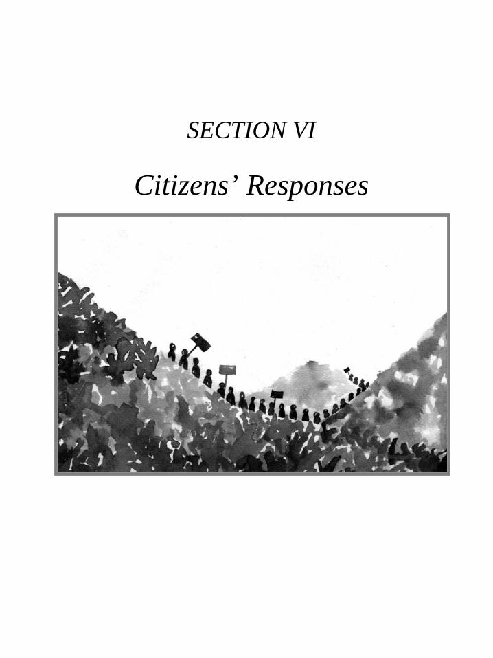
185
SECTION VI
Citizens’ Responses
Section 6.p65 3/17/05, 10:42 AM185
Black

Large Dams for Hydropower in Northeast India186
“LOCAL EXPERIENCES AND FUTURE STEPS”NORTHEAST REGION CONSULTATION ON THE WORLD COMMISSION ON DAMS
9-11th July 2001, Mawlein, Meghalaya, India
Organised byCitizens Concern for Dams and Development (CCDD*) Manipur
In partnership with South Asia Network on Dams, Rivers and People (SANDRP), the Independent Assessment of theWCD, Church Auxiliary for Social Action (CASA) – Guwahati, Development of Human Potential (DHP) Manipur
6.1
Report by:Joseph R. HmarFellow (Indigenous Peoples’ Rights Programme),CORE ManipurDated: 7 August 2001
The Northeast Regional consultation on the finalreport on WCD was organised by the Citizens Concernfor Dams and Development (C.C.D.D.), Manipur inpartnership with CASA - NEI, Independent AssessmentWCD, SANDRP, CORE and DHP. It was attend bymore than 35(thirty-five) participants. Representativesof government also attended, some though in theirpersonal capacity. It goes to the credit of the panelmembers and the organisers all the stakeholderrepresentatives debated constructively throughout thethree days of consultation. It was a good consultationas the participants were drawn from academicinstitutions, government and nongovernmentalorganisations. It was unfortunate that representativesfrom the states of Mizoram and Sikkim could not attend.
A press conference was held on the last day of theconsultation at the Shillong Press Club, in which overthirty members of the press and media includingDoordarshan and All India Radio attended. The finalrecommendations and plan of action of the consultationwas announced at the press conference.
A number of regrets, due to personal and officialengagements, were received before and during theconsultation:
1. Dr. R. K. Shyamanada, Manipur Science &Technology Council
2. Oinam Jilla, Loktak Project Affected Areas ActionCommittee
3. P.L. Thanga, Adviser (Planning), North Eastern Council4. Prof. Mrinal Miri, Vice Chancellor, NEHU5. Kuladhar Saharia, Chairman, Brahmaputra Board6. Dr. V.D. Darlong, Joint Director, Regional Office,
Ministry of Env. & Forests7. Dr. B. D. Sharma, ex-Chairman, NCSCST and ex-
VC, NEHU8. Dr. S. Parasuraman, WCD Secretariat9. Dr. Ramaswamy Iyer, Indian Institute of Public
Administration10.Dr. Nirmal Sengupta, Madras Institute of
Development Studies
FINAL RECOMMENDATIONSThe Northeast regional consultation on the final
report of the World Commission of Dams becamenecessary in view of the felt need to assess the overallimpact of the large number of dams that exist in theregion or are in the pipeline. Nearly twenty-five hydelprojects, large and small, are in various stages ofimplementation in the Northeast, where the power sectorhas been given the status of industry by the Indiangovernment. But the adverse impact of several existingdams set up in the past in Northeastern India made ustake a close look at the final report of the WorldCommission on Dams (WCD) and the existing legal
* CCDD is a coalition of over forty civil society organizations, professional organizations, academics and individuals based in Manipur,India. CCDD was formed in 1999 to assert the peoples’ rights to information and participation in all development decision-making,planning and activities, particularly regarding to dams, that are seen as having or to have many deep and long-lasting effects onpeoples, cultures, lands, waters and the environment.For further information, please contact: CCDD Secretariat, CORE, Ghari, Airport Road, Imphal 795001, Manipur, IndiaTel/Fax: +91 385 441339 Email: [email protected]
Section 6.p65 3/17/05, 10:42 AM186
Black

187Local Experiences and Future Steps
framework related to hydel power and water resourcesdevelopment in India. We find some of the WCDrecommendations for implementation of hydel projectsrelevant to the Northeast, as legal provisions exist andtheir implementation needs review. The regionalconsultation was not restricted to the region; in a way itbrought together activists and academics, government,officials of power corporations and journalists withinthe region with many specialist NGO organizers andexperts from other parts of the country. So a sharing ofthe national experience with the regional was possibleand the WCD report provided a useful framework forthe discussions. The regional consultation came up witha specific set of recommendations, both for existingdams and those being planned. It also agreed on a planof action for the future.
EXISTING DAMS(a) Keeping in mind the ecological fragility of the
northeastern region and the loss of bio-diversity andlivelihoods caused by some past dams, a thoroughassessment of the carrying capacity of the regionwith regard to hydropower generation needs to beconducted by an independent team of experts /agencies.
(b) The regional consultation agreed to persuade thegovernment / power corporations and other relatedagencies to conduct a periodic review of existingdams after every five years.
(c) The review should encompass both techno-economicfeasibility and also take into account the social,cultural and environmental impact of the projectsconcerned.
(d) For an objective assessment of the socio-environmental impact, agencies such as BotanicalSurvey of India, Zoological Survey of India,Geological Survey of India, Bombay NaturalHistory Society and Wildlife Institute of India andgovernment wildlife and forest departments shouldbe consulted. Such studies should be made availableto all interested parties and stakeholders. Theknowledge of the local population should be part ofthis process of review and decision-making process.
(e) Such hydel projects that are no longer found to befeasible in either techno-economic terms or in termsof the high social and environmental costs should beconsidered for decommission after proper study.Strong cases for decommissioning of Dumbur Hydro
Electric Project of Tripura and Loktak HydroElectric Project of Manipur were presented at themeeting.
(f) The regional consultation also decided to persuade,or pressurize government if necessary; to completethe process of rehabilitation and resettlement ofdisplaced and affected communities who wereuprooted by hydel projects in the past beforedisplacing any more people by new dams. TheChakmas, who were displaced by the Kaptai Damin Bangladesh’s Chittagong Hill Tracts and acceptedas refugees in India, merit special consideration forprotection, rehabilitation and endowment of Indiancitizenship without any further delay. Since there isno way Bangladesh will ever accept them backbecause they came to India before the creation ofBangladesh, the Indian government must takenecessary steps to protect and rehabilitate theChakmas and provide them with Indian citizenshipto ensure they are not displaced a second time.
UPCOMING DAMS(a) While the regional consultation agreed on the need
to develop Northeast region in every sense of theterm, participants advocated a broader vision ofdevelopment that would encompass social, culturaland environmental factors. We hope implementingagencies like NEEPCO, NHPC, Brahmaputra Boardand state & the central governments would take intoaccount factors like the extent of humandisplacement, damage to natural eco-systems andaggravation of ethnic conflicts, options available fordevelopment while conceiving and prioritizingdevelopment projects and that no decisions wouldbe taken without full and transparent consent of thepeople of the region. The five core values — equity,efficiency, participatory decision-making,sustainability and accountability – and the sevenstrategic priorities highlighted by the WCD report(which has been commended even by some of thenational governments in South Asia) should befactored into assessing the viability of the project.
(b) Utmost importance should be given to these factorsin site selection and project implementation by theconcerned agencies. Extensive interaction betweenthe implementing agencies and the upstream anddownstream communities should be held before theproject design and parameters are finalized. An
Section 6.p65 3/17/05, 10:42 AM187
Black

Large Dams for Hydropower in Northeast India188
acceptable procedure for holding such interactionsshould be put in place. The regional consultationfelt that evolving a popular consensus with localcommunities in the project area, rather than adoptinga top-down confrontationist attitude, should be givenhighest priority for implementing the upcomingdevelopment projects.
(c) The government should ask agencies likeBotanical Survey, Zoological Survey andGeological Survey to conduct independent surveysin proposed project areas to assess theenvironmental impact of the projects. NGOscapable and willing to conduct such surveysshould be allowed to do so and their reports shouldbe used while considering the projects.
(d) The government should also be requested to exploit otheralternate sources of power and development. Exploitationof natural gas reserves and non-conventional forms ofenergy like solar and biomass should be explored inkeeping with local needs and concerns. In consideringhydropower development, priority should be given tomicro and mini hydro projects.
(e) With regard to new projects in the pipeline, theproject implementing agency should also make acomprehensive and technical assessment of potentialimpacts of the river regime downstream of the projectand accordingly modify design parameters.
(f) While drawing up rehabilitation schemes, specialattention must be given to local socio-culturalrealities. A proper weighing of benefits in ethnicterms should be made, so that development forsome does not become disaster for others.Indigenous and Tribal Peoples by tradition alwaysdon’t have land deeds or records for lands theyhave owned, cultivated and used. And they havethus been left out of the rehabilitation processadding to ethnic unrest. Before taking up anyproject, full land records survey and landentitlement process should be completed. Projectsshould be implemented after getting prior, free andinformed consent of the local people for the projectand also for the full rehabilitation plan in atransparent way.
(g) Considering the wealth of biodiversity in the NorthEast Region, and other environmental aspects suchas the high siltation rates, the seismicity and ethnicrealities of the region, there is a need forcomprehensive environmental impact assessmentover sufficient period of time.
Having come up with a specific set ofrecommendations as above, the Regional Consultationagreed on a Plan of Action for the future. Some of theelements of the same are:
� It was agreed that civil society organizations, NGOs,WWF-India (northeast), academics and otherprofessionals in the region will have a NE Coalitionthat will network among themselves and with thoseelsewhere in the country and abroad on the issue ofDams and Development. The Citizens Concern forDams and Development (CCDD) will take the initiativeto develop the regional coalition.
� In order to serve as a model and as a starting pointtwo dams, an ongoing and another a proposed one, willbe thoroughly assessed. As proposed the ongoingDumbur Dam in Tripura and the Tipaimukh High Damin Manipur will be assessed.
� It was also proposed that a meeting would be calledby CCDD in Tipaimukh/Churachandpur/Tamenglonginviting NEEPCO and other dam building authoritiesrelated to the Tipaimukh High Dam for an opendialogue to debate the necessity of the dams, variousoptions and issues surrounding the proposed dam.
� In addition to this every member of the coalition inall the states will seek to collect the Status Reportprepared by Governments and other implementingagencies of all existing dams in the region.Compilation and dissemination of these reports to allpartners is expected to contribute in strengthening thelink among partners.
� All efforts will be made to study and promote reviewand decommissioning of some of the past dams likeDumbur and Loktak Project. Efforts will also be madeto study and highlight the options available to damsand development in the region.
Section 6.p65 3/17/05, 10:42 AM188
Black

189
Participants List
NR. NAME DESIGNATION/ORGANISATION ADDRESS/CONTACT
1. Dr. A. K. Goswami WWF – NE Regional Branch Meghamallar Apartments, Room No. 202, Uzan BazaarGuwahati 781001Tel: (361) 660732, 668329 (R)Tele/Fax: 63465421714 (Mobile)Email: [email protected]
2. Girin Chetia North East Affected-Area , Jorhat Email: [email protected] Society (NEADS)
3. Nirmal Kanti Dey Nature’s Foster Ward No. 1, Dattabari, Dhubri District, Assam 783301Tel: (3662) 31067, 325505Email: [email protected]
4. A.K. Goldsmith Coordinator NEI, CASA Satribari, Guwahati, Assam 781 008Tel: (361) 522152Email: [email protected],[email protected]
5. R. H. Wahlang RRC, CASA Tele: (363) 866302/303
6. Walter Fernandes NESRC, Guwahati C/o Dr. A. K. Sharma (GF)Principal J. Baruah Road, SilpukhuriGuwahati 781001Tel: (361) 637941, 544773 (R)Email: [email protected]
7. Ashim Kumar Chakma Organising Secy., Committee for Ashok Buddha Vihar, Old Power House RoadCitizenship Rights of the Chakmas Rajghat, New Delhiof Arunachal Pradesh Tel: (11) 3253462
Fax: (11) 6191120Email: [email protected]
8. Joseph R. Hmar President, Hmar Students’ Association Sangaiprou, Imphal
9. Aram Pamei Naga Women’s Union Manipur Tharon Village, Chingmeirong, ImphalConvenor, CCDD Tel: (385) 421385 (O), 310302 (R)
Email: [email protected]
10. Kindenson Pamei Zeliangrong Union Tharon Village, Imphal
11. Dr. Y. L. Mingthing Director, T.T.A.
12. Rev. T. Ruivanao Coordinator, D.H.P. Chingmeirong, Imphal, Manipur
13. Dr. D. Roy Laifungbam CCDD Working Group/General Secy./ Yaiskul Police Line, Imphal 79501Director, CORE Telefax: (385) 338169, 441339
Email: [email protected]@hotmail.com, [email protected]
14. Anna Pinto Director, CORE/CCDD Secretariat do
15. Ramananda Wangkheirakpam CORE/CCDD Secretariat/IA WCD do
16. Inamul Islam (Manager Civil) North Eastern . North Eastern Electric Power Corporation Ltd.Electric Power Corporation Ltd Woodland Compound(C/o Executive Director, Lower New Colony, Shillong 793 003Corporate Futuristic) Tel: (364) 226707, 224487 (Off.), 569653(Res.)
PABX: 22070/122Telefax: 0364-226417Email: [email protected]
17. A. K. Dam NEEPCO Tel/PABX: (364) 22070/12218. Ph. I. Singh NEEPCO Tel: (364) 22310419. Sanat Chakraborty North East Observer Tel: (364) 502593 (R)
Email: [email protected]
Local Experiences and Future Steps
Section 6.p65 3/17/05, 10:42 AM189
Black

Large Dams for Hydropower in Northeast India190
20. Anirban Roy Journalist (Hindustan Times) Email:[email protected]
21. Subir Bhaumik Correspondent (BBC) Email: [email protected]
22. P. P. Singh Correspondent (Economic Times) Tele:0361 456768/661155
23. Peter Thorose Secretary, Meghalaya Environment SHILLONG& Wildlife Society Tel: (364) 225092
Fax: 222497Email: [email protected],
24. Adviser (Power & IFC) North Opp. A. I. R. ShillongEastern Council Tel: (364) 225090 (R), 223982 (O)
Fax: 224270
25. A. Nongrumu CWPO, Department of the Social Tele: (364) 224332/225187Welfare, Meghalaya
26. Dr. B. Kharbuli NEHU (NE Biodiversity Research Email: [email protected]), Shillong
27. D.R. Michael Buam NEHU (NEBRC) Email: [email protected]
28. Dr. D. D. Nongnong NEHU V-P NEBRC
29. Dileep Singh Bhuria Chairman, National Commission 12, Dr. Bishambar Das Marg, New Delhion SC & ST Fax: (11) 4632298,
Tel: (11) 4620435 (O), 3715460 (R)Email: [email protected]
30. J. Poddar Director, National Commission for IInd Floor, “VN Enterprises Building”,SCs and STs Christian Basti, G.S. Road, Dispur,
Guwahati-781001Tel: (361) 267040 (O), 475070 (R) Fax: 267040
31. P. Syiemlich National Commission of Scheduled Tel: (364) 221362/504202Castes and Scheduled Tribes, Shillong
32. Neeraj Vagholikar Kalpavriksh Apt.5, Shree Dutta Krupa, 908 Deccan GymkhanaPune – 411004Tel/Fax: (20) 565 4239Email: [email protected]
33. Manju Menon Kalpavriksh Apt. 5, Shree Dutta Krupa, 908 Deccan Gymkhana,Pune 411004Tel/Fax: (20) 565 4239Email: [email protected], [email protected]
34. Smitu Kothari Lokayan 13, Alipur Road, Exchange StoreDelhi 54Tel: (11) 3969380Email: [email protected]
35. Dinesh K. Mishra Email: [email protected]
36. Himanshu Thakkar SANDRP, New Delhi Tel: (11) 7470016, 7484654Email: [email protected]
37. Khurshid Anwar Popular Education & Action Research 92, Katwaria Sarai, New Delhi 110067Tel: (11) 6968121 (, 6895809Fax: (11) 6893172Email: [email protected]
p p p p
Section 6.p65 3/17/05, 10:42 AM190
Black

191
6.2
Press Note, 21 December, 2001
NEED TO RE-ORIENT DEVELOPMENT TO CONSERVE NORTHEAST’SBIOLOGICAL AND CULTURAL DIVERSITY
Statement of the North-Eastern Regional Workshop of National Biodiversity Strategy And ActionPlan (NBSAP)
The North-Eastern Regional Workshop of the National Biodiversity Strategy and Action Plan (NBSAP) processwas held at Guwahati on 18-20th December, 2001. It noted that the north-eastern region being one of India’s mostbiologically and culturally diverse areas, special efforts were needed to evolve models of development that wouldhelp to conserve this diversity rather than destroy it. To do this, participants felt that:
• greater efforts were needed to sensitise various agencies of development, and institutions rangingfrom the district councils to the North-East Council (NEC), with regard to the importance ofbiodiversity in human life;
• much greater role has to be given to communities in conservation and sustainable use of naturalresources, in particular involving disprivileged sections such as women, tribals, landless, and othersocially or economically downtrodden;
• greater coordination is needed amongst the states of the north-eastern region, on issues of commonecological concern.
The NBSAP is a Ministry of Environment and Forests (Government of India) project, funded by theGlobal Environment Facility (GEF)/United Nations Development Program (UNDP). Its technical executionis being done by an NGO, Kalpavriksh, which has set up a 15-member Technical and Policy Core Group(TPCG) for the overall co-ordination of the process. Its administrative coordination is by the BiotechConsortium India Ltd. The process aims to create about 75 implementable action plans at local, state,regional, thematic, and national levels, for conservation of biodiversity, sustainable use of biological resources,and achievement of equity in conservation and sustainable use.
The process has been going on since early 2000, and is expected to end in mid-2002. In its 18 months ofexistence, NBSAP has so far involved several tens of thousands of people through workshops, yatras, festivals,meetings, public hearings, media outreach, and other means. Its unique feature is that every relevant sectionof society ( tribals, fisherfolk, farmers, scientists, government officials, artists, armed forces personnel,mediapersons, academics, corporate sector, and so on) has been involved, and the diverse voices from thegrassroots are being given first priority while building a national picture. In the north-east too, this processis attempting such widespread participation.
The workshop in Guwahati brought together the coordinators of the NBSAP process from:• the states of Assam, Mizoram, Meghalaya, Nagaland, Arunachal Pradesh, and Manipur;• local sites of Rathong-Chu in Sikkim, Karbi-Anlong in Assam, West Garo Hills in Meghalaya, and
Chedema in Nagaland;• the ecoregion of North-East India as a whole;• resource persons, members of the Technical and Policy Core Group, and members of Kalpavriksh.
Participants ranged from government officials to NGOs, scientists, and activists. The workshop was hosted bythe NGO Aaranyak.
Need to Re-orient Development to Conserve Northeast’s Biological and Cultural Diversity
Section 6.p65 3/17/05, 10:42 AM191
Black

Large Dams for Hydropower in Northeast India192
Sessions at the workshop dealt with:1. Moving towards concrete, implementable action plans for all the states, local sites, and the ecoregion;2. Identifying and recommending actions for coordinating biodiversity-related actions amongst all thestates of the region;3. Integrating sensitivity on issues of gender (especially women’s rights), equity (especially involvementof disprivileged sections), and empowerment (especially of communities to deal with natural resourcemanagement);4. Integrating biodiversity sensitivity into all sectors of planning and development, especially sectors
like agriculture and mining;5. Dealing with issues related to international agreements like the WTO and facing up to threats like
those of biopiracy and patenting; at the same time positively using opportunities provided by otherinternational agreements like the Convention on Biological Diversity (CBD). .
The key action points that came up are given in the attached note.
This is the fourth regional workshop of the NBSAP process, and there will be a final fifth one for thesouthern region. These workshops will lead to the finalisation of action plans for sites and themes in the statesof these regions, and finally into a national action plan for consideration by the Government of India.
Participants were especially hopeful that the vast amount of effort that is going into this process, will result innot only action plans and strategies, but also in concrete implementation by governments, NGOs, and communities,so that the serious ecological destruction and livelihood loss faced by India could be reversed.
(Ashish Kothari) (Bibhab Talukdar)
For further information:
(At North-east Level):Assam Science Society, Latasil, Guwahati. Tel: 544208; Email: [email protected]
Aaranyak Nature Club, Ever Green, Samanya Path, PO Beltola, Basistha Road, Guwahati 781028. Tel: 266087;email: [email protected]
(At National Level):Kalpavriksh, Aptmt. 5 Shree Datta Krupa, 908 Deccan Gymkhana, Pune 411004. Tel/fax: 020-5654239; email:[email protected]
NORTH-EASTERN REGIONAL WORKSHOP OF NATIONALBIODIVERSITY STRATEGY AND ACTION PLAN
Guwahati, 18-20 December, 2001
Major Issues and Recommendations
1. The most significant aspect of the north-east region is its biological and cultural diversity, the large range ofcommunity beliefs and practices relevant to biodiversity (such as sacred groves and lakes); the developmentstrategy for the region must be sensitive to this diversity and should help to conserve rather than destroy it.
2. There are serious inter-state border issues across the region, including deforestation, social conflicts, poaching,and others; these can only be resolved by providing much greater role to local communities on both sides of
each border, in dialogue and mutually acceptable actions, including joint forest and wildlife conservation measures.
3. Several major dams are being proposed in the region, which will have significant impacts on biodiversityand local people; there should be a thorough impact assessment of these, as also a search for ecologically
Section 6.p65 3/17/05, 10:42 AM192
Black

193
friendly alternatives such as micro-hydel and run-of-river schemes, before going ahead. Local people shouldbe fully involved in such exercises through public hearings and other means.
4. Considerable damage is being caused by trade in forest produce (e.g. bamboo, cane, thatch, and medicinalplants like Taxus and Rauwolfia), from one state to the other and from the north-east to other parts of Indiaand abroad; there should be a full investigation into this trade, stringent controls on extraction from forestswith help from local people, and measures to ensure that the major benefits from the trade go to the local communities.
5. Patterns of land ownership and rights across the region are complex, and their relationship with biodiversityneeds to be understood. All efforts should be made to encourage and revive community management systems,which are otherwise breaking down under the influence of modernisation and privatisation; and in somestates to address the issue of alienation of tribal lands by outsiders.
6. Structures of governance in the region, such as local and district councils, and state bureaucracies, need tobe made sensitive to concerns regarding biodiversity.
7. Biodiversity should be integrated as a central concern in all development departments and sectors, includingthrough appropriate education of planners, mandatory portion of each department’s funds set aside for biodiversity,and changes in policies/programmes that destroy biodiversity (e.g. monoculture and chemical-intensive agriculture).
8. Considerable damage is being caused by mining in many states of the region; this needs to be controlled bysubjecting all mining to stringent ecological and social impact assessments, consent from local communities,and public hearings.
9. Women’s role in all aspects of planning, implementation, and monitoring of environment and developmentprojects, must be strengthened by mandatory inclusion of women in decision-making bodies and buildingtheir capacity to participate in such forums.
10. The issue of large-scale immigration into India, and the settlement of “refugees” or other foreign nationals,needs to be settled at the highest political levels, especially in areas of great ecological sensitivity.
11. International trade in wildlife and timber, especially to Myanmar and Bhutan, needs to be curbed if possiblethrough involving and providing to local communities and with help and sensitisation of the armed forcesstationed along the border.
12. The true economic and social value of biodiversity in the region, including the ecosystem services beingprovided within and between states (e.g. Assam’s water security provided by Arunachal’s forests), should beestimated and built into the planning and budgeting of the state and regional plans.
13. Such valuation can also be the basis of compensation by the country, for the north-eastern states having to“forego” options like logging and large dams; such compensation should be used to help devise alternativelivelihoods for those who lose jobs for ecological reasons.
14. The impact of the Armed Forces on the environment and people needs to be independently assessed, andorientation sessions held to make them more sensitive to biodiversity and cultural/livelihood issues.
15. There is considerable expertise and innovativeness within the north-eastern region, which can be exchangedamongst the states to mutual benefit; e.g. ecotourism model in Sikkim, bamboo crafts in Tripura and Arunachal,short-cycle sustainable shifting cultivation in Nagaland, women-led orchid growing societies in Arunachal,and many others. Exchange visits of communities, NGOs, and officials should be facilitated.
16. The issue of elephant depradation and deaths is serious in many states of the region, and needs to be urgentlyaddressed through habitat protection and restoration, resolution of encroachment issues, prompt and adequatecompensation for crop/human losses, and a long-term plan that identifies critical remaining elephant corridorsand affords protection to them.
Overall, it was recommended that institutions such as the North-East Council (NEC), should take the aboveand other biodiversity-related issues much more seriously, and incorporate them as one of their core items fordiscussion and decision-making.
Need to Re-orient Development to Conserve Northeast’s Biological and Cultural Diversity
p p p p
Section 6.p65 3/17/05, 10:42 AM193
Black

Large Dams for Hydropower in Northeast India194
1. As part of the National Biodiversity Strategy &Action Plan (NBSAP) process, the Centre forEnvironment Protection (CEP) organized a one-daypublic hearing on Biodiversity Conservation (withreference to hydel projects) on 22.5.2002 at PressClub, Aizawl. Er. Dunglena, Chairman, StateSteering Committee, NBSAP Mizoram presided overthe hearing. He opened the hearing by thoroughlyelaborating the process of NBSAP in Mizoram, andhe also defined the nature and purpose of the hearing.Participants at the meeting were from variousorganizations like Mizo Students’ Union (MSU),Central Young Mizo Association (CYMA), ZoramNationalist Party (ZNP), Public Health EngineeringDepartment, Environment & Forests Department,News Papers, LPS Vision Production, State PublicWorks Department, Mizoram State Pollution ControlBoard, Power & Electricity Department, etc.
2. Keynote address was presented by Shri. RothuamaSailo, Team Asst. Secy., CEP. First of all he pointedout how the NBSAP process was initiated in Indiaand how the process was being undertaken inMizoram. He pointed out that man has been givennatural resources by nature for our survival, howeverone must understand nature and develop a symbioticrelationship, and we were part of the nature andshould abide by its rules, he stated. He further pointedout the possibility of various adverse impacts onbiodiversity by hydel projects. We were havingdevelopments at the cost of environment and weshould try to have developments on a sustained basis,he stated. He strongly pointed out the need ofsustainable developments and also pointed outEnvironment Impact Assessment Notification wasthe key to have developments on a sustained basis.He also pointed out the process of environmentalimpact assessment and how forest clearance andenvironmental clearance can be had for hydelprojects. At the end of his presentation, herecommended mini/micro hydel projects andrenewable sources of energy like wind and solar
6.3
PROCEEDINGS OF PUBLIC HEARING ON BIODIVERPSITY CONSERVATION(WITH REFERENCE TO HYDEL PROJECTS)
Venue : Press Club, Aizawl, Mizoram.Date & Time : 22.5.2002 at 12:30 noon
energy rather than big dams.
3. Technical Report I was presented by Shri. K. Guite,Superintending Engineer, Power & Electricity Deptt.,Govt. of Mizoram. He pointed out that Mizoramwas endowed with vast hydropower potential — upto 2425 MW based on assessment made by CentralElectricity Authority (CEA). He also stated thepower potential developed in the State as on todaywas 8.20 MW only while the peak demand wasaround 90 MW. He pointed out the on-going hydelprojects of Mizoram such as Maicham Phase – IIsmall hydel project, Lamsial Small Hydel Project,Serlui ‘B’ small hydel project, etc. and its likelyimpact on biodiversity. He stated no adverse impacton biodiversity were expected due to the projectsexcept for Serlui ‘B’ hydel project. For Serlui ‘B’hydel project, the conditions set out in the clearancefor forests and environment were strictly followedand fulfilled in all aspect, the project affectedvillagers were rehabilitated in Bawktlang area as perthe National Guideline, he stated. At the end of hispresentation, he mentioned that his Department usedto keep provision for plantation, environment &ecology, etc. without fail in every project and in everymajor or minor work. He further mentioned that hisDepartment had already deposited a sum ofRs.170.14 lakhs to the concerned Department (i.e.Forests Department) for compensatory afforestation(CA) in Serlui ‘B’ Project.
4. Technical Report II was presented by Shri. B.V.Chhuana, M.F.S., Asst. Conservator of Forests,Wildlife Division, E & F Department. He mentionedTuirial Hydel Project and its impact on biodiversityin details, and stated the catchment area of the projectcovered an area of 1861 sq. km. and was very richin biodiversity. He elaborated that no rare andendangered species of wild animals including birdswere found in the submergence area of Tuirial Damas bamboos mostly covered the area. It supportedonly wildlife like sambar, barking deer, snake, etc.,
Section 6.p65 3/17/05, 10:42 AM194
Black

195
he stated. However, he clarified that practically noaccountable impact on biodiversity was yet knownor observed in the submergence and rest of thecatchment area. In the meantime, he stated, the directimpact on biodiversity had been observed that twowater points (water licks) had been already desertedwithin the dam site, such were the water pointsfrequented by barking deer, sambar and other birddiversity. He further mentioned that large numberof wild animals from the dam site had migratedtowards the adjoining forests of Mauchar, which waslinked up to Buhban hill situated outside Mizoram.At the end of his presentation, he hoped that acomplete disappearance of bird diversity from thecatchment area did not happen due to timely actiontaken by the Wildlife Wing of the Environment &Forests Deptt. In collaboration with local NGOs andvillagers of the fringe area.
5. Discussion followed right after Technical Report IIwas over. First of all, most of the participants askedquestions on Keynote address, Technical Report I& II, and clarifications were made by the resourcepersons wherever possible. Generally, majority ofthe participants expressed their ideas while smallgroups were reluctant to do so. Inputs given byparticipants of the hearing may be compiled asfollows :-
� The State has vast hydropower potential.However, due to the potentiality of detrimentalimpact on environment by hydel projects,development of power potential in the Stateshould be need based only.
� Alternatives like wind energy, solar energy,micro hydel and run of the river projects needto be explored more seriously.
� Big dams should not be encouraged and hydelprojects should not be done in ecologicallysensitive areas (ESAs).
� To ensure sustainable development,environment impact assessment be taken moreseriously.
� The implementing agency should strictly adhereto the conditions set out in the environmentalclearance letter.
� Expenditure incurred for compensatoryafforestation (CA) should be evaluated andmonitored strictly and there should betransparency on whether the expenditureincurred for CA is really being spent or not.
� There should be a good coordination betweenthe implementing agency and the StateEnvironment & Forests Deptt.
� Locally available NGOs/Consultants should beutilized for biodiversity assessment, EIA, etc.of the projects rather than other NGOs/Consultants from outside Mizoram.
(A.C. ZONUNMAWIA)Coordinator & Chairman,
Centre for Environment Protection (CEP)
No.CEP/PUB-NBSAP/09/2002 Dated Aizawl the 22nd
May, 2002.
Copy to :-1. P.S. to Chief Minister, Govt. of Mizoram, for
information of the Hon’ble Chief Minister.2. P.S. to Minister, Environment & Forests, etc. Govt.
of Mizoram.3. P.S. to Chief Secretary, Govt. of Mizoram.4. P.S. to Secretary, Environment & Forests, Govt. of
Mizoram.5. Chairman/Member Secy., Mizoram State Pollution
Control Board.6. PCCF, Environment & Forests, Govt. of Mizoram.7. National Project Director, NBSAP, MoEF, Govt. of
India.8. Coordinator/Member Secy., TPCG, NBSAP, New
Delhi.9. Presidents, Congress (I), MNF, MPC, ZNP, JD (U), etc.10.All participants.
(V.L. TLANA)General Secretary,
Centre for Environment Protection (CEP)A – 88/1, Tuikual South,
Aizawl – 796001, Mizoram, India.Tel : 0389-324483 e-mail : [email protected]
Proceedings of Public Hearing on Biodiveristy Conservation
p p p p
Section 6.p65 3/17/05, 10:42 AM195
Black

Large Dams for Hydropower in Northeast India196
6.4
August, 22, 2001
ToChairmanAssam Pollution Control BoardBamunimaidamGuwahati- 781021
Sub: Objections to the Lower Subansari Hydro Electric Project, Gerukamukh
Dear Sir,
The Public Hearing notice for the Lower Subansari project appeared in the Assam Tribune as per the provisionsof the Environmental Impact Assessment Notification, 1994, under the Environmental Protection Act, 1986.The notice seeks objections, suggestions and comments from concerned individuals and groups.
Enclosed is a note on our concerns with regard to the project. These may please be recorded as our objectionsas per the provisions of the Public Hearing Notification, 1997 (schedule IV of the EIA Notification, 1994). Wealso urge you to reconsider the project proposal on these grounds and take stringent action against NHPC for theviolations caused, as pointed out in our note.
We would appreciate a response to this letter.Thanking you,
Sincerely,
Manju Menon/ Neeraj VagholikarKalpavriksh
Cc: Secretary, Ministry of Environment and Forests, New DelhiRegional Chief Conservator of Forests, North Eastern Regional Office, Ministry of Environment and Forests,ShillongShri. Suresh Prabhu, Minister, PowerPollution Control Board, Regional Office, TezpurArunachal Pradesh Pollution Control Board, Itanagar, Arunachal Pradesh
THE LOWER SUBANSARI PROJECT: MAJOR ECOLOGICAL CONCERNS
1) VIOLATIONS OF THE LAW: The project proponent, NHPC, has already gone ahead with massiveconstruction of project housing on the left bank of the Subansari river on 131 ha of forest land illegally occupiedby them. Since they neither had (nor have) forest or environmental clearance, this is a clear violation of both theForest (Conservation) Act, 1980, and the Environment (Protection) Act, 1986. Stringent action needs to be takenagainst the project authorities for these violations.
2) DESTRUCTION OF BIODIVERSITY: The submergence area of the reservoir falls in one of the world’scrucial biodiversity hotspots, the Eastern Himalayas, and also has a large spread of over 3000 ha. We are concernedabout the serious impacts on biodiversity due to inundation of the reservoir area.
LETTER TO ASSAM POLLUTION CONTROL BOARD ON LOWER SUBANSIRI
Section 6.p65 3/17/05, 10:42 AM196
Black

197
3) FRAGMENTATION OF ELEPHANT CORRIDOR: The Wildlife Institute of India (WII) report on“Planning a Protected Area Network in India” (1988, Rodgers and Panwar) had in its proposal for the EasternHimalayan biotic province, stated the need for “Fully protected migratory pathways for elephant and otheranimals on the Assam- Bhutan borders at Kalaktang and Pakhui and Lower Subansari”. For this purpose theyhad also proposed the formation of a new sanctuary in the Lower Subansari district, by the name of KarsingaNala, to protect essential corridors for continued east-west movement of elephant and other species. Thisproposal has been reiterated in the updated version of the WII report.1. The Lower Subansari project has the TaleValley sanctuary to its west and the proposed Karsinga Nala sanctuary to it east, and is most likely to affectimportant wildlife corridors. We are extremely concerned about the possible impacts of a large submergence ofover 3000 ha in cutting off crucial corridors for elephant and other species. This assumes special significancenot only because of the impact on elephants and other wildlife, but also the possibility of greatly increasinghuman-elephant conflicts as elephant herds may stray into human habitation, a situation that occurs in manyparts of north Bengal and Assam areas where corridors have already been fragmented.
4) DESTRUCTION OF RICH BIRD HABITAT: As mentioned above, the submergence area is to the east ofand contiguous with the Tale Valley sanctuary, which has been described in the WII report (Rodgers and Panwar)as “ a distinctive valley swamp community not found elsewhere”. This has also been identified as an ImportantBird Area (IBA) under Birdlife International’s Important Bird Area Programme, being conducted by the BombayNatural History Society in India. IBAs are sites of international significance for bird conservation and the TaleValley Sanctuary has been identified as an IBA under two criteria of the programme: A1 (globally threatenedspecies) and A2 (restricted - range species). Though further investigations are required in the area, availableinformation already indicates at least 4 species listed in the IUCN Red Data Book and 6 restricted-range species.
5) DAM-BREAK DANGERS: During the 1950 earthquake, a dyke formed as a result of a landslide blockedthe Subansari river. This broke after eight days and the wave, seven metres high, caused severe damage to life andproperty.2 In 2000, a dam breach on the Tsang-po river in Tibet, caused flash floods and wreaked havoc inArunachal Pradesh.3 A mega project of the proposed size would have disastrous impact on the whole of Assam incase of a dam break. This is a serious cause of concern.
6) FAULTY EXECUTIVE SUMMARY: The executive summary of the project which has been made availableto the public at the Pollution Control Board office (a mandatory step under the Environmental Impact AssessmentNotification, 1994) is supposed to incorporate the essence of project details and findings of Environmental ImpactAssessment study (as per the explanatory note under the EIA Notification). However, the executive summary ofthe Lower Subansari project has no mention of the environmental impacts. In such a situation, conducting anenvironmental public hearing will not serve its objective as people have not had access to adequate information onthe impacts of the project.
7) DATA DISCREPANCY: According to the executive summary, the submergence area is 33.50 sq.km.(3350ha) but the information that appeared in the Assam Tribune on August 17, 2001, (NHPC communication) statesthat the submergence area is 3436 ha. This is a disparity in the information furnished by the project proponents.
1 Reference: a) W.A. Rodgers & H.S. Panwar: Planning a Wildlife Protected Area Network in India, Wildlife Institute of India, 1988and b) W.A. Rodgers, H.S. Panwar, V.B. Mathur: Wildlife Protected Area Network in India: A Review, Wildlife Institute of India,20002 National Earthquake Information Centre (NEIC), USA3 References: News reports on Tibet dam bursta) Radha Das, “14 killed in floods in the Northeast”, Rediff News, June 20, 2000b) AFP, “Chinese officials confirms a China dam break caused India floods”. July 10, 2000
Letter to Assam Pollution Control Board on Lower Subansiri
p p p p
Section 6.p65 3/17/05, 10:42 AM197
Black

Large Dams for Hydropower in Northeast India198
6.5
May 16, 2002
JUSTICE B.N. KIRPAL,HONORABLE CHIEF JUSTICE OF THE SUPREME COURT,NEW DELHI.
Sub: Lower Subansari hydroelectric project, Assam - Arunachal Pradesh border
Dear Shri Kirpal,
I am a wildlife researcher, a member of the group Aaranyak and a citizen of Assam. I have read in a recentnewspaper report ( Assam Tribune, May 10, 2002, attached as Annexure I) that the Supreme Court has grantedan exemption to the Lower Subansari hydroelectric project, submerging a part of the Tale Valley Sanctuary, fromthe interim order earlier passed by the honourable court in writ petition No. 337/ 95, restraining the StateGovernments’ from dereserving any National Park/ Sanctuary area. I understand that the project still needs thefollowing clearances as mandated by the respective forest/wildlife/ environmental laws:
1) Permission from the Chief Wildlife Warden of the state for diversion of land from the Tale Valley Sanctuaryunder section 29 of the Wildlife (Protection) Act, 1972, after taking the opinion of the Indian Board forWildlife (IBWL). The opinion of IBWL for permission under section 29 is as per the court orders.
2) Clearance for the entire project under the Environment Impact Assessment Notification, 1994.
3) Clearances under the Forest (Conservation) Act, 1980.
I have been following the Lower Subansari issue for some time and am concerned about how the aboveclearance processes are taking place. I would like to bring this to the notice of the honourable Supreme Court,especially since this particular project has been discussed in the court and in this light it is important that the courtbe updated on some of the ground realities. I will outline my concerns on each of the above points:
1) Permission from the Chief Wildlife Warden of the state for diversion of land from the Tale Valley Sanctuaryunder section 29 of the Wildlife (Protection) Act, 1972:In February 2002 the Department of Environment & Forests of Arunachal Pradesh had written to the IBWLthat based on the report submitted by the CCF (Wildlife) the “impact of submergence of the above small areaof 42 ha. of the sanctuary on its wildlife will be insignificant”. This report is based on a helicopter survey. Asyou are aware this region forms a part of the Eastern Himalayas and is a crucial global biodiversity hotspot.It is extremely important that any judgement on the ecological significance of such an area be based on aproper ground survey. I am an amphibian & reptilian researcher and my experience shows that these areas inthe Eastern Himalayas are still largely unexplored, with new species still being discovered in numbers. Forseveral species (eg. reptiles and amphibians), an aerial survey will not indicate any information. I am alsoattaching a recent newspaper report ( Telegraph, May 4, 2002, attached as Annexure II) which reports thediscovery of some rare bamboo species near Gerukamukh, near the Lower Subansari damsite. Even as wewait for peer approval of this report (which is likely to be published in the Indian Journal of Forestry soon),the least it warrants is a thorough investigation of the submergence area.
2) Clearance for the project under the Environment Impact Assessment (EIA) notification, 1994:a) Environmental public hearing:An important addition to the environmental clearance in 1997 was the introduction of environmental publichearings under the EIA notification. This promised to be an important step for greater transparency andpeoples’ participation in environmental decision making. I attended the public hearing for the Lower Subansari
LETTER TO SUPREME COURT CHIEF JUSTICE ON LOWER SUBANSIRI
Section 6.p65 3/17/05, 10:42 AM198
Black
199
project that took place on September 4, 2002, at Gerukamukh, Assam. The manner in which this was conducted(in terms of access to information, quality of information available, procedural aspects) is a real cause forconcern. I am attaching a short note (Annexure III) on the Lower Subansari public hearing.
b) Environmental Impact Assessment (EIA) report:The EIA document was not made available and was sourced with great difficulty after the public hearing. Thereport is greatly lacking in biodiversity aspects. eg. Annexure IV on Reptiles and Amphibians lists only 3snakes, 2 lizards and 3 amphibians for the entire submergence zone of over 3000 ha! This is shocking for thearea in concern.Shri Nripen Das, the person appointed by the Assam Pollution Control Board to review the EIA document,also highlighted the poor quality of biodiversity assessment in the Lower Subansari public hearing. This haslargely to do with very little of the submergence zone having been surveyed for the project.It is a cause of great worry that in an area, which is a global BIODIVERSITY HOTSPOT, the weakest aspects of theEIA report are the biodiversity aspects.
I am attaching a critique of the EIA done by a renowned naturalist from North East India, Dr. AnwaruddinChoudhury. This looks at the biodiversity aspects of the report and is part of a critique he has done of EIAs fortwo dam projects in the North East. (attached as Annexure IV).
c) Violations of the EIA notification:The EIA notification clearly states that: “No construction work, preliminary or otherwise, relating to thesetting up of the project may be undertaken till the environmental and site clearance is obtained.” In spite ofthis, NHPC has already gone ahead and built housing colonies for the Subansari basin projects and carried outother construction activities (please see next point), in spite of having only site clearance and no environmentalclearance. These investments will now be used as a justification to push for environmental clearance, aphenomenon often seen around the country.
3) Clearances under the Forest (Conservation) Act (FCA), 1980.The NHPC has illegally occupied 131 ha of forestland and continues to carry out non-forestry activities on itin violation of the Forest (Conservation) Act, 1980. They have also been illegally collecting boulders, stone,gravels, sand and earth form the river bed I violation of the FCA. Please see letter from Principal Secretary(Forests), Assam, to Chairman & Managing Director, NHPC, dated 5th May, 2001, in this regard (attached asAnnexure V).
As a citizen of the North East concerned with ensuring ecologically sensitive developmental planning for thisfragile region, I am really concerned seeing the above violations (particularly with respect to environmental andforest clearances). The questions that the Lower Subansari project clearance process raises in my mind are just asrelevant for any other project that might come up in the region or elsewhere. I am taking this opportunity to placethese concerns before the Honourable Chief Justice:
a) Are powerful project proponents treating the environmental clearance process as a formality? How are weas a country accepting to go ahead with projects because investments have already been made, in spite of thesebeing in violation of the environmental laws? How can we allow illegalities to be perpetuated in the name ofinvestments already made and that too at a great ecological cost?b) Why is there such a lack of transparency and access to information with respect to planning of CentralGovernment projects in the North East? How is the Central Government justified in planning developmentprojects for the region without letting the citizens of the region have access to information and documents onthese?Project documents (such as EIA reports) should be public information and open to review by whosoeverwishes to do so. Non-transparency is leading to project proponents getting away with shoddy assessments andensuring poor environmental decision-making.
Letter to Supreme Court Chief Justice on Lower Subansri
Section 6.p65 3/17/05, 10:42 AM199
Black

Large Dams for Hydropower in Northeast India200
c) How is the Impact Assessment Agency (IAA) within the Ministry of Environment & Forests (MoEF),assisted by its expert committees (such as the one on river valley projects in this case), being able to makeimportant environmental decisions based on such poor quality assessments which have both inadequate/incorrectinformation?
These are all important questions for us in this region. Development projects such as the Lower SubansariHydroelectric Project have grave implications for both the biodiversity of the region as well the natural resourcebased livelihoods of communities both upstream and downstream of the project. The least we need to do is haveproper assessments and share information on these projects with citizens, before deciding whether these are viableor not.
I hope the Honorable Chief Justice gives attention to these pressing issues.
Thanking you,
Sincerely,
M Firoz AhmedAdd: Christian Basti, Dispur, Guwahati-781005, Assam
Cc: 1) Chairman, Indian Board for Wildlife, c/ o Additional Director General of Forests (Wildlife), New Delhi. 2) Secretary, Ministry of Environment & Forests (MoEF), New Delhi.
3) Addl. Director (EIA), MoEF, New Delhi. 4) Regional CCF, North Eastern Regional Office, MoEF, Shillong.
p p p p
Section 6.p65 3/17/05, 10:42 AM200
Black

201
TAKAM MISING PORIN KEBANG(All Mising Students Union)
H.O. Gogamukh, Dhemaji, Assam.e-mail : [email protected]
To1. Shri K.C. Mishra
Secreatary, MOEFParyavaran Bhawan, CGO ComplexLodhi Road, New Delhi- 110003
2. Shri P. V. RajagopalanImpact Assesment Division, MoEFParyavaran Bhawan, CGO ComplexLodhi Road, New Delhi- 110003
3. The Chairman & Managing DirectorNHPC Ltd.NHPC Office Complex, Sector-33Faridabad – 121 003
4. The General Manager, N.H.P.C Ltd.
Subansiri Lower Project,Gerukamukh;Dhemaji;Assam.
Sub: Resolutions of the Public Meeting on Subonsiri Lower Dam Project held on 15-6-2003 at Gogamukhin Dhemaji district.
Sir,I have the honour to inform you that, in view of the growing concern and apprehension among the local people
of Subansiri valley about the construction of the Subansiri Lower Dam at Gerukamukh in Dhemaji district ofAssam, a public meeting was convened by the Takam Mising Porin Kebang (All Mising Students Union) on 15-6-2003 at Gogamukh Town High School, Gogamukh in Dhemaji district.
The meeting was presided over by Shri Rebot Khanikar a senior citizen of Gogamukh area and attended by alarge number of public which included College Teachers, School Teachers, state Govt. employees, student andyouth leaders and several NGOs and environmentalists.
The meeting discussed the Subansiri Lower dam project, its impact on environment, bio-diversity, the localpeople including indigenous/tribal communities, impact on the life and subsistence of the people down stream etc.References were made mostly to the World Commission on Dam(WCD) Report and the Environmental ImpactAssessment (EIA) Report and at the end, the meeting unanimously passed several important resolution whichwe are submitting herewith to your honour for your perusal and immediate necessary action.
Meanwhile, the Central Committee of the TMPK, has also completed its own study on the Dam project andpreparing a Memorandum which will be submitted to you within short time.
We hope, your honour will consider this matter as very serious and urgent and take appropriate bold action. Thanks.
Yours sincerely, JOHAN DOLEY
General Secretary, TMPK e-mail: [email protected]
6.6
Letter to Secretary MoEF on Lower Subansiri
Section 6.p65 3/17/05, 10:42 AM201
Black

Large Dams for Hydropower in Northeast India202
Resolutions of the Public Meeting on Subonsiri Lower Dam Project held on15-6-2003 at Gogamukh in Dhemaji district.
1. The meeting unanimously resolved to demand a Second Public Hearing on the Subansiri Lower DamProject for “demonstrable acceptance” of the dam by the affected people on the following ground:
i) The local people were not properly informed about the First Public Hearing. The advertisement waspublished only in two English language news papers of Assam which are not circulated in Dhemajidistrict and people have no access to such news papers.ii) The local people who attended the meeting without properly knowing the objective put their signature
or thumb impression only as attendance; not as their acceptance of the Dam Project. But the NHPCauthority is now using those signatures as approval for the Dam.iii) The people who attended the so called first public hearing, were not provided proper information
about the Dam; rather they were misled and fooled by blatant lies.iv) It is alleged that important citizens, NGOs etc. who have expert knowledge about impacts of big
dams, have concerns about preserving bio-diversity, environment etc. were not invited to the hearing.v) It is alleged that the EIA Report is full of false and distorted data and statement. It has not a single line
on the impacts of the Dam on the down stream.vi) It is alleged that the NHPC is not complying with the Recommendations of the World Commission on
Dams (WCD).
2. The meeting unanimously resolved to demand release of a copy of the DPR and the EIA Report for the Public.
3. The meeting came to an unanimous conclusion that the Assam-Arunachal region is a highly seismic sensitiveregion and the rock formation in Arunachal Pradesh are sedimentary. Therefore, the meeting consideredconstruction of big dam in Arunachal hills as most dangerous and non-viable and unanimously resolved todemand abandonment of the Subansiri Lower Dam Project and instead, construct eco-friendly small dams.
4. The meeting strongly condemned the colonial attitude of the officers of NHPC in Subansiri Lower Projecttowards the local people, deprivation of local contractors, inhuman behaviour with the labourers and exploitationof the labourers, rampant corruption and gross violation of human rights, Environmental & Forest laws etc.and resolved to demand immediate stoppage of all such activities by the NHPC authority.
5. Resolved to form a broad based Committee of the people in a Convention with representatives from all leadingorganisations, senior citizens, affected people etc. to fight for the rights and interest of the local and affectedpeople, preservation of environment and bio-diversity.
ApprovedSd/-
Rebot KhanikarPresident of the meeting.
p p p p
Section 6.p65 3/17/05, 10:42 AM202
Black

203
6.7Office of the
SUBANSIRI VALLEY INDIGENOUS PEOPLES FORUM(A Forum for People’s Rights in Subansiri Lower Project)
H.O. Mohori Camp, Gerukamukh Road, Dist Dhemaji, Assam.
ToShri Yogendra PrashadChairman cum Managing DirectorNational Hydroelectric Power Corporation Ltd.NHPC Office Complex, Sector-33Faridabad, -121 003, Haryana.
Subject: Memorandum on Subansiri Lower Project.
Sir,
This is to inform you that the people and various democratic organizations of Subansiri Valley in Assam andArunachal Pradesh have formed the “Subansiri Valley Indigenous Peoples Forum” (SVIPF) as an apex organizationto fight for their rights and interests in the Subansiri Lower Project.
All of us are aware of international and national movement against construction of big dams and large-scaledisplacement of indigenous people, negative environmental and social impact and non-viability of large dams.The historic Report of the World Commission on Dams under the United Nations is worth mentioning in thisregard.
In case of Subansiri Lower Project, we have been observing with deep pain and anguish that NHPC is completelyignoring the aspects of environmental and social impact of the project, the rights and interests of the local indigenouspeople and behaving as an alien company –treating the local populace as colonial subjects.
It is being largely alleged that the Environmental Impact Assessment (EIA) Report of the Subansiri LowerProject is grossly inadequate, particularly in case of impact on the down stream. When the first public hearing washeld at Gerukamukh in November, 2001, it was not well publicized; the important social organizations and individualsof the locality were not invited. The Executive Summery Report placed in that hearing was also inadequate.
Therefore, the people are completely in dark about the actual impact of the Subansiri Lower Project upon theirlives. What will happen if an earthquake like that of 1950 comes? What is the volume of water that will bereleased from the Dam during monsoon? What will happen to the silt deposited in the reservoir? What is theprocess and procedure of its clearance? What rehabilitation packages the NHPC will offer to the victims, both inupstream and down stream areas? What are the welfare programmes for the people, the NHPC will take up?These are big questions that are haunting the people at present.
In case of employment, other job opportunity, contract work etc. the local people are now completely disillusionedwith the NHPC. It is clear from the activities of NHPC till date that there is no job for the local people in theNHPC, only a few thrown away works for the local contractors and the labourers are to work under subhumancondition without proper wage and working conditions. This is evident from surreptitious recruitments made byNHPC in last two years where not a single local person has been appointed. All major contracts are being offeredto contractors from out side North-East.
On top of such discrimination, the NHPC authority, in collusion with the Forest deptt. evicted the GerukamukhDaily Bazar on 2nd August, 2003 and thus deprived 107 families from their livelihood. The Forest deptt. usedNHPC’s vehicles in the eviction operation and they were provided food in the NHPC canteen.
It is known to all that Gerukamukh is the most attractive picnic spot in north bank of upper Assam and everyyear thousands of picnic teams visit Gerukamukh. It is being feared now that NHPC might use force to deprive thelocal people from enjoying picnic at Gerukamukh this year.
Letter to Chairman, NHPC on Lower Subansiri
Section 6.p65 3/17/05, 10:42 AM203
Black

Large Dams for Hydropower in Northeast India204
Under the above circumstances, we the representatives of the people of Subansiri Valley place the followingdemands before you for perusal and immediate redressal:1. A Second Public hearing should be immediately held at Gerukamukh after wide publicity in the local dailies
(particularly the vernacular ones) and through All India Radio. All the prominent persons, social and politicalorganizations, local NGOs, social and environmental activists should be invited to the meeting.
2. The Subansiri Valley Indigenous Peoples Forum should be given a copy of the Detailed Project Report (DPR)and the Environmental Impact Assessment (EIA) Report for study.
3. All fresh recruitments made in Subansiri Lower Project from out side North East should be cancelled and localcandidates should be appointed.
4. A comprehensive Rehabilitation package for the victims, of direct or indirect impact, should be announcedimmediately.
5. A comprehensive welfare programme should be announced immediately.6. The picnic spot or spots at Gerukamukh should be kept untouched by NHPC and picnic parties should be
allowed to have picnic freely at Gerukamukh as usual.7. Local contractors must be given works on preferential basis with concessions and relaxation in credentials
requirement and equipment possession.8. Labourers should be recruited directly by the NHPC on wages fixed by the Labour department of Govt. of
Assam with provident fund and insurance facilities.9. The evicted Gerukamukh Daily market should be rehabilitated with permanent sheds and buildings. Apart
from rehabilitating the victims of eviction, local unemployed youths should be engaged as vendors.
Thanking you
Yours sincerely
Ranoj Pegu, AdviserSubansiri Valley Indigenous Peoples Forum
Paramananda ChayengiaGeneral SecretarySubansiri Valley Indigenous Peoples Forum
Dilip Kumar Agarwalla, MemberSubansiri Valley Indigenous Peoples ForumGeneral Secretary, NHPC Contractors Association.
p p p p
Section 6.p65 3/17/05, 10:42 AM204
Black

205
SECTION VII
Spaces for People’s Participationin Decision Making forHydroelectric Projects1
1 Also referred to as River Valley Projects.
Section 7.p65 3/17/05, 11:52 AM205
Black

Large Dams for Hydropower in Northeast India206
Environmental decision-making for hydroelectric projectsSPACES FOR PEOPLES’ PARTICIPATION
Large scale developmental projects in thecountry like roads, dams and mines have mostlybeen planned and implemented by governmentdepartments/agencies. While they have been seenas inevitable for the economic growth of thecountry, concerns regarding impacts on the localenvironment and the people of the area where theproposed project is to come up, have often takena backseat. For several decades it was by andlarge accepted by the nation that the state knowswhat is best for its people and their development,and there was little scope for people to participatein decision-making on development projects.Many of these projects have resulted in seriousnegative social and environmental impacts.
However, there has also been a gradual thoughgrowing acceptance of the fact that developmentalplanning could benefit from the inputs of localcommunities, citizens, NGOs and various othersections of civil society. This has begun to reflectin the laws and policies related to the planningof development projects, such as those related toenvironmental-decision making, and we now dohave certain ‘spaces’ for citizens to bring inenvironmental and social concerns intodevelopmental planning.
Although these spaces are by no meansadequate and efforts need to be made to bring inmore systemic changes in the way developmentprojects are planned, it is also crucial that theavailable spaces are used to the fullest. Whilesome citizens groups, NGOs and localcommunities around the country are now activelyusing available spaces to participate as much aspossible in the process of decision making ofprojects, these remain largely unused.
To ensure effective involvement of citizens,NGOs and local communities in decision makingof developmental projects, it would requirefacilitation at various levels. At level one it isnecessary to disseminate information to differentgroups about these ‘spaces’ (constitutional,legislative, administrative and policy) at national,
state and local levels which provide the spacefor citizens participation and intervention indecision making. At another level it is necessaryto share the experiences of how these have beenused elsewhere and build capacities for theireffective use.
Effective use of these ‘spaces’ by citizensduring the planning of development projects willhelp to make the process sensitive toenvironmental and social concerns, includingimpacts on biodiversity and natural resource-based livelihoods.
THE NE SCENARIOThe NE region is an ecologically fragile zone
and forms one of the biodiversity hotspots in theworld. The region is also culturally and sociallyunique, being home to over hundred tribalcommunities and a large percentage of thepopulation is dependent on traditional naturalresource based livelihoods. As per the currenteconomic development plans for the region, anumber of large development projects ( dams,mines, pipelines for oil and gas etc.) are proposedto come up in and around biodiversity-rich areas,including protected areas (PAs) and wildlifecorridors. Many of the areas being affected arealso those used by local communities for theirlivelihoods and survival.
It has also been observed in many cases thatenvironmental and social concerns have notbeen/ are not being appropriately addressed inthe planning and decision-making of theseprojects and the few projects that have beenscrutinised indicate that there is little or noinvolvement of people in the planning of theseprojects. For example, the environmental impactassessment report of the Lower Subansirihydroelectric project proposed to come up onthe Assam-Arunachal Pradesh border, amongstother things has very poor information on thedownstream impacts of the project. It makesabsolutely no mention of the dependence of the
Effective use of these‘spaces’ by citizens
during the planning ofdevelopment projectswill help to make theprocess sensitive toenvironmental and
social concerns,including impacts on
biodiversity andnatural resource-based livelihoods.
Section 7.p65 3/17/05, 11:52 AM206
Black

207Spaces for People’s Participation in Decision Making for Hydroelectric Projects
local communities living downstream of theproposed dam on livelihoods such as wet ricecultivation and fishing in the beels (wetlands).These beels are connected to the river by feederchannels and damming of the river will impactthe natural regulation of water, thus impactingthe ecology and livelihoods. Local communitiessuch as the Mising tribe resident here have notbeen consulted at all.
SPACES FOR PEOPLES’ PARTICIPATIONThis section is the result of an analysis of
the provisions (in constitutional, legislative,administrative and policy documents) atnational, state and local levels which providethe space for citizens participation andintervention in environmental decisionmaking. We have briefly outlined the salientfeatures of these provisions, in particular the‘space’ they offer for peoples participation inenvironmental decision-making ofdevelopment projects.
I) SPACES – NATIONAL (CENTRAL) LEVEL PROVISIONS
They have been arranged in the following order:• Policies and Acts• Notifications• Authorities and Committees
A C T SFOREST (CONSERVATION) ACT (FCA), 1980
“An Act to provide for the conservation offorests and for matters connected therewith orancillary or incidental thereto.”
The FCA has been one of the most cruciallegislations to be enacted with respect toforests and it in essence puts a restriction onthe ‘dereservation’ of forests or use of forestsfor ‘non-forestry’ purpose. Mostdevelopmental projects like roads, dams andmines require large areas of forest land andclearance under the FCA is required for this‘non-forest’ use. The Forest (Conservation)Act, 1980, is supposed to prevent theindiscriminate diversion of forest land for non-forest purposes.
Salient features:§ The State Governments/Union Territories arerequired to submit formal proposals to the CentralGovernment (Ministry of Environment andForests) for diversion of forest land for non-forestpurposes in the prescribed proforma along withdetails such as flora, fauna, map of the area,compensatory afforestation proposed etc.
§ The clearance needs to be sought not only fordevelopmental/infrastructure projects but also forcultivation of tea, coffee, rubber, spices,medicinal plants etc on forest land. All theseconstitute ‘non-forestry’ activities.
§ As per Annexure 6 of the ConsolidatedGuidelines under the FCA, a cost- benefit analysisneeds to be worked out by the state forestdepartment for all proposals above 20 ha in theplains and 5 ha in the hills before deciding on thegranting of clearance to the project.
§ As per the FCA, the Regional Chief Conservatorof Forests (RCCF)1 has the powers to take a finaldecision on proposals involving forest land upto 5hectares (except in the case of mining andregularization of encroachments). Proposals seekinguse of forest land between 5 - 40 hectares areprocessed by the RCCF in consultation with a StateAdvisory Group consisting of representatives of theconcerned State Government and then sent to theCentral Government for a final decision. Proposalsseeking to divert more than 40 ha. of forest land fornon-forest use are required to be placed before theForest Advisory Committee (FAC) constituted bythe MOEF at the Central level, although the regionalMoEF office would be asked to do field visits etc.So in all cases of clearance under the FCA in theNE region, the regional office of the MOEF basedin Shillong is involved in some way. But it ismandatory for regional to conduct a site inspectiononly in cases of clearance above 100 ha.2
§ The clearance under FCA is given in two stages;first an agreement in principle followed by a finalclearance. The MOEF or the FAC could recommendthat the project be examined as per the proceduresfor environmental clearance laid down in the EIA
1 The MoEF has six regional offices in the country, each headed by a Regional CCF (RCCF). The MOEF regional officefor North East India is in Shillong.2 Circular No. 2-2/2000 – FC dated 16.10.2000 issued by MoEF to all it is regional offices.
The FCA has been oneof the most cruciallegislations to be
enacted with respectto forests and it in
essence puts arestriction on the‘dereservation’ offorests or use offorests for ‘non-
forestry’ purpose.Most developmentalprojects like roads,
dams and minesrequire large areas of
forest land andclearance under the
FCA is required for this‘non-forest’ use.
Section 7.p65 3/17/05, 11:52 AM207
Black

Large Dams for Hydropower in Northeast India208
notification, even if it is not a project that falls withinthe schedule I of the EIA notification.
§ The Forest Advisory Committee (FAC)which advises the Central Government on grantof approval of proposals under the FCA and onany other matter concerned with the conservationof forests that the government refers to it, ischaired by the Director General of Forests,MoEF. The Committee constitutes two otherMoEF officials (Additional Director General ofForests and Inspector General of Forests (ForestConservation)); the Joint Commissioner (SoilConservation), Ministry of Agriculture; and threenon-official members who will be ‘eminentexperts in forestry and allied disciplines’.
§ The State Advisory Group is chaired by theRCCF of the MoEF Regional office and has itsmembers representatives of the followingdepartments of the concerned state: RevenueDepartment; Forest Department; Planning and/or Finance Department ; and concerneddepartment whose proposal is being examined.
§ The ‘Forest case’: One ongoing litigation inthe Supreme Court has made a significantintervention in the applicability of the FCA. TheAct used to apply only to legally defined forestareas earlier but after the landmark orders of theSupreme Court in 1996 in the ‘Forest case’(T.N. Godavarman Vs Union of India, WP (Civil)No. 202 of 1995), the FCA applies to all areaswith forests as per the dictionary meaning of theword. Thus the scope of the FCA has expandedsince then. The significant points of the 1996ruling in this case were:• Forest to be understood as per the dictionary
meaning• FCA made applicable to all types of forests• Felling of trees to be taken up only as per
approved working plansFurther orders in this particular case have
kept defining various crucial aspects related tothe subject of forests in the country. Over 800interventions have been filed by several groupsand people under this single case. Some of thedecisions relevant to the NE region are:
§ Orders of the court shall apply to all theAutonomous Hill Councils of NE states andUnion Territories.
§ Considering the dependence of the local peopleon the forest resources in the region, it is neitherfeasible, nor desirable to ban completely eitherthe timber trade or running of the wood basedindustries.
§ Industrial requirements have to besubordinated to the maintenance of environmentand ecology as well as bonafide local needs§ Fool proof institutional arrangement need tobe put in place, and made functional under thestrict supervision of the North – Eastern Council(NEC).
§ The State Governments shall formally notifyindustrial estates for locating the wood basedindustrial units in consultation with the Ministryof Environment and Forests.
§ To ensure protection of the forest wealth theforest officers in the North Eastern States maybe empowered with the authority to investigate,prosecute and confiscate on the lines of the powerconferred on the forest officers in many otherstates in the Country.
§ The forests under the District, Regional andVillage Councils shall be worked in accordancewith the working schemes which shall specifyboth the programme for regeneration andharvesting and whose period of shall not be lessthan 5 years.
§ The states shall identify ecologically sensitiveareas in consultation with leading institutionssuch as the Indian Council of Forestry Researchand Education, Wildlife Institute of India, NorthEastern Hill University, North Eastern RegionalInstitute of Science and Technology leadingNGOs etc.
§ Setting up of the Arunachal Pradesh ForestProtection Authority under section 3 of theEnvironment (Protection) Act, 1986.
Spaces:§ Supporting the spirit of participation of localcommunities in decisions regarding diversion offorest land for projects, Annexure XXII underthe Consolidated Guidelines under the FCAdated 26.2.99 states the following:
“It has been observed that in respect of alarge number of proposals, the CentralGovernment is receiving representation from
The Act used to applyonly to legally defined
forest areas earlierbut after the landmarkorders of the Supreme
Court in 1996 in the‘Forest case’ (T.N.
Godavarman Vs Unionof India, WP (Civil) No.202 of 1995), the FCAapplies to all areas
with forests as per thedictionary meaning of
the word.
Section 7.p65 3/17/05, 11:52 AM208
Black

209
NGOs/local public bodies against the diversionof forest land on environment and ecologicalgrounds. Therefore, the Central Governmentfeels that it is essential to have the opinion ofthe local people whenever a project is comingup in that area. Therefore, it has been decidedthat whenever any proposal for diversion offorest land is submitted, it should beaccompanied by a resolution of the ‘Aam Sabha’of Gram Panchayat/Local Body of the areaendorsing the proposal that the project is in theinterest of people living in and around theproposed forest land.”
Comment:Although Annexure XXII stated that all
proposals for FCA clearance should beaccompanied by the resolution of the Aam Sabha,a subsequent letter from the Central governmentstated that the resolution is:� Not required if the consent for the project hasbeen obtained through public hearing under EPA.� Not required for linear forest clearance forroads, transmission lines, canals etc where severalvillages may be involved.� Not required in public utility projects likedrinking water, schools, hospitals etc.� Not required in private forests.� Not required where national security isconcerned.
Understanding certain aspects of the FCAhelps to investigate if the project authorities andgovernment agencies have adhered to the normslaid down by the Act. If these norms have beenviolated, then they could be brought to the noticeof the state forest department as well as theMOEF Regional offices and a stay on the projectcould be sought till the norms are followed.Another key aspect is to keep a watch on whethera project is following the conditions under whichit was granted clearance.
Who to approach:§ Nodal Officer (who handles FCA cases withinthe State Government) – State Level.§ Regional Chief Conservator of Forests,Ministry of Environment & Forests, Shillong –Regional level.§ Secretary, Ministry of Environment & Forests– Central level.
THE FREEDOM OF INFORMATION ACT, 2002An Act “to provide for freedom to every
citizen to secure access to information under thecontrol of public authorities, consistent withpublic interest, in order to promote openness,transparency and accountability in administrationand in relation to matters connected therewith orincidental thereto.”
The Freedom of Information Act 2002,although passed by the Lok Sabha and RajyaSabha has not yet been gazetted by the Centre. Itwill come into effect only after this is done.
Salient features:§ The Act makes it necessary for the publicorganization or institution to publish at regularintervals, information about the organization andimportant decisions and policies that affect thepublic.§ Any information sought by a citizen must bemade available to him/her by the concerneddepartment within a defined time period. If it isnot possible to do so, the reasons for such inabilitymust be furnished to the citizen. Following this,the citizen can appeal to the next higher authorityand could further appeal to the relevant statedepartment or central government.
Spaces:§ There are several clauses in this Act, whichgive citizens the right to demand information ofvarious kinds and thereby participate in decisionmaking. Eg section 4 states “before initiatingany project, publish or communicate to the publicgenerally or to the persons affected or likely tobe affected by the project in particular, the factsavailable to it or to which it has reasonable accesswhich in its opinion should be known to them inthe best interests of natural justice and promotionof democratic principles.”
§ If information sought for concerns the life andliberty of a person, the same should be providedwithin forty-eight hours of the receipt of therequest.
§ If information request is rejected, then reasonsfor the rejection, provisions and procedures forappeal should be given to person.
§ Rejection may be in case the request is vague,or if information is likely to be published within
There are severalclauses in the
Freedom ofInformation Act, whichgive citizens the right
to demandinformation of various
kinds and therebyparticipate in decision
making.
Spaces for People’s Participation in Decision Making for Hydroelectric Projects
Section 7.p65 3/17/05, 11:52 AM209
Black

Large Dams for Hydropower in Northeast India210
30 days, if already published, if it unnecessarilytrespasses on individual privacy.
§ Information is to be granted in the requestedform unless it requires heavy resources or affectsthe safety of the information/ record.
§ Incase, one part of the requested informationis exempted from disclosure, then the rest couldbe made available to person stating that it is partof the desired information.
§ If information is about trade or commercialaspects it is disclosed only if the benefit frompublic disclosure outweighs harm to third party.
Who to approach:§ As per Section 5 of the Act, a PublicInformation Officer (PIO) is to be appointed byevery public authority.
§ Section 6: the request for information can bemade in written form or orally (PIO to assist inwriting it down)
§ Section 7: Information is to be made availablewithin 30 days
§ Section 11: If information sought is suppliedby third party then officer can give a notice tothird party within 25 days stating its intention todisclose the information. Third party can take20 days to make a representation against thedisclosure. The officer communicates his decisionto third party within 60 days.
§ The third party can appeal against the decisionof the public officer within 30 days of receivingthe final notice. Second appeal to the relevantstate or central authority. Appeals are to bedisposed within 30 days
Comment:The Freedom of Information Act, 2002, has
come about due to the long and persistent effortsof various people’s groups, concerned citizensand NGOs who have mobilized public supportas well as initiated court action for this purpose.In several court judgements related to thesematters, right to information has been equatedwith right to life (Article 21 of the Constitution)and right to freedom of speech and expression(Article 19 (1) a).
The Act can be used in conjunction with otherlaws like the Forest Conservation Act or the laws
related to land acquisition. The right toinformation can also be used to advocate relevantamendments in already existing laws. For eg: thecampaign in Rajasthan resulted in the amendingof the Rajasthan Panchayati Raj Act so as toinclude people’s right to access informationrelating to Panchayati Raj institutions by allowinginspection and photocopying of officialdocuments.
As is the case with many other legislations,this Act too has a number of exemptions and gaps.
No penalties are laid down for officers whodo not comply with the clauses of the Act.However, the High/ Supreme Court could beapproached by citizens.
Cases cannot be filed in the subordinate courtsif officer refuses information. The citizen has toapproach the High court or Supreme Court
The Act does not state how the informationwill be published by government.
There are numerous exemptions in the Act.These are restrictions on the right to information.(Section 8: Exemptions: matters which affectsovereignty, security, integrity, internationalrelations, public safety and order, investigationsof offences, fair trial of cases, centre- staterelations, cabinet papers, legal advice sought byofficers for policy formulation, trade orcommercial secrets)
Many defence and security organisations areout of the purview of the proposed law. Further,states have been given the option of adding theirown security and police organisations to this list.
The Act allows the ‘competent authority’ towithhold any information on the ground that itinterferes with the work of a government officeor involves a disproportionate expenditure incollecting it. (section 9 a)
The Act pertains only to government agenciesand departments and not private bodies likeCompanies, NGOs etc. who are not under anyobligation to provide information pertaining tothe public sphere.
The Act does not allow for an independentappeal mechanism. The first appeal under the Actis to the next higher authority and the secondappeal lies with the central or state government,as the case may be.
The Freedom ofInformation Act can
be used inconjunction with other
laws like the ForestConservation Act orthe laws related to
land acquisition. Theright to informationcan also be used toadvocate relevant
amendments inalready existing laws.
Section 7.p65 3/17/05, 11:52 AM210
Black

211
A number of states have already passed theRight to Information Act. It would be importantfor groups and individuals to follow up withrespective state governments and obtain the finalgazetted notification and examine the specificclauses in them.
Several groups in the Northeast havedemanded the enactment of Right to Informationin their respective states. Activists of the MaitShaphrang Movement held a demonstration inShillong in June 2003. The Movement has beendemanding enactment of the Meghalaya Right toInformation Act. The Mizo Students Union hasalso made a similar demand to their stategovernment. The Assam Right to Information Billwas tabled in 2001. Its present status is notknown.
THE BIOLOGICAL DIVERSITY ACT, 2002The Act is “to provide for conservation of
biological diversity, sustainable use of itscomponents and fair and equitable sharing ofthe benefits arising out of the use of biologicalresources, knowledge and for matters connectedtherewith or incidental thereto.”
Salient features:The Act seeks to achieve its objective by
regulating access to biodiversity especially bycertain groups like non-Indians and corporatebodies and restricting transfer of researchpertaining to biodiversity. The above would needthe permission of the National BiodiversityAuthority to be set up under the Act. Howeverthese restrictions do not apply to traditionalcommunities or practitioners of indigenousmedicine like vaids, hakims etc.
Spaces:The Act allows for the creation of a three tier
system to implement the provisions of the Act. Theseare the National Biodiversity Authority, BiodiversityBoards at the state level and BiodiversityManagement Committees at local levels.
Section 36 (4) which states “The CentralGovernment shall undertake measures, wherevernecessary, for assessment of environmentalimpact of that project which is likely to haveadverse effect on biological diversity, with a viewto avoid or minimise such effects and where
appropriate provide for public participation insuch assessment” is especially relevant topeople’s participation in decision making onprojects that are likely to impact biologicalresources.
As per the Act, Indian citizens, organisationsetc. are required to give prior intimation to StateBiodiversity Board (SBB) about obtainingbiological resources for commercial utilisation.The SBB, in consultation with local bodies andafter making enquiries, can restrict such activityif it is contrary to the objectives of conservationor sustainable use of biodiversity or equitablesharing of benefits.
Section 41 of the Act states that theBiodiversity Management Committees areresponsible for the conservation, sustainable useand documentation of biological resources withinits area. Therefore, in principle, all projects whichare likely to impact biodiversity have to be
The Freedom of Information Act, 2002, had been criticizedas too weak while it awaited being notified so that it couldbecome operational.
With the UPA government coming into force, there wasan assurance in its Common Minimum Programme, that “TheRight to Information Act will be made more progressive,participatory and meaningful”. Following this the NationalAdvisory Council (NAC) of the government proposed a setof wide ranging amendments to the Freedom of InformationAct, 2002, in order to improve upon the Act.
However, the new Right to Information (RTI) Bill that wastabled in the Parliament on 23rd December 2004 issubstantially worse than the Freedom of Information Act of2002. It completely dilutes some of the critical amendmentsproposed by the NAC. For instance, the NAC hadrecommended that the central law should apply to officesand public bodies of state governments, but the Bill intendsapplying it only to the central government offices and publicbodies. In other words, ill takes away the access that theearlier law gave to state, district and local level informationthat is most relevant to the common people of India.
As per the recommendations made by the NAC, thepenalties were imposable by the designated InformationCommissioners. In the new bill the Information Commissioner“may authorise any officer of the Central Government to filea complaint against such Public Information Officer before aJudicial Magistrate of First Class”. According to a NationalCampaign for People’s Right to Information (NCPRI) note tothe Parliament, “this is especially regrettable becauseexperience from states where there is an RTI law shows thatwhere there are no penalties or weak penalties, the defaultingofficers ignore the appellate authorities.”
The provision to keep the cost of information at areasonable and affordable level has also been removed.
Spaces for People’s Participation in Decision Making for Hydroelectric Projects
Section 7.p65 3/17/05, 11:52 AM211
Black

Large Dams for Hydropower in Northeast India212
discussed and decided upon by this committeecomprising local community members, in lightof the above objective.
As per the Act:• Every local body shall constitute aBiodiversity Management Committee forconservation, sustainable use and documentationof biological diversity• National Biodiversity Authority and the StateBiodiversity Boards will consult the BiodiversityManagement Committees while taking anydecision relating to the use of biological resourcesand associated knowledge occurring within theirjurisdiction• Biodiversity Management Committees mayimpose collection fees for collecting biologicalresources from their territory
The Act also confers the State Governmentwith the power to may in notify areas ofbiodiversity importance as biodiversity heritagesites. This is to be done in consultation with localbodies.
Comments:The role of the boards under the Act is only
advisory and not binding on the stategovernments.
Who to Approach:§ Biodiversity Management Committee (local
level).
§ State Biodiversity Board (state level).
§ National Biodiversity Authority (national level).
WILDLIFE PROTECTION ACT (WLPA), 1972“An Act to provide for the protection of wild
animals, birds and plants, and for mattersconnected therewith or ancillary or incidentalthereto with a view to ensuring the ecologicaland environmental security of the country.”
This Act provides a statutory framework forthe protection of wild animals, plants and theirhabitats. As per the Act, specific endangeredspecies are protected regardless of their locationand all species are protected in designated areas.
Salient features:§ As per the Act, wildlife includes any animal,aquatic or land vegetation, which forms a part ofthe specified habitat.
§ The authorities assigned to ensure theimplementation of the Act are the Chief WildlifeWarden (CWLW), the National Board forWildlife (NBWL) and the State Board forWildlife (SBWL). The NBWL has the power toconstitute committees, sub-committees and studygroups under it. It can also ask for assessment ofimpacts of various projects and activities onwildlife to be carried out. The SBWL has threepersons from NGOs and ten persons amongsteminent conservationists, ecologists andenvironmentalists including at least tworepresentatives of Scheduled Tribes. It advisesthe State Government on matters related towildlife conservation.
§ The SBWL needs to be consulted by the StateGovernment before the Chief Wildlife Wardenof the State gives any permission for certainactivities in a sanctuary (as per section 29).
§ No state can alter the boundaries of asanctuary unless on a recommendation of theNBWL. All development projects involvingdiversion of areas from PAs have to be referredto it.
§ As per rulings of the Supreme Court ruled ina case filed by the Centre for Environmental Law(CEL), WWF – India (WP No. 337 of 1995)proposals for dereservation of national parks/sanctuaries need to be placed before the SC forits approval.
Spaces:§ The SBWL which consists of at least 13 civilsociety representatives (three persons fromNGOs, ten persons who are eminentconservationists, ecologists and environmentalistsand at least two representatives of the ScheduledTribes) need to be consulted by the StateGovernment before allowing the use of any PAfor development projects under section 29 of theWLPA. It would be important for citizens/activists to keep themselves informed about whorepresents civil society on the SBWL and engagewith these people when areas within PAs are beingproposed to be diverted for development projectsusing section 29 of the WLPA.
§ As per the amended WLPA (2002), everysanctuary is to have an Advisory Committeecomprising the Chief Wildlife Warden (CWLW)
The WLPA providessome space for
peoples’ participationin the environmental
clearance fordevelopment projects,
particularly in thecase of projects
affecting protectedareas. In addition, the
National WildlifeAction Plan, 2002,
recommended thatareas around PAs andwildlife corridors be
declared asEcologically Sensitive
Areas under theEnvironment
(Protection) Act, 1986.
Section 7.p65 3/17/05, 11:52 AM212
Black

213
or his nominee not below the rank of aConservator of Forests, the local MLA, threerepresentatives of Panchayati Raj Institutions,two representatives of non-governmentalorganisations and three individuals active in thefield of wildlife conservation, one representativeeach from the departments dealing with Homeand Veterinary matters, Honorary WildlifeWarden and the officer in charge of the sanctuary.The Committee is supposed to render advice onbetter conservation and management of thesanctuary. In those cases where developmentprojects are coming up in and around sanctuariesand causing an impact on them, the civil societyrepresentatives on the Advisory Committee coulduse this space to raise concerns with the ChiefWildlife Warden of the State to influenceenvironmental decision-making on this.
§ The amended WLPA (2002) has establishedtwo new categories of PAs - ConservationReserves and Community Reserves. TheConservation Reserves are proposed for areasaround existing PAs and wildlife corridors withthe intention of protecting seascapes, landscapesetc. Community Reserves are proposed oncommunity or privately owned lands. The WLPAproposes that a Conservation reserve managementcommittee (MC) and a Community Reservemanagement committee be established to managethe areas designated under these new categories.Although concerns have been raised about theeffectivity of these new categories in their currentform, there has been some space created for civilsociety representation on these two committees.For the Conservation Reserve MC, there is spacefor one representative of each Village Panchayatin whose jurisdiction the reserve is located andthree representatives of NGOs working in the fieldof wildlife conservation to be a part of it. TheCommunity Reserve MC shall consist of 5members of the Village Panchayat/Gram Sabha.
In those cases where development projectsare coming up in and around areas declared underthese two new categories and are causing animpact on them, the civil society/local communityrepresentatives on the respective committeescould be crucial in making an impact on theenvironmental-decision making for these projects.
Comment:The WLPA provides some space for peoples’
participation in the environmental clearance fordevelopment projects, particularly in the case ofprojects affecting protected areas.
In addition to this, the National WildlifeAction Plan, 2002, recommended that areasaround PAs and wildlife corridors be declared asEcologically Sensitive Areas (explained later inthis section) under the Environment (Protection)Act, 1986.
Who to Approach:Honorary Wildlife Wardens – local levelState Board for Wildlife (SBWL) – state levelChief Wildlife Warden – state levelNational Board for Wildlife (NBWL) – nationallevel
WATER (CONTROL AND PREVENTION OFPOLLUTION) ACT, 1974
The Water (Control and Prevention ofPollution) Act, 1974 is an act to control andregulate the pollution of water. The Act appliesto streams, inland waters, subterranean waters,the seas and tidal waters. Consent must beobtained from the state pollution control boardbefore establishing any of the listed projects.
Salient features:It sets in place a permit system or consent
procedure to prevent and control water pollution.A person/agency/ company must obtain
consent from the state board before establishingany of the listed projects.
Spaces:As per the Act, a complaint can be filed by
any person who has given a notice of at least 60days of an alleged violation and of his intentionto make a complaint (Section 49 of the Act)
Who to approach:The notice has to be made to the Pollution
Control Board or the authorized officer.
AIR (CONTROL AND PREVENTION OFPOLLUTION) ACT, 1981
The Air (Control and Prevention of Pollution)Act, 1981 is an act to control and regulate thepollution of air. The Act is implemented by theState Pollution Control Board (SPCB).
Spaces for People’s Participation in Decision Making for Hydroelectric Projects
Section 7.p65 3/17/05, 11:52 AM213
Black

Large Dams for Hydropower in Northeast India214
Salient features:It gives powers to the state government to
create air pollution control areas (Section 19).While processing a consent application, the
SPCB is required to carefully examine all therelevant facts including the measures proposedto be taken to prevent pollution.
Spaces:As per Section 43 of the Act, if a complaint
has been lodged with the board, the latter mustmake the relevant reports and emission dataavailable to the citizen so that the case can bebuilt by the citizen. However, the Board canrefuse this information in public interest.
Comment:Although the Air and Water Acts have no
expressed mandate requiring communityconsultation or transparency while issuingconsent, there are specific spaces available incertain states. For example in Meghalaya, theapplications for Consent are to be accompaniedwith a No Objection Certificate (NOC) from thelocal headman.3
ENVIRONMENT (PROTECTION) ACT, 1986The Act is to protect and improve the
environment.
Salient features:The Act seeks to take up planning and
execution of a nation wide programme for theprevention, control and abatement ofenvironmental pollution.
Spaces:Section 3 (2) (v) of the Act gives power to the
central government i.e. the Union Ministry ofEnvironment and Forests to take all measures thatit feels is necessary to protect and improve qualityof the environment and to prevent and controlenvironmental pollution. To meet this objectivethe Central Government can restrict areas inwhich any industries, operations or processes orclass of industries, operations or processes shallnot be carried out or shall be carried out subjectto certain safeguards.
Section 5 (1) of the Environment (Protection)Rules, 1986 (EPR), states that the central
government can prohibit or restrict the locationof industries and carrying on certain operationsor processes on the basis of considerations likethe biological diversity of an area (clause v)maximum allowable limits of concentration ofpollutants for an area (clause ii) environmentallycompatible land use (clause vi), proximity toprotected areas (clause viii) etc.
Comment:The concept has been used in various parts of
the country to highlight the sensitivity of a regionand thus grant it a special protection status underthe Environment Protection Act.
The declaration of an area as ecologicallysensitive helps to regulate and plan for moreecologically sensible land use management. Someof the measures that have been used in previouslydeclared ESAs are categorisation of industriesas red, orange and green on the basis of theirpollution loads, regulation of industrial units/activities, siting of industries on the basis ofguidelines and plans, special approvals madenecessary for certain activities/ operations,creating Zonal/Master Plans for futuredevelopment of the area and setting up ofmonitoring committees to oversee the planningand regulation of land use in the area. Forexample in the case of Dahanu (Maharashtra), aDahanu Taluka Environmental ProtectionAuthority (DTEPA) was setup which hadmembers from civil society/ local citizens on it.
An area of 15 km radius around Numaligarhrefinery was declared a ‘No Development Zone’in 1996. If conservation groups in Assam pushthe state government to respect the terms of thisnotification and implement the clauses in it, alarge number of the anthropogenic factors thatcause land, water and air pollution and directlyaffect Kaziranga National Park could beregulated.
While the declaration of ESAs does notdirectly give space for citizens to participate inenvironmental decision-making, it creates aspace for sustainable landuse planning over aregion, which in turn helps reduce the impactsof development projects. In addition, specific
3 W.R. Kharkrang, Meghalaya Pollution Control Board, personal communication.
Section 5 (1) of theEnvironment
(Protection) Rules,1986 (EPR), states that
the centralgovernment can
prohibit or restrict thelocation of industries
and carrying oncertain operations or
processes on thebasis of
considerations likethe biological
diversity of an area(clause v) maximum
allowable limits ofconcentration of
pollutants for an area(clause ii)
environmentallycompatible land use(clause vi) proximity
to protected areas(clause viii) etc.
Section 7.p65 3/17/05, 11:52 AM214
Black

215
bodies set up to oversee the planning andregulation of land use in the area for the ESA(such as the DTEPA mentioned above) couldhave local communities/ other civil societymembers on it.
Who to approach:The Central government (Ministry of
Environment & Forests) had set up a committeein 2000 to develop guidelines for identifying areasthat can be declared ESAs. Therefore, if an areasatisfies the criteria laid down in the guidelines,local groups or individuals could propose to theMoEF to declare an area as an ESA.
N O T I F I C A T I O N SEnvironmental Impact Assessment Notification,1994
One major step in the evolution of theenvironmental decision-making for developmentprojects was the enactment of the EnvironmentalImpact Assessment Notification, 1994.
The purpose of undertaking EnvironmentalImpact Assessment (EIA) of a proposed projectis to identify and evaluate the potential impacts(beneficial and adverse) of developmental projectson the environment. It is a useful tool tounderstand the environmental, social, cultural andaesthetic consequences of the project. Such anassessment helps to determine the viability of aproject on ecological and social grounds andthereby forms an important basis to decide if aproject should be granted environmentalclearance, and if yes, on what conditions.
Salient features:The notification makes it mandatory for every
category of projects listed in Schedule I and withan investment of more than 100 crores to conductan assessment of the environmental and socialimpacts of the project. The Ministry ofEnvironment and Forests (MOEF) has an ImpactAssessment Agency (IAA) which grantsenvironmental clearance to developmentalprojects that come under Schedule I of thisnotification. The MoEF is also assisted by a teamof experts from different fields. This team is called
the Expert (Appraisal/Assessment) Committee(EAC) and is selected by the MOEF. Publichearings are also held as a part of the clearanceprocess by the Pollution Control Board of therespective State Government.
Spaces:As part of this notification, an environmental
public hearing must be held at the site of theproject or the closest place convenient for peopleto attend, where people can voice their views,objections and suggestions regarding the project.A public hearing panel (which comprises ofgovernment officers, district administrationrepresentatives and local people) must record thepresentations made by the people so that theycan be considered by the decision makingauthorities (MoEF). The public hearing is to beorganised by the Pollution Control Board of therespective state government.
Comment:The EIA notification and the process of
public hearing has been used successfully bymany community groups and NGOs to gainaccess to project reports, to analyse them interms of impacts on the environment andpeople of the region and raise concerns aboutthese proposed impacts. The increasing useof the process has resulted in greaterawareness amongst officials and citizensregarding the process, understanding of theloopholes and inadequacies of the process andattempts at making them more effective. Forexample an Ahmedabad based group, Centrefor Social Justice, has extensively used publichearings to raise concerns about pollutingindustries coming up in Gujarat. Afterattending a large number of hearings the groupfiled a Public Interest Litigation in the GujaratHigh Court pointing out certain flaws in theprocess of holding public hearings and askingfor reform. The order of the court laid downcertain procedures for conducting publichearings.4
One major criticism of the EIA notificationhas been that it operates at a very late stage inthe project cycle and comes much after the site is
4 See Pandya Mahesh (2003). Environmental Public Hearing. Paryavaran Mitra.
The EnvironmentalImpact Assessment
Notification, 1994,makes it mandatoryfor every category of
projects listed inSchedule I and with
an investment ofmore than 100 crores
to conduct anassessment of theenvironmental andsocial impacts of
the project.
Spaces for People’s Participation in Decision Making for Hydroelectric Projects
Section 7.p65 3/17/05, 11:52 AM215
Black

Large Dams for Hydropower in Northeast India216
chosen5 and the project is designed. Also, thereis no mechanism for participation of citizens inpost clearance procedures or monitoring andevaluation unless specifically mentioned as aclearance condition by the MoEF while issuingthe environmental clearance letter for the project.
A checklist with a few basic steps to befollowed so that groups and individuals canprepare for a public hearing was discussed in theworkshop and copies distributed to participants.
Since members of the EC make field visits,read project documents and give their opinionsto the IAA, it would be useful for individualsand groups to communicate with them regardingprojects that are proposed to come up in theirareas. Comments, suggestions and concernsregarding impacts of the projects on the ecology,livelihoods, culture and other aspects could becommunicated to them so that they are aware ofthese concerns and include them in their opinionsthat will be given to the IAA. The list of ECmembers are available on the website of theMOEF.
Who to approach:§ State Pollution Control Board (for publichearing details)§ MoEF, Impact Assessment Division§ Expert Committee dealing with the specificdevelopment project§ MoEF Regional office (monitorsenvironmental clearance conditions)
AUTHORITIES & COMMITTEESNational Environment Appellate Authority (NEAA)
The NEAA was constituted under the NationalEnvironment Appellate Authority Act, 1997.
Salient features:The function of this body is to hear appeals
against orders that have granted environmentalclearances to activities or operations in areasdesignated as restricted or proscribed by theregulations of the Environment Protection Act.Basically it deals with environmental clearance
granted to development projects.The jurisdiction of the Appellate is restricted
to cases where the environmental clearance hasbeen granted and not to cases where the clearancehas been refused.
Space:Any person or association of persons who is/
are likely to be affected by the grant ofenvironmental clearance can appeal to theAuthority within a period of 30 days from theday of clearance. It could also be done within 90days from the date of clearance provided thereasons for delay in appeal are explained.
Who to approach:National Environmental Appellate Authority,
New Delhi (details provided in workshop)
Central Empowered CommitteeThe Central Empowered Committee (CEC)
has been constituted under section 3 (3) of theEnvironment (Protection) Act, 1986, inSeptember 2002. This was in pursuance of theorders of the Supreme Court orders dated 9th May,2002, and 9th September, 2002 in Writ Petitions(Civil) No. 202/956 and 171/967 for a period offive years. The purpose of the committee is tomonitor and ensure compliance of the orders ofthe SC covering the subject matter of forests andwildlife and related issues arising out of the twospecific orders mentioned above.
The committee consists of five members andfunctions under the administrative control of theMoEF and is headquartered in Delhi.
Salient Features:The CEC has been granted the powers to:
§ monitor the implementation of the SC’s orderon various issues related to conservation suchas plantations, deforestation, compensatoryafforestation, illegal felling, illegal mining inforest areas etc.
§ examine pending Interlocutory Applications(IAs) in the Writ Petitions mentioned above.
§ hear applications filed by any individual having
5 Except for a few projects which require ‘site clearance’ under the EIA notification. But even site clearances have veryoften been easily granted to projects in ecologically fragile areas, since the assumption is that the project is inevitable.6 T.N. Godavarman Thirumulpad Vs. Union of India and others.7 Environment Awareness Forum Vs. State of Jammu and Kashmir and others.
Any person orassociation of
persons who is/arelikely to be affected
by the grant ofenvironmental
clearance can appealto the Authority within
a period of 30 daysfrom the day of
clearance. It couldalso be done within
90 days from the dateof clearance providedthe reasons for delay
in appeal areexplained.
Section 7.p65 3/17/05, 11:52 AM216
Black

217
any grievance against any steps taken by Governmentor any other authority in purported compliance withorders passed by the Supreme Court.
The committee may as and when necessary,choose to undertake field visits, hold publicmeetings or discussions with experts officials andNGOs through one or more of its members orthrough special invitees or such CentralGovernment / State Government officials, NGOs,institutions, and experts as the Committee maydeem fit. This committee is empowered to passorders that are binding on governments andprivate parties.
Any individual can approach the CEC byfiling an application to seeking relief againstaction taken by the State/Central Government orany other authority:
§ “in respect of deforestation, encroachments,working of the wood based industries, workingplans, compensatory afforestation, plantations,regeneration, illegal felling and transportation oftimber, illegal mining in forest area, and any otherconservation issues.
§ the implementation of the Forest(Conservation) Act, 1980, Indian Forest Act,1927, Wildlife (Protection) Act, 1972 includingthe respective Rules, Regulations and Guidelinesframed thereunder”.
Who to approach:§ The Member Secretary, Central EmpoweredCommittee, New Delhi.
PRINCIPLES IN INTERNATIONALENVIRONMENTAL LAW
The developments in the field of EnvironmentalLaw have resulted in bringing forth some radicalconcepts and principles. These principles arereflected in the processes of decision making,legislations and court judgements of variouscountries. For citizens and groups working onissues of environment, conservation andsustainable development, an understanding of theseprinciples can be very useful. These principles canbe used in litigation, in advocacy with governmentagencies and also while communication to thepublic through the media.
The Precautionary Principle requires that ifa project is likely to cause serious environmental
damage or affect human health, thenprecautionary measures should be undertakeneven if the cause and effect relationships cannotbe established fully or clearly. The principle ismeant to foresee and assess environmental risksto warn potential victims of such risks and tobehave in ways to prevent or mitigate such risks.
As per the Polluter Pays principle, pollutersshould internalize the costs of their pollution, controlit at its source and pay for its effects, includingremedial or cleanup costs, rather than forcing otherstates or future generations to bear such costs.
The Principle of Inter-Generational Equitymaintains that the present generation has theobligation to conserve the diversity of the naturaland cultural resource base for the generations thatfollow. This principle requires that a balance beattained between the consumptive demands ofexisting societies and ensuring that adequateresources are available for future generations.
The Principle of Public Trust Doctrine restson the assumption that certain natural resourceshave great importance to the people as a wholeand that it would be wholly unjustified to makethem a subject of private ownership. It is basedon the premise that certain common propertiessuch as rivers, sea shores, forests and air are tobe held by the government in trusteeship for thefree and unimpeded use of the general public. Itbecomes the duty of the state to protect theseresources for the people, while planning andallocating the use of these resources.
The spaces mentioned in this section are byno means exhaustive. It is only representative ofthe spaces that are available within the frameworkof central legislations. While groups all acrossthe country are involved in advocating for morechanges in the process of planning and decisionmaking for developmental projects it is importantto recognise and use the spaces already availablewithin the existing legal context. While effortsshould be on to make them more effective andmeaningful, these existing tools , howeverinadequate, must be used to the fullest.
II) SPACES: STATE AND LOCAL LEVEL PROVISIONS IN THE NEWhile the central level ‘spaces’ mentioned in
the earlier section are important, it is crucial to knowof the spaces available at the state and local level in
Any individual canapproach the CECseeking relief in
respect ofdeforestation,
encroachments,timber and forest
issues, illegal miningin forest areas and
any otherconservation issues,
as well asimplementation of theForest (Conservation)
Act, 1980, IndianForest Act, 1927,
Wildlife (Protection)Act, 1972 including the
respective Rules,Regulations and
Guidelines framedthereunder.”
Spaces for People’s Participation in Decision Making for Hydroelectric Projects
Section 7.p65 3/17/05, 11:52 AM217
Black

Large Dams for Hydropower in Northeast India218
the NE for people to participate in environmentaldecision-making. It is important to see the interfacebetween decision making processes fordevelopmental projects and the institutions (formaland non-formal) of the NE region (AutonomousDistrict Councils, traditional and customaryinstitutions etc.), even though many of these ‘spaces’may are not be specifically with respect to‘environmental’ decision-making. These spaces arehowever, important for citizens to participate indecision-making on matters in the public/socialsphere. It is also important to look at theconstitutional status of different parts of theNortheast which influences landuse choices anddecision-making processes for development projects.Also of importance are the State Governmentdepartments/institutions and the clearance processesthey follow for development projects.
This section does requires a more systemicand detailed study. An initial brainstorming on
the subject was held during a workshop inShillong8 , where all participants made an attemptto identify the spaces available for people’sparticipation in decision making of developmentalprojects at the state and local levels. Such ananalysis is difficult due to the complex realitiesof the region; multiplicity of institutions; non-codified laws; lack of clarity on interface betweentraditional and modern non-formal bodies anddecision- making for development projects.
In the following table, the state level, locallevel and traditional and customary institutionsof each NE state are mentioned in the left columnof the table and their role/functions in the processof decision making for developmental projects ismentioned on the right column. In many casesthe information available is not adequate, butthese could serve as leads for organisations thatare keen to explore these spaces in their respectivestates/ districts/regions.
8 ‘Environment decision-making for development projects: Spaces for peoples participation’ from August 8-10,2003, in Shillong. This workshop was co-organised by Kalpavriksh, the Centre for Environment Education’s (CEE)TALEEM programme, and the Centre for Environmental Studies, North Eastern Hill University (NEHU), Shillong.
DEPARTMENT/INSTITUTION ROLE
MEGHALAYAConstitutional provisions:Articles 244 (2) and 275 (1)– Sixth Schedule –governing the Garo HillsDistrict Council (HDC),Khasi HDC and Jaintia HDC
Pollution Control Board • No Objection Certificate under Air and Water Act• Consent for Establishment and Operation of pollutingindustries.• Consent is given by a committee under the SPCB, comprisingmembers from the Industries Dept, Forest dept, Inspector ofFactories and Boilers, Mineral resources, Urban Affairs andNorth Eastern Hill University)• The application for consent is to be accompanied by a NoObjection Certificate (NOC) from the local headman.• Dissemination of information on development project (EIAreport etc.) under the EIA notification and conduct the publichearing process.
Section 7.p65 3/17/05, 11:52 AM218
Black

219
Department ofEnvironment
DEPARTMENT/INSTITUTION ROLE
• There are no specified procedures/guidelines/notifications at the state levelfor the environmental clearance of projects which do not fall within ScheduleI of the EIA notification.
Forest Department • Plays a role at the state-level in the ‘forest clearance’ procedure under theForest Conservation Act (FCA) for projects seeking to use forest land for‘non-forestry’ purposes. When a proposal for diversion of forest land issubmitted, it needs to be accompanied by a resolution of the ‘Aam Sabha’of the Local Body of the area endorsing that the project is in the interest ofpeople living in and around the proposed forest land.” (List of exceptions inFCA section)
• Chief Wildlife Warden (CWLW) to give opinion on projects involvingimportant wildlife areas. If protected area is involved, he needs to consultthe State Board for Wildlife (SBWL).
State Biodiversity Board(SBB)
• Indian citizens, organisations etc. are required to give prior intimation toState Biodiversity Board (SBB) about obtaining biological resources forcommercial utilisation. The SBB, in consultation with local bodies and aftermaking enquiries, can restrict such activity if it is contrary to the objectivesof conservation or sustainable use of biodiversity or equitable sharing ofbenefits.• But the SBB has been newly formed under the Biodiversity Act. Its exactroles/function, other than for those broadly laid down in the Act are notknown.
State Board for Wildlife(SBWL)
• The SBWL has three persons from NGOs and ten persons amongsteminent conservationists, ecologists and environmentalists including at leasttwo representatives of Scheduled Tribes.• The SBWL needs to be consulted by the State Government before theChief Wildlife Warden of the State gives any permission for certain activitiesin a sanctuary (as per section 29).
Autonomous DistrictCouncils (Khasi, Garoand Jaintia ADCs)
• The role of the ADCs in the clearance of Central/State Governmentdevelopment projects is unclear.• The ADCs can take up their own developmental works (such as roadrepairs) only after it is approved by the state government. Whileimplementing the project, in most cases, the opinions of the local headmanare also taken.• Issue mineral exploitation right and permits but no mention ofenvironmental safeguards/ecorestoration.
Biodiversity ManagementCommittees (BMCs)
• BMC is constituted by every local body.• The National & State Biodiversity Board need to consult the BMC whiletaking any decision relating to the use of biological resources and associatedknowledge occurring within their jurisdiction.
Traditional Institutions(Syiemships, Doloiships,Nokmaships)
• The jurisdiction of ADCs and these institutions overlap to a large extentdue to which there is confusion and conflict over roles and functions. Insome areas the traditional institutions still play a crucial role in decisionmaking on developmental projects, whereas in other areas, they are defunctbodies. There is a movement in Meghalaya by the traditional institutions todemand for constitutional recognition and asking for development to berouted through them.
Spaces for People’s Participation in Decision Making for Hydroelectric Projects
Section 7.p65 3/17/05, 11:52 AM219
Black
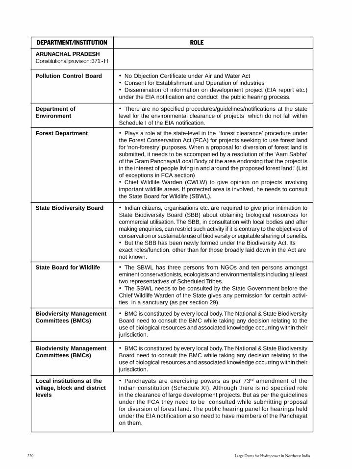
Large Dams for Hydropower in Northeast India220
DEPARTMENT/INSTITUTION ROLE
Pollution Control Board
ARUNACHAL PRADESHConstitutional provision: 371 - H
• No Objection Certificate under Air and Water Act• Consent for Establishment and Operation of industries• Dissemination of information on development project (EIA report etc.)under the EIA notification and conduct the public hearing process.
Department ofEnvironment
• There are no specified procedures/guidelines/notifications at the statelevel for the environmental clearance of projects which do not fall withinSchedule I of the EIA notification.
Forest Department • Plays a role at the state-level in the ‘forest clearance’ procedure underthe Forest Conservation Act (FCA) for projects seeking to use forest landfor ‘non-forestry’ purposes. When a proposal for diversion of forest land issubmitted, it needs to be accompanied by a resolution of the ‘Aam Sabha’of the Gram Panchayat/Local Body of the area endorsing that the project isin the interest of people living in and around the proposed forest land.” (Listof exceptions in FCA section)• Chief Wildlife Warden (CWLW) to give opinion on projects involvingimportant wildlife areas. If protected area is involved, he needs to consultthe State Board for Wildlife (SBWL).
State Biodiversity Board • Indian citizens, organisations etc. are required to give prior intimation toState Biodiversity Board (SBB) about obtaining biological resources forcommercial utilisation. The SBB, in consultation with local bodies and aftermaking enquiries, can restrict such activity if it is contrary to the objectives ofconservation or sustainable use of biodiversity or equitable sharing of benefits.• But the SBB has been newly formed under the Biodiversity Act. Itsexact roles/function, other than for those broadly laid down in the Act arenot known.
State Board for Wildlife • The SBWL has three persons from NGOs and ten persons amongsteminent conservationists, ecologists and environmentalists including at leasttwo representatives of Scheduled Tribes.• The SBWL needs to be consulted by the State Government before theChief Wildlife Warden of the State gives any permission for certain activi-ties in a sanctuary (as per section 29).
Biodviersity ManagementCommittees (BMCs)
• BMC is constituted by every local body.The National & State BiodiversityBoard need to consult the BMC while taking any decision relating to theuse of biological resources and associated knowledge occurring within theirjurisdiction.
Biodviersity ManagementCommittees (BMCs)
• BMC is constituted by every local body.The National & State BiodiversityBoard need to consult the BMC while taking any decision relating to theuse of biological resources and associated knowledge occurring within theirjurisdiction.
Local institutions at thevillage, block and districtlevels
• Panchayats are exercising powers as per 73rd amendment of theIndian constitution (Schedule XI). Although there is no specified rolein the clearance of large development projects. But as per the guidelinesunder the FCA they need to be consulted while submitting proposalfor diversion of forest land. The public hearing panel for hearings heldunder the EIA notification also need to have members of the Panchayaton them.
Section 7.p65 3/17/05, 11:52 AM220
Black

221
DEPARTMENT/INSTITUTION ROLE
Traditional institutions(like Nyel, Kebang)
• No Objection Certificate under Air and Water Act• Consent for Establishment and Operation of industries• Dissemination of information on development project (EIA report etc.)under the EIA notification and conduct the public hearing process.
Role not known
ASSAMConstitutional provision:Article 371 – B; Articles 244(2) and 275 (1) – SixthSchedule – governing theNorth Cachar Hills DistrictCouncil, Karbi Anglong DCand the Bodo TerritorialCouncil (BTC)
Pollution Control Board
• There are no specified procedures/guidelines/notifications at the statelevel for the environmental clearance of projects which do not fall withinSchedule I of the EIA notification.
Department ofEnvironment
Forest Department • Plays a role at the state-level in the ‘forest clearance’ procedure underthe Forest Conservation Act (FCA) for projects seeking to use forest landfor ‘non-forestry’ purposes. When a proposal for diversion of forest land issubmitted, it needs to be accompanied by a resolution of the ‘Aam Sabha’of the Gram Panchayat/Local Body of the area endorsing that the project isin the interest of people living in and around the proposed forest land.” (Listof exceptions in FCA section).• Chief Wildlife Warden (CWLW) to give opinion on projects involving im-portant wildlife areas. If protected area is involved, he needs to consult theState Board for Wildlife (SBWL).
State Biodiversity Board(SBB)
• Indian citizens, organisations etc. are required to give prior intimation toState Biodiversity Board (SBB) about obtaining biological resources forcommercial utilisation. The SBB, in consultation with local bodies and aftermaking enquiries, can restrict such activity if it is contrary to the objectives ofconservation or sustainable use of biodiversity or equitable sharing of benefits.• But the SBB has been newly formed under the Biodiversity Act. Its exactroles/function, other than for those broadly laid down in the Act are not known.
State Board for Wildlife(SBWL)
• The SBWL has three persons from NGOs and ten persons amongsteminent conservationists, ecologists and environmentalists including at leasttwo representatives of Scheduled Tribes.• The SBWL needs to be consulted by the State Government before theChief Wildlife Warden of the State gives any permission for certain activitiesin a sanctuary (as per section 29).
�� Local Self GovernmentInstitutions at the district, blockand village levels (Panchayats)�� In sixth schedule areas(Karbi Anglong ADC, NorthCachar Hills ADC, BodoTerritorial Council)�� In non sixth schedule areas(Rabha ADC, Tiwa ADC,Mising ADC
• Panchayats are exercising powers as per 73rd amendment of the Indianconstitution (Schedule XI). Although there is no specified role in theclearance of large development projects. But as per the guidelines underthe FCA they need to be consulted while submitting proposal for diversionof forest land. The public hearing panel for hearings held under the EIAnotification also need to have members of the Panchayat on them.• In sixth schedule areas, approval for a project is complete only alongwith the approval from the ADC. However, environmental concerns maynot reflect in their decision making process.• The role of the non-sixth schedule ADCs in decision-making is not known.
Spaces for People’s Participation in Decision Making for Hydroelectric Projects
Section 7.p65 3/17/05, 11:52 AM221
Black
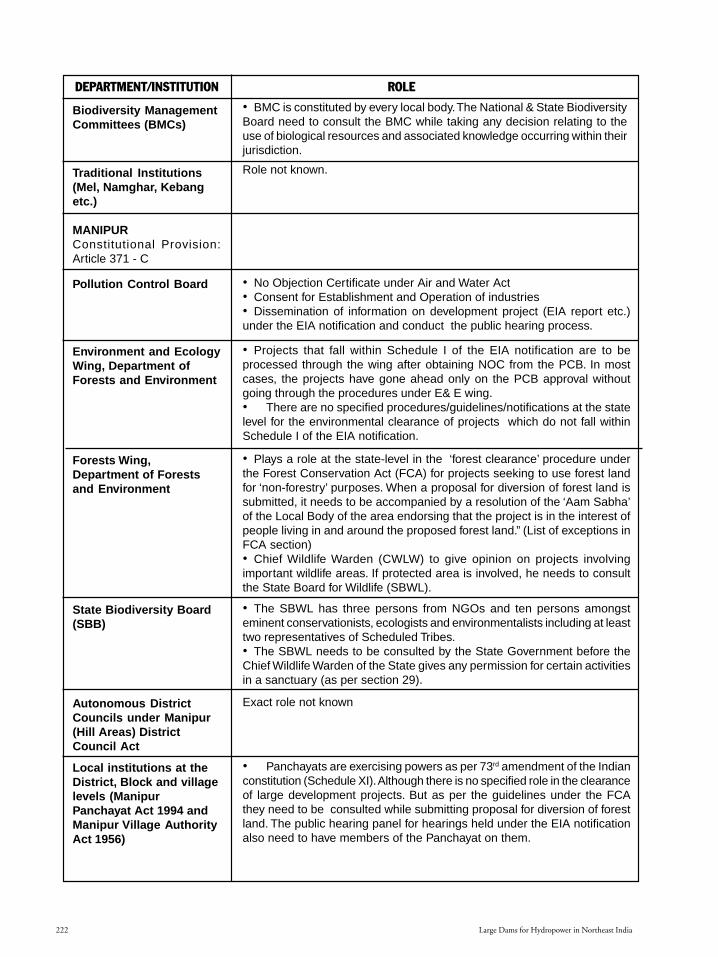
Large Dams for Hydropower in Northeast India222
DEPARTMENT/INSTITUTION ROLE
Biodiversity ManagementCommittees (BMCs)
• BMC is constituted by every local body.The National & State BiodiversityBoard need to consult the BMC while taking any decision relating to theuse of biological resources and associated knowledge occurring within theirjurisdiction.
Traditional Institutions(Mel, Namghar, Kebangetc.)
MANIPURConstitutional Provision:Article 371 - C
Pollution Control Board • No Objection Certificate under Air and Water Act• Consent for Establishment and Operation of industries• Dissemination of information on development project (EIA report etc.)under the EIA notification and conduct the public hearing process.
Environment and EcologyWing, Department ofForests and Environment
• Projects that fall within Schedule I of the EIA notification are to beprocessed through the wing after obtaining NOC from the PCB. In mostcases, the projects have gone ahead only on the PCB approval withoutgoing through the procedures under E& E wing.• There are no specified procedures/guidelines/notifications at the statelevel for the environmental clearance of projects which do not fall withinSchedule I of the EIA notification.
Forests Wing,Department of Forestsand Environment
• Plays a role at the state-level in the ‘forest clearance’ procedure underthe Forest Conservation Act (FCA) for projects seeking to use forest landfor ‘non-forestry’ purposes. When a proposal for diversion of forest land issubmitted, it needs to be accompanied by a resolution of the ‘Aam Sabha’of the Local Body of the area endorsing that the project is in the interest ofpeople living in and around the proposed forest land.” (List of exceptions inFCA section)• Chief Wildlife Warden (CWLW) to give opinion on projects involvingimportant wildlife areas. If protected area is involved, he needs to consultthe State Board for Wildlife (SBWL).
State Biodiversity Board(SBB)
• The SBWL has three persons from NGOs and ten persons amongsteminent conservationists, ecologists and environmentalists including at leasttwo representatives of Scheduled Tribes.• The SBWL needs to be consulted by the State Government before theChief Wildlife Warden of the State gives any permission for certain activitiesin a sanctuary (as per section 29).
Autonomous DistrictCouncils under Manipur(Hill Areas) DistrictCouncil Act
Exact role not known
Local institutions at theDistrict, Block and villagelevels (ManipurPanchayat Act 1994 andManipur Village AuthorityAct 1956)
• Panchayats are exercising powers as per 73rd amendment of the Indianconstitution (Schedule XI). Although there is no specified role in the clearanceof large development projects. But as per the guidelines under the FCAthey need to be consulted while submitting proposal for diversion of forestland. The public hearing panel for hearings held under the EIA notificationalso need to have members of the Panchayat on them.
Role not known.
Section 7.p65 3/17/05, 11:52 AM222
Black

223
DEPARTMENT/INSTITUTION ROLE
Biodiversity ManagementCommittees (BMCs)
• BMC is constituted by every local body. The National & State BiodiversityBoard need to consult the BMC while taking any decision relating to the use ofbiological resources and associated knowledge occurring within their jurisdiction.
MIZORAMConstitutionalprovisions: Article 371 –G; Articles 244 (2) and275 (1) – Sixth Schedule –governing the Chakma,Lai and MaraAutonomous DistrictCouncils
Pollution Control Board • No Objection Certificate under Air and Water Act• Consent for Establishment and Operation of industries• Dissemination of information on development project (EIA report etc.)under the EIA notification and conduct the public hearing process.
Department ofEnvironment
• There are no specified procedures/guidelines/notifications at the statelevel for the environmental clearance of projects which do not fall withinSchedule I of the EIA notification.
Forest Department • Plays a role at the state-level in the ‘forest clearance’ procedure under the ForestConservation Act (FCA) for projects seeking to use forest land for ‘non-forestry’purposes.When a proposal for diversion of forest land is submitted, it needsto be accompanied by a resolution of the ‘Aam Sabha’ of the Local Body ofthe area endorsing that the project is in the interest of people living in andaround the proposed forest land. (List of exceptions in FCA section).• Chief Wildlife Warden (CWLW) to give opinion on projects involvingimportant wildlife areas. If protected area is involved, he needs to consultthe State Board for Wildlife (SBWL).
State Biodiversity Board • Indian citizens, organisations etc. are required to give prior intimation to StateBiodiversity Board (SBB) about obtaining biological resources for commercialutilisation. The SBB, in consultation with local bodies and after makingenquiries, can restrict such activity if it is contrary to the objectives of conservationor sustainable use of biodiversity or equitable sharing of benefits.• But the SBB has been newly formed under the Biodiversity Act. Its exactroles/function, other than for those broadly laid down in the Act are not known.
State Board for Wildlife(SBWL)
• The SBWL has three persons from NGOs and ten persons amongsteminent conservationists, ecologists and environmentalists including at leasttwo representatives of Scheduled Tribes.• The SBWL needs to be consulted by the State Government before theChief Wildlife Warden of the State gives any permission for certainactivities in a sanctuary (as per section 29).
ADCs (Chakma, Lai andMara ADC)
Role not known.
Village Councils (in non-Sixth Schedule areas)
• Role in decision making not known. They have a well defined system ofmaintaining safety reserves which were conserved areas and supply reservesto meet their needs.
• BMC is constituted by every local body. The National & State BiodiversityBoard need to consult the BMC while taking any decision relating to the use ofbiological resources and associated knowledge occurring within their jurisdiction.
Biodiversity ManagementCommittees (BMCs)
Traditional Institutions Exact role unknown.
Spaces for People’s Participation in Decision Making for Hydroelectric Projects
Section 7.p65 3/17/05, 11:52 AM223
Black

Large Dams for Hydropower in Northeast India224
DEPARTMENT/INSTITUTION ROLE
NAGALANDConstitutional provision:Article 371 – AGreater control over“ownership & transfer ofland & and its resources”
Pollution Control Board • No Objection Certificate under Air and Water Act• Consent for Establishment and Operation of industries• Dissemination of information on development project (EIA report etc.)under the EIA notification and conduct the public hearing process.
Department ofEnvironment
• There are no specified procedures/guidelines/notifications at the statelevel for the environmental clearance of projects which do not fall withinSchedule I of the EIA notification.
Forest Department In the state of Nagaland the role of the FD in clearance of developmentalprojects requiring forest land is not fully clear. There is ongoing disputebetween the Government of Nagaland and the Centre about the degree ofapplicability of FCA in the state vis-à-vis Article 371- A of the constitution.Several development projects have not sought clearance under the FCA asa result of this.
State Biodiversity Board • Indian citizens, organisations etc. are required to give prior intimation toState Biodiversity Board (SBB) about obtaining biological resources forcommercial utilisation. The SBB, in consultation with local bodies andafter making enquiries, can restrict such activity if it is contrary to theobjectives of conservation or sustainable use of biodiversity or equitablesharing of benefits.• But the SBB has been newly formed under the Biodiversity Act. Itsexact roles/function, other than for those broadly laid down in the Act arenot known.
State Board for Wildlife(SBWL)
• The SBWL has three persons from NGOs and ten persons amongsteminent conservationists, ecologists and environmentalists including at leasttwo representatives of Scheduled Tribes.• The SBWL needs to be consulted by the State Government before theChief Wildlife Warden of the State gives any permission for certain activitiesin a sanctuary (as per section 29).
Local councils at thelevel of Range, Area,Village and Tribe (underthe Nagaland Tribe, Area,Range and VillageCouncil Act of 1966)
• The Village Council is an important local institution in Nagaland and willneed to be consulted when large development projects are being plannedin an area, although there is no explicit legal provision for this.• The other Councils (range, area etc.) are non-functional.
Village DevelopmentBoard
Modern local institution promoted by the state government.
Other modern institutions(Naga Hoho)
Biodiversity ManagementCommittees (BMCs)
• BMC is constituted by every local body. The National & State BiodiversityBoard need to consult the BMC while taking any decision relating to the use ofbiological resources and associated knowledge occurring within their jurisdiction.
Traditional Institutions Role unknown.
Role not known.
Section 7.p65 3/17/05, 11:52 AM224
Black

225
DEPARTMENT/INSTITUTION ROLE
SIKKIMConstitutional provision:Article 371 - F
Pollution Control Board • No Objection Certificate under Air and Water Act• Consent for Establishment and Operation of industries• Dissemination of information on development project (EIA report etc.)under the EIA notification and conduct the public hearing process.
Department ofEnvironment
• There are no specified procedures/guidelines/notifications at the statelevel for the environmental clearance of projects which do not fall withinSchedule I of the EIA notification.
Forest Department • Plays a role at the state-level in the ‘forest clearance’ procedure underthe Forest Conservation Act (FCA) for projects seeking to use forest landfor ‘non-forestry’ purposes. When a proposal for diversion of forest landis submitted, it needs to be accompanied by a resolution of the ‘AamSabha’ of the Local Body of the area endorsing that the project is inthe interest of people living in and around the proposed forest land.(List of exceptions in FCA section)• Chief Wildlife Warden (CWLW) to give opinion on projects involvingimportant wildlife areas. If protected area is involved, he needs to consultthe State Board for Wildlife (SBWL).
State Biodiversity Board • Indian citizens, organisations etc. are required to give prior intimation toState Biodiversity Board (SBB) about obtaining biological resources forcommercial utilisation. The SBB, in consultation with local bodies and aftermaking enquiries, can restrict such activity if it is contrary to the objectivesof conservation or sustainable use of biodiversity or equitable sharing ofbenefits.• But the SBB has been newly formed under the Biodiversity Act. Its exactroles/function, other than for those broadly laid down in the Act are not known.
State Board for Wildlife(SBWL)
• The SBWL has three persons from NGOs and ten persons amongsteminent conservationists, ecologists and environmentalists including at leasttwo representatives of Scheduled Tribes.• The SBWL needs to be consulted by the State Government beforethe Chief Wildlife Warden of the State gives any permission for certainactivities in a sanctuary (as per section 29).
Local institutions at thedistrict, block and villagelevel (Panchayats)
• Panchayats are exercising powers as per 73rd amendment of the Indianconstitution (Schedule XI). Although there is no specified role in the clearanceof large development projects. But as per the guidelines under the FCAthey need to be consulted while submitting proposal for diversion of forestland. The public hearing panel for hearings held under the EIA notificationalso need to have members of the Panchayat on them.
Biodiversity ManagementCommittees (BMCs)
• BMC is constituted by every local body. The National & State BiodiversityBoard need to consult the BMC while taking any decision relating to the use ofbiological resources and associated knowledge occurring within their jurisdiction.
Traditional Institutions(pippen system in NorthSikkim)
Role not known.
Spaces for People’s Participation in Decision Making for Hydroelectric Projects
Section 7.p65 3/17/05, 11:52 AM225
Black

Large Dams for Hydropower in Northeast India226
DEPARTMENT/INSTITUTION ROLE
TRIPURAArticle 371 – G; Articles244 (2) and 275 (1) – SixthSchedule – governing theTripura Tribal AreasDistrict Council
Pollution Control Board • No Objection Certificate under Air and Water Act• Consent for Establishment and Operation of industries• Dissemination of information on development project (EIA report etc.)under the EIA notification and conduct the public hearing process.• The Tripura State Pollution Control Board, in collaboration with CentralPollution Control Board (CPCB) and German Technical Cooperation (GTZ)has completed a Zoning Atlas for Siting of Industries for the entire State. Itis the only State in the country which has completed this project for thewhole State. The TPCB has been established by the MoEF as one of the 4Centres for Excellence in Spatial Environmental Planning. It is expectedthat this Centre will meet the spatial environmental planning needs for theentire Northeastern region.
Department ofEnvironment
• There are no specified procedures/guidelines/notifications at the statelevel for the environmental clearance of projects which do not fall withinSchedule I of the EIA notification.• Plays a role at the state-level in the ‘forest clearance’ procedure underthe Forest Conservation Act (FCA) for projects seeking to use forest landfor ‘non-forestry’ purposes. When a proposal for diversion of forest land issubmitted, it needs to be accompanied by a resolution of the ‘Aam Sabha’of the Local Body of the area endorsing that the project is in the interest ofpeople living in and around the proposed forest land.” (List of exceptions inFCA section)• Chief Wildlife Warden (CWLW) to give opinion on projects involvingimportant wildlife areas. If protected area is involved, he needs to consultthe State Board for Wildlife (SBWL).
State Biodiversity Board • Indian citizens, organisations etc. are required to give prior intimation toState Biodiversity Board (SBB) about obtaining biological resources forcommercial utilisation. The SBB, in consultation with local bodies and aftermaking enquiries, can restrict such activity if it is contrary to the objectives ofconservation or sustainable use of biodiversity or equitable sharing of benefits.• But the SBB has been newly formed under the Biodiversity Act. Itsexact roles/function, other than for those broadly laid down in the Act arenot known.
State Board for Wildlife • The SBWL has three persons from NGOs and ten persons amongsteminent conservationists, ecologists and environmentalists including at leasttwo representatives of Scheduled Tribes.• The SBWL needs to be consulted by the State Government before theChief Wildlife Warden of the State gives any permission for certain activitiesin a sanctuary (as per section 29).
Tripura Tribal AreasAutonomous DistrictCouncil
Not consulted regarding projects proposed to be set up in areas undertheir jurisdiction.
Section 7.p65 3/17/05, 11:52 AM226
Black
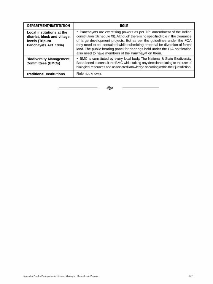
227
DEPARTMENT/INSTITUTION ROLE
Local institutions at thedistrict, block and villagelevels (TripuraPanchayats Act. 1994)
• Panchayats are exercising powers as per 73rd amendment of the Indianconstitution (Schedule XI). Although there is no specified role in the clearanceof large development projects. But as per the guidelines under the FCAthey need to be consulted while submitting proposal for diversion of forestland. The public hearing panel for hearings held under the EIA notificationalso need to have members of the Panchayat on them.
Biodiversity ManagementCommittees (BMCs)
• BMC is constituted by every local body. The National & State BiodiversityBoard need to consult the BMC while taking any decision relating to the use ofbiological resources and associated knowledge occurring within their jurisdiction.
Traditional Institutions Role not known.
Spaces for People’s Participation in Decision Making for Hydroelectric Projects
Section 7.p65 3/17/05, 11:52 AM227
Black

1Hydroelectric Projects in NagalandMap not to scale, borders neither authenticated nor verified.
State-wise descriptionof projects
NagalandNagalandNagalandNagalandNagaland
StateNagaland.p65 6/4/2005, 1:52 AM1
Black

Large Dams for Hydropower in Northeast India2
Hydroelectric Projects in NagalandThe present peak demand of power in the state of Nagaland is only 50 MW. With commissioning of more 132/
66 KV substations in Wokha and Tizit during the year 2000, augmentation and system improvement, the peakdemand is expected to reach 80 MW. Even after the commissioning of the 75 MW Doyang HEP, 24 MW LikhimroHEP and 24 MW Thermal Power Station, the State will still be in shortage of power. Therefore there is tremendousscope of investment opportunities in the Power sector. Nagaland has potential of more than 2000 MW in hydel-power generation. (Source: Nagaland state website)
Out of a total requirement of 52 MW of power in the state, micro hydel stations and diesel stations in the statesector generate about 4.26 MW. In the central sector, North Eastern Electric power Corporation (NEEPCO) hascommissioned the 75 MW Doyang HEP.
The allocation from National Hydroelectric Power Corporation (NHPC) and NEEPCO for Nagaland is only25 MW and therefore the department has arranged with Meghalaya State Electricity Board and Assam StateElectricity Board to meet the short fall.
Power Demand
Peak (MW) Average (MW) Per-Capita Consumption (KWH) Transmission &Distribution loss (%)
52 38 947 29
Power Consumption Details (In Million Unit)Domestic Industry Agriculture Public Works Others
75.400 20.650 NA 6.750 29.090
Installed Project DetailsName Type Sector CompletionYear Installed Capacity (in MW)
Doyang Hydro Central 2000 75
(Source: Northeast Region Databank website: http://databank.nedfi.com content.php?menu=170603&page_id=320)
Basic information on some of the projects inNagaland, proposed and being implemented areas follows:1. Doyang Hydroelectric Project2. Likimro Hydroelectric Project3. Dikhu Hydroelectric Project4. Dzuza Multipurpose Project5. Tizu Hydroelectric Project6. Yangnyu Hydroelectric Project7. Tizu-Zungki Hydroelectric Project8. Others
1. Doyang Hydroelectric Project
Region: Nagaland, Wokha district.
Physical Characteristics: Capacity of 75 MW (3 X 25MW). Estimated annual generation of 227 Million Units.
Total cost: The cost of the project was Rs. 758.70crores. Rs. 100 crore was budgeted by the NorthEastern Council (NEC).
Year of Commissioning: All the three units of theproject have been completed and commissioned in July2000. The project suffered a setback due to flooding ofpower house during August 1998.
Implementing agency: North Eastern Electric PowerCompany (NEEPCO).
Status: As on 31st December 2001 all Civil and E/Mworks were completed except the spillway gate. (http://wokha.nic.in/doyang_hydro.htm).
Ecological impactsThe project caused submergence of 5420 ha. of
which almost the entire area was under jhum cultivation.The submergence of part of the community jhum land
StateNagaland.p65 6/4/2005, 1:52 AM2
Black

3Hydroelectric Projects in Nagaland
has resulted in the shortening of jhum cycles over theremaining jhum lands. The cycle has now reduced to4-5 years.
Plantations have been undertaken in the catchmentarea for soil and water conservation.
Social impactsThere are 193 villages in the catchment area. Out of
these, 23 villages are in the immediate catchment of theproject.An effort was made by the MoEF Regional office,Shillong and the state government agencies to involvethe communities living in these 23 villages in a communitybased catchment area treatment plan. In this process thevillagers formed themselves into Village ForestCommittees and prepared their own microplans. TheCommittee comprised of every member from the village.There were also executive committees of 12 memberseach, including six women
Further information on ecological and socialimpacts identified by the project authorities are notknown as project documents were not available at thetime of this compilation.
2. Likimro Hydroelectric Project
Region: Tuensang district
Physical characteristics: 24 MW
Cost: Rs. 31.01 crores released from the Non-LapsableCentral Pool of Resources as on 6.7.2004 (http://northeast.nic.in/nagaland_table.htm).As on 30.11.2003,the Power Finance Corporation had disbursed Rs. 13.87of the Rs. 15 crores sanctioned for the project (http://164.100.24.208/lsq/quest.asp? qref=69488)
Implementing Agency: Department of Power,Government of Nagaland.
Status: Inaugurated by the Chief Minister on 12th
February 2002. Two units have been commissioned.According to the January 2003 report of the PowerFinance Corporation, the performance of the plant hasbeen unsatisfactory (with monthly generation less than1.5 MU on an average (http://powermin.nic.in/reports/pdf/nagaland.pdf)
Ecological and Social Impacts: Not known.
3. Dikhu Multipurpose Hydroelectric ProjectPhysical Characteristics: Installed Capacity of 140MW (4x35). Annual Energy Generation will be 513.41GWh.Implementing Agency: North Eastern Electric PowerCompany (NEEPCO)Total Cost: Estimated cost of the project is Rs. 723.63crores. As per the quarterly progress report of NECschemes (March 2004), Rs. 246.4 lakhs was thecumulative expenditure towards this project.Status: Pre-feasibility Report completed by NEEPCO.Detailed Project Report (DPR) completed, EIA studycontinuing (http://necouncil.nic.in/qpr03.04.doc)Ecological and Social Impacts: Not known.
4. Dzuza Multipurpose Project
Physical Characteristics: This project could have aninstalled capacity of 7 MW (2x3.5 MW) and providefor the irrigation of 9540 ha. It proposes to harness theDzuza river by construction of a barrage over the river.It is meant to benefit irrigation in Nagaland and Assamwith the construction of a 21.51 km. long canal. (http://164.100.24.219/cga/cmtstat.asp?ses=200&min=70)
Implementing Agency: Irrigation and Flood ControlDepartment. Government of Nagaland.
Status: The Irrigation, Flood Control and WatershedManagement Sector of North Eastern Council (NEC)have carried out studies on the project. The CentralWater Commission has been asked to modify the DPRin accordance with the requirement. Rs. 15.98 lakhshave been spent during 2003-2004 (http://necouncil.nic.in/qpr03.04.doc)
Ecological and Social Impacts: Not known.
5. Tizu Hydroelectric Project
Physical Characteristics: Installed Capacity of 150MW (3x50). Annual Energy Generation will be 561.41 GWh.
Implementing Agency: North Eastern Electric PowerCompany (NEEPCO).
Total Cost: Estimated cost is Rs. 731.7.63 crores.
Map
not
to
scal
e, b
orde
rs n
eith
er a
uthe
ntic
ated
nor
ver
ified
StateNagaland.p65 6/4/2005, 1:52 AM3
Black

Large Dams for Hydropower in Northeast India4
Status: Pre-feasibility Report completed by NEEPCO.
Ecological and Social Impacts: Not known.
6. Yangnyu Hydroelectric ProjectPhysical Characteristics: Installed Capacity of 40MW (2x20). Annual Energy Generation will be 176.45GWh.Implementing Agency: North Eastern Electric PowerCompany (NEEPCO).Total Cost: Estimated cost is Rs. 397.55 crores.Status: Pre-feasibility Report completed by NEEPCO.Ecological and Social Impacts: Not known.
7. Tizu-Zungki Hydroelectric Project
Physical Characteristics: 150 MW
Status: NHPC has completed the assessment ofEnvironmental Aspects for the Pre-feasibility report ofTizu-Zungki Hydroelectric Project (150 MW) inNagaland. This was done for the Department of Power,Government of Nagaland and was undertaken in 2000-2001. (http://www.nhpcindia.com/english/envConsult.htm)
8. OthersThe Irrigation, Flood Control and Watershed
Management Sector of NEC had carried out anumber of studies and investigation schemes ofhydel power and irrigation multi-purpose projectsduring the 8th Plan.
The schemes taken up in the state of Nagaland are:
T’surang Irrigation ProjectThe project could provide irrigation to 1755 ha
within the state. The Irrigation, Flood Control andWatershed Management Sector of North EasternCouncil (NEC) have carried out studies on the project.
Dikhu Multipurpose Power projectThis project could have an installed capacity of 45 MW
(3x15 MW) and provide for the irrigation of about 20,000 ha.These along with the 7 MW Dzuza project
(mentioned as point 4 above) would together providearound 52 MW hydel power and irrigation facility to19,295 ha of Nagaland and 8000 ha to Assam.(Source: North East Council website, http://necouncil.nic.in/power.htm)
StateNagaland.p65 6/4/2005, 1:52 AM4
Black

1Hydroelectric Projects in MizoramMap not to scale, borders neither authenticated nor verified.
State-wise descriptionof projects
MizoramMizoramMizoramMizoramMizoram
StateMizoram.p65 6/4/2005, 1:59 AM1
Black

Large Dams for Hydropower in Northeast India2
In the state of Mizoram, the peak load is 54 MW as against a demand for 88 MW. It is estimated that aminimum of 105 MW of additional power is needed for the state. The state authorities have 11 small hydelprojects, which are to be implemented. Multi agency involvement is sought to implement more number of smallhydel projects.
Kolodyne phase-I project of 100 MW, despite its possible drawback in terms of viability needs to be implementedas the state and people stand to gain from the project. (Source: Mizoram state website)
Details of Hydro Projects in the pipelineProject Name and Location Type Sector Capacity (in MW) Expected Completion
Tuipanglui, Saiha Dist. Hydro State govt. 3.000 2000/2001Lamsial, Champhai Hydro State govt. 0.500 2003
Maicham-II Hydro State govt. 3.000 2004Serlui ‘B’, Kolasib, Dist Hydro State govt. 12.00 2005
Kolodyne Phase-I, Lunglei Dist. Hydro State govt. 120.000 2012Tuirini, Aizawl Dist. Hydro State govt. 60.000 2008
Tuivawl, Aizawl Dist. Hydro State govt. 48.000 2008Bairabi, Aizawl Dist. Hydro State govt. 80.000 2010
Tuirial (60 MW) Hydro Central govt. 7.00 2004Tuivai (120 MW) Hydro Central govt. 25.00 2010
Hydroelectric Projects in Mizoram
Power Demand in the StatePeak (MW) Average (MW) Per-Capita Transmission &
Consumption (KWH) Distribution loss (%)
80 32 108.65 24.5
Power Consumption Details (In Million Unit)Domestic Industry Agriculture Public Works Others171.760 10.11 16.15 28.93 52.05
Installed Hydro Project Details
Name Type Sector In MW
Installed Gross AvailedCapacity Generated Power
Capacity
9 Hydel Projects Hydro State Govt. 8.25 6.447 6.23
Import of PowerImported From Year In MillionUnits
ASSAM 1997-1998 0.810TRIPURA 1997-1998 8.630
MEGHALAYA 1997-1998 4.500NEEPCO(T), KATHALGURI 1997-1998 38.670
NEEPCO(H), KOPILI 1997-1998 50.120NEEPCO(T), AGARTALA 1997-1998 0.250
NHPC, LOKTAK 1997-1998 37.350
(Source: Department of Power, Mizoram)
StateMizoram.p65 6/4/2005, 1:59 AM2
Black

3Hydroelectric Projects in Mizoram
Pre-feasibility Reports for 3 projects in Mizoram have been prepared under 50,000 MW Hydroelectric Initiativeto generate a total of 1500 MW. The Prime Minister had launched a programme for preparation of these reports24.5.2003. The scheme was formulated by Central Electricity Authority (CEA) and sanctioned by the Ministryof Power on 31st March 2003 at a cost amounting to Rs. 24.95 crores. The following are 3 projects for which thepre-feasibility reports have been completed:
No. Project Consultant Installed Capacity Estimated Cost(No. of units x MW per unit) (in Rs. crores)
1. Boinu WAPCOS 640 MW (4 x 60) 3243.32. Lungleng WAPCOS 815 MW ( 5 x 163) 2913.143. Tlawng WAPCOS 45 MW (2 x 22.5) 528.10
Following are some details of three other large projects proposed for Mizoram.1. Tuirial Hydroelectric Project2. Bairabi Hydroelectric Project3. Tuivai Hydroelectric Project
1. Tuirial Hydroelectric ProjectRegion: Mizoram, Aizwal district, Kolasib Forest Division, 6 km. west of Moucher village.Lat/ long: 24° 21.5’ N, 92° 53.2’ EPhysical Characteristics: The project involves the construction of an earthen dam 77 m high, 250 m long and15 m wide with a maximum reservoir level of 93.51 m. to generate 60 MW. The powerhouse is to be situated onthe left bank of the river.Implementing agency: North Eastern Electric Power Corporation (NEEPCO).Total cost: First estimated at 130 crores, the latest figure indicates an estimated cost of Rs. 425 crore. 85% ofthe funds will be obtained as a loan from Japan, 15% from Government of India and NEEPCO’s internal resources.
As per the MoU between the state government and NEEPCO, power generated should first be used to meet therequirements of the NE states and only the remaining should be transmitted out. Power allocated for the other NEstates if unused should be given back to Mizoram at the usual price. (See: MoU between Government of Mizoram andNEEPCO for Execution of Tuirial Hydroelectric project in Section 4.4)
Commissioning period: June 2006.
Status: The project was granted clearance under the Forest Conservation Act on March 16, 2000. It receivedclearance under the Environment Protection Act in June 1995.
However, in March 2002, NEEPCO surrendered foreign direct investments (FDI) worth Rs. 83.26 crorebecause “it failed to utilise the funds owing to adverse law-and-order situation in the region”. The entire fundsanctioned by Japan Bank for International Cooperation (JBIC) in 2000-2001 was surrendered. (Source: TheAssam Tribune, Monday, March 11, 2002, NEEPCO surrenders FDI worth Rs 83 cr).
According to a list of units that are slipping from the 10th five-year plan (2202-2007) target, work in the Tuirialproject has been held up. However, it is also in the CEA list of projects likely to be benefited during the 11th five-year plan (2007-2012) period (Source: Central Electricity Authority, National Electricity Plan; http://www.cea.nic.in/nep).
Ecological ImpactsThe project will create a submergence area 85 km. long and 5380 ha. in surface area. This comprises 150 ha.
of forests with a density greater than 40%, 1690 ha. of forests with less than 40% density, cliffs and gorges of254 ha. and 3286 ha. of jhum land/ scrub forest/ riverine forest.
The project reports state that no endangered species are found in the submergence area but members of the ExpertCommittee on River Valley projects (1994-95) stated that 15 species listed in Schedule I of the Wild Life ProtectionAct, 1972 are found in the project area, when the project first came up for environmental clearance in the early 1990s.
StateMizoram.p65 6/4/2005, 1:59 AM3
Black

Large Dams for Hydropower in Northeast India4
The project reports state very simplistically that thetotal impacts on fauna will be minimal as the habitatavailable for the animals is spread over a huge areaand therefore they will migrate to lesser affected areas.This is an arbitrary assumption made without supportiveevidence of carrying capacity studies. In fact there arenow studies to show that many faunal species areconnected to their micro habitats for their survival,making migration impossible or very difficult.
Studies on the impact on larger mammals and birdshave also not been done by the project authorities. Evenin the case of large mammals and birds there is noguarantee that the adjoining forests/ aquatic ecosystemwill have the carrying capacity to accommodate thesudden influx of a new population of animals.
The project proposes to take up compensatoryafforestation of 5268 ha.
Volume I of the project report states that thecatchment area gets very heavy rainfall and monsoonextends for over six months. The valley lies in a highlyseismic zone and tremors have been disturbing thestability of the soil cover resulting in frequent land slides.The river carries a lot of silt too.
In the questionnaire, the answer to whether fishladders are necessary is “ after construction of the damthere will not be much down flow of water from thedam for migration of fishes. So fish ladders will not benecessary”! Whatever happened to the need formaintaining minimum downstream flows?
Social impacts: One of the incentives identified towean off those who are involved in jhuming is to providethem Rs. 20,000- 40, 000 so that they may establishthemselves in other trades of their choice. This form of
compensation in various projects in other parts of thecountry has come under much criticism as it takes awaythe food security of farmers and substitutes it withmonetary support that is very short lived.
The project authorities hope that the reservoir willbecome a tourist spot and “traditional culture and art ofthe people which is presently confined within the statedue to lack of communication will automatically beopened up to outsiders.”
2. Bairabi Hydroelectric Project
Region: Mizoram, Kolasib district and Kolasib forestdivision, Thingdawl block, 3.5 km. upstream of Bairabivillage on the river Tlawng (Dhaleshwari).
Lat/ long: 24° 9.25’ N, 92° 32.20’ E
Physical characteristics: 180 m. long; 62-metre high earthfilled dam to be built to generate 80 MW (2 x 40 MW).
Power generated at this project is proposed to beevacuated to the District headquarters of Kolasibthrough a 132 KV single circuit transmission line.Another 132 KV double circuit transmission line wouldbe provided to evacuate power to Aizawl.
Implementing Agency: Power & ElectricityDepartment, Mizoram.
Total cost: Rs. 600 crores
Commissioning period: The project is likely to bedeveloped in 7 years time and is estimated to cost Rs.522.60 crore. It would be financed through 100%central assistance and cost of generation would be Rs.2.21 crore during the first year.
Status: The MoEF while giving site clearance forinvestigation and survey to prepare detailed reports for
StateMizoram.p65 6/4/2005, 1:59 AM4
Black

5Hydroelectric Projects in Mizoram
the project, sought that thefollowing issues be addressedby the project authorities intheir survey reports:1) loss of riverine forests2) loss to aquatic fauna –fishes, snails, prawns andcrabs3) loss of property,agricultural fields, gardensand dwelling places4) Resettlement andrehabilitation (R&R) of thepeople, capacity building tobe done for people
Environmental ClearanceEnvironmental Public
hearings were held at Sairangvillage- on 5th March 2001;Hortoki village-on 7th March2001; Bairabi village- on 8th
March 2001For details of the public hearing, refer ‘Summary
Records of the Public Hearing’ in section 4.5Expert Committee recommended for environmental
clearance in January 2003. Environmental clearancereceived in February 2003.
Forest ClearanceFirst Stage clearance was granted by the Ministry
on 18th October 2002 for diversion of 9,294 ha. offorest land.
Other detailsThe NHPC has listed “the construction of Bairabi
H.E. Project (2 X 40 MW)on ‘Deposit Work Basis forGovernment of Mizoram”as one of its ongoingconsultancies listed on theirwebsite (http://w w w. n h p c i n d i a . c o m /english/achiev.htm). At thesame time, according to a listof units that are slippingfrom the 10th five-year plan(2202-2007) target, nomajor work has beenawarded to the project.(http://www.cea.nic. in/nep/Appendix% 209.2.pdf).
It was reported thatbecause of the Mizoramgovernment’s failure to ropein funding agencies hasaffected hydel power
projects in the state, including the Bairabi project.(www.northeastvigil.com/news/detail.php?id=4377&vol=164&cat=11).
However, the project is in the CEA list of projectslikely to be benefited during the 11th five-year plan(2007-2012) period.(Source: Central Electricity Authority, National ElectricityPlan; www.cea.nic.in/nep).
Ecological impactsThe project initially sought 10, 768 ha of land of
which 7553 ha. was reserved forest. Subsequently theland requirement was reduced to 9,294 ha. of which
Map
not
to s
cale
, bor
ders
nei
ther
aut
hent
icat
ed n
or v
erifi
ed
StateMizoram.p65 6/4/2005, 1:59 AM5
Black

Large Dams for Hydropower in Northeast India6
7721 ha. is forest land. 3047 ha. is private land underjhum, orchards/ gardens or irrigated wet rice cultivatedland. 168 ha. is unclassified land.
The reserved forest land is presently under various uses:1. Village area/ human settlement area consisting of 6
villages (Bairabi, Hortoki, Sairang, Vaak, Phaizau& Dapchhuah): 137 ha.
2. Highway (NH 54) and State PWD road: 16.75 ha.3. Grazing area of above villagers: 42 ha.4. Horticulture area: 830 ha.5. River bed area: 688.25 ha.
Total: 1714 ha.
In addition, about 3000 ha. has been exposed toshifting cultivation in recent years. All of these landswill now be taken over by the project.
As per official records, the vegetation in the forestsis primarily bamboo (Melocanna baccifera) with a fewtree species. Density varies from 0.4 – 0.7. Becauseof repeated degradation by fire, biodiversity is less.Bamboo is heavily exploited for supply to the HindustanPaper Corporation.
The project reports (the EIA report is prepared byConsulting Engineering Services, New Delhi) state thatthe area is not rich in wildlife and does not form a partof any Protected Area, nor a migratory route. The fishresources may have been depleted due to unscientificand excessive fishing practices. The above conclusionsneed to be carefully examined.
The project involves the submergence of a largearea and has a catchment area vulnerable to erosion.
One serious issue for the project is going to be theneed to arrest siltation from various activities in
the catchment area and shifting cultivation.(Sedimentation: 0.064 ha meter/ sq. km/
year) The water is alkaline (ph 7.8)and was also observed to be
heavily silted. The river was found to be carrying heavysediments, perhaps due to the ongoing sand collectionupstream of Sairang.
The region is seismically active Zone V.The project authorities have stated in preliminary
reports that there are no sites of archaeological orhistorical importance.
Social ImpactsThe proposed reservoir would submerge 6 villages
with a total population of 6,500. The submergence areacomprises of notified revenue land, private forestland,wet rice cultivation land and jhum land. As the availabilityof flat, cultivable lands is relatively less in a hilly statesuch as Mizoram, the huge submergence area of theproject is that much more of a concern.
One of the villages that will be affected is Hortoki(on the right bank of river, 40 km. upstream of damsite).This village has 400 families and 2500 people. The villageeconomy is based on Atkora, a citrus fruit sold to peoplefrom the plains for Rs. 2-3 per fruit. The peel of thefruit is used as a spice, which can be dehydrated andstored for a long time. The juice is also extracted.
The village has an annual income of Rs. 40 lakhsfrom this fruit and therefore the villagers proudly statethat they do not depend on the government for theirlivelihood.Agriculture in the area includes paddy, ginger,chilli, sugarcane. Commercial crops are fruits likeAtkora (Hatkora), Runa, Orange, Pineapple and Tung.Teak plantations are also present.
The Village Council President had opposed theproject at first, but later said that given the ‘right kind’of rehabilitation (including cultivation of Atkora orchardetc.) they were ready to sacrifice their lands.
2.5 km of NH 54 will be submerged by this project.The construction of the dam would raise the
upstream water level making the river navigable
StateMizoram.p65 6/4/2005, 1:59 AM6
Black

7Hydroelectric Projects in Mizoram
throughout the year and it will provide a 180 km.waterway for transportation of goods from the capitalof Mizoram, Aizwal to Silchar. The waterway will notonly decongest roads but also provide cheaper meansof transport (source: CEA Approval note, website ofPress Information Bureau)
3. Tuivai Hydroelectric Project
Region: Mizoram, Aizawl District, Champhai ForestDivision, near Ngopa village; Power House: near villagePhuibuang 13.4 km. downstream of the dam.
Lat/ long: 23° 58’14 N, 93° 12' 55 E.
Physical characteristics: 155 m. high and 534 m. long damwith head race tunnel of 4.95 km. to generate 210 MW.
Implementing agency: North Eastern Electric PowerCorporation (NEEPCO).
Commissioning period: Six and half years afterconstruction begins.
StatusEnvironmental and Forest clearance: The projectwas granted forest clearance in October 2001. Theenvironmental clearance was granted in November2001. (See letters granting environmental and forestclearance in Sections 4.6 and 4.7) However till April2002, NEEPCO was not being allowed to beginconstruction work, as the conditions under which theforest clearance had been granted were not fully met.
The Environmental Public Hearing (a mandatorypart of the environment clearance procedures) was heldin October 1997 and the document states that nobodyhad objections to the project. This is to be expected asthe practice of making all the relevant informationavailable to citizens and especially those related toimpacts was probably non existent then (the notificationmaking public hearings mandatory in the environmentalclearance process came about only in April 1997). Eventoday, despite greater awareness among the public andgovernment agencies about the importance of publichearing, obtaining project-related information before thepublic hearing is an uphill task.
Secondly, even if there were voices of disagreementregarding the need for the project or concerns aboutthe impacts, it is quite likely that they were not evendocumented by the project authorities. It is not clearfrom the report as to whether the public hearing wasdocumented by the State Pollution Control Board or byNEEPCO, the project proponent.
Some conditions stated in the environmentalclearance letter which are crucial from the point ofecological safety of the area are:a. To establish the presence of Copper Mahseer in
Tuivai a detailed seasonal survey should beundertaken. If its presence is established beyonddoubt a proper conservation and management planfor this fish should be prepared. This study shouldbe completed before starting the constructionof dam.
b. To check the siltation in the Tuivai dam, the entirecatchment area may be declared as ecologicallyfragile area under Environment (Protection) Act,1986. All activities may be allowed in this areaexcept mining and heavy industries. A proposal tothis effect should be submitted to the Union Ministryof Environment & Forests through the State Govt.within six months.
c. Jhum cultivation should be stopped on the upstreamof the dam site 3 years before reservoir starts tofill up.
d. A study on impact on wildlife of the project impactarea should be got done by a competent agencyand submitted to the Ministry within 18 months fromthe date of issue of this letter. The study must alsopropose the remedial measures (if any required) tomitigate the impact.
The letter granting forest clearance states amongthe conditions that the settlement of rights of LengtengWildlife Sanctuary must be completed as a precondition to the environmental clearance beinggiven; recurring and non recurring cost of thedevelopment and management of the sanctuary fornext 10 years to be borne by the project; all projectroads must be constructed only after obtaining forestclearance under the Forest Conservation Act, 1980and no road to be constructed upstream of the damsite and catchment area treatment plan should becommunity based.
Ecological impacts: Total land sought by projectauthorities for the project was 2150 ha. of which 248ha. is agricultural land. The area to be diverted waslater reduced to 1479 ha. out of which 39 ha. is to betemporary diversion.
The project involves an impoundment of 1600 ha.(50 km long). According to authorities out of the 1600ha., 55% is either open forest/grassland/ permanent jhum& remaining areas falls in dense vegetation category.
StateMizoram.p65 6/4/2005, 1:59 AM7
Black

Large Dams for Hydropower in Northeast India8
After his site visit in 1999, Bittu Sahgal, member ofthe MoEF Expert Committee on River Valley Projectsobserved that in the Tuivai valley 1,60,000 mature treeswould be felled in the submergence area alone.
According to the MoEF officials the loss of forestsdue to the submergence will be compensated in 3 ways:- Declaration of a new Protected Area (Lengteng) -
completion of Settlement of Rights and finalnotification has been made prerequisite for FCAclearance of project.
- Regular compensatory afforestation as per theFCA.
- In addition to this compensatory afforestation, jhumland of old-growth (at least 6-7 years) having 5 timesthe number of trees as the trees being lost in thesubmergence will be brought under the forestdepartment.
According to the available information, survey andrecords of forest department, Tuivai river basinharbours more than 30 species of mammals, 100 speciesof birds and about four species of fish. However dueto intensive shifting cultivation and hunting, thecatchment has very few numbers of these animalspecies.
The area is in seismic zone 5. Taking note of thepossibilities of Reservoir Induced Seismicity (RIS) andthe general seismic nature of the region the EIA says,“The dam will create a large reservoir. Hence it is
necessary to prepare a seismicity surveillance at thedam site.” The report recommends that four microearthquake monitoring stations be located in the area.
Any dam is bound to have downstream impacts.The EIA report states that “during the first few yearsafter construction, downstream river course will bedegraded.” Further the EIA recommends flushing ofthe reservoir during high floods so that the capacity ofthe reservoir can be maintained!
Other impacts of the dam could be inundation ofthe fish spawning grounds, disappearance of the poolswhich serve as feeding grounds, and migration, asclearly stated in the project EIA report.
Social Impacts: All the measures identified forcompensating the project’s impacts on the forest landand ecology of the area are likely to have an impact onthe livelihood of the people living in the surroundingareas. Their access and use of areas like those to comeunder Lengteng sanctuary and the old jhum areas thatare to be brought under the forest department willundergo modification and may be restricted too. It isimportant to study the probable impacts of suchmeasures on the local people’s livelihoods prior to statingthem as conditions for the clearance of the project.
“Our discussions with the local residents indicatereadiness on the part of the village councils to giveaway the land in lieu of electricity” states page 99 ofthe EIA report.
StateMizoram.p65 6/4/2005, 1:59 AM8
Black

1Hydroelectric Projects in MeghalayaMap not to scale, borders neither authenticated nor verified.
State-wise descriptionof projects
Meghalaya
StateMeghalaya.p65 6/4/2005, 1:57 AM1
Black

Large Dams for Hydropower in Northeast India2
Hydroelectric Projects in MeghalayaMeghalaya is one of the few states in the country with surplus power generation. Industrial units in Meghalaya
have the unique privilege of uninterrupted power supply. The state possesses a hydro-electricity potential of nearly1,200 MW. The Umiam-Umtro basins have only been partly developed during the past forty years. This system hasthree concrete gravity dams, one weir, six earthing dykes, four reservoirs and a network of tunnels and openchannels catering to five existing power stations. The State is in the process of identifying agencies that can investin the development of Meghalaya’s considerable hydro power potential. (Source: Meghalaya state website, http://meghalaya.nic.in/industry/opens.htm#Power%20Generation)
The excess power generated in the state is presently being sold to the neighbouring states. At present, Meghalayahas a total of five installed projects (all hydro) with total installed capacity of 185.2 MW under the state sector. Butin view of the proposed industrialisation of the state and also for the industrial development of the Northeasternregion, Meghalaya government and the North Eastern Council have taken several steps to develop thermal as well ashydro power generating stations in Meghalaya. Accordingly, Leshka (Myntdu) Hydroelectric project of 84 MW hasbeen proposed under the state plan. (Source: website of North East Region databank)
Installed Capacity and Generation of Electricity
Year Total Units generated Installed Capacity(million units) (million units)
1996-97 486.01 745.21997-98 595.61 916.71998-99 555.79 892.7
Power Consumed (In Million Unit/hr)Domestic Industry Agriculture Public Works Per capita Consumption
0.0170.009 0.00003 0.0025 213.2 (KwH)
Installed Projects in the state (all state sector)
No. Name of power stations Location Unit Capacity Date of(MW) commissioning
I. Umiam Umtru Stage I Sumer I 9 21.02.1965II 9 16.03.1965III 9 06.09.1965IV 9 11.09.1965
2. Umiam Umtru Stage II Um Sumer I 9 22.07.1970II 9 24.07.1970
3. Umiam Umtru Stage III Kyrdemkulai I 30 26.01.1979II 30 30.03.1979
4. Umiam Umtru Stage IV Nongkhylem I 30 00.08.1992II 30 00.09.1992
5. Umtru Dehal I 2.8 01.04.1957II 2.8 01.04.1957III 2.8 01.04.1957IV 2.8 01.04.1968
Total 185.2
Hydro Projects in the pipeline (state sector): Leshka (Myntdu)HEP. Capacity (MW): 84. [Source: http://databank.nedfi.com/content.php?menu=150602&page_id=229]
Pre-feasibility Reports for 11 projects in Meghalayahave been prepared under 50,000 MW HydroelectricInitiative to generate a total of 931 MW. The PrimeMinister had launched a programme for preparation ofthese reports 24.5.2003. The scheme was formulated byCentral Electricity Authority (CEA) and sanctioned bythe Ministry of Power on 31st March 2003 at a costamounting to Rs. 24.95 crores. The table on the following
Power imported (during 1999-00): 110.114 MUPower exported (during 1999-00): 183.525 MU
Power DemandedPeak (MU) Average (MU/hr)114.72 0.077
Map not to scale, borders neither authenticated nor verified
page represents 11 projects for which the pre-feasibilityreports have been completed.
Given below is basic information collected from differentsources regarding some projects proposed for the state.
1. Myntdu- Laishka Hydroelectric Project, Stage I2. Jadukata Multipurpose Dam Project3. Someswari Multipurpose Dam Project4. Um-N-Got Multipurpose Dam Project5. Kulsi Multipurpose Dam Project6. Umiam-Khwan dam
StateMeghalaya.p65 6/4/2005, 1:57 AM2
Black

3Hydroelectric Projects in Meghalaya
No. Project Consultant Installed Capacity Estimated Cost(No. of units x MW per unit) (in Rs. crores)
1. Mawblei WAPCOS 140 MW (2 x 70) 807.02
2. Mawhu WAPCOS 120 MW (3 x 40) 434.243. Mawput WAPCOS 21 MW (3 x 7) 199.514. Nongkolait WAPCOS 120 MW (2 x 60) 392.805. Nongnam WAPCOS 50 MW ( 2 x 25) 272.076. Rangmaw WAPCOS 65 MW (2 x 32.5) 268.377. Selim WAPCOS 170 MW (2 x 85) 652.078. Sushen WAPCOS 65 MW (2 x 32.5) 521.539. Umduna WAPCOS 57 MW (3 x 19) 226.68
10. Umjaut WAPCOS 69 MW (3 x 23) 276.97
11. Umngi WAPCOS 54 MW (2 x 27) 389.93
1. Myntdu- Laishka Hydroelectric Project, Stage IRegion: Southern Meghalaya, in the Jaintia hills. Theproposed dam will be located 100 metre downstream ofLeshka, the tri-junction of Umshaking, Myntdu and Lamurivers, at a distance of 40 km. from Jowai.Lat/ long: 25 °10’ to 25° 17’N 92° 15’ to 92° 30’ EPhysical Characteristics: The project involves a 59 m.high concrete gravity storage and diversion dam, tunnel,penstock and power house to generate 84 MW (2x 42).The power house will be on the right bank of the river.Implementing agency: Meghalaya State Electricity BoardCommissioning period: Required time for constructionis 5 years (MSEB website).Total cost: Total project investment at the time ofcompletion specified on the MSEB website is Rs. 350crores including 12% interest on loan. The estimatedconstruction cost is 270 crores. (http://meseb.nic.in/brief_profile_of_leshka.htm).StatusEnvironmental clearance: The site clearance underEnvironment (Protection) Act (EPA) was given on 18-8-1999. The EPA clearance has been granted (Refer to section3.3 for clearance letter). Earlier the proposal was sent backwith concerns about the high ph value (3.5), indicatingthe acidic nature of the water. This is due to the coal miningin the upstream region. But the Meghalaya State ElectricityBoard responded with new data and sampling at moreplaces. The environmental clearance was granted on26.9.2001, along with several conditions.Forest clearance: Forest clearance has been granted bythe MoEF, subject to certain conditions vide letter No.8-33/2000-FC dated. 19.6.2000 (http://jaintia.nic.in/President_visit.htm). On 2nd September 2004, the MSEBinvited tenders towards, “Design, manufacture, supply,transportation to site, erection, testing and commissioningand handing over to the Board the (2x42MW) Hydro-generating units along with associated units, conformingto latest internationally accepted technologies andpractices.” The time for completion of works from the
date of award of work is specified as 25 months (http://meseb.nic.in/tender.htm).It is also in the CEA list of projectslikely to be benefited during the 11th five-year plan (2007-2012) period (Source: Central Electricity Authority,National Electricity Plan; http://www.cea.nic.in/nep).Ecological Impacts
Land required by the project is 181.16 ha. out of which102 ha. is forest land. The submergence area covers 54.5ha. of forest land. The EIA report states that in the totalcatchment area (350 sq. km.) and 100 km. upstream, only4.6% is covered by medium forest, 15.2% is dense, 4.6%is agricultural land and 74% is barren! There is no irrigatedland. The report also states that vegetation in 47.5 ha. willbe lost by construction of roads, colony, etc.
The faunal study in the EIA is very poor. The report byZoological Survey of India has no zoological names andmentions species such as rabbit, which is not found in India!The endangered wildlife recorded in this area includes tiger,jungle cat and binturong, among other species.
The conditions laid down in the environmental clearanceletter indicate that the impacts from mining in the upstreamareas will affect the project unless the activity is regulated.
Scientists have noted that, “however good the project’sstructural engineering may be, if the dam is built on limestonebeds and the area is highly prone to seismic activity, then thequestion of the life-span of the dam is critical. There is likelyto be slow seepage of water from the reservoir as the calciumcarbonate, which is solid, tends to form soluble bicarbonateswhen it reacts with the region’s acidic water, on account ofupstream coal mining”. (www.sanctuaryasia.com/features/detailfeaturescategory.php?id=415&catid=47).Social Impacts: It has been noted, “land in the area “is ownedeither by communities or clans. There are also other privately-owned lands. The land-use pattern is largely non-agricultural,with sustainable agro-ecosystems consisting of plantations oforanges, arecanut, broomstick, tezpata, pepper, betel, vines,etc. from which local people derive their main livelihoods. Thereare still pristine forest patches rich in biodiversity in Amtapoh,Thlu-Umwi and Muktapur. Such patches have been left
StateMeghalaya.p65 6/4/2005, 1:57 AM3
Black

Large Dams for Hydropower in Northeast India4
untouched by the local people as part of traditional practicesand rituals associated with sacred groves.” (Meghalaya,Biodiversity Conservation and Dams, by B. Kharbuli et al.,Ecologist Asia, Vol. 11 No.1, Jan-Mar 2003).
The report says that fishing will help displaced populationsdespite earlier stating that the project will not displace people.
One of the clearance conditions specifies that “awarenessshould be created among the public as well as the minersthrough government agencies, NGOs and local bodies aboutthe ill-effects of unscientific coal mining and haphazarddumping.” Another condition is “to treat the mine water andtheAcid Mine Drainage with lime before releasing it into thestreams. This is to ensure that water from the tail-race whichis used for irrigation of agricultural land is free of metals.”The scale of possible social impacts of the dam is clear withthese conditions of clearance. Given the bleak status ofcompliance with clearance conditions, it is not certain thatthey would be adhered to in this case either.
2. Jadukata Multipurpose Dam ProjectRegion: On river Jadukata (Kaynshi), 9 km. south westof Nongatain township in Meghalaya.Physical characteristics: The project envisagesconstruction of a 120 m high rock fill/ concrete dam andhaving an installed capacity of 450 MW(http://wrmin.nic.in/publication/ar2000/ar00ch20.html)Investigating agency: Brahmaputra BoardStatus: The Brahmaputra Board is expected to completethe Detailed Project Report after conducting survey andinvestigation by March 2006 (http://necouncil.nic.in/qpr03.04.doc). NEC has allocated Rs. 40 lakhs for thesame. According to the MoEF Annual Report 2003-2004,EIA studies have been completed. This has been listedunder the activities of the Botanical Survey of India (http://envfor.nic.in/report/0304/chap-02.pdf). The project isexpected to also provide flood benefit to a certain extent.
3. Someswari Multipurpose Dam ProjectRegion: 6 km. upstream of Nangalbibra township inMeghalaya over the river Someswari (Simsange).Physical characteristics: The project envisagesconstruction of a 63 m high rock fill dam and having aninstalled capacity of 130 MW (http://wrmin.nic.in/publication/ar2000/ar00ch20.html).Investigating agency: Brahmaputra BoardStatus:Preliminary investigation work is in progress.The projectis expected to provide flood control and irrigation benefits.
4. Um-N-Got Multipurpose Dam ProjectPhysical characteristics: storage dam with installedcapacity of 710 MW.Investigating agency: Brahmaputra Board.Status: The Geological Survey of India (GSI) hasundertaken geo-technical investigations (http://
www.theshillongtimes.com/A-16-oct.html). According tothe Performance Budget 2001-2002 of the Ministry ofWater Resources, the investigation of the project has beendiscontinued as the Meghalaya Government came out withalternative plan for the river (http://wrmin.nic.in/publication/pb2002/pb02c04.htm). The CEA has listed the Umngot-Iproject of 150 MW in its tentative list of projects withlikely benefits in the 11th five-year plan period. (http://www.cea.nic.in/nep/Appendix%209.10.pdf)
5. Kulsi Multipurpose Dam ProjectRegion: 1.3 km. upstream of Ukium village on Assam-Meghalaya border over river Kulsi, a tributary of Brahmaputra.Physical characteristics: The project envisagesconstruction of a 60 m high composite dam with an installedcapacity of 36 MW (http://wrmin.nic.in/publication/ar2001/ar01ch20.htm). It is proposed to provide irrigation to a grosscommand area of about 1.96 lakh ha in Assam.Investigating agency: Brahmaputra Board.Status: Feasibility stage investigations are under progress.The Geological Survey of India (GSI) has undertaken geo-technical investigations (http://www.theshillongtimes.com/A-16-oct.html).Ecological Impacts: The Ministry of Environment andForests, vide letter No. 6-13-114/2001/RONE/AS/2702-4asked the Principal Secretary, Environment and Forests,Government of Assam, to carry out population estimation ofriver dolphins (Platanista gangetica) in Kulsi river and considerdeclaring the area a wildlife sanctuary. This is the only theonly known abode of resident river dolphins in the world.(http://www.indiasocial.org/cgi/newsreg.asp?id=2248).
6. Umiam-Khwan damRegion: Between the East Khasi hills and the Ri Bhoidistricts of Meghalaya, about 12 km. from Shillong. Thereservoir is also known as Barapani.Status: Built in the 1960s, it is used for hydropower(supplied to neighbouring areas), fisheries and to supplywater to the Rangmen cantonment area.While the projecthas been augmented to produce more power, the catchmenthas been allowed to degrade, threatening the dam’s life.Ecological and Social Impacts: The dam has submergeda large cultivated area, mainly rice fields. This has increasedpressure on surrounding forests, leading to fragmentationand high disturbance levels. However, there are still a fewpatches rich in biodiversity, where sacred forests havebeen left untouched due to local traditional practices andrituals. At present, the main problems are extensive siltationand sewage pollution from the catchment. These factorshave contributed to the decrease in the endemic chocolatemahseer Neolissocheilus hexagonalepis, and could alsoseriously impact the dam’s long term viability .(www.sanctuaryasia.com/features/detailfeaturescategory.php?id=415&catid=47)
4
StateMeghalaya.p65 6/4/2005, 1:57 AM4
Black
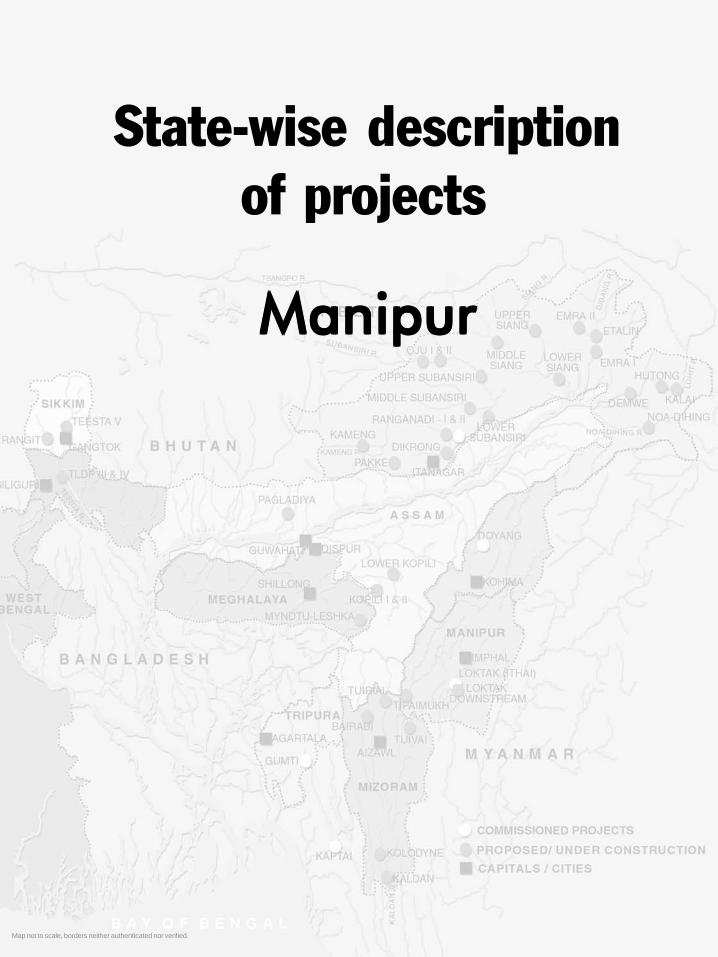
1Hydroelectric Projects in ManipurMap not to scale, borders neither authenticated nor verified.
State-wise descriptionof projects
ManipurManipurManipurManipurManipur
StateManipur.p65 6/4/2005, 1:56 AM1
Black

Large Dams for Hydropower in Northeast India2
Manipur has two small hydro projects and twenty-two diesel projects with a total installed capacity of about10 MW under the state sector. At present, the total poweravailability including share of power from central sectoris about 48 MW only. Against this, the peak demand isestimated to be approximately 129 MW, there is totalshortage of more than fifty percent. To meet the powerrequirement during critical periods, the state has topurchase power from other sources like Eastern RegionalElectricity Authority and Meghalaya State ElectricityBoard. Under the Central sector, there is one hydel project-Loktak HEP with installed capacity of 105 MW. LoktakDown Stream (90 MW) is under implementation.
The Government of India has clear norms for theallocation of power from central sector projects. Thestate is entitled to 12 percent of the total generated powerfree of cost. As in the case of Loktak project, the freepower available every year is around 26 MW and fromother central sectors will be around 70 MW. So, includingboth share of central sectors and the state sector, thetotal availability will be around 150 MW at the end ofninth plan (1997-2002).
Another aspect is the normal share of power to bereceived on payment by the state from proposedTipaimukh Hydel Project (Manipur/Mizoram) to beimplemented by NEEPCO. The Tipaimukh HEPenvisages generation of 1500 MW (6 units of 250 MWeach) of power at 26.7 percent load factor byharnessing the hydropower potentials available in theBarak river of Manipur. Brahmaputra Board hasprepared the detailed project report. The stategovernment will get a free share of 10% (150 MW)and if the state government is allocated 20% more ofthe total output, the state shall get another 300 MW ofpower. Thus the project shall make available to thestate a total of 450 MW of power by the time the projectis fully commissioned. The 15th electric power surveyconducted by Central Electricity Authority hasprojected a demand power of 530 MW by the terminalyear of the 11th plan in the state of Manipur. The totalpower availability in the state by then would be around600 MW including share from other central sector
power projects and power projects under stategovernment. (Source: Manipur state website)
Pre-feasibility Reports for 3 more projects in Manipurhave been prepared under 50,000 MW HydroelectricInitiative to generate a total of 931 MW. The PrimeMinister had launched a programme for preparation ofthese reports 24.5.2003. The scheme was formulatedby Central Electricity Authority (CEA) and sanctionedby the Ministry of Power on 31st March 2003 at a costamounting to Rs. 24.95 crores. The table below liststhree projects for which the pre-feasibility reports havebeen completed.
Some details of the large hydroelectric projectsexisting and proposed in Manipur are as follows:1. Loktak Hydroelectric project2. Loktak Downstream Hydroelectric Project3. Tipaimukh Hydroelectric Project4. Irang Hydroelectric Project5. Mapithel Hydroelectric Project
1. Loktak Hydroelectric projectRegion: Manipur, district Bishenpur, 38 km southof Imphal, on Imphal- Kumbi state highway.Lat/ long: 24.25° to 24.44° N, 93.46° to 93.55° EPhysical Characteristics: 10.7 m high, 58.8 m. longbarrage called the Ithai barrage. 6.89 km long head racetunnel, Surface Power House containing 3 units of 35MW for generation of 105 MW of electricity.Implementing agency: National Hydroelectric PowerCorporation (NHPC)Project cost: Rs. 130 croresStatus: Commissioned in 1983.Ecological impacts
Before the construction of the Ithai Barrage, thewetland was naturally and continuously cleared of thesilt that is brought down by the various streams and riversfrom the valley and the hills. During lean season, theroots of the phumdis and other aquatic vegetation touchedthe bottom for nutrients. During monsoons, when thewater level rose the vegetation surfaced, bringing up thesilt with it. Much of this silt got washed by the current
Hydroelectric Projects in Manipur
No. Project Consultant Installed Capacity Estimated Cost(No. of units x MW per unit) (in Rs. crores)
1. Khongnum Chakka st.-II WAPCOS 67 MW (2 x 33.5) 525.062. Nunglieban WAPCOS 105 MW (2 x 52.5) 841.993. Pabaram WAPCOS 190 MW (2 x 95) 1256.74
StateManipur.p65 6/4/2005, 1:56 AM2
Black

3Hydroelectric Projects in Manipur
of the rivers, which flowed out through the ManipurRiver. Some of the phumdis also got carried along withthe outflow. This was the natural cycle of the Loktak.With the construction of the barrage, the water level ofthis wetland has been raised to a static 769.12 meters,has blocked the natural flow of water to and from thewetland, and has altered the hydrologic cycle of thisdelicately balanced system. It has resulted in the siltingup of the wetland at an unprecedented rate. Other changesinclude gradual thinning of the floating phumdi(vegetation), decline in the original aquatic vegetation,extinction of fish species, interference with the fishmigration pattern and the increased spread of phumdinow covering almost half of the total area of the presentwater body.
The other problem associated with siltation, weedinfestation and proliferation of the phumdi is the gradualreduction of the water holding capacity, which results inreduction of power generating capacity of the project
During the dry season the barrage is kept closed sothat there is no shortage of water for power generation.And during periods of heavy rainfall there have beenfloods as the barrage shutters were still kept closed.
A major impact of the high water raised by the Ithaibarrage is felt by the Keibul Lamjao National Park, theonly home of the Sangai, the Manipur brow-antlered Deer.The Park experiences flash floods and sudden raise ofwater level at most times in the year, more frequently inmonsoon months. As noted by the wildlife researcherSalam Rajesh, the first impacts of back-flow of water ofthe Khuga river (in spate during the monsoon) after hittingthe Ithai barrage and gushing in through the Ungamelchannel is felt on the southern edge of the Park. Theimpact is seriously felt since it damages the vegetationmass providing shelter and home to the wildlife in thePark. He observes that due to the high water levelmaintained in the reservoir for the there has been areduction in the number of birds visiting the lake. Somespecies like the Sarus crane, Hooded crane, Graylaggoose, Bar-headed goose, Large-whistling teal havestopped visiting the lake all together.
Social impacts: A case study by RamanandaWangkheirakpam in section 4.1 of the dossier explainsthe ecological and social impacts of the Ithai barrage indetail. The authorities have been unable to preventjhumming in the hills, which has resulted in increase insilt flowing into the lake and increase in weeds and waterhyacinth during construction phase. The maintenance ofa water level optimum for power generation has resultedin new areas coming under water, which was notforeseen by the project, as at the time of planning thesiltation levels were lower. Due to increased siltation, the
reservoir with the optimum water level is more than whatwas actually planned.
The project affected a large number of people whoselives and livelihoods were connected with the lake,especially the Khangpok people who lived in huts builton the phumdis.
On the degree of inundation caused by the barrage, itis reported that anywhere between 20,000 to 83,000 ha.of cultivable lands got submerged after the constructionof Ithai barrage. The Government’s estimate of 20,000ha. is considered an under statement, on the other handthe estimate done by S. Ibomcha of an area of 83,000hectares seems to be slightly exaggerated. (Singh, N. L.,1993) However proper survey and estimation has notbeen conducted on the total inundated area, either by thegovernment or others. De Roy (1992) estimates that 30% of the cultivable lands along the wetland got submergedand some 12,000 local people are now no longer able touse shallow fishing techniques.
Loktak Project Affected Areas Action Committee hasfiled a case in the Guwahati High Court, seekingcompensation for the suffering caused due to thesubmersion of their paddy fields and residential housesby the project. They blame the project authorities for nottaking appropriate measures to prevent these damages atthe time of planning the project itself. “The court in itsruling on July 22, 2002 directed the state government toconstitute an expert committee to identify genuinelandowners of areas affected by the power project.Following the court directive, the state governmentconstituted a 13 member committee chaired bycommissioner (revenue). Till date, the committee hasconducted 19 sittings with another scheduled for October6 next at the office chamber of IS Laishram,commissioner (revenue).. In the meantime, the jointsecretary of the expert committee has notified all affected
Map
not
to s
cale
, bor
ders
nei
ther
aut
hent
icat
ed n
or v
erifi
ed
StateManipur.p65 6/4/2005, 1:56 AM3
Black

Large Dams for Hydropower in Northeast India4
landowners whose lands have been documented after1970 to submit original copies of their patta allotmentnumber, receipt of premiums paid, deed of agreementsand registration documents to their respective circle SDOslatest by October 11, failing which no complaints will beentertained.” (Source: Imphal Free Press, 30th September2004 www.kanglaonline.com/index.php?template=headline&newsid=19799&typeid=1)
Unfortunately this committee did not have anyone fromthe communities living around the lake, only scientists(some of whom were consultants in the EIA process)and government officials both of who had in the firstplace not looked at these aspects in their reports.
The wetland acts both as a vast space for waste thatcomes from different sources and as well as the sourceof drinking water. Before the construction of the damthe natural movement of water took care of water quality.Even the waste brought down by rivers from the citywere largely taken care by the same process. But withthe dam, stagnant water, which accumulates the waste,both from the khangpok people and of the city dwellers,become hazardous for consumption.
The khangpok population increased phenomenallyin the post project period between 1986 and 1999. Manyof the new fishing families and khangpok dwellers atLoktak are those displaced by the project. Thisincreasing population of the khangpok families has begunto create further demand on the already depletedresources of the wetland. This is resulting inunsustainable levels of resource use, decreasing incomesand decreasing consumption of these resources by thefamilies themselves.
It is true that import of fish was essential even beforethe dam, but the post-dam scenario has accentuatedexternal requirement of fish. In the case of rice, areasaround the wetland were once known for its quality andquantity. As a consequence of the project, the people aremore dependent on inferior quality of rice brought fromoutside the state.
A news report on the investigation into the cause andintensity of floods that hit Manipur in August this yearstates, “The intensity of the flood that ravaged andcontinues to ravage the four valley districts of Manipurmay have been less if only the authority of the NationalHydro-Electric Project (NHPC), which operates the LoktakProject, had opened the Ithai barrage a little earlier.Disclosing this, a highly placed source said that the StateIrrigation and Flood Control Department had asked theChief Engineer of NHPC to open the Ithai barrage inadvance. However for reasons best known to the NHPCauthority sluice gates of the Ithai barrage were not openedon time, said the source. Taking the rainfall record intoconsideration at the catchment areas and the rising waterlevel of the rivers, IFCD had asked NHPC to open the allthe five sluice gates of Ithai barrage on August 10 and 11.However the NHPC resorted to fully opening all the 5 sluicegates only on August 13, by which time it was already toolate, the source further said. (‘Flood fury linked to lateopening of lthai barrage’ The Sangai Express, Imphal,August 23)
As reported by various newspapers, the floods in thestate caused the death of 7 people, damaged 40,000 ha.of agricultural land and caused loss to property worthRs. 600 crores.
2. Loktak Downstream Hydroelectric Project
Region: Manipur, Tamenglong district approximately 70km. southwest of Imphal, Manipur
Lat/ long: 24° 44’ 50” N; 93° 35’ 25” E
Physical Characteristics: 64.5 m high, 250 m long,5.8 km head race tunnel and surface power house (onthe left bank of Irang river) to generate 90 MW (3 unitsx 30 MW); expects to utilise the tail race discharge ofthe existing Loktak HEP and the free draining catchmentof the Leimatak river.
Implementing agency: National Hydroelectric PowerCorporation (NHPC)
Steps towards conservation on LoktakSome members of the local communities living on in periphery of Loktak have formed the Environmental Social
Reformation and Sangai Protection Forum - a group of more than a hundred local clubs. The initial effort was theprotection of the Sangai and its habitat, the Keibul Lamjao National Park. The initiative later expanded to cover theprotection of migratory waterfowl and other avifauna. Awareness campaigns have been take up to mobilise the localstowards the effort, especially the rejuvenation of the lake from the impacts of the Loktak hydroelectric project,commissioned in 1983. The people’s movement has gained much ground in that public awareness has been generatedon the need to conserve the lake and its resources
The Loktak Development Authority (LDA) was set up by the Manipur government, in 1986 to ensure that conservationand protection measures are taken up. At a meeting organised by the LDA in January 2002, the local communitiesliving in and around the lake sought that the barrage be kept open for eight months of the year (January to April andJune to September) so that the stability of the lake and their livelihoods which are dependent on the health of thewetland can be gradually restored.
StateManipur.p65 6/4/2005, 1:56 AM4
Black

5Hydroelectric Projects in Manipur
Estimated cost: Rs. 667.46 crores (Completion cost)(source: website of Directorate of Commerce andIndustries Government of Manipur. Wednesday, 23October, 2002) The cost of the project is Rs 873 croreand it may cross over Rs 1000 crore in the final stage(Source: Bit Irom, 21st April 2002)
The project was agreed to by the state under theagreement that the state government will get the 50 %benefit i.e. 38% free power and 12% share on minimumprice. The NHPC will get the remaining 50% share ofthe benefit from the project when completed.
Year of Commissioning: 2008
Status: Central Electricity Authority gave techno-economic clearance for the project in February 1999.In December 2002, it was reported that Cabinet approvalwas given to the MoU agreed between Ministry ofPower and State Electricity Department on theTipaimukh Dam and Loktak Downstream Projects. Theproject is said to start in January 2003 and is expectedto be completed by 2007.
Environmental clearance: The project was discussedin 1994 by the Expert Committee on River Valley projectsand additional details such as water balance studies, leanseason flow and the migratory path of wild animals weresought. The environmental clearance was granted to theproject on April 24, 1995, on grounds that soil conservationworks would be undertaken in the entire 24,000 ha.catchment area. This was to be completed prior to thecompletion of works on the project. No construction wasto be taken up on the left bank of the river as they containeddense forests above the submergence area. The 42 familiesthat were to be displaced were to be given “1 ha of cultivableland and ex gratia payment etc”! The landless oustees wereto be provided gainful employment and training in skilled/semi skilled jobs. A rehabilitation committee was to beconstituted. Since some rare/ endangered species of animalswere found on the upper catchment of the project, suchareas were to be identified and delineated for declaring asProtected Area. A detailed programme for management ofwildlife including establishment of anti-poaching squad wasto have been submitted by September 1995.
Forest Clearance: The forest clearance was granted tothe project on Jan 1, 1997 wherein 250 ha. of forest landwas diverted under certain conditions. Some of them arethat the rehabilitation site be chosen by the villagersthemselves, state government to certify that the 250 ha.being sought is not archaeologically or religiouslyimportant, construction of office and buildings shouldpreferably be located on jhum land.
“The project has been in limbo despite the CentralGovernment having sanctioned Rs. 575 crores. The mainhurdles in implementation of the projects are the pending case
in the Gauhati High Court over the land compensation to theaffected tribal families and deployment of security forces forthe project. The affected local people are demanding duecompensation against damages and 25% jobs.
The government is ready to provide Rs. 18.65 croreas land compensation but the demand for landcompensation for the project is Rs. 68 crore. Theauthorities concerned have rejected this amount statingthat it is exaggerated.
A group of affected tribal villagers of Taosang villageunder the Nungba sub division of Tamenglong district ofManipur had filed a case against the step taken up by theState Government for re-inquiry, which the Gauhati Highcourt stayed. Since then, all works for the project hadbeen suspended due to the court’s intervention.” (Source:Bit Irom, 21st April 2002). In November 2004, theNational Hydro Electric Corporation (NHPC), demandedadequate security measures for the project to take off. Italso proposed that government purchase its share ofpower generated. A high level meeting high level meetingwas held on November 4 at New Delhi between officialsof the Union Home Ministry, NHPC, Power FinanceCorporation and representatives of the State PowerDepartment and Chief Secretary Jarnail Singh. The longdelay has shot up the estimated cost and it has been agreedin principle between the Centre and the State to increasethe cost of the Project to Rs 700. crores (Source: http://www.e-pao.net/GP.asp?src=3.07.291104.nov04)
Ecological impacts: Ashish Kothari, member of theExpert Committee for River Valley projects during 1994-95 stated in an official report to the MoEF, that althoughthe project involves a submergence of 257 ha including170 ha of wet paddy fields and the remaining areas havebeen identified as abandoned jhum or degraded forestland, the Report on Environmental Impacts (November1994) says that agricultural land is ‘negligible’.Discrepancies in the data on jhumed land and forest landwere also found in the project documents.
Out of the total catchment area of 55,400 ha. theproject intends to treat only 4,060 ha. This is despite thefact that much of the catchment area was found to bedegraded forest, jhum or non-forest land. Further, thereports show no data on siltation level. Without this itwould be impossible to determine the life of the project,the impact of siltation on the project and the change insiltation due to catchment area treatment.
No studies have been done on the impact ofsubmergence on flora. The proforma on environmentalaspects states that there are no rare or endangered speciesin the submergence zone but the listing in the report has15 species that are threatened and are in Schedule I listof the Wildlife Protection Act.
Hydroelectric Projects in Manipur 5
StateManipur.p65 6/4/2005, 1:56 AM5
Black

Large Dams for Hydropower in Northeast India6
Also, the report states that the surrounding forestshas the carrying capacity for the displaced population ofanimals. But the surrounding areas have been jhumed asper the same reports. This clearly is a contradiction.
The declaration of Loktak lake as a wetland of globalimportance under the Convention on Wetlands ofInternational Importance (popular as the RamsarConvention) signifies the high ecological value of theecosystem and the need for its protection.
Social ImpactsThe 1992 document on the environmental aspects of
the project state that 172 ha. land of four villages will besubmerged.Yet the resettlement and rehabilitation packagehas been offered only for the residents of 42 ha. of thevillage Tousang Khunou (261 persons) They are to berehabilitated in a new site called Penglong located 4 kms.downstream of the present village.
The project authorities plan to stop shifting cultivationin the catchment and declare some areas as ReservedForests. This is likely to impact the livelihoods of thepeople, so it is important for them to know of this impactand the availability of alternatives.
3. Tipaimukh Hydroelectric Project
Region: Manipur, 500 meters downstream of theconfluence of the Tuivai and Barak Rivers in the Districtof Churachanpur in the State of Manipur, near the Assam-Manipur - Mizoram border.
Lat/ long: 24º14’ N and 93º1.3’ E
Physical Characteristics: 390 m long, 162.8 m highearthen core rock filled dam on the river Barak forgeneration of 1500 MW (6units X 250 MW) of power. Itis also expected that the project will help to moderate thefloods in the plains of Barak in Assam.
Date of completion of the project: 2008
Implementing agencies: North Eastern Electric PowerCorporation (NEEPCO).
Total cost: The project cost as estimated by NEEPCO isRs. 5225.70 crore. It was reported last year that therevised cost of the project is Rs. 4,421 crore, With 12per cent interest, the project cost would rise to Rs. 6,351crore. The project has to be completed within 10 yearsand, by that time, the project cost could rise up to Rs.8,867 crore. (The Telegraph Northeast, February 1,2002, Power giant to sign MoU, Neepco woos Manipurwith relief offer)
StatusEnvironmental and forest clearance: The project hasnot been granted either. Site visits have been undertakenby officials of the state government and Ministry ofEnvironment and Forests.
The government of Manipur signed the MoU withNEEPCO in December 2002 despite loud and persistentprotests by local groups and communities. Due to theefforts of Citizens’ Concern for Dams and Development(CCDD) and Committee against Tipaimukh Dam, a copyof the MoU was made available by the Power Minister,Mr. T. Phunzathang (see section 4.2). However, projectreports are still being maintained as classified documents.Such lack of transparency is in contradiction with clauseslike section 29 (2) of the Electricity (Supply) Act, 1948wherein citizens are given two months to submit anyrepresentation regarding this project. (The new ElectricityAct that was passed in 2004 does not have this clause).For the Tipaimukh project, the gazette notification underthis clause was issued on January 20, 2003.
The public hearing (under the EIA notification, 1994)for the project impacts in Mizoram was proposed to beheld first in August 2004 and then on September 22, 2004.The Public Hearing was held on 2.12.2004. There wasstrong protest by citizens groups on grounds of violationsof the EIA notification. In a letter to the Secretary, Ministry
Regarding the status of the techno economicclearance and the signing of the MOU between thestates and NEEPCO, there have been many reports innewspapers, some of which contradict each other. TheManipur government had not signed the MoU for a longtime and various reasons were quoted in the press forthis. One of them being that the state “feared large-scale submergence of farmlands of Hmar, Kuki andNaga tribals, in the Tipaimukh sub-division”.(Source: The Telegraph: Guwahati edition, December12, 2001, Manipur Clears Jinxed Hydel Project)
of Environment and Forests it was pointed out that therelevant documents as per the EIA Notification were notavailable with the MSPCB. The Mizoram State PollutionControl Board (MSPCB) had only two documents. Thesewere documents titled: 1) Executive Summary (calledAnnexure II) and 2) Impact of the Project on Environment(annexure F). The letter also highlighted that the reasonfor organizing the public hearing in Mizoram was notcompletely clear as there was going to be more impact ofthe project in Manipur.At least 12 villages in Manipur wouldbe totally or partly submerged, requiring rehabilitation andresettlement while no villages in Mizoram would be withinthe submergence zone.
The MSPCB in its report on the hearing stated thatthe people and organizations who attended the hearingobjected to the project. The Secretary of MSPCB saidthat “the affected people and the organisations who camefor the public hearing were not satisfied with NEEPCO’splans for their rehabilitation and compensation. They also
StateManipur.p65 6/4/2005, 1:56 AM6
Black

7Hydroelectric Projects in Manipur
said they wanted free power as well for which NEEPCOdid not seem to have an answer,” The report stated thatin view of the objections voiced by the people, it wasdifficult to come to a conclusion. It stated that “thediscussion made at the hearing was that a workablecompromise be arrived at a meeting of the three partiesinvolved - the people living in the affected area, thegovernment of Mizoram and NEEPCO,” (Source: ImphalFree Press, Tuesday December 7, 2004)
On 23.1.2005, the Union Minister for HeavyIndustries, Santosh Mohan Dev made a statement thatthe Union Government has decided to go ahead with theTipaimukh project and that decision to implement theproject was taken in a Central level meeting held twoweeks back, which agreed to allot Rs 500 crore for theinitial construction works, expected to begin soon(www.hindustantimes.com/news 181_1210065,0008000500010000.htm).
This project is also in the CEA list of projects likelyto be benefited during the 11th five-year plan (2007-2012) period (Source: Central Electricity Authority,National Electricity Plan; http://www.cea.nic.in/nep).
Ecological impactsTotal submergence area is 293.56 sq. km. The total
Reserved Forests (RF) of Manipur amounts to 1463 sq.km. and the rest of it is under Unclassed State Forests (USF).Out of this small area under RF, 217 sq. km. will besubmerged by this project alone which is a substantial loss.
Total area required for construction including thesubmergence area is 30, 860 ha. Out of this, 20, 979 isforest land, 1,195 ha. is village land, 6,160 ha. ishorticultural land, and 2,525 is agricultural land.
It is feared that 40% of the Keilam Wildlife Sanctuarythat was declared by the State Forest Department in 1997will be submerged.
The area is home to at least three of the five Hornbillspecies found in Manipur, the Capped Langur and HoolockGibbon. Interestingly, the prime hornbill habitat in theTipaimukh area is located just above the sharp south-north bend in the Barak river (where the river bendssharply north from Tipaimukh in Churachandpur district
to enter the Jiribam subdivision in Imphal East district)This sharp bend is where the dam is to be built, notesSalam Rajesh, a wildlifer who has travelled this regionextensively
The catchment area is 12, 75, 800 ha. The other rivervalley projects in the catchment area are the Tuivai (atributary of Barak) and the Loktak Downstream HEP onLeimatak river, a tributary of Irang.
The report by Botanical Survey of India (BSI) statesthat a number of flora specimen could not be collectedas the area along the Barak river is occupied by the VangaiReserve forest and area between the Barak and Irangrivers is the Irangmokh RF. Both these are impenetrableand have steep hilly terrain. They are also rich in wildlifelike elephants. The MoEF feels that the floral diversityreport needs to be assessed
The Zoological Survey of India (ZSI) report attachedwith the project documents was found to be veryinadequate by the MoEF. It is felt that the area needs tobe reassessed for faunal diversity before the project isgranted clearance.
The dam site is located on a major seismic zonecharacterised by earthquakes of magnitude 7 or more onthe Richter scale and which has experienced more thanfive such earthquakes. The most recent earthquake thattook place on April 5, 1999 measured 5 on the Richterscale. The project authorities have quoted studies (1981-82) by Central Water and Power Research Station, Pune,which states that the area is prone to an earthquake of7+/- .25 and an earthquake of 7.5 is to be expected. Theproject authorities had planned to take up further seismicstudies through recognised institutions. It remains to befound if these studies have been done yet.
Social impactsAs per estimates of the authorities, the project will
totally affect 311 sq. km. and 8 villages; 1461 Hmarfamilies in all. The project will submerge altogether 60km. of National Highway No. 53, (the only alternative toNH-39, the Imphal-Dimapur road) at three different pointswith two major bridges.
There are varying reports about the totalsubmergence area and the number of villages that willbe impacted. The BSI report states 31 villages and 1310families living along the course of the river on the S-Wpart of Manipur will be under direct impact of thereservoir.
The people use the river extensively for transportationas the road connectivity is poor. They carry bamboo andginger through the Tuivai river to Barak and then all theway to Lakhimpur in Lower Assam.
The Vaiphei, Hmar and the Zeliangrong communitiespossess ancient historic sites and monuments, which are
Regarding the status of the techno economic clearanceand the signing of the MOU between the states andNEEPCO, there have been many repor ts innewspapers, some of which contradict each other. TheManipur government had not signed the MoU for a longtime and various reasons were quoted in the press forthis. One of them being that the state “feared large-scale submergence of farmlands of Hmar, Kuki andNaga tribals, in the Tipaimukh sub-division”.(Source: The Telegraph: Guwahati edition, December
12, 2001, Manipur Clears Jinxed Hydel Project)
StateManipur.p65 6/4/2005, 1:56 AM7
Black

Large Dams for Hydropower in Northeast India8
threatened by this project. The high watermark of thedam will also destroy five most important lakes locatedjust above the Ahu waterfall where the magical sword ofJadonang, the hero of the Nagas, is believed to be hidden.However professors of Manipur University who wereconsulted regarding this issue categorically stated thatthere are no sites that are archaeologically important inthe submergence area.
The project authorities categorically claim that thereare no downstream users (human, irrigation, industry)of the water!
The dependence of the communities living by the riveron the local aquatic fauna like the prawn, fish, snails andcrabs have also not been considered. These need to bedocumented and their loss to the community factored inthe assessment studies.
Malaria is already a cause of concern in the region.The possibilities of whether the proposed reservoir willincrease the incidence is yet to be ascertained.
Manipur has started the survey and investigation andpreparation of Detailed Project Report. As per theQuarterly Progress Report (March 2004) of the NEC,this is to be completed by March 2005. More informationon this project is not presently available.(Source: http://tamenglong.nic.in/hds2000.htm;http://investinmanipur.nic.in/gp_power.htm;http://investinmanipur.nic.in/energy.htm;http://necouncil.nic.in/qpr03.04.doc)
5. Mapithel Hydroelectric ProjectRegion: It is to be built across the Thoubal river nearLouphong village, which is located at the cross-road ofImphal East, Senapati and Ukhrul districts.Physical Characteristics: 66 meter high, 1074 meterdam with an Installed Capacity of 7.5 MW. The projecthas dual components of irrigation and hydropower.Implementing Agency: Government of Manipur.Status: In 1976 the Irrigation & Flood ControlDepartment, Government of Manipur had submitted asurvey report and proposal for the construction of thedam to the Central Water Commission. The PlanningCommission of India had given its approval in 1980.Ecological and Social Impacts: Six villages are locatedin the submergence zone. These are Louphong, Chadong,Lamlai Mongbung, Lamlai Khunou and Lamlai Khullen[Ukhrul district], and Phayang [Imphal East district], Thevillages in the downstream areas are also likely to beimpacted, particularly Loutai (Riha), Thawai, ThawaiZalengbung and Sankai [Ukhrul district], T.C. Pokpi andMaphou [Senapati district], Tummukhong andMoirangpurel [Imphal east district] villages. A total of1200 families, with approximate population of 7500, aregoing to be either displaced or affected.
An estimated 1181.62 hectares of standing land(arable, settlement & jhum) are expected to be submergedby the dam (Source: Article in Imphal Free Press bySalam Rajesh)
The Mapithel Dam-Thoubal River Valley MultipurposeProjectAffected Villages Committee (MDTVMPAVC) hasthreatened to launch a series of agitation as theGovernment has failed to fulfill the 1993 Agreement signedwith regard to payment of compensation. According toMDTVMPAVC, on June 19, 1993 the affected villagersand the Government signed an agreement wherein theGovernment had agreed to pay compensations to theaffected villagers within two years. The Governmentshould have also constructed houses for those affectedvillagers as per agreement of the 1993 but till now nothingof that sort had been done (Source: Sangai Express,March 24, 2004).
The confluence of the Tuiroung and Tuivai calledRounglevaisuo by the indigenous peoples is located about 500meters upstream of the purposed dam site. Rounglevaisuo is ahistorical and sacred spiritual site of not only the Hmar tribe butalso of the Unau-Suopuis, the kindred tribes of the Hmar; theHrangkhawls and Darlongs of Tripura, the Bietes of Meghalaya,the Sakecheps of Assam and the Komrem tribes of Manipur. Itis at Rounglevaisuo that the kindred tribes part ways afterstaying together for centuries during their long travel in Centraland Southeast Asia. From Rounglevaisuo all the kindred tribestarted to have their own distinct separate identity. Thus it is aplace where they originate and as such are spiritually andhistorically connected. The Unau-Suopui tribes left the place tothe Hmars to treasure and preserve for all generations to come.Since then, the Hmars have lived and died through manygenerations taking great care to fulfill their role as trustee andcustodian of this priceless heritage.
Further upstream is the sacred river island of the Hmar.This small river island which is a few distance upstream fromthe Dam Axis is called Thiledam, in Hmar, meaning Death andLife. In the Hmar traditional religious belief the island is the placewhere the soul of all human beings goes as soon as they die.From this island the soul proceeds either to paradise or hell orcomes back to earth to be reborn (Joseph Hmar, 2003).
4. Irang Hydroelectric Project (60 MW)
Region: Irang River, Tamenglong DistrictPhysical Characteristics: Earthen dam 60 m high togenerated 60 MW (4 x15).Total Cost: Estimated cost of Rs. 352.00 crore. Rs. 120lakhs was to be released by NEC for completion ofinvestigation by 31/12/2001Investigating Agency: State Power DepartmentStatus: The Power Department of the Government of
StateManipur.p65 6/4/2005, 1:56 AM8
Black

1Hydroelectric Projects in Assam
State-wise descriptionof projects
AssamAssamAssamAssamAssam
Map not to scale, borders neither authenticated nor verified.
StateAssam.p65 6/4/2005, 1:54 AM1
Black

Large Dams for Hydropower in Northeast India2
Hydroelectric Projects in AssamAssam State Electricity Board (ASEB) was originally
constituted on 1st June 1958 in the composite state of Assamunder Electricity (Supply) Act, 1948. But the existing ASEBwas reconstituted in 1975 when the state of Assam wasbifurcated into Assam, Meghalaya and Mizoram. The ASEBis responsible for generation, transmission and distribution ofelectricity in the state of Assam.
ASEB has six installed projects with a total installedcapacity of 574 MW against a peak demand of 621 MW.The power supply position in the state is expected to improveconsiderably in the coming years with the materialisation ofprojects under the state sector like Borgolai Thermal Powerproject (120 MW), Karbi Langpi Hydroelectric Project(100 MW) and Amguri Combined Cycle Gas Based project(90 MW).
In the Central sector, NEEPCO has installed andcommissioned Kopili HEP (250 MW) and Kathalguri GasBased Power Project (291 MW). NEEPCO is currentlytaking up construction of Kopili 2nd stage (25 MW) and itplans to take up the Lower Kopili (150 MW). (Source: Assamstate website)
The Karbi Langpi Project and the Upper Borpani Projectare in the CEA list of projects likely to be benefited duringthe 11th five-year plan (2007-2012) period (Source: CentralElectricity Authority, National Electricity Plan; http://www.cea.nic.in/nep).
The following are the projects being actively proposed inthe state except for Kopili stage I and stage I extension thathave been commissioned and stage II that is being executed.1. Kopili Stage I Hydroelectric Project2. Kopili Hydroelectric Project- Stage I Extension3. Kopili Hydroelectric Project - Stage II4. Lower Kopili Hydroelectric Project5. Pagladiya Multipurpose Project
1. Kopili Stage I Hydroelectric ProjectRegion: Assam, North Cachar Hills DistrictLat/ long: 25° 32’ N, 92° 41’ EPhysical characteristics: The project has two dams namelyKhandong dam and Umrong dam for creating two reservoirs,one on the Kopili River and the other on the Umrong stream,a tributary of the Kopili.Khandong dam: 66 m high dam. Water from the Kopilireservoir is utilised in the Khandong power station througha 2. 8 km long tunnel to generate 50 MW (2 X 25 MW) ofpower. The tail water from this powerhouse is led to theUmrong reservoir.Umrong dam: height 60 m. The water from Umrongreservoir is taken through a 5.5 km long tunnel to the Kopilipower station to generate 100 MW (2 X 50 MW) of power.
Implementing agency: The Kopili Hydroelectric Projectwas the maiden venture of North Eastern Electric PowerCorporation Ltd when it came into existence in 1976.Status: The Khandong power station was commissionedin March/April 1984. The Kopili power station wascommissioned in June/July 1988. Thus the total installedcapacity of the first stage is 150 MW.Ecological and social impacts: The implementation of theKopili project was delayed for a long time due to the findingsof investigations, which revealed that there may be leakagefrom the reservoirs through the karst limestone formations.However, the project was finally taken up after fresh studies,which stated that the leakage would be very small. Costsfor treatment of leakage if they occurred were also budgetedin the project. This was based on the conclusion that thebenefits from the project would far exceed such costs, whichwould be nominal.
The diversion of water from Kopili reservoir to Khandongpower house and from Umrong reservoir to Kopili powerhouse leaves the downstream of Kopili river (below Khandongdam) with less water. In the case of the Umrong stream,which has very less discharge during lean seasons, the creationof the reservoir may have affected the seasonal change in theflow of the river and converted it into a constant flow stream,so that power can be generated by the Kopili power housethroughout the year. Detailed investigations are necessary tounderstand the full impact of such diversions.
Whether the impacts of such interferences with riverflow regimes have been studied in the EIA is not known.
The spin off ‘benefits’ from the project, claims NEEPCO,are the two privately owned cement plants (limestone based)that have come up in the area due to the infrastructure createdby NEEPCO for the Kopili project.
Further information on ecological and social impactswill be known only after these studies are undertaken.
2. Kopili Hydroelectric Project- Stage I ExtensionPhysical characteristics: In the extension of stage I, theheight of Umrong reservoir was raised by 7.6 m. and two50 MW units were added to the Kopili power house.Status: The Units III and IV under this extension schemewere commissioned in November 1996 and March 1997respectively. Thus the capacity of the Kopili power housewas increased to 200 MW.
The project authorities claim that provision for thisincrease was already made during the development of stageI of the project. Sanctions for the raising of the full reservoirlevel and addition of the power units was taken under thehead ‘renovation and modernization of KHEP –phase II’.Ecological and social impacts: Not known
StateAssam.p65 6/4/2005, 1:54 AM2
Black

3Hydroelectric Projects in Assam
3. Kopili Hydroelectric Project - Stage IIPhysical characteristics: The second stage of the KopiliHydroelectric Project involves construction of an additionalpowerhouse to generate 25 MW of power. The water fromthe Kopili reservoir is to pass through a 481 m long waterconductor system to this power house. The water fromthis second stage powerhouse will go to the Umrong reservoirfor utilisation in the Kopili power station. After this powerhouse becomes functional, the total installed capacity of theKopili Hydroelectric Project will be 275 MW.
Physical Characteristics: The project involves constructionof a 71. 35 m high, 504 m long concrete gravity dam. Thewater from the reservoir thus created will be conveyedthrough a 3640 m long tunnel of 6.8 m diameter to a semiunderground power house to generate 150 MW of power(3 X 50 MW).Implementing agency: North Eastern Electric PowerCorporation Ltd (NEEPCO).Commissioning period: estimated time of completion is 6years after commencement of construction.Total cost: Estimated cost in 1988 was Rs. 148 crores.Cost revised to 463.6 crores (1997 price levels) after changesin the project design were made by NEEPCO.Status: The project was first investigated by AssamState Electricity Board and submitted to CEA for technoeconomic clearance.
According to the 2003-2004 Annual Report of MoEF,the Environmental Impact Assessment for the project hasbeen completed. However, the website of the Ministry ofDevelopment of North East Region (as on 31st January 2005)says that this project is at the stage of Survey, investigationand preparation of pre-feasibility report (http://northeast.nic.in/power.htm).Environmental and forest clearance: The project is stilldue for clearance.Ecological Impacts
On page 117 of the 1997 project report is said that theconstruction of the project requires 1200 ha of forest landof which 90 ha is reserve forest, 1100 ha is Unclassifiedstate forest. Remaining land required has been mentionedas ‘other land’ in the report. At the time of the preparation ofthe project report in 1997, appropriate forest area was beingidentified. The status on this is not known yet.
On page 120 of the same report, the details of thesubmergence area show that total submergence due to theproject will be 1628.5 ha of which forest land is 1561.86ha, cultivated area is 55 ha and shrubs and fallow land is 8ha. It seems therefore that the total land taken over by theproject is 2828.5 ha.
Most of the information regarding the loss of forestsdue to the project is very vague, for example they say thatforest affected by construction of roads and other componentstructures consists mainly of ordinary junglewood ofunknown species. It is hoped that the investigations beingcarried out will be more specific on the impacts of the projecton the ecology of the region.
The Kopili has one dam upstream of this project. Althoughthe discharge of the Umrong reservoir flows back into Kopili,it is hardly a full compensation of what is held back in theKhamdong reservoir. How one more dam on the Kopili riverwill affect its downstream flows will have to be ascertainedthrough detailed investigations.
PIL on damages due to artificial floods caused by the Kopili Dam
“A public interest litigation (PIL) has been filed at the GauhatiHigh Court calling for the appointment of a high powercommission to suggest appropriate ways and measures toensure that the Kopili dam, at Umrangshu in North Cachardistrict, does not create artificial floods any more. The PIL hasalso demanded punishment to the persons guilty for the havocthat the dam caused and for adequate compensation to theaffected people after assessment by an independentcommittee. It has additionally demanded repair of all roads,bridges and culverts while asking for prompt afforestation ofthe areas that were made barren due to the Kopili hydropowerproject.
The PIL was filed by Bimala Prasad Talukdar of Hojai, inNagaon district, on the basis of a news report in The AssamTribune. The complainant said that incalculable damage hasbeen caused by the artificial floods in Nagaon, Morigaon, andparts of Karbi Anglong and Kamrup districts in the state dueto the “callous and negligent” release of confined water in thedam belonging to the Nor th Eastern Electric PowerCorporation (NEEPCO).
Talukdar in his petition said that the Kopili dam, as long as itwas scientifically managed and looked after by the authorities,not only generated power but also helped in controlling floods.But in July this year, it said, there was a rush of water that ledto heavy floods. He claimed that the loss was above Rs 10,000crore. The floods were not natural, Talukdar argued, addingthat there was no proper care of the dam though there werefacilities for the same. (Assam Tribune, August 24, 2004)
The project report states that the “installation of thispower house is of immense importance in maintaining theeconomy of the generation of power in Kopili”.Total cost: 63. 3 crores (as per 1997 report)Status: The execution of this stage of the project is on. It isin the CEA list of projects likely to be benefited during the10th five-year plan (2002-2007) period (Source: CentralElectricity Authority, National Electricity Plan; http://www.cea.nic.in/nep).Ecological and social impacts: Not known
4. Lower Kopili Hydroelectric ProjectRegion: Assam, North Cachar district, the dam will belocated at Langku about 20 km. downstream of the existingKopili Power House on River Kopili, east of Karbi Anglongand west of the North Cachar Hills.Lat/ long: 20° 40’ N, 92° 47’ E
StateAssam.p65 6/4/2005, 1:54 AM3
Black
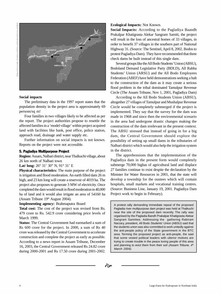
Large Dams for Hydropower in Northeast India4
Social impactsThe preliminary data in the 1997 report states that the
population density in the project area is approximately 69persons/sq m!
Four families in two villages likely to be affected as perthe report. The project authorities propose to resettle theaffected families in a ‘model village’ within project acquiredland with facilities like bank, post office, police station,approach road, drainage and water supply etc.
Further information on social impacts is not known.Reports on the project were not accessible.
5. Pagladiya Multipurpose ProjectRegion:Assam, Nalbari district, near Thalkuchi village, about26 km north of Nalbari townLat/ long: 26° 31’ 30” N, 91° 31’ EPhysical characteristics: The main purpose of the projectis irrigation and flood moderation. An earth filled dam 26 mhigh, and 23 km long will create a reservoir of 4019 ha. Theproject also proposes to generate 3 MW of electricity. Oncecompleted the dam would result in flood moderation in 40,000ha of land and it would also irrigate an area of 54160 ha(Assam Tribune 19th August 2004).Implementing agency: Brahmaputra BoardTotal cost: The cost of the project was revised from Rs.479 crore to Rs. 542.9 crore considering price levels ofMarch 1999.Status: The Central Government had earmarked a sum ofRs 600 crore for the project. In 2000, a sum of Rs 40crore was released by the Central Government to accelerateconstruction and complete the project as early as possible.According to a news report in Assam Tribune, December16, 2003, the Central Government released Rs 24.82 croreduring 2000-2001 and Rs 17.50 crore during 2001-2002.
Ecological Impacts: Not Known.Social Impacts: According to the Pagladiya BaandhPrakalpar Khatigrasta Alekar Sangram Samiti, the projectwill result in the loss of ancestral homes of 33 villages, inorder to benefit 37 villages in the southern part of NationalHighway 31. (Source: The Sentinel, April 8, 2002. Bodos toprotest Pagladiya Dam). They have recommended that threecheck dams be built instead of this single dam.
Several groups like the All Bodo Students’ Union (ABSU),Bodoland Demand Legislative Party (BDLD), All RabhaStudents’ Union (ARSU) and the All Bodo EmployeesFederation (ABEF) have held demonstrations seeking a haltto the construction of the dam as it may create a seriousflood problem in the tribal dominated Tamulpur RevenueCircle (The Assam Tribune, Nov 1, 2001, Pagladiya Dam)
According to the All Bodo Students Union (ABSU),altogether 27 villages of Tamulpur and Mushalpur RevenueCircle would be completely submerged if the project isimplemented. They say that the survey for the dam wasmade in 1968 and since then the environmental scenarioin the area had undergone drastic changes making theconstruction of the dam irrelevant in the present context.The ABSU stressed that instead of going in for a bigdam, the Central Government should explore thepossibility of setting up small dams in the tributaries ofNalbari district which would also help the irrigation systemin the district.
The apprehensions that the implementation of thePagladiya dam in the present form would completelysubmerge 70,000 bighas of agricultural land and displace27 families continue to exist despite the declaration by theMinister for Water Resources in 2001, that the state willdevelop a township for the oustees which will containhospitals, small markets and vocational training centres.(Source: Business Line, January 19, 2001. Pagladiya DamProject work to begin in February).
A protest rally demanding immediate repeal of the proposedPagladia river multipurpose dam project was held at Thalkuchinear the site of the proposed dam recently. The rally wasorganised by the Pagladia Bandh Prakalpar Khatigrasta AlekarSangram Samittee. Addressing the gathering RabiramNarzary, president, All Bodo Students’ Union (ABSU) said thatthe students union was also committed to work unitedly againstthe anti-people policy of the State government in the BTCarea. Terming the proposed project as anti-people, the saidthat some vested political leaders with ulterior motives aretrying to create trouble in the peace loving people of this areaand planning to evict them from their soil (Assam Tribune, 4th
March 2004).
Map
not
to s
cale
, bor
ders
nei
ther
aut
hent
icat
ed n
or v
erifi
ed
StateAssam.p65 6/4/2005, 1:54 AM4
Black

1Hydroelectric Projects in Arunachal Pradesh
State-wise descriptionof projects
Arunachal PArunachal PArunachal PArunachal PArunachal Pradeshradeshradeshradeshradesh
Map not to scale, borders neither authenticated nor verified.
StateArunachal.p65 6/4/2005, 1:31 AM1
Black

Large Dams for Hydropower in Northeast India2
Hydroelectric Projects in Arunachal PradeshArunachal Pradesh has 37 power plants ranging
from 5 KW to 4500 KW with a total installed capacityof 23.8 MW and firm power of 16.5 MW. Against firmgeneration of 16.5 MW, the peak requirement to loadcentres covered by the network of transmission anddistribution system is 75 MW. The short fall is therefore58.5 MW. However most of the peak demand is metout of diesel generation. In the state, 94 diesel generatingstations ranging from 10 KW to 500 KW capacity arefunctioning with a total capacity of 18.5 MW. Thereare another 21 projects with total installed capacity of76.25 MW targeted for completion in 9th plan to bridgethe demand supply gap. The state has the highestnumber of high head mini and micro hydel projects inIndia. (Arunachal Pradesh state website)
This was the power scenario of the state prior tothe commissioning of the 405 MW Ranganadi HEP in2002.
Pre-feasibility Reports for 42 projects in ArunachalPradesh have been prepared under 50,000 MWHydroelectric Initiative to generate a total of 27293 MW.The Prime Minister had launched a programme forpreparation of these reports on 24.5.2003. The schemewas formulated by Central Electricity Authority (CEA)and sanctioned by the Ministry of Power on 31st March2003 at a cost amounting to Rs. 24.95 crores. On thefollowing page are 42 projects for which the pre-feasibility reports have been completed.
Listed below are the projects being activelyproposed in the state or have been granted clearancesexcept for Ranganadi stage I, which has beencommissioned.1. Ranganadi Hydroelectric Project. Stage I2. Ranganadi Stage II Hydroelectric Project3. Upper Subansiri Hydroelectric Project4. Kamla Hydroelectric Project (Middle Subansiri) 5. Lower Subansiri Hydroelectric Project6. Upper Siang (Upper Dehang) Hydroelectric Project7. Siyom (Middle Siang) Hydroelectric Project8. Lower Siang Hydroelectric Project9. Kameng Hydroelectric Project10.Debang Hydroelectric Project11. Lohit Multipurpose Dam Project12.Noa-Dehing Multipurpose Dam Project13.Demwe Power project
14.Etalin Power project15.Dikrong Hydroelectic Project
1. Ranganadi Hydroelectric Project. Stage I
Region: Arunachal, Lower Subansiri district, near Ziro
Lat/ long: 27° 20’ N, 93° 49’E
Physical dimensions: built to generate 405 MW,(3X135) the project comprises of a 60 m. high concretedam. This diversion dam located at Yazali on riverRanganadi, diverts the water into the Dikrong riverthrough a 10.07 km long tunnel .The power house islocated at Haj on the left bank of river Dikrong.
Implementing agency: North Eastern Electric PowerCorporation (NEEPCO)
Total cost: 1455.45 crores (July 1999). One part ofthe funds were provided by the North Eastern Council(NEC). Sources of funding specified on the NEEPCOwebsite include loan from Government, LIC, PFC alongwith money from equity and bonds (http://www.neepco.com/).
Status: All three units of the project were completedby March 2002. With the commissioning of this projectit was reported that the Northeast became a powersurplus region. And it is hoped that the region will beable to export power to elsewhere in India and toneighbouring countries like Bangladesh.
As per the PIB release on March 28, 2002, annualenergy generation of 1876 Gwh would be distributed to the7 constituent states of the Northeast in accordance to theformula of sharing of power from Central Sector projectswith 12% free power to the state of Arunachal Pradesh.
Evacuation of power from Ranganadi is being takenup by the Power Grid Corporation through a 400 KVtransmission system for distribution in all thenortheastern states and connecting the project with thenational grid. The 12 % free power that is available toArunachal Pradesh will be evacuated by a 132 KVtransmission system that was stated to be present.However, at a meeting in June 2002 the Chief Ministersaid that, “though 405 MW Ranganadi hydel project inLower Subansiri district has been completed andpresently under trial run, due to non-availability of a132 KV transmission grid, power cannot be transferredto other power deficit regions. In the given situation,
StateArunachal.p65 6/4/2005, 1:31 AM2
Black

3Hydroelectric Projects in Arunachal Pradesh
S.No. Project Consultant Installed Capacity Estimated Cost(No. of units x MW per unit) (in Rs. crores)
1. Agoline NHPC 175 MW (3x 125) 2293.62
2. Amulin NHPC 460 MW (3x140) 2979.45
3. Ashupani NHPC 30 MW (2x15) 570.78
4. Attunli NHPC 500 MW (4 x 125) 2725.26
5. Badao NEEPCO 120 MW (3 x4) 443.98
6. Bhareli-I NEEPCO 1120MW (8 x 140) 3372.45
7. Bhareli-II NEEPCO 600 MW (5 x 120) 1698.35
8. Chanda NEEPCO 110 MW (4 x 27.5) 466.06
9. Demwe NHPC 3000 MW (12 x 250) 9539.40
10. Dengser NHPC 552 MW (4 x 138) 3945.09
11. Dibbin NEEPCO 100 MW (2 x 50) 371.52
12. Duimukh NHPC 150 MW (3 x 50) 2420.46
13. Elango NHPC 150 MW (3 x 50) 1503.07
14. Emini NHPC 500 MW (4 x 125) 3067.20
15. Emra-II NHPC 390 MW (3 x130) 2564.5
16. Etabue NHPC 165 MW (3 x55) 1208.39
17. Etalin NHPC 4000 MW (16 x 250) 14069.14
18. Hirong NHPC 500 MW (4 x125) 2072.78
19. Hutong WAPCOS 3000 MW (12 x 250) 7792.29
20. Kalai WAPCOS 2600 MW (10 x 260) 6637.67
21. Kameng Dam NEEPCO 600 MW (5 x 120) 2264.00
22. Kapakleyak NEEPCO 160 MW (4 x 40) 463.52
23. KurungI&II NHPC 330 MW ( 3 x 110) 2985.04
24. Mihumdon NHPC 400 MW (4 x100) 2700.33
25. Mirak NHPC 141 MW (3 x 47) 1320.75
26. Naba NHPC 1000 MW (4 x 250) 4399.89
27. Nalo NHPC 360 MW ( 4 x 90) 2922.14
28. Naying NHPC 1000 MW (4 x 250) 3016.96
29. Niare NHPC 800 MW (4 x 200) 3498.55
30. Oju-I NHPC 700 MW (4 x 175) 3526.28
31. Oju-II NHPC 1000 MW (4 x 250) 3492.99
32. Pakke NEEPCO 110 MW (2 x 55) 480.45
33. Papu NEEPCO 200 MW (2 x 100) 646.8
34. Phanchung NEEPCO 60 MW (2 x 30) 282.43
35. Ringong NHPC 150 MW (3 x 50) 1211.06
36. Sebu NEEPCO 80 MW (2 x 40) 371.4
37. Simang NHPC 90 MW (3 x30) 1028.34
38. Talong NEEPCO 300 MW (3 x100) 891.04
39. Tarangwarang NEEPCO 30 MW (2 x 15) 134.54
40. Tato-II NHPC 700 MW (4 x 175) 2608.60
41. Tenga NEEPCO 600 MW 4x 150) 1602.30
42. Utung NEEPCO 100 MW ( 3 x 33.3) 488.1
StateArunachal.p65 6/4/2005, 1:31 AM3
Black

Large Dams for Hydropower in Northeast India4
Ranganadi project will therefore cover only four of the15 districts of the State.
According to the Inspection Notes of Atul Sinha,Secretary, DONER dated 9th January 2003, “Atpresent, the NLCPR1 funded 132 KV Ziro –AlongTransmission Line being built by Power GridCorporation of India Ltd. (PGCIL) is progressing well.However, there is no proposal from the StateGovernment, as yet, for the Ranganadi–Ziro 132 KVTransmission Line – in absence of this link, the Ziro –Along 132 KV line would not serve any purpose. I wasinformed that the PGCIL are already working on the132 KV Ranganadi – Ziro Transmission Line with theunderstanding that it will receive NLCPR funding.(http://northeast.nic.inSecy_tour_Arunachal_Assam_08012003.pdf)
In October 2002, the state commenced the sale of 50MW of power to Punjab, Haryana and Delhi at a rateof 1.95 per unit, via the Power Trading Corporation.The contract will yield Rs 65 crore to the state
exchequer. (Project monitor, 16-31 October 2002)
Ecological impacts: During construction two quarries onthe left bank of the river seemed abandoned. If these quarrieswere left open without being rehabilitated, it is possible thatthe flow of loose soil into the river has increased.
Plantations are to be raised on 566 ha. of degradedforest land to compensate for the 281.18 ha. of forestland that was diverted for the project use.
The project is bound to have impacts on the characteristicsof both Ranganadi and Dikrong rivers due to inter basintransfer. There are also likely to be impacts due to thetransmission lines to be laid to evacuate power.The extent ofthese and many other impacts needs to be studied.
The ecological impacts identified by projectauthorities are not known as the Environment ImpactAssessment (EIA) report was not accessible at thetime of compiling the dossier.
A study of the EIA reports and conditions forclearance of the project will help to understand if allthe impacts of the project had been looked into and ifmitigation measures were accordingly planned by theproject authorities and the Ministry of Environment andForests (MOEF), which is in charge of grantingenvironmental clearance to hydel projects.
The Catchment Area Treatment (CAT) plan also
needs to be studied to understand the manner and extentof treatment that the project authorities along with thestate departments propose to undertake. If thecatchments are under human habitation, then it will beimpossible to undertake such activities without thecooperation of the local communities.
It is also not known if the project authorities haveworked out an appropriate and a detailed disastermanagement plan.
Social impacts: There is very little information availableon the social impacts as identified by the projectauthorities, as the EIA report was not accessible at thetime of compiling the dossier.
The NEEPCO website states that the Ranganadipower project has “helped in providing employmentopportunities to the local people. More than hundredlocal educated youths are employed while thousandsof others are engaged in contractual jobs and in therunning various business establishments in the projectlike a shopping complex developed by NEEPCO. Theproject site is today a complete township with facilitieslike banking, postal and telecommunication services.The lifestyle of people along the Kimin-Ziro road haschanged drastically. Today they are getting electricityfree of cost supplied by NEEPCO, and their childrenhave started going to school. There has been no directdisplacement of local people due to the project. About34 families, who were affected due to the project havebeen rehabilitated with compensation package atSomebasti and Rupbasti villages”.
There is no mention of the probable impacts in thedownstream regions of both the rivers involved in thisproject. Changes in the pattern and quantity of waterflow downstream of the dam site occur when a river isimpounded and these changes affect the livelihoods ofpeople depending on the river. In his paper onEnvironmental Impact Assessment in Northeast India,Dr. V.T. Darlong states that the impacts of sedimentationdue to one specific project in the Eastern Himalayas,was visible up to 100 km downstream in the form ofdecreased fish catch, which in turn affected the fishingcommunity. (For details on downstream impacts of theprojects, refer case study 2.6, page 57).
Impacts of the project on health of the communitiesliving near the project site, sanitation and availability ofdrinking water need to be examined as well.
1 NLCPR is Non-Lapsable Central Pool of Resources, a special resource pool for the Northeast as recommended by Planning Commission.
StateArunachal.p65 6/4/2005, 1:31 AM4
Black

5Hydroelectric Projects in Arunachal Pradesh
2. Ranganadi Hydroelectric Project Stage II
Region: Arunachal Pradesh, Lower Subansiri district,10 km upstream of Ranganadi Stage I at 51 km. ofKimin- Ziro road.
Lat/ long: 27° 20’ N and 93° 49’E
Physical characteristics: a 134 m. high dam togenerate 180 MW (2X65). The project envisages toregulate the water for Ranganadi stage I (http://www.neepco.com/ranga2.html)
Implementing agency: North Eastern Electric PowerCorporation Ltd (NEEPCO)
Total cost: estimated at 2002 price levels is 611.8crores
Status: received stage I site clearance. Thisclearance allows the project authorities to undertakedetailed surveys and investigation for thepreparation of the pre feasibility report as well asEnvironmental Impact Assessment (EIA) report andEnvironment Management Plan (EMP). Thewebsite of the Ministry of Development of NorthEast Region on 31st January 2005 says that thisproject is at the stage of survey, investigation andpreparation of pre-feasibility report (http://northeast.nic.in/power.htm).
It is also in the CEA list of projects likely to bebenefited during the 11th five-year plan (2007-2012)period (Source: Central Electricity Authority, NationalElectricity Plan; http://www.cea.nic.in/nep).
Ecological impacts: A total of 1054 ha. of land isrequired for the project. (Information on the statusand ownership of this land was not accessible at thetime of compiling the dossier) The feasibility reportmakes a vague statement that “the damage to beaffected due to the construction of the RanganadiHydroelectric Project Stage II is quite negligiblecompared to the damage already caused or will be
caused due to the practice of shifting cultivation bythe local tribal people”. It will be critical to check ifany studies have been conducted by project authoritiesbefore arriving at such a conclusion. There were nosuch studies mentioned in the feasibility report. And ifindeed the practice of jhumming especially in thecatchment area is as rampant as is made out to be,the viability of the project could be adversely affected.
The report states that there are no endangeredspecies of wildife in the ‘area’ It is not clear as towhether they mean only the dam site, the submergencearea, the project site or the entire catchment area! Italso says that the effect on the habitat of wildlife dueto the project will be much less compared to the damagebeing done by jhumming.
However, while substantiating the possibilities oftourism being enhanced by the reservoir created bythe project, the report states “ The project site withsub-Himalayan ranges and rich variety of fauna andflora in addition to its scenic beauty constitutes one ofthe most magnificent areas of India”!
The project authorities propose to develop thereservoir as a fishery so that locals can benefit it. Ifsuch a plan includes the introduction of exotic species,it will lead to more negative than positive, including lossof native species, as has been demonstrated in manycases in the past.
The total submergence area is 988 ha. of which 80ha is cultivated land and the rest is unclassified forests.The project authorities propose to compensate the lossof cultivated land with cash.
Eight km of the Kimin Ziro road will be submergedand will therefore require realignment.
Social Impacts: 2000 families are to be displacedand resettled in a “near-by area”. Further informationon social impacts will require detailed investigationsto be done.
Aaranyak’s Study On Ranganadi ProjectsA study (rapid appraisal as part of long-term research) conducted by conservation group Aaranyak, pointed to the
Ranganadi Projects of NEEPCO as one of the major woes for the people of Assam. The projects will dry up a part ofLakhimpur district in Assam in the lean season and will simultaneously accentuate the flood havoc for the entiredistrict….“ The Dikrong River has an average annual flow of 60 - 70 cumecs.This flow rises to 1200 - 1500 cumecs duringthe floods. Addition of another 160 cumecs to the river (due to the Ranganadi I project) is sure to increase its flood levelin coming years which will inevitably lead to bank topping and inundation of more areas on its two banks in the plainssection between Harmoti and Badati,” said the study. “In fact, no hydrological (or otherwise) investigation was done onthe Dikrong River and its basin before the project was constructed. Interestingly, the amount of water to be diverted fromthe Ranganadi and released to the Dikrong was also never mentioned in the DPR (Assam Tribune, 22nd August, 2004http://www.janmanch.org/newsletter/sandrp-october-2004.htm).
StateArunachal.p65 6/4/2005, 1:31 AM5
Black
Large Dams for Hydropower in Northeast India6
3. Upper Subansiri Hydroelectric Project
Region: Arunachal Pradesh, Upper Subansiri district,Village Menga
Lat/ long: 28° 05’ N , 94° 10’ E
Physical Characteristics: 230 m. high dam proposedto generate 2000 MW of power. Land required for thisproject is 6500 ha.
Implementing agencies: National HydroelectricPower Corporation (NHPC)
Total cost: The estimated cost is Rs. 8952.85 Crores
Commissioning period: Completion Scheduleindicated on NHPC website is December 2011 (http://www.nhpcindia.com/english/ns.htm)
Status: Vide letter No. J- 2011/17/2000- IA-I dated30-11-2000, the MoEF granted Stage I site clearanceto three projects together, Siyom (Middle Siang), UpperSubansiri and Kamla (Middle Subansiri). The lettergranting site clearance states “Shifting cultivation affectsa large part of the catchment of these projects. Effortsmade in the past to control this practice have failed.The high siltation caused by this has to be addressedtaking the people into confidence. The feasibility reportshould indicate plan and programme for involving thelocal people in treatment of degraded catchment area.”
The NHPC website as on 31st January 2005, statesthat the project is at Stage II which is at a point ofcarrying out detailed and extensive site investigationsleading to the preparation of Detailed Project Report(DPR). Pre-construction works, development ofinfrastructure facilities, land acquisition etc. are alsoincluded in this stage (http://www.nhpcindia.com/english/ns.htm). The CEA accorded commercial viabilityto the project.
Ecological impacts: Not known as yet. TheEnvironmental Impact Assessment of the project is beingdone. However, area of submergence specified on theNHPC website is 2400 ha.
Social Impacts: The whole range of social impactsare not known yet as assessment studies are stillunderway. However, a submergence map obtainedthrough informal sources indicates that six villages ofHoro, Lega, Rading, Chengreng, Lower Nguba andMayeng will be completely submerged while eightvillages namely Nintmori, Bogne, Mara, Kibaso, Timba,Jeba, Ramsing, and Ganga Camp will be partiallysubmerged. The total population of all these villages isapproximately 675.
4. Kamla Hydroelectric Project (Middle Subansiri). Region: Arunachal Pradesh, Lower Subansiri district,Village Tamen.Lat/ long: 27° 48’ N, 94° 04’ EPhysical Characteristics: Height of the dam will be195 m to generate 1600 MW. Total land requirementof the project is 6000 ha.Implementing agency: National Hydroelectric PowerCorporation (NHPC)Total cost: Estimated Cost is Rs. 6539.40 CroresCommissioning period: Completion Scheduleindicated on NHPC website is December 2011 (http://www.nhpcindia.com/english/ns.htm)Status: Vide letter No. J - 12011/17/2000 - IA-I dated30-11-2000, the MoEF granted Stage I site clearanceto three projects together, Siyom (Middle Siang), UpperSubansiri and Kamla (Middle Subansiri).
The letter granting site clearance states: Shiftingcultivation affects a large part of the catchment of theseprojects. Efforts made in the past to control this practicehave failed. The high siltation caused by this has to beaddressed taking the people into confidence. Thefeasibility report should indicate plan and programmefor involving the local people in treatment of degradedcatchment area.
The NHPC website as on 31st January 2005, statesthat the project is at Stage II which is at a point ofcarrying out detailed and extensive site investigationsleading to the preparation of Detailed Project Report(DPR). Pre-construction works, development ofinfrastructure facilities, land acquisition etc. are alsoincluded in this stage (http://www.nhpcindia.com/english/ns.htm).
Techno-economic clearance for the project wasreceived from the Central Electricity Authority (http://w w w. b l o n n e t . c o m / 2 0 0 3 / 0 1 / 2 2 / s t o r i e s /2003012202271700.htm)
Ecological Impacts: Not known as yet. TheEnvironmental Impact Assessment of the project is beingdone. However, according to the NHPC website theproject involves a total submergence of about 2478 ha.(http://www.nhpcindia.com/english/ns.htm).
Social Impacts: The whole range of social impactsare not known yet as assessment studies are stillunderway. A submergence map obtained throughinformal sources indicates that four villages of Puku,Kamporijo, Tebsi and Bam will be submergedcompletely and the village of Duggi will be partially
StateArunachal.p65 6/4/2005, 1:31 AM6
Black

7Hydroelectric Projects in Arunachal Pradesh
submerged. The total population of all these villagesput together is 600 (1999 data).
5. Lower Subansiri Hydro Electric Project
Region: Dam site at Gerukamukh, Dhemaji district,Assam (on the interstate boundary of Assam andArunachal Pradesh)
Lat/ long: 27° 33’ 15 N, 94° 15’ 30 E
Physical Characteristics: 116 m high dam proposedto generate 2000 MW of power. The submergencearea is 3350 ha.
Implementing agency: National HydroelectricPower Corporation (NHPC)
Total cost: estimated at December 2002 price levelsfor Rs. 6285.33 crores.
Commissioning period: Completion Schedulespecified on the NHPC site is September 2010.
Status: Environmental and Forest Clearancegranted. Project under construction.
Environmental Clearance: The project receivedStage- I site clearance from MoEF on 30-11-2000.This letter stated, the pre-feasibility report shouldclearly identify the habitat of elephants and HoolockGibbon in the project area including their migratoryroute if any. In this regard comments of Chief Wildlife
Wardens of Assam and Arunachal Pradesh have tobe submitted. The EIA was done by WAPCOS, NewDelhi, and the ecological component of the EIA wasdone by Centre for Environmental Sciences, NEHU.
This site clearance was withdrawn by the MoEFin October 2001 when it came to their notice thatpart of the Tale Valley Wildlife Sanctuary was beingsubmerged, since it attracted the provisions of theSupreme Court (SC) order of November 2000 in thecase filed by WWF. Thus a clearance from the SCbecame necessary. But the MoEF reissued the siteclearance in December 2001 to allow investigationsand other preliminary work, even as the SCclearance was pending.
On July 28, 2001, the Assam Pollution ControlBoard (APCB) issued an advertisement in localnewspapers announcing the environmental publichearing for the Lower Subansiri project at the damsite, Gerukamukh, on September 4, 2001. A copy ofthe executive summary from the APCB office inGuwahati indicated that it was faulty. The executivesummary of the project is supposed to incorporatethe essence of project details and findings of theEnvironmental Impact Assessment study (as per theexplanatory note for the EIA Notification). However,the executive summary of the Lower Subansiri project
Map
not
to s
cale
, bor
ders
nei
ther
aut
hent
icat
ed n
or v
erifi
ed
StateArunachal.p65 6/4/2005, 1:31 AM7
Black

Large Dams for Hydropower in Northeast India8
was a four-page document with information only onthe physical dimensions of the project and numericalfigures related to the engineering aspects. It had nomention of environmental impacts.
Written submissions were sent to the APCBwithin the prescribed period mentioned in the publichearing advertisement. Concerns raised included thelikely impacts on biodiversity, fragmentation ofelephant habitat, impacts on Tale Valley Sanctuary,faulty executive summary, data discrepancies,violations of law by NHPC and concerns such asdam-break dangers. An important concernhighlighted was legal violations by the projectproponent, NHPC, who had already gone ahead withmassive construction of project housing on the leftbank of the Subansiri river on 131 ha. of forest landillegally occupied by them. Since they did not haveforest or environmental clearance then, this was aclear violation of both the Forest (Conservation) Act(FCA), 1980, and the Environment (Protection) Act(EPA), 1986. The EIA notification issued under theEPA clearly says that: “No construction, preliminaryor otherwise, relating to the setting up of the projectmay be undertaken till the environmental and siteclearance is obtained.”
The Assam government had repeatedly raisedthe issue of FCA violations with NHPC citing thehousing colony as well as illegal collection ofboulders, stone, gravel, sand and earth from theriverbed (Letter No. FRS.2/2001 dated 5th May2001 from Principal Secretary (Forests), Assam,to Chairman & Managing Director, NHPC). TheMoEF had also brought to the company’s noticethe FCA and EPA violations, but the violationscontinued not only in this project but also in otherprojects in the Subansiri and Siang basins, wherepreliminary work was already underway!
It was only at the public hearing at Gerukamukhon September 4, 2001 that citizens learned that twopublic hearings in Arunachal Pradesh had alreadybeen held for the project. The proposal forenvironmental clearance was submitted by theauthorities in March 2002. The proposal forenvironmental clearance was considered by theExpert Appraisal Committee (EAC) on August 8,2002.
On November 29, 2002, the EAC recommendedthe project for environmental clearance subject tosubmission of additional information on biodiversity
conservation plans and forest clearance. Thisrecommendation was surprising as a September 2002report of the Indian Board for Wildlife clearly statesthat the current studies are inadequate.
Environmental Clearance was granted in July 2003.
Forest clearance: The project involves the totaldiversion of 4,039.3 ha. of forest land, 3183 ha inArunachal Pradesh and 856.3 ha in Assam. Theproject authorities had first obtained forest clearancefor 4.8 ha. on the right bank of the river in ArunachalPradesh for the construction of a road.
It was necessary for the project to get clearancefrom the Supreme Court and seek the approval ofthe IBWL since the project involved submergenceof a part of the Tale Valley Sanctuary. In December2001, the Wildlife Wing of Arunachal Pradesh alongwith a botanist of the State Forest Research Institute(SFRI), Itanagar and NHPC authorities did an aerialsurvey of the portion of Tale Valley being submergedand submitted a two-page report to the IBWL inFebruary 2002. The report stated that the area beingsubmerged is insignificant from the point of view ofwildlife. A subsequent communication from theDepartment of Environment & Forests, Itanagar, tothe MoEF stated that the impact on “wildlife will beinsignificant and on the contrary the presence ofwater in the reservoir may facilitate avifauna.” TheArunachal Pradesh forest department contended thatthe area of the sanctuary being submerged need notbe denotified from the sanctuary and can continueto remain part of the protected area. If this were thecase, it would mean that the approval of the IBWLwould not be required. Meanwhile NHPC and theArunachal State Government had filed theirInterlocutory Applications (IA) in the WWF case inthe Supreme Court. The main prayer of the NHPCIA was to “grant permission to the applicants toimplement the Subansiri Lower Project bysubmerging 42 ha. of land on the boundary of theTale Valley Sanctuary along the existing water courseof the Sipu river and permit de-reservation ifnecessary to the limited extent of 0.1 % of area ofthe sanctuary”.
In response, on May 9, 2002, the SupremeCourt granted an exemption to the project fromits interim stay of November 2000 restricting de-reservation of protected areas. But the SC alsosaid that no permission under section 29 of theWildlife (Protection) Act should be granted without
StateArunachal.p65 6/4/2005, 1:31 AM8
Black

9Hydroelectric Projects in Arunachal Pradesh
getting the ‘approval’ of the Standing Committeeof the IBWL.
On July 12, 2002, the IBWL discussed theLower Subansiri project in its meeting. When theextreme ecological fragility of the area and itsbiodiversity value was highlighted by members, theMinister of Environment and Forests, Mr. T.R.Baalu immediately agreed that project clearancewould be subject to a site visit by Mr. S.C. Sharma,Additional Inspector General of Forests (IGF),Wildlife, and Mr. Bittu Sahgal, Member, IBWL.They made their field visit from August 31 –September 1, 2002. Their report submitted inSeptember 2002 noted the richness of thebiodiversity of the area and said: “The EIA andproject documents reveal several shortcomings inthe analysis of the project’s impacts on biodiversity.Before taking a decision of such magnitude, it isessential that we be provided with accurate,detailed, scientific information from reputedsources. A detailed study on the impacts ofbiodiversity on both Tale Valley Sanctuary and thesurrounding areas should be commissioned.” Itfurther said, “In the light of these observations, wethe undersigned recommend that further clearanceto the Lower Subansiri Project be withheld pendinga detailed biodiversity impact study to be conductedby a reputed scientific organisation.” In its lastmeeting on November 8, 2002, the IBWLrecommended that detailed Environment ImpactAssessment studies are required by the project.
A little after this, the MoEF website stated thatthe Botanical Survey of India/ Zoological Survey ofIndia have been asked to submit a biodiversity studyto the MoEF within 4 months.
On February 5, 2003 a news item in the Timesof India stated that a special committee (set up in
January) chaired by the Cabinet secretary Shri.Kamal Pandey was to meet representatives ofvarious departments on February 6th to review theprogress of the project. Also in January 2003, technoeconomic clearance (TEC) was granted to theproject and in March, there was a news item in theAssam Tribune that the project will be allowed topass without a pre Public Investment Boardclearance and that the project will directly seekCabinet Committee on Economic Affairs (CCEA)clearance in April 2003.
It is also in the CEA’s list of projects likely to bebenefited during the 11th five-year plan (2007-2012)period (Source: Central Electricity Authority, NationalElectricity Plan; http://www.cea.nic.in/nep).
Ecological Impacts: The Subansiri is an extremelyflashy river (great variation in minimum andmaximum flows and prone to sudden increased waterflows due to intense precipitation in a very short time)A dam on such a river in this region can greatly affectthe safety of downstream areas as after sudden andhigh precipitation upstream of the dam, the water ofthe reservoir will have to be released to protect thedam structure and prevent overtopping.
While the Environmental Impact Assessmentreport admits the serious impact of the dam on theMahseer and the snow trout, it makes no mention ofthe impacts of the dam on the river dolphin. Thenatural flows of the river affected by the dam couldhave a serious impact on the resident population ofdolphins in this region. Dr. Lal Mohan and hiscolleagues at the Ganges River Dolphin ProtectionCommittee recommend that the lower reaches of theSubansiri river be declared a dolphin sanctuary.
In this part of the Eastern Himalayas, theerodibility of the catchment is not just dependent onthe status of the catchment forests but is largely
An Intervention Application in the ongoing T.N. Godavarman Case in the Supreme Court, was filed by Dr. L.M. Nath,a former member of the Indian Board for Wildlife. This was against the clearance granted to the Lower SubansiriProject. The IA highlighted most of the above points related to impacts and clearances. The matter was heard on manyoccasions and finally disposed off on 19-4-2004, laying down certain conditions of the project, including no constructionof dam upstream of the Subansiri River in future, the relocation and resettlement will be done with the funds providedby the NHPC; the excavated material will not be dumped either in the river or any other part of the National Park/Sanctuary and so on. During subsequent hearings, NHPC requested for an exemption from the payment of Rs. 300crore as against Net Present Value (NPV) for the forest land diverted for non forest purpose. This was not accepted bythe Supreme Court and NHPC deposited the money in the court with a request to grant final forest clearance begranted so that work can begin at the project site. Since October 2004, NHPC has received all necessary clearancesfrom the MoEF (Forest Case Update, Issue 1, June 2004 and Issue 4, September 2004; www.indianjungles.com/231104e.htm)
StateArunachal.p65 6/4/2005, 1:31 AM9
Black

Large Dams for Hydropower in Northeast India10
influenced by the tremendous geophysical forces inthe region, irrespective of the status of thesurrounding forests. This is a serious concern as itcan greatly affect the viability of the project.
Presence of more than 15,000 people willdefinitely have adverse effect on the wildlife andvegetation of the area and it is possible that poachingand logging will take place.
The reservoir itself may not obstruct elephantmovement but the presence of over 15,000 workersand their camps at Gerukamukh will seriously hamperelephant movement. From Dulungmukh the animalscross the river Subansiri and move along the southernedge of Gerukamukh housing complex. In fact, thehousing complex located there since 1980s and thesubsequent road construction has already disturbedthe elephants although they still maintain theirmovement. As noted wildlifer of the region Dr.Anwaruddin Choudhury observes, “earlier they usedto spend a great deal of time in Gerukamukh itselfbefore and after crossing over but after constructionof the colony, they only pass through. This belt ofAssam-Arunachal Pradesh has more than 500elephants and blocking their corridor nearGerukamukh through further development andconsequent disturbance will be disastrous”.
Social Impacts: The wetlands of the Brahmaputraplains are fed by the river and its tributaries throughfeeder channels. These wetlands (beels) have greatecological importance and are an important sourceof livelihood for local people. The report does notindicate what could be the impact of damming andthe subsequent reduction in downstream flows onthe recharging of wetlands and its consequentecological impact.
In the areas lying downstream of the project,fishing is one of the main traditional livelihoods ofthe local people. The studies for the project havenot indicated the impacts of the dam on downstreamlivelihoods. It has been observed that the drop in
downstream fish and other aquatic diversity andnumbers as a result of building dams has had aserious impact on the livelihoods of people stayingdownstream. While the report refers to reservoirfisheries and its benefits, it is silent on the economicand social impacts due to loss of fisheriesdownstream.
According to information provided by BikulGoswami of Green Heritage, Lakhimpur, thedownstream impacts have been very poorly coveredin the studies for the Lower Subansiri report. Thewaters of the Subansiri in the lower reaches chargewetlands. These wetlands are crucial for bothfisheries and ‘deep water rice’ cultivation’ (calledBaodhan in Assamese) and a substantial populationof local communities are dependent for theirlivelihoods on this. The studies for the project totallyneglect these aspects and there is no enumerationof populations downstream whose livelihoods will beaffected. A considerable population here belongs tothe Mishing tribe and a small group of these peoplehave come together to form the Subansiri BachaoCommittee. However, information regarding theproject and its impacts is not accessible to them.
Sections 2.2 and 2.3 in the dossier deal with theecological and social impacts of the Lower Subansiriproject in greater detail. A matter of great concernto individuals who followed the progress on theproject is that many of the ecological and socialconcerns mentioned here were not even touched uponin the Environmental Impact Assessment Report. Anumber of these concerns were raised at the PublicHearing but no satisfactory answers were provided.
6. Upper Siang (Upper Dehang) Hydroelectric Project
Region: Arunachal Pradesh. Upper Siang district;dam site is to be 26 km upstream of Yinkiong
Lat/ long: 28° 57’ N, 94° 57’ E
Physical Characteristics: 257 m high dam to generate11,000 MW.
ITANAGAR, April 25 — The Siang Valley Bachao Movement (SVBM) has opposed the construction of the proposedhigh dam on river Siang at Upper Siang district of Arunachal Pradesh in view of the possibility of submergence of thearea, reports PTI. In a letter to the Arunachal Pradesh Power Minister Lijum Ronya, a copy of which released to presshere today, the SVBM said if the proposed dam was constructed under Siang Hydel Project, most of the cultivable landnear the river bank would be submerged depriving the people of their livelihood as there would not be any alternativeland left for cultivation. Apart from dwelling houses, a number of Buddhist temples and other places of worship werealso likely to be submerged, according to SVBM general secretary Mukkut Lonchung. (The Assam Tribune, Guwahati,Friday, April 26, 2002.)
StateArunachal.p65 6/4/2005, 1:31 AM10
Black

11Hydroelectric Projects in Arunachal Pradesh
Implementing agencies: National Hydro ElectricPower Corporation Ltd. (NHPC)
StatusEnvironmental clearance: The site clearance hasbeen granted for undertaking survey and investigationand for collection of environmental data forpreparation of pre feasibility report, vide letter No. J- 12011/17/2000- IA- I dated 30 - 11 – 2000. Whilegiving stage -I site clearance the MOEF has statedsome of the following points:a) This clearance as per EPA is only for survey andinvestigation and for collecting environmental datafor pre-feasibilty report.b) Tail end of proposed reservoir is likely tosubmerge a portion of the Debang - Dehangbiosphere reserve and Tuting Monastery withpresent proposed height of 257 m. They have askedfor the height to be reduced.c) They have said that since this is close to the Chinaborder, they should seek clearance from the Ministryof Defence.d) The Siang is carrying an exceedingly high amountof silt (annual average in the range of 2500 - 3000mg.) in contrast to all other rivers in the area. Thiscould be due to forest degradation in Tibet andwould greatly affect the life of dam. NHPC hasbeen asked to investigate this carefully in the pre-feasibility report.e) Other factors such as the pre-feasibility report toindicate measures for upstream migration of mahseer.f) Stage II clearance will be given after pre-feasibility report comes in.
The EIA of this project is being done by Water &Power Consultancy Services (WAPCOS), NewDelhi. They are also doing the EIAs for Middle Siangand Lower Subansiri projects. The ecologicalcomponent of the EIA of all three projects have beendone by Centre for Environmental Studies, NorthEastern Hill University (NEHU), Shillong.
Presently survey and investigation works forthe preparation of feasibility report is in progress.The project is expected to be commissioned duringthe 12th five-year plan (http://www.nhpcindia.com/english/ns.htm). On 15.12005 NHPC has issued anotice inviting tenders for the “ HydrographicSurvey (X-sections) of Siang River incorporatingriver bed level and extending up to EL 550 m onboth banks at an interval of 100 m up to 01 kmupstream and downstream of Dam axis and at an
interval of 1000 m from Gogging Dam axis toBishing (Near Tuting)”. The estimated cost of thisexercise is Rs 31,02,861.00 and is to be undertakenover a period of s ix months. (ht tp: / /n t . n h p c i n d i a . c o m / t e n d e r 1 /description.asp?tno=1130)
According to the website of the PlanningDepartment, Arunachal Pradesh, “part exploratorycore drilling and exploratory drifting works has beencompleted. Major portion of the catchment area fallsin China. Though efforts are on for collection of dataconcerning the project catchment / influence area, itwas felt that for data on the Chinese side the matterbe taken up by NHPC with the Government of India”(http://arunachalplan.nic.in/website/Third%20Review%20Meeting.html).
Ecological impacts: The total area proposed fordiversion is 13,500 ha. out of which 9015 ha. isforest land. Most of this is very dense forests. Thetotal submergence area is not known but it isbound to stretch to a great distance. Thesubmergence will be confined to the deep gorgethrough which the river runs. The valley is boundto be r ich in f lora and fauna which arecharacteristic of valley ecosystems. The Siangriver carries the highest amount of silt. It may bedifficult to change this situation through catchmentarea treatment as more than half of the river’scatchment area lies in Tibet.
The Upper Siang project could be crucial fromthe point of view of defence as it is to be locatedvery close to the Indo-China border. An assessmentby the defence authorities on the safety of the damwill be very crucial.
Social impacts: Not known.
7. Siyom (Middle Siang) Hydroelectric Project
Region: Arunachal Pradesh Village Mega, UpperSiang District
Lat/ long: 28° 30’ N, 94° 40’ E
Physical characteristics: 180 m. high dam to generate1000 MW (www.nhpcindia.com/english/siang-m.htm)
Implementing agency: National Hydro ElectricPower Corporation Ltd (NHPC)
Commissioning period: Completion Schedulespecified on the NHPC site is December 2011.
Total Cost: Estimated cost at August 2003 pricelevel is Rs. 4699.81Crores
StateArunachal.p65 6/4/2005, 1:31 AM11
Black

Large Dams for Hydropower in Northeast India12
Status
Environmental clearance: Vide letter No. J -12011/17/2000 - IA-I dated 30 – 11 - 2000, the MOEFgranted Stage I site clearance to three projectstogether, one of them being Siyom (Middle Siang).The EIA is being done by WAPCOS, New Delhi.The ecological component of the EIA has been doneby Centre for Environmental Studies, NEHU,Shillong. The letter granting site clearance states:Shifting cultivation affects a large part of thecatchment of these projects. Efforts made in the pastto control this practice have failed. The high siltationcaused by this has to be addressed taking the peopleinto confidence. The feasibility report should indicatePlan and programme for involving the local peoplein treatment of degraded catchment area.
Submergence area: 1,000 haTwo environmental public hearings were
organized, first on 9th June 2004 and the other whenit was rescheduled for 3rd August 2004. Severalprocedural violations of the Environment ImpactAssessment notification, 1994 were pointed out,including the non-availability of the necessarydocuments. NGOs and citizen’s groups alsohighlighted inadequacies in the EIA report. Many ofthe points of content and incomplete impactassessment were raised during the 3rd August 2004public hearing.
According to the status on the MoEF websiteas on 24th January 2005, the expert committeehas recommended the project for environmentalclearance. The project was considered by thecommittee on 21.09.04 and it sought additionalclarifications / information on Techno EconomicClearance, basin study of the Siang / DebangValleys, and comments of Chief Wildlife Warden.Clarifications/information received from projectauthorities on 23.12.04. Expert Committee thenconsidered the project on 10.01.05, when it wasrecommended for environmental clearance.(ht tp: / /164.100.194.13/al l ied_envclr /htmls/display.asp.)
The CEA has accorded commercial viability tothe project. The Detailed Project Report is submittedand is under scrutiny in CEA (http://www.nhpcindia.com/english/siang-m.htm). It is alsoin the CEA list of projects likely to be benefitedduring the 11th five-year plan (2007-2012) period
(Source: Central Electricity Authority, NationalElectricity Plan; http://www.cea.nic.in/nep).
Ecological ImpactsBoth the Mouling National Park and the Dehang
– Dibang Biosphere Reserve are within 5-7 km. ofthe project. However, The ‘questionnaire forenvironmental appraisal’ filled by NHPC forenvironmental clearance (made available at thePollution Control Board Office) has a section on‘Description of fauna within 7 km, in which there isa sub-section on ‘rare and endangered species’,which mentions only six species. This figure isdefinitely underestimated. Further the EIA reportmentions only 10 species of mammals, 5 species ofsnakes and 5 species of birds, which is extremelyinadequate considering the location of the project.
Several lacunae in the Environment ImpactAssessment have been pointed out. For instance, thedownstream areas and impacts have not beenstudied. The EIA report mentions the existence oftwo endangered plants – Calamus inermis andCalamus khasianus. But it has been pointed out thatthe original ecological study done by North EasternHill University (NEHU) who did the field studies hadlisted atleast 10 rare and endangered species –Arundina graminifolia, Calamus inermis, calamuskhasianus, Cyathia spinulosa, Dipteris wallichii,Entada purseatha, Epipogeum voseum, Galeolafalconerii, Gnetum scandens, Podocarpusnerifolius. The EIA report has excluded the othereight species.
The Siang Valley Bachao Committee has beenraising the issue of dam-induced floods due tocloudbursts and landslide dam bursts upstream ofdam. There are 9 existing landslides within thereservoir area.
The likely impacts of the widening of a 207km length of road from Akajan to the project siteto facilitate the movement of project machineryhave not been considered in the EIA report. Theseneed to be included to get a full picture of theproject’s impacts.
Social impacts: It has been stated that the lands of 9villages (209 families, 1070 people) will be impacted.However, the EIA only takes into consideration thevillages that will be submerged due to the creation ofthe reservoir. The downstream villages that will beaffected due to reduction/ change in downstream
Large Dams for Hydropower in Northeast India12
StateArunachal.p65 6/4/2005, 1:31 AM12
Black

13Hydroelectric Projects in Arunachal Pradesh
flows have not been considered. Further, theresettlement package mentioned in the EIA does notinclude compensation for loss of jhum land.
The EIA of the project states that a lot of theprimary undisturbed forest in the submergence areais protected as ‘Village Community Forest Reserve’.This is a significant issue. If the communities haveprotected these areas to achieve the twin objectivesof conservation and livelihoods, the EIA is not clearon how will the loss of this land be compensated?Such forests are crucial to the livelihood security oflocal communities.
There are likely to be 10, 500 people in area duringthe peak period of the project. The management ofthis migrant population is going to be a problem.
8. Lower Siang Hydroelectric Project
Region: Arunachal, District East Siang. Dam siteis likely to be 23 km upstream of Pasighat village atRotang village
Lat/long: 28° 10’ N, 95° 13’E
Physical characteristics: 90m high dam, to generate1600 MW. Annual generation would be 7744.55GWhr (http://www.nhpcindia.com/english/ns.htm).
Implementing agency: National Hydro ElectricPower Corporation Ltd (NHPC)
Commissioning Period: As per the NHPC websitethe project is expected to be completed during the12th five year plan.
Total Cost: The estimated cost as per February 2004price level is Rs. 8296.97 crores
Status:Environmental clearance: This project hasreceived Stage- I site clearance. A letter (J-12011/17/2001-IA.I dated May 5, 2001 was issued to theauthorities stating that no civil work of permanentnature on the project shall be initiated in anticipationof the final approval of the Ministry The Projectauthority would have to apply for environmentalclearance by submitting environmental data andplans (http://envfor.nic.in/news/mayjun01/envclr.html).
The CEA accorded Commercial Viability on25.03.04 and the Planning Commission has accorded“In-Principal” approval on 26.03.04 (http://www.nhpcindia.com/english/ns.htm)
Ecological Impacts: The project would require atotal land area of 5130 ha. of which 3293 ha. is forest
land. This is inclusive of 1429 ha of the riverbed.The river is rich in fish, crab, prawn and other aquaticfauna. According to the NHPC website, the projectinvolves a total submergence of about 43.43 sq. km.at FRL. Details about ecological impacts are notknown yet.
Social impacts:123 ha. of unirrigated private land and jhum/
orchards will come under submergence.
9. Kameng Hydroelectric Project
Region: Arunachal Pradesh, West Kameng district
Lat/long: 27°17’54 N, 92° 37’ 39 E.
Physical Characteristics: involves the constructionof 2 dams on the tributaries of the Kameng river,Bichom and Tenga. The project envisages the tappingof the Bichom flow by a 96.5 m high dam and topick up the diverted flow at Tenga by another 60.5m high dam, which will be diverted to the Kimi PowerHouse, bordering Pakhui Sanctuary. The length ofthe Bichom – Tenga tunnel will be 8.75 km., whilethe head race tunnel from Tenga reservoir to Kimipower House will be 5.75 km. There are twoproposed power transmission lines: a 400 kv d/c linefrom Kameng power station to Balipara 220/400 kvsub-station (60 km.) and a 220 kv S/C line on D/Ctower from Kameng power station to Bhalukpungand Balipara (90 km.).
Bichom dam: This dam will be across River Bichomsituated 3.65 km. downstream of the confluence ofRiver Bichom with River Digien
Height: 96.5 m; length: 200 m
Tenga dam: The dam site lies south of Gohaithanvillage (West Kameng) and 16.5 km. downstreamof Jameri. It is 1.05 km upstream of the confluenceof River Bichom and River Tenga (http://www.neepco.com/kameng.html)
Height: 60.5 m; length: 140 m
Lat/Long: 27° 13’ 46 N, 92° 40’ 7 E
Interconnecting tunnel ( Bichom – Tengatunnel): Length: 8.75 km., Diameter: 6.7 m
Head race tunnel ( Tenga – Kimi PowerHouse): Length: 5.75 km., Diameter: 7.00 mKimi Power House, Near Kimi village on the rightbank of the river Kameng, bordering Pakhui WildlifeSanctuary.
Hydroelectric Projects in Arunachal Pradesh 13
StateArunachal.p65 6/4/2005, 1:31 AM13
Black

Large Dams for Hydropower in Northeast India14
Power to be generated: 600 MW (150 X 4 units).
Implementing agency: North Eastern ElectricPower Corporation Ltd (NEEPCO)
Total cost : Rs. 2444.28 crores at June 1999 pricelevels.
Status:Environment and Forest clearance: The ForestConservation Act (FCA), 1980, clearance wasgranted on 3 – 8 - 2000 and the environmentalclearance (under the Environmental ImpactAssessment Notification, 1994 of the Environment[Protection] Act) was granted by the MoEF on 29-3–2001, vide their letter no.J-12011/17/2000-1A-1 (see section 3.1) Copies ofthe clearance letters are available with the StatePollution Control Board, Arunachal Pradesh. Eventhough the environmental clearance has been grantedthe project is yet to get funding.
According to newspaper reports on 7th January2005, the Bharat Heavy Electricals Ltd (BHEL) hasbagged a Rs. 241 crore order from North EasternElectric Power Corporation to set up the Kamenghydro electric project. It is scheduled to be completedin 54 months.(http://www.thehindubusinessline.com/blnus/02071306.htm).
It is also in the CEA list of projects likely to bebenefited during the 11th five-year plan (2007-2012)period (Source: Central Electricity Authority, NationalElectricity Plan; http://www.cea.nic.in/nep).
Ecological Impacts: The total submergence of theproject is 370 ha. (Bichom Dam- 300 ha, Tenga Dam-70 ha.)
The power house of the project borders one ofthe finest wildlife sanctuaries, Pakhui. The birdchecklist for Pakhui lists 245 species. Pakhui hasalso been identified as an Important Bird Area (IBA)under Birdlife International’s Important Bird AreaProgramme, being conducted by the Bombay NaturalHistory Society (BNHS) in India. IBAs are sites ofinternational significance for bird conservation andthe Pakhui Sanctuary has been identified as an IBAunder two criteria of the programme: A1 (globallythreatened species) and A2 (restricted - rangespecies).
The power house is located in Tenga ReservedForest, which is the only Reserved Forest in the
catchment area of the Kameng river. All other forestsare under Unclassified State Forest category, opento use by village communities and having littleprotection from the state forest department.
The powerhouse to be situated at Kimi is inTenga RF and is at the edge of PakhuiWildlife Sanctuary. This area is a primary forest withvery rich wildlife. The road construction, housing andother activities will definitely harm the area, in facthunting and snaring is already being done at theproject site. The powerhouse area houses Rufous-necked and other Hornbills, Dhole, Tiger, Leopard,Clouded leopard, Black bear, Elephant, Gaur, Cappedlangur, Assamese macaque, and many species offorest birds.
Social Impacts: Two villages namely Bichom valleyand Yayung, on the banks of River Bichom will besubmerged. No villages will be submerged by the Tengadam. 355 people (74 households) will be directly impacteddue to the project. The rehabilitation package offered bythe project authorities comprises houses of 50 sq. kmplinth area with latrine, granary and cattle/ poultry shed,agricultural land of 1.50 ha. per family and 1 ha ofhorticultural land per family, transportation grant of Rs.3500 per family and rehabilitation grant of Rs. 2500 perfamily per month for 10 months. 36 ha. of grazing land isalso to be made available to these families.
One of the environmental impacts of the projectas mentioned by the project authorities is that“enterprising groups could work towards theupliftment of traditional culture and will bebenefited considerably due to substantial cash flowespecially during construction phase that will boomthe local economy”!
The project was cleared on the commitment fromNEEPCO that jhum cultivation will be replaced bysettled cultivation on an area of 36830 ha. in a phasedmanner. This is to be done in consultation with theState Government. However the report also statesthat “land for settled cultivation is limited” The EIAreport recommends horticulture on lands freed fromjhumming. However, it needs to be confirmed at theoutset if the people practising subsistence cultivationthrough jhumming will benefit from this move or willthey lose even the little that they presently have?
Sections 2.4 and 2.5 has a detailed analysis onthe Kameng project.
StateArunachal.p65 6/4/2005, 1:31 AM14
Black

15Hydroelectric Projects in Arunachal Pradesh
10. Debang Hydroelectric Project
Region: Arunachal Pradesh, Dibang Valley districtnear Munli (Ichi)
Lat/ long: 28° 20’ N, 95° 47’ E
Physical characteristics: The project envisagesconstruction of a 165 m high rock fill dam to generate1000 MW. In addition to power, the other benefitsare flood moderation, recreation, navigation andpisciculture etc. (source: Brahmaputra Board)
Investigating agency: National HydroelectricPower Corporation (NHPC)
Status: As on December 2002, information wasthat the Brahmaputra Board was conductingstudies regarding the project. The Board was alsoto be preparing the Detailed Project Report .However, according to the NHPC website, theDebang Hydro electric project is listed underStage II, implying that detailed and extensive siteinvestigations are being undertaken, leading to thepreparation of Detailed Project Report (DPR).Pre-construction works, development ofinfrastructure facilities and land acquisition arealso included in this s tage. (ht tp: / /w w w . n h p c i n d i a . c o m / e n g l i s h / n s . h t m )Infrastructural works have already been startedincluding construction of a road. Furtherinformation on this is not known yet.
11. Lohit Multipurpose Dam Project
Physical characteristics: This project at Mompanienvisages construction of 272 m high rock fill damacross river Lohit with an installed capacity of 2000MW (http://wrmin.nic.in/publication/ar2000/ar00ch20.html).
Investigating agency: Brahmaputra BoardThe benefits likely to accrue from the project asstated by the investigating agency are flood control,pisciculture and recreation.
12. Noa-Dehing Multipurpose Dam ProjectRegion: near Miao in Arunachal Pradesh over riverNoa-Dihing, a tributary of Brahmaputra.Physical characteristics: The project envisagesconstruction of 57 m high rock fill dam with aninstalled capacity of 75 MWLat/ Long: 27° 28’ N, 96° 24’ EInvestigating agency: Brahmaputra BoardStatus: The Geological Survey of India (GSI) hasundertaken geo-technical investigations (http://www.theshillongtimes.com/A-16-oct.html)
The project is proposed to provide irrigation to agross command area of about 8,000 ha. in ArunachalPradesh in addition to flood moderation in ArunachalPradesh and Assam.
13. Demwe power projectPower to be generated: 3000 MWLat/ long: 27° 57’ 30 N, 96° 24’ 30 EImplementing agency: National Hydro ElectricPower Corporation Ltd (NHPC)Total Cost: Estimated Cost Rs. 9539.40 croresStatus: Pre-feasibility report completed
14. Etalin power projectPower to be generated: 4000 MWImplementing agency: National Hydro ElectricPower Corporation Ltd (NHPC)Total Cost: Estimated Cost Rs. 14069.14 croresStatus: Pre-feasibility report completed
15. Dikrong Hydroelectic ProjectRegion: On Dikrong River downstream of thepowerhouse of the first stage of the Ranganadi HydroElectric ProjectPhysical characteristics: The project envisages theconstruction of a concrete-rockfill composite dam of height48 m. The water from the reservoir will be carried througha 4 km. long tunnel of 7.60 m diameter. 100 MW of powerto be generated. Power house located on the right bank ofthe river Dikrong.( http://www.neepco.com/future.html)Implementing Agency: North Eastern ElectricPower Corporation Ltd (NEEPCO)Status: The Geological Survey of India (GSI) hasundertaken geo-technical investigations (http://www.theshillongtimes.com/A-16-oct.html).
It is also in the CEA’s list of projects likely to bebenefited during the 11th five-year plan (2007-2012)period (Source: Central Electricity Authority, NationalElectricity Plan; http://www.cea.nic.in/nep).
A new hydro capacity addition plan for the next 15 yearswas presented by NHPC before the power ministryofficials on September 23 1998. The new projectsidentified by the government for the 10th Plan periodincludes the 450 MW Kadwan power project in Biharand the 520 MW Demwe power project in ArunachalPradesh.(Source: The Financial Express Friday, October 16, 1998,NHPC to execute 21 projects in 15 years)
StateArunachal.p65 6/4/2005, 1:31 AM15
Black

Large Dams for Hydropower in Northeast India16
Investigations have begun for the 100MW projectat Papumpare, and 100MW project at Pakke
The Irrigation, Flood Control and WatershedManagement Sector of NEC had carried out anumber of studies and investigation schemes of hydelpower and irrigation multi-purpose projects duringthe 8th plan.
Two schemes investigated in Arunachal Pradeshwere the Kamlang Hydro Electric Project and Sissiri
Multipurpose Project. These will create anirrigation facility for around 1600 ha in the statealong with hydropower (source: NEC website). Asper the Quarterly Progress Report (March 2004)of the NEC, the Central Water Commission is tocomplete the Detailed Project Report for the Sissiriproject by March 2005. Rs. 22.21 lakhs have beenallocated for this (http://necouncil.nic.in/qpr03.04.doc).
StateArunachal.p65 6/4/2005, 1:31 AM16
Black

1Hydroelectric Projects in SikkimMap not to scale, borders neither authenticated nor verified.
State-wise descriptionof projects
SikkimSikkimSikkimSikkimSikkim
StateSikkim.p65 6/4/2005, 2:00 AM1
Black

Large Dams for Hydropower in Northeast India2
In 1974 a special committee was set up to study thepower potential of Sikkim.This committee suggested thatRiver Teesta be harnessed in six stages.The suggestionwas made on the basis of preliminary survey.Govt. proposes to harness Teesta in a cascadearrangement
� Stage I- 160 MW at Lachen
� Stage II- weir near Lachen with power house atChungthang to generate 373 MW
� Stage III- weir at Chungthang with powerhouse atSinghik (power to be generated not mentioned)
� Stage IV- weir at confluence of Talung chu and Teestaand powerhouse at Dikchu to generate 107 MW
� Stage V- weir below the confluence of rivers Dikchuand Teesta and powerhouse at Singtam to generate510 MW
� Stage VI- Diversion of Teesta to Rangpo to generate27 MW at Rangpo.(Source: EIA report of Teesta Stage V)Note: A weir is defined as run of river dam, usually alow wall of stone, concrete or wicker.
Hydroelectric Projects in SikkimPre-feasibility Reports for 10 projects in Sikkim have been prepared under 50,000 MW Hydroelectric Initiative
to generate a total of 1469 MW. The Prime Minister had launched a programme for preparation of these reports24.5.2003. The scheme was formulated by Central Electricity Authority (CEA) and sanctioned by the Ministryof Power on 31st March 2003 at a cost amounting to Rs. 24.95 crores. The following are 10 projects for whichthe pre-feasibility reports have been completed:
No. Project Consultant Installed Capacity Estimated Cost(No. of units x MW per unit) (in Rs. crores)
1. Dikchu NHPC 105 MW (3 x 35) 518.5
2. Lachen NHPC 210 MW (3 x 70) 1046.93
3. Lingza NHPC 120 MW (3 x 40) 699.8
4. Panan NHPC 200 MW (4 x 50) 846.08
5. Rangyong NHPC 141 MW (3 x 47) 890.82
6. Ringpi NHPC 70 MW (2 x 35) 519.27
7. Rongni Storage NHPC 195 MW (3 x 65) 2265.14
8. Rukel NHPC 33 MW ( 3 x 11) 422.01
9. Talem NHPC 75 MW (3 x 25) 683.76
10. Teesta-I NHPC 320 ( 4 x 80) 1206.59
Out of the following hydel projects in Sikkim, listedbelow Rangit has been commissioned, Teesta stage Vis being implemented and the rest are at various stagesof investigation.
1. Rangit Hydroelectric Project
2. Teesta Stage V Hydroelectric Project
3. Teesta Stage III Hydroelectric Project
4. Teesta Stage-IV and Stage-VI HydroelectricProjects
5. Rolep, Hydroelectric Project
6. Chakung Hydroelectric Project
7. Ralang Hydroelectric Project
1. Rangit Hydroelectric Project
Region: Sikkim, West Sikkim district
Physical characteristics: The project consists of a 45 mhigh, 100 m. long concrete gravity dam with a 3 km longhead race tunnel and a surface power house containing 3units of 20 MW each for generation of 60 MW of power.
Total cost: 492 crores
Status: was commissioned in 1999.Environmental clearance was granted in July 1984
and forest clearance in April 1986. (See clearance lettersin Section 3.8 and 3.9)
Ecological and social impacts: Although local peoplehave mentioned reduced downstream flows and damageto agricultural lands and other property in downstreamareas due to sudden releases of water from the dam,details of environmental and social impacts of the projectare not known.
StateSikkim.p65 6/4/2005, 2:00 AM2
Black

3Hydroelectric Projects in Sikkim
2. Teesta Stage V Hydroelectric Project
Region: Sikkim, largely East Sikkim district and someparts of North and South districts.
Lat/ long: 27° 15’ N, 88° 27’ 30” E
Physical Characteristics: 96.45 m high, 182.5 m longconcrete gravity dam, with 17.78 km long head racetunnel to generate 510 MW (3x170). Out of the 510MW, only 100 MW is for Sikkim, rest is to meet thedemands of Orissa, W. Bengal, and Bihar.
Total cost: The projected project cost was Rs. 1925.44crores when appraised by the CEA in 1993. It wasfinally cleared by the CEA at Rs. 2015 crores. (Source:Feasibility Report, March 1999) The estimated cost in2004 is Rs. 2,198. (http://www.blonnet.com/businessline/2000/08/05/stories/020518w2.htm)
Implementing agency: National Hydroelectric PowerCorporation (NHPC).
Status: The project is presently under construction. Itis to be completed by 2006. In 2004, NHPC had signedan agreement with Sikkim Government, according towhich “on completion of the project, NHPC will provide12 per cent power to Sikkim free of cost. In the eventthat the Sikkim Government does not consume thispower, NHPC will arrange to sell it on behalf of theState Government”. (http://www.blonnet.com/businessline/2000/08/05/stories/020518w2.htm)
Clearances under the Environmental Protection Actand Forest Conservation Act were obtained in May 1999.(See clearance letters in Section 4.10 and 4.11).
Forest land granted to the project is 147.42 ha.. 250ha of degraded forest has been acquired forcompensatory afforestation. 2% of total project costhas been kept for catchment area treatment and anadditional amount of Rs. 1.08 crores have beenproposed by MoEF and NHPC for protection of forestssurrounding the project area and stabilization of the landslide behind dam site and Singtam. Rs.. 2.19 croreshas been released to the state forest department forcompensatory afforestation and protection ofsurrounding area.
EIA and Public hearing: The EIA report was done bythe Environment and Pollution Control Department ofthe Forest Department, Government of Sikkim forNHPC.
The public hearing for Teesta V was held onDecember 2, 1997 in Gangtok. It was attended by localgroups such as: - Khamdong Busti Local protection Union - Srijana Club, Tintek Marchek, east Sikkim - Association for Local protection, Kokaley Branch,
East Sikkim - Yuva Jagrut Manch, Lower Samdong - Social Welfare Youth Association, Rakdong Tintek
Constituency, PO Samdong, East Sikkim130 people attended the hearing. The minutes are
reproduced in the 2nd volume of the EIA report. A memberof the Expert Committee on River Valley projects raiseda concern that the public hearing should have beenorganised at a venue closer to the project site rather
“Kanchendzonga, or the “five big treasures of ice” in the language of the Bhotia tribe of Sikkim, is the symbol ofSikkim’s cultural identity, which is closely linked to nature. It is also venerated by Buddhists as the home of theirpresiding deity. It is also the source of nourishment for Teesta, perhaps the wildest river in the Himalaya, and one of themain sources of water supply in Sikkim. Placed in a geologically-sensitive zone, Sikkim is prone to landslides.Geologists fear that an increase in glacial meltwater will only add to the problems. “Sikkim is dotted with glacial lakes,so an increased volume of meltwater can lead to sudden glacial lake outbursts and devastating floods and landslides,”says P. Mukherjee, deputy director, Geological Survey of India, Gangtok. Most glaciers in Sikkim originate from theKanchendzonga. The Rangit, which is the largest tributary of the Teesta, is mainly fed by the Rathong Chu and the PrekChu in northwest Sikkim. And Teesta gets its nourishment from the Onglokthang glacier. “The Rathong and theOnglokthang glaciers are receding rapidly,” says G.P. Chattopadhyaya, glaciologist and geographer, department ofgeography, Presidency College, Calcutta, who was part of a team of environmentalists and scientists that conducteda detailed study of the Kanchendzonga National Park area from Dzongri to the glaciers, in May 1995.
The team found that, since the Little Ice Age, the Onglakthong glacier had retreated by about 500 m. and the Rathongglacier by about 600 m. Sikkim’s largest glacier, Zemu, had retreated by about 3-4 km.
”If glaciers continue to recede, it will spell disaster for Sikkim’s fragile ecology and result in the premature death of theTeesta after a period of devastating floods,” says Chattopadhya. Mahendra Lama of the School of International Studies,Jawaharlal Nehru University, adds “Geologists suspect that the overflooding of the Teesta River in October 1968 wasalso due to a glacial lake outburst.” But Eklabya Sharma, principal scientist at the G.B. Pant Institute of HimalayanDevelopment, Gangtok, Sikkim refuses to share the pessimism. “What we need is more weather monitoring stations.Most of the current predictions are based on isolated studies. They are useful but cannot be the sole yardstick,” he says”.
(Source: Glaciers-Beating Retreat, Down to Earth, April 30, 1999)
StateSikkim.p65 6/4/2005, 2:00 AM3
Black

Large Dams for Hydropower in Northeast India4
than in Gangtok to elicit effective participation from thepeople who are likely to be most affected by the project.
Ecological impactsThe Expert Committee on river valley projects in 1998
had recommended that the ecological study be done by aninstitute like BNHS or the WII prior to the granting ofclearances to the project. This was because the faunalsurvey was found to be inadequate. Wildlife Institute ofIndia (WII) was commissioned to do an EcologicalAssessment of Teesta stage V. However, after a meetingbetween the MoEF and Ministry of Power, it was concludedthat the environmental clearance to the project could begranted without waiting for the reports. The WII study wassubmitted in September 1999 by which time the projectwas cleared! In this report major concerns were raisedabout the impacts of the project on the biodiversity.
“From the limnological point of view, there will be nodoubt an ocean change in the ecology of river Teesta,when the dam is constructed. Here the running watersystem is suddenly forced to become a stagnant watersystem, which will have a tremendous influence on thebiodiversity of the area. The species composition issubjected to undergo a drastic change from torrential
species to stagnant species. The dam itself may posea barrier to migratory fishes like Mahseer andothers… Similarly the reduced volume of watercascading downstream will also have a far flungeffect on the downstream aquatic life.” (Source: EIAreport of Teesta V)
The project is a ‘run of the river’ scheme. Sucha project creates a relatively smaller reservoir thana storage dam and cannot effectively regulatedownstream flows. While they tend to have lessdamaging consequences than storage dams, theyare far from environmentally benign. The distinctionbetween the two types of dams is not always clear.Dam proponents have in some cases sought to downplay the impact of planned dams by claiming thatthey will be ‘run of river’ projects (Source: Silenced
Rivers, Patrick McCully, 2001)The reservoir created by the dam will submerge
67.75 ha. of land.The recommendation that the project should be
cleared only after a carrying capacity study of the entirebasin is done was raised by the expert committee onRiver Valley projects in 1998. The project authoritiesdid not agree to undertake the carrying capacity studyof the region. MoEF with funds from NHPC agreed todo the carrying capacity study for North, South and Eastdistricts of Sikkim. But this project was to be delinkedfrom the study and considered for clearance on its own.
Since early 2001, the Department of Forest,Environment and Wildlife, Government of Sikkim starteddetecting serious violations in the project. These include,dumping of huge quantities of excavated muck anddebris into the river, on the riverbanks and in surroundingreserved forests by NHPC. It is both the state forestlaws as well as the mandatory conditions of clearancegranted under Central laws such as the Forest(Conservation) Act, 1980, and the Environment(Protection) Act, 1986, that are being violated. InNovember 2002, the Department of Forest,
Map
not
to s
cale
, bor
ders
nei
ther
aut
hent
icat
ed n
or v
erifi
ed
StateSikkim.p65 6/4/2005, 2:00 AM4
Black

5Hydroelectric Projects in Sikkim
“No other project in Sikkim will beconsidered for environmental
clearance till the carrying capacitystudy is completed” (Letter grantingenvironmental clearance to Teesta V
dated May 19, 1999)
Environment and Wildlife,took the NHPC to court (CivilSuit No. 28 of 2002) onground of these violations.Other violations detectedinclude setting up labourhousing illegally on forestland, use of land set aside for muck disposal as per theEnvironment Management Plan for setting up otherproject components, untreated sewage being releasedstraight into the river.
The court issued an ad-interim injunction restrainingthe company from violating the law. The Departmenthas filed several contempt petitions since NHPC hasfailed to comply with the orders. MoEF verified theviolations and in September 2003, gave a show-causenotice to NHPC for violations of environment and forestlaws, thus supporting the state government’s action.(http://www.indianjungles.com/200704.htm)
The legal violations mentioned in the section abovehave grave environmental and social risks in thedownstream areas, particularly due to narrowing of theriver course. In 2002, the Teesta waters washed awaya temporary bridge and a huge quantity of muck fromthe powerhouse site. Repeated warnings by theDepartment of Forest, Environment and Wildlife earlierhad resulted in the removal of only 2 per cent of dirtillegally dumped by NHPC. In May 2004, the bridge atthe village of Lum (located in the Dzongu area, a legallynotified reserve of the Lepcha tribe) collapsed afterindiscriminate dumping of waste downstream of theDikchu dam site (Violating the Teesta, The Statesman,26th June 2004, http://www.indianjungles.com/200704.htm)
Social impacts: 201.2 ha. of private land is neededfor the project.
204 families are directly affected due to the project.The affected families are to be resettled at Samdong
and Dhudhyadhara. Theproject report also states thatthe families will be resettledin an area with approachroad, electricity, drinkingwater, school, health care andassistance in vocational
training will be lent by the project authorities.The region had no incidence of malaria as the river
was fast flowing. However, if due precautions are nottaken in ensuring the fast flow of the river even afterthe dam is built and if small pools of water are allowedto be formed in and around the project site, the problemof malaria may arise.
The expert committee stated that an ethnographicstudy of the area must be undertaken before grantingclearance to the project that is to be situated in closeproximity to the settlements of the indigenous Lepchacommunity. Water and Power Consultancy Services,New Delhi, was asked to do this study.
The study identifies that the project will bring alongwith it a large number of outsiders and this will have anirreversible impact on the Lepcha and Bhutiacommunities residing in that area. The findings of thestudy are all the more crucial as one part of the projectfalls within the area protected for the ethnic community,the Lepchas. The report raises fears that besides thedirect impact of loss of their lands, the influx of largenumber of labourers may affect the culture and way oflife of the community, may cause “a sense ofdeprivation and loss of ethnic identity”, result in “dilutionof their social customs and practices” and affect theavailability of labour for work on their remaining fields.The presence of a large number of people in an areawhich was earlier sparsely populated may also resultin health problems and outbreak of diseases includingthose that may not have occurred in the past within thecommunity.
StateSikkim.p65 6/4/2005, 2:00 AM5
Black

Large Dams for Hydropower in Northeast India6
As in the case of the ecological study, the clearanceto the project was granted before this report wassubmitted. As expected, the conditions in the clearanceletter are weak in comparison with the concerns raisedin the ethnographic study. The clearance letter states
Status: Environmental and forest clearance has notbeen sought for the project.
According to the Satluj Jal Vidyut Nigam website,“Meetings of CMD and Director (Civil) held withHon’ble Governor of Sikkim and the Chief Minister ofSikkim on September 02, 2004 for allocation of Projectsin Sikkim. In this context, a team comprising of Engineersand Geologists had visited Sikkim to explore the viabilityof Teesta HEP Stage-III.” (http://www.sjvnindia.com/project_progress/progress/news-highlights.htm)
Ecological Impacts: The EIA Report (December1991) done by the National EnvironmentalEngineering Research Institute (NEERI), Nagpur isbased on baseline data of one season only. This ishighly inadequate. A minimum requirement is one fullyear’s data so that readings of all seasons areavailable for analysis.
Submergence area is 12.23 ha. 199.5 ha. of the totalland required is private land and 163.6 ha is forest land.
All the forests in and around the project site, werefound to be of very high diversity and density by theEIA studies.
Although Teesta and its tributaries are fed by theZemu glacier, and there is a mention of the location ofmoraines, there is no information on changes in glaciersand their subsequent impact on the river itself. Thereare also no studies to understand the possibilities ofglacial lake outburst floods (GLOFs).
Social Impacts: No human population to be directlyaffected due to submergence. Seven families will beresettled due to the colony construction work at Magan/Singhik/ Chungthang/ Sankalan (EIA report, 1991)
A public meeting was held at Mangan Bazaar, on20 August 1995, to discuss the Sikkim Government’sproposal to implement Stage III of the Teesta Hydro-electric Project, in the North District of Sikkim.A resolution passed at the meeting made the followingdemands:1. The Government of Sikkim consider canceling theTeesta Hydroelectric Project III2. The memorandum submitted to the President ofIndia on 21 October 1991 should be duly consideredby the Government.3. The impact of the project on the local Lepchacommunity, and on the Khangchendzonga NationalPark are likely to be severe enough to warrantcancellation of the project.4. Small scale power project should be activelyconsidered for power generation and meeting thepower requirements of Sikkim.
The resolution, signed by local village leaders,Panchayat representatives, current and former MLAs,was submitted to the Union Minister of Environmentand Forests in November 1995.
Contact: Nandu Thapa, Thapa House, Paljor, StadiumRoad, Gangtok 737 101, Sikkim. Ph: (03592) 22348.
(Source: JPAM update 10, July 1996. Kalpavriksh)
that labour camps will be located outside of the Lepchaand Bhutia settlements. And that once the project iscompleted all the labour who came in from other statesmust not be allowed to settle anywhere in Sikkim.
Such conditions are easier said than done. Sikkimalready has a large population of people who came intothe state as labour on road construction and other suchdevelopmental projects and have now settled in Sikkim.
3. Teesta Stage III Hydroelectric ProjectRegion: Sikkim, North Sikkim district, 400 mdownstream of the confluence of Lachen Chu andLachung Chu near Chungthang.Lat/ long: 27° 36’ N, 88° 39’ EPhysical Characteristics: reservoir created by aconcrete gravity dam 103 m high and 245 m long andwater is diverted to an underground power house togenerate 1200 MW (6 units X 200).Total cost: Rs. 1282. 75 crores (estimated at 1990 prices)Implementing agency: National Hydroelectric PowerCorporation (NHPC).
NTPC eyesTeesta-IV & VI hydel projects (17 January2005): PM News Bureau
“NTPC has again shown interest in the 495 MW Rs1,295 crore and Teesta-IV 360 MW, Rs 1,561 croreTeesta-VI projects. These two projects are now at astandstill as the original developers have backed out.NTPC had, in 2001, sent its EoI for development ofthese projects, but the Sikkim government had giventhe project to other developer. NTPC has confirmed itsintention to develop Teesta-II and Teesta-III projects forwhich it has conducted feasibility report and is in theprocess of getting techno-commercial clearances. Asper the original plan, Sikkim government wanted to setup Teesta stage IV and Teesta stage VI hydel powerproject in the state on BOO basis through private sectorparticipation”.www.projectsmonitor.com/detailnews.asp?newsid=8573)
StateSikkim.p65 6/4/2005, 2:00 AM6
Black

7Hydroelectric Projects in Sikkim
The population in the study area (between 10 kmupstream of Chungthang along Lachen chu andLachung chu and up to Mangan) was 7 persons/sq.km. as against the state average of 57 (as per ’91study). More than 50% of the population was tribaland only 2% of the total population lived in the onlytown in the area, Mangan. The tribal population waslargely agricultural, growing cardamom, maize, rice,wheat, ginger and potato.
4. Teesta Stage-IV and Stage-VI Hydroelectric Projects.Teesta Stage-IV, 495 MW
Lat/ long: 27° 33’, 88° 27’
Teesta Stage-VI, 369 MW
Lat/ long: 27° 10’ 42”, 88° 30’ 40”Although the original proposal as per the cascade
plan was to generate 107 and 27 MW from Teestastage IV and VI respectively, in 2001 the StateMinister for Power, Mr. Hishey Lachungpa, toldreporters that the State Government had already issuednotice inviting bids from prospective developers forimplementation of the Teesta Stage-IV (495 MW) andStage-VI (369 MW) projects. (Source: Sikkim seeksprivate funds for power, tourism. The Hindu BusinessLine, May 30, 2001)
Further to this it was reported on March 29, 2002“that the consortium of Karnataka Power CorporationLtd. (KPCL) and Amalgamated Transpower Ltd.(ATPL) of New Delhi is leading the race for developingthe 495 MW Teesta Stage-IV and 360 MW TeestaStage-VI projects in Sikkim. At the end of the evaluationof bids for the project at a global level done byWAPCOS, a Central Government Enterprise, theconsortium has emerged as the `best bidder’ for boththe projects.
Both the projects are slated to be commissioned in theearly years of Eleventh Plan.” (Source: KPCL in race forSikkim hydel projects The Hindu, March 29, 2002).
Status of these projects in terms of clearances orinformation about their impacts is not known.
5. Rolep Hydroelectric Project
Region: East Sikkim district on Rangpo Chhu.
Physical Characteristics: 32 MW
Status: It was reported in March 2002 that two hydelprojects Rolep and Chakung in North Sikkim had alreadybeen identified and the detailed project report is underpreparation by the consortium of Karnataka PowerCorporation Limited (KPCL) and ATPL
(www.hinduonnet.com/2002/ 03/29/stories/2002032902141600.htm)
The minutes of the 26th meeting of the committeeconstituted to administer the Non-Lapsable Central Poolof Resources (NLCPR), under the Department ofDevelopment of North Eastern Region (F.No. DNER/NLP-III/6(xxvi)/2004) has a mention of “Constructionof approach roads to Rolep Hydro Electric Project andWidening of Rongli – Rolep Road in East District” (http://64.233.161.104/search?q=cache:_mjmcGtV0yUJ:northeast .nic . in/nlcpr26meet .pdf+Rolep+project+Sikkim&hl=en)
The Environment Impact Assessment andEnvironment Management Plan for the project has beenby Centre for Interdisciplinary Studies of Mountain andHill Environment, Delhi ((http://cismhe.org/projects.html).
Public Hearing as per the EIA Notification, 1994was held at Rolep Junior High School, Rolep, EastSikkim on July 22, 2003.” After a thorough hearing onthe merit and demerits of the project Mr. S.T.Lachungpa, IFS Member Secretary, State PollutionControl Board, Sikkim, summed up the proceedings ofthe hearing and provided the overall view of the people.The people welcomed the project. Further, theyproposed to send their representatives to concernedDepartment for discussion on miscellaneous items.”(Source: Article in Sikkim Herald)
6. Chakung Hydroelectric Project
Region: North Sikkim district on Chakung Chhu
Physical Characteristics: 24 MW
Status: It was reported in March 2002 that two hydelprojects Rolep and Chakung in North Sikkim had alreadybeen identified and the detailed project report is underpreparation by the consortium of KPCL and ATPL(www.hinduonnet.com/2002/ 03/29/stories/
Karnataka has already drawn a plan to evacuate 800MW power from Sikkim with the help of Power GridCorporation of India Ltd (PGCIL) and Power TradingCorporation during the Eleventh Plan provided theTeesta basin projects are awarded to it and the newElectricity Bill comes into effect. L. V. Srirangarajan,general manager (consultancy) of KPCL said, thecompany had been working for identification of hydelprojects, to be developed through private participation,in Sikkim since 1999.(Source: KPCL in race for Sikkim hydel projects. TheHindu March 29, 2002)
StateSikkim.p65 6/4/2005, 2:00 AM7
Black

Large Dams for Hydropower in Northeast India8
2002032902141600.htm).The Environment Impact Assessment and
Environment Management Plan for the project is beingprepared by Centre for Interdisciplinary Studies ofMountain and Hill Environment, Delhi. (http://cismhe.org/projects.html).
The locals of the Toong Naga area who will beaffected by the proposed Chakung ChuHydroelectric Power Project at Naga, NorthSikkim, have consented to the project and agreedto come to the negotiation table with thegovernment following a meeting in January 2004between the government officials, panchayats andland owners of the area. They demanded that allthe contract work should be allotted to the residentsof the area. Their demands also included formationof a contractors’ association and obtaining of noobjection certificate from the land owners beforecommencing the project. The project will destroycardamom fields in the area (Sikkim Express, 4th
February 2004).
7. Ralang Hydroelectric Project
Region: Ralang project is to be located on tributary ofthe Rangit in South and West Sikkim. The project locationis upstream of the Rangit Dam.
Physical characteristics: 40 MW
Status: APTL, New Delhi has also been awarded theRalang project. The State Power Secretary, P. P. Kharelstated that ATPL has already invested in creatinginfrastructure at Ralang (although it has not receivedall the required clearances then) and the tunneling workwas expected to begin by the end of 2002. The projectwas so far being managed by Sikkim PowerDevelopment Corporation Ltd.
The project has sought clearance under FCA forconstruction of infrastructure like roads forinvestigation purposes.
The Environment Impact Assessment andEnvironment Management Plan is being prepared byCentre for Interdisciplinary Studies of Mountain andHill Environment (http://cismhe.org/projects.html)
StateSikkim.p65 6/4/2005, 2:00 AM8
Black

KALPAVRIKSH (KV) is an environmental action group based in New Delhi and Pune, India, working on environmentaleducation, research, campaigns, and direct action. It began in 1979, with a students’ campaign to save Delhi’s Ridge Forestarea from encroachments and destruction. Starting with these roots in local action, Kalpavriksh has moved on to work on anumber of national, and global issues. Its activities are directed to ensuring conservation of biological diversity, challengingthe current destructive path of ‘development’, helping in the search for alternative forms of livelihoods and development,assisting local communities in empowering themselves to manage their natural resources, and reviving a sense of onenesswith nature.
KV has also had a deep involvement with peoples’ movements such as the Narmada Bachao Andolan and has closeassociations with local community initiatives for conservation such as those from the Garhwal Himalayas.
KV’s work on impacts of large dams and other developmental projects and their environmental and social impacts hasresulted in the following reports/publications:• The Narmada Valley Project: Development or Destruction, Ashish Kothari, Rajiv Bhartari, Pallava Bagla, et al.• The Environmental Impacts of the Sardar Sarovar Project, Ashish Kothari and Rahul Ram.• Muddy Waters: A Critical Assessment of the Benefits of the Sardar Sarovar Project, Rahul Ram.• Watery Dreams and Unfulfilled Promises: How Beneficial are Large Scale irrigation projects?, Rohan D’Souza, Pranab
Mukhopadhyay and Ashish Kothari.• River of Stories, Orijit Sen.• Undermining India: Impacts of Mining on Ecologically Sensitive Areas, Neeraj Vagholikar and Kaustubh Moghe with
Ritwick Dutta.• Important Bird Areas And Development Projects In Northeast India, Neeraj Vagholikar and Manju Menon.
For information or a catalogue of all Kalpavriksh publications, please write to [email protected], or the address mentionedon the front (inside) cover.
DAMS, RIVERS & PEOPLE
For over two years SANDRP has been publishing Dams, Rivers & People. Annual Subscription to DRP is Rs 125/- You canalso subscribe for more than one year at the same rate. Please send a DD in favor of YUVA, payable at Mumbai to: SANDRP,86-D, AD Block, Shalimar Bagh, Delhi 110 088. Alternatively, you can also send a money order to SANDRP’s Delhi address.
PUBLICATIONS AVAILABLE WITH SANDRP
1. Bade Bandh, Bharat ka Anubhav, Hindi Translation of WCD India Country study, By R Rangachari, Nirmal Sengupta,Ramaswamy Iyer, Pranab Banerji & Shekhar Singh, SANDRP, 2001, pp 268, Rs. 100/-.
2. Power Finance: Financial Institutions in India’s Hydropower Sector, P Bosshard, SANDRP (in India), 2002, pp 132, Rs 100/3. Vishwa Bandh Ayog per Nagarik Margadarshika (Hindi), SANDRP, 2002, pp 63, Rs 30/-.4. Citizens’ Guide to the World Commission on Dams, By A Imhof, S Wong & P Bosshard, Published by IRN, pp 59, Rs 30/-5. The Drought, the State and the People: An Experience in Gujarat SANDRP Dossier, 2000, Ed: S Sangvai, pp 90, Rs 75/-6. Water: Private, Limited by Shripad Dharmadhikary, Manthan, pp 54, Rs 20/-7. Bharat Mein Bade Bandh ka Lekha Jokha (Hindi) summary of WCD India Country Study, Manthan, pp 18, Rs 5/-.8. THE GREATER COMMON GOOD by Arundhati Roy, published by India Book Distributors, 1999, pp 76, Rs 80/-.9. ECOLOGIST ASIA SPECIAL ISSUE ON DAMS IN NORTHEAST INDIA, Jan-Mar 2003, pp. 96, Rs 50/-.10. Rahiman Paani Bik Raha Saudagar Ke Haath (Hindi) By Shripad Dharmadhikari, Published by Manthan, pp 55, Rs 10/-.11. River Linking: A Millennium Folly? edited by Medha Patkar, Published by NAPM & Initiative, pp 131, Rs 100/-.12. Ken-Betwa Link: Why it won’t click SANDRP, Dec 2003, pp 16, Rs 10/-.13. Nadi Jod Yozana Ke Mayne, Vastvikta Ke Aaine Mein (Hindi), SANDRP, 2004, pp 58, Rs 20/-.14. Ken-Betwa Nadi Jod : Pyasi Ken Ka Paani Betwa Mein Kyon? (Hindi), SANDRP, 2004, pp 46, Rs 20/-.15. Know Your Power: A Citizen’s Primer on the Electricity Sector, Prayas, Pune, 2004, pp 138, Rs 150/-16. Dam Vs Drinking Water: Exploring the Narmada Judgement, LC Jain, Parisar (Pune), 2001, pp 134, Rs 75/-17. The River and Life: People’s Struggle in the Narmada Valley, Sanjay Sangvai, Earthcare Books, June 2002, Rs 180/-18. Kasbe Ka Paani by Rehmat/ Mukesh Jat, Published by Manthan, pp 40, Rs 20/-19. Unravelling Bhakra: Assessing the Temple of Resurgent India, Manthan, 2005, p. 372, Rs. 150/-
Please send your orders with DD in favour of YUVA, payable at Mumbai and send them to SANDRP, c/o 86-D, AD Block,Shalimar Bagh, Delhi 110 088. Please add Rs. 25/- for postage and packing charges for all publications.
Cover.p65 6/3/2005, 8:05 PM4