Embed Size (px)
Citation preview
Landslides and Sediment Budgets in Four Watersheds in Eastern Puerto Rico
By Matthew C. Larsen
Chapter F ofWater Quality and Landscape Processes of Four Watersheds in Eastern Puerto RicoEdited by Sheila F. Murphy and Robert F. Stallard
Professional Paper 1789–F
U.S. Department of the InteriorU.S. Geological Survey
Contents
Abstract .......................................................................................................................................................157Introduction.................................................................................................................................................157
Landslides ..........................................................................................................................................159Slopewash..........................................................................................................................................159Soil Creep ...........................................................................................................................................159Treethrow ...........................................................................................................................................159Suspended Sediment .......................................................................................................................159
Watershed Sediment Budgets ................................................................................................................161Analysis of Geomorphic Processes ........................................................................................................161
Landslides ..........................................................................................................................................161Slopewash..........................................................................................................................................162Soil Creep ...........................................................................................................................................162Treethrow ...........................................................................................................................................164Fluvial Sediment ................................................................................................................................165Sediment Storage .............................................................................................................................165
Amounts, Rates and Characteristics of Hillslope Erosion, Sediment Storage, and Transport, and Relation to Landform Development ...................................................................................165
Landslides ..........................................................................................................................................165Landslide Frequency ...............................................................................................................166Landslide Erosion Rate ...........................................................................................................167
Slopewash..........................................................................................................................................167Soil Creep ...........................................................................................................................................168Treethrow ...........................................................................................................................................168Fluvial Sediment ................................................................................................................................169Sediment Storage and Sediment Budgets ...................................................................................170
Sediment Storage in Channel Beds, Bars, and Floodplains .............................................170Colluvium, Hillslope Sediment, and Core Stones ................................................................171Time Scales and Anthropogenic Effects .............................................................................171Erosion and Sediment Export: Are They in Balance? ........................................................172Landform Development ...........................................................................................................172
Summary and Conclusions .......................................................................................................................173Acknowledgments .....................................................................................................................................174References ..................................................................................................................................................174
Figures 1. Map showing location of Puerto Rico and study watersheds, eastern
Puerto Rico ................................................................................................................................158 2. Photographs of landslides in study watersheds, eastern Puerto Rico ............................160 3. Shaded relief maps of study watersheds showing locations of landslide
scars, eastern Puerto Rico ......................................................................................................163 4. Graph showing fluvial suspended sediment yield versus runoff in study
watersheds, eastern Puerto Rico ..........................................................................................170
Tables 1. Geologic, geographic, topographic, and hydrologic characteristics of study
watersheds, eastern Puerto Rico ..........................................................................................164 2. Dimensions of 2,882 landslides mapped from aerial photographs (1937, 1951,
1962, 1972, 1974, 1979, 1990, and 1995) in study watersheds, eastern Puerto Rico ................................................................................................................................166
3. Types and estimated rates of hillslope erosion in study watersheds, eastern Puerto Rico ................................................................................................................................168
4. Estimated annual soil creep in study watersheds, eastern Puerto Rico .........................168 5. Annual fluvial suspended sediment, 1991–2005, in study watersheds,
eastern Puerto Rico ..................................................................................................................169 6. Estimated sediment in storage in study watersheds, eastern Puerto Rico, in channel
beds, bars, floodplains, and Quaternary terraces ...............................................................171
Abbreviations Used in This Report> greater than
cm centimeter
ha hectare
ha yr−1 hectares per year
kg km−2 h−1 kilograms per square kilometer per hour
kg km−2 mm−1 kilograms per square kilometer per millimeter
km kilometer
km2 square kilometer
km–2 century–1 per square kilometer per century
m meter
m yr−1 meters per year
m2 square meter
m3 cubic meter
mg L−1 milligrams per liter

mm millimeter
mm h−1 millimeters per hour
mm yr−1 millimeters per year
t metric ton
t km−2 metric tons per square kilometer
t km−2 yr−1 metric tons per square kilometer per year
t m−3 metric tons per cubic meter
GIS geographic information system
Conversion Factors
Multiply By To obtain
Length
millimeter (mm) 0.03937 inch (in.)centimeter (cm) 0.3937 inch (in.)meter (m) 3.281 foot (ft) kilometer (km) 0.6214 mile (mi)
Area
square meter (m2) 10.76 square foot (ft2) hectare (ha) 0.003861 square mile (mi2) square kilometer (km2) 0.3861 square mile (mi2)
Volume
cubic meter (m3) 35.31 cubic foot (ft3)Flow rate
millimeters per hour (mm h−1) 0.03937 inches per hour (in. h−1)millimeters per year (mm yr−1) 0.03937 inches per year (in. yr−1) meters per year (m yr−1) 3.281 feet per year (ft yr−1)
Mass
milligrams per liter (mg L−1) 0.058 41 grains per gallon (gr gal−1)Other
metric tons per cubic meter (t m−3) 0.8428 short tons per cubic yard (tons yd−3)metric tons per square kilometer (t km−2) 2.855 short tons per square mile (tons mi−2)metric tons per square kilometer per year
(t km−2 yr−1) 2.855 short tons per square mile per year (tons mi−2 yr−1)
kilograms per square kilometer per hour (kg km−2 h−1) 5.710 pounds per square mile per hour
(lb mi−2 h−1)
AbstractThe low-latitude regions of the Earth are undergoing
profound, rapid landscape change as forests are converted to agriculture to support growing population. Understanding the effects of these land-use changes requires analysis of watershed-scale geomorphic processes to better inform and manage this usually disorganized process. The investigation of hillslope erosion and the development of sediment budgets provides essential information for resource managers.
Four small, montane, humid-tropical watersheds in the Luquillo Experimental Forest and nearby Río Grande de Loíza watershed, Puerto Rico (18° 20′ N., 65° 45′ W.), were selected to compare and contrast the geomorphic effects of land use and bedrock geology. Two of the watersheds are underlain largely by resistant Cretaceous volcaniclastic rocks but differ in land use and mean annual runoff: the Mameyes watershed, with predominantly primary forest cover and run-off of 2,750 millimeters per year, and the Canóvanas water-shed, with mixed secondary forest and pasture and runoff of 970 millimeters per year. The additional two watersheds are underlain by relatively erodible granitic bedrock: the forested Icacos watershed, with runoff of 3,760 millimeters per year and the agriculturally developed Cayaguás watershed, with a mean annual runoff of 1,620 millimeters per year.
Annual sediment budgets were estimated for each watershed using landslide, slopewash, soil creep, treethrow, suspended sediment, and streamflow data. The budgets also included estimates of sediment storage in channel beds, bars, floodplains, and in colluvial deposits.
In the two watersheds underlain by volcaniclastic rocks, the forested Mameyes and the developed Canóvanas water-sheds, landslide frequency (0.21 and 0.04 landslides per square kilometer per year, respectively), slopewash (5 and 30 metric tons per square kilometer per year), and suspended sediment yield (325 and 424 metric tons per square kilometer per year), were lower than in the two watersheds underlain by granitic bedrock. In these granitic watersheds, landslide frequency, slopewash, and suspended sediment yield were 0.43 landslides per square kilometer per year, 20 metric tons per square
kilometer per year, and 2,140 metric tons per square kilometer per year, respectively, in the forested Icacos watershed and 0.8 landslides per square kilometer per year, 105 metric tons per square kilometer per year, and 2,110 metric tons per square kilometer per year, respectively, in the agriculturally developed Cayaguás watershed. Comparison of sediment budgets from the forested and developed watersheds indicates that human activities increase landslide frequency by as much as factor of 5 and slopewash by as much as a factor of 6. When the differ-ence in annual runoff is considered, the effect of land use on suspended sediment yields is also notable. Sediment concentra-tion, calculated as sediment yield normalized by runoff, was about 2.3 to 3.7 times as great in the two watersheds in second-ary forest and pasture compared with sediment concentration in the watersheds in primary forest. Even in the two watersheds with primary forest cover, the Mameyes and Icacos, located in the Luquillo Experimental Forest, the effects of anthropogenic disturbance were marked: 43 to 63 percent of landslide-related erosion was associated with road construction and maintenance.
IntroductionErosion and tectonics are continuous processes that shape
the surface of the Earth, but our description of the working of these processes is inadequate (Stallard, 1995). The geomor-phic activity of humans further complicates our understand-ing of erosion processes. At present humans may be the most important agent of geomorphic work on the planet (Hooke, 2000). The volume of sediment moved by human activities such as farming, mining, construction, and quarrying may exceed by a factor of 10 the total quantity carried to the sea by the world’s rivers (Wolman, 1990) and exceed by a similar amount that moved by all other natural processes operating on the earth’s surface.
The humid tropics occupy 25 percent of the Earth’s land surface and support approximately 45 percent of the Earth’s population (CIA World Factbook, 2005). Development stresses in this region reduce soil resources, water quality, and reservoir storage capacity, and they increase landslide and
Landslides and Sediment Budgets in Four Watersheds in Eastern Puerto Rico
By Matthew C. Larsen
158 Water Quality and Landscape Processes of Four Watersheds in Eastern Puerto Rico
Area shown in B
A
B
FLORIDA
PUERTO RICO
25°
85° 80° 75° 70° 65° 60°
0
0
200 400 KILOMETERS
200 400 MILES
20°
15°
10°
BAHAMAS
DOMINICANREPUBLIC
HAITI
CUBA
JAMAICA
G r e a t e r A n t i l l e sC A R I B B E A N S E A
A T L A N T I C O C E A N
L e s s e r An
t il l
es
Cayaguás
San Juan
18°20’
66°10’ 66°00’ 65°50’ 65°40’
18°10’
A T L A N T I C O C E A N
0
0
10 KILOMETERS
10 MILES
5
5
N:\Jeff\den11_hwcg00_0224_pp_murphy\chapter_F_figures\BW_figures\BWfigure_01F.ai
Canóvanas
C A Y E Y
M O U N T A I N SC A R I B B E A N S
E A
L U Q U I L L O
M O U N T A I N S
Mameyes
Icacos
Río Grande de Loíza Watershed
Base from United Nations Digital Soil Map of the World, 20071:5,000,000, Geographic coordinate system, degreesWorld Geodetic Survey 1984 (WGS 1984)
Base from U.S. Geological Survey National Atlas, 20021:2,000,000, Geographic coordinate system, degreesNorth American Datum of 1983 (NAD 1983)
EXPLANATION
Luquillo Experimental ForestWatershed boundaryStudy watershed boundary
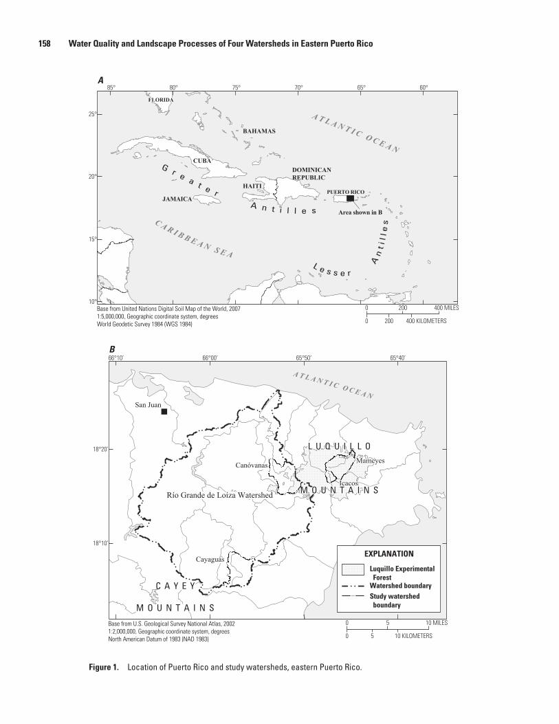
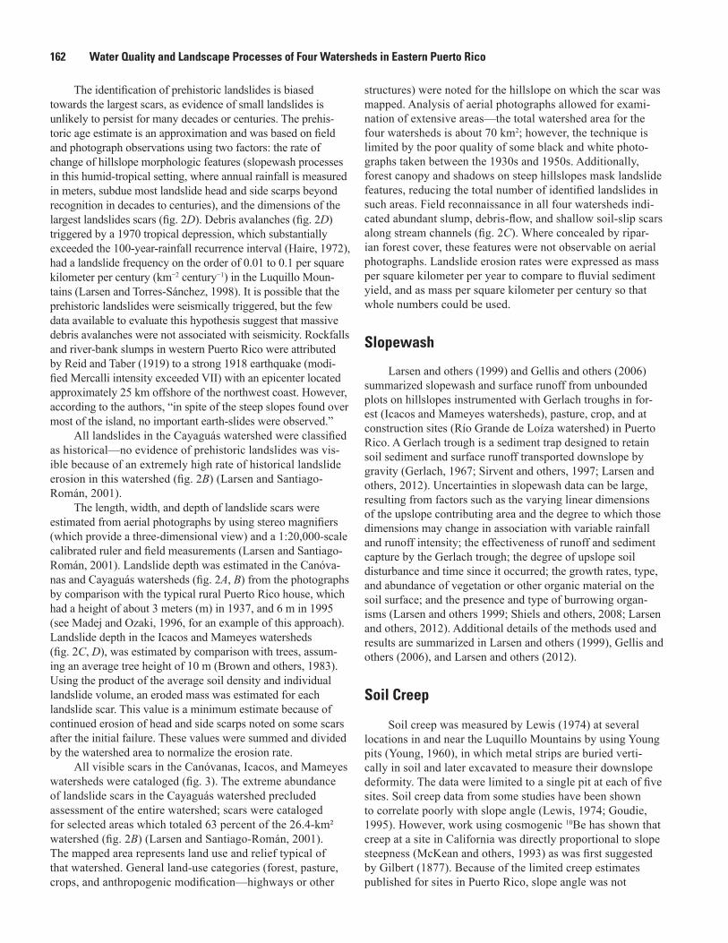
Figure 1. Location of Puerto Rico and study watersheds, eastern Puerto Rico.
Landslides and Sediment Budgets in Four Watersheds in Eastern Puerto Rico 159
flood hazards (Kates and others, 1990). The effect of develop-ment pressure is compounded in tropical nations, which tend to have limited resources for planning and carrying out careful economic development. Sustainable development of the trop-ics, as is true elsewhere, requires improved understanding of the long-term geomorphic effects on soil and water resources of economic development and human activities.
Small watersheds provide an ideal scale for the integrated study of hillslope and fluvial processes because their small size minimizes the spatial variability of lithology, land use, and cli-mate. Paired study of these small watersheds provides a means to isolate and then compare or contrast a variable of inter-est. Landslide, slopewash, soil creep, treethrow, suspended-sediment, streamflow, and sediment-storage data were used to quantify hillslope and fluvial erosion, transport, and storage processes, and to develop sediment budgets in two relatively undisturbed forested watersheds (Icacos and Mameyes) in the Luquillo Experimental Forest and two agriculturally developed watersheds in the adjacent Río Grande de Loíza watershed (Canóvanas and Cayaguás), Puerto Rico (fig. 1). Geology, climate, hydrology, and land cover of these watersheds are described in Murphy and others (2012), Murphy and Stallard (2012), and Gould and others (2012). The objectives of this work were to quantify and contrast geomorphic processes in relatively undisturbed and developed watersheds in an environ-ment—the montane humid tropics—where relatively little geo-morphic research has been done. This study provides sediment budgets that can be compared with budgets in other settings and highlights the importance of landsliding as the dominant mass-wasting process in the montane humid tropics.
Landslides
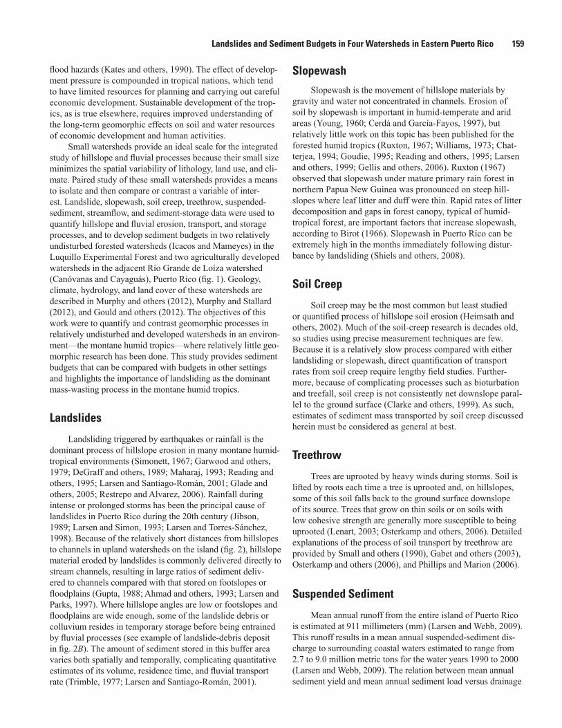
Landsliding triggered by earthquakes or rainfall is the dominant process of hillslope erosion in many montane humid-tropical environments (Simonett, 1967; Garwood and others, 1979; DeGraff and others, 1989; Maharaj, 1993; Reading and others, 1995; Larsen and Santiago-Román, 2001; Glade and others, 2005; Restrepo and Alvarez, 2006). Rainfall during intense or prolonged storms has been the principal cause of landslides in Puerto Rico during the 20th century (Jibson, 1989; Larsen and Simon, 1993; Larsen and Torres-Sánchez, 1998). Because of the relatively short distances from hillslopes to channels in upland watersheds on the island (fig. 2), hillslope material eroded by landslides is commonly delivered directly to stream channels, resulting in large ratios of sediment deliv-ered to channels compared with that stored on footslopes or floodplains (Gupta, 1988; Ahmad and others, 1993; Larsen and Parks, 1997). Where hillslope angles are low or footslopes and floodplains are wide enough, some of the landslide debris or colluvium resides in temporary storage before being entrained by fluvial processes (see example of landslide-debris deposit in fig. 2B). The amount of sediment stored in this buffer area varies both spatially and temporally, complicating quantitative estimates of its volume, residence time, and fluvial transport rate (Trimble, 1977; Larsen and Santiago-Román, 2001).
Slopewash
Slopewash is the movement of hillslope materials by gravity and water not concentrated in channels. Erosion of soil by slopewash is important in humid-temperate and arid areas (Young, 1960; Cerdá and García-Fayos, 1997), but relatively little work on this topic has been published for the forested humid tropics (Ruxton, 1967; Williams, 1973; Chat-terjea, 1994; Goudie, 1995; Reading and others, 1995; Larsen and others, 1999; Gellis and others, 2006). Ruxton (1967) observed that slopewash under mature primary rain forest in northern Papua New Guinea was pronounced on steep hill-slopes where leaf litter and duff were thin. Rapid rates of litter decomposition and gaps in forest canopy, typical of humid-tropical forest, are important factors that increase slopewash, according to Birot (1966). Slopewash in Puerto Rico can be extremely high in the months immediately following distur-bance by landsliding (Shiels and others, 2008).
Soil Creep
Soil creep may be the most common but least studied or quantified process of hillslope soil erosion (Heimsath and others, 2002). Much of the soil-creep research is decades old, so studies using precise measurement techniques are few. Because it is a relatively slow process compared with either landsliding or slopewash, direct quantification of transport rates from soil creep require lengthy field studies. Further-more, because of complicating processes such as bioturbation and treefall, soil creep is not consistently net downslope paral-lel to the ground surface (Clarke and others, 1999). As such, estimates of sediment mass transported by soil creep discussed herein must be considered as general at best.
Treethrow
Trees are uprooted by heavy winds during storms. Soil is lifted by roots each time a tree is uprooted and, on hillslopes, some of this soil falls back to the ground surface downslope of its source. Trees that grow on thin soils or on soils with low cohesive strength are generally more susceptible to being uprooted (Lenart, 2003; Osterkamp and others, 2006). Detailed explanations of the process of soil transport by treethrow are provided by Small and others (1990), Gabet and others (2003), Osterkamp and others (2006), and Phillips and Marion (2006).
Suspended Sediment
Mean annual runoff from the entire island of Puerto Rico is estimated at 911 millimeters (mm) (Larsen and Webb, 2009). This runoff results in a mean annual suspended-sediment dis-charge to surrounding coastal waters estimated to range from 2.7 to 9.0 million metric tons for the water years 1990 to 2000 (Larsen and Webb, 2009). The relation between mean annual sediment yield and mean annual sediment load versus drainage
160 Water Quality and Landscape Processes of Four Watersheds in Eastern Puerto Rico
N:\Jeff\den11_hwcg00_0224_pp_murphy\chapter_F_figures\BW_figures\BWfigure_02F.ai
A
C
D
B
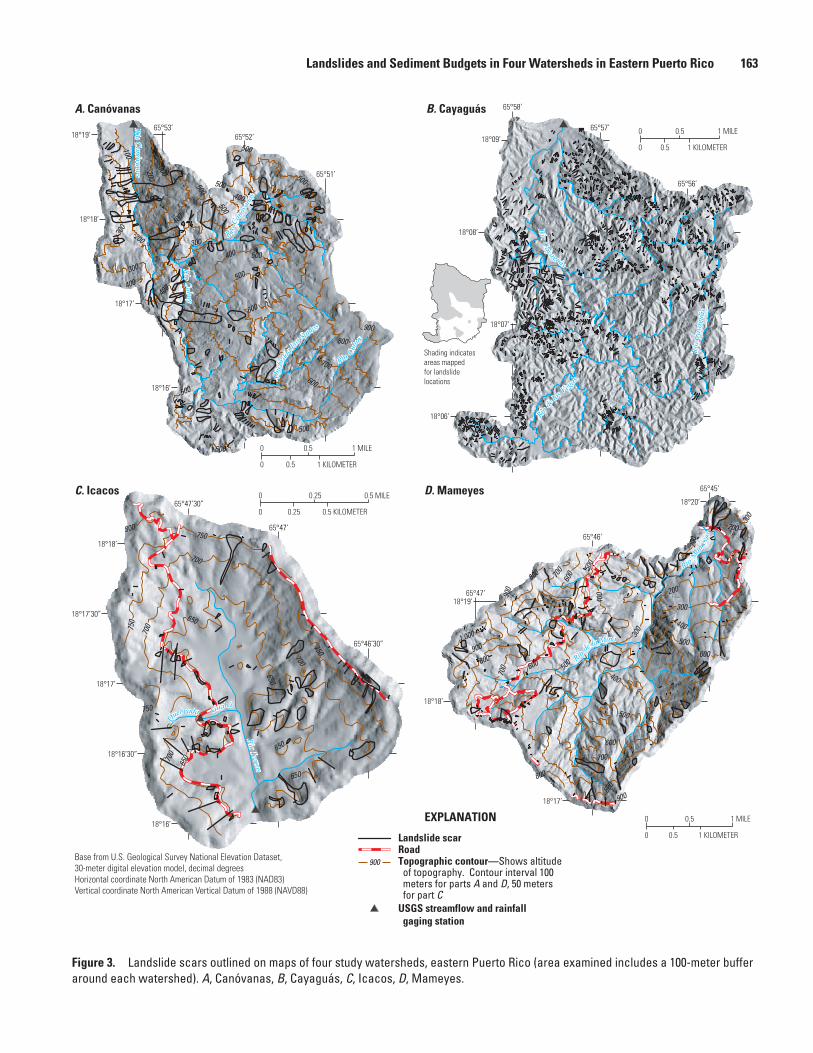
Figure 2. Landslides in the study watersheds, eastern Puerto Rico. A, Roadside slump in the upper Canóvanas watershed. Roadside slumps are an important source of sediment in ephemeral and perennial streams. B, Coalesced debris-flow scars estimated to be 10–20 years in age in the Cayaguás watershed, showing recovery of vegetation on scar surface and landslide debris deposited at footslope. C, Slump along Río Icacos channel, showing transport of landslide debris directly to river channel. D, Aerial view of two large debris-avalanche scars, Icacos watershed, 1989. Debris avalanche to right, triggered by Hurricane Hugo in 1989, measured 33 m wide at the headscarp and had a volume of approximately 30,000 m3. Debris-avalanche scar to left delivered several hundred thousand cubic meters of debris to the Río Icacos channel. It dates to a 1970 tropical depression (rainfall total of 976 mm).
Landslides and Sediment Budgets in Four Watersheds in Eastern Puerto Rico 161
area for Puerto Rico rivers is comparable to that of other rivers of the world draining similar terrain (Larsen and Webb, 2009). However, comparison of mean annual sediment yield to runoff indicates that Puerto Rico rivers are sensitive to the frequent high rainfall associated with tropical storms characteristic of this region (Larsen and Simon, 1993). Furthermore, sedi-ment discharge from the island is highly episodic and spatially uneven because of the variability of tropical storm frequency and topography throughout the island.
Watershed Sediment BudgetsWatershed sediment budgets have been developed
for a variety of geographic settings and spatial scales (for example, Trimble, 1977; Dietrich and Dunne, 1978; Meade, 1982; Milliman and Meade, 1983; Caine and Swanson, 1989; Nelson and Booth, 2002; Ramos-Scharron and MacDonald, 2007). These authors discuss the uncertainties of water-shed- to regional-scale sediment-budget calculations that are based on relatively short records of sediment flux, and they stress the importance of differentiating between human and “natural” rates of sediment yield. A particularly confound-ing uncertainty in areas with a history of human disturbance stems from sediment recently eroded (tens to hundreds of years ago) now in temporary storage on lower hillslopes, flood plains, and in aggraded channels, documented by Trimble (1977), Meade (1982), and Larsen and Santiago-Román (2001). These authors emphasize the uncertainties of attempting to use present-day sediment transport rates to estimate long-term watershed denudation rates. In the sub-tropical Serra do Mar, Brazil, for example, sediment recently eroded (in the 19th and 20th centuries) lies as a colluvial apron at the foot of slopes and, as stated by Haggett (1961), slope conservation efforts may be a century too late.
The work described herein follows the approach outlined by Dietrich and Dunne (1978) that has been widely applied for the development of sediment budgets for small water-sheds. Their work describes the quantification of fluvial and hillslope sediment erosion and transport and accounts for debris flows, soil creep, treethrow effects, and the residence time of particles on the valley floor, channel, and hillslope. Because much of the data they required for their budget were unavailable, they used data from nearby or similar watersheds to supplement their work.
Analysis of Geomorphic ProcessesFor each of the watersheds studied, geomorphic pro-
cesses were described and sediment budgets were estimated for landslides at the watershed scale. Slopewash, soil creep, and treethrow sediment budgets were estimated at hillslope and plot scale and extrapolated to watersheds. Erosion of channel banks during storms is also a source of sedi-ment and, although such erosion was observed in the four
watersheds, it was not quantified for this study. Generalized land use and the location and extent of landslide scars were mapped using black and white stereo aerial photographs ranging in scale from 1:17,000 to 20,000 for several years between 1937 and 1995 in each of the four study watersheds. Additionally, for the Icacos and Mameyes watersheds, pho-tographs from 1951, 1962–67, 1971–77, and 1990 were used (Larsen and Torres-Sánchez, 1998).
Previously published slopewash data were used to characterize hillslope erosion process, rates, and budgets in the Icacos, Mameyes, and Río Grande de Loíza watersheds (Larsen and others, 1999; Gellis and others, 2006). Soil creep rates were based on work by Lewis (1974) in the Mameyes watershed. Data from Scatena and Lugo (1995) and Larsen (1997) were used to estimate soil eroded by treethrow in the Mameyes watershed. Fluvial sediment data were obtained from U.S. Geological Survey publications (Figueroa-Alamo and others, 2006) and summarized from Larsen (1997), Larsen and Webb (2009) and Stallard and Murphy (2012).
Landslides
Landslides mapped in each of the watersheds were classi-fied by type or movement style (debris flow, slump, shallow soil slip, debris avalanche, earthflow, complex slump–earthflow, and indeterminate) according to scar morphology using the termi-nology of Campbell (1975) and Cruden and Varnes (1996).
The mapped landslide scars were also classified by apparent age as either “historical” (defined herein as since 1820) or “prehistoric” (defined herein as during the last 1,000 years before 1820). These age classifications are approximate and, in the case of prehistoric scars, are based on size and the presence of mature forest cover, because no precise evidence of landslide scar age exists prior to 1937 aerial photographs. Using their morphology and large dimensions as the key identifying characteristics, prehistoric landslides were identified on aerial photographs. The largest historic scars were assumed to serve as a modern equivalent of landslide scars estimated to have formed before wide-spread deforestation, which began in the studied watersheds about 1820 (Morales Muñoz, 1943). Debris avalanches triggered by storms caused by a tropical depression in 1970 eroded hillslopes from ridgetops to stream channels and left scars that are comparable in dimension and morphology to numerous hillslope forms in the Luquillo Mountains (Larsen and Torres-Sánchez, 1998). Landslides classified as histori-cal (those that occurred after about 1820) are characterized by bare soil, some vegetation regrowth, head- and side-scarp boundaries that were clear to somewhat subdued at the head, and partially eroded or absent debris deposits. Landslides classified as prehistoric had rounded, gently sloping, eroded head- and side-scarp boundaries, and highly eroded or absent debris deposits. Identification of older scars was based mainly on hillslope morphology that usually showed amphitheater-shaped headscarps upslope of elongated rectilinear depres-sions that extended from ridgetop to stream channel.
162 Water Quality and Landscape Processes of Four Watersheds in Eastern Puerto Rico
The identification of prehistoric landslides is biased towards the largest scars, as evidence of small landslides is unlikely to persist for many decades or centuries. The prehis-toric age estimate is an approximation and was based on field and photograph observations using two factors: the rate of change of hillslope morphologic features (slopewash processes in this humid-tropical setting, where annual rainfall is measured in meters, subdue most landslide head and side scarps beyond recognition in decades to centuries), and the dimensions of the largest landslides scars (fig. 2D). Debris avalanches (fig. 2D) triggered by a 1970 tropical depression, which substantially exceeded the 100-year-rainfall recurrence interval (Haire, 1972), had a landslide frequency on the order of 0.01 to 0.1 per square kilometer per century (km−2 century−1) in the Luquillo Moun-tains (Larsen and Torres-Sánchez, 1998). It is possible that the prehistoric landslides were seismically triggered, but the few data available to evaluate this hypothesis suggest that massive debris avalanches were not associated with seismicity. Rockfalls and river-bank slumps in western Puerto Rico were attributed by Reid and Taber (1919) to a strong 1918 earthquake (modi-fied Mercalli intensity exceeded VII) with an epicenter located approximately 25 km offshore of the northwest coast. However, according to the authors, “in spite of the steep slopes found over most of the island, no important earth-slides were observed.”
All landslides in the Cayaguás watershed were classified as historical—no evidence of prehistoric landslides was vis-ible because of an extremely high rate of historical landslide erosion in this watershed (fig. 2B) (Larsen and Santiago-Román, 2001).
The length, width, and depth of landslide scars were estimated from aerial photographs by using stereo magnifiers (which provide a three-dimensional view) and a 1:20,000-scale calibrated ruler and field measurements (Larsen and Santiago-Román, 2001). Landslide depth was estimated in the Canóva-nas and Cayaguás watersheds (fig. 2A, B) from the photographs by comparison with the typical rural Puerto Rico house, which had a height of about 3 meters (m) in 1937, and 6 m in 1995 (see Madej and Ozaki, 1996, for an example of this approach). Landslide depth in the Icacos and Mameyes watersheds (fig. 2C, D), was estimated by comparison with trees, assum-ing an average tree height of 10 m (Brown and others, 1983). Using the product of the average soil density and individual landslide volume, an eroded mass was estimated for each landslide scar. This value is a minimum estimate because of continued erosion of head and side scarps noted on some scars after the initial failure. These values were summed and divided by the watershed area to normalize the erosion rate.
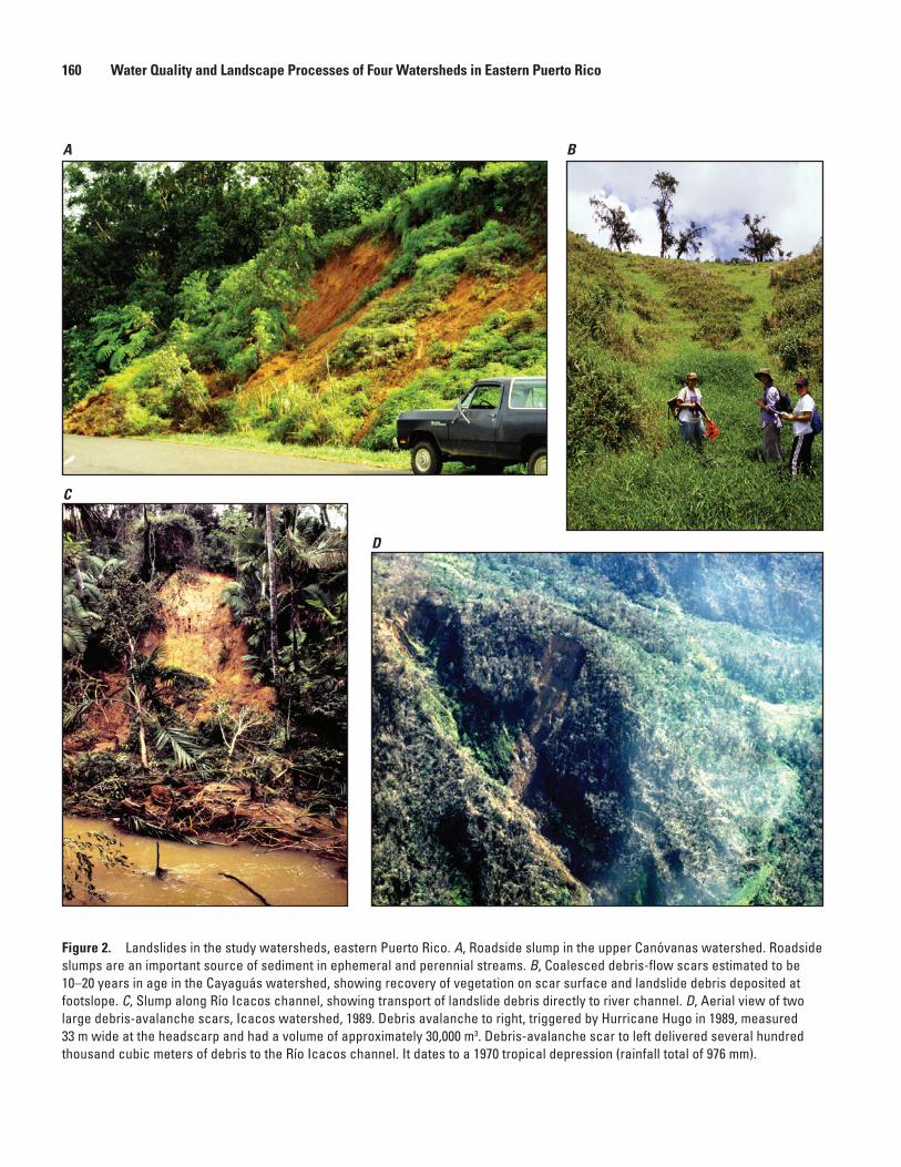
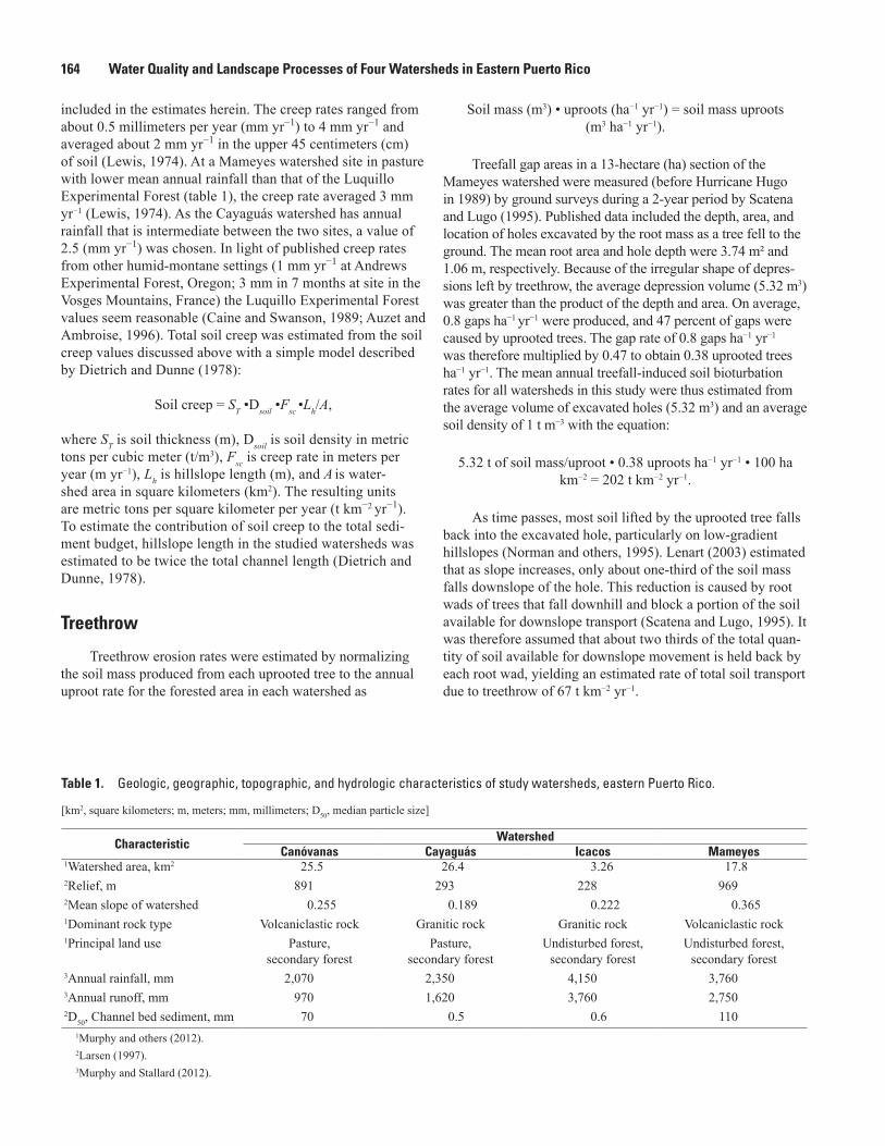
All visible scars in the Canóvanas, Icacos, and Mameyes watersheds were cataloged (fig. 3). The extreme abundance of landslide scars in the Cayaguás watershed precluded assessment of the entire watershed; scars were cataloged for selected areas which totaled 63 percent of the 26.4-km² watershed (fig. 2B) (Larsen and Santiago-Román, 2001). The mapped area represents land use and relief typical of that watershed. General land-use categories (forest, pasture, crops, and anthropogenic modification—highways or other
structures) were noted for the hillslope on which the scar was mapped. Analysis of aerial photographs allowed for exami-nation of extensive areas—the total watershed area for the four watersheds is about 70 km2; however, the technique is limited by the poor quality of some black and white photo-graphs taken between the 1930s and 1950s. Additionally, forest canopy and shadows on steep hillslopes mask landslide features, reducing the total number of identified landslides in such areas. Field reconnaissance in all four watersheds indi-cated abundant slump, debris-flow, and shallow soil-slip scars along stream channels (fig. 2C). Where concealed by ripar-ian forest cover, these features were not observable on aerial photographs. Landslide erosion rates were expressed as mass per square kilometer per year to compare to fluvial sediment yield, and as mass per square kilometer per century so that whole numbers could be used.
Slopewash
Larsen and others (1999) and Gellis and others (2006) summarized slopewash and surface runoff from unbounded plots on hillslopes instrumented with Gerlach troughs in for-est (Icacos and Mameyes watersheds), pasture, crop, and at construction sites (Río Grande de Loíza watershed) in Puerto Rico. A Gerlach trough is a sediment trap designed to retain soil sediment and surface runoff transported downslope by gravity (Gerlach, 1967; Sirvent and others, 1997; Larsen and others, 2012). Uncertainties in slopewash data can be large, resulting from factors such as the varying linear dimensions of the upslope contributing area and the degree to which those dimensions may change in association with variable rainfall and runoff intensity; the effectiveness of runoff and sediment capture by the Gerlach trough; the degree of upslope soil disturbance and time since it occurred; the growth rates, type, and abundance of vegetation or other organic material on the soil surface; and the presence and type of burrowing organ-isms (Larsen and others 1999; Shiels and others, 2008; Larsen and others, 2012). Additional details of the methods used and results are summarized in Larsen and others (1999), Gellis and others (2006), and Larsen and others (2012).
Soil Creep
Soil creep was measured by Lewis (1974) at several locations in and near the Luquillo Mountains by using Young pits (Young, 1960), in which metal strips are buried verti-cally in soil and later excavated to measure their downslope deformity. The data were limited to a single pit at each of five sites. Soil creep data from some studies have been shown to correlate poorly with slope angle (Lewis, 1974; Goudie, 1995). However, work using cosmogenic 10Be has shown that creep at a site in California was directly proportional to slope steepness (McKean and others, 1993) as was first suggested by Gilbert (1877). Because of the limited creep estimates published for sites in Puerto Rico, slope angle was not
Landslides and Sediment Budgets in Four Watersheds in Eastern Puerto Rico 163
N:\Jeff\den11_hwcg00_0224_pp_murphy\chapter_B_figures\BW_figures\BWfigure_03F
EXPLANATION
Landslide scarRoadTopographic contour—Shows altitude of topography. Contour interval 100 meters for parts A and D, 50 meters for part CUSGS streamflow and rainfall gaging station
900Base from U.S. Geological Survey National Elevation Dataset,30-meter digital elevation model, decimal degrees Horizontal coordinate North American Datum of 1983 (NAD83)Vertical coordinate North American Vertical Datum of 1988 (NAVD88)
A. Canóvanas
18°19’65°53’
65°52’
65°51’
18°16’
18°17’
18°18’
200
200
100
300
300
300
400
500
500
500
500
500
400
400
400
500
500
400
300
500
500
600
600
700
800
900
Río Canóvanas
R í o C
anóv
anas
500
Río Cub
uy
Río Cubuy
Que
brad
a Los
Santos
0 0.5
0
1 KILOMETER
0.5 1 MILE
18°07’
18°08’
18°09’
65°58’
65°57’
65°56’
18°06’
B. Cayaguás
0 0.5
0
1 KILOMETER
0.5 1 MILE
Río Cayaguás
Río d
e las
Vegas
Río
Caya
guás
C. Icacos
18°18’
18°17’
18°16’
18°17’30”
65°47’30”
65°47’
65°46’30”
18°16’30”
800750
750
750
700
700
650
650
650
650
65070
0
750
700
Río Icacos
Quebrada Guabá
0 0.25
0
0.5 KILOMETER
0.25 0.5 MILE
18°18’
18°19’
18°20’
18°17’
65°45’
65°46’
65°47’
D. Mameyes
1,000
900
900
900
800
800
700
600
600
500
400
600
600 50
040
0
300
300
300
200
200
200
500
500
400700
700
800
800Río M
ameyes
Río
de la Mina
0 0.5
0
1 KILOMETER
0.5 1 MILE
Shading indicatesareas mappedfor landslidelocations
Figure 3. Landslide scars outlined on maps of four study watersheds, eastern Puerto Rico (area examined includes a 100-meter buffer around each watershed). A, Canóvanas, B, Cayaguás, C, Icacos, D, Mameyes.
164 Water Quality and Landscape Processes of Four Watersheds in Eastern Puerto Rico
included in the estimates herein. The creep rates ranged from about 0.5 millimeters per year (mm yr−1) to 4 mm yr−1 and averaged about 2 mm yr−1 in the upper 45 centimeters (cm) of soil (Lewis, 1974). At a Mameyes watershed site in pasture with lower mean annual rainfall than that of the Luquillo Experimental Forest (table 1), the creep rate averaged 3 mm yr−1 (Lewis, 1974). As the Cayaguás watershed has annual rainfall that is intermediate between the two sites, a value of 2.5 (mm yr−1) was chosen. In light of published creep rates from other humid-montane settings (1 mm yr−1 at Andrews Experimental Forest, Oregon; 3 mm in 7 months at site in the Vosges Mountains, France) the Luquillo Experimental Forest values seem reasonable (Caine and Swanson, 1989; Auzet and Ambroise, 1996). Total soil creep was estimated from the soil creep values discussed above with a simple model described by Dietrich and Dunne (1978):
Soil creep = ST •Dsoil •Fsc •Lh/A,
where ST is soil thickness (m), Dsoil is soil density in metric tons per cubic meter (t/m3), Fsc is creep rate in meters per year (m yr−1), Lh is hillslope length (m), and A is water-shed area in square kilometers (km2). The resulting units are metric tons per square kilometer per year (t km−2 yr−1). To estimate the contribution of soil creep to the total sedi-ment budget, hillslope length in the studied watersheds was estimated to be twice the total channel length (Dietrich and Dunne, 1978).
Treethrow
Treethrow erosion rates were estimated by normalizing the soil mass produced from each uprooted tree to the annual uproot rate for the forested area in each watershed as
Soil mass (m3) • uproots (ha−1 yr−1) = soil mass uproots (m3 ha−1 yr−1).
Treefall gap areas in a 13-hectare (ha) section of the Mameyes watershed were measured (before Hurricane Hugo in 1989) by ground surveys during a 2-year period by Scatena and Lugo (1995). Published data included the depth, area, and location of holes excavated by the root mass as a tree fell to the ground. The mean root area and hole depth were 3.74 m² and 1.06 m, respectively. Because of the irregular shape of depres-sions left by treethrow, the average depression volume (5.32 m3) was greater than the product of the depth and area. On average, 0.8 gaps ha−1 yr−1 were produced, and 47 percent of gaps were caused by uprooted trees. The gap rate of 0.8 gaps ha−1 yr−1 was therefore multiplied by 0.47 to obtain 0.38 uprooted trees ha−1 yr−1. The mean annual treefall-induced soil bioturbation rates for all watersheds in this study were thus estimated from the average volume of excavated holes (5.32 m3) and an average soil density of 1 t m−3 with the equation:
5.32 t of soil mass/uproot • 0.38 uproots ha−1 yr−1 • 100 ha km−2 = 202 t km−2 yr−1.
As time passes, most soil lifted by the uprooted tree falls back into the excavated hole, particularly on low-gradient hillslopes (Norman and others, 1995). Lenart (2003) estimated that as slope increases, only about one-third of the soil mass falls downslope of the hole. This reduction is caused by root wads of trees that fall downhill and block a portion of the soil available for downslope transport (Scatena and Lugo, 1995). It was therefore assumed that about two thirds of the total quan-tity of soil available for downslope movement is held back by each root wad, yielding an estimated rate of total soil transport due to treethrow of 67 t km−2 yr−1.
Table 1. Geologic, geographic, topographic, and hydrologic characteristics of study watersheds, eastern Puerto Rico.
[km2, square kilometers; m, meters; mm, millimeters; D50, median particle size]
Characteristic WatershedCanóvanas Cayaguás Icacos Mameyes
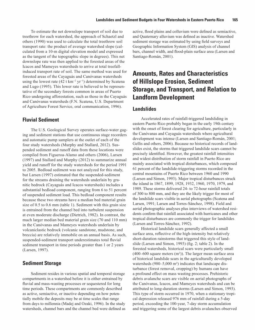
1Watershed area, km2 25.5 26.4 3.26 17.82Relief, m 891 293 228 9692Mean slope of watershed 0.255 0.189 0.222 0.3651Dominant rock type Volcaniclastic rock Granitic rock Granitic rock Volcaniclastic rock1Principal land use Pasture,
secondary forestPasture,
secondary forestUndisturbed forest,
secondary forestUndisturbed forest,
secondary forest3Annual rainfall, mm 2,070 2,350 4,150 3,7603Annual runoff, mm 970 1,620 3,760 2,7502D50, Channel bed sediment, mm 70 0.5 0.6 110
1Murphy and others (2012).2Larsen (1997).3Murphy and Stallard (2012).
Landslides and Sediment Budgets in Four Watersheds in Eastern Puerto Rico 165
To estimate the net downslope transport of soil due to treethrow for each watershed, the approach of Schaetzl and others (1990) was used to calculate the total treethrow soil transport rate: the product of average watershed slope (cal-culated from a 10-m digital elevation model and expressed as the tangent of the topographic slope in degrees). This net downslope rate was then applied to the forested areas of the Icacos and Mameyes watersheds to arrive at total treefall-induced transport rate of soil. The same method was used for forested areas of the Cayaguás and Canóvanas watersheds using the lowest rate (42 t km−2 yr−1) determined by Scatena and Lugo (1995). This lower rate is believed to be represen-tative of the secondary forests common in areas of Puerto Rico undergoing afforestation, such as those in the Cayaguás and Canóvanas watersheds (F.N. Scatena, U.S. Department of Agriculture Forest Service, oral communication, 1996).
Fluvial Sediment
The U.S. Geological Survey operates surface-water gag-ing and sediment stations that use continuous stage recorders and automatic pump samplers at the outlet of each of the four study watersheds (Murphy and Stallard, 2012). Sus-pended sediment and runoff data from these locations were compiled from Figueroa-Alamo and others (2006), Larsen (1997) and Stallard and Murphy (2012) to summarize annual yield and runoff for the study watersheds for the period 1991 to 2005. Bedload sediment was not analyzed for this study, but Larsen (1997) estimated that the suspended-sediment for the streams draining the watersheds underlain by gra-nitic bedrock (Cayaguás and Icacos watersheds) includes a substantial bedload component, ranging from 6 to 51 percent of suspended sediment load. This bedload component results because these two streams have a median bed material grain size of 0.5 to 0.6 mm (table 1). Sediment with this grain size is entrained from the channel bed into turbulent suspension at even moderate discharge (Dietrich, 1982). In contrast, the much larger median bed material grain size (70 and 110 mm) in the Canóvanas and Mameyes watersheds underlain by volcaniclastic bedrock (volcanic sandstone, mudstone, and breccia) are relatively immobile on an annual basis. As such, suspended-sediment transport underestimates total fluvial sediment transport in time periods greater than 1 or 2 years (Larsen, 1997).
Sediment Storage
Sediment resides in various spatial and temporal storage compartments in a watershed before it is either entrained by fluvial and mass-wasting processes or sequestered for long time periods. These compartments are commonly described as active, semiactive, or inactive depending on how poten-tially mobile the deposits may be at time scales that range from days to millennia (Madej and Ozaki, 1996). In the study watersheds, channel bars and the channel bed were defined as
active, flood plains and colluvium were defined as semiactive, and Quaternary alluvium was defined as inactive. Watershed sediment storage was estimated by using field surveys and Geographic Information System (GIS) analysis of channel bars, channel width, and flood-plain surface area (Larsen and Santiago-Román, 2001).
Amounts, Rates and Characteristics of Hillslope Erosion, Sediment Storage, and Transport, and Relation to Landform Development
Landslides
Accelerated rates of rainfall-triggered landsliding in eastern Puerto Rico probably began in the early 19th century with the onset of forest clearing for agriculture, particularly in the Canóvanas and Cayaguás watersheds where agricultural development was intense (Larsen and Santiago-Román, 2001; Gellis and others, 2006). Because no historical records of land-slides exist, the storms that triggered landslide scars cannot be precisely identified. However, the greatest rainfall intensities and widest distribution of storm rainfall in Puerto Rico are mainly associated with tropical disturbances, which composed 61 percent of the landslide-triggering storms recorded in the central mountains of Puerto Rico between 1960 and 1990 (Larsen and Simon, 1993). Major tropical disturbances struck the island in 1867, 1899, 1928, 1932, 1960, 1970, 1979, and 1989. These storms delivered 24- to 72-hour rainfall totals of 300 to 800 mm, and they are the likely trigger for most of the landslide scars visible in aerial photographs (Scatena and Larsen, 1991; Larsen and Torres-Sánchez, 1998). Field and aerial photographic analyses plus interviews of watershed resi-dents confirm that rainfall associated with hurricanes and other tropical disturbances are commonly the trigger for landslides (Larsen and Torres-Sánchez, 1992).
Historical landslide scars generally affected a small surface area, reflective of the high-intensity but relatively short-duration rainstorms that triggered this style of land-slide (Larsen and Simon, 1993) (fig. 2; table 2). In the forested watersheds, historical scars were particularly small (400–600 square meters (m2)). The larger mean surface area of historical landslide scars in the agriculturally developed watersheds (980–5,000 m²) indicates that landscape dis-turbance (forest removal, cropping) by humans can have a profound effect on mass wasting processes. Prehistoric debris avalanche scars are visible on aerial photographs of the Canóvanas, Icacos, and Mameyes watersheds and can be attributed to long-duration storms (Larsen and Simon, 1993). This type of storm occurred in 1970, when a stationary tropi-cal depression released 976 mm of rainfall during a 5-day period, exceeding the 100-year, 7-day storm accumulation and triggering some of the largest debris avalanches observed

166 Water Quality and Landscape Processes of Four Watersheds in Eastern Puerto Rico
on the island (fig. 2D; Haire, 1972). In the Cayaguás water-shed, the historical landslide frequency is so great that no rec-ognizable evidence of prehistoric landslides persists (fig. 2B). The large size of prehistoric landslide scars (6,300–49,000 m2) mapped in this overall study is mainly a reflection of the operational definition of these features.
Most landslide scars were classified as debris flows; soil slips were the second most common type of scar (Larsen, 1997). Both of these landslide types are characteristic of high-intensity, short-duration storms that result in 24-hour rainfall totals on the order of 200 mm (Larsen and Simon, 1993) and have about a 5-year recurrence interval (U.S. Department of Commerce, 1961). The remaining landslide scars were classi-fied mainly as slumps, debris avalanches, and complex. About 1 percent of landslide scars could not be categorized because of poorly defined features.
Landslide Frequency
Watershed area disturbed by historical landsliding is 1 percent or less in the forested Icacos and Mameyes water-sheds. About 3 percent of the Canóvanas watershed surface area was disturbed by historical landsliding, compared with an impressive 19 percent of the Cayaguás watershed (table 2). Historical landslide frequency in the developed Canóvanas and Cayaguás watersheds was estimated to be four landslides km−2 century−1 and 80 landslides km−2 century−1, respectively (table 2). The 20-fold difference in the landslide frequency between the two watersheds can be attributed to both the more intensive land-use practices and more erodible bedrock in the Cayaguás watershed (Gould and others, 2012; Murphy and others, 2012). In the well-forested Icacos and Mameyes water-sheds, historical landslide frequency was 43 and 21 landslides
Table 2. Dimensions of 2,882 landslides mapped from aerial photographs (1937, 1951, 1962, 1972, 1974, 1979, 1990, and 1995) in four watersheds, eastern Puerto Rico.1
[m, meter; m2, square meter; m2 km–2, square meter per square kilometer; m3, cubic meter; m3 km–2, cubic meter per square kilometer; t, metric ton; km2, square kilometer; t km−2, metric tons per square kilometer; t km−2 yr−1, metric tons per square kilometer per year; km2 century–1, square kilometers per century]
CharacteristicWatershed and landslide age
Canóvanas2 Cayaguás2 Icacos3 Mameyes3
Historical Prehistoric Historical Historical Prehistoric Historical PrehistoricLandslides mapped 172 44 2,321 70 24 189 62Mean length, m 90 330 53 30 130 30 310Mean width, m 30 100 16 20 30 15 53Mean depth4, m 4 20 3.5 2 9 2 12Mean surface area, m² 5,000 49,000 980 600 6,300 400 17,000Mean volume, m3 72,000 935,000 4,700 1,200 71,000 1,200 310,000Mean mass, t 94,000 1,234,000 2,300 2,000 93,000 2,300 605,000Total surface area, m² 874,000 2,168,000 2,270,000 42,000 152,000 70,600 1,031,000Total volume, m3 12,314,000 41,159,000 10,900,000 84,000 1,696,000 218,700 19,231,000Total mass, t 16,254,000 54,329,000 14,400,000 111,000 2,239,000 426,500 37,501,000Landslide scars per km2 7 2 140 22 7 11 4Landslide surface area per
watershed area, m2 km–234,000 85,000 140,000 13,000 47,000 4,000 58,000
Percent of basin surface area 3 9 14 1 5 0.4 5.8Landslide volume per
watershed area, m3 km–2483,000 1,615,000 660,000 26,000 520,000 12,000 1,079,000
Total surface lowering averaged for study area, m
0.5 1.6 0.66 0.03 0.52 0.01 1.08
Landslide mass, t km–² 638,000 2,132,000 870,000 34,000 687,000 24,000 2,104,000Landslide mass, t km−2 yr−1 4,000 2,000 5,000 700 700 480 2,100Landslides per km2 per 100 yr 4 0.2 80 43 0.7 21 0.3
1Prehistoric landslide scars were estimated to represent as much as 1,000 years of landslide activity. Volume was converted to mass by using an average land-slide debris density of 1.3 metric tons per cubic meter. Data for Canóvanas, Icacos, and Mameyes watersheds from Larsen (1997); data for Cayaguás watershed from Larsen and Santiago-Román (2001). Mapped area of Cayaguás watershed was 16.6 square kilometers (63 percent of the total area of the watershed). Other watersheds were fully mapped.
2In Canóvanas and Cayaguás watersheds, historical landslide scars estimated to represent landslide activity since forest clearing for settlement began in the 1820s.
3In forested Icacos and Mameyes watersheds, historical landslide scars estimated to represent landslide activity for a 50 year period (1945–1995).4Calculated as an unweighted average of all landslides.
Landslides and Sediment Budgets in Four Watersheds in Eastern Puerto Rico 167
km−2 century−1, respectively. This twofold difference is attrib-uted to the more landslide-prone soil and saprolite weathered from the granitic bedrock of the Icacos watershed compared with the volcaniclastic Mameyes watershed.
Mean annual rainfall in the Icacos watershed is almost double that of the lithologically similar Cayaguás watershed (table 1); therefore, if other factors were equal, the landslide frequency in the Icacos watershed would be expected to be greater than in the Cayaguás watershed. However, historical landslide frequency in the developed Cayaguás watershed was about double that in the forested Icacos watershed (table 2). Note that the dense forest cover of the Icacos watershed reduces the number of visible landslide scars, so the twofold difference may not be as great as estimated here. Evidence of an anthropogenic effect on landslide frequency and location is apparent in the forested watersheds. Forty-three percent of the 189 historical landslides mapped in the Mameyes water-shed were associated with road construction and maintenance (fig. 2A; Larsen and Parks, 1997). Most of these landslides were small slumps and shallow soil slips that eroded about 80 t km−2 yr−1, or approximately one-half of all landslide-derived sediment. In the Icacos watershed, the majority (63 percent) of the 70 historical scars were associated with road construction and maintenance, resulting in 500 t km−2 yr−1 of hillslope erosion.
Landslide Erosion Rate
The estimated mass wasting rate by historical landsliding in the Canóvanas watershed is about 4,000 t km−2 yr−1, twice that estimated for the prehistoric period (table 2), suggest-ing that forest clearing and other agricultural practices have significantly increased hillslope erosion in this watershed. Examination of aerial photography indicates that mass-wasting has been even greater in the Cayaguás watershed, where land-slides have eroded approximately 5,000 t km−2 yr−1 since the watershed was first occupied for subsistence farming (fig. 3; table 2). This mass of material is equivalent to an average watershed surface lowering of 0.66 m in 175 years, compara-ble to the 0.5-m lowering estimate since European occupation of the region, determined from analysis of cosmogenic 10Be concentration in fluvial sediment in this watershed (Brown and others, 1998).
It is unlikely that the extremely high frequency of histori-cal mass wasting in the Cayaguás watershed existed prior to the period of major land clearing. At present, extensive deposits of the material, apparently eroded during the 19th and 20th centuries, remain in storage throughout the watershed as colluvium as much as 3 m deep on footslopes and as alluvium 1 to 3 m deep along channels and flood plains (Clark and Wilcock, 2000; Larsen and Santiago Román, 2001). Colluvial deposits from groups of small landslide scars coalesce to fill the floors of small zero-order hollows (fig. 2B). Extensive col-luvial deposits also mantle the floors of first- and second-order valleys and create poorly drained bog-like soils (Larsen and Santiago Román, 2001).
In the granitic-bedrock Icacos watershed, the rate of historical landslide-induced mass wasting was estimated to be about 700 t km−2 yr−1. This rate is substantially less than that estimated for the lithologically similar but developed Cayaguás watershed, but about 1.5 times as great as that of the volcaniclastic, forested Mameyes watershed (table 2). Prehistoric landslide scars affected approximately 5 percent of the Icacos watershed surface area, or about 0.5 percent per 100 years, essentially identical to the rate per 100 years deter-mined for the Mameyes watershed (table 2).
A total of 26 of the 70 historical landslides in the Icacos watershed were not associated with roadways because they were distal to road corridors. These landslides had a mean mass of 1,200 t and eroded a total mass of 200 −2 yr−1. This landslide erosion rate probably represents the “natural” rate, or the rate that might be expected for this watershed in the absence of human activity. This rate is less than one-third that estimated for prehistoric landsliding (annual rate of erosion is 700 t km−2), indicating that watershed conditions may have been wetter or storms more frequent during the last 1,000 years. This possibility is supported by work by Don-nelly and Woodruff (2007) in which they describe increased tropical storm intensity in the late Holocene near Puerto Rico. Mayewski and others (2004) describe both wetter and drier periods in the Caribbean, but these periods are in the early to middle Holocene. Alternatively, shifting agriculture (known also as “slash and burn”) of pre-European populations may have been actively practiced on hillslopes, resulting in acceler-ated rates of landsliding (Denevan, 1992). Accounts of Taino Indian population in the Greater Antilles in the 16th century indicate that large numbers of inhabitants resided in these islands; in Puerto Rico, the estimate is as much as 600,000 (Rouse, 1993). A population of this size would likely have occupied at least some hillslope settings and could have altered vegetation, soil stability, and hillslope erosion.
Slopewash
Slopewash erosion rates were estimated to range between 30 and 105 t km−2 yr−1 in the developed watersheds (Canóva-nas and Cayaguás, respectively) and between 5 and 20 t km−2 yr−1 in the forested Mameyes and Icacos watersheds, respectively (table 3) (Larsen and others 1999; Gellis and others, 2006). Larsen and others (2012) reported a comparable slopewash rate, 12 t km−2 yr−1, on a low-gradient hillslope under undisturbed forest canopy in the El Verde section of the Luquillo Experimental Forest. Slopewash was observed as deposits in swales on hillslopes and on footslopes along ephemeral and perennial channels, where it is available for transport into channels. Additionally, other mass wasting processes, including landslides, soil creep, and slumping or erosion of channel banks transport slopewash into channels where it is entrained as fluvial sediment.
Bruenig (1975) measured average slopewash rates of 20 t km−2 y−1 under virgin forest; slopewash may be as high as 100 t km−2 y−1 for the humid tropics in general (UNESCO/
168 Water Quality and Landscape Processes of Four Watersheds in Eastern Puerto Rico
UNEP/FAO, 1978). Gellis and others (2006) reported slope-wash rates in the Río Grande de Loíza watershed, Puerto Rico, ranging from 10 t km−2 in secondary forest and pasture, to 31 to 86 t km−2 on hillslopes in crops, and 288 to 910 t km−2 at construction sites. Shiels and others (2008) reported remark-ably high slopewash rates of 25 to 81grams per square meter in 1-m2 bounded plots (from December 2003 to May 2004) at the center of freshly exposed landslide scars on volcaniclastic and quartz diorite bedrock in the Luquillo Mountains.
Soil Creep
Annual rates of soil creep for each watershed were esti-mated to be 9–12 t km−2 yr−1 (table 4). These rates are approxi-mations because of the large uncertainties and variability in creep rate, soil thickness and density, and hillslope lengths within each watershed. Soil creep mobilizes an annual mass of sediment comparable to the contributions of treethrow, but generally less than the slopewash contribution in each water-shed. It is assumed that this mass of soil is supplied to channel margins of ephemeral and perennial streams and is entrained by slumping, abrasion, and avulsion of stream banks during high discharge.
In humid-temperate environments, sediment delivery to river channels by soil creep in forested watersheds was estimated at 29 t km−2 yr−1 from Clearwater River watershed, Washington (Reid, 1981), and at 11 t km−2 yr−1 from water-shed 10, Cascade Range, Oregon (Swanson and others, 1982). In New South Wales, Australia, Heimsath and others (2002) estimated soil creep at 6 mm yr−1 on a hillslope in intermedi-ate to wet schlerophyll forest. Soil creep rates in the Luquillo Experimental Forest averaged about 2 mm yr−1 and ranged from about 0.5 mm yr−1 to 4 mm yr−1 (Lewis, 1974). These rates correlate poorly with slope gradient, indicating that slope angle may not be a limiting factor on most hillslopes. However, the paucity of data makes this difficult to confirm. No other soil creep data are available for the study watershed.
Using the annual creep rate of 2 mm and mean slope length of 51 m in the northeastern Luquillo Experimental Forest, Scatena (1995) estimated that creep could remove all hillslope topsoil, absent any soil production from the weathering of bedrock, in a period of 27,000 years.
Treethrow
Estimates of treethrow contribution to hillslope soil movement range from 4 to 29 t km−2 yr−1 in the study water-sheds (table 3). Rates are lower in the developed watersheds owing to less forest cover and because secondary-forest treethrow rates are lower, possibly as a result of lesser tree height. Because the treethrow model is most sensitive to slope, the four watersheds show additional variation as a function of their relative steepness. Bedrock lithology controls treethrow erosion because of relatively greater steeply sloping watershed area. The mean annual treethrow erosion rate for the Canóva-nas watershed is reduced because only about 71 percent of the watershed is currently forested (Murphy and others, 2012). Because the Cayaguás watershed has less steep slopes and is only about 42 percent forested, the contribution of treethrow
Table 3. Types and estimated rates of hillslope erosion in study watersheds, eastern Puerto Rico.
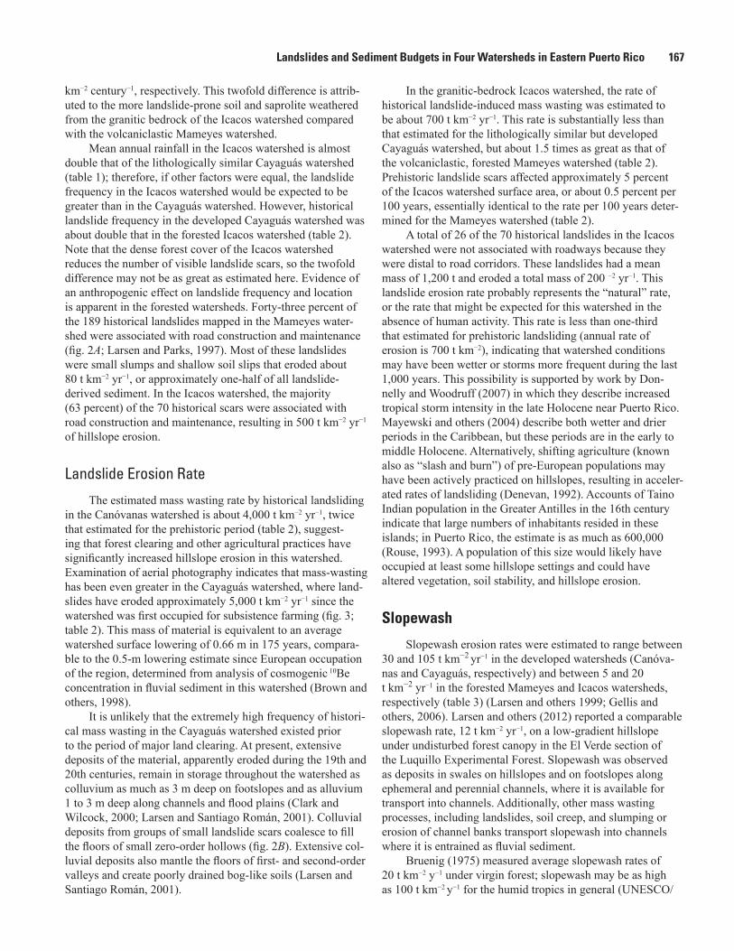
[--, not available]
Hillslope erosion processAverage rate
(metric tons per square kilometer per year)Canóvanas Cayaguás Icacos Mameyes
Treethrow 11 4 19 29Soil creep 12 11 11 9Slopewash 30 105 20 5Landslide: Historical 4,000 5,000 700 480
Prehistoric 2,000 -- 700 2,100Total hillslope erosion (range varies with landslide rate used) 2,053 to 4,053 5,120 750 523 to 2,143Suspended-sediment yield1 424 2,110 2,140 325Bedload yield2 83 -- -- 110Sediment delivery, percent (calculated as suspended sediment yield/
total hillslope erosion; range reflects landslide rates above)10 to 21 41 285 15 to 62
1From Stallard and Murphy (2012).2From Larsen (1997).
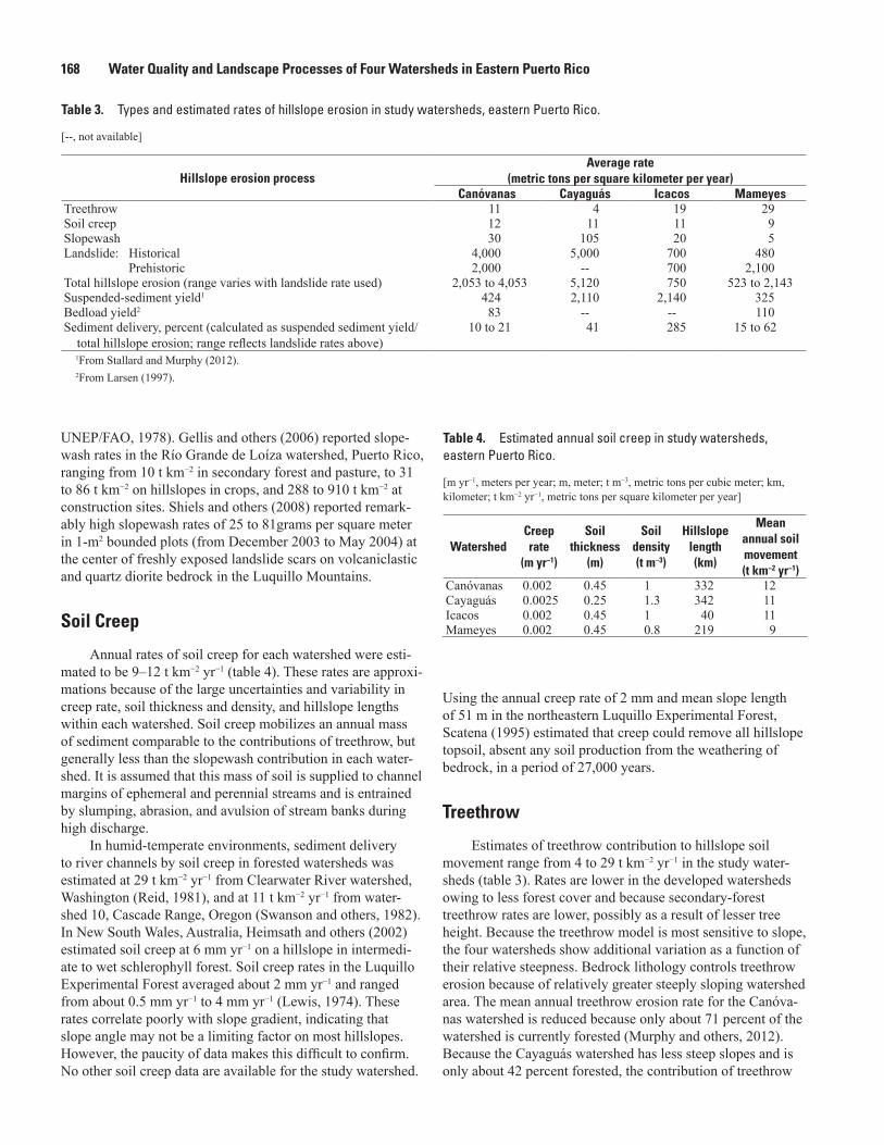
Table 4. Estimated annual soil creep in study watersheds, eastern Puerto Rico.
[m yr−1, meters per year; m, meter; t m−3, metric tons per cubic meter; km, kilometer; t km−2 yr−1, metric tons per square kilometer per year]
WatershedCreep rate
(m yr−1)
Soil thickness
(m)
Soil density (t m–3)
Hillslope length (km)
Mean annual soil movement (t km−2 yr−1)
Canóvanas 0.002 0.45 1 332 12Cayaguás 0.0025 0.25 1.3 342 11Icacos 0.002 0.45 1 40 11Mameyes 0.002 0.45 0.8 219 9
Landslides and Sediment Budgets in Four Watersheds in Eastern Puerto Rico 169
soil erosion is only 4 t km−2 yr−1. Comparable values were esti-mated in North American settings, where sediment delivery to river channels by treethrow was estimated at 9 t km−2 yr−1 from Clearwater River watershed, Washington (Reid, 1981), and at 1 t km−2 yr−1 from watershed 10, Cascade Range, Oregon (Swanson and others, 1982).
Fluvial Sediment
Mean suspended sediment yield (or export) ranged from 325 to 2,140 t km−2 yr−1 in the study watersheds for the period 1991–2005, varying with land use and bedrock lithology (table 5). These values are comparable to island-wide esti-mates of 570 to 1,900 t km−2 yr−1 for the period 1990–2000 (Larsen and Webb, 2009). Using a bedload transport equa-tion from Parker and others (1982), Larsen (1997) estimated bedload transport in the Canóvanas and Mameyes rivers for the period 1991–1995 at 83 t km−2 yr−1 and 110 t km−2 yr−1, respectively. It should be noted that bedload-sediment transport models are potentially inaccurate by as much as an order of magnitude or more in predicting annual loads, and for the most part they predict maximum potential loads if the various frictional effects of channel obstructions that reduce transport are not considered (Gomez and Church, 1989). With this uncertainty in mind, Larsen (1997) reported that bedload transport was estimated to have occurred for a total of about 7 days during the 5-year (1991–1995) study period in the Canóvanas and Mameyes rivers. The mass of bedload trapped behind wire screens (10-cm mesh) at gaging stations moni-tored by the U.S. Department of Agriculture Forest Service on two Mameyes tributaries averaged 52 t km−2 yr−1 (F.N. Scatena, written commun., 1996). This rate is 47 percent of the median rate of 110 t km−2 yr−1 estimated for the Río Mameyes. The factor-of-2 difference between the two values suggests that the modeled bedload estimates are reasonably accurate, if one considers the coarse screen size used on the Mameyes tributaries and the inherent uncertainties noted above associ-ated with bedload transport models.
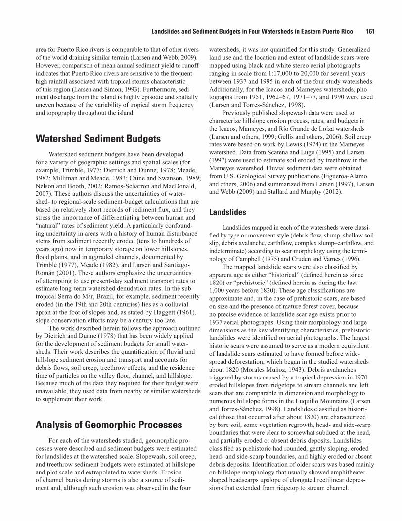
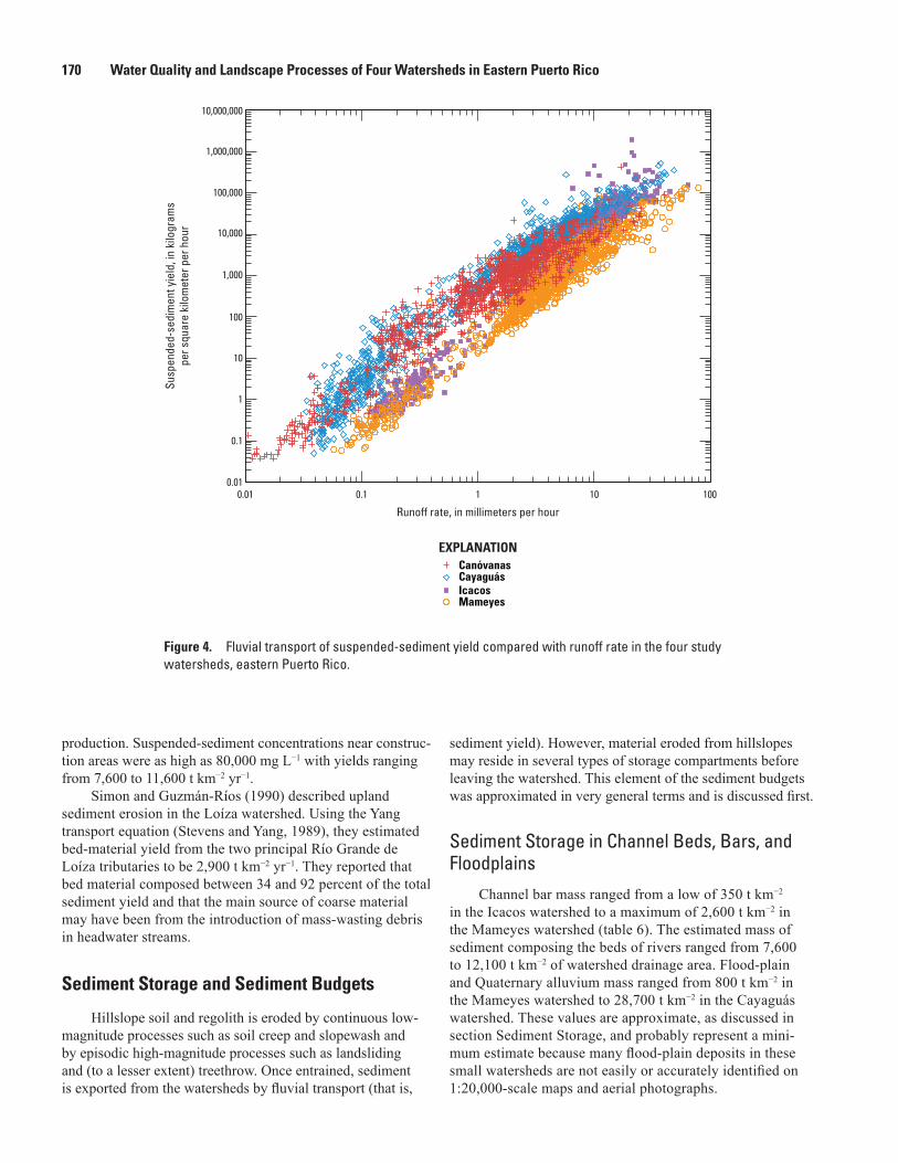
Sediment concentration, calculated here as sediment yield normalized by runoff, was about 2.3 to 3.7 times as great in the two watersheds in secondary forest and pasture compared with sediment concentration in the watersheds in primary forest (fig. 4). The influence of lithology was comparable: sediment concentration in granitic-bedrock (quartz diorite and granodiorite) watersheds was 3.0 to 4.7 times as high as sediment concentration in volcaniclastic-bedrock watersheds.
These contrasts highlight the well-known effect of land use on sediment yield, but they also make apparent the strong control of bedrock geology as well.
The relation between suspended-sediment yield and runoff among the four study watersheds is relatively consis-tent for three orders of runoff, from about 0.1 millimeters per hour (mm h−1) to 30 mm h−1 (fig. 4). Yield from the forested Mameyes watershed is the least per unit of runoff, in spite of the great relief (approximately 1 km) of the watershed. The forested Icacos watershed is comparable to the Canóvanas watershed with respect to suspended-sediment yield per unit of runoff. Although relief in the Icacos watershed is much lower than that of the Mameyes watershed, the more easily mobilized sediment in this sandy-bed river makes the Icacos productive. Suspended-sediment yield from the Canóvanas watershed is large, because relief is high and the landscape has been dis-turbed for agriculture and pasture. Finally, suspended-sediment yield from the Cayaguás watershed is the greatest of the four watersheds, because of the combination of easily mobilized sediment in the sandy-bed river and the great anthropogenic disturbance. Most of the landscape was deforested during the past two centuries for agricultural and pastoral use (Larsen and Santiago-Román, 2001). Mean annual suspended-sediment discharge from Puerto Rico into surrounding coastal waters is estimated to range from 2.7 to 9.0 million metric tons (Larsen and Webb, 2009). Storm runoff transports a substantial part of fluvial suspended sediment from uplands to the coast; for example, the highest recorded daily sediment discharge is 1 to 3.6 times the annual suspended-sediment discharge, and runoff from major storms induces sediment transport 1 to 32 times the median annual sediment load. During this study, suspended-sediment yield (measured as instantaneous concentration) from the four study watersheds extended about nine orders of magnitude, from a low of 0.04 kg km−2 h−1 in the Canóvanas watershed to a remarkable 2 million kg km−2 h−1 in the Icacos watershed (fig. 4).
Gellis (1993) described fluvial sediment transported by the discharge related to Hurricane Hugo in the Loíza water-shed. He noted that observed suspended-sediment loads were less than expected because high winds caused vegetation and debris to accumulate on hillslopes where it blanketed the soil surface, and in channels where it resulted in local backwater effects that reduced stream velocity. The storm-average suspended sediment concentration in the Río Grande de Loíza was 2,290 mg L−1, the second lowest of 12 storms monitored at the site. In another study, Gellis (1991), again in the Loíza watershed, evaluated the effects of construction on sediment
Table 5. Annual fluvial suspended sediment for the period 1991–2005 in study watersheds, eastern Puerto Rico.1
[t km−2 yr−1, metric tons per square kilometer per year; kg km−2 mm−1, kilograms per square kilometer per millimeter, which is equivalent to milligrams per liter]
Measure of sediment load Canóvanas Cayaguás Icacos MameyesMean suspended sediment export, t km−2 yr−1 424 2,110 2,140 325Mean suspended sediment concentration, kg km−2 mm−1 of runoff 435 1,300 560 118
1U.S. Geological Survey data summarized from Stallard and Murphy (2012).
170 Water Quality and Landscape Processes of Four Watersheds in Eastern Puerto Rico
production. Suspended-sediment concentrations near construc-tion areas were as high as 80,000 mg L−1 with yields ranging from 7,600 to 11,600 t km−2 yr−1.
Simon and Guzmán-Ríos (1990) described upland sediment erosion in the Loíza watershed. Using the Yang transport equation (Stevens and Yang, 1989), they estimated bed-material yield from the two principal Río Grande de Loíza tributaries to be 2,900 t km−2 yr−1. They reported that bed material composed between 34 and 92 percent of the total sediment yield and that the main source of coarse material may have been from the introduction of mass-wasting debris in headwater streams.
Sediment Storage and Sediment Budgets
Hillslope soil and regolith is eroded by continuous low-magnitude processes such as soil creep and slopewash and by episodic high-magnitude processes such as landsliding and (to a lesser extent) treethrow. Once entrained, sediment is exported from the watersheds by fluvial transport (that is,
sediment yield). However, material eroded from hillslopes may reside in several types of storage compartments before leaving the watershed. This element of the sediment budgets was approximated in very general terms and is discussed first.
Sediment Storage in Channel Beds, Bars, and Floodplains
Channel bar mass ranged from a low of 350 t km−2 in the Icacos watershed to a maximum of 2,600 t km−2 in the Mameyes watershed (table 6). The estimated mass of sediment composing the beds of rivers ranged from 7,600 to 12,100 t km−2 of watershed drainage area. Flood-plain and Quaternary alluvium mass ranged from 800 t km−2 in the Mameyes watershed to 28,700 t km−2 in the Cayaguás watershed. These values are approximate, as discussed in section Sediment Storage, and probably represent a mini-mum estimate because many flood-plain deposits in these small watersheds are not easily or accurately identified on 1:20,000-scale maps and aerial photographs.
N:\Jeff\den11_hwcg00_0224_pp_murphy\chapter_F_figures\BW_figures\BWfigure_04F.ai
CanóvanasCayaguásIcacosMameyes
EXPLANATION
0.01 0.1 1 10 100
Susp
ende
d-se
dim
ent y
ield
, in
kilo
gram
spe
r squ
are
kilo
met
er p
er h
our
10,000,000
1,000,000
100,000
10,000
1,000
100
10
1
0.1
0.01
Runoff rate, in millimeters per hour
Figure 4. Fluvial transport of suspended-sediment yield compared with runoff rate in the four study watersheds, eastern Puerto Rico.
Landslides and Sediment Budgets in Four Watersheds in Eastern Puerto Rico 171
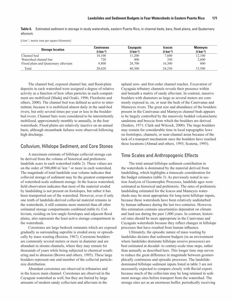
The channel bed, exposed channel bar, and flood-plain deposits in each watershed were assigned a degree of relative activity as a function of how often particles in each compart-ment are mobilized (Madej and Ozaki, 1996; Florsheim and others, 2000). The channel bed was defined as active to inter-mittent, because it is mobilized almost daily in the sand-bed rivers, but only several times per year or less in the boulder-bed rivers. Channel bars were considered to be intermittently mobilized, approximately monthly to annually, in the four watersheds. Flood plains are relatively inactive on an annual basis, although streambank failures were observed following high discharge.
Colluvium, Hillslope Sediment, and Core StonesA maximum estimate of hillslope colluvial storage can
be derived from the volume of historical and prehistoric landslide scars in each watershed (table 2). These values are on the order of 500,000 m3 km−2 or more in each watershed. The magnitude of total landslide scar volume indicates that colluvial storage of sediment may be the greatest component of watershed-scale sediment storage. In the Icacos watershed, field observation indicates that most of the material eroded by landsliding is not present on footslopes, but rather it has been transported out of the watershed. However, even if only one tenth of landslide-derived colluvial material remains in the watersheds, it still contains more material than all other estimated storage compartments combined (table 6). Col-luvium, residing on low-angle footslopes and adjacent flood plains, also represents the least active storage compartment in the watersheds.
Corestones are large bedrock remnants which are exposed gradually as surrounding saprolite is eroded away or episodi-cally by mass wasting (Ruxton, 1967). Corestone boulders are commonly several meters or more in diameter and are abundant in stream channels, where they may remain for thousands of years while being subjected to chemical weath-ering and to abrasion (Brown and others, 1995). These large boulders represent one end member of the colluvial particle-size distribution.
Abundant corestones are observed in tributaries and in the Icacos main channel. Corestones are observed in the Cayaguás watershed as well, but they are buried by large amounts of modern sandy colluvium and alluvium in the
upland zero- and first-order channel reaches. Excavation of Cayaguás tributary channels reveals their presence within and beneath a matrix of sandy alluvium. In contrast, massive boulders with diameters as large as several meters are com-monly exposed in, on, or near the beds of the Canóvanas and Mameyes rivers. The great size and abundance of the boulders present in the Canóvanas and Mameyes channel beds appears to be largely controlled by the massively bedded volcaniclastic sandstone and breccia from which the boulders are derived (Seiders, 1971; Clark and Wilcock, 2000). The large boulders may remain for considerable time in local topographic lows on footslopes, channels, or near-channel areas because of the lack of a transport mechanism once the boulders have reached these locations (Ahmad and others, 1993; Scatena, 1995).
Time Scales and Anthropogenic EffectsThe total annual hillslope sediment contribution in
the watersheds is dominated by the material derived from landsliding, which highlights a timescale consideration for the budget estimates (table 3). As previously noted in sec-tion Analysis of Geomorphic Processes, landslide ages were estimated as historical and prehistoric. The rates of prehistoric landsliding estimated for the Icacos and Mameyes water-sheds may be most appropriate for long-term hillslope inputs, because these watersheds have been relatively undisturbed by human influence during the last two centuries. However, this estimation contains uncertainties dependent on climate and land use during the past 1,000 years. In contrast, histori-cal rates should be more appropriate in the Canóvanas and Cayaguás watersheds because they reflect changes in hillslope processes that have resulted from human influence.
Ultimately, the episodic nature of mass wasting by landslides dictates that sediment budgets (in an environment where landslides dominate hillslope erosive processes) are best estimated at decadal- to century-scale time steps, rather than annually as described here. This longer time step serves to reduce the great difference in magnitude between geomor-phically continuous and episodic processes. The landslide-dominated hillslope sediment inputs listed in table 3 are not necessarily expected to compare closely with fluvial export, because much of the colluvium may be long retained in sedi-ment storage sites before transport from the watershed. The storage sites act as an enormous buffer, periodically receiving
Table 6. Estimated sediment in storage in study watersheds, eastern Puerto Rico, in channel beds, bars, flood plains, and Quaternary alluvium.
[t km−2, metric tons per square kilometer]
Storage locationCanóvanas
(t km−2)Cayaguás
(t km−2)Icacos (t km−2)
Mameyes (t km−2)
Channel bed 10,100 11,200 7,600 12,100Watershed channel bar 720 400 350 2,600Flood plain and Quaternary alluvium 9,800 28,700 16,300 800
Total 20,620 40,300 24,250 15,500
172 Water Quality and Landscape Processes of Four Watersheds in Eastern Puerto Rico
large pulses of hillslope-derived sediment and losing it at a more continuous rate. Nonetheless, the fluvial sediment export rates are multiyear averages from a period that included a drought and several large hurricanes and should, therefore, represent long-term conditions. These variations in geomor-phic process considerations, timescales, and land use notwith-standing, the approximate sediment budgets provide insights into the geomorphology of each watershed.
Erosion and Sediment Export: Are They in Balance?
Hillslope erosion in the Canóvanas watershed exceeds fluvial suspended-sediment export (yield) (table 3). If all hillslope inputs are included, this watershed has a sediment delivery ratio of 10 to 21 percent (13 to 25 percent if bedload yield estimates are included). However, because little land-slide activity has been noted in the watershed during recent decades, most of the current annual sediment export was probably derived from nonlandslide inputs (slopewash, soil creep, and treethrow). The annual landslide input of 2,000 to 4,000 t km−2 can therefore be left out of the budget for recent decades. Accordingly, at least for the period 1991 to 2005, the difference between the sum of the annual nonlandslide inputs and annual fluvial export could have been derived from the extensive active and intermittent storage compartments (tables 3, 5, and 6).
In the Cayaguás watershed, hillslope erosion is more than double the estimate of fluvial sediment export. As discussed in the Landslide Frequency section, this highly modified landscape can yield sediment in large quantities. Much of the sediment in this low-gradient watershed resides in temporary storage in and near channels where it is available for export during storms.
The estimate of hillslope erosion in the Icacos watershed is less than half the fluvial export rate; however, if one consid-ers the inherent uncertainties of each element, this difference may not be important (table 3). Hillslope-derived inputs were calculated to be 750 t km−2 yr−1, while the mean annual fluvial export was 2,140 t km−2. The high annual rainfall, minimal anthropogenic disturbance, and sand-dominated particle size lead to a high transport-rate, high-efficiency geomorphic system. The large amount of material available for transport from active storage in the channel bars and the channel bed, 7,950 t km−2 (table 6), means that most storms should be able to transport substantial sediment loads. Field observations and GIS analysis of the watershed indicates that extensive flat areas (flood plains and Quaternary alluvium) total approxi-mately 36,000 m2 in the Icacos watershed (Larsen, 1997). Sediment storage in these areas is 16,300 t km−2 (table 6). This area provides an additional source of sediment, although deposits in this area are probably rarely entrained because of the low channel gradient and small contributing area of the watershed (0.88 km2) upstream of most of the deposits. Finally, historical landslides not associated with roads in the Icacos watershed were estimated to have eroded 200 t km−2
yr−1. This volume indicates that two thirds of all hillslope ero-sion, 500 t km−2 yr−1, is attributable to road construction and maintenance. Anthropogenic disturbance in this watershed may be responsible for the majority of fluvial sediment yield.
Hillslope erosion in the Mameyes watershed exceeds fluvial sediment export. If all hillslope inputs are included, the Mameyes has a sediment delivery ratio of 15 to 62 percent (20 to 83 percent if bedload yield estimates are included). This ratio indicates a more efficient linkage between hillslopes and river channels than in the anthropogenically disturbed Canóva-nas watershed. A total of 43 percent of the 189 historical land-slides mapped in the Mameyes watershed were associated with road construction and maintenance. Most of these landslides were small slumps and shallow soil slips that eroded about 80 t km−2 yr−1, or approximately half of all landslide-derived sediment. Most of the total fluvial sediment yield may there-fore be derived from landslide activity associated with roads.
Landform Development
A conceptual geomorphic model of landform develop-ment for the Greater Antilles was proposed by Ahmad and others (1993). This model postulates that landsliding is the major contributor of sediment to stream channels. A simi-lar landslide-dominated model was proposed earlier for the island of Dominica by Reading (1986). These models are supported by the work described in the four Puerto Rican study watersheds.
A total of 41 landslide-triggering storms occurred between 1960 and 1991 in the central mountains of Puerto Rico (Larsen and Simon, 1993), an average of 1.3 landslide-triggering storms per year. This rate demonstrates that geo-morphic work by mass wasting is a regular and important process in much of the island. With respect to mass wast-ing, landslides, for the most part, move orders of magnitude more material than other modes of hillslope erosion. The annual mass of combined slopewash, treefall, and soil creep is dwarfed by the amount of material eroded by landsliding. At decadal or longer time scales, landslides deliver orders of magnitude more sediment to footslopes, flood plains, and stream channels than all other hillslope-erosion processes combined, although the frequency and magnitude of landslid-ing differs strongly with lithology and land use.
Once the sediment is delivered to riparian areas and stream channels, the rate and manner of its evacuation are also variable, and both depend on, and contribute to, channel morphology. In the watersheds underlain by volcaniclastic bedrock (Canóvanas and Mameyes) this evacuation of sedi-ment can be seen as an autocontrolled feedback loop in which a period of accelerated mass wasting (caused in the short term by anthropogenic disturbance, climate perturbation (a period of increased tropical disturbances), winter storms, or other heavy rainfall) introduces large amounts of sediment, includ-ing massive boulders, into the river channels. The increased number of large particles armors the channel bed, temporar-ily reduces sediment transport, and reduces channel incision.
Landslides and Sediment Budgets in Four Watersheds in Eastern Puerto Rico 173
As incision is slowed, the rate of mass wasting of hillslopes may be reduced and theoretically remain so until chemical weathering, abrasion, or sufficient high-magnitude flows are able to reduce the mass of large particles and transport enough channel sediment to allow further incision. Thus starts another cycle of potentially increased mass wasting.
In the watersheds underlain by granitic bedrock (Cay-aguás and Icacos), the much higher rate of chemical weather-ing of the coarsely crystalline rocks limits channel armoring with boulders, compared with the volcaniclastic bedrock of other watersheds. The explanation lies in the highly erodible nature of granitic rock in the humid tropics (White and others, 1998). The granitic bedrock weathers to saprolite to depths of as much as tens of meters (Douglas, 1967; Simon and others, 1990). As feldspars and other minerals are weathered in the year-round wet (>2,000 mm annual rainfall) and warm (>19°C mean annual temperature) environment, the rock matrix disag-gregates, and easily transported grus develops at the ground surface (Gerrard, 1994; Buss and White, 2012). Therefore, landsliding and slopewash are more effective agents of erosion in granitic bedrock terrain than in the volcaniclastic terrain. Although large corestones are abundant in some channel reaches in the granitic bedrock, the resulting material deliv-ered to drainage channels is mainly sand sized. Consequently, fluvial erosion is highly effective and promotes channel exten-sion. This extension is manifested, in part, as active slumping at the heads of tributaries in zero-order valleys, leading to higher watershed drainage density in the watersheds underlain by granitic bedrock (1.87 km km−2 in the Cayaguás watershed and 2.54 km km−2 in the Icacos watershed), compared with those in volcaniclastic bedrock (about 1.35 km km−2 in both the Canóvanas and Mameyes watersheds). Moreover, channel heads that are extended by erosion during large storms tend to pirate neighboring drainages observable in the field or on topographic maps as unusual confluences in southern portion of Cayaguás watershed. Outward expansion resulting from mass wasting on valley sides also leads to widening of main channel valleys. This rapid erosion has lowered channel gradients in the granitic watersheds to the point where the Icacos water-shed forms, on average, a relatively low-relief landscape in the central part of the watershed (fig. 3). The contact between the erodible granitic bedrock and resistant volcaniclastic bedrock downstream of the Icacos gaged outlet is a prominent nick-point, downstream of which the stream descends from 610 m to 50 m elevation above mean sea level in a distance of only 3 km. This nickpoint limits erosion and downcutting of the Río Icacos upstream of the gaging station. The Río Cayaguás has eroded its watershed similarly, such that low-gradient tributar-ies predominate and their headward extension has enabled the stream system to approach within 12 km of the south (Carib-bean) coast of the island, in spite of being part of a north-coast-draining river that crosses a straight-line distance of more than 50 km to reach the Atlantic Ocean. However, substantial erosion and downcutting of the Río Cayaguás upstream of the gaging station is limited by its relatively low elevation, only 150 m above sea level (Figueroa-Alamo and others, 2006).
The rates of mass-wasting erosion and fluvial sediment transport estimated for the Cayaguás and Icacos watersheds are high for Puerto Rico. Even on geologic time scales, landscape denudation in the Cayaguás and Icacos watersheds appears to have been extreme. Evidence of this denudation can be seen on topographic maps, where watersheds underlain by granitic bedrock appear anomalously low compared with surround-ing nongranitic bedrock terrain. The granitic rocks are easily identified on topographic maps as eroded areas of the otherwise high-elevation Luquillo Mountains and Cayey Mountains.
Summary and ConclusionsThe montane humid tropics are a geomorphologically
dynamic environment that hosts a range of continuous to episodic hillslope erosion processes. The warm, moist setting promotes rapid development of soil and subsequent growth of vegetation. Steep hillslopes and heavy, intense rainfall result in active hillslope erosion.
The four forested and agriculturally developed water-sheds located in eastern Puerto Rico that were investigated in this study hold numerous possibilities for geomorphological comparison, only a few of which were examined here. Hill-slope erosional processes— landslides, slopewash, soil creep, and treethrow—are important mass wasting mechanisms in all four study watersheds. The intensity of these processes is closely related to land use, bedrock geology, and rainfall. In all watersheds, episodic landslide activity, calculated at annual, decadal, or greater time scales, is far more important than any other form of mass wasting with respect to the mass of earth materials moved downslope. Landslide activity is estimated to have eroded about 500 to 5,000 t km−2 yr−1 in the four water-sheds, whereas the combined totals of estimated slopewash, soil creep, and treethrow ranged from 43 to 120 t km−2 yr−1. Nonetheless, the low-intensity, more continuous processes of erosion (slopewash, soil creep, treethrow) provide a steady stream of sediment to fluvial systems that is sufficient to make up the bulk of fluvial sediment export during some years.
In contrast, anthropogenic disturbance plays a conspicu-ous role in mass wasting that is most apparent in the devel-oped Cayaguás watershed. Much of the landslide-caused erosion in the forested watersheds was associated with high-way corridors: road-related landslides composed 63 percent and 43 percent of the total contribution of historical land-slides in the Icacos and Mameyes watersheds, respectively. The differing timescales upon which the landslide data were based require cautious comparison of annual mass wasting rates. However, the order of magnitude difference in rates between the forested and developed watersheds implies that human modification of hillslopes has increased landslide frequency and consequent availability of sediment for fluvial transport. The large proportion of rapid mass movements associated with road construction and maintenance in the for-ested watersheds further demonstrates the great sensitivity of these hillslopes to human disturbance.
174 Water Quality and Landscape Processes of Four Watersheds in Eastern Puerto Rico
Suspended sediment yield from the four watersheds ranged from 325 to 2,140 t km−2 yr−1. Expressed as metric tons per square kilometer of sediment per millimeter of runoff per year, yield was 2.3 to 3.7 times as high in the anthropogeni-cally disturbed watersheds (Canóvanas and Cayaguás) as in the forested watersheds (Icacos and Mameyes) and, similarly, 3.0 to 4.7 times as high in the watersheds underlain by granitic bedrock (Cayaguás and Icacos) as in the watersheds underlain by volcaniclastic bedrock (Canóvanas and Mameyes). These comparisons highlight the importance of both land use and bedrock geology on fluvial sediment transport.
The quantification of the principal hillslope and fluvial processes and sediment budgets provides a means for evaluat-ing small montane humid-tropical watersheds from a geomor-phological perspective and for comparing them with other small watersheds. More important, the contrasting of water-sheds with differing land use history provides insights into what present-day development strategies may bring in future decades or even centuries. Based on storage of colluvium and annual fluvial sediment yields, hillslope processes that were triggered as long ago as the early 19th century by the onset of forest clearing will likely affect fluvial sediment transport for more decades to come and possibly into the late 21st century.
AcknowledgmentsThis work was supported through the United States Geo-
logical Survey Water, Energy, and Biogeochemical Budgets program (Larsen and others, 1993; Lins, 1994). Many of the data used in this study were collected and compiled by U.S. Geological Survey Caribbean Water Science Center staff Angel Torres-Sánchez and Iris Margarita Concepción. The manuscript was greatly improved by thoughtful review com-ments received from Allen Gellis, and Jonathan Godt, both of the U.S. Geological Survey.
References
Ahmad, Rafi, Scatena, F.N., and Gupta, Avijit, 1993, Morphol-ogy and sedimentation in Caribbean montane streams—Examples from Jamaica and Puerto Rico: Sedimentary Geology, v. 85, p. 157–169.
Auzet, Anne-Veronique, and Ambroise, Bruno, 1996, Soil creep dynamics, soil moisture and temperature conditions on a for-ested slope in the granitic Vosges Mountains, France: Earth Surface Processes and Landforms, v. 21, p. 531–542.
Birot, Pierre, 1966, General physical geography: London, Harrap, 360 p.
Brown, E.T., Stallard, R.F., Larsen, M.C., Bourlès, D.L., Rais-beck, G.M., and Yiou, F., 1998, Determination of predevel-opment denudation rates of an agricultural watershed
(Cayaguás River, Puerto Rico) using in situ-produced 10Be in river-borne quartz: Earth and Planetary Sciences Letters, v. 160, p. 723–728.
Brown, E.T., Stallard, R.F., Larsen, M.C., Raiseck, G.M., and Yiou, F., 1995, Denudation rates determined from the accu-mulation of in-situ produced 10Be in the Luquillo Experi-mental Forest, Puerto Rico: Earth and Planetary Science Letters, v. 129, p. 193–202.
Brown, Sandra, Lugo, A.E., Silander, Susan, and Liegel, Leon, 1983, Research history and opportunities in Luquillo Experimental Forest: New Orleans, La., U.S. Department of Agriculture Forest Service, Southern Forest Experimental Station General Technical Report SO–44, 128 pages.
Bruenig, E.F., 1975, Tropical ecosystems—State and targets of research into the ecology of humid tropical systems: Plant Research and Development, v. 1, p. 22–38.
Buss, H.L., and White, A.F., 2012, Weathering processes in the Río Icacos and Río Mameyes watersheds in eastern Puerto Rico, ch. I in Murphy, S.F., and Stallard, R.F., eds., Water quality and landscape processes of four watersheds in east-ern Puerto Rico: U.S. Geological Survey Professional Paper 1789, p. 249–262.
Caine, Nel, and Swanson, F.J., 1989, Geomorphic coupling of hillslope and channel systems in two small mountain basins: Zeitschrift für Geomorphologie N.F., v. 33, no. 2, p. 189–203.
Campbell, R.H., 1975, Soil slips, debris flows and rainstorms in the Santa Monica Mountains and vicinity, southern California: U.S. Geological Survey Professional Paper 851, 51 p.
Cerdà, Artemi, and García-Fayos, Patricio, 1997, The influ-ence of slope angle on sediment, water and seed losses on badland landscapes: Geomorphology, v. 18, p. 77–90.
Chatterjea, Kalyani, 1994, Dynamics of fluvial and slope processes in the changing geomorphic environment of Singapore: Earth Surface Processes and Landforms, v. 19, p. 585–607.
CIA World Factbook, 2005, at url http://www.cia.gov/cia/publications/factbook/index.html, ISSN 1553–8133, accessed November 11, 2005.
Clark, J.J., and Wilcock, P.R., 2000, Effects of land-use change on channel morphology in northeastern Puerto Rico: Geological Society of America Bulletin, v. 112, p. 1763–1777.
Clarke, M.F., Williams, M.A.J., and Stokes, T., 1999, Soil creep—Problems raised by a 23-year study in Aus-tralia: Earth Surface Processes and Landforms, v. 24, p. 151–175.
Landslides and Sediment Budgets in Four Watersheds in Eastern Puerto Rico 175
Cruden, D.M., and Varnes, D.J., 1996, Landslide types and processes, in Turner, A.K., and Schuster, R.L, eds., Landslides, investigation and mitigation—Transportation Research Board Special Report 247: Washington, D.C., National Academy Press, p. 36–75.
DeGraff, J.V., Bryce, R., Jibson, R.W., Mora, Sergio, and Rog-ers, C.T., 1989, Landslides—Their extent and significance in the Caribbean, in Brabb, E.E., and Harrod, B.L., eds., Landslides—Extent and economic significance, Interna-tional Geological Symposium on Landslides, 28th, Wash-ington, D.C., 1989, Proceedings: Rotterdam, The Nether-lands, Balkema Publishers, p. 51–80.
Denevan, W.M., 1992, The pristine myth—The landscape of the Americas in 1492: Annals of the Association of Ameri-can Geographers, v. 82, no. 3, p. 369–385.
Dietrich, W.E., 1982, Settling velocity of natural particles: Water Resources Research, v. 18, no. 6, p. 1615–1626.
Dietrich, W.E., and Dunne, Thomas, 1978, Sediment budget for a small catchment in mountainous terrain: Zeitchrift für Geomorphologie N.F., Supplementband 29, p. 191–206.
Donnelly, J.P., and Woodruff, J.D., 2007, Intense hurricane activity over the past 5,000 years controlled by El Niño and the West African monsoon: Nature, v. 447, p. 465–468.
Douglas, Ian, 1967, Natural and man-made erosion in the humid tropics of Australia, Malaysia, and Singapore: International Association of Scientific Hydrology, v. 75, p. 31–39.
Figueroa-Alamo, Carlos, Aquino, Zaida, Guzmán-Ríos, Senén, and Sánchez, A.V., 2006, Water resources data—Puerto Rico and the U.S. Virgin Islands, water year 2004: U.S. Geological Survey Water-Data Report PR–04–1, 577 p.
Florsheim, J.L., Mount, J.F., and Rutten, L.T., 2000, Effect of base level change on floodplain and fan sediment storage and ephemeral tributary channel morphology, Navarro River, California: Earth Surface Processes and Landforms, v. 26, p. 219–232.
Gabet, E.J., Reichman, O.J., and Seabloom, E.W., 2003, The effects of bioturbation on soil processes and sediment transport: Annual Review of Earth and Planetary Sciences, v. 31, p. 249–273.
Garwood, N.C., Janos, D.P., and Brokaw, Nicholas, 1979, Earthquakecaused landslides—A major disturbance to tropical forests: Science, v. 205, p. 997–999.
Gellis, Allen, 1991, Construction effects on sediment for two basins in Puerto Rico, in Fan, Shou-Shan, and Kuo, Yung-Huang, eds., Interagency Sedimentation Confer-ence, 5th, Las Vegas, Nevada, March 18–21, 1991, Pro-ceedings: Federal Energy Regulatory Commission, ch. 4: p. 72–78.
Gellis, Allen, 1993, The effects of Hurricane Hugo on sus-pended-sediment loads, Lago Loíza Basin, Puerto Rico: Earth Surface Processes and Landforms, v. 18, p. 505–517.
Gellis, A.G., Webb, R.M.T., McIntyre, S., and Wolfe, W.J., 2006, Land-use effects on erosion, sediment yields, and reservoir sedimentation—A case study in the Lago Loiza Basin, Puerto Rico: Physical Geography, v. 27, p. 39–69.
Gerlach, T., 1967, Hillslope troughs for measuring sediment movement: Revue de Geomorphologie Dynamique, v. 17, p. 173–174.
Gerrard, John, 1994, Weathering of granitic rocks—Environ-ment and clay mineral formation, in Robinson, D.A., and Williams, R.B.G., eds., Rock weathering and landform evolution: New York, John Wiley, p. 3–20.
Gilbert, G.K., 1877, Report on the geology of the Henry Mountains, Utah: Washington, D.C., U.S. Geographic and Geologic Survey, Rocky Mountain Region, 160 p.
Glade, Thomas, Anderson, M.G., and Crozier, M.J., 2005, Landslide hazard and risk: New York, John Wiley, 824 p.
Gomez, Basil, and Church, Michael, 1989, An assessment of bed load sediment transport formulae for gravel bed rivers: Water Resources Research, v. 25, no. 6, p. 1161–1186.
Goudie, Andrew, 1995, The changing earth, rates of geomor-phological processes: Oxford, United Kingdom, Blackwell Publishers, 302 p.
Gould, W.A., Martinuzzi, S., and Parés-Ramos, I.K., 2012, Land use, population dynamics, and land-cover change in northeastern Puerto Rico, ch. B in Murphy, S.F., and Stal-lard, R.F., eds., Water quality and landscape processes of four watersheds in eastern Puerto Rico: U.S. Geological Survey Professional Paper 1789, p. 25–42.
Gupta, A., 1988, Large floods as geomorphic events in the humid tropics, in Baker, V.R., Kochel, R.C., and Patton, P.C., eds., Flood geomorphology: New York, John Wiley, p. 301–315.
Haggett, Peter, 1961, Land use and sediment yield in an old plantation tract of the Serra do Mar, Brazil: Geographical Journal, v. 27, p. 50–59.
Haire, W.J., 1972, Flood of October 5–10, 1970, in Puerto Rico: Commonwealth of Puerto Rico Water Resources Bul-letin 12, 38 p.
Heimsath, A.M., Chappell, John, Spooner, N.A., and Questiaux, D.G., 2002, Creeping soil: Geology, v. 30, no. 2; p. 111–114.
Hooke, R.L., 2000, On the history of humans as geomorphic agents: Geology, v. 28, no. 9, p. 843–846.
Jibson, R.W., 1989, Debris flows in southern Puerto Rico: Geo-logical Society of America Special Paper 236, p. 29–55.
176 Water Quality and Landscape Processes of Four Watersheds in Eastern Puerto Rico
Kates, R.W., Turner, B.L., and Clark, W.C., 1990, The great transformation, in Turner, B.L., Clark, W.C., Kates, R.W., Richards, J.F., Mathews, J.T., and Meyer, W.B., The Earth as transformed by human action—Global and regional changes in the biosphere over the past 300 years: New York, Cambridge University Press, p. 1–17.
Larsen, M.C., 1997, Tropical geomorphology and geomorphic work—A study of geomorphic processes and sediment and water budgets in montane humid-tropical forested and developed watersheds, Puerto Rico: Boulder, University of Colorado Geography Department, unpublished Ph.D. dis-sertation, 341 p.
Larsen, M.C., Collar, P.D., and Stallard, R.F., 1993, Research plan for the investigation of water, energy, and biogeo-chemical budgets in the Luquillo Mountains, Puerto Rico: U.S. Geological Survey Open-File Report 92–150, 19 p.
Larsen, M.C., Liu, Z., and Zou, X., 2012, Effects of earth-worms on slopewash, surface runoff, and finelitter transport on a humidtropical forested hillslope, Luquillo Experimen-tal Forest, Puerto Rico, ch. G in Murphy, S.F., and Stallard, R.F., eds., Water quality and landscape processes of four watersheds in eastern Puerto Rico: U.S. Geological Survey Professional Paper 1789, p. 179–198.
Larsen, M.C., and Parks, J.E., 1997, How wide is a road? The association of roads and mass-wasting disturbance in a for-ested montane environment: Earth Surface Processes and Landforms, v. 22, p. 835–848.
Larsen, M.C., and Santiago-Román, Abigail, 2001, Mass wast-ing and sediment storage in a small montane watershed—An extreme case of anthropogenic disturbance in the humid tropics, in Dorava, J.M., Palcsak, B.B., Fitzpatrick, F., and Montgomery, D., eds., Geomorphic processes and riverine habitat: American Geophysical Union Water Science and Application, v. 4, p. 119–138.
Larsen, M.C., and Simon, Andrew, 1993, Rainfall-threshold conditions for landslides in a humid-tropical system, Puerto Rico: Geografiska Annaler, v. 75A (1–2), p. 13–23.
Larsen, M.C., and Torres-Sánchez, A.J., 1992, Landslides triggered by the rainfall associated with Hurricane Hugo, eastern Puerto Rico, September 1989: Caribbean Journal of Science, v. 28, no. 3–4, p. 113–120.
Larsen, M.C., and Torres-Sánchez, A.J., 1998, The frequency and distribution of recent landslides in three montane tropical regions of Puerto Rico: Geomorphology, v. 24, p. 309–331.
Larsen, M.C., Torres-Sánchez, A.J., and Concepción, I.M., 1999, Slopewash, surface runoff, and finelitter transport in forest and landslide scars in humidtropical steeplands, Luquillo Experimental Forest, Puerto Rico: Earth Surface Processes and Landforms, v. 24, p. 481–506.
Larsen, M.C., and Webb, R.M.T., 2009, Potential effects of runoff, fluvial sediment and nutrient discharges on the coral reefs of Puerto Rico: Journal of Coastal Research, v. 25, p. 189–208.
Lenart, M.T., 2003, A comparative study of soil disturbance from uprooted trees, and mound and pit decay, in Puerto Rico and Colorado: Tucson, University of Arizona, unpub-lished Ph.D. dissertation, 175 p.
Lewis, L.A., 1974, Slow movements of earth under tropical rainforest conditions: Geology, v. 2, p. 9–10.
Lins, H.F., 1994, Recent directions taken in water, energy, and biogeochemical budget research: EOS, Transactions, Ameri-can Geophysical Union, v. 75, no. 38, p. 433–439.
Madej, M.A., and Ozaki, Vicki, 1996, Channel response to sediment wave propagation and movement, Redwood Creek, California, USA: Earth Surface Processes and Land-forms, v. 21, no. 10, p. 911–928.
Maharaj, R.J., 1993, Landslide processes and landslide suscep-tibility analysis from an upland watershed—A case study from St. Andrew, Jamaica, West Indies: Engineering Geol-ogy, v. 34, p. 53–79.
Mayewski, P.A., Rohling, E.E., Stager, J.C., Karlén, Wibjörn, Maasch, K.A., Meeker, L.D., Meyerson, E.A., Gassef, Francoise, van Kreveld, Shirley, Holmgren, Karin, Lee-Thorp, Julia, Rosqvist, Gunhild, Rack, Frank, Staubwasser, Michael, Schneider, R.R., and Steig, E.J., 2004, Holocene climate variability: Quaternary Research, v. 62, p. 243–255.
McKean, J.A., Dietrich, W.E., Finkel, R.C., Southon, J.R., and Caffee, M.W., 1993, Quantification of soil production and downslope creep rates from cosmogenic 10Be accumulations on a hillslope profile: Geology, v. 21, p. 343–346.
Meade, R.H., 1982, Sources, sinks, and storage of river sedi-ment in the Atlantic drainage of the United States: Journal of Geology, v. 90, p. 235–252.
Milliman, J.D., and Meade, R.H., 1983, World-wide delivery of river sediment to the oceans: Journal of Geology, v. 91, p. 1–21.
Morales Muñoz, G.E., 1943, Origenes historicos de San Miguel de Hato Grande—Actual pueblo de San Lorenzo: Hato Rey, Puerto Rico, Esmaco Printers Corp., 333 p.
Murphy, S.F., and Stallard, R.F., 2012, Hydrology and climate of four watersheds in eastern Puerto Rico, ch. C in Murphy, S.F., and Stallard, R.F., eds., Water quality and landscape processes of four watersheds in eastern Puerto Rico: U.S. Geological Survey Professional Paper 1789, p. 43–84.
Murphy, S.F., Stallard, R.F., Larsen, M.C., and Gould, W.A., 2012, Physiography, geology, and land cover of four water-sheds in eastern Puerto Rico, ch. A in Murphy, S.F., and
Landslides and Sediment Budgets in Four Watersheds in Eastern Puerto Rico 177
Stallard, R.F., eds., Water quality and landscape processes of four watersheds in eastern Puerto Rico: U.S. Geological Survey Professional Paper 1789, p. 1–24.
Nelson, E.J., and Booth, D.B., 2002, Sediment sources in an urbanizing, mixed land-use watershed: Journal of Hydrol-ogy 264, p. 51–68.
Norman, S.A., Schaetzl, R.J., and Small, T.W., 1995, Effects of slope angle on mass movement by tree uprooting: Geo-morphology, v. 14, no. 1, p. 19–27.
Osterkamp, W.R., Toy, T.J., and Lenart, M.T., 2006, Develop-ment of partial rock veneers by root throw in a subalpine setting: Earth Surface Processes and Landforms, v. 31, p. 1–14.
Parker, Gary, Klingeman, P.C., and McLean, D.C., 1982, Bedload and size distribution in paved gravel–bed streams: Journal of the Hydraulics Division of the American Society of Civil Engineers, v. 108, no. HY4, p. 544–571.
Phillips, J.D., and Marion, D.A., 2006, Biomechanical effects of trees on soil and regolith— Beyond treethrow: Annals of the Association of American Geographers, v. 96, p. 233–247.
Ramos-Scharrón, C.E., and MacDonald, L.H., 2007, Develop-ment and application of a GIS-based sediment budget model: Journal of Environmental Management, v. 84, p. 157–172.
Reading, A.J., 1986, Landslides, heavy rainfalls, and hur-ricanes in Dominica, West Indies: Aberystwyth, United Kingdom, University of Wales, unpublished Ph.D. disserta-tion, 545 p.
Reading, A.J., Thompson, R.D., and Millington, A.C., 1995, Humid tropical environments: Cambridge, Mass., Black-well Publishers, 429 p.
Reid, H.F., and Taber, Stephen, 1919, The Puerto Rico earthquakes of October–November 1918: Bulletin of the Seismological Society of America, v. 9, no. 4, p. 94–127.
Reid, L.M., 1981, Sediment production from gravel-surfaced forest roads, Clearwater Basin, Washington: Seattle, Uni-versity of Washington Fisheries Research Institute publica-tion FRI–UW8108, 247 p.
Restrepo, Carla, and Alvarez, Nora, 2006, Landslides and their contribution to land-cover change in the mountains of Mexico and Central America: Biotropica, v. 38, p. 446–457.
Rouse, Irving, 1993, The Tainos—Rise and decline of the people who greeted Columbus: New Haven, Conn., Yale University Press, 211 p.
Ruxton, B.P., 1967, Slopewash under mature primary rainfor-est in northern Papua, in Jennings, J.N., and Mabbut, J.A., eds., Landform studies from Australia and New Guinea: Cambridge, United Kingdom, Cambridge University Press, p. 85–94.
Scatena, F.N., and Larsen, M.C., 1991, Physical aspects of Hurricane Hugo in Puerto Rico: Biotropica, v. 23, no. 4A, p. 317–323.
Scatena, F.N., 1995, Relative scales of time and effectiveness of watershed processes in a tropical montane rain forest of Puerto Rico, in Costa, J.E., Miller, A.J., Potter, K.W., and Wilcock, Peter, eds., Natural and anthropogenic influences in fluvial geomorphology: American Geophysical Union Geophysical Monograph 89, p. 103–111.
Scatena, F.N., and Lugo, A.E., 1995, Geomorphology, distur-bance, and the soil and vegetation of two subtropical wet steepland watersheds of Puerto Rico: Geomorphology, v. 13, p. 199–213.
Schaetzl, R.J., Burns, S.F., Small, T.W., and Johnson, D.L., 1990, Tree uprooting—Review of types and patterns of soil disturbance: Physical Geography, v. 11, p. 277–291.
Seiders, V.M., 1971, Geologic map of the El Yunque quad-rangle, Puerto Rico: U.S. Geological Survey Miscellaneous Geologic Investigations Map I–658, scale 1:20,000.
Shiels, A.B., West, C.A., Weiss, Laura, Klawinski, P.D., and Walker L.R., 2008, Soil factors predict initial plant colo-nization on Puerto Rican landslide: Plant Ecology, v. 195, p. 165–178.
Simon, Andrew, and Guzmán-Ríos, Senén, 1990, Sediment discharge from a montane basin, Puerto Rico—Implica-tions of erosion processes and rates in the humid tropics, in Ziemer, R.R., O’Loughlin, C.L., and Hamilton, L.S., eds., Research needs and applications to reduce erosion and sedimentation in tropical steeplands: International Association of Hydrologic Science Publication 192, p. 35–47.
Simon, Andrew, Larsen, M.C., and Hupp, C.R., 1990, The role of soil processes in determining mechanisms of slope fail-ure and hillslope development in a humid-tropical forest—Eastern Puerto Rico, in Kneuper, P.L.K., and McFadden, L.D., eds., Soils and landscape evolution: Geomorphology, v. 3, p. 263–286.
Simonett, D.S., 1967, Landslide distribution and earthquakes in the Bewani and Torricelli Mountains, New Guinea, in Jennings, J.N., and Mabbutt, J.A., eds., Landform studies from Australia to New Guinea: Cambridge, United King-dom, Cambridge University Press, p. 64–84.
Sirvent, Jaume, Desir, Gloria, Gutierrez, M., Sancho, Car-los, and Benito, Gerardo, 1997, Erosion rates in badland areas recorded by collectors, erosion pins and profilometer techniques (Ebro Basin, northeast Spain): Geomorphology, v. 18, p. 61–75.
Small, T.W., Schaetzl, R.J., and Brixie, J.M., 1990, Redistri-bution and mixing of soil gravels by tree uprooting: The Professional Geographer, v. 42, p. 445–457.
178 Water Quality and Landscape Processes of Four Watersheds in Eastern Puerto Rico
Stallard, R.F., 1995, Tectonic, environmental, and human aspects of weathering and erosion—A global review using a steady-state perspective: Annual Reviews of Earth and Planetary Science, v. 13, p. 11–39.
Stallard, R.F., 2012, Weathering, landscape equilibrium, and carbon in four watersheds in eastern Puerto Rico, ch. H in Murphy, S.F., and Stallard, R.F., eds., Water quality and landscape processes of four watersheds in eastern Puerto Rico: U.S. Geological Survey Professional Paper 1789, p. 199–248.
Stevens, H.H., and Yang, C.T., 1989, Summary and use of selected fluvial sediment-discharge formulas: U.S. Geologi-cal Survey Water Resources Investigation Report 89–4026, 62 p.
Swanson, F.J., Fredriksen, R.L., and McCorison, F.M., 1982, Material transfer in a western Oregon forested water-shed, in R.L. Edmonds, ed., Analysis of coniferous forest ecosystems in the western United States: Stroudsburg, Pa., Hutchinson Ross Publishing Company, p. 233–266.
Trimble, S.W., 1977, The fallacy of stream equilibrium in contemporary denudation studies: American Journal of Sci-ence, v. 277, p. 876–887.
UNESCO/UNEP/FAO [United Nations Educational, Scien-tific, and Cultural Organization, United Nations Environ-mental Programme, United Nations Food and Agriculture Organization],1978, Tropical forest ecosystems: Paris, UNESCO, 683 p.
U.S. Department of Commerce, 1961, Generalized estimates of probable maximum precipitation and rainfall frequency data for Puerto Rico and the Virgin Islands: U.S. Depart-ment of Commerce Technical Report 52, 94 p.
White, A.F, Blum, A.E., Schulz, M.S., Vivit, D.V., Stone-strom, D.A., Larsen, Matthew, Murphy, S.F., and Eberl, D., 1998, Chemical weathering in a tropical watershed, Luquillo Mountains, Puerto Rico—I. Longterm versus shortterm weathering fluxes: Geochimica et Cosmochimica Acta, v. 62, no. 2, p. 209–226.
Williams, M.A.J., 1973, The efficacy of creep and slopewash in tropical and temperate Australia: Australian Geographi-cal Studies, v. 11, p. 62–78.
Wolman, M.G., 1990, The impact of man: EOS, Transactions, American Geophysical Union, v. 71, no. 52, p. 1884–1886.
Young, A., 1960, Soil movement by denudational processes on slopes: Nature, v. 188, p. 120–122.