Embed Size (px)
Citation preview

University of Massachusetts AmherstScholarWorks@UMass AmherstLandscape Architecture & Regional PlanningHonors Projects Landscape Architecture & Regional Planning
Spring 5-14-2010
Landscape Urbanism for the Highway city ofSpringfield North EndPiyawut InthasornUniversity of Massachusetts - Amherst, [email protected]
Follow this and additional works at: https://scholarworks.umass.edu/larp_honors
Part of the Environmental Design Commons, Landscape Architecture Commons, OtherGeography Commons, Urban, Community and Regional Planning Commons, and the UrbanStudies and Planning Commons
This Article is brought to you for free and open access by the Landscape Architecture & Regional Planning at ScholarWorks@UMass Amherst. It hasbeen accepted for inclusion in Landscape Architecture & Regional Planning Honors Projects by an authorized administrator of ScholarWorks@UMassAmherst. For more information, please contact [email protected].
Inthasorn, Piyawut, "Landscape Urbanism for the Highway city of Springfield North End" (2010). Landscape Architecture & RegionalPlanning Honors Projects. 1.Retrieved from https://scholarworks.umass.edu/larp_honors/1

1
Landscape Urbanism for the Highway city of
Springfield North End
By
Piyawut Inthasorn, BSLA 2010
University of Massachusetts Amherst
Department of Landscape Architect and Regional Planning

2
Content
Introduction 3
Springfield North End Highway Analysis/ Problems 6-13
Landscape Urbanism 13-17
Four co-ecological system concepts 18-35
Recommendation 36-42
Conclusion 42-45
Reference 46-48
Picture Content
Figure (1) Context Map: State of Massachusetts, City of Springfield, and Details 6
Figure (2) History Photos of the City of Springfield on 1960 7
Figure (3) Unemployment Status and Poverty Status 8
Figure (4) Assets 9
Figure (5) Area along the Highway 10
Figure (6) Site Analysis 11
Figure (7) Composite Map 12
Figure (8) Land Bridge 19
Figure (9) Bp Bridge 21
Figure (10) Craigieburn Bypass 22
Figure (11)Highway Embankment Design 24
Figure (12) Phytoremediation 26
Figure (13) Anaerobic Digestion 26
Figure (14) Phillips Street Lamps 29
Figure (15) Wind and Tide Turbines 30
Figure (16) Goodwill-Milgard Living Wall 32
Figure (17) PNC and Ann Demeulemeester Living Wall 34

3
Introduction
The expansion of transportation and roadway systems in the United States has caused
drastic socioeconomic changes in cities. Springfield’s North End is one of them. The
Interstate highway I-91 from Chicopee to South Springfield divided three neighborhoods;
Liberty Heights Memorial Square, and Brightwood. Consequences of the separation
include: changed community relations, disconnected access to the Connecticut River and
parks, polluted water, air, and sound, as well as other health issues. More than 20 years
after the expansion that the separation the city continues to struggle with the adverse
effects.
Landscape architects are able to see opportunities in these problems. The Interstate I-91
has four lanes, two directions on both sides, which are wide 100 feet on each side that
create many currently unused spaces along them. The idea is to turn those negative
spaces (highway leftover area) into the positive living system (four co-ecological
systems) by using the landscape urbanism concept as example framework.
Landscape Urbanism is a new design method that creates a new frame of design process
and development for all designers. It was introduced by Charles Waldheim on 1997 in
Chicago Conference. The designers are encouraged to look across other related multiple
disciplines to learn the different system or functions -- infrastructure, hydrology system,
culture, history, wildlife habitation, and so on-- and overlay them together for the better

4
ecological relationships in design. It emphasizes the importance and competence of
landscape, which work better in the organizing the city.
The Four Co-Ecological System is a sustainable system, which combined the Springfield
North End major problems and Landscape Urbanism concept. It has consisted with: 1) A
Green Highway: corridor buffer and connection, 2) Hydrological/ Embankment Design
and management, 3) Energy Efficiency Zone and Renewable Energy 4) Sustainable
Infrastructural Highway Materials. Each topic focuses on different aspects along the
Springfield North End highway based on the major issues. A Green Highway is a new
concept for roadway design that integrates transportation functionality and ecological
sustainability. Hydrological/ Embankment Design and management looks at the run-off
water best practice management. Energy Efficiency Zone and Renewable Energy
emphasizes on the development of energy efficiency town scale plan with combination of
renewable energy. Lastly, Sustainable Infrastructural Highway Materials aim to utilize
some of unused parts of highway turning those to more benefit areas. All four integrated
systems work as a single machine unit process cycle for the future single social-culture of
the North End neighborhood.
The thesis is an extended research based on the 497A urban design senior design studio
in fall 2009 program of department of landscape architecture and regional planning.
Some investigation had been done by senior students in landscape architect class of 2010.
For example, urban form and usage, open space and transportation networks, physical

5
and social environment of urban communities, development of a larger framework and
context for design, culture and history through the simultaneous use of plans, sections,
and three-dimensional work models as the fundamental information and guide line to
understand the overall areas and information. The research scope will look at the cities
with the similar circumstance or problems around the world as case studies for applicable
solutions, programs, and designs. The most important benefit of the thesis is the
understanding of Springfield North End Issues, taking some part of the landscape
urbanism concept, and be able to use it as a framework to establish a network or system
for design. It will be another research support document for the town of Springfield. The
research will be a good guide line for the future commonwealth college students in
Landscape Architecture and Regional Planning program who are interest to learn about
the landscape urbanism either involved with highway problems or else as well as use for
department support reference in the future.

6
Springfield North End Highway Analysis/ Problems
Figure (1) Context Map: State of Massachusetts, City of Springfield, and Details
(Making Connections - Envisioning Springfield's North End: Senior Studio Fall 2009)
Springfield serves as the Southern Gateway into Massachusetts. The North End of
Springfield is located north of downtown along Main Street, with I-291 to the South and
the I-91 Springfield–Chicopee border to the North. To the West the Connecticut River is
a natural boundary, and to the East the boundary is defined by Armory Street. The North
End comprises three neighborhoods: Brightwood to the West along the Connecticut
River, Memorial Square in the center, and Liberty Heights to the East.
The city of Springfield is alive with culture, history, and diversity. It is known as ―a city
of homes’ and in many ways, has a small town feel within a large city. Springfield boasts

7
one of the highest Percentages of open space per capita in New England and is home to
many schools, museums, and historic buildings.
History
Figure (2) History Photos of the City of Springfield on 1960.
(Making Connections - Envisioning Springfield's North End: Senior Studio Fall 2009)
Springfield MA in Western Massachusetts was founded by William Pynchon in 1636 and
became an important city for industry and manufacturing since it was selected in 1770 as
the United States Armory. The decline of industry in the United States after the Second
World War and the closure of the Armory in 1968 affected the economy of Springfield
heavily. Today, health care/educational/social services provide the base of the economy,
followed by wholesale/retail trade and manufacturing. A young and diverse ethnic
population of 150,000 people lives in Springfield. Springfield is located next to the
Connecticut River but has turned its back to the river since the 1960’s when I-91 was
constructed, connecting Vermont to Connecticut. Springfield, with its 350-year history,
must showcase its assets to become a capital in the region. It has much to offer, and is
home to New England’s largest companies, such as MassMutual Financial Group, Bay

8
State Health, Smith and Wesson, and Big Y food Inc. The North End is comprised of
three neighborhoods, Brightwood, Memorial Square, and Liberty Heights. It is bordered
to the North by Chicopee, to the West by the Connecticut River, and to the South by
Springfield’s thriving Metro Center. Interstate-91 runs north and south, directly through
the North End. In the early 1960’s, Connecticut River Valley farm employed a large
Puerto Rican Population. Many of these workers and their families have since settled in
the area. Today, 10,000 residents live in Brightwood and Memorial Square (only a
portion of Liberty Heights is included in our focus area) and 80% of the population is
Puerto Rican, contributing greatly to the North End’s strong cultural identity. It is also
home to a number of community outreach groups that actively promote community well-
being within Springfield.
Economy
Figure (3) Unemployment Status and Poverty Status
(Making Connections - Envisioning Springfield's North End: Senior Studio Fall 2009)
Based on the 2000 census, the North End has:
• 40% poverty rate and the lowest household income in the state
• Lowest educational attainment in the city

9
• Highest unemployment rate in the city
• Significant health problems such as asthma and diabetes
Assets
Figure (4) A variety of Asset in Springfield North End: Bay State Medical Center, Connecticut River,
Several Green Open areas.
The North End has many other valuable assets as well. Several medical institutions are
also located in the North End, including Baystate Medical Center, which is one of the
largest employers in the region. Baystate represents some of the greatest buying power in
the area and has a strong incentive to work towards improving its surroundings. The
Connecticut River is a great natural resource. There are several green open areas such as
Van Horn Park, Kennific Park, Bikepath and Walkway. A fairly number of neighbor
diversity: Liberty Height is a high class family with bigger house, Memorial Square is

10
located on Main Street where the North End’s commercial center, and Brightwood is a
mid to low income family.
Areas along the Highway
Figure (5) Several Left Open Areas along the North End Highway are unused and filled with invasive
plants.
The interstate I-91 creates severe physical barriers that bisect the community. However,
the highway makes Springfield quite accessible to both Connecticut and to the rest of
Western Massachusetts. There are four under passes under I-91 that people currently use
for commuting. The highway is 20 feet above the ground with about 20-50 feet extend
areas on both sides. The green spaces along the highway are mostly long thin and narrow
but continue and connect with the large patch of forest on the North. Most people use this
highway exit to get off to Bay State Medical Center.

11
Site Analysis
Figure (6) A series of Analysis Map show each important analysis topic in Springfield North End.
(Making Connections - Envisioning Springfield's North End: Senior Studio Fall 2009)
Topography is steep along the Connecticut River. Brightwood and Memorial Square are
relatively flat, and much steeper to the East. A number of combined sewer overflow
outlets are detrimental to the water quality of the Connecticut River. The North End
consists primarily of residential neighborhoods and, for an urban setting, contains a large
number of green spaces and parks. The majority of the North End’s mixed use and
commercial buildings are situated along Main Street in Memorial Square. Hospitals and
the medical industry are present both in Liberty Heights and Brightwood. Those creates a
very large portion of our project area is spanned by impervious surfaces.

12
Figure (7) A composite map combines many important asses and site analysis in Springfield North End.
(Making Connections - Envisioning Springfield's North End: Senior Studio Fall 2009)
Using terminology by Landscape Architect Kevin Lynch analyzed the North End
accordingly. There are three neighborhoods: Brightwood, Memorial Square, and Liberty
Heights. Major edges that define and block pedestrian traffic are Interstate 91 (bisects the
North End), Interstate 291 to the south of Memorial Square and Liberty Heights. Major
nodes are Van Horn Park, Calhoun Park, Kenefick Park, and the Schools (Gerena Magnet
School, Chestnut Accelerated Middle School and Lincoln School). Major paths that
connect the nodes and neighbor hoods to the Connecticut River Walk and Bikeway are
denoted in green. One of the major paths is a pedestrian tunnel that connects Memorial
Square to Brightwood. The tunnel starts at Baystate Hospital and the Medical Campus are
two major outsider destinations in the North End.

13
Landscape Urbanism
Introduction
Landscape is emerging as a model for urbanism. Landscape has traditionally been
defined as the art of organizing horizontal surfaces by paying close attention to these
surface conditions- not only configuration, but also materiality and performance-
designers can activate space and produce urban effects without the weighty apparatus of
traditionally space making. Many issues facing contemporary designers of the built
environment: the relationship between natural environments and processes of
urbanization globally. After a decade of debates and theory development, many
professionals and academics continue to be unclear about the idea of landscape urbanism.
Many theorists have attempted to clarify meaning with different definitions, meanings,
and a ways to describe to others; still people have a hard time understanding about it. So,
who did invent the term and what actually is landscape urbanism?
When was it first introduced?
Landscape Urbanism, first introduced by Charles Waldheim from exhibition and a
conference in Chicago on 1997, as design process or methodology. Waldheim defined
Landscape Urbanism as a branch of landscape ecology, concentrating on the organization
of human activities in the natural landscape. He highlighted the leftover void spaces of
the city as potential commons. Waldheim saw Landscape Urbanism, like landscape

14
architecture, as an interstitial design discipline, operating in the spaces between buildings,
infrastructural systems, and natural ecologies (Waldheim 10-14).
What is Landscape Urbanism?
Landscape Urbanism Landscape Urbanism is a movement within architecture in a broad
sense; new paradigm of bringing together all related knowledge to the project. It uses
many overlay planning and design of multi-system or information layers in a particular
site location where will develop in over a period of time. Landscape Urbanism usually
uses for the large scale projects - can be used for small scale as well- or development
where there are complex systems and unpredictable variables. The designers are
encouraged to look across other related multiple disciplines to learn the different system
or functions -- infrastructure, hydrology system, culture, history, wildlife habitation, and
so on-- and overlay them together for the better ecological relationships in design. It
emphasizes the importance and competence of landscape, which work better in the
organizing the city (Waldheim 70-80).
The main characteristics of Landscape Urbanism
The Landscape Urbanism is one of the new topics among designers. There are five
important features that can summarize the unique characteristics of Landscape Urbanism
(Ahern Zube Lecture).
1. Contextualization - Landscape is an important feature of the cities.

15
2. Using more of the horizontal design than vertical design. Meaning that landscape rather
than architecture is more capable of organizing the city and enhancing the urban
experience.
4. The approaching is a time-base strategy. Design through processing over time in the
future. Landscape urbanism is not fixed, it is moving with the context and the
circumstances- "Terra Fluxus."
5. New design thinking and methods for designers across multi-disciplinary. On its way, it
needs all relevant knowledge, from whatever discipline, to solve its tasks and to develop
a dynamic professional competence (Waldheim 20-28).
Why do people having hard time understanding Landscape Urbanism?
1. A rift between the design orientation and the planning orientation is an obstacle for the
professional development. Landscape architecture has a unique combination of nature
and social science, art and the humanities. This unique combination, that builds a
competence to perceive and understand connections and relations, not least between
different scale levels, is developed during the time in the academy and needs to develop
even more in practice.
2. From a situation with long traditions of specialization, it is not an easy task to work and
think in an interdisciplinary way. Each field has its own focus point. So, it is hard to think
crossing through different fields or think differently from what regular basis.

16
3. Landscape Urbanism from a theoretical point of view is already hard to imagine how it
will be, ever harder practically to use interdisciplinary models of understanding,
designing, and planning over time and space.
4. The ability of handling uncertainties in more or less specified between space and time is
greatly benefits to design, yet it solves many unpredictable issues or a variation of
situations that might happen in the future. The designers cannot predict all future issues
but Landscape Urbanism will help to control or prevent those. Dealing with uncertainties
is tough to handle and cope with for designers, not only they might or might be happened
but also depend on many factors that change the design over time. Therefore, it is hard to
program for covering Landscape Urbanism (Linholm 6-10).
How will Landscape Urbanism relate to the thesis?
First of all, Landscape urbanism has a closed relation to landscape architect field. It
brings together knowledge from architecture, landscape architecture, urban design, urban
planning and landscape planning. Of all these specialties within architecture, I believe
landscape architecture gets the most benefits out of accepting the concept of landscape
urbanism. Such a step will not change landscape architecture as such, but it will create a
bridge of communicating and influencing into the fields of planning, architecture and
urban design and thereby provide a uniting landscape for those disciplines (Czerniak, and
Hargreaves 10-12).

17
Second, the highway is one of the transportation infrastructures, which related with some
part of Landscape Urbanism about the infrastructures as another important layer of
information that have to be included into the design.
Conclusion
Landscape Urbanism is a rhetoric way of introducing the abilities and competence of
landscape architecture, in a wider forum, a way to unify scientific and artistic activities
and ambitions, in the trials to create possible solutions for the sustainable human society.
It is an ecologic way of understanding the city and its components. It presents the
importance of the space dynamic between city and landscape that are linking dynamically
and relationally in ecology, sociality, and spatially. As designers or specialists, we have
to accept that to get a successful environmental design; the works need cooperation and
contextualization.

18
Four Co-Ecological System Concepts
North End has consisted with several potential factors to reconnect the disjointed
neighborhood, fragmented ecosystem as well as to utilize the great unused assets in the
area such as Connecticut River, Vanhorn Park, and Bay State Medical Center: four
existing tunnels, embankment area on both sides, extensive forest patch on Northern side
to Chicopee. The Four Co-Ecological System is a sustainable system, which combined
the Springfield North End major problems and some Landscape Urbanism concept. It has
consisted with: 1) A Green Highway: corridor buffer and connection, 2) Hydrological/
Embankment Design and management, 3) Energy Efficiency Zone and Renewable
Energy 4) Sustainable Infrastructural Highway Materials. Each topic focuses on different
aspects along the Springfield North End highway based on the major issues.
1. A Green Highway: Corridor, Buffer, and Connection
A green highway is a roadway constructed per a relatively new concept for roadway
design that integrates transportation functionality and ecological sustainability. An
environmental approach is used throughout the planning, design, and the construction.
The result is a highway that will benefit transportation, the ecosystem, urban growth,
public health and surrounding communities. Establishment of the Green highway will
create the new ecosystem along corridor of the highway that functions as a buffer from

19
air and sound pollutions as well as connection for people and wildlife. This solution
promotes safety and connectivity for human and animals (Operating Committee on
Roadside Development 130-135).
Green Corridor Examples
Land Bridge: Prairie Crossing Vancouver, Washington Janes Jacob August, 2008
Figure (8) Prairie Crossing is a good example of the pedestrian bridge over the highway.
(Landscape Architect Magazine February 2009)

20
The Land bridge crosses over Highway 14, reconnecting the upland historic district,
which includes a number of old army base building and open spaces, with the river. The
project is dedicated to reconnecting the people of the Northwest with their history along
450 mile stretch of the river. The semicircle bridge spans 187 feet over and has a 3,800-
foot pathway. The bridge offers views of Fort Vancouver, the Cascades, the Columbia
River and Mount Hood. It helps connect the upland prairie to the river's edge. The bridge
has interpretive components, such as a "Language Walk" featuring indigenous words
about the land, people and river, as well as patterns and forms, such as the use of circles
and basket geometry. There is also a timeline path with photo murals that reflect changes
in the nearby land over time, as well as several overlooks and trellis systems. Landscape
plantings are native to the area and drought tolerant. A new bridge over the freeway
carries pedestrians and bicycles, along with a reestablished native plant community and
opportunities for rest, reflection, and education about the area. People, Land, and River
are celebrated there in English and in local native American languages. (Enlow, "Prairie
Crossing").
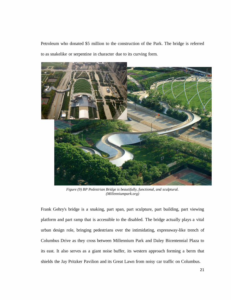
BP Pedestrian Bridge is a pedestrian bridge crossing Columbus that connects
Millennium Park to Daley Bicentennial Plaza in Grant Park. The Girder Bridge is the first
bridge designed by Pritzker Prize-winner, Frank Gehry, and was named for British
Millennium Park Bridge Chicago, Illinois Frank Gehry July, 2004
21
Petroleum who donated $5 million to the construction of the Park. The bridge is referred
to as snakelike or serpentine in character due to its curving form.
Figure (9) BP Pedestrian Bridge is beautifully, functional, and sculptural.
(Millenniumpark.org)
Frank Gehry's bridge is a snaking, part span, part sculpture, part building, part viewing
platform and part ramp that is accessible to the disabled. The bridge actually plays a vital
urban design role, bringing pedestrians over the intimidating, expressway-like trench of
Columbus Drive as they cross between Millennium Park and Daley Bicentennial Plaza to
its east. It also serves as a giant noise buffer, its western approach forming a berm that
shields the Jay Pritzker Pavilion and its Great Lawn from noisy car traffic on Columbus.

22
The bridge's design enables it to bear a heavy load and is known for its aesthetics. The
skin consists of 9,000 stainless steel shingles, smaller versions of the ones that clad the
Pritzker Pavilion. It has a pure form, no handrails to muck things up, just waist-high walls
that hold you in a viewing platform allows you to look back at the skyline, out to the
lake, or at the curving metal shells of Gehry's own Pritzker Pavilion and its monumental
trellis(Millenniumpark.org).
Figure (10) Craigieburn Bypass is standing welcome travelers to Melbourne.
(Craigieburn Bypass, Hume Freeway Australia)
Craigieburn Bypass Melbourne, Australia Peter Tonkin and Taylor Cullity Lethlean 2005

23
Sound walls and road furniture for a new 32 km stretch of freeway linking the Hume
Highway with the Melbourne Ring Road were designed in association with Landscape
Architects Taylor Cullity Lethlean. The project was designed to be experienced at a
freeway speed of 110km per hour. The footbridge, spanning 65 m over the freeway, links
housing to a protected expanse of native grassland. It includes three series of sculptural
sound walls, a pedestrian bridge and a set of design parameters for road bridges, crash
barriers and retaining structures. A major element of the work was a new pedestrian
bridge, which was designed as a gateway to the distant city of Melbourne, visible on the
horizon. The bridge, a complex curve in plan and elevation, is a tubular steel truss faced
with the same austenitic steel as the main sound walls, which at this point appear to leap
over the road in a gesture of welcome or farewell (Barbey, "Craigieburn Bypass, Hume
Freeway, Melbourne, Australia").
2. Hydrological/ Embankment design and management
Water run-off is one of the major issues along the highway as well. The Springfield
Northway is a raised 20-30 feet and extending 20-50 feet highway above both sides of the
neighborhood. The embankments are unused and filled with the invasive plants.
Therefore clearing up the invasive and unwanted plants, there will be more open areas to
re-design the embankment along the highway. Some areas have steep slopes that increase
the flow speed of the run-off water and reduce the absorbing time. In the rainy season,

24
some highway exist area such as Gerena Magnet high school, was overwhelmed with the
overflow run-off water from highway.
Cleaning up the dirty water from transportation is another parallel system that will work
perfectly with the embankment. Some interesting natural process such as the
phytoremediation or anaerobic digestion can be one option that applicable to filter the
water before going into the ground.
Highway Embankment Examples
Figure (11) Several Embankment Section and Design of the highway show the relationship between
highway, surrounding nature and landform.
(National System of Interstate and Defense Highway)

25
The sections show many different examples of embankment design: shoulders, drainage
channels, and slope to control erosion by grading and by the establishment of vegetative
cover. In regions too dry for growths of turf and groundcovers similar rounding of slope
intersections and channels is suggested, but bituminous, stone, or other paving may be
necessary to control erosion in gutters and channels.
A typical drainage way and side slope section readily protected against erosion on 4:1 fill
slopes and on 3:1 or 2:1 slopes and steeper, groundcover planting may be desirable .
A typical embankment paralleling a stream. Riprap or other masonry protection is
carried to a point above floodwater level. Above the riprap, the embankment is protected
by planting of permanent types of woody vegetation.
On urban highways, structures such as curbs, retaining walls, grade separations, bridges,
and interchanges. Form the framework of planting design. On open country roadsides,
planting design is largely controlled by natural features such as hillsides, bodies of water,
outstanding views, trees, and other existing natural growth as well as pavements and
structures and land use outside the right-of-way(Operating Committee on Roadside
Development,. A Policy on Landscape Development for the National System of Interstate and
Defense Highways).
Hydrological Management Examples
Phytoremediation describes the treatment of environmental problems by the use of plants
which mitigate the environmental problem without the need to excavate the contaminant
material. The specific plants are able to contain, degrade or eliminate - oil or

26
Figure (12) Phytoremediation requires some plant installation to set up multi-layer filter.
(What is Phytoremediation?)
contaminants, from the media that contain them. ("What is Phytoremediation")?
Anaerobic digestion is a series of processes in which microorganisms break down
biodegradable material in the absence of oxygen. It is widely used as part of the process
to treat wastewater. Some also used as a renewable energy source because the process
produces a methane and carbon dioxide rich biogas suitable for energy production,
helping to replace fossil fuels("Anaerobic Digestion").
Figure (13) Anaerobic Digestion does not only clean the dirty water but also creates some renewable
energy such as biogas.
(Anaerobic Digestion)

27
3. Energy efficiency zone and Renewable energy
To enhance power of the landscape, the city and its citizens should be a part of the future
plan to complete the mission. The Energy Efficiency Zone is a long term plan for
community to eager the town for the self-efficient energy in each household unit. Turning
nature energy into family need daily basis energy.
Renewable energy is not a new story but also never be an old story, likewise it is
developing all the times with the better technology. Wind, sun, and tides are three
resources within close proximity to the Springfield North End highway that can be
brought to produce energy to subsidize costs of the city. Two ideas are related with the
energy efficiency ideas and should be considered of the combination plan.
Planning and Network Examples
Pioneer City 2030 is an ideal city planning for power up neighborhood in energy system.
The idea is to create a number of local microgrids that share power across neighborhoods.
It turned out that having power networks deployed on a neighborhood level proved more
economically practical to generate renewable energy. Neighborhoods with numerous
high-rise buildings are a case in point. A combination of large solar photovoltaic
installations on major commercial and industrial roofs power microgrids, as do several
utility-scale wind turbine clusters on the edge of the city, and combined heat and power

28
plants fueled with biogas and biomass from urban waste streams. Those heat power
plants supply not only electricity, but also hot water and heat through pipe networks that
serve the central business district and other densely occupied areas. Neighborhood
heating and cooling substantially increase efficiency over each building having its own
heating and cooling units. Pioneer City also draws substantial renewable power from
distant, central installations including wind farms, solar photovoltaic and thermal plants,
and wave and tidal installations. These are delivered to the city on a smart transmission
grid that has been upgraded to handle the complex power flows from varying and
sometimes unpredictable renewable sources (Mazza, "Pioneer City 2030).
A number of municipalities across the country are getting creative and experimenting
with incremental, neighborhood- or district-based lending programs that help
homeowners pay the up-front capital costs. Under what are called ―renewable energy
community‖ programs, offering homeowners or businesses within designated
neighborhoods low-interest loans to complete efficiency or renewable energy projects.
("Neighborhood Assistance Program" Great City)
Renewable Energy Examples
Solar Flower Petal Street Lamps Phillips Simplicity Event 2008 Exhibition
Inspired by how flowers open up to the sun to collect the sun’s energy, the sustainable
city lights feature photovoltaic petals that open during the day to collect the sun’s rays

29
and transform them into energy. Then at night, the light closes and LED lights turn on to
brighten city streets.
The LED lights feature motion sensors that are triggered once the sun sets by individuals
walking in close proximity to the light. The intelligent outdoor lighting can enhance city
life by providing accurate light effects where and when needed, adapted to the day's
rhythm or triggered by activity ("Simplicity Event- Sustainable City Light." Phillips).
Figure (14) Phillips Street Lamps is a good example of solar energy mimicked from pure flower habit.
(Phillip.com)
This is the tidal turbines, and their rotors are propelled by tidal currents instead of wind.
The largest test of this new type of power production is under way in New York City's
East River, with six 35-kilowatt turbines scheduled to be installed in a channel that's off-
limits to large vessels. As the 16-ft.-dia. rotors spin, as close as 6 ft. to the water's surface,
they'll provide power to a supermarket and a parking garage. Once the test wraps up,
Virginia-based Verdant Power hopes to add hundreds more turbines, potentially reaching
Tidal Turbines New York City April, 2007

30
a total capacity of as much as 10 megawatts — enough to power 4000 homes up to
130,000 gigawatt-hours per year — about half the yearly production of the country's
dams — it's only a matter of time before major energy utilities begin testing the waters.
Figure (15) Wind and Tide Turbines are another ways of renewable energy that are getting more popular
in many places. (The Jordanville Wind Farm)
Wind Turbines Dagenham, London March, 2007
The Quiet Revolution or QR wind turbine is designed for an urban environment with low
wind speeds and changing wind directions. The QR helical design allows the turbine to
collect wind from all directions equally. The first qr5 turbine was installed in Dagenham,
a suburb of London, in March 2007. At the end of 2008, over 70 turbines had been
installed throughout the United Kingdom, where each unit generates between 4000 and
10000 kilowatt-hours per year. The second is the windspire, another vertical wind
turbine, similar to the Quiet Revolution. This 30-foot tall, 4-foot wide turbine generates
2000 kilowatts per hour given 12-mph winds, and it can survive winds up to 105 mph. It

31
has a tall, thin propellerless rotor. It generates power when wind spins its vertical airfoils.
These wind turbines have been installed across the county in homes, museums,
businesses, and schools. For example, the Michigan governor's residence has a wind
turbine, and Quinnipiac College in Connecticut is planning to use the turbines on campus
to help power its buildings ("The Jordanville Wind Farm").
4. Sustainable infrastructural highway materials
The use of local sustainable materials for design, maintenances, and construction can help
to make use of the highway. Green design should be introduced to the neighborhood.
Green design is an idea of using materials in the most efficient way. The principles are
simple: use materials wisely, conserve energy, save money in the long term, and create
surroundings that are safe and healthy. The easiest way is to reuse on-site, nearby, or
local materials to minimize the labor costs and buying new materials. In General,
highway is one part of the transportation infrastructures that including such as structures
(bridges, tunnels, culverts, retaining wall, signage and markings, electrical systems (street
lighting and traffic lights) and edge treatments. To improve the whole infrastructure
system will require an extensive amount of work from many disciplinary. The research
has mentioned some of them on previous topic such as bridges, tunnels, street lighting,
and edge treatment. One last interesting element want to explore is the vertical walls that
are easily found all along the Springfield North End Highway.
Living wall examples

32
Goodwill-Milgard Tacoma, Washington Patrick Blanc November, 2009
Goodwill-Milgard Living Wall designed by Patrick Blanc in Tacoma, Washington. The
green wall in Tacoma is his first exterior project in the United States. A twenty-by-forty-
foot vertical green wall on the east side of the building at Tacoma Avenue and Center
Figure (16) Goodwill-Milgard shows significantly the power of plants that can create a better use of hard
surface.
(Tacomagoodwill.org)
Street. The wall features nearly 2,200 plants from ninety-six different species arranged in
a wavelike pattern that creates, according to the artist, an expression of ―freedom.‖ There

33
are few flowers in sight, but the diversity of color, texture and form is remarkable. The
wall has also attracted small insects and animals. The vertical garden gives us a view of
the complete organism. We can see the roots. In the vertical presentation, the plants claim
their space, roots intertwine, and relationships develop It is a small ecosystem for animals
and insects as well as a good opportunity for the young people coming here and learning
many new things, to see a piece of nature(Bunker, "Tacoma").
PNC Headquarter Pittsburgh, Pennsylvania Mingo Design September, 2009
On the side of PNC headquarters building in downtown Pittsburgh, PA, the largest living
wall of North America, designed by Kari Katzander of Mingo Design. PNC’s living wall
is not only beautiful, but helps to reduce energy use as well. This spectacular vertical
garden is roughly the size of a doubles tennis court. The 2,380 sq foot living wall is soil
based and includes many regional plants, all acquired locally within 500 miles of
downtown Pittsburgh. The panels are reducing the temperature of the building, with
preliminary studies showing that the wall behind the panels is 25% cooler than ambient
temperatures. The eight varieties of plants are actually evergreen, meaning they should
remain green throughout the year with some even flowering in the spring (Meinhold,
"North America’s Largest Living Wall Installation by PNC").

34
Figure (17) Two different living walls turn unused vertical wall into beautiful and functional part of
buildings.
(landscapeurbanism.org)
An elegant version came from fashion retailer Ann Demeulemeester in Seoul, Korea. The
living building was designed by Mass studies, a Korean based architecture firm on 2007.
The building consists of four levels, shop, a multi-store and restaurant on the top floors.
The project's facade is made from a geo-textile planted with herbaceous perennials to
form a living wall. The greenery is carried interior and exterior; the extensive building
coverage, the integration with windows, curves, wall, or elsewhere could possibly
incorporating nature. The shop's location is in a residential neighborhood that is evolving
into a shopping district. (Jason A., "Living Wall").
Ann Demeulemeester Seoul, Korea Mass studies 2007

35
Recommendation
After understand the Four Co-ecological concepts and its examples, this part of the
research will tell about how to apply those ideas to solve the Springfield North End
highway issues orderly;
1) A Green corridor buffer and connection.
2) Hydrological/ Embankment design and management.
3) Energy efficiency zone and Renewable energy.
4) Sustainable infrastructural highway materials.

36
Each paragraph will restate what happened in existing conditions, problems, and
researcher's recommendation based on the examples of each idea from the previous
chapter.
1. A Green corridor buffer and connection
There are several ways of connecting people over or under the highways. First, the easiest
way, is to utilize the existing tunnel by illuminated it such as Craigieburn Bypass in
Melbourne, creatively cooperated the art of lighting and structure. Not only promote
people to use the path but also resolve the safety issues from car accidents and crime.
Second, the pedestrian bridge should be considered as another for Springfield North End.
Even though it is a tough challenge and requires time and money, it is a good alternative
way and will provide much more benefits. The Landbridge in Washington is a great
proved example of the successful pedestrian connection; functional, historical, and
ecological design. Thinking the connection is an important landmark for people. Make it
visible and useable; bring people in to celebrate the new connection, which will also
attract travelers as well. Furthermore, we have to bring in both surrounding nature and
highway together for creating the green highway corridor that functions as the
environmentally safe travelling way and ecologically buffering edge that encourage and
promote locally relation of neighborhood while provide animal movement and habitat.
Most of the left over space along the highway are fragmented, narrow, and thin; densed
with understory shrubs and invasive plants, also do not have many big trees. Trees are

37
important to reduce the noise level, pollution, and screen vehicle movement for
residential from highway. I would recommend the town to plant more native trees and re-
vegetate the lower understory plants and groundcover in the left over area used the
highway guidelines of planting; they will be not only vegetation edge to buffer from
highway and direct people from both neighborhood to the connection bridge but also
provide animal habitats and enhance their movement to other areas.
2. Hydrological/ Embankment design and management.
The best management practice for North End should look at the combination of a series
of terrace embankment with groundcover and bioretention swales. The consideration
should reduce a number of grey water as well as create the better hydrological system and
visual pleasing to the community living nearby. A variety typologies in embankment
design can use in order to slow down the run-off water and increase the area to absorb the
water in the drainage system such as terraced terrain riprap stones/gravels, and retention
basins as shown in previous topic.
The Highway needs at least one filtration to make water cleaner by using either
phytoremediation or anaerobic digestion before piping to the river. This can be done
easily with the retention basin area nearby the site. Installed the treatment plants such as
Alpine pennycress, Thlaspi, or Amaranthus retroflexus- those are some expert plants on
responses to environmental stress, mineral nutrition, and soils contaminated with heavy
metals and radioisotopes- at some major drain areas such as the Bay State Medical Exit to

38
filter some heavy particles and oil from the transportation. That can clean and eliminate
some mixed particles in dirty water before let the cleaner one through the other resources.
Then, double filter run-off water in sewage system with anaerobic digestion. Almost any
organic material can be processed with anaerobic digestion. Biogas from sewage works
is sometimes used to run a gas engine to produce electrical power; some or all of which
can be used to run the sewage works. Some waste heat from the engine is then used to
heat the digester. That might be another filter option that provides the great benefit to
city.
3. Energy efficiency zone and Renewable energy
Many cities in the United States of America have been purposed and developed the town
scale energy plan such as renewable energy community in Berkeley, California where the
city or involved organizations support particular designated neighborhoods for low-
interest loans to complete efficiency or renewable energy projects. The behind idea is that
to have an individual being self-efficiency and reduce the city center energy. It is a long
term plan that eventually will bring back an incredible result in next 15 or more years for
community and family. The town should at least be studied or researched the energy
efficiency zone or plan or may adapt similar strategy that applicable to the neighborhood
with smaller budget and faster result.

39
The North End Springfield neighborhood is mainly Latino and people are mostly low-
income family. Unfortunately, the town of Springfield has a limit budget to spend for a
long term project. However, there are some private non-profit organizations in North End
that have been helping people and developing the community for more than 10 years,
called NEON, North End Outreach Network lead by Joaquin Rodriguez. The
organization is now focusing on the quality life, job distribution, and education for Latino
community. If the city can provide some support to NEON to establish some fund or
connect to fund resources, they might have a chance to expand their future plan in
integration some energy efficiency plan or research for people.
With a new advanced technology, many new designed wind turbines do not require much
strong wind to trigger its function any more. The QR or Quiet Revolution wind turbine is
a good low-wind operate example. It also can collect wind from any direction with a
smart fan design. Springfield North End has a fair amount of wind along the highway, so
this should be one option to be considered to utilize the wind power. Phillips has
presented brand-new smart street lamps on 2008 exhibition. The innovative lamp is
called "Solar Flower Petal Street Lamps." It blooms to absorb sun energy during the day
and transform to provide a bright light street lamp at night. The intelligent lamps are
adjustable interactively with users around them. The design is not only to save energy
and money but to use it more efficiency as well. Ideally, the smart lamps can help to
reduce a number of Horse Shoe spot light along the highway and save more energy.
Lastly, similar concept with the wind, tidal turbine uses river current to operate and

40
transform into electricity. The Connecticut River is a good resource to experiment the
idea. All above ideas are some great examples of the renewable energy concept that turn
the natural power into positive energy. Several areas have potential to install some of
those utilities and make them part of the natural and educational green energy corridor.
The town can use them to teach community and children about the future energy of the
world as well.
4. Sustainable infrastructural highway materials
Many parts of the retaining wall along the Springfield North End are typically left blank,
no-used, and unattractive. They are mostly impervious concrete, which will not help for
drainage system. Some interesting ideas like living walls can help to utilize the unused
vertical hardscape elements in a different way by make them beautifully alive and greatly
benefits. By adding plants to traditional highway walls it helps not only to screen the
unpainted surface but also collect some water on the vertical surface off the highway and
the embankment. Most living wall examples are usually done with the tall walls or high
buildings. Living wall is not as hard as it look. On the highway area, it should not use too
fancy planting plants. It can be done with one simple plant or local resilient plant for
example vine, is one of the most common and the easiest plant that can be used. Not only
it will cover the hard surface, but it can change color seasonally as well.

41
How do four systems work as a single machine to resolve the disconnected community?
Step:
1. To educate and trigger community about the circular sustainable system that will
reconnect and redevelop the neighborhood.
: To educate, promote, and communicate to community are a grass root for future
development and commitment. People will truly understand the process and work
together in both communities.
: Resolve => neighborhood intangible barrier, confusion, lack of community support
2. To locate the green connection and corridor location along the highway either tunnel or
bridge
: This is a significant step because it is a main attraction for both pedestrians and
vehicles.
: Resolve => neighborhood disconnection and safety issues.
3. To begin with revegetate and redesign the embankment to set up the new ecological
system of the highway and reduce the run-off dirty water before pipe to the Connecticut
River.
: The second important step will hugely support much strong defined ecological edge and
path
: Resolve => waste left over space, lack of the ecological system, animal habitat and
corridor. movement, run-off water, air pollution, noise, and traveling visibility.

42
4. To combine some renewable energy technologies or inventions in the major area
: Promote the educational green energy opportunity among community, long term energy
cost deduction, take advantage of major assets in the area.
: Resolve => waste left over space, lack of energy efficiency plan
5. To use the local plants, materials, and expertise in constructions, planting, and details.
: Promote local economy supports both products and personals, use more sustainable
materials.
: Resolve => material costs and efficiency
6. To monitor the system by community eyes
: Use the community base as an inspector to generate the strong system.
All four integrated systems work as a single machine unit process cycle for the future
reconnection of the North End neighborhood.
Conclusion
The North End of Springfield aligns along two major highways, I-91 and I-291, in West
and South orderly. The North End comprises three neighborhoods: Brightwood,
Memorial Square, and Liberty Heights. Memorial Square and Brightwood have a rich
Hispanic culture but a very low average household income. The most physical challenges
in the North End as a whole is the

43
fragmentation of the area by two Interstates-- I-291 and I-91--and the Springfield-
Holyoke Railroad Line. The major assets include the closed proximity to downtown
Springfield as well as the North End’s thriving medical industry, which includes Baystate
Medical Center and Mercy Medical Center. The medical industry is, one of the largest
employers in the region as a whole. The Connecticut River and Van Horn Park are
significant natural and potential recreational resources for the North End but are
characterized by a lack of connection to and integration into the adjacent neighborhoods.
As the world change every day as well as other such as landscape, ecosystem, cities, and
so on, therefore, the designers try to come up with the design approach to handle and
provide a longer flexibility for space and human. The answer is Landscape Urbanism.
Landscape urbanism is a movement, theory, concept, or method within design fields that
provides the visionary framework for an interdisciplinary urban discourse, counteracting
several disciplinary and other related professional to find possible solutions for the
sustainable human society. It is an ecologic way of understanding the city and its
components. It presents the importance of the space dynamic between city and landscape.
Many important characteristics of Landscape Urbanism are such as a time-base strategy,
horizontal design, multi-disciplinary, flexibility handling uncertainty, and more.
However, Landscape Urbanism is still new and complicated and requires much
experience to think beyond for the future unpredictable problems.

44
It should be addressed and integrated in regular course for much more benefits in student
knowledge and practice for better understanding and design approach as well as it will be
a good establishment for wider connection and learning with other related fields.
Learning from Springfield North End highway and Landscape Urbanism, combines some
part of the theory with the major issues of the site, eventually brought into the Four Co-
Ecological system;
1) Green Highway: Green corridor buffer and connection.
2) Hydrological/ Embankment design and management.
3) Energy efficiency zone and Renewable energy.
4) Sustainable infrastructural highway materials.
Those four concepts are based on finding the ways to solve the neighborhood existing
issues that work together as a single system. Green highway aim to reconnect three area
to be able to access and share the natural assets on both side, promote the wild life
movement and habitat, and provide more benefits to the travelers on highway for better
scenery. To redesign embankment is a simple and practical method to response and
support the hydrological system around the highway. Several embankment designs can be
applied to fix the run-off problem, to slow down the water, and increase more time to
filter to the ground. Double filter water with phytoremediation before going into the pipe
and anaerobic digestion before piping the water to other sources. People must know and
think that all the problems are not specific for city or some particular organization to
resolve but they are all should be responsible and be part of the system to solve those

45
problems. Energy efficiency zone is an ideally residential area for self-efficiency power
to subsidize the money for energy in each household unit. Taking advantages of solar,
wind, or water to make the best use of them in many different ways. Lastly, should be the
first consider before installation, is the sustainable infrastructure material. Most of the
highway wall are party that mainly unused and unattractive for people. To utilize the area
wisely will provide more benefit to the highway, hydrological system, and education for
community. Living wall is a good example for it.
The most important benefit of the thesis is the understanding of the landscape urbanism
concept and be able to apply some part of the theory into specific site design. It will be
another research support document for the town of Springfield. The research will be a
good guide line for the future students who are interest to learn about the landscape
urbanism either involved with highway problems or else as well as support for master
degree research in landscape architecture field in much deeper level project in the future.

46
Reference
Print.
Bunker, Virginia. "Tacoma." City Arts Nov 2009: 20-24. Print.
Czerniak, Julia, and George Hargraves. Large Park. New York, USA: Princeton
Architectural Press, 2007. Print.
Enlow, Clair. "Prairie Crossing." Landscape Architecture Feb 2009: 90-95. Print.
Lindholm, Gunilla. "Large-Scale Architecture, Ecological Urban Planning or a
Designerly Research Policy." Landscape Urbanism. Alnarp, Sweden: Print.
Marek, Mark A. Landscape and Aesthetics Design Manual. Texas: Design Division,
2009. Print.
Operating Committee on Roadside Development, . A Policy on Landscape Development
for the
National System of Interstate and Defense Highways. Washington, DC: American
Association of State Highway Officials, 1961. Print.
Operating Committee on Roadside Development, . Landscape Design Guide.
Washington, DC:
American Association of State Highway Officials, 1964. Print.
Sleegers, Frank. Making Connection in Springfield's North End. Senior Urban Design
Studio LA
497 A Fall 2009
Taylor, James. Sustainable Urban Landscapes. Vancouver, Canada: University of British
Columbia, Sep 1995. Print.
Waldhiem, Charles. The Landscape Urbanism Reader. New York, USA: Princeton
Architectural Press, 2006. Print.

47
Non-Print
"Anaerobic Digestion." Residua n. pag. Web. 28 Mar 2010. <www.residua.com>
"Ann Demeulemeester shop by Mass Studies." Designboom. Daily Coverage, 17Dec
2007. Web. 29 Mar 2010.
<http://www.designboom.com/weblog/read.php?CATEGORY_PK=&TOPIC_PK
=2163>.
Barbey, Thosmas. "Craigieburn Bypass, Hume Freeway, Melbourne, Australia." Vulgare.
Thomas Barbey, 07 Dem 2008. Web. 29 Mar 2010.
<http://www.vulgare.net/craigieburn-bypass-hume-freeway-melbourne-australia/>.
Beimborn, Edward A. "Center for Urban Transportation Studies." University of
Wisconsin- Wilwaukee. University of Wisconsin- Wilwaukee, n.d. Web. 29 Mar
2010. <http://www4.uwm.edu/cuts/index.html>.
<http://www.greatcity.org/campaigns/neighborhood-assistance-program/>.
"Bennington Bypass Project Environmental." Bennington Bypass. N.p., 24 Dec 2008 .
Web. 29 Mar 2010.
<http://www.aot.state.vt.us/progdev/Sections/Design/bennBypass/ProjectEnviron
mental.htm>.
"Cities use creative, targeted lending to speed energy projects ." Climate Solution. The
New York Times, Jan 6 2009. Web. 29 Mar 2010.
<http://climatesolutions.onenw.org/news/cities-use-creative-targeted-lending-to-
speed-energy-projects>.
"Household greywater wetlands." Frog Watch. The Amphibian Research Centre, 2004.
Web. 29 Mar 2010. <http://frogs.org.au/frogwatch/greywater.php>.
Jason A., King. "Living Wall." Landscape+Ubranism. N.p., 20 December, 2007. Web.
29 Mar 2010.
<http://landscapeandurbanism.blogspot.com/2007_12_01_archive.html>.
Mazza, Patrick. "Pioneer City 2030: What the Energy System of the Future Looks Like ."
Climate Solution. N.p., 30 Jun 2009. Web. 29 Mar 2010.
<http://climatesolutions.onenw.org/cs-journal/pioneer-city-2030-what-the-energy-

48
system-of-the-future-looks-like>.
Meinhold, Bridgette. "North America’s Largest Living Wall Installation by PNC."
Inhabitat. Inhabitat, LLC, 23 Sep 2009. Web. 29 Mar 2010.
<http://www.inhabitat.com/2009/09/23/north-americas-largest-living-wall-
installation-by-pnc/>.
Meinhold, Bridgette. "Solar Flower Petal Street Lamps Bloom by Day, Illuminate the
Night." Inhabitat. Inhabitat, LLC, 26 Feb 2010. Web. 29 Mar 2010.
<http://www.inhabitat.com/2010/02/26/sustainable-city-street-lights-by-
phillips/>.
"Projects." CHA. N.p., n.d. Web. 29 Mar 2010.
<http://www.chacompanies.com/go/project/>.
"Reforming Engineering of Beijing 101 Highway in Miyun Section." USA RHM
International Engineering Design LLC. USA RHM International Engineering
Design LLC, 2004. Web. 29 Mar 2010. <http://www.usa-
delaware.us/portfolio_roads%20and%20bridges/roads_11.htm>.
"Simplicity Event- Sustainable City Light." Phillips. Koninklijke Philips Electronics,
2008. Web. 29 Mar 2010.
<http://www.design.philips.com/philips/sites/philipsdesign/about/design/designpor
tfolio/brand_communication/simplicity_event/sustainable_city_light.page>.
"The Jordanville Wind Farm." New Wind Energy. N.p., n.d. Web. 29 Mar 2010.
<http://www.jordanvillewind.com/>.
"What is Phytoremediation." N.p., n.d. Web. 29 Mar 2010.
<http://arabidopsis.info/students/dom/mainpage.html>.