Embed Size (px)
Citation preview

Lander County, NevadaSocioeconomic Impact Analysis
of the Proposed Repositoryat Yucca Mountain


Lander County Impact Report 1 August 2001
1.0 INTRODUCTION Lander County Nevada is valued for historical significance, mountain scenery, rich natural resources, and diverse recreational opportunities. The County's natural resources have attracted residents since the 1800's when prospectors sought the area's gold and silver. Today mining, outdoor recreation, and agriculture serve as a basis for the County economy. The "boom or bust" nature of the mining industry has resulted in periods of rapid growth and corresponding economic declines throughout the County. Both Austin and Battle Mountain have experienced these cyclical growth patterns which have resulted in reactive development to satisfy immediate needs. By establishing long-range planning goals through a master planning effort, the quality of life for all Lander County residents can be improved and protected. Lander County is named after Frederick W. Lander, builder of a wagon road across the State for the federal government. The County was formed December 19, 1862 and originally encompassed the eastern third of the State. It was called "The Mother of Counties" after it was divided into the Counties of Lander, Eureka, White Pine and Elko. The first County seat was Jacobsville, six miles west of Austin. Voters mandated its move to Austin in September 1863. In May, 1979 the voters approved moving the County seat to Battle Mountain. The Austin Courthouse was built in 1869 and served Lander County for 116 years. It is still used for County offices today. There are three primary population centers in Lander County. They include the Town of Battle Mountain and outer-lying areas, The Town of Austin, and the Town of Kingston (See Figure 1-1). Battle Mountain Battle Mountain was home to the Northern Paiute and Shoshone Indian tribes. A fur trader for the Hudson Bay Company, Peter Skeen Ogden, was one of the first to see the junction of the Humboldt and Reese Rivers in November of 1828. Beginning in 1833 with the Walker Expedition, the Humboldt River was used by trappers and explorers as a pathway west. By 1845 the emigrant trail along the Humboldt was well established. Beginning in 1851, the overland mail was carried by pack mules along the Humboldt Trail. A stone cabin was built for the mule skinners at Stonehouse, one of the first buildings in the region. Sometime during 1850 to 1860, there was a conflict between white settlers and local Indians, and Battle Mountain was born. In 1860 a shorter route was found through Austin and travel shifted south. In 1866 gold and silver were discovered in the hills southwest of town, in Licking Canyon. Two years later the Central Pacific Railroad built its lines along the Humboldt River and the Town of Battle Mountain. Mining and ranching have been the backbone of Battle Mountain's economy. At one time, Battle Mountain was considered the Barite Capital of the World.


Lander County Impact Report 2 August 2001
By 1880, Battle Mountain had become a regional freight and trade center. In 1917 the Battle Mountain Indian Colony was established on 688 acres west of Battle Mountain. 1930 saw the start of the paving of the major highways and the advent of tourism. Today, the area has a population of approximately 5,300. Substantial fluctuations in population have occurred recently do to mining activity. Austin Austin is located almost in the geographic center of Nevada on U.S. Highway 50, 179 miles east of Reno. It was named after Austin, Texas. Austin was founded in 1862 when a Pony Express pony kicked over a rock west of the present town and started a rush for the rich silver ore. By the summer of 1863, Austin and the Reese River Mining District had a population of 10,000 persons. In that year, Austin was made the County seat of Lander County, which at that time included Eureka, White Pine, and Elko Counties. The Nevada Central Railroad was built in 1880 and aided in mining developments and enhanced Austin's position as a commercial center. When silver production dropped, the area switched to uranium and Apex Minerals Corporation Rundberg Mine was the largest uranium mines in Nevada. Later, Austin became the center of the turquoise mining industry. Austin today is the center of a vast cattle and sheep ranching area and offers some to the finest fishing and deer hunting areas in the west. Austin's population has diminished and many of the old buildings have been removed, but the "spirit" of Austin is much the same today as it was in the 1860s. The Town currently has a population of approximately 340. Tourism/recreation, ranching and mining are important economic activity in the Austin area. The Town is located on U.S. Highway 50 about 10 miles west of the proposed rail line through Big Smoky Valley. Kingston Kingston Canyon, a historic mining district, is a short 30-mile drive south of Austin. It is named after the Kingston Mine discovered in 1863 and was the location of a number of silver mines in the 1860s. Remnants of these are scattered throughout the canyon and one large stone mill can be seen across from the Kingston Lodge. The Kingston area hosts some of the best varied trout fishing in the state. Some of the most beautiful scenery in Lander County can be seen here, from the Kingston Canyon Creek Campgrounds to Groves Lake. Gilman Springs, a sister community to Kingston, is located on State Highway 376, 12 miles from Highway 50 and a few miles north of Kingston. It is composed of one acre family farms and has had a number of houses built in the last few years. Both Kingston and Gilman Springs are located in the Big Smoky Valley approximately 3 miles from the proposed rail route.

Lander County Impact Report 3 August 2001
Purpose and Need This report is a preliminary investigation into the potential social, economic impact, and transportation impacts that could occur in Lander County as a result of the Yucca Mountain Repository program and related transportation activities. The analysis considers direct, indirect and risk induced impacts associated with the repository program and more specifically the transportation program. Impacts discussed in this report are primarily related to transportation impacts. Although Interstate 80 is not currently a preferred route to Yucca Mountain, states have the ability to select alternative routes that could place waste shipments to Yucca Mountain on a host of alternative routes other than U.S. DOT preferred transportation routes (Interstate System). In two DOE shipping campaigns including the Waste Isolation Pilot Project in New Mexico and the Nevada Test Site, western states have been very active in the selection of transportation routes. A similar situation will likely occur with Yucca Mountain where states become active in route selection in order to avoid major population centers. Interstate 80 provides a substitute link for certain generator sites throughout West and Northwestern areas of the country. As a result, Lander County could experience a sizeable number of waste shipments to the Yucca Mountain site, if it were to be built. Among the transportation options being considered for Yucca Mountain is a rail access spur through north central Nevada. The U.S. Department of Energy (DOE) is currently considering a rail alignment that leaves the Union Pacific mainline at Beowawe, Nevada and heads south past Crescent Valley into eastern Lander County. The proposed rail spur could carry as many as 19,000 rail shipments of spent nuclear fuel and high-level nuclear waste to a repository over a period of 24 to 38 years. Organization of the Report This report contains two major sections. Section 2.0 discusses existing and projected transportation activities and highway corridor characteristics associated with Interstate 80 and the proposed rail line through eastern Lander County (Crescent Valley route) It identifies critical features of the corridor that could be adversely impacted by highway shipments to Yucca Mountain. Section 3.0 focuses primarily on impacts to natural resources and natural resources users along the proposed rail corridor. Section 4.0 describes the potential economic and fiscal implications of Yucca Mountain and the transportation program on Lander County. Section 5.0 provides a description of potential community impacts from rail construction and operations. Finally, Section 6.0 describes the extent to which Lander County may be affected by cumulative radiation exposure from Past NTS weapons testing activity. 2.0 WASTE TRANSPORTATION IMPACTS IN LANDER COUNTY The U.S. Department of Energy plans to make thousands of shipments of low-level radioactive waste (LLW), high-level radioactive waste (HLW), and spent nuclear fuel (SNF) to the Nevada Test Site (NTS) and the proposed repository at Yucca Mountain.

Lander County Impact Report 4 August 2001
Shipments will be made by a combination of mostly truck or mostly rail. Because DOE has yet to determine a specific modal option, it is possible that a combination of truck and rail shipments will occur. Currently, LLW shipments move to the NTS by truck. Until recently DOE had not considered rail shipments for LLW because NTS is not served by rail access. Since 1997, the DOE has considered the possibility of an intermodal transfer station in southern Nevada where LLW would be off-loaded from trains and transferred to trucks for the final leg to NTS. Currently, there is only one known LLW generator site (Femald) considering the intermodal rail option. It is possible that some LLW shipments may travel by rail, if a spur were constructed through northern Nevada. High-level radioactive waste and SNF can also be shipped by rail, truck or a combination of both. To date, the DOE has not announced any specific modal options for shipments to the proposed Yucca Mountain site. Similar to the LLW shipping campaign, the Yucca Mountain program would have to develop rail access to the proposed repository site, or utilize an intermodal transfer station with heavy haul trucks in order to ship HLW and SNF by rail. Under DOE's privatization proposal, commercial shipping companies would be responsible for moving HLW and SNF from generator sites to Yucca Mountain. A commercial shipping company called a regional servicing contractor would be responsible for transporting wastes from one of four regions of the country to the repository. It is difficult to predict with any certainty whether the DOE will actively select one mode (rail or truck) over the other. All indications are that the DOE appears to be moving towards the use of commercial transportation where a private company will be responsible for moving waste from a generator site to Yucca Mountain. Commercial shippers currently use trucks to haul LLW from generator sites to the NTS. Even in the event that a mostly rail option is selected for the Yucca Mountain project and or LLW shipments to the NTS, some truck shipments will still occur because there are a number of generator sites around the country that do not have rail access. Contained within this review are the projected numbers of shipments of HLW and SNF destined for the proposed repository at Yucca Mountain. Projections for waste volumes are shown for a mostly truck option and a mostly rail option (See Table 2-1). Generator sites that could ship wastes through Lander County are located in the northeast and north central portion of the United States as well as Oregon, Washington, and Idaho. Under the proposed action about 70,000 metric tones of waste will be stored at Yucca Mountain. Under an alternative scenario approximately 105,000 metric tons of commercial spent nuclear fue1 could be shipped to the repository. The increased amount is due to greater waste volumes being generated as a result of continuing operations at nuclear power plants beyond 2033. Under the high volume scenario, waste shipments through Lander County could begin around 2010 and continue nearly 40 years to 2048. Table 2-1 summarizes the number of waste shipments that could potentially move through Lander County. The mostly rail scenario represents a condition where most shipments are made by rail on the proposed rail spur through Crescent Valley. It is

Lander County Impact Report 5 August 2001
possible that some truck shipments could move through the area even if the Crescent Valley rail spur were not constructed. However, it is difficult to quantify the total number of shipments at this time. Assuming most western sites in California, Oregon, and Washington were to use rail, approximately 1,000 to 4,000 shipments could move through Battle Mountain either to the rail spur or the interim storage facility at Skull Valley. It may be possible that one or all Ca1ifornia reactor sites may use Interstate 80 to reach Skull Valley, Utah. (See Figure 2-1). The mostly truck shipment scenario represents shipments to an interim site from California nuclear power plants. Table 2-1 Summary of Projected Shipments Through Lander County
Waste Type Mostly Truck-Shipments To an Interim Site
Mostly Rail Shipments to a Rail Spur
Yucca Mountain: Proposed High
Volume Proposed High
Volume Commercial SNF 0 0 8,386 13,906 DOE SNF and HLW 1,667 2,768 2,429 5,253 Greater than Class C 0 0 Total Shipments 1,667 2,768 10,815+ 19,159+
*Estimate- The total number of shipments is likely to increase. Source: Table J-1 Draft EIS for Yucca Mountain, 1999 Under the current proposal, 8 nuclear power utilities seek to site and operate an interim storage facility at the Skull Valley Goshute Reservation in northern Utah. A consortium of nuclear power utilities and the Goshute Indians are seeking a license to construct and operate an interim storage facility for spent nuclear fuel. Private Fuel Storage L.L.C (PFS) is a limited liability company owned by eight U.S. power utilities has applied to the Nuclear Regulatory Commission (NRC) for a license to receive, transfer, and possess spent nuclear fuel (SNF) from commercial nuclear power plants at a privately owned independent spent nuclear fuel storage facility. PFS has identified a location for this facility on the Reservation of the Skull Valley Band of Goshute Indians approximately 27 miles west-southwest of Tooele, Utah. Skull Valley lies just south of Interstate 80 approximately one hour from the Nevada border. Shipments from California reactors could pass through Battle Mountain to Skull Valley. In addition to rail and truck shipments, which may pass through the area, Lander County may also be called upon to provide emergency assistance to truck accidents along the proposed Interstate 80 and U.S.93/6 corridor. For several years, local government response agencies have considered establishing a regional hazardous materials response team in northeast Nevada. Under this scenario, it is very likely that Lander County

Lander County Impact Report 6 August 2001
emergency response personnel would participate in accident situations in either Elko or White Pine County that involve Yucca mountain shipments. 2.1 Transportation Routes Through Lander County Interstate 80 Very few direct truck shipments are expected through Lander County to the repository unless the State of Nevada selects an alternative route configuration that moves waste across the interstate corridor connecting to U.S. 95 south to Yucca Mountain. Some shipments could move through the area as a result of truck shipments to an interim site at Skull Valley, Utah. Posted speed limits through the area are 75 mile per hour. Population density along Interstate 80 is generally low similar to rural areas used in the Yucca Mountain EIS. However, the Town of Battle Mountain has an estimated population of 4,200 in 2000 (Nevada State Demographer, 2000) and a resulting population density of approximately 4,000 persons per square mile. Outside the Battle Mountain area the population density is relatively low with few residential units adjacent to the highway. In total about 5,200 residents live in and around Battle Mountain. With such a limited number of trucks moving through the area, the probability of an accident remains extremely low. Furthermore, because Interstate 80 is a divided 4 lane freeway, the potential of a credible accident scenario that would result in a release of radioactivity also remains somewhat limited. Rail Routes Lander County could potentially be impacted by transportation of high-level waste along the Union Pacific mainline corridor. The rail corridor in Lander County is approximately 22 miles in length. The Union Pacific operates its mainline system in the Humboldt River Valley. The Town of Battle Mountain is located halfway along the corridor at the northern end of the Reese River Valley. There are two branch lines of the Union Pacific Mainline. The former Southern Pacific mainline carries west bound traffic while the branch line to the north of Battle Mountain carries traffic to the east. The Town of Battle Mountain is located on the branch of the mainline carrying west bound traffic. As a result, rail operations would not directly affect the Town of Battle Mountain. Shipments from western generators to an interim site at Skull Valley would pass north of Battle Mountain. The corridor is virtually flat having no adverse grades. Bridges and culverts are generally in good condition. Generally this rail corridor provides favorable conditions for rail operations with some noted exceptions. Access for emergency response along the branch line passing directly through Battle Mountain is generally good. However, access to the eastern bound branch for emergency response is limited. During periods of inclement weather, the maintenance roadway would be impassable. Emergency response

Lander County Impact Report 7 August 2001
equipment would risk bogging down attempting to reach and or use the maintenance roadway. Materials currently shipped through Battle Mountain are of an extremely hazardous nature. Products shipped include sodium cyanide, ammonium nitrate, chlorine, sulfuric acid, hydrochloric acid, and ammonia. These materials generally move from areas north of Battle Mountain through the Town of Battle Mountain to active mining operations in northern Nevada. However, movement of these materials does not cross the northern branch of the UP mainline. As a result, shipments moving east would probably not encounter radioactive waste shipments to the Yucca Mountain site or an interim storage site at Skull Valley. In 1993 Lander County reviewed road crossings on both branches. Recommendations for improvements were made-up of 8 road crossings. Road crossings in Lander County, particularly those in Battle Mountain, are heavily traversed by trucks hauling materials of a toxic and explosive nature. Additionally, there are several at-grade crossings along the rail routes in northern Lander County that have limited safety and warning devices. Total costs of improvements was estimated to be more than $30,000 in 1993 dollars. This cost does not include realignment of one road that intersects the rail line at 90 degrees. This configuration violates the principle of the straight approach for at least 100 feet either side of the crossing. More detailed information regarding rail crossing in Lander County can be found in a 1994 report entitled, Evaluation of Railroad Grade Crossings, prepared by ETS Pacific, Inc. • Crescent Valley Rail Spur Among the transportation options being considered for Yucca Mountain is a rail access spur through north central Nevada. The U.S. Department of Energy (DOE) is currently considering a rail alignment that leaves the Union Pacific mainline at Beowawe, Nevada and heads south past Crescent Valley into eastern Lander County. The proposed rail spur could carry as many as 19,000 rail shipments of spent nuclear fuel and high-level nuclear waste to a repository over a period of 24 to 38 years. The proposed rail route is shown in Figure 2-2.
Figure 2-1 Proposed Rail Routes Through Lander County
From the connection at Beowawe, the proposed rail route travels southwesterly following the alignment of Coyote Creek and State Highway 306 at mile post 6.2. The grade of the first 15 miles is slightly ascending at 0.3%. There is bottomland to the east of the route and there is mining activity in the area with several mine access roads criss-crossing the valley. From MP 15 to 31.3 the grade is flat and passes through rolling hills up to 75 feet high. The line again crosses Highway 306 at MP 22.5, east of Tenabo where the highway swings west toward the Gold Acres mine area. At MP 31.3 the valley is still wide but the grade begins a perceptible climb of 1.2% toward Dry Canyon. From MP 34.3 to 56.5 the slope increases 1.6% and the corridor narrows to a tight valley 500 feet wide. For the


Lander County Impact Report 8 August 2001
next 6.7 miles the grade increases to 2.4% and the canyon narrows to 200 feet wide and becomes quite winding as it works its way through 150 high side hills. Flooding and slides would be a concern of this section. The peak elevation of 6,300 is reached at Dry Canyon Summit at MP 45.2. The descent down the first 5 miles of Dry Canyon is more gradual at 1.6% but the canyon is still winding and narrow at 400 feet wide with 100-foot side hills. The next 5 miles down Dry Canyon Wash is more gradual yet at 0.7% and the wash widens to perhaps 1,000 feet. From MP55 to 65.6 the route is level along the west edge of 11-mile wide Grass Valley. This section is characterized by numerous small transverse washes from the east side of the Toiyabe Range watershed and rolling terrain. The hillocks are in the order of 30 feet high and the washes are perhaps 15 feet across. At the south end of Grass V alley the route follows Callaghan Creek and begins a gradual rise of 0.6% for 8.6 miles. The geography is one of lush farmland with the Grass Valley Ranch sitting at the confluence of several creeks at MP 71. The line crosses State Road 21 at MP 74.2 and begins a more aggressive ascent of 1.6% up a 400- foot wide canyon. After 3.5 miles the grade turns steeper yet at 2.6% and the canyon narrows to 200 feet. The summit at elevation 6,550 is reached at MP79.5. From the summit the descending grade is 1.3% for 7 miles through Rye Patch Canyon which averages 400 feet wide. At MP 86.5 Rye Patch Canyon begins to widen out into the head of Big Smoky Valley and the grade lightens to 0.8%. After 7 miles the route crosses Highway 50 at MP 93.6 and the descent flattens to 0.3% for another 10.4 miles. From this point on the corridor is essentially flat and runs for an additional 6.75 miles to the County line at MP 110.75, crossing Birch Creek and the all-weather road that crosses the Toquima Range into Monitor Valley. The troublesome sections of this route are the heavy agricultural use at the south end of Grass Valley and the 20 miles of difficult terrain from there through the Rye Patch Canyon area. A more detail map of the routes can be found in Appendix A 3.0 IMPACTS TO NATURAL RESOURCES Section 3.0 describes impacts to natural resources along the proposed Crescent Valley rail route. The impacts are largely associated with the construction and operation of a proposed rail spur to Yucca Mountain. The Draft Environmental Impact Statement made little reference to natural resource impacts. As described in this section, there are several potential significant adverse impacts that could occur as a result of the construction and operation of a rail spur through Lander County. 3.1 Impacts to Hydrology The proposed rail line in northern Nevada affects water resources in Lander County. For purposes of this report the analysis discusses two principal segments. They include the Humboldt River and Eastern Lander County segments. More specific information concerning Lander County water resources can be found in a study prepared by Lander County entitled Hydrology Along the Proposed Rail Spur Through Lander County, 2000.

Lander County Impact Report 9 August 2001
3.1.1 Humboldt River Segment The Humboldt River east of Battle Mountain extends nearly 130 miles upstream to Wells, Nevada. The Union Pacific railroad parallels this water body nearly the entire length of the route. The track is generally maintained at high standards. Speeds along the track can reach 70 miles per hour in certain areas. An accident or derailment that occurs in this area has the potential to contaminant surface water resources in the Humboldt River Basin. A rather severe accident would have to occur in order for the canister to be comprised and release radioactive material. Release fractions vary according to package type and the physical and chemical form of the waste. Most solid radionuclides are difficult to release in particulate form and therefore are relatively nondisperable. Gaseous radionuclides, which are sometimes produced by certain waste forms, are relatively easy to release when the container is comprised (Monette etal. 1998). Contamination could occur from a release of materials from a canister directly into the Humboldt River or as a radioactive cloud that deposits material in the river. Contamination may also occur by rain washoff and runoff from contaminated surrounding land areas. Surface water contamination can result from the deposition of radionuclides onto the water bodies that serve as potential sources of drinking water. Concentrations in vegetation may be the result of direct deposition from the initial passing plume or of root uptake from soil and deposition of resuspended contamination. Radionuclides deposited on hay or pasture grass can be ingested by animals whose meat and milk is consumed by man. Contaminated water used for irrigation can transport radioactive materials to farm and pasture areas. All of these pathways of contamination are possible along the Humboldt River. Irrigation diversions occur off the Humboldt. The river also supports surrounding areas of pastures utilized by grazing livestock. Surface water is not currently used for human consumption, however, it is a major component of groundwater recharge that is ultimately available for domestic wells and municipal and industrial water supplies. A release of radionuclides has the potential to adversely affect domestic ground and surface water uses in the Humboldt River Basin. Adverse effects could be experienced in the immediate vicinity of the accident site as well as downstream several miles. Because the river is an important source for groundwater recharge, it is possible that groundwater users in the basin could also be affected. Figure 3-1 shows groundwater basins recharged by the Humboldt River in Lander County. Groundwater users in the basin include municipal and industrial water systems, domestic wells, mining, geothermal withdrawals, and irrigation. Along many areas of the Humboldt River Basin there is direct interaction between surface and ground waters. Surface water contamination can directly intercept groundwater leading to a direct contamination of the groundwater reservoir. Further investigations using models designed to estimate contamination levels would be needed to quantify specific impacts to ground and surface water users.


Lander County Impact Report 10 August 2001
Because this report focuses on Lander County, impacts to water resources down stream from Beowawe are the principal focus. However, potential impacts described in the report could be representative of impacts to similar areas throughout the entire length of the river. A summary of water users along the Humboldt River is discussed in more detail in entitled Hydrology Along the Proposed Rail Spur Through Lander County, 2000. Although floods occur rather infrequently, the Humboldt River has experienced severe run-off events in the past that destroyed several miles of track. During the flood of 1910, several miles of track between Palisades and Battle Mountain were either washed out or became in operable for days even weeks. 3.1.2 Eastern Lander County Unlike the Humboldt River segment, the proposed rail spur is not located adjacent to a continuous surface water body. However, the proposed route does traverse areas with important surface water features (See Figure 3-2). From Beowawe south to the Lander County line, the proposed rail spur might come into contact with surface water during intense storm events or high spring run-off that cause normally dry stream channels to discharge flow near the proposed route. During these high flow events, flooding can occur. The southern end of Crescent Valley is still wide but the grade begins a perceptible climb of 1.2% toward Dry Canyon. From MP 34.3 to 56.5 the slope increases 1.6% and the corridor narrows to a tight valley 500 feet wide. For the next 6.7 miles the canyon narrows to 200 feet wide and becomes quite winding as it works its way through 150 high side hills. Flooding and slides would be a concern of this section. The peak elevation of 6,300 is reached at Dry Canyon Summit. Drainage in this area is generally to the north, Surface water flows recharge the groundwater in Crescent Valley. Once the rail spur crosses into Lander County, it begins to intercept more significant surface water features. For a short distance the route is near Cooks and Elderly Creeks near Rocky Flats (See Figure 3-3). Surface flow in the Carico Lake Valley coalesces into Cooks Creek, which enters Crescent Valley through Rocky Pass. Cooks Creek flows approximately 1 mile into Crescent Valley and then becomes dry. As the spur crosses Dry Canyon Summit, surface drainage generally flows in a southerly direction towards Grass Valley (See Figure 3-4). The descent down the first 5 miles of Dry Canyon is more gradual at 1.6% but the canyon is still winding and narrow at 400 feet wide with 100-foot side hills. The next 5 miles down Dry Canyon Wash is more gradual yet at 0.7% and the wash widens to perhaps 1,000 feet. From MP55 to 65.6 the route is level along the west edge of 11-mile wide Grass Valley. This section is characterized by numerous small transverse washes from the east side of the Toiyabe Range watershed and rolling terrain. The hillocks are in the order of 30 feet high and the washes are perhaps 15 feet across. The route crosses Corral Creek, Cowboy Rest Creek, and Rosebud Creek.


Lander County Impact Report 11 August 2001
At the south end of Grass Valley the route follows Callaghan Creek and begins a gradual rise of 0.6% for 8.6 miles. The geography is one of lush farmland with the Grass Valley Ranch sitting at the confluence of several creeks at MP 71. Those creeks include Ox Corral Creek, Skull Creek, and the North Fork of Skull Creek. The line crosses State Road 21 at MP74.2 and begins a more aggressive ascent of 1.6% up a 400- foot wide canyon. After 3.5 miles the grade turns steeper yet at 2.6% and the canyon narrows to 200 feet. The summit at elevation 6,550 is reached at MP79.5. During nearly the entire length through Grass Valley, the proposed rail spur either crosses or follows principal surface water drainages. The surface water drainages are the primary source of recharge for groundwater in Grass Valley. Estimates of recharge are not available for each creek. Recharge to the area is derived from precipitation within the drainage area. However, because most of the precipitation is lost through evapotranspiration, only a small percentage recharges the groundwater reservoir. The mountains receive more run-off than the low-lands, and accordingly, contribute more runoff and recharge to the area. During the spring as the snow melts, some of the resulting streamflow infiltrates into cracks in consolidated rocks and moves toward the valley as groundwater. A small part of the precipitation on the alluvial apron and some of the streamflow crossing the alluvial apron also infiltrate to the groundwater reservoir in the alluvium. The estimated average annual precipitation for Grass Valley is 290,000 acre-feet and the estimated recharge is 13,000 acre-feet. In general most groundwater recharge in the area is derived from runoff (Nevada Department of Conservation and Natural Resources, 1966). From the summit in southern Grass Valley, the descending grade is 1.3% for 7 miles through Rye Patch Canyon, which averages 400 feet wide. Babe and Willow Creek and several unnamed channels joins Rye Patch Canyon near the head of Big Smoky Valley. Together these stream channels provide an estimated 6,300 acre-feet of recharge annually. This amount accounts for approximately 9 percent of the total recharge for Big Smoky Valley (See Figure 3-5). Figure 3-3 Crescent Valley Figure 3-4 Grass Valley Figure 3-5 Big Smoky Valley After 7 miles the route crosses Highway 50 at MP 93.6 and the descent flattens to 0.3% for another 10.4 miles. From this point on the corridor is essentially flat and runs for an additional 6.75 miles to the County line at MP 110.75, crossing Birch Creek and the all-weather road that crosses the Toquima Range into Monitor Valley. From Birch Creek south the proposed rail spur remains near the Rye Canyon stream channel. Other creeks in this area include Pete’s Canyon Creek, Clipper Cap Canyon and several unnamed channels. Together these stream channels provide an estimated mean annual recharge of approximately 4,300 acre-feet annually. It is also important to note that nearly all the surface waters in Lander County are fully appropriated. Primary uses for surface water include stock and irrigated agriculture. Contamination of these surface water sources could provide pathways for human and


Lander County Impact Report 12 August 2001
animal ingestion. Contamination may also occur by rain washoff and runoff from contaminated surrounding land areas. Surface water contamination can result from the deposition of radionuclides onto the water bodies that serve as potential sources of drinking water. Concentrations in vegetation may be the result of direct deposition from the initial passing plume or of root uptake from soil and deposition of resuspended contamination. Radionuclides deposited on hay or pasture grass can be ingested by animals whose meat and milk is consumed by man. Contaminated water used for irrigation can transport radioactive materials to farm and pasture areas. Most of the surface water rights including surface waters in and around the proposed rail spur are used for irrigation and stock water. There are three main population areas from Beowawe to the Nye County line. They include the Town of Crescent Valley in Eureka County, the Town of Kingston and Gilman Springs, and Round Mountain. Each of these communities are served by a community water system. In total there are approximately 1,500 people served by groundwater based systems along the proposed rail route. Protection of groundwater in Nevada is vital because in most areas it is the only source of drinking water for human consumption. Along the rail spur, there is insufficient surface water resources capable of supplying municipal and industrial needs. 3.2 Mining and Agriculture 3.2.1 Mining The proposed rail line passes through highly mineralized and in some cases active mining operations. The most significant mining activity occurs at the southern end of Crescent Valley. In 1994 Lander County prepared a mineral resource assessment. Mining has and continues to be a substantial economic activity in Lander County. There are 31 mining districts in the County. Of the 31 mining districts located in Lander County, the Battle Mountain district has yielded the largest value. Production from this district together with the Reese River, Cortez, McCoy, and Bullion Districts accounts for most of the total metals production. Most of the community areas currently have or have had recent mining activity near them. Today, major mining activity is centered in the North in and around the Battle Mountain area (Battle Mountain District/Buffalo Valley) and Crescent Valley (Cortez) with gold, silver, and barite production. However, recent exploration and drilling activity will likely lead to renewed mining activity in an around Austin. The Cortez district is located on the southwest end of the Cortez Mountains, about 30 miles south of Beowawe (Figure 3-6). The Eureka County line bisects the district in two, dividing the old silver-producing mines in Eureka County from the presently active Cortez gold mine in Lander County. The Cortez mining district has been active since the early 1800s producing gold, silver, copper, lead and zinc. Today, the Pipeline Project, the largest and most active mine in the district, produces over 300,000 ounces each year. The mine employs between 400 to 500 workers.


Lander County Impact Report 13 August 2001
Current mining operations at Cortez are expected to continue beyond 2010. The proposed rail route would pass directly through the pipeline and south pipeline project area (See Figure 3-7). The total project area is located within the 640 square mile Joint Venture Area (JVA), established by Placer Dome U.S. and Kennecott Minerals where all mineral exploration and development activities by these two companies are conducted by Cortez Gold Mines. The proposed Crescent Valley route cuts through the activity mining areas of the Cortez Gold Mine’s Pipeline Project. Within this area there are also oil and gas leases, geothermal leases, private lands holdings, and numerous facilities associated with current mining activities. A development of a rail line could cause serious conflicts, particularly with respect to the value of mineral rights in the Pipeline and Cortez Mining areas. It is unlikely that the rail line could pass through areas with mining claims, particularly patented mining claims. The Cortez District is one of the most active gold and silver producing regions in Nevada. The value of mining rights in the area could be prohibitive in terms of right-of-way acquisition.
Figure 3-6 Location of Mines, Advanced Stage Exploration, and Geothermal Areas in Lander County Figure 3-7 South Pipeline and Pipeline Project Area Boundaries 3.2.2 Agriculture 3.2.2.1 Grazing The effect of construction and operation of the railroad will have on livestock grazing depends primarily on whether or not the right-of-way will be fenced and where the fence will be located. It is obvious that fencing just the rail bed and an adjacent buffer would prevent use of the land enclosed within the fence. The area involved can be measured, forage production estimated, and the effect on the grazing resource calculated using an assumed value for the number of animal unit months1 (AUMs) of grazing lost. This section will evaluate the effects three different scenarios will have on the livestock grazing resource. The general effects, parameters for the scenario, and the criteria used for the evaluation are discussed below.
1 An Animal Unit Month (AUM) is one 1,000-pound cow or one 1,000-pound cow with a calf that is less than 6 months old for a period of one month. The total number of AUMs allowed in an allotment is based on the relationship between the productive capacity of the public land and the private land, owned by the permittee licensed to use the allotment.


Lander County Impact Report 14 August 2001
Unfenced right-of-way Forage would be destroyed by the roadbed, access roads, and cut and fill areas. In the absence of a better figure, we will assume that this area will average 200 feet in width. The length of the section will be determined using the metric stationing on the DOE map. The number of acres disturbed will be computed and the AUMs lost estimated, based on the average number of acres per AUM for the allotment data determined from the BLM grazing permit and the total acres producing those AUMs. Individual animals may be hesitant or even refuse to cross the tracks. Management of livestock can be complicated by problems in herding, and the interference with operations such as salting and maintenance of facilities. The economic cost related to these factors is much harder to quantify, but we will assign an arbitrary 0.1% reduction in AUMs to reflect the effect on management unless special circumstance exist within the allotment or field being evaluated. Fenced right-of-way Grazing would be eliminated within the right of way fence that we will assume would enclose the construction area, access roads and other facilities immediately adjacent to the tracks. The dimensions of the area involved will be obtained from the metric stationing on the map and a width 400 feet. The acres affected will be computed using the above numbers. Terrain, location of available water, quality and quantity of forage, and other factors complicate the effect fencing would have on grazing areas outside the fenced right of way. At a minimum, fencing would interfere with the free movement of livestock on the allotment and with maintenance, salting, gathering and other management operations. We will assume an arbitrary 0.5% minimum reduction of AUMs to reflect the effect on management unless special circumstances exist within the allotment or field being evaluated. In some cases, a fenced right-of-way might reduce or prevent access to an important source of stock water, which could reduce or entirely prevent the use of a portion of the allotment. In other cases fencing could isolate a sizeable area of grazing land that would be unusable by the present operator. Where these, or similar situations occur, the acreage involved will be estimated and additional reductions applied. The total of these reductions will be converted to the number of AUMs lost in the allotment or field. Fenced Corridor Grazing would be eliminated within the fenced area, which we assume would enclose the cross hatched area shown on the DOE map. The affect this option would have on grazing would be essentially the same as for fencing just the ROW, except for the greater acreage involved. The dimensions of this area were obtained by using the metric stationing on

Lander County Impact Report 15 August 2001
the map and averaging the scaled measurements across the area at about one kilometer intervals. These numbers were used as discussed under fenced right-of-way, above. • CARICO LAKE ALLOTMENT The Carico Lake allotment (Appendix B) contains portions of Crescent Valley, Carico Lake Valley, Reese River Valley, Grass Valley, and a part of the Toiyabe and Shoshone ranges of mountains. Starting at a point on the Eureka/Lander County line that is approximately five miles south of the town of Crescent Valley, the northern boundary of the allotment zigzags approximately west 33 miles, then 30 miles almost south, about 35 miles westerly then about 30 miles north to the starting points. The allotment boundaries described above enclose a total of about 536,000 acres. The allotment is roughly separated into several identifiable grazing areas by the mountain ranges. These areas are not fenced, but the each permittee tends to use the same general area within the allotment each year. Livestock waters
The primary sources of stock water for the part of the Carico Lake allotment that is within the Crescent Valley watershed area are a windmill on the south side of the valley south of Gold Acres, and several springs located in the foothills and in the canyons of the west slope of the Toiyabe Range, south of Cortez Canyon. Some of these springs have been developed with troughs. Water may be available, at times, from the ranch at Rocky Pass and the mining water disposal operation in the south end of Crescent Valley. The Grass Valley side of the Toiyabe Range is watered by a few springs in the canyons and two hot springs in Grass Valley. Water is hauled by some of the sheep operators. Range users and primary areas grazed by their livestock Grazing mostly in the central and western part of the allotment are: Henry Fillipini, with a year around permit for 1,028 cattle and 20 horses; Agri-Beef, Inc, with a spring permit for 668 sheep; Ellison Ranching Company, with a winter permit for 1,884 sheep and a spring permit for 1,572 sheep; and Tomera Ranches, with a spring permit for 2,050 sheep. These permits would not be affected by the railroad to a significant degree. Grazing mostly in the eastern part of the allotment are: John Fillipini, with a year around permit for 1,117 cattle; Cortez Joint Venture with a winter permit for 755 cattle and an early spring permit for 433 cattle; and Silver Creek Ranch with a year around permit for 500 sheep. The last three operators are the ones most likely to be affected by the railroad. Effect of constructing the railroad in the Carico Lake allotment The ’Primary Alignment’ for the railroad would begin near the northeast corner of the allotment, about five miles south of the town of Crescent Valley. It would skirt the large

Lander County Impact Report 16 August 2001
mine waste dump, near Gold Acres, travel along the south foothills of Crescent Valley, go around the prominent steep rocky point about two miles east of the John Fillipini ranch. It would cross Dry Canyon Summit, then head almost south where it would exit the allotment about 1.5 miles east of the west Grass Valley road. The total length of track within this allotment would be 42.9 miles. If the right of way (ROW) is not fenced, there will be little effect on grazing at the lower elevations, except the loss of forage due to construction on 1,037 acres. Forage production is low on most of the land near the floor of Crescent Valley and Grass Valley. At the higher elevations, on either side of Dry Canyon Summit, forage production is higher and the area affected will be larger because of the cuts and fills required to climb the pass. The movement of livestock will be more restricted in the higher country when compared with the valleys. The reduction applied for this option is 246 AUMs. Fencing the ROW would prevent grazing on 2,079 acres. The tracks would pass close to the windmill in Crescent Valley, and close to one or more of the springs south of there. Since there are springs on both sides of the proposed ROW, no forage will be isolated from livestock, but herding or other special effort will be required to utilize it. The reduction applied for this option totals 479 AUMs. Increased public access available on roads constructed to service the railroad and associated facilities may cause additional problems. It is difficult to quantify this affect. Alternate routes Two alternate alignments were considered within this allotment. The north end of the “Crescent Valley Alternate” would be at the Lander/Eureka County line, about 10 miles south of the town of Crescent Valley. It would proceed southwest about 4.9 miles and join the “Primary alignment” about one mile east of the Cortez facility. There is no corridor associated with this alternate. The “Wood Springs Canyon Alternate” departs from the “Primary Alignment” at the point where the primary crosses the creek and proceeds toward the west. This alternate follows Wood Springs Canyon an additional two miles toward the south, then bends southwest to join the primary alignment. This alternate shares the wide corridor with the primary alignment. A railroad using the Wood Springs Canyon alternate would require the construction of 39.8 miles of track. It is estimated that grazing would be reduced by 241 AUMs under the no fence option and 469AUMs under the fence the ROW option. Using the Crescent Valley alternate would require the construction of 38.0 miles. It is estimated that grazing would be reduced 238 AUMs under the no fence option and 463 AUMs under the fence the ROW option.

Lander County Impact Report 17 August 2001
Using both alternates would require the construction of 34.9 miles. It is estimated that grazing would be reduced 231 AUMs under the no fence option and 453 AUMs under the fence the ROW option. Information on the computation of the effects on grazing in the Carico Lake allotment may be found in Appendix D.
• GRASS VALLEY ALLOTMENT The Grass Valley Allotment (see Appendix B) is roughly thirty-five miles long and is about six miles wide in the north and twelve miles wide in the south. The allotment occupies most of Grass Valley, which is bounded on the east by the Simpson Park mountain range and on the west by the Toiyabe Range. The northern third of the allotment is like a panhandle, the west boundary being in the center of a large playa. The allotment contains approximately 249,920 acres, of which about 216,640 are public and 33,280 are privately owned. About 75,000 acres of this allotment are Eureka County, but are not directly affected by the proposed project. Livestock waters The primary sources of livestock water are several springs and small streams flowing out of the Toiyabe range and the Simpson Park range. There is a hot spring near the playa and at least one windmill in the southeast part of the allotment. Some of the operators haul water as needed. Range users and primary areas used by their livestock Silver Creek Ranch is the largest operator in the allotment, with a permit for 9,470 AUMs. Silver Creek grazes mostly on both sides of the south end of the allotment. Tom Connolly has a permit for 4,112 AUMs, which he uses mostly in the north and east side of the allotment. The University of Nevada’s Gund Ranch has a permit for 4,223 AUMs, used mostly in the panhandle area. Other operators are Kenneth Buckingham with 1,131 AUMs and Dry Creek Ranch with 873. Effect of constructing the railroad through a part of the Grass Valley Allotment The railroad would enter the allotment about one and one half miles east of the west Grass Valley Road and would exit on the pass just north of Rye Patch Canyon. The ‘Primary Alignment’ would cross one of the alfalfa fields on the Grass Valley Ranch, about one mile east of the ranch headquarters. This option would construct 23.9 miles of track in the allotment. The ‘Steiner Creek Alternate’ would cross Callaghan Creek about five miles east of the ranch headquarters, cross the valley and climb the foothills to pass about six miles south of the ranch and join the other alignment nearly at the allotment boundary. This option would construct 25.1 miles of track in the allotment.

Lander County Impact Report 18 August 2001
If the right of way (ROW) is not fenced, neither alignment would have a large effect on grazing except for the loss of forage due to the construction. The land lost to grazing would be about 1,205 acres under the primary alignment and 1,266 acres for the Steiner Creek alternate. The reduction in grazing would be higher under the Steiner Creek alignment because of the longer length and more cut and fill because of topography. The reductions applied for this option are 73 AUMs under the ’Primary Alignment’ and 96 AUMs under the Steiner Creek alternate. A fenced ROW would eliminate grazing 3,855 acres under the ’Primary Alignment’. It would prevent livestock grazing on the east side of the track, north of Callaghan Creek, from getting to the waters from the west side of the track during dry periods. The east side would still be useable, but grazing might be reduced 10% or more on about 10 sections immediately adjacent to the tracks. Grazing would be eliminated on 4,052 acres under the Steiner alternate. Livestock grazing between the track and Callaghan Creek in the south part of the allotment would be cut off from the water sources in the canyons. This might reduce grazing about 10% on 15 sections between the track and the fenced bottom. The total reductions applied for this option are 265 AUMs under the ’Primary Alignment’ and 300 AUMs under the Steiner Creek alternate. Information on the computation of the effects on grazing in the Grass Valley allotment may be found in Appendix D. • SIMPSON PARK ALLOTMENT The Simpson Park Allotment (see Appendix B) is an irregularly shaped area that is roughly twenty miles long, about 12 miles wide in the extreme north, and comes to a point at the southernmost point. The north boundary of the allotment is roughly the watershed boundary for Simpson Park and Rye Patch Canyons, both of which drain into the north end of Big Smokey Valley. The west boundary follows the east forest boundary (Toiyabe Range) south to Highway US 50, follows the Toquima Cave access road that runs diagonally toward the southeast across Big Smokey Valley to the boundary of national forest (Toquima Range) on the east side of the valley. The east boundary follows the forest boundary north, then east along this boundary to the crest of the Toquima range, then north along the ridge, across highway 50 and on north to the aforementioned watershed boundary. The allotment contains approximately 76,800 acres, of which about 320 acres are private. The balance is public land administered by the BLM. This allotment is one of those that border unfenced National Forest lands. The effect of this will not be evaluated, except water sources that are thought to be useable will be considered. Another complicating factor in this allotment is the on going fencing of the highway US 50 right of way. This will divide the allotment further and perhaps isolate water.

Lander County Impact Report 19 August 2001
Livestock waters The primary sources of livestock water are several springs and small streams, some of which are within the forest boundaries on the Toiyabe and Toquima ranges. There is a hot spring, some flowing wells, and a windmill near the southeast tip of the allotment. Range users Silver Creek Ranch is the largest operator in the allotment, with a permit for 1,548 AUMs for cattle and 790 for sheep. Silver Creek Ranch grazes mostly on the north end of the allotment. Other operators are Ken Woodland with 1,925 AUMs, Howard Wolf with 743 AUMs, Dry Creek Ranch with 687 AUMs, and Young Brothers with 332 AUMs. Effect of constructing the railroad through a part of the Simpson Park Allotment The railroad would enter the north end of the allotment on the pass just north of Rye Patch Canyon. The ‘Primary Alignment’ continues down the west side of Rye Patch Canyon, crosses highway 50 about three miles east of the intersection between US 50 and Nevada highway 376 and leaves the allotment about two miles northwest of Spencer hot springs. This option would construct 17.8 miles of track in the allotment. A similar alignment called the ‘Rye Patch Alternate’ would run down the east side of Rye Patch Canyon and rejoin the primary alternate several miles south of the south boundary of the allotment. The ‘Monitor Valley Alternate’ would leave the ‘Rye Patch Alternate’ about six miles north of US 50. This route would bend to the east and start climbing the slopes of the Simpson Park Mountains, crossing US 50 about 1½ miles southwest of Hickison Summit. It would continue to climb and cross the ridge of the Toquima range about 1½ miles north of the forest boundary. This option would construct 22.0 miles of track in the allotment. If the right of way (ROW) is not fenced, the project would not have a large effect on grazing except for the loss of land due to the construction. 430 acres would be affected and grazing would be reduced by 40 AUMs under the ‘Primary Alignment’. The ‘Monitor Valley Alternate’ would affect 533 acres. The increased cut and fill needed to climb to the pass would make crossing the tracks somewhat more difficult for livestock and the livestock operator. Grazing would be reduced by 72 AUMs under this alternative. If the ROW is fenced, the ‘Primary Alignment’ would eliminate grazing on 861 acres. The fence would split the allotment into two areas, but would not completely isolate either from water. It is estimated that 108 AUMs would be lost under this option. The ‘Monitor Valley Alternate’ would eliminate grazing on 1,069 acres and 218 AUMs

Lander County Impact Report 20 August 2001
would be lost. Further information on the effects on grazing in the Simpson Park allotment may be found in Appendix D. • KINGSTON ALLOTMENT The Kingston Allotment (see Appendix B) is in Big Smokey Valley, is roughly 14 miles long at the longest point, and 10 miles wide. The northernmost point is the intersection of highway US 50 and the eastern boundary of the national forest (Toiyabe Range). The north boundary follows the Toquima Cave access road that runs diagonally toward the southeast across Big Smokey Valley to the boundary of national forest (Toquima Range) on the east side of the valley. The east boundary follows the forest boundary south to a point about ¼ mile south of the Lander/Eureka county line. The south boundary follows various roads westerly across the valley, to a point on the forest boundary that is about one mile south of Kingston Canyon. The west boundary follows the forest boundary north to the starting point. The allotment contains approximately 70,080 acres, of which about 3,200 acres are private. The balance is public land administered by the BLM. This allotment is one of those that border unfenced National Forest lands. The effect of this will not be evaluated, except water sources that are thought to be useable will be considered. Livestock waters The primary sources of livestock water are several springs and small streams, most of which are within the forest boundaries on the Toiyabe and Toquima ranges. Range users Young Brothers ranch is the largest operator in the allotment, with a permit for 1,511 AUMs for cattle. James Boyce has a permit for 1,212 AUMs for cattle. Effect of constructing the railroad through the Kingston Allotment The railroad would enter the north end of the allotment about two miles northwest of Spencer hot springs and travels mostly down the east side of the valley to exit about one mile west of the forest boundary (Toquima Range). The project would construct 12.2 miles of track in the allotment. If the right of way (ROW) is not fenced, the project would not have a large effect on grazing except for the loss of forage due to the construction. 296 acres would be affected and grazing would be reduced by 15 AUMs. If the ROW is fenced, grazing would be eliminated on 594 acres. The fence would split the allotment into two areas and may reduce access to stock water on the west side of the ROW. It is estimated that 160 AUMs would be lost under this option. Information on

Lander County Impact Report 21 August 2001
the computation of the effects on grazing in the Kingston allotment may be found in Appendix D. • POTTS ALLOTMENT The Potts Allotment (Appendix B) affected in the north end of Monitor Valley, about four miles south of Highway US 50. It is bounded on the east and west by the Toiyabe National Forest (Monitor Range and Toquima Range respectively) and runs south into Nye County an unknown distance. The Lander County portion of the allotment is roughly 16 miles long seven miles wide. The allotment contains approximately 63,320 acres of BLM land and 40 acres private. Range users The single range user is James Boyce, with a permit for 1,363 cattle AUMs. Effect of constructing the railroad through the Potts Allotment The railroad would enter the allotment near the north boundary and run south, about one mile east of the forest boundary, on the west side of the allotment. About seven miles from the starting point, it would swing slightly toward the east to bypass the private land at Stoneberger Creek. 16.5 miles of track would be constructed in the allotment. If the right of way (ROW) is not fenced, the project would not have a large effect on grazing except for the loss of forage due to construction. 400 acres would be affected and grazing would be reduced by an estimated 10 AUMs. If the ROW is fenced, the project would eliminate grazing on 802 acres. It appears that the fence would isolate a long narrow strip of land between the fenced ROW and the forest boundary. An estimated 8,960 acres is contained in this strip. It would be very difficult to graze this area, unless arrangements could be made with the Forest Service. It is estimated that a total of 169 acres might be lost under this option. Information on the computation of the effects on grazing in the Potts allotment may be found in Appendix D. 3.3 Wildhorses The Bureau of Land Management (BLM) recognizes three wild horse herd management areas (HMAs) in the vicinity of the proposed railway corridor. These are the South Shoshone HMA, the Bald Mountain HMA, and the Callaghan HMA. The South Shoshone HMA horses run generally on the Shoshone Mountain range, in the west central part of the Carico Lake allotment, and probably would not normally be affected by the proposed railway. However, there do not appear to be fences that would prevent them from drifting ten or more miles to come into the area of concern. The BLM

Lander County Impact Report 22 August 2001
land use plan calls for 78 head in this area, but they counted 411 horses during the 2001 horse census. The Bald Mountain HMA is in the southeastern part of the Carico Lake allotment, covering the north end of the Toiyabe Range and a part of the west side of Grass Valley. The proposed railway would bisect this HMA. The BLM land use plan calls for 362 head and they counted 296 during the 2001 horse census. The Callaghan HMA is in the southwestern part of the Grass Valley allotment, the extreme northwestern part of the Simpson Park allotment, and crosses the Toiyabe Range into the neighboring Austin allotment. The proposed railway would run along the east side of this HMA. The BLM land use plan calls for 302 head, they have set an appropriate management level at 35 head, and the 2001 census counted 888 head. The Forest Service has a “Burro Territory” in the vicinity of Hickison Summit on the Toquima Range. The Monitor Valley alternate for the railway would cross the Toquima mountains just north of the forest boundary and run parallel to the east boundary the full length of Monitor Valley. The latest population count in this area is the 2000 census, which found 35 burros and 14 horses. The Dann sister’s horse herd that runs in the South Buckhorn allotment is considered by some to be essentially made up of wild horses. The number of horses in this group has been estimated by the BLM to be about 800 head. The construction of the railway would have little effect on the horses unless it was to be fenced. Fencing would stop their natural movement, create a hazard of injury, and 3.4 Wildlife Mule deer use the area near the Humboldt River for winter range, and a few can be found in the vicinity nearly year around. Deer cross Crescent Valley, traveling between the seasonal range areas that surround the valley. There are no areas of prime habitat in Crescent Valley due to the droughty conditions in the area. There is summer deer habitat on the Toiyabe Range, the Shoshone Range and the Cortez Mountains and the Simpson Park Range. This attracts a few hunters to the area during the season; however, there is probably not a large demand for hunting related services. Roads constructed as a part of the project might provide motorized access to allow hunters to reach new areas. This could be detrimental to some of the seasonal ranges. If the proposed rail line were to be fenced, an impediment to movement and a danger of entrapment would be created. Pronghorn antelope occasionally cross Crescent Valley, but there are no important habitat areas in the valley. Sizeable herds are found farther south, spending time in

Lander County Impact Report 23 August 2001
Grass Valley and the north end of Big Smokey and Monitor Valleys. Fencing the right of way would create an impediment to movement and a danger of entrapment for antelope. Sage grouse leks (strutting grounds) and other habitat features are found in numerous locations along the proposed railway alignment. The environmental impact statement maps for Sierra Pacific Power Company’s Falcon to Gonder power transmission project noted several leks near Gold Acres, in Grass Valley and in northern Big Smokey Valley and Monitor Valley. The rail line would violate the recommendation for a two-mile radius protected circle around leks in several locations. With the current controversy about listing this species as threatened or endangered, this concern might be fatal to the project. Other sensitive species known to inhabit the vicinity of the corridor are the Ferruginous hawk and the pygmy rabbit. No information is available on the rabbit, but the Falcon to Gonder EIS map shows Ferruginous hawk nesting territory near the railway alignment in Grass Valley and in the north end of Big Smokey and Monitor valleys. 3.5 Soils Appendix C contains soils maps for areas along the proposed rail corridor in eastern Lander County that identify irrigable soils. The maps show irrigable soils in relationship to the proposed rail line. Because the rail corridor follows primarily valley floors through Lander County, it is important review the soils along the proposed route in order to determine suitability for agricultural development. As shown in Appendix C, the proposed rail line intercepts irrigable soils throughout the route. Groundwater basins (Carico Lake and Grass Valley) have water resources available for irrigated agriculture. Therefore, construction and operation of a rail line could impede agricultural development in Lander County. 4.0 SOCIOECONOMIC IMPACTS The analysis in this section focuses on local community fiscal and economic impacts to Lander County as a result of the construction and operation of a proposed repository at Yucca Mountain. In general, the analysis considers both direct impacts and impacts occurring as a result of special or risked induced behavior. The State of Nevada has conducted several research efforts in the area of risk-induced behaviors. Their findings shows that a high-level nuclear waste repository will be colored by the very powerful negative imagery historically associated with radioactivity. From this, it follows that the repository site, the waste transport routes, and other locations linked to the repository may become affected by the negative perceptions and imagery associated with nuclear waste, if this occurs, these places could become less desirable in the eyes of both residents and nonresidents of Nevada. Some of the principal concerns raised by the State include potential reduction in short-term visits to the region by vacationers, gamers, and convention-goers; effects on potential migrants to the sate; and reduced ability to attract new business.
Lander County Impact Report 24 August 2001
4.1 Economic Impacts Lander County could incur economic impacts as a result of Yucca Mountain shipments. Economic impacts, which include reduced economic activity and the loss of income and jobs, are the result of :
• A decline of visitors to the area including travelers and outdoor recreational users.
• A decline of property value along the waste transportation route through
Lander County.
• Impacts to natural resource users along the proposed rail corridor in Lander County.
4.1.1 Loss of Local Visitors Overnight Travelers Risk induced behavior can occur locally as a result of Yucca Mountain shipment through Lander County. In addition to loss of economic activity, there are a host of state and local taxes generated in Lander County that can be adversely impacted in the event of risk-induced behavior by visitors occurs. Two categories of visitors were considered in the analysis. They include overnight travelers staying in local motels in Battle Mountain and Austin, and recreation users in areas near the proposed Crescent Valley rail spur. There are approximately 316 motel rooms in Battle Mountain and Austin. Based upon discussions with local operators, the overall occupancy rate could be as high as 55 percent resulting in as many as 59,020 room nights per year. The average number of persons per room is assumed to be 2 based upon the Reno/Sparks Visitor Convention Authority’s Annual Survey of Visitors. Therefore, the total number of estimated visitor days in the Lander County is 118,040 annually. A portion of these visitors attend special events in the Battle Mountain area each year. It is important to make this distinction because, those who attend special events tend to spend more and stay longer as compared to overnight travelers passing through the area. • Total Visitation Total visitation and expenditures by type of visitor are shown in Table 4-1. Fiscal impacts could also occur as a result of special or risk induced behavior in Lander County. Risk induced behavior could directly affect Lander County as a result of transportation of high-level nuclear waste through the area. Table 4-1

Lander County Impact Report 25 August 2001
Total Visitation-Lander County Per Capita Day Expenditures Travelers Special Events Overnight Travelers 107,140 10,900 Expenditures: Gaming $25 $ 75 Food/Drinks $25 $ 36 Shows/Ent. $ 2 $ 2 Shopping/gifts $ 5 $ 5 Sightseeing $ 1 $ 1 Recreation $ 1 $ 5 Lodging $25 $ 25 Fuel $ 5 $ 5
Results The analysis simulates the fiscal and economic impacts due to the loss of visitors to the Lander County area. Table 4-2 shows 10 percent decline in visitor volume annually over the course of the shipment campaign through Lander County. Over the course of the shipment campaign, total economic activity could be reduced by $112.9 to $289.5 million. Total labor income would be reduced by nearly $30.1 to $77.2 million during the shipment campaign. State and local taxes generated locally would be reduced a total of $4.5 to $11.5 million. If Lander County were to suffer even greater losses in visitor volume such as 20 percent or more, the results in Table 4-2 would be doubled. Additionally, outdoor recreationalists may choose not to visit the area. The proposed rail corridor through Lander County passes through areas that provide outstanding recreational opportunities such as fishing, camping, hunter, off-road vehicle use. Additional negative impacts could occur to Lander County in the event outdoor recreationalist choose not to visit the area (See Table 4-2). Risk induced behavior could also affect the desirability of the area for current and future residents. No attempts were made to quantify this impact for Lander County. However, the State of Nevada attempted to address this issue in its Yucca Mountain Socioeconomic Project An Interim Report The State of Nevada Socioeconomic Studies, 1989. The analysis in Chapter 2 of the report made it clear that the repository could have “special impacts” (i.e those resulting from the hazardous characteristics of radioactive waste) on the Nevada economy. More over, the studies indicate that populations important to Nevada’s economic well-being may be highly sensitive to the radioactive characteristics of the repository, and that the attractiveness of the state as a place to visit, move to, or invest could be reduced. The same can be said for Lander County. Outdoor Recreation

Lander County Impact Report 26 August 2001
Lander County has exceptional outdoor recreational opportunities including big game and bird hunting, stream and lake fishing, camping, hiking, and mountain bike opportunities that draw thousands of visitors annually. The Bureau of Land Management maintains estimates of recreation use in Lander County. The total number of recreation users for 1996 exceeded 500,000. Most of the use occurred as dispersed recreational activity. However, approximately 42,200 visitors were assumed to be overnight campers and hunters. Table 4-2 shows the economic impact of a decline in 10 percent of the overnight hunters and campers to the area. Table 4-2 10 Percent Loss of Visitors Volume Economic Impacts to Lander County During the Shipment Campaign in $Millions 2010-2033 2010-2048 Overnight Traveling Total Industry Impact -$82.8 million -$212.3 million Labor Income -$30.1 million -$77.2 million Employment (Loss) -51-155 jobs -51-321 jobs Total Economic Activity -$112.9 million -$289.5 million State/Local Taxes -$4.5 million -$11.5 million Outdoor Recreation Total Industry Impact -$6.5 million -$12.2 million Labor Income -$2.4 million -$4.5 million Employment (Loss) -4-9 jobs -4-14 jobs Total Economic Activity -$8.9 million -$16.7 million
4.1.2 Agriculture The principal impact to agriculture in Lander County would occur as a result of a potential reduction in grazing attributed to a loss of AUMs along the proposed rail route. As shown in Appendix B the total number of AUMs in Lander County that could potentially be lost due to construction and operation of a rail spur is estimated to range from 374 to 1,131 annually. The direct economic impact would range from $11,220 to $33,930 per year based upon a value of $30 per AUM. The amount of the lost becomes more substantial when viewed on a long-term basis. For example, over a 30 year period the total amount of income lost to livestock operators would range from $550,000 to $1.66 million. In addition to the loss in value of AUMs, some existing irrigated agriculture could be disrputed primarily in the Grass Valley region. The current crop is alfalfa. No estimates were made of the potential loss. The rail line also crosses areas that contain irrigable soils. The construction of a rail line through these areas could effectively limit the development opportunities for irrigated agriculture and reduce the ability to maintain livestock herds. Again, no estimates were made for potential losses.

Lander County Impact Report 27 August 2001
4.1.3 Property Diminution Studies have been sponsored by the State of Nevada’s Nuclear Waste Project Office (NWPO), as part of its ongoing activities to assess the impacts of the United States Department of Energy’s DOE’s) program to transport High-Level Nuclear Waste (HLNW) and Spent Nuclear Fuel (SNF) from civilian nuclear power plants and the nation’s weapons complex to a repository at Yucca Mountain, Nevada. The study sought to determine the extent of property value diminution that may occur in Clark County, Nevada as a result of the Yucca Mountain and associated transportation activities. The results and methodology have been applied to Lander County property values to determine the potential overall impact both in terms of potential property value and property tax revenue loss. Methodology Recent work on property value diminution (State of Nevada, 2001) has been completed for the Las Vegas area. Stigma resulting from an amplified perception of risk has been associated with all aspects of nuclear energy including nuclear waste transport and it’s also been associated with a decline in property values (Gawande and Jenkins-Smith 1999). In order to evaluate the range of potential property value diminution that may result from the transportation of HLNW and SNF, a face-to-face survey was conducted of real estate appraisers and lenders for residential, commercial, and industrial property in Clark County. Results of the survey provide a potential range of property value diminution that real estate appraisers and lenders indicate may occur under various scenarios if the DOE proceeds with its plans to transport SNF and HLNW through Clark County, Nevada (see Table 4-3). Results of the survey were also used as variables in an income capitalization model to determine the range of potential impacts on commercial and industrial properties. The survey results indicate that even under the most benign non-event scenario, property value losses are likely along the corridor, as well as, at distances of up to three miles. The survey results indicate that an accident even without a release of radioactive waste will significantly increase the rate of property value diminution. Further, if a major accident were to occur, the property value loss would be devastating according to those surveyed in Clark County. The results of the Clark County survey were then applied to private property ownership along the transportation corridor in Lander County. Findings Related to Lenders and Appraisers Evaluations Under Three Scenarios One important observation in the survey responses is the strong consistency in the estimates of property value changes provided by the two professional groups. For example, the largest difference in percent diminution of a property within the residential sector between the two groups is only 5.5 percent. The fact that two different groups, both with strong expertise in the real estate market, could be so consistent in their estimation of likely diminution effects for three different scenarios and for three different

Lander County Impact Report 28 August 2001
types of properties is significant. It provides one check for internal validity and lends credibility tot the results. Table 4-3 Scenario Summaries Scenarios Description
1 No accident of any kind has occurred. However, anti-nuclear environmental groups and property owners along the route (who claim that their property values will decrease) have generated considerable publicity.
2 Shipments of nuclear waste to the Yucca Mountain repository site have progressed for several years without incident. Three days after New Year’s Day 2010, the driver of a truck transporting nuclear waste loses control of the vehicle and runs into the median of Interstate 15. The cask containing the nuclear waste breaks away from the trailer and skids 50 yards along the median of I-15 in North Las Vegas. The cask remains intact and no radiation is released, but the national media covers the event heavily.
3 An accident involving a truck carrying spent nuclear fuel and a gasoline tanker on I-15 near the Las Vegas Strip. The accident triggers a chain reaction collision Twenty-seven civilians, four sheriff’s deputies, and seven firefighters are hospitalized after exposure to radiation at the site of the accident. Another 1,000 or more persons are exposed to radiation form the fire’s radioactive plume. Experts indicate that 5 to 200 latent cancer fatalities may result from the accident. The affected highway and several access ramps are closed for four days. The two drivers of the spent fuel hauler and the gasoline tanker, and one driver-escort, died from head injuries and burns. Six months later the cleanup effort is still under way, and thousands of lawsuits have been filed. Preliminary reports estimate cleanup costs and economic losses in excess of $1 billion.
Source: State of Nevada, 2001 What are the results? First, as the following tables show, even under Scenario 1, a no-event characterization, diminution will likely result in all three market segments of the economy—residential, commercial, and industrial (Table 4-4 and Table 4-5). The largest declines (around 4 percent) will be experienced in the residential sector within one mile of shipment routes. Declines will also be realized in both commercial and industrial properties, but less than what is likely in the residential sector. Based on survey results, property value diminution will result from the implementation of the shipment program alone along designated routes even without accident events. Amplification of the transportation risks through heightened media attention and non-serious transportation mishaps as shown in Scenario 2 will have the effect of further increasing losses in property values of up to eight percent for residential properties, but up to seven percent for commercial office properties. Under Scenario 3 conditions, property declines may reach up to 30 percent for residential properties in the shipment corridors, but large diminution factors between 20 and 30 percent can also be anticipated for commercial office and industrial buildings as well. For the residential property sector, appraisers and lenders suggested fear, risk, and stigma factors as principal reasons for the diminution. While worker fear may be partly responsible for some loss in property values, other factors including higher risk

Lander County Impact Report 29 August 2001
premiums, loss of prestige location, product tainting, and the loss of productivity in case of accidents was recognized as influencing the value of office and industrial properties according to the real estate professionals interviewed. Table 4-4 Property Value Diminutions Under Three Scenarios, Within One-Mile Distance of a Shipment Route, and by Professional Groups Residential Commercial Industrial Groups Lenders Appraisers Lenders Appraisers Lenders Appraisers Scenario 1 2.00% 3.50% .56% 3.21% 0.56% 1.25% Scenario 2 6.18% 7.96% 4.00% 7.39% 4.00% 5.29% Scenario 3 29.00% 33.79% 22.00% 31.88% 21.25% 25.54%
Source: State of Nevada, 2000 Table 4-5 Property Value Diminutions Under Three Scenarios, Within One to Three -Mile Distance of a Shipment Route, and by Professional Groups Residential Commercial Industrial Groups Lenders Appraisers Lenders Appraisers Lenders Appraisers Scenario 1 .50% 1.46% 0.56% 1.25% 0.56% 0.83% Scenario 2 1.64% 4.00% 1.00% 3.04% 1.00% 2.08% Scenario 3 20.00% 23.65% 16.67% 20.50% 10.00% 16.73%
Source: State of Nevada, 2000 Property Value in Lander County Using information from the County Assessor, all parcels with approximately one mile of proposed transportation routes were identified. The Assessor’s database contains appraised values for land and improvements. Because there is no depreciation schedule for land, appraised values are actual market values. Improvements (housing and buildings) on the other hand decline in value each year based upon a schedule set forth in Nevada Revised Status. In order to adjust the appraised values back to market value, the County Assessor and appraisers provided rough estimates of average adjustments need to bring improvements in line with actual market conditions. In general, appraised values in Lander County are about 85 percent of market value. Total appraised value was divided by .85 to create total market value. Table 4-6 shows the total amount of property value within one mile of either side of the mainline rail line, Interstate 80 and the proposed rail spur through Crescent Valley. Total property value in Lander County along the transportation corridors is estimated to be just over $150 million.

Lander County Impact Report 30 August 2001
Table 4-6 Property Values in Lander County: April 2001 Land Use
Land
Improvements
Appraised Value-Land
Appraised Value-Improvements
Market Value
Residential $15,712,659 $17,851,603 $44,893,311 $51,004,580 $104,898,700 Commercial $ 2,549,918 $ 8,926,203 $ 7,285,480 $ 7,285,480 $ 37,289,524 Industrial $ 804,246 $ 1,807,526 $ 2,297,846 $ 2,297,846 $ 8,373,563 Total $19,066,823 $28,585,332 $54,476,637 $81,672,377 $150,561,787
Source: Lander County Assessor Most development currently is centered in and around Battle Mountain and the mainline railroad and Interstate 80. Future development is likely to continue to be concentrated along the highway corridor. As a result, future property values are expected to grow in relation to the population growth of Lander County. Property values were inflated 3 percent per year until 2010 when waste shipments are expected to occur. Property Value Loss Scenario I Using estimated losses in Table 4-6, property value loss in Lander County can calculated. Under scenario I property value loss would occur with the commencement of shipping and continue throughout the shipment period. In addition to the initial loss incurred at the beginning of the shipment campaign, other property losses occur as well each year. New development along the route would not reach its full value until the shipment campaign has ended. As a result, property owners suffer an unrealized loss. Table 4-6 showed projected property value loss for Lander County for the period of the shipment campaign. Loss in property value is determined by appreciating existing property at approximately 3% per year. The forecasted value is then multiplied by the estimate of property value diminution in Tables 4-3. The cumulative loss for all types of property under Scenario I amounts to $13.2 million to $6.24 million for a shipment campaign extending from 2010 to 2033, and a loss of $20.55 to $9.73 million for a campaign shipment from 2010 to 2048. Scenario II The property value and tax revenue losses for Scenario II are significantly higher than Scenario I. The methodology used to calculate such losses is the same as used in Scenario I. During the life of the shipping campaign, accidents involving Yucca Mountain shipments are expected to occur. Because these accidents could occur over a period of time, arguably Scenario II could affect property value throughout the life of the shipment campaign. Projected property value loss and the resulting loss in property taxes under a non-release accident scenario (Scenario II) are shown in Table 4-7.

Lander County Impact Report 31 August 2001
Table 4-7 Property Value and Tax Loss Resulting from Property Value Diminution Lander County Shipping Campaign
2010-2033 Shipping Campaign
2010-2048 Scenario I High Low High Low Value Loss $ 13.2 million $6.2 million $20.6 million $ 9.7 million Tax Loss $ 2.1 million $1.0 million $ 4.3 million $2.04 million Scenario II Value Loss $30.6 million $22.4 million $47.7 million $34.3 million Tax Loss $4.8 million $3.4 million $10.0 million $ 7.2 million
Property Tax Revenue In addition to the loss in property value, Lander County would incur declines in property tax revenues. The total estimated loss of property tax revenues from the beginning of the shipment campaign and covering a period of 24 to 48 years is shown in Table 4-7 for Scenario I and II. The losses in property value and hence property tax revenue could be significantly higher if an accident situation as described under Scenario III. The extent of the losses is difficult to estimate without knowing when an accident of this magnitude might occur. The total number of Yucca Mountain shipments through Lander County is expected to vary depending upon the mode of transportation and final alignment of the proposed rail alignment. Because more than one accident is likely to occur in Lander County over the life of the shipment campaign, it is reasonable to assume that Scenario II as described in could apply throughout the shipment campaign. It is uncertain as to how many, if any, accidents would result in a release of radioactivity. Therefore, it is difficult to make any estimates of property value and tax revenue loss for Scenario III. 4.2 Fiscal Impacts
There are five general categories of fiscal impacts. They include: (1) costs incurred by Lander County for emergency management and response capabilities, (2) general governmental and administrative impacts, (3) losses in state services due to resources allocated to oversee and monitor Yucca Mountain related activities, (4) losses in visitors and declines in visitor related tax revenues, and (5) losses in property value and associated declines in property tax revenues.

Lander County Impact Report 32 August 2001
4.2.1 Emergency Management With the total number of radioactive waste shipments (mostly rail scenario) possibly ranging from 10,000 to 20,000, local emergency response personnel need to be adequately trained and equipped to handle potential accident situations. This analysis focuses on emergency response capabilities of local agencies in Lander County and the financial resources required to develop and maintain adequate capabilities throughout the life-time of the Yucca Mountain shipping campaign. It identifies the type of equipment, personnel needs, and planning and coordination requirements for Lander County. Currently, Lander County is not adequately equipped or trained to respond to incidents involving radioactive materials. Shipments of high-level nuclear waste and spent nuclear fuel could occur over a 24 year period and up to a 38 year period depending upon whether the final storage volume at Yucca Mountain exceeds the current statutory limitation of 70,000 metric tons. This analysis attempts to identify the costs required to equip and maintain local emergency response capabilities for Lander County. There are three principal categories of costs considered in this analysis. They include communications, response equipment, and management, and training. 4.2.1.1 Equipment and Costs Table 4-8 summarizes the type of communications equipment needed, the quantity or number of units required, estimated cost per unit and total costs for acquisition. Additional1y, a replacement estimate is made for each type of communications equipment. The replacement period generally ranges from 3 to 7 years depending on the type of equipment. Local emergency management personnel made cost estimates for communications and response equipment. The quantity of equipment required is generally based upon estimates of the number of response personnel likely to be involved in a situation or who wi11 likely utilize such equipment during an emergency. Other miscellaneous communications equipment generally includes service charges, equipment maintenance and repair, battery reconditioning, and various minor equipment needs. Table 4-8 Lander County Communications Equipment Requirements (in 1999 dollars) Equipment Quantity Cost/Unit Total Cost Replacement Pagers with service 35 $400 $14,000 5yrs Satellite Phone 4 $14,000 $56,000 5yrs Hand Held Multi-Ch. Radios 30 $500 $15,000 7yrs Portable Computers 4 $2,000 $8,000 3yrs Vehicle Radios 20 $2,000 $40,000 5yrs Cellular Phone-service charge 4 $300 $1,200 Annual Other Miscellaneous $2,500 Annual

Lander County Impact Report 33 August 2001
Table 4-9 shows specialized response equipment needed for emergency situations involving radioactive wastes. This table generally includes the types of equipment which Lander County either currently does not have or must spend additional funding in order to acquire and maintain adequate response capabilities. The cost estimate in Table 4-9 assumes that Geiger counters and dosimeters will be donated and maintained by DOE. Table 4-9 Lander County Response Equipment Equipment Quantity Cost/Unit Total Cost Replacement Vehicles/trailer 1 $60,000 $60,000 7yrs Ion Chamber Survey Meter 4 $1,585 $6,340 5yrs Confined Space Gas Detector 4 $1,845 $7,390 5yrs CMS Chemical Analyzing Kits 1 $2,641 $2,641 5yrs Binoculars 20 $150 $3,000 7yrs Geiger Counters 20 NA Donation NA Dosimeters 350 NA Donation NA Personal Protective Eq. II Suits 25 $750 $18,750 3yrs Personal Protective Eq. I Suits 10 $5,250 $52,000 3yrs Air Cylinders 60 minutes 40 $1,000 $40,000 5yrs Other Miscellaneous $20,000 5yrs
To acquire a sufficient number of dosimeters may cost an additional $100,000. Other miscellaneous equipment and supplies include traffic control equipment, foam, spill containment supplies, and other minor items needed to adequately equip emergency responders. Table 4-10 shows related planning, management and training expenditures. The analysis assumes that approximately .6 FTEs of the emergency management director's position and other resources under the Lander County Sheriff’s office will be dedicated to the management of Yucca Mountain related shipments. Local fire department personnel will provide a smaller planning and management effort, about .1 FTE. Costs for these positions are based upon current wages and benefits paid by Lander County. Also included is an annual budget of $45,000 required to bring training course instructors to Lander County. This analysis also assumes that reimbursement of lost wages and benefits due to training requirements will occur. The analysis contains an estimated number of training days for local emergency response personnel. For awareness level training its is assumed that 2 training days for approximately volunteers will be required annually. The number of training days (400) multiplied by the average wage per day ($181 per day) results in the total training cost reimbursement required. The average wage per day is provided by the Nevada Employment Security Department, Research Division. Annual per diem expense is calculated by multiplying the total number of training days (400 days) by $100 per day. Per diem includes mileage, meals, and accommodations. Per diem rates would normally

Lander County Impact Report 34 August 2001
be higher, however, the analysis assumes that all training and exercises will occur in Lander County and only about half the volunteers would actually draw it. Table 4-10 Planning/Management and Training Requirements Lander County Equipment Quantity Cost/Unit Total Cost Emergency Management Dir. .5 $58,500 $29,250 Sheriff’s Department .10 $58,500 $5,850 Fire Department .10 $47,000 $4,700 Planning-Supplies $20,000 Training Requirements: Training Course Instructors $45,000 Awareness Level Training Days 80 Training Days $181/day $14,480 Operations Level Training Days 80 Training Days $181/day $14,480 Technician Level Training Days 80 Training Days $181/day $14,480 Hospital/EMS 40 Training days $181/day $7,240 Other 60 Training days $181/day $10,860 Exercises 60 Training Days $181/day $10,860 Per Diem 400 training days $100 $40,000
Results Current cost estimates in Table 4-11, 4-12 and 4-13 were inflated by 3 percent annually throughout the life of the proposed shipment campaign to determine an annual costs beginning in 2010 through 2048. The three percent inflation rate was also used to inflate replacements items. Table 4-14 shows the results of the analysis both in terms of the total amount of funding required of the shipment campaign and as a discounted current dollar amount. Total annual expenditures were discounted by 5 percent over the life of the shipments campaign to derive a current dollar amount. In other words the current dollar amount would be a one-time payment made at the beginning of the shipment campaign that would provide a sufficient level of funding to meet the expenditure requirements over the shipment campaign. Table 4-11 Funding Requirements Lander county Emergency Response 2010-2030 2010-2048 Total Expenditures $16,369,420 $31,380,780 Current Dollar @5% $8,148,780 $ 10,960,665
The total costs in Table 3-1 could increase somewhat as greater regional coordination efforts are undertaken by local governments in northeastern Nevada.

Lander County Impact Report 35 August 2001
4.2.2 General Government In addition to the emergency response functions required, Lander County is likely to incur costs related to general administrative functions. It is uncertain as to what extent such impacts will occur, but they could be substantial over time. Many of the governmental impacts are captured in the emergency response cost analysis described in the previous section. 4.2.3 Loss of State Services Increases in state expenditures have already occurred and will likely continue to occur in the future. State sponsored studies made estimates of expenditures incurred by various state agencies including NDOT, NDMV, and the Public Service Commission, etc. Additional expenditures made by the State of Nevada for oversight of the Yucca Mountain Site result in “lost benefit” or lost opportunity for residents of the State of Nevada. Nevada residents will forgo benefits in the form of services, state funded programs, and capital improvements in order to fund additional oversight activities associated with the repository program. Since most of Nevada’s tax revenues are distributed based on population estimates and population growth, it is appropriate to use a per capita method to allocate lost benefit to Lander County residents. Recent estimates made by the State of Nevada in a report entitled The Fiscal Effects of Proposed Transportation of Spent Nuclear Fuel on Nevada State Agencies, 1998 calculated the estimated cost for four state agencies for the first three years of an accelerated shipment campaign which was approximately $498 million. Many of the cost incurred by these state agencies are recurring costs. As a result, they were projected forward through the shipment campaign period at an appreciated rate of 3 percent resulting in a total estimated cost of $1.2 to $1.66 trillion over the life of the shipping campaign. The Lander County portion of the estimated cost based upon the per capita method of allocation is $3.5 to $5.0 million in lost benefit. Additionally, the State could incur fiscal impacts as a result of risk-induced behavior associated with repository transportation through Clark County and the proximity of the repository to this growing urban area. Because the State relies heavily upon gaming related revenues, substantial losses to the State’s revenue resources could occur from risk induced behavior and the decline in the number of visitors willing to come to Clark County. In the State of Nevada’s Interim Report for the Yucca Mountain Socioeconomic Project, initial estimates of losses to the State’s General Fund as a result of risk induced behavior was estimated to be as high as $70,000,000 annually in 2010. Such losses would likely continue throughout the shipment campaign and perhaps even longer. The reductions in State general fund revenues would result in lower governmental services to local jurisdictions such as Lander County. Using estimates in the State’s Interim report, cumulative losses in benefit to Lander County residents over the course of the shipping campaign could range from $10.9 million to $21.3 million.

Lander County Impact Report 36 August 2001
4.2.4 Fiscal Impact from Special Effects Property Tax Revenue In addition to the loss in property value, Lander County would incur declines in property tax revenues. The total estimated loss of property tax revenues from the beginning of the shipment campaign and covering a period of 24 to 48 years is shown in Table 5 for Scenario I and II. The losses in property value and hence property tax revenue could be significantly higher if an accident situation as described under Scenario III. The extent of the losses is difficult to estimate without knowing when an accident of this magnitude might occur. The total number of Yucca Mountain shipments through Lander County is expected to vary depending upon the mode of transportation and final alignment of the proposed rail alignment. Because more than one accident is likely to occur in Lander County over the life of the shipment campaign, it is reasonable to assume that Scenario II as described in could apply throughout the shipment campaign. It is uncertain as to how many, if any, accidents would result in a release of radioactivity. Therefore, it is difficult to make any estimates of property value and tax revenue loss for Scenario III. Fiscal Linkages to other Local Governments (Clark County) and State of Nevada Waste transportation in other areas of the State, particularly in Clark County, has the potential to affect Lander County if risk-induced behavior actually occurs. There are a number of tax revenue sources that are generated locally and redistributed or shared through formula allocation with all areas of the State. In cases where tax revenues are exported from Clark County, a decline in economic activity and visitor volume as a result of risk induced and stigma affects has the potential to impact other areas of the State. Visitors are an important component of the Nevada and Clark County employment. Directly and indirectly gaming and tourism accounts for about 44 percent of all employment in Clark County. Five tax revenues sources have been identified as potential exports from Clark County to Lander County and other counties in Nevada. They include: Sales Taxes This tax is based on 1.75% of gross receipts from taxable sales and on sales price of taxable items purchased out of state. This tax is mandatory statewide. The revenue distribution to each county and city is based on statutory formula that is comprised of guaranteed and non-guaranteed counties. In accordance with the statutory formula, the guaranteed counties are guaranteed their current level of receipts plus the lesser of the increase in statewide SCCRT collections or the sum of the growth in population and the change in CPI. The non-guaranteed counties share in the remaining distribution basis on their proportionate share of collections. As such, it is expected that the percentage of the rural guarantee payment is likely to increase as a percentage. It has averaged 6.72% of

Lander County Impact Report 37 August 2001
the total collection over the past four years. If there were a significant decreases in SCCRT collections, the non-guaranteed counties’ distributions would directly bear the financial burden. The non-guaranteed counties would probably be frozen at their current distribution for some time and feel the effects of the loss of purchasing power due to the change in CPI. Inflation loss could average 2 to 3 percent per year for the length of the shipping campaign. Lander County’s proportionate share of SCCRT distributions has been declining as its local growth in taxable sales has not kept pace with the statewide growth. The County’s proportionate share in FY 99 was 0.722% compared to the estimated FY 02 amount of 0.648%. The average distribution for the four-year period is 0.678%. Assuming an annual growth factor of 2.5% of SCCRT collections over the period of analysis the following is the estimated loss in SCCRT revenues: SCCRT Tax
• Projected loss 2010-2033 $2,268,906 • Projected loss 2010-2048 $4,616,333
School Distributive Fund Under the Nevada Plan the State guarantees basic support to school districts to insure each Nevada child receives a reasonably equal educational opportunity. The formula allows a guaranteed amount of basic support. Simplified, the districts receive a fixed dollar amount per pupil. The amount is established by the state legislature. The amount has increased an average of 2.83% for the past six years. The FY 2002 per pupil amount is $4,894 and for FY 2003 the amount is $5,017. In order to determine the estimated fiscal linkage of negative impacts for the period under review, an enrollment growth rate of 2.5% was used for the next four years and no growth in enrollment thereafter. In light of the average increase of 2.83% in the per pupil funding, the model assumes an annual increase of 2.5%. Gaming and visitors to Clark County provide an estimated 35 percent of all revenues for k-12 schools in Nevada. A 10 percent reduction (3.5%) in the amount provided by visitors/gaming to Clark County could have significant impacts on all school districts in Nevada. To estimate individual impacts to the Lander County School District, it is assumed that the ratio of Lander County students to all students would remain the same over the course of the shipment campaign. Students enrolled in Lander County schools comprise about .25 percent of all students in K-12 public schools in Nevada. Therefore, the loss to Lander County schools would be approximately .25 percent of the total projected loss to the Distributive School Account. Lander County Schools
• Projected loss 2010-2033 $ 9,269,309 • Projected loss 2010-2048 $19,449,029

Lander County Impact Report 38 August 2001
Cigarette and liquor tax
Cigarette Tax: This tax is levied upon the purchase or possession of cigarettes by a consumer in the State of Nevada at the rate of 17.5 mills per cigarette as allowed in N.R.S. 370.165. This revenue is remitted to the Department of Taxation and apportioned to the first tier based on population. Based on projected growth of Cigarette Tax revenue at 3% annually and Lander County maintaining a proportionate share of population to the state at .3 % for the period of analysis the following is the estimated loss in cigarette tax revenue: Liquor Tax: This tax is levied upon the purchase or possession of liquor as outlined in chapter 369 of the N.R.S. This revenue is remitted to the Department of Taxation and apportioned to the County in proportion to their respective populations. Based on projected growth of Liquor Tax revenue at 2.25% annually and Lander County maintaining a proportionate share of population to the state at .3% for the period of analysis the following is the estimated loss in cigarette tax revenue over the course of the shipping campaign: Cigarette/Liquor Tax
• Projected loss 2010-2033 $154,761 • Projected loss 2010-2048 $297,065
State Games License State Games License is distributed equally to all Nevada Counties. State Games License is an annual fee on all games to be operated in any calendar year. Clark County is estimated to provide about 78 percent of gaming revenues in the State. As a result, an equal distribution of State Games License creates a situation where Clark County exports tax revenues to other counties. Therefore a 10 percent reduction in gaming activity could result in a loss to Lander County of $463,386 to $854,743 over the course of the shipping campaign. Fuel Taxes Gas taxes are levied at the Federal, State and Local level. Currently, there is a 51.5 cents per gallon excise tax on the purchase of gasoline in the State of Nevada in Lander County. Various laws govern the collection and distribution of this tax. State 5.35 cents: Of the total gas taxes levied at the state level, 5.35 cents is apportioned back to the counties. The apportionment of the 5.35 cents is broken down into three separate levies: 1.25 cents, 2.35 cents and 1.75 cents. The l.25 and 2.35 cent levies are governed by N.R.S. 365.180 as to creation and 365.550 for distribution. The current distribution formula is based on ¼ of proportionate area, population, vehicle

Lander County Impact Report 39 August 2001
miles traveled and road miles. The 1.75-cent levy is created in N.R.S. 365.190. The distribution in accordance with N.R.S. 365.560 is based upon proportionate assessed value. For the sake of this fiscal linkage study, these three tax sources were blended using historical data to determine the proportionate share of Lander County to the overall statewide collection based on the current formulas. As such, Lander County’s proportionate share is 2.44% of the state total. Applying a historical growth rate of 2.5% annually to the total collections, Lander County would experience a reduction in gas tax over the course of the shipping campaign as follows: Fuel Taxes
• Projected loss 2010-2033 $1,790,625 • Projected loss 2010-2048 $3,585,949
Summary of Fiscal Impacts Table 4-12 summarizes the various fiscal impacts expected to occur in Lander County as a result of waste being shipped directly through Lander County as well as other areas of the State, and the construction and operation of a repository. The fiscal impacts are calculated for the length of the shipping campaign. Certain impacts such as those described in the fiscal linkages discussion could continue beyond the shipping campaign because they are also tied to the operation of a repository, and could continue indefinitely. In summary, there are five categories of fiscal impacts associated with the repository program. Emergency management identifies the total cumulative costs incurred by Lander County every year during the course of the shipping campaign. The loss of State services relates to the lost benefit Lander County would have received because State resources are being used to monitor, oversee and mitigate certain elements of the repository. Fiscal linkages identify current tax revenues received by Lander County which are partly generated in Clark County. As a result, transportation through Clark County and the operation of a repository could limit economic activity. In turn reduced economic activity will produce lower tax revenues. Property value loss as a result of waste shipments along Nevada corridors will result in a temporary reduction in property tax revenues. Finally, risk induced behaviors could reduce the number of visitors willing to stay in the Lander County area. As a result, both the loss of economic activity and generation of tax revenues could result.

Lander County Impact Report 40 August 2001
Table 4-12 Total Fiscal Impacts Type of Impact 2010-2033 2010-2048 Emergency Management
$16.4 million $31.4 million
Loss of State Services $14.4 million $26.3 million Fiscal Linkages $13.9 million $28.8 million Property Diminution Scenario I Scenario II
$1.0-$2.1 million $2.0-$4.3 million
$3.4-$4.8 million $7.2-$10.0 million
Visitor Spending $4.5 million + $11.5 million + Total Fiscal Impacts $52.2-$55.6 million $108.6-$112.8 million
Community Based Impacts 5.1 Direct Impacts from Rail Construction Construction of the rail line and related facilities could take nearly three years. DOE estimates that the annual average construction employment will be 500 workers. DOE estimates that the cost of the Carlin route will be between $985 million and $1,112 million. This cost is for the road bed and track construction only, and does not include the support facilities such as shops, operations center and yard located at the connection with the mainline. Based upon other railroad construction projects, it is anticipated that each major bridge site will average 50 workers. Approximately five road bed construction crews of 50 workers each would be working simultaneously on roadbed construction. Many of these crew members are likely to live in Lander County , most likely in the communities of Austin, Battle Mountain and Kingston. The total number of construction crew members could range from 100 to 200. Depending upon construction and operation headquarters, Lander County communities could see additional employment. The influx of construction crew workers particularly in southern Lander County would likely require short-term housing. The availability of such housing is often limited. Mining construction and operation crews have typically utilized mobile homes and local motel rooms for short-term housing. Depending on several factors, the availability of housing could be very limited. In addition to limited availability of housing, construction worker influx on small local communities could create significant impacts on local community sewer and water systems. Typically, small communities operate these systems with limited excess capacity. As a result, additional financial burdens could be placed on communities such as Austin to provide sewer and water services to construction crews.

Lander County Impact Report 41 August 2001
Other than housing and some community services the construction and operation of a rail line through eastern Lander County could have beneficial impacts on local communities particularly in terms of economic affects. The economic affects will largely occur as a result of income and employment in local communities. Most of the materials and supplies will be purchased outside Lander County. The construction project could provide some minor opportunities for local construction companies to participate. 5.2 Socio-cultural Impacts Socio-cultural impacts are based upon a case study of the development and operation of the Nevada Central Railroad (NCRR) Experience of 1879-1938 in Lander County. The purpose of the case study was to examine the social and economic impacts that the construction and operation of the Nevada Central Railroad generated for Austin, Battle Mountain and Lander County generally. Probably the greatest contribution of the Nevada Central, at least to the community of Austin, was neither social nor economic-it was psychological: Austin had seen its role as the supply center of Nevada challenged first by the construction of the Central Pacific Railroad far to the north, and then by the rapid growth of Elko as the commercial center for the White Pine boom. With the construction of the NCRR, the opportunity for Austin to once again be the commercial center of the area was at hand. There was also the optimism that the NCRR was just the beginning-that rails would be extended further south, and perhaps even north and Austin would become a railroad center. The earlier views of the rail line construction and operation are not unlike the present day reaction to the construction of the rail line in eastern Lander County where those supporting the initiative are generally tied to its perceived economic benefits. The pre-railroad relationship of the two communities to put it bluntly little love has been lost between Battle Mountain and Austin from the very beginning. This is partially due to history, geography, partially due to their different origins, and partially due to political matters. Relations between Austin and Battle Mountain have from time to time been severely strained. For example in 1871 Battle Mountain and Winnemucca joined forces to create a new county of Argenta for the purposes of severing Austin’s connection with the transcontinental railroad and the tax revenues that the railroad generated. Later in 1979, the County seat was moved from Austin to Battle Mountain. The construction of a railroad spur to Yucca Mountain could again create some level of strained relations among Lander County communities as wells as other central Nevada communities and counties as opportunities for development and economic related benefits emerge. 5.2.1 Psychological Impacts Clearly the greatest impact of the Nevada Central Railway was psychological: the life of a mining town was tenuous to say the least. All around Nevada and California once booming camps had faded away. The Nevada Central Railway offered hope, opportunity, and the belief that things could only get better; and that Austin would not only survive but boom once again. The conditions which existed at the time when the

Lander County Impact Report 42 August 2001
NCRR was being considered and ultimately developed exist today. Mining is a dominant economic activity in Lander County. Mine closures in the early 1990 created a decline of 50 percent in Austin’s population. In the northern portion of the County, mining activity has declined somewhat but has begun to stabilize with the possibility of new projects coming on-line. Ultimately, how Lander County residents view the proposed rail spur will depend upon the extent to which the benefits exceed the perceived risk associated with the transportation of radioactive materials. Unlike the late 1880s the interests of the area extend beyond mining to other sectors of the economy. Recreation, tourism, and agriculture are also important economic interests in the region. The ability of the rail spur to support these interests as well as mining operations could determine how Lander County residents view the rail spur. Because the proposed rail spur does not have direct economic development benefits similar to those in the 1880s, it may be difficult to ultimately maintain a level of acceptance among Lander County residents. 5.2.2 Social Impacts One possible social impact is the degree to which communities would vie for related economic development opportunities along the proposed route. There has been much discussion of associated benefits of a rail spur such as a transfer station, cask maintenance facility, and other ancillary uses. The location of such facilities and the associated economic benefits could potentially create animosity between communities and county governments in the affected area, particularly when viewed in the context of risks and benefits generated by the project. A number of Nevada communities have considered economic development opportunities as a offset to perceived adverse impacts. Although a risk benefit trade-off was never really an issue in the 1880s, the use of the rail spur to benefit one community over another is certainly very similar to the conditions that existed between Austin and Battle Mountain. A similar situation could erupt between northern Crescent Valley, Kingston/Gilman Springs area, Round Mountain, Tonopah, Goldfield and Beatty. 5.2.3 Economic Impact There appears to be a real desire to achieve economic benefits from the rail spur similar to those in the late 1880s. The NCRR was primarily seen as a way to maintain Austin’s prominence as a supply and freight center. Although the proposed rail spur would not provide the potential for similar development, several affected units of local government participating in the oversight of the Yucca Mountain program have considered possible development opportunities including those not directly related to the Nevada Test Site or the Yucca Mountain project. Construction and operation could provide some level of economic impacts for a short period of time. However, the long-term economic benefits from the Yucca Mountain rail spur would come from development opportunities unrelated to the repository program.

Lander County Impact Report 43 August 2001
5.2.4 Property Value Impact The value of property adjacent to the proposed rail spur could be adversely affected to the extent that current and planned future uses are in conflict with the use of a proposed rail spur and potential development. Unlike the 1880s when the railroad so thoroughly complimented the development of lands for mining and associated uses, the proposed rail spur to Yucca Mountain has only speculative secondary development benefits that may or may not be achieved. Furthermore, the use of the rail line during the 1880s presented no real harm or threat to adjacent property owners. The perceived risk of radioactive material transportation may serve to stigmatize adjacent land holdings similar to those experienced in New Mexico resulting in a decline in value and economic harm to individual owners. Assuming that the U.S. Department of Energy would be required to make payments in-lieu of taxes as they have for the facilities currently at Yucca Mountain, the rail spur could add an equivalent of $150 to $200 million in assessed value. 6.0 CUMULATIVE IMPACTS Under the Radiation Exposure and Compensation Act of 1990, the Attorney General of the United States is to establish procedures for making certain payments to qualifying individuals developed diseases specified in the Act following: (1) a presumptive exposure to radiation related to the federal governments atmospheric nuclear weapons testing program, or (2) actual exposure to radiation from employment in a uranium mine. In the State of Nevada, the counties of Eureka, Lander Lincoln, Nye, White Pine and a portion of Clark County were designated as downwind areas susceptible to radiation exposure from atmospheric nuclear weapons testing from January 1951 through October 1958. Between 1951 and 1958, 121 above-ground nuclear tests occurred. Radiation fallout was detected off-site in 96 of these tests. Venting and seepage from 418 announced underground and Plowshare tests occurred from 1961through 1979. Radiation was measured off the test range complex in at least 43 of these tests. Figures 6-2 to 6-5 show number of off-site occurrences having fallout per sector. The greatest number of exposure events occurred in the northeastern portion of the State, primarily White Pine and Northern Lincoln Counties. To date little is known about the actual number of persons affected in Lander County. The State of Nevada has started to conduct community health surveys in an attempt to identify community baseline health statistics. The operation of a rail spur and the shipment of waste on Nevada highways could have cumulative impact on the State’s residents and more specifically those in Lander County. Little or no analysis concerning cumulative impact from radiation exposure were discussed in the Yucca Mountain Draft EIS. Figure 6-1
Estimated Exposure Map
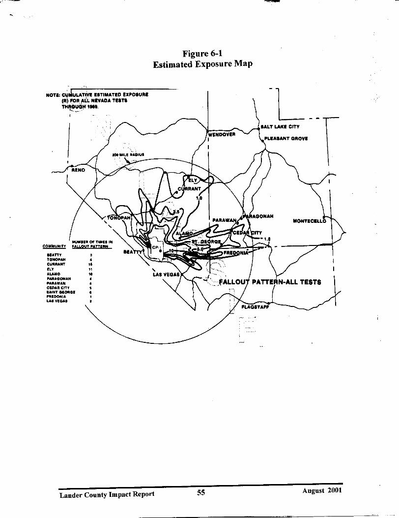


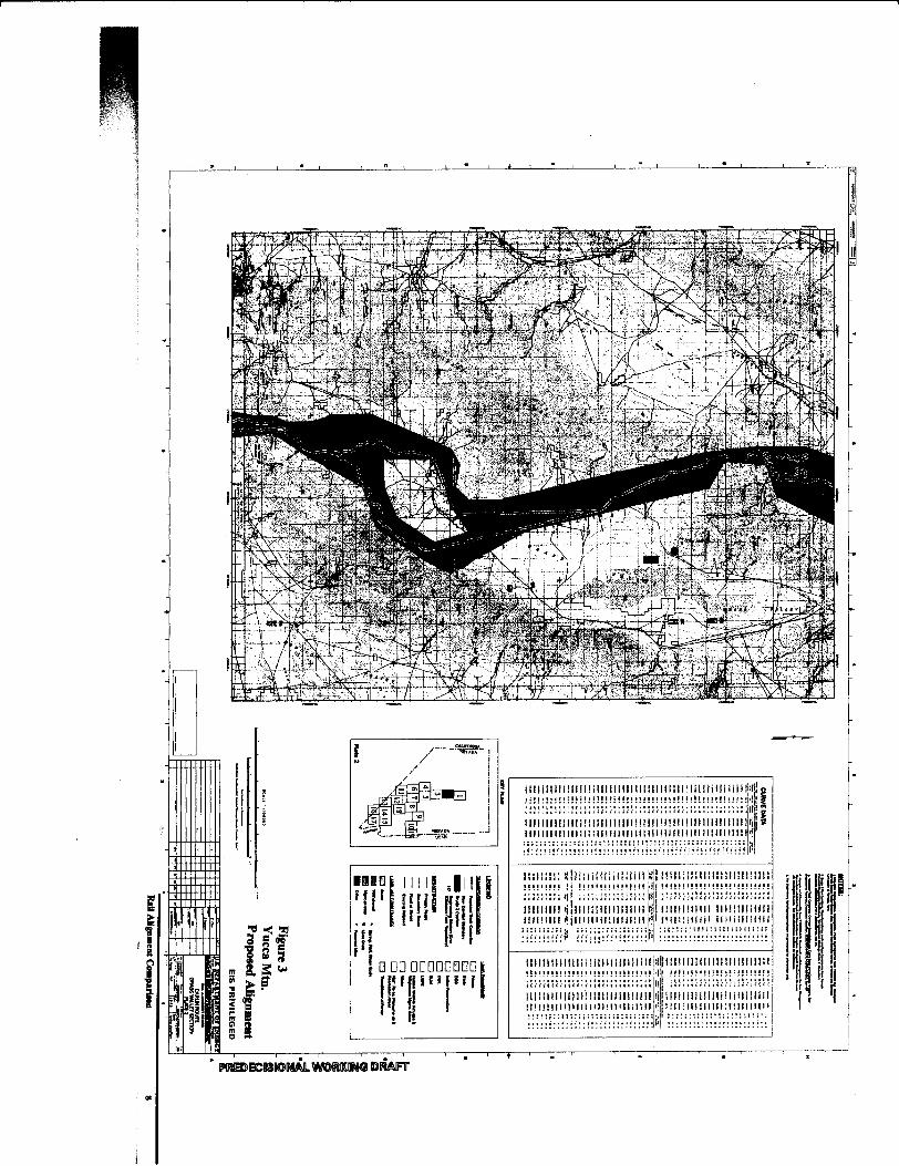


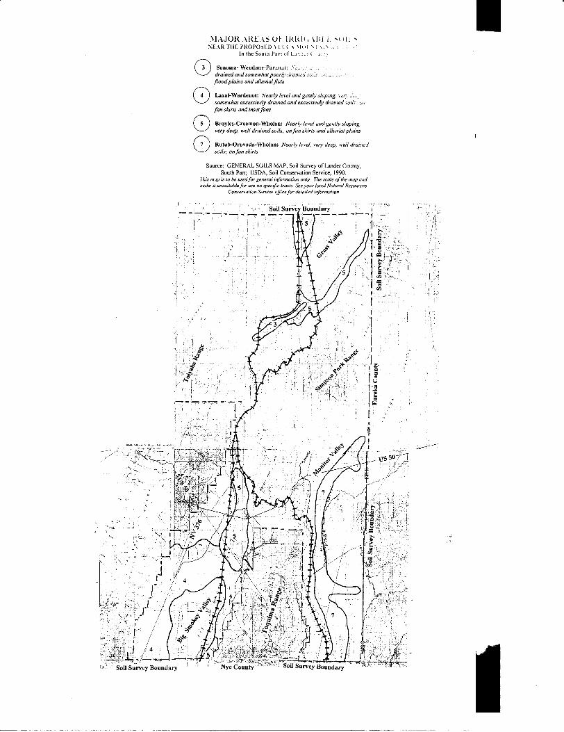
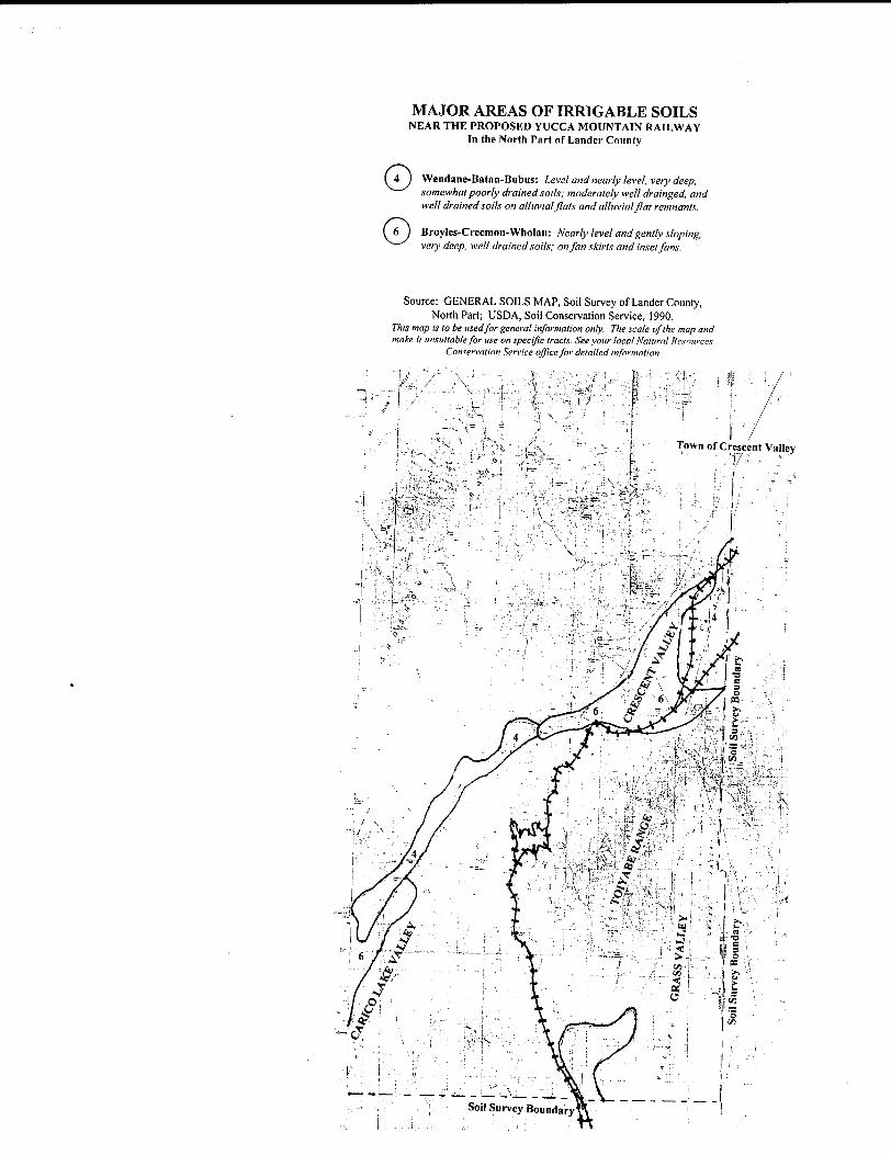


![2013 Hunters and Trappers Guide[1]](https://img.dokumen.tips/doc/110x75/55cf98ba550346d0339958ac/2013-hunters-and-trappers-guide1.jpg)