Embed Size (px)
DESCRIPTION
land use
Citation preview

A HIGH QUALITY LIVING ENVIRONMENT
FOR ALL SINGAPOREANS Land Use Plan to Support Singapore’s Future Population
January 2013


A HIGH QUALITY LIVING ENVIRONMENT
FOR ALL SINGAPOREANS Land Use Plan to Support Singapore’s Future Population
January 2013

EXECUTIVE SUMMARY
ExEcUTIVE SUMMARY
The Population White Paper: A Sustainable Population for a Dynamic Singapore (Jan 2013) to address Singapore’s demographic challenge, has projected a possible population range of 6.5 to 6.9 million by 2030. This paper outlines our land use plan to support the larger population while preserving a high quality living environment for all Singaporeans.
Our development strategy is to make Singapore one of the most liveable cities in the world − a city for all ages and a country we are proud to call home. This requires sound planning, close inter-agency coordination, timely implementation and responsiveness to Singaporeans’ needs and aspirations. We will also build in buffers where possible, so that we maintain the flexibility to respond to unexpected developments and future needs.
BUILdING GOOdAFFORdABLE HOMES
In meeting our people’s needs, good and affordable housing is our top priority. We will build up to 700,000 new homes by 2030. Of these, almost 200,000 are already in the pipeline. Many of the remaining 500,000 new homes will be in new towns and housing estates, infill sites in existing towns, land freed up from redeveloping old estates, and vacant land within and on the fringe of the city centre. How quickly we build new homes will depend on the actual demand.
When planning our new towns and estates, we will incorporate the latest planning concepts and technological innovations. Existing towns will be rejuvenated through various government-funded development programmes. Building more homes in mature estates will present opportunities for more young couples and new
families to live near their parents, and existing residents to upgrade their homes within the same estates.
We will also provide more housing in and around the Central Region to enable more Singaporeans to live nearer their workplaces. All these homes will have easy access to abundant green and recreational spaces, comprehensive amenities and services for the young and old, and an extensive public transport network, especially MRT lines.
BEcOMING A cITY IN A GARdEN
Singapore is a renowned Garden City and we will continue to add greenery to soften the tone and texture of our urban landscape. We will also build more parks and aim to have at least 85% of Singaporean households living within 400m of a park. Our popular park connector network will be further extended. A 150km Round-Island-Route will provide an accessible and uninterrupted leisure corridor around the island. The Rail Corridor along the old Malayan Railway track will offer inviting routes for joggers and cyclists, and improve access to recreational and heritage sites.
GREATER MOBILITY wITH ENHANcEd TRANSPORT cONNEcTIVITY
We are determined to build one of the best public transport systems in the world. Given our limited land, we will have to continue to restrain private transport usage and invest heavily in a more extensive public transport system. A key feature will be the doubling of our rail network to about 360km by 2030, so that eight in ten homes will be within a ten-minute walk of an

MRT station. We will build new rail lines such as the Cross Island Line and Jurong Region Line, and extensions such as Circle Line Stage 6, Northeast Line Extension and Downtown Line Extension. We will make bus services more frequent and reliable, with more bus routes to serve new and existing areas. As we expand the public transport system, we will make it even more accessible and connected for commuters by improving first- and last-mile connectivity. There will be more sheltered walkways, as well as more integrated transport hubs where bus interchanges and MRT stations are co-located with shops and offices, making it more convenient for commuters. More cycling paths and bicycle parking facilities will be provided. We will enhance mobility for seniors and ensure that our transport system is barrier-free. These efforts will ensure that our transport system meets the needs of all commuters and enhances the liveability of our island.
SUSTAINING A VIBRANT EcONOMY wITH GOOd JOBS
These developments will need to be supported by a dynamic economy which creates good jobs for Singaporeans and generates resources to invest in our city and our people. We will continue restructuring the economy so that Singapore remains competitive in the global economy and stays ahead of other Asian cities. We want to safeguard Singapore’s position as a high-end manufacturing base and a global financial and business hub. Although we cannot predict the exact structure of our economy in 2030, we will set aside enough land to grow our economy and seize opportunities that come along.
To meet higher aspirations and new lifestyle preferences, we plan to site more commercial activities near homes. We will build urban centres in various parts of Singapore, including
Jurong Lake District, One-North, Paya Lebar Central, Tampines, Woodlands and Punggol. These developments will transform Singapore and benefit future generations.
ENSURING ROOM FOR GROwTH ANd A GOOd LIVING ENVIRONMENT IN THE FUTURE
Creating, redeveloping and optimising land in order to build a highly liveable urbanised environment has always been the Singapore story. This is how we progressed from the Third World to the First. And the best is yet to be.
Technology will continue to amaze. We must be alert to changes and breakthroughs, and exploit them to our advantage. Our physical resources may be limited, but we can overcome this with the help of new technology and innovation. NEWater shows that we can do this when we put our minds to it.
Likewise, we will invest resources to tackle our land challenge, to come up with practical solutions to create new land capacity and raise land productivity while keeping Singapore highly liveable. In this spirit, we have recently embarked on the new National Innovation Challenge of “Land and Liveability” to fund research on creating new space and optimising the use of space to support a future Singapore. Our development strategy and land use plan must meet the aspirations of our people. We will continue to engage different stakeholders to gather feedback and ideas as we revise and update our Master Plan 2008.
Let us work together and jointly create in Singapore a global city among the best in the world, which we and our children can proudly and fondly call home.
EXECUTIVE SUMMARY


cONTENTS
01INTRODUCTION 1
02LaND USe aND aLLOCaTION 3
03BUILDING GOOD aFFORDaBLe HOMeS 8
04a CITY IN a GaRDeN 25
05GReaTeR MOBILITY WITH eNHaNCeD TRaNSPORT CONNeCTIVITY 39
06SUSTaINING a VIBRaNT eCONOMY WITH GOOD JOBS 53
07eNSURING ROOM FOR GROWTH aND 62a GOOD LIVING eNVIRONMeNT IN FUTURe
08CONCLUSION 67


01INTRODUCTION

INTROdUcTION
1.1 We aim to create a high quality living environment for all Singaporeans to live and work in, bring up their children and grow old gracefully in. Today, many international surveys1 have placed Singapore among the most liveable cities in the world. We are confident that our land capacity can support a larger population while preserving a high quality living environment for all Singaporeans. A higher population density and a high quality living environment can co-exist. We can achieve this through the same careful, creative planning and societal support that have successfully transformed our city to what we enjoy today.
1.2 Our city planning focuses on achieving the following: good quality and affordable housing; accessible and inclusive green and recreational spaces, and other amenities; a dynamic economy that creates good and diverse jobs for Singaporeans; greater mobility with enhanced connectivity; a vibrant and cosmopolitan culture that is forward-looking while being anchored in our history and heritage; and a clean, safe and pleasant environment.
1.3 Singapore has the physical capacity to sustain a high quality living environment for a larger population ranging between 6.5 and 6.9 million by 2030. With innovative planning, as well as disciplined and determined efforts to create, redevelop and optimise our land, we can make our city even more liveable than it is today.
1.4 This paper explains how we can continue to make Singapore one of the best places in the world to live in, and also shares specific projects in the pipeline to illustrate what our city will look like in the future.
INTRODUCTION2
1 Singapore is ranked first in Siemens Asian Green City Index (2011); the top Asian city for quality of living and top city worldwide for infrastructure by Mercer (2012); and fifth among Asian cities in Monocle’s Most Liveable City Index (2012).

02LaND Use aND aLLOCaTION

LAND USE AND ALLOCATION4
2.1 The Population White Paper: A Sustainable Population for a Dynamic Singapore (Jan 2013) has projected that Singapore could have a population of between 6.5 and 6.9 million by 2030. This will require 76,600ha of land, an increase from the current supply of 71,000ha.
2.2 To support this larger population, we need to (a) reclaim additional land; (b) develop some of our reserve land; (c) intensify new developments; and (d) recycle land with lower intensity uses such as old industrial areas and some golf courses to achieve higher land productivity.
2.3 Land use and allocation in Singapore is governed by our Master Plan. The Master Plan 2008 is being revised and updated to support the Population White Paper. Table 1 summarises the proposed land uses and planned supply. By 2030, more than half of our land (58%) will be allocated to uses which enable us to live, work and play in a high quality environment. These uses include housing, services and manufacturing jobs, facilities and amenities, as well as green spaces such as parks and nature reserves, essential services and utilities like water and electricity. 19% of our land will support mobility within Singapore and connectivity to the rest of the world. Another 19% of our land will be for our defence needs.
2.4 Beyond 2030, we will still have room for growth through further land reclamation. There will also be opportunities to further optimise and redevelop our land. For example, we can look forward to the development of new growth corridors both in the north (from Woodlands to Punggol) and in the south (from Tanjong Pagar to Pasir Panjang Terminal). Over the long term, the way we live, work and play will continue to evolve, and we will continue to exploit technology and implement innovative solutions to further optimise our land uses.
LANd USE ANd ALLOcATION

LAND USE AND ALLOCATION 5
TABLE 1: OUR LANd REQUIREMENTS
Land UsePlanned Land Supply (ha)
2010 2030
Housing10,000(14%)
13,000(17%)
Industry and Commerce9,700(13%)
12,800(17%)
Parks and Nature Reserves5,700(8%)
7,250(9%)
Community, Institution and Recreation Facilities5,400(8%)
5,500(7%)
Utilities (e.g. power, water treatment plants)1,850(3%)
2,600(3%)
Reservoirs23,700(5%)
3,700(5%)
Land Transport Infrastructure8,300(12%)
9,700(13%)
Ports and Airports2,200(3%)
4,400(6%)
Defence Requirements13,300(19%)
14,800(19%)
Others10,000(14%)
2,800(4%)
Total71,000(100%)
76,600(100%)
2 Reservoirs occupy an area equivalent to 3,700ha.

Land Use Beyond 2030
This map illustrates the likely profile of Singapore and possible land use allocation beyond 2030. It shows the scope for additional land reclamation, if needed. These reclaimed land parcels, including the land currently zoned as ‘reserve’, could be used for housing, industry and other uses. In addition, the map indicates how we can potentially recycle our land for other uses in the future. We will refine these plans as our population needs and land use requirements evolve.

03BUILDINg gOOD affORDaBLe HOmes

3.1 Housing lies at the heart of a high quality living environment. Housing meets our basic needs for shelter, helps families to have and bring up children, and strengthens our sense of ownership and belonging as Singaporeans. As our population becomes more diverse, we will continue to provide a range of affordable and quality housing to meet the needs and aspirations of our people.
3.2 Today, there are about 1.2 million housing units, of which 0.9 million are HDB flats. To support the projected 2030 population range, we will set aside enough land to develop up to 1.9 million homes, an increase of 700,000 housing units from today. Of these units, 90,000 private housing units (including Executive Condominiums) and 110,000 public housing units will be completed by 2016.
3.3 Even with the increase in population densities of our towns and estates, we will ensure liveability through creative layout and design, sensitive planning and smart innovations. We will also provide a wide range of facilities and community amenities for our residents to enjoy.
3.4 Additional housing will come from:
NEw TOwNS ANd ESTATES
3.4.1 Opening up new towns and towns: We will open up three new towns and housing estates at Bidadari, Tampines North and Tengah. Punggol will be developed further, making it one of the largest HDB towns. Like the recently released development plans for Punggol, all new public housing areas will incorporate HDB’s latest planning and technological innovations. There will be abundant green and recreational spaces, comprehensive amenities and good connectivity to public transport.
BUILdING GOOd AFFORdABLE HOMES
BUILDING GOOD AFFORDABLE HOMES 9

dEVELOPMENT OF PUNGGOL TOwN
Punggol will serve as a platform for green and sustainable solutions, to create a high density yet highly liveable town. When fully developed, Punggol will have 96,000 dwelling units, tripling its current size.
SIGNATURE wATERFRONT HOUSING
Punggol residents can look forward to seven waterfront housing districts, each with a distinctive character. Development of Waterway East and Waterway West districts are in progress. Northshore and Matilda districts are likely to be developed within the next decade.
Aerial view of locations of seven waterfront housing districts
BUILDING GOOD AFFORDABLE HOMES10

GREEN HEART ANd GREEN FINGERS
Punggol residents can look forward to a town with more green spaces. My Waterway@Punggol, the Punggol Waterway Park and the town centre will form the Green Heart of Punggol. Through the Green Fingers linking the Green Heart to the waterfront, residents will enjoy a multitude of open spaces and gain easy access to the waterfront promenade. They can also use these Green Fingers for recreation such as jogging and brisk walking. One such Green Finger will be the Old Punggol Road, a 1.5km Heritage Trail amidst lush greenery.
(From top) Old Punggol Road will be transformed to be a Heritage Trail; Residents can enjoy water sports in the Punggol Waterway and other activities along the banks
Source: Singapore Press Holdings Limited. Reproduced with Permission Source: Singapore Press Holdings Limited. Reproduced with Permission
BUILDING GOOD AFFORDABLE HOMES 11

(From top) Punggol Town Square; Creative Cluster with a Market Village and a Learning Corridor; Waterfront Market Village
PUNGGOL dOwNTOwN: A NEw dESTINATION FOR NORTH-EAST REGION
The existing Town Centre will be expanded into Punggol Downtown. There will be a Town Square and a Creative Cluster with a Market Village to host new commercial activities, and a Learning Corridor to house future educational institutions. In addition, more community facilities and a new hawker centre will be developed.
BUILDING GOOD AFFORDABLE HOMES12

MORE HOMES IN ExISTING ESTATES IN FAMILIAR cOMMUNITIES
3.4.2 Developing vacant land: Apart from new estates, we will also develop more housing on vacant land within existing estates across the island. This will provide opportunities for young couples and families to live near their parents, and for existing residents to stay within their communities when they upgrade or when their old flats are redeveloped.
3.4.3 Rejuvenating mature towns: At the same time, we will rejuvenate mature towns through various government-funded development programmes. We have just completed the barrier-free accessibility programme for all HDB towns. The Lift Upgrading Programme will soon be completed, benefitting more than 500,000 residents, including seniors, young children and persons with physical disabilities.
3.4.4 Improving estates and towns: Meanwhile, HDB’s Remaking Our Heartland (ROH) programme will systematically improve more HDB estates and towns, starting with Punggol, Yishun, and Dawson in Queenstown. Other towns like Hougang, East Coast, and Jurong Lake District will follow.
BUILDING GOOD AFFORDABLE HOMES 13
REMAkING OUR HEARTLANd (ROH)
Under the ROH programme, selected towns and estates will undergo comprehensive enhancement works to update facilities and inject fresh vibrancy into the area. Each estate will preserve the characteristics which make it unique and distinctive.
YISHUN TOwN
We will transform Yishun to “A Vibrant Hub and Great Outdoors”. Phase I involving Northpoint Shopping Centre and Pedestrian Mall, Khoo Teck Puat Hospital, Yishun Pond, Yishun Park, various neighbourhood parks and Lower Seletar Reservoir, has been completed.
Artist’s impression of the new Yishun Integrated Transport Hub
The next phase will allow us to develop more housing in Yishun, enhance connectivity with a new integrated transport hub comprising a town plaza and an improved bus interchange, and more shopping facilities.
BUILDING GOOD AFFORDABLE HOMES14

(From top) Cascading terrace gardens at SkyTerrace @ Dawson; Sky Garden at Skyville @ Dawson
THE dAwSON ESTATE IN QUEENSTOwN: HOUSING IN A PARk
Skyville @ Dawson and SkyTerrace @ Dawson are iconic HDB developments set in park-like environments. HDB will complete these two developments by 2015, with more to come in the following years.
Greenery will be brought to the doorsteps of residents through mid-level sky gardens and roof-top gardens. This is part of HDB’s landscape master plan to promote connectivity and environmental sustainability by linking housing areas via the Alexandra Canal Linear Park and a future Eco-Corridor.
Multi-generation living is facilitated to encourage extended family living and foster closer family ties. In addition, the rich heritage of Dawson will be accentuated through the preservation of older buildings such as the popular food centre along Commonwealth Avenue.
BUILDING GOOD AFFORDABLE HOMES 15
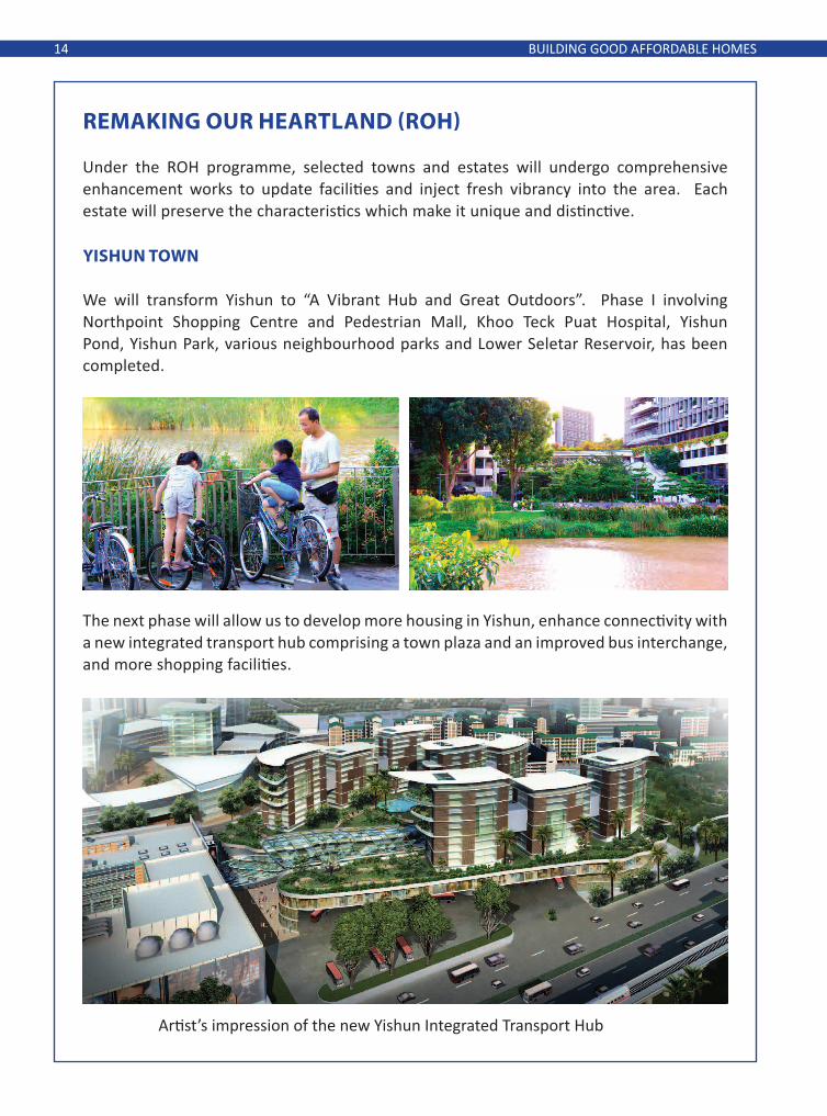
(From top) Outdoor Play Corridor directly connecting Bedok Reservoir and East Coast Park; Rest point at Neighbourhood Centre 5 along the Outdoor Play Corridor
EAST cOAST ROH: GATEwAY TO THE EAST cOAST
East Coast ROH will create a “Gateway to the East Coast” to leverage on its proximity to two major recreational hubs – Bedok Reservoir Park and East Coast Park.
Residents can look forward to an Outdoor Play Corridor, a dedicated cycling and pedestrian path that directly connects Bedok Reservoir and East Coast Park. The corridor will be lined with community gardens, recreational and sports facilities. We will also introduce an extensive cycling network within the East Coast area to enhance connectivity to MRT stations, major employment areas, parks, schools and Neighbourhood Centres.
BUILDING GOOD AFFORDABLE HOMES16

The Bedok Town Centre is being transformed into a vibrant new hub. An integrated mixed use development will house a modern shopping mall, a private residential housing development and a new air-conditioned bus interchange, with a seamless connection to Bedok MRT station. There will also be new commercial facilities and enhancements to the pedestrian mall.
Residents and patrons can look forward to an enhanced dining experience in a new and more spacious hawker centre while we develop the site of the existing hawker centre into a Town Plaza, which will house a Heritage Corner. Sports enthusiasts will welcome a new integrated community and sports facility offering a swimming complex, sports hall, tennis centre and a community centre.
Enhancements to Pedestrian Mall in Bedok Town Centre
New hawker centre and Town Plaza
BUILDING GOOD AFFORDABLE HOMES 17

Residents can explore East Coast and Bedok Town via a heritage trail that traces the early road network of the area and links points of historical interests.
(From top) Heritage Trail around East Coast and Bedok Town; Discovery Plans around Neighbourhood Centres to rediscover unique facilities for recreation
BUILDING GOOD AFFORDABLE HOMES18

3.4.5 We will provide more housing in the Central Region to allow more Singaporeans to live close to where they work. There will also be a wider diversity of housing choices at different locations, amidst lush greenery or waterfront settings.
wATERFRONT cITY LIVING AT kALLANG RIVERSIdE
Located close to the city centre, homes at Kampong Bugis will be set in both lush greenery and waterfront settings. The heights of housing developments will be stepped down towards the waterfront, providing residents scenic views of Kallang Basin and the city skyline. Through the use of water-sensitive urban design features, landscaping elements and “fenceless” developments, the linear park from Lavender MRT station to the Kallang waterfront will provide seamless greenery.
(From left) Artist’s impression of Kallang Riverside and waterfront living at Kallang Riverside
3.4.6 In particular, we are planning for new housing estates at the former Bukit Turf Club, Kallang Riverside, Keppel and Bukit Brown areas. When fully developed, they will offer attractive housing options close to the city and connected to MRT lines.
BUILDING GOOD AFFORDABLE HOMES 19
MORE HOMES IN THE cENTRAL REGION
cELEBRATING OUR PAST 3.5 Our built heritage is important and reminds us of who we are, where we come from and why Singapore is our home. We want to celebrate and preserve our past in a sensitive and practical manner such that it is not at the expense of the needs of Singaporeans today or in the future.
3.6 Since the 1980s, we have conserved whole historical districts and more than 7,000 buildings and structures island-wide. We have also promoted conservation excellence through our internationally recognised annual Architectural Heritage Awards. We have and will continue to find practical and innovative ways to retain links to our past, without compromising future development needs.
cOMMUNITY, cOMMERcIAL ANd REcREATIONAL FAcILITIES
3.7 Singaporeans will have greater access to community, commercial and recreational facilities in their neighbourhoods.
3.7.1 Planning for a full range of amenities and facilities: Our housing areas will be planned with a full range of amenities and facilities, conveniently located near to residents. These amenities include hawker centres, shop clusters, childcare centres, schools and community clubs. By 2017, 20,000 more childcare places will be added to areas where there is demand from families with young children. These will be located close to homes, transport nodes and workplaces.
3.7.2 Providing a range of care facilities: As our population ages, we will also provide a comprehensive range of care services so that our seniors can age gracefully among family and friends in the community. These include hospitals, outpatient polyclinics and community-based care services such as Senior Care Centres, Senior Activity Centres and Nursing Homes.
3.7.3 Establishing more integrated hospitals: More land will be safeguarded for new integrated hospitals across the island. Each integrated hospital comprises a public acute regional hospital co-located with a community hospital which will provide better step-down care and rehabilitation for recovering patients. They are also conveniently located near major residential areas and public transport nodes. By 2020, we will have added 4,100 hospital beds across Singapore. The number of acute beds will increase by 2,200, 30% more than today. Community hospital beds will also increase by 1,900 beds, more than tripling the 800 beds today.
BUILDING GOOD AFFORDABLE HOMES20

A range of community, commercial and recreational facilities for all ages.
Source: Singapore Press Holdings Limited. Reproduced with Permission
Source: Singapore Press Holdings Limited. Reproduced with Permission
BUILDING GOOD AFFORDABLE HOMES 21

cOMPREHENSIVE ANd AccESSIBLE HEALTHcARE SERVIcES
TAMPINES cOMMUNITY HEALTH cENTRE
The Tampines Community Health Centre (CHC) was launched to support general practitioners (GPs) with relevant allied health services, such as diabetic retinopathy, diabetic foot screening and nurse counselling, to better manage chronic diseases in the community. Such CHCs will enable patients to be treated by their family doctors, with support from key allied health services.
UPcOMING NG TENG FONG GENERAL HOSPITAL & JURONG cOMMUNITY HOSPITAL
The 700-bed Ng Teng Fong General Hospital will be twinned with a 400-bed community hospital to provide patients with holistic and integrated care. Slated to open from end 2014, these two hospitals will be an integral part of the Jurong Lake District, with easy access to public transport services (Jurong East MRT Station and Jurong East Bus Interchange), as well as retail and entertainment hubs. The two hospitals will be connected via link bridges and a common basement. Managing the two hospitals as one will ensure integration at the infrastructure, administrative and clinical levels for smooth transfer and care of patients from the acute to sub-acute setting.
BUILDING GOOD AFFORDABLE HOMES22

3.8 Singapore will have a diverse and vibrant arts, culture and sports scene. The National Art Gallery will be completed in 2015, adding to the vibrancy of our Civic District. Our Sports Hub will open in 2014, providing a fully integrated sports, entertainment and lifestyle hub. It will house Singapore’s largest all-weather venue - a 55,000-seater national stadium, a water sports centre, an aquatic centre, shopping mall,
(From top): Artist’s impression of National Art Gallery; and Singapore Sports Hub
waterfront and F&B options, and indoor and outdoor sports spaces such as beach volleyball courts and rock climbing walls. We are also investing in regional sports venues as well as in cultural and sports programming so as to provide more opportunities for Singaporeans toparticipate in arts and sports activities at the community level.
BUILDING GOOD AFFORDABLE HOMES 23
ARTS, cULTURE ANd SPORTS FAcILITIES

04a CITy IN a gaRDeN

A CITY IN A GARDEN26
4.1 Parks and greenery soften the tone and texture of a built landscape and make a high-density urban environment more liveable. They provide recreational and social spaces, improve the well-being of residents, and bring relief to a busy and bustling city.
4.2 Singapore is a prime example of a city that is green despite urbanisation. Our international branding as a Garden City is well-established. Even so, there is scope to do more.
HOw wE cAN BEcOME A cITY IN A GARdEN
4.3 As we provide more housing, we will also design and develop a variety of accessible parks close to homes, to provide a healthy and good living environment for residents of all ages and abilities to enjoy.
4.4 We will continue to plan parks based on our present norm of around 0.8ha of parks per 1,000 residents. These parks will be distributed across housing areas so that at least 85% of our residents and their families can live within 400m of a park by 2030.
4.5 To be a City in a Garden, we will continue to pursue innovative ways to connect our green and blue spaces, so that our people can seamlessly move from one park to another via our park connector network. The proposed Round-Island-Route, stretching 150km, will provide an uninterrupted leisure route around the island, linking major cultural, natural and historical attractions with our parks, park connectors and intra-town cycling networks. By 2020, we will have 360km of park connectors compared to 200km today. The old Malayan Railway track has also opened up an opportunity to build a green Rail Corridor to provide a variety of leisure and recreational choices.
A cITY IN A GARdEN

A CITY IN A GARDEN 27
A range of activities for all ages and green spaces in our transformation to a City in a Garden.


MORE PARkS ANd PARk cONNEcTORS
Singaporeans will be able to enjoy parks of different themes and sizes that offer a diversity of recreational experiences, and cater to all ages and interests. The themes include art and heritage, nature, coastal, learning and discovery. Parks of varying sizes, from community to town and regional parks, will mostly be close to homes for easy access.
To date, we have more than 350 parks, and many are already connected by park connectors in the east, west and northeast. We will progressively implement more park connectors, together with the Round-Island-Route and the Rail Corridor, to improve accessibility and connectivity.
There is a variety of parks of different themes and sizes for all to enjoy. (From top, left to right) Singapore Botanical Gardens; Labrador Nature and Coastal Walk;
East Coast Park; and Southern Ridges
A CITY IN A GARDEN30

(From top) Artist’s impression of Family Zone; Adventure Zone; Nature Green Zone
JURONG LAkE PARk
Jurong Lake Park will be redeveloped as a Destination Park, leveraging on its extensive waterfront promenade. Residents will enjoy a variety of recreational options offered in three zones. The Adventure Zone will offer an “island-hopping” experience. The Family Zone will comprise play spaces for children of all ages. The Nature Green Zone will preserve the natural habitats and their rich biodiversity.
A CITY IN A GARDEN 31

cONEY ISLANd
Coney Island Park, located on the north-eastern half of Coney Island, will be kept as rustic as possible. It forms part of the greenery provision for Punggol and will be developed by 2015. To retain its existing ecology, Coney Island Park will be vehicle-free and built with facilities that are sensitive to the natural environment. These will offer park users a back-to-nature experience in an urban landscape.
A CITY IN A GARDEN32

AcTIVE BEAUTIFUL ANd cLEAN (ABc) wATERS PROGRAMME
The ABC Waters Programme, launched in 2006, is an initiative by the Public Utilities Board (PUB) to transform Singapore’s network of utilitarian drains, canals and reservoirs into vibrant and beautiful streams, rivers and lakes. The programme will be carried out in phases with over 100 projects to be implemented over the next 15 to 20 years. Under Phase One of the Programme (2007- 2012), 28 projects have been implemented. The locations of these projects are indicated in the map below.
4.6 We will continue to make creative use of functional water bodies, such as reservoirs, canals and drains, for recreation.
A CITY IN A GARDEN 33
GREATER AccESS TO OUR BLUE SPAcES
By 2030, about 900ha of reservoirs and 100km of waterways will be opened up for recreational activities, compared to about 800ha and 80km today.

ROcHOR cANAL
By 2014, we will transform Rochor Canal between Jalan Besar and Crawford Street from a concrete canal into an attractive river with look-out decks and seating areas. It will bring people close to water, allowing them to enjoy the improved waterway. Natural cleansing systems will help to cleanse rainwater runoff before it is channelled into Rochor Canal.
ABC Waters projects have already transformed some of our waterways into habitats for wildlife, bringing biodiversity closer to people and enriching the urban environment. For example, at the Sengkang Floating Wetland, both migratory and resident birds such as the Common Sandpiper and the Olive-backed Sunbird have been spotted.
A CITY IN A GARDEN34
SUNGEI ULU PANdAN
To be completed by 2013, Sungei Ulu Pandan is conceptualised as a series of ‘river classrooms’ to allow experiential learning for students. The project showcases the use of different design features that treat and improve the quality of the rainwater run-off from the surrounding catchment before the runoff enters the waterways. Gathering decks will be built to serve as outdoor classroom spaces and for the public to enjoy the tranquil water, scenery and the local biodiversity.

MORE GREENERY IN THE SkY
SkYRISE GREENERY INcENTIVE ScHEME
The National Parks Board has introduced the Skyrise Greenery Incentive Scheme to provide funding support to building owners for the installation of green roofs and vertical greenery on building façades. The scheme aims to create a distinctive image of the city in a tropical climate through extensive greenery adorning building facades and skyrise levels. The scheme also seeks to bring about environmental benefits such as mitigating urban island heat effect and improving air quality.
4.7 We will continue to develop more skyrise greenery in the form of mid-level or roof-top landscaped decks within residential estates.
A CITY IN A GARDEN 35
NEw FORMS OF GREENERY IN THE SkY
Garden settings will be integrated into our housing developments at elevated levels to provide residents with additional community and leisure spaces. These are also excellent uses of space.

LUSH PROGRAMME
The Urban Redevelopment Authority (URA) ‘LUSH’ (Landscaping for Urban Spaces and High-rises) Programme promotes more vertical and skyrise greenery in private developments. Bonus Gross Floor Area (GFA) is granted to allow outdoor refreshment areas on the rooftop of buildings providing landscaping for their developments. To date, the LUSH programme has supported the development of 40ha of new high-rise and urban greenery, equivalent to approximately 130 primary school fields. Since 2009, all new developments in Marina Bay, Kallang Riverside and Jurong Gateway, are required to provide greenery within their developments, occupying an area at least equal to the plot of land the developments sit on. This will ensure that even while we urbanise, greenery coverage will be maintained. The greenery can be provided through a combination of landscaped areas, sky terraces and rooftop gardens.
(From left) Elevated greenery at Newton Suites; interior landscaped areas
A CITY IN A GARDEN36

NEw NATURE AREAS AT JALAN GEMALA ANd BETING BRONOk ANd PULAU UNUM
We have added Beting Bronok & Pulau Unum and Jalan Gemala to our list of Nature Areas, where the natural flora and fauna will be protected from human activity. BETING BRONOk ANd PULAU UNUM
Beting Bronok and Pulau Unum extend the Pulau Tekong Nature Area. These sites contain a wide array of marine and coastal flora and fauna. Of particular significance are two locally endangered mangrove plant species (out of 23 species from 13 families), three very rare and ten rare mollusc species (out of 36 species from 16 families). Some of the wildlife species found here are the Knobbly Sea Star (Protoreaster nodosus) and Thorny Sea Urchin (Prionocidaris sp.)
4.8 While we will not be able to conserve every local green area, we have, through conscientious planning, conserved a significant and representative segment of our native ecosystem through four nature reserves and 18 nature areas. We will continue to allocate around 10% of land to greenery, a large proportion for a highly urbanised city.
(From left) Knobbly Sea Star; Thorny Sea Urchin
A CITY IN A GARDEN 37
SUPPORTING OUR NATURAL HERITAGE
Apart from selectively conserving new nature areas, we will also enhance our urban landscape by expanding our network of streetscape greenery, skyrise greenery and green corridors.

JALAN GEMALA
Jalan Gemala at Lim Chu Kang has varied habitats such as wet grassland, freshwater marshes, as well as tall secondary woodland and freshwater reservoir. Its addition as a nature area is significant given its rich wet grassland, with two rare plants (Leea angulata and Cayratia trifolia) being sighted. The inclusion of Jalan Gemala will also help secure the sustainability of the existing Kranji Marshes at Neo Tiew Lane. The pink-necked Green Pigeons and Mallotus paniculatus, a quick growing shrub that provides food for small birds are some of the wildlife species that can be found here.
A CITY IN A GARDEN38
(From left) Pink-necked Green Pigeons; Mallotus paniculatus

05gReaTeR mOBILITy wITH eNHaNCeD TRaNspORT CONNeCTIvITy
GREATER MOBILITY WITH ENHANCED TRANSPORT CONNECTIVITY40
GREATER MOBILITY wITH ENHANcEd TRANSPORT cONNEcTIVITY
5.1 Cities that are highly liveable are people-centric. They place emphasis on walkability and tend to have extensive, affordable and high quality public transport infrastructure that connects people to jobs, schools, facilities and amenities in an efficient, reliable and pleasant way.
5.2 In Singapore, travel needs must be met largely by public transport as it is the most space-efficient way of transporting large numbers of people. Our limited land supply also does not allow us to build ever more roads and other facilities for private transport in an unrestrained way. We aim to achieve a public transport mode share of 70% of journeys during the morning peak hours by 2020, and 75% by 2030.
HOw wE wILL MOVE AROUNd wITH GREATER EASE ANd cOMFORT
5.3 Our rail network will continue to be the backbone of our public transport system. The Circle Line was opened in 2011 to connect people between the east, west and north without passing through busy interchanges in the city centre. The next major line that will be opened, in stages from 2013 to 2017 is the Downtown Line, which will improve connectivity for commuters in the northwest and east. The Thomson Line, which serves the population in the north, will then be opened in stages from 2019 to 2021. With these two lines, as well as the Eastern Region Line, Tuas West Extension and North-South Line Extension, our rail network will increase by about 100km to 280km by 2021. Our rail density will increase from 34km per million population today to 47km per million population.
GREATER MOBILITY WITH ENHANCED TRANSPORT CONNECTIVITY 41
dOwNTOwN LINE
The Downtown Line will be the longest automated underground train line in Singapore. It will connect estates in the northwest and eastern regions of Singapore to the city centre, greatly reducing travel time. A trip from Bukit Panjang to the heart of the city will only take 20 minutes, a third of the travel time needed today.
The Downtown Line will also significantly reduce crowding on busy stretches of the existing MRT network, and will be equipped to run at high frequencies to better serve commuters. There will be extra wheelchair spaces on the trains to better meet the needs of wheelchair-bound commuters.
THOMSON LINE
Our sixth MRT line, the Thomson Line, will be fully completed in 2021. An estimated 400,000 more commuters can look forward to MRT stations at their doorstep.
Savings in travel time will be significant. For example, a Republic Polytechnic student living in Sin Ming will need only 25 minutes to get to school, compared to 50 minutes today. Shoppers from Springleaf Estate in Sembawang will only need 35 minutes to travel to the Great World City shopping mall, instead of 60 minutes today.
The Thomson Line will also benefit commuters in other areas as it will connect to four other MRT lines at six interchange stations.

5.4 To allow trains to run more frequently, we are upgrading the signalling systems of the North-South and East-West Lines. When completed in stages from 2016 onwards, there will be six instead of five trains running every ten minutes during peak periods. This will reduce crowding and shorten waiting times.
5.5 To further increase train frequency and improve comfort levels for commuters, we will add new trains to the fleet from 2014 to 2016. There will be 25% more trains for the North-South and East-West Lines, 70% more trains for the North East Line, 60% more trains for the Circle Line, 70% more trains for the Bukit Panjang Light Rail Transit (LRT) and 40% more trains for the Sengkang-Punggol LRT.
5.6 By 2030, our rail network will be further extended to include:
5.6.1 Cross Island Line (CRL): The CRL will provide a direct link to connect residents in the east and northeast (like Pasir Ris, Hougang and Serangoon) directly to the towns in the central (like Ang Mo Kio) and western region (like Jurong and Tuas). It will augment the existing North-South and East-West Lines.
5.6.2 Jurong Region Line (JRL): The JRL will enhance connectivity around the Jurong region, serving the future Tengah new town, Nanyang Technological University, and Jurong Industrial Estate.
5.6.3 Circle Line Stage 6 (CCL6): The CCL6 will close the loop for the Circle Line, between the central east areas (like Paya Lebar), and central and west areas (such as Kent Ridge). This will establish a more direct route to key employment areas in the Central Business District, Marina Bay and HarbourFront.
5.6.4 North East Line (NEL) Extension: To accommodate the growing population in Punggol, the NEL will be extended northeast to serve Punggol Downtown and the northern part of Punggol.
5.6.5 Downtown Line (DTL) Extension: The extension will connect to the Eastern Region Line and enhance the connectivity between the areas served by both lines.
5.7 We are also studying the possibility of adding a station between Sembawang (NS11) and Yishun (NS13) on the North-South Line, in anticipation of future developments in that area.
5.8 In total, the rail network will increase to about 360km with a density of 54km per million population by 2030. This will be higher than New York today, and comparable to London. Eight in ten homes will then be within a ten- minute walk from a train station.
GREATER MOBILITY WITH ENHANCED TRANSPORT CONNECTIVITY42

34
47
54
31
35
46
55
0
10
20
30
40
50
60
Today (2012) With LTMP 2008 Lines
With New Lines by 2030
Hong Kong Tokyo New York London
Rail Density (Rail-‐km/million popula4on)
GREATER MOBILITY WITH ENHANCED TRANSPORT CONNECTIVITY 43


5.9 To make our bus services more frequent and reliable, and less crowded, we are partnering bus operators to roll out the Bus Service Enhancement Programme (BSEP) over the next five years.
5.10 To complement this addition of buses, we will expand bus priority measures so that bus commuters will enjoy speedier journeys. These measures include more bus lanes, giving priority to buses at traffic light junctions, and Mandatory Give-Way to Buses schemes. They will help make buses a more attractive mode of transport.
Under the BSEP, commuters can expect shorter waiting times and more comfortable journeys. About 40 new services will be introduced and 800 buses will be added to the existing bus fleet. Of the 40 new services, eight will run parallel to MRT lines to connect major HDB towns to the city area by making use of the expressways. Of the 800 buses, 300 will be deployed to improve the frequencies of existing services, 250 will be used to run new services, and 250 will support ridership growth.
Bringing You More Buses, Better Rides
GREATER MOBILITY WITH ENHANCED TRANSPORT CONNECTIVITY46
BUS SERVIcE ENHANcEMENT PROGRAMME (BSEP)
5.11 Beyond this, we will study the need to further strengthen bus service connectivity and reliability. Among others, we will consider introducing community buses, which will operate in local communities, possibly using smaller-capacity buses and operating during specific periods of the day. This will extend the coverage of the public transport network. We are also considering measures to improve the en-route reliability of bus services to give commuters more certainty in bus arrival timings.

5.13 Transport plays an important role in enhancing the quality of our living environment. We will invest heavily in projects to improve first- and last-mile connectivity and accessibility to public transport.
5.13.1 Building more sheltered walkways around key transport nodes: To provide a comfortable walking environment to and from transport nodes, we will build more sheltered walkways between key transport nodes such as MRT and LRT stations, bus interchanges and bus shelters, and nearby amenities such as hawker centres and commercial buildings.
Sheltered walkways around Serangoon MRT Station on the North East Line
5.12 We are looking to smoothen travel demand around the peak hours to help alleviate crowding on our public transport system and allow commuters to travel in greater comfort.
5.12.1 Incentive schemes for off-peak travel: Commuters today can enjoy two incentive schemes for off-peak travel – SMRT’s Early Travel Discount for travel into the city area on the MRT before 7:45am, and the Incentives for Singapore’s Commuters (INSINC) scheme, which rewards commuters with more credits for travel during the hour before and the hour after the morning peak hour. We will consider more aggressive measures to encourage commuters to travel outside the peak hours.
GREATER MOBILITY WITH ENHANCED TRANSPORT CONNECTIVITY 47
TRANSPORT’S ROLE IN cREATING LIVEABLE cOMMUNITIES
5.12.2 Travel Smart Programme: We are also engaging employers in the private and public sectors to encourage their employees to travel off-peak. A two-year pilot consultancy, Travel Smart, was launched in 2012 to help employers understand the travel needs of their employees and recommend action plans to induce changes in travel behaviour. We aim to learn and propagate useful ideas from this programme to a much wider group of organisations.

5.13.2 Barrier-free accessibility: To meet the needs of the physically less able, we will ensure that all MRT stations and bus interchanges will be barrier-free. All our public buses will be wheelchair-accessible by 2020. We will also introduce more wheelchair-accessible taxis.
The Green Man Plus will be extended to more pedestrian crossings to allow seniors and the physically less able to have more time to cross roads safely. More pedestrian overhead bridges, especially those near our MRT stations, will be fitted with lifts.
GREATER MOBILITY WITH ENHANCED TRANSPORT CONNECTIVITY48
Lifts at pedestrian overhead bridges to enhance barrier-free accessibility
5.14 With an ageing MRT system that has been in operation since 1987 and increased train frequencies to better serve commuters, residents living particularly close to MRT
viaducts may experience increased noise levels. We therefore plan to build noise barriers at key locations island-wide to provide relief to those living and working close to our rail tracks. The target completion date is 2020.
Noise Barrier
Noise barriers at Bishan MRT Station

TAMPINES cYcLING TOwN
Tampines is considered Singapore’s pioneer cycling town and was among the earliest to have off-road cycling paths and more bicycle racks built. A key success factor for cycling in Tampines is its strong community support. The community actively encourages pedestrians and cyclists to share the space in the safest manner possible. Volunteer cycling wardens patrol the streets and offer advice on safe cycling to cyclists. Such community support and acceptance by all road users to share the space are needed for cycling to be successfully promoted throughout Singapore.
5.15 Cycling is increasingly popular among Singaporeans, especially for short-distance travel to neighbourhood amenities, schools, and workplaces. It is also suitable for the first and last mile of a journey on public transport. Cycling reduces our reliance on motorised modes of transport, reduces our carbon footprint and also promotes healthier living. We will facilitate cycling within towns to connect to amenities, as well as to public transport nodes.
5.15.2 Providing basic cycling infrastructure: We will roll out basic cycling infrastructure in all new housing estates and developments, and as part of major estate upgrading programmes under the Remaking our Heartland (ROH) initiative. The long-term plan is to extend the off-road cycling network to as much of our island as possible, capitalising on the extensive Park Connector Network to achieve a larger and safer cycling network.
GREATER MOBILITY WITH ENHANCED TRANSPORT CONNECTIVITY 49
FAcILITATING cYcLING AS A MOdE OF TRANSPORT
5.15.1 Implementing the National Cycling Plan: A $43 million pilot programme is underway to construct dedicated off-road cycling paths in seven HDB towns to facilitate intra-town cycling. These off-road paths segregate cyclists from on-road vehicles and pedestrians, and thus are safer for cyclists of all skill levels. More bicycle parking facilities are also being added as part of this plan.
5.15.3 Piloting bicycle sharing schemes: To cater to Singaporeans who want to cycle but prefer not to own a bicycle, we will explore piloting bicycle sharing schemes at key locations to assess their feasibility for wider-scale implementation.

5.16 More integrated transport hubs will be built. These hubs will co-locate air-conditioned bus interchanges, MRT/LRT stations and shops. They will make transfers more convenient and allow commuters to run errands, shop or have
GREATER cONVENIENcE wITH INTEGRATEd TRANSPORT HUBS
INTEGRATEd TRANSPORT HUB AT BUkIT PANJANG
Come 2015, with the upcoming Bukit Panjang Downtown Line MRT station, the Bukit Panjang bus interchange will be integrated with the MRT and LRT stations, and commercial and residential developments. This enhanced connectivity will mean that it will take only about 1½ minutes to walk from the new bus interchange to the LRT station and about 2½ minutes to walk to the MRT station. There will be dedicated boarding points and lower counters at the Passenger Service Office for the convenience of wheelchair-bound commuters. Similar integrated transport hubs at Bedok and Joo Koon will open in 2014 and 2015 respectively.
a meal on their way home. Such hubs are planned in Bedok, Bukit Panjang, Hougang, Joo Koon, Jurong East, Marina South and Yishun in the next ten years.
GREATER MOBILITY WITH ENHANCED TRANSPORT CONNECTIVITY50

5.17 Given our limited land and greater priority for housing and work, we will have to reduce our reliance on private transport and focus on improving public transport. Our car population per capita and road density are already higher than Hong Kong’s today. We will continue to tightly control the vehicle growth rate and implement usage restraint measures such as the Electronic Road Pricing (ERP) and manage road growth at a slower and sustainable pace.
5.18 Roads already account for a significant 12% of our total land use. We have to further expand our road network, but it will largely be to serve new areas, improve bus speeds and support the continued growth of our economy.
ROAd NETwORk wILL BE ExPANdEd BUT STRINGENT VEHIcLE RESTRAINT MEASURES ARE STILL NEEdEd
For example, the North-South Expressway will be built by around 2020 to serve the expected increase in travel along the north-south corridor. We will also study the feasibility of a ‘reversible flow’ scheme along certain expressways where the traffic flow is heavy in one direction during the morning peak hours and in the opposite direction in the evening. This could optimise the use of our roads.
5.19 With these initiatives, we hope to create a more people-centred land transport experience in Singapore, in particular, one that will give the commuters on public transport more connections, better service, and takes into consideration the needs of our diverse community.
GREATER MOBILITY WITH ENHANCED TRANSPORT CONNECTIVITY 51


06sUsTaININg a vIBRaNT eCONOmywITH gOOD JOBs

SUSTAINING A VIBRANT ECONOMY WITH GOOD JOBS54
6.1 To achieve and sustain a high quality of life and well-being, we need to provide good and diverse jobs for our people. We will do so by supporting the growth of our manufacturing, financial, business services, tourism and logistics sectors.
6.2 Singapore is one of the world’s leading maritime and aviation hubs. We will continue to support the expansion in our airport and seaport capacity by:
6.2.1 Expanding our airport: Changi Airport currently connects to over 230 destinations worldwide, serving more than 50 million passengers in 2012. With the new Terminal 4 and expanded Terminal 1, Changi Airport will have a total capacity of 85 million passengers per annum by 2017. In order to tap on the strong growth of air travel, we are also studying the feasibility of an additional passenger terminal and the use of Changi’s third runway.
SUSTAINING A VIBRANT EcONOMY wITH GOOd JOBS
6.2.2 Consolidating and increasing capacity of port operations at Tuas: The City Terminals and Pasir Panjang Terminal have the combined capacity to handle about 50 million containers or Twenty-foot Equivalent Units (TEUs).
We plan to eventually decant these container port facilities to Tuas Port. Consolidating container port operations at one location will improve connectivity and economies of scale, and reduce costs by eliminating inter-terminal haulage. The consolidated port will have an annual handling capacity of up to 65 million TEUs when fully operational. We expect the first set of berths at Tuas Port to be operational in about ten years’ time. This will open up a major urban development opportunity in the city, of a scale even larger than Marina Bay.

also continue to expand to provide more jobs and amenities to the west, central and east regions. Together, these growth nodes can grow to six times the size of Tampines Regional Centre today.
6.6.2 Developing the North Coast Innovation Corridor: There will be new commercial clusters from Woodlands to Punggol. Woodlands Regional Centre will be expanded to be a major commercial node in tandem with the development of the new Thomson MRT line and the North-South Expressway. There will also be new industrial clusters in Woodlands and Sengkang West, and additional commercial space in Punggol and Serangoon sub-regional centres.
6.6.3 Expanding commercial nodes in the East: The Changi Business Park, Tampines Regional Centre and industries at Lorong Halus will be expanded.
6.5 Our major employment centres are presently located in the west region and in the city. As our housing towns are in the north, northeast and east regions, there is high travel demand towards the city and the west during peak hours.
6.6 In the medium term, we will grow more commercial centres outside the CBD to provide employment and amenities close to homes. By 2030, we will develop major regional hub towns, which will provide at least 13 million sqm of commercial space outside the city. Successful examples today are Novena Fringe Centre and Tampines Regional Centre. 6.6.1 Continuing to develop new growth nodes: Jurong Lake District is developing very quickly to achieve a critical mass of offices and retail outlets to serve residents and business needs. one-north and Paya Lebar Central will
BRINGING MORE JOBS cLOSER TO OUR HOMES
STRENGTHENING SINGAPORE’S POSITION AS A GLOBAL FINANcIAL BUSINESS HUB
6.3 The manufacturing sector contributes about 22% to Singapore’s GDP. To support the growth of the manufacturing sector, there will
HOw wE wILL SUPPORT ANd cREATE GOOd JOBS FOR SINGAPOREANS
GROwING OUR MANUFAcTURING SEcTOR
55SUSTAINING A VIBRANT ECONOMY WITH GOOD JOBS
6.4 Our existing Central Business District (CBD) has served as our core business and financial district for the past five decades. Marina Bay offers at least another one million
sqm of prime office space, from the current six million sqm. We will rejuvenate the current CBD and further develop Marina Bay as a live-work-play precinct.
be new manufacturing areas at Woodlands, Sengkang West, Seletar, Lorong Halus and Pasir Ris, and also in newly reclaimed areas at Tuas.


ExPANdING cOMMERcIAL NOdES cLOSE TO HOMES
In addition to our existing commercial nodes, we will develop more nodes island-wide to distribute jobs near to where people live.
JURONG LAkE dISTRIcT
The 360ha Jurong Lake District will be the largest commercial and regional centre outside the city centre, with a capacity of more than two and a half times that of Tampines Regional Centre today. It will contain about 500,000 sqm of office space, 250,000 sqm of retail space and 2,800 hotel rooms, providing jobs and amenities for residents and visitors in the west. The new buildings here will be 25% to 30% more energy efficient than typical developments today. An extensive pedestrian and cycling network will enhance connectivity, while ground level and elevated greenery will provide new community spaces and a pleasant live-work-play environment.
Jurong Lake District is also a Living Lab where companies, businesses and research institutions partner with government agencies to test-bed innovative smart and sustainable urban solutions. We are exploring new urban solutions and intelligent systems to make the district smarter, more connected, liveable and environmentally friendly.
SUSTAINING A VIBRANT ECONOMY WITH GOOD JOBS58

ONE-NORTH
The 200ha one-north is a hot spot for the Biomedical Sciences, Infocomm Technology, Media, Physical Sciences and Engineering sectors. It co-locates educational institutes, commercial developments, residences and recreational amenities with research facilities and business parks. The first phase of Biopolis and Fusionopolis brings together companies in state-of-the-art facilities in a creative live-work-play-learn environment. Upcoming developments will see an exciting mix of media companies and educational institutions moving into Mediapolis and Nepal Hill.
(From top, left to right) Biopolis; Fusionopolis; Mediapolis
59SUSTAINING A VIBRANT ECONOMY WITH GOOD JOBS

(From top) Aerial perspective of Paya Lebar Central; Street-view of Wisma Geylang Serai
PAYA LEBAR cENTRAL
Paya Lebar Central is a good location for businesses that prefer to be located at the fringe of the city. When fully developed, the area will have an additional 500,000 sqm of commercial space for offices, hotels and retail outlets. Paya Lebar Central will be a bustling, pedestrian-friendly and culturally distinctive commercial centre. A pedestrian network will link the Paya Lebar MRT interchange station to the Geylang Serai Precinct and the future civic centre of Geylang Serai (Wisma Geylang Serai). A new pedestrian mall along Geylang Road, lined with outdoor dining areas, will enhance pedestrian experience in the area.
SUSTAINING A VIBRANT ECONOMY WITH GOOD JOBS60
NORTH cOAST INNOVATION cORRIdOR
We intend to make the future North Coast an innovative economic corridor buzzing with ideas, creative design and new technologies. It will span from Woodlands Regional Centre, Sembawang, the future Seletar Regional Centre to the learning corridor and creative cluster at Punggol.
Over the longer term, the Seletar Regional Centre has the potential to grow to two times the size of the Tampines Regional Centre. Located next to it is the Seletar Aerospace Park which will provide a range of activities including training, and research and development. The Seletar Regional Centre and Seletar Aerospace Park will be a major employment node for people living in the north and northeast.
Along the Sembawang coastline, new waterfront land will be freed up once we phase out the existing shipyard facilities. This will also provide land for new business activities.
SOUTHERN wATERFRONT cITY
In the longer term, a new southern waterfront city will extend from Marina Bay along the waterfront from Keppel Channel, through Telok Blangah to Pasir Panjang Terminal. After the relocation of the existing City Terminals and Pasir Panjang Terminal, 325ha and 600ha of waterfront land will be freed up respectively. The land will subsequently be redeveloped to provide new commercial and housing developments.
61SUSTAINING A VIBRANT ECONOMY WITH GOOD JOBS

07eNsURINg ROOm fOR gROwTH aND a gOOD LIvINg eNvIRONmeNT IN THe fUTURe

63ENSURING ROOM FOR GROWTH AND A GOOD LIVING ENVIRONMENT IN THE FUTURE
7.1 Beyond 2030, we will continue to create, optimise and recycle land to support the needs of future generations of Singaporeans. We cannot predict what these needs will be or the forms that they will take. However, what is clear is that we must provide our next generation with options, so that they will have room for growth and can seize opportunities when they arise.
7.2 We will continue to conceive and try out new ways of:
7.2.1 Optimising the use of existing land: We can make better use of our land by consolidating activities which require large amounts of land, such as military training, golf courses and farming in order to release more land for other uses.
7.2.2 Reclaiming more land: Land reclamation will remain a key strategy for Singapore to expand our physical capacity. There is still scope for more land reclamation, for example at Marina East, Simpang, Changi East, Sungei Kadut, Pasir Ris, and around the Western Islands.
7.2.3 Expanding our underground space: We will expand our current uses of underground space (such as for MRT lines, pedestrian linkways, utilities and shops) and explore new and innovative ways to use underground rock caverns (such as for industrial and commercial developments, as well as for utility plants). 7.3 Innovations in science, technology and urban solutions can improve the quality of life and environment for societies. Singapore seeks to be at the leading edge of urban innovation. An example is our Common Services Tunnel (CST), a network of underground tunnels housing utility networks serving the Marina Bay area. The CST maximises the use of underground space and optimises land use by freeing up road verges typically set aside for utilities. We recently launched the National Innovation Challenge (NIC) on “Land and Liveability” to support new solutions to create new land capacity and enhance liveability.
ENSURING ROOM FOR GROwTH ANd A GOOd LIVING ENVIRONMENT IN THE FUTURE

7.4 We also seek to learn from the experiences of other cities and adapt new ideas to make Singapore even more liveable. The Centre for Liveable Cities (CLC) and Urban Redevelopment Authority (URA) co-host one of the most successful international events on cities – the World Cities Summit, which includes the World
Cities Summit Mayors Forum and the Lee Kuan Yew World City Prize Ceremony. Such exchanges expose us to new ideas, which we can then adapt to make Singapore even more liveable, and also enable us to share our own experiences with others.
(From left) Cross-section of the Common Services Tunnel showing utilities housed within the tunnel; Pipe tunnel that houses utilities such as NEWater, potable water and chilled water for air-conditioning
"LANd & LIVEABILITY" NATIONAL INNOVATION cHALLENGE (NIc)
The recently launched Land and Liveability NIC will focus on two inter-related research thrusts:
− The first thrust is on Research and Development (R&D) to create new space cost-effectively, for example building underground or developing floating structures on which we can put facilities such as power stations or waste disposal facilities.
− The second thrust aims to optimise the use of space while keeping Singapore liveable, for example, R&D on how to distribute residences and offices in a way that reduces travel times, relieves traffic congestion and reduces the amount of space required by roads.
We plan to test-bed and deploy the proposed solutions in our new housing areas.
ENSURING ROOM FOR GROWTH AND A GOOD LIVING ENVIRONMENT IN THE FUTURE64

cITIES IN TRANSFORMATION:LEE kUAN YEw wORLd cITY PRIzE
This publication includes 11 inspiring, transformative stories of cities and communities, with practical and impactful urban solutions and ideas that can be adapted across the world. It features two Lee Kuan Yew World City Prize Laureates and nine Special Mentions from 2010 and 2012. Prize Laureates such as Bilbao (2010) and New York City (2012) have shown that bold leadership and creative solutions can turn cities around. Special Mention cities such as Copenhagen and Malmö provide valuable lessons on sustainable development and close collaboration across national boundaries.
Singapore
10 Principles for Liveable High DensityCities
Lessons from Singapore
THE PRIZE Lee Kuan Yew World City Prize is a biennial international award that honours outstanding achievements and contributions to the creation of liveable, vibrant and sustainable urban communities around the world. The Prize seeks to honour cities and their key leaders and organisations for displaying foresight, good governance and innovation in tackling the many urban challenges faced, to bring about social, economic and environmental benefits in a holistic way to their communities. To facilitate the sharing of best practices in urban solutions that are easily replicable across cities, the Prize places an emphasis on practical and cost-effective solutions and ideas, for the benefit of communities around the world. Through this prize, Singapore hopes to promote exemplary thought-leadership and exchange of ideas among cities, so as to spur further innovation in the area of sustainable urban development.
The Lee Kuan Yew World City Prize Laureate is presented with an award certificate, a gold medallion and a cash prize of S$300,000, sponsored by Keppel Corporation.
A FITTING TRIBUTELee Kuan Yew World City Prize is named after Singapore’s first prime minister and former minister mentor. Mr Lee was instrumental in developing Singapore into a distinctive, clean and green garden city in the short span of a few decades. Under his leadership, the adoption of strategic land use, transport and environmental policies and programmes has helped Singapore to develop into a liveable city with a high quality living environment, in tandem with rapid economic growth.
The Lee Kuan Yew World City Prize is co-organised by the Urban Redevelopment Authority of Singapore (URA) and the Centre for Liveable Cities (CLC).
CITIES IN
TRAN
SFOR
MATIO
N
LEE KUAN YEW WORLD CITY PRIZECITIES IN TRANSFORMATION
2010 Laureate Bilbao
2012 Laureate New York City
The Lee Kuan Yew World City Prize visual identity design is based on the appropriation of the “ring” symbol, which is commonly used to represent cities on a world map and in atlases. Complemented by graphical shapes of countries, the overall identity design communicates the global perspective of the award and creates a new awareness of the real-life possibility of cities that have benefited from excellent and innovative urban solutions.
Prize Sponsor:
Co-organisers:
Partners:
NEW YORK BILBAO AHMEDABAD BRISBANE COPENHAGEN MALMÖ VANCOUVER MELBOURNE KHAYELITSHA CURITIBA DELHI
RESEARcH PUBLIcATIONS BY THE cENTRE FOR LIVEABLE cITIES
10 PRINcIPLES FOR LIVEABLE, HIGH-dENSITY cITIES: LESSONS FROM SINGAPORE
CLC works closely with local and global experts and has recently completed joint research with the US-based Urban Land Institute to identify strategies and principles for making high-density environments more liveable. Their recent publication titled “10 Principles for Liveable, High-Density Cities: Lessons from Singapore” has distilled ten principles from Singapore’s experience. Its key message is that with thoughtful planning and effective governance, a city can mitigate the negative externalities of high-density living, while capitalising on opportunities to improve liveability, competitiveness and sustainability.
65ENSURING ROOM FOR GROWTH AND A GOOD LIVING ENVIRONMENT IN THE FUTURE
7.5 In 2030, we envision a Singapore that is well planned and sensitively designed with our citizens and communities as its core. Taken together, these plans will enable Singaporeans to live in a high quality living environment even with a larger population in 2030. Singapore will be a vibrant city, comprising eco-friendly districts and towns, rich in heritage and culture. It will be an endearing home for Singaporeans to raise and nurture their children, where the young have exciting opportunities, where we care for those less fortunate than ourselves, and where our senior citizens can live with grace and dignity.
7.6 Our housing towns will be planned and designed to be human-centred. Housing estates will be centred around green community spaces, both at ground and elevated levels, with abundant opportunities for recreation, social bonding and interactions with family members and neighbours.
7.7 We will design our towns for a less car-dependent lifestyle. Neighbourhoods will be well-connected to integrated transport hubs, each comprising an MRT station, bus interchange and amenities. A network of walkways, linkways and cycling tracks will encourage walking and cycling within a town.
7.8 Our towns will have mixed uses, providing residents with a range of convenient amenities. Regional commercial centres and health and community facilities will be well distributed around the island, providing accessible and comprehensive services to residents of all ages.
7.9 Innovations and new technologies can support the lifestyle preferences of our future generations. Their work environment may no longer be confined to a typical office. More people will work on the move and remotely from home, in regional commercial centres, and in ‘Smart Work Centres’ in residential areas that provide office-like facilities shared by employees from different companies. This will reduce the need to travel, improve work productivity and enhance work-life balance.
7.10 Besides high-rise buildings, our city of the future may also be built around a network of underground and cavern spaces. New urban solutions and technologies will open up new functional possibilities for current and future generations of Singapore.
HOw wE wILL LIVE, wORk ANd PLAY IN SINGAPORE 2030
ENSURING ROOM FOR GROWTH AND A GOOD LIVING ENVIRONMENT IN THE FUTURE66


08CONCLUsION
8.1 This paper outlines our strategy to plan, develop and provide a high quality living environment for Singapore, with a possible population range of 6.5 to 6.9 million by 2030. We are not starting from scratch as we will be building on the generally good living environment we have today.
8.2 We will plan ahead and invest in the necessary infrastructure in a coordinated and timely manner. We will also build in buffers where possible, so that we maintain the flexibility to respond to unexpected developments and future needs.
cONcLUSION
8.3 The successful and remarkable transformation of Singapore within a generation gives us confidence that we have the ability, resources, will and imagination to realise the strategies in a practicable and pragmatic way. We will have to make some tough trade-offs and land use decisions. There are no solutions that can satisfy everyone. We will continue to engage different stakeholders to gather feedback and ideas as we debate through the options and arrive at the right balance.
8.4 Together, we can build a high quality living environment for all Singaporeans, an outstanding city which we can all proudly and fondly call home.
CONCLUSION68


We would like to thank the following agencies for their contributions towards the preparation of this publication “A High Quality Living Environment for All Singaporeans”.
Ministry of Culture, Community and Youth
Ministry of Defence
Ministry of the Environment and Water Resources
Ministry of Finance
Ministry of Health
Ministry of Law
Ministry of Social and Family Development
Ministry of Trade and Industry
Ministry of Transport
Economic Development Board
Housing and Development Board
Infocomm Development Authority
Jurong Town Corporation
Land Transport Authority
Maritime and Port Authority of Singapore
National Arts Council
National Parks Board
National Population and Talent Division, Prime Minister’s Office
Public Utilities Board
Singapore Sports Council
Urban Redevelopment Authority
The publication “A High Quality Living Environment for All Singaporeans” is available at www.mnd.gov.sg/landuseplan
Copyright@Ministry of National DevelopmentAll rights reserved. Reproduction in any form of editorial content or photographs is strictly prohibited unless written permission is first obtained from the Ministry of National Development.
AckNOwLEdGEMENTS

Ministry of National Development5 Maxwell Road
Singapore 069110