Embed Size (px)
Citation preview

LAND USE ASSESSMENT REPORT
October 21, 2021
APPLICATION TO REZONE 5-7 LITTLE STREET

CONSULTANTS:
Architectural
683 Water Street, 2nd FloorSt. John’s, NLA1E 1B5
t: 709-753-7132f: 709-753-6469e: [email protected]
Nevida Properties Inc.15 Douglas StreetSt. John’s, NLA1H 0J8contact: Roozbeh (Roy) Kamyar
37 Hallett Cres.St. John’s, NLA1B 4C4
t: 709-753-2260f 709-753-1514e: [email protected]
Civil Engineering
TABLE OF CONTENTS
Introduction 1
A BUILDING USE 2
B ELEVATION & BUILDING MATERIALS 3
C BUILDING HEIGHT & LOCATION 3
D EXTERIOR EQUIPMENT & LIGHTING 4
E LANDSCAPE & BUFFERING 5
F SNOW CLEARING/SNOW STORAGE 6
G OFF-STREET PARKING & SITE ACCESS 6
H MUNICIPAL SERVICES 7
I PUBLIC TRANSIT 8
J CONSTRUCTION TIME FRAME 8
APPENDICES
1 TERMS OF REFERENCE
2 SURVEY
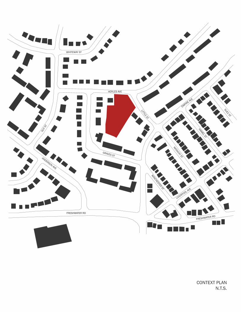
3 CONTEXT PLAN
4 SITE PLAN
5 SITE SERVICING PLAN
6 LANDSCAPE AND PARKING PLAN
7 BUILDING ELEVATIONS
8 SHADOW STUDY
9 TRANSIT CORRESPONDENCE
10 EXTERIOR PERSPECTIVES

LAND USE ASSESSMENT REPORT 1
INTRODUCTION
Nevida Properties is proposing a new development for the property located at 5-7 Little Street. The new building will be a personal care home featuring a mix of single and double rooms to accommodate approximately 100 residents.
The existing property is within the R2 (Residential Medium Density) Zone and the proposition is to rezone this property as A2 (Apartment 2) Zone to allow construction of a new 4 storey personal care home.
This Land Use Assessment Report (LUAR) is submitted by LAT49 Architecture Inc on behalf of Nevida Properties Ltd. for the development of 5-7 Little Street.
LAND USE ASSESSMENT REPORT 2
A | BUILDING USE
A new personal care home is being proposed for the property of 5-7 Little Street and will be a total of three storeys in height. Due to the substantial grade change on this property, the basement level will be at grade for the elevation facing Hoyles Avenue only, and will be the main point of entry to the building. The basement level will feature amenity spaces for residents, including a large lobby area, multipurpose room, chapel and private dining room. The commercial-grade kitchen, and utility spaces (such as laundry facilities) will also be located on the basement level.
Levels 1, 2, and 3 will contain all of the resident suites plus additional amenity and dining space dedicated to the residents on that level. Each floor will include private bathing rooms, resident laundry rooms, housekeeping and storage rooms and staff facilities. There will be 76 suites, either single or double occupancy, to accommodate up to 100 residents.
A conservatory space connected to an outdoor roof garden is located on Level 3 facing the southwest corner of the property, to maximize sun exposure.
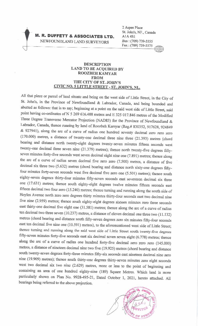
The current area of the property at 5-7 Little Street is approximately 4,558 square meters. Nevida Properties intend to purchase the strip of land between their existing boundary and the sidewalks on Little Street and Hoyles Avenue, currently City of St. John's owned property. This would add 189 square meters of landscaped area to the development, for a total of 4,747 square meters.
The total area (including all area bounded by the exterior walls) per floor is the following: Floor AreaBasement 765 m2
Level 1 1,419 m2
Level 2 1,419 m2
Level 3 1,350 m2 + 72 m2 deckTOTAL 4,953 m2 + 72 m2 deck
Lot coverage is defined in the Envision Development Regulations as "the combined area of all Buildings on a Lot measured at the level of the lowest floor above the established grade and expressed as a percentage of the total area of the Lot." Though the City considers the first storey to be the basement level (main entrance), the National Building Code of Canada defines the first storey as "the uppermost storey having its floor level not more than 2 m above grade." Since the established grade is not at the basement level, the NBCC definition is being used to determine the Lot Coverage.
Lot coverage is 29.9 per cent (1,419 m2 ÷ 4,747 m2) of the current site area, including the previously mentioned "to be purchased" property.
The Gross Floor Area (GFA) of the building, as defined in the City of St. John's Development Regulations (less parking and common amenity space), is 4,303 square meters and the Floor Area Ratio (FAR) is 0.91 with the total site area.
The following table breaks out the gross areas of the proposed uses by floor.
LAND USE ASSESSMENT REPORT 3
Amenity space includes the lobby, lounges, multipurpose room, chapel, beauty salon, resident dining areas and the conservatory and roof garden. Service spaces include the commercial kitchen and associated support area, servery space per floor, laundry and housekeeping services. Utility spaces include all storage rooms and any space required for building services. All other remaining area is classified as Circulation space.
Amenity Suites Service Utility CirculationBasement 174 m2 - 170 m2 174 m2 259 m2
Level 1 142 m2 859 m2 20 m2 8 m2 389 m2
Level 2 142 m2 859 m2 20 m2 8 m2 389 m2
Level 3 330 m2 706 m2 18 m2 19 m2 345 m2
Totals 788 m2 2,424 m2 228 m2 209 m2 1,382 m2
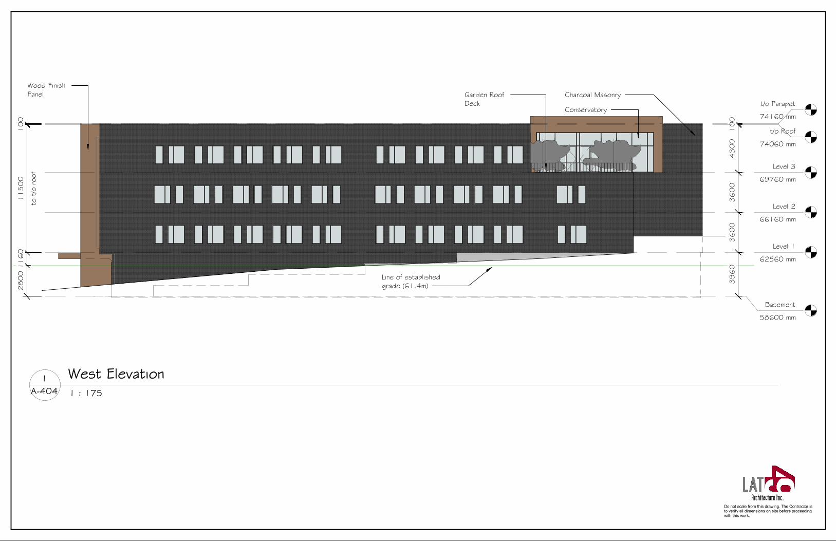
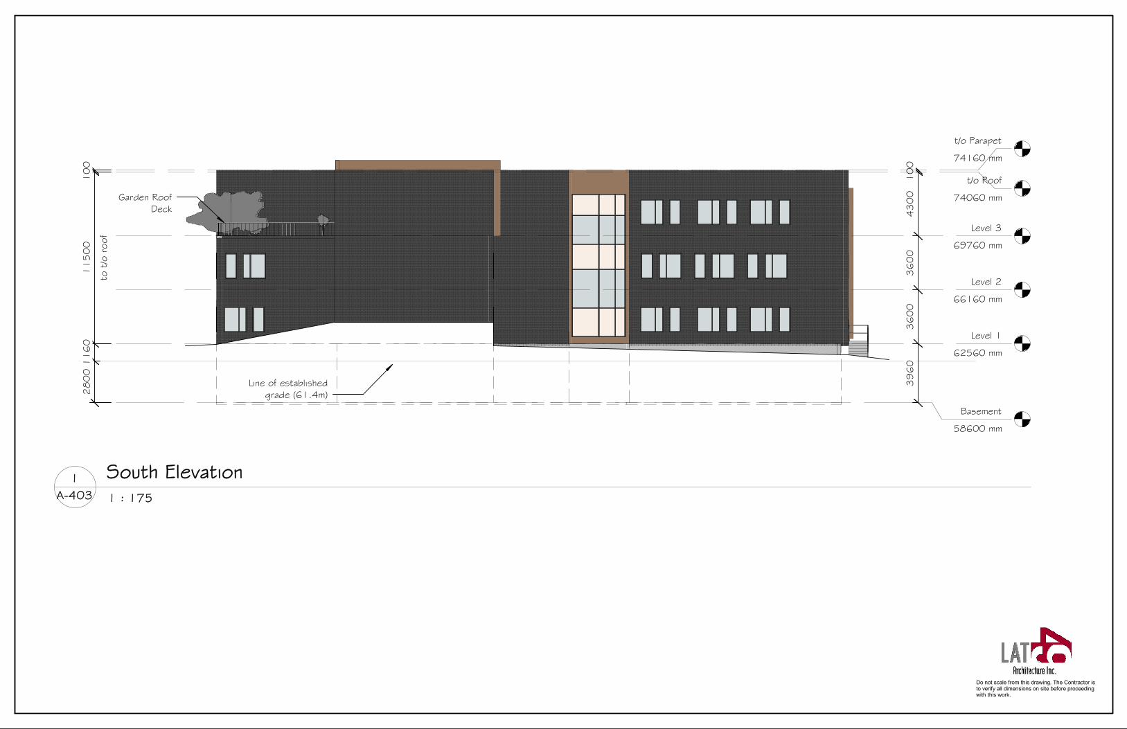
B | ELEVATIONS & BUILDING MATERIALS
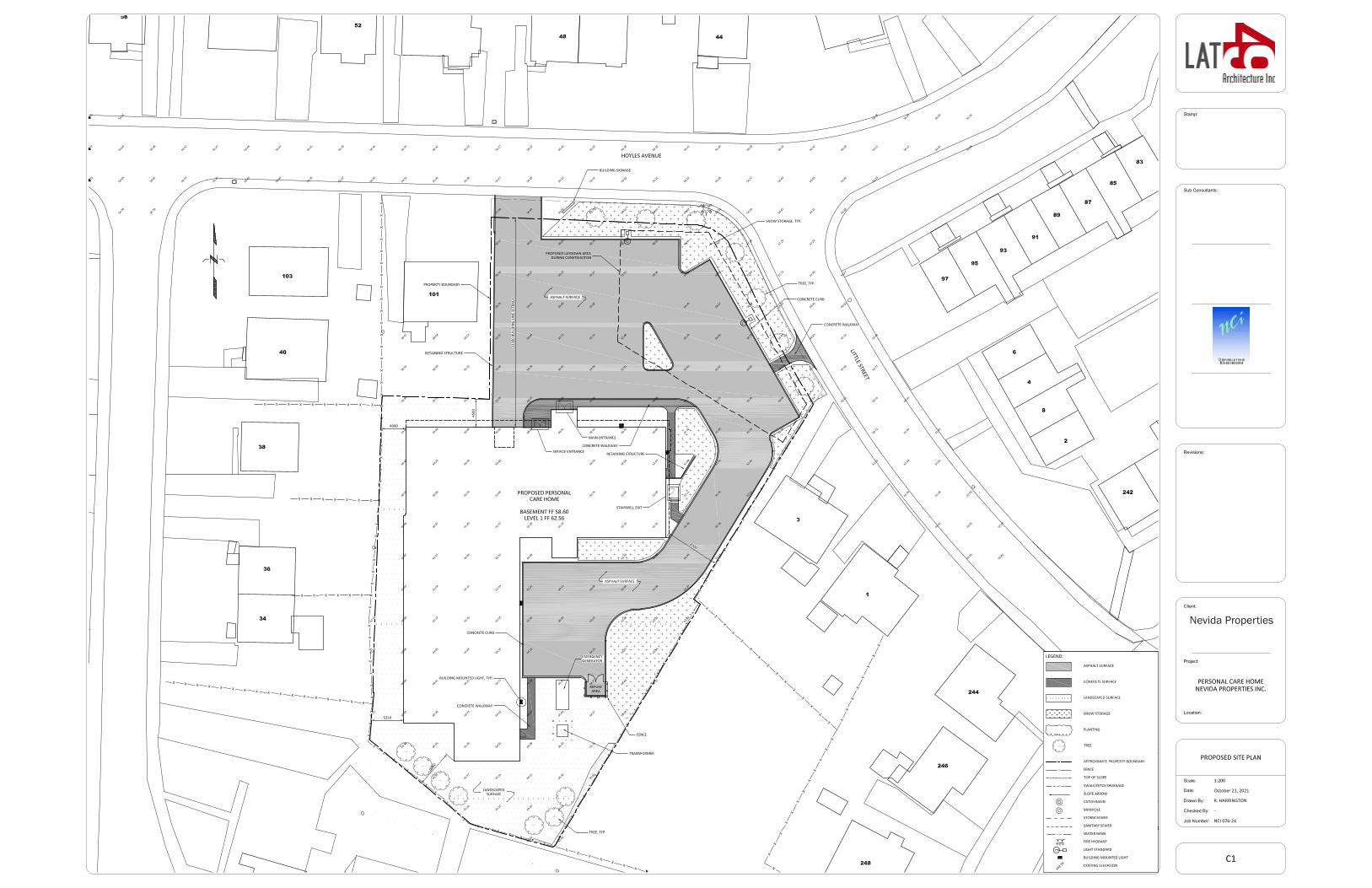
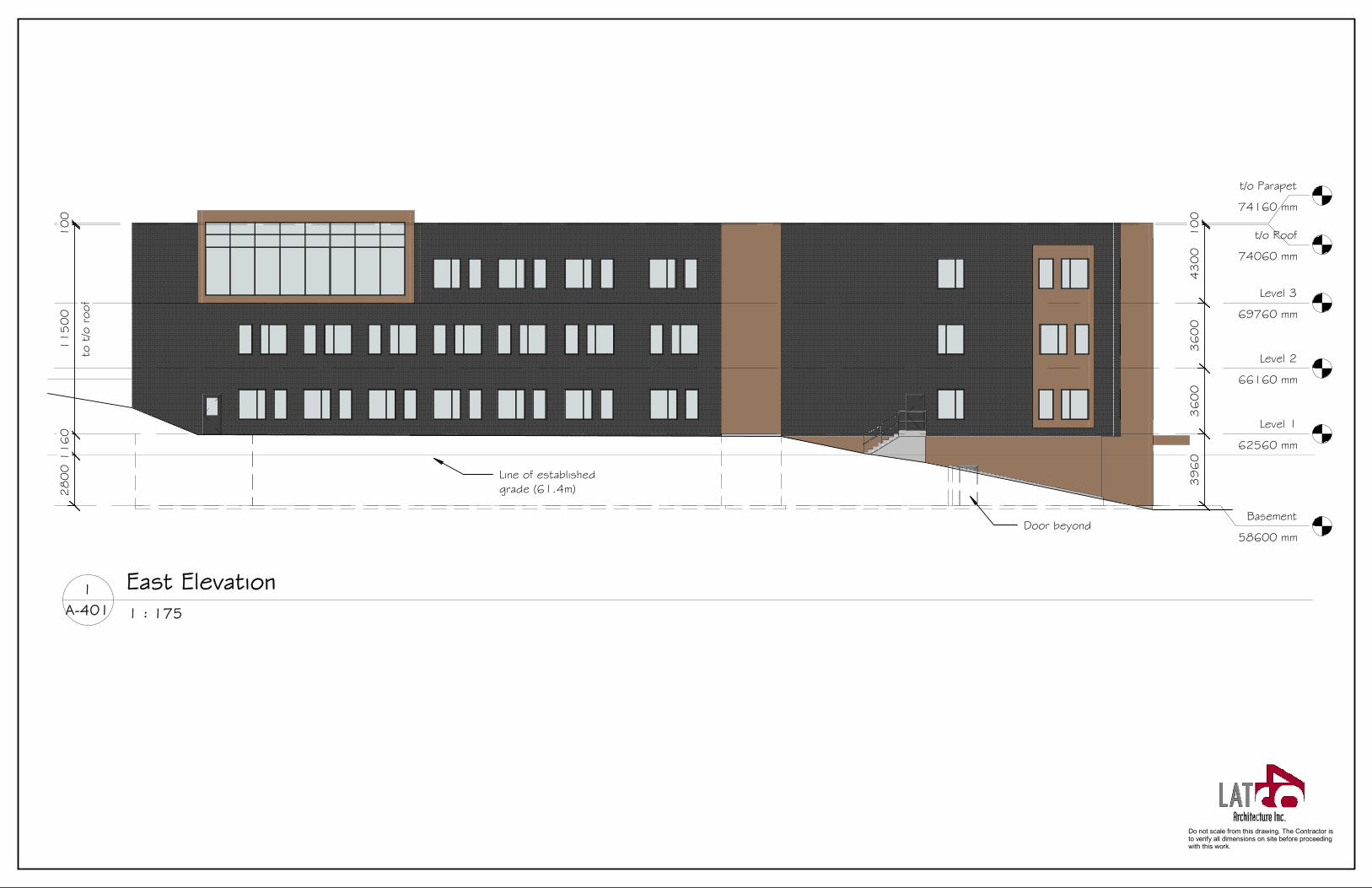
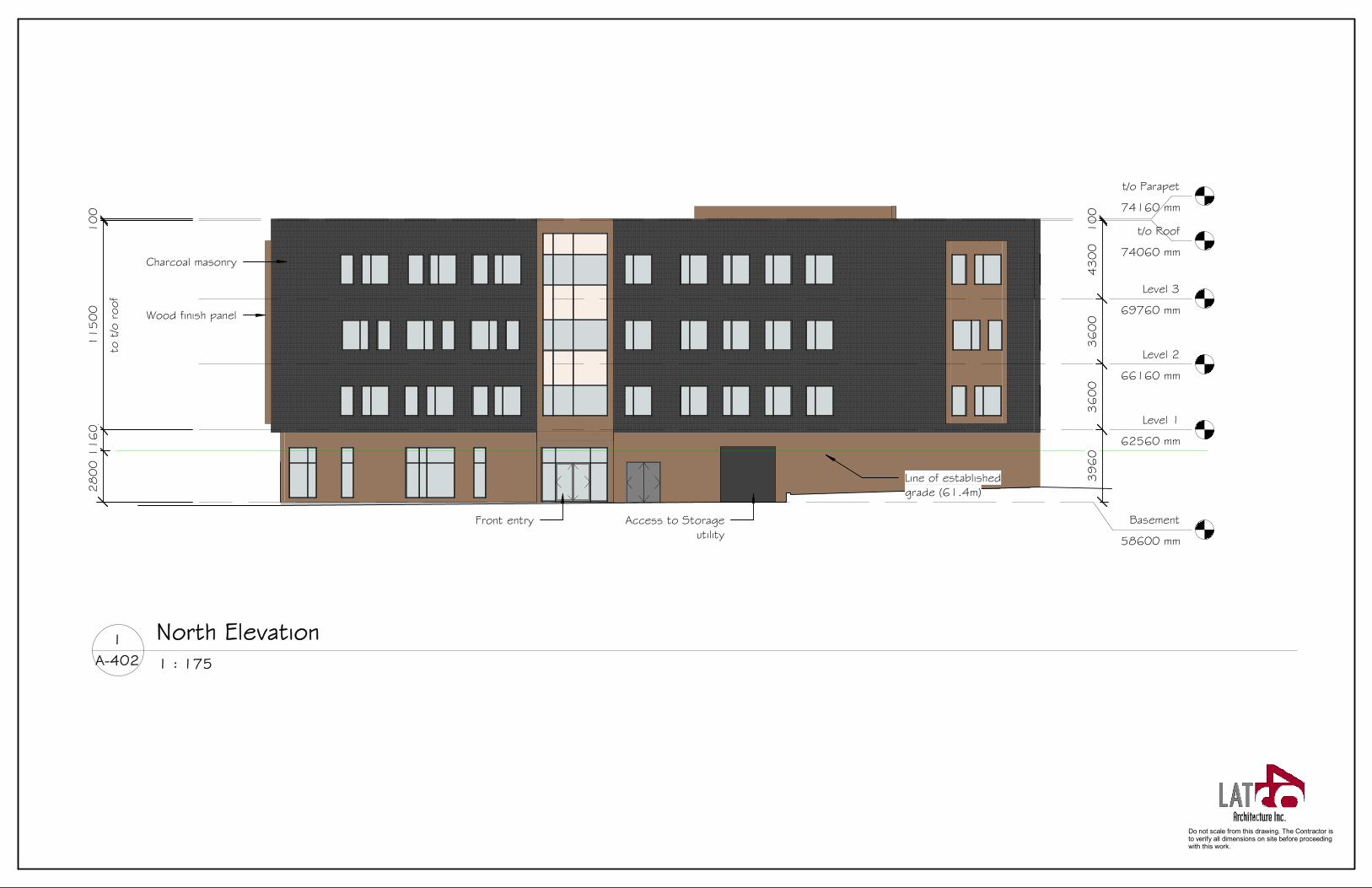
The proposed exterior materials for the building are charcoal-coloured masonry, accented with a wood-finish panel that is predominately located at the basement level — when above grade — and at featured window bays on several elevations. The exterior walls at the basement level are inset approximately 1.2 meters from the levels above on the elevation facing Hoyles Avenue to help reduce the size of the building footprint at grade. Similarly, along the elevation facing Little Street, the basement is inset 0.5 meters. The main entrance to the building is on the elevation facing Hoyles Avenue, at the basement level.
There is a mixture of punched windows and curtain wall glazing throughout the building with the majority of the curtain wall glazing along the basement level facing the main entry to the property along Hoyles Avenue and at featured window bays. At the southwest corner on Level 3, there is an exterior roof garden connected to an interior glazed conservatory space for resident use. The lower level of the building features accent lighting that doubles as security lighting along the main walkways and entries of the building.
Refer to Appendix 7 for elevations and Appendix 10 for building renderings.
C | BUILDING HEIGHT & LOCATION
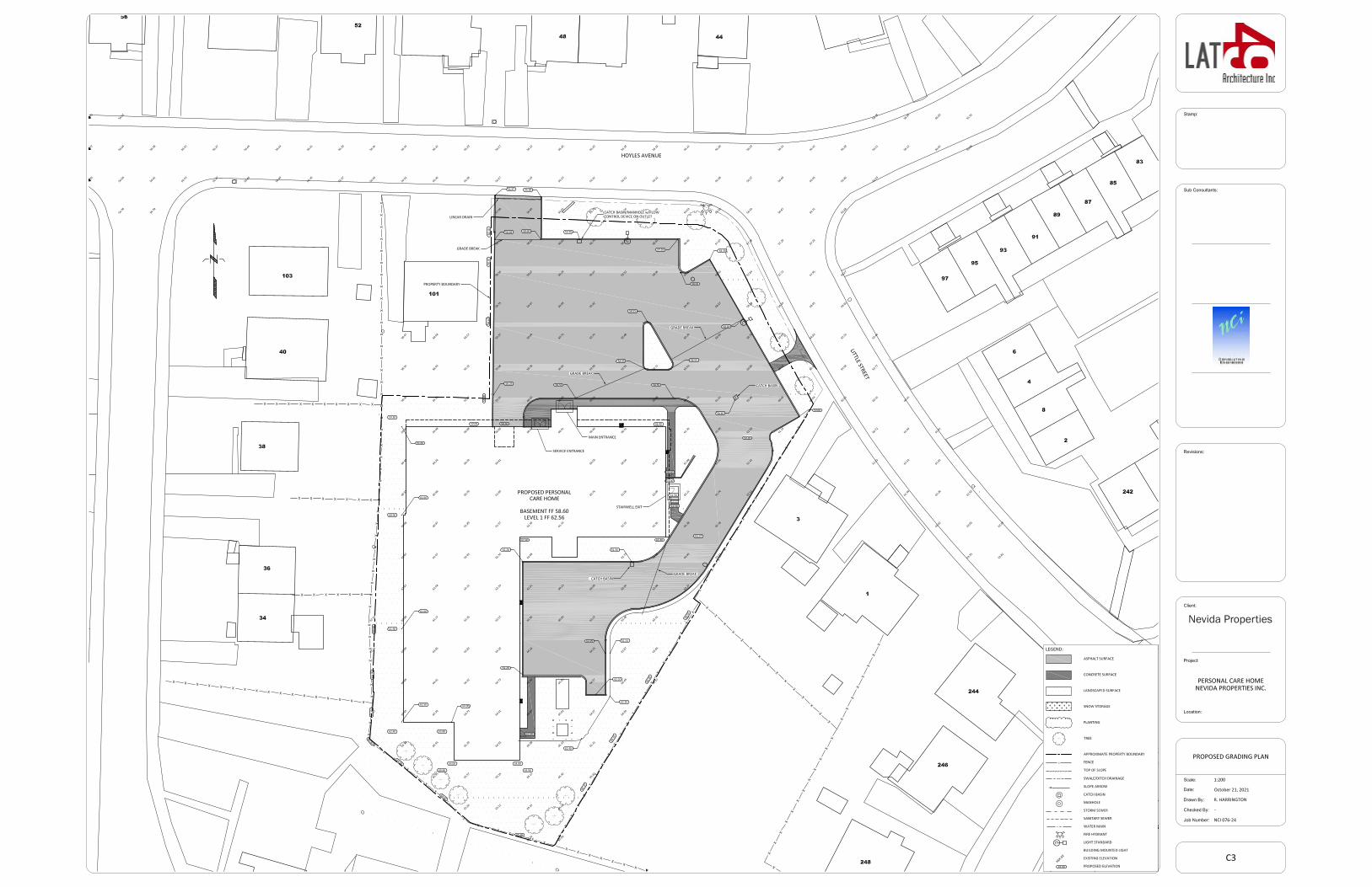
The average grade around the perimeter of the building is 61.4 meters above sea level. This was calculated by averaging the building perimeter elevation points as indicated on drawing C3 Proposed Grading Plan (refer to Appendix 4).
The height of the proposed building is three storeys, approximately 11.5 meters above the established grade to the top of the roof on the majority of three sides. However, due to the substantial grade change of nine meters across the site, the building is considered four storeys at a portion of the north elevation facing Hoyles Avenue. From basement-level grade to the top of the roof at this location is 15.46 meters. The main entry is under a canopy at this level, facing Hoyles. Floor to floor heights are currently set at 3.96 meters for the basement to level 1 and 3.6 meters per floor for levels 2 and 3.
The steeply changing grade of the site was the driving factor behind the layout of the building. The main residential storey (level 1) is placed just one meter above the established grade and in-line with the nearby houses on Little Street. Locating the entry and main lobby at the basement level avoids a blank concrete wall facing Hoyles Avenue, which would have been the result if the entrance
LAND USE ASSESSMENT REPORT 4
level had been at the average grade. The mass of the building sits comfortably into the site. In fact, due to the surrounding elevation changes, the proposed building is approximately the same height as the Rabbittown Community Centre and row housing on Graves Street adjacent to the rear of the property, though it is one storey taller.
The new building will be closely placed along the side yard and rear year setback lines on the west and south portions of the property, but it does not encroach over any required setback. The building is setback 33.3 meters from the front property line along Hoyles Avenue and 4.5 meters along the property line at the rear of 101 Hoyles Avenue. On the west boundary, the building is set back 4.00 meters at its closest, increasing to 5.21 meters toward the southwest corner. A retaining wall must be placed along this property line to allow for an even slope at the access road. Along the rear of the property, the building is 6.06 meters from the boundary and 8.90 meters back from the property line closest to Little Street.
All personal care homes are required to be sprinklered. The National Building Code requires a hydrant to be within 45 meters of the building's fire department connection. This distance is achievable using the existing hydrant located at the corner of Little and Hoyles.
Refer to Appendices 4 and 6 for site and landscape plans and Appendix 10 for exterior views.
As illustrated in the shadow study, the main impact of shadows cast on existing buildings is during the morning hours of the winter months of the year. There will be some shadowing along the residential property at 101 Hoyles Avenue and the rear yards of the properties along Graves Street. However, outside of the winter months, there is minimal impact from shadows on neighbouring properties.
Refer to Appendix 8 for the shadow studies taken at the Winter Solstice, Spring Equinox, Summer Solstice and Fall Equinox.
D | EXTERIOR EQUIPMENT & LIGHTING
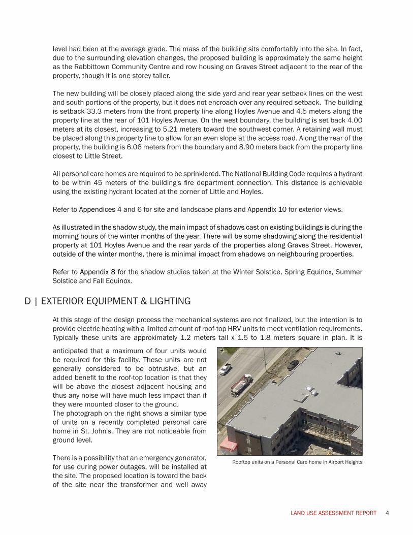
At this stage of the design process the mechanical systems are not finalized, but the intention is to provide electric heating with a limited amount of roof-top HRV units to meet ventilation requirements. Typically these units are approximately 1.2 meters tall x 1.5 to 1.8 meters square in plan. It is Rooftop Units
06/05/2019
anticipated that a maximum of four units would be required for this facility. These units are not generally considered to be obtrusive, but an added benefit to the roof-top location is that they will be above the closest adjacent housing and thus any noise will have much less impact than if they were mounted closer to the ground. The photograph on the right shows a similar type of units on a recently completed personal care home in St. John's. They are not noticeable from ground level.
There is a possibility that an emergency generator, for use during power outages, will be installed at the site. The proposed location is toward the back of the site near the transformer and well away
Rooftop units on a Personal Care home in Airport Heights
LAND USE ASSESSMENT REPORT 5
from most houses. The exact proposed location is illustrated on the site plan in Appendix 4.
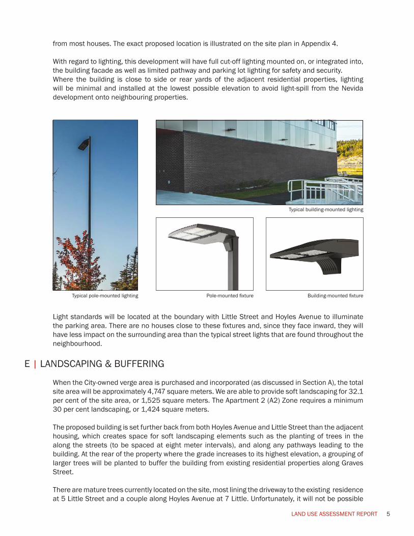
With regard to lighting, this development will have full cut-off lighting mounted on, or integrated into, the building facade as well as limited pathway and parking lot lighting for safety and security. Where the building is close to side or rear yards of the adjacent residential properties, lighting will be minimal and installed at the lowest possible elevation to avoid light-spill from the Nevida development onto neighbouring properties.
Typical building-mounted lighting
Typical pole-mounted lighting Pole-mounted fixture Building-mounted fixture
Light standards will be located at the boundary with Little Street and Hoyles Avenue to illuminate the parking area. There are no houses close to these fixtures and, since they face inward, they will have less impact on the surrounding area than the typical street lights that are found throughout the neighbourhood.
E | LANDSCAPING & BUFFERING
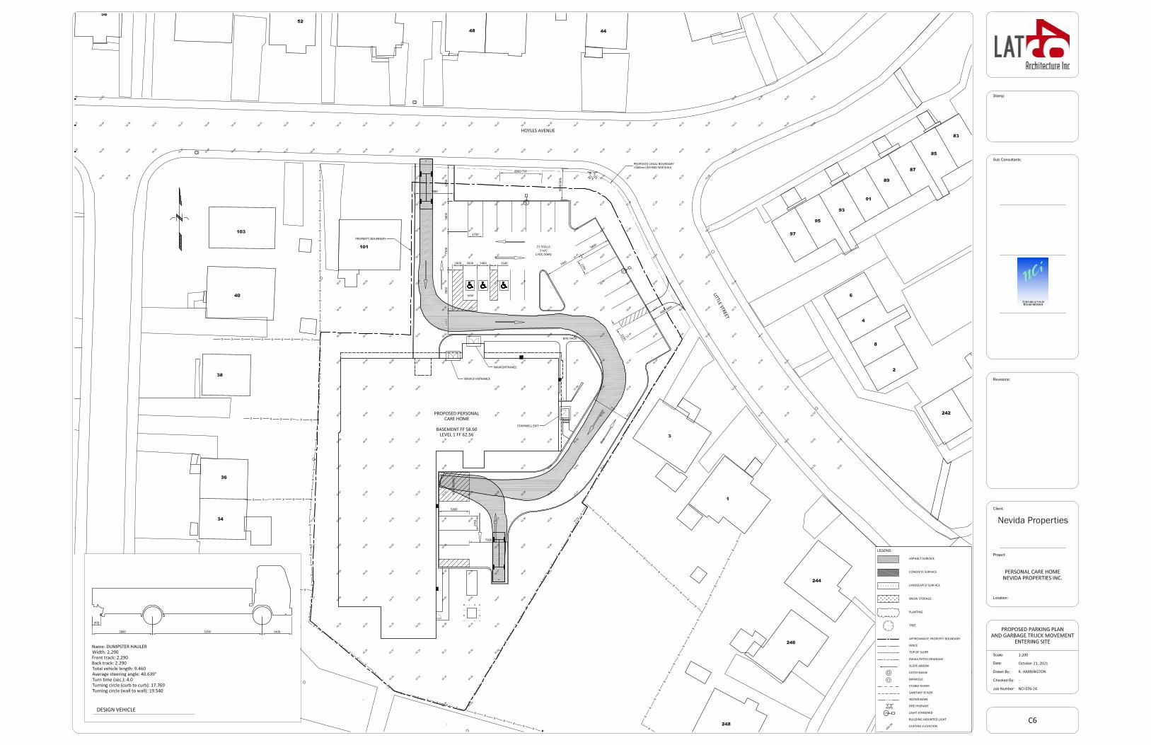
When the City-owned verge area is purchased and incorporated (as discussed in Section A), the total site area will be approximately 4,747 square meters. We are able to provide soft landscaping for 32.1 per cent of the site area, or 1,525 square meters. The Apartment 2 (A2) Zone requires a minimum 30 per cent landscaping, or 1,424 square meters.
The proposed building is set further back from both Hoyles Avenue and Little Street than the adjacent housing, which creates space for soft landscaping elements such as the planting of trees in the along the streets (to be spaced at eight meter intervals), and along any pathways leading to the building. At the rear of the property where the grade increases to its highest elevation, a grouping of larger trees will be planted to buffer the building from existing residential properties along Graves Street.
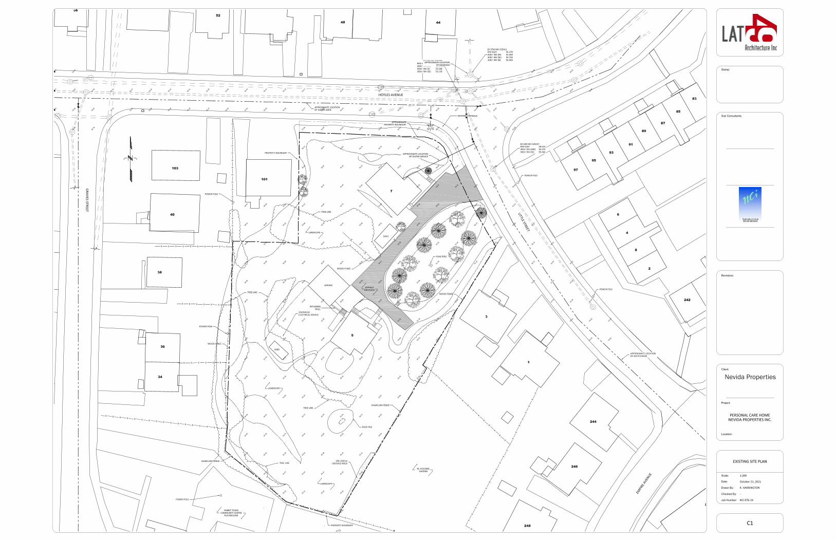
There are mature trees currently located on the site, most lining the driveway to the existing residence at 5 Little Street and a couple along Hoyles Avenue at 7 Little. Unfortunately, it will not be possible
LAND USE ASSESSMENT REPORT 6
to retain any of the trees toward the interior of the property, but it may be possible to save the two on Hoyles. This will be determined as the design progresses and any measures required to mitigate damage to these trees will be submitted to the City for review and approval at the permitting phase. Planters will be placed near the main entrance to the building and in the space between the building and the lane to the rear parking, a planted area featuring shrubbery, flowers and accent boulders will be designed. As previously noted, one of the main features of this building is the conservatory and greenhouse space on Level 3. This was designed with the local climate in mind - the intention is to create a landscaped and garden area for residents that could be enjoyed year round. An exterior roof garden can be accessed off of this space so that residents can enjoy an exterior upper garden during the summer months.
A refuse container will be located on the site at the rear of the parking area. Any refuse or garbage from the building will be appropriately dealt with on the basement level with interior collection and storage. The garbage will then be removed via the service exit and placed in the refuse bin. The refuse bin will be covered and located in a fenced enclosure. Any other exterior infrastructure, including a pad-mounted transformer and, potentially, a generator, will also be fenced or screened with planting as much as possible. The transformer location illustrated on the attached drawings is preliminary and will be finalized during detailed design in discussion with NF Power.
Refer to Appendix 6 for the Landscape Plan .
F | SNOW CLEARING / SNOW STORAGE
There is at least a six meter buffer between the back of the sidewalks on Little and Hoyles and the parking lot curb for city snow storage. As previously mentioned, it is the intention to plant trees within this area, however if the buffer space is required for City snow clearing and storage operations, arrangements will need to be made with the City to define other locations on the property for tree planting.
For snow clearing on site, the developer would hire a snow clearing service to push the snow to the various landscaped areas across the site and will have it removed as necessary. Due to the grade changes and overall shape of the property, there is not an abundance of space for snow storage on site and removal is expected to be frequent.
See Appendix 4 for the site plan showing proposed snow storage locations.
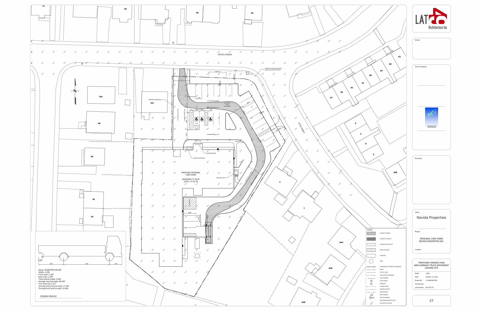
G | OFF-STREET PARKING AND SITE ACCESS
The off-street parking requirement for a personal care home in the current development regulations (8.3 Parking Standards, Envision St. John's Development Regulations) is one parking stall for every five dwelling units as a minimum, and one parking stall for every two dwelling units as a maximum. The following table is a breakdown of the minimum and maximum number or parking stalls required, based on the current number of dwelling units:
Total # of Suites Calculation factor Total Parking Req.Minimum 76 1 per 5 suites 16Maximum 76 1 per 2 suites 38
LAND USE ASSESSMENT REPORT 7
As illustrated on the site plan in Appendix 6, there are 23 regular, two accessible and one accessible van stall in the parking lot, for a total of 26 spaces.
The design vehicle used for the swept path analysis for garbage collection is based on a scenario where the dumpster gets replaced each time it needs to be emptied. The truck brings an empty unit and replaces it with the full unit during collection days. The design vehicle for this type of service is smaller than the load over the front type collection truck, similar to those used by GFL for commercial collection services.
H | MUNICIPAL SERVICES
Sanitary Rate Generated
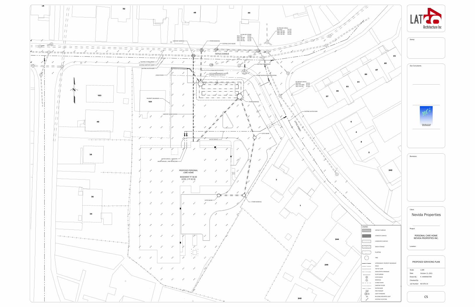
There is an existing sanitary sewer along Hoyles Avenue which is available for connection. At this stage of the design, a conservative estimate of the sanitary flow rate by our civil engineers, Nova Consultants, based on the estimated number of fixture units is approximately 13 liters per second. However, as the design progresses, this rate will be finalized by the project's mechanical engineering consultant. We anticipate that this number will be lower, once the design is finalized.
The sanitary rate is indicated on the attached Appendix 11.
Storm Water Management and Detention
All runoff will be captured on site and conveyed to the storm water management system. No surface run-off will be directed to adjacent properties or into the streets. The catchment area includes the rear yards of numbers 3 and 4 Little Street, 244, 246, 248 Empire Avenue, and the undeveloped rear lot bounded by the properties mentioned, lying generally east of the proposed development.
A storm water detention system comprised of manifolded, large diameter HDPE pipe and equipped with a flow control device will be used to manage the rate of discharge so it will not exceed the pre-development storm water generation rates. This would then be released into the City’s municipal storm water system under Hoyles Avenue.
The storm water detention system will be designed to accommodate a 100-year rainfall event as described in the City's Stormwater Detention Policy.
Water Service
The property will be serviced by the City of St. John’s water supply system. An existing water main is located in Little Street along the eastern boundary of the property. This water main is available for connection to provide both the domestic and sprinkler supply water service to the proposed building. Due to the proximity of an exiting hydrant at the corner of Little and Hoyles, a private hydrant will not be required.
The design of the water service will meet all City requirements for new construction.
LAND USE ASSESSMENT REPORT 8
I | PUBLIC TRANSIT
LAT49 Architecture contacted Keith Woodfine, Transit Planner at Metrobus, to inquire about any public transit infrastructure requirements for this development and after reviewing the location Metrobus does not feel there is any further transit infrastructure required. Please refer to Appendix 9 for a copy of our email correspondence.
J | CONSTRUCTION TIMEFRAME
The construction timeframe for this project is anticipated to be approximately 20-22 months in length following approvals and permits, a process anticipated to take up to six months. Worker parking will be provided on site, either in the lower parking area or upper parking area depending on necessary space for material laydown and storage during construction.
Workers will be able to park in the noted parking areas on site or, if construction on those areas is ongoing, workers will park in nearby parking locations only as approved by the City of St. John's.

LAND USE ASSESSMENT REPORT 9
APPENDIX 1 | TERMS OF REFERENCE
TERMS OF REFERENCE LAND USE ASSESSMENT REPORT (LUAR)
APPLICATION FOR A PERSONAL CARE HOME AT 5 AND 7 LITTLE STREET
PROPONENT: LAT 49 AND NEVIDA PROPERTIES INC. UPDATED DECEMBER 14, 2020
The proponent shall identify significant impacts and, where appropriate, also identify measures to mitigate impacts on land uses adjoining the subject property. All information is to be submitted under one report in a form that can be reproduced for public information and review. The numbering and ordering scheme used in the report shall correspond with that used in this Terms of Reference and a copy of the Terms of Reference shall be included as part of the report (include an electronic PDF version with a maximum file size of 15MB). A list of those persons/agencies who prepared the Land Use Assessment Report shall be provided as part of the report. The following items shall be addressed by the proponent at its expense:
A. Building Use. • Identify the size of the proposed building by:
- Gross Floor Area, and - Floor Area Ratio (FAR).
• Identify all proposed uses/occupancies within the building by their respective floor area.
B. Elevation & Building Materials
• Provide elevations of the proposed building. • Identify the finish and colour of exterior building materials.
C. Building Height & Location
• Identify graphically the exact location with a dimensioned civil site plan: - Location of the proposed building in relation to neighbouring buildings; - Proximity of the building to property lines and identify setbacks; - Identify any stepbacks of higher storeys from lower storeys (if applicable); - Identify any encroachment over property lines; - Identify the height of the building; - Information on the proposed construction of patios/balconies (if
applicable); - Potential shadowing/loss of sunlight on adjacent public and private
properties, including sidewalks; - Identify any rooftop structures; and - Identify if the building will be sprinklered or not, and location of the nearest
hydrant. • Provide street scape views/renderings of the proposed building from the
following locations: - Along the property frontage at Hoyles Avenue; - Along the property frontage at Little Street.
• Provide a Legal Survey of the property showing the consolidated lots.
D. Exterior Equipment and Lighting • Identify the location and type of exterior lighting to be utilized. Identify
possible impacts on adjoining properties and measures to be instituted to minimize these impacts.
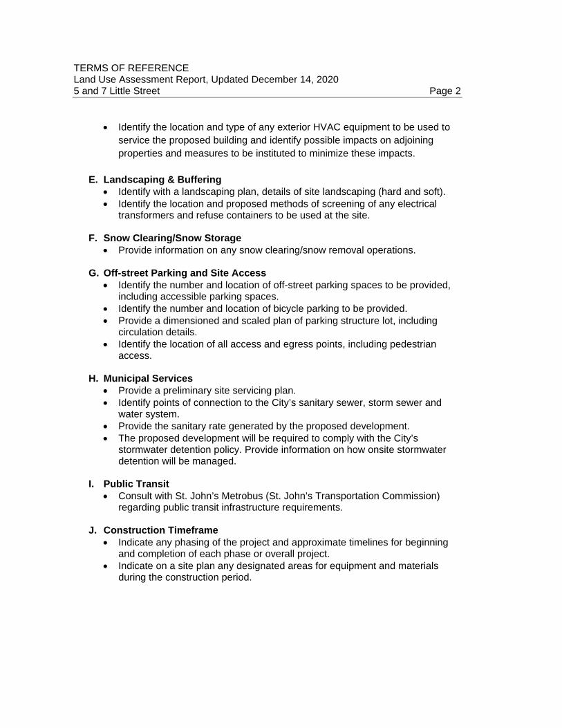
TERMS OF REFERENCE Land Use Assessment Report, Updated December 14, 2020 5 and 7 Little Street Page 2
• Identify the location and type of any exterior HVAC equipment to be used to service the proposed building and identify possible impacts on adjoining properties and measures to be instituted to minimize these impacts.
E. Landscaping & Buffering • Identify with a landscaping plan, details of site landscaping (hard and soft). • Identify the location and proposed methods of screening of any electrical
transformers and refuse containers to be used at the site.
F. Snow Clearing/Snow Storage • Provide information on any snow clearing/snow removal operations.
G. Off-street Parking and Site Access
• Identify the number and location of off-street parking spaces to be provided, including accessible parking spaces.
• Identify the number and location of bicycle parking to be provided. • Provide a dimensioned and scaled plan of parking structure lot, including
circulation details. • Identify the location of all access and egress points, including pedestrian
access.
H. Municipal Services • Provide a preliminary site servicing plan. • Identify points of connection to the City’s sanitary sewer, storm sewer and
water system. • Provide the sanitary rate generated by the proposed development. • The proposed development will be required to comply with the City’s
stormwater detention policy. Provide information on how onsite stormwater detention will be managed.
I. Public Transit • Consult with St. John’s Metrobus (St. John’s Transportation Commission)
regarding public transit infrastructure requirements.
J. Construction Timeframe • Indicate any phasing of the project and approximate timelines for beginning
and completion of each phase or overall project. • Indicate on a site plan any designated areas for equipment and materials
during the construction period.

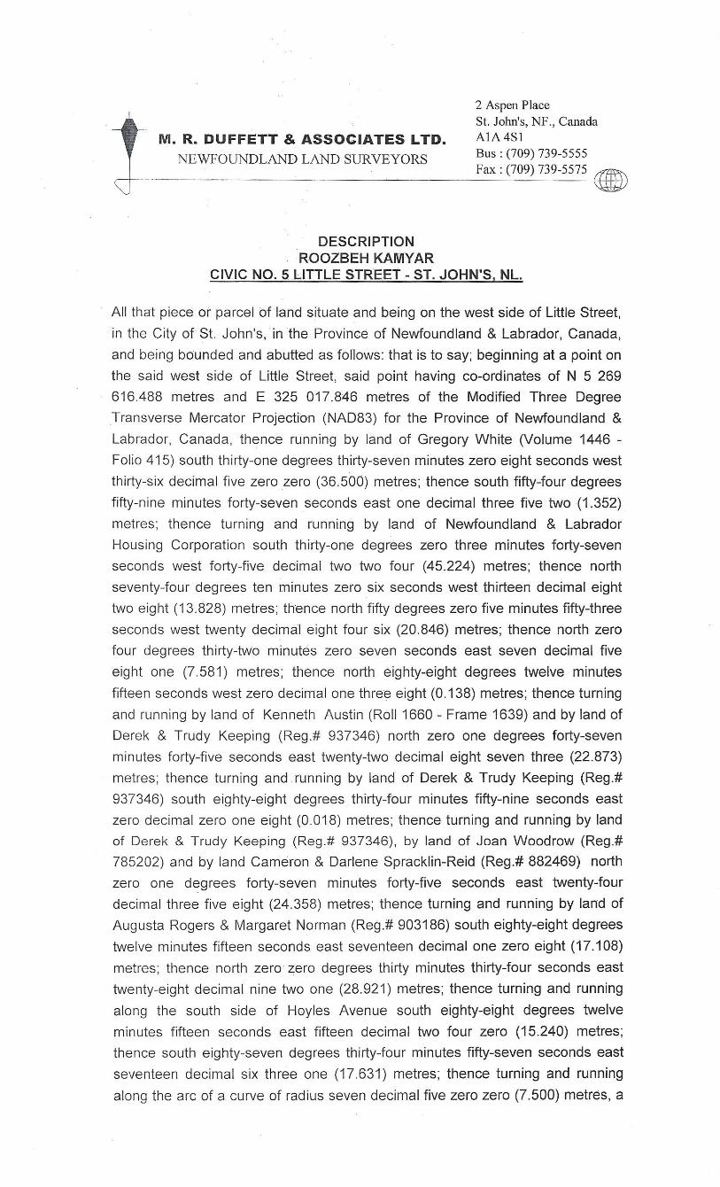
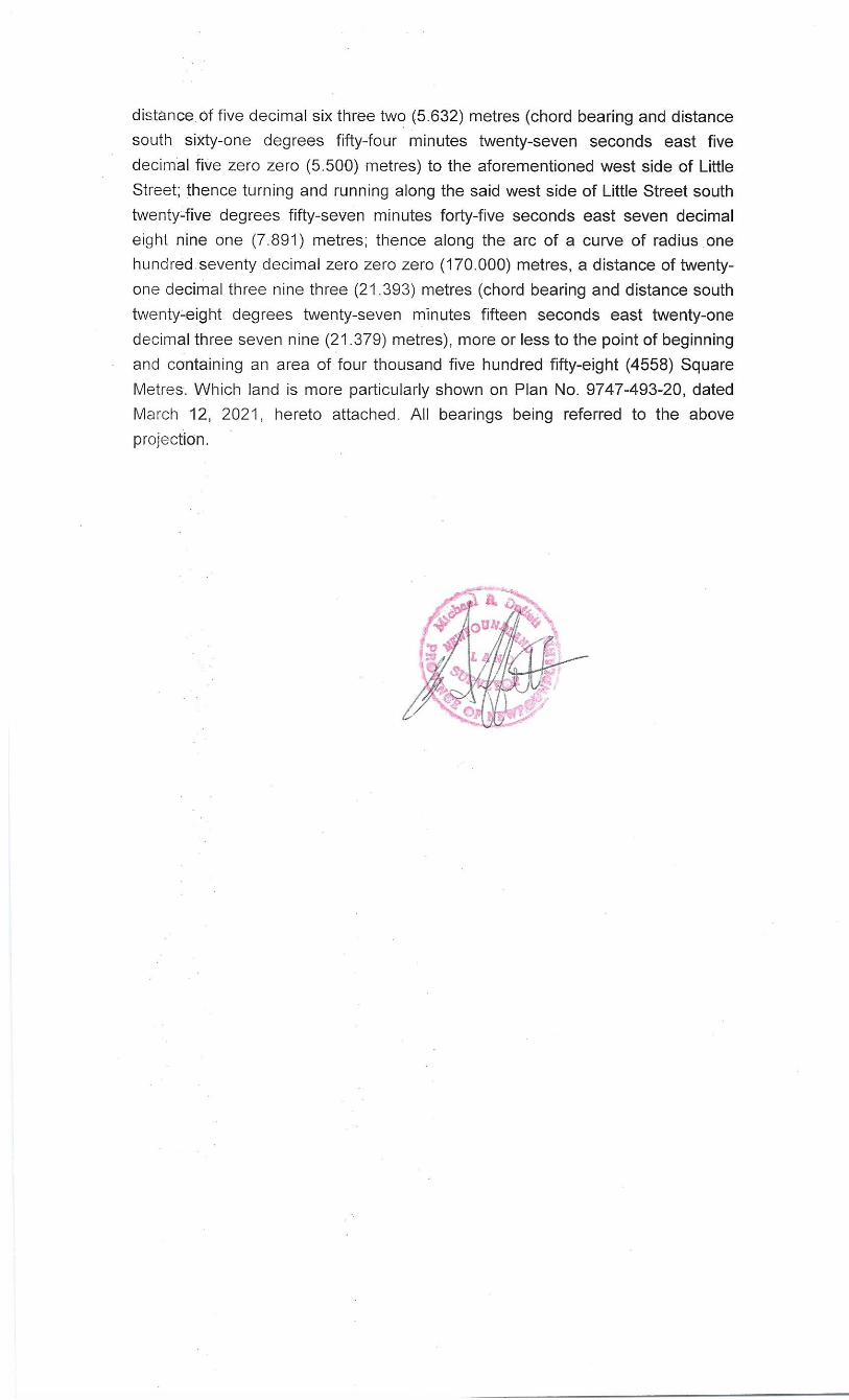
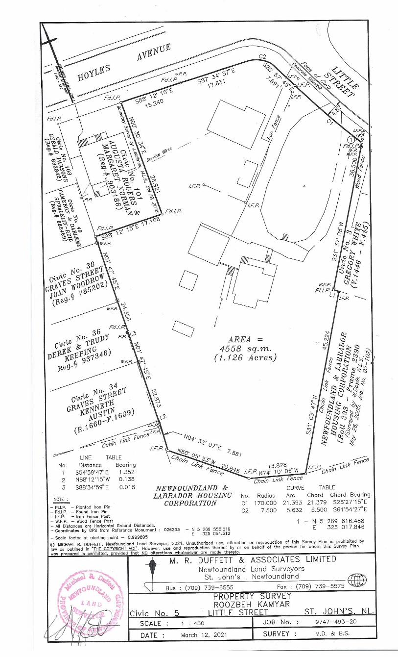
APPENDIX 2 | SURVEY


APPENDIX 3 | CONTEXT PLAN
HOYLES AVE
WHITEWAY ST
LITTLE ST
GRAVES STANDERSON AVE
FRESHWATER RD
FRESHWATER RD
LIVERPOOL AVE
WINCHESTER ST
MONCHY ST
HAMEL ST
SUEZ ST
EMPIRE AVE
GUY S
T
CONTEXT PLANN.T.S.

APPENDIX 4 | SITE PLANS
Nevida Properties
Nevida Properties
Nevida Properties

APPENDIX 5 | SITE SERVICING PLAN
Nevida Properties
APPENDIX 6 | LANDSCAPE AND PARKING PLAN

Nevida Properties
5
Nevida Properties
5
Nevida Properties
5
APPENDIX 7 | BUILDING ELEVATIONS
Level 1
62560 mm
Level 2
66160 mm
Level 3
69760 mm
Basement
58600 mm
t/o Parapet
74160 mm
10
04
30
03
60
03
60
03
96
0
Door beyond
t/o Roof
74060 mm
28
00
11
60
to t
/o r
oof
11
50
01
00
Line of establishedgrade (61.4m)
Do not scale from this drawing. The Contractor is to verify all dimensions on site before proceeding with this work.
11 :: 117755AA--440011
EEaasstt EElleevvaattiioonn11
Level 1
62560 mm
Level 2
66160 mm
Level 3
69760 mm
Basement
58600 mm
t/o Parapet
74160 mm
10
04
30
03
60
03
60
03
96
0
Charcoal masonry
Wood finish panel
Access to Storage utility
Front entry
t/o Roof
74060 mm
28
00
11
60
to t
/o r
oof
11
50
01
00
Line of establishedgrade (61.4m)
Do not scale from this drawing. The Contractor is to verify all dimensions on site before proceeding with this work.
11 :: 117755AA--440022
NNoorrtthh EElleevvaattiioonn11
Level 1
62560 mm
Level 2
66160 mm
Level 3
69760 mm
Basement
58600 mm
Garden Roof Deck
Conservatory
Charcoal MasonryWood Finish Panel
t/o Parapet
74160 mm
39
60
36
00
36
00
43
00
10
0
t/o Roof
74060 mm
28
00
11
60
to t
/o r
oof
11
50
01
00
Line of establishedgrade (61.4m)
Do not scale from this drawing. The Contractor is to verify all dimensions on site before proceeding with this work.
11 :: 117755AA--440044
WWeesstt EElleevvaattiioonn11
Level 1
62560 mm
Level 2
66160 mm
Level 3
69760 mm
Basement
58600 mm
10
04
30
03
60
03
60
03
96
0
t/o Parapet
74160 mm
Garden Roof Deck
t/o Roof
74060 mm
28
00
11
60
to t
/o r
oof
11
50
01
00
Line of establishedgrade (61.4m)
Do not scale from this drawing. The Contractor is to verify all dimensions on site before proceeding with this work.
11 :: 117755AA--440033
SSoouutthh EElleevvaattiioonn11

APPENDIX 8 | SHADOW STUDY

March 22
9 am
12 pm
5 pm
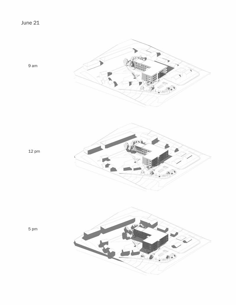
June 21
9 am
12 pm
5 pm
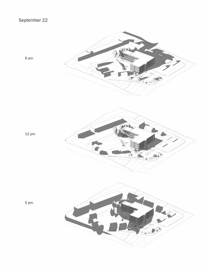
September 22
9 am
12 pm
5 pm
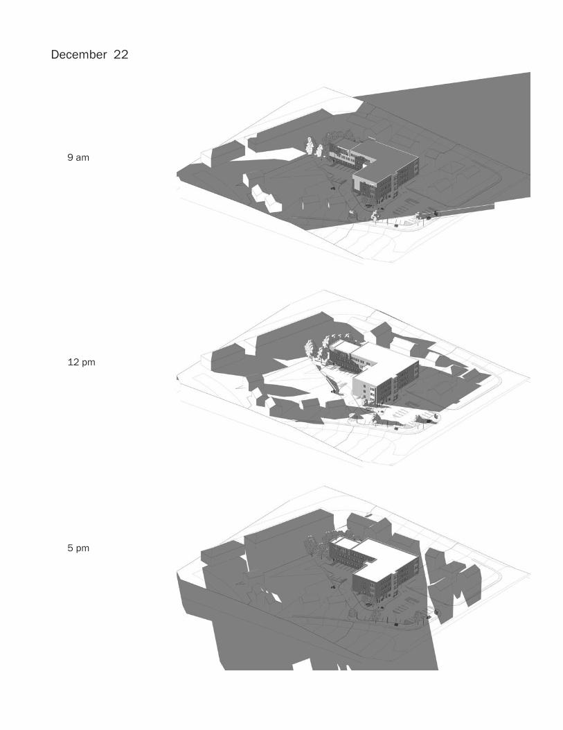
December 22
9 am
12 pm
5 pm

APPENDIX 9 | TRANSIT CORRESPONDENCE
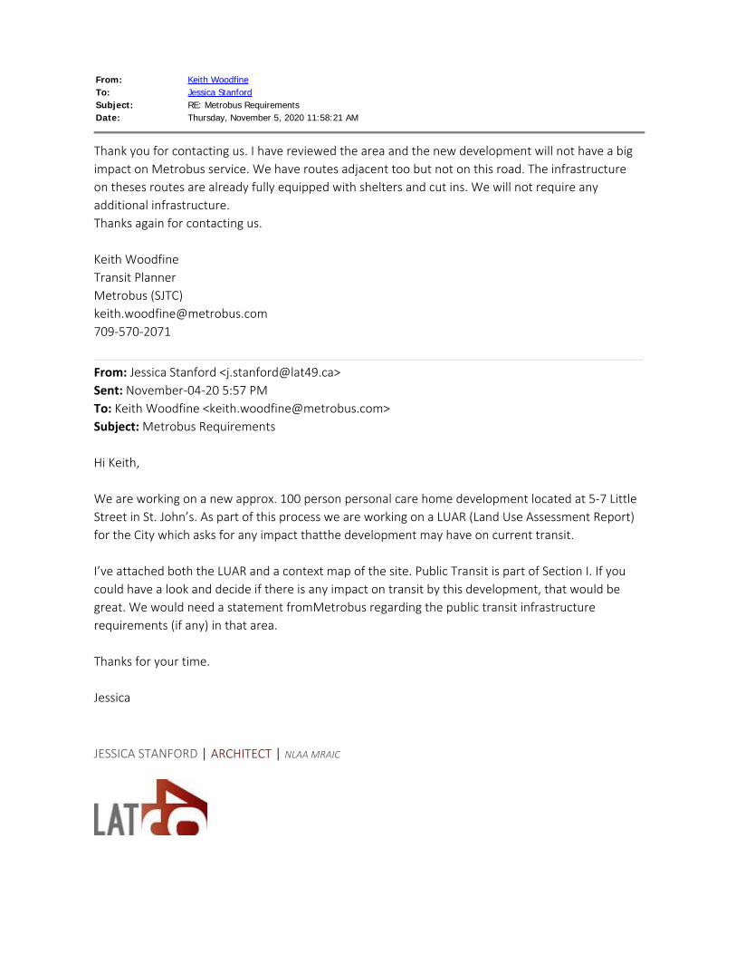
From: Keith WoodfineTo: Jessica StanfordSubject: RE: Metrobus RequirementsDate: Thursday, November 5, 2020 11:58:21 AM
Thank you for contacting us. I have reviewed the area and the new development will not have a bigimpact on Metrobus service. We have routes adjacent too but not on this road. The infrastructureon theses routes are already fully equipped with shelters and cut ins. We will not require anyadditional infrastructure.Thanks again for contacting us. Keith WoodfineTransit PlannerMetrobus (SJTC)[email protected]
From: Jessica Stanford <[email protected]> Sent: November-04-20 5:57 PMTo: Keith Woodfine <[email protected]>Subject: Metrobus Requirements Hi Keith, We are working on a new approx. 100 person personal care home development located at 5-7 LittleStreet in St. John’s. As part of this process we are working on a LUAR (Land Use Assessment Report)for the City which asks for any impact thatthe development may have on current transit. I’ve attached both the LUAR and a context map of the site. Public Transit is part of Section I. If youcould have a look and decide if there is any impact on transit by this development, that would begreat. We would need a statement fromMetrobus regarding the public transit infrastructurerequirements (if any) in that area. Thanks for your time. Jessica JESSICA STANFORD | ARCHITECT | NLAA MRAIC

APPENDIX 10 | EXTERIOR PERSPECTIVES
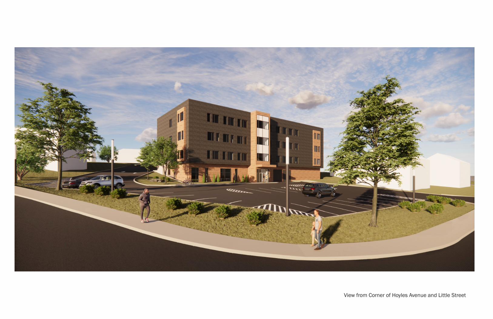
View from Corner of Hoyles Avenue and Little Street
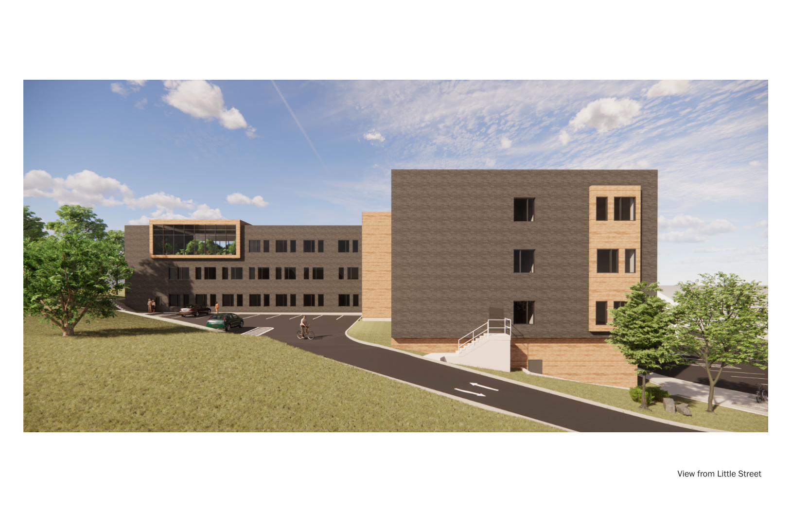
View from Little Street