Embed Size (px)
Citation preview

LAND APPLICATION OF BIOSOLIDS WILLIAM SCHEUREN
MA 12 (FIELDS 1-2) MADISON COUNTY, VIRGINIA
AUGUST 2012

March 6, 2014
Mr. Ed Stuart Dept. of Environmental Quality Northern Virginia Regional Office 13901 Crown Court Woodbridge, VA 22193
Dear Mr. Stuart:
Transmitted herein for your consideration is land application site for William Scheuren (designated as MA 12, fields 1-2), located in Madison County, Virginia. This submission contains strictly site specific information. Please refer to the operations and maintenance manual submitted under separate cover for all non-site specific information.
Do not hesitate to contact me at (804) 443-2170 should you have any questions or require additional information.
Sincerely,
&KVWL±^<_P Carolanne M. Whiteside Technical Services Coordinator
10647 Tidewater Trail, Champlain, VA 22438 • Phone (804) 443-2170 • Fax:(804)223-2214

SYNAGR© FIELD SUMMARY SHEET
William Scheuren MA12
SYNAGR FIELD
#
0 GROSS I ACRES A<
MET FSA ORES TRACT
#
FSA J FIELD Q
#
OPO >UAD OWNER
12-01 21.3
12-02 7.0
20.8 1747 1,2 Rochelle William J Scheuren
6.5 1747 1,3,4 Rochelle William J Scheuren
TOTALS : 28.3 27.3

09/03/2013 14:31 FAX I&UU1
VIRGINIA POLLUTION ABATEMENT PERMIT APPLICATION FORM D: MUNICIPAL EFFLUENT AND BIOSOLIDS
PART D-VI: LAND APPLICATION AGREEMENT - BIOSOLIDS AND INDUSTRIAL RESIDUALS
pared, changes. If ownership of Individual parcels identified In this agreement changes, those parcels for which ownership has changed will no longer be authonzed to receive biosolids or Industrial residuals under this agreement
Th?firSowner Is the owner of record ot the real property located In MMbon . Virginia, which Includes the agricultural, silvfculiural or reclamation sites Identified below In Table 1 and identified on the tax mapts) attached as Exhibit A.
Table 1Parcels authorized to receive biosolids, water treatment residuals or other industrial sludges
Ta* Parceljg ^ Tax Parcel ID ; T M Parcel >D . J M BatBajJft.
#ZMcT_Z I_ . . ..... — i — i -— "i •• - 4..
• Additional parous oontalnlng Land Application Shan art IdanMlled on Supplsmwil A (ohw* If applleabto)
Check one- X The Landowner is the sole owner of the properties Idantif led herein. • The Landowner Is one of multiple owners of the properties Identified herein.
In the event that the Landowner sells or transfers all or part ol the property to which biosolids have been applied
**? ̂ . ^ ^ « — — — » later than the dated the property transfer; and .
2. Notify the Permittee of the sale within two weeks following property transfer. The Landowner has no other agreements for land application on the fields identified herein The Landowner j * notify the Permittee immediately if conditions change such that the fields are no longer available to thePsfrnWw tor application or any part of this agreement becomes invalid or the Information herein contained becomes incorrect. The Landowner hereby grants permission to the Permittee to land apply residuals as specified betow. on the agricultural sites Identified above and in Exhibit A. The Landowner also grants W ^ ^ I X * • ^ • c o n d u c t inspections on the land Identified above, before, during or after land application of permrtted residuals tor tne purpose of determining compliance with regulatory requirements applicable to such application. Class B biosolids w a t o r .raiment residuals fjgjd PfOCess|po WMla PJMindUSt{1flN"dgW. XYes ONo XYes • No XYes • No XYes u NO
:,Y—iinrf- j j ' f c ^ Landowner - Nntad Nam*, Title S&natwe M " N n ° A 0 0 r B M
B5l revtowad the dceurnerots) assigning signatory authority to th- parson signing for landowner abova. l will make a copy of this document(s) available to DEO for review upon request, (Do not check tWs box If the landowner signs this agreement)
i f — \ _ . . j . . V / 10647 Tidewater Trail 5 f c , M ^ / V l ^ o ^ A J ^ / ^ ^ C h a m o l a m . VA 224^8
Permittee - Authored RspreeenWve Signature MsKrng Address Printed Name
Rev B/14A012 Page 1 of 2

09/03/2013 14:32 FAX igluuz
VIRGINIA POLLUTION ABATEMENT PERMIT APPLICATION: PART D-VI LAND APPLICATION AGREEMENT
permittee: Svnaoro County or City: MfldlffPf) (MA 13)
Landowner: WtmdJttkmm
Landowner Site Management Requirements;
I, the Landowner, I have received a DEQ BtosolWs Fact Sheet that includes information regarding regulations governing the land application of biosolids, the components of biosolids and proper handling and land application of biosolids. 1 have also been expressly advised by the Permittee that the site management requirements and site access restrictions Identified below must be complied with after biosolids have been applied on my property In order to protect public health, and thai I am responsible for the implementation of these practices. I agree to Implement the following site management practices at each site under my ownership following the land application of biosolids at the site:
1. Notification Signs: I will not remove any signs posted by the Permittee for the purpose of identifying my Held as a biosolids land application site, unless requested by the Permittee, until at least 30 days after land application at that site is completed.
2. Public Access ... , a. Public access to land with a high potential for public exposure shall be restricted for at least one year
following any application of biosolids. b. Public access to land with a low potential for public exposure shall be restricted for at least 30 days
following any application of biosolids. No biosolids amended soil shall be excavated or removed from the site during this same period of time unless adequate provisions are made to prevent public exposure to soil, dusts or aerosols;
c. Turf grown on land where biosolids are applied shall not be harvested for one year after application of biosolids when the harvested turf Is placed on either land with a high potential for public exposure or a lawn, unless otherwise specified by DEQ.
3. Crop Restrictions: a. Food crops with harvested parts that touch the blosollds/soil mixture and are totally above the land
surface shall not be harvested for 14 months after the application of biosolids. b. Food crops with harvested parts below the surface of the land shall not be harvested for 20 months
after the application of biosoBds When the biosolids remain on the land surface for a time period of four (4) or more months prior to Incorporation into the soil,
c. Food crops with harvested parts below the surface of the land shall not be harvested for 38 months when the biosolids remain on the land surface for a time period of less than four (4) months prior to incorporation.
d. Other food crops and fiber crops shall not be harvested for 30 days after the application of biosoUds; e. Feed crops shall not be harvested for 30 days after the application of biosolids (60 days If fed to
lactating dairy animals). 4. Livestock Access Restrictions:
Following biosolids application to pasture or hayland sites: a. Meat producing livestock shall not be grazed for 30 days, b. Lactating dairy animals shall not be grazed lor a minimum of 60 days. c. Other animals shall be restricted from grazing lor 30 days;
5. Supplemental commercial fertilizer or manure applications will be coordinated with the biosolids and industrial residuals application* such that the total crop needs for nutrients are not exceeded as identified In the nutrient management plan developed by a person certified In accordance with §10.1-1042 of the Code of Virginia;
6. Tobacco, because it has been shown to accumulate cadmium, should not be grown on the Landowner's land for three years following the application of biosolids or industrial residuals which bear cadmium equal to or exceeding 0.45 pounds/acre (0.5 kilograms/hectare).
y
f y £ ^ • - 09-03-2013 Date
R@v 8/14/2012 Pio«2of2

SYNAGR® William Scheuren MA12 Fields 1,2
TAX MAP nfv, fcyk/ir

Tax ID Landowner Identification Sheet
Landowner Field # Tax ID
William J Scheuren 12-01 46 - 29C
William J Scheuren 12-02 46 - 29C
Field #
12-01
12-02
Latitude (north)
38° 21' 10.86"
38° 21' 03.82"
Longitude (west)
78° 22' 08.02"
78° 22' 05.37"

Farm Summary Report
Plan: New Plan Fall, 2010 -Winter, 2013
Farm Name: MA12 Location: Madison Specialist: Bill Rogers N-based Acres: 35.6 P-based Acres: 0.0
Tract Name: FSA Number Location:
MA12 0
Madison
Field Name: 12-01 Total Acres: 21.30 Usable Acres: 20.80 FSA Number: 1747/1,2 Tract: MA12 Location: Madison Slope Class: C Hydrologic Group:
Riparian buffer width: 0 ft Distance to stream: 0 ft
P-lndex Summary N-based Phosphorus Limit method: Phosphorus Environmental Threshold (PET) method
Soil Test Results: DATE PH
[NO TEST] Lab
Soils: PERCENT SYMBOL SOIL SERIES 55 DkC2 Dyke 18 SrC Starr 14 BeC Braddock Thurmont 8 MvB Meadowville 5 HaC Hazel
Field Warnings:
Crop Rotation: PLANTED YIELD CROP NAME

Field Name: 12-02 Total Acres: 7.00 Usable Acres: 6.50 FSA Number: 1747/1,3,4 Tract: MA12 Location: Madison Slope Class: C Hydrologic Group:
Riparian buffer width: 0 ft Distance to stream: 0 ft
P-lndex Summary N-based
Phosphorus Limit method: Phosphorus Environmental Threshold (PET) method
Soil Test Results: DATE PH P K
[NO TEST]
Soils: PERCENT SYMBOL SOIL SERIES 25 EyC2 Eubanks Lloyd 23 DkC2 Dyke 22 BcB Braddock Thurmont 12 MvB Meadowville 8 BeC Braddock Thurmont 5 HaC Hazel 5 EmC2 Elioak
Field Warnings:
Crop Rotation: PLANTED YIELD CROP NAME
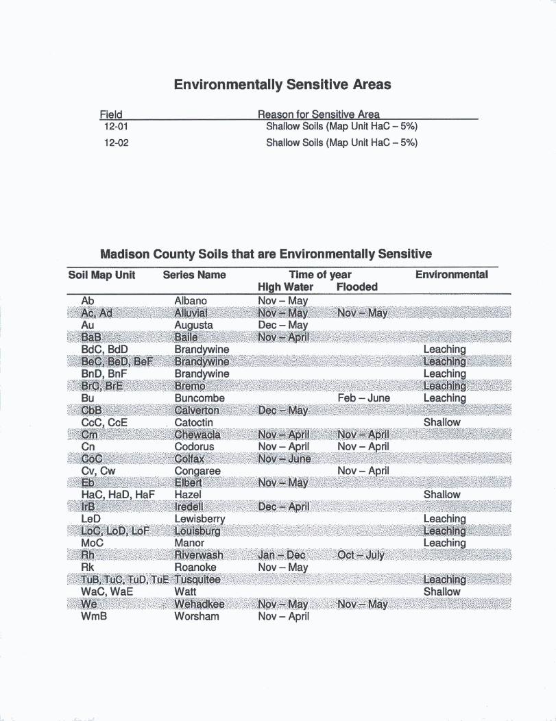
Environmentally Sensitive Areas
Field Reason for Sensitive Area Shallow Soils (Map Unit HaC - 5%)
Shallow Soils (Map Unit HaC - 5%)
12-01
12-02
Madison County Soils that are Environmentally Sensitive Soil Map Unit Series Name Time of year
High Water Flooded Environmental
Ab Ac, Ad Au BaB BdC, BdD BeC, BeD, BeF BnD, BnF BrC, BrE Bu CbB CcC, CcE Cm Cn
Albano Alluvial Augusta Baile Brandywine
# # # y # # Brandywine
g@@bo" Buncombe Calverton Catoctin Chewacla Codorus
Nov - May Nov - May Dec - May
Nov - May
Feb - June
Leaching Leaching Leaching
# # # # Leaching
Shallow Nov - April Nov- April
CoC Colfax Nov - April Nov - June
Nov - April
Nov - April Jov-May
Cv, Cw Congaree Eb Elbert HaC, HaD, HaF Hazel IrB Iredell LeD Lewisberry LoC, LoD, LoF Louisburg MoC Manor Rh Riverwash Jan-Dec i Rk Roanoke Nov - May TuB, TuC, TuD, TuE Tusquitee WaCWaE Watt
WrriB Worsham Nov - April
f
mmBBSm
Shallow
Leaching (lllhing Leaching
Leaching Shallow
-: ;v

MAP LEGEND
House/Dwelling with a well
Rock Outcrop
Well
Lake/Pond
# # Slope which exceeds 15%
' \ — Intermittent Stream
Stream/River
Agricultural/Drainage Ditch
Field boundary
— Property Line - (standard ioo' Buffer, unless waiver issued)
Revised: Jan. 13, '14
SYNAGR©

8 u
SYNAGR© William Scheuren MA 12
Fields 1,2
»>»:««««*iTO^
1 inch = 417 feet 1:5,000
SOIL MAP Environmentally Sensitive Areas
REVISED 10-15-2015

N
SYNAGRO William Scheuren MA 12
Fields 1,2
*•-•* > ,
1 inch = 417 feet 1:5,000
A E R I A L M A P REVISED 1015-2015

N
SYNAGR© William Scheuren MA 12
Fields 1,2
FiEL& #RE# 12-01 21.3
12-02 7.0
TOPO MAP REVISED 10-15-2015

N
SYNAGR® William Scheuren MA 12
Fields 1, 2
_
1 inch = 2,000 feet 1:24,000
TOPO MAP REVISED 10-15-2015