Embed Size (px)
Citation preview
Land and Water Division Working Paper
LAND AND WATER RIGHT
Territorial Development Officer (NRL)
FOOD AND AGRICULTURE ORGANIZATION OF THE UNITED NATIONS
Land and Water Division Working Paper 8
LAND AND WATER RIGHTS HOTSPOT
Michel Merlet Clara Jamart
Samuel L’Orphelin
With the supervision of:
Paolo Groppo
Territorial Development Officer (NRL)
April 2014
AGRICULTURE ORGANIZATION OF THE UNITED NATIONSAGRICULTURE ORGANIZATION OF THE UNITED NATIONS

Land and Water Division Working Paper 8
The views expressed in this paper are those of the authors and do not necessarily reflect the
views of the Food and Agriculture Organization of the United Nations FAO.
The designations employed and the presentation in this information product do not imply the
expression of any opinion whatsoever on the part of the Food and Agriculture Organization of
the United Nations (FAO) concerning the legal or developmental status of any country,
territory, city or area, or of its authorities, or concerning the delimitation of frontiers or
boundaries.
The mention of specific companies or products, irrespective of whether these have been
patented or not, does not imply that these have been endorsed or recommended by FAO in
preference to others of a similar nature that are not mentioned.

Land and Water Division Working Paper 8
Acknowledgements
This document was prepared by Michel Merlet, Clara Jamart and Samuel L’Orphelin, under
the technical direction of Paolo Groppo, Territorial Development Officer (NRL).
The authors want to thank the following persons for their contributions and comments: Joseph
Comby, Thierry Ruf, Etienne Le Roy, Gérard Chouquer, Caroline Plançon, Philippe Lavigne
Delville, Hubert Cochet, Françoise Macé, Sylvie Dideron, Pierre Merlet, Vincent Garcés,
Denis Pommier, Lorenzo Cotula

Land and Water Division Working Paper 8
Contents
Executive Summary
Introduction
1 Growing pressure on land and water rights, growing conflict:
a brief overview of the global contex…………………………………………………………………7
1.1 Different pressures on land and water
rights………………………………………………………………………………………………….7
1.1.1 Availibility of agricultural land and water throughout the
world…………………………………………………………………………………………………7
1.1.2 Distribution of access rights......................................... ………………………………..10
1.1.3 Socio-economic, legal, and political variables .......................................................... …12
1.2 Conflict over land tenure and water rights ........................................................... ………14
1.2.1 Conflict over land rights ................................................................................................ 14
1.2.2 Conflict over water rights ............................................................................................. .16
1.2.3 Conflict related to change in land and water management policy:
some examples ............................................................................................................................... …17
1.2.4 Tensions and conflicts indirectly related to changes in land and water management
policy………………................................................................................................. ……………….19
2 Growing pressure on land tenure and water rights that leads to conflict:
causes and current trends……………………………………………………………………………19
2.1 Growing
Pressures…………………………………………………………………….....................................19
2.1.1 Demographic Factors…………………………………………………………………. 19
2.1.2 Climate Factors…………………………………………………………………...........22
2.2 Land Grabbing. A burning question……………………………………………………...23
2.3 Are we headed for global crisis ?............................................................................................25
Figures
1. Agricultural area per farmer………………………………………………………………….7
2. Water shortages throughout the world……………………………………………………….8
3. Ecosystems throughout the world……………………………………………………............9
4. Areas with agricultural potential (very high, high, or medium) that are not currently used for
farming……………………………………………………………………………………………….9
5. Zones of the African Savannah where agriculture is not widely practiced…………………10
6. Characteristics of land distribution throughout the world…………………………………..11
7. Differences in agricultural productivity. National Averages………………………………..14
8. Examples of different kinds of land conflict throughout the world…………………………16
9. Examples of water related conflicts throughout the world………………………………….17
10. Population growth throughout the world. Source: World Population Prospect……………..20
11. Population growth rates (percentages)……………………………………………………....20
12. Urbanized population percentage by country as of 2006……………………………………21
13. Principal areas in which foreign (or national) investors are engaging in large scale land
appropriation and concentration…………………………………………………………………….24

Land and Water Division Working Paper 8
2
Executive Summary
There are many different kinds of land and water rights, and many different kinds of rights holders.
Land and water rights are social constructions that reflect existing power relationships and, as such,
they sometimes lead to conflict. Today, social and technological change are occurring so quickly that
societies are struggling to develop forms of social organization to cope with new challenges. Existing
social structures cannot evolve and adapt quickly enough.
Pressures on land and water
The development of hotspots is frequently linked to constraints and/or limitations that put pressure on
land and water use. These pressures affect two different aspects of land and water use: overall
availability, and access rights. The average or overall availability of a given resource may hide
individual disparities. In certain regions, a minority of individuals or corporations control most of the
agricultural land, leaving the remaining majority with very little land access. Different areas of the
world are distinguished by broad characteristics and trends. However, despite these broad
characteristics, there is considerable variation within individual countries (for more detailed
information about contrasts and distinct dynamics, consult the land tenure database at
www.landportal.info). Because water resources are governed by cyclical dynamics, the equity, or
inequity, of water access must be evaluated using specific methods. Fluctuating water resources
(groundwater, rivers, canals, etc.) are shared by a large number of potential water users. It is not
uncommon for different interest groups (whose access rights, while recognized, are regulated by a
variety of different laws and institutions) to engage in conflict. Moreover, new conflicts arise when
new interest groups with additional access claims emerge, complicating old conflicts and fueling
territorial and social tensions. While the abundance of natural resources (or lack thereof) is in large
part a natural physical feature, resource access is regulated differently by each society. Rights
develop from the bottom up, over long periods of time, and that they are shaped by power
relationships and ecological realities. However, they can also be imposed from the top-down, by
national governments or outside powers, for example in the context of imperial expansion or colonial
submission. Contradictions between imported legal concepts and local practices frequently lead to
conflict.
Conflict over land tenure and water rights
- Conflict over land rights
One kind of conflict over land rights arises when rural populations are marginalized and excluded
from land that has been appropriated by a minority of agricultural producers that rely on salaried
employees. Another kind of land related conflict arises in contexts where feudalism (a system in
which large land owners take advantage of sharecroppers or tenant farmers) persists. Still other
conflicts involve indigenous populations who are attempting to re-appropriate land (sometimes very
large amounts of land) that they have been using for generations. These populations often practice
forest agriculture and leave land fallow for long periods of time as it regenerates. This makes them
particularly vulnerable to land grabbing by foreign parties. In semi desert areas and steppes, conflict
between herd people and farmers has increased due to population growth. Land and water related
conflicts may also between village communities, ethnicities, or even between countries. A large
percentage of current and recent conflicts in central and West Africa are related (in one way or
another) to land tenure and/or use. The map in figure 8 (in the text) uses specific examples to
highlight the diverse nature of land related conflicts and hotspots everywhere in the world. It is not
exhaustive and does not provide precise information about the location of hotspots.

Land and Water Division Working Paper 8
3
- Conflict over water rights
Water related conflicts are varied as well. They include conflicts between different sovereign states
over the management of transnational watersheds, conflict between different regions within the same
country (over river water that has been re-routed by large scale water engineering works), conflicts
between different water users for access, and conflict caused by changing public water policies.
If we are to improve water governance in areas affected by poor water management, territorial
boundaries will have to be redefined to take watersheds and water distribution into account. Our
governance style -and the choices we make to privilege certain sectors over others - must be guided
by a coherent territorial approach.
Trends
- Growing Pressure
Land and water scarcity does not, in and of itself, inevitably lead to tension and conflict. Conflict
occurs when change occurs so rapidly that societies are unable to develop forms of governance that
will allow them to overcome crises. Currently, two major factors are accelerating change and putting
enormous pressure on land and water resources: world population growth and climate change. The
countries with the lowest number of available calories per person per day are the countries
experiencing the most demographic growth. In some cases, they also have less and less water per
inhabitant, per year. These trends will be exacerbated by urbanization, and the additional pressure it
puts on natural resources (due to population growth and growing demand for energies other than oil)
in the coming years. If governments create binding emissions reduction targets, it will be necessary to
change farming methods if we want to avoid placing even more pressure on non-forested agricultural
land. Climate imbalance is likely to influence both the quality and the quantity of agricultural
resources.
- Land Grabbing. A provocative question
The less resource users’ rights are protected, the easier it is for outside parties to take control of them.
The systems that we currently use to regulate land and water access, and the transfer access and use
rights, are inefficient and inadequate. Land grabbing will most likely accelerate, as countries continue
to pursue food security, expand their use of bio-fuels (which are encouraged by public policy in many
developed countries), and seek water resources needed for agro-industry. Without a binding legal
framework that applies to land transactions at the international level, public and private investors can
negotiate opaque contracts that are grossly advantageous to investors and which do not afford the
possibility of formal judicial recourse in case of conflict with local populations or governments.
Large scale land acquisition and concentration are already a source of political tension and conflict,
and we have reason to believe that they will cause more and more violence in coming years. The mid
and long-term consequences of these practices are very serious. If it continues, land grabbing will not
only eradicate poor farmers, but it will accentuate environmental problems and threaten food security
in host countries.
- Are we headed for global crisis?
The intensification of land-grabbing and, more globally, the deregulation of land and water resources,
has lead to the proliferation of land and water “hotspots.” More particularly, it is now clear that the
systems that we currently use to regulate land and water access, and the transfer access and use rights,

Land and Water Division Working Paper 8
4
are inefficient and inadequate. Tension often arises when governance is out of step with territorial
realities. In the coming years, conflicts will be increasingly international, challenging the legitimacy
of national borders. Given the inherent complexity of the current context, land tenure policy must be
governed by a culture of preventative negotiation that fully acknowledges the plurality of existing
appropriation rights. In keeping with democratically determined, constitutionally protected
economic, political, ethical, and social priorities, it must provide recognition for the structural
interdependence of different land appropriation regimes. If there is a genuine risk that the current
context, which is characterized by several hotspots, will transform into a full-blown global crisis -
and if increasing global poverty and inequalities pose a legitimate threat to humanity - then it seems
clear that international and civil society organizations have the ability to decisively influence the
course of current trends.

Land and Water Division Working Paper 8
5
Introduction
There are many different kinds of land and water rights. A wide variety of rights holders - including
individuals, communities, institutions, etc., enjoy temporary and/or definitive rights to use, manage,
and alienate (through inheritance, lease or sale) a wide variety of resources. The idea that private
property is an exclusive, absolute right is a relatively new concept. It is not currently applied
everywhere and cannot be, given that it will require at least 2/3rds of the world population to change
their ways (which is easier for some than others). There are just as many different kinds of rights as
there are different rights holders. These rights overlap within the same spaces and, depending on the
time and place, are managed by different institutions.
Land and water rights are therefore social constructions that reflect existing power relationships and,
as such, they sometimes lead to conflict. This has always been the case, but the acceleration of the
social and technological change is currently creating new challenges, and existing social structures
are not evolving and adapting quickly enough to confront them. It is extremely difficult to develop
new means of social organization in response to these changes, especially because they are no longer
exclusively local in nature and they frequently have global dimensions as well. Moreover, the social
and environmental aspects of these challenges are associated with different and sometimes
conflicting objectives and limitations. In this essay, the word “hotspot” refers to areas where land
related conflicts or limitations are worrisome, and, by their nature, may lead to crisis. These crises
may result directly or indirectly from said limitations and/or conflicts. While hotspots may require
individual attention, they also shed light on broader issues and trends that are less obvious elsewhere.
It is challenging to think globally about resource-related problems for variety of reasons. Territorial
realities, ecosystems, and human societies widely vary from one place to another. Moreover, these
differences are not frozen in time and space, territorial evolutions and dynamics fluctuate well. Land
and water rights must be addressed using an approach that takes both spatial and temporal dynamics
into account. Moreover, it is essential to address land and water related phenomena using appropriate
temporal and spatial scales:
- At the global level, we employ a general vision focused on macro differences. However,
when we look more closely at different countries and regions, considerable differences
appear within these broader categories. Generalizations that apply to entire continents
may be inaccurate when applied to a specific region. We must avoid the trap of an
excessively mechanical, simplistic approach by examining multiple levels of governance
(from the local to the global). We would like to insist on the importance of sovereign
states, insofar as they play a significant role in implementing laws and regulatory
mechanisms. We will zoom in specific situations that speak to issues that are relevant at
the national and/or global scale, without losing sight of sub continental similarities and/or
trends.
- Similar issues arise when evaluating temporal scales. The situations that we have chosen
to label as “hotspots” have developed over long periods. At the same time, conflict is
frequently caused by recent changes, which also influence the ways it is dealt with. In
addressing these situations, we must evaluate past, present, and (possible) future
evolutions, with a particular focus on the factors that may lead to the conflicts in the
future. In doing so, we will try to identify larger dynamics at play, and to differentiate
between short and long term phenomena, between factors that facilitate progressive
evolution and/or reform and factors associated with sudden shifts or departures from the
past, and finally, between evolutions that are permanent/irreversible, and evolutions that
are not. The latter will be evaluated using different temporal scales.

Land and Water Division Working Paper 8
6
This process is difficult, and inevitably flawed, it should be repeated as often as possible to reach new
information and perspectives. While we can start by looking at a certain number of factors that help
us understand hotspots through the lens of land and water rights, this data alone does not provide all
the information we need to evaluate the different ways in which specific situations are currently
evolving. We must also evaluate how a variety of different human societies has dealt with changing
pressures on land and water over time. These are questions of governance, not statistics. This is why
we will use two different kinds of visual representation in this document: maps based on existing
data, that illustrate (with varying degrees of precision) specific situations that reflect isolated
pressures, and broader visual interpretations that gloss over local particularities in order to express a
general idea and/or hypothesis. By using hotspots to illustrate broader trends and issues, this chapter
invites readers to think globally. If we are to do so, we must recognize fully the world’s
environmental and social diversity. This will allow us to develop solutions for major 21st century
challenges.

Land and Water Division Working Paper 8
7
1. Growing pressure on land and water rights, growing conflict: A
brief overview of the global context
1.1 Different pressures on land and water rights
The development of hotspots is frequently linked to constraints and/or limitations that put pressure on
land and water use. These may lead directly to open (sometimes-recurrent) disputes, or simply lay the
ground for future conflict.
Each macro-region is different, and can be classified according to key variables that reflect broad
characteristics and trends. These variables structure our research. They are categorized according to
two major themes:
- Resource availability
- Resource access (the distribution of access rights to water, land, and natural resources).
1.1.1 Availability of agricultural land and water throughout the world
The average utilized agricultural area per inhabitant varies considerably from region to region. In
China, for example, the average farmer has 66 ha, whereas in Argentina the average farmer has 41 ha.
However, country averages are often misleading. Not only available agricultural land (which include
pastures) vary in quality, but also regional realities vary widely within any given country. For
example, national averages make little sense in Bolivia, where lowlands coexist with an Andean
region. The same can be said of China, where the vast majority of the population is concentrated
within one third of the country’s surface area. Moreover, land use depends on a populations’ ability to
cultivate and maintain the land at their disposal, not to mention their capacity to valorize the fruit of
their labor. These factors, which are influenced by economic development choices, have an impact on
land availability. In western countries, the amount of land per farmer is high because most of the
population has left the agricultural sector. The per capita availability of freshwater also varies from
Figure 1. Agricultural area per farmer. There are significant disparities between different regions (hectares
per individual)

Land and Water Division Working Paper 8
8
region to region. Our focus is on the water that can be used for agricultural and pastoral activities,
which makes up about 70 percent of the freshwater used globally (20 percent goes towards industrial
use, and only 10 percent towards domestic use)2. As with the utilized agricultural area, national
averages are also very misleading. For example, the eastern Amazonian region of Ecuador is very
rich in water, while there are water shortages on the western slopes of the Andes. The following map,
which illustrates water stress in different regions throughout the world, is not misleading in this way.
Figure 2. Water shortages throughout the world.
(Source: Le Monde Diplomatique 2010, 2009. L’Atlas. Armand Colin)
17 percent of the world’s cultivated land is irrigated. Diverse forms of irrigation have developed in
most areas where surface and ground water is accessible. It has required 73 percent of the world’s
water resources to stabilize yields and to modify agricultural calendars and crops. Mobilizing water
and land in this way has tripled the productivity of pluvial agriculture, meeting 40 percent of the
world’s basic food needs as well as a series of complementary products (vegetables and forage
crops)3. Soil quality, weather conditions, and water availability (with or without irrigation) have a
significant impact on agro pastoral activities. In desert and semi-desert regions, land is not the only
resource needed for agricultural production; water is essential as well. This map representing major
forms of land use illustrates how varied land use is throughout the world. The extent of this diversity
is visible at the global scale. It is particularly pronounced within forested areas.
2 FAO, 2009. Aquastat. Cited by Black, M. and King, J., The Atlas of Water. Earthscan. Myriad Ed. U.K.
3 According to Stephen Hodgson, Land and water the rights interface. Livelihood Support Programme. FAO, March
2004, and information from Thierry Ruf. For a careful calculation of arable land productivity potential comparability, see
the FAO, 2009 interactive CD: Multilingual Thesaurus on Land Tenure, French version, at the term: Productivité
agricole per hectare.

Land and Water Division Working Paper 8
9
According to the IIASA, there is a significant amount of unused land that is suitable for non-irrigated
agriculture. It is located throughout the world, in Africa, Latin America, North America, Europe, and
Russia. The data that they used to develop the map in figure 4 includes land in protected areas.
Moreover, certain forested areas are considered suitable for agriculture.
Figure 4. Areas with agricultural potential (very high, high, or medium) that are not currently used for farming. In thousands of
ha/per country. Developed by AGTER, at GAEZ, IIASA-FAO, 2002. (Map elaborated with Philcarto)
Figure 3. Ecosystems throughout the world.
Source: IIASA, GAEZ, 2002.

Land and Water Division Working Paper 8
10
The IIASA data base reveals that 80 percent of this uncultivated, agriculturally suitable land is
concentrated in 24 countries. In Africa, most of it (that is not covered by forest) is located in a strip
(yellow on the map, figure 5) of savanna surrounding the Congo Basin. This said, these regions are
not empty; they are inhabited by farmers (including livestock farmers).They often harbor cultivation
systems that employ long rotations, and require vast areas of fallow, forested land. This land may be
incorrectly identified as non cultivated by evaluation systems that rely on remote sensing. It is
therefore important to take the assertion that this land is available for other uses with a grain of salt.
Developed countries (the United States, Europe) also harbor significant amounts of unused land that
is suitable for farming. This can be explained by evolving agrarian systems and agricultural policies,
which have influenced the ways in which property owners choose to use their land.
1.1.2 The distribution of access rights
The average or overall availability of a given resource may hide individual disparities. Certain
individuals or groups of individuals may have liberal access rights while others have none. It is
important to keep this in mind when evaluating global land and water access. In certain regions, a
minority of individuals or corporations control most of the agricultural land, leaving the remaining
majority with very little land access. The GINI coefficient can be used to measure inequalities in
resource distribution. The coefficient is 0 when this distribution is equitable, and 1 when one
individual use has complete access to a given resource, (and the rest of the population none).Global
data4 on this subject is incomplete, and has been gathered at different times using different methods;
calculations of this kind are only valid when evaluating production units that control all of the
resources within a given area5
, and operate in relatively homogenous ecological
4 FAO and the World Bank, above all, and additional data collected from different sources on Eastern Europe.
5 Globally speaking, this is not how things work in Sub-Saharan Africa and in many areas of Asia, where multiple
rights-holders enjoy different rights over the same land.
Figure 5. Zones of the African Savannah where agriculture is not widely practiced.
Source: World Bank.

Land and Water Division Working Paper 8
11
contexts6.Notwithstanding, this data can be used to identify broad characteristics and trends that
distinguish different areas of the world, and within them to identify macro-regional contexts
associated with the development of land access hotspots. The following map illustrates these broad
characteristics.
Figure 6. Characteristics of land distribution throughout the world.
Created by AGTER, with Philcarto, using GINI coefficients taken from the World Bank and FAO databases, and other sources.
This chart does not include as much information on subtle variations as large scale maps. The land
tenure database (which will become the International Land Portal), for example, provides more
detailed information about the contrasts and the distinct dynamics that exist within individual
countries, including Bolivia, Cambodia, Guatemala and Niger (amongst others)7. Because water
resources are governed by cyclical dynamics (with the exception of fossil waters, which are very
similar to non-renewable mineral resources), questions related to water access -and in particular to
the equity, or inequity, of water access - must be evaluated using specific methods. However, land
and water access are frequently linked, in particular regarding ground water access, but sometimes
regarding surface water access as well8.Water access is constantly in flux. Changing ground water
levels and/or river and canal flow are shared by a large number of potential water users. It is not
uncommon for different interest groups (whose access rights, while recognized, are regulated by a
variety of different laws and institutions) to engage in conflict. Moreover, new conflicts arise when
new interest groups with additional access claims emerge, complicating old conflicts and fueling
territorial and social tensions.
6 In Chile, a country with a vast array of climate zones, a high national GINI coefficient hides extreme regional variations
in land concentration. 7 Additional information are available at www.landportal.info.
8 See Hodgson, S. March 2004. Land and water – the rights interface. Livelihood Support Programme. FAO. Rome.

Land and Water Division Working Paper 8
12
When water resources are re-allocated from areas where they are abundant to areas where they are
rare, they often become concentrated in the hands of a limited number of actors: Small farmers in
Ecuador constitute 86 percent of the country’s water users, but only possess 22 percent of the
country’s irrigated land, and are only responsible for 13 percent of overall water use; whereas large
private farms, occupied by 1 percent of the country’s farmers, use 67 percent of its irrigation water9.
1.1.3 Socio-economic, legal, and political variables
While the abundance of natural resources (or the lack thereof) in any given location is in large part a
natural physical feature, resource access is defined by social norms, power relationships, and
management rules. Historical factors can be used to distinguish a series of broader issues that have a
decisive impact on the development of tensions, conflict, and hotspots. Different cultures view land
and water rights differently. These rights also change over time. Because they are molded by history,
they tend to be complex and heterogeneous. This said, globalization has homogenized administrative
and legal systems, and while norms and practices governing land and water rights vary widely,
certain systems benefit from more international recognition and support than others. Getting out of
this maze is not easy. We must not forget that rights develop from the bottom up, over long periods,
and that they are shaped by power relationships and ecological realities. However, they can also be
imposed from the top-down, by national governments or outside powers, for example in the context
of imperial expansion or colonial submission. Most countries in the world have experienced some
form of colonial conquest (Latin America was colonized for several centuries, and Asia and Africa
for shorter periods of time). Different kinds of colonization are associated with different land tenure
systems:
- Trading post colonies (which took a variety of different forms),
- Colonies based on the domination of local populations, for example in the Mesoamerican and
Andean regions of Latin America,
- Settlement colonies, for example in North America, Argentina, or Brazil, which almost always
lead to the disappearance of local populations, and
- Plantation Economy Colonies, which frequently imported slaves. The different varieties of land
rights that exist in each place are often directly related to its colonial history.
Different colonial powers used different legal systems in the colonies. These did not always
correspond the systems used within the metropolis. Regardless, each was based on one of two broad
legal systems structured by different basic principles: the Common law system, in which multiple
rights and rights holders exist; and the Civil Law system, in which property is exclusive, but limited
by laws and regulations. Over time, both of these systems and their various incarnations have
gradually accorded some form of recognition to rights of use. During colonization, the metropolis
granted rights within the colonies; then, after decolonization, this responsibility fell to newly
independent states. Understanding the ways in which pre and post colonial rights have been
combined and subsequently transformed by the populations of previous colonized countries is
essential because this process has had a decisive influence on land governance almost everywhere in
the world. Tensions and conflicts around land and water rights are often related to clashes between
imported legal concepts and local practices – or between positive and customary law. Moreover, land
and water rights are frequently denied to local indigenous populations because they lack legal and
political recognition or representation. This is the case in several Southeast Asian countries,
including India. It is therefore important to avoid broad generalizations and to examine the evolutions
9 Foro de los Recursos Hídricos. 2008. El despojo del agua y la necesidad de una transformación urgente. Quito,
Equateur.

Land and Water Division Working Paper 8
13
discussed above on a case-by-case basis. Everywhere in the world, land and water rights are
influenced legal systems. In most systems, they have been historically interconnected (with the
exception of public water rights, in particular rights related to navigable waterways). Increasingly,
however, they are treated separately, as withdrawing large quantities of water in any given place may
affect the water cycle within a much broader area10
. It is important to note that accusations of
excessive water usage should be evaluated with care, because this label is sometimes applied
inaccurately by newly arrived downstream populations, attempting to modify the existing political
balance by questioning the legitimacy of existing water rights.
Other historical factors unrelated to imperial or colonial processes, in particular broad agrarian
reforms and/or forced land collectivization, also play a large role in the appearance of land and water
related conflicts. Current forms of land access, whether equitable or inequitable, are the result of
long-term evolutions and power struggles, but they are also affected by sweeping, radical
transformations of varying shades. It is the case of the complete dispossession of small-holders in the
Soviet Bloc. Or the one related to the equitable, efficient redistribution in Asia (a variety of reforms
implemented by a variety of different regimes), or the creation of new property markets in Latin
America, in connection with agrarian reforms that did not, in most cases, lead to legitimate land
redistribution.
Resource access, and the legal contexts in which access rights evolve, are not the only factors to take
into account when evaluating land and water availability and use. If resource users do not have access
to technology and capital, and are unable to transform and/or market the fruit of their labor, resources
will not be fully taken advantage of. Agricultural productivity varies widely from country to country
and, increasingly, within each country. In wealth distribution systems that privilege those who are
already wealthy, these differing levels of productivity have a huge impact on the ways in which land
and water rights evolve. Average productivity levels are misleading as well. Net productivity
differences sometimes surpass the 1-500 scale, even without subsidies, and significant differences
exist within many countries. For example, Brazil’s average productivity level is between that of
developed, and developing, countries, but within the country itself, productivity levels vary
dramatically.
10
Hodgson, S., op. cit. See also Ramazzotti, M. December 2008. Customary Water Rights and contemporary Water
Legislation. FAO Legal Papers. Rome.

Land and Water Division Working Paper 8
14
Figure 7. Differences in agricultural productivity. National Averages.
Source: L’Atlas du Monde Diplomatique, 2010. Armand Colin. (Based on data provided by the World Bank)
In a globalized market, what the best-equipped plantation produces in one day has the same value as
what a smallholder produces in 500 days. This figure makes it easier to understand how the
phenomenon of unequal exchange contributes directly to rural poverty.11
1.2 Conflict over land tenure and water rights
While tensions and conflicts over land and water access (whether they are the direct, or indirect,
result of access related issues) vary widely, almost all of them are affected by the factors that we have
just discussed.
1.2.1 Conflicts over land rights
One kind of conflict over land rights arises when rural populations are marginalized and excluded
from land that has been appropriated by a minority of agricultural producers that rely on salaried
employees. Historically, this situation has been widespread in Latin America; it has also occurred in
Austral and North Africa. In Brazil, Zimbabwe, South Africa, and in the Philippines, conflicts of this
kind have taken the form of agrarian struggles, and resulted in the repression of farmer’s
organizations. In certain countries, like Brazil, farmers’ movements have gained national and
international political significance. In Latin America, the expansion of large farms is closely linked to
the development of pioneer fronts, and clashes between smallholders and large agricultural producers
are intense and frequently violent. In North Africa, mobilizations of this kind are less common, but
conflict and resistance to land grabbing sometimes occur on a local scale.
Another kind of land related conflict arises in contexts where feudalism (a system in which large land
owners take advantage of sharecroppers or tenant farmers) persists. This is the case, for example, in
the southern provinces of Nepal, in many regions of India, and in the Philippines. In several
11
See Mazoyer, M. 2001. Protéger la paysannerie pauvre dans un contexte de mondialisation. FAO.Rome.

Land and Water Division Working Paper 8
15
countries, agrarian reform has modified these systems, but in countries where it has not, conflict is
continuing and often intensifying. Several Indian states have implemented policies intended to
protect tenant and sharecropper rights, but most have been unsuccessful12
. In India and Nepal, land
rights are the subject of acute political and social tensions. Nepal’s Maoist uprising demonstrates the
magnitude of these tensions, which sometimes decisively influence national politics. In India,
hundreds of thousands of people participate in small farmer’s movements such as Ekta Parishad. Still
other conflicts involve indigenous populations who are attempting to re-appropriate land (sometimes
very large amounts of land) that they have been using for generations. These populations often
practice forest agriculture and leave land fallow for long periods as it regenerates. This makes them
particularly vulnerable to land grabbing by foreign parties. In China, rapid industrialization and
urbanization have provoked intense conflict by evicting farmers with rights of use from their
land.13
In semi desert areas and steppes, conflict between herd’s people and farmers has increased due
to population growth. This is not new in the Sahel. However, conflict between different populations
-in particular, between traditional rights-holders and newly arrived migrants- has also increased in the
agricultural regions of sub Saharan Africa (in spite of the fact that migrants obtain permission to
settle from the local population before doing so). Conflict often occurs in valleys, irrigated (or
irrigable) perimeters, and forests used for fuel wood, as well. The conflicts discussed above are
relatively local disputes between specific groups of resource users. However, land and water related
conflicts might be also between village communities, ethnicities, or even between countries. A large
percentage of current and recent conflicts in central and West Africa are related (in one way or
another) to land tenure and/or use. The independence movement in Bolivia’s eastern provinces is
directly related to widespread conflict over land and mineral resources. The following map (figure 8)
uses specific examples to highlight the diverse nature of land related conflicts and hotspots
everywhere in the world. It is not exhaustive and does not provide precise information about the
location of hotspots. It includes information about the following kinds of conflict and/or conflict area:
armed civil conflicts that are largely fueled by disagreement over land tenure and/or use; land
disputes that are directly related to mining, industrial, or touristic projects; areas where there is
conflict between nomadic herd people and sedentary farmers; areas where indigenous people have
been stripped of their ancestral lands; areas experiencing tension and/or open conflict due to
inequitable land distribution; tensions and/or open conflicts caused by expanding pioneer fronts;
conflicts related to the Chinese governments’ massive land requisitions, which marginalize millions
of farmers; and land conflicts related to water access. In North Africa, there are also numerous
conflicts of ethnic and/or linguistic nature. These disputes are heavily influenced by the region’s
complex past: colonial conquest, the subsequent nationalization of natural resources, and the current
vogue for liberalization and privatization. Analogous historical factors have created tensions in the
Balkans, in Eastern Europe, and in Central Asia (although not all of them are included in the map
below).
12
Hanstad, T., Nielsen, R. and Brown, J. 2004. Land and livelihoods. Making land rights real for India’s rural poor. LSP
Working Paper 12. FAO. Rome. 13
See Etudes Rurales No. 179 (2007), dossier on Contemporary Rural China pp. 170-191.

Land and Water Division Working Paper 8
16
Figure 8. Examples of different kinds of land conflict throughout the world.
Source: AGTER.
1.2.2 Conflict over water rights
Water related conflicts vary as well. They include:
- Conflict between different sovereign states over the management of transnational
watersheds.14
- Conflict between different regions within the same country, over river water that has been
re-routed by large-scale water engineering works.
- Spain provides a well-known example of the above. In general, decisions of this kind are
driven by technological choices that favor certain forms of agriculture over others.
- Conflicts between different water users for access.
- Conflict of this kind has occurred in Ecuador, where a variety of different users is competing
for water resources from rivers and streams, from shared water sources, and water towers.
These conflicts are more intense than land related conflicts.
- An entire category of water related conflicts are the direct result of changing public water
policies.
Entities responsible for water management are often in charge of administrative and/or geographic
areas that it make it impossible to manage water sustainably. Moreover, most projects that aim to
“modernize” irrigation are designed to optimize water use within individual parcels. There is
14
For more information on this topic, consult the databases developed by the Institute for Water and Watersheds
(University of Oregon). The Program in Water Conflict Management and Transformation (PWCMT),
http://www.transboundarywaters.orst.edu/ .

Land and Water Division Working Paper 8
17
widespread ignorance concerning intermediary water management units, perimeter networks and
quartiers hydrauliques, and management techniques that take temporal factors into account (seasons,
appropriate times for watering, frequency, and the ways in which these factors interact with water
availability and access). This ignorance has a negative impact on territorial water management and,
over time, may lead to conflict.
If we are to improve water governance in areas affected by poor water management, territorial
boundaries will have to be redefined to take watersheds and water distribution into account. This
paper focuses exclusively on conflicts over agricultural water. This said, there are a vast array of
water related conflicts in the world. If we are to prevent these conflicts, our governance style - and the
choices we make to privilege certain sectors over others - must be guided by a coherent territorial
approach. It is important to note that Figure 9 does not include information about a number of
significant water related disputes in North America and Europe, between the United States and
Canada, the United States and Mexico, within the Iberian Peninsula, in the south of France, or in
Italy.
Figure 9. Examples of water related conflicts throughout the world.
1.2.3 Conflict related to changes in land and water management policy: some examples
Modifying land and water management, even on a local scale, has wide-ranging repercussions. The
following examples illustrate this:

Land and Water Division Working Paper 8
18
Cisterns in Ethiopia
In Ethiopia, seasonal rainwater has traditionally been stored in cisterns called berkados. Development projects
designed by donors from developed western countries have gradually replaced these with storage systems that
permanently stock purchased water, which is then resold to local water users for human and animal
consumption. This transformation has had serious environmental and social consequences. Livestock farmers
have settled around storage areas, putting enormous pressure on land resources and damaging pastureland.
Moreover, cistern owners have expanded their herds (normally composed of camels and small ruminants) to
include animals that consume more significant quantities of water. Pressure on resources and overgrazing has
increased. Poorer farmers without cisterns now travel larger and larger distances in search of the land and
water resources they need to guarantee the survival of their herds.15
In pastoral areas of the Sahel, control over water access is a fundamental component of pastoral
governance systems. Individuals and groups who grant or withhold access to a water source also
control (de facto) surrounding pastures. Privatizing water points and making access rights exclusive
will inevitably lead to the disappearance of pastoral communities. On the other hand, if unlimited
water access is freely granted to everyone, herds will grow, exhausting pastures before the end of the
dry season.
Pastoral Wells in Niger Traditional water management systems manage pastures sustainably. For example, in eastern Niger, people
who dig wells have priority, but not exclusive, access to well water. They grant rights to other herdsmen with
the knowledge that they will be granted access to wells created by others during transhumance. These access
rights, which are negotiated between both parties, include conditions relative to the herd’s health, watering
hours, and length of stay. Regulating the number of livestock around each source of water prevents
overgrazing and protects the quality of the soil. In Niger, sustainable water and pasture management require
both negotiation and reciprocity. Managing wells in this way is not only better for the environment, but it
strengthens communities by reinforcing social ties.
This said, over the last 50 years, traditional governance in pastoral areas has been progressively destabilized by
new forms of water access. The advent of modern infrastructure that provides unlimited water access has
seriously undermined the sustainability water management, leading to conflict. Most of this infrastructure was
constructed by development projects promulgated by western developed countries, which were intended to
optimize pastoral water use by providing a consistent network of water points throughout the Sahel. Although
local authorities were asked to supervise new wells to avoid overgrazing, they never implemented new
management methods, which required near constant well surveillance.
After the independence, the state continued to strongly fund the construction of modern infrastructure. Freshly
built wells were the private property of the new government, and unlimited access was granted free of charge
to the entire population. State wells attracted larger herds, encouraging overgrazing and seriously damaging
the surrounding environment. Negotiation and reciprocity were replaced by deregulation and force. As a
result, a variety of different actors vied for access rights in pastoral areas.
The reestablishment of collective management systems in the 1980s and 1990s did not reverse this trend.
Modern well management was already a major source of intercommunity conflict. In some places, like
Niger, intercommunity disputes have erupted into armed conflict.16
15
Gomes, N. 2006. Access to water, pastoral resource, management and pastoralists’ livelihoods. FAO LSP. Rome. 16
From Thébaud, B. 2006. Land and Water Rights in the Sahel, in Cotula, L. (Ed.). 2006. IIED, FAO LSP. Rome.

Land and Water Division Working Paper 8
19
1.2.4 Tensions and conflicts indirectly related to changing land and water management policy
The conflicts discussed above are directly fueled by disagreements over land and water rights.
However, limitations on land and water resources may indirectly lead to conflict by exacerbating
rural poverty. Poverty related uprisings (frequently referred to as hunger strikes) and discord
surrounding illegal immigration are examples of this kind of conflict. Conflict reflects poor
governance. On the bright side, it may serve as a catalyst by encouraging stakeholders to address
causes of dissent. It is extremely important to develop governance mechanisms capable of
confronting and resolving current and future conflict. It is also important to note that national
approaches will not suffice (see below); global forms of governance will be necessary.
2 Growing pressure on land tenure and water rights that leads to
conflicts: causes and current trends
2.1 Growing Pressure
Scarcity is does not, in and of itself, inevitably lead to tension or conflict: human societies have
always confronted resource shortages, and have often found ways to adapt to them. However, when
change occurs too quickly, societies do not have the time that they need to develop new forms of
governance. This leads to crisis. The current global context reinforces existing pressures on natural
resources, in particular on land and water. Factors that exacerbate these pressures -hence increasing
the probability of conflict- are organized into two broad categories: demographic factors and climate
factors.
2.1.1 Demographic factors
The world population is growing. According to the United States Census Bureau, it was roughly 6.8
billion in January 2010; it was only 1.6 billion in 1900. If predictions are precise, it will reach 9
billion in 2050.

Land and Water Division Working Paper 8
20
Figure 10. Population growth throughout the world.
(Source: Population Mondiale and World Population Prospect, fr.wikipedia.org)
Population distribution and growth are not consistent throughout the world. These inconsistencies are
portrayed in the above reported charts. The overall rate of population growth has gradually declined
since the 1970s, but it is still positive. In 2006, it was estimated at 1.14 percent per year. With the
exception of certain Eastern European Countries, Russia, and some southern African countries,
population growth rates are positive everywhere in the world. They are particularly high in Africa, in
the Gulf countries, and (although somewhat less so), in Latin America and Southeast Asia.
Figure 11. Population growth rates (percentages), according to the CIA Fact book (2006).

Land and Water Division Working Paper 8
21
In 2050, it will be necessary to feed a world population of 9 billion. This means that pressure on land
and water will increase. Even worse, the countries with the lowest number of available calories per
person per day are the countries experiencing the demographic growth17
. In some cases, they also
have less and less water per inhabitant, per year18
. If these countries (Sub-Saharan countries in
particular) are struggling to feed their current population, how can we expect them to deal with the
rapid population growth of the next 40 years?
Urbanization will also have an impact on land and water resources in the coming years.
Figure 12. Urbanized population percentage by country as of 2006. Source. Wikipedia Commons.
Source: UNICEF, The State of the World’s Children 2008 (p. 134).
Not only do cities take up many land (in alluvial or littoral areas, moreover, they often develop on
fertile land), but they use many resources. Land and water suitable for agriculture are now
increasingly being consumed by growing urban populations, which consume more meat than rural
populations. According to predictions, global meat consumption will increase by 64 percent between
2006 and 2025. This means that more and more water will be used to produce less and less food; 15
500 liters of water are required to produce just one kilogram of bovine meat, whereas it takes only
625 liters to produce a kilogram of potatoes, or 1 300 liters for a kilogram of wheat19
. Meat is
generally produced in pastoral, rainy ecosystems composed of prairies and itineraries adapted to this
task. By tripling the production of dry materials, irrigation makes it possible to combine cultivation
and livestock farming. Fodder crops are an intrinsic component of this system because they allow
farmers to produce dairy and meat products, manure for fertilization, and animal power. In addition
to significantly increasing our global water use, therefore, the new lifestyles discussed above will
also modify the way people farm. Finally, unless our consumption and production habits change, we
will consume more and more energy as the population grows and urbanizes. Resources are required
to access fossil fuels, to produce electricity, and to grow bio-fuels. This means that pressure on these
resources will inevitably grow. Bio-fuels are particular, insofar as they compete with agricultural
crops for land and resources. In France, replacing just 10 percent of conventional fuels with bio-fuels
would require that 20 percent of the country’s agricultural surface area, not to mention billions of
cubic meters of irrigation water, be re-allocated. Developed countries that want to increasingly rely
on bio-fuels without undermining food production are likely to import bio-fuels (ethanol and
biodiesel) from developing countries that have a comparative advantage in terms of energy balance
and production cost (cane sugar in Brazil, palm oil in Indonesia or Malaysia, for example). However,
at what environmental cost? Putting even more pressure on land resources in developing countries
will accelerate deforestation that is already underway in tropical forests in Asia, and in the Amazon.
17
Millstone, E., Lang, T. 2008. The Atlas of Food, Earthscan, maps pp.18-19. 18
Millstone, E., Lang, T. 2008. The Atlas of Food, Water Pressure, map p.25 19
Source: Black, M. and King, J. 2009. The atlas of water. Earthscan, maps pp.56-57.

Land and Water Division Working Paper 8
22
Demographic and climate-related factors both put additional pressure on land and water resources.
This said, we would like to look at climate-related factors individually.
2.1.2 Climate Factors
In 2010, agriculture was responsible for roughly one third of global greenhouse gas emissions. Not
only do we need to find a way to feed a growing, increasingly urban world population, but also we
need to do so without making climate change - and associated pressures on land and water resources
- worse. What kind of agricultural system can sustainably provide food for 9 billion people?
Most climate experts agree that it is necessary to reduce greenhouse gas emissions everywhere in the
world. According to the IPCC (Intergovernmental Panel on Climate Change), developed countries
must reduce emissions by 25–40 percent before 2020 if we are to limit global temperature growth to
2 degrees; moreover, even if they succeed in doing so, we only have a 50 percent chance of meeting
this goal. It is therefore necessary to adopt farming and development methods that pollute less.
Deforestation is currently responsible for roughly 20 percent of the world’s greenhouse gas
emissions; if we want to address climate change, expanding farming fronts into forest areas or
clearing trees for the benefit of extensive livestock farms is no longer an option. If governments
create binding emissions reduction targets, it will be necessary to change farming methods if we want
to avoid placing even more pressure on non-forested agricultural land.
Whether they do so or not, climate imbalance is already underway. This process has unavoidable
consequences that influence both the quality and the quantity of agricultural resources. Certain areas
of the world are already experiencing soil erosion due to disproportionately intense periods of rain or
draught. Moreover, ice melts more quickly when summers are longer, which threatens agricultural
activities (and food security) in vast, densely populated areas. For example, the Indus and Ganges
basins in northern India are replenished (in large part) if these melt, Himalayan glaciers will affect
500 million people affected by severe water stress. The effects of climate imbalance are not
systematically negative. For example, in temperate climates, temperature increases will extend
cultivation time. In tropical and sub-tropical regions, however, increases of only a few degrees (or
even a few tenths of degrees) will seriously affect agricultural activities by extending dry and wet
seasons. World food production will therefore evolve differently in different areas of the world. In
their “Atlas of Climate Change,” Kirsten Dow and Thomas E. Downing examine how these changes
will affect different countries between now and 208020
. According to their research, food production
should increase everywhere in Latin America, North Africa, and Southeast Asia, and decrease in the
Indian sub-continent, in Western Europe, and in all of sub-Saharan Africa. In sub-Saharan Africa
in particular, climate change will have extremely negative consequences. Given the fact that the
population of this area is growing, and that available calories per person per day are more limited than
anywhere else, these consequences will be highly destructive. How should we deal with this
situation? The systems that we currently use to define, recognize, and protect land and water rights –
and, consequently, the economic, political, and social regulations that apply to these resources on a
variety of different scales (from the local to the global) are ill-adapted to the pressures described
above. With a significant amount of political will, developed countries can use existing governance
systems to address coming evolutions. However, developing countries with young and/or weak
governments are not in a position to do so. Even in this respect, different areas of the world differ
significantly. Land and resource grabbing- and associated political, economic, social, and
environmental consequences- are accelerating. This proves that the systems that we currently use to
manage land and water must be improved. Below, we look more closely at the phenomenon of land
grabbing. We believe that this issue sheds light on the dangers of deregulating resource management
in the context of global population growth and climate change.
20
Based on information from: Dow K., Downing, T. E. 2007. Atlas of Climate Change. Earthscan.
Land and Water Division Working Paper 8
23
2.2 Land grabbing. A burning question
When we use the term “resource grabbing,” we are referring either to the privatization of common
resources, or to the hoarding of private resources for economic, or financial purposes (by public or
private investors). This process has intensified over the last few years, revealing the inadequacy of
the current regulatory environment. Generally speaking, land grabbing occurs in two contexts:
- In cases where land is already private, and is sold or leased (emphyteutic lease) to investors by
individual property owners with formally recognized rights. Land concentration, in the form of large
property domains or leased areas, can occur both quickly and easily. While rights holders sometimes
relinquish their rights voluntarily, they may also be threatened or pressured (sometimes violently)
into doing so.
- In the second case, the land that is sold or leased (emphyteutic lease) is already governed by
customary law. This is frequently “national” land that was given back to newly independent states
after colonization. While in most cases it has been lived on, and used, for generations, its inhabitants
have no formally recognized rights. They may enjoy some rights of use, but these are poorly
protected. Governments therefore feel that they can dispose of this land as they wish.
Privatizing it through sale or long-term lease seriously modifies existing land tenure regimes, which
privilege the common or collective nature of the resources found there21
.
Whatever the situation, one thing is clear: the less resource users’ rights are protected, the easier it is
for outside parties to take control of them. The systems that we currently use to regulate land and
water access, and the transfer access and use rights, are inefficient and inadequate. They do not
prevent land grabbing, which, in addition to destabilizing the economic, social, and environmental
harmony of local communities, threatens food security. Furthermore, land grabbing weakens existing
regulations. It creates a situation in which local populations have less and less control over land and
water. Once a local farming system, and local farming populations, are destabilized and/or destroyed,
they will never be the same again. This process is irreversible. Even with political will, it is
impossible to re-create an entire society of small holders that has disappeared, taking their lifestyle,
their knowledge, and their know-how with them. Moreover, given current trends, it seems likely that
land grabbing - and, in its wake, the destruction of local farmers and farming systems-will intensify in
coming years:
- Land is “grabbed” with the goal of producing food that investor countries (such as South Korea
or Gulf countries) need to feed a growing, increasingly urban population. Lacking unused
agricultural land within their own territory, in a context of rising commodity prices, they will
continue to seek it abroad.
- Public policy in certain western countries encourages the use of biofuels. These countries may
grab land for biofuels abroad, to avoid converting food crops at home.
- Investor countries are not only looking to grab hundreds of thousands of hectares of land. They
also want to take control of water resources, which they need for intensive, agro-industrial crops.
This water is appropriated at the expense of local, or even distant, residents that depend on it.
- There are no binding laws that apply to land transactions at the international level. This allows
public and private investors to negotiate opaque contracts with host governments or local
populations. The conditions in which they are negotiated are frequently very advantageous to
21
Merlet, M., Jamart, C. Avril 2009. Pressions commerciales sur la terre dans le monde. Problématique et cadre
conceptuel. ILC AGTER, (available at
http://www.agter.asso.fr/IMG/pdf/ILC_AGTER_Conceptual_framework_of_the_Scoping-Study-fr_def.pdf).
Land and Water Division Working Paper 8
24
investors, and contracts rarely afford the possibility of formal judicial recourse in case of
conflict.
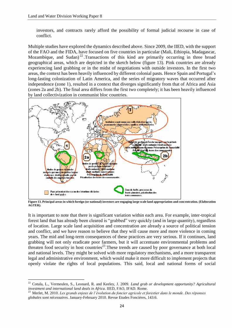
Multiple studies have explored the dynamics described above. Since 2009, the IIED, with the support
of the FAO and the FIDA, have focused on five countries in particular (Mali, Ethiopia, Madagascar,
Mozambique, and Sudan)22
.Transactions of this kind are primarily occurring in three broad
geographical areas, which are depicted in the sketch below (figure 13). Pink countries are already
experiencing land grabbing or in the midst of negotiations with outside investors. In the first two
areas, the context has been heavily influenced by different colonial pasts. Hence Spain and Portugal’s
long-lasting colonization of Latin America, and the series of migratory waves that occurred after
independence (zone 1), resulted in a context that diverges significantly from that of Africa and Asia
(zones 2a and 2b). The final area differs from the first two completely; it has been heavily influenced
by land collectivization in communist bloc countries.
Figure 13. Principal areas in which foreign (or national) investors are engaging large scale land appropriation and concentration. (Elaboration
AGTER).
It is important to note that there is significant variation within each area. For example, inter-tropical
forest land that has already been cleared is “grabbed” very quickly (and in large quantity), regardless
of location. Large scale land acquisition and concentration are already a source of political tension
and conflict, and we have reason to believe that they will cause more and more violence in coming
years. The mid and long-term consequences of these practices are very serious. If it continues, land
grabbing will not only eradicate poor farmers, but it will accentuate environmental problems and
threaten food security in host countries23
.These trends are caused by poor governance at both local
and national levels. They might be solved with more regulatory mechanisms, and a more transparent
legal and administrative environment, which would make it more difficult to implement projects that
openly violate the rights of local populations. This said, local and national forms of social
22
Cotula, L., Vermeulen, S., Leonard, R. and Keeley, J. 2009. Land grab or development opportunity? Agricultural
investment and international land deals in Africa. IIED, FAO, IFAD. Rome. 23
Merlet, M. 2010. Les grands enjeux de l’évolution du foncier agricole et forestier dans le monde. Des réponses
globales sont nécessaires. January-February 2010. Revue Etudes Foncières, 143:6.

Land and Water Division Working Paper 8
25
organization and control change slowly. This is why it is necessary to begin by regulating land
grabbing on an international, and not a national or local, scale.
2.3 Are we headed for global crisis?
Given the demographic, environmental, and regulatory challenges described above, it is clear that we
must make significant changes if we want to guarantee the food and energy security of 9 billion
people in 2050. In this context, what is the best way to move forward? How can we preserve the
resources that we need to survive?
The proliferation of land and water “hotspots” is directly related to the intensification of land
grabbing and, more globally, to the deregulation of land and water resources.
- Due to land grabbing and land concentration in areas where private property already exists,
agricultural land and water is less and less available to smallholders, who make up most of the
world’s rural population. Their land and water rights are subject to more and more limitations
and constraints. Conflicts are getting worse and occurring more and more frequently.
- Indirect conflict related to growing rural (and urban) poverty, intensifying inequalities, and
illegal immigration is becoming more widespread.
- Unless we develop alternatives, violence will continue to grow.
Tension often arises when governance is out of step with territorial realities. For example, as conflict
becomes more and more international, national borders will become less relevant.
Given the inherent complexity of the current context, land tenure policy must be governed by a
culture of preventative negotiation that fully acknowledges the plurality of existing appropriation
rights. In keeping with democratically determined, constitutionally protected economic, political,
ethical, and social priorities, it must provide recognition for the structural interdependence of
different land appropriation regimes. If there is a genuine risk that the current context, which is
characterized by several hotspots, will transform into a full-blown global crisis - and if increasing
global poverty and inequalities pose a legitimate threat to humanity - then it seems clear that
international and civil society organizations have the ability to decisively influence the course of
current trends.

Land and Water Division Working Paper 8
26
References
Cotula, L., Hed, C., Sylla, O., Thébaud, B., Vogt, G. & Vogt, K. 2006. Land and water rights in
the Sahel. Tenure challenges of improving access to water for agriculture. FAO LSP WP No. 25,
Access to Natural Resources Sub-Programme. Rome.
Cotula, L., Vermeulen, S., Leonard, R. & Keeley, J. 2009. Land grab or development
opportunity? Agricultural investment and international land deals in Africa. IIED, FAO, IFAD.
Rome.
FAO. June 2009. From Land Grab to Win-Win - Seizing the Opportunities of International
Investments in Agriculture – FAO Policy Notes. Rome.
Foro de los Recursos Hídricos. 2008. El despojo del agua y la necesidad de una transformación
urgente. Quito, Equateur.
Gomes, N. 2006. Access to water, pastoral resource management and pastoralists’ livelihoods:
Lessons learned from water development in selected areas of Eastern Africa (Kenya, Ethiopia, and
Somalia). Access to Natural Resources Sub-Programme.FAO LSP WP, No. 26. Rome.
Hanstad,T., Nielsen, R., Brown, J. 2004. Land and livelihoods: Making land rights real for India’s
rural poor. Access to Natural Resources Sub-Programme. FAO LSP WP 12. Rome.
Hodgson, S. March 2004. Land and water – the rights interface. Livelihood Support Programme.
FAO. Rome.
Mazoyer, M. 2001. Protéger la paysannerie pauvre dans un contexte de mondialisation. FAO.
Rome.
Merlet, M. Novembre-Décembre 2009. Les phénomènes d’appropriation à grande échelle des terres
agricoles dans les pays du Sud et de l’Est. S’interroger sur la nature des droits de propriété peut aider
à faire la différence entre investissement et prédation. Revue Etudes Foncières, 142:4.
Merlet, M. & Jamart C. Avril 2009. Pressions commerciales sur la terre dans le monde.
Problématique et cadre conceptuel. (ILC – AGTER).
Merlet, M. Janvier-Février 2010. Les grands enjeux de l’évolution du foncier agricole et forestier
dans le monde. Des réponses globales sont nécessaires. Revue Etudes Foncières, 143:6.
Ramazzotti, M. 2008. Customary Water Rights and contemporary Water Legislation. FAO Legal
Papers, No. 76. Rome.

Land and Water Division Working Paper 8
27
Sources
Sources for the map “Agricultural area per farmer” (figure 1):
- FAOSTAT. 2007. Agricultural area per farmer.
Sources for the map “Water shortages throughout the world” (figure 2):
- Le Monde Diplomatique, 2009. L’Atlas 2010. Armand Colin.
Sources for the map “Ecosystems throughout the world” (figure 3):
- IIASA, GAEZ, 2002.
Sources for the map “Areas with agricultural potential (very high, high, or medium) that are not
currently used for farming. In thousands of ha/per country” (figure 4):
- GAEZ, IIASA-FAO, 2002. Land with rain fed potential (mixed technology) [Very Suitable +
Suitable + Moderately Suitable] – Land in use for crop cultivation.
Sources for the map “Zones of the African Savannah where agriculture is not widely practiced”
(figure 5):
- World Bank. Awakening Africa’s Sleeping Giant. Washington, 2009.
Sources for the map “Characteristics of land distribution throughout the world” (figure 6):
- Deininger, K. & Olinto, P. Juin 2000. Asset Distribution, Inequality and Growth. In Policy
Research Working Paper 2375. Banque Mondiale.
- Azzedine A. Mars 2006. Indicateurs et référentiels pour le suivi de la réforme agraire et du
développement rural. Technical document, ICARRD.
- Lerman, Z., Csaki, C., Feder, G., 2002. Land Reform and Farm Restructuring in East
Central Europe and the CIS in the 1990s. World Bank.
- Csaki, C., Lerman Z., 2000. Policy and Changing Farm Structures in Central Eastern
Europe and Former Soviet Union, World Bank.
Sources for the map “Differences in agricultural productivity. National averages” (figure 7) :
- Le Monde Diplomatique, 2009. L’Atlas 2010. Armand Colin.
Sources for the map “Examples of water related conflicts throughout the world” (figure 8)
- Etudes rurales No. 179 (2007), Dossier sur la Chine rurale contemporaine.
- University of West Georgia, Indigenous People of the World, 2000, (available at
http://www.westga.edu/~gvanvale/map_of_indigenous_people.htm).
- Selod H., 6 Octobre 2009. Acquisition de droits fonciers à grande échelle ; Réunion élargie
du Comité Technique “Foncier et Développement, World Bank, Paris.
- Indices GINI de FAO et Banque Mondiale.
- Millstone E., Tim L. 2008. The Atlas of Food. Earthscan, p. 128.
- Gresh A., Radvanyi J., Rekacewicz P. 2010. La faim, toujours un fardeau. Atlas du Monde
Diplomatique. Armand Colin, Paris, p.25.
- Articles collected from the blog de Grain, www.farmlandgrab.org and from the International
Land Coalition, http://www.landcoalition.org/cpl-blog/.
Sources for the map “Examples of water related conflicts throughout the world” (figure 9):
- Pacific Institute, The World’s Water: 2008-2009, (available at http://www.worldwater.org/) .
- Yoffe Shira B., Basins At Risk: Conflict and Cooperation Over International Freshwater
Resources, Program in Water Conflict Management and Transformation, Oregon State

Land and Water Division Working Paper 8
28
University, Institute for Water and Watersheds, (available at
http://www.transboundarywaters.orst.edu)
Other sources for illustrations and complementary illustrations:
- Black, M. & King J. 2009. The Atlas of Water. Earthscan. Myriad Ed. UK.
- Dow, K. & Downing, T., E. 2007. The Atlas of Climate Change: Mapping the World’s
Greatest Challenge. The Earthscan Altlas Series, Vol, 1.
- Millstone, E. & Lang T., 2008. The Atlas of Food, Earthscan.