Embed Size (px)
Citation preview

Lake Eyre Basin 2013 Ministers' Report to the Community
Australia’s unique, natural, desert river system – healthy environments, sustainable industries, vibrant communities,
adaptive cultures

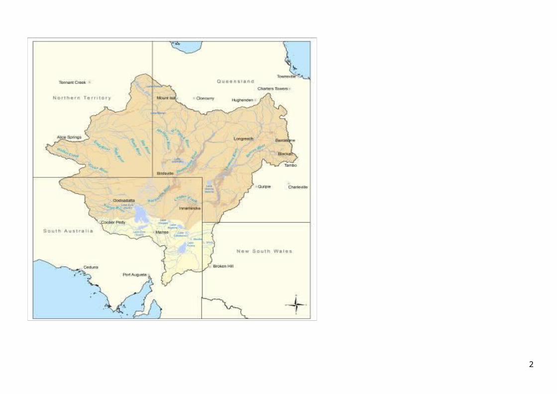
2

3

This page left blank in Word version
4

ContentsMessage from the Ministerial Forum.....................................................6
From the Chairs......................................................................................8
Boom and Bust: understanding what’s ‘normal’ in LEB river systems....9
Strategic Adaptive Management..........................................................11
2013 Biennial Conference....................................................................12
LEB Aboriginal Map and Booklet..........................................................13
New LEB website..................................................................................13
Research links.......................................................................................14
People of the Basin...............................................................................15
NRM around the regions......................................................................18
LEB Agreement enters the teenage years…..........................................22
LEB issues making the news.................................................................23
Common abbreviations in this report
5
CAC Community Advisory CommitteeCMA Catchment Management AuthorityCSIRO Commonwealth Scientific and Industrial Research OrganisationDCQ Desert Channels QueenslandLEB Lake Eyre BasinLEBRA Lake Eyre Basin Rivers AssessmentNRM Natural Resource ManagementNSW New South WalesNT Northern TerritoryQld QueenslandSA South AustraliaSAM Strategic Adaptive ManagementSAP Scientific Advisory Panelthe Agreement
Lake Eyre Basin Intergovernmental AgreementTPC Threshold of Potential Concern

www.lakeeyrebasin.gov.au
This page left blank in Word version
6

7
Message from the Ministerial ForumUnder the Lake Eyre Basin (LEB) Intergovernmental Agreement, the Australian, Queensland, South Australian and Northern Territory governments are working together to protect and manage the Lake Eyre Basin’s water and related natural resources.
Parliamentary Secretary to the Minister for the Environment, Senator the Hon. Simon Birmingham (Chair)
Queensland Minister for Natural Resources and Mines, the Hon. Andrew Cripps MP
South Australian Minister for Sustainability, Environment and Conservation, the Hon. Ian Hunter MLC
Northern Territory Minister for Land Resource Management, the Hon. Willem Westra van Holthe MLA
The Lake Eyre Basin (LEB) Ministerial Forum is pleased to provide the fifth annual Ministers’ Report to the Community - an update of programs and collaborations in the Basin as part of the LEB Intergovernmental Agreement.
The primary purpose of the Agreement is to implement policies and strategies “to avoid or eliminate so far as reasonably practicable adverse cross-border impacts”.
To this end, one important objective of the Agreement is “to jointly promote and support the management of water and related natural resources through a cooperative approach between community, industry and other stakeholders, and all levels of government”.
A driving force in developing that cooperative approach has been the Five-Year Action Plan. As the Plan notes, it is a ‘living’ document that is reassessed annually by Ministers.
This year, priority activities have centred on three key Actions:
improving governance outcomes to assist better decision making and implementation of priority Actions;
monitoring the health of our wetlands and rivers through the LEB Rivers Assessment (LEBRA); and
improving information sharing and staying connected within and beyond the Basin.
The preceding twelve months has been one of steady progress in these areas of the LEB Intergovernmental Agreement, thanks to the cooperative approach shown by a range of people and organisations, within and outside of government.
Another successful LEB Biennial Conference in September 2013 brought together stakeholders from many sectors and regions to share views and information about the natural, cultural and economic values of the Basin. The event celebrated the stories, experience and knowledge of the broad LEB community and culminated in a strong, mutual commitment to continue all possible efforts to protect the Basin’s values into the future.
LEBRA has continued this year to collect important data which will contribute toward our on-going condition assessment and adaptive management of the Basin. Regional natural resource management groups across the Basin have also made important contributions through on-ground management and community engagement programs.
In 2012, the traditional name of Lake Eyre, Kati Thanda, was recognised and is an important step in building awareness and acknowledgement of the region’s Aboriginal heritage and traditional owners, the Arabana people.
The development of alternative strategies to protect Queensland’s western rivers within the Lake Eyre Basin started in late 2012 with the formation of the Western Rivers Advisory Panel,
8

which includes representatives of the LEB Community Advisory Committee (CAC) and Scientific Advisory Panel (SAP).
In November 2013, the Ministerial Forum was briefed by the Queensland Minister on his Government’s proposed changes for management of Queensland’s LEB rivers, including the core principles of the management framework entailing the establishment of a Channel Country Protection Area and the prohibition of open cut mining in that Area. Queensland is sharing its data, modelling and proposed flow and trade conditions with Forum members and with the CAC and SAP, in order to better inform the continuing discussion towards successful, cooperative management of the water and related natural resources of the Basin.
All stakeholders need to remain alert to emerging issues that could adversely impact on the LEB and potentially threaten policies of the Ministerial Forum, adopted “to protect and maintain the ecological integrity and natural function of in-stream and floodplain ecosystems, and the viability of economic, social, cultural and other activities which do not threaten these environmental values.”
For our part, we are committed to working through these issues collaboratively with the clear purpose of maintaining the health and resilience of this unique ecosystem and the people who depend on it.
We take this opportunity to express our appreciation to members of the CAC and the SAP in
providing quality advice over the last twelve months toward a sustainable future for the Basin.
9

From the Chairs
Chair of the Community Advisory Committee, Angus Emmott
Following several years of high rainfall and floods in the Lake Eyre Basin (LEB), the past year has returned us to the harsher end of the boom-bust cycle, with much of the Basin now in drought, and with the pastoral industry especially facing difficult times. As demand on the water, mineral and energy resources of the Basin continues to grow, together with our knowledge of its astonishing ecological and biophysical processes, so too does our responsibility to nurture strong relationships between sectors, industries, communities, interest groups and governments. Amidst the short term pressures continually exerted by business and political cycles, we know that it is only through inclusive, respectful communication and careful, joint planning that the landscapes and water of the Basin can be utilised and managed for the truly long term.
2013 has seen the LEB Community Advisory Committee continue to seek a growing consensus around a shared vision for the long-term future of the Basin. The 6th LEB Biennial Conference in September 2013 showcased the knowledge, passion and commitment of a remarkable diversity of people and groups in the Basin, and reminded us again that sound planning requires the input of multiple voices. It has been a privilege and a pleasure to once again benefit from a strong and
growing Aboriginal voice in this conversation, and the Community Advisory Committee welcomes the official dual-naming of Kati Thanda-Lake Eyre as a reminder of these Aboriginal roots in the LEB landscape.
The Strategic Adaptive Management approach endorsed by the LEB Ministerial Forum in 2010 has required us to strive for stronger links with industries in the Basin, and to better connect our monitoring and knowledge with the decisions made in the Basin on behalf of the Australian community. As we grapple with the need to build these connections and relationships, it is clear that the LEB Intergovernmental Agreement remains a stand-out, world-class framework for cross-border and cross-sector communication and negotiation. The demand on us has never been higher to honour this framework and seek policy and management that future generations will thank us for.
Chair of the Scientific Advisory Panel, Steve Morton
The challenge of natural resource management begins firstly with recognition that the Lake Eyre Basin contains areas of economic value in pastoralism, tourism, oil and gas extraction and mining. While natural gas extraction has occurred in the Basin for many years, recent development has added spice to the management mix. The second significant feature is that the rivers of the Basin are among a handful world-wide remaining relatively untouched by water resource development. We all know that the river systems of the Lake Eyre Basin are subject to boom and
bust, with serious implications for how the health of the Basin might be monitored and managed. Maintaining the current overall excellent natural condition of the Basin’s rivers and their cultural values, while also supporting economic activity and human communities, is the big issue.
In collaboration with the Community Advisory Committee, the Scientific Advisory Panel is focusing on implementation of the Lake Eyre Basin Rivers Assessment, or LEBRA. The LEBRA aims to understand the evolving condition of the Basin in order to measure trend in condition and guide future responses in management and research. The first rounds of monitoring have now occurred and will continue. A ‘strategic adaptive management’ framework will guide LEBRA’s use, as confirmed by the Ministerial Forum three years ago. Strategic adaptive management is a phrase meaning really just ‘learning-by-doing’ – but it forces everyone to ask of the monitoring, ‘Do we need to alter management as a result of what we are learning’? And, importantly, strategic adaptive management insists upon input from pastoralists, Aboriginal people, miners, and tourism operators, as well as government people. Plans for testing this adaptive approach are well under way.
The Commonwealth and States have instituted a ‘Lake Eyre Basin Rivers Monitoring Project’ as one of the Bioregional Assessments underpinning development of unconventional gas resources. Collaborative arrangements will ensure intersection between this Project and the LEBRA, for efficiencies in the targeting of knowledge gaps and synergy among monitoring programs.
10

The Scientific Advisory Panel has beneficially welcomed new members in recent years and through its work is supporting with enthusiasm these significant initiatives.
11

Boom and Bust: understanding what’s ‘normal’ in LEB river systemsThe rivers of the Basin are unique on a world scale. River flows are highly variable and unpredictable, creating a distinctive ‘boom and bust’ ecology. Both high and low river flows have important ecological functions in the landscapes of the Basin.
The Lake Eyre Basin Rivers Assessment (LEBRA) is now in its third year of monitoring at more than forty-five sites across the Basin. Monitoring commenced in 2011 following some exceptionally wet years - a ‘boom’ period.
From boom to bustConditions are now significantly drier (the ‘bust’) with many rivers experiencing much lower flows compared to 2011. Some rivers in the Basin, for example, the Finke River in the Northern Territory, have not seen a flow for eighteen months. Actually, it is not unusual for some systems to be without flows for many years, up to five years or more in places like the Strzelecki Creek in the Cooper catchment.
Monitoring data from autumn 2013 could be considered the first set of LEBRA data collected in a dry period, and signal a fairly dramatic shift in water quality and fish populations. Fewer fish numbers
are now being found at many of the LEBRA sites. In 2012, the highest count of fish at a single site was 4 874, much lower than the highest count of 52 000 fish in 2011. Although quite startling, this difference is actually within normal expectations for the Basin.
It is not just the number of fish that can vary between years, but also which fish species are found where, and which species are most common. Twenty-one native fish species were recorded in 2012 compared with seventeen in 2011, and bony bream (Nematalosa erebi) was the most common across most sites, while in 2011 it was the silver tandan (Porochilus argenteus).
Monitoring yields new knowledgeSince monitoring commenced, we have new fish species distribution records for the Basin, with data collected in the Northern Territory from the very first systematic population sampling undertaken for most sites in this part of the Basin. In many catchments and sub-catchments some species were recorded for the first time (five in the Macumba, one in the Neales, three in the Ooratippra, one in the Ranken and four in the Sandover). Three exotic species - sleepy cod (Oxyeleotris lineolatus), eastern gambusia (Gambusia holbrooki) and goldfish (Carassius auratus) - have been recorded, although generally in low numbers. Repeated sampling at LEBRA sites also enables greater observation of the spread of cane toads (Rhinella marina) down the Cooper, and the movement of the invasive redclaw crayfish (Cherax quadricarinatus) in western Queensland.
Local knowledge and engagementAs with previous years, land managers and their families, including the Tjuwanpa Rangers on the Finke River and the Scott family at Lake Nash, have continued to provide assistance with monitoring field work.
10-year condition assessment LEBRA has been designed with a clear purpose. Under the LEB Intergovernmental Agreement, the LEB Ministerial Forum is required to undertake an assessment of the condition of all watercourses and catchments within the LEB Agreement Area. The LEBRA monitoring program is building the foundations for the next condition assessment which is due by 2018.
Annual monitoring reportsAn analysis of each year of LEBRA monitoring data is published in an annual report. The 2011 and 2012 monitoring reports are available online at www.lakeeyrebasin.gov.au/projects-and-activities.
LEBRA monitoring is improving our understanding of the Basin’s rivers and catchments, our ability to determine if the condition of the Basin is shifting beyond what we would normally expect, and the scientific integrity behind our management decisions.
12

Cullyamurra Waterhole, Cooper Creek, Innamincka, SA – Lake Eyre Basin Rivers Assessment monitoring site profile
GPS location: -27.701212 latitude, 140.840971 longitude
LEBRA sample dates - autumn 2011, spring 2011 and autumn 2012
Site Description - Cullyamurra Waterhole is a large, very deep, main channel waterhole in Innamincka Regional Reserve. The site is acknowledged as the deepest and one of the most permanent waterholes in the LEB. This is corroborated by the presence of flora and fauna indicative of permanence at this site.
Vegetation - Submerged – none. Emergent – 5 metre fringe dominated by velvet knotweed (Persicaria attenuata ssp attenuata), some large snags present on the river’s edge. Overstory riparian - dominated by coolabah (Eucalyptus coolabah) and red gum (Eucalyptus camaldulensis).
Hydrology - A flow gauging station at the site recorded that flow had ceased during spring of 2011 followed by pulse flows nearing 50 000ML/day in autumn 2012 (Figure 1), while at downstream sites flow had ceased.
Water quality - Water quality on all occasions was good with low salinity, low turbidity and good
dissolved oxygen levels. No stratification evident in the 4–6m depth profile. More alkaline (pH 9.4) in November 2011, but within expected range.
Fish: Autumn 2011 – 2 724 fish counted; most common species was the spangled perch (Leiopotherapon unicolour) and the exotic eastern gambusia (Gambusia holbrooki). Other species known from this site include the silver tandan (Porochilus argenteus) and Barcoo grunter (Scortum barcoo).
Spring 2011 - little to no water flow, 215 fish counted, with bony bream (Nematalosa erebi) the most dominant species.
Autumn 2012 - up to 1 000 fish counted per day; species present depicted in Fig. 2.
13
Figure 1: River flow (ML/day - blue line) at Cullyamurra Waterhole between 2008 and 2012
Figure 2: Fish species composition at Cullyamurra Waterhole during sampling period 13–18 April 2012

Strategic Adaptive ManagementDetermining whether the condition of the Basin is shifting beyond normal expectations, and deciding how we should collectively respond, are challenges we will meet through the Strategic Adaptive Management (SAM) framework. The first, fundamental step in this process is negotiating and clearly expressing a widely shared vision for the future of the Basin:
Lake Eyre Basin—Australia’s unique, natural, desert river system:
healthy environments, sustainable industries, vibrant communities, adaptive cultures.
This vision has been developed over the past three years through consultation and negotiation among LEB stakeholders. We invite you to share the journey towards achieving it fully.
Based on this vision, long-term sustainability in the Basin requires equally clear, shared objectives. Through our Community Advisory Committee and Scientific Advisory Panel, and utilising strong links with the Basin community including Regional Natural Resource Management partners, we offer the following objectives for long-term sustainability and prosperity in the Basin. We encourage you to share in their pursuit, and to join the continuing discussion on their fitness for purpose in achieving our vision.
Objective - Healthy environments
Protect biodiversity in its natural, long-term variations
Retain natural flow patterns over the long term Protect water quality within its natural, long-
term ranges Keep catchments in healthy condition
Objective - Sustainable industries, vibrant communities Encourage sustainable economic development Develop sustainable vibrant communities Promote responsible and efficient use of water
Objective - Adaptive cultures Balance resource utilisation with the integrity
of natural systems Share and honour Indigenous, local and
scientific knowledge Communication:o Increase understanding of the natural,
cultural, social and economic values of the Basin, including Aboriginal values
o Increase understanding of Basin-wide connectedness
o Nurture and retain the identity of the Basin
Governance:o Manage the Basin as a whole-build
connected governance that mirrors the connectedness of the rivers
o Provide adequate resources for the LEBRA SAM process
Anchored in these foundations is the paramount importance of reliable knowledge and strong relationships, cornerstones of the SAM approach.
In the 13-year life of the LEB Agreement, our knowledge and relationships have grown and strengthened. Following upon the recent three years of Basin-wide monitoring, we are now investigating the formation of a consortium of science and research providers to ensure that the best science can continue to be done in the Basin by the best people available. The challenge of utilising this knowledge for appropriate, shared decisions will be met by bringing together science, community, industry and management players to negotiate Thresholds of Potential Concern (TPCs)-the levels of change in attributes of the Basin that are widely agreed to be of some concern for the future. Negotiating TPCs, and how we respond to them, will require a close working relationship among stakeholders, especially those whose decisions and activities will affect the condition of the water and natural resources in the Basin.
As an interim step toward implementing the consortium model, a LEB researchers’ network is to be established to harness the significant level of good will and stakeholder effort which is already sustaining the LEBRA program.
14

2013 Biennial Conference Convened every two years under the LEB Intergovernmental Agreement, the Biennial Conference has become an important event for those with a special interest in the sustainable management of the Basin’s natural and cultural values. This sixth conference was no exception, with 140 delegates gathering in Port Augusta to share views and information, to celebrate stories, experience and knowledge, and to reinforce the critical importance of collaborative and inclusive planning and action for this vast cross-border region.
Broad community representationAttendance assistance packages, made possible with generous sponsorship from Santos Limited, Territory Natural Resource Management, Western Catchment Management Authority (CMA) and South Australia Arid Lands Natural Resource Management, helped to support wide community representation at this year’s event.
Over two and a half days, people from all sectors of the Basin community - industry groups (mining, petroleum, grazing and tourism), water and land management agencies, Aboriginal communities, local councils, members of parliament, research institutions, private conservation organisations and interest groups, regional natural resource management (NRM) organisations and Landcare groups – gathered to hear about the natural,
cultural, economic and social resilience of the Basin from a wide range of community, industry, government and scientific presenters.
Prominent issuesSeveral presenters spoke of the accelerating pace of the extractive industry and the global pressure for exploitation of the Basin’s energy resources. Other speakers flagged the cumulative impacts of the mineral and petroleum industries as a critical issue not yet being addressed in the Basin.
Day two showcased some of the superb on-ground achievements of regional NRM groups around the Basin, including the highly innovative work of the Desert Channels Group in using unmanned aerial vehicles (UAVs) for weed control in the Queensland part of the LEB, and the critical role of feral goat management by Western CMA landholders in the NSW portion of the LEB.
Presenters from the tourism and visitor management sector described increasing public attention on the Basin and public knowledge of its special features, highlighting the need for a continued, consistent approach to visitor access, communication and management.
The Water Resource Management and Development session highlighted the vulnerability of small floods/flows to increased water extractions, the shortcomings of our current hydrological modelling in predicting these effects on small floods, and our low confidence in anticipating the long-term effects of changes in water extraction. The conference again stressed the central importance of boom-bust hydrological and
ecological cycles in the Basin, and of continuing to monitor these cycles into the future.
Aboriginal delegates spoke of the need for continued integration of Aboriginal perspectives, knowledge and priorities into NRM across the Basin. Delegates from Arabana country generously shared their stories and songs and asked the gathering to understand the importance of formal acknowledgement of the traditional name for Lake Eyre, Kati Thanda.
The Conference saw vigorous discussion about proposed changes to the Queensland Government’s water management policy for LEB rivers, including a petition, signed by many delegates, urging the LEB Ministerial Forum to debate this issue. While not planned as a formal conference output, the Ministerial Forum nevertheless welcomes the spirit of open debate exemplified by this robust articulation of views.
A taste of TPCsWorkshops exposed delegates to the process of setting Thresholds of Potential Concern (TPC), a critical component of the Strategic Adaptive Management process (see page 11), exploring the warning signs that would tell us that we may be approaching undesirable changes in the condition of the Basin’s natural resources.
“I took away so much from the experience. I found the conference participants such a friendly and passionate group of people it was inspiring.” ‐Conference delegate
15

“Great conference with terrific range of presentations and topics, and from all stakeholders.” Conference delegate
Detailed Conference Proceedings are available at the LEB Ministerial Forum website: www.lakeeyrebasin.gov.au/community-forums
16
LEB Aboriginal Map and BookletStill in production, but nearing completion, the ‘Lake Eyre Basin – Aboriginal Way’ map and booklet seeks to celebrate the richness, diversity and vibrancy of Aboriginal culture across the Basin in a way that honours the desire of Aboriginal people to tell their story.
The publication will be the first of its kind to show multiple layers of information about Aboriginal groups, places, cultures and histories across the whole of the Basin – that’s one sixth of Australia! Photographs, colourful graphics and personal stories will convey strong messages of respect and recognition of the traditional and contemporary presence and culture of Aboriginal people in this region, to an audience of both Aboriginal and non-Aboriginal people—to all people who wish to learn more about the natural and cultural significance of the Basin.
Designed to raise broad community and industry understanding of the significance of Aboriginal culture in the LEB, it is hoped that the product will be a useful communication tool for Aboriginal people, especially when speaking with non-Aboriginal people about the cultural values of their region.
Speaking about the project through his involvement in the Project Management Team, Mr George Cooley, SA Aboriginal representative on
the Lake Eyre Basin Community Advisory Committee, says;
“The Lake Eyre Basin has always been a home to Aboriginal people, and it remains rich in meaning for Aboriginal culture, shared by us in story and in song. This map is a small taste of our places, songlines, stories and histories, and an invitation to learn more. It is not about native title or land rights, it’s about working together to look after this unique place for our grandchildren’s future. We hope you will join us on this journey.”
The project encompasses an immense generosity of spirit from scores of Aboriginal people across the Basin, contributing sage advice, photographs, knowledge, stories and support.
The project has grown into a partnership between Aboriginal people and organisations across the Lake Eyre Basin, the LEB Community Advisory Committee, the governments of SA, Qld, the NT and the Australian Government (through the LEB Ministerial Forum), the mining industry and regional natural resource management groups. These partners have committed cash or in-kind support to the project. The Project Management Team, comprising Aboriginal and non-Aboriginal people from across the Basin, has been steering the project since its formal inception in 2011. The project will be completed in 2014.
For more information, contact the Project Coordinators:Michelle Rodrigo, LEB Communications Officer,(08) 8951 9255, [email protected]
Vol Norris, LEB Facilitator, (07) 4650 1235, [email protected]
17
New LEB websiteThe Lake Eyre Basin Ministerial Forum website has a fresh new look and more information about the ecology, hydrology, people and economies of the Lake Eyre Basin than ever before, as well as up-to-date information about the networks, publications, events and programs of the LEB Intergovernmental Agreement. The new and interesting content is backed up by stunning images of the Basin from talented photographers and supporters of the LEB process.
Check it all out at:
www.lakeeyrebasin.gov.au
18

Research linksTick of health for LEB waterbirds
Lake Eyre Basin wetlands support some of the larger concentrations of waterbirds on the continent. As part of the LEB Rivers Assessment, analyses of long-term annual aerial-survey data for waterbird communities across the eastern part of the LEB, collected over a period of thirty years (1983–2012), has been used to assess the condition of the wetlands in the LEB. Unlike some other regions of Australia (e.g. Murray-Darling Basin), the data showed little evidence for any long-term decline in abundance, species richness, breeding abundance, breeding species richness or abundances of any of the six functional groups (ducks, herbivores, large wading birds, piscivores, shorebirds), providing a strong indication that the condition of the LEB wetlands and their rivers remain in largely natural condition, unaltered over the thirty years for which data were available.
The report, ‘Waterbirds in the Lake Eyre Basin Report for the Lake Eyre Basin Rivers Assessment (April 2013)’, was prepared by the University of NSW Australian Wetlands, Rivers and Landscapes Centre with funding from the Australian Government’s National Environmental Research Program.
Invasive plant species in the LEB – ecologically cost-effective management
The LEB covers a sixth of Australia, with an array of globally significant natural values that are
threatened by invasive plants, among other things. Land managers at various levels are investing in attempts to control, contain and eradicate these invasive plant species, under severe time and resources limitations. Prioritisation of threat management actions based on their ecological cost-effectiveness is essential for achieving the best possible biodiversity benefits.
This research, conducted by the Queensland University of Technology and the CSIRO, identifies the key invasive plants species to target to protect ecosystem intactness across the bioregions of the LEB, the level of investment required, and the likely reduction in invasive species dominance gained per dollar spent on each strategy.
The outputs of this work are designed to help guide decision-making and further planning and investment in weed management for the Lake Eyre Basin.
The full project report titled, ‘Priority threat management of invasive plant species in the Lake Eyre Basin,’ is available from the LEB Ministerial Forum website - www.lakeeyrebasin.gov.au/projects-and-activities
Lake Eyre Basin bioregional assessment
The Bioregional Assessment Programme is one way in which the science underpinning decisions about coal seam gas and large coal mining activities and their potential impacts on water resources is being strengthened.
The LEB has been identified as an area to be targeted under the Bioregional Assessment Programme because it is underlain by significant coal deposits - Galilee, Cooper, Pedirka and Arckaringa coal basins (see map).
The South Australian Government’s Coal Seam Gas and Coal Mining Water Knowledge Program is providing foundational inputs for the LEB bioregional assessment. Key components of this initiative are the LEB Rivers Monitoring and Springs Assessment projects which are being delivered across the entire Lake Eyre drainage basin. The projects are collating ecological and hydrological data to inform the bioregional assessment, in collaboration with the LEB Rivers Assessment teams to enhance data collection and knowledge sharing.
For more information:
19

Water Connectwww.waterconnect.sa.gov.au/Industry-and-Mining
Independent Expert Scientific Committee on Coal Seam Gas and Large Coal Mining Developmentwww.environment.gov.au/coal-seam-gas-mining
20

People of the BasinThere are only 60 000 or so people living in the Basin, others who visit regularly for work, and hundreds of thousands who travel through every year for the outback experience. Stories of people’s passion, fascination and connection with this arid, dynamic region are countless. Three such stories are featured here…
Touring the BasinAnne Pye, a resident of Alice Springs, talks about a once in a lifetime experience of travelling the Basin by car, camel and boat, during recent wet years...
“In the last couple of years, I have been lucky to visit different parts of the Lake Eyre Basin region. In 2011, on a flight out of William Creek, I saw Lake Eyre when it was eighty per cent full, and later took a rare boat trip down the Warburton Creek. We were there right at the peak of the good season. At every stop along the river there was different vegetation, along with an amazing abundance of birdlife.
In 2012, I joined Rex Ellis for a trip down the Bulloo River, arriving just after the flood peak. With the water dropping about a metre a day, by the third day we ran out of water, and after one boat sank and had to be recovered, we diverted to the Cooper Creek. The diversion meant we were able to visit Innamincka, the Dig Tree and Coongie Lakes. I saw Darling Lilies in flower and lots of brolgas and emus.
We visited Cullyamurra Waterhole which was full of turtles, as well as a swimming snake, alarming a few people in the water at the time.
In mid-2012, I drove around the Queensland side of the Basin visiting Longreach, Windorah, Edgbaston Springs and Hunters Gorge. As soon as we crossed the Queensland border, the flocks of budgies seemed much bigger, as were the feral cats - they were enormous and not scared of anything, crossing the road after cars had passed. There were plenty of feral pigs too.
This year, a multi-day camel trek from Old Andado with Andrew Harper, and numerous day trips out of Alice Springs with the Field Naturalists Club, allowed me to explore more of the Northern Territory part of the Basin. Despite drier conditions, the little rain that fell earlier this year was enough to create a spectacular wildflower display in July and August, as well as terrific photo opportunities!
The most interesting part of travelling around the Lake Eyre Basin by road, on foot with camels and by boat, has been to see the differences and similarities in country between Queensland, the Northern Territory and South Australia. Even just a short drive through Diamantina National Park reveals many different landscapes in a relatively small area.
As a visitor, it’s great to tap into the knowledge of adventurers like Rex Ellis, ecologists like Adam Kerezsy at Edgbaston Springs, and knowledgeable locals from the Alice Springs Field Naturalists Club, who, over the years, have taken the time to observe the land with passion and enthusiasm. They make sure you don’t miss the details!
It was great to travel the Basin when the country was looking so good. With so much vegetation you could easily forget how bare the place can be in the dry times. You’ve got to catch the good times when you can and, as an enquiring tourist, this was a once in a lifetime experience.”
21
Cycles of life in the BasinJo Lewington, an Aboriginal woman from Birdsville, lives and works in Bedourie, Queensland and enjoys the life-giving cycles of flooding in the Basin …
“I have been living in the Diamantina Shire for the majority of my life, the last nine years working with the council as the Community Development Officer.
After two floods, two years running in 2010 and 2011, where it was so beautiful and green in the area, the country is now becoming dry around here.
During a flood, we can be isolated here for up to ten weeks, that’s going out by road. The water is so widespread, it goes out for kilometres and we look like a little island. There are still flights though, and we get some food flown in. Normally the locals are all pretty prepared with food in stock, although during that time you miss out on fresh fruit and vegetables. We can be prepared as we know when the Georgina River is going to run. As soon as the water starts coming up, we take the kids out to watch it rise.
It’s interesting to listen to the new people who come to town and to watch their reactions to the floods. At first they can’t wait for the flood to come; then, when it’s here, they start getting cabin fever! At other times our river is dry and we only see it run a couple of times a year.
In the last twelve months we’ve been catching yabbies, but it’s been nearly ten years since we have been able to catch a decent feed of yabbies. Instead of the blue yabbies, we are starting to see the red claws, the ones that have been introduced.
It’s important to get out of town, enjoy the area when it’s good and do some fishing. The yellowbelly we are catching are getting to be a good size. This year they are cleaner, but usually they have that muddy taste when you eat them.
We realise the importance of the river system in the shire and how it can affect us if it’s blocked off somewhere else, up stream. One thing that really opened my eyes when I attended the Lake Eyre Basin Aboriginal Forum in Birdsville, was how sad it was to hear about the Murray-Darling Basin and how, down there, they had lost a lot of the birdlife. I never ever want that to happen out this way, especially as with the floods you get such a range of birdlife which are so good to photograph.”
22

A fascination with arid riversHenry Mancini, Senior Water Project Officer with South Australian Arid Lands NRM, explains his fascination with the arid rivers of the Lake Eyre Basin and his passion for telling their complex story…
“I have been working in the Lake Eyre Basin for over six years, the last three of those in the Cooper Creek region. I’m fascinated by the Cooper - the channels, wetlands and floodplains are all very important parts of the system. There are big gaps in knowledge about these arid zone rivers. Water is the main driver of these systems, and understanding more about all of this is my job.
An important part of science is linking it with people. I have a passion about getting information out and finding the best way to do that. If we don’t make things relevant to a whole range of people, then it doesn’t mean much. By translating good messages and really good stories about our natural environment in ways that people can embrace, we raise awareness and, potentially, increase the chances of protection, as people understand how the river system works.
I’ve recently worked on a whole of Cooper Creek system signage project, translating knowledge about the diversity of the system and the connectivity observed over the recent period of active flooding (2010–2012) in the region, to illustrate that what happens at the top end of the system will affect the bottom end. We aren’t trying to hammer people over the head with this information; we’re just creating a better understanding of how interconnected the system is
and why protection of our arid rivers is so important.
It is also important to tap into local knowledge when studying these systems as it makes us ask different questions and look at things from a different angle. Lake Hope commercial fisherman, Garry Overton, has been collecting information about the Cooper for thirty years – this is invaluable. Lake Hope is a terminal lake and a potential indicator of how the river system is working. If something is going wrong in the Lake Hope fishery, perhaps a dramatically reduced catch, this could be a sign of something happening upstream or maybe just natural variation. Locals like Garry can help people like me understand what’s going on.
These arid river systems are hugely variable and unpredictable, which is why I find them so fascinating. We are learning all the time, filling the knowledge gaps, and we have to keep asking ourselves, ‘how do we best manage, protect and understand these systems’?
What I would like to see in another thirty or forty years is the system in its natural state - unrestricted natural flows, unpolluted waterholes, thriving populations of water birds and fish, and healthy vegetation. There will always be a struggle around this, but if we can get the right information in place so that people can make informed decisions, I think together we could do it.”
23

NRM around the regions Working closely with community, government and industry, natural resources management (NRM) groups across the Basin have an important role in facilitating a range of NRM projects that are responsive to the environments and people they work with. Here are just a few project stories...
Managing South Australia’s Cooper Creek CatchmentSA Arid Lands NRM Board, Caring for our Country Project 2010-2013
The ‘Cooper Creek Project’ is investigating the natural features and human influences on key waterholes and wetlands along the iconic Cooper Creek in the Marree-Innamincka district of the South Australian Arid Lands region.
The Cooper Creek catchment is an important but relatively poorly understood wetland system which supports unique and important aquatic biodiversity and a range of industries, including pastoralism, mining and tourism.
In order to manage this unique resource into the future, the project is gathering baseline data to inform community, land managers and industry.
Investigations centred on the natural features and human influences of key waterholes and wetlands along the Cooper Creek in South Australia, to develop an understanding of ecosystem processes and functioning, identify threats, and develop management strategies to protect key assets.
A total of 15 aquatic sites were assessed including Cullyamurra, Minkie, and Scrubby Camp waterholes in the Innamincka Regional Reserve, Gidgealpa Waterhole and Lake Hope.
A key finding from fieldwork assessments, and a major current impact, is unregulated tourism and recreational activity at key waterhole and cultural sites near the Birdsville Track, and outside of the Innamincka Regional Reserve, such as Killalpaninna Mission and the lower Cooper Creek lakes.
In partnership with the Dieri Aboriginal community, a tourism management framework and interpretive signage strategy was developed to address this issue. The strategy integrates with the Parks South Australia interpretation program at Innamincka Regional Reserve, providing a plan that ‘fits’ ecological, community, land manager and tourism industry needs.
A community workshop was held in Innamincka in June 2013 to present findings, and to seek feedback from stakeholders relating to future management.
A series of technical reports describing the geomorphology, hydrology, aquatic ecology, riparian condition assessment and cultural landscapes were also made available at the workshop.
Big Blyth cappedSA Arid Lands Natural Resources Management Board
A free-flowing bore located on The Peake Station, Big Blyth was drilled in 1917 and has flowed freely for about 90 years, releasing more than 1 000 megalitres of water and almost 2 500 tonnes of salt annually.
The bore was decommissioned in 2011 as part of the Great Artesian Basin Sustainability Initiative Phase 3 (GABSI 3). Having to locate the original drill-hole in an overgrown artificial wetland and work with a highly corroded bore-casing made the project technically complex.
In its non-rehabilitated state, Big Blyth had negligible production benefits to the pastoral industry and low ecological value – but was a major source population of the invasive mosquito fish (Gambusia holbrooki).
This population is thought to be a source of re-infestation into the Neales-Peake river system after flood events, so capping is expected to substantially reduce mosquito fish numbers and increase the health of waterholes like Algebuckina – the most important permanent waterhole in the Neales-Peake catchment.
Big Blyth’s closure will save over 1 000 megalitres per year and should also have major benefits for nearby springs and waterholes – increased pressure to the springs should lead to improved flow and wetland health.
Land managers should also benefit through an increase in pressure and improved water quality at controlled bores.
24
The conversion of Big Blyth’s artificial wetland to more manageable grazing country on the Peake Creek floodplain is expected to improve grazing management outcomes.
Capping was carried out by the Department of Environment, Water and Natural Resources while the SA Arid Lands NRM Board funded the study of environmental and production benefits of Big Blyth’s closure.
For more information about the Cooper Creek and Big Blyth capping projects contact Henry Mancini, Senior Water Projects Officer, Natural Resources SA Arid Lands, (08) 8648 5300, [email protected].
Getting smart with feral goatsWestern CMA
The Western Catchment Management Authority commissioned a comprehensive suite of research into unmanaged goats. Overgrazing by a large, unmanaged goat population is the major factor influencing groundcover over the majority of the Western Catchment, predetermining the success of most other land management activities.
The project included:
• background evidence-based information to guide more strategic implementation of on-ground management solutions;
• recognition that projects to manage total grazing pressure from feral goats dominate landholder proposals for incentive funding;
• a literature review of feral goat ecology, impact
and control measures;
• a review of the policy context of feral goat management;
• a review of the feral goat harvest industry and implications for natural resources;
• an analysis of feral goat population data identifying trends since 1993;
• an analysis of the economics of grazing enterprises based on feral goat harvesting in comparison with those where total grazing pressure management systems are in place; and
• a discussion paper summarising the main findings and options for future management.
Copies of the reports are available on the Western CMA website or by calling 1800 032 101.
For more information visit www.western.cma.nsw.gov.au.
Lake Eyre Basin People and Passion – films from the heart of AustraliaDesert Channels Queensland
Twenty thousand dollars provided to Desert Channels Queensland (DCQ) by the Queensland Government in 2011 provided the catalyst for what eventually became a Basin-wide digital communications project.
The first stage of the project saw DCQ set up a collaborative venture with the Lake Eyre Basin Community Advisory Committee to produce digital stories about six Queensland ‘Lake Eyre Basin champions’. So well received were these first stories that additional funding was made available by the
Queensland Government, Territory NRM and the LEB Ministerial Forum to undertake a second stage of filming in 2012-13, capturing another fourteen stories from all corners of the Basin.
Showcasing some of the distinctive characters of the Lake Eyre Basin and their passion for protecting its natural values, the films cover topics such as water management, fauna conversation, sharing of traditional knowledge, weed and pest control, community capacity building and more.
The complete showcase of twenty films was launched at the Lake Eyre Basin Biennial Conference in September 2013 by the South Australian Minister for Sustainability, Environment and Conservation, the Hon. Ian Hunter MLC.
These films, each carefully and respectfully edited to around five minutes in length, capture the personal stories of land managers and scientists who go that extra mile to look after the Basin – their commitment is inspiring and their messages are strong.
View this wonderful collection of films online at www.dcq.org.au/lakeeyrebasin.
25

Rehabilitating spring ecosystems at Edgbaston ReserveDesert Channels Queensland
Edgbaston Reserve, an 8 000 ha former grazing property near Aramac, in the north-east of the Lake Eyre Basin, is a unique environment where the Desert Uplands and Mitchell Grass bioregions meet, and where more than fifty discharge springs of the Great Artesian Basin upwell, forming one of the most significant spring complexes in Australia.
The entire ecological community is listed as endangered under the Environmental Protection and Biodiversity Conservation Act, and continuous protection of the endemic species that inhabit the artesian springs is of the utmost importance.
Desert Channels Queensland has been working in partnership with Edgbaston’s land managers since 2005. Six projects have been undertaken, including five with Bush Heritage Australia, who purchased the property in 2008.
The investment to date is nearing $600 000, 42 per cent of which has been in-kind contributions from the land managers.
Weed, feral animal and fire management plans, and a reserve management plan have been produced; monitoring sites have been set up and data collection is ongoing; 3 180 ha of parkinsonia (Parkinsonia aculeata) and prickly acacia (Acacia nilotica) have been controlled; cattle have been removed to prevent further weed spread; 2 500 ha has been controlled for feral pigs with approximately 300 pigs removed; and a program of developing effective and ecologically acceptable methods for the control of
invasive mosquito fish (Gambusia holbrooki) in the springs is ongoing.
Edgbaston Reserve will be managed in perpetuity in accordance with Bush Heritage Australia’s long-term plan and reserve management planning process which is built on an adaptive management framework.
For more information contact Desert Channels Queensland, (07) 4658 0600, www.dcq.org.au.
Protecting Pertame waterholes in the mid-Finke river regionTerritory Natural Resource Management
Pertame (Southern Arrernte) language speakers are traditional owners of the mid-Finke River region that sits centrally in the pools of the Western Finke River Catchment, recognised nationally as a High Conservation Value Aquatic Ecosystem (HCVAE). The area is of high cultural significance to Pertame people, and a year-long project has been working towards protecting its conservation values by implementing management strategies at four waterholes. This includes two Lake Eyre Basin Rivers Assessment (LEBRA) sites.
The project’s achievements include:
recording Indigenous Ecological Knowledge to inform future management;
management of castor oil plant (Ricinus communis), spiny rush (Juncus acutus) and annual beard grass (Polypogon
monospeliensis), to reduce spread of new infestations;
management of the Weed of National Significance, athel pine (Tamarix aphylla), in collaboration with the Department of Land Resource Management Weeds Branch, including mapping and reporting sites;
establishment of photo monitoring points and vegetation surveys to monitor impacts of weeds and cattle management; and
the provision of qualitative data to the LEBRA ecological field data collection.
These activities have contributed to the ongoing management of the area for long-term biodiversity conservation by the station leaseholder, in collaboration with traditional owners and the Central Land Council
For more information contact Heidi Groffen, Regional NRM Coordinator Arid Lands, (08) 8951 9284, [email protected].
26

Discovering critical drought refuges in poorly known catchments Territory Natural Resource Management
The Department of Land Resource Management (DLRM) and Territory NRM have been identifying critical drought refuges along the Palmer River, Finke River and Ooratippra Creek.
The project aimed to:
determine fish species presence by sampling a range of habitat types and tributaries;
determine the relative importance of different habitats for different fish species (springs in gorges, spring-fed waterholes in major creeks, deep rockholes);
increase knowledge of the location and nature of drought refuge waterholes and springs, by combining information from landholders and Traditional Owners with field observations;
create a basis for any potential future inventory of drought refuge biota such as spring dependent invertebrates; and
support the Lake Eyre Basin Rivers Assessment by generating contextual information.
Information collected during the project included:
the location of known or possible drought refuges, identified by pastoral landholders and Traditional Owners;
fish species presence, relative abundance and size range at sites;
waterhole dimensions including depth;
water chemistry and flow information relevant to assessing groundwater discharge;
spring dependent vegetation; and
some invertebrate samples.
The project has been a great success with seven of the nine Finke region fish species recorded during the survey and yabbies found at some sites, confirming their presence in the Palmer catchment.
Vegetation at the Areyonga Spring site was found to be quite unique in this system, with the presence of a high number of spring dependent (relict) plants, including some recorded at very few other sites in central Australia.
All of the information collected during this project will be used to improve the way we identify and manage important drought refuges for aquatic species in the future.
For more information contact Heidi Groffen, Regional NRM Coordinator Arid Lands, (08) 8951 9284, [email protected] .
Regional NRM groups in the Lake Eyre Basin
South Australian Arid Lands NRM Board www.saalnrm.sa.gov.au
Territory NRM www.territorynrm.org.au
Desert Channels Queensland www.dcq.org.au
Western Catchment Management Authority www.western.cma.nsw.gov.au
Alinytjara Wilurara NRM Board www.awnrm.sa.gov.au
27

LEB Agreement enters the teenage years… Thirteen years since the Lake Eyre Basin Intergovernmental Agreement was enacted at the turn of the millennium, we take a look back at where it all started.
In 1990, the General Assembly of the World Conservation Union called for the protection of Lake Eyre Basin wetlands. Local pastoralists, landowners and mining industry representatives opposed the proposal for World Heritage listing, concerned that it would threaten the viability of local properties and commercial activities. Consequently, the Australian Government did not pursue a nomination.
In 1995, a proposal to divert significant volumes of water from the Cooper Creek for cotton production generated deep community concern, and an unlikely alliance between conservationists and local pastoralists. At a public meeting in Birdsville, the LEB Steering Group was formed, bringing together the various sustainable natural resource management interests of the region. Membership included representatives of the pastoral industry, Queensland and South Australian Governments, conservation groups, mining and petroleum industries, Landcare groups, Aboriginal organisations and local government.
In 1997, following on from the work of the Steering Group, an integrated catchment framework for the Basin was proposed and a Coordinating Group was formed to assemble cross-border interests. Cross-border catchment management strategies were developed and then launched in 2000.
This focussed and dedicated effort by Basin stakeholders culminated in the signing of the Lake Eyre Basin Intergovernmental Agreement (the Agreement) by Ministers of the Australian, Queensland and South Australian Governments in October 2000, and later by the Northern Territory in 2004.
The purpose of the Agreement is to ‘provide for the development or adoption, and implementation of policies and strategies concerning water and related natural resources in the Agreement Area to avoid or eliminate, so far as reasonable practicable, adverse cross-border impacts’.
Central to the intent of the Agreement is the conservation and promotion of the important social, environmental, economic and cultural values of the Basin.
Ministers from the four signatory governments make up the LEB Ministerial Forum, which has overall responsibility for implementing the Agreement. To do this, the Ministerial Forum receives advice from the Community Advisory Committee, the Scientific Advisory Panel and the Senior Officers Group. The Forum also maintains a connection to the Basin community by arranging a conference, every two years, for all interested parties to exchange information and views on issues relevant to the
Agreement. Since 2000, six Biennial Conferences and four Aboriginal Forums have been held.
2013 6th Conference Port Augusta, SA2011 4th Aboriginal Forum Tibooburra, NSW2010 5th Conference Alice Springs, NT2009 3rd Aboriginal Forum Birdsville, Qld2008 4th Conference Longreach, Qld
2006 3rd Conference2nd Aboriginal Forum
Renmark, SAMount Serle, SA
2004
2nd Conference
1st Aboriginal Forum
Alice Springs, NT
Hamilton Downs (Alice Springs), NT
2002 1st Conference Birdsville, Qld
In 2007, a review of the Agreement demonstrated that it had ‘made good progress toward reducing adverse cross-border impacts and had created a whole-of-Basin, integrated NRM mindset’. It also demonstrated that the Agreement was ‘highly valued by stakeholders as a vehicle to safeguard the integrity of the LEB against the threat of inappropriate land management’ (URS, 2007).
Thirteen years on, the Agreement maintains a whole-of-Basin focus and a foundation of sustainable management for the benefit of the stakeholders and natural values of this unique region.
28
Read the LEB Agreement at www.environment.gov.au/resource/lake-eyre-basin-intergovernmental-agreement
29
LEB issues making the news 29 November 2013, ABC NewsWestern Qld graziers celebrate storm rainMore storm activity in Queensland's drought-stricken west is forecast, as some graziers celebrate the first decent rain they have seen in more than a year.
18 September 2013, ABC North and West SAConference considers Lake Eyre Basin futureMining prospects and changes to water licenses were among the major issues raised during the biennial Lake Eyre Basin conference being held in Port Augusta this week.
16 September 2013, The AdvertiserGrazier concerned for Lake Eyre watersWater flowing into Lake Eyre in South Australia will begin to dry up if Queensland moves to increase irrigation in the State's west, a third-generation grazier says.
20 May 2013, Courier MailNorthern weather in wacky way as cycle of wet and dry more unpredictable North Queensland graziers who missed the monsoon rain had better get used to erratic weather patterns.
17 May 2013, ABC PM Grazier and Aboriginal pair take rivers lobby to Premier's seatIn an unlikely alliance, a western Queensland cattle grazier and an Aboriginal traditional owner have joined forces to oppose a development. The Queensland Government wants to repeal laws which prevent mining and irrigation along rivers feeding Lake Eyre.
13 May 2013, The ConversationUnknown wonders: Kati Thanda-Lake Eyre Out in the Lake Eyre Basin, there is no more idyllic place to camp than beside a waterhole on the Diamantina River. The tranquil water belies that this is a land of extremes, with soaring summer heat and cold winter nights.
19 March 2013, ABC NewsExperts probe Lake Eyre carp threatResearchers have headed to Leigh Creek in South Australia’s north to investigate reports of European carp in the area.
27 February 2013, The North West Star Exploration granted near Bedourie More than 2 000 square metres of land will be released near Bedourie to allow for mineral exploration in the area less than 24 hours after a conference was held aiming to stop mining activity in the region.
25 February 2013, ABC NewsTalks focus on Lake Eyre Basin futureA major conference is being held in western
Queensland to discuss the future of the Lake Eyre Basin, one of the world’s last great desert river systems.
25 February 2013, The Australian Lake Eyre under greatest threat in decadesMining on its floodplains and irrigation along its rivers post the greatest threat in decades to Australia’s largest lake, an advocacy group warns.
20 December 2012, ABC News New name adopted for outback Lake EyreRemote Lake Eyre in the arid heart of Australia now has dual names. The Arabana peoples have convinced the Geographical Names Unit to recognise the ancient name of Kati Thanda.
15 December 2012, The AustralianLake Eyre’s waters are a mirage image once moreShining like a diamond in the baking South Australian desert, Lake Eyre has reverted to its true nature and is wondrously dry.
30

Want to find out more?
Subscribe to the Lake Eyre Basin Ministerial Forum electronic mailing list to receive information about what’s happening in the Lake Eyre Basin Agreement Area (e.g. conferences, forums, publications) at www.lakeeyrebasin.gov.au
Visit the Lake Eyre Basin Ministerial Forum website:www.lakeeyrebasin.gov.au
Contact the LEB Facilitator:
Vol Norris07 4650 [email protected] Box 519, Longreach, Qld 4730
Contact a member of the Lake Eyre Basin Community Advisory Committee www.lakeeyrebasin.gov.au/contact
Government departments implementing the Lake Eyre Basin Intergovernmental Agreement:
Australian Government Department of the EnvironmentLEB Secretariat via www.lakeeyrebasin.gov.au//contact
South Australia Department of Environment, Water and Natural Resourceswww.environment.sa.gov.au
Queensland Department of Natural Resources and Mineswww.dnrm.qld.gov.au
Northern Territory Department of Land Resource Management www.lrm.nt.gov.au
This publication is supported by all parties to the Lake Eyre Basin Intergovernmental Agreement
31

Lake Eyre Basin Agreement timeline (wrapped around front and back covers)
40 000-60 000 years ago– emergence of complex & successful Aboriginal presence in LEB
1840 Edward John Eyre becomes first European to see Kati Thanda-Lake Eyre
1845 Captain Charles Sturt names Cooper’s Creek - now Cooper Creek
1860/1 Burke & Wills leave Camp LXV, Cooper Creek, Dec 16; return to abandoned camp April 21
1864-67 Major drought
1872 Port Augusta to Darwin Overland Telegraph Line completed
1877 First recorded flood on the Cooper since settlement
1880 Augustus Poeppel surveys Poeppel Corner, Simpson Desert
1884 Rabbits first seen in the southern Channel Country
1925-30 Severe drought
1929 Oodnadatta to Alice Springs Old Ghan railway completed
1930s-40s Drought continues
1949/50 Big floods in NSW, Qld & SA fills Kati Thanda-Lake Eyre
1952 Kati Thanda-Lake Eyre remains full
1974/75 Massive flooding throughout LEB fills Kati Thanda-Lake Eyre
1984/85 Flows into Kati Thanda-Lake Eyre
1985 Proposal for World Heritage listing of LEB
1987 Ramsar listing of Coongie Lakes
1989/90 Flows into Kati Thanda-Lake Eyre

1995 Proposal to grow cotton at Currareva, Cooper Crk │LEB Steering Group formed
1997 Signing of LEB Heads of Agreement │Flows into Kati Thanda-Lake Eyre
1998 LEB Coordinating Group (LEBCG) takes up role of Steering Group
2000 LEB Intergovernmental Agreement signed by Aust, Qld & SA Ministers │ Big rains in Qld & NT part-fill Kati Thanda-Lake Eyre
2001 1st meeting of LEB Ministerial Forum, Longreach │ LEBCG appointed as 1st LEB Community Advisory Committee (CAC) │ LEB Scientific Advisory Panel appointed
2002 1st LEB Biennial Conference, Birdsville
2003 New LEB CAC appointed
2004 NT signs up to LEB Agreement │ 1st LEB Aboriginal Forum, Hamilton Downs NT │ 2nd Biennial Conference, Alice Springs
2006 2nd Aboriginal Forum, Mt Serle SA │ 3rd Biennial Conference, Renmark
2007 Review of LEB Agreement │ Dry conditions across Basin since early 2000s
2008 4th Biennial Conference, Longreach │ 1st State of the Basin Rivers Assessment published
2009 Floodwaters reach Kati Thanda-Lake Eyre in May │ 3rd LEB Aboriginal Forum, Birdsville │ LEB Five-Year Action Plan endorsed
2010 Cooper Crk crosses Birdsville Track, flow reaches Kati Thanda-Lake Eyre │ 5th Biennial Conference, Alice Springs │ Cane Toads reach Noonbah Station, south of Longreach
2011 Floodwaters reach Kati Thanda-Lake Eyre │ Cooper Creek flowing its full length │ 4th Aboriginal Forum, Tibooburra NSW │ LEB Rivers Assessment monitoring commences
2012 Official recognition of ‘Kati Thanda’ as traditional Arabana name for Lake Eyre │10th Ministerial Forum meeting │ Floodwaters reach Kati Thanda-Lake Eyre for 4th consecutive year
2013 6th Biennial Conference, Port Augusta SA │Extreme dry conditions in Qld LEB