Embed Size (px)
Citation preview
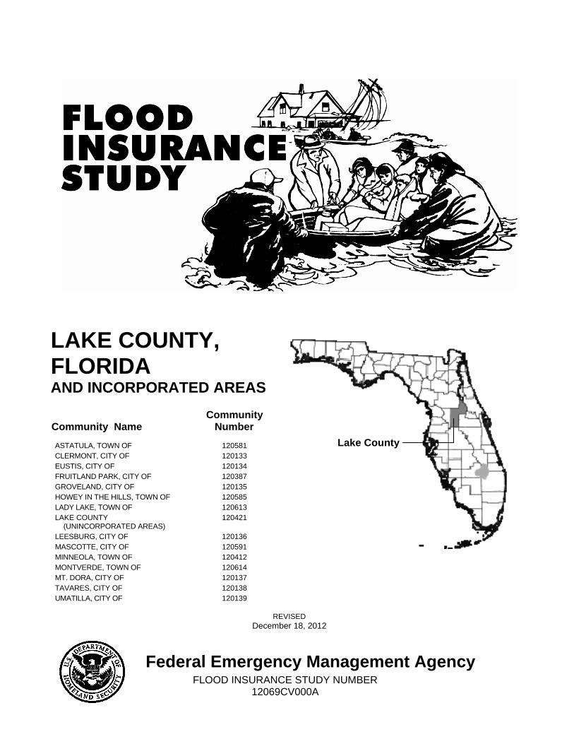
LAKE COUNTY, FLORIDA AND INCORPORATED AREAS
Community Name Community
Number
ASTATULA, TOWN OF 120581 CLERMONT, CITY OF 120133 EUSTIS, CITY OF 120134 FRUITLAND PARK, CITY OF 120387 GROVELAND, CITY OF 120135 HOWEY IN THE HILLS, TOWN OF 120585 LADY LAKE, TOWN OF 120613 LAKE COUNTY
(UNINCORPORATED AREAS) 120421
LEESBURG, CITY OF 120136 MASCOTTE, CITY OF 120591 MINNEOLA, TOWN OF 120412 MONTVERDE, TOWN OF 120614 MT. DORA, CITY OF 120137 TAVARES, CITY OF 120138 UMATILLA, CITY OF 120139
REVISED
December 18, 2012
Federal Emergency Management Agency FLOOD INSURANCE STUDY NUMBER
12069CV000A
Lake County

i
NOTICE TO FLOOD INSURANCE STUDY USERS
Communities participating in the National Flood Insurance Program have established repositories of flood hazard data for floodplain management and flood insurance purposes. This Flood Insurance Study may not contain all data available within the repository. It is advisable to contact the community repository for any additional data.
Part or all of this Flood Insurance Study may be revised and republished at any time. In addition, part of this Flood Insurance Study may be revised by the Letter of Map Revision process, which does not involve republication or redistribution of the Flood Insurance Study. It is, therefore, the responsibility of the user to consult with community officials and to check the community repository to obtain the most current Flood Insurance Study components.
Initial Countywide FIS Effective Date: July 3, 2002
First Revised Countywide FIS Date: December 18, 2012

ii
TABLE OF CONTENTS
Page
1.0 INTRODUCTION ......................................................................................................................... 1
1.1 Purpose of Study ............................................................................................................... 1 1.2 Authority and Acknowledgments ...................................................................................... 1 1.3 Coordination ...................................................................................................................... 4
2.0 AREA STUDIED ........................................................................................................................... 6
2.1 Scope of Study .................................................................................................................. 6 2.2 Community Description .................................................................................................. 13 2.3 Principal Flood Problems ................................................................................................ 13 2.4 Flood Protection Measures .............................................................................................. 14
3.0 ENGINEERING METHODS ..................................................................................................... 15
3.1 Hydrologic Analyses ....................................................................................................... 15 3.1.1 Methods for Flooding Sources with New or Revised Analyses in Current Study .......... 15 3.1.2 Methods for Flooding Sources Incorporated from Previous Studies .............................. 16 3.2 Hydraulic Analyses ......................................................................................................... 23 3.2.1 Methods for Flooding Sources with New or Revised Analyses in Current Study .......... 57 3.2.2 Methods for Flooding Sources Incorporated from Previous Studies .............................. 57 3.3 Vertical Datum ................................................................................................................ 59
4.0 FLOODPLAIN MANAGEMENT APPLICATIONS ............................................................... 60
4.1 Floodplain Boundaries .................................................................................................... 60 4.2 Floodways ....................................................................................................................... 61
5.0 INSURANCE APPLICATIONS ................................................................................................. 68
6.0 FLOOD INSURANCE RATE MAP .......................................................................................... 68
7.0 OTHER STUDIES ....................................................................................................................... 72
8.0 LOCATION OF DATA ............................................................................................................... 72
9.0 BIBLIOGRAPHY AND REFERENCES ................................................................................... 72
10.0 REVISION DESCRIPTIONS ..................................................................................................... 75
10.1 First Revision (Revised December 18, 2012) ................................................................. 76

iii
FIGURES
Figure 1. Floodway Schematic................................................................................................................... 62
TABLES
Table 1: Historical CCO Meeting Dates ...................................................................................................... 4 Table 2: Flooding Sources Studied by Detailed Methods ............................................................................ 6 Table 3: Flooding Sources with New or Revised Analyses as part of the Current Study Update ............ 10 Table 4: Flooding Sources Studied by Approximate Methods .................................................................. 11 Table 5: Letters of Map Revision (LOMRs) Incorporated into Current Study ......................................... 11 Table 6: Historic Flood Elevations ............................................................................................................. 14 Table 7: Summary of Discharges ............................................................................................................... 21 Table 8: Summary of Stillwater Elevations ................................................................................................ 24 Table 9: Manning’s “n” Values ................................................................................................................. 59 Table 10: Floodway Data .......................................................................................................................... 63 Table 11: Community Map History ........................................................................................................... 70
EXHIBITS
Exhibit 1 – Flood Profiles
Leesburg Tributary 1 Panels 01P-02P Leesburg Tributary 2 Panels 03P-04P Leesburg Tributary 2-1 Panels 05P Leesburg Tributary 3 Panels 06P St. Johns River Panels 07P-11P Wekiva River Panel 12P Wolf Branch Panels 13P-14P
Exhibit 2 – Flood Insurance Rate Map Index (Published Separately) Flood Insurance Rate Maps (Published Separately)

1
FLOOD INSURANCE STUDY
LAKE COUNTY, FLORIDA, AND INCORPORATED AREAS
1.0 INTRODUCTION
1.1 Purpose of Study
This Flood Insurance Study (FIS) revises and updates information on the existence and severity of flood hazards in the geographic area of Lake County, including the Cities of Clermont, Eustis, Fruitland Park, Groveland, Leesburg, Mascotte, Mt. Dora, Tavares, and Umatilla; the Towns of Astatula, Howey in the Hills, Lady Lake, Minneola, and Montverde; and the unincorporated areas of Lake County (referred to collectively herein as Lake County).
This countywide FIS aids in the administration of the National Flood Insurance Act of 1968 and the Flood Disaster Protection Act of 1973. This study has developed flood-risk data for various areas of the community that will be used to establish actuarial flood insurance rates and to assist the community in its efforts to promote sound floodplain management. Minimum floodplain management requirements for participation in the National Flood Insurance Program (NFIP) are set forth in the Code of Federal Regulations at 44 CFR, 60.3.
In some states or communities, floodplain management criteria or regulations may exist that are more restrictive or comprehensive than the minimum Federal requirements. In such cases, the more restrictive criteria take precedence, and the State (or other jurisdictional agency) will be able to explain them.
The Digital Flood Insurance Rate Map (DFIRM) and FIS Report for this countywide study have been produced in digital format. Flood hazard information was converted to meet the Federal Emergency Management Agency (FEMA) DFIRM database specifications and geographic information standards and is provided in a digital format so that it can be incorporated into a local Geographic Information System and be accessed more easily by the community.
1.2 Authority and Acknowledgments
The sources of authority for this FIS report are the National Flood Insurance Act of 1968 and the Flood Disaster Protection Act of 1973.
For this revision of the countywide FIS, new hydrologic and hydraulic analyses were prepared by BakerAECOM, LLC, for FEMA, under Contract No. HSFEHQ-09-D-0368, Task Order HSFE04-09-J-0066. This revised study was completed in March 14, 2011.

2
This revision also incorporates the results of Royal Trails Flood Study that was performed by Inwood Consulting Engineers for the Department of Public Works, Lake County.
For the initial countywide FIS, the hydrologic and hydraulic analyses were prepared by Engineering Methods & Applications, Inc., for FEMA, under Inter-Agency Agreement No. EMW-96-CO-0024. That work was completed on November 11, 1997.
The initial countywide FIS was prepared to include all jurisdictions within Lake County in a countywide FIS. Information on the authority and acknowledgements for each jurisdiction with a previously printed FIS report included in the countywide FIS is shown below:
Astatula, Town of: The hydrologic and hydraulic analyses for the FIS report dated February 15, 1984, were performed by Newman Consulting Engineering, for FEMA.
Clermont, City of: The hydrologic and hydraulic analyses for the FIS report dated February 15, 1984, were performed by Newman Consulting Engineering, for FEMA.
Eustis, City of: The hydrologic and hydraulic analyses for the FIS report dated June 4, 1987, were performed by Newman Consulting Engineers for FEMA. That FIS report also included information from the FIS of Lake County, Unincorporated Areas, Florida (FEMA, April 1982).
Fruitland Park, City of: The hydrologic and hydraulic analyses for the FIS report dated March 5, 1984, were performed by Newman Consulting Engineering, for FEMA.
Groveland, City of: The hydrologic and hydraulic analyses for the FIS report dated March 5, 1984, were performed by Newman Consulting Engineering, for FEMA
Howey in the Hills, Town of: The hydrologic and hydraulic analyses for the FIS report dated February 15, 1984, were performed by Newman Consulting Engineering, for FEMA.
Lady Lake, Town of: The hydrologic and hydraulic analyses for the FIS report dated February 15, 1984, were performed by Newman Consulting Engineering, for FEMA.
Lake County The hydrologic and hydraulic analyses for the FIS report (Unincorporated areas): dated October 1, 1981, were prepared by the U.S. Army Corps of Engineers (USACE), Jacksonville District, for FEMA, under Inter-Agency Agreement No. IAA-H-9-79,

3
Project Order No. 10. That work was completed in May 1980.
Leesburg, City of: The hydrologic and hydraulic analyses for the FIS report dated January 18,, 1985, were performed by Newman Consulting Engineering, for FEMA.
For the FIS report dated April 7, 1999, the hydrologic and hydraulic analyses were performed for Lake Hollywood and Ponding Areas K1-1, K1-2A, K1-2B, K1-2C, and K1-2D by Walling Engineering for FEMA. That work was completed in February 1996.
Mascotte, Town of: The hydrologic and hydraulic analyses for the FIS report dated May 15, 1984, were performed by Newman Consulting Engineering for FEMA.
Minneola, Town of: The hydrologic and hydraulic analyses for the FIS report dated February 15, 1984, were performed by Newman Consulting Engineering for FEMA.
Montverde, Town of: The hydrologic and hydraulic analyses for the FIS report dated May 15, 1984, were performed by Newman Consulting Engineering for FEMA.
Mt. Dora, City of: The hydrologic and hydraulic analyses for the FIS report dated April 5, 1988, were performed by the U.S. Department of the Interior, Geological Survey (USGS), Water Resources Division, Orlando, Florida, for FEMA under Inter-Agency Agreement No. EMW-85-E-1823. That work was completed in July 1986.
Tavares, City of: The hydrologic and hydraulic analyses for the FIS report dated March 16, 1988, were performed by the USGS, Water Resources Division, Orlando, Florida, for FEMA under Inter-Agency Agreement No. EMW-85-E-1823. That work was completed in July 1986.
Umatilla, City of: The hydrologic and hydraulic analyses for the FIS report dated April 3, 1989, were performed by the USGS, Water Resources Division, Orlando, Florida, for FEMA under Inter-Agency Agreement No. EMW-85-E-1823, Project Order No. 75139. That work was completed in August 1987.

4
Base map information shown on this Flood Insurance Rate Map (FIRM) was derived from multiple sources. Base map information for Lake County and all incorporated communities within Lake County was provided in digital format by Lake County and Florida Geographic Data Library. Orthophotography was collected in 2009 by the South West Florida Water Management District (SWFWMD) and St. Johns River Water Management District (SJRWMD).
The coordinate system used for producing this FIRM is NAD 1983 State Plane Florida East FIPS 0901. The horizontal Datum was NAD83 HARN, GRS 1980 spheroid. Corner coordinates shown on the FIRM are in latitude and longitude referenced to the UTM projection, NAD 83. Differences in the datum and spheroid used in the production of FIRMs for adjacent counties may result in slight positional differences in map features at the county boundaries. These differences do not affect the accuracy of information shown on the FIRM.
1.3 Coordination
Consultation Coordination Officer’s (CCO) meetings may be held for each jurisdiction in this countywide FIS. An initial Consultation Coordination Officer (CCO) meeting (also occasionally referred to as the Scoping meeting) is held with representatives of the communities, FEMA, and the study contractors to explain the nature and purpose of the FIS and to identify the streams to be studied by detailed methods. A final CCO (often referred to as the Preliminary DFIRM Community Coordination, or PDCC, meeting) is held with representatives of the communities, FEMA, and the study contractors to review the results of the study.
For this revision of the countywide FIS, the initial CCO meeting was held on November 3, 2009, and attended by community officials, representatives of the St. Johns River and South Florida Water Management Districts, the State of Florida, FEMA Region IV, and the study contractor, BakerAECOM, LLC.
The final CCO meeting was held on August 18 2011 to review and accept the results of this FIS. Those who attended this meeting included representatives of Lake County, Cities of Mt. Dora and Tavares and Towns of Lady Lake and Astatula, AECOM, FEMA REGION IV. All problems raised at that meeting have been addressed in this study.
The dates of the historical initial and final CCO meetings held for the communities within the boundaries of Lake County are shown in Table 1, “Historical CCO Meeting Dates.”
Table 1: Historical CCO Meeting Dates
Community Name Initial CCO Date Final CCO Date
Town of Astatula * September 13, 1983
City of Clermont * September 12, 1983
City of Eustis * February 25, 1986
City of Fruitland Park * September 14, 1983

5
Community Name Initial CCO Date Final CCO Date
City of Groveland * September 12, 1983
Town of Howey in the Hills * September 13, 1983
Town of Lady Lake * September 14, 1983
Lake County and Incorporated Areas (countywide) September 22, 1995 September 21, 2000
Lake County (Unincorporated Areas)
November 27, 1978 March 3, 1981
City of Mascotte * September 12, 1983
Town of Minneola * September 13, 1983
Town of Montverde * September 13, 1983
City of Mt. Dora * August 30, 1987
City of Tavares * August 30, 1987
City of Umatilla * April 27, 1988
* Data not available
For the initial countywide FIS report, the initial CCO meeting was attended by representatives of Lake County; Cities of Eustis, Fruitland Park, Leesburg, Mascotte, and Mt. Dora, and the Town of Montverde; local consulting engineering companies; Engineering Methods & Applications, Inc.; and FEMA. Numerous other contacts for coordination and data acquisition were made with appropriate agencies and groups throughout the course of the study, including the following:
• Lake County Department of Public Services • Land Planning Group • St. Johns River Water Management District (SJRWMD) • Lake County Water Authority • DeGrove Surveyors, Inc. • Cities of Eustis, Fruitland Park, Leesburg, Mascotte, and Mt. Dora • Town of Montverde • Florida Turnpike Office • Florida Department of Transportation • Centrum Electric Company • USACE, Jacksonville District • U.S. Dept. of Agriculture, Natural Resource Conservation Service (NRCS) • USGS, Water Resources Division • National Weather Service • Dewberry & Davis

6
• Local Engineering Firms
The Cities of Clermont, Groveland, Tavares, Umatilla and the Towns of Astatula, Howey in the Hills, Lady Lake, and Minneola, as well as the above communities who attended the initial CCO meeting, were notified by a letter dated January 6, 2000, that their FIS/FIRM would be revised in countywide format.
The final CCO meeting for the initial FIS report was attended by representatives of the Towns of Astatula, Howey in the Hills, Lady Lake, Minneola; the Cities of Clermont, Eustis, Fruitland Park, Groveland, Leesburg, Mascotte, Mt. Dora, Umatilla; Lake County; the study contractor; the state; and FEMA.
2.0 AREA STUDIED
2.1 Scope of Study
This FIS report covers the geographic area of Lake County, Florida, including the incorporated communities listed in Section 1.1. The scope and methods of this study were proposed to, and agreed upon, by FEMA and Lake County.
For this revision, a total of 13.1 stream miles were studied using detailed methods. Additionally, detailed methods were also used to determine stillwater elevations for ponding areas in the Royal Trails subdivision located in the unincorporated northeastern portion of Lake County. Royal Trails subdivision extends from west of State Road 44 to east of Lake Tracy. Floodplain boundaries of streams that had been previously studied by detailed methods were redelineated based on more detailed and up-to-date topographic mapping for this FIS report.
All or portions of the flooding sources in Table 2, “Flooding Sources Studied by Detailed Methods,” were studied by detailed methods. Limits of detailed study are indicated on the Flood Profiles (Exhibit 1) and on the FIRM (Exhibit 2). The areas studied by detailed methods were selected with priority given to all known flood hazards and areas of projected development or proposed construction.
Table 2: Flooding Sources Studied by Detailed Methods 6th Avenue Depressional
Area Apopka Beauclair Canal Bass Lake Bear Pond Big Prairie Lake Blacks Still Lake Blue Lake
Boggy Marsh Bonaire Pond Center Lake Cherry Lake Church Lake Clearwater Lake Cook Lake
County Road 42 Depressional Area 1
County Road 42 Depressional Area 2
Crescent Lake Crooked Lake Crystal Lake Danger Pond
Deep Lake Depressional Area 1 Depressional Area 2

Table 2: Flooding Sources Studied by Detailed Methods (continued)
7
Depressional Area 3 Dilly Lake Dilly Marsh Dream Lake Dukes Lake Dyches Lake East Crooked Lake East Lake East Lake 220 East Lake Dixie Edgewood Lake Emeralda Marsh Forest Lake Fountain Lake Fountain Lake East Fountain Lake West Gallows Lake Grande Canal Grassy Lake Hancock Bay North Hancock Bay South Hancock Lake Heritage Hills North
Ponding Area Heritage Hills Pond 1A Heritage Hills Pond 1B Heritage Hills Pond 2 Heritage Hills Pond 3 Hickorynut Lake Hidden Lake Horseshoe Lake Horseshoe Lake East Horseshoe Lake West Indianhouse Lake East Indianhouse Lake West Island Lake Island Pond Jacks Lake Jake Bay Depressional
Area Johns Lake
Keene Lake Lake Akron Lake Alice Lake Amos Lake Apopka Lake Arlene Lake Arthur Lake Audrey Lake Beasley Lake Beauclair Lake Bracy Lake Burns Lake Carlton Lake Catherine Lake Charles Lake Chloe Lake Clair Lake Cooley Lake David Lake Denham Lake Dicie Lake Dora Lake Dot Lake Douglas Lake Edwards Lake Eldorado Lake Ella-170 Lake Ella-220 Lake Elsie Lake Enola Lake Etowah Lake Eustis Lake Eustis Area Pond 1 Lake Eustis Area Pond 2 Lake Eustis Area Pond 3 Lake Eustis Area Pond 4 Lake Felter Lake Florence Lake Frances Lake Franklin Lake Gary
Lake Gem Lake Geneva Lake Gertrude Lake Gibson Lake Glona Lake Grace Lake Gracie Lake Griffin Lake Harris Lake Hermosa Lake Heron
Depressional Area 1 Lake Heron
Depressional Area 2 Lake Heron
Depressional Area 3 Lake Holly Lake Holly
Depressional Area 2 Lake Holly
Depressional Area 3 Lake Holly
Depressional Area 4 Lake Holly
Depressional Area 5 Lake Holly
Depressional Area 6 Lake Holly
Depressional Area 7 Lake Hollywood Lake Idamere Lake Illinois Lake Jewel Lake Joanna Lake John Lake Josephine Lake Junietta Lake Katherine Lake Kathryn Lake Keith Lake King

Table 2: Flooding Sources Studied by Detailed Methods (continued)
8
Lake Lincoln Lake Linda Lake Lizzie Lake Lorraine Lake Louisa Lake Louise Lake Lucerne Lake Lucie Lake Lulu Lake Mack Lake Madge Lake Maggie Lake Mary Lake Minnehaha Lake Minneola Lake Needham Lake Nellie Lake Nettie Lake Oleo Lake Ouida Lake Owen Lake Palatlakaha Lake Palm Lake Pearl Lake Sallie Lake Saunders Lake Schimmerhorn Lake Seneca Lake Sidney Lake Smith Lake Sparkling Water Lake Spencer Lake Sunnyside Lake Sunshine Lake Susan Lake Swatara Lake Tavares Lake Tem Lake Umatilla Lake Vista Lake Wash Lake Willie
Lake Winona Lake Woodward Lake Yale Leesburg Tributary 1 Leesburg Tributary 2 Leesburg Tributary 2-1 Leesburg Tributary 3 Leesburg Unnamed Pond Little Bluff Lake Little Everglades
Area No. 1 Little Everglades
Area No. 2 Little Everglades
Area No. 3 Little Everglades
Area No. 4 Little Everglades
Area No. 5 Little Everglades
Area No. 6 Little Grassy Lake Little Lake Blackwelder Little Lake Bracy Little Lake Harris Long Lake Martins Lake Minneola Annex Pond 1 Minneola Annex Pond 2 Mirror Lake Mount Plymouth Lake Mule Pond Muscle Lake Myrtle Lake Neighborhood Lakes
North Neighborhood Lakes
South North Twin Lake Olsen Lake Park Lake Peanut Pond Perch Lake
Pike Lake Pine Island Lake Pine Meadows Lake Plum Lake Pond Chain 580-1 Ponding Area 07-3 Ponding Area 07-5 Ponding Areas 07-7 Ponding Area 180-1 Ponding Area 220-1 Ponding Area 306-1 Ponding Area 308-1 Ponding Area 345-1 Ponding Area 359-1 Ponding Area 359-2 Ponding Area 362-1 Ponding Area 367-1 Ponding Area 378-1 Ponding Area 378-2 Ponding Area 378-3 Ponding Area 378-4 Ponding Area 378-5 Ponding Area 378-6 Ponding Area 378-7 Ponding Area 380-1 Ponding Area 380-2 Ponding Area 380-3 Ponding Area 380-4 Ponding Area 395-1 Ponding Area 395-2 Ponding Area 480-1 Ponding Area 486-1 Ponding Area 495-1 Ponding Area 505-1 Ponding Area 505-2 Ponding Area 505-3 Ponding Area 505-4 Ponding Area 535-1 Ponding Area 550-1 Ponding Area 550-2 Ponding Area 550-3 Ponding Area 560-1

Table 2: Flooding Sources Studied by Detailed Methods (continued)
9
Ponding Area 560-2 Ponding Area 580-1 Ponding Area 580-2 Ponding Area 580-3 Ponding Area 590-1 Ponding Area 675-3 Ponding Area 675-4 Ponding Area 675-5 Ponding Area 750-1 Ponding Area A Ponding Area B Ponding Area B10B Ponding Area B10C Ponding Area B10D Ponding Area B10E Ponding Area B10F Ponding Area B10G Ponding Area B10H Ponding Area B10I Ponding Area B10J Ponding Area B10K Ponding Area B10M Ponding Area B21D Ponding Area B21E Ponding Area B21F Ponding Area B30A Ponding Area B30C Ponding Area B30D Ponding Area C Ponding Area D2B Ponding Area D2E1 Ponding Area D2E2 Ponding Area D2G Ponding Area D2H Ponding Area D2J Ponding Area D2K Ponding Area D2L Ponding Area D2M Ponding Area D2N Ponding Area D2O Ponding Area D2P Ponding Area E
Ponding Area E3B Ponding Area F1A Ponding Area F1D Ponding Area F1H Ponding Area F3D Ponding Area F3F Ponding Area F5B Ponding Area F6B Ponding Area F6C Ponding Area F6D Ponding Area G1-3 Ponding Area G1-4 Ponding Area G4B Ponding Area G4C Ponding Area G7B Ponding Area G7C Ponding Area G7D Ponding Area G7E Ponding Area G7F Ponding Area G7H Ponding Area G7HA Ponding Area G7I Ponding Area G7J Ponding Area G8B Ponding Area G9-1 Ponding Area G9-2 Ponding Area G9-3 Ponding Area H1B Ponding Area H1C Ponding Area H1D Ponding Area H1H Ponding Area H1I Ponding Area H5A Ponding Area H5F Ponding Area H5G Ponding Area J-1-1 Ponding Area K1-1 Ponding Area K1-2 Ponding Area K1-2A Ponding Area K1-2B Ponding Area K1-2C Ponding Area K1-2D
Ponding Area K1A Ponding Area K1B Ponding Area K4-1 Ponding Area K5A Ponding Area K5B Ponding Area K5C Ponding Area K5E Ponding Area K5F Ponding Area K5H Ponding Area K-11-3 Ponding Area K-11-6 Ponding Area K-11-7 Ponding Area K-11-8 Ponding Area L1A Ponding Area L1B Ponding Area L1C Ponding Area L1D Ponding Area L1E Ponding Area L1F Ponding Area Q2-1 Ponding Area Q3-2 Ponding Area Q3-4 Ponding Area Q4-6 Ponding Area West of Plum Lake (L-26) Round Lake Sap Pond Saw Mill Lake Sawgrass Bay Sawgrass Lake Schoolhouse Lake Shady Nook Lake Shepherd Lake Silver Lake Smith Pond South Lake South Twin Lake Spring Lake Square Lake Stewart Lake St. Johns River Sumner Lake

Table 2: Flooding Sources Studied by Detailed Methods (continued)
10
Sunset Lake Sunset Valley Lake Sylvan Lake Sylvia Lake-Lake Ivanhoe Trout Lake Unity Lake Unnamed Lake West of Lake
Joanna Unnamed Pond North of
Lake Clair
Unnamed Pond North of Lake Sunnyside
Unnamed Pond South of Lake Sunshine
Unnamed Ponding Area 1 Unnamed Ponding Area 2 Unnamed Ponding Area 3 Unnamed Ponding Area 4 Unnamed Sand Mine
Ponding Area Wash Lake Wash Pond 1 Wash Pond 2
Wash Pond 3 Wash Pond 4 West Crooked Lake West Lake West Lake Dixie Wilma Lake North Wilma Lake South Wilson Lake Wekiva River Wolf Branch Wolf Branch Sink Zephyr Lake
All or portions of the following flooding sources have been studied or restudied in detail in the current revision.
Table 3: Flooding Sources with New or Revised Analyses as part of the Current Study Update
Flooding Source Reach Length (miles) Limits
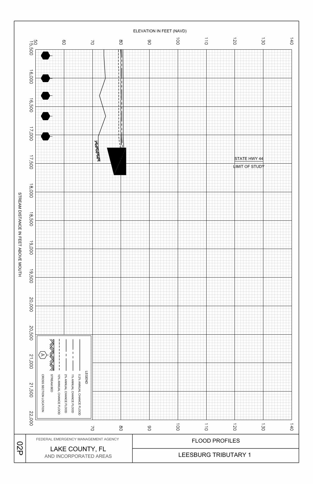
Leesburg Tributary 1 1.7 From mouth to State Hwy 44
Leesburg Tributary 2 1.5 From mouth to a point approximately 100 feet upstream of Main Street
Leesburg Tributary 2-1 0.3
Confluence with Leesburg Tributary 2 to a point approximately 1,410 feet upstream of confluence
Leesburg Tributary 3 0.4 From mouth to a point Approximately 310 feet upstream of Youngs Road
St. Johns River 7.0
Approximately 3.1 miles downstream of State Hwy 40 to a point approximately 3.9 miles upstream of State Hwy 40
Wolf Branch 2.2
From mouth to a point to approximately 620 feet upstream of Country Club Boulevard
Approximate analyses were used to study those areas having a low development potential or minimal flood hazards. This revision refined Zone A for all flooding sources listed in Table 4.

11
Table 4: Flooding Sources Studied by Approximate Methods Alexander Springs Creek Big Creek Billies Bay Black Water Creek Bugg Spring Eustis Meadows Glenn Branch Glenn Branch Tributary Hicks Ditch Jumping Gully Little Creek Live Oak Hammock Ninemile Branch Ninemile Creek Pittman Swamp Seminole Creek Sulpher Run Tracy Canal
Tributary 1 to Alexander Springs Creek
Tributary 1 to Black Water Creek
Tributary 1 to Jumping Gulley
Tributary 1 to Lake Dexter Tributary 1 to Ninemile
Creek Tributary 2 to Alexander
Springs Creek Tributary 2 to Lake Dexter Tributary 2 to Lake Dorr Tributary 2 to Little Creek Tributary 2 to Little Lake
Harris Tributary 2 to Tracy Canal Tributary 3 to Black Water
Creek Tributary 3 to Lake Dexter
Tributary 3 to Lake Dorr Tributary 3 to Sulphur Run Tributary 3-1 to Black Water
Creek Tributary 4 to Black Water
Creek Tributary 4 to St. Johns River Tributary 4-1 to Black Water
Creek Tributary 5 to St. Johns River Tributary 6 to St. Johns River Tributary 6-1 to St. Johns
River Tributary 6-2 to St. Johns
River Tributary to Black Water
Swamp Tributary to Lake Norris Unnamed Tributary to
Lake Harris
This revision to the countywide FIS also incorporates the determination of letters issued by FEMA resulting in Letters of Map change as shown in Table 5, “Letters of Map Revision (LOMRs) Incorporated into Current Study.”
Table 5: Letters of Map Revision (LOMRs) Incorporated into Current Study
Case Number Flooding Source(s) Communities
Affected Effective
Date
97-04-377P Zone A Ponding Area North of Wolf Branch Road City of Mt. Dora 5/27/1999
02-04-323P Zone A Ponding Areas Lake County 7/5/2002
03-04-573P Lake Frances Lake County 12/23/2003
04-04-353P Lake Everglades Ponding Area Nos. 1 through 6 Lake County 11/4/2004
04-04-363P Schoolhouse Lake Lake County 3/16/2005
12
Case Number Flooding Source(s) Communities
Affected Effective
Date
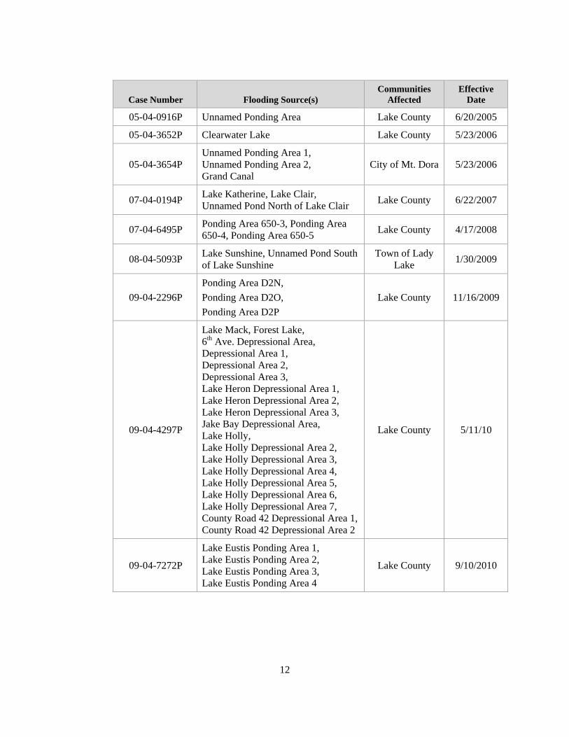
05-04-0916P Unnamed Ponding Area Lake County 6/20/2005
05-04-3652P Clearwater Lake Lake County 5/23/2006
05-04-3654P Unnamed Ponding Area 1, Unnamed Ponding Area 2, Grand Canal
City of Mt. Dora 5/23/2006
07-04-0194P Lake Katherine, Lake Clair, Unnamed Pond North of Lake Clair Lake County 6/22/2007
07-04-6495P Ponding Area 650-3, Ponding Area 650-4, Ponding Area 650-5 Lake County 4/17/2008
08-04-5093P Lake Sunshine, Unnamed Pond South of Lake Sunshine
Town of Lady Lake 1/30/2009
09-04-2296P Ponding Area D2N, Ponding Area D2O, Ponding Area D2P
Lake County 11/16/2009
09-04-4297P
Lake Mack, Forest Lake, 6th Ave. Depressional Area, Depressional Area 1, Depressional Area 2, Depressional Area 3, Lake Heron Depressional Area 1, Lake Heron Depressional Area 2, Lake Heron Depressional Area 3, Jake Bay Depressional Area, Lake Holly, Lake Holly Depressional Area 2, Lake Holly Depressional Area 3, Lake Holly Depressional Area 4, Lake Holly Depressional Area 5, Lake Holly Depressional Area 6, Lake Holly Depressional Area 7, County Road 42 Depressional Area 1,County Road 42 Depressional Area 2
Lake County 5/11/10
09-04-7272P
Lake Eustis Ponding Area 1, Lake Eustis Ponding Area 2, Lake Eustis Ponding Area 3, Lake Eustis Ponding Area 4
Lake County 9/10/2010

13
Case Number Flooding Source(s) Communities
Affected Effective
Date
10-04-4299P
Unnamed Sand Mine Ponding Area, Heritage Hlls North Ponding Area, Heritage Hills Pond 1A, Heritage Hills Pond 1B, Heritage Hills Pond 2, Heritage Hills Pond 3
Lake County 1/10/2011
11-04-4633P Unnamed Ponding Area 3, Unnamed Ponding Area 4 Lake County 12/19/2011
2.2 Community Description
Lake County is located in central Florida, bounded on the east by Volusia, Seminole and the heavily developed Orange County; on the south by Polk County; on the west by Sumter County; and on the north by Marion County.
Topography in Lake County is varied. Ground elevations range from less than 5 feet above National Geodetic Vertical Datum of 1929 (NGVD) along the St. Johns River to a high of 312 feet NGVD (USGS; 7.5 min. Quads). Landforms in Lake County are of three basic types: ridges, valleys, and uplands. Lake County has 1,345 lakes whose surface areas are 2.5 acres or more. About 32 percent of the county is taken up by lakes, swamps, and marshes; 33 percent by open undeveloped land; 21 percent by agriculture; 12 percent by Ocala National Forest; and 2 percent by urban use.
The climate of the county is semitropical characterized by warm, humid summers and mild dry winters. The mean annual temperature is about 72 degrees Fahrenheit (°F). January is the coldest month with a mean minimum temperature of 50°F; however, occasional below-freezing temperatures occur. The hottest months are July and August, each with a mean maximum temperature of 92°F. Annual precipitation in Lake County averages about 51 inches, most of which occurs during the June-October rainy season.
Lake County has continued to be the site of rapid population growth and development owing to the popularity of central Florida as a major entertainment and recreational area. The County population more than doubled between the 1970 and 1990 censuses (increasing from 69,305 to 152,104), and is estimated to have increased another 24% by 1997 (State of Florida, February 1996). From April 1, 2000 to July 1, 2009, the populated increase was estimated at 48.3% with a total county population of 312,119 (U.S. Census, March 2011).
2.3 Principal Flood Problems
Floods can occur in Lake County any time during the year, however, they are most frequent during the June-October rainy season. Floods on the lakes would result from prolonged heavy rainfall over the study area with high antecedent lake stages. Floods on the streams would result from prolonged heavy rainfall over a large area. The flooding

14
would be more severe from rainfall associated with hurricanes or tropical storms and when antecedent rainfall has resulted in saturated ground conditions when the infiltration is minimal. Cloudburst storms can occur any time but do not constitute a serious flood hazard in the study area.
Information on past floods in Lake County is sparse. Heavy rainfall in late 1959 and the early spring of 1960 saturated the ground and raised the groundwater table well above normal. In September 1960, Hurricane "Donna" passed through the area causing significant flooding throughout Lake County. The flooding was considerably worse on the closed lake basins that depend on subsurface drainage. Table 6, "Historic Flood Elevations", lists lakes in Lake County with records of past stages. The table shows the historic peak, the date of the historic peak, and the date of the first year of record.
Table 6: Historic Flood Elevations
Lake Historic Peak (feet NAVD) Date
First Year of Records
Apopka 68.3 October 1936 1935 Beauclair 62.49 July 1968 1960 Carlton 62.52 November 1975 1960 Dora 64.7 1927 1927 Johns 97.46 August 1960 1959 Louisa 98.64 March 1960 1957 Minnehaha 98.04 April 1960 1945 Cherry 97.13 April 1959 1956 Yale 60.29 October 1960 1959
More recent flooding has also been recorded. Widespread flooding and property damages were observed in peninsular Florida in September 1994, when a tropical and non-tropical system combined to bring heavy rains. Heavy rains in December 1997 and January 1998 flooded a mobile home park in the Clermont area. An estimated 8 to 10 inches from Hurricane Frances in September 2004 flooded roads and a few homes in the central and northern part of Lake County (NOAA, March 2011).
2.4 Flood Protection Measures
Channelization for navigation purposes began as early as 1860 when a 4-foot channel was dug from the mouth of the Oklawaha River to Leesburg on Lake Griffin. Since that time, a great number of small public and private water control measures have been completed in Lake County. Lake Griffin has been regulated to some extent for more than 35 years by a control in the Oklawaha River at Moss Bluff, about 8 miles downstream of the lake. A timber control was placed in the Apopka-Beauclair canal in 1950, and the present lock and dam, about halfway between Lake Apopka and Lake Beauclair was opened in 1956. Also in 1956, the lock and dam in the canal between Lakes Eustis and Griffin was opened. The canals between Lakes Dora and Eustis and Lakes Apopka and Beauclair were deepened in 1958. Lake regulation has also been implemented on lakes in the

15
upper Palatlakaha basin which includes Lakes Cherry, Minneola, Minnehaha and Louisa.
For the City of Tavares, there are some privately owned retention/detention ponds, only the locks and control structures on the Apopka-Beauclair Canal, the Palatlakaha River, and the Oklawaha River affect the lake levels within the City of Tavares. Burrel Lock and Dam on Haines Creek, the outlet from Lake Eustis, acts to control the level of Lake Eustis and all waters upstream of the control in the City of Tavares.
There are no other existing or proposed flood protection projects which would significantly reduce the 1-percent-annual-chance flood levels in Lake County.
3.0 ENGINEERING METHODS
For the flooding sources studied by detailed methods in the community, standard hydrologic and hydraulic study methods were used to determine the flood-hazard data required for this study. Flood events of a magnitude that is expected to be equaled or exceeded once on the average during any 10-, 50-, 100-, or 500-year period (recurrence interval) have been selected as having special significance for floodplain management and for flood insurance rates. These events, commonly termed the 10-, 50-, 100-, and 500-year floods, have a 10-, 2-, 1-, and 0.2-percent chance, respectively, of being equaled or exceeded during any year. Although the recurrence interval represents the long-term, average period between floods of a specific magnitude, rare floods could occur at short intervals or even within the same year. The risk of experiencing a rare flood increases when periods greater than 1 year are considered. For example, the risk of having a flood that equals or exceeds the 1-percent-annual-chance flood in any 50-year period is approximately 40 percent (4 in 10); for any 90-year period, the risk increases to approximately 60 percent (6 in 10). The analyses reported herein reflect flooding potentials based on conditions existing in the community at the time of completion of this study. Maps and flood elevations will be amended periodically to reflect future changes.
3.1 Hydrologic Analyses
For this countywide study, hydrologic analyses were carried out to establish peak discharge frequency relationships for each flooding source studied by detailed and approximate methods affecting the community. A summary of peak discharge-drainage area relationships for streams studied by detailed methods is shown in Table 7, "Summary of Discharges."
The stillwater elevations for the 10-, 2-, 1-, and 0.2-percent-annual-chance floods for all lacustrine flooding sources have been determined and are summarized in Table 8, "Summary of Stillwater Elevations."
3.1.1 Methods for Flooding Sources with New or Revised Analyses in Current Study
Peak flood discharges for 10-, 2-, 1-, and 0.2-percent-annual-chance recurrence intervals were developed using the USACE Hydrologic Engineering Center’s Hydrologic Modeling System (HEC-HMS), Version 3.40, for all detailed study streams other than the St. Johns River. Peak discharges for St. Johns River

16
remain unchanged from that determined for the previous FIS.
SCS 24-hour Type II rainfall distribution was used for all design frequency simulations to develop runoff hydrographs. Rainfall values were obtained from the U.S. Department of Commerce Technical Paper No. 40 “Rainfall Frequency Atlas of the Eastern United States”. A 24 hours storm was chosen based on historical patterns. For 0.2% annual chance flood, rainfall values were interpolated using best fit curve.
Drainage basin boundaries for the detailed studied streams in Lake County were delineated using a digital elevation model (DEM) generated from the LIDAR data collected and processed in 2007, as well as a 1/3 arc-second National Elevation Dataset DEM. A weighted runoff curve number was calculated for each sub-basin by using an intersection of soils data, land use data, and sub-basin boundary data. The resultant runoff curve number is the weighted runoff curve number for the sub-basin.
Soils information was obtained from the St. Johns River Water Management District (SJRWMD) 1:500000 General Soil Map, Florida, 1982. Land Use data was obtained from the St. Johns River Water Management District. The Land Use data was based on 2004 Natural Color and color infrared aerial photography.
3.1.2 Methods for Flooding Sources Incorporated from Previous Studies
This section describes the methodology used in previous studies of flooding sources incorporated into this FIS that were not revised for this countywide study. Hydrologic analyses were carried out to establish peak discharge-frequency relationships for each flooding source studied by detailed methods affecting the community.
Precountywide Analyses
The hydrologic data for the St. Johns River was taken from the January 1979 Seminole County FIS and "Flood Plain Information, St. Johns River and Lake Beresford, Volusia and Lake Counties, Florida," (USACE, 1974). Additional information was obtained from a stage-frequency analysis at Lake George on the St. Johns River.
The hydrologic data for the Wekiva River was taken from the January 1979 Seminole County FIS. Lakes Dora, Johns, Apopka, Beauclair, and Carlton were taken from May 1979 Unincorporated Areas of Orange County FIS.
Lakes Louisa, Minnehaha, and Yale were analyzed by a frequency analysis of historical data using a Weibull distribution. Lakes Cherry and Minneola are connected hydraulically with Lake Minnehaha and differ in stage only by the amount of headloss caused by the flow between the lakes (FIS Lake County, October, 1981).

17
To analyze lakes where little or no stage records exist, rainfall-frequency estimates were obtained from statistical analysis of records from long term rainfall stations in and around Lake County. Results are as follows:
Rainfall (inches)
Duration 10-percent-
annual-chance2-percent-
annual-chance1-percent-
annual-chance 0.2-percent-
annual-chance
1-day 6.4 10.0 12.0 17.4
3-day 8.8 11.9 13.6 18.5
1-month 15.2 19.5 21.0 24.0
Lakes Akron, Bass, Grace, Jewel, Kathryn, Louisa, Lulu, Perch, Schimmerhorn, Sidney, Silver, South, and were analyzed using the Volumetric runoff method. Analysis of the soil characteristics and land use of each lake basin were used to determine the percent of rainfall that would be retained on land from a storm of specified duration and frequency and the corresponding percent that would run off the basin into the lake. The sum of the volume of runoff added to the volume of rain falling directly on the lake gives the total volume of rainfall the lake receives during the storm. A stage-capacity curve was developed for each lake using contours on the USGS Quadrangle maps [USGS; 7.5 min. Quads: Salt Springs (1970), Juniper Springs (1970), Astor (1972), Alexander Springs (1972), Lake Woodruff (1962/1970), Emeralda Island (1966), Umatilla (1965/1970), Paisley (1965/1970), Pine Lakes (1962/1970), Orange City (1964/1970), Leesburg East (1965), Eustis (1966/1970), Sorrento (1960/1970), Sanford SW (1965/1970), Howey-in-the-Hills (1969), Astatula (1962/1970), Apopka (1960/1970), Clermont West (1969), Clermont East (1962/1970), Lake Nellie (1959), and Lake Louisa (1959/1970)] and field surveys. Applying the computed volume to the stage- capacity curve revealed the stage required to store the storm rainfall excess in the lake for each storm considered. The 5-day duration, 10-, 2-, 1-, and 0.2-percent-annual-chance storms were analyzed for the above lakes and the results are listed in Table 8 in the "Summary of Stillwater Elevations". For Lake Kathryn, which has outlet capacity, it was necessary to consider the rate of inflow and outflow, as well as the volume. An outflow rating was developed for the north and south outlets of Lake Kathryn and the rainfall inflow routed through the lake by the modified Puls techniques.
The February 15, 1984, Town of Astatula FIS; February 15, 1984, City of Clermont FIS; March 5, 1984, City of Fruitland Park FIS; March 5, 1984, City of Groveland FIS; February 15, 1984, Town of Howey in the Hills FIS; February 15, 1984, Town of Lady Lake FIS; May 15, 1984, City of Mascotte FIS; February 15, 1984, Town of Minneola FIS; April 7, 1999, City of Leesburg FIS; and the May 15, 1984, Town of Montverde FIS flooding sources were reviewed for the effects of three storms: a 10-percent-annual-chance 24 hour storm, a 2-percent-annual-chance 24 hour storm and a 1-percent-annual-chance 24 hour

18
storm. Both existing and proposed conditions were studied. Base runoff coefficients ranged from 0.9 for impervious areas to 0.15 for Agricultural areas. The existing flood prone maps were utilized to determine the elevations of land locked lakes for the 1-percent-annual-chance flood, existing conditions. The calculated 1-percent-annual-chance flood was then deducted from the level and used as a base level for existing occupancy and land use.
The June 4, 1987, City of Eustis FIS used a rainfall-frequency estimates to analyze lakes where little or no stage records exist by using statistical analysis of records from long term rainfall stations in and around Lake County.
The lakes and ponding areas studied in detail in the City of Eustis, except Lake Eustis, were elevations taken from "Comprehensive Drainage Plan, Lake County, Florida, Phase II" (Newman, 1981). The 1-percent-annual-chance (base) flood elevations were obtained from aerial photographs taken during actual flooding conditions and were overlaid onto topographic maps. The 10- and 2-percent-annual-chance flood elevations were determined from the base flood elevations. The 0.2-percent-annual-chance flood was not determined.
The April 7, 1999, FIS for the City of Leesburg revision, used advanced Interconnected Pond Routing (adICPR) modeling to determine the elevations of Lake Hollywood and Ponding Areas K1-1, K1-2A, K1-2B, K1-2C, and K1-2D in St. Johns Basin.
The April 5, 1988, City of Mt. Dora FIS and March 16, 1988, City of Tavares FIS analysis of the 1-percent-annual-chance flood elevation on Lake John, Lake Nettie, and Lake Tern followed the procedures developed by M.A. Lopez in his report "Regional Flood Relations for Unregulated Lakes in West-Central Florida" (Lopez, 1984). This procedure utilizes information available from maps and rainfall data to calculate the volume of water for a designated-frequency flood, which is then used to determine the elevation of that flood.
The 1-percent-annual-chance flood elevation in the City of Mt. Dora, for Lake Dora was taken from the June 1984 Unincorporated Areas of Orange County FIS.
The 1-percent-annual-chance flood elevation in the City of Tavares, for Lakes Frances, Junietta, and Tavares were based on the regionalized flood relations for ungaged lakes. The calculations for Lake Eustis were based on the frequency analysis of lake volumes for lakes with previous water level records.
The April 3, 1989, City of Umatilla FIS used equations for rural areas developed in USGS Report 82-4012 were used with the estimated local drainage basin parameters for each lake to estimate the 1-percent-annual-chance rural peak discharge (USGS, 1982b). Equations developed in USGS Water Supply Paper 2207 were used to adjust the 1-percent-annual-chance rural peak discharge to the 1-percent-annual-chance urban peak discharge (Sauer, 1983). The parameters used in the regionalized regression equations include basin drainage area; basin

19
slope; basin length; basin storage; impervious area; two-hour, two- year estimated rainfall; and a basin development factor. The basin parameters were determined using a topographic map. The rainfall parameter was taken from TP-40 (NOAA, 1961). The basin development factor was chosen by engineering judgement and based on field observation. Flood inflow hydrographs for each lake were estimated using a unit-hydrograph method described in USGS Open- File Report 82-365 (Sauer, 1982).
Hydraulic analyses of the basins in Umatilla were performed to provide estimates of the elevation of the 1-percent-annual-chance flood. For the routing analyses, a relationship between lake-stage and lake-storage volume for each lake was determined. The stage-storage relationship was determined from contours obtained from USGS Quadrangle maps (7.5 min. Umatilla Quad, 1980). Structural geometry and elevations of culverts were obtained from field surveys. For culverts, the coefficient of discharge was assumed to be 0.80 and the roughness factor (Manning's "n") was assumed to be 0.015. Outflows from Lake Mary and Lake Umatilla were computed using a broad-crested-spillway equation. The coefficient of discharge for outflows from Lake Mary and Lake Umatilla was assumed to be 2.0.
The 1-percent-annual-chance water-surface elevations for Lake Pearl, Lake Owen, Muscle Lake, and Lake Yale in the City of Umatilla were determined using aerial photographs taken at the time of actual flooding and delineated onto topographic maps.
The remaining water-surface elevations in the City of Umatilla for the 1-percent-annual-chance flood were computed using an interconnected lake routing computer program developed for this study. The computer program accounts for storage, flow through connecting culverts, flow over broad-crested weirs including submerged flow, local inflow, and possible reverse flows out of the lakes. The discharge for each lake culvert was computed using a simplified version of the culvert equations described by the USGS (Bodhaine, 1968).
Data for fifteen years of continuous record and one historical peak are available for Lake Umatilla. A lake volume-frequency analysis similar to that described in Bulletin No. 1713 was performed for Lake Umatilla and indicated a 1-percent-annual-chance flood elevation of 70.4 feet NGVD. That elevation is in general agreement with the 1-percent-annual-chance flood elevation of 69.9 feet NGVD generated by the USGS procedures.
Analyses for the Initial Countywide FIS
Hydrology for the Lake County restudy was determined using a variety of methods. For the St. Johns River a Log Pearson III statistical analysis of gage records was used (USGS, 1982). For streams the USACE HEC-1 computer program was used (USACE, September 1990). For lakes and ponding areas the adICPR computer program was used (Streamline Technologies, November 1996). SCS hydrographs were used in both the HEC-1 and adICPR programs to

20
determine basin runoff. Peak rate factors were determined based on standard recommendations by NRCS [previously, Soil Conservation Service (SCS)] for various basin slopes.
Times of concentration were determined using either the SCS velocity method or the SCS lag equation (SCS, August 1972). Rainfall infiltration calculations were based on SCS curve number methods. Curve numbers were calculated based on SCS Lake County Soil maps (SCS, 1971), land-use as determined from 1995 Florida Department of Transportation aerials (Florida Department of Transportation, 1995), Digital aerial map files provided by the Lake County Water Authority (Lake County Water Authority, Spring 1994), and site visits.
Rainfall values were determined from analysis of rain gage data for locations in and around Lake County. Data was provided by the St. Johns River Water Management District and the National Weather Service (ibid.). A 4-day storm was chosen based on historical patterns.

21
Table 7: Summary of Discharges
Peak Discharge (Cubic Feet per Second)
FLOODING SOURCE AND LOCATION Drainage Area (Square Miles)
10-percent-annual-chance
2-percent-annual-chance
1-percent-annual-chance
02.-percent-annual-chance
LEESBURG TRIBUTARY 1
Approximately 800 feet downstream of the airport runway 3.6 938 1,605 1,920 2,561
Approximately 2,500 feet downstream of West Main Street 2.5 770 1,257 1,518 2,048
Approximately 1,450 feet downstream of West Main Street
2.2 740 1,205 1,452 1,967
LEESBURG TRIBUTARY 2
Approximately 1,200 feet downstream of Youngs Road 1.93 796 1,154 1,336 1,709
Approximately 1,400 feet upstream of Interstate 44 1.36 713 1,040 1,206 1,543
LEESBURG TRIBUTARY 2-1
At confluence with Leesburg Tributary 2 0.1 123 190 225 298
LEESBURG TRIBUTARY 3
Approximately 1,600 feet downstream of Youngs Road 0.76 748 1,124 1,302 1,683
Approximately 500 feet downstream of Youngs Road 0.21 261 394 463 622
ST. JOHNS RIVER
At Swamp Outflow 55.7 3,000 5,090 6,310 8,920

Table 7: Summary of Discharges (continued)
22
Peak Discharge (Cubic Feet per Second)
FLOODING SOURCE AND LOCATION Drainage Area (Square Miles)
10-percent-annual-chance
2-percent-annual-chance
1-percent-annual-chance
02.-percent-annual-chance
ST. JOHNS RIVER (CONTINUED)
At Astor Saunders Canal 3,070 12,120 16,592 18,506 23,075
WOLF BRANCH
At mouth 5.5 2,160 2,292 3,794 4,955
Approximately 850 feet downstream of Wolf Branch Road 5.2 2,144 2,261 3,761 4,905
Approximately 2,350 feet upstream of Wolf Branch Road 4.6 2,051 2,127 3,579 4,645
Just downstream of Country Club Boulevard 3.5 1,732 1,752 2,993 3,863

23
3.2 Hydraulic Analyses
Analyses of the hydraulic characteristics of flooding from the sources studied were carried out to provide estimates of the elevations of floods of the selected recurrence intervals. Users should be aware that flood elevations shown on the FIRM represent rounded whole-foot elevations and may not exactly reflect the elevations shown on the Flood Profiles or in the Floodway Data tables in the FIS report. Flood elevations shown on the FIRM are primarily intended for flood insurance rating purposes. For construction and/or floodplain management purposes, users are cautioned to use the flood elevation data presented in this FIS in conjunction with the data shown on the FIRM.
Locations of selected cross sections used in the hydraulic analyses are shown on the Flood Profiles (Exhibit 1). For stream segments for which a floodway was computed (Section 4.2), selected cross section locations are also shown on the FIRM (Exhibit 2).
Channel roughness coefficients (Manning's “n”) used in the hydraulic computations were selected based on field observations, aerial photos, and photographs of the stream and floodplain areas. Table 9, “Manning’s ‘n’ Values,” contains the channel and overbank "n" values for the streams studied by detailed methods. Roughness values used for the main channels ranged from 0.03 to 0.05 with floodplain roughness values from 0.06 to 0.15 for all flood frequencies.
Flood profiles were drawn showing the computed water-surface elevations for floods of the selected recurrence intervals.
The stillwater elevations for the 10-, 2-, 1-, and 0.2-percent-annual chance floods have been determined and are summarized in Table 8, “Summary of Stillwater Elevations.”
The hydraulic analyses for this study were based on unobstructed flow. The flood elevations shown on the Flood Profiles (Exhibit 1) are thus considered valid only if hydraulic structures remain unobstructed, operate properly, and do not fail.

24
Table 8: Summary of Stillwater Elevations
Stillwater Elevations (feet NAVD88)
Lake Name
Old Name If Changed for this
FIS Report FIRM Panel Number(s) Community Name
10-percent-annual-chance
2-percent-annual-chance
1-percent-annual-chance
0.2-percent-annual-chance
6th Avenue Depressional Area 150, 260 Lake County * * 44.2 *
Apopka Beauclair Canal
365, 370, 505, 525
Lake County * * 65.0 *
Bass Lake 235 Lake County 48.6 49.6 50.0 50.7 Bear Pond 385, 395, Lake County 58.6 58.9 59.0 * Big Prairie Lake 535, 550, Lake County 92.7 93.3 93.5 94.0 Blacks Still Lake 580 Lake County 80.0 83.3 84.7 87.1
Blue Lake 357 Lake County, City of Eustis 133.1 133.7 134.1 *
Boggy Marsh 675, 750 Lake County 117.3 118.0 118.3 118.9
Bonaire Pond Ponding Area K1-3 317 City of Leesburg * * 74.1 *
Center Lake 570 City of Clermont 96.1 96.8 97.1 * Cherry Lake 555, 560 Lake County 96.9 97.9 98.3 98.6 Church Lake 490 Lake County 86.8 87.8 88.1 89.0 Clearwater Lake 460 Lake County * * 89.0 * Cook Lake 333, 334, 335 Lake County 68.7 69.0 69.1 * Cook Lake 560 Lake County 96.9 97.9 98.3 98.6
*Data Not Available

Table 8: Summary of Stillwater Elevations (continued)
25
Stillwater Elevations (feet NAVD88)
Lake Name
Old Name If Changed for this
FIS Report FIRM Panel Number(s) Community Name
10-percent-annual-chance
2-percent-annual-chance
1-percent-annual-chance
0.2-percent-annual-chance
County Road 42 Depressional Area 1
150 Lake County * * 48.1 *
County Road 42 Depressional Area 2
150 Lake County * * 50.3 *
Crescent Lake 545 Lake County 105.1 106.1 106.5 107.4
Crescent Lake 210, 220 Lake County, City of Umatilla 68.7 69.0 69.1 *
Crescent Lake 570, 650 Lake County * * 99.0 * Crooked Lake 750 Lake County. 117.2 117.5 117.6 117.7
Crystal Lake 306 Lake County, City of Fruitland Park 76.5 78.1 78.9 80.6
Crystal Lake 570 City of Clermont 98.5 98.9 99.1 * Danger Pond 317 City of Leesburg * * 74.1 * Deep Lake Ponding Area F3G 215, 220 Lake County 63.7 63.9 64.0 * Depressional Area 1 260 Lake County * * 49.8 *
Depressional Area 2 260 Lake County * * 49.8 *
Depressional Area 3 260 Lake County * * 46.4 *
*Data Not Available

Table 8: Summary of Stillwater Elevations (continued)
26
Stillwater Elevations (feet NAVD88)
Lake Name
Old Name If Changed for this
FIS Report FIRM Panel Number(s) Community Name
10-percent-annual-chance
2-percent-annual-chance
1-percent-annual-chance
0.2-percent-annual-chance
Dilly Lake 486 Lake County * * 87.4 * Dilly Marsh 480, 486 Lake County * * 87.4 * Dream Lake 306, 307 City of Fruitland Park 71.0 72.2 72.8 74.1
Dukes Lake 535, 555, 565 Lake County,
City of Groveland, City of Mascotte
98.8 99.0 99.1 *
Dyches Lake 316, 317 City of Leesburg 78.8 79.0 79.1 *
East Crooked Lake 358 Lake County, City of Eustis * * 73.0 *
East Lake 570, 590 City of Clermont 97.7 98.6 99.1 *
East Lake 220 220 Lake County, City of Umatilla 78.7 78.9 79.0 *
East Lake Dixie 317 City of Leesburg 73.6 73.9 74.0 *
Edgewood Lake 560, 580 Lake County, Town of Minneola 98.1 98.8 99.1 *
Emeralda Marsh 180, 185, 190, 195 Lake County * * 60.0 *
Forest Lake 150,260, 252 Lake County * * 46.8 * Fountain Lake 309 City of Leesburg * * 70.1 *
Fountain Lake East 306 Lake County, City of Fruitland Park 85.7 85.9 86.2 86.4
*Data Not Available

Table 8: Summary of Stillwater Elevations (continued)
27
Stillwater Elevations (feet NAVD88)
Lake Name
Old Name If Changed for this
FIS Report FIRM Panel Number(s) Community Name
10-percent-annual-chance
2-percent-annual-chance
1-percent-annual-chance
0.2-percent-annual-chance
Fountain Lake West 306 City of Fruitland Park 79.3 82.5 83.7 86.0
Gallows Lake 535 Lake County, City of Mascotte 103.8 104.0 104.1 *
Grande Canal 359 Lake County * * 163.0 *
Grassy Lake 580 Lake County, Town of Minneola 83.6 84.8 85.4 *
Hancock Bay North 675 Lake County 109.7 109.9 110.1 110.8
Hancock Bay South 675 Lake County 113.4 113.7 113.8 114.1
Hancock Lake 675, 750 Lake County 114.4 114.6 114.7 114.9 Heritage Hills North Ponding Area
590 City of Clermont * * 106.5 *
Heritage Hills Pond 1A 590 City of Clermont * * 105.2 *
Heritage Hills Pond 1B 590 City of Clermont * * 112.9 *
Heritage Hills Pond 2 590 City of Clermont * * 113.7 *
*Data Not Available

Table 8: Summary of Stillwater Elevations (continued)
28
Stillwater Elevations (feet NAVD88)
Lake Name
Old Name If Changed for this
FIS Report FIRM Panel Number(s) Community Name
10-percent-annual-chance
2-percent-annual-chance
1-percent-annual-chance
0.2-percent-annual-chance
Heritage Hills Pond 3 590 City of Clermont * * 117.0 *
Hickorynut Lake 675 Lake County * * 106.0 * Hidden Lake 675 Lake County 110.9 111.5 111.7 112.2 Horseshoe Lake 370, 525 Lake County * * 65.0 * Horseshoe Lake East 525 Lake County 85.2 88.3 88.9 89.2
Horseshoe Lake West 495, 525 Lake County 82.3 83.7 84.8 88.5
Indianhouse Lake East 490, 555 Lake County 84.7 86.0 86.5 87.5
Indianhouse Lake West 490, 555 Lake County 85.3 86.1 86.5 87.5
Island Lake 205, 210 Lake County 73.6 73.9 74.0 * Island Lake 675 Lake County 101.8 103.6 104.4 106.2 Island Pond 380 Lake County 64.3 68.1 69.6 71.3
Jacks Lake 590 Lake County, City of Clermont 88.8 89.0 89.1 *
Jake Bay Depressional Area
260 Lake County * * 44.4 *
Johns Lake 595 Lake County 96.9 99.0 99.7 101.1
*Data Not Available

Table 8: Summary of Stillwater Elevations (continued)
29
Stillwater Elevations (feet NAVD88)
Lake Name
Old Name If Changed for this
FIS Report FIRM Panel Number(s) Community Name
10-percent-annual-chance
2-percent-annual-chance
1-percent-annual-chance
0.2-percent-annual-chance
Keene Lake 675 Lake County 110.0 110.6 110.8 111.0 Lake Akron 155, 235 Lake County 46.0 47.1 47.7 49.6 Lake Alice 170 Lake County 98.7 * 99.0 *
Lake Amos 380, 390
Lake County 60.8 63.1 64.1 *
Lake Apopka 505, 525, 580, 585,
595
Lake County, Town of Montverde 67.5 68.1 68.3 68.8
Lake Arlene Wash Pond 5 565, 570 Lake County 103.8 104.4 104.8 * Lake Arthur 490, 555, Lake County 82.7 83.9 84.3 85.4 Lake Audrey 565 Lake County 106.6 106.9 107.1 * Lake Beasley Ponding Area F1F 220 Lake County 69.7 69.9 70.6 * Lake Beauclair 367, 370, Lake County 64.0 64.7 65.0 65.6 Lake Bracy 220 Lake County 68.7 68.9 69.0 * Lake Burns 220 Lake County 73.6 73.9 74.0 * Lake Carlton 370 Lake County 64.0 64.7 65.0 65.6
Lake Catherine 555, 565 Lake County, City of Groveland 98.7 99.0 99.1 *
*Data Not Available

Table 8: Summary of Stillwater Elevations (continued)
30
Stillwater Elevations (feet NAVD88)
Lake Name
Old Name If Changed for this
FIS Report FIRM Panel Number(s) Community Name
10-percent-annual-chance
2-percent-annual-chance
1-percent-annual-chance
0.2-percent-annual-chance
Lake Charles 590 City of Clermont 88.6 88.9 89.1 * Lake Chloe Ponding Areas H1B 332, 334 Lake County 68.3 68.8 69.1 * Lake Clair 570 Lake County * * 103.0 * Lake Cooley 210 Lake County 69.7 69.9 70.0 * Lake David 565 City of Groveland 98.6 98.9 99.1 *
Lake Denham 320 Lake County, City of Leesburg * * 64.0 *
Lake Dicie 358 Lake County * * 73.0 *
Lake Dora 361, 362, 365, 366, 367, 370
Lake County, City of Tavares,
City of Mount Dora 64.0 64.7 65.0 65.6
Lake Dot 570 Lake County 96.0 96.8 98.9 * Lake Dot 356 City of Eustis 66.6 67.6 69.1 * Lake Douglas 565, 570 Lake County * * 97.0 * Lake Edwards 395 Lake County 58.6 58.9 59.0 * Lake Eldorado 220, 240 Lake County 64.8 65.1 65.2 *
Lake Ella-170 170 Lake County, Town of Lady Lake 78.6 78.9 79.0 *
Lake Ella-220 220 Lake County, City of Umatilla * * 70.3 *
*Data Not Available

Table 8: Summary of Stillwater Elevations (continued)
31
Stillwater Elevations (feet NAVD88)
Lake Name
Old Name If Changed for this
FIS Report FIRM Panel Number(s) Community Name
10-percent-annual-chance
2-percent-annual-chance
1-percent-annual-chance
0.2-percent-annual-chance
Lake Elsie 355, 362 Lake County, City of Tavares 73.4 73.8 74.1 *
Lake Enola 220 Lake County * * 70.5 * Lake Etowah 355 Lake County 72.6 73.0 73.1 *
Lake Eustis
195, 215, 331, 332, 334, 345,
355, 356, 361
Lake County, City of Eustis, City of Tavares
62.5 63.4 63.8 64.6
Lake Eustis Area Pond 1 332 Lake County 65.8 * 66.5 66.7
Lake Eustis Area Pond 2 332 Lake County 66.0 66.6 67.1 67.2
Lake Eustis Area Pond 3 332, 355 Lake County 66.1 66.6 67.1 67.2
Lake Eustis Area Pond 4 332 Lake County 67.7 68.0 68.1 68.2
Lake Felter 590 Lake County, City of Clermont 86.3 88.0 88.7 90.5
Lake Florence 585 Lake County, Town of Montverde 74.2 75.1 75.5 76.4
Lake Frances 215 Lake County * * * * Lake Frances 355, 361, 362 City of Tavares * * 68.4 *
*Data Not Available

Table 8: Summary of Stillwater Elevations (continued)
32
Stillwater Elevations (feet NAVD88)
Lake Name
Old Name If Changed for this
FIS Report FIRM Panel Number(s) Community Name
10-percent-annual-chance
2-percent-annual-chance
1-percent-annual-chance
0.2-percent-annual-chance
Lake Franklin 367 City of Mt. Dora 104.4 105.3 105.6 106.0 Lake Gary 650 Lake County 102.3 102.9 103.1 103.4 Lake Gem 306 City of Fruitland Park 87.6 90.2 91.0 91.5 Lake Geneva 220 City of Umatilla * * 74.2 *
Lake Gertrude 358, 359, 366 Lake County, City of Mt. Dora 69.9 71.4 72.0 73.5
Lake Gibson 210 Lake County 74.7 74.9 75.0 * Lake Glona 650 Lake County 102.2 102.8 103.0 104.1 Lake Grace 235 Lake County 46.7 47.4 47.8 49.6 Lake Gracie 356 City of Eustis * * 64.1 *
Lake Griffin
170, 180, 190, 195, 307, 309, 330, 331
Lake County, City of Fruitland Park * * 60.5 *
Lake Harris
317, 320, 330, 333, 334, 340, 345, 361, 480, 485
Lake County, City of Leesburg, City
of Tavares * * 63.8 *
Lake Hermosa 170 Lake County, Town of Lady Lake 83.8 83.9 84.0 *
*Data Not Available

Table 8: Summary of Stillwater Elevations (continued)
33
Stillwater Elevations (feet NAVD88)
Lake Name
Old Name If Changed for this
FIS Report FIRM Panel Number(s) Community Name
10-percent-annual-chance
2-percent-annual-chance
1-percent-annual-chance
0.2-percent-annual-chance
Lake Hermosa 355 Lake County, City of Eustis 72.4 72.9 73.1 *
Lake Heron Depressional Area 1
252 Lake County * * 57.4 *
Lake Heron Depressional Area 2
252 Lake County * * 59.9 *
Lake Heron Depressional Area 3
150, 260 Lake County * * 59.2 *
Lake Holly 260 Lake County * * 51.4 * Lake Holly Depressional Area 2
260 Lake County * * 50.2 *
Lake Holly Depressional Area 3
260 Lake County * * 56.6 *
Lake Holly Depressional Area 4
260 Lake County * * 56.5 *
*Data Not Available

Table 8: Summary of Stillwater Elevations (continued)
34
Stillwater Elevations (feet NAVD88)
Lake Name
Old Name If Changed for this
FIS Report FIRM Panel Number(s) Community Name
10-percent-annual-chance
2-percent-annual-chance
1-percent-annual-chance
0.2-percent-annual-chance
Lake Holly Depressional Area 5
252 Lake County * * 57.0 *
Lake Holly Depressional Area 6
252 Lake County * * 58.0 *
Lake Holly Depressional Area 7
252, 260 Lake County * * 58.2 *
Lake Hollywood 317 City of Leesburg * * 74.1 * Lake Idamere 345, 365 Lake County 67.6 68.8 69.3 70.5 Lake Illinois 485 Lake County, Town
of Howey in the Hills 78.7 79.0 79.1 *
Lake Jewel 235 Lake County 47.3 48.2 48.7 50.4
Lake Joanna 357, 359 Lake County, City of Mt. Dora 153.7 154.0 154.1 *
Lake John 359, 367 City of Mt. Dora 79.9 81.4 81.9 82.9 Lake Josephine Ponding Area F4C 210 Lake County 63.7 63.9 64.0 *
Lake Junietta 355 Lake County, City of Tavares * * 67.7 *
Lake Katherine 570 Lake County * * 107 * Lake Kathryn 125, 150 Lake County 40.6 42.1 44.0 46.6
*Data Not Available

Table 8: Summary of Stillwater Elevations (continued)
35
Stillwater Elevations (feet NAVD88)
Lake Name
Old Name If Changed for this
FIS Report FIRM Panel Number(s) Community Name
10-percent-annual-chance
2-percent-annual-chance
1-percent-annual-chance
0.2-percent-annual-chance
Lake Keith Ponding Area F1G 220 Lake County 69.6 69.9 70.0 * Lake King 210 Lake County 73.6 73.9 74.0 * Lake Lincoln 357 Lake County 73.6 74.0 74.1 * Lake Linda Ponding Area HIE 333, 334 Lake County 69.6 69.9 70.1 * Lake Lizzie Ponding Area 220-2 220 Lake County 72.2 72.8 73.1 * Lake Lorraine Ponding Area G1-2 309 City of Leesburg 68.6 69.0 69.1 *
Lake Louisa 570, 590, 650, 675 Lake County 98.4 99.0 99.2 99.5
Lake Louise 358 Lake County, City of Eustis 78.5 78.9 79.1 *
Lake Lucerne 317 City of Leesburg * * 72.1 * Lake Lucie 395 Lake County 61.0 62.8 63.5 65.1 Lake Lulu 235 Lake County 46.0 47.1 47.7 49.6 Lake Mack 252, 260 Lake County * * 58.1 * Lake Madge 380 Lake County * * 80.0 *
Lake Maggie 357 Lake County, City of Eustis * * 154.1 *
Lake Mary Lake 357-1 220, 357 Lake County 73.8 74.0 74.1 *
Lake Mary 220 Lake County, City of Umatilla * * 70.5 *
*Data Not Available

Table 8: Summary of Stillwater Elevations (continued)
36
Stillwater Elevations (feet NAVD88)
Lake Name
Old Name If Changed for this
FIS Report FIRM Panel Number(s) Community Name
10-percent-annual-chance
2-percent-annual-chance
1-percent-annual-chance
0.2-percent-annual-chance
Lake Minnehaha 570, 590 Lake County, City of Clermont 97.8 98.6 98.8 99.1
Lake Minneola 560, 570 Lake County,
City of Clermont, Town of Minneola
97.4 98.2 98.6 98.9
Lake Minneola Ponding Area F6A 210 Lake County 73.7 73.9 74.0 * Lake Needham 675 Lake County * * 106.0 * Lake Nellie 650 Lake County 99.8 100.3 100.5 101.3 Lake Nettie 367 City of Mt. Dora 88.1 89.0 89.3 89.8
Lake Nettie 356, 358 Lake County, City of Eustis 63.6 64.0 64.1 *
Lake Oleo Ponding Area F3H 205, 210, 215, 220 Lake County 68.8 68.9 69.0 *
Lake Ouida Ponding Area B10N 210 Lake County 63.7 63.9 64.0 *
Lake Owen 205, 210 Lake County 68.7 68.9 69.0 *
Lake Palatlakaha 570 Lake County, City of Clermont 97.8 98.6 98.8 99.1
Lake Palm 220 City of Umatilla * * 78.8 *
Lake Pearl 210 Lake County, City of Umatilla 78.6 78.9 79.0 *
*Data Not Available

Table 8: Summary of Stillwater Elevations (continued)
37
Stillwater Elevations (feet NAVD88)
Lake Name
Old Name If Changed for this
FIS Report FIRM Panel Number(s) Community Name
10-percent-annual-chance
2-percent-annual-chance
1-percent-annual-chance
0.2-percent-annual-chance
Lake Pearl Ponding Area B10O 210 Lake County 63.6 63.9 64.0 *
Lake Sallie Ponding Area D2C 170 Town of Lady Lake 83.7 83.9 84.0 *
Lake Saunders 355, 358, 362 Lake County,
City of Mt. Dora 76.5 77.2 77.5 78.2
Lake Schimmerhorn 75 Lake County 48.8 49.8 50.3 51.5
Lake Seneca 380 Lake County 75.4 77.2 78.0 79.2 Lake Sidney 235 Lake County 46.3 47.4 48.1 50.3 Lake Smith 220 Lake County 68.7 68.9 69.1 * Lake Sparkling Water 570 City of Clermont 98.4 98.9 99.1 *
Lake Spencer 555 Lake County 83.2 84.2 84.6 85.5 Lake Sunnyside 570 City of Clermont 98.1 98.8 99.1 * Lake Sunshine 170 Town of Lady Lake 66.7 67.9 68.6 * Lake Susan 570 Lake County * * 99.0 * Lake Swatara 357 Lake County 71.6 71.7 71.8 *
Lake Tavares 362 Lake County, City of Tavares * * 70.9 *
Lake Tem 366 Lake County, City of Mt. Dora * * 81.3 *
*Data Not Available

Table 8: Summary of Stillwater Elevations (continued)
38
Stillwater Elevations (feet NAVD88)
Lake Name
Old Name If Changed for this
FIS Report FIRM Panel Number(s) Community Name
10-percent-annual-chance
2-percent-annual-chance
1-percent-annual-chance
0.2-percent-annual-chance
Lake Umatilla 220 Lake County, City of Umatilla * * 68.9 *
Lake Vista 675 Lake County * * 106.2 * Lake Wash 565, 570 Lake County 99.5 100.2 100.5 101.2
Lake Willie Lake 356-1 356 Lake County, City of Eustis 103.1 103.8 104.1 *
Lake Winona 570 City of Clermont 97.8 98.6 98.8 99.1 Lake Woodward
358 Lake County, City of Eustis,
City of Mt. Dora 73.5 73.9 74.1 *
Lake Yale 185, 195, 205, 215 Lake County 60.3 60.5 60.6 60.7
Leesburg Unnamed Pond 316, 317 Lake County,
City of Leesburg 69.7 70.0 70.1 70.3
Little Bluff Lake 535 Lake County, City of Mascotte 98.6 99.0 99.1 *
Little Everglades Area No. 1 490, 495 Lake County * * 83.4 *
Little Everglades Area No. 2 490 Lake County * * 85.3 *
Little Everglades Area No. 3 490, 495 Lake County * * 84.8 *
*Data Not Available

Table 8: Summary of Stillwater Elevations (continued)
39
Stillwater Elevations (feet NAVD88)
Lake Name
Old Name If Changed for this
FIS Report FIRM Panel Number(s) Community Name
10-percent-annual-chance
2-percent-annual-chance
1-percent-annual-chance
0.2-percent-annual-chance
Little Everglades Area No. 4 490, 495 Lake County * * 87.0 *
Little Everglades Area No. 5 490, 495 Lake County * * 85.2 *
Little Everglades Area No. 6 490, 495 Lake County * * 84.9 *
Little Grassy Lake 580 Lake County, Town of Minneola 86.2 88.6 89.6 91.4
Little Lake Blackwelder Lake 530-1 490, 555 Lake County 88.6 89.8 90.3 91.5
Little Lake Bracy Ponding Area H5E 220 Lake County 73.8 73.9 74.0 *
Little Lake Harris 485, 495, 505, 525
Lake County, Town of Howey in
the Hills, Town of Astatula
63.4 63.8 63.9 64.1
Long Lake Ponding Area 650-2 675 Lake County 102.9 104.3 105.0 106.5
Martins Lake 580 Town of Minneola 87.6 88.6 89.1 * Minneola Annex Pond 1
560 Town of Minneola 91.4 93.8 94.8 97.2
Minneola Annex Pond 2 560 Town of Minneola 93.8 96.1 97.1 97.3
*Data Not Available

Table 8: Summary of Stillwater Elevations (continued)
40
Stillwater Elevations (feet NAVD88)
Lake Name
Old Name If Changed for this
FIS Report FIRM Panel Number(s) Community Name
10-percent-annual-chance
2-percent-annual-chance
1-percent-annual-chance
0.2-percent-annual-chance
Mirror Lake 306 City of Fruitland Park 81.3 83.1 83.9 86.0 Mirror Lake 235 Lake County 46.7 47.4 47.8 49.6 Mirror Lake Ponding Area F3I 220 Lake County 68.6 68.9 69.0 * Mirror Lake Ponding Area H5C 220 Lake County 69.7 69.9 70.0 * Mount Plymouth Lake 385, 395 Lake County 63.8 64.0 64.1 *
Mule Pond Ponding Area H6E 220 Lake Co. 83.3 83.8 84.0 *
Muscle Lake 210 Lake County
City of Umatilla 68.6 68.9 69.0 *
Myrtle Lake 306, 308 Lake County, City of Fruitland Park 70.3 71.3 71.8 72.8
Neighborhood Lakes North 395 Lake County 58.7 59.4 59.7 60.3
Neighborhood Lakes South 395 Lake County 59.1 60.2 60.7 61.4
North Twin Lake 210 Lake County, City of Umatilla 63.7 63.9 64.0 *
Olsen Lake 565 Lake County * * 100.1 *
Park Lake 170 Lake County, Town of Lady Lake 73.9 74.0 74.0 *
Peanut Pond Ponding Area H6F 220 Lake Co. 78.6 78.9 79.0 *
*Data Not Available

Table 8: Summary of Stillwater Elevations (continued)
41
Stillwater Elevations (feet NAVD88)
Lake Name
Old Name If Changed for this
FIS Report FIRM Panel Number(s) Community Name
10-percent-annual-chance
2-percent-annual-chance
1-percent-annual-chance
0.2-percent-annual-chance
Perch Lake 235 Lake County 48.6 49.6 50.0 * Pike Lake 675 Lake County 100.6 101.5 101.9 102.7 Pine Island Lake 565, 650 Lake County 107.7 107.9 108.1 108.3 Pine Meadows Lake Ponding Area H5B 220 Lake County 69.7 69.9 70.0 *
Plum Lake 580 Lake County, Town of Minneola 84.1 85.7 86.5 88.2
Pond Chain 580-1 Pond Chain 555-1 580 Lake County 82.0 84.5 84.8 87.0 Ponding Area 07-3 309 City of Leesburg 73.3 73.9 74.1 * Ponding Area 07-5 309 City of Leesburg 73.8 74.0 74.1 * Ponding Area 07-7
308, 309 City of Leesburg 73.2 73.8 74.1 *
Ponding Area 180-1 180 Lake County * * 61.0 *
Ponding Area 220-1 220, 357 Lake County 68.3 68.8 69.0 *
Ponding Area 306-1 306 Lake County * * 79.0 *
Ponding Area 308-1 308 City of Fruitland Park * * 73.0 *
Ponding Area 345-1 345 Lake County 78.6 81.0 82.0 *
*Data Not Available

Table 8: Summary of Stillwater Elevations (continued)
42
Stillwater Elevations (feet NAVD88)
Lake Name
Old Name If Changed for this
FIS Report FIRM Panel Number(s) Community Name
10-percent-annual-chance
2-percent-annual-chance
1-percent-annual-chance
0.2-percent-annual-chance
Ponding Area 359-1
359 City of Mt. Dora * * 76.0 *
Ponding Area 359-2 359 Lake County,
City of Mt. Dora * * 168.0 *
Ponding Area 362-1 362 Lake County * * 80.0 *
Ponding Area 367-1 367 Lake County,
City of Mt. Dora * * 115.0 *
Ponding Area 378-1 378 Lake County * * 161.0 *
Ponding Area 378-2 378 Lake County * * 160.0 *
Ponding Area 378-3 378, 390 Lake County * * 150.0 *
Ponding Area 378-4 378 Lake County * * 120.0 *
Ponding Area 378-5 378 Lake County * * 108.0 *
Ponding Area 378-6 378 Lake County * * 86.0 *
*Data Not Available

Table 8: Summary of Stillwater Elevations (continued)
43
Stillwater Elevations (feet NAVD88)
Lake Name
Old Name If Changed for this
FIS Report FIRM Panel Number(s) Community Name
10-percent-annual-chance
2-percent-annual-chance
1-percent-annual-chance
0.2-percent-annual-chance
Ponding Area 378-7 378, 380, 390 Lake County * * 80.0 *
Ponding Area 380-1 380 Lake County * * 69.0 *
Ponding Area 380-2 380 Lake County * * 70.0 *
Ponding Area 380-3 380 Lake County * * 70.0 *
Ponding Area 380-4 380 Lake County * * 71.0 *
Ponding Area 395-1 395 Lake County * * 62.0 *
Ponding Area 395-2 395 Lake County * * 55.0 *
Ponding Area 480-1
Ponding Area 455-1 480, 485 Lake County 82.5 83.3 83.6 84.3
Ponding Area 486-1
Ponding Area 461-1 486 Lake County * * 87.0 *
Ponding Area 495-1
Ponding Area 470-1 495 Lake County 85.1 87.3 88.2 88.7
Ponding Area 505-1
Ponding Area 480-1 505 Town of Astatula 69.1 69.1 69.1 *
*Data Not Available

Table 8: Summary of Stillwater Elevations (continued)
44
Stillwater Elevations (feet NAVD88)
Lake Name
Old Name If Changed for this
FIS Report FIRM Panel Number(s) Community Name
10-percent-annual-chance
2-percent-annual-chance
1-percent-annual-chance
0.2-percent-annual-chance
Ponding Area 505-2
Ponding Area 480-2 505 Town of Astatula 79.1 79.1 79.1 *
Ponding Area 505-3
Ponding Area 480-3 505 Town of Astatula 74.1 74.1 74.1 *
Ponding Area 505-4
Ponding Area 480-4 505 Lake County,
Town of Astatula 74.1 74.1 74.1 *
Ponding Area 535-1
Ponding Area 510-1 535 Lake County * * 95.0 *
Ponding Area 550-1
Ponding Area 525-1 550 Lake County * * 98.0 *
Ponding Area 550-2
Ponding Area 525-2 535, 550 Lake County * * 94.0 *
Ponding Area 550-3
Ponding Area 525-3 550 Lake County * * 95.0 *
Ponding Area 560-1
Ponding Area 535-1 560 Town of Minneola 99.4 100.1 100.2 100.4
Ponding Area 560-2
Ponding Area 535-2 560 Town of Minneola * * 99.0 *
Ponding Area 580-1
Ponding Area 555-1 580, 585 Lake County,
Town of Montverde 80.4 81.4 82.0 83.0
Ponding Area 580-2
Ponding Area 555-2 580, 585 Lake County,
Town of Montverde 80.4 81.4 81.9 82.9
*Data Not Available

Table 8: Summary of Stillwater Elevations (continued)
45
Stillwater Elevations (feet NAVD88)
Lake Name
Old Name If Changed for this
FIS Report FIRM Panel Number(s) Community Name
10-percent-annual-chance
2-percent-annual-chance
1-percent-annual-chance
0.2-percent-annual-chance
Ponding Area 580-3
Ponding Area 555-3 580 Lake County 85.3 88.8 90.2 93.1
Ponding Area 590-1
Ponding Area 565-1 590 City of Clermont 96.3 98.2 99.0 *
Ponding Area 675-3
Ponding Area 650-3 675 Lake County * * 96.1 *
Ponding Area 675-4
Ponding Area 650-4 675 Lake County * * 96.1 *
Ponding Area 675-5
Ponding Area 650-5 675 Lake County * * 92.2 *
Ponding Area 750-1
Ponding Area 725-1 750 Lake County * * 114.0 *
Ponding Area A 485 Town of Howey in the Hills 73.7 74.0 74.1 *
Ponding Area B 485 Town of Howey in the Hills 78.9 79.0 79.1 *
Ponding Area B10B 210 Lake County 64.7 64.9 65.0 *
Ponding Area B10C 210 Lake County 64.6 64.9 65.0 *
*Data Not Available

Table 8: Summary of Stillwater Elevations (continued)
46
Stillwater Elevations (feet NAVD88)
Lake Name
Old Name If Changed for this
FIS Report FIRM Panel Number(s) Community Name
10-percent-annual-chance
2-percent-annual-chance
1-percent-annual-chance
0.2-percent-annual-chance
Ponding Area B10D 210 Lake County 82.7 82.9 83.0 *
Ponding Area B10E 210 Lake County 78.5 78.8 79.0 *
Ponding Area B10F 210 Lake County 68.6 68.9 69.1 *
Ponding Area B10G 210 Lake County 63.5 63.8 64.0 *
Ponding Area B10H 210 Lake County 68.5 68.8 69.0 *
Ponding Area B10I 210 Lake County * * 64.0 *
Ponding Area B10J 210 Lake County * * 64.0 * Ponding Area B10K 210 Lake County 64.5 64.9 65.0 *
Ponding Area B10M 210 Lake County 63.6 63.9 64.0 *
Ponding Area B21D 395 Lake County 57.7 58.6 59.0 *
Ponding Area B21E 385 Lake County 56.5 56.8 57.0 *
*Data Not Available

Table 8: Summary of Stillwater Elevations (continued)
47
Stillwater Elevations (feet NAVD88)
Lake Name
Old Name If Changed for this
FIS Report FIRM Panel Number(s) Community Name
10-percent-annual-chance
2-percent-annual-chance
1-percent-annual-chance
0.2-percent-annual-chance
Ponding Area B21F 395 Lake County 58.1 58.7 59.0 *
Ponding Area B30A 395 Lake County 58.6 58.9 59.0 *
Ponding Area B30C 385, 395 Lake County 60.6 60.9 61.0 *
Ponding Area B30D 395 Lake County 57.7 58.6 59.0 *
Ponding Area C 485 Town of Howey in the Hills 82.9 83.7 84.1 *
Ponding Area D2B 170 Town of Lady Lake 68.6 68.9 69.0 * Ponding Area D2E1 170 Town of Lady Lake 78.9 79.0 79.0 *
Ponding Area D2E2 170 Lake County 83.7 83.9 84.0 *
Ponding Area D2G 170 Town of Lady Lake 68.6 68.9 69.0 * Ponding Area D2H 170 Town of Lady Lake 68.4 68.8 69.0 * Ponding Area D2J 170 Town of Lady Lake 70.0 70.3 70.6 * Ponding Area D2K 170 Town of Lady Lake 73.6 73.9 74.0 * Ponding Area D2L 170 Town of Lady Lake 73.5 73.8 74.0 * Ponding Area D2M 170 Town of Lady Lake 68.6 68.8 69.0 *
*Data Not Available

Table 8: Summary of Stillwater Elevations (continued)
48
Stillwater Elevations (feet NAVD88)
Lake Name
Old Name If Changed for this
FIS Report FIRM Panel Number(s) Community Name
10-percent-annual-chance
2-percent-annual-chance
1-percent-annual-chance
0.2-percent-annual-chance
Ponding Area D2N 170 Town of Lady Lake * * 65.9 * Ponding Area D2O 170 Town of Lady Lake * * 71.8 * Ponding Area D2P 170 Town of Lady Lake * * 72.7 * Ponding Area E 485 Lake County, Town
of Howey in the Hills 73.6 73.9 74.1 *
Ponding Area E3B 170 Lake County, Town of Lady Lake 74.6 75.0 75.0 *
Ponding Area F1A 215 Lake County 73.6 73.9 74.0 * Ponding Area F1D 215, 220 Lake County 73.4 73.8 74.0 * Ponding Area F1H 215, 220 Lake County 68.7 68.9 69.1 * Ponding Area F3D 210 Lake County 68.7 68.9 69.0 * Ponding Area F3F 205, 210 Lake County 73.6 73.9 74.0 * Ponding Area F5B 210 Lake County 78.5 78.8 79.0 * Ponding Area F6B 210 Lake County 73.6 73.9 74.0 * Ponding Area F6C 210 Lake County 73.6 73.9 74.0 * Ponding Area F6D 210 Lake County 73.3 73.8 74.0 * Ponding Area G1-3 309 City of Leesburg * * 72.1 *
Ponding Area G1-4 309 City of Leesburg, City
of Fruitland * * 65.1 *
*Data Not Available

Table 8: Summary of Stillwater Elevations (continued)
49
Stillwater Elevations (feet NAVD88)
Lake Name
Old Name If Changed for this
FIS Report FIRM Panel Number(s) Community Name
10-percent-annual-chance
2-percent-annual-chance
1-percent-annual-chance
0.2-percent-annual-chance
Ponding Area G4B 170 Lake County, Town of Lady Lake 68.4 68.8 69.0 *
Ponding Area G4C 170 Town of Lady Lake * * 79.0 * Ponding Area G7B 331 Lake County 67.7 68.0 68.1 * Ponding Area G7C 331 Lake County 62.7 63.0 63.1 * Ponding Area G7D 331 Lake County 68.8 69.0 69.1 * Ponding Area G7E 331 Lake County 67.9 68.7 69.1 * Ponding Area G7F 333 Lake County 68.5 68.9 69.1 * Ponding Area G7H 331, 332 Lake County 67.7 68.0 68.1 * Ponding Area G7HA 331 Lake County 63.6 63.9 64.1 *
Ponding Area G7I 331, 332 Lake County 68.7 69.0 69.1 * Ponding Area G7J 331 Lake County 68.6 69.0 69.1 * Ponding Area G8B 330 Lake County 68.7 69.0 69.1 * Ponding Area G9-1 309 Lake County,
City of Leesburg * * 69.1 *
Ponding Area G9-2 309 City of Leesburg 73.9 74.0 74.1 *
Ponding Area G9-3 309 City of Leesburg * * 72.0 *
Ponding Area H1B 332, 334 Lake County 68.3 68.8 69.1 *
*Data Not Available

Table 8: Summary of Stillwater Elevations (continued)
50
Stillwater Elevations (feet NAVD88)
Lake Name
Old Name If Changed for this
FIS Report FIRM Panel Number(s) Community Name
10-percent-annual-chance
2-percent-annual-chance
1-percent-annual-chance
0.2-percent-annual-chance
Ponding Area H1C 332 Lake County 68.7 69.0 69.1 * Ponding Area H1D 331, 333 Lake County 73.0 73.7 74.1 * Ponding Area H1H 334 Lake County 68.5 68.9 69.1 * Ponding Area H1I 333 Lake County 68.4 68.9 69.1 * Ponding Area H5A 220 Lake County 69.6 69.9 70.0 * Ponding Area H5F 220 Lake Co. 73.6 73.9 74.0 * Ponding Area H5G 220 Lake Co. 80.1 80.7 81.0 * Ponding Area J-1-1 560 Lake Co., Town of
Montverde 73.1 73.7 74.1 *
Ponding Area K1-1 317 City of Leesburg * * 72.1 *
Ponding Area K1-2 317 City of Leesburg * * 74.1 * Ponding Area K1-2A 317 City of Leesburg * * 74.3 *
Ponding Area K1-2B 317 City of Leesburg * * 73.1 *
Ponding Area K1-2C 317 City of Leesburg * * 72.2 *
Ponding Area K1-2D 317 City of Leesburg * * 72.0 *
*Data Not Available

Table 8: Summary of Stillwater Elevations (continued)
51
Stillwater Elevations (feet NAVD88)
Lake Name
Old Name If Changed for this
FIS Report FIRM Panel Number(s) Community Name
10-percent-annual-chance
2-percent-annual-chance
1-percent-annual-chance
0.2-percent-annual-chance
Ponding Area K1A 340, 460, 480, Lake Co. 73.6 73.9 74.1 *
Ponding Area K1B 330 Lake Co. 63.8 64.0 64.1 *
Ponding Area K4-1 330, 340 Lake Co., City of Leesburg 65.0 65.1 65.1 *
Ponding Area K5A 460 Lake Co. 78.3 78.9 79.1 * Ponding Area K5B 320, 460 Lake Co. 73.4 73.9 74.1 * Ponding Area K5C 320 Lake Co. 68.4 68.9 69.1 * Ponding Area K5E 320 Lake County 83.4 83.8 84.1 * Ponding Area K5F 320 Lake County 76.8 76.8 77.1 * Ponding Area K5H 460 Lake County 72.7 73.0 73.1 * Ponding Area K-11-3 485 Lake County, Town
of Howey in the Hills 83.8 84.0 84.1 *
Ponding Area K-11-6 485 Town of Howey in the
Hills 78.6 78.9 79.1 *
Ponding Area K-11-7 485 Town of Howey in the
Hills 78.8 79.0 79.1 *
Ponding Area K-11-8 485 Town of Howey in the
Hills 76.6 78.3 79.1 *
Ponding Area L1A 460 Lake County 81.2 81.9 82.1 * Ponding Area L1B 460 Lake County 81.1 81.8 82.1 *
*Data Not Available

Table 8: Summary of Stillwater Elevations (continued)
52
Stillwater Elevations (feet NAVD88)
Lake Name
Old Name If Changed for this
FIS Report FIRM Panel Number(s) Community Name
10-percent-annual-chance
2-percent-annual-chance
1-percent-annual-chance
0.2-percent-annual-chance
Ponding Area L1C 460 Lake County 83.6 84.0 84.1 * Ponding Area L1D 460 Lake County 83.1 83.8 84.1 * Ponding Area L1E 460 City of Leesburg 78.9 79.0 79.1 * Ponding Area L1F 320 Lake County 78.6 78.9 79.1 *
Ponding Area Q2-1 308, 316 Lake County, City of Leesburg * * 77.1 *
Ponding Area Q3-2 316 Lake County, City of Leesburg 78.0 78.1 78.1 *
Ponding Area Q3-4 308, 309 Lake County, City of Leesburg 77.5 77.9 78.1 *
Ponding Area Q4-6 316, 317 Lake County, City of Leesburg 79.0 79.1 79.2 *
Ponding Area West of Plum Lake (L-26)
580 Town of Minneola 89.0 89.7 90.9 *
Round Lake Ponding Area 650-1 675 Lake County 99.8 101.7 102.6 104.5
Sap Pond 480 Lake County 82.8 83.0 83.1 * Saw Mill Lake 650 Lake County 100.5 101.7 102.3 104.1 Sawgrass Bay 675 Lake County 105.4 106.1 106.4 106.8 Sawgrass Lake 675 Lake County 105.3 106.1 106.4 106.8
*Data Not Available

Table 8: Summary of Stillwater Elevations (continued)
53
Stillwater Elevations (feet NAVD88)
Lake Name
Old Name If Changed for this
FIS Report FIRM Panel Number(s) Community Name
10-percent-annual-chance
2-percent-annual-chance
1-percent-annual-chance
0.2-percent-annual-chance
Schoolhouse Lake 495,560 Lake County * * 89.0 * Shady Nook Lake 570 City of Clermont 98.1 98.8 99.1 * Shepherd Lake 560, 580 Lake County 84.6 85.6 86.1 87.1 Silver Lake 235 Lake County 48.6 49.6 50.0 50.7 Silver Lake 331, 333 Lake County 68.8 69.0 69.1 * Smith Pond 485 Lake County 83.7 84.0 84.1 * South Lake 235 Lake County 48.6 49.6 50.0 50.7 South Twin Lake 210 Lake County 63.7 63.9 64.0 * South Twin Lake 210 Lake County 63.8 64.0 64.1 *
Spring Lake 170, 306 Lake County, City of Fruitland Park 74.0 74.0 74.1 *
Spring Lake 570 City of Clermont 98.0 98.8 99.1 * Square Lake 675 Lake County 107.3 109.6 110.4 111.0
Stewart Lake 565 Lake County, City of Groveland * * 100.1 *
Sumner Lake 565, 570 Lake County * * 97.3 * Sunset Lake 570 City of Clermont * * 104.9 * Sunset Valley Lake 390 Lake County 77.7 80.7 81.9 84.0 Sylvan Lake Ponding Area F1C 220 Lake County 72.6 72.9 73.0 *
*Data Not Available

Table 8: Summary of Stillwater Elevations (continued)
54
Stillwater Elevations (feet NAVD88)
Lake Name
Old Name If Changed for this
FIS Report FIRM Panel Number(s) Community Name
10-percent-annual-chance
2-percent-annual-chance
1-percent-annual-chance
0.2-percent-annual-chance
Sylvia Lake-Lake Ivanhoe 170 Town of Lady Lake 68.7 69.0 69.0 *
Trout Lake 235 Lake County 46.3 47.4 48.1 *
Trout Lake 220, 355, 356 Lake County, City of Eustis * * 65.0 *
Trout Lake 675 Lake County 96.5 97.4 97.8 98.9
Unity Lake 170, 190, 307, 330 Lake County * * 64.0 *
Unnamed Lake West of Lake Joanna
358 Lake County 83.9 84.0 84.1 *
Unnamed Pond North of Lake Clair 570 Lake County * * 110.0 *
Unnamed Pond North of Lake Sunnyside
570 City of Clermont 123.1 123.8 124.0 *
Unnamed Pond South of Lake Sunshine
170 Town of Lady Lake 63.4 64.8 65.5 *
Unnamed Ponding Area 1
359 Lake County * * 165.0 *
Unnamed Ponding Area 2
359 Lake County * * 162.0 *
*Data Not Available

Table 8: Summary of Stillwater Elevations (continued)
55
Stillwater Elevations (feet NAVD88)
Lake Name
Old Name If Changed for this
FIS Report FIRM Panel Number(s) Community Name
10-percent-annual-chance
2-percent-annual-chance
1-percent-annual-chance
0.2-percent-annual-chance
Unnamed Ponding Area 3 675 Lake County * * 92.2 *
Unnamed Ponding Area 4 675 Lake County * * 90.1 *
Unnamed Sand Mine Ponding Area 590, 595 Lake County * * 101.5 *
Wash Lake 650 Lake County * * 101.0 * Wash Pond 1 565, 570 Lake County 99.6 100.4 100.7 * Wash Pond 2 565, 570 Lake County 99.6 100.4 100.7 * Wash Pond 3 565, 570 Lake County 99.6 100.4 100.7 * Wash Pond 4 565 Lake County 100.2 100.8 101.1 * West Crooked Lake 358 Lake County,
City of Eustis 73.0 73.2 73.3 *
West Lake 570 City of Clermont 98.1 98.8 99.1 * West Lake Dixie 317 City of Leesburg 73.6 73.9 74.0 *
Wilma Lake North 590 Lake County, City of Clermont 88.5 90.5 91.2 92.8
Wilma Lake South 590 Lake County, City of Clermont 86.0 88.8 90.2 92.8
Wilson Lake 560 Lake County * * 98.3 *
*Data Not Available

Table 8: Summary of Stillwater Elevations (continued)
56
Stillwater Elevations (feet NAVD88)
Lake Name
Old Name If Changed for this
FIS Report FIRM Panel Number(s) Community Name
10-percent-annual-chance
2-percent-annual-chance
1-percent-annual-chance
0.2-percent-annual-chance
Wolf Branch Sink 390 Lake County 77.7 80.7 81.9 84.5
Zephyr Lake 306 Lake County, City of Fruitland 108.5 108.9 109.1 *
*Data Not Available

57
3.2.1 Methods for Flooding Sources with New or Revised Analyses in Current Study
Water-surface profiles for the 10-, 2-, 1- and 0.2-percent-annual-chance recurrence intervals were computed for detailed analyses, and the water-surface profile for the 1-percent-annual-chance recurrence interval was computed for approximate analyses. The USACE HEC-RAS step-backwater computer program version 4.0 was utilized for hydraulic analyses of Leesburg Tributary 1, Leesburg Tributary 2, Leesburg Tributary 2-1, Leesburg Tributary 3, the St. Johns River, Wolf Branch, and all approximate study streams (USACE, 2008).
Hydraulic cross section geometries were obtained from the Digital Terrain Model (DTM) and supplemented with surveyed hydraulic data at various locations throughout the detailed studied reaches. All hydraulic structures were field surveyed for detailed analyses. The Watershed Information System (WISE) software was used for preprocessing HEC-RAS data (Watershed Concepts, 2008). No floodway was calculated for streams studied by approximate methods.
Starting conditions for the hydraulic models were set to normal depth using starting slopes calculated from channel elevation values taken from the DTM, or set based on known downstream water-surface elevations as appropriate. Manning’s n-values were estimated using high-resolution imagery and field photos for both channel and overbank areas.
Interconnected Channel and Pond Routing (ICPR) model, version 3.1, was used to determine the stillwater elevations for ponding areas located in Royal Trails Subdivision (Lake County, 2009).
3.2.2 Methods for Flooding Sources Incorporated from Previous Studies
Precountywide Analyses
Flood profiles were drawn showing computed water-surface elevations to an accuracy of 0.5 foot for floods of the selected recurrence intervals.
All elevations are measured from NGVD.
Flood boundaries in other locations in Lake County, which overflow relatively undeveloped areas, were determined by approximate methods. The approximate methods involved the use of USGS quadrangle maps [USGS; 7.5 min. Quads: Salt Springs (1970), Juniper Springs (1970), Astor (1972), Alexander Springs (1972), Lake Woodruff (1962/1970), Emeralda Island (1966), Umatilla (1965/1970), Paisley (1965/1970), Pine Lakes (1962/1970), Orange City (1964/1970), Leesburg East (1965), Eustis (1966/1970), Sorrento (1960/1970), Sanford SW (1965/1970), Howey-in-the-Hills (1969), Astatula (1962/1970), Apopka (1960/1970), Clermont West (1969), Clermont East (1962/1970), Lake Nellie (1959), and Lake Louisa (1959/1970)].

58
During floods, debris collecting at culverts could decrease their carrying capacity and cause greater water depths (backwater effect) upstream of the structures. However, since the occurrence and amount of debris are indeterminate factors, only the physical characteristics of the structures were considered in preparing the profiles. Flood elevations shown on the profiles are thus considered valid only if hydraulic structures in general remain unobstructed.
Encroachment on flood plains, such as artificial fill, reduces the flood-carrying capacity, increases the flood heights of streams, and increases flood hazards in areas beyond the encroachment itself. One aspect of flood plain management involves balancing the economic gain from flood plain development against the resulting increase in flood hazard. For purposes used as a tool to assist local communities in this aspect of flood plain management. A floodway is not appropriate in areas such as those that may be inundated by floodwaters from lakes and shallow flooding areas. The flood profiles for the St. Johns and Wekiva Rivers were taken from previous studies which did not include determination of floodways. It was determined at the pre-contract consultation and coordination meeting on November 27, 1978, to not include a floodway analysis for the St. Johns and Wekiva Rivers.
Analyses for the Initial Countywide FIS
For streams studied by detailed methods, water-surface elevations for the 10-, 2-, 1-, and 0.2-percent-annual-chance floods were computed using the USACE HEC-RAS water-surface profile computer programs (USACE, April 1997). All lakes were studied using adICPR. Starting water-surface elevations for streams were taken to be normal depth; for lakes, the starting water surface was determined based gage data; lake elevations reported on USGS quad sheets, supplementary one-foot topo, or new surveyed levels; controlling culvert invert elevations; or backwater from adjacent water bodies.
Channel cross sections and lake outlets were obtained from new surveys by DeGrove Surveyors, Inc., performed as part of that study.
Channel roughness factors (Manning's n) used in the hydraulic computations were selected based on field observations, aerial photos, and photographs of the stream and floodplain areas. Roughness values used for the main channels ranged from 0.03 to 0.08 with floodplain roughness values from 0.06 to 0.15 for all flood frequencies.
Gage data for historical storm events was used for determining discharges along the St. Johns River, initial starting elevations for lakes and verification of the adICPR lake models. Gage data was obtained from USGS (USGS, WATSTORE); the gages used were: 02236820 Lake Louisa, 02236840 Lake Minnehaha, 02236860 Lake Apshawa, 02236880 Cherry Lake, 02237370 Church Lake, 02237753 West Crooked Lake, 02237865 Lake Umatilla, 02238020 Silver Lake, 02238180 Holly Lake, 02238200 Lake Yale, 02266239 Trout Lake, 02312670 Lake Catherine, 02312694 Lady Lake, 02235260 Mt. Plymouth Lake,

59
02235150 Lake Don, 02237520 Lake Harris, 02237800 Lake Dora, 02237900 Lake Eustis, 02238300 Lake Griffin, 02236000 St. Johns River Near Deland, and 02236125 St. Johns River at Astor.
Table 9: Manning’s “n” Values
Flooding Source Channel “n” Overbank “n”
Leesburg Tributary 1 0.050 0.060-0.150
Leesburg Tributary 2 0.050 0.060-0.150
Leesburg Tributary 3 0.050 0.060-0.150
St. Johns River 0.030 0.060-0.150
Wolf Branch 0.050 0.060-0.150
3.3 Vertical Datum
All FIS reports and FIRMs are referenced to a specific vertical datum. The vertical datum provides a starting point against which flood, ground, and structure elevations can be referenced and compared. Until recently, the standard vertical datum used for newly created or revised FIS reports and FIRMs was the National Geodetic Vertical Datum of 1929 (NGVD 29). With the completion of the North American Vertical Datum of 1988 (NAVD 88), many FIS reports and FIRMs are now prepared using NAVD 88 as the referenced vertical datum.
All flood elevations shown in this FIS report and on the FIRM are referenced to the NAVD 88. These flood elevations must be compared to structure and ground elevations referenced to the same vertical datum. It is important to note that adjacent counties may be referenced to NGVD, which may result in differences in base flood elevations across county lines.
Ground, structure, and flood elevations may be compared and/or referenced to NGVD 29 by applying a standard conversion factor. For Lake County, Florida, the conversion factor to NGVD is 0.9 for the southern portion of the county and 1.0 for the northern portion of the county. The Elevation Reference Marks are referenced as NAVD 88 as indicated in the Elevation Reference Marks table shown on the FIRM.
The BFEs shown on the FIRM represent whole-foot rounded values. For example, a BFE of 102.4 feet will appear as 102 feet on the FIRM and 102.6 will appear as 103. Therefore, users who wish to convert the elevations in this FIS report to NGVD should apply the stated conversion factor to elevations shown on the Flood Profiles and supporting data tables in the FIS report, which are shown at a minimum to the nearest 0.1 foot.
For more information regarding conversion between the NGVD and NAVD, see the FEMA publication entitled Converting the National Flood Insurance Program to the

60
North American Vertical Datum of 1988 (FEMA, 1992), visit the National Geodetic Survey website at Hwww.ngs.noaa.govH, or contact the National Geodetic Survey at the following address:
NGS Information Services NOAA, N/NGS12 National Geodetic Survey SSMC-3, #9202 1315 East-West Highway Silver Spring, Maryland 20910-3282 (301) 713-3242
Temporary vertical monuments are often established during the preparation of a flood hazard analysis for the purpose of establishing local vertical control. Although these monuments are not shown on the FIRM, they may be found in the Technical Support Data Notebook associated with the FIS report and FIRM for this community. Interested individuals may contact FEMA to access these data.
To obtain current elevation, description, and/or location information for benchmarks shown on this map, please contact the Information Services Branch of the NGS at (301) 713-3242, or visit their website at www.ngs.noaa.gov.
4.0 FLOODPLAIN MANAGEMENT APPLICATIONS
The NFIP encourages State and local governments to adopt sound floodplain management programs. To assist in this endeavor, each FIS report provides 1-percent-annual-chance floodplain data, which may include a combination of the following: 10-, 2-, 1-, and 0.2-percent-annual-chance flood elevations; delineations of the 1- and 0.2-percent-annual-chance floodplains; and a 1-percent-annual-chance floodway. This information is presented on the FIRM and in many components of the FIS report, including Flood Profiles, Floodway Data tables, and Summary of Stillwater Elevation tables. Users should reference the data presented in the FIS report as well as additional information that may be available at the local community map repository before making flood elevation and/or floodplain boundary determinations.
4.1 Floodplain Boundaries
To provide a national standard without regional discrimination, the 1-percent-annual-chance flood has been adopted by FEMA as the base flood for floodplain management purposes. The 0.2-percent-annual-chance flood is employed to indicate additional areas of flood risk in the community. For each stream studied by detailed or limited detailed methods, the 1- and 0.2-percent-annual-chance floodplain boundaries have been delineated using the flood elevations determined at each cross section.
Between cross sections, the boundaries were interpolated based on contours developed from the Digital Terrain Model (BakerAECOM, 2010).

61
The 1- and 0.2-percent-annual-chance floodplain boundaries for streams studied by detailed methods are shown on the FIRM. On this map, the 1-percent-annual-chance floodplain boundary corresponds to the boundary of the areas of special flood hazards (Zones A and AE), and the 0.2-percent-annual-chance floodplain boundary corresponds to the boundary of areas of moderate flood hazards. In cases where the 1- and 0.2-percent-annual-chance floodplain boundaries are close together, only the 1-percent-annual-chance floodplain boundary has been shown. Small areas within the floodplain boundaries may lie above the flood elevations, but cannot be shown due to limitations of the map scale and/or lack of detailed topographic data.
For the flooding sources studied by approximate methods, only the 1-percent-annual-chance floodplain boundary is shown on the FIRM (Exhibit 2).
4.2 Floodways
Encroachment on floodplains, such as structures and fill, reduces flood-carrying capacity, increases flood heights and velocities, and increases flood hazards in areas beyond the encroachment itself. One aspect of floodplain management involves balancing the economic gain from floodplain development against the resulting increase in flood hazard. For purposes of the NFIP, a floodway is used as a tool to assist local communities in this aspect of floodplain management. Under this concept, the area of the 1-percent-annual-chance floodplain is divided into a floodway and a floodway fringe. The floodway is the channel of a stream, plus any adjacent floodplain areas, that must be kept free of encroachment so that the base flood can be carried without substantial increases in flood heights. Minimum Federal standards limit such increases to 1 foot, provided that hazardous velocities are not produced. The floodways in this study are presented to local agencies as minimum standards that can be adopted directly or that can be used as a basis for additional floodway studies.
The floodways presented in this study were computed for certain stream segments on the basis of equal-conveyance reduction from each side of the floodplain. Floodway widths were computed at cross sections. Between cross sections, the floodway boundaries were interpolated. The results of the floodway computations are tabulated for selected cross sections and provided in Table 10, “Floodway Data.” The computed floodway is shown on the FIRM (Exhibit 2). In cases where the floodway and 1-percent-annual-chance floodplain boundaries are either close together or collinear, only the floodway boundary is shown on the FIRM.
No floodway is shown for the Wekiva River and portions of the St. Johns River.
Encroachment into areas subject to inundation by floodwaters having hazardous velocities aggravates the risk of flood damage and heightens potential flood hazards by further increasing velocities. A listing of stream velocities at selected cross sections is provided in Table 10. To reduce the risk of property damage in areas where the stream velocities are high, the community may wish to restrict development in areas outside the floodway.

62
The area between the floodway and 1-percent-annual-chance floodplain boundaries is termed the floodway fringe. The floodway fringe encompasses the portion of the floodplain that could be completely obstructed without increasing the water-surface elevation (WSEL) of the base flood more than 1 foot at any point. Typical relationships between the floodway and the floodway fringe and their significance to floodplain development are shown in Figure 1.
Figure 1. Floodway Schematic

FLOODING SOURCE FLOODWAY BASE FLOOD WATER SURFACE ELEVATION
CROSS SECTION DISTANCE1 WIDTH (FEET)
SECTION AREA
(SQUARE FEET)
MEAN VELOCITY (FEET PER SECOND)
REGULATORY (FEET NAVD 88)
WITHOUT FLOODWAY (FEET NAVD 88)
WITH FLOODWAY (FEET NAVD 88)
INCREASE (FEET)
LEESBURG
TRIBUTARY 1
A 9,115 447 1,378 1.4 64.1 64.1 65.1 1.0 B 9,423 459 1,196 1.6 65.2 65.2 66.2 1.0 C 12,571 850 2,408 0.8 80.2 80.2 80.8 0.6 D 12,886 1,000 4,026 0.5 80.2 80.2 80.8 0.6 E 13,446 1,200 4,619 0.3 80.2 80.2 80.9 0.7 F 13,813 1,200 6,957 0.2 80.2 80.2 80.9 0.7 G 14,593 1,200 4,937 0.3 80.2 80.2 80.9 0.7 H 15,004 1,000 3,864 0.4 80.2 80.2 81.0 0.8 I 15,607 483 2,760 0.6 80.2 80.2 81.1 0.9 J 16,004 475 2,844 0.5 80.3 80.3 81.1 0.8 K 16,310 470 2,215 0.7 80.3 80.3 81.1 0.8 L 16,669 550 1,978 0.7 80.3 80.3 81.2 0.9 M 17,024 465 1,498 1.0 80.3 80.3 81.2 0.9
FEDERAL EMERGENCY MANAGEMENT AGENCY
LEESBURG TRIBUTARY 1LAKE COUNTY, FL
AND INCORPORATED AREAS
1 Feet above mouth.
TAB
LE 10
FLOODWAY DATA

FLOODING SOURCE FLOODWAY BASE FLOOD WATER SURFACE ELEVATION
CROSS SECTION DISTANCE1 WIDTH (FEET)
SECTION AREA
(SQUARE FEET)
MEAN VELOCITY (FEET PER SECOND)
REGULATORY (FEET NAVD 88)
WITHOUT FLOODWAY (FEET NAVD 88)
WITH FLOODWAY (FEET NAVD 88)
INCREASE (FEET)
LEESBURG
TRIBUTARY 2
A 3 478 1,142 1.2 64.4 64.4 65.4 1.0 B 461 37 128 10.5 69.1 69.1 69.1 0.0 C 907 30 197 6.8 74.6 74.6 74.9 0.3 D 1,436 400 1,910 0.7 78.4 78.4 79.0 0.6 E 1,971 400 1,646 0.8 78.4 78.4 79.0 0.6 F 2,848 224 1,266 1.1 78.6 78.6 79.3 0.7 G 3,498 326 2,131 0.6 78.7 78.7 79.5 0.8 H 3,978 200 769 1.7 78.7 78.7 79.7 1.0 I 4,851 325 1,509 0.9 79.4 79.4 80.0 0.6 J 5,452 325 640 2.1 79.4 79.4 80.4 1.0 K 6,200 216 523 2.3 81.7 81.7 81.9 0.2 L 6,827 206 777 1.6 82.3 82.3 82.7 0.4 M 7,261 146 651 1.9 82.6 82.6 83.0 0.4 N 7,763 160 637 1.9 82.7 82.7 83.4 0.7
FEDERAL EMERGENCY MANAGEMENT AGENCY
LEESBURG TRIBUTARY 2LAKE COUNTY, FL
AND INCORPORATED AREAS
1 Feet above mouth.
TAB
LE 10
FLOODWAY DATA

FLOODING SOURCE FLOODWAY BASE FLOOD WATER SURFACE ELEVATION
CROSS SECTION DISTANCE1 WIDTH (FEET)
SECTION AREA
(SQUARE FEET)
MEAN VELOCITY (FEET PER SECOND)
REGULATORY (FEET NAVD 88)
WITHOUT FLOODWAY (FEET NAVD 88)
WITH FLOODWAY (FEET NAVD 88)
INCREASE (FEET)
LEESBURG
TRIBUTARY 2-1
A 822 28 58 3.9 78.4 74.92 75.7 0.8 B 1,149 55 175 1.3 78.4 75.52 76.4 0.9 C 1,410 25 34 6.6 78.4 76.42 76.9 0.5
FEDERAL EMERGENCY MANAGEMENT AGENCY
LEESBURG TRIBUTARY 2-1LAKE COUNTY, FL
AND INCORPORATED AREAS
1 Stream distance in feet above confluence with Leesburg Tributary 2. 2 Elevation computed without consideration of backwater effects from Leesburg Tributary 2.
TAB
LE 10
FLOODWAY DATA

FLOODING SOURCE FLOODWAY BASE FLOOD WATER SURFACE ELEVATION
CROSS SECTION DISTANCE1 WIDTH (FEET)
SECTION AREA
(SQUARE FEET)
MEAN VELOCITY (FEET PER SECOND)
REGULATORY (FEET NAVD 88)
WITHOUT FLOODWAY (FEET NAVD 88)
WITH FLOODWAY (FEET NAVD 88)
INCREASE (FEET)
LEESBURG
TRIBUTARY 3
A 1,449 205 593 2.2 64.3 64.3 65.3 1.0 B 1,999 62 227 5.7 69.3 69.3 69.9 0.6 C 2,440 177 1,001 0.5 70.5 70.5 71.5 1.0 D 2,761 100 107 4.3 71.0 71.0 71.4 0.4
FEDERAL EMERGENCY MANAGEMENT AGENCY
LEESBURG TRIBUTARY 3LAKE COUNTY, FL
AND INCORPORATED AREAS
1 Feet above mouth.
TAB
LE 10
FLOODWAY DATA

FLOODING SOURCE FLOODWAY BASE FLOOD WATER SURFACE ELEVATION
CROSS SECTION DISTANCE1 WIDTH (FEET)
SECTION AREA
(SQUARE FEET)
MEAN VELOCITY (FEET PER SECOND)
REGULATORY (FEET NAVD 88)
WITHOUT FLOODWAY (FEET NAVD 88)
WITH FLOODWAY (FEET NAVD 88)
INCREASE (FEET)
ST. JOHNS
RIVER
A 650,002 7,2382/3,2533 57,630 0.3 6.0 6.0 7.0 1.0 B 654,720 5,2042/2,8233 42,525 0.4 6.1 6.1 7.1 1.0 C 657,880 7922/3273 17,672 1.1 6.1 6.1 7.1 1.0 D 662,328 7162/2673 12,937 1.4 6.1 6.1 7.1 1.0 E 666,334 9422/7103 10,779 1.7 6.2 6.2 7.2 1.0 F 666,591 9422/7183 13,309 1.6 6.3 6.3 7.3 1.0 G 670,351 1,6012/8903 18,677 1.0 6.4 6.4 7.3 0.9 H 673,881 7692/2973 14,250 1.3 6.4 6.4 7.4 1.0 I 677,612 7652/3803 14,119 1.3 6.5 6.5 7.4 0.9 J 683,384 2,0872/1,5793 24,406 0.8 6.5 6.5 7.5 1.0 K 687,038 2,3992/1,2123 33,224 0.6 6.6 6.6 7.6 1.0
FEDERAL EMERGENCY MANAGEMENT AGENCY
ST. JOHNS RIVERLAKE COUNTY, FL
AND INCORPORATED AREAS
1 Feet above mouth. 2 Total floodway width. 3 Floodway width within Lake County.
TAB
LE 10
FLOODWAY DATA

FLOODING SOURCE FLOODWAY BASE FLOOD WATER SURFACE ELEVATION
CROSS SECTION DISTANCE1 WIDTH (FEET)
SECTION AREA
(SQUARE FEET)
MEAN VELOCITY (FEET PER SECOND)
REGULATORY (FEET NAVD 88)
WITHOUT FLOODWAY (FEET NAVD 88)
WITH FLOODWAY (FEET NAVD 88)
INCREASE (FEET)
WOLF BRANCH
A 86 531 2,410 1.6 82.5 82.5 83.5 1.0 B 732 299 1,139 3.3 84.1 84.1 85.0 0.9 C 1,320 129 593 6.4 87.0 87.0 88.0 1.0 D 1,883 75 580 6.5 90.8 90.8 91.5 0.7 E 2,599 100 574 6.6 96.9 96.9 97.1 0.2 F 3,206 44 507 7.5 101.4 101.4 102.3 0.9 G 3,718 96 443 8.6 106.8 106.8 107.1 0.3 H 4,365 109 728 5.2 112.4 112.4 113.3 0.9 I 5,887 141 1,296 2.9 124.4 124.4 124.7 0.3 J 7,029 266 2,058 1.8 126.5 126.5 127.3 0.8 K 7,565 475 3,814 0.9 126.9 126.9 127.8 0.9 L 8,729 42 332 10.8 137.4 137.4 138.4 1.0 M 9,338 47 292 12.3 147.1 147.1 147.2 0.1 N 9,897 160 1,141 3.1 152.3 152.3 153.3 1.0 O 10,691 70 303 11.8 158.3 158.3 158.7 0.4 P 11,919 271 1,199 2.5 167.7 167.7 168.6 0.9
FEDERAL EMERGENCY MANAGEMENT AGENCY
WOLF BRANCHLAKE COUNTY, FL
AND INCORPORATED AREAS
1 Feet above mouth.
TAB
LE 10
FLOODWAY DATA

68
5.0 INSURANCE APPLICATIONS
For flood insurance rating purposes, flood insurance zone designations are assigned to a community based on the results of the engineering analyses. These zones are as follows:
Zone A
Zone A is the flood insurance rate zone that corresponds to the 1-percent-annual-chance floodplains that are determined in the FIS report by approximate methods. Because detailed hydraulic analyses are not performed for such areas, no base (1-percent-annual-chance) flood elevations (BFEs) or depths are shown within this zone.
Zone AE
Zone AE is the flood insurance rate zone that corresponds to the 1-percent-annual-chance floodplains that are determined in the FIS report by detailed methods. Whole-foot BFEs derived from the detailed hydraulic analyses are shown at selected intervals within this zone.
Zone X
Zone X is the flood insurance rate zone that corresponds to areas outside the 0.2-percent-annual-chance floodplain, areas within the 0.2-percent-annual-chance floodplain, areas of 1-percent-annual-chance flooding where average depths are less than 1 foot, areas of 1-percent-annual-chance flooding where the contributing drainage area is less than 1 square mile (sq. mi.), and areas protected from the base flood by levees. No BFEs or depths are shown within this zone.
Zone D
Zone D is the flood insurance rate zone that corresponds to unstudied areas where flood hazards are undetermined, but possible.
6.0 FLOOD INSURANCE RATE MAP
The FIRM is designed for flood insurance and floodplain management applications.
For flood insurance applications, the map designates flood insurance rate zones as described in Section 5.0 and, in the 1-percent-annual-chance floodplains that were studied by detailed methods, shows selected whole-foot BFEs or average depths. Insurance agents use zones and BFEs in conjunction with information on structures and their contents to assign premium rates for flood insurance policies.
For floodplain management applications, the map shows by tints, screens, and symbols, the 1- and 0.2-percent-annual-chance floodplains, floodways, and the locations of selected cross sections used in the hydraulic analyses and floodway computations.
The current FIRM presents flooding information for the entire geographic area of Lake County. This countywide FIRM includes flood hazard information previously printed on separate Flood

69
Hazard Boundary Maps and/or FIRMs that were prepared for each incorporated community identified as flood-prone and the unincorporated areas of the County. Historical data relating to the maps prepared for each community are presented in Table 11, “Community Map History.”

COMMUNITY NAME
INITIAL IDENTIFICATION
FLOOD HAZARD BOUNDARY MAP REVISIONS DATE
FIRM EFFECTIVE DATE
FIRM REVISIONS DATE
Astatula, Town of August 24, 1979 None August 15, 1984 None
Clermont, Town of May 31, 1974 January 30, 1976 August 15, 1984 None
Eustis, City of June 28, 1974 October 17, 1975 June 4, 1987 None
Fruitland Park, City of January 14, 1977 None September 5, 1984 None
Groveland, City of January 16, 1974 January 30, 1976 September 5, 1984 None
Howey in the Hills, Town of March 2, 1979 None August 15, 1984 None
Lady Lake, Town of August 15, 1984 None August 15, 1984 None
Lake County (Unincorporated Areas) May 26, 1978 None April 1, 1982 None
Leesburg, City of September 13, 1974 January 28, 1977 July 18, 1985 April 7, 1999
Mascotte, City of September 21 1979 None November 15, 1984 None
TAB
LE 11
FEDERAL EMERGENCY MANAGEMENT AGENCY
LAKE COUNTY, FL AND INCORPORATED AREAS
COMMUNITY MAP HISTORY

COMMUNITY NAME
INITIAL IDENTIFICATION
FLOOD HAZARD BOUNDARY MAP REVISIONS DATE
FIRM EFFECTIVE DATE
FIRM REVISIONS DATE
Minneola, Town of July 23, 1976 None August 15, 1984 None
Montverde, Town of November 15, 1984 None November 15, 1984 None
Mt. Dora, City of June 28, 1974 February 27, 1976 April 5, 1988 None
Tavares, City of August 2, 1974 September 12, 1975 March 16, 1988 None
Umatilla, City of May 31, 1974 January 30, 1976 April 3, 1989 None
TAB
LE 11
FEDERAL EMERGENCY MANAGEMENT AGENCY
LAKE COUNTY, FL AND INCORPORATED AREAS
COMMUNITY MAP HISTORY

72
7.0 OTHER STUDIES
FIS reports have been prepared for the unincorporated and incorporated areas of Marion, Volusia, Seminole, Orange, and Polk Counties and for the unincorporated areas of Sumter County.
This FIS report supersedes or is compatible with all previous studies published on streams studied in this report and should be considered authoritative for the purposes of the NFIP.
8.0 LOCATION OF DATA
Information concerning the pertinent data used in the preparation of this study can be obtained by contacting Federal Insurance and Mitigation Division, FEMA Region IV, Koger-Center — Rutgers Building, 3003 Chamblee Tucker Road, Atlanta, GA 30341.
9.0 BIBLIOGRAPHY AND REFERENCES
BakerAECOM, LLC, (2010). Digital Terrain Model developed from Lake County, FL, LiDAR Data (Lake County Board of County Commissioners, 4/5/2007); National Elevation Dataset (United States Geological Survey/EROS, 3/1/2008).
Bodhaine, G.L., U.S. Geological Survey. (1968). Measurement of Peak Discharge at Culverts by Indirect Methods.
Environmental Science & Engineering, Inc. (January 1992). Palatlakaha River Basin Hydrologic and Hydraulic Study. Volume I Lake County, Florida.
Environmental Science & Engineering, Inc. (February 1996). Water Quality Analysis of the Hicks Ditch Watershed of Lake County, Florida, Volume II, Draft Report. Lake County, Florida.
Federal Emergency Management Agency. (October 1, 1981) Flood Insurance Study, Lake County, Florida. Washington, D.C.
Federal Emergency Management Agency. (July 3, 2002) Flood Insurance Study, Lake County, Florida, and Incorporated Areas. Washington, D.C.
Federal Emergency Management Agency. (February 15, 1984). Flood Insurance Study, City of Clermont, Lake County, Florida. Washington, D.C.
Federal Emergency Management Agency. (February 15, 1984). Flood Insurance Study, Town of Astatula, Lake County, Florida. Washington, D.C.
Federal Emergency Management Agency. (February 15, 1984). Flood Insurance Study, Town of Howey in the Hills, Lake County, Florida. Washington, D.C.
Federal Emergency Management Agency. (February 15, 1984) . Flood Insurance Study, Town of Lady Lake, Lake County, Florida. Washington D.C.
Federal Emergency Management Agency. (February 15, 1984). Flood Insurance Study, Town of Minneola, Lake, Lake County, Florida. Washington D.C.
Federal Emergency Management Agency. (March 5, 1984). Flood Insurance Study, City of

73
Fruitland Park, Lake County, Florida. Washington D.C.
Federal Emergency Management Agency. (March 5, 1984). Flood Insurance Study, City of Groveland, Lake County, Florida. Washington D.C.
Federal Emergency Management Agency. (May 15, 1984). Flood Insurance Study, City of Mascotte, Lake County, Florida. Washington D.C.
Federal Emergency Management Agency. (May 15, 1984). Flood Insurance Study, Town of Montverde, Lake County, Florida. Washington D.C.
Federal Emergency Management Agency. (June, 1984). Flood Insurance Study, Orange County, Unincorporated Areas, Florida. Washington D.C.
Federal Emergency Management Agency. (June 4, 1987). Flood Insurance Study, City of Eustis, Lake County, Florida. Washington D.C.
Federal Emergency Management Agency. (April 5, 1988). Flood Insurance Study, City of Mt. Dora, Lake County, Florida. Washington D.C.
Federal Emergency Management Agency. (March 16, 1988). Flood Insurance Study, City of Tavares, Lake County, Florida. Washington D.C.
Federal Emergency Management Agency. (April 3, 1989). Flood Insurance Study, City of Umatilla, Lake County, Florida. Washington D.C.
Federal Emergency Management Agency. (June 1, 1992). Converting the National Flood Insurance Program to the North American Vertical Datum of 1988 - Guidelines for Community Officials, Engineers, and Surveyors. 3-0170.
Federal Emergency Management Agency. (April 7, 1999). Flood Insurance Study, City of Leesburg, Lake County, Florida. Washington, D.C.
Florida Department of Transportation. (1995). Index of Stereo Aerial Photographs of Lake County — Negative, Scale 1":2083'.
Lake County. (various dates). Topographic Aerial Maps, 1:2,400, 1 foot contours.
Lake County. (2009). Preliminary Flood Assessment Technical Memorandum – Royal Trails Flood Study – Prepared by Inwood Consulting Engineers for the Department of Public Works, Lake County.
Lopez, M.A., U.S. Geological Survey. (1984). Regional Flood Relations for Unregulated Lakes in West-Central Florida, Water-Resources Investigations Report 84-4015.
Lake County Water Authority. (Spring 1994). Digital Orthophotograph Quarter Quads, prepared from 1:40,000 color infrared aerial photography.
McCoy & Associates. (May 1994). 100-Year Flood Study, Southeastern Groveland Basin Lake

74
County, Florida.
National Oceanic and Atmospheric Administration, National Climatic Data Center. (March 22, 2011). “Storm Events.” [online], http://www4.ncdc.noaa.gov
National Oceanic and Atmospheric Administration, National Weather Service. (1961). Rainfall-Frequency Atlas of the United States, TP-40.
National Oceanic and Atmospheric Administration, National Weather Service. Digital files of Daily Precipitation Data. Asheville, North Carolina.
Newman Consulting Engineering. (1981). Comprehensive Drainage Plan, Lake County., Florida, Phase II.
Sauer, V.B., U.S. Geological Survey. (1983). Flood Characteristics of Urban Watersheds in the United States, Water Supply Paper 2207.
Sauer, V.B., U.S. Geological Survey. (1982). Techniques for Estimating Flood Hydrographs for Ungaged Urban Watersheds, Open-File Report 82-365.
Soil Conservation Service. (1971). Soil Survey Report, Maps and Interpretations, Lake County, Florida.
Soil Conservation Service. (August 1972). National Engineering Handbook, Section 4: Hydrology.
Soil Conservation Service. (August 1981). Flood Hazard Study, Blackwater Creek and Tributaries. Lake County, Florida.
State of Florida. (February 1996). Florida Population Estimates and Projections by County. Executive Office of the Governor.
Streamline Technologies. (November 1996). Advanced ICPR Computer Program. Version 2.11.
St. Johns River Water Management District. (May 1988). Rainfall Analysis for Northeast Florida, Part N 24-hour to 96-hour Maximum Rainfall for Return Periods 10 Years, 25Years, and 100 Years, Technical Publication SJ 88-3.
U.S. Army Corps of Engineers, Hydrologic Engineering Center. (December 1968 with updates). Computer Program 723-X6-L202A HEC-2 Water-Surface Profiles. Davis, California.
U.S. Army Corps of Engineers, Hydrologic Engineering Center. (1976). HEC-2 Water- Surface Profiles. Modification No. 58.
U.S. Army Corps of Engineers, Hydrologic Engineering Center. (September 1990). Computer Program HEC-1: Flood Hydrograph Package. Davis, California.
U.S. Army Corps of Engineers, Hydrologic Engineering Center. (April 1997). HEC-RAS River Analysis System. Version 2.2. Davis, California.

75
U.S. Army Corps of Engineers, Hydrologic Engineering Center. (March 2008). HEC-RAS River Analysis System. Version 4.0. Davis, California.
U.S. Army Corps of Engineers, Jacksonville District. (September 1974). Flood Plain Information, St. Johns River and Lake Beresford, Volusia and Lake Counties, Florida. Jacksonville, Florida.
U.S. Army Corps of Engineers, Jacksonville District. (January 1979). Flood Insurance Study, Unincorporated Seminole County, Florida.
U.S. Census. (March 22, 2011). “State and County Quickfacts: Florida Quicklinks.” [online]. http://quickfacts.census.gov/qfd/states/12/12069.html
U.S. Geological Survey. (1982). Guidelines for Determining Flood Flow Frequency, Bulletin No.17B.
U.S. Geological Survey. (1982b). Water Resources Investigations Report 82-4012, Technique for Estimating Magnitude and Frequency of Floods on Natural Flow Streams in Florida, Bridges, Wayne C.
U.S. Geological Survey. (various dates). 7.5 Minute-series Topographic Maps (all maps covering Lake County, scale 1:24,000, 5 foot contour intervals).
U.S. Geological Survey. WATSTORE computer hydrologic database.
Watershed Concepts, a Division of Hayes, Seay, Mattern & Mattern, Watershed Information System (WISE) Computer Software, v. 4.1.0 beta, 2008.
10.0 REVISION DESCRIPTIONS
This section has been added to provide information regarding significant revisions made since the original FIS was printed. Future revisions may be made that do not result in the republishing of the FIS report. To assure that the user is aware of all revisions, it is advisable to contact the community repository of flood-hazard data located at:
• Astatula Town Hall 25019 Country Road 561 Astatula, Florida 34705
• Clermont Planning and Zoning Department 685 W. Montrose Street – 1st Floor Clermont, Florida 34711
• Eustis Building Department 10 North Grove Street Eustis, Florida 32727-0068

76
• Fruitland Park City Hall Building Department 506 West Berckman Street Groveland, Florida 34731
• Howey in the Hills Town Hall 101 North Palm Avenue Howey in the Hills, Florida 34737
• Lady Lake Town Hall 409 Fennell Boulevard Lady Lake, Florida 32159
• Lake County Public Works Department 437 Ardice Avenue Eustis, Florida 32726
• Leesburg Public Works Department 550 South 14th Street Leesburg, Florida 34748
• Mascotte City Hall 100 East Myers Boulevard Mascotte, Florida 34753
• Minneola City Hall 800 North U.S. Highway 27 Minneola, Florida 34715
• Montverde Town Hall 17404 Sixth Street Montverde, Florida 34756
• Mt. Dora Building and Zoning 510 North Baker Street Mt. Dora, Florida 32757
• Tavares Planning and Zoning 201 East Main Street Tavares, Florida 32778
• Umatilla City Hall 1 South Central Avenue Umatilla, Florida 32784
10.1 First Revision (Revised December 18, 2012)
This December 18, 2012 revision was initiated in support of the FEMA Risk MAP Program.

77
This revision involved countywide remapping of Lake County, Florida. The revision included new detailed studies of St. Johns River, Leesburg Tributary 1, 2, 2-1 and 3 and Wolf Branch, refinement and establishment of approximate zones, redelineation of existing studies, and creation of new FIRMs using new topographic and base map data.