Embed Size (px)
Citation preview

LacduFlambeauTribeHazardMitigationPlanDraftforPublicCommentApril5,2019

2
ThisprojectwasfundedbytheFederalEmergencyManagementAssociation(Grant#:XXXXXXXX)andmanagedbytheEmergencyManagementDepartmentfortheLacduFlambeauTribe.Wewouldliketopersonallythankallofthecontributorswhoprovidedtheirtime,expertise,andinputintotheformationofthisdocumentincluding:theTribalCouncil;allthemembersoftheTribalEmergencyPlanningCommittee;andcommunitymembersandelderswhoprovidedinputandinsightsthataidedinthecreationofthisplan.SpecialthankstotheprojectcoreteamthatincludedEricChapman,DamonCoppola,BrianGauthier,GeorgeHaddow,ElluNasser,SaschaPetersen,andAndreVirden,
RecommendedCitation:LacduFlambeauTribe.2019.HazardMitigationPlan.Chapman,E.,Gauthier,B.,Petersen,S.,Haddow,G.,Cappola,D.,eds.FundedbytheFederalEmergencyManagementAgency.Available:http://www.ldftribe.com/resilienceCoverPhotoCredits:

3
Table of Contents TheLacduFlambeauTribeandOjibwePeople.............................................................................7
Part1:PlanningProcess(ElementA)................................................................................................9
Introduction......................................................................................................................................................9
PlanningProcess...........................................................................................................................................10PhaseI:CommunityEngagementandIdentificationofKeyHazards........................................................................10PhaseII:AnalysisofCurrentandFutureRisk......................................................................................................................12PhaseIII:DevelopmentofMitigationActions......................................................................................................................12PhaseIV:PlanReview.....................................................................................................................................................................12
TribalEmergencyPlanningCommittee................................................................................................12
PublicEngagementProcess......................................................................................................................13
InvolvingNeighboringJurisdictions......................................................................................................14
BuildingoffExistingConditionsandNewResearch.........................................................................14
KeepingthePlanCurrentandFutureUpdates...................................................................................15
Part2:PlanningArea............................................................................................................................16
GeographyandClimate..............................................................................................................................16
Population.......................................................................................................................................................19People.....................................................................................................................................................................................................19Employment,Economy,andEducation...................................................................................................................................20HistoricClimateObservation.......................................................................................................................................................20ChangingClimateConditions.......................................................................................................................................................21
NaturalandCulturalResources...............................................................................................................24
CriticalFacilities...........................................................................................................................................25
Part3:HazardIdentificationandRiskAssessment(ElementB)...........................................26
HazardIdentificationOverview..............................................................................................................26
AssessmentApproach/Methodology.....................................................................................................27AssessmentFactors..........................................................................................................................................................................27AssessmentFormula........................................................................................................................................................................29
HazardProfilesandAssessment.............................................................................................................301.PlantandAnimalEpidemic/InvasiveSpecies/SpeciesLoss...........................................................................312.IllegalDrugCrisis...................................................................................................................................................................363. SevereThunderstorms/Lightning/Hail...................................................................................................................404. Epidemic/Pandemic/Vector-BorneDisease..........................................................................................................425. Flood(flashflood,lake,river,stormwater)................................................................................................................456. SevereWinterStorms/IceStorms................................................................................................................................507. ForestandWildlandFires...................................................................................................................................................52

4
8.HazardousMaterialsRelease/Contamination/Run-off....................................................................................589.Tornado/HighWind...........................................................................................................................................................6210. ExtremeHeat.......................................................................................................................................................................6711. ExtremeCold.......................................................................................................................................................................7112. SchoolViolence/ArmedAttack/WorkplaceViolence...................................................................................7313. DamFailure..........................................................................................................................................................................75
PartIV:MitigationStrategies(ElementC).....................................................................................77
DevelopmentProcess..................................................................................................................................77
CriteriaforEvaluatingActions.................................................................................................................77
PriorityActions.............................................................................................................................................77
AllHazardMitigationActions...................................................................................................................781. AllHazards................................................................................................................................................................................782. PlantandAnimalEpidemic/InvasiveSpecies/SpeciesLoss...........................................................................793. IllegalDrugCrisis....................................................................................................................................................................794. SevereThunderstorms/Lightning/Hail...................................................................................................................815. Epidemic/Pandemic/Vector-BorneDisease..........................................................................................................826. Flood(flashflood,lake,river,stormwater)................................................................................................................837. SevereWinterStorms/IceStorms................................................................................................................................858. Forest/WildlandFire..........................................................................................................................................................859. HazardousMaterialsRelease/Contamination/Run-off.....................................................................................8710. Tornado/HighWind......................................................................................................................................................8811. ExtremeHeat.......................................................................................................................................................................8912. ExtremeCold.......................................................................................................................................................................8913. SchoolViolence/ArmedAttack/WorkplaceViolence...................................................................................8914. DamFailure..........................................................................................................................................................................90
PartV:PlanUpdates(ElementD).....................................................................................................91
FutureUpdates..............................................................................................................................................91
StatusofActionsIdentifiedinthe2006Plan......................................................................................91
PlanIntegration............................................................................................................................................91
PartVI:AssurancesandPlanAdoption(ElementE)..................................................................92
AppendixA:AnalysisofClimateData..............................................................................................93
ClimatologicalObservationsSummaries..............................................................................................93
SelectionofGeographicAreaofInterest..............................................................................................94
ClimateProjectionsSummaries..............................................................................................................96
AppendixB:PublicEngagement.....................................................................................................104

5
List of Figures Figure1:TheLacduFlambeauTribalResilienceInitiativeLogo................................................................................................11Figure2:LocationoftheLacduFlambeauReservationinNorthCentralWisconsin.........................................................16Figure3:LacduFlambeauReservationarea(blacksquare)andsurroundinglandscape..............................................17Figure4:LandcoverbytypefortheLacduFlambeauReservation...........................................................................................17Figure5:LandCoverandLandUseintheLacduFlambeauRegion..........................................................................................19Figure6:ProjectedchangesinAverageAnnualTemperaturefortheregion........................................................................22Figure7:ProjectedchangesinAverageAnnualPrecipitationfortheregion.........................................................................22Figure8:Summaryofprojectedchangesintemperatureandprecipitationbyseasonbythe2050s.........................23Figure9:Summaryofprojectedseasonalclimatechangesby2050...........................................................................................23Figure10:Manoomin(WildRice)harvestareasinandaroundthereservation..................................................................24Figure11:CriticalfacilitieswithintheLacduFlambeauReservation......................................................................................25Figure12:Rankingofthetop13keyhazardsandtheiroverallhazardranking.................................................................31Figure13:NationalOverdoseDeathsfromOpioidDrugsintheUnitedStatesbyYear.....................................................36Figure14:EmergencyMedicalServicesRunswithNaloxoneAdministrationbyPatientCountyofResidence......36Figure15:NumberofOpioidrelatedoverdosebytypeinWisconsin.........................................................................................37Figure16:NationalFloodHazarddesignationsfortheLacduFlambeauReservation....................................................48Figure17:NumberofWildfiresperyearontheLacduFlambeauReservationfrom1980-2013.................................53Figure18:DetailedwildfireeventsbycausefortheLacduFlambeauReservationfrom1980-2013.........................54Figure19:WildlandUrbanInterfacedesignationsfortheLacduFlambeauReservations.............................................55Figure20:EnhancedFujita(EF)Ratings,windspeeds,andexpecteddamages.....................................................................63Figure21:HeatWarningsforfrontlineorvulnerablepopulationsbasedontemperatureandhumiditylevels....68Figure22:Heatrelatedvulnerabilitybycensusblockgroup.........................................................................................................69Figure23:WildChillandrelativetemperatures..................................................................................................................................71Figure24:Averagewinter(December,January,February)temperaturesfortheStateofWisconsin........................72Figure25:LacduFlambeauTCRP'sAreaofInterest.........................................................................................................................94Figure26:TheAOIoverlaidontheNCEIClimateDivisions............................................................................................................95Figure27:TheGHCN-DStationObservationsaroundtheLacduFlambeauReservation................................................96Figure28:Depictionglobalandregionalclimatemodelresolution...........................................................................................97

6
List of Tables Table1:MembersoftheTribalEmergencyPlanningCommittee(TEPC)................................................................................13Table2:LandcoverbytypefortheLacduFlambeauReservation.............................................................................................18Table3:SummaryofkeyhistoricclimatevariablesfortheLacduFlambeauRegion.......................................................21Table4:Summaryofobservedchangesintemperatureandprecipitationfortheregion...............................................21Table5:CriticalfacilitieswithintheLacduFlambeauReservation...........................................................................................26Table6:VulnerabilityandriskassessmentforPlantandAnimalEpidemic...........................................................................34Table7:VulnerabilityandriskassessmentfortheIllegalDrugCrisis.......................................................................................39Table8:VulnerabilityandriskassessmentfortheSevereThunderstorms/Lightning/Hail.......................................41Table9:VulnerabilityandriskassessmentforEpidemic/Pandemic/VectorBorneDisease.......................................44Table10:VulnerabilityandriskassessmentforFlooding...............................................................................................................49Table11:VulnerabilityandriskassessmentforSevereWinterStorms/IceStorms..........................................................51Table12:VulnerabilityandriskassessmentforForestandWildlandFires............................................................................57Table13:SummaryofrecordedHazardousMaterialspills,releases,orleaksintheLacduFlambeauRegion.....59Table14:VulnerabilityandriskassessmentforHazardousMaterialsRelease/Contamination/Run-off.............61Table15:VulnerabilityandriskassessmentforTornado/HighWind.....................................................................................66Table16:VulnerabilityandriskassessmentforExtremeHeat.....................................................................................................70Table17:VulnerabilityandriskassessmentforExtremeCold......................................................................................................72Table18:VulnerabilityandriskassessmentforSchoolViolence/ArmedAttack/WorkplaceViolence..................74Table19:VulnerabilityandriskassessmentforDamFailure.......................................................................................................75Table20:PhaseI-ImplementationactionsidentifiedbytheTEPCasstartingpointsforaction..................................78Table21:Actionstomitigatetheriskofallnaturalandmanmadehazardsaffectingthecommunity......................78Table22:ActionstomitigatetheriskofPlant&AnimalEpidemics/InvasiveSpecies/SpeciesLoss.......................79Table23:ActionstomitigatetheriskoftheIllegalDrugCrisis....................................................................................................80Table24:ActionstomitigatetheriskofSevereThunderstorms/Lightning/Hail............................................................81Table25:ActionstomitigatetheriskofEpidemic/Pandemic/Vector-BorneDisease...................................................82Table26:ActionstomitigatetheriskofFlooding..............................................................................................................................84Table27:ActionstomitigatetheriskofSevereWinterStorms/IceStorms.........................................................................85Table28:ActionstomitigatetheriskofWildfire/StructureFire..............................................................................................86Table29:Actionstomitigatetheriskofnaturalorman-madeHazardousMaterialsrelease.......................................87Table30:ActionstomitigatetheriskofTornadoes/HighWinds..............................................................................................88Table31:ActionstomitigatetheriskofExtremeHeat....................................................................................................................89Table32:ActionstomitigatetheriskofExtremeCold.....................................................................................................................89Table33:ActionstomitigatetheriskofSchoolViolence/ArmedAttacks/WorkplaceViolence...............................90Table34:ActionstomitigatetheriskofDamFailure.......................................................................................................................90Table35:SummaryofRegCM4historicalperformance...................................................................................................................99Table36:InstitutionsproducingGCMsimulationsusedtoprovideboundaryconditionstoRegCM4......................100Table37:ListofthevariableschosenbyTCRP,AI,andGLISAfortheclimateanalysisoftheAOI.............................101

7
The Lac du Flambeau Tribe and Ojibwe People Before Columbus made his voyages, Cortes conquered Mexico, and Samuel de Champlain searched for a series of lakes he believed would link the Pacific with the Atlantic, the Anishinabe (Original People) lived near the mouth of the St. Lawrence River on the east coast. From there, they migrated slowly to the west guided by 7 prophecies that their journey would end where they found food growing on water. The prophecy was fulfilled after a centuries-long migration when they found manoomin (wild rice) in the waters of Lake Superior. By 1600 they had settled where the water of Lake Superior enters Lake Huron.
“Since their early history, the Ojibwe have called themselves Anishinabe, meaning spontaneously created or original man, and many prefer this name today. Thus, man was the
last form of life to be placed on the Earth. From the Original Man came the A-nish-i-na’be people. - Edward Beton-Banai”
The Lac du Flambeau Band of Lake Superior Chippewa (Ojibwe) Indians have inhabited the Lac du Flambeau area since 1745 when Chief Kishkemun (Sharpened Stone) led the Band to the area. This was three decades before the birth of the United States and more than a century before Wisconsin became a state. The Band acquired the name Waaswaagoning (Lac du Flambeau) from its gathering practice of harvesting fish at night by torchlight. The name Lac du Flambeau, or Lake of the Torches, refers to this practice and was given to the Band by the French traders and trappers who visited the area. The Ojibwe had minimal impact on the ecology of the area. They lived in harmony with the land and lakes, using only what they needed to live and survive. They used the lakes for travel, trade, communication, hunting, trapping, fishing, and during times of war. The fur trade era had opened the Lake Superior region, including Lac du Flambeau, to settlement, and as more and more settlers moved in the demand for the region’s natural resources expanded accordingly. In response, the United States government expropriated vast tracts of Ojibwe land through cession treaties, promising small amounts of money, schooling, equipment, and the like in exchange for land. The Lac du Flambeau Indian Reservation was established through the Treaties of 1842 and 1854 with the United States. In 1863, three townships were set aside to serve as the Lac du Flambeau Reservation, and another township was added in 1866, increasing the Reservation to its current size. The area was continually logged in the following years and became a tourist destination for families from southern Wisconsin and Illinois around the turn of the century. The Reservation consists of 260 lakes with 17,897 surface acres of water, which is believed to be the third highest concentration of lakes in the world. In addition to the lakes, there are approximately 71 miles of creeks, rivers, and streams and 24,000 acres of wetlands; altogether, surface waters cover nearly one-half (48%) of the Lac du Flambeau Reservation. Finally, 41,733 acres of forested upland leave only 3,000 acres for residential, manufacturing and commercial development.

8
The Lac du Flambeau Band of Lake Superior Chippewa Indians is governed by a twelve-member Tribal Council elected by tribal membership. The Tribal Council follows an established Constitution and By-laws that gives the Tribe the right to regulate through adopted codes and ordinances and negotiate with federal, state and local governments or agencies. The Lac du Flambeau Band recognizes the following vision, mission and value statements:
“We shall strive to improve the quality of life for the Lac du Flambeau Band of Lake Superior
Ojibwe Nation.” Vision Statement The Lac du Flambeau Tribal Council shall have the constitutional duty, working together to maintain a sustainable community for tribal members, descendants and future generations. The tribal government shall improve the quality of life by following a cultural and well-balanced approach within all tribal programs and entities. Healthy lifestyles, wellness, family values and spirituality shall guide our long-range planning and implementation. The tribal government shall protect our sovereignty and treaties, while moving forward for present and future generations. Value Statement The Lac du Flambeau Band of Lake Superior Chippewa Indian’s are committed to following our ancestors seven teachings. These values will be used to carry out our mission and vision for our community so that we can move forward in a good way for the seventh generation. They are:
Honesty- to walk through life with integrity is honesty Humility- to know that you are a sacred part of creation is to know humility Love- to know love is to know peace Wisdom- to cherish knowledge is to know wisdom Courage- to face life with bravery is to know courage Respect- to honor all creation is to have respect Truth- is to know all of these things
In order to fulfill the obligations to our treaty resources, community members and property, the Lac du Flambeau Band of Lake Superior Chippewa Indians must develop mitigation strategies to effectively reduce impacts from natural and man-made events.

9
Part 1: Planning Process (Element A)
IntroductionFortheLacduFlambeauTribe,waterispartoftheirdailyexistence.Abouthalfoftheirreservationisopenwaterorwetlandsandwaternourishesboththepeopleandthenaturalresourcesonthereservation.FortheOjibwepeople,naturalresourcesareculturalresourcesandwaterplaysavitalroleinensuringthatthecommunitycontinuestothrivewithachangingclimate.Thedevelopmentofthisplanbroughtthetribalcommunity,tribalstaffmembers,andthetriballeadershiptogethertoidentifykeyhazardsofconcernfortheLacduFlambeauReservation,assesstherelativeriskofthosehazards,anddevelopthemitigationactions.Theextensiveengagementoccurredoverthecourseoftheprojecttohelpensurethattheactionsarebotheffectiveandrepresentthegoals,priorities,andperspectivesofthetribalcommunity.Thislengthyandmulti-facetedengagementapproachalsohelpedbuildthetribalstaffcapacitytoimplementtheactionsidentifiedinthisplanandcontinuetoidentifyandimplementmitigationactionsinthefuture.The18-monthplanningprocessculminatesinthisdocument,anupdatetothe2006planthattheLacduFlambeauTribecompletedincollaborationwithVillasCounty.Sincethatinitialplan,theStateofWisconsin,VilasCounty,IronCounty,andanumberofNativeAmericanTribesintheregionhavecompletedhazardmitigationplans.AsdeterminedbythefederalDisasterMitigationActof2000,mitigationplansmustbecompletedandupdatedonafive-yearcyclewiththegoalofensuringthatapprovedtribalmitigationplansmeettherequirementsoftheStaffordActandTitle44oftheCodeofFederalRegulations(CFR)1.AnadoptFEMA-approvedhazardmitigationplansisaconditionreceivingcertaintypesofnon-emergencydisasterassistance.
DISASTERMITIGATIONACTOF2000TheLacduFlambeauAllHazardsMitigationPlanhasbeendevelopedinaccordancewiththeDisasterMitigationActof2000(DMA2K).OnOctober30,2000,DMA2KwassignedintolawbytheU.S.Congressinanattempttostemthelossesfromdisasters,reducefuturepublicandprivateexpenditures,andtospeedupresponseandrecoveryfromdisasters.ThisAct(PublicLaw106-390)amendedtheRobertT.StaffordReliefandEmergencyAssistanceAct.ThefollowingisasummaryofthepartsofDMA2Kthatpertaintolocalgovernmentandtribalorganizations:
• TheActestablishesarequirementforlocalgovernmentsandtribalorganizationstoprepareanAllHazardsMitigationPlaninordertobeeligibleforfundingfromFEMAthroughthePre-DisasterMitigationAssistanceProgramandtheHazardMitigationGrantProgram.
1FEMA.TribalMitigationPlanReviewGuide.2018.FP206-112-01OMBCollectionNumber:1660-0062

10
• TheActestablishesarequirementthatnaturalhazardssuchastornados,floods,andwildfiresneedtobeaddressedintheriskassessmentandvulnerabilityanalysispartsoftheAllHazardsMitigationPlan.Manmadehazardssuchashazardouswastespillsareencouraged,butnotrequired,tobeaddressed.
• TheActauthorizesuptosevenpercentofHazardMitigationGrantProgramfundsavailabletoastateafterafederaldisastertobeusedfordevelopmentofstate,local,andtribalorganizationAllHazardsMitigationPlans.
• TheActestablishesNovember1,2004asthedatebywhichlocalgovernmentsandtribalorganizationsaretoprepareandadopttheirrespectiveplansinordertobeeligiblefortheFEMAHazardMitigationGrantProgramandPre-DisasterMitigationProgram.
PlanningProcessThe18-monthplanningprocessincludedthefollowingfourkeyphases.
• PhaseI:CommunityEngagementandIdentificationofKeyHazards(Months1-6);• PhaseII:AnalysisofCurrentandFutureRisk(Months7-11);• PhaseIII:DevelopmentofMitigationActions(Months12-14);and• PhaseIV:PlanReviewandAdoption(Months15-18).
PhaseI:CommunityEngagementandIdentificationofKeyHazards–Thisphasefocusedonbroadanddeepcommunityengagement.Thisincludedamulti-facetedapproachthatreachedouttocommunitymembersfortheirinputinidentifyingkeyhazardsofconcern.
• TheTribebegantheprocessbyconductingdepartmentinterviewstoinitiallyscopethehazardsthataremostrelevanttotheTribe.Thisincludedinterviewswiththefollowingdepartments:EmergencyManagement,NaturalResourcesProgram,LandManagement,Water&Sewer,StateofEmergencyCoordinator,PublicHealth,TribalHistoricPreservationOffice,andWaterResources.
• TheHistoricPreservationOffice,withsupportfromthenaturalresourceandemergencymanagementdepartments,conductedinterviewswithtribalelders.Theseinterviewsprovidedanopportunityfortheelderstosharelocalandtraditionalknowledgeswiththeofficeabouthistoricconditions,observationsofextremeweatherandhowchangingclimateconditionswerealreadyaffectingthereservation,thenaturalresources,andthepeoplethatdependonthoseresources.
• Theprojectcoordinatoralsohostedtwotalkingcircleswithtribalyouthfocusedonextremeweathereventsandclimatechange.
• Theprojectteamdevelopedanddistributedacommunitysurvey(seeAppendixB)thatwassharedbothelectronicallythroughthetribe’ssocialmediachannelsandwebsite,butalsophysicallyatalargeannualcommunityfestivalonApril26th.Thispresentationhelpedgenerateinterestinbeingapartofscopingtheplan(s).Thetribereceived54completed

11
surveysfromthecommunityandelevencompletedsurveystribalstaff(AppendixB).Theprojectteamthenreviewedandanalyzedtheseconcernsalongwithhistoricclimateandweatherdatatodevelopalistofkeyhazardstobeanalyzedindetailforthecommunity.
• Inauniquesynergywithanongoingandseparatelyfundedclimatechangevulnerabilityandadaptationplanningprocess,theTribeinvestedinworkingwithoneofthetribe’sspiritualleaderstodevelopalogofortheproject.TheTribe’sResilienceInitiativeLogohelpsthecommunityunderstandcurrentandexistingconditionscanthreatenthecommunityandthevalueofinvestinginhazardmitigationtobothreducethepotentialimpactsofthoseevents,butalsoconsiderthehazardmitigationplanaspartofabroaderandholisticapproachtoenhancetheresilienceofthecommunity.
• TheprojectteamheldmonthlymeetingswiththeTribalEmergencyPlanningCommittee.Mostofthesemeetingswere2-3hourslongandinvolveddiscussionandadviceonboththeHazardMitigationPlanandthebroaderResilienceInitiative.TheworkshopsbroughttogetherbothTEPCmembersandsomeotherkeystakeholderstodiscussprioritizationofhazards,identificationofrisk,anddevelopmentofmitigationactions.Theseincludedmeetingsonthefollowingdates:
o January25th,2018o February15th,2018o March22nd,2018o May24th,2018(full-dayworkshop)o June21st,2018o August23rd,2018o September27th,2018o October25th,2018o November14th,2018(full-dayworkshop)o January24th,2019o February28th,2019o March28th,2019(full-dayworkshop)
• TheprojectteamprovidedupdatestotheTribalCouncilthroughouttheprocess.TheseincludedpresentationsonDecember5th,2017;May24th,2018;andMarch28th,2019.
• Aone-dayworkshopwasusedtobringthemembersoftheTribalEmergencyPlanningCommitteetogethertoreviewtheresultsofthesurveyandprovideotherinputinthefinalidentificationandselectionkeyhazardstobeincludedinthehazardmitigationplanningprocess.
Figure1:TheLacduFlambeauTribalResilienceInitiativeLogosymbolizinghowprotectingthecommunityfromhazardsandchangingclimateconditionscanensurearesilientfutureforthetribe.

12
PhaseII:AnalysisofCurrentandFutureRiskTheanalysisofcurrentandfuturerisksreliedonacombinationofdatasources.TheprojectteambroughtinandutilizedhistoricweatherobservationsaswellasfutureclimateprojectionsprovidedbytheUniversityofWisconsinandanalyzedbytheGreatLakesIntegratedSciencesandAssessmentCenter(GLISA),oneofNOAA’sRegionallyIntegratedSciencesandAssessmentCenters,locatedattheUniversityofMichigan.Thisexplicitqualitativeandquantitativeconsiderationoffutureconditions,includinglong-termchangesinweatherpatterns,willhelpensurethatthetribeispreparingfornotonlythehazardsofthepast,butalsothehazardsofthefuture(seePart2:ChangingClimateConditionsformoredetails).
PhaseIII:DevelopmentofMitigationActionsDevelopmentofhazardmitigationsactionsstartedwiththecollectionandreviewofexistingtribalprograms,projects,andinitiativesaswellasareviewoftheactionsidentifiedintheTribe’s2008HazardMitigationPlan.Theprojectteamthencompiledlistsofactionsbeingusedinothercommunitiestoaddresssimilarhazards.TheseactionswerereviewedbytheTribalEmergencyResponseCommitteeandupdatedtoensurerelevanceandeffectivenesswithinthecommunity.Theprojectteamusedadaylongworkshopwithtribalstaffandkeycommunitymemberstofurtherrefinethoseactions,identifyingtheleaddepartments,projectcosts,andkeyopportunitiesforimplementation.
PhaseIV:PlanReviewAcompletedraftofthehazardplanwasprovidedtotribalstaff,thetriballeadership,andthecommunityasawholeforreview.Commentsreceivedduringthatreviewperiodwerereviewedandtheplanwasupdated,asappropriate,torespondtooraddressthecomments.TheupdatedplanwassubmittedtoFEMAforreviewandapprovalbeforebeingpresentedtoTribalCouncilforadoption.
TribalEmergencyPlanningCommitteeTheTribalEmergencyPlanningCommittee(TEPC)consistedof36staffmembers.Thisgroupservedasthecoreadvisorsforthisproject,aswellasaseparatelyfundedclimatechangeresilienceproject.TheTEPCmetmonthlythroughouttheprojectandprovidedinputandguidanceduringeachphaseofthedevelopmentoftheHazardMitigationPlan.Oncethekeyhazardswereidentified,thegroupsplitintofoursub-committeesfocusedonhazardsrelatedtooneofthefollowingareas.:1)communitysafetyandsecurity;2)extremeweatherevents,wildfire,andinfrastructure;3)publicandcommunityhealth;and4)naturalandculturalresources.Thesesub-committeesreviewedandhelpedupdatethedraftdescriptionsofthehazardsandwerecloselyinvolvedinthedevelopmentofhazardmitigationactionstoreducethepotentialimpactsofeachofthesehazards.Theywerealso,asalargergroup,involvedinthefinalreviewofthecompletedhazardmitigationplan.

13
Table1:MembersoftheTribalEmergencyPlanningCommittee(TEPC)thatwereinvolvedinthepreparationoftheall-hazardmitigationplan.Sub-committeeinvolvementisshowninthefinalfourcolumns.
PublicEngagementProcessForthisplanningprocess,the“Public”isdefinedasanyonelivinginandaroundthereservation.Thefocusoftheengagementwasonthreekeyaudiences,tribalmembership(representingthecommunity),tribalstaffmembersinkeydepartments(asrepresentedbytheTEPC),andtriballeadership(asrepresentedbytheTribalCouncil).Thebroaderpublicwasgivennumerousopportunitiestoparticipateinthedevelopmentofthisplan.AllopportunitieswereadvertisedthroughtheTribe’sactivesocialmediachannels;thetribe’swebsite,newsletters,andflyers;andpresentationstotheTribalCouncil.Keyopportunitiesforengagementincluded:
• Surveyofkeyhazardsofconcern(seehttp://www.ldftribe.com/resilience,theon-linesurveyandresponses(AppendixB),andtheboothsandpresentationsatthe2018youthforum);

14
• Interviewswithdepartmentleadsandtribalelders(notesfromthemeetingsareconsideredconfidentialtribalinformation–butrelevantsummarieswereincorporatedintotheidentificationofhazards);
• Invitationtoparticipateintherelevantsub-committees;• OpportunitiesforpubliccommentatTribalCouncilmeetings;and• Reviewofthedrafthazardmitigationplan(seesurveyquestions/responses,AppendixB).
TheTribalEmergencyManagementCoordinatoralsomadehimselfavailabletoreceivecommentsoutsideoftheseprescribedopportunities.
InvolvingNeighboringJurisdictionsTherewasatwo-waychannelofcommunicationandparticipationwithneighboringjurisdictions.TribalstaffmemberswereinvitedtoandparticipatedintherecentupdateoftheVilasCountyhazardmitigationplan.Attheseevents,TribalStaffpromotedanddiscussedthedevelopmentofthishazardmitigationplanandrequestedinput.Thesurroundingjurisdictionswereinvitedtoparticipateinthecommunityforumaroundthereleaseofthedraftplanandencouragedtoprovideinputonthedraftplanthroughtheuseofeitheranon-linesurveyorbyprovidingdirectcommentstotheTribe’sEmergencyManagementCoordinator.
BuildingoffExistingConditionsandNewResearchLocal,state,andnationaldatasetsforexistinghazardswerereviewedandanalyzedforinclusioninthishazardmitigationplan.Localknowledgewasusedtogroundtruth,validate,refine,andupdatethelocaldatasetsandtherelativefrequencyofhazardsbasedontheTribe’shistoricexperiencewiththoserisks.Inaddition,theteam,ledbytheGreatLakesIntegratedSciencesandAssessmentCenterattheUniversityofMichigananalyzednewdownscaledclimateprojectionfromtheUniversityofWisconsinforwatershedswithin40milesofthereservationboundaries.Theensembleaverageforprojectionsunderthe“business-as-usual”climatescenario2wasusedtoinformthefutureriskprofileforeachhazard.Eachhazardwasindividuallyscoredbasedonanumberoffactorsandtheoverallriskscorewasweightedbasedonwhetherthathazardislikelytobecomemorefrequentorintenseinthefuture,remainthesame,ordecreaseinfrequency,severity,ormagnitude(seePart3:AssessmentApproach/Methodologyfordetails).Onebasicexampleisthatthefrequencyofextremelycoldconditionsisprojectedtodecreasewhilethefrequencyofextremeheateventsisprojectedtoincrease.Fundingforthisspecificanddetailedanalysisofclimatedatawasprovidedprimarilyaspartofasimultaneousbutseparateprojectevaluatingtheclimaterelatedvulnerabilityandoptionsforadaptation.Inanefforttoleverageotheron-goingplanningactivitiesandprograms,theprojectteamreviewedanumberofexistingtribalpoliciesandprograms.Thisreviewincluded:theState2“Business-as-usual”isdefinedasthehigherclimatechangescenarioscurrentlyinusetermedRCP8.5.Emissionsofgreenhousegassesinthisscenariocontinuetoriseatcurrentratesandresultinaradiativeforcingof8.5WattsperMetersquaredbytheendofthecentury.

15
ofWisconsin’s2016HazardMitigationPlan;theVilasCounty2006and2013AllHazardMitigationPlans;IronCounty’s2018HazardMitigationPlan;theLacCourteOreillesBandoftheLakeSuperiorOjibweHazardMitigationPlan;theSokaogonChippewaCommunityAllHazardsMitigationPlan;theTownofLacduFlambeau’sComprehensivePlan;ItalsoincludedTribalOrdinancesandPlanssuchas:
• StateofEmergencyCoordinationplan;• EmergencyManagementOrdinance;• WetlandManagementProgram;• CodeComplianceOrdinance;• LandUseOrdinance;• EmergencyOperationsPlan;• ZoningOrdinance;• ForestManagementPlan;and• WildRiceRestorationPlan;
KeepingthePlanCurrentandFutureUpdatesTheTribeiscommittedtoimplementingtheseactionsasfundingandotherresourcesbecomeavailable.Monitoring-EachmemberoftheTEPCcommitteeandher/hisdepartmenthascommittedtomovingforwardwithatleastonehazardmitigationaction(seePartIV:PriorityActions).Foreveryactionidentifiedintheplan,theTribehasidentifiedadepartmentalleadaswellastheimplementationtimeframe.Thedepartmentsidentified,whohelpedcreatetheactionswillberesponsibleformonitoringtheirprogressonimplementation.Evaluation-TheTribeiscommittedtomaintainingfundingforaTribalEmergencyManagementCoordinatorposition.Thispositionwillworkwiththedepartmentleadstomonitorandtrackprogressonimplementingeachoftheidentifiedactions(withafocusontheactionsthatwereidentifiedasimmediateandnear-termpriorities).WiththecontinuedsupportofthecrossdepartmentTEPC,theEmergencyManagementCoordinatorwillworkcloselywiththedepartmentleadstoevaluatetheopportunitiesandbarrierstoimplementingactions.TheNaturalResources,PublicHealth,Roads,WaterandSewer,Housing,andHistoricPreservationdepartmentswillreportannuallytotheTribalCouncilonprogressandon-goingfundingneedsaspartoftheannualbudgetingandappropriationsprocessoftheTribe.Thesepresentationswillalsoprovideanopportunityforon-goingpubliccommentandengagement.Updating–TheTribecommitstoreviewingandupdatingthisplaninitsentiretyeveryfiveyearswiththenextupdatetobecompletedin2024.Throughthemonitoringandevaluationprocess,eachdepartmentresponsibleforimplementingthehazardmitigationactionswillmaintainacurrentlistofon-goingprogressonimplementingactions.Eachdepartmentalsocommitstorefiningandaddingtothatlistasprojectsarecompletedandnewactionsareadded.Inaddition,ifandwhenadisasterdoesoccur,theTribeiscommittedtoreviewingtheconditionsthatledtothedisaster,determininghowthe

16
investmentinexistingactionshelpedreducetheextentofthedisaster,andidentifyingadditionalactionsthatcouldbeusedtofurtherreducethemagnitudeofthoseimpactsinthefuture.NowthattheTribehasinvestedindevelopingitsfirstClimateSmartHazardMitigationPlan,futureupdateswillbemoreefficientandeasiertocomplete.PublicParticipation-Thepublicwillbeincludedthroughtheongoinguseofsocialmediatobeinformedofprogressonactionsimplementationaswellasprovideanavenueforidentifyingadditionalandlocallyspecificareasofconcern.AnnualpresentationstotheTribalCouncilaswellasupdatesthatthelargecommunityYouthForumwillprovideopportunitiesforcommunityengagementandforon-goingeducationandoutreachtothecommunityonhazardpreparedness.TheEmergencyManagementCoordinatorwillalsobeavailabletoreceiveinputfromthecommunity.
Part 2: Planning Area
GeographyandClimateTheLacduFlambeauTribalReservationisthefocusforthedevelopmentofthehazardmitigationplan.TheReservation(blacksquareFigure2andFigure3)is86,630acres(144squaremiles)locatedinNorthCentralWisconsinprimarilyinVilasCounty.
Figure2:LocationoftheLacduFlambeauReservationinNorthCentralWisconsin.Reservationshownastheblacksquare.ResilienceInitiativeplanningareadesignationshowninpurple.Relevanttreatyareasshowninmapinset.

17
Figure3:LacduFlambeauReservationarea(blacksquare)andsurroundinglandscape.ThereservationboundaryisthefocusoftheHazardMitigationPlanningeffort.
WoodyWetlands,24,395
OpenWater,18,395
ForestDeciduous,17,319
ForestMixed,12,143
EmergentWetlands,4,720
Dev.(Open),3,799
ForestEvergreen,2,461
Shrub/Scrub,2,433
D…C…G
2011 Land Cover by Class - Lac du Flambeau Reservation
Figure4:LandcoverbytypefortheLacduFlambeauReservation.Valueslistedaretotalnumberofacresbylandcovertypein2011.AllDatafromthe2011NationalLandCoverDataset(2014version).Foundat:https://www.mrlc.gov/data.

18
Table2:LandcoverbytypefortheLacduFlambeauReservation.Valueslistedaretotalnumberofacresbylandcovertypein2011.AllDatafromthe2011NationalLandCoverDataset(2014version).Foundat:https://www.mrlc.gov/data
Onthereservation,39,403acresaretriballyowned,18,532acresareindividuallyallotted,and28,665acresarefeeland.Nearly50%ofthereservationisopenwaterorwoodedwetlandsthatinclude260lakes,65milesofstreams,lakes,andrivers.Theremaininglandcoverisprimarilyforestwithsomecultivatedorlightlyormoderatelydevelopedareas.
Class Acres PercentofTotal
WoodyWetlands 24,395 28.18OpenWater 18,395 21.25ForestDeciduous 17,319 20.00
ForestMixed 12,143 14.03
EmergentWetlands 4,720 5.45
Dev.(Open) 3,799 4.39
ForestEvergreen 2,461 2.84
Shrub/Scrub 2,433 2.81
Dev.(Low) 298 0.34
CultivatedCrops/Fields 284 0.33
Grassland/Herbaceous 246 0.28Dev.(Med) 56 0.06Dev.(High) 14 0.02Pasture/Hay 11 0.01
TOTAL 86,573 100

19
Figure5:LandCoverandLandUseintheLacduFlambeauRegion,2011.
Population
PeopleForthemostpart,tribalmembersliveinandaroundtheTownofLacduFlambeauorthe“towncenter”.Thoughtherearetribalresidencesscatteredthroughoutthereservation.ThehighestdensityofdevelopmentisintheTownareaorimmediatelysoutheastofthereservationinMinnequa.Therearecurrently3,415tribalmembers.Thereare860tribalmembersundertheageof18and2,555are18-yearsoldorolder.BasedontheAmericanCommunitySurvey5-yearEstimates(2013-2017),theLacduFlambeauReservation,WIhasatotalpopulationof3,406(1,634Male,1,772Female)3,1,761identifythemselvesasAmericanIndianorAlaskanNative.Approximately17%ofthepopulationhassomesortofdisability,24%areover65yearsold,and8%bothhaveadisabilityandareover65yearsold,allofwhichcanenhancevulnerabilitytohazards.
3https://www.census.gov/tribal/?aianihh=1825

20
Employment,Economy,andEducationOftheestimated2,783peopleover16yearsoldonthereservation,1,522areconsideredinthelaborforce(about55%)withanestimated13.3%unemploymentrate.Morethanhalf(about800people)areemployedbytheTribalGovernment4oranothergovernmentagencyorservice.Morethan50%oftheestimated1,682householdsmakelessthan$35,000ayear.Forallfamilies,17.8%fallbelowthepovertylevelforincomeand45.2%offamilieswithchildrenundertheageof18fallinthiscategory.Thoughlowerincomesareknowntodecreasepreparednessforandincreasetheimpactsofdisastersonfamilieswithlowersocio-economicstatus5,thisdoesnothoweverfactorinthetribalculturalconnectionstothelandscapeanduseofnaturalresourcesforfood.About13%ofthepopulationdoesnothavehealthinsurancecoverage.Approximately700membersoftheschool-agedcommunity(3yearsandolder)areenrolledinschooland88%ofthecommunity(25-yearsandolder)hasattainedatleasthighschooldegreewith25%havingcompletedabachelor’sdegreeorhigher.
HistoricClimateObservationNorthernpartsofWisconsinexperiencefrigidwintersandgenerallycoolsummerswithafewdaysofhottemperatures.Theareaexperiencesavarietyofdifferentairmassesrangingfromcontinentalpolarfromthenorthandmaritimetropicalfromthesouth.Theseairmassescontributetothebitterlycoldtemperaturesinthewinter(i.e.,continentalpolarclimate)aswellaswarmandhumidsummers(i.e.,maritimetropicalclimate).Theseconditionsdeterminethetemperaturesandamountsofprecipitationintheregion.InLacduFlambeau,WI,thehistoricmonthlyaveragetemperaturesvaryfrom10.9°FinJanuaryto65.8°FinJuly.Inwinter(December,January,February),themonthlyaveragetemperatureis13.6°Fwithanaverageof190.2daysperyeardaysbelow32°F.Themonthlyaveragetemperatureis63.8°Finthesummer(June,July,andAugust),withanaverageof2.3daysperyearabove90°F.ThetotalannualprecipitationforLacduFlambeauis32.1inches,withmajorityoftheprecipitationoccurringfromJunetoAugust.Snowstormsarethemainwinterhazardinthearea,withanaverageof108inchesofsnowfall(allnumbersbasedontheperiod1980-2010)6.Highwinds,excessiveprecipitation,andelectricalstormscancauseoccasionaldamagetoinfrastructurearoundthearea.4http://witribes.wi.gov/docview.asp?docid=19082&locid=575SAMHSA.2017.DisasterTechnicalAssistanceCenterSupplementalResearchBulletin.GreaterImpact:HowDisastersAffectPeopleofLowSocioeconomicStatus.July2017.SubstanceAbuseandMentalHealthServicesAdministration.Available:https://www.samhsa.gov/sites/default/files/programs_campaigns/dtac/srb-low-ses.pdf6Frankson,R.,K.Kunkel,andS.Champion,2017:WisconsinStateClimateSummary.NOAATechnicalReportNESDIS149-WI,4pp.https://statesummaries.ncics.org/wiLocalClimatologicalDataPublicationforGreenBay,WI(KGRB).NationalOceanicandAtmosphericAdministration(NOAA)NationalCentersforEnvironmentalInformation(NCEI)https://www.ncdc.noaa.gov/IPS/lcd.htmlGlobalHistoricalClimatologyNetworkDaily(GHCN-D)StationObservationsforMinocqua,WI.NOAANationalCentersforEnvironmentalInformation.https://www.ncdc.noaa.gov/ghcn-daily-description;http://glisa.umich.edu/station/C00475516

21
Table3:SummaryofkeyhistoricclimatevariablesfortheLacduFlambeauRegion.BasedonthecurrentNOAAClimateNormaltimeperiod(1981-2010),source:https://www.ncdc.noaa.gov/data-access/land-based-station-data/land-based-datasets/climate-normals/1981-2010-normals-data.
Variable ValueAnnualMeanTemperature 39.9°FAnnualMinimumTemperature 28.4°FAnnualMaximumTemperature 51.4°FDaysabove90°F 2.3daysDaysbelow32°F 190.2daysTotalPrecipitation 32.1”AverageNumberofDaysperYearthatExceed1”Precipitation 4.5daysAverageSnowfall 108”
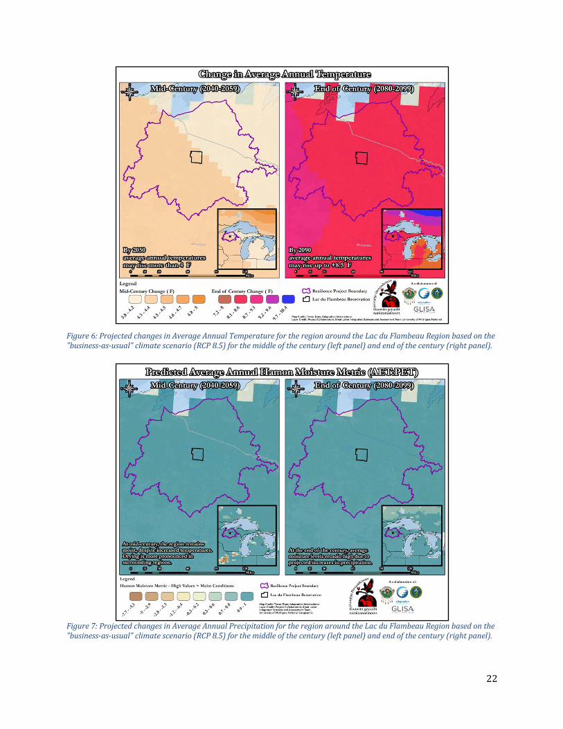
ChangingClimateConditionsTheclimateoftheregionisalreadychanging.Averageannualtemperatureshaveincreased3.1°Fsince1951.Temperatureobservationsshowincreasesintemperaturesduringallseasons.Projectionsunderthe“business-as-usual”climatechangescenario(RCP8.5)downscaled,averaged,andaveragedspecificallyfortheareathatincludeswatershedswithin40milesofthereservationboundariesshowprojectionsofincreasingtemperaturesannuallyandinallseasons(Table4).Averageannualtemperatures,aswellasspring,summer,andfalltemperatures,mayincreasebymorethan10degreesFahrenheit.Annualprecipitationhasdecreasedinthesummerbutincreasedintheotherthreeseasons.Projectionsunderthe“business-as-usual”climatechangescenario(RCP8.5)forthesameareashowageneraltrendtowardsincreasingannualprecipitationwithhighvariability(Table4).Projectedincreasesinaverageannualtemperature(
Figure6)andprecipitation(Figure7)areshownbelow.Table4:Summaryofobservedchangesintemperatureandprecipitationfortheregion(column2)alongwithprojectedchanges(mid-centurycolumn3;endofCenturycolumn4)fortheresilienceprojectboundaryunderthe"business-as-usual"climatescenario(RCP8.5)..
Variable Observations(1951-2017)
Mid-Century(2040-2059)
EndofCentury(2080-2099)
AnnualTemperature +3.1°F +3.0°Fto+5.3°F +5.4°Fto+10.0°F
WinterTemperature +4.7°F +2.2°Fto+4.8°F +5.1°Fto+8.6°F
SpringTemperature +3.2°F +1.9°Fto+5.6°F +5.2°Fto+10.9°F
SummerTemperature +1.9°F +5.0°Fto+7.1°F +8.4°Fto+12.4°F
FallTemperature +2.5°F +2.3°Fto+5.9°F +4.2°Fto+12.3°F
AnnualPrecipitation +1.8in. -17%to+103% -1%to+239%
WinterPrecipitation +0.8in. 0%to+103% -95%to200%
SpringPrecipitation +0.6in. -26%to+69% -1%to+129%
SummerPrecipitation -1.0in. -23%to+16% -31%to+44%
FallPrecipitation +1.5in. -19%to+22% -1%to+50%
22
Figure6:ProjectedchangesinAverageAnnualTemperaturefortheregionaroundtheLacduFlambeauRegionbasedonthe"business-as-usual"climatescenario(RCP8.5)forthemiddleofthecentury(leftpanel)andendofthecentury(rightpanel).
Figure7:ProjectedchangesinAverageAnnualPrecipitationfortheregionaroundtheLacduFlambeauRegionbasedonthe"business-as-usual"climatescenario(RCP8.5)forthemiddleofthecentury(leftpanel)andendofthecentury(rightpanel).

23
Figure8:Summaryofprojectedchangesintemperatureandprecipitationbyseasonbythe2050s(2040-2059)usingthe“business-as-usual”climateprojections(RCP8.5).DataisbasedondownscaledclimateprojectionsdevelopedbytheUniversityofWisconsinandanalyzedbytheGreatLakesIntegratedSciencesandAssessmentCenterattheUniversityofMichigan.Therangeofvaluesrepresentthehighestandlowestprojectionsaveragechangefromtheensembleofclimatemodels.
Figure9:Summaryofprojectedseasonalclimatechangesby2050includingincreasesintemperatures,varyingprecipitationpatterns,decreasesinsnowfall,alongergrowingseason,andmorehotsummerdays.CalculationscompletedbytheGreatLakesIntegratedSciencesandAssessmentCenterattheUniversityofMichiganfortheResilienceInitiativeProjectBoundary.

24
NaturalandCulturalResourcesThenaturalresourcesinandaroundthereservationplayanimportantroleinthecommunity’sphysical,emotional,mental,andeconomichealthandvitality.FortheLacduFlambeauTribe,naturalresourcesareculturalresourcesandanintegralpartofwhatsupportsthecommunityandhelpsitthrive.Throughoutthecommunityengagementprocess,tribalmembers,staff,andleadershipdeterminedthatthesurvivalandcontinuedexistenceofthehabitatsandkeyplantandanimalspeciesthathavebeenpartoftheLacduFlambeaucultureforthousandsofyearsaremorethanacriticalresource,theyarepartoftheidentityandhealthofthecommunity.Extremeweathereventsandchangingclimateconditions,inparticularextendedperiodsofdroughtandmoreextensiveorintensewildfires,havethepotentialtocreateplantandanimalepidemicsthatmayincreaseintheprevalenceofinvasivespeciesonthelandscapeandleaddirectlytothelossofthesespecies.
Figure10:Manoomin(WildRice)harvestareasinandaroundthereservation.Extremeweatherevents,changingclimateconditions,andhumandevelopmenthaveaffectedthelocationandabundanceofwildricecropsinrecentyears(datafromtheGreatLakesInter-TribalFisheriesCouncil(GLIFWC).
Thepotentialreductionandlossofkeynaturalresources,suchasManoomin(WildRice-Figure10)isakeyhazardfacingtheLacduFlambeauTribe.
25
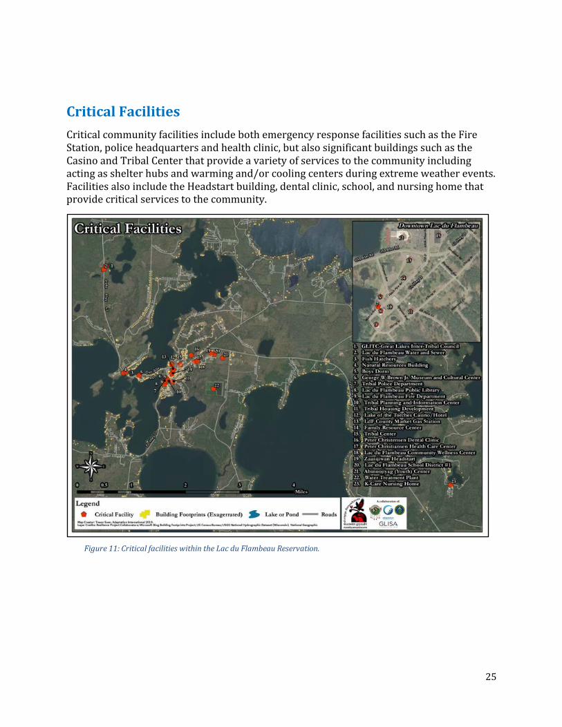
CriticalFacilitiesCriticalcommunityfacilitiesincludebothemergencyresponsefacilitiessuchastheFireStation,policeheadquartersandhealthclinic,butalsosignificantbuildingssuchastheCasinoandTribalCenterthatprovideavarietyofservicestothecommunityincludingactingasshelterhubsandwarmingand/orcoolingcentersduringextremeweatherevents.FacilitiesalsoincludetheHeadstartbuilding,dentalclinic,school,andnursinghomethatprovidecriticalservicestothecommunity.
Figure11:CriticalfacilitieswithintheLacduFlambeauReservation.

26
Table5:CriticalfacilitieswithintheLacduFlambeauReservation.
Name Address EstimatedValueAbinoojiyag(Youth)Center 13708YouthCenter
Lane $375,000
BoysDorm 873OldAbeRoad FamilyResourceCenter 533PeacePipeRoad $280,000 FishHatchery 2500OldAbeRoad GeorgeWBrownJr.MuseumandCulturalCenter- 603PeacePipeRoad $3,000,000
GLITC-GreatLakesInter-TribalCouncil 2952WisconsinStateHighway47 $500,000
K-CareNursingHome 12399WarpathLane LacduFlambeauCommunityWellnessCenter- 125OldAbeRoad $6,000,000
LacduFlambeauFireDepartment 614WildRice LacduFlambeauPublicLibrary 622PeacePipeRoad LacduFlambeauSchoolDistrict#1 2899HWY47S LacduFlambeauWaterandSewer 2650CemeteryRd. LakeoftheTorchesCasino/Hotel 510OldAbeRd $100,000,000 LdFCountryMarketGasStation 509OldAbeRoad NaturalResourcesBuilding 1101OldAbeRd PeterChristensenDentalClinic 128OldAbeRd PeterChristiansenHealthCareCenter 125OldAbeRoad $1,300,000 TribalCenter 418LittlePines $4,000,000 TribalHousingDevelopment 554ChicogSt TribalPlanningandInformationCenter 602PeacePipeRoad $500,000 TribalPoliceDepartment 623PeacePipeRoad $500,000 WaterTreatmentPlant 2450ThorofareRoad
ZaasijiwanHeadstart 2899WisconsinStateHighway47 $280,000
Part 3: Hazard Identification and Risk Assessment (Element B)
HazardIdentificationOverviewThehazardidentificationprocessbeganwiththeextensivecommunityengagementprocess(describedinSectionX.X).Itstartedwithconsiderationofthecontinuedrelevanceofthehazardsidentifiedinthe2006VilasCountyAllHazardsMitigationPlanthatincludedtheTribe.Thosehazards,alongwithanumberofnewandemergingthreatssuchaslossofnaturalresources,schoolandworkplaceviolence,andtheillegaldrugcrisiswereevaluatedbasedontheircurrentrelevancetotheTribe.

27
Foreachhazard,thedescriptionsbelowincludediscussionofthebackgroundonthehazard,ananalysisofhistoricconditions,andavulnerabilityandriskassessment.
AssessmentApproach/MethodologyAmulti-factorquantitativeriskrankingsystemthatincorporatedlocalexpertriskknowledgeandexperiencewasusedtocalculatetheseverityofidentifiedhazardriskintheLacduFlambeauplanningarea.Hazardrisksselectedforinclusioninthisplanhavebeenpriorityorderedinkeepingwiththeresultsofthisassessmentsystemandprocess.
AssessmentFactorsAssessmentfactorsandthedescriptionsofrelevantscoringforassessmentandrankingofhazards.ProbabilityAssessesthelikelihoodoffutureoccurrencebasedonhistoricalexperience.Measuresinclude:
● 0=notpossible● 1=Rare(<1eventper100years)● 2=Low(1eventevery21to100years)● 3=Moderate(1eventevery6to20years)● 4=High(1eventevery1to5years)● 5=Severe(1ormoreeventsperyear)
TrendAssesseswhetherhazardlikelihoodisexpectedtochangeovertime,andwhetherthatchangewillbeanincreaseordecreaseinfrequency.Thisfactorisbasedonananalysisofincreasingordecreasingprobabilitytrends,tribalstaffexperienceandknowledge,changesindemographicanddevelopmentpatterns,climatechangeprojections,andotherinformationasavailable.Measuresinclude:
● 1=FrequencyorImpactswilllikelydecrease● 2=Frequencyorimpactswilllikelystaythesame● 3=Frequencyorimpactswilllikelyincrease
HealthandPublicSafetyAssessesthenumberofpeoplewhowilllikelybesickened,injured,orkilledduringanaverageoccurrenceofthehazard,orthatwillsuffersomeformofpost-traumaticstress.Measuresinclude:
● 0=Nohealthorsafetyimpacts● 1=Low(<20sick/injured/PTSD;<3dead)● 2=Moderate(21-50sick/injured/PTSD;3-9dead)● 3=High(>50sick/injured/PTSD;>10dead)

28
HomeandPropertyDamageAssessesthepercentageofhomesandprivateresidenceslikelytobedamagedordestroyedduringanaverageoccurrenceofthehazard.Measuresinclude:
● 0=Nohomesimpacted● 1=Low(1-10homesimpacted)● 2=Moderate(11-35homesimpacted)● 3=High(>35homesimpacted)
LivelihoodImpactsAssessesthenumberofpeoplewhowilllikelylosehouseholdincomeasaresultoftheevent.Measuresinclude:
● 0=N/A● 1=Low(<10people)● 2=Moderate(10-35people)● 3=High(>35people)
CulturalandHistoricalImpactsAssessesthepotentiallossofculturally-importantresourcesthatcontributetoindividualandcommunityculture,history,medicinalplants,andspirituality.Measuresinclude:
● 0=Noimpacts● 1=Low(limitedlosses,short-termlosses)● 2=Moderate(moderatelosses,long-termlosses)● 3=High(broad-reachinglosses,permanentlosses)
EnvironmentalHarmAssessesthepotentialmonetaryandnonmonetaryimpactsonnaturalsystemsandhabitats,includinglakes,rivers,streams,flora,andfauna.Includesbothshortandlong-termimpacts.Measuresinclude:
● 0=Noenvironmentalimpacts● 1=Low(<$50,000remediation/recovery)● 2=Moderate($50,000-$500,000remediation/recoverycosts)● 3=High(>$500,000remediation/recoverycosts;permanentenvironmentaldamage)
DamagetoInfrastructureAssessesthenumberofpeoplelikelytobeimpactedbycriticalinfrastructureloss;andthenumberofdayscriticalinfrastructureoutagesarelikelytopersist.Measuresinclude:
● 0=N/A● 1=Low(<35peopleaffected;<1day)● 2=Moderate(35-100peopleaffected;1-3days)● 3=High(>100peopleaffected;>3daysoutage)
RecoveryCostsAssessestheuninsuredpublicsectorlossesassociatedwithrecovery,reconstruction,andrehabilitationinanaverageoccurrenceofthehazard.Measuresinclude:
● 0=N/A● 1=Low(<$50,000)● 2=Moderate($50,000-$500,000)● 3=High(>$500,000)

29
GovernmentServicesAssessesthepotentialextentofimpactstogovernmentservicesandoperations,includingclosureofthepublicschoolsystem.Measuresinclude:
● 0=Noimpacts● 1=Low(<1day)● 2=Moderate(1-5days)● 3=High(>5days)
DamagetoFacilities/AgricultureAssessesthenumberofbusinesseslikelytobeclosedfor1ormoredaysorreceivephysicaldamageduringanaverageoccurrenceofthehazardandmeasuresthecostofdamagetolivestockandcrops.Measuresinclude:
● 0=None● 1=Low(<1-5SMEs,nomajoremployers;<$50,000inagricultureloss)● 2=Moderate(6-10SMEs;nomajoremployers;$50,000to$500,000inagricultureloss)● 3=High(>10SMEs,1ormoremajoremployers;>$500,000inagricultureloss)
RiskAcceptabilityAssessesofrelativehazardimportanceassignedbyTribalmembersandleaders(ataMay2018riskassessmentworkshop).Measuresinclude:
● 1=Low● 2=Moderate● 3=High
MitigationPotentialAssessestheavailabilityandcost-benefitpotentialofmitigationactionfortheparticularhazard.Ahighernumberrepresentsagreaterabilitytocontrolriskthroughinvestmentoffundsoreffort.Measuresinclude:
● 0=Littleornoexpectedreturnoninvestments● 1=Standardreturnoninvestments● 2=Highexpectedreturnoninvestments
AssessmentFormulaTheassessmentformulaallowsfortheweightingofdifferentfactorsinamannerthatrecognizesthevision,goal,andobjectivesofTribalmitigationplanningefforts.Theformulaisasfollows:RISK=((1+0.2*(RELEVANCE-1))*((PROBABILITY+(TREND-2))/3)*(((HEALTH&PUBLICSAFETY2)+(HOME&PROP+LIVELIHOOD)+(CULTURE&HISTORY+ENVIRONMENT)+((INFRASTRUCTURE+RECOVERYCOSTS)/2)+((GOVT+BUSINESS)/2))/40))*((2*MITIGATION)/(MITIGATION+1))

30
ThefollowingexplainshowthisformulacalculatesriskintheLacduFlambeauPlanningArea:
● Thereare9factorsthattogetherassesshazardconsequences.Theyareeachweightedandaddedtogethertogiveafactorthatrangesfrom0to.675.Allotherfactorsacttoincreaseordecreasethisnumberwithinarangefrom0to1toachievetherelativeriskrating.Theseconsequencefactorsandtheirweightingareasfollows:
○ Health&PublicSafety:Thisisthemostheavily-weightedconsequencefactor,representingupto33%oftheconsequencefactor.
○ Home&PropertyandLivelihoodsfieldstogethercontributeupto22%oftheconsequencefactor.
○ EnvironmentandCulture&HistoricalImpactsfieldscontributeupto22%oftheconsequencefactor.
○ InfrastructureLossandRecoveryExpensestogethercontributeupto11%oftheconsequencefactor.
○ GovernmentServicesandBusinessImpactsfieldscontributeupto11%ofthetotalconsequencefactor.
● Allotherfactorsincreaseordecreasethismeasureasfollows:○ Probabilityhasthegreatestinfluence.Itisincreasedordecreasedaccordingto
Trend,whichindicateswhetherthehazardlikelihoodisexpectedtoincreaseordecreaseovertime.Thegreatestcombinationofthesetwofactors(5+3)wouldresultinadoublingoftheriskfactor,whilethelowestcombinationwouldnegatetheriskbyzeroingitoutentirely.
● LocalRelevance,whichisameasureofhowcommunitymembershavecharacterizedtheimportanceofmanagingthehazards,hasthepotentialtoincreasethetotalriskcalculationbyupto40%.
● MitigationPotentialbooststherankingofthosehazardsforwhichexpectedreturnoninvestmentishighbyupto33%,whilezeroingoutthosehazardsforwhichtherearefewtonoeffectivemitigationoptions.
HazardProfilesandAssessmentThehazardidentificationprocessidentifiedmanyhazardsthatexistintheLacduFlambeauplanningarea.Theriskassessmentprocessenabledrankingofthesehazardsaccordingtomitigationpriority.Thefifteenhighest-rankinghazardsareincludedinthisplanandareprofiledbelow.Theyinclude(inorderofrelativerisk):

31
Figure12:Rankingofthetop13keyhazardsandtheiroverallhazardrankingasdeterminedbytheTribalEmergencyPreparednessCommittee,historicriskdata,andfutureclimateprojections.
1.PlantandAnimalEpidemic/InvasiveSpecies/SpeciesLossBackground:Plantandanimalepidemicsthreatentoinflictenvironmental,cultural,andeconomicdamage.Plantepidemicscanbecausedbyanumberoffactors,manyofwhicharenotdependentonanexternalbioticorganismlikepathogens,insects,oranimals.Forinstance,climatechange(includingchangesinrainfall,temperature,sunlight,relativehumidity,andwind)willlikelyleadtooracceleratethelossofcertainplantspecies.Drought:Astemperaturesincreaseandprecipitationpatternschange,thereisthepotentialformoredrought,whichcouldaffectthesurvivaloflocalplantandanimalspecies.Whileaverageannualprecipitationisprojectedtoincreaseintheregion(SeeFigure7)thisdoesnotprecludethepossibilityofdroughts.Droughtistheresultofanaturaldeclineinexpectedprecipitationoveranextendedperiodoftimeandoccursinvirtuallyeveryclimateontheplanet,includingareasofbothhighandlowprecipitation.Theseverityofdroughtcanbeaggravatedbyotherclimaticfactorssuchasprolongedhighwinds,lowrelativehumidity,andextremeheat.Thefollowingfourdefinitionsarecommonlyusedtodescribedifferenttypesofdroughtanddemonstratethecomplexityofthehazard:
1. Meteorologicaldrought:Degreeofdryness,expressedasadepartureoftheactualprecipitationfromtheexpectedaverageornormalprecipitationamount,basedonmonthly,seasonal,orannualtimescales.
2. Hydrologicaldrought:Effectsofprecipitationshortfallsonstreamflows,andreservoir,lake,andgroundwaterlevels.
3. Agriculturaldrought:Soilmoisturedeficienciesrelativetowaterdemandsofcrops.

32
4. Socioeconomicdrought(orwatermanagementdrought):Shortageofwaterduetothedemandforwaterexceedingthesupply.Theseverityofadroughtdependsonseveralfactors:duration,intensity,geographicextent,watersupplydemandsforbothhumanuseandvegetation.
Droughtisdifficulttodefineinexactterms,dueinparttothewaysitdiffersfromotherhazards:
● Theonsetandendofadroughtaredifficulttodeterminebecauseoftheslowbuildupofeffectsandthelingeringimpactsafteritsapparentend;
● Thereisnoexactanduniversally-accepteddefinition,addingtotheconfusionofexistenceandseverity;and
● Theimpactofdroughtislessobviousandmaybespreadoveralargergeographicarea.
Thesecharacteristicshavehinderedthepreparationofdroughtcontingencyormitigationplansandcanmakeitdifficulttoperformanaccurateriskanalysis.ThemagnitudeofadroughtismeasuredusingthePalmerDroughtSeverityIndex.Factorsliketemperature,soilmoisture,andprecipitationareenteredintoanalgorithmthatreturnsresultsbetween-4(extremedrought)and4(extremelymoist)withzerobeingnormalconditions.Theindexiseffectiveatdeterminingdroughtoveraperiodofmonths,butlesseffectiveovershortertimeframes.DroughtsareratedbytheU.S.DroughtMonitorintothefollowingcategoriesbasedonfiveindicatorsincludingthePalmerIndexandstreamflowdata:
● D0:AbnormallyDry○ Goingintodrought:Short-termdrynessslowingplantingandgrowthofcropsor
pastures○ Comingoutofdrought:Somelingeringwaterdeficits;Pasturesorcropsnotfully
recovered● D1:ModerateDrought
○ Somedamagetocropsandpastures○ Streams,reservoirs,orwellslow,somewatershortagesdevelopingorimminent○ Voluntarywater-userestrictionsrequested
● D2:SevereDrought○ Croporpasturelosseslikely○ Watershortagescommon○ Waterrestrictionsimposed
● D3:ExtremeDrought○ Majorcropandpasturelosses○ Widespreadwatershortagesorrestrictions
● D4:ExceptionalDrought○ Exceptionalandwidespreadcropandpasturelosses○ Shortagesofwaterinreservoirs,streams,andwellscreatingwateremergencies
TheCropMoistureIndexwasdevelopedtomeasuresoilmoistureovershorterperiods,uptofourweeks,andhasvaluesbetween-3(severelydry)and3(excessivelywet),againwithzeroasnormalconditions.
PeriodsofdroughthavebeencommoninWisconsin,occurringaboutonceeverytenyears.Assuch,droughthasbeenacommonandoftenextendedoccurrenceinVilasCounty,and

33
likewisetheLacduFlambeauReservation.Sincetheturnofthe21stcentury,droughtconditionshaveexistedinalmostoneofeverytwoyears,including2005,2006,2007,2008,2009,2010,2012,and2013.Analmostcontinuousperiodofdroughtpersistedfrom2005untiltheendof2010.Lakelevelsthroughoutthecountywereaffectedbytheseprolongedconditions,andbothrecreationandagriculturewereaffected.
OtheryearsofnotabledroughtinVilascountyinclude1929-1934,1948-1950,1955-1959,1976/77,1987-1989.The1976/77eventresultedin$624millioninagriculturallossesacrossWisconsin,includinginVilasCounty.Diseases:Anotherwaythatplantandanimalspeciesmaybeaffectedisthroughdiseases.Therearefivebasiccategoriesofplantdiseases:
1. Newdiseases:diseasesintroducedonanewhostwithinthepastfiveyearsinanewgeographicarea
2. Emergingdiseases:diseaseswhoseincidencehasincreasedwithinthepast10to15years3. Reemergingdiseases:diseasespreviouslyknownintheareabutthataregaining
importance4. Threateningdiseases:diseasesnotreportedorwithlimiteddistributioninanew
geographicarea5. Chronic/spreadingdiseases:diseaseswhosepresencehasbeenknownforalongperiod
andthatarestillcausingoutbreaks
Plantandagriculturaloutbreakscanbespreadbyanumberofmeans,including(butnotlimitedto)thefollowing:
● Vectors(insects,suchasaphids,arecommonvectors);● Propagationofdiseasedplants;● Plantingofinfectedseeds;● Useofcontaminatedcattlemanure;● Movementofcropsincontaminatedequipment;● Wind,includinghurricanesandtornadoes;and● Humantransportationofinfectedplantsandfruits(intentionalandunintentional).
TheBureauofPlantIndustry,DATCP,monitorsforplantpestsanddiseasesinthestate.TheBureauusesscientificsurveysandroutineinspectionsoflicensedbusinessestomonitorforpestsanddiseases.Italsoenforcesregulationstocontrolandpreventintroductionandspreadofpestsanddiseases.GrowersinWisconsincansubscribetotheweeklyPestBulletintostayinformed.Livestockandanimalepidemicsarethosethataffectthelifeofanyanimalotherthanhumans.Animalepidemicsoftenstrikelivestockonalargescalegiventhedenselivingenvironments,andcontrolmayrequirecullingofallanimalsintheaffectedarea.Epidemicscancausealossofconfidenceinfoodsupplies,andevennon-contaminatedproductscanberenderedvalueless.VeterinariansarelegallyrequiredtoreportsuspectedcasesofcertaindiseasestotheWisconsinDepartmentofAgriculture,TradeandConsumerProtection(DATCP)ortheU.S.DepartmentofAgriculture.Whenveterinariansreportthesediseases,astateorfederal

34
veterinarianwillinvestigateand,ifnecessary,submitsamplestoeithertheU.S.VeterinaryLaboratoryinAmes,Iowa,ortoPlumIslandResearchCenterinNewYork(forsuspectedforeignanimaldiseases).Untiltestresultsareavailable,thepremisesarelikelytobequarantined.Invasivespeciesarespeciesthatare:1)non-native(oralien)totheecosystemwheretheyarefound,and;2)likelytocauseeconomicorenvironmentalharmorharmtohumanhealthasaresultoftheirintroduction.Invasivespeciescanbeplants,animals,andotherorganisms(e.g.,microbes).Humanactionsaretheprimarymeansofinvasivespeciesintroductions.In2001theWisconsinLegislaturedirectedtheDepartmentofNaturalResources(DNR)toestablishastatewideprogramtocontrolinvasivespecies.TheprogramandregulationsareaimedatpreventingnewinvasivespeciesfromgettingtoWisconsinandenablingquickactiontocontroloreradicatethoseherebutnotyetestablished.TheLacduFlambeauTribehasitsownmonitoringprogramsforbothaquaticandterrestrialspecies.TheWisconsinDepartmentofNaturalResourceslistshundredsofregulatedandnon-regulatedaquatic,terrestrial,andwetlandinvasiveplantsandanimalsthatareimpactingthestate.Animalandplantepidemicsarelesscommon,yethavethepotentialtocausegraveeconomicandenvironmentaldamagesinarelativelyshorttimespan.VulnerabilityandRiskAssessment:OutbreaksofforeignanimaldiseasesnotpreviouslyoccurringintheUnitedStates,suchasavianinfluenzaH5N1;orthathavebeenpreviouslyeradicated,suchasFMD;orthattheUnitedStatesisattemptingtoeradicate,suchaspseudorabiesandbovinetuberculosis,areveryrareinWisconsin.Thestateis,however,currentlyengagedineffortstoaddressanumberofotherwell-knownthreatssuchasavianinfluenza(poultry),chronicwastingdisease(deerandelk),andthedestructiveinvasivespeciesemeraldashborer,gypsymoth,andzebramussel.Theon-goinglocal,state,andfederalmanagementeffortsseektocontrolandminimizetheseandotherthreats.Table6:VulnerabilityandriskassessmentforPlantandAnimalEpidemicsummarizingassessmentandscoresforeachmeasure.
Measure Assessment Value
Probability
Basedonthehistoricalprevalenceofinvasivespeciesandplantandanimalepidemics,theLacduFlambeautribeshouldanticipatethepresenceofinvasivespeciesatalltimes,andtheintroductionofnewandemergingepidemicsand/orinvasiveplantoranimalspeciesonaregularbasisaveragingapproximately1ormoreinstancesperyear.Thisequatestoa100%probabilityinanygivenyear.
5
Trend
Increasedtemperaturevariabilityandincreasedprecipitationresultinshiftingplantandanimalranges,andresultinexpansionofareasimpactedbyplantandanimaldiseases.Specieslossoccursasaresultofdisease,habitatloss,contamination,habitatorclimateincompatibility(asaresultofclimatechange),developmentpressures,andotherfactors.
3

35
Health/PublicSafety
Thelossofkeyplantandanimalspecieshasthepotentialaffectboththephysicalhealthoftribalmembersastheyshiftawayfromtraditionaldietstomoreprocessedfoodsandthementalhealthofcommunitymembers.
1
HomeandPropertyDamage
Invasivespeciescancausesignificantdamagetohomesandpropertybecausemechanismsforprotectionareoftenweakornonexistent(duetoalackofexperiencemanagingtheinvasivespecies).
2
LivelihoodsInvasivespeciescancausewidespreadandeventotallossofcertaincrops,livestock,andtrees,impactingthosewhoselivelihoodsdependontheseresources.
2
Infrastructure Nolikelyimpact. 0
RecoveryCostsPublicexpendituresrelatedtothecontrolofinvasivespeciesand/orplantoranimalepidemicscanextendintothemillionsofdollarsevenforsmallcommunities.
3
Environment Forestsandendemicplantandanimalspeciesareatsignificantandconstantriskfrominvasivespeciesandplantandanimalepidemics. 3
Cultural/Historic
TheLacduFlambeauwayoflifeiscloselyinterlinkedwiththeplantsandanimalsnativetotheplanningarea.DamagetoorlossofanynaturalresourceswillhaveprofoundimpactsonTribalculture.Assignedbyworkshopparticipants.
3
GovernmentServices Nolikelyimpact. 0
Business/Agriculture
Theeconomiccostofinvasivespeciesand/orplantandanimalepidemicsonagricultureandbusinessreachesintothebillionsofdollarsnationwide.Croploss,cullingofanimals,andcostsassociatedwithvaccination,testing,publicrelations,andotheractionscanandhavebeenveryhighinpasteventsintheUnitedStatesincludinginWisconsin.
3
RiskAcceptability Assignedbyworkshopparticipants. 3
MitigationPotential Standardexpectedreturnoninvestment 1

36
2.IllegalDrugCrisisBackground:Illegaldrugsareaperennialpublichealthissueandaconstantstrainonpublicresources.Opioids,whichareaclassofdrugsthatinteractwithreceptorsonnervecellsinthebodyandbrain,producingeuphoriaandpainrelief(NIH,2017),arenotableintermsoftheirseveresocialandmedicalimpactsonsocietyandrepresentthemostpressingdrug-relatedconcerninLacduFlambeauatthepresenttime.Methamphetamineuseanddistributionalsothreatensthepublichealthandlifesafetyoftribalmembers.Examplesofopioidsfrequentlyabusedincludeheroin,oxycodone,hydrocodone,morphine,codeine,fentanyl,andcarfentanyl.Whileseveralofthesearecommonlyprescribedforpatientpainrelief,allmayleadtosevereaddictioninashorttimeframeandarethusabusedforrecreationaluses.Opioidsbecomedeadlywhentakeninhighdoses,usedincombinationwithotherdrugs,orgiventopeoplewithcertainpre-existingmedicalconditions.ThemisuseandabuseofopioidsispresentlydeclaredapublichealthcrisisinWisconsin(http://bit.ly/2FoarGl).Mirroringnationwidetrends,theLacduFlambeauTribeandVilasCountyatlargecontinuetofaceanepidemicofopioidaddictionandabuse.Thishasresultedinanincreasingnumberofemergencycallsrelatedtooverdose,oftentimeaccompaniedorfollowedbydeathoftheaffectedindividual(s)(seeFigureX-USOpioidDeaths2002-2015(NIH,2017)).
Figure13:NationalOverdoseDeathsfromOpioidDrugsintheUnitedStatesbyYear.(Source:NationalCenterforHealthStatistics.
Figure14:EmergencyMedicalServicesRunswithNaloxoneAdministrationbyPatientCountyofResidence,Wisconsin2015.

37
Opioidoverdoseresultsindeathwhenanexcessivedoseslowsbreathing.Thisriskisexacerbatedwhenopioidsarecombinedwithalcoholorantianxietydrugs.Whilegenerallyprescribedwithgoodintentions,opioidsareoftenover-prescribedinamannerthatresultsinaddiction.Thereopioidcrisisinfluencescommunityvulnerabilityinanumberofwaysasaresultofthefollowingcommonresponseandrecoveryrequirements.Examplesinclude:
● Increasedcallstoemergencymedicalservicesrelatedtooverdose;● Requirementforlawenforcementofficerstocarrydrugsthathelpreversetheeffectsof
opioidoverdose(Naloxone)bothforvictimsandtoaddresstheirownjob-relatedexposurerisks;
● Unemploymentandjoblossrelatedtoaddiction;● Higherburdenonfostercareandotherrelatedservicesforchildrenofaddictedindividuals
(includingchildrenbornwithopioidaddiction);and● Increaseinviolentcrime,robberies,andburglaries.
TheU.S.CentersforDiseaseControlandPrevention(CDC)reportsthatmorethan115peopledieeverydayintheUnitedStatesfromanopioidoverdose(CDC,2018).Between2015and2016,thedeathrateassociatedwithopioidabuseinWisconsinrose41%,to15.8per100,000peopleor827totaldeaths(WisconsinDHS,2018;seeFigure15).MeasuredasafactorofNaloxoneadministrationbypatientcountyofresidence,VilasCountyexperiencedarateof102.3per100,000callsrequiringNaloxone,placingitjustunderthemostsevereranking(seeFigure14).
Methamphetamine,alsoknownas“speed,""crank,""ice,"and"meth",isapowerful,illegally-producedstimulantthatattacksthecentralnervoussystem.Useofmethamphetaminecanquicklyresultinnervousness,compulsivebehavior,irritability,anger,aggressiveness,hallucinations,paranoia,depressionwithsuicidaltendencies,heartattacksandstrokes.MethamphetaminehasspreadthroughouttheUnitedStates,particularlyintheWest,Midwest,andSoutheast.AlthoughmostofthemethamphetamineinWisconsinismanufacturedoutsideofthestate,clandestinemethamphetaminelabshavealsobeensetuponkitchentablesorworkbenchesinsheds,garages,barns,homes,apartmentsandmotelrooms.Manufacturingmethamphetamineundertheseconditionsposesdangerousrisksforpublichealthandtheenvironment.
Figure15:NumberofOpioidrelatedoverdosebytypeinWisconsin.

38
Methamphetamineproduction,distribution,anduseendangersthecommunityonmultiplelevelsincludingthetearingapartoffamilies,incarcerationandjoblossforusers,pollutionofthenaturalenvironment,andstrainonlocalgovernmentsburdenedbytherequirementsoffightingthemethproblem.TheimpactofmethamphetamineuseanddistributionisalsoincreasingacrossVilasCounty,includinginLacduFlambeau.Arecent(February2018)murderofa22-yearoldLacduFlambeauresidentthathasbeenlinkedtodistributionofmethamphetamineshighlightsthepublicsafetythreatassociatedwiththisdrug.WhilemuchofthemethamphetaminefoundinVilasCountyistraffickedfromMexico,thediscoveryoflocalproductionlabsindicatesagrowingcomplexityofthisproblem.Fatalitiesassociatedwithmethamphetamineoverdosearelesscommonthanwithopioids,howevertheimpactonthelivesandlivelihoodsofthoseaddictedtomethamphetaminesandtheirimmediatefamilymembersisnonethelesssignificant.FutureOccurrence:Ratesofopioidprescriptionsfellin2017by12percent,representingthelargestdropinaquartercentury(CNBC,2018).Whilethisrepresentsprogresstowardscontrollingthecrisis,opioidoverdosesstilltakemorelivesthanautomobileaccidents.
Riskfactorsforopioidoverdoseinclude:● Tolerance:Tolerancecandecreaserapidlywhensomeonetakesabreakfromusingan
opioid.Restartingatthesamedoseputsindividualsatriskforanoverdose.● PhysicalHealth:Opioidscanimpairbreathing.Individualswithasthmaorotherbreathing
problemsareatahighriskforoverdose.Individualswithliverand/orkidneyproblemsorthosewhoareHIVpositivealsoareatincreasedrisk.
● PreviousOverdose:Anindividualwhohashadanonfataloverdoseinthepasthasanincreasedriskoffataloverdoseinthefuture.
● MixingDrugs:Manyoverdosesoccurwhenopioidsaremixedwithalcohol,sedatives/anti-anxietymedicines,orothersubstances.
Intheeventofanopioidoverdose,deathcansometimesbepreventedwiththeuseofNaloxone.Emergencymedicalrespondershaveaccesstothetreatment,andbystandingorderNaloxoneisavailablewithoutaprescriptioninWisconsin.MethamphetamineusecontinuestorisethroughoutWisconsin,especiallyinruralareas.7Policesurveysindicatethatlawenforcementofficialsconsideritsuseanddistributiontheirprimarydrugproblem.VulnerabilityAssessment:Deathsfromprescriptionopioiddrugslikeoxycodone,hydrocodone,andmethadone,aswellasthosefromsyntheticopioidslikeheroin,haveincreasedbyafactorofmorethanfoursince2010(NIH,2018).InWisconsin,emergencyroomvisitsforsuspectedopioidoverdosesmorethandoubledjustbetweenJulyof2016andSeptemberof2017(WisconsinStateJournal,2018).VilasCountyisparticularlyhard-hitbythecrisis,withLacduFlambeaumostsignificantlyaffected(VilasCountyNews
7Gibson,Gary.2018.MethRatesStillonRise,DespiteEffortsCombatingUsage.TheBadgerHerald.March13.http://bit.ly/2miXLcx.

39
Review,2018).Whileopioidaddictionisoftenviewedasacriminalorsocialproblem,itmustalsobeaddressedinlightofitscommunityvulnerabilityimplications.Table7:VulnerabilityandriskassessmentfortheIllegalDrugCrisissummarizingassessmentandscoresforeachmeasure.
Measure Assessment Value
Probability TheillegaldrugcrisisisanongoingprobleminVilasCounty,includinginLacduFlambeau.Vilascountyrankedamongthecountiesmostseverelyaffectedbytheopioidcrisisinthestate.Thereiscurrentlya100%probabilityofoccurrenceinanyyear.
5
Trend Publichealthstatisticsindicatethatwhiletherateofopioidprescriptionpeakedin2017,thenumberofoverdosesandassociatedfatalitiesremainshigh.Riskremainshighandisunlikelytowaneinthenearfuturewithoutintenseintervention.
2
Health/PublicSafety Theillegaldrugcrisisthreatensthepublichealthandlifesafetyofresidentsasaresultofoverdoserisk,riskfromaccidentalcontactoringestion,andsafetyriskfromviolenceassociatedwiththeillegaldrugtrade.
2
HomeDamage Contaminationanddamagecanoccurinhomesusedforthecreation,processing,andconsumptionofillegaldrugssuchasmethamphetamines.
1
Livelihood TheabilitytomaintainemploymentamongIndividualsimpactedbytheillegaldrugcrisis,whetherusers,caregiversofusers,ordependentsofusers,issignificantlyimpacted.
2
Infrastructure n/a 2
RecoveryCosts Thecostsofmanagingthepublichealthandsafetyresponseandrecoveryrequirements,includingtreatmentofoverdosevictims,carefordependents,increasedemandsonlawenforcement,andothercosts,aremoderate.
2
Environment Environmentalharmassociatedwithmethamphetamineproductionistypicallylimitedtoprivatepropertywhereproductionlabsoperate.Whilebroadercontaminationispossible(syringes/needlesbeingleftonthelandscapeorwashedintowaterbodies)thereislimitedlikelyimpact.
0
Cultural/Historic Theillegaldrugcrisiscontinuestohaveprofoundimpactsontriballifeandtradition. 3
GovernmentServices Someadditionalstrainonlawenforcementagenciesaswellascommunityhealthandmedicalprograms. 1
Business/Agriculture Nolikelyimpact. 0
RiskAcceptability Assignedbyworkshopparticipants. 3

40
MitigationPotential Highexpectedreturnoninvestments. 2
3. SevereThunderstorms/Lightning/HailBackground:Thunderstormsarelocalstormsaccompaniedbylightningandthunder.Theyareproducedbycumulonimbuscloudsandareusuallyaccompaniedbygustywinds,heavyrain,andoccasionallyhail.Theyrequiremoistureintheformofwatervaporthatliesinthelowestatmosphericlevels;arapidcoolingofairabovetheselow,wetlevels,decreasesintemperaturewithaltitude;andaforcestrongenoughtoliftthelowmoistairtothehigher,colderatmosphericlayers(e.g.,acoldfront).
Thunderstormsareclassifiedasnon-severeandsevere.Non-severethunderstormsrarelylastlongerthantwohours.Atypicalnon-severethunderstormlifecyclehasthreestages:8
7. Cumulusstage.Warm,moistairrises(updrafts)andcondensesintotinywaterdropletsthatmakeupthevisiblecloud.Outsideairispulledintothecloud.Supercooleddropletsofwaterarecarriedfarabovethefreezinglevel.
8. Maturestage.Thecloudgrowsabovethefreezinglevel;precipitationformsandbecomesheavyenoughtofallbacktotheearth.Frictioncausedbythefallingprecipitationgeneratesdowndraftsofcoolairthatreachtheearth’ssurface.Veryheavyrainsareassociatedwiththisstage.Thecloudextendsupwardtothetropopause,causingacharacteristicflat(anvil)toptoform.Periodsofstronglightningarelikelyduringthisstage,whichtypicallylastsfrom10to20minutes.
9. Dissipationstage.Thedownwardmotionofairovercomesthestorm,deprivingitofmoistair.Precipitationbeginstosubside,andthecloudevaporates.
Thunderstormsbecomeseverewhentheirwindspeedsexceed58milesperhourandhailformsinballsgreaterthanthree-quartersofaninchindiameter.Severaldifferentkindsofthunderstormscanform:
● Singlecell.Theseuncommonshort-livedstorms,lastingonly20to30minutesfromformationtodissipationandgenerallycoveringonlyalimitedareaofafewsquaremiles.
● Multi-cell.Themostcommontypeofthunderstormsconsistofanorganizedclusteroftwoormoresinglecells.Thestormcellsfueleachotherwiththeairthatflowsbetweenthemandcausenewcellstoforminsuccessionontheflankorrearsideseveryfiveto15minutes.
● Supercell.Thesestormsarealwayssevere.Supercellscausesignificantdamage,lastforalongtime(typicallyonetosixhours)andtravelgreatdistances(200milesormore).Thesestormscancausehurricane-forcewinds,gianthail(twoinchesindiameterormore),andsignificanttornadoactivity.Asupercellproducesupdraftsof56to112mphthatcombinewithsustaineddowndraftstoextendthestorm’sduration.
● Squalllines.Thesearelinesorbandsofactivethunderstormsthatcanextendmorethan500miles,canbe20mileswide,andconsistofmanylaterallyalignedcellsthatdonotinteractorinterferewithoneanother.Thecellsinvolvedinthesqualllinemaybeacombinationoftypes.Thesephenomenaoftenformalongcoldfronts,buttheyalsocanform
8Coppola,DamonP.2015.IntroductiontoInternationalDisasterManagement.Elsevier.Burlington.https://amzn.to/2w3haWF.

41
asfaras100milesaheadofanadvancingcoldfront,inthewarmsectorofanextratropicalstorm.Theyoftentrailalarge,flatcloudlayerthatbringssignificantrainafterthestormspass.
Thunderstormscausemostoftheirdamagethroughtherainandwindtheygenerate.Flashfloodsarecommonbecauseoftherapidprecipitation,whichcannotbeabsorbedbythegroundandquicklyaccumulatesasrunoff.Hailcancausedamagetobuildingsandcrops.Lightingcancausefatalitiesandgeneratefires.Lesscommonbutverydamagingaretornadoesthatcanformasaresultofthesestorms.HistoricalAnalysis:Therehavebeen32recordedsevereandpotentially-damagingthunderstorm,lightning,and/orhaileventsinLacduFlambeausince1993.Thisequatestoanaveragefrequencyof1.28eventsperyear.In1993,aparticularlyseverestormresultedinthedowningofover100,000treesandthedeathoftwopeople.Over50,000peoplewereleftwithoutpower,approximately150to200homesweredamaged,andmanymajorhighwaysandsecondaryroadswereblocked.VulnerabilityandRiskAssessment:GeographicexposureisrelativelyuniformacrosstheLacduFlambeauReservation.Thoselivingorworkinginstructuresthatarenotresistanttohighwindsaremorevulnerable,includingprefabricatedclassroomsandmobilehomes.Thoseinlivingorworkinginstructureswithlargeoverhangingtreesarealsoatrisk.Personal,business,andgovernmentpropertyriskisextremeintheeventoflargehail,especiallyautomobilesthatarenotgaraged.Livestockandcropsareatriskfromhailandlightning.Therisktoresidentsfromlightningissevere,aslightningstrikesareoftenfatalandaresecondonlytofloodingintermsofdisaster-relatedfatalitiesintheUnitedStates.Table8:VulnerabilityandriskassessmentfortheSevereThunderstorms/Lightning/Hailsummarizingassessmentandscoresforeachmeasure.
Measure Assessment Value
ProbabilityBasedonhistoricalfrequency,theLacduFlambeautribeshouldanticipateanaverageof1-2severethunderstormeventsperyear.Thisequatestoa100%probabilityinanygivenyear.
5
Trend Climatechangeisincreasingboththefrequencyandthestrengthsofseverestorms. 3
Health/PublicSafety
Publicsafetyisthreatenedbystructuralfailure,fallingtreesandlimbs,lightningstrikes,andhail.Inpastevents,injuriesandfatalitieshaveoccurredbuthavebeenlimitedto2orfewerfatalitiesandlessthan20injuries.
1
HomeDamageHomeandpropertydamagefromdownedtrees,lightning,andhailissignificantinstrongandwidespreadthunderstorms,especiallythosethatincludelargehailstones.
3

42
Livelihood Nolikelyimpact. 0
Infrastructure Heavywindscanseverelyimpactpowerandcommunicationstransmissionlines,andblockmajorandsecondaryroads. 3
RecoveryCosts
Pasteventshaveresultedindamagetoschools,streetsigns,emergencyservices,governmentbuildings,utilities,publicsectorequipmentandvehicles,andmore.Costsassociatedwithdebrisclearanceandcleanupmaybeexcessive.Costsassociatedwiththunderstormrecoverycaneasilyexceed$500,000perevent.
3
EnvironmentPaststormshavefelledhundredsofthousandsoftrees.Stormwaterrunoffhasthepotentialtopollutewaterresourcesincludingdrinkingwater.
2
Cultural/Historic Assignedbyworkshopparticipants. 2
GovernmentServices Morethan1dayofdisruptionisunlikely. 1
Business/AgricultureImpacts Agriculturallossesfromwind,hail,andlightningcanbesevere. 2
RiskAcceptability Assignedbyworkshopparticipants. 3
MitigationPotential Standardexpectedreturnoninvestment. 1
4. Epidemic/Pandemic/Vector-BorneDiseaseBackground:Communicablediseases(alsocalled“infectious”diseases)areillnessescausedbybacteria,viruses,fungi,andprions.Theillnessmaybetheresultoftheinfectingorganismoratoxintheorganismproduces.Communicablediseasesmaybetransmittedinseveralways,including:
● Fromaninfectedpersontoanothernon-infectedperson;● Fromananimaltoahuman;and● Fromaninanimateobject(doorknobs,tabletops,etc.)toahuman.
Somecommunicablediseasescanbespreadinmorethanoneoftheseways.Theroutesoftransmissionmayincludeairborneparticulates,food,liquids,bodilyfluids,contaminatedobjects,ingestion,orvector-bornespread.Someinfectiousdiseases,suchasflu,presentseasonalthreatstothepublicandrequirecontinualmonitoring.Apandemicfluisanepidemicofaninfluenzavirusthatspreadsonaworldwidescaleandinfectsalargeproportionoftheworldpopulation.Regularseasonalepidemicsoffluaremoregeographicallyconstrained.Aflupandemiccanoccurwhenanewstrainoftheinfluenzavirusistransmittedtohumansfromanotheranimalspecies.Historically,thesenewhuman-susceptiblestrainshavearisenmostcommonlyinpigs,chickens,andducks.Themostcurrentandactivethreatcomes

43
frominfluenzatypeAstrainsthatoriginateinbirdsandbecomereadilytransferableintootherorganisms.Thesevirusescanbetransmittedfromwildbirdstootherbirdspecies,causingoutbreaksindomesticpoultry.Thesevirusescanalsomutateintohighlyvirulentstrainsthatcaninfecthumans,withthepotentialtocausehumaninfluenzapandemics.Thisshouldespeciallyconcernpeoplewholiveincloseproximitytolivestock.Virusesdesignatedashighlypathogenicresultinhighmortality(upto100percent)within48hours.Controlofoutbreaksmayrequirethecullingoflivestock.Severalinfluenzaoutbreaksinthepast15yearshaveresultedinmillionsofpoultrydeathsandsevereimpactstolivelihoods,localeconomies,andinternationaltrade.Anepidemicbecomesapandemicwhenitsinfluencebecomesglobal.Theytypicallyoccurwhenanewpathogenemergesforwhichpeoplehavelittleornoimmunity,andforwhichthereisnovaccine.Thediseasespreadseasilyfrompersontoperson,causesseriousillnessordeath,andcanoverwhelmacommunityinaveryshorttimeframe.HistoricalAnalysis:InfluenzaPandemicsarenaturallyoccurringeventsthathavestruckatvariouspointsacrossthenation’shistoricalrecord.EachoftheseeventsimpactedWisconsinresidents.Therewerethreepandemicinfluenzaoutbreaksduringthe20thcentury,beginningin1918,1957,and1968respectively.Sincetheturnofthe21stcentury,therehasbeenonepandemicinfluenzaoutbreak,whichbeganin2009andwasbroughtundercontrolin2010.Thegreatesthumanlossassociatedwithapandemicoccurredinthe1918SpanishFlu(H1N1)incident.Anestimated20-40millionpeoplelosttheirlivesworldwide,550,000ofwhichwereintheUnitedStates.TheAsianFlu(H2N2)pandemicthatstruckin1957and1958hadanassociatedmortalityofapproximately70,000intheUnitedStates.TheHongKongFlu(H3N2),whichlastedfrom1968to1969,killedapproximately34,000peopleintheUnitedStates.The2009SwineFlupandemic(H1N1),wasconfirmedtohavekilledapproximately14,000peopleworldwide,ofwhich3,400wereintheUnitedStates,thoughexpertsbelievethesenumbersrepresentonly6-10%ofthetotalnumberofdeaths.InWisconsin,therewere13,511confirmedorprobablecasesofH1N1fromApril2009toMarch2010,with1,320hospitalizedand55deaths.InVilasCounty,therewere6casesofH1N1with4hospitalizationsandnodeathsreported.Othereventswithpandemicpotential,includingAvianFlu,SevereAcuteRespiratorySyndrome(SARS),andMiddleEasternRespiratorySyndrome(MERS),andnon-respiratoryillnesseslikeEbolaandWestNileVirus,wereeitherbroughtundercontrolbyamixofpublichealthandothermeasuresbeforeveryhighdeathtollsresultedorarestillactivebutarebeingsuccessfullycontrolled.TheVilasCountyHealthDepartmenttrackscommunicablediseasethroughachannelofcommunicationsatthelocal,stateandregionallevelsbetweenpublichealth,privatephysicians,hospitals,andlabs.Thiscommunicationchannelallowsforpromptinvestigationofpossibleoutbreaksandunusualsituations,andtoimplementcontrolmeasurestominimizefurthertransmissionofdiseasetoothers.

44
VulnerabilityandRiskAssessment:Emerginginfectiousdiseasesposeaparticularrisktourbanandsuburbancommunitiesduetothecloseenvironmentinwhichpeopleinteract.Mostcommunicablediseasesaredealtwiththroughtraditionalhealthdepartmentactivities.ThecomplexityandmagnitudeofaPandemicInfluenzaoutbreakwouldtaxthenormalcapabilitiesofthemedicalservicecommunityandtheEmergencyManagementDepartmentwouldassistinallactivitiessurroundinganeventofthisseverity.ThepossibilityofacommunicablediseaseepidemicorpandemicoutbreakisequalacrossVilasCountyandthereforeLacduFlambeau.Theabilitytopredictwhereandwhenaneventwilloccurisverydifficult.Theprobabilityofemerginginfectiousdiseasesepidemicsisthereforeunknown.Table9:VulnerabilityandriskassessmentforEpidemic/Pandemic/VectorBorneDiseasesummarizingassessmentandscoresforeachmeasure.
Measure Assessment Value
Probability Infectiousdiseasesareanever-presentconcerninLacduFlambeauasitisthroughoutthecountryandtheworld.Influenzaisanannualoccurrenceandthepotentialformutationthatresultsinanexceptionallyvirulentstrainissmallbutever-present.SeveralemerginginfectiousdiseasesimpactVilasCountyatanygiventime,thoughthevastmajorityofthesearekeptundercontrolthroughavarietyofpublichealthmeasures.Basedonhistoricalfrequency,theLacduFlambeautribeshouldanticipateanaverageof1eventwithepidemicorpandemicpotentialevery30-35years.Thisequatestoa3%probabilityinanygivenyear.
2
Trend Highertemperaturesandwetterconditionstendtoincreasemosquitoandtickactivity,leadingtoanincreasedriskofexistingandnewzoonoticdiseases(e.g.,WestNilevirus(WNV),LaCrosse/Californiaencephalitis,JamestownCanyonvirus,St.Louisencephalitis,andEasternequineencephalitis.)Non-nativemosquitospeciesmaymoveintoWisconsiniftheclimatebecomesmoresuitableforthem,bringingwiththemdiseasessuchasJamestownCanyonvirus,Chikungunya,andDengueFever.Ticksarealsowell-knowndiseasevectorsinWisconsin,carryingpathogenssuchasLymedisease,anaplasmosis,Ehrlichiosis,Powassanvirus,andBabesiosis.Tickpopulationsarealreadyexpandingdueinparttoclimatechange.Warmer,wetterweathercancausealgalbloomsanddecliningbeachhealth.Anincreaseinfloodeventsmayresultinmoreprevalentmoldproblemsinhomesandbusinessesandcontaminationofwellsandsurfacewaters.
3
Health/PublicSafety
AnepidemicorpandemiccausedbyaninfectiousdiseasehasthepotentialtoinfectasizeablenumberofresidentsontheReservation,leadingtohospitalizationandpotentiallythedeathofupto100%ofthoseinfected.
3
HomeDamage Nolikelyimpact. 0
Livelihood Manypeoplewilltemporarilyorpermanentlylosetheirsourceofincomeduetoillnessorworkplaceclosure.
3

45
Infrastructure Nolikelyimpact. 0
RecoveryCosts Recoverycostsassociatedwithepidemicorpandemicillnessstemfromtheuseofpublicfundstoaddresstransmissionprevention(includingvectorcontrol),decontamination,medicalsupplies,andotherrelatedexpenses.
2
Environment Nolikelyimpact. 0
Cultural/Historic
Thelossofkeycommunitymembers,notablytribalelders,mayhaveprofoundandpermanentimpactsontraditionalknowledgeandpractices.
3
GovernmentServices
Governmentservicesmaybeimpactedwhengovernmentemployeesbecomeill,whengovernmentfacilitiesareforcedtoclosefordecontaminationortransmissionprevention,orwhengovernmentpersonnelaredivertedtoworkonpublic-healthneeds.
2
Business/Agriculture
Businessesmaybeimpactedbyanepidemicorpandemiceventifemployeesbecomeill,ifcustomersavoidpublicspaces,ifsupplychainsaredisrupted,oriftherearedecontaminationrequirements,amongotherreasons.
2
RiskAcceptability
Assignedbyworkshopparticipants. 3
MitigationPotential
Therealorperceivedthreatofanemerginginfectiousdiseasehasthepotentialtodisruptnormalpublicinteractions.Theimpactofemerginginfectiousdiseasescanbemitigatedbyimmunization;reporting,investigation,andsurveillance;andresponse.
2
5. Flood(flashflood,lake,river,stormwater)Background:Afloodisanoverabundanceofwaterthatengulfslandandotherpropertythatisnormallydry.Thereareseveraldifferentreasonsthatfloodsoccur,includingsustainedorheavyrainfall,meltingsnow,obstructionofanaturalwaterways(e.g.,bybeavers,ice,debris,orlandslides),amongothergenerativefactors.Majorfloodsaffectingwidegeographicareasaretypicallytheresultoflarge-scaleweathersystemscapableofgeneratingprolongedrainfall,buteventsofequallysignificantmagnitudecanoccurinmuchlesstimefollowingintensethunderstormswithexceptionallyheavyprecipitationratesordamfailures.Floodsarecapableofunderminingbuildingsandbridges,erodingshorelinesandriverbanks,tearingouttrees,washingoutaccessroutes,andcausinglossoflifeandinjuries.Flashfloods,whichcanreachfullpeakinonlyafewminutes,areadistinctcategoryoffloodcharacterizedbythelackofwarningthatispossiblegiventheirrapidgeneration.Floodingonabodyofwaterisnormallymeasuredaccordingtoanestablishedfloodstage,whichreferstothelevelatwhichinundationofnormally-dryareasoccurs.Thiselevationcorrespondstoanannualizedlikelihoodofreachingsuchheights.Forexample,aflood

46
stagethathasa1%chanceofbeingreachedorcouldbeexpectedtooccuronceacrossa100-yearperiodwouldencompassalandareareferredtoasthe“100-yearfloodplain”andaneventthatimpactedthisareawouldbecalleda100-yearfloodevent.Typically,structurescontainedwithinareasthatcarrya1%annualizedriskoffloodingareconsideredtoexistwithinthefloodplain.Inmanylocations,climatechangeisaffectingtherecurrenceintervalfortheseheavyprecipitationevents,meaningthatthehistoric1%annualizedriskoffloodingmaynolongerreflectthefutureriskofthoseevents.Thereareseveralclassificationsoffloodsthataredifferentiatedbytheircause,location,andduration,amongotherfactors.FloodtypesthatthreatenLacduFlambeauinclude:
● FlashFlood:Arapidriseinwaterlevelonnormally-drylandwhichoccurswithlittleornowarningduringorimmediatelyfollowingheavyrainfall.Flashfloodingmaymoveathighvelocityandcontainlargeamountsofdebriswhichcanleadtotreesdamage,theunderminingbuildingsandbridges,andscouringofnewchannels.Urbanandbuilt-upareasareatgreatestriskfromflashfloodingduetoremovalofvegetation,coveringofgroundwithimpermeablesurfaces,andtheexistenceofinadequatedrainagesystems.Flashfloodingisalsocalledstormwaterflooding.
● LakeFlooding:Elevatedlakewaterlevelsthatresultinexpansionontolakeshoreareas.● RiverineFlooding:Alsoknownasoverbankflooding,riverinefloodsarethemostcommon
floodeventtype.Theamountoffloodingisafunctionofthesizeandtopographyofthewatershed,theregionalclimate,soilandlandusecharacteristics.Insteepvalleys,floodingisusuallyrapidanddeep,butofshortduration,whilefloodinginflatareasistypicallyslow,relativelyshallow,andmaylastforlongperiods.Thecauseoffloodinginriversistypicallyprolongedperiodsofrainfallfromweathersystemscoveringlargeareas.Thesesystemsmaysaturatethegroundandoverloadthestreamsandreservoirsinthesmallersub-basinsthatdrainintolargerrivers.Annualspringfloodsaretypicallyduetothemeltingofsnowpack.Riverinefloodingcanoccuronsmallerstreamsandwaterwaysandisreferredtoas“UrbanandSmallStreamFlooding”.Suchfloodsaregenerallymorelocalintheirscope,thoughtheremaybenumerousfloodedstreamsacrossawidergeographicareaimpactedbyincreasedprecipitationorhydrologicpressures.Streamsthatpassthroughurbanorbuilt-upareasaremoresusceptibletostreamfloodingduetoincreasedsurfacerunoffandconstrictedchannels.RiverineandstreamfloodinginLacduFlambeautendstobeheaviestinthespringwhenmeltingsnowaddstonormalrunoffandinsummerorearlyfallafterintenserainfalls.Floodingoccursinthespringduetosnowmeltandfrozensoil.
HistoricalAnalysis:VilasCounty,withinwhichthemajorityofthereservationandtheLacduFlambeautowncenterislocated,hasanunremarkablehistoricalrecordwithregardstomajorfloodingevents.Mostofthecounty’sfloodplainsurroundsflowagetypewaterbodiesforwhichwaterlevelsareactivelycontrolled.Pastfloodeventshavecausedonlyminimalpropertyandinfrastructuredamageandhavegenerallybeenclassifiedasminor.Thereishoweverthepotentialforincreasedlevelsofdamageinfutureeventsduetothesignificantnumberofstructuresthatexistinthefloodplain.Inaddition,demandforshorelandpropertyoftenresultsinpressuretodevelopflood-proneplots.FloodriskinLacduFlambeauisgreatestinthespringwhenmeltingsnowaddstonormalrunofforinsummerorearlyfallfollowingintenserainfallthatlastsforseveraldays.

47
Buildupfromrunoffcancauseriversandstreamstooverflowstheirbanks.Floodwatersmaytakeaslongastwoweekstorecedeinsuchevents.Fortunately,thetimingandlocationofthistypeoffloodingisfairlypredictableandallowsampletimeforevacuationofpeopleandprotectionofproperty.Understandably,thefloodplainandwatershedareasaremostvulnerabletofloodinginLacduFlambeau.Asof2018,neitherLacduFlambeaunorVilasCountyhaseverhadaclaimsubmittedundertheNationalFloodInsuranceProgram.AlthoughfloodinghasoccurredinVilasCountyinthepast50years,includingin1999duringaFederally-declareddisaster,andin2011asaresultofrapidrainfall(flashfloodingevent),inundationinLacduFlambeauhasbeenlargelylimitedtoroadwaysandculverts.ThemostseverefloodingeventinLacduFlambeauoccurredinAugustof2000asaresultofprolongedpresenceofthunderstorms.Theeventwascharacterizedasurbanandsmall-streamflooding.9TheNOAANationalCentersforEnvironmentalInformationStormEventsDatabaseliststwofloodeventsforLacduFlambeau.Theseinclude:
● August14,2000SeverethunderstormsdevelopedinthevicinityofafrontthatwasstalledacrossnortheastWisconsin.Bowinglinesofthunderstormsandsupercellthunderstormsproducedconsiderablewinddamage,somehail,streetfloodingandabrieftornadotouchdown.Strongwindsdownednumeroustreesandpowerlines.Somehomesweredamagedwhentreesfellonthem.About25,000customerslostelectricalpowerduetothestorms.AtornadotoucheddownbrieflyatLakeTomahawk(Oneidaco.)resultingintreedamage.Heavyrainfallcausedstreetfloodingatseverallocations.
● June11,2017AfternoonthunderstormsdownedtreesandpowerlinesacrosspartsofnorthernWisconsinandproducedtorrentialrainfalltotaling6.5inchesthatcausedstreetfloodingintheLacduFlambeautowncenteraswellasinothernearbycommunities.
9NorthCentralWisconsinRegionalPlanningCommission.2013.VilasCountyAll-HazardsMitigationPlan.VilasCountyEmergencyManagement.

48
Figure16:NationalFloodHazarddesignationsfortheLacduFlambeauReservation.FloodHazardLayersareonlyavailableforsomeofthereservation.
MembersoftheTEPCarenotoverlyconcernedwithfloodingcitingprimarilytheflattopographyoftheregionandthesandysoilsforthelowerrisk.TheJune2017flashfloodeventcarriedsomuchwaterthatitoverwhelmedthedowntownsewersystemandcausedtemporarylocalizedflooding.Changingclimateconditionsareprojectedtoincreasethemagnitudeofextremeprecipitationeventsintheregion.VulnerabilityandRiskAssessment:Thethreatoffloodingistypicallynotconsideredacommunity-widethreat.Floodingismostcommonlyassociatedwithfloodplainsorlowlandsadjacenttowaterbodies.LacduFlambeaufloodareasaredelineatedinFEMANationalFloodInsuranceProgram(NFIP)FloodInsuranceRateMaps(FIRMs).FIRMsshowtheSpecialFloodHazardArea(SFHA),definedastheareathatisinundatedduringthebaseflood,alsoknownasthe1-percent-annual-chanceor“100-year”flood.InWisconsin,thebasefloodisalsoreferredtoastheregionalflood.InareaswheretheBaseFloodElevation(BFE)hasbeencalculatedthroughengineeringstudies,itservesastheregulatorybenchmarkforstructureelevationorfloodproofing.Floodinsurancepremiumsaredeterminedbyastructure’selevationinrelationtotheBFE.StatestatutesrefertotheBFEastheregionalfloodelevation;inWisconsin,thefloodprotectionelevationistwofeetabovetheregionalfloodelevation.

49
FloodplainregulationactivitiesinWisconsinareadministeredbytheWisconsinDepartmentofNaturalResources(DNR)FloodplainManagementSection.TheStateofWisconsinhasrequiredcommunitiestoregulatefloodplainssince1968throughChapterNR116oftheWisconsinAdministrativeCode.ThestandardsestablishedinchapterNR116exceedtheminimumstandardssetbytheNFIPinordertoprovideahigherlevelofprotectiontoWisconsinresidents.SomeofthehigherstandardssetbyWisconsinincludetheprohibitionofstructuresinthefloodway,therequirementthatelevatedstructuresbeatleasttwofeetabovetheregionalfloodelevation,andtherequirementthatstructureshavedrylandaccessevenduringflooding.PastfloodingeventsinWisconsinhavetypicallyaffected:
● Infrastructure–floodedpublicfacilities;● Roadways–washouts,inundatedroadways,debrisclean-up;● Residentialstructures–floodedbasements,damagedsepticsystems;● Businesses–lossofcommerce;and● Agriculture-inundatedcropland.
Table10:VulnerabilityandriskassessmentforFloodingsummarizingassessmentandscoresforeachmeasure.
Measure Assessment Value
Probability WhilemajorfloodingeventsarerelativelyrareinLacduFlambeau,minorfloodeventswithmorelocalimpactsshouldbeexpectedtooccurevery15-20years.Thisequatestoapproximately5-7%probabilityinanygivenyear.
3
Trend Climatechangeisincreasingthenumberofprecipitationdaysandthequantityofrainfallinindividualevents.Floodriskisthereforelikelytoincreaseasaresultofclimatechange.
3
Health/PublicSafety
FloodeventsinLacduFlambeaumayimpactpropertybeyondtheroadwayandculvertimpactsseeninpastevents.Whilepotentiallydamagingtoproperty,suchimpactsarehoweverunlikelytoposeasignificantthreattopublichealthandlifesafety.Nolikelyimpact.
0
Home/PropertyDamage
FloodriskinLacduFlambeaupresentsamoderaterisk(11-35homes)forhomeandpropertydamage.
2
Livelihood Impactsonlivelihoodrelatedtofloodedbusinessesand/orhomespresentsalow-levelriskinLacduFlambeau.
1
Infrastructure Transportationinfrastructureismostacutelyimpactedbyfloodevents.However,floodeventshavethepotentialtoimpactgroundwaterquality.
1
RecoveryCosts Recoverycostsrelatedtorepairofpublicfacilitiesandinfrastructure,debrisclearance,andmitigationmaybesignificantintheaftermathofafloodevent.
3

50
Environment Threeexistssignificantriskforenvironmentaldamageinfloodeventsresultingfrominundation,erosion,contamination,oracombinationofthethree.
3
Cultural/Historic Floodwatersimpactinghistoricorculturalfacilitiescanresultinsignificantandpermanentimpacts.
3
GovernmentServices
Governmentservices,notablypublicschoolservices,maybeimpactedforashorttimeintheeventofafloodevent.
1
Business/Agriculture
Floodeventscanresultinroadclosures,inundationanddestructionofcrops,lossofgrazingareas,andlivestockfatalities.
2
RiskAcceptability Assignedbyworkshopparticipants. 2
MitigationPotential
Highexpectedreturnoninvestment. 2
6. SevereWinterStorms/IceStormsBackground:Severewinterstormsareextratropical,cold-weathercyclonicweatherhazardsassociatedwithexcessiveprecipitationofsnow,sleet,andice.Severewinterstormscanimpedeorfullydisrupttravel,areaccompaniedbydangerouslycoldtemperatures,andcancausemanysecondaryhazardsincludingavalanches,snowdrifts,andfloods.Thelonger-termeffectsofsuccessivesnowaccumulationcanbedisastrous:snowmeltsandrunsoffoncetemperaturesbegintorise,leadingtomudslidesandwidespreadflooding.Blizzardsareatypeofseveresnowstormaccompaniedbyverylowtemperatures(below20°F)andhighwinds(35mphorgreater).Icestormscanleadtothedevelopmentofathickglazeoficeontrees,cars,roads,andothersurfaces,makingconditionsextremelyhazardoustomotoristsandpedestrians,andcanleadtopropertydamagefromcollapsedroofs,fallentreesandlimbs,damagedpowerandcommunicationspolesandlines,andotherphysicalandenvironmentalimpacts.Duringaseverewinterstorm,powerandtelecommunicationsmaybedisruptedfordays.Whenseverewinterstormsareaccompaniedorfollowedbyheavyrainfall,snowmeltcanresultwhichcausessuddenandsevereflooding.ThefollowingareNationalWeatherService(NWS)approveddescriptionsofwinterstormelements:
● Heavysnowfall:accumulationofsixormoreinchesofsnowina12-hourperiodoreightormoreinchesina24-hourperiod.
● Blizzard:sustainedwindorfrequentwindgustsofatleast35mphaccompaniedbyconsiderablefallingand/orblowingsnowandvisibilitybelow¼mile.
● Icestorm:freezingrainproducessignificantordamagingaccumulationsofice,usually¼”orthicker.
● Freezingdrizzle/freezingrain:drizzleorrainthatfallsasaliquidbutfreezesintoglazeuponcontactwiththegroundorobjectswithatemperatureof32°Forbelow.

51
● Sleet:pelletsoficecomposedoffrozenormostlyfrozenraindropsorrefrozenpartially-meltedsnowflakes.Heavysleetisdefinedassleetaccumulationexceeding½inch.
● Windchill:measureofacceleratedheatlossfromexposedskinduetoincreasedwindspeeds.
● LakeEffectSnow:Snowshowersthatarecreatedwhencold,dryairpassesoveralargewarmerlake,suchasoneoftheGreatLakes,andpicksupmoistureandheatresultinginheavybutlocalizedsnowfall.Thistypeofsnowstormhasthepotentialtobeasignificanthazardorbelifethreatening.
HistoricalAnalysis:WhileheavysnowandicestormshavebeenapartofnearlyeverywinterinLacduFlambeau,trueblizzardsarerarethroughoutWisconsin.Blizzardsaremorelikelytooccurinthenorthwesternpartofthestatethaninthesouth-centralparts,althoughheavysnowfallsismostcommoninthesoutheast.Blizzard-likeconditionsdooftenexistduringheavysnowstormswhengustywindscausethesevereblowinganddriftingofsnow.TheNOAANationalCentersforEnvironmentalInformationreports68winterstormeventsinVilasCountybetweenJanuary1,2001andMay1,2018.Allofthesestormscontainedsomeformofsnow,sleet,freezingrain,oriceconditions.Therecord24-hoursnowfallis24inches,whiletherecordmonthlysnowfallaccumulationis83inches.AnApril13-15,2018blizzarddropped19.5inchesofsnowonLacduFlambeauandupto30inchesinothercommunitiesintheregion.Impactsfromtheheavysnowandhighwinds(upto50mph)includedroadclosures,businessclosures,androofcollapse.VulnerabilityandRiskAssessment:GeographicexposureisrelativelyuniformacrosstheLacduFlambeauReservationandisthereforeconsistentwithcounty-wideassessments.Winterstormspresentasignificantthreattothehealthandsafetyofaffectedcitizensandcanresultinsignificantdamagetopropertyandcommunityandbusinessdisruption.Heavysnoworaccumulatedicecancausethestructuralcollapseofbuildings,disruptinfrastructurenetworks,increasetheprevalenceofmotorvehicleaccidents,andcanisolateresidentsfrommuchneededassistanceandservices.Table11:VulnerabilityandriskassessmentforSevereWinterStorms/IceStormssummarizingassessmentandscoresforeachmeasure.
Measure Assessment Value
Probability Basedonhistoricalfrequency,theLacduFlambeautribeshouldanticipateanaverageof3.7significantwinterweathereventsperyear.Thisequatestoa100%probabilityinanygivenyear.
5
Trend Wisconsinisexperiencingrisingannualaveragetemperaturesasaresultofclimatechange.Whilestatewideincreaseshaveaveraged2.5°Fsince1950,Vilashasseenanincreaseofapproximately1-1.5°F.Asbothtemperatureandprecipitationincreaseduringthewintermonths,freezingrainwillbemorelikely.Additionalwintertimeprecipitationinanyformwillcontributetosaturationandincreasetheriskand/orseverityofspringflooding.Thecombinationoffactorsindicatesarisingtrendinimpactsrelatedtoseverewinterstorms.
3

52
Health/PublicSafety
Few(ifany)deathsand/orinjurieshavebeendirectlyattributabletoseverewinterstormsinVilasCounty.Futureriskisassociatedwithautomobileaccidents,slipsandfalls,reducedaccesstoemergencymedicalcare,fallingtreelimbs,andexposuretothecold.
1
HomeDamage Homedamageisassociatedwithfallingtreesandbranches,winddamage,waterdamagefromicedams,waterdamagefromfrozenwaterpipesandLPlines,frozensepticsystems,andexceededroofsnowloads.
1
Livelihood Nolikelyimpact. 0
Infrastructure Thepotentialforprolongeddisruptionofinfrastructureduetodamagedpowerandcommunicationstransmissionlinesexists.
3
RecoveryCosts Costsassociatedwithclearingandtreatingroadsandmanagingdebriscanexceed$500,000insevereevents.
3
Environment Damagestendtobeisolatedandrequireminorremediationactions. 1
Cultural/Historic
Potentialdamagecausedbysnow,ice,and/orwindtoculturalandhistoricsitesand/orfacilities,orthelossofplantsandanimalscriticaltotriballife,presentsalowand/orshort-termthreat.
1
GovernmentServices
Availabilityofkeygovernmentservices,includingschoolsandemergencyservices,maybeimpactedbyseverewinterstorms.Nonessentialservicesmaybeimpactedforseveraldays.
2
Business/Agriculture
Businessimpacts,primarilybusinessinterruption,mayresultfrombrokensupplychains,alossofe-commerce,unavailabilityofutilityservices,physicalaccessproblems,andalossoftourismresources.Stormsthatoccurearlyorlateintheseasoncanimpactcrops.Allwinterstormscanhaveanimpactonthetimberindustry.
3
RiskAcceptability
Assignedbyworkshopparticipants. 2
MitigationPotential
Highexpectedreturnoninvestments 2
7. ForestandWildlandFiresBackground:Chapter26.01oftheWisconsinStateStatutesdefinesforestfiresas“uncontrolled,wild,orrunningfiresoccurringonforest,marsh,field,cutover,orotherlandsinvolvingfarm,city,orvillagepropertyandimprovementsincidentaltotheuncontrolled,wild,orrunningfiresoccurringonforest,marsh,field,cutover,orotherlands.”Theyoftenbeginunnoticed,canspreadquickly,andareusuallysignaledbydensesmokethatcanfilltheairformilesaround.WildfiresinWisconsinareprimarilyhuman-causedbyburningyarddebris,fireworks,arson,orcampfires,forexample.Theycanalsobecausedbynaturaleventslikelightning.

53
WildfireclassificationsinWisconsininclude:● Interfaceorintermixfires(alsoknownaswildland-urbaninterfaceorWUIfires):Occurin
areaswherebothvegetationandstructuresprovidefuel.● Firestorms:Occurduringextremeweather(e.g.,hightemperatures,lowhumidity,andhigh
winds)withsuchintensitythatfiresuppressionopportunitiesarelimited.Theseeventstypicallyburnuntiltheweatherorfuelconditionschangetoreducethefirespreadingbehavior.
● Prescribedfires:Occurwiththeintentionalapplicationoffiretowildlandnaturalfuels,underspecificenvironmentalconditions,toaccomplishplannedlandmanagementobjectives.Theyareapartofafuelmanagementstrategyandoneofthemostcomplicatedandcomplexoperationstoimplement.
Wildfiresareoftenasecondaryimpactofotherhazards.Somehazardscausewildfires,someintensifythem,andothersarethemselvesintensifiedbywildfires.InWisconsin,thefollowinghazardsmayinteractwithwildfires,alteringtheconditionsinthefire:
● Severethunderstormwindevents:Higherwindspeedsincreasetherateatwhichwildfiresspread.Therateofspreadvariesdirectlywithwindvelocity.Additionally,highwindsanddownburstscancauseblowdowns,leavingdownedtreesandbranchesasfuelforwildfires.
● Lightning:Acloud-to-groundlightningstrikemaycauseawildfire.● Flooding:Wildfiresclearvegetationfromthelandscape,decreasingthesoil’sabilityto
absorbmoistureandremovingobstructionsthatcouldslowfloodwaters.Thisincreasesthelikelihoodoffloodinginfire-ravagedareas.
● Landslidesandmudslides:Becausewildfiresremovevegetationanddamagesoils,flashrunofferosionismorelikelyandcancontributetolandslidesand/ormudslides.ThoughthisisoflimitedconcerngiventhetopographyoftheLacduFlambeauReservation.
Thefollowingfiguressummarizeboththenumberofwildfiresinandaroundthereservationbetween1980and2013andthecausesofthosefires.
Figure17:NumberofWildfiresperyearontheLacduFlambeauReservationfrom1980-2013.SourceGEOMACWildfiredatabase.
0
20
40
60
80
100
120
19851988199019921994199619982000200220042006200820102012
FiresperYear(1980-2013)-LacduFlambeauReservation

54
Figure18:DetailedwildfireeventsbycausefortheLacduFlambeauReservationfrom1980-2013.GEOMACWildfireDatabase.Humans(particularlyfireworksorchildrenplaying)weretheprimaryidentifiedcausesofwildfireforthefireswithintheReservation.
ThemajorityofthereservationisclassifiedasWildlandUrbanIntermix.WhiletheareaoftheLacduFlambeauTownisclassifiedasInterface,muchoftherestofthereservationisforestedwithlowdensityhousing.Thereality(ShowninFigure19)isthatawildfireintheregionhasthepotentialtoaffectallsegmentsofthecommunity.

55
Figure19:WildlandUrbanInterfacedesignationsfortheLacduFlambeauReservations.AreasshowninRedareInterfaceareas(primarilytheLacduFlambeauTownCenter)whereareasshowninyelloware"Intermix"areaswithhomesandbuildingsthroughouttheforest.Thegrayshadedareasareprimarilyforestwithsomehomesandbuildings(blackdots)scatteredthroughout.
SeveralWisconsincommunitiesparticipateintheFirewiseCommunitiesProgram,whichisamulti-agencyeffortthatbringstogetherstategovernmentoffices,tribes,organizations,firedepartments,andcommunitiestoreducethelossoflife,property,andresourcestowildlandfirebybuildingandmaintainingcommunitiesinawaythatiscompatiblewithnaturalsurroundings.Thisgoalisaccomplishedbyactivelyinvolvinghomeowners,communityleaders,planners,developers,andothersintheefforttodecreasethefireriskbeforeafirestarts.TheFirewiseCommunitiesapproachemphasizescommunityresponsibilityforplanninganddesigningasafecommunity,effectiveemergencyresponse,andindividualresponsibilityforsaferhomedesign,construction,landscaping,andmaintenance.TherearethreemainFirewiseconcernsinfire-proneareas:
1. Buildings:Emphasisisonflammabilityofresidentialbuildings/areasandoutbuildings.2. Surroundingvegetation:Doesthecurrentvegetationhelpspreadfireorpromotefire
suppression?3. Access:Canemergencyvehiclesandworkersservicetheareaif/whenafireisburning?
Therearecurrently11WisconsincommunitiesintheFirewiseprogram,mainlyinthecentralpartofthestate.

56
HistoricalAnalysis:Between2000and2009,therewasanannualaverageof70.9wildfiresinVilasCounty,burninganaverageof32acrestotal.TheVilasCountywildfireburnsapproximatelyone-halfacre.Firesremainsmallprimarilyasaresultofrapidresponsefirefightingcapabilities,however,thereexiststheriskforalargefiresuchasa2010fireinConoverthatburnedover30acresanda2012firethatinLandO'Lakesthatburnedover80acres.FireselsewhereinMichiganhaveburnedmuchmorethanthis,includingthe2012DuckLakefirethatburnedover21,000acresanddestroyed136structures.AprilistheleadingmonthforwildfireinVilasCounty,with40%ofallfiresbetween2000and2009occurringthen.Wildfirescanhappeninanymonth,butthelowesthistoricriskhasbeenduringDecember,January,andFebruary.TheTownofLacduFlambeauexperienced484wildfiresbetween2000and2009,whichisthelargestnumberforasinglejurisdictioninthecounty.Thesefiresresultedin132acresburned,whichisalsothehighestinthecounty.VulnerabilityandRiskAssessment:WithinVilasCounty,496,000acresor76%ofallland,isclassifiedasforestland.OntheLacduFlambeauReservation,morethan34,000ofatotal86,573acres(~40%)isclassifiedasforestland.Thepotentialforpropertydamagefromfireincreaseseachyearasmorerecreationalandretirementhomesaredevelopedonwoodedland.Ruralbuildingsmaybemorevulnerablebecauseoflackofaccess.Accesstobuildingsoffmainroadsissometimeslong,narrowdrivewayswithminimalverticalclearancemakingithardforemergencyvehiclestocombatfires.Thesebuildingsalsomaynothavemuchofadefensiblespacebecauseoflittleareabetweenthestructuresthemselvesandhighlyflammablevegetation.ThetrendtowardintroducingmorehumandevelopmentintofireproneareashasbroughtaboutthetermwildlandurbaninterfaceorWUI.TheWUIidentifiesareaswherestructuresandhumandevelopmentmeetorinterminglewithundevelopedwildlands.Itiswithintheseareaswherewildfireposesthegreatestrisktohumanlivesandproperty.Campgroundsarealsoaconcernbecauseofcampfires.VilasCountyhasfederal,state,countyandnumerousprivately-ownedcampgroundsthroughouttheCounty.Thereare121individualcampsitesinLacduFlambeau.TheWDNRhascompletedastatewideevaluationoffirerisk,referredtoastheCARorCommunitiesAtRiskassessment.ThisassessmentusesextensiveDNRgeo-databasestoanalyzeandmaphazardouswoodlandfueltypesandthedegreeoftheintermixingofdevelopmentwithwildlands.Themapsidentifythelevelofriskforeachcommunityonascaleofveryhigh,high,moderate,orlow,andalsohaveacommunityofconcerndesignation.LacduFlambeauhasahigh-risklevel.

57
Table12:VulnerabilityandriskassessmentforForestandWildlandFiressummarizingassessmentandscoresforeachmeasure.
Measure Assessment Value
Probability Basedonhistoricalfrequency,theLacduFlambeautribeshouldanticipateanaverageof50eventsperyear.Thisequatestoa100%probabilityinanygivenyear.
5
Trend Wildfireriskisexpectedtoholdrelativelyconstantdespiteincreasedclimatevariabilityandincreasesindevelopmentwithinthewildland-urbaninterface.
2
Health/PublicSafety
WildfiresinLacduFlambeaudonottypicallyresultininjuriesorfatalities.However,thepotentialexistsforalargeand/orfast-movingfiretoresultininjuryordeath,asexperiencedelsewhereintheUnitedStatesinrecentyears.
1
Home/PropertyDamage
Intheeventofamajorfire,manyhomesmaybedamagedordestroyed. 3
Livelihood Amajorfiremayrequireclosureofallplacesofemploymentinthevicinityofthefire.
2
Infrastructure Forestandwildlandfiresoftenimpactnetworkedcriticalinfrastructure,includingpowerandcommunicationstransmissionlinesandpowertransferstations.
2
RecoveryCosts Costsassociatedwithforestfirescanexceed$500,000. 3
Environment Forestandwildlandfiresoftenhaveastartyetmoderateimpactonthenaturalenvironment.Impactscangrowexponentially,however,whenfiresarefollowedbytorrentialrainsandmudslidesresult.
1
Cultural/Historic
Potentialdamagecausedbyforestand/orwildlandfiretoculturalandhistoricsitesand/orfacilities,orthelossofplantsandanimalscriticaltotriballife,presentsamoderatethreat.
2
GovernmentServices
Governmentservicesarenotlikelytobeseverelyimpactedbyamajorfire.
1
Business/Agriculture
Firescanimpactcropsandlivestock,andcausebusinessinterruptioneitherindirectlyasaresultoftransportation,power,andcommunicationsinfrastructureimpacts,ordirectlyasaresultofevacuationorphysicaldamage,
2
RiskAcceptability
Assignedbyworkshopparticipants. 1
MitigationPotential
Highexpectedreturnoninvestments. 2

58
8.HazardousMaterialsRelease/Contamination/Run-offBackground:Ahazardousmaterialsincidentcanbedescribedastheuncontrolledreleaseofhazardousmaterialscapableofposingarisktolife,health,safety,property,ortheenvironment.AhazardousmaterialsincidentismostoftenaresultofaccidentsatfixedfacilitiesorduringTransportation.UndertheEmergencyPlanningCitizenRighttoKnowAct(EPCRA),ahazardousmaterialisdefinedasanychemicalthatisaphysicalhazardorhealthhazard[definedat29CFR1910.1200]forwhichtheOccupationalHealthandSafetyAdministration(OSHA)requiresafacilitytomaintainaMaterialSafetyDataSheet(MSDA).UnderEPCRAthereisnospecificlistofhazardousmaterials.Anextremelyhazardoussubstance(EHS)isdefinedasoneofthe356substancesontheUnitedStatesEnvironmentalProtectionAgency(EPA)listofextremelyhazardoussubstances,identifiedat40CFRPart355.EPCRAof1986alsoknownasSARATitleIII,bringsindustry,governmentandthegeneralpublictogethertoaddressemergencyplanningforaccidentalchemicalreleases.Theemergencyplanningaspectrequirescommunitiestoprepareforhazardouschemicalreleasesthroughemergencyplanning.Thisprovidesessentialinformationforemergencyresponders.Thecommunityright-to-knowaspectincreasespublicawarenessofchemicalhazardsintheircommunityandallowsthepublicandlocalgovernmenttoobtaininformationaboutthesechemicalhazards.Hazardousmaterialsareanysolid,liquid,orgasthatcanposeathreattohumanhealthand/ortheenvironmentduetobeingradioactive,flammable,explosive,toxic,corrosive,abiohazard,anoxidizer,anasphyxiant,orcapableofcausingsevereallergicreactions.Thereleaseofhazardousmaterialscanleadtopropertydamage,short-andlong-termhealtheffects,seriousinjuries,andevendeath.Emergencyresponsetoincidentsinvolvingthereleaseofhazardousmaterialsmayrequirefire,lawenforcement,searchandrescue,andhazardousmaterialsunits.Thevastmajorityofreportedhazardousmaterialsincidentsresultfromtheloading,unloading,andtransportationofhazardousmaterials.LacduFlambeauparticipatesintheVilasCountyLocalEmergencyPlanningCommittee(LEPC),whichisacounty-levelrequirementandhasbeenestablishedinaccordancewithfederallegislation.ItisresponsibleforimplementationofEPCRAatthecountylevel,inclusiveofthedevelopmentofaCountyHazardousMaterialsResponsePlan.Thisplanestablishespoliciesandproceduresforrespondingtohazardousmaterialincidents.TheLEPCisrequiredtoreview,test,andupdatethePlaneverytwoyears.Methodsfornotificationandreportinganincidentareoutlinedintheplan,whichistestedthroughtabletop,functionalandfull-scaleexercisesandactualresponsesituations.Toprovideahighlevelofhazardousmaterialsresponsecapabilitiestolocalcommunities,WisconsinEmergencyManagementcontractswitheightRegionalor"LevelA"HazardousMaterialsResponseTeams.TheRegionalteamforVilasCountyislocatedatWausau.TheRegionalResponseTeammaybeactivatedforanincidentinvolvingahazardousmaterialsspill,leak,explosion,injuryorthepotentialofimmediatethreattolife,theenvironment,orproperty.

59
TheRegionalor"LevelA"Teamrespondtothemostseriousofspillsandreleasesrequiringthehighestlevelofskinandrespiratoryprotectivegear.Thisincludesallchemical,biological,orradiologicalemergencies.Countyor“LevelB”Teamsrespondtochemicalincidentswhichrequirealowerlevelofprotectivegearbutstillexceedthecapabilitiesofstandardfiredepartments.Currently,thereare36countiesthathavea“LevelB”team.ThoseteamsmayprovideassistancetosurroundingcountiesandareapprovedbythelocalEmergencyPlanningCommittees.VilasCountycontractswithOneidaCounty's“LevelB”HazardousResponseTeamwhichismadeupoffirepersonnelfromtheRhinelanderFireDepartmentandareavolunteerfiredepartments.Inadditiontothe“LevelB”hazardousResponseteam,membersfromtheRhinelanderFireDepartmentarealsoa“LevelA”ChemicalAssessmentTeam(CAT)fortheWausauRegionalor“LevelA”Team.TheseHazMatTeamshavethecapabilitiestorespondtoincidentsthatrequireahighdegreeofpersonalprotectionandrespiratoryprotection.Notethatonekeyconcern,ahazardousspillontheLacduFlambeauReservation,istheresponsetimefromeithertheCounty“LevelB”(estimatedresponsetimefourhours)orRegional“LevelA”team(estimatedresponsetimesixhours).Thisextendedperiodoftimemayallowthedispersalofhazardouschemicalsintotheenvironmentespeciallyiftheyareairborneorreleasedintoawaterbody.HistoricalAnalysis:Mosthazardousmaterialsincidentsaresosmallthattheyfallbelowthethresholdforreportingandarethereforenottracked.WithinVilascounty,therehavebeenanaverageof3to4incidentsperyearreported.WithinLacduFlambeau,therehasbeen1majorhazardousmaterialsspillrequiringresponsefromaLevelBHazardousMaterialsResponseTeam.ThiseventoccurredonAugust12,2005andinvolvedaspillof40gallonsofhazardousmaterialsasaresultofatransportationaccident.Between1978and2017,therewereatotalof60hazardousmaterialsincidentsinLacduFlambeau.Twenty-threeoftheseweretheresultofleakingstoragetanks,15wererelatedtomaterialsspills,and22wereeventsforwhichnoactionwasrequired.10Table13:SummaryofrecordedHazardousMaterialspills,releases,orleaksintheLacduFlambeauRegion1978-2017.
EventName Location StartDate EndDate EventType
HWY70 STH70 1978-10-04 1999-09-28 SPILL
3055HWYH 3055CTHH 1986-09-02 1987-11-06 SPILL
CHIPPEWALODGE 3525CHIPPEWALODGETR 1989-07-19 1989-08-25 SPILL
10WisconsinDepartmentofNaturalResources,BureauforRemediationandRedevelopmentTrackingSystem(BRRTS),2018.

60
FLAMBEAUMOBILSTATION 701PEACEPIPELN 1990-06-06 2003-04-25 LUST
LACDUFLAMBEAUTNHALL 109OLDABERD 1990-12-14 1997-12-17 LUST
SCHILLEMANRESIDENCE 14809ARTISONLN 1991-05-08 1995-04-21 LUST
GRIZZLYBILLS 1420STH70W 1992-04-30 1995-06-15 LUST
TOWERMOTEL 14277STH70W 1992-08-24 2001-12-05 LUST
SNARSKI/BISSELL(RITCHIEOIL) 1653SEVENOAKSLN 1992-09-05 1998-06-25 ERP
1653SEVENOAKSLN 1653SEVENOAKSLN 1992-09-05 1998-06-25 SPILL
KUREK(FMRJANOTTAPROP.) 3089KIBONIKIRD 1993-03-26 1994-04-29 LUST
PATTERSONTOM 11795STH70W 1993-05-21 1994-11-17 ERP
VALSAUTO&BOATREPAIR 2851STH47S 1993-09-13 1994-08-29 LUST
KEENANIRENE 1795CTHD 1993-11-09 1994-08-29 ERP
BOBIDOSH(FMRSINCLAIROIL) STH47&CTHHNWCNR 1993-11-18 1995-09-28 LUST
LACDUFLAMBEAUTNHALL 109OLDABERD 1994-06-01 1995-10-20 LUST
STANTHONYSCHURCH 650OLDABERD 1994-08-11 1995-01-30 LUST
14257HWY70W 14257STH70W 1994-09-16 1994-09-15 SPILL
TIMBERLANDTOWER 14257STH70W 1994-09-19 1997-01-02 LUST
FENCELAKELODGE 12919FRYINGPANCAMP 1995-06-02 1996-02-23 LUST
DILLMANSSANDLAKELODGE 3305SANDLKLODGERD 1995-09-19 2002-09-06 LUST
K&MMINI-MART 2855STH47 1996-05-30 2005-09-07 LUST
FRANCOISKENPROPERTY 1870WSTH47 1996-06-27 0000-00-00 LUST
LDFTRIBALCAMPGROUND 2501STH47 1996-08-07 2000-07-20 LUST
PATTERSONLUMBERCO(FMR) 11795STH70W 1997-02-01 2003-07-29 LUST
TOWERSTANDARDSERVICE 14267STH70W 1997-05-07 0000-00-00 LUST
NIIJIICENTER 838WHITEFEATHERST 1997-12-09 2000-04-07 LUST
FLAMBEAUBUS(FORMER) 736OLDABERD 1998-02-26 2001-09-05 LUST
YUKONCOUNTRYSTORE 2641STH47 1998-03-11 2003-06-30 LUST
WATSONSHOLIDAYBEACHRESORT
3315SANDLAKELODGE 1999-05-17 1999-12-22 LUST

61
LAMPOPROPERTY 1359WSQUAWLAKERD 2005-07-18 2010-07-19 LUST
SCHROMEXCAVATINGACCDNT CTHD&SILVERBEACHRD 2005-08-12 2005-08-12 SPILL
WILLIAMWYSSPROPERTY 1525CTHF 2006-09-03 2006-09-08 SPILL
RAYCORULLOSPILL STH70(1/2MWOFCTHD) 2008-12-23 2009-06-08 SPILL
WIPUBLICSERVICECORPSPILL 1233AKIWENSIDR 2010-08-02 2010-10-08 SPILL
WIPUBLICSERVICE(WPS)SPILL 12190WARPATHLN 2010-10-29 2010-12-20 SPILL
HILGYLPGASSPILL 1755EFENCELAKERD 2012-10-24 2012-10-24 SPILL
WISCONSINPUBLICSERVICE 2732MAANGAVE 2016-07-30 2016-08-19 SPILL
VulnerabilityandRiskAssessment:HazardousmaterialsriskinLacduFlambeauexistsasaresultofmultiplesources,including:
● Storageofhazardousmaterialsatcommercialandprivatefacilities(e.g.,gasstation,privateworkshop),includingLeakingUndergroundStorageTank(LUST)incidents;
● Transportofhazardousmaterialsonroadsandhighways;● Useofhazardousmaterialsinmining,agriculture,commercial,andotheroperations;● Flood-drivenrunoffofchemicalsintosurfaceandgroundwater;and● Transportofhazardousmaterials(petroleum)viapipeline(inVilasCounty-thereareno
pipelinesontheLacduFlambeaureservation)
Table14:VulnerabilityandriskassessmentforHazardousMaterialsRelease/Contamination/Run-offsummarizingassessmentandscoresforeachmeasure.
Measure Assessment Value
Probability Between1978and2017,therewere38hazardousmaterialsincidentsrequiringactiontocleanuporotherwiseremediatetheincident.Thisgivesafrequencyofslightlylessthanoneeventperyear.
4
Trend Hazardeventfrequencyisunlikelytochangesignificantlyasaresultofclimatechangeordevelopmentpatterns.
2
Health/PublicSafety
Thevastmajorityofhazardousmaterialseventshavehadnoimpactonhumanhealthorlifesafety.Futureeventsdohavethepotentialtoimpactlifesafety,especiallyintheeventofatransportationaccident.
1
Home/PropertyDamage
Exceptinghazardousmaterialsspillsthatoriginatefromandcausedamagetothesameprivateproperty,thereisanegligiblelong-termthreattohomesand/orprivatepropertyasaresultofhazardousmaterialsspillsinLacduFlambeau.Nolikelyimpact.
0
Livelihood Nolikelyimpact. 0
Infrastructure Beyondtemporaryroadclosureswithinsmallgeographiclimits,threeareunlikelytoimpactinfrastructure.
0

62
RecoveryCosts Remediationcostsfromhazardousmaterialsspills,notablythosethataffectgroundwater,maybesignificantlymorethanthethresholdforthismeasure.
3
Environment Contaminationofsoilandgroundwatermayhaveprofoundeffectsonlocalfloraandfaunaandontheuseofsuchresourcesbythecommunity.
3
Cultural/Historic Tribalpracticesandtraditionsmaybesignificantlyandpermanentlyimpactedbycontaminationoflandandwaterways.
3
GovernmentServices
Nolikelyimpact. 0
Business/Agriculture
Nolikelyimpact. 0
RiskAcceptability Assignedbyworkshopparticipants. 3
MitigationPotential
Highexpectedreturnoninvestment. 2
9.Tornado/HighWindBackground:Atornadoisaviolentlyrotatingcolumnofair(vortex)extendingfromthebaseofaconvectivecloud(usuallycumulonimbus)totheground.TornadoesinWisconsinaremostcommonlyassociatedwiththepresenceofintensesqualllinesandsupercellthunderstorms.Tornadoescanbeclassifiedassupercellornon-supercell.Supercelltornadoesarederivedfromsupercellthunderstormsofwhichakeycomponentisarotatingupdraft.Thesetornadoescanbedevastating.Non-supercelltornadoesareformedbyaspinningcolumnofairnearthegroundandtendtobeshort-livedandweakerthansupercelltornadoes.Non-supercelltornadoesincludegustnadoes,landspouts,andwaterspouts.AlthoughmostU.S.tornadoeslastlessthantenminutes,theycanpersistformorethananhour.Thetornadoes’pathscanrangeinlengthfromafewhundredfeettoseveralmiles,andtheirwidthsmayrangefromtensofyardstooneortwomiles.TornadointensityismeasuredusingtheEnhancedFujitaTornadoScale(EF-Scale,seeFigure20),whichisbasedonwindspeedsdata.

63
Straight-linewinds,whicharealsoassociatedwiththunderstorms,causedamagesthataresimilartothosecausedbytornadoesandarethereforeoftenconfusedwiththem.Straight-linewindsareconsidered“severe”ifmovingatorover58milesperhour.Differentcategoriesofstraight-linewindsinclude:
● Downdrafts:Small-scalecolumnsofairthatrapidlysinktowardtheground(a“downburst”isaresultofastrongdowndraft).
● Downbursts:Strongdowndraftswithhorizontaldimensionslargerthan2.5milesresultinginanoutwardburstofdamagingwindswhereitmeetstheground.Downburstdamagecanbeassevereasthatwhichresultsfromastrongtornado.
● Microbursts:Smallconcentrateddownbursts,generallylessthanfourkilometersacross,lastingonlyfivetotenminutes,andwithmaximumwindspeedsof168mph.Microburstscanbewetordry,withwetmicroburstsaccompaniedbyheavysurfaceprecipitation,anddrymicroburstsoccurringwithlittleornoprecipitationreachingtheground.
● Gustfronts:Theleadingedgeofrain-cooledairthatmeetsthewarmairofathunderstorm.Gustfrontsarecharacterizedbyawindshift,temperaturedrop,andgustywindsoutaheadofathunderstorm.
● Derechos:Widespreadthunderstormwindeventscausedwhennewthunderstormsformalongtheleadingedgeoftheouterboundaryofthestorm-cooledair.Thesephenomenatypicallyoccurinthesummerwhenthunderstormsformoverthewideplains.Derechos,
Figure20:EnhancedFujita(EF)Ratings,windspeeds,andexpecteddamages.

64
whichoftenproducesevererainfall,canproducestrongwindsthatpersistforalongtimeandcoveraverylargegeographicarea.
● Bowechoes:Thesewindsgettheirnamefromthebow-shapedappearancetheymakeonradardisplays.Damagingstraight-linewindsoftenoccurnearthecrest,orcenter,ofabowecho,whichcanextendover300kilometersinlength,lastforseveralhours,andproduceextensiveswathsofwinddamageontheground.11
HistoricalAnalysis:VilasCountyhasexperienced14tornadoessince1964.Ofthese,onetornadoimpactedLacduFlambeau.Thefollowingdescriptionofthese14eventswasproducedbytheNationalWeatherService:
● May4,1964TheF/EF-1tornadowasfirstreported10milessouthwestofSt.Germainaround6pmCST.Thetornadotravelledjustover7milesbeforedissipatinginSt.Germainat6:10pmCST.Thetornadohadamaximumwidthof125yards.ThelocalstormreportindicatedthetornadotoucheddowntwiceandcrossedovertheBigSt.Germaindrawingwatertoaheightof200feet.Therewasconsiderabledamagetoresortsandwoodsinthepathofthetornado.
● June26,1969Accordingtothelocalstormreport,theF/EF-1tornadoskippednortheastthroughtheforestsofPrice,southeastIronandwesternVilasCounties.ThetornadostruckVilasCountyfrom2mileswestofManitowishWatersaround4:30pmCSTandmovedtothreemilessouthwestofPresqueIsle.MostofthedamageoccurredaroundManitowishWaters.
● June26,1969TheF/EF-2tornadoformednearLacDuFlambeauaround5pmCSTandskippednortheastfornearly29miles.ThetornadodissipatedalongtheMichiganborder9milesnorthwestofLandO’Lakes.Maximumwidthofthetornadowas35yards.ResortareasfromFenceLakenortheastwardacrossBigCrookedandHighLakessuffereddamage.
● July7,1970TheF/EF-1tornadodevelopedacrossIronCountyinnorthwestWisconsin.Thetornadotravelledeastsoutheastwardfornearly38milesacrossVilasCountyaround7pmCST.ThetornadotravelledfromWinchestertoBoulderJunctiontoConover.Extensivedamagetowoodsandlakepropertywerenotedinthepathofthetornado.
● July12,1973TheF/EF-1tornadowasstrucktouchdownjustsouthofBoulderJunctionaround3amCST.Thetornadowas100yardswideandtravelled19.5milesbeforedissipatingnearSayner.Scattereddamagetothewoodswasreportedalongthepathofthetornado.
● June13,1981TheF/EF-1tornadotoucheddownatCountyHighwayNaboutahalfmilenorthSayner.ThetornadomovedeastforthreemilesthroughthedenseforestandcrosstheintersectionofHighwayNandHighwayGthendissipated.Thetornadodamagedelectriclines,telephonepolesandtrees.Thetornadowasfiftyyardswide.
● July3,1983TheEagleRiverMunicipalAirportwashitbytheF/EF-1tornadoat4:39amCST.Thetornadowas20yardswideandtravelledahalfmilebeforedissipating.Twosingleengineplanesweredestroyed,andthirteenothersweredamaged.Fiveeighthsinchropesholdingtheplanesdownwereshredded.Oneplanecartwheeledfourhundredfeet.
11Coppola,DamonP.2015.IntroductiontoInternationalDisasterManagement,3rdEdition.Elsevier.Burlington.https://amzn.to/2w3haWF.

65
● April27,1984TheF/EF-3tornadodevelopednearFawnLakeinOneidaCountyaround2:37pmCST.ThetornadotravelledtonearStarLakeinVilasCountybeforedissipatingaround3:07pmCST.Thetornadoleveledseveralthousandacresofforest,destroyedordamaged80homesandcabins,rippedupdocksandtossedboatsintheairorwrappedthemaroundtrees.AFawnLakemanwaskilledaftergettinghisfamilytosafety.ThehardesthitareaswereFawnLake,TwoLakes,HasbrookandGilmoreLakesinOneidaCounty.InVilasCounty,thehardesthitareaswereSt.GermainLake,LostLakeandStarLake.Thetornadotravelled29milesandreachedamaximumwidthof880yards.
● July24,1986TheF/EF-1tornadobrieflytoucheddownaround2:15pmCSTonSouthShoreDrivenearLittleSt.GermainLakenearSt.Germain.Thetornadowas50yardswideandtravelledaquarterofamile.Fivebuildings,somegarages,someboatsanddocksweredamaged.Adozentreesweresnappedoffatthebase.
● July29,1988ThebrieftornadotoucheddownintheEagleRiveraround8:30pmCST.Thetornadowas50yardswideandonlytravelledatenthofamile.TheF/EF-1tornadodamagedtheNorthlandPinesHighSchoolinEagleRiver.WindsaccompanyingthestormdownedsignsandtreesintheEagleRiverarea.
● August1,1988TheF/EF-1tornadotouchedonemilewestofSt.Germainaround6:52pmCST.Thetornadowas50yardswideandtravelledonemile.ThetornadocausedfallingtreestodamagecarsandbuildingsonemilewestofSt.Germain.Anothertornado(F/EF-0)wasreportedat7:22pmCSTtwomilessoutheastofEagleRiver.
● August1,1988Abrieftornado(F/EF-0)occurred2milessoutheastofEagleRiveraround7:22pmCST.Thetornadowas25yardswideandtravelledthreetenthsofamile.Thetornadodamagedsometrees.
● April26,1994TheF/EF-1tornadotoucheddownamileandahalfnorthofConoveraround2:55pmCST.Thetornadowas150yardswideandtravelledfourandahalfmilesbeforedissipating3milessoutheastofLandO’Lakesaround3:05pmCST.ThetornadodamagedahousejustnorthofConoverandleveledhundredsoftreesalongitsfourandahalfmilepathintotheNicoletNationalForest.
● July14,1995ThetornadotoucheddownamileandahalfsouthwestofPhelpsaround4:40pmCST.TheF/EF-1tornadowas250yardswideandtravelledeastforthreeandahalfmilesbeforedissipatingjustsoutheastofPhelpsat4:47pmCST.Treesfelloncars,homesandbusinesses.
TherewerenotornadoesreportedinVilasCountybetween1995and2017.However,severalstrongwind,funnelcloud,dustdevil,andhighwindeventsthathaveoccurred:
• July27,2010-AcoldfrontcombinedwithawarmandhumidairmasstotriggerthunderstormsthatmovedacrossnortheastWisconsin.Thestormsproducedhailtogolfballsize,windguststo95mph,funnelcloudsandheavyrainfallthatledtoflashflooding.Downedtreesandpowerlineswerecommon,andthousandsofhomeslostpower.
• May22,2011-Severethunderstormsproducedhighwinds,largehail,andatornadoacrosscentralandnortheastWisconsin.Unstableaircombinedwithasurfaceboundaryandanupperairdisturbancetoproducethunderstorms.Stormsbecamesevereduringtheafternoonandearlyevening,causingnumerousincidentsoflargehailandisolatedstraight-linewinddamage.Along-tracktornadomovedfromwesternWisconsinintothecentralpartofthestate,snappingoruprootingmanyhundredsoftreesanddamagingseveralbuildingsandfarmequipment.AfunnelcloudwasspottedinLacduFlambeau.

66
VulnerabilityandRiskAssessment:Wisconsinliesalongthenorthernedgeofthenation'smaximumfrequencybeltfortornados,knownas"TornadoAlley".VilasCountyandLacduFlambeauTribalLandsaremostlyrural.Moredenselysettledareasaremorevulnerablethanlesser-populatedareasbecausepeopleandpropertymaybeconcentratedinthestormortornado’spath.Thoselivinginmobilehomesorworkingandattendingschoolinprefabricatedstructuresareatgreatestriskbecausethesestructuresaremoreeasilydestroyed.TheNationalWeatherServiceclaimsthatbetween1985and1998,40percentofalldeathsintheUnitedStatesfromtornadoesoccurredinmobilehomes,comparedto29percentinpermanenthomes,and11percentinvehicles.AccordingtotheU.S.CensusBureau,onlyabout1.8%oftheoccupiedhousingunits(1712)inLacduFlambeauaremobilehomes.Inadditiontomobilehomes,therearemanyotherareasthatarevulnerabletotornadoessuchascampgrounds.Campgroundsarevulnerablebecausetypicallythereislittleornoeffectiveshelteravailabletothoseusingthesite.Youthcampsoperatingintheareapresentasimilarvulnerability.Thereareapproximately121campsitesinLacduFlambeau,whichtogetheraccommodateupto424persons.12VilasCountyexperiencesatornadoorstrongwindeventevery4.4years.Theimpactofeventsisnotuniformacrosstheentiregeographicarea,andthereforelikelihoodriskinLacduFlambeauconstitutes15%ofthecounty,andthereforeshouldassumeanimpactlikelihoodof1eventper25years.TornadoesthathaveoccurredinVilasCountyhavecausedbetween$0and$25millioninpropertydamage.Theexpectedlossinanysingleeventhasbeenestimatedas$1.9million.13Table15:VulnerabilityandriskassessmentforTornado/HighWindsummarizingassessmentandscoresforeachmeasure.
Measure Assessment Value
Probability Basedonhistoricalfrequency,theLacduFlambeautribeshouldanticipateanaverageof1eventevery25years.Thisequatestoa.04%probabilityinanygivenyear.
2
Trend Researchontheimpactofclimatechangeontornadoandhighwindfrequencyandseverityremainsinconclusive.
2
Health/PublicSafety
Tornadoesrepresentasignificantlifesafetyriskforanyoneinastructurewithoutatornado-safeshelter(e.g.,asaferoom).However,atornadowilllikelyimpactalimitedphysicalareathatfallswithinthetornado'strack,andnotthereservationasawhole.
2
HomeDamage Homesdirectlyimpactedbyatornadoaretypicallydestroyed.Thoseintheimmediatevicinityaredamagedbyflyingdebris.
2
12VilasCounty.2013.VilasCountyAllHazardsMitigationPlan.13VilasCounty.2013.VilasCountyAllHazardsMitigationPlan.

67
Livelihood Ifatornadostrikesthereservation’scentralbusinessdistrict,therewillbemoderatetohighlivelihoodimpacts.
2
Infrastructure Pasttornadoesandstrongwindeventshavedamagedpowerandcommunicationstransmissionlinesandhaveblockedprimaryandsecondaryroadways.
2
RecoveryCosts Costsassociatedwithtornadoesandstrongwindscanexceed$500,000inanysingleevent.
3
Environment Tornadoescanhaveamoderateimpactonforestswhenmanytreesarefelled.
2
Cultural/Historic
Potentialdamagecausedbyhighwindsoratornadotoculturalandhistoricsitesand/orfacilities,orthelossofplantsandanimalscriticaltotriballife,presentsamoderatethreat.
2
GovernmentServices
Tornadoeventsarefleeting,lastingaveryshorttime,andgovernmentservicesarelikelytoberesumedwithinonedayifimpacted.
1
Business/Agriculture
Tornadoescanhaveasignificantimpactonareabusinessesifmajorroadwaysorbusinessdistrictsareclosedforrecovery.Lossofutilitiesortransportationaccesswillalsoimpactbusinesses.Tornadowindscandevastatecrops.
3
RiskAcceptability
Assignedbyworkshopparticipants. 2
MitigationPotential
Mitigationinvolvesenhancedtracking,warning,andnotificationsystem;publiceducation;andincreaseduseoftornado-safebuildingtechnology.
2
10. ExtremeHeatBackground:Majordiversionsinaverageseasonaltemperaturescancauseinjuries,fatalities,andmajoreconomicimpactswhentheyareprolongedorcoincidewithothernaturalortechnologicalevents.Extremeheat,calledaheatwave,occurswhentemperaturesoftenormoredegreesabovetheaveragehightemperaturepersistacrossageographicregionforseveraldaysorweeks.Humidormuggyconditions,whichaddtothediscomfortofhightemperatures,canoccurwhena“dome”ofhighatmosphericpressuretrapshazy,dampairclosetotheground.Excessivelydryconditionsthatcoincidewithextremeheatcanprovokewindandduststorms.Whenlittlerainoccursinconjunctionwithextremeheat,droughtsarelikelytooccur.Extendedperiodsofwarm,humidweathercancreatesignificantrisksforpeople,particularlytheelderlywhomaylackairconditioningorproperinsulationorventilationintheirhomes.Animalsarealsoatriskduringextendedperiodsofheatandhumidity.TheNationalWeatherServiceissuesaHeatAdvisorywhentheHeatIndexrangesfrom105°Fto114°Fdaytimeandremainsatorabove80°Fatnight,duringa24-hourperiod.Theheat

68
indexcombinestheeffectsofheatandhumiditytobetterreflecttheriskofwarmweathertopeopleandanimals.Whenheatandhumiditycombinetoreducetheamountofevaporationofsweatfromthebody,outdooractivitybecomesdangerousevenforthoseingoodshape.Theindexmeasurestheapparenttemperatureintheshade.Peopleexposedtothesunwouldexperienceanevenhigherapparenttemperature.Aheatindexof105°Fisconsidereddangerousandprolongedexposurecanresultinheatstroke,exhaustionandcramps.Peopleshouldberemindedtouseextremecautionwhentheheatindexisbetween95°Fand105°F.Aheatindexof95°Foccurswhenthetemperatureis90°Fdegreesandtherelativehumidityis50percent.Whenextremeheatconditionsareforecast,theNationalWeatherService(NWS)warnspeopleandagenciestotakeprecautions:
● ExcessiveHeatOutlook:Issuedwhenconditionsforanexcessiveheateventmayoccurinthenextthreetosevendays;providesinformationforthosewhoneedtoplanforheat(emergencymanagement,publichealthofficials,utilitycompanies,etc.).
● ExcessiveHeatWatch:Issuedwhenconditionsforanexcessiveheateventwilloccurinthenext12to48hours.
● ExcessiveHeatAdvisory:Issuedwhenthedaytimeheatindexisexpectedtoexceed100°Finthenext36hours;oriftheheatindexisexpectedtoexceed95°Fforfourconsecutivedays.
● ExcessiveHeatWarning:Issuedwhentheheatindexisexpectedtoexceed105°Fduringthedayand75°Fthroughoutthenightinthenext36hours;oriftheheatindexisexpectedtoexceed100°Fforfourconsecutivedays.
Figure21:HeatWarningsforfrontlineorvulnerablepopulationsbasedontemperatureandhumiditylevels.Source:NOAA,NWS.2018HeatIndex.https://www.weather.gov/safety/heat-index
HistoricalAnalysis:ThereturnintervalforextremeheateventsinLacduFlambeauisthesameashasbeencalculatedacrossallofVilasCounty,onemajorincidentever13years(basedonhistoricaldata).Thatsaid,theStateofWisconsinexperiencedanaverageof10heatwavedaysperyearduringthe2000s,andthisnumberisexpectedtoincreaseto35

69
peryearby2030,and60peryearby2050.14Withsummertemperaturesprojectedtorisebetween5.0°Fand7.1°Fby2050,hotsummerdaysarealsolikelytoincrease.WithintheResilienceInitiativeprojectboundarysummarydaysover90°Fareprojectedtoincreasebetween18and37daysayear.VulnerabilityandRiskAssessment:AccordingtoWisconsinEmergencyManagement,excessiveheathasbecomethedeadliesthazardinWisconsininrecenttimes.Extremeheatincidentsoccuracrosslargegeographicareas,oftenseveralstatesatonce.Theseeventsthereforeaffectalllivingthingswithintheimpactedarea,includinglivestock,wildanimals,pets,andcrops.Eldersandyouthareathighestriskofheatrelatedinjuries,whichcanleadtodeath.Electricalinfrastructureisoftenaffectedbyheatwaves,whetherfromdamagedtransmissionlines,exceededdemand,orothereffects.WithinVilasCounty,LacduFlambeaufaceshigherthanaveragevulnerabilitytoheat-relatedevents.
Figure22:Heatrelatedvulnerabilitybycensusblockgroup.VilasCountyandtheLacduFlambeauReservationareinthetwohighestcategoriesofrelativevulnerabilityfortheregion.Source:DepartmentofHealthServices,BureauofEnvironmentalandOccupationalHealth8/2015https://www.dhs.wisconsin.gov/publications/p01084-vilas.pdf.
14ClimateCentral.2018.StatesatRisk:Wisconsin.http://statesatrisk.org/wisconsin/extreme-heat.

70
Table16:VulnerabilityandriskassessmentforExtremeHeatsummarizingassessmentandscoresforeachmeasure.
Measure Assessment Value
Probability Approximately10heatwavedaysoccurininWisconsineachyear,givinganalmost100%likelihoodofoccurrenceinanygivenyear.
5
Trend Thenumberofheatwavedaysisincreasingonaccountofclimatechange.
3
Health/PublicSafety
ExtremeheateventscausemorefatalitiesthananyotherhazardinWisconsin.Withoutrelieffromtheextremeweather,vulnerablepeoplecansufferfromheatexhaustion,heatstroke,ordeath.
1
Home/PropertyDamage
Nolikelyimpact. 0
Livelihood Nolikelyimpact. 0
Infrastructure Prolongedextremeheateventscanleadtopoweroutages. 1
RecoveryCosts Nolikelyimpact. 0
Environment Extremeheateventscanhaveasignificantimpactonplants,crops,waterresources,andanimals.
2
Cultural/Historic Plants,animals,andnaturalresourcesutilizedintribalpracticesandtraditionsmaybeimpactedduringprolongedperiodsofextremeheat.
1
GovernmentServices
Governmentservices,namelyaccesstopublicschool,maybeimpactedduringprolongedperiodsofextremeheat.
2
Business/Agriculture
Exceptingduringperiodsofconcurrentdrought,extremeheatwillhavelittletoNolikelyimpact.onbusinessandagriculture.
0
RiskAcceptability Assignedbyworkshopparticipants. 2
MitigationPotential
Highexpectedreturnoninvestments. 2

71
11. ExtremeColdBackground:Extremecoldtemperatures,whichmaybefleetingormaypersistfordaysorweeks,canhaveseverenegativeconsequences.Coldtemperaturesareconsidered‘extreme’whenasignificantdropbelowtheaveragelowtemperaturefortheareaisobserved,andtheseconditionsarelikelytocauseadverseeffectstounpreparedpeople,animals,andproperty.Theriskfromextremecoldstemsfromthepossibilitythatittriggershealthemergenciesinsusceptiblepopulations,suchasthosewhoarewithoutshelterorstranded,orwholiveinahomethatispoorlyinsulatedorwithoutheat.Windchill,whichisameasureofapparenttemperaturerelativetoactualtemperaturebasedonobservedwindspeed,canexacerbatetheeffectsofextremecold(seeFigure23).Hypothermiaisadangerousconditionthatisobservedmuchmorefrequentlyduringperiodsofextremecold.Extremecoldcancausedamagetostructuresfromfrozenpipes,includingfuellines,andmayleadtoburstingorbreakage.Firesarecommonduringperiodsofextremecoldbecausemorepeopleusefireplacestoheattheirhomes.Thiseffectisincreasedwhenpoweroutagesaccompanytheextremecold.Carbonmonoxidepoisoningisanotherrelatedhazardofindoorwood-fireheat.Withextendedperiodsofextremecold,secondaryenvironmentalhazardsmayarise,suchasicejamsorshovesonmajorwaterways.Floodingbehindthejammedicecanbedisastrous,especiallyinconjunctionwiththeextremelycoldtemperaturesthatthreatenanyonewithoutshelter.Equipmentandinfrastructurerequiredforheating,transportation,powergenerationandtransmission,andotherservicesmaynotbefunctionalinextremelycoldconditions.Roadwayscanbecomemoredangerousatverylowtemperatures(below-20)becausesaltisnolongerabletomelttheice.Whilewildanimalsaretypicallyabletocopewiththecoldweather,petsarehighlysusceptibletofrostbiteandhypothermia.
Figure23:WildChillandrelativetemperatures.Source:NationalWeatherService

72
HistoricalAnalysis:VilasCounty,andLacduFlambeauspecifically,experiencesomeofthecoldestaveragetemperaturesinWisconsin(seeFigure24).15Ahistoricalandmediasearchfindsthatnotableperiodsofextremecoldoccurredin1912,1936,1951,1982,1994,1996,1999,2006,2007,2014and2018.16,17InJanuaryof2014,windchilltemperaturesreached55belowzero,knockingoutpowertomanyresidents,forcingtheclosureofschools,governmentandcommunityservices(e.g.,theRhinelanderFoodPantry,MealsonWheels,andtheKidsinNeedcommunityserviceproject),andrequiringtheLacduFlambeaugovernmentandothersinVilasCountytoopenwarmingshelters.Thiseventcoincidedwithapropaneshortage,whichincreasedhealthandsafetyriskduetothefactthatsomanyhomesrelyonpropaneforheatingneeds.Manyresidentswereforcedtoseekshelterincommunitysheltersorwithfriendsandneighbors.Morebroadlyacrossthestate,impactsincludedfrozenwaterintakesatmajorenergyutilities.VulnerabilityandRiskAssessment:GeographicexposureisrelativelyuniformacrosstheLacduFlambeauReservation.Amongresidents,theeldersandveryyoungchildren,thosewithfunctionalandcognitiveneeds,andthoseinlowincomehouseholdsareatgreatestrisk.Table17:VulnerabilityandriskassessmentforExtremeColdsummarizingassessmentandscoresforeachmeasure.
Measure Assessment Value
Probability Basedonhistoricalfrequency,theLacduFlambeautribeshouldanticipateperiodsofextremecoldevery8-12years,equatingtoa10%probabilityinanygivenyear.Morerecently,probabilitieshaveincreasedgiventherehavebeen6eventsin25yearswhichequatesto1.1eventsper4-yearperiod.
4
15WisconsinStateClimatologyOffice.2018.http://bit.ly/2KrEjoY.16LakelandTimes.2014.“TheWeatherOutsideHasBeenFrightful”.January6.http://bit.ly/2JFnEwQ.17NOAANationalCentersforEnvironmentalInformationStormEventsDatabase.http://bit.ly/2jjgfYW.
Figure24:Averagewinter(December,January,February)temperaturesfortheStateofWisconsin.TemperaturesinVilasCountyandtheReservationareinthesingledigitswellbelowfreezing.

73
Trend Climatechangeresultsingreatertemperaturevariability.However,climatepredictionsshowwintertemperaturesincreasing2.3°Fto5.3°FdegreesacrosstheResilienceInitiativeprojectboundaryby2050.Inthatsametimeframe,thenumberofdayswithbelowzerolowswilldecreaseby13to27daysperyear.
1
Health/PublicSafety
Extremecoldeventscancausefrostbite.Thosewithoutaccesstoreliablehomeheatingaremoresusceptible.Mostpeoplewillbeabletofindreliefincommunitywarmingcentersorwithfriendsandneighbors.Sociallyisolatedseniorcitizens,thosewithfunctionalneeds,andpoorhouseholdsaremostatrisk.Duringverycoldorprolongedevents,manyhouseholdswillbeimpactedbythepublichealthimpactsofextremecoldweather..
2
Home/PropertyDamage
Homeandpropertydamagearecommonduringperiodsofextremecoldasaresultoffrozenwaterpipesandsepticsystems.
2
Livelihood Businessesandotherplacesofemploymentmayneedtocloseasresultofextremecold.
1
Infrastructure Extremecoldcanleadtopowerfailurewhenwaterintakepointsatpowergenerationfacilitiesbecomefrozen.Excessivedemandonbothpowerandpropanecanresultinoutagesorshortages.
3
RecoveryCosts Costsareprimarilyassociatedwiththeneedtousealternateroadtreatment,andwiththerepairofdamagescausedbyfrozenpipes.
1
Environment Nolikelyimpact. 0
Cultural/Historic Nolikelyimpact. 0
GovernmentServices
Governmentserviceshaveclosedformultipledaysduringpastextendedperiodsofcoldweather.
2
Business/Agriculture
Somebusinesseswillbeforcedtocloseduetothedangerofemployeeexposure,thelossofutilityaccess,damagetowaterpipesorsewage,andotherreasons.
1
RiskAcceptability Assignedbyworkshopparticipants. 1
MitigationPotential
Highexpectedreturnoninvestments.
2
12. SchoolViolence/ArmedAttack/WorkplaceViolenceBackground:Attacksinvolvingedgedweapons,firearms,explosives,orotherweaponscaninflictahighnumberofcasualtiesinaveryshorttimeframe,overwhelmingimmediateresponsecapacityandleadingtoprofoundsecondaryeffectsthatdisruptthecommunityandadverselyaffectlives.Theriskfromarmedattacksexistsinschools,inplacesofbusiness,inplacesofworship,ingovernmentfacilities,andinpublicplaces,amongothers.

74
Recenthigh-profilearmedattacksandincidentsofworkplaceviolenceincludethe2009FortHoodshooting(13killed,44injured),the2015SanBernardinoshooting(16killed,23injured),the2016OrlandoPulseNightclubshooting(50killed,53injured),andthe2017LasVegasshooting(59killed,851injured).Schoolshootingsarenotableintheirphysicalandpsychologicalimpactgiventheyoungageandvulnerabilityofvictims.However,despitethehigh-profilenatureoftheseevents,theyremainrelativelyrarewhendataisnationalized.HistoricalAnalysis:Whileshootings(includingthoseresultinginfatalities)haveoccurredinLacduFlambeau,therehavebeennomassshootingsorothersignificantinstancesofarmedattackinLacduFlambeau.Thefrequencyoftheseeventsisunlikelytobealteredwithchangingclimateconditions.VulnerabilityandRiskAssessment:ArmedattacksarepossibleinallcommunitiesintheUnitedStates,andallcommunitiesarelikewisevulnerabletothem.GiventheprevalenceofprivategunownershipintheUnitedStates,eliminationofthisriskisunrealistic.Prevalenceofpreparednesstrainingandcommunicationsinschoolsandplacesofemployment,including“Run,Hide,Fight”andstandardlockdowndrillshelptoreducethelikelyimpactsofsuchevents.Table18:VulnerabilityandriskassessmentforSchoolViolence/ArmedAttack/WorkplaceViolencesummarizingassessmentandscoresforeachmeasure.
Measure Assessment Value
Probability ThelikelihoodofanarmedattackinLacduFlambeauislow(oneeventevery20-100years)
2
Trend Therearenoanticipatedchangesinhazardprobabilityonaccountofclimatechange,populationdynamics,orotherfactors.
2
Health/PublicSafety
Armedattackshavethepotentialtoresultinahighnumberofinjuriesand/orfatalities.
3
Home/PropertyDamage
Nolikelyimpact. 0
Livelihood Nolikelyimpact. 0
Infrastructure Nolikelyimpact. 0
RecoveryCosts Recoverycostsfromanarmedattackarelikelytobelowandpertaintorepairofpublicfacilitiesandcostsassociatedwithinjuryandfatalityresponse.
1
Environment Nolikelyimpact. 0
Cultural/Historic Culturalandhistoricalriskfromarmedattacksisassociatedwiththelossofkeymembersofthecommunity.
1

75
GovernmentServices
Governmentservices,namelyaccesstopublicschool,maybeimpactedforseveraldaysintheeventofanarmedattack.
2
Business/Agriculture
Nolikelyimpact. 0
RiskAcceptability Assignedbyworkshopparticipants 2
MitigationPotential
Highexpectedreturnoninvestment. 2
13. DamFailureBackground:ThereisonlyoneofficialwatercontrolstructureontheLacduFlambeaureservation.TherearetworegulatedDamsintheregionwiththepotentialtoreleasewaterdownriveranddirectlyaffectthereservation.Whiledamfailurecanberelatedtoextremeprecipitationeventsandtheforcesassociatedwithextremelyhigh-waterlevels,thisprimarilyatechnologicalorman-madehazardwherethefailureofthedamstructurehasthepotentialtoaffectcommunitiesandnaturalresourcesdownstreamofthedam.HistoricAnalysis:DamfailureshavenothappenedinVilasCountyortheReservationinthepast.Though,therearesomeagingdamsthatareconcernsfortribalmembers.VulnerabilityAssessment:ThetribeisparticularlyconcernedaboutthepotentialforadamfailuretoaffectdownstreamnaturalandculturalresourcessuchasManoomin(WildRice).Theunexpectedreleaseofwaterdownstream,particularlyinthefloatingleafstageofwildricedevelopmenthasthepotentialtouproottheseedlingsandleadtothefailureofthewildriceharvestintheaffectedstreamsandlakes.Table19:VulnerabilityandriskassessmentforDamFailuresummarizingassessmentandscoresforeachmeasure.
Measure Assessment Value
Probability Thelikelihoodofadamfailureaffectingthereservationisrare(lessthan1eventevery100years).
1
Trend Therearenoanticipatedchangesinhazardprobabilityonaccountofclimatechange,populationdynamics,orotherfactors.
2
Health/PublicSafety
Asignificantdamfailurehasthepotentialtoinjurepeoplewherethewatersurgeflows.
2
Home/PropertyDamage
Damfailurecouldresultinpropertydamageformorethan35homes. 3
Livelihood Nolong-termimpactstolivelihoodsareexpected 0
Infrastructure Thecostofrepairingthedamalonewillhaveasignificantimpactonthecommunity.
3

76
RecoveryCosts Recoverycostsfromafailurearelikelytobehigh 3
Environment Thepotentialdamagetowildriceharvestareasaloneisenoughtomaketheseimpactspotentiallysevere.
3
Cultural/Historic Culturalandhistoricalriskfromadamfailurecouldbeseveregiventheconnectiontowildrice.
3
GovernmentServices
Governmentservicesareunlikelytobeaffectedformorethanaday. 1
Business/Agriculture
Businessandinparticularwildriceharvestcouldbeaffected. 3
RiskAcceptability Assignedbyworkshopparticipants 1
MitigationPotential
Standardreturnoninvestment. 1

77
Part IV: Mitigation Strategies (Element C)
DevelopmentProcessThedevelopmentandprioritizationofmitigationactionsfollowedtheprocessdescribesinSectionX.X.Theseactionsweredrawnfromexistingtribalactivities,actionsthatarebeingtakenbyothercommunitiesfacingsimilarhazards,andthetribalstaffmember’srecommendations.TheTERCworkedtogetherbothinsub-committeesandinafullgroupduringaworkshoptorefineandprioritizetheactions.CriteriaforEvaluatingActionsForeachofthekeyhazards,theprojectteamandtheTEPCidentifiedkeygoalstoguidethedevelopmentofspecificactions.Thoseactionswerethenrefinedandprioritizedusingthefollowingcriteria.TheTEPCassignedrankingstoeachofthefollowingcategories:
• Feasibility:acombinedrankingofthepoliticallyandtechnicallyfeasibilityonanaction;• Cost:aninitialassessmentoftheoverallcostoftheactionbrokenintothreecategories:low
cost(<$10,000),mediumcost(<$10,000and<$100,000),andhighcosts(>$100,000);• Timing:theidealtimingforimplementation(immediate,short-term(1-3years),medium
term(4-5years),andlong-term(>5years);and• Synergieswithexistingprograms:Overlapwithexistingprogramsthatcouldbeusedfor
implementation.
ThesefactorswereconsideredandcombinedbytheTEPCtoidentifyanimplementationpriorityforeachaction(low,medium,high).Aspartofthisprocess,theTEPCalsoidentifiedthedepartmentororganizationwhowouldbetheleadontheimplementationandifanyspecificpartnerswouldberequiredfortheimplementationtobesuccessful.
PriorityActionsAsetof15keyactionswereidentifiedbytheTEPCasprioritiesforinitialimplementation.TheseincludedactionsfrommostofthekeytribaldepartmentsrepresentedbymembersoftheTEPCandrepresentinitialstartingpointsfortheimplementationofhazardmitigationactions.

78
Table20:PhaseI-ImplementationactionsidentifiedbytheTEPCasstartingpointsforaction.
AllHazardMitigationActions1. AllHazardsGoal:Thegoalofthesehazardmitigationsactionsistoprepareandprotectallresidentsandvisitorsfromallhazards.Table21:Actionstomitigatetheriskofallnaturalandmanmadehazardsaffectingthecommunity.

79
2. PlantandAnimalEpidemic/InvasiveSpecies/SpeciesLossThepotentiallossofplantandanimalspeciesthatareimportanttotheTribe’shistory,culture,andlifeways,isacriticalconcernandhazardfacingthecommunity.Thedevelopmentofthepre-disasterhazardmitigationplanisbeingcompletedinconjunctionwiththetribe’sclimateadaptationplanthatfocusesonthesenaturalresourcesandaninitialsetof20keyplantandanimalspecies.Detailedactionsforeachofthesespeciesareincorporatedbyreferenceintothisplan.Goal:Thegoalofthesehazardmitigationsactionsistoreducetheriskandextentoflossofcriticalnaturalresources(plantandanimalspecies)andthespreadofinvasivespeciesonindividuals,families,andthecommunityasawhole.Implementationoftheseactionswillhelpensurethehealthandwellnessofthecommunity,aswellasdecreasetheincidenceofotherman-madehazards.Table22:ActionstomitigatetheriskofPlant&AnimalEpidemics/InvasiveSpecies/SpeciesLoss
3. IllegalDrugCrisisGoal:Thegoalofthesehazardmitigationsactionsistoreducetheriskandextentofimpactsofillegaldrugusageonindividuals,families,andthecommunityasawhole.Reducingtheburdenonemergencyresponders,publichealth,andpublicsafetystaffwillcreatemorecapacityfortheseproviderstoassistinresponsestootherhazards.

80
Table23:ActionstomitigatetheriskoftheIllegalDrugCrisis

81
4. SevereThunderstorms/Lightning/HailGoal:Thegoalofthesehazardmitigationsactionsistominimizethethreattohumanlifeandpropertycausedbyassociatedthunderandlightning.Table24:ActionstomitigatetheriskofSevereThunderstorms/Lightning/Hail

82
5. Epidemic/Pandemic/Vector-BorneDiseaseGoal:Thegoalofthesehazardmitigationsactionsistoprotectthehealthandsafetyofcommunityresidentsespeciallyinthefaceofcommunicableandvectorbornediseases.
Table25:ActionstomitigatetheriskofEpidemic/Pandemic/Vector-BorneDisease

83
6. Flood(flashflood,lake,river,stormwater)Goal:Thegoalofthesehazardmitigationsactionsistoprotectthesafetyandpropertyofallresidentsfromextremewaterlevels.

84
Table26:ActionstomitigatetheriskofFlooding

85
7. SevereWinterStorms/IceStormsGoal:Thegoalofthesehazardmitigationsactionsistoprotectthehealthandsafetyoftribalresidentsfromtheadverseeffectsofheavysnow,blizzards,orotherseverewinterconditions.Table27:ActionstomitigatetheriskofSevereWinterStorms/IceStorms
8. Forest/WildlandFireGoal:Thegoalofthesehazardmitigationsactionsistoprotectthesafetyandpropertyofresidentsfromforestandwildfires.

86
Table28:ActionstomitigatetheriskofWildfire/StructureFire
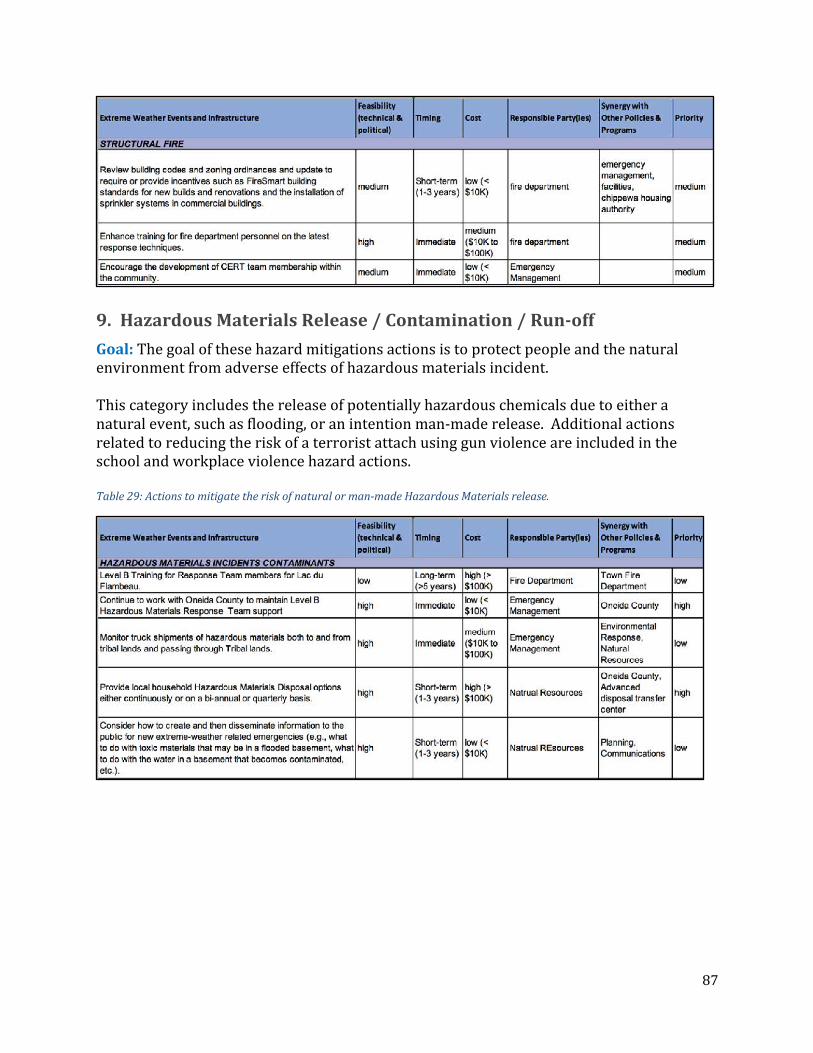
87
9. HazardousMaterialsRelease/Contamination/Run-offGoal:Thegoalofthesehazardmitigationsactionsistoprotectpeopleandthenaturalenvironmentfromadverseeffectsofhazardousmaterialsincident.Thiscategoryincludesthereleaseofpotentiallyhazardouschemicalsduetoeitheranaturalevent,suchasflooding,oranintentionman-maderelease.Additionalactionsrelatedtoreducingtheriskofaterroristattachusinggunviolenceareincludedintheschoolandworkplaceviolencehazardactions.Table29:Actionstomitigatetheriskofnaturalorman-madeHazardousMaterialsrelease.

88
10. Tornado/HighWindGoal:Thegoalofthesehazardmitigationsactionsistoprotecthealthandsafetyofcommunityresidentsandtouristsandminimizelossoflifeandproperty.Table30:ActionstomitigatetheriskofTornadoes/HighWinds

89
11. ExtremeHeatGoal:Thegoalofthesehazardmitigationsactionsistoprotectthehealthandsafetyofcommunityresidents,particularlyelders,youth,andthosewithspecialmedicalneeds.Table31:ActionstomitigatetheriskofExtremeHeat.
12. ExtremeColdGoal:Thegoalofthesehazardmitigationsactionsistoprotectthehealthandsafetyofcommunityresidents,particularlyelders,youth,andthosewithspecialmedicalneeds.Table32:ActionstomitigatetheriskofExtremeCold
13. SchoolViolence/ArmedAttack/WorkplaceViolenceGoal:Thegoalofthesehazardmitigationsactionsistoenhanceprotectionandcontinueinformationsharingandcoordinationbetweenlocalagenciesanddepartmentsaswellasfederalandstate,county,municipalemergencyserviceandlawenforcementagencies.

90
Table33:ActionstomitigatetheriskofSchoolViolence/ArmedAttacks/WorkplaceViolence
14. DamFailureGoal:ThegoalofthesehazardmitigationsactionsistoprotectthesafetyandpropertyofLacduFlambeaucommunityandallresidents.Table34:ActionstomitigatetheriskofDamFailure

91
Part V: Plan Updates (Element D)
FutureUpdatesInorderforthismulti-hazardmitigationplantocontinuetoberelevantandusefulfortheTribe,itwillneedtobeupdatedtoreflectchangesinonthegroundrisksinthecommunity,enhancedunderstandingofchangingclimateconditions,andtheemergenceofnewissuesofconcern.Thisupdateprocesswillbepartofastandardizedsystemtoreviewactivitiesandprojectsandmonitorandtrackimplementation.Theeffortwillinclude:
• AnofficialreviewandupdateprocessforthecompletehazardmitigationplaneveryfiveyearsthatwillgenerateanewhazardmitigationplanningdocumentthatwillbeadoptedbyTribalCouncil;
• TheTribalEmergencyPlanningCommitteewillcontinuetomeetquarterly(ormonthly)asneededtoexchangeinformationandprovideupdatesontheimplementationoftheactionsidentifiedinthisplan;
• TheTribalEmergencyPlanningCommitteewillannuallyreviewanynewclimateprojectionsfortheregionoradditionalinfrastructuredevelopment;and
• TheTribe’sannualbudgetingprocesswillbeinformedbythehazardandresilienceneedsofthetribe.EachdepartmentresponsibleforactionsidentifiedinthisplanwillreporttoTribalCouncilannuallyontheprogressofimplementingthoseactions,upcomingprioritiesforaction,opportunitiesforexternalfunding,andfundingneeds.
StatusofActionsIdentifiedinthe2006PlanAlothaschangedsincethecompletionandapprovalofthe2006hazardmitigationplan.Theemergenceoftheillegaldrugcrisis,anenhancedunderstandingoftherealitiesandnuancesofclimatechange,andthecapacityofthetribetoconductitsownhazardmitigationplanningeffort.Thetribehasmadesignificantprogressondevelopingandsharingeducationalmaterialsonavarietyofhazards(exemplifiedby“tornadoweek”inearlyAprilorannualpresentationsandactivitiesatthecommunityforum).Thetribehasalsomadeprogressdevelopingamasswarningsystem(communitysiren),enhancingprotectionforcriticalfacilitiessuchaswatertowers,andimplementingnewsecuritymeasuresattheschools.
PlanIntegrationForeachaction,theTEPCidentifiednotonlyresponsibledepartments,butalsosynergieswithexistingdepartmentplanortribaloperationsandmanagementplans.Thisidentificationwillalsofacilitatetheintegrationoftheseactionsintotheon-goingoperationsandmanagementplanswhenresourcesandthetimingmakethisintegrationpossible.

92
Part VI: Assurances and Plan Adoption (Element E)

93
Appendix A: Analysis of Climate Data
ClimatologicalObservationsSummariesTheobservationaldatasetsprovidedbytheGreatLakesIntegratedSciencesandAssessments(GLISA)containinformationfromthelate1800stothepresent.Theseobservationaldataprovidehigh-qualityobservationsthatrepresenttheoverallclimateoftheGreatLakesregion.TheobservationaldatasetsusedfortheLacduFlambeauTribeofLakeSuperiorChippewaIndians(LacDuFlambeau)ClimateChangeResiliencePlanweretheNationalOceanicandAtmosphericAdministration(NOAA)NationalCentersforEnvironmentalInformation(NCEI)ClimateDivisionsandtheGlobalHistoricalClimatologyNetworkDaily(GHCN-D)Stationobservations.NCEIClimateDivisionsDatasetTheNCEIClimateDivisionsdatasetisalong-termtemporaldatasetforthecontiguousUnitedStates.TheClimateDivisionswereusedtoidentifyseasonalandannualtrendsingeographicallyrelatableareas.ForeachClimateDivision,monthlystationtemperatureandprecipitationvalueswerecomputedfromtheNCEIGHCN-Dailyobservationaldataset.Eachdivisionwassmallenoughtobesubjectedtosimilarclimateforceswhileincorporatingenoughobservationstoprovideastatisticallysoundsummaryoftrendsatthemulti-countyscale.TheperiodofrecordfortheClimateDivisionsdatasetspannedfrom1895topresent,andthisisimportantforunderstandingclimatetrendsatabroaderscalethanlocalobservations.

94
SelectionofGeographicAreaofInterestAttheFebruary2018meetinghostedbyAdaptationInternational(AI)andtheLacduFlambeauClimateResiliencePlanning(TCRP)Committee,GLISAwasinvitedtopresentanoverviewofitsworkwithTribalNationsacrosstheGreatLakesregion.Inaddition,GLISAprovidedasummaryoftheclimateinformationthatwouldbeusedinsupportofthisproject(i.e.,historicalobservationsandfutureprojections).Attheconclusionofthemeeting,theTCRPdecideduponanareaofinterest(AOI)forwhichGLISAwouldcustomizesummarizedclimateinformation.ThisAOIiscomposedofseveralwatershedswithinaforty-mileradiusoftheLacduFlambeauReservation.ThisAOIissignificantduetohuntingandotheractivitiesimportanttotheTribe(seeFigure1).AspartoftheongoingeffortstosupportclimateadaptationactivitieswithintheGreatLakesregion,GLISAhasdevelopedsummariesoftheobservedhistoricalclimateforNCEIClimateDivisions.TheClimateDivisionforNorthCentralWisconsin(WICD2)wasusedinsupportoftheanalysisoftheLacduFlambeauTribalClimateResiliencePlanning(TCRP)
Figure25:LacduFlambeauTCRP'sAreaofInterest(AOI)whichspannedoverseveralwatershedswithinaforty-mileradiusofthereservedlands.Theredborderistheoutlineoftheforty-mileboundary,andtheblueareahighlightedtheAOIforthisanalsis.(Source:AdaptationInternational)

95
Committee'sAOI.Comparedtotheotherclimatedivisionssurroundingthearea(i.e.,NorthwesternWisconsin(CD1),NortheasternWisconsin(CD3),andWesternUpperMichigan(CD1)),WICD2hasthemostcoverageintheAOIasshowninFigure2.ThiswasoptimalforunderstandinghowtheobservedclimatetrendshavebeenchangingwithintheareasurroundingtheLacduFlambeauReservation.GlobalHistoricalClimatologyNetworkDaily(GHCN-D)StationDatasetsGHCN-DistheNCEIintegrateddatabaseofclimatesummariesfromlandobservationstationsacrosstheglobe,whichhavebeensubjecttostandardizedqualityassurancecontrols.TheGHCN-Discomprisedofdailyclimaterecordsfromnumerouslandsurfacestations,andthesestationsareusedtodescribethetypicalclimateofaparticularplace.TheGLISAquality-controlledGHCN-Dstationscontainedover60yearsofthehigh-qualitylandsurfaceobservationsforthestationssurroundingtheGreatLakesregion.FortheGHCN-Dstationsincludedintheanalysis,thedatawasfurtherprocessedbyaseriesofscriptswhichwereusedtoreviewthequalityflags(i.e.,signifyinginaccuratedata)oftheobservations.Ifaflagwasfoundforasingleobservation,itwasnotusedwithinthecalculationoftheclimatetrendsforthegivenstation.Thisensuredanomaliesfoundfromanysingledailyobservationdidnotadverselyinfluencethecharacterizationofthestation’sclimatetrend.ThescriptsprovidedoutputsintheformofCommaSeparatedValues(.csv)fileswhichwerecompatiblewithmanyspreadsheetapplications.WebfileswereformattedanduploadedtotheserverhostingtheGLISAwebsite,allowingGLISAtoeasilyupdatetheinformationontheGreatLakesStationClimatologieswebpagecurrentlyavailableforagivenstation.ThisprocesswasusedfortheprocessingandupdatingoftheclimatedataontheGreatLakesClimateDivisionswebpagefromtheNCEIClimateDivisionsaswell.
Figure26:TheAOIoverlaidontheNCEIClimateDivisions.MajorityoftheAOIiswithinWICD2(NorthCentralWisconsin),andthisClimateDivisionwasusedintheanalysisforthehistoricalclimatologicaltrends.(Source:GLISA)

96
TheGHCN-DstationslocatedinRestLake,WIandMinocqua,WIwereusedintheanalysisoftheLacduFlambeauTribalClimateResiliencePlanning(TCRP)Committee'sAOI.ThesestationsarelocatedatoppositeendsofthereservedlandsofLacduFlambeau.TheclimatologicalobservingstationatRestLakeislocatedtothenorthofLacduFlambeau,whiletheclimatologicalobservingstationatMinocquaislocatedtothesouthofLacduFlambeau(Figure3).TheuseofthesestationsprovidedamorelocalizedunderstandingofthelocalclimateobservedwithintheLacduFlambeauReservation.HistoricalObservationSourcesGlobalHistoricalClimatologyNetworkDaily(GHCN-D)StationObservations:https://www.ncdc.noaa.gov/ghcn-daily-descriptionhttp://glisa.umich.edu/climate-stationsNationalCentersforEnvironmentalInformationClimateDivisions:https://www.ncdc.noaa.gov/monitoring-references/maps/us-climate-divisions.php;http://glisa.umich.edu/resources/great-lakes-climate-divisions
ClimateProjectionsSummaries
FutureClimateDatafortheGreatLakesRegionClimatemodelsareusedtogeneratefutureclimatedatathatareoftenusedinclimateadaptationplanning.Globalclimatemodels(GCMs)simulateimportantphysicalprocessesandinteractionsinvolvingtheland,atmosphere,ocean,andiceovertheentireEarth.DozensofGCMsexistasdifferentmodelinggroupsworktoimprovemodelsimulations.ComputinglimitationsrestrictGCMstorelativelycoarsespatialresolution—meaningthemodelsdividetheEarth’ssurfaceintorelativelylargeareas(calledgridboxes)forperformingsimulationsandaveraging.Unfortunately,thislimitationmakesGCMsaninsufficientsourceofinformationforprocessesthatoccuratrelativelysmallspatialscales(suchasthosethatwouldoccurwithinanindividualgridbox),likeextremeprecipitationorwind,becausetheseeventsarenotphysicallysimulatedinthemodelsbutestimated.Inparticular,mostGCMsdonotincludearepresentationoftheGreatLakesortheyaretoosimplisticintheirrepresentationtoaccuratelysimulatelake-land-atmosphereinteractions(i.e.,lake-effectprecipitation),whichareimportantintheGreatLakesregion.This,along
Figure27:TheGHCN-DStationObservationsaroundtheLacduFlambeauReservation.ThestationinRestLake,WIislocatedtothenorth,andthestationinMinocqua,WIislocatedtothesouth.(Source:GLISA)

97
withtheexclusionofothersmallerscaleclimateprocesses,makeGCMsbestsuitedforlarge-scale(global)climatestudies.Whenoneisinterestedinstudyingplausiblefutureclimatesatsmallerareasofinterest,liketheGreatLakesregion,thedetailsofthelandscapebecomeimportant(i.e.,topography).ThesefeaturesaretypicallybetterrepresentedinRegionalClimateModels(RCMs)thatincludesimulationsofsmallerscaleclimateprocessesatfinerspatialresolutions(Figure4).SuchenhancementsmakeRCMsmuchmorecomputationallyexpensivecomparedtoGCMs,sotheyareprimarilydesignedforandlimitedtospecificregions.AnRCMreliesontheinputfromaGCMatitsgeographicalboundarytoprovidetheinitialorstartingconditionsforthesimulation.TheRCMthenperformsamoredetailedsimulationoftheclimatepredictionoveraspecificregion.Thisapproachofgeneratingafine-scaleclimatesimulationinformedbylarger-scaleGCMsimulationsiscalled“dynamicdownscaling.”
Figure28:DepictionofhowglobalclimatemodelsdividethesurfaceoftheEarthintorelativelylargegridcellsandregionalclimatemodelsperformsimulationsoversmallerportionsoftheEarthatfinerspatialresolutions.(Source:GLISA)
GlobalClimateModelQualityAspreviouslystated,mostGCMsdonotincludetheGreatLakesphysically,oradequatelyrepresenttheirinfluenceonimportantatmosphericprocesses,sotheirqualityisratherpoorfortheregion.Hence,thereisaneedforRCMsimulations.However,thequalityofthefinalRCM
Table1:GCMbiasesinnear-surfaceairtemperature(°C)andprecipitation(mm/day)overlandwithintheGreatLakesBasinreportedasroot-mean-square-differencesfromobservations.Betterperformingmodelsarebolded.(Source:Notaroetal.2014)

98
projectiondependsinpartonthequalityofinformationcomingfromtheGCMthatisusedasinputattheboundaryoftheRCM.Notaroetal.(2014)evaluated33GCMspriortoselectingasubsetofsixthatwereusedaspartoftheNelsonInstituteCenterforClimaticChangeResearch’sdynamically-downscaledsimulationsintheGreatLakes.ThemodelsranundertheRepresentativeConcentrationPathway8.5(RCP8.5),whichprojectedthehighestgreenhousegasemissionsmodelanalysis.Thesemodelsweredownscaledtoa25-kilometerspatialresolutionaccordingtotheRCP8.5scenariousingtheInternationalCentreforTheoreticalPhysics(ICTP)RegionalClimateModelVersionFour(RegCM4)coupledtoaone-dimensionallakemodeltorepresenttheGreatLakes.TheRegCM4wasoriginallydevelopedattheNationalCenterforAtmosphericResearchandiscurrentlymaintainedbytheInternationalCenterforTheoreticalPhysics(2010).Rootmean-square-differences,ameasureofaccuracy,wereusedtoshowhowwelleachGCMsimulatedhistoricalobservationsoftemperaturesandprecipitationovertheGreatLakesRegion(Table1).Root-mean-square-differencevaluesclosertozeroindicatesmallermodelerror(bias),whichwasdeterminedbycomparingthehistoricalsimulationinthemodeltoobservations.ValuesshowninboldtextinTable1indicatethemodelwasinthetop33%forbestperformancefortheselectvariable.
RegionalClimateModelSystem4(RegCM4)Whatelevatesthisdynamical-downscalingeffortabovemanyotherswastheinclusionofaninteractive1-Dlakemodelthatmorerealisticallysimulatedlaketemperaturesandlakeice—twovariablesnecessaryforcapturingcriticallakedynamicfeedbackstotheatmosphere.TheinclusionoftheGreatLakesandlakeprocessesinRegCM4hasresultedinsomeofthebestavailablemodelsimulationsfortheGreatLakesregionto-date.DetaileddescriptionsofRegCM4’sabilitytosimulatespecificclimatevariablescanbefoundinTable2.TheseevaluationspertainonlytotheperformanceofRegCM4,drivenbyobservationalreanalysisdata(i.e.,spatiallygriddedcompilationsofinstrumentobservations),anddonotincludetheinheritedGCMbiases.

99
ThequalityoftheGCMimpactsthequalityoftheRCM’sfutureprojections,becauseGCMbiaseswerecarriedintotheRCMsimulation.Forexample,aGCMwithawarmbiasmaypreventtheRCMfromsimulatingiceontheGreatLakesduringwinter,whichhasimplicationsfortheRCM’ssimulationoflake-effectprecipitation,lakeevaporation,andotherlake-effects.ThefinalsetofsixGCMswereselectedbasedonthosethathadsufficientlyhighspatialresolution,goodoverallperformance,andrepresentedarangeoffuturewarmingandprecipitationchange.
Table35:SummaryofRegCM4historicalperformancebasedonevaluationinformationfoundinNotaroetal.2013band2014.

100
Dynamically-downscaledClimateProjectionsfortheGreatLakesRegionThisprojectutilizedasetofdynamically-downscaledclimateprojectionsthatweredesignedfortheGreatLakesregion.Projectionsoffuturechange(mid-andlate-21stcentury)havebeenmadepubliclyavailableforavarietyofclimatevariables.Themid-centuryperiodspannedovertheyearsof2040-2059,andthelate-centuryperiodspannedovertheyearsof2080-2099.Thedatawasmadeavailablefordownload(netcdffiles)orviewableasmappedproductsatthelinkbelow.LinktoData:http://nelson.wisc.edu/ccr/resources/dynamical-downscaling/index.phpCharacterizationofDynamically-downscaledClimateModelSimulationResultsfortheLacduFlambeauAOIAsagreeduponbytheTCRP,AI,andGLISA,thecharacterizationofdynamically-downscaledclimatemodelsimulationresultswaspresentedthroughtheuseofbothmapsandspreadsheetapplications.ThismethodologyhasprovensuccessfulincharacterizingclimateobservationsandprojectedclimatetrendsaspartofpreviouscollaborationsbetweenGLISA,AI,andotherIndigenousTribesintheregion.ThisprocessinvolvedcollectinghistoricalobservationsforthelocationswithintheLacduFlambeauAOIfromtheNCEIandfutureclimateprojectionsfromthedynamically-downscaledoutputoftheRCMsimulationsdescribedintheprevioussection.Theoutputfromthesixdynamically-downscaledmodelswereprocessedusingaPythonprogramminglanguagescript.ThevariablesacquiredforthisanalysisconsistedoftemperatureandprecipitationoutputsgivenbytheNelsonInstitute,andseveralothervariables,suchasdaysover90°F,firstfallfreeze,lastspringfreeze,andmanyothers,weredetailedinTable5.ThesevariableswerechosenbasedontheprioritiesspecifiedbytheTCRPtobeusedintheClimateChangeResiliencePlan.
Table36:InstitutionsproducingGCMsimulationsusedtoprovideboundaryconditionstoRegCM4(Source:Notaroetal.2014)

101
Table37:ListofthevariableschosenbyTCRP,AI,andGLISAfortheclimateanalysisoftheAOI.AlldatawasprovidedbytheNelsonInstitutedynamically-downscaledRegionalClimateModels.
Variable UnitsTemperature °FPrecipitation InchesDayswith2+”ofPrecipitation Days/DecadeFirstFallFreeze DaysLastSpringFreeze DaysDaysOver90°F DaysDaysOver100°F DaysSnowfallChange InchesSnowfallDays DaysSnowfallGreaterthan6” Days
ThePythonprogrammingscriptsusedtheoutputdatafromtheNelsonInstitutetoanalyzethechangesinthesevariablesbasedonthetimeperiodsof2040-2059(i.e.,mid-century)and2080-2099(i.e.,endofcenturyorlate-century)comparedtotheobservedclimatologicalconditions.Duetotheirresolution,thedynamically-downscaledmodelsprovideinformationatscalesasfineas25-kilometers,andtheoutputsprovidedbytheNelsonInstituteconsistedofNetCDFspatialdatafilesconsistingofpastchangeintrendsfortheobservationsduringtheperiodof1980-199918.GiventhatthemodelsimulationsprovideaprojectionofthespatialvariationinprojectedtrendsacrosstheGreatLakes,thePythoncodewasusedtoprocessthedatawithintheboundaryoftheAOI.ThisinvolvedapplyingcertainPythonfunctionstocarveor“clip”thedatawithintheboundary.The“clipping”ofthedatagatheredthedatacellswhichwerecontainedwithintheAOI,andtheresultswerespatiallyaveragedovertheareatoprovideasinglenumberrepresentingthechangefortheentireAOI.ThePythoncodecreatedbyGLISAprovidedtwoformsofdatathatcanbeusedforfurtheranalysisoftheclimatearoundLacduFlambeau.Themapsprovidedavisualizationoftheresultsfromtheprocessingforallsixmodels,individually,andfortheensemblemean.Theensemblemeanwasproducedbytakingtheaverageoftheresultsfromallsixmodels.ThemapsgeneratedaspartofthisprojectprovidedresultswhichspannedtheGreatLakesregion(boundedbytheareaof40°Nto50°Nand75°Wto95°W)aswellastheAOIcoverageofLacduFlambeau19.ThenumericaloutputsfromthemodelsthatwereprocessedusingthePythoncodewereplacedintoaCommaSeparateValues(.csv)spreadsheet.Thislatterspreadsheetprovidedthespatialaverageofallthevariablesforeachofthesixmodelsduringthemid-centuryandendofcenturytimeperiodsfortheLacduFlambeauAOI20.Therangeofavariableswasdeterminedthroughidentifyingtheminimumandmaximumnumberofallsixmodels,andtheserangeswereprovidedforthemid-centuryandendofcenturytimeperiods.
18Source:https://nelson.wisc.edu/ccr/resources/dynamical-downscaling/index.php19Link:https://drive.google.com/open?id=1iVkDaJlaL8dk97vIE-UV5VwdbjWMFOCd20Link:https://drive.google.com/open?id=1-VJnYgYPT4-ogu2fqZcotBWfv7-dSg02

102
CalculationoftheHamonMoistureMetric(HMM)ThecalculationoftheHamonMoistureMetric(HMM)isamethodofintegratingtemperature,precipitation,andsunlighthourstoproducetheresultsneededfortheClimateChangeVulnerabilityIndex(CCVI)createdbyNatureServe21.TheCCVIhasaidedinidentifyingwhichspeciesaremostvulnerabletothedrasticeffectsofclimatechangeimpacts.TheHMMisbasedontheHamonpotentialevapotranspirationequationwhichquantifiestheratiobetweenwateravailabilityandtheevaporativedemand(Hamon,1961andLuet.al.,2005).Thedeterminationoftheratiorequiredtheuseoftemperature,precipitation,andnumberofdaylighthoursforagivenlocationasspecifiedbytheformulasgiveninCopelandetal.,2010.ThedatafromtheNelsonInstitutewasusedtocalculatethisratiobasedontheformulawhichistheratioofactualevapotranspiration(AET)andpotentialevapotranspiration(PET).
𝐻𝑎𝑚𝑜𝑛𝑀𝑜𝑖𝑠𝑡𝑢𝑟𝑒𝑀𝑒𝑡𝑟𝑖𝑐(𝐻𝑀𝑀) = 𝑃𝐸𝑇/𝐴𝐸𝑇
ThecalculationofHMMrequiredgatheringhistoricalgriddedclimatologicalobservationsandmodelprojections,whichwereusedwithecologicaldataprovidedbyAI,fortheCCVIanalysis.TheDynamically-downscaleddatafromtheNelsonInstitutehasgriddedhistoricaldataavailable,andthisgriddeddatawaspairedwiththeprojectionstoensureconsistencyinthecomparingthemodels’historicalmodeloutputsandmodels’projections.ThefollowingformulawasusedtocomputethePETusedintheCCVIanalysis:
𝑃𝐸𝑇𝐻𝑎𝑚𝑜𝑛 = 13.97𝑑𝐷2𝑊𝑡,wheredisthenumberofdayspermonth;Disthehoursofsunlightforthegivenmonth;andWtisthesaturatedwatervapordensity,whichisdependentontheaveragetemperatureofthemonthT,definedbythefollowingformula:
𝑊𝑡 = (4.95𝑒0.062𝑇)/100
ThePETwasdependentontheaveragemonthlytemperature,andtemperaturesbelow32°FmakethePETzero.ThiswouldmakewintermonthsmorelikelytohavezeroPETduetotheaveragebelow-freezingtemperatures.TheAETdependedonseveralconditionsofwhetherthemonthlyaveragetotalprecipitationisgreaterorlesserthanthePET.TheAETwouldequaltheprecipitationamountiftheamountwasgreaterthanthePET;however,theAETandPETwouldbethesameoncetheprecipitationamountwaslessthanthePETforthemonth.AnadditionalcodewascreatedbyGLISAtocalculatetheensemblemeanofthehistoricalandfuturegriddedmodeloutputsforthiscalculation.Thehistoricaldatawasaveragedoverthetimeperiodof1980-1999forconsistencywiththe20-yearaveragingofthemid-centuryandendofcenturytimeperiods.Oncetheensemblemeanwascalculatedforthe
21link:http://www.natureserve.org/conservation-tools/climate-change-vulnerability-index

103
differentparametersoftheHMM(i.e.,Wt,PET,andAET),theresultingcalculationwasoutputtedintogriddedNetCDFfiles.ThegriddedoutputsprovidedtheHMMfortheentireGreatLakesregion,andAIhascontinuedtheprocessingoftheCCVIwiththeresultinggriddeddataforfurtheranalysis.
CCVIAnalysisDifferencesTheCCVIanalysisinvolvedintegratinggriddedmodeldatafromclimatechangemodelswithecologicaldatatofindwhichspeciesaremostvulnerabletoclimatechangeimpacts.DuetotheirefficiencyofdepictingthedynamicsoftheGreatLakeswiththeatmosphere,GLISAuseddatafromtheNelsonInstituteandprovidedanensemblemeancontaininganaverageofallsixmodels.Thisensemblemeanprovidedsomeconsensusofdirectionastohowthemodelswerebehavingbasedonmodelrunsformid-centuryandendofcentury.Incontrast,theGreatLakesIndianFishandWildlifeCommission(GLIFWC)usedthesamedataprovidedbytheNelsonInstitutetocreatetheirownmethodofcalculatingtheCCVI.GLIFWC’smethodinvolvedusingtworepresentativemodelsgivingthemostandleastamountofchangeinthefuturebasedonallsixmodels.ThismethodwasdistinctlydifferentfromGLISA’ssincetwomodelswerechosentorepresentthebehaviorofthedata;however,GLISA’smethoddidtakeintoconsiderationthedifferentbehaviorsofthemodelsbasedontheensemblemean.GLISA’smethodcanbethoughtofasamiddlegroundforhowtheresultsoftheCCVIshouldbeinterpretedcomparedtoGLIFWC’smethodology.Otherfactorsandfurtherinvestigationswillbeneededtounderstandtheadvantagesanddisadvantagesofeachmethod.

104
Appendix B: Public Engagement Itemstobeinserted–
• InitialSurvey–Onlineandpaper• InitialSurveyResponses• ReviewSurvey• ReviewSurveyResponses