Embed Size (px)
Citation preview

2016
KOMITE NASIONAL KESELAMATAN TRANSPORTASIREPUBLIC OF INDONESIA
FINALKNKT.15.06.13.04
Aircraft Serious Incident Investigation Report
PT. Garuda IndonesiaBoeing 737‐800; PK‐GFA
Sultan Hasanuddin International Airport MakassarSouth Sulawesi
Republic of Indonesia2 June 2015
2016

This final report was produced by the Komite Nasional Keselamatan Transportasi (KNKT), 3rd Floor Ministry of Transportation, Jalan Medan Merdeka Timur No. 5 Jakarta 10110, INDONESIA.
The report is based upon the investigation carried out by the KNKT in accordance with Annex 13 to the Convention on International Civil Aviation, the Indonesian Aviation Act (UU No. 1/2009) and Government Regulation (PP No. 62/2013).
Readers are advised that the KNKT investigates for the sole purpose of enhancing aviation safety. Consequently, the KNKT reports are confined to matters of safety significance and may be misleading if used for any other purpose.
As the KNKT believes that safety information is of greatest value if it is passed on for the use of others, readers are encouraged to copy or reprint for further distribution, acknowledging the KNKT as the source.
When the KNKT makes recommendations as a result of its investigations or research, safety is its primary consideration.
However, the KNKT fully recognizes that the implementation of recommendations arising from its investigations will in some cases incur a cost to the industry.
States participating in KNKT investigation should note that the information in KNKT reports and recommendations is provided to promote aviation safety. In no case is it intended to imply blame or liability.

i
TABLE OF CONTENTS TABLE OF CONTENTS ....................................................................................................... i
TABLE OF FIGURES ........................................................................................................... ii
ABBREVIATIONSAND DEFINITIONS ........................................................................... iii
INTRODUCTION ................................................................................................................ iv
1 Factual Information ........................................................................................................ 1 1.1 History of the Flight .............................................................................................. 1
1.2 Weight and balance ............................................................................................... 8
1.3 FCOM Performance in-flight normal configuration landing distance .................. 9
1.4 Weather information ........................................................................................... 10
1.5 Other information ................................................................................................ 12
1.5.1 Aircraft lift ............................................................................................. 12
1.5.2 Thunderstorm formation ........................................................................ 13
2 ANALYSIS .................................................................................................................... 15
3 CONCLUSIONS ........................................................................................................... 16 3.1 Findings ............................................................................................................... 16
3.2 Contributing Factors ........................................................................................... 17
4 SAFETY ACTION ........................................................................................................ 18
5 SAFETY RECOMMENDATIONS ............................................................................. 19
5.1. Garuda Indonesia ................................................................................................ 19
5.1 Lembaga Penyelenggara Pelayanan Navigasi Penerbangan Indonesia (AirNav Indonesia) ............................................................................................. 19
ii
TABLE OF FIGURES Figure 1: Archive photo of aircraft involved ....................................................................... 1 Figure 2: Airport CCTV footage of the aircrafttouched down ............................................ 3 Figure 3: Aircraft position and condition after stop ............................................................ 4 Figure 4: Super imposed from Google earth and CCTV just after aircraft touch down ..... 5 Figure 5: The graph of relevant FDR parameters ................................................................ 6 Figure 6: Visual weather observedat 06.19 and 06.20 UTC ............................................. 11 Figure 7: Visual weather observedat 06.29 and 06.30 UTC ............................................. 12 Figure 8: Visual weather observedat 06.39 and 06.40 UTC ............................................. 12 Figure 9: Stages of thunderstorm ...................................................................................... 13 Figure 10: Lateral view illustration of thunderstorm .......................................................... 13

iii
ABBREVIATIONSAND DEFINITIONS
AGL : Above Ground Level ARFF : Airport Rescue and Fire Fighting
ATC : Air Traffic Control
ATIS : Aerodrome Terminal Information Service
ATPL : Airline Transport Pilot License
°C : Degrees Celsius
CCTV : Closed-circuit Television
CSN : Cycles Since New
CVR : Cockpit Voice Recorder
EGPWS : Enhanced Ground Proximity Warning System
FCOM : Flight Crew Operating Manual
FDR : Flight Data Recorder
Ft : Feet
ILS : Instrument Landing System
Kg : Kilogram(s)
KNKT : Komite Nasional Keselamatan Transportasi (National Transportation Safety Committee)
Km : Kilometer (s)
Kts : Knot(s)
LPPNPI : Lembaga Penyelenggara Pelayanan Navigasi Penerbangan Indonesia (AirNav Indonesia)
Mbs : Millibars
ND : Navigation Display
PF : Pilot Flying
PIC : Pilot in Command
PM Pilot Monitoring
QNH : Height above mean sea level based on local station pressure
SIC : Second in Command
TSN : Time Since New
TSRA : Thunderstorm Rain
UTC : Universal Time Coordinate
VREF : Reference Landing Speed

iv
INTRODUCTION SYNOPSIS On 2 June 2015, a Boeing 737-800 aircraft, registration PK-GFA was being operated by PT. Garuda Indonesia on a scheduled passenger flight from Soekarno-Hatta Airport, Jakarta to Sultan Hasanuddin Airport, Makassar. The Pilot in Command (PIC) acted as Pilot Flying (PF) while the Second in Command (SIC) acted as Pilot Monitoring (PM).
The calculation of the required runway length for the estimated aircraft landing weight with flaps 30 configuration was approximately 2,100 meters.
After evaluation of weather condition, the controller changed the runway in use from runway 03 to runway 13. During approach on Instrument Landing System (ILS) runway 13, the crew noticed that on the east of the airport was cloudy, the end of runway 13 was raining and approximately 1/4 part of the runway was wet on the end of runway 13.
At approximately 100 ft Above Ground Level (AGL), the PM informed the PF that refer to the data displayed on the Navigation Display (ND), the tail wind was up to 10 kts and cross wind 10 kts from the right side of aircraft.
During landing flare, the thrust levers were closed however the aircraft floated.The Cockpit Voice Recorder (CVR) data revealed that the interval between Enhanced Ground Proximity Warning System (EGPWS) call ‘ten’ to touchdown was 16 seconds while the Flight Data Recorder (FDR) recorded that after passing 20 ft to touchdown was 13 seconds. Floating for 13 seconds with the current speed it was calculated that the aircraft has travelled approximately 1,075 meters. The FDR and airport Closed-circuit Television (CCTV) recorded that the aircraft touched down after passing taxiway Charlie.
The flight crew did not consider a go around as they aware that the takeoff area of the runway 13 was mountainous area and might jeopardized the flight.
The aircraft stopped at the left side of the stopway with the nose landing gear and left main landing gear stuck at the mud while the right main landing gear remain on the stopway pavement. No one injured on this serious incident.
1
1 FACTUAL INFORMATION 1.1 History of the Flight
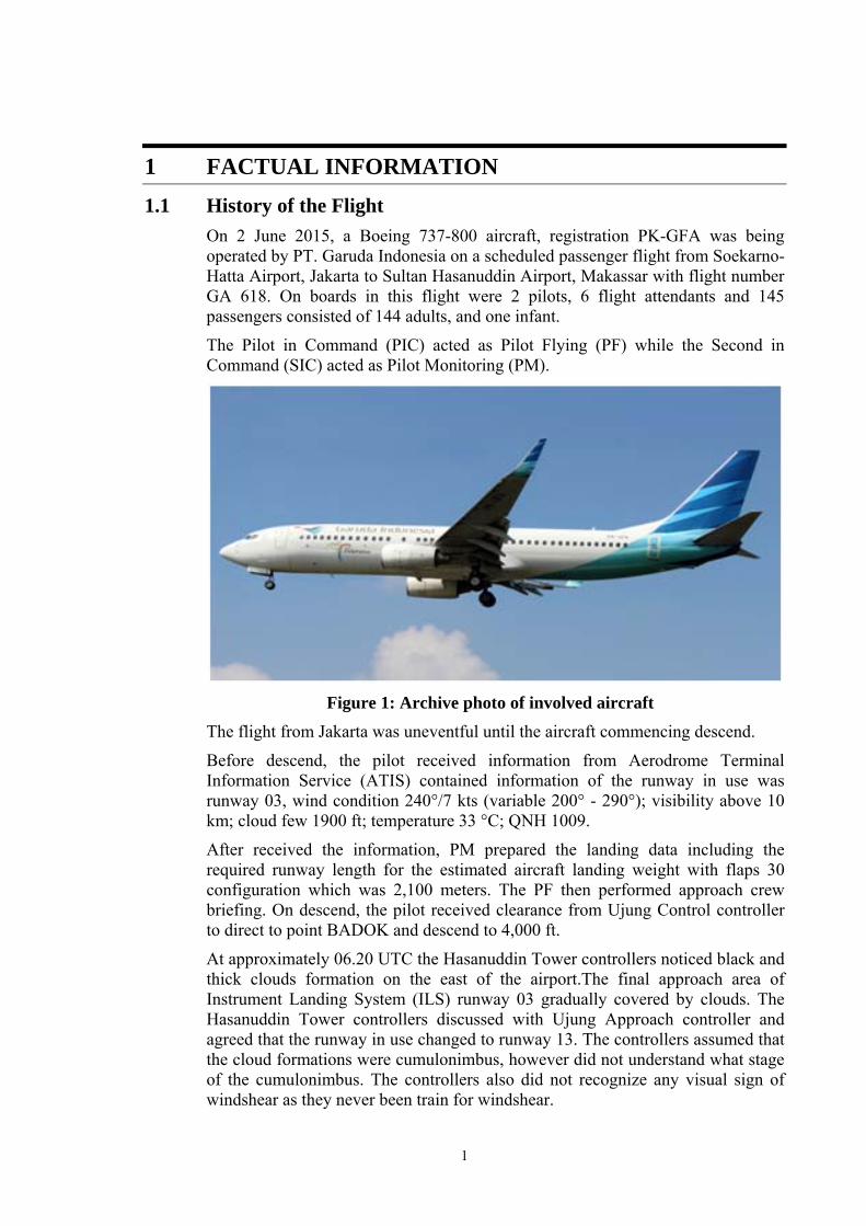
On 2 June 2015, a Boeing 737-800 aircraft, registration PK-GFA was being operated by PT. Garuda Indonesia on a scheduled passenger flight from Soekarno-Hatta Airport, Jakarta to Sultan Hasanuddin Airport, Makassar with flight number GA 618. On boards in this flight were 2 pilots, 6 flight attendants and 145 passengers consisted of 144 adults, and one infant.
The Pilot in Command (PIC) acted as Pilot Flying (PF) while the Second in Command (SIC) acted as Pilot Monitoring (PM).
Figure 1: Archive photo of involved aircraft
The flight from Jakarta was uneventful until the aircraft commencing descend.
Before descend, the pilot received information from Aerodrome Terminal Information Service (ATIS) contained information of the runway in use was runway 03, wind condition 240°/7 kts (variable 200° - 290°); visibility above 10 km; cloud few 1900 ft; temperature 33 °C; QNH 1009.
After received the information, PM prepared the landing data including the required runway length for the estimated aircraft landing weight with flaps 30 configuration which was 2,100 meters. The PF then performed approach crew briefing. On descend, the pilot received clearance from Ujung Control controller to direct to point BADOK and descend to 4,000 ft.
At approximately 06.20 UTC the Hasanuddin Tower controllers noticed black and thick clouds formation on the east of the airport.The final approach area of Instrument Landing System (ILS) runway 03 gradually covered by clouds. The Hasanuddin Tower controllers discussed with Ujung Approach controller and agreed that the runway in use changed to runway 13. The controllers assumed that the cloud formations were cumulonimbus, however did not understand what stage of the cumulonimbus. The controllers also did not recognize any visual sign of windshear as they never been train for windshear.

2
The pilot instructed to contact Makassar Approach and the controller informed that the runway in use was changed to runway 13 and provide radar vector for ILS approach runway 13. The PF then reviewed and briefed the ILS approach procedure for runway 13.
At 06.28 UTC, the pilot contacted Hasanuddin Tower controller and was informed that the QNH was 1009 and another aircraft at 6 miles ahead.
During the approach the crew noticed that on the east of the airport was cloudy, the end of runway 13 was raining and approximately 1/4 part of the runway was wet on the end of runway 13.
After established on the ILS, at 06.32 UTC, the Hasanuddin Tower controller issued landing clearance with additional information of wind 280°/7 kts up to 15 kts, and caution for wet runway.
At approximately 100 ft Above Ground Level (AGL), the PM informed the PF that refer to the data displayed on the Navigation Display (ND), the tail wind was up to 10 kts and cross wind 10 kts from the right side of aircraft.
During landing flare, the thrust levers were closedhowever the aircraft floated. The Cockpit Voice Recorder (CVR) data revealed that the interval between Enhanced Ground Proximity Warning System (EGPWS) call ‘ten’ to touchdown was 16 seconds. The Flight Data Recorder (FDR) recorded that after passing 20 ft to touchdown was 13 seconds. The pilot noticed the aircraft has passed taxiway Alpha prior to touchdown. After touched down, the aircraft encountered heavy rain.
The flight crew did not consider a go around as they aware that the takeoff area of the runway 13 was mountainous area and might jeopardized the flight.
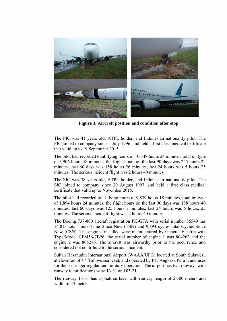
The crew did not feel normal aircraft decelerationthe PF then applied manual braking with intention to increase deceleration. Noticed that the end of the runway was near, the PIC turned the aircraft slightly to the left. The aircraft stopped at the left side of the stopway with the nose landinggear and left main landing gear stuck at the mud while the right main landing gear remain on the stopway pavement.

3
Figure 2: Airport CCTV footage of the aircrafttouched down
After the aircraft touchdown, the Hasanuddin Tower controller was unable to see the aircraft due to the heavy rain.
After the aircraft stopped, both pilots executed the “On Ground Emergency” checklist and contacted the Hasanuddin Tower controller and informed that they blocked the end of the runway and requesting for assistance. The pilot was unable to communicate with the flight attendant through interphone system. They decided to open the cockpit door and invited the flight attendant. The pilot informed that the all passengers requested to be remain seated. The flight attendant 1 and the pilot then made announcement to the passengers to inform the situation.
The Hasanuddin Tower controller could not confirm situation and called the Airport Rescue and Fire Fighting (ARFF) and requested to check the aircraft condition.
The ARFF deployed to the location mentioned by the tower controller via taxiway WP (Whiskey Papa) and almost collided with the aircraft that was taxied on the taxiway. The visibility hampered the ARFF driver vision.
After the ARFF arrived at the side, the observed the aircraft condition and communicated to the pilot. Passengers and crews were evacuated used ARFF stair and thereafter changed with passenger stair.
No one injured on this serious incident.
4
Figure 3: Aircraft position and condition after stop
The PIC was 41 years old, ATPL holder, and Indonesian nationality pilot. The PIC joined to company since 1 July 1996, and held a first class medical certificate that valid up to 19 September 2015.
The pilot had recorded total flying hours of 10,348 hours 24 minutes, total on type of 3,906 hours 48 minutes, the flight hours on the last 90 days was 245 hours 22 minutes, last 60 days was 158 hours 26 minutes, last 24 hours was 5 hours 25 minutes. The serious incident flight was 2 hours 40 minutes.
The SIC was 38 years old, ATPL holder, and Indonesian nationality pilot. The SIC joined to company since 20 August 1997, and held a first class medical certificate that valid up to November 2015.
The pilot had recorded total flying hours of 9,839 hours 18 minutes, total on type of 1,894 hours 24 minutes, the flight hours on the last 90 days was 188 hours 40 minutes, last 60 days was 125 hours 7 minutes, last 24 hours was 5 hours, 25 minutes. The serious incident flight was 2 hours 40 minutes.
The Boeing 737-800 aircraft registration PK-GFA with serial number 36549 has 14,813 total hours Time Since New (TSN) and 9,894 cycles total Cycles Since New (CSN). The engines installed were manufactured by General Electric with Type/Model CFM56-7B26, the serial number of engine 1 was 804263 and the engine 2 was 805276. The aircraft was airworthy prior to the occurrence and considered not contribute to the serious incident.
Sultan Hasanudin International Airport (WAAA/UPG) located at South Sulawesi, at elevation of 47 ft above sea level, and operated by PT. Angkasa Pura I, and uses for the passenger regular and military operation. The airport has two runways with runway identifications were 13-31 and 03-21
The runway 13-31 has asphalt surface, with runway length of 2,500 meters and width of 45 meter.

5
According to the coordinates recorded by the FDR the aircraft touchdown was approximately 1,435 meters from beginning runway 13 and stopped at approximately 1,095 meters after touchdown.
Figure 4: Super imposed from Google earth and CCTV just after aircraft
touch down

6
Figure 5: The graph of relevant FDR parameters
The FDR data indicated that the aircraft was on correct approach path during the approach.
Aircraft reached 10 ft Aircraft first touchdown
KNKT.15.06.13.04
7
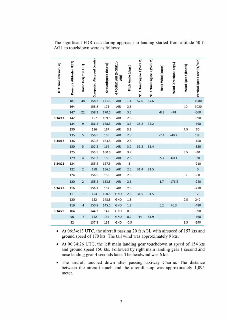
The significant FDR data during approach to landing started from altitude 50 ft AGL to touchdown were as follows:
UTC
Tim
e (hh:mm:ss)
Pressure Altitude
(FEET)
Radio Heigh
t (FEET)
Compu
ted Airspe
ed (k
nots)
Groun
dspe
ed (kno
ts)
GRO
UND AIR (0
‐GND,1‐
AIR)
Pitch An
gle (degs.)
N1 Ac
tual Engine 1 (%
RPM)
N1 Ac
tual Engine 2 (%
RPM)
Head Wind (kno
ts)
Wind Dire
ction (degs.)
Wind Speed (kno
ts)
Vertical Spe
ed re
v (Ft/Min)
181 48 158.2 171.5 AIR 1.4 57.6 57.6 ‐1080
164 158.8 171 AIR 2.5 10 ‐1020
147 22 158.2 170.5 AIR 3.3 ‐8.8 ‐78 ‐660
6:34:13 142 157 169.5 AIR 2.5 ‐390
134 9 156.2 168.5 AIR 3.3 38.2 35.2 ‐360
130 156 167 AIR 3.5 7.5 30
135 5 156.5 165 AIR 2.8 ‐7.4 ‐48.2 180
6:34:17 136 153.8 163.5 AIR 2.8 ‐150
130 5 152.5 162 AIR 3.2 31.2 31.4 ‐330
125 155.5 160.5 AIR 3.7 5.5 ‐30
129 4 151.2 159 AIR 2.6 ‐5.4 ‐60.1 ‐30
6:34:21 124 155.2 157.5 AIR 3 ‐210
122 2 158 156.5 AIR 2.5 31.4 31.5 0
124 156.5 155 AIR 2.5 3 ‐60
120 2 155.2 153.5 AIR 2.6 1.7 ‐176.5 ‐240
6:34:25 116 156.2 152 AIR 2.5 ‐270
111 1 154 150.5 GND 2.6 31.5 31.5 120
120 152 148.5 GND 1.6 9.5 240
119 ‐1 150.8 145.5 GND 1.2 6.2 76.3 ‐480
6:34:29 104 144.2 142 GND 0.5 ‐690
96 ‐3 142 137 GND 0.2 44 51.9 ‐660
82 137.8 132 GND ‐0.5 8.5 ‐690
• At 06:34:13 UTC, the aircraft passing 20 ft AGL with airspeed of 157 kts and ground speed of 170 kts. The tail wind was approximately 9 kts.
• At 06:34:26 UTC, the left main landing gear touchdown at speed of 154 kts and ground speed 150 kts. Followed by right main landing gear 1 second and nose landing gear 4 seconds later. The headwind was 6 kts.
• The aircraft touched down after passing taxiway Charlie. The distance between the aircraft touch and the aircraft stop was approximately 1,095 meter.
8
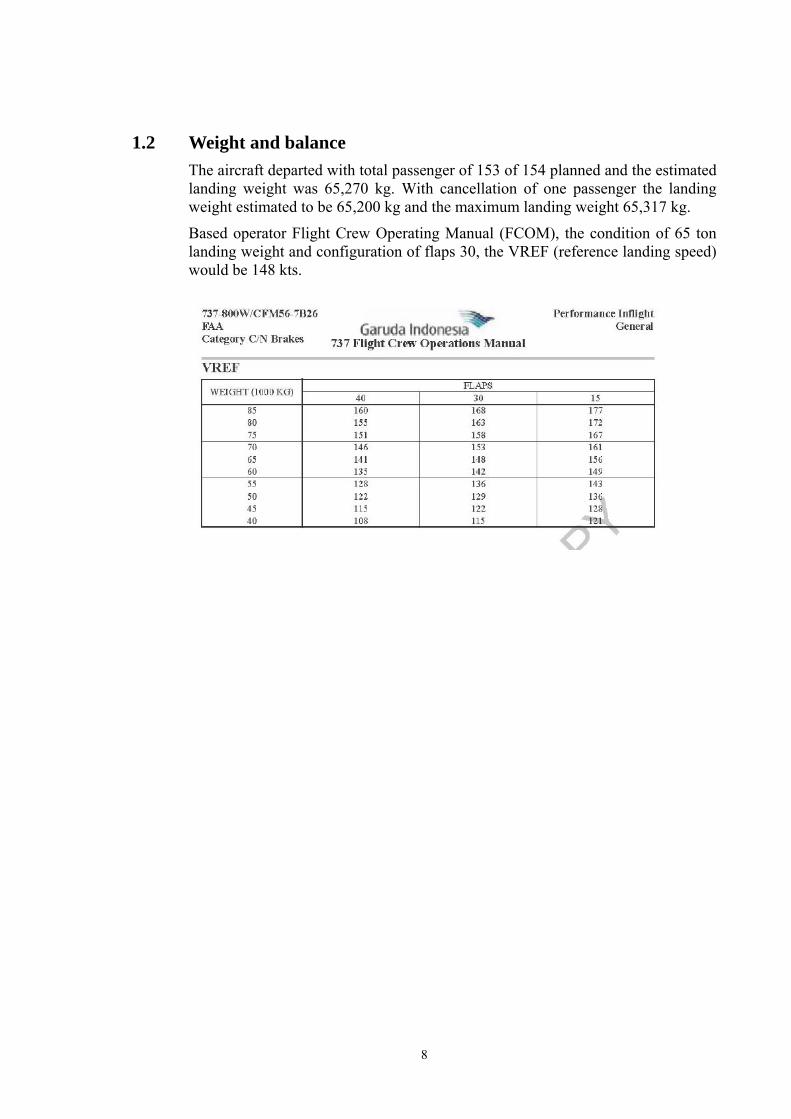
1.2 Weight and balance The aircraft departed with total passenger of 153 of 154 planned and the estimated landing weight was 65,270 kg. With cancellation of one passenger the landing weight estimated to be 65,200 kg and the maximum landing weight 65,317 kg.
Based operator Flight Crew Operating Manual (FCOM), the condition of 65 ton landing weight and configuration of flaps 30, the VREF (reference landing speed) would be 148 kts.
9
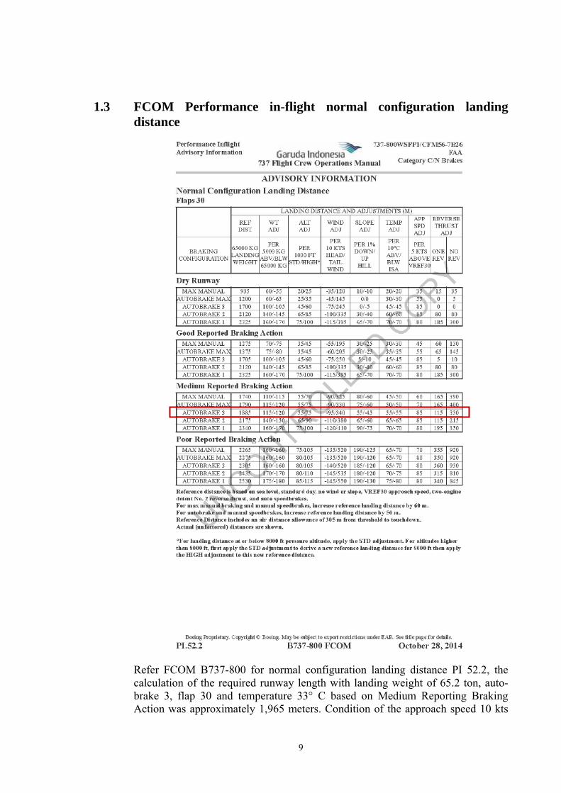
1.3 FCOM Performance in-flight normal configuration landing distance
Refer FCOM B737-800 for normal configuration landing distance PI 52.2, the calculation of the required runway length with landing weight of 65.2 ton, auto-brake 3, flap 30 and temperature 33° C based on Medium Reporting Braking Action was approximately 1,965 meters. Condition of the approach speed 10 kts
10
higher would affect to additional distance of 170 meters. Based on this calculation, the required landing distance would be 2,135 meters. The calculation includes 305 meters from threshold to touchdown and the ground roll required for additional tail wind condition would be 1,830 meters.
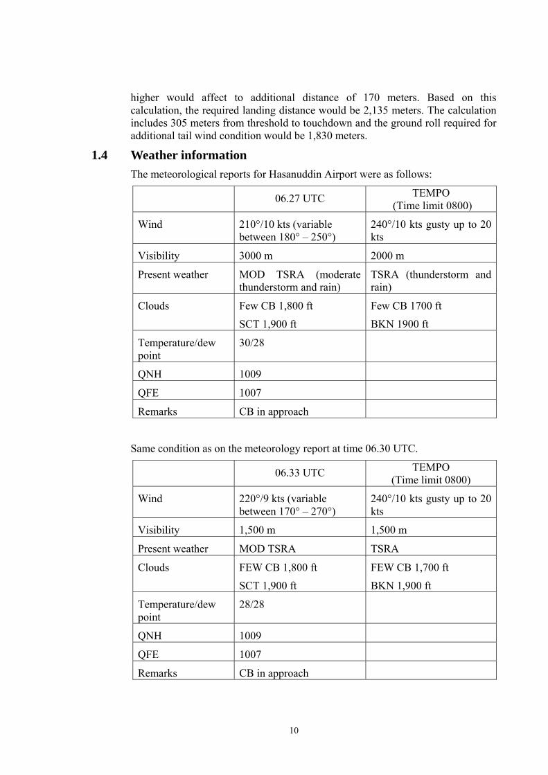
1.4 Weather information The meteorological reports for Hasanuddin Airport were as follows:
06.27 UTC TEMPO (Time limit 0800)
Wind 210°/10 kts (variable between 180° – 250°)
240°/10 kts gusty up to 20 kts
Visibility 3000 m 2000 m
Present weather MOD TSRA (moderate thunderstorm and rain)
TSRA (thunderstorm and rain)
Clouds Few CB 1,800 ft
SCT 1,900 ft
Few CB 1700 ft
BKN 1900 ft
Temperature/dew point
30/28
QNH 1009
QFE 1007
Remarks CB in approach
Same condition as on the meteorology report at time 06.30 UTC.
06.33 UTC TEMPO (Time limit 0800)
Wind 220°/9 kts (variable between 170° – 270°)
240°/10 kts gusty up to 20 kts
Visibility 1,500 m 1,500 m
Present weather MOD TSRA TSRA
Clouds FEW CB 1,800 ft
SCT 1,900 ft
FEW CB 1,700 ft
BKN 1,900 ft
Temperature/dew point
28/28
QNH 1009
QFE 1007
Remarks CB in approach
11
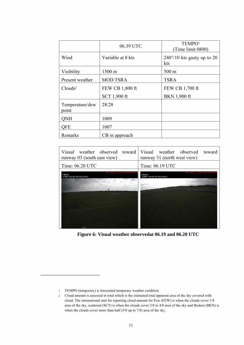
06.39 UTC TEMPO1 (Time limit 0800)
Wind Variable at 8 kts 240°/10 kts gusty up to 20 kts
Visibility 1500 m 500 m
Present weather MOD TSRA TSRA
Clouds2 FEW CB 1,800 ft
SCT 1,900 ft
FEW CB 1,700 ft
BKN 1,900 ft
Temperature/dew point
28/28
QNH 1009
QFE 1007
Remarks CB in approach
Visual weather observed toward runway 03 (south east view)
Visual weather observed toward runway 31 (north west view)
Time: 06.20 UTC Time: 06.19 UTC
Figure 6: Visual weather observedat 06.19 and 06.20 UTC
1 TEMPO (temporary) is forecasted temporary weather condition 2 Cloud amount is assessed in total which is the estimated total apparent area of the sky covered with
cloud. The international unit for reporting cloud amount for Few (FEW) is when the clouds cover 1/8 area of the sky, scattered (SCT) is when the clouds cover 3/8 to 4/8 area of the sky and Broken (BKN) is when the clouds cover more than half (5/8 up to 7/8) area of the sky.

12
Time: 06.30 UTC Time: 06.29 UTC
Figure 7: Visual weather observedat 06.29 and 06.30 UTC
Time: 06.40 UTC Time: 06.39 UTC
Figure 8: Visual weather observedat 06.39 and 06.40 UTC
1.5 Other information 1.5.1 Aircraft lift
The aircraft can fly as result of the lift produce by the aircraft wing. The wing may produce lift as the airfoil shape of the wing. An airfoil is a structure designed to obtain reaction upon its surface from the air through which it moves or that moves past such a structure.
The amount of lift affected by the air velocity moves through the wing, angle of attack, surface area and air density.
The lift formula is L=1/2 Ƿ V2 S Cl.
Ƿ = Air density
V= Aircraft speed (air velocity)
S = Wing surface
Cl = Coefficient lift (affected by angle of attack)
The aircraft speed which is related to the air velocity moves through the wing surface has significant effect to the lift produces. Flying into the wind will increased the air velocity and hence increase the lift.

13
1.5.2 Thunderstorm formation Generally, thunderstorms require three conditions to form:
1. Moisture 2. An unstable airmass 3. A lifting force (heat)
All thunderstorms, regardless of type, go through three stages: the developing stage, the mature stage, and the dissipation stage. The average thunderstorm has a 24 km (15 miles) diameter. Depending on the conditions present in the atmosphere, these three stages take an average of 30 minutes to go through.
Figure 9: Stages of thunderstorm
Figure 10: Lateral view illustration of thunderstorm
Cumulus Stage The first stage of a thunderstorm is the cumulus stage, or developing stage. In this stage, masses of moisture are lifted upwards into the atmosphere. The trigger for this lift can be insolation heating the ground producing thermals, areas where two winds converge forcing air upwards, or where winds blow over terrain of

14
increasing elevation. The moisture rapidly cools into liquid drops of water due to the cooler temperatures at high altitude, which appears as cumulus clouds. As the water vapor condenses into liquid, latent heat is released, which warms the air, causing it to become less dense than the surrounding dry air. The air tends to rise in an updraft through the process of convection (hence the term convective precipitation). This creates a low-pressure zone beneath the forming thunderstorm. In a typical thunderstorm, approximately 5×10⁸kg of water vapor is lifted into the Earth's atmosphere. Mature Stage In the mature stage of a thunderstorm, the warmed air continues to rise until it reaches an area of warmer air and can rise no further. Often this 'cap' is the tropopause. The air is instead forced to spread out, giving the storm a characteristic anvil shape. The resulting cloud is called cumulonimbus incus. The water droplets coalesce into larger and heavier droplets and freeze to become ice particles. As these fall they melt to become rain.
Dissipating Stage In the dissipation stage, the thunderstorm is dominated by the downdraft. If atmospheric conditions do not support super cellular development, this stage occurs rather quickly, approximately 20–30 minutes into the life of the thunderstorm. The downdraft will push down out of the thunderstorm, hit the ground and spread out.

15
2 ANALYSIS The FDR recorded that after passing 20 ft AGL, the aircraft floated for approximately 13 seconds. During this period, the airspeed indicated 157 kts and decreased to 154 kts while touchdown. The ground speed was recorded 170 kts and decreased to 150 kts on touchdown. As of the ATIS before descend, informing that the runway in use was runway 03, wind condition 240°/7 kts (variable 200° - 290°), while the FDR recorded that 20ft the wind changed from tailwind 9kts to headwind 6kts.
This data showed that the ground speed has decreased 20 kts while the air speed decreased 3 kts. Slight decrement of air speed indicated that only slight change of air velocity movement on the wing surface. This condition resulted in minor changed on the lift produce by the wing. This means that the wing still produced sufficient lift to the aircraft and made the aircraft floated.
The significant differences between the reduction of the ground speed and airspeed was result of the change in wind condition, from tailwind to head wind. The change of wind direction might have not been anticipated by the pilot and ATC.
The black clouds and rain that visible by the pilot and ATC was indication that the cumulonimbus has reached the mature stage. During the mature stage, the downdraft will push down out of the thunderstorm, hit the ground and spread out. This downward force created the headwind to the runway. The head wind from the downward force did not reach the final area and the final area was still affected by the local wind. This condition has made the aircraft has tailwind on final and changed to head wind while flew over the runway.
A steady approach on correct approach flight track the aircraft will touchdown at approximately 300 meters from the beginning of the runway. The calculation of the required runway length for the estimated aircraft landing weight with flaps 30 configurations was 2,100 meters, which means that the ground roll required was approximately 1,800 meters.
During the 13 seconds floated at ground speed of 170 kts to 150 kts, the aircraft has travelled for 1,075 meters over the runway. Based on this calculation, the aircraft might touchdown at approximately 1,375 meters from the beginning of the runway. The required runway for the aircraft to stop was approximately 3,175 meters while the runway length available was 2,500 meters. This calculation was relevant to the FDR data that the aircraft touch down at the middle of the runway approximately after passing the taxiway Charlie.
16
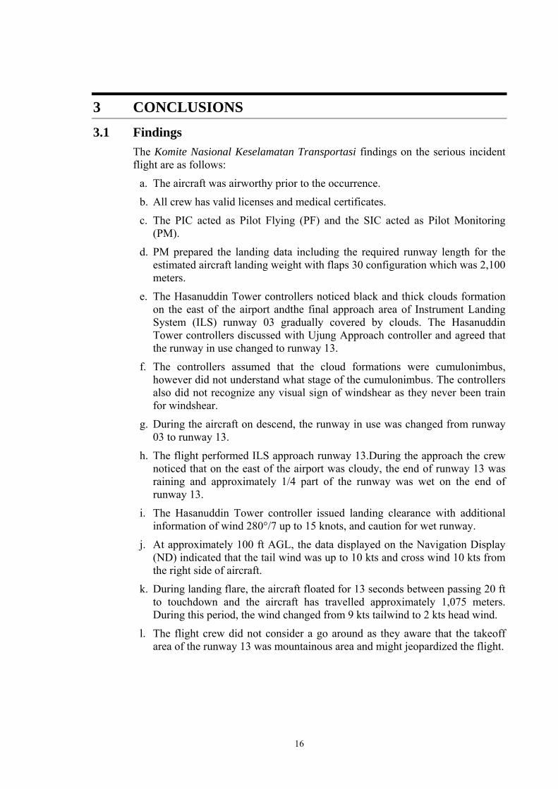
3 CONCLUSIONS 3.1 Findings
The Komite Nasional Keselamatan Transportasi findings on the serious incident flight are as follows:
a. The aircraft was airworthy prior to the occurrence.
b. All crew has valid licenses and medical certificates.
c. The PIC acted as Pilot Flying (PF) and the SIC acted as Pilot Monitoring (PM).
d. PM prepared the landing data including the required runway length for the estimated aircraft landing weight with flaps 30 configuration which was 2,100 meters.
e. The Hasanuddin Tower controllers noticed black and thick clouds formation on the east of the airport andthe final approach area of Instrument Landing System (ILS) runway 03 gradually covered by clouds. The Hasanuddin Tower controllers discussed with Ujung Approach controller and agreed that the runway in use changed to runway 13.
f. The controllers assumed that the cloud formations were cumulonimbus, however did not understand what stage of the cumulonimbus. The controllers also did not recognize any visual sign of windshear as they never been train for windshear.
g. During the aircraft on descend, the runway in use was changed from runway 03 to runway 13.
h. The flight performed ILS approach runway 13.During the approach the crew noticed that on the east of the airport was cloudy, the end of runway 13 was raining and approximately 1/4 part of the runway was wet on the end of runway 13.
i. The Hasanuddin Tower controller issued landing clearance with additional information of wind 280°/7 up to 15 knots, and caution for wet runway.
j. At approximately 100 ft AGL, the data displayed on the Navigation Display (ND) indicated that the tail wind was up to 10 kts and cross wind 10 kts from the right side of aircraft.
k. During landing flare, the aircraft floated for 13 seconds between passing 20 ft to touchdown and the aircraft has travelled approximately 1,075 meters. During this period, the wind changed from 9 kts tailwind to 2 kts head wind.
l. The flight crew did not consider a go around as they aware that the takeoff area of the runway 13 was mountainous area and might jeopardized the flight.

17
3.2 Contributing Factors3 Unanticipated wind condition has made the pilot did not aware to the wind direction changes and resulted the aircraft floated for 13 seconds and touched down on the middle of the runway.
3 “Contributing Factors” is defined as events that might cause the occurrence. In the case that the event did not occur
then the accident might not happen or result in a less severe occurrence.

18
4 SAFETY ACTION After the occurrence, the DGCA monitored that Garuda Indonesia revised the ground and simulator recurrent syllabus training for Boeing 737 pilot to include windshear avoidance and recovery.
At the time of issuing this final investigation report, the KNKT has not been informed any other safety action resulting from this occurrence.
19
5 SAFETY RECOMMENDATIONS As a result of this investigation, the Komite Nasional Keselamatan Transportasi (KNKT) issued safety recommendations to address safety issues identified in this report.
The Directorate General of Civil Aviation (DGCA) is responsible for the implementation of these recommendations addressed to the relevant parties.
5.1. Garuda Indonesia • 04.O-2016-7.1
To review the pilot training on meteorology training related to cumulonimbus development and its effects.
• 04.O-2016-8.1 To emphasis all pilot to perform go around when a safe landing cannot be made.
5.1 Lembaga Penyelenggara Pelayanan Navigasi Penerbangan Indonesia (AirNav Indonesia) • 04.A-2016-9.1
To provide all controllers with meteorology training that includes the understanding of cumulonimbus and windshear.

20