Embed Size (px)
Citation preview

Following are pages that show all plan amendments adopted by the county and the cities in the county and submitted to DLCD since January of 1987. The list shows the county amendments first and then the cities alphabetically. Within a jurisdiction the amendments are sorted by adoption date with the older ones first. Page numbering returns to page 1 with each city.
For each amendment the first line includes the name of the jurisdiction, local file number, DLCD file number, local adoption date and any LUBA case number for those amendments that were appealed to LUBA. We have not provided information on LUBA decisions, but provide the case number to indicate that the amendment was appealed.
Below the amendment identification information are descriptions labeled "Proposed Desc." and "Adopted Desc." The Proposed Description is a more complete description of the amendment as it was proposed amendment and submitted to DLCD . This is the description that accompanied DLCD's Proposed Notice of Amendments. The adopted amendment description is a more limited description or is missing. Both descriptions are provided because not all amendments went through the department's proposed amendment process and to note changes to a proposed amendment prior to adoption.
Fonts are not consistent in the document. These are an artifact of the input process and do not affect the data content. No doubt you will discover some errors in this database. The data has been converted from one database program to another and includes more than 12,000 records in both theproposed and adopted plan amendment databases.
The department provides this general information to assist local governments and others in determining when local land use changes were made. Itis our best effort at identifying adopted amendments but should always be verified with the appropriate local government before proceeding.
Please let your regional representative know if we can be of any additional assistance with respect to this data.
Klamath County
Page Number : 1

LUBA #Adoption DateLocal File # DLCD File #Klamath County44.25 009-92Klamath County
Five sites totalling 107.08 acres.Adopted Desc.
Amend the comprehensive plan and zoning ordinance to add five resource sites to the Goal 5 Mineral and Aggregate Inventory as 3C sites and apply the Significant Resources Overlay zone to 107.08 acres located off Dalles- California Highway.
Proposed Desc.
44.31 001-93Klamath County
Add 4 sites to the aggregate inventory.Adopted Desc.
Amend the comprehensive plan to add four mineral/aggregate sites to the Goal 5 inventory as 1C site with a 3C level of protection. Also apply the SRO (Significant Resources Overlay) to the site located near Obenchain Road (Ivory Pine Road) and 600 Road, north of Beatty.
Proposed Desc.
Sec. 52.005 003-87AKlamath County 3/26/1987
FLOODPLAIN REGULATIONS TO CONFORM WITH FEMA REQUIREMENTS.Adopted Desc.
Amend the zoning ordinance's floodplain regulations to conform with revised Federal Emergency Management regulations.Proposed Desc.
Map Corr. 006-87AKlamath County 6/23/1987
Adopted Desc.
Amend the plan and zoning map from Residential to Industrial in order to correct a mapping error on a 0.1 acre portion of a parcel located in Crescent.
Proposed Desc.
CLUP&ZC 1-87 002-87AKlamath County 7/8/1987
INCLUDES AN EXCEPTION.Adopted Desc.
Amend the comprehensive plan from Agriculture to Commercial and zoning from EFU-CG (Crop and Grazing) to CR (Recreation-Commercial) for approximately 10 acres located on the northeast shore of Agency Lake. The applicant proposes establishment of a hunting and fishing lodge on the site.
Proposed Desc.
Page Number : 1

LUBA #Adoption DateLocal File # DLCD File #Klamath CountyCLUP&ZC 3-87 005-87AKlamath County 7/8/1987
Adopted Desc.
Amend the comprehensive plan from Forestry to Agriculture and zoning from FR to EFU-CG for approximately 160 acres south of Bonanza.
Proposed Desc.
CLUP/ZC 1587 007-87AKlamath County 7/15/1987
Adopted Desc.
Amend the comprehensive plan from Urban Residential to General Commercial and zoning from Suburban Residential to General commercial for approximately 0.5 acre located on Altamont Drive.
Proposed Desc.
CLUP/ZC10-87 010-87AKlamath County 7/29/1987
SCHOONOVER (ALSO 88-024). INCLUDES AN EXCEPTION.Adopted Desc.
Amend the comprehensive plan and zoning from Forestry to Residential for approximately 420 acres. The proposal includes a goal exception. NOTE: The amendment was appealed to LUBA and remanded per LUBA No. 87-070.
Proposed Desc.
87070
N/A 008-87AKlamath County 7/29/1987
REVISION OF COUNTY POLICIES RELATED TO PUBLIC FACILITIES AND SERVICES. AMENDMENT ALLOWS SITING OF RESIDENTIAL SUBDIVISIONS OUTSIDE AREAS WITH RURAL FIRE PROTECTION DISTRICTS. MISC. OTHER POLICY AMENDMENTS.
Adopted Desc.
Amend the comprehensive plan policies related to: 1) waste- water management planning; 2) requirements for subdivisionsto be located within a fire district; 3) public facilities planning; 4) transportation planning, and; 5) the role of the public works department.
Proposed Desc.
N/A 009-87AKlamath County 8/12/1987
ISSUANCE OF BUILDING PERMITS ON NON-CONFORMING AND ILLEGALLY SUBDIVIDED LOTS. LOT OF RECORD
Adopted Desc.
of procedures and standards for issuance of building permits on non-conforming and illegally subdivided lots.Proposed Desc.
87084
Page Number : 2
LUBA #Adoption DateLocal File # DLCD File #Klamath CountyN/A 009-87AKlamath County 8/19/1987
Adopted Desc.
of procedures and standards for issuance of building permits on non-conforming and illegally subdivided lots.Proposed Desc.
CLUP/ZC 8-87 014-87BKlamath County 12/9/1987
CHANGE FROM AGRICULTURE TO INDUSTRIAL. INCLUDES AN EXCEPTION.Adopted Desc.
Amend the comprehensive plan from Agriculture to Industrial and zoning from EFU-C to IH for approximately 9.62 acres located south of Lower Klamath Lake Road, east of Merrill Pit Road.
Proposed Desc.
CLUP/ZC 7-87 011-87BKlamath County 3/23/1988
SCHOONOVERAdopted Desc.
Appealed to LUBA April 1988. AMENDMENT DENIED 3/15/89Proposed Desc.
88025
CLUP/ZC 1-88 001-88Klamath County 5/11/1988
INCLUDES AN EXCEPTION.Adopted Desc.
Amend the comprehensive plan from Forestry to Commercial and zoning from Forestry to Highway Commercial for approximately 15 acres located on Highway 97 at Sand Creek Station for the purpose of developing a mobile home park. This proposal includes a goal exception.
Proposed Desc.
Ord. #44-16 004-88Klamath County 6/28/1988
Adopted Desc.
Amend the comprehensive plan to add 1.2 acres to City of Malin's Urban Growth Boundary to allow a park to be added in the northeast corner of the city. The proposal includes an exception.
Proposed Desc.
Page Number : 3
LUBA #Adoption DateLocal File # DLCD File #Klamath CountyCLUP/ZC 3-88 003-88Klamath County 8/10/1988
Adopted Desc.
Amend the comprehensive plan from Forest to Agriculture and zoning from Forestry Range to EFU-CG (Exclusive Farm Use- Cropland Grazing) for 40 acres located at Southeast Poe Valley.
Proposed Desc.
ORD. 44.18 007-88Klamath County 11/23/1988
GOAL 5 POLICIES FOR MINERAL AND AGGREGATE RESOURCES.Adopted Desc.
Amend the comprehensive plan Goal 5 policies for mineral and aggregate resources. This amendmend relates to periodic review.
Proposed Desc.
ORD. 44.17 006-88Klamath County 11/28/1988
ADD TO GOAL 5 PACKET MINERAL AND AGGREGATE RESOURCE SITE IDENTIFIED ON MINERAL RESOURCES INVENTORY MAP, MINERAL AND AGGREGATE RESOURCE SITE IDENTIFIED ON GOAL 5 MAP OF 1-C RESOURCES.
Adopted Desc.
Amend the comprehensive plan to add a new mineral and aggregate site to the Goal 5 inventory of mineral resources, significant "1-C" resources and make other revisions required by the Goal 5 process. The site is located approximately 2.5 miles west/northwest of the City of Merrill.
Proposed Desc.
ORD 45.12 009-88Klamath County 12/19/1988
LIMITS PERMITTED USES TO THOSE WHICH ARE REQUESTED IN A CHANGE OF ZONE APPLICATION.NEW REGULATION ALLOWS THE REVIEW BODY TO APPLY THE OVERLAY ZONE ON PROPERTIES BOTH COVERED & NOT COVERED BY EXCEPTIONS STATEMENT.
Adopted Desc.
Amend the zoning ordinance to include a limited use overlay zone to limit uses allowed in the underlying zone.Proposed Desc.
CLUP/ZC 4-88 005-88Klamath County 1/11/1989
Adopted Desc.
Amend the comprehensive plan from Rural to Industrial and zoning from R-1 (Rural-1) to IL (Light Industrial) for 6.33 acres located west of Highway 97 and Wocus Road. The proposal includes an exception.
Proposed Desc.
Page Number : 4

LUBA #Adoption DateLocal File # DLCD File #Klamath CountyCLUP/ZC 5-88 010-88Klamath County 1/11/1989
Adopted Desc.
Amend the comprehensive plan from Urban Residential to General Commercial and zoning from Medium Density Residential to Neighborhood Commercial to 0.56 acre located at 815 Washburn Way.
Proposed Desc.
Ord. 45.13 001-89Klamath County 2/28/1989
AUTHORIZE THE PLANNING DIRECTOR TO CLASSIFY USES NOT OTHER WISE ALLOWED IN THE CODEAND TO ALLOW A DETERMINATION OF THE PLANNING DIRECTOR TO BE APPEALED.
Adopted Desc.
Amend the Land Development Code to authorize the planning director to classify uses not otherwise allowed in the code and to allow a determination of the planning director to be appealed.
Proposed Desc.
Ord. 45.14 004-89Klamath County 5/9/1989
REQUIRE PLANNING COMMISSION REVIEW OF LAND PARTITIONS, CONDITIONAL USE PERMITS AND VARIANCES ON LANDS DESIGNATE AGRICULTURE AND FORESTRY.
Adopted Desc.
Amend the zoning ordinance to require planning commission review of land partitions, conditional use permits and variances on lands designated agriculture and forestry. These actions are presently reviewed by the hearings officer
Proposed Desc.
CLUP/ZC 2-88 002-88Klamath County 5/10/1989
Adopted Desc.
Amend the comprehensive plan from Urban Residential to General Commercial and zoning from Suburban Residential to General Commercial for 1.26 acre located at 5541 Altamont Drive.
Proposed Desc.
CLUP/ZC 2-89 002-89Klamath County 5/10/1989
Adopted Desc.
Amend the comprehensive plan from Urban Residential to General Commercial and zoning from RS (Suburban Residential) to CG (General Commercial) for 0.23 acre located at Hope and South Sixth Street, Klamath Falls.
Proposed Desc.
Page Number : 5

LUBA #Adoption DateLocal File # DLCD File #Klamath CountyORD. 45.11 008-88Klamath County 5/23/1989
INCORPORATE NEW STANDARDS FOR SITING AND OPERATION OF MINERAL AND AGGREGATE EXTRACTION.
Adopted Desc.
Amend the zoning ordinance to allow new standards for the siting and operation of mineral and aggregate extraction.Proposed Desc.
CLUP/ZC 4-89 005-89Klamath County 7/11/1989
Adopted Desc.
Amend the comprehensive plan from Urban Residential to Industrial and zoning from Suburban Residential to Heavy Industrial for 9.2 acres located on the southeast corner of Washburn Way and Anderson.
Proposed Desc.
CLUP/ZC 6-89 006-89Klamath County 8/7/1989
INCLUDES AN EXCEPTION.Adopted Desc.
Amend the comprehensive plan from Agriculture to Rural and zoning from EFU-CG (Exclusive Farm Use/General Commercial) to R-1 (Residential) for approximately 37 acres limited to two acre lots by restriction. The property is located north of Klamath Falls and 4 miles west of Chiloquin, Agency Lake Area. The proposal includes an exception. NOTES: This proposal is a remand from LUBA and is a revised proposal. 89-113
Proposed Desc.
90069
CLUP/ZC 7-89 007-89Klamath County 10/4/1989
INCLUDES AN EXCEPTION TO GOAL 4.Adopted Desc.
Amend the comprehensive plan from Forestry to Industrial and zoning from F (Forestry) to LI (Light Industrial) for 7 acres located 6 miles west of Chiloquin and 6 miles south of Fort Klamath on Highway 62, across from old Indian Agency, Chiloquin. The proposal includes an exception.
Proposed Desc.
CLUP/ZC 9-89 009-89Klamath County 10/16/1989
INCLUDES AN EXCEPTION.Adopted Desc.
Amend the comprehensive plan from General Commercial to Transportation Commercial and zoning from CG (General Commercial) to CH (Highway Commercial) for 2.59 acres located at 2933 Greensprings Drive, Klamath Falls.
Proposed Desc.
Page Number : 6

LUBA #Adoption DateLocal File # DLCD File #Klamath CountyCLUP/ZC 8-89 010-89Klamath County 10/16/1989
INCLUDES AN EXCEPTIONAdopted Desc.
Amend the comprehensive plan from Urban Residential to Transportation Commercial and zoning from RL (Low Density Residential) to CH (Highway Commercial) for 1.47 acres located one block north of South Side Bypass on Greensprings Drive, Klamath Falls.
Proposed Desc.
CLUP/ZC 4-89 003-89Klamath County 10/23/1989
Adopted Desc.
Amend the comprehensive plan from Forestry to Agriculture and zoning from FR (Forestry Range) to EFU-CG (Exclusive Farm Use-Cropland Grazing) for approximately 62 acres located east and north of Sprague River. NOTICE: The proposal has a revised hearing date.
Proposed Desc.
WOODLANDS 008-89Klamath County 11/9/1989
Adopted Desc.
Amend the comprehensive plan from Agriculture to Industrial and zoning from EFU-CG (Exclusive Farm Use/Cropland/Grazing General) to IH (Heavy Industrial) for 46 acres located at the junction of US 97 and Modoc Point Highway.
Proposed Desc.
CLUP/ZC 10 012-89Klamath County 12/1/1989
Adopted Desc.
Amend the comprehensive plan from Forestry to Agriculture and zoning from FR (Forestry Range) to EFU-CG (Exclusive Farm Use-Cropland-Grazing) for 80 acres located aproximately three miles northwest of Sprague River.
Proposed Desc.
CLUP/ZC 11 014-89Klamath County 1/23/1990
Adopted Desc.
Amend the comprehensive plan from Rural to Industrial and zoning from R-1 (Rural Residential) to I-L (Light Industrial) for 0.16 acre located on the corner of 4th and Main, Fort Klamath.
Proposed Desc.
Page Number : 7
LUBA #Adoption DateLocal File # DLCD File #Klamath CountyCLUP/ZC 1-90 001-90Klamath County 2/27/1990
Adopted Desc.
Amend the comprehensive plan from Urban Density Residential to Industrial and zoning from RL (Low Density Residential) to IL (Light Industrial) for 4.3 acres located on the north and west side of Greensprings Drive, Klamath Falls.
Proposed Desc.
CLUP/ZC 2-90 002-90Klamath County 4/5/1990
Adopted Desc.
Amend the comprehensive plan from Rural to Industrial and zoning from R-1 (Residential-1) to I-L (Light Industrial) for 1.5 acres located south of Highway 140 and east of Yellow Jacket Spring Road, Beatty.
Proposed Desc.
CLUP/ZC 6-90 006-90Klamath County 6/1/1990
EXCEPTIONAdopted Desc.
Amend the comprehensive plan from Agriculture to Rural and zoning from EFU-C (Exclusive Farm Use-Commercial) to R-1 (Residential-1) for approximately 4 acres located immediately west of the end of Rocking Horse Lane. The proposal includes an exception.
Proposed Desc.
CLUP/ZC 8-90 009-90Klamath County 6/1/1990
Adopted Desc.
Amend the comprehensive plan from Urban Residential to General Commercial and zoning from RS (Suburban Residential) for 0.48 acre located at 3221 Maryland, Klamath Falls.
Proposed Desc.
CLUP/ZC 7-90 005-90Klamath County 6/1/1990
Adopted Desc.
Amend the comprehensive plan from Forestry to Agriculture and zoning from Forestry Range to EFU-CG (Exclusive Farm Use/General Commercial) for approximately 78.19 acres located in the Dodds Hollow area and Taylor Road, 6 miles NE of Merrill.
Proposed Desc.
Page Number : 8

LUBA #Adoption DateLocal File # DLCD File #Klamath CountyCLUP/ZC 5-90 008-90Klamath County 6/1/1990
Adopted Desc.
Amend the comprehensive plan from Rural to General Commercial and zoning from R-1 (Residential-1) to CR (Recreational Commercial) for approximately 1.5 acres located at the intersection of Highways 62 and 97, Williamson River Drive, Chiloquin.
Proposed Desc.
CLUP/ZC 3-90 003-90Klamath County 7/11/1990
Adopted Desc.
Amend the comprehensive plan from Industrial to Urban Residential and zoning form IL (Light Industrial) to RS (Single Family Residential) for approximately 26.5 acres located on the southwest corner of Memorial Drive and Southside Bypass.
Proposed Desc.
NA 011-90Klamath County 7/11/1990
Adopted Desc.
Amend the comprehensive plan from Urban Residential to Industrial and zoning from RS (Single Family Residential) to IH (Heavy Industrial) for 0.7 acre located south and west of the OC&E Railroad and Summers Lane.
Proposed Desc.
CLUP/ZC 9-90 012-90Klamath County 8/15/1990
Adopted Desc.
Amend the comprehensive plan from Urban Residential to Industrial and zoning from RS (Single Family Residential) to IL (Light Industrial) for 0.49 acre located between Washburn Way and Altamont Drive in first addition to Altamont Acres.
Proposed Desc.
ORD. 45.17 010-90Klamath County 8/15/1990
Adopted Desc.
Amend the Development Code to make numerous housekeeping changes.Proposed Desc.
Page Number : 9

LUBA #Adoption DateLocal File # DLCD File #Klamath CountyCLUP-ZC 10 013-90Klamath County 9/12/1990
Adopted Desc.
Amend the comprehensive plan from Agricultural to General Commercial and zoning from EFU (Exclusive Farm Use) and CG (Cropland Grazing) to CR (Commercial Recreation) for 72.04 acres east of the Highway 97/62 junction, between Williamson River and US Highway 97, Chiloquin. The proposal includes an exception.
Proposed Desc.
CLUP/ZC 1-91 002-91Klamath County 3/8/1991
Adopted Desc.
Amend the comprehensive plan and zoning from IL (Industrial) to CG (General Commercial) for 26.99 acres located on the northwest corner of Washburn and Laverne.
Proposed Desc.
CLUP/ZC 12 016-90Klamath County 3/8/1991
Adopted Desc.
Amend the comprehensive plan from Rural to Agriculture and zoning from R-5 (Residential-5) to EFU-C (Exclusive Farm Use-Commercial) for approximately 40.79 acres located between Doods Hollow Road and Patricia Lane, Merrill.
Proposed Desc.
CLUP/ZC 2-91 004-91Klamath County 3/29/1991
Adopted Desc.
Amend the comprehensive plan and zoning from NR (Non- Resource) to R-5 (Rural-5) for 22.59 acres located on Algoma Road, Klamath Falls.
Proposed Desc.
Ord. 45.18 001-91Klamath County 4/3/1991
Adopted Desc.
Amend the comprehensive plan to comply with state legislation regarding Forest Lands. Make miscellaneous housekeeping amendments.
Proposed Desc.
Page Number : 10

LUBA #Adoption DateLocal File # DLCD File #Klamath County45.21 009-91Klamath County 6/5/1991
Adopted Desc.
Amend the zoning ordinance to comply with state legislation regarding manufactured homes (HB 2863).Proposed Desc.
45.23 013-91Klamath County 6/5/1991
Adopted Desc.
Amend the zoning ordinance to change the references to manufactured home and manufactured home park to comply with the definitions and new standards in Article 11 and Article 84.
Proposed Desc.
45.20 008-91Klamath County 6/5/1991
Adopted Desc.
Amend the zoning ordinance to adopt a new definition for manufactured dwelling.Proposed Desc.
Ord. 45.19 003-91Klamath County 6/5/1991
Adopted Desc.
Amend the comprehensive plan to allow manufactured homes of any age that meet the definition to be placed on private properties.
Proposed Desc.
45.22 011-91Klamath County 7/3/1991
Adopted Desc.
Amend the zoning ordinance to address the Forestry Zone, Forestry Range Zone, and the Rural/Wildland Fire Safety Standards.
Proposed Desc.
Page Number : 11
LUBA #Adoption DateLocal File # DLCD File #Klamath CountyORD. 44.20 015-91Klamath County 7/3/1991
Adopted Desc.
Amend the comprehensive plan to update and streamline the Klamath County Citizen Involvement Program. NOTE: This is a revised proposal to address DLCD concerns.
Proposed Desc.
CLUP/ZC 5-91 010-91Klamath County 7/10/1991
Adopted Desc.
Amend the comprehensive plan and zoning from NR (Non- Resource) to R-1 (Rural-1) for approximately 50 acres located north of Klamath Falls on Highway 97, on Shady Pine Road.
Proposed Desc.
CLUP/ZC 7-91 016-91Klamath County 7/10/1991
Adopted Desc.
Amend the comprehensive plan from Transportation Commercial to General Commercial and zoning from CT (Transportation Commercial) to CR (Recreational Commercial) for 2.76 acres located on the southwest corner of Diamond Lake Junction.
Proposed Desc.
CLUP/ZC 6-91 014-91Klamath County 7/10/1991
Adopted Desc.
Amend the comprehensive plan from Forestry to Agriculture and zoning from FR (Forest/Range) to EFU-CG (Exclusive Farm Use-Cropland Grazing) for approximately 2,297 acres located 3 miles south of Bonanza.
Proposed Desc.
CLUP/ZC 9-91 018-91Klamath County 7/30/1991
Adopted Desc.
Amend the comprehensive plan from Forestry to Agriculture and zoning from FR (Forestry Range) to EFU-CG (Exclusive Farm Use Cropland Grazing) for 440 acres located in the Langell Valley area, north slope of Bryant Mountain.
Proposed Desc.
Page Number : 12

LUBA #Adoption DateLocal File # DLCD File #Klamath CountyCLUP/ZC 10 021-91Klamath County 9/25/1991
Adopted Desc.
Amend the comprehensive plan from Agriculture to Industrial and zoning from EFU-C (Exclusive Farm Use-Cropland Grazing) to IL (Light Industrial) for 5.73 acres located west of Highway 97, south of Miller Island Road. The proposal includes and exception.
Proposed Desc.
PR 020-91Klamath County 10/9/1991
Adopted Desc.
Amend the comprehensive plan and zoning ordinance to make changes regarding periodic review.Proposed Desc.
Ord. 45.25 023-91Klamath County 11/6/1991
Adopted Desc.
Amend the zoning ordinance to clarify standards describing a home occupation.Proposed Desc.
CLUP/ZC 11-9 024-91Klamath County 1/13/1992
Adopted Desc.
Amend the comprehensive plan from Urban Residential to Industrial and zoning from RL (Low Density Residential) to IL (Light Industrial) for one acre located east of Riverside Drive and south of Beaver Avenue, in the Riverview area, Klamath Falls.
Proposed Desc.
Ord. 45.26 022-91Klamath County 2/5/1992
Adopted Desc.
Amend the Land Development Code to set significance standards and clarify the procedure and applications process, set out procedure for lifting the Significant Resource Overlay Zone and remove the site from the Goal 5 Inventory.
Proposed Desc.
Page Number : 13
LUBA #Adoption DateLocal File # DLCD File #Klamath County45.28 004-92Klamath County 3/31/1992
Clarification of language in Article 81 - Mineral and Aggregate Extraction Standards.Adopted Desc.
Amend the zoning ordinance to: delete the section requiring neighboring landowner's consent for a new mineral and aggregate site to be established if conflicting uses are existing within 1,000-foot impact area; and clarify procedures.
Proposed Desc.
CLUP-ZC 1-92 001-92Klamath County 4/8/1992
Transportation Commercial to Rural Residential-1.Adopted Desc.
Amend the comprehensive plan and zoning from CT (Transportation Commercial) to R-1 (Rural) for one acre located at Two Rivers North Subdivision.
Proposed Desc.
Ord.45.27 002-92Klamath County 4/8/1992
Comply with state changes and address issues raised by DLCD in periodic review.Adopted Desc.
Amend the Land Ordinance Code to comply with 1991 state legislation and address substantive issues raised by periodic review.
Proposed Desc.
ORD. 44.20 015-91Klamath County 4/8/1992
Addressed the concerns of DLCD.Adopted Desc.
Amend the comprehensive plan to update and streamline the Klamath County Citizen Involvement Program. NOTE: This is a revised proposal to address DLCD concerns.
Proposed Desc.
Ord. 44.24 007-92Klamath County 5/6/1992
Add 10 sites to the mineral aggregate inventory.Adopted Desc.
Amend the comprehensive plan and zoning ordinance to add ten 2A sites totalling 200.11 acres to the Goal 5 Mineral and Aggregate Inventory. Also apply the Significant Resources Overlay to allow mining.
Proposed Desc.
Page Number : 14

LUBA #Adoption DateLocal File # DLCD File #Klamath CountyCLUP/ZC 3-92 006-92Klamath County 5/13/1992
Adopted Desc.
Amend the comprehensive plan from Urban Residential to Industrial and zoning from RS (Residential) to IL (Industrial) for 1.25 acreS located at 5609 Altamont Drive, Klamath Falls.
Proposed Desc.
ORD. 44.26 011-92Klamath County 6/3/1992
Add 11 sites to the mineral and aggregate inventory, as 1C sites with a 3C level of protection.Adopted Desc.
Amend the comprehensive plan to add eleven sites (totaling approximately 801 acres) to the Goal 5 inventory and apply the SRO (significant resources overlay) zone to operate the sites.
Proposed Desc.
CLUP/ZC 5-92 010-92Klamath County 6/10/1992
Adopted Desc.
Amend the comprehensive plan from Forestry to Agriculture and zoning from FR (Forestry Range) to EFU-CG (Exclusive Farm Use-Crop Grazing) for 250 acres located six miles due north of Bly, along the north fork of the Sprague River.
Proposed Desc.
Ord 44.27 013-92Klamath County 7/1/1992
Add 7 sites to the mineral and inventory as 1C sites with 3C level of protection.Adopted Desc.
Amend the comprehensive plan to add ten new mineral and aggregate sites totaling 714.27 acres to the Goal 5 inventory as 1C sites with a 3C level of protection. To apply the Significant Resources Overlay zone to each site and the impact area and to allow operation of each site in accordance with Article 81.
Proposed Desc.
44.28 017-92Klamath County 9/2/1992
Add three sites to the aggregate inventory.Adopted Desc.
Amend the comprehensive plan to add a three new mineral/ aggregate sites with a SRO (Significant Resources Overlay) zone. The total acreagte is 266.56 and is located near Highway 97 and the Tulesmoke Marsh.
Proposed Desc.
Page Number : 15

LUBA #Adoption DateLocal File # DLCD File #Klamath CountyCLUP/ZC 7-92 014-92Klamath County 9/9/1992
Adopted Desc.
Amend the comprehensive plan and zoning from R-1 (Rural) to CR (General Commercial) for 1.83 acres located on South Main Street in the City of Crescent.
Proposed Desc.
CLUP/ZC 6-92 012-92Klamath County 9/12/1992
Agriculture to General Commercial for 2.96 ac.Adopted Desc.
Amend the comprehensive plan from Agriculture to General Commercial and zoning from EFU-CG (Exclusive Farm Use- Crop Grazing) to CG (General Commercial) for 2.96 acres located at the Highway 97 and Highway 62 junction. The proposal includes an exception.
Proposed Desc.
CLUP/ZC 8-92 015-92Klamath County 9/14/1992
Adopted Desc.
Amend the comprehensive plan and zoning from IH (Industrial) to CG (General Commercial) for approximatley 3.7 acres located in Fremont Park and Altamont Acres, Klamath Falls.
Proposed Desc.
CLUP/ZC 9-92 018-92Klamath County 10/13/1992
Adopted Desc.
Amend the comprehensive plan and zoning from IL (Industrial) to CG (General Commercial) for 1.33 acres located at 3040 Washburn Way, Klamath Falls. The property is located in the urban growth boundary.
Proposed Desc.
CLUP/ZC 2-92 005-92Klamath County 10/15/1992
Adopted Desc.
Amend the comprehensive plan and zoning from R-5 (Rural Residential) to CT (Transportation Commercial) for 8.2 acres located along Merrill-Malin Highway 39 near the intersection of Falvey Road.
Proposed Desc.
Page Number : 16

LUBA #Adoption DateLocal File # DLCD File #Klamath CountyCLUP/ZC 1092 019-92Klamath County 11/23/1992
Adopted Desc.
Amend the comprehensive plan and zoning from CR (General Commercial) and IL (Industrial) to RS (Urban Residential) for 8.7 acres located south of Southside Bypass between Memorial Drive and Reames Golf and Country Club.
Proposed Desc.
44.29 020-92Klamath County 12/29/1992
Add significant resources overlay to allow mining.Adopted Desc.
Amend the comprehensive plan and zoning ordinance to add 14 1C mineral/aggregate sites to the Goal 5 Inventory. Also apply the Significant Resources Overlay to allow mining.
Proposed Desc.
44.30 021-92Klamath County 12/29/1992
Add SRO (Significant resources overlay).Adopted Desc.
Amend the comprehensive plan and zoning ordinance to add eleven 3C mineral/aggregate sites to the Goal 5 inventory. Also apply the Significant Resources Overlay to allow mining.
Proposed Desc.
CLUP/ZC 12 022-92Klamath County 1/6/1993
Adopted Desc.
Amend the comprehensive plan and zoning from CR (General Commercial) to R-1 (Rural) for 1.0 acre located at the intersection of Highway 140 and Ground Squirrel Drive, Hidden Pines Motel.
Proposed Desc.
CLUP/ZC 15 025-92Klamath County 2/3/1993
Adopted Desc.
Amend the comprehensive plan from Agriculture to Rural and zoning from EFU-C (Exclusive Farm Use) to R-1 (Residential) for 32.01 acres on the east side of Shield Crest Golf Course, bordering Highway 140 on the south, and west of Pine Grove Subdivision. The proposal includes an exception.
Proposed Desc.
Page Number : 17

LUBA #Adoption DateLocal File # DLCD File #Klamath CountyCLUP/ZC 7-92 014-92Klamath County 2/4/1993
Additional adoption for 3.5 acres from Transportation Commercial to General Commercial.Adopted Desc.
Amend the comprehensive plan and zoning from R-1 (Rural) to CR (General Commercial) for 1.83 acres located on South Main Street in the City of Crescent.
Proposed Desc.
CLUP/ZC 14 024-92Klamath County 2/4/1993
Adopted Desc.
Amend the comprehensive plan and zoning from CT (Transportation Commercial) to CR (General Commercial) for 3.5 acres to allow an RV campground off State Highway 97 in Crescent.
Proposed Desc.
CLUP/13-92 023-92Klamath County 2/9/1993
Adopted Desc.
Amend the comprehensive plan and zoning from RS (Urban Residential) to IL (Industrial) for 1.36 acres located at 1818 Derby Street within the urban growth boundary.
Proposed Desc.
CLUP/ZC 005-93Klamath County 4/30/1993
Adopted Desc.
Amend the comprehensive plan and zoning from NR (Non-Resource) to R-5 (Rural) for 31 acres located at 9570 Hill Road.Proposed Desc.
45.29 006-93Klamath County 5/5/1993
Adopted Desc.
Amend the comprehensive plan to make several housekeeping changes.Proposed Desc.
Page Number : 18

LUBA #Adoption DateLocal File # DLCD File #Klamath County44.32 002-93Klamath County 5/5/1993
Two sites.Adopted Desc.
Amend the comprehensive plan to add two mineral/aggregate sites to the Goal 5 inventory as 1C sites with a 3C level of protection. Also apply the SRO (Significant Resources Overlay) to the site known as the Meryl Butte Cinder Pit, north of Bly.
Proposed Desc.
44.33 003-93Klamath County 5/5/1993
Add five ag sites to the inventory.Adopted Desc.
Amend the comprehensive plan to add 5 mineral/aggregate sites to the Goal 5 inventory as 1C sites with a 3C level of protection. Also apply the SRO (Significant Resources Overlay) zone to the site, located near Ivory Pine Road and Obenchain Road and northwest of Klamath Falls.
Proposed Desc.
45.30 027-93Klamath County 6/8/1993
Adopted Desc.
Amend the zoning ordinance to reinstate permitted use of "Additional Residence for Family Member" in the NR (Non-Resource) zone.
Proposed Desc.
CLUP 4-93 007-93Klamath County 6/8/1993
Adopted Desc.
Amend the comprehensive plan and zoning from RM (Urban Residential) to IL (Industrial) for 1.5 acres located 1240 Annie Court, within the Ciloquin urban growth boundary.
Proposed Desc.
44.34 004-93Klamath County 6/8/1993
Adopted Desc.
Amend the comprehensive plan to add one mineral/aggregate site to the Goal 5 inventory as a 1C site with a 3C level of protection. Also apply the SRO (Significant Resources Overlay) to the site, located at Godowa Springs Road and Sycan Road and east of Beatty.
Proposed Desc.
Page Number : 19
LUBA #Adoption DateLocal File # DLCD File #Klamath CountyCLUP 026-93Klamath County 6/25/1993
Adopted Desc.
Amend the comprehensive plan and zoning from F (Forestry) to EFU-G (Agriculture) for 520 acres located due east of Gerber Reservior in southeastern Klamath County.
Proposed Desc.
44.36 008-93Klamath County 6/29/1993
Adopted Desc.
Amend the comprehensive plan and zoning from Forest to OS&C (Open Space and Conservation) for the Sky Lakes Widerness area. Also add this site to the Goal 5 resource inventory.
Proposed Desc.
44.37 009-93Klamath County 6/29/1993
Forestry to Open Space and Conservation.Adopted Desc.
Amend the comprehensive plan and zoning from Forestry to OS&C (Open Space and Conservation) for the Mount ThielsenWilderness Area. Also add this site to the Goal 5 Resource inventory.
Proposed Desc.
44.35 010-93Klamath County 6/29/1993
Adopted Desc.
Amend the comprehensive plan to revise the boundaries to the Deer Winter Range habitat of the significant resources overlay.
Proposed Desc.
CLUP/ZC 3-93 028-93Klamath County 7/6/1993
Adopted Desc.
Amend the comprehenisve plan and zoning from EFU-C (Agriculture) to R-5 (Rural) for 79.10 acres located near Pine Grove Road and Lisa Road, and four miles east of Klamath Falls. The proposal includes an exception.
Proposed Desc.
Page Number : 20

LUBA #Adoption DateLocal File # DLCD File #Klamath CountyCLUP/ZC 4-93 011-93Klamath County 7/6/1993
Adopted Desc.
Amend the comprehensive plan and zoning from R-1 (Rural) to CG (General Commercial) for 2.77 acres located at 1091 Joe Wright Road.
Proposed Desc.
CLUP/ZC 6093 013-93Klamath County 7/14/1993
Adopted Desc.
Amend the comprehensive plan and zoning from IH (Industrial) to CG (General Commercial) for 0.52 acre located on the corner of Washburn Way and Edison Avenue, Klamath Falls.
Proposed Desc.
44.34 014-93Klamath County 8/3/1993
Work task 4.1Adopted Desc.
Amend the zoning ordinance to implement minimum lot sizes in the Forestry/Range zone to comply with statewide planning Goal 4.
Proposed Desc.
CLUP/ZC 11 018-93Klamath County 11/30/1993
Adopted Desc.
Amend the comprehensive plan and zoning from CR (General Commercial) to R-1 (Rural) for 9.0 acres located one mile south of Petric Park and west of Modoc Point Highway.
Proposed Desc.
CLUP/ZC 10-9 017-93Klamath County 11/30/1993
Adopted Desc.
Amend the comprehensive plan and zoning from EFU-G (Agriculture) to F (Forestry) for 160 acres located at Military Crossing, three miles east of Highway 97, near the Klamath Marsh.
Proposed Desc.
Page Number : 21

LUBA #Adoption DateLocal File # DLCD File #Klamath CountyCLUP/ZC 2493 016-93Klamath County 1/13/1994
Adopted Desc.
Amend the comprehensive plan and zoning from RS (Urban Residential) to CG (General Commercial) for 0.38 acres located on Miller Avenue in Pleasant Home Tracts.
Proposed Desc.
45.31 028-94Klamath County 2/15/1994
Adopted Desc.
Amend the comprehensive plan and zoning ordinance to make numerous revisions to the Land Development Code.Proposed Desc.
CLUP ZC 1-94 002-94Klamath County 3/11/1994
Adopted Desc.
Amend the comprehensive plan and zoning from RS (Urban Residential) to IL (Industial) for 5.14 acres located in the south end of Altamount Drive, Klamath Falls.
Proposed Desc.
CLUP ZC 2-94 001-94Klamath County 4/19/1994
Adopted Desc.
Amend the comprehensive plan and zoning from FR (Forestry) to NR (Non-Resource) for 390 acres located in the area know as Pearson Butte, south and east of Keno.
Proposed Desc.
CLUP/ZC 8-94 008-94Klamath County 5/3/1994
Adopted Desc.
Amend the comprehensive plan and zoning from EFU-CG (Agriculture) to R-1 (Rural Residential) for 6.32 acres located on the southeast corner of Modoc Point Road and Lake Forest Road in the Chiloquin/Agency Lake area. This proposal includes an exception.
Proposed Desc.
Page Number : 22

LUBA #Adoption DateLocal File # DLCD File #Klamath CountyCLUP ZC 7-94 007-94Klamath County 5/5/1994
Adopted Desc.
Amend the comprehensive plan and zoning from EFU-CG (Agricultural) to R-5 (Rural Residential) for approximately 133 acres located in the Agency Lake residential area, north of Neptune Park and between Modoc Point Road and Highway 62. This proposal includes an exception.
Proposed Desc.
CLUP 5-94 005-94Klamath County 5/19/1994
Adopted Desc.
Amend the comprehensive plan from Urban Residential to Industrial and zoning from RH (High Density Residential) to IL (Light Industrial) for 2.4 acres located on Onyx and Altamont Drive, Klamath Falls.
Proposed Desc.
CLUP-3-94 004-94Klamath County 6/6/1994
Adopted Desc.
Amend the comprehensive plan and zoning from RM (Urban Residential) to IL (Industrial) for 3.7 acres located at 1757 Greensprings Drive.
Proposed Desc.
CLUP/ZC 9-94 009-94Klamath County 6/8/1994
Adopted Desc.
Amend the comprehensive plan and zoning from IH (Industrial) to CG (General Commercial) for 17.62 acres located on thesoutheast corner of Washburn Way and Laverne inside the urban growth boundary.
Proposed Desc.
CLUP 4-94 003-94Klamath County 6/9/1994
Adopted Desc.
Amend the comprehensive plan and zoning from RS (Urban Residential) to CG (General Commercial) for 0.20 acre located at 3830 Altamont Drive.
Proposed Desc.
Page Number : 23

LUBA #Adoption DateLocal File # DLCD File #Klamath CountyCLUP 11-94 011-94Klamath County 7/5/1994
Adopted Desc.
Amend the comprehensive plan and zoning from CT (Transportation Commercial) to R-1 (Rural Residential) for 5.17 acres located two miles south of Fort Klamath on Highway 62.
Proposed Desc.
CLUP-12-94 013-94Klamath County 7/5/1994
Adopted Desc.
Amend the comprehensive plan from Agriculture to Rural and zoning from EFU-C (Exclusive Farm Use-Cropland) to R-1 (Rural Residential) for 6.14 acres located on Modoc Point Highway near Lake Forest Road. This proposal includes an exception.
Proposed Desc.
CLUP 13-94 012-94Klamath County 7/5/1994
Adopted Desc.
Amend the comprehensive plan from Agriculture to Rural and zoning from EFU-C (Exclusive Farm Use-Cropland) to R-1 (Rural Residential) for 5.70 acres located on Modoc Point Highway 101 near Forest Road. This proposal includes an exception.
Proposed Desc.
CLUP/ZC19-94 019-94Klamath County 8/4/1994
Adopted Desc.
Amend the comprehensive plan (and zoning) from Transportation Commercial (CT) to Rural (R-5) for 9.7 acres located two miles south of Fort Klamath on Highway 62.
Proposed Desc.
CLUP 17-94 017-94Klamath County 8/4/1994
Adopted Desc.
Amend the comprehensive plan (and zoning) from Rural (R-1) to Industrial (IH) for 16.5 acres located 21801 Highway 140 East, Dairy.
Proposed Desc.
Page Number : 24

LUBA #Adoption DateLocal File # DLCD File #Klamath County44.39 019-93Klamath County 8/9/1994
Adopted Desc.
Amend the Exclusive Farm Use, Forestry and Forestry/Range zones to comply with HB 3661 and OAR 660, Division 6 and 33.
Proposed Desc.
CLUP/ZC 2094 020-94Klamath County 9/6/1994
Adopted Desc.
Amend the comprehensive plan (and zoning) from Urban Residential (and RS) to General Commercial (and CG) for .22 acre at 2767 Altamont Drive.
Proposed Desc.
CLUP/ZC15-94 015-94Klamath County 9/12/1994
Adopted Desc.
Amend the comprehensive plan and zoning from FR (Forestry) to NR (Non-Resource) for 360 acres lying at the end of Adams Point Road, between the city of Merrill and Malin.
Proposed Desc.
ORD 44.39A 025-94Klamath County 10/5/1994
Comply with HB3661Adopted Desc.
Amend the comprehensive plan to change permitted/ conditional uses and define lot of record review criteria.Proposed Desc.
ZC 94-2 002-94Klamath County 10/11/1994
Adopted Desc.
Amend the comprehensive plan and zoning ordinance to authorize recreational vehicle parks in one or more zoning districts.Apply standards applicable to recreatonal parks.
Proposed Desc.
Page Number : 25
LUBA #Adoption DateLocal File # DLCD File #Klamath CountyOrd 44.41 024-94Klamath County 11/9/1994
Adopted Desc.
Amend the Land Development Code and Plan Policies for a Destination Resort Overlay (DRO) with a new Article 88 and an addition to Goal 8, Policy 12, to define a destination resort and amend the objective.
Proposed Desc.
CLUP 28-94 026-94Klamath County 12/23/1994
Adopted Desc.
Amend the comprehensive plan (and zoning) from Transportation Commercial (and CT) to General Commercial (and CR) for 6.95 acres located in the general area of Diamond Lake Junction.
Proposed Desc.
CLUP 27-94 027-94Klamath County 12/23/1994
Adopted Desc.
Amend the comprehensive plan (and zoning) from Forestry (and FR) to Non-Resource (NR) for 60 acres located on Motz Road, south of Oregon Pines Road. This proposal includes an exception.
Proposed Desc.
CLUP/18-94 018-94Klamath County 3/3/1995
Adopted Desc.
Amend the comprehensive plan (and zoning) from Forestry (and F) to Industrial (and IH) for 27.88 acres located on the westside of KNRR Railroad, south of Cresent Lake cutoff. This proposal includes an exception.
Proposed Desc.
Ord 44.43 001-95Klamath County 5/2/1995
Adopted Desc.
Amend the comprehensive plan to include an Aggregate Site to the Goal 5 inventory as a "1C" site with a "3C" level of protection and amend the comprehensie plan and zoning to apply the Significant Resource Overlay Zone (and SRO) to the site and impact area and allow operation of the site located on 560 acres near Klamath Falls Urban Growth Boundary.
Proposed Desc.
Page Number : 26
LUBA #Adoption DateLocal File # DLCD File #Klamath CountyCLUP/ZC 2-95 002-95Klamath County 6/5/1995
Adopted Desc.
Amend the comprehensive plan map (and zoning map) from Urban Residential (and RS) to Industrial (and IL) for .19 acre located at 2444 Kane Street.
Proposed Desc.
CLUP/ZC 3-95 003-95Klamath County 7/10/1995
Adopted Desc.
Amend the comprehensive plan (and zoning) from Industrial (and IL) to Rural (and R-1) on 7.9 acres located west of the Keno-Worden Road, 1.75 miles south of Keno School.
Proposed Desc.
Ord 44.46 005-95Klamath County 9/12/1995
Adopted Desc.
Amend the comprehensive plan to implement an overlay zone near the airport to encourage commercial and industrial development, as well as protect transportation facilities from incompatible land uses.
Proposed Desc.
CLUP/ZC 4-95 006-95Klamath County 10/30/1995
Adopted Desc.
Amend the comprehensive plan (and zoning) from Industrial (and IL) to Urban Residential and Transportation Community on 2.64 acres located north of Greensprings Drive and east of Riverside Drive inside the urban growth boundary.
Proposed Desc.
PRD 44.49 007-95Klamath County 10/30/1995
Adopted Desc.
Amend the comprehensive plan for the high density antelope winter range boundaries allowing ease in the interpretation.Proposed Desc.
Page Number : 27

LUBA #Adoption DateLocal File # DLCD File #Klamath CountyCLUP/ZC 5-95 008-95Klamath County 2/1/1996
Adopted Desc.
Amend the comprehensive plan (and zoning) from Rural (and R-1) to Commercial (and CG) on 7.79 acres located south of Airway Drive, west of Highway 39.
Proposed Desc.
CLUP/ZC 1-96 003-96Klamath County 4/5/1996
Adopted Desc.
Amend the comprehensive plan (and zoning) from Urban Residential (and RS) to General Commercial (and CG) on .9 acre located at 5132 and 5144 Miller Avenue in the Klamath Falls area.
Proposed Desc.
Ord 45.33 002-96Klamath County 5/13/1996
Adopted Desc.
Amend the Land Development Code for minor revisions/housekeeping changes.Proposed Desc.
Ord 45.34 005-96Klamath County 5/24/1996
Adopted Desc.
Amend the land use regulations establishing new standards and procedures for Article 65--Landscaping.Proposed Desc.
CLUP/ZC 2-96 004-96Klamath County 6/4/1996
Adopted Desc.
Amend the comprehensive plan (and zoning) from Agriculture (and EFU-CG) to Rural (and R-5) on 233 acres located approximately 1.5 miles north of Chiloquin, north of Pine Cone Drive and west of Williamson River Highway. This proposal includes an exception.
Proposed Desc.
Page Number : 28

LUBA #Adoption DateLocal File # DLCD File #Klamath CountyCLUP/ZC 6-96 008-96Klamath County 7/1/1996
Adopted Desc.
Amend the comprehensive plan (and zoning) from Rural (and R-1) to General Commercial (and CG) on 1.31 acres located at the corner of Highway 140 and Yellow Jacket Springs Road.
Proposed Desc.
RUNNING Y PI 012-96Klamath County 8/2/1996
Adopted Desc.
Amend the comprehensive plan to add Running Y Cinder Pit to the Goal 5 inventory as 1C with a 3C level of protection.Proposed Desc.
CLUP/ZC-96 009-96Klamath County 8/14/1996
Adopted Desc.
Amend the comprehensive plan (and zoning) from Forestry/Agriculture (and FR/EFU-CG) to Commercial (and CT) for 7.55 acres located at 36785 Highway 97, north of Chiloquin. The proposal includes an exception.
Proposed Desc.
ZC 8-96 011-96Klamath County 8/29/1996
Adopted Desc.
Amend the comprehensive plan (and zoning) from Agriculture (and EFU-G) to Forestry (and F) on 397.24 acres located 12 miles north of Rocky Point on Westside Road.
Proposed Desc.
CLUP/ZC 3-96 006-96Klamath County 8/29/1996
Adopted Desc.
Amend the comprehensive plan (and zoning) from Forestry (and FR) to Non-Resource (and NR) on 76 acres located at 1/8 mile off Highway 97 near Wocus Road.
Proposed Desc.
Page Number : 29

LUBA #Adoption DateLocal File # DLCD File #Klamath CountyCWAT-CB-1 013-96Klamath County 10/3/1996
Adopted Desc.
Amend the comprehensive plan and land development code to apply the admiistrative rules for unincorporated communities (OAR 660, Division 22) to the community of Chemult. Involves approximately 157 acres. This proposal includes an exception.
Proposed Desc.
CLUP/ZC10-96 014-96Klamath County 12/9/1996
Adopted Desc.
Amend the comprehensive plan (and zoning) from Non-Resource (and NR) to Rural (and R-5) on 20 acres located north of Highway 66 and east of Jake Road.
Proposed Desc.
CWAT-CB-1 013-96Klamath County 12/10/1996
Adopted Desc.
Amend the comprehensive plan and land development code to apply the admiistrative rules for unincorporated communities (OAR 660, Division 22) to the community of Chemult. Involves approximately 157 acres. This proposal includes an exception.
Proposed Desc.
CLUP/ZC 11-9 016-96Klamath County 12/19/1996
Adopted Desc.
Amend the comprehensive plan map (and zoning map) from Forestry (and Forestry) to Agriculture (and EFU-CG) on 117.9 acres located west of Beal Road, 2.5 miles south of State Highway 31 and 3 miles south of the Deschutes-Klamath County boundary.
Proposed Desc.
CLUP/ZC12-96 017-96Klamath County 12/19/1996
Adopted Desc.
Amend the comprehensive plan map (and zoning map) from Forestry (and F) to Rural (and R-5) on 20 acres located 3/4 miles west of highway 97 and 1/4 mile north of River Pine Estates. This proposal includes an exception.
Proposed Desc.
Page Number : 30

LUBA #Adoption DateLocal File # DLCD File #Klamath CountyCLUP/ZC13-96 018-96Klamath County 12/19/1996
Adopted Desc.
Amend comprehensive plan map (and zoning map) from Transportation Commercial (and CT) to Urban Residential (and RM) on 2.18 acres located north of Greensprings Drive and west of Devonridge Drive, inside the urban growth boundary.
Proposed Desc.
CLUP/ZC14-96 019-96Klamath County 2/3/1997
Adopted Desc.
Amend the comprehensive plan map (and zoning map) from Rural (and R-1) to Transportation Commercial (and CT) on .48acre located the NW corner of 5th and 4th Street, Sprague River, one block east of Sprague River Highway.
Proposed Desc.
CLUP/ZC 15-9 020-96Klamath County 2/3/1997
Adopted Desc.
Amend the comprehensive plan map (and zoning map) from Urban Residential (and RL) to Industrial (and IL) on .33 acres; and from General Commercial (and CN) to Industrial (and IL) on .14 acres located at 2625 Greensprings Drive, Klamath Falls.
Proposed Desc.
CLUP/ZC16-96 021-96Klamath County 2/3/1997
Adopted Desc.
Amend the comprehensive plan map (and zoning map) from Urban Residential (and RS) to General Commercial (and CG) on 1.84 acres located approximately 1/2 mile south of Stewart Lenox on Highway 66 (also known as Green Springs Highway) off of Orindale Road.
Proposed Desc.
CLUP/ZC17-96 022-96Klamath County 2/3/1997
Adopted Desc.
Amend the comprehensive plan map (and zoning map) from Forestry (and F) to Agriculture (and EFU-CG) on 217 acres located in north Klamath County, west of Burlington Northern Railroad, east of Highway 97, south of Long Prairie, near Beal Road.
Proposed Desc.
Page Number : 31

LUBA #Adoption DateLocal File # DLCD File #Klamath CountyORD 44.64 005-97Klamath County 4/28/1997
Adopted Desc.
Amend the comprehensive plan, the land use policy, and the public facilities and services policy to revise criteria for rezoning property from Non-Resource to Rural-5. This proposal was received with only 26 days notice.
Proposed Desc.
CLUP/ZC 4-97 004-97Klamath County 7/11/1997
Adopted Desc.
Amend the comprehensive plan map (and zoning map) from Agriculture (and EFU-C) to Rural (and R-1) on 114.76 acres located on Lakeshore Drive, Upper Klamath Lake.
Proposed Desc.
97-141
CLUP/ZC 7-97 008-97Klamath County 7/28/1997
Adopted Desc.
Amend the comprehensive plan map (and zoning map) from Rural Community Residential (and RCR) to Transportation Commercial (and CT) located at the east end of Bly and the north side of Highway 140.
Proposed Desc.
CLUP/ZC 8-97 009-97Klamath County 7/28/1997
Adopted Desc.
Amend the comprehensive plan map (and zoning map) from Rural Community Residential (and RCR) to Transportation Commercial (and CT) on 1 acre located in Bly.
Proposed Desc.
CLUP/ZC 1/97 001-97Klamath County 8/4/1997
Adopted Desc.
Amend the comprehensive plan map (and zoning map) from Non-Resource (and NR) to Rural (and R-5) on 76 acres locatedon Highway 66.
Proposed Desc.
Page Number : 32

LUBA #Adoption DateLocal File # DLCD File #Klamath CountyCLUP/ZC 5-97 007-97Klamath County 9/4/1997
Adopted Desc.
Amend the comprehensive plan map (and zoning map) from Non-Resource (and NR) to Rural (and R-5) on 38.15 acres located on a parcel east of Hill Road, west of Chalet Vista which is a subdivision near the base of Stukel Mountain.
Proposed Desc.
CLUP/ZC11-97 012-97Klamath County 10/14/1997
Denied by County 7/1/98.Adopted Desc.
Amend the comprehensive plan map (and zoning map) from General Commercial (and CG) to Industrial (and IL) on 4 acreslocated at 11030 Highway 39. LUBA REMAND (97-221) Denied received from the county 6/15/98.
Proposed Desc.
97-221
CLUP/ZC 14-97 014-97Klamath County 11/25/1997
Adopted Desc.
Amend the comprehensive plan map (and zoning map) from Forestry (and F) to Industrial (and IH) on 108.57 acres located 50 miles north of Klamath Falls at Milepost 224 on Highway 97 in Sand Creek. This proposal includes an exception.
Proposed Desc.
CLUP/ZC 16-97 017-97Klamath County 1/29/1998
Adopted Desc.
Amend the comprehensive plan map (and zoning map) from Transportation Commercial (and Rural) to Rural (and R-1) for 5.24 acres located at 12888 Keno Worden Road
Proposed Desc.
CLUP/ZC 18-97 001-98Klamath County 3/3/1998
Adopted Desc.
Amend the comprehensive plan map (and zoning map) from General Commercial (and CG) to Medium Density Residential (and RM) for 1 acre located at 4519 Altamont Drive.
Proposed Desc.
Page Number : 33

LUBA #Adoption DateLocal File # DLCD File #Klamath CountyDRO 1-94 029-94Klamath County 3/21/1998
Apply overlay destination resort overlay Running Ranch Y ResortAdopted Desc.
Other Affected Agencies: Water Resources Dept., The Klamath Tribe, Dept. of Environmental QualityProposed Desc.
CLUP/ZC 4-98 003-98Klamath County 5/7/1998
Adopted Desc.
Amend the comprehensive plan map (and zoning map) from Non-Resource (and NR) to Rural (and R-5) for 11 acres located at Uhrmann Rd. and Long Acre Lane in Klamath Falls.
Proposed Desc.
CLUP/ZC 6-98 004-98Klamath County 6/5/1998
Adopted Desc.
Amend the comprehensive plan map (and zone map) from Forestry (and F) to Agriculture (and EFU-CG) for 80 acres located west of Beal Road and south of State Highway 31 in LaPine.
Proposed Desc.
CLUP/ZC 7-98 005-98Klamath County 6/10/1998
Adopted Desc.
Amend the comprehensive plan map (and zone map) from Industrial (and IH) to General Commercial (and CG) for .5 acres located at Washburn Way and Edison Ave. in Klamath Falls.
Proposed Desc.
CLUP/ZC12-97 013-97Klamath County 8/28/1998
Adopted Desc.
Amend the comprehensive plan map (and zoning map) from Forestry (and F) to Rural (and R-5) on 33.06 acres and .87 acre located 10 miles north of Gilchrist on Highway 97 and 7 miles south of LaPine. This proposal includes an exception. This proposal was returned to the planning commission docket for 8/25/1998.
Proposed Desc.
Page Number : 34

LUBA #Adoption DateLocal File # DLCD File #Klamath CountyCLUP/ZC 8-98 006-98Klamath County 8/28/1998
Adopted Desc.
Amend the comprehensive plan map (and zone map) from Forestry (and FR) to Rural (and R-5) for 43.9 acres located west of Old Fort Rd. and north of the Klamath Falls city limit. This proposal includes an exception.
Proposed Desc.
CLUP/ZC 12-98 010-98Klamath County 8/28/1998
Adopted Desc.
Amend the comprehensive plan map (and zoning map) from Non-Resource (and NR) to Rural (and R-5) on 19.5 acres located at 630 Flowers Lane, off of Wocus Road, Klamath Falls.
Proposed Desc.
44.68KlamFallsTSP 012-98Klamath County 10/12/1998
SameAdopted Desc.
Amend the comprehensive plan to adopt the City of Klamath Falls Transportation System Plan. This proposal was received with 42 days notice.
Proposed Desc.
DeerWinterRange/res. 011-98Klamath County 10/12/1998
Same.Adopted Desc.
Amend the Big Game Habitat overlay map to remove from the deer winter range designation the existing exception areas zoned for residential use (R-1 and R-5) and for one property zoned heavy industrial.
Proposed Desc.
ORD 45.36 015-98AKlamath County 11/10/1998
Adopted Articles 11, 22, 30, 51 through 51.8, 54, 71Adopted Desc.
Amend the Land Development Code to adopt various revisions including definitions, nonconforming items, and manufactured dwelling regulations.
Proposed Desc.
Page Number : 35
LUBA #Adoption DateLocal File # DLCD File #Klamath CountyORD 45.36 015-98BKlamath County 12/5/1998
Adopted Desc.
Amend the Land Development Code to adopt various revisions including definitions, nonconforming items, and manufactured dwelling regulations.
Proposed Desc.
CLUP/ZC 15-98 016-98Klamath County 12/21/1998
Adopted Desc.
Amend the comprehensive plan map (and zoning map) from Forestry (and F) to Heavy Industrial (and IH) for 5.38 acres located northeast of Beaver Marsh, near but not visible from Highway 97.
Proposed Desc.
CLUP/ZC 13-98 013-98Klamath County 12/23/1998
Adopted Desc.
Amend the comprehensive plan map (and zoning map) from Forestry (and F) to Rural (and R-5) on 20 acres located on Paul Drive, 3/4 mile west of Highway 97, and 1/4 mile north of River Pine Estates, between the communities of Gilchrist and La Pine.
Proposed Desc.
ORD 44.70 017-98Klamath County 2/11/1999
Adopted Desc.
Amend comprehensive plan map (and zoning map) from Agriculture (and EFU-CG) to Non-Resource (and NR) for 80 acres located north of Drews County Road along the border of the Knot Table Land in the Sprague River area.
Proposed Desc.
ORD 45.36 015-98CKlamath County 2/11/1999
Adopted/Revision Articles 13, 26, and 84 of the Klamath County Land Development Code.Adopted Desc.
Amend the Land Development Code to adopt various revisions including definitions, nonconforming items, and manufactured dwelling regulations.
Proposed Desc.
Page Number : 36
LUBA #Adoption DateLocal File # DLCD File #Klamath CountyORD 44.69 019-98Klamath County 2/22/1999
Adopted Desc.
Amend the comprehensive plan map (and zoning map) from Agriculture (and EFU-CG) to Rural (and R-5) for 114 acres located southwest of Lakeshore Drive, west of Upper Klamath Lake. This proposal was received with 43 days notice.
Proposed Desc.
ORD 45.36 015-98DKlamath County 3/2/1999
Adopted Articles 14 and 24 of the Land Developmen Code.Adopted Desc.
Amend the Land Development Code to adopt various revisions including definitions, nonconforming items, and manufactured dwelling regulations.
Proposed Desc.
CLUP/ZC 4-99 005-99Klamath County 5/5/1999
Adopted Desc.
Amend the comprehensive plan map and zoning map to realign the plan and zone (r-1/Rural and CG/General Commercial) currently applied to 8.7 acres located at the intersection of Midland Road and Washburn Way.
Proposed Desc.
CLUP/ZC 1-99 002-99Klamath County 7/6/1999
Adopted Desc.
Amend the comprehensive plan map and zoning map from IH, Heavy Industrial to CG, General Commercial for 6.89 acres located west off Washburn Way, and north of LaVern Avenue.
Proposed Desc.
CLUP/ZC 2-99 004-99Klamath County 7/26/1999
Same.Adopted Desc.
Amend the comprehensive plan map and zoning map NR, Non-Resource to R-5, Rural for 60 acres in the Paradise Hill.Proposed Desc.
Page Number : 37

LUBA #Adoption DateLocal File # DLCD File #Klamath CountyCLUP/ZC 7-99 008-99Klamath County 9/3/1999
Only 10 acres were change from Forestry Range to NON RESOURCE the rest will stay in Forestry Range zoning as before.Adopted Desc.
Amend the comprehensive plan and zoning maps from FR, Forestry Range to NR, Non-Resource for 121.41 acres, located 3/4 of a mile north of County Road No. 1059 and east of Egert Road. This proposal includes an exception.
Proposed Desc.
CLUP 8-99 009-99Klamath County 9/8/1999
Same.Adopted Desc.
Amend the comprehensive plan (and zoning ordinance) to describe the Collier State Master Plan as an allowed use within the forest designation (and to make uses included in the master plan permitted uses in the forest zone) applied to 655.62 acres, located approximately 3 miles north of the City of Chiloquin. This proposal was received with 43 days notice.
Proposed Desc.
CLUP/ZC 11-99 011-99Klamath County 10/4/1999
Same.Adopted Desc.
Amend the comprehensive plan map (and zoning map) from RR, Rural Residental to C, Commercial (and from RCR, Rural Community Residential To CG, General Commercial) for 1.63 acres, located near the southwest corner of Mountain View Drive and Manzarita Street in the Community of Gilchrist.
Proposed Desc.
CLUP/ZC 10-99 012-99Klamath County 10/4/1999
SameAdopted Desc.
Amend the comprehensive plan map (and the zoning map) from RR, Rural Residential to C, Commercial (and from RCR, Rural Community Residential to CT, Transportation Commercial) for .57 acres, located on the westside of Highway 140, north of Gerber Street in the Community of Bly.
Proposed Desc.
CLUP/ZC 13-99 014-99Klamath County 12/9/1999
Same.Adopted Desc.
Amend the comprehensive plan and zoning maps from UR, Urban Residential to GC, General Commercial (and from RS, Urban Residential to CG, Commercial General) for .66 acres, located at 1614 Ivory Street in Klamath Falls.
Proposed Desc.
Page Number : 38

LUBA #Adoption DateLocal File # DLCD File #Klamath CountyORD 45.37 017-99Klamath County 3/1/2000
Same.Adopted Desc.
Amend the development code article 71 to add roadway improvement standards to roads in mobile home parks.Proposed Desc.
CLUP/ZC 1-94 010-94Klamath County 3/11/2000
Same.Adopted Desc.
Amend the comprehensive plan and zoning from EFU-CG (Agriculture) to F (Forestry) for 1884.79 acres located west of US Highway 97 and both north and south of the South Chiloquin Road.
Proposed Desc.
CLUP/ZC 16-99 001-00Klamath County 3/31/2000
Same.Adopted Desc.
Amend the comprehensive plan map (and zoning map) to down zone from RR, Rural Residential to EFU, Exclusive Farm Use (and from R-1, Rural Residential one acre to EFU, Exclusive Farm Use) for 17.43 acres, located at the south end of Algoma Road approximately 0.9 miles from Highway 97.
Proposed Desc.
CLUP/ZC 15-99 016-99Klamath County 5/2/2000
Same.Adopted Desc.
Amend the comprehensive plan map (and the zoning map) from NR, Non-Resource to RR, Rural Residential (and from NR, Non-Resource to R-5, Rural Residential) for 680 acres, located east of Highway 97 and 3 miles north of the City of Klamath Falls. To create a Planned Unit Development to potentially create a 118 lot residential development, ranging in size from 2.3 to 22 acres.
Proposed Desc.
CLUP/ZC 15-99 016-99Klamath County 1/12/2001
Adopted material in response to LUBA (Remand) Final Opinion and Order No. 2000-071.Adopted Desc.
Amend the comprehensive plan map (and the zoning map) from NR, Non-Resource to RR, Rural Residential (and from NR, Non-Resource to R-5, Rural Residential) for 680 acres, located east of Highway 97 and 3 miles north of the City of Klamath Falls. To create a Planned Unit Development to potentially create a 118 lot residential development, ranging in size from 2.3 to 22 acres.
Proposed Desc.
Page Number : 39
LUBA #Adoption DateLocal File # DLCD File #Klamath CountyCLUP/ZC 1-01 001-01Klamath County 4/2/2001
Same.Adopted Desc.
Amend the comprehensive plan map from Urban Residential to General Commercial (and from RS, Urban Residential to CG, General Commercial) for 3 parcels on 1.77 acres, located southeast of the City of Klamath Falls at 5854 S. 6th Street, inside the Urban Growth Boundary.
Proposed Desc.
CLUP/ZC 3-01 003-01Klamath County 6/12/2001
Same.Adopted Desc.
Amend the comprehensive plan map (and the zoning map) from Urban Residential to General Commercial (and from RS, Urban Residential to CG, General Commercial) for five parcels and a portion of Ronald Street on 1.76 acres, located near 2515 Homedale Road, inside the Urban Growth Boundary of Klamath Falls.
Proposed Desc.
CLUP/ZC 6-01 007-01Klamath County 8/20/2001
Same.Adopted Desc.
Amend the comprehensive plan map (and the zoning map) from Agriculture to Commercial (and from EFU-C, Exclusive Farm Use-Cropland to CN, Neighborhood Commercial) for approximately 1.0 acre of a 125 acre parcel, located on the north side of Falvey Road, one-half mile west of the intersection of Highway 39 and Falvey Road, and one-half mile from the city limits of the City of Merrill, to convert a vacant house into a small retail store specializing in selling supplies for, and teaching quilting. This proposal includes an exception to Statewide Planning Goal 3.
Proposed Desc.
ORD 45.40 008-01Klamath County 9/24/2001
Same.Adopted Desc.
Amend the land development code Article 88, Section 88.030-Destination Resort Overlay in three areas to revise the building setbacks for the "Running Y Ranch Resort".
Proposed Desc.
ORD 44.72 003-00Klamath County 10/3/2001
Same.Adopted Desc.
Amend the comprehensive plan to add a significant sand quarry site to the Mineral and Aggregate Inventory; and to operate a processing plant and stockpile area in a Exclusive Farm Use-Grazing zone on 40 acres, located east of Highway 97, near the corner of Day School Road and Rivers Bend Road, approximately 25 miles north of the City of Klamath Falls.
Proposed Desc.
Page Number : 40
LUBA #Adoption DateLocal File # DLCD File #Klamath CountyORD 45.38 011-01Klamath County 1/31/2002
Minor text changes and additions.Adopted Desc.
Amend the land development code to add and delete text in the following Articles: 11-Definitions, 26-Planning Commission Review Procedure, 28-Board of County Commissioners Review Procedure, 44-Conditional Use Permit, 45-Land Partition, 45.5-Property Line Adjustment, 46-Land Subdivisions, 47-Change of Zone Designation (Quasi-Judicial), 50-Basic Provisions, 51.2-Rural Residential (R-5), 51.3-Rural Residential (R-1), 54-Exclusive Farm Use (EFU), 55-Forestry (F), 55.2 Forest/Range (FR), 69-Rural/Wildland Fire Safety Standards.
Proposed Desc.
ORD. 45.41 009-01Klamath County 1/31/2002
Minor text changes.Adopted Desc.
Amend the development code Article 11 Definitions and Article 42 Temporary Use Permit in the following ways: in Article 11 - add new definitions defining Outdoor Mass Gathering, Organizer, Permanent Structure, Temporary Structure; in Article 42 - revise and expand the areas pertaining to Outdoor Mass Gatherings.
Proposed Desc.
ORD 45.44 012-01Klamath County 1/31/2002
Same.Adopted Desc.
Amend the land development code to bring the code into compliance with Senate Bill 715 and House Bills 2502, 2804, 3326 and 3924, by adding and deleting text to the following Articles: "11" Terms Defined; "54" Permitted Uses, Criteria For Guest Ranches, Farm Dwellings, Non-Farm Dwellings, Land Divisions in EFU Zones; "55" Forestry - Land Divisions in Forest Zones.
Proposed Desc.
45.43 010-01Klamath County 1/31/2002
Minor text changes.Adopted Desc.
Amend the land development code Article 46 Land Subdivisions to add Standards for the Conversion of existing Manufactured and Mobile Home Parks to Manufactured and Mobile Home Park Subdivisions.
Proposed Desc.
ZC 1-01 001-02Klamath County 2/13/2002
Same.Adopted Desc.
Amend the zoning map from CN, Neighborhood Commercial to CG, General Commercial for two parcels on 0.39 acre, located 3245 and 3245-1/2 Homedale Road. This proposal was received with 22 days notice before the first and final hearing dates.
Proposed Desc.
Page Number : 41

LUBA #Adoption DateLocal File # DLCD File #Klamath CountyCLUP/ZC 15-99 016-99BKlamath County 2/27/2002
Re-adopted from appeal. First adoption 05/02/2000. 2nd Adoption 01/17/2001. This is the third adoption.Adopted Desc.
Amend the comprehensive plan map (and the zoning map) from NR, Non-Resource to RR, Rural Residential (and from NR, Non-Resource to R-5, Rural Residential) for 680 acres, located east of Highway 97 and 3 miles north of the City of Klamath Falls. To create a Planned Unit Development to potentially create a 118 lot residential development, ranging in size from 2.3 to 22 acres.
Proposed Desc.
ORD 45.45 002-02Klamath County 4/2/2002
The adopted ordinance is absence of two amendments to Chapter 43.060, which are still under consideration.Adopted Desc.
Amend the land development code in the following areas: (1) Article 43-Variances to add in its entirety a new Section 43.060-"Exceptions For Accessory Buildings" consisting of five sections to define what is permitted in an accessory building, and how many accessory buildings per lot, and the permits needed for the building; (2) Article 64-Fences, Walls Screening and add a Section E-"Required Screening" regard screening of auto wrecking yards; (3) Article 84-Manufactured Dwellings, Recreational Vehicles, and Parks to add in its entirety a new Section 84.060-"Replacement of Single Wide Mobile/Manufactured Homes within the UGB" consisting of three sections dealing with replacement of single wide mobile homes and manufactured homes.
Proposed Desc.
ORD 45.45 002-02AKlamath County 5/1/2002
The proposed amendment contained the revisions for sections 64.060, 43.060, and 84.060. This notice contains the revisions to section 43.060 of the Klamath County Land Development code, only.
Adopted Desc.
Amend the land development code in the following areas: (1) Article 43-Variances to add in its entirety a new Section 43.060-"Exceptions For Accessory Buildings" consisting of five sections to define what is permitted in an accessory building, and how many accessory buildings per lot, and the permits needed for the building; (2) Article 64-Fences, Walls Screening and add a Section E-"Required Screening" regard screening of auto wrecking yards; (3) Article 84-Manufactured Dwellings, Recreational Vehicles, and Parks to add in its entirety a new Section 84.060-"Replacement of Single Wide Mobile/Manufactured Homes within the UGB" consisting of three sections dealing with replacement of single wide mobile homes and manufactured homes.
Proposed Desc.
CLUP/ZC 1-02 003-02Klamath County 5/6/2002
Same.Adopted Desc.
Amend the comprehensive plan map (and the zoning map) from Rural to Commercial (and from R-1, Rural Residential to CG, Commercial General) for two parcels on 1.41 acres, located south of Southside Express Way, and 1/8 of a mile west of State Highway 39.
Proposed Desc.
CLUP/ZC 5-03 009-03Klamath County 6/13/2002
Same.Adopted Desc.
Amend the comprehensive plan map (and the zoning map) from Urban Density Residential to General Commercial (and from RL, Low Density Residential to CG, General Commercial) for 1.30 acres, located at 2962 Greensprings Drive in the City of Klamath Falls Urban Growth Boundary; generally on the south end of Greensprings Drive, adjacent to State Highway 97, and approximately 1 block north of the South side Expressway.
Proposed Desc.
Page Number : 42

LUBA #Adoption DateLocal File # DLCD File #Klamath CountyORD 45.46 004-02Klamath County 6/25/2002
Adopted Desc.
Amend the development code in the following areas to provide for structural setbacks, time limitations, and development permits: Article 45-Land Partitions add new text; Article 46-Subdivisions add text; Article 62-Setback add text; Article 59.8-Limited Use Overlay=add text. Amend the development code to provide for addition standards to the following Articles: 52.91-Rural Community Commercial (RUC-C) Zone=revise permitted uses, conditional uses, and property development standards; 53.91-Rural Community Industrial (RUC-I) Zone=add subsections to permitted uses and conditional uses, add subsections to use limitations, and property development standards; Article 53.92-Rural Service Center Industrial (RSC-I) Zone=add subsections to permitted uses and conditional uses, add subsections to use limitations, and property development standards. Amend the zoning map from R-1, Rural Residential-1 acre to R-2, Rural Residential-2 acre for a total of 120.00 acres, located with in the boundaries of the Unincorporated Communities of Beaver Marsh, Dairy, Fort Klamath, Diamond Lake Junction, and Henley.
Proposed Desc.
CLUP/ZC 2-02 005-02Klamath County 7/11/2002
Adopted Desc.
Amend the comprehensive plan map (zoning map) from Agriculture to Commercial (and from EFU-C, Exclusive Farm Use-Cropland to Commercial Transportation) for 17.72 acres, located southwest corner of Highway 97S and Miller Island to build a proposed recreational vehicle park.
Proposed Desc.
ORD 45.47 006-02Klamath County 10/1/2002
Section 54.020 and 54.035 was added.Adopted Desc.
Amend the land development code to reflect changes in the Oregon Revised Statutes and Oregon Administrative Rules from 2001 legislation by adding and deleting text the following sections: 44.050-Time Limit On Conditional Use Permit Approval; 54.020-Permitted Uses; 54.030-Conditional Uses; 54.025-Criteria For Guest Ranches (also change the section number to 54.035); 54.060-Farm Dwellings. This proposal was received with 43 days notice before the first evidentiary and final hearings.
Proposed Desc.
ZC 5-02 007-02Klamath County 11/7/2002
Same.Adopted Desc.
Amend the zoning map from Rural (R-5) to Rural (R-2) on 5.79 acres. located east of Modoc Road on the west bank of the Williamson River.
Proposed Desc.
CLUP/ZC 7-02 009-02Klamath County 12/13/2002
Changed General Commercial/CG request to Rural Community Commercial/RUC-C.Adopted Desc.
Amend zone plan from Rural Community Residential (RCR) to Commerical (CG) to facilitate possible motel, mini storage, and manufactured home park. Located at 1/8 mile east of Hwy 140E - Central Bly.
Proposed Desc.
Page Number : 43

LUBA #Adoption DateLocal File # DLCD File #Klamath CountyCLUP/ZC 3-02 011-02Klamath County 2/10/2003
Same.Adopted Desc.
Amend the comprehensive plan map (and the zoning map) from Agriculture to Industrial for 2.238 acres, located North of Klamath Falls, east side of Highway 97, 2 miles north of Modoc Point, and immediately north of and adjacent to the Sportman Motel.
Proposed Desc.
CLUP/ZC 1-03 001-03Klamath County 3/10/2003
Same.Adopted Desc.
Amend the comprehensive plan map (and the zoning map) from Non-Resource to Rural (and from NR, Non-Resource to R-10, Resource-10 acre) for 120.00 acres, located north of Vale Road, Vale Dean Canyon, and west of Shieldcrest Golf Course and Condos.
Proposed Desc.
ORD 45.48 005-03Klamath County 4/16/2003
Same.Adopted Desc.
Amend Article 88 Section 88.030 Setback Standards for the Destination Resort Overlay ( DRO ). Clarifying the amended changes adopted on Sept 24, 2001.
Proposed Desc.
UGB Exception 1-03 003-03Klamath County 5/23/2003
Same.Adopted Desc.
Amend the comprehensive plan to allow the realignment of two proposed road sections on the Southview property in the City of Klamath Falls outside of the UGB on to land designated as Non Resource ( NR ). Orindale Realignment will realign the approach from Southview to Highway 140. The realignment relocates the road approximately 22 feet and realigns the road with the proposed realignment of Orindale Road at its intersection with Highway 140. The Ridgetop Connector is the second realignment, connecting the lower portions of the Southview property to the east portions of the site. This proposal includes exceptions to Statewide Planning Goals3 - Agricultural Lands, 4 - Forest Lands, 11 - Public Facilities and Services, and 14 - Urbanization.
Proposed Desc.
CLUP/ZC 3-03 007-03Klamath County 6/11/2003
Same.Adopted Desc.
Amend the comprehensive plan map (and the zoning map) from Commercial to Agriculture (and from CR, Commercial Retail to EFU-C, Exclusive Farm Use-Commercial) for approximately 8.00 acres, located on the east shore of Agency Lake, west of Modoc Point Road. The zone change is to facilitate an algae harvesting facility. NOTE: This was adopted on 06/11/2003 and appeal to the Land Use Board of Appeals under LUBA No. 2003-169, and on 10/16/2003 LUBA remand the adoption back to the County. This proposal was then withdrawn on July 7, 2004 and the withdrawal was received by DLCD on September 1, 2004.
Proposed Desc.
Page Number : 44

LUBA #Adoption DateLocal File # DLCD File #Klamath CountyCLUP/ZC 2-03 004-03Klamath County 6/12/2003
Same.Adopted Desc.
Amend the comprehensive plan map (and the zoning map) from Industrial to Urban Residential (and from IL, Light Industrial to RS, Urban Residential) for 1.25 acres, located north of Johns Avenue and east of Altmont Drive.
Proposed Desc.
CLUP/ZC 4-03 008-03Klamath County 7/22/2003
Same.Adopted Desc.
Amend the comprehensive plan map (and from zoning map) from Non-Resource to Rural (and from NR, Non-Resource to R-10, Rural Residential-10 acre) for four parcels on 565.00 acres, located at 9338 Hill Road, approximately 4.0 miles southeast of the City of Klamath Falls; and approximately 2.0 miles east of Reeder Road, on the south side of Hill Road.
Proposed Desc.
CLUP/ZC 7-03 010-03Klamath County 1/12/2004
Same.Adopted Desc.
Amend the comprehensive plan map (and the zoning map) from Non-Resource to Rural (and from NR, Non Resource to R-5, One Dwelling for 5-acre) for three 20.00 acre lots on approximately 60.00 acres, located north of Klamath Falls in the Paradise Hills area.
Proposed Desc.
CLUP/ZC 1-04 002-04Klamath County 4/5/2004
Same.Adopted Desc.
Amend the comprehensive plan map (and the zoning map) from Commercial to Rural (and from C-T, Commercial Tourist to R-2, Rural Residential) for two tax lots on 2.00 acres, located northwest of the City of Klamath Falls in the Rocky Point Area, between State Highway 140 and Mountain Lakes Drive on Greylock Way, and near Highway 140 W Mile Marker 41. This proposal was received with 29 days notice before the first evidentiary hearing.
Proposed Desc.
CLUP/ZC 2-04 003-04Klamath County 7/21/2004
Same.Adopted Desc.
Amend the comprehensive plan map (and the zoning map) from Urban Residential to Industrial (and from RS, Single Family Residential to IL, Light Industrial) for 2.47 acres, located at 5437 Altamont Drive outside the City of Klamath Falls. The map changes are needed to develop the site for a Well Drilling Equipment Office and Shop.
Proposed Desc.
Page Number : 45

LUBA #Adoption DateLocal File # DLCD File #Klamath CountyCLUP/ZC 3-04 004-04Klamath County 7/21/2004
Same.Adopted Desc.
Amend the comprehensive plan map (and the zoning map) from Transportation Commercial to Urban Residential (and from CT, Transportation Commercial to RS, Urban Residential) for two parcels on 0.59 acre, located west of State Highway 39 and south of Booth Road.
Proposed Desc.
CLUP/ZC 6-04 007-04Klamath County 8/27/2004
Same.Adopted Desc.
Amend the comprehensive plan map (and the zoning map) from Rural Residential to Rural Commercial (and from R-2, Rural Residential-2 acre minimum to RCR-C, Rural Community Resort Commercial) for two parcels on 5.47 acres, located on the southwest side of State Highway 58, approximately 0.25 mile south of the intersection of Highway 429, within the boundaries of the Unincorporated Community of Cresent Lake; and allow a Conditional Use Permit for a mini-storage warehouse and worker residential housing units. This proposal was received with 43 days notice before both the first evidentiary and final hearings.
Proposed Desc.
CLUP/ZC 7-04 008-04Klamath County 9/3/2004
Same.Adopted Desc.
Amend the comprehensive plan map (and the zoning map) from Commercial to Rural (and from CT, Commercial Tourist to R-2, Single Family Dwelling) for 1.00 acre, located west of Rocky Point, west of the intersection of West Side Road and State Highway 140, south of State Highway 140, and north of Mountain Lake Drive. This proposal was received with 39 days notice before the first evidentiary and final hearings.
Proposed Desc.
Page Number : 46

LUBA #Adoption DateLocal File # DLCD File #Bonanza88-001 001-88ABonanza 7/11/1988
PERIODIC PLAN REVIEW UPDATEAdopted Desc.
Amend the comprehensive plan and zoning ordinance to make changes related to the periodic review plan update.Proposed Desc.
NA 001-92Bonanza 11/2/1993
Comply with state legislation regarding subdivisions, partitions and zoning ordiance.Adopted Desc.
Amend the zoning ordinance to comply with state legislation regarding subdivisions and partitions.Proposed Desc.
N/A 001-95Bonanza 10/2/1995
Adopted Desc.
Amend the zoning and subdivision ordinances to make text clarifications.Proposed Desc.
002-00Bonanza 11/6/2000
Same.Adopted Desc.
Amend the zoning map for two parcels located on the west side of town, from I, Industrial to R, Residential for 24.5 acres, located between Casebeer Road and Dairy-Bonanza Road; and from R, Residential to I, Industrial for 16.5 acres, located on the south side of Casebeer Road.
Proposed Desc.
Page Number : 1

LUBA #Adoption DateLocal File # DLCD File #ChiloquinN/A 001-87Chiloquin 6/28/1988
PERIODIC REVIEW PLAN UPDATE.Adopted Desc.
Amend the comprehensive plan and zoning ordinance to make changes related to the periodic review plan update.Proposed Desc.
N/A 001-87AChiloquin 6/28/1988
Adopted Desc.
Amend the comprehensive plan and zoning ordinance to make changes related to the periodic review plan update.Proposed Desc.
Page Number : 1

LUBA #Adoption DateLocal File # DLCD File #Klamath FallsN/A 001-87AKlamath Falls 3/23/1987
FLOODPLAIN REGULATIONS TO CONFORM WITH FEMA REQUIREMENTS.Adopted Desc.
Amend the zoning ordinance's floodplain regulations to conform with revised Federal Emergency Management regulations.Proposed Desc.
1-A-87 002-87AKlamath Falls 5/18/1987
Adopted Desc.
Amend the comprehensive plan and zoning from Klamath County's High Density Residential to Klamath Falls' Planned Unit Development School for approximately 15 acres located adjacent to and north of the Oregon Institute of Technology.
Proposed Desc.
N/A 003-87AKlamath Falls 9/8/1987
Adopted Desc.
Amend the comprehensive plan and zoning from Apartment Residential (A) to Industrial (I) for approximately 1.4 acre located at 301 - 315 Ashland Street.
Proposed Desc.
1-ZC-88 001-88Klamath Falls 5/3/1988
Adopted Desc.
Amemd the comprehensive plan from Residential to Special Reserve and zoning from Single-Family Residential to Special Reserve for approximately 28 acres located along Bluff, Delta, Fulton, Donald, Upham, and Cook Streets.
Proposed Desc.
NA 004-89Klamath Falls 9/26/1989
Adopted Desc.
Amend the comprehensive plan from Residential to Commerical and zoning from Medium Density Residential to General Commercial and Highway Commercial for a 15-acre portion of Opportunity Subdivision located northeast of State Highway 97.
Proposed Desc.
Page Number : 1

LUBA #Adoption DateLocal File # DLCD File #Klamath FallsNA 002-89Klamath Falls 11/20/1989
ADOPTION OF AN URBAN REDEVELOPMENT PLAN FOR DOWNTOWN KLAMATH FALLS.Adopted Desc.
Add the Downtown Redevelopment Plan as an addendum to the comprehensive plan.Proposed Desc.
NA 005-89Klamath Falls 3/19/1990
Adopted Desc.
Amend the notice and hearing requirements for land use actions relating to House Bill 2288.Proposed Desc.
NA 002-90Klamath Falls 11/19/1990
Adopted Desc.
Amend the Community Development Ordinance to address housing and urban development concerns related to residential care and training facilities.
Proposed Desc.
1 Z-91 002-91Klamath Falls 11/18/1991
Adopted Desc.
Amend the comprehensive plan from Residential to Commercial and zoning from Apartment Residential to Neighborhood Commercial for 0.09 acre located at 140 Holly Street in the Industrial Addition. NOTE: The proposal was submitted without text.
Proposed Desc.
2-Z-92 002-92Klamath Falls 7/20/1992
Adopted Desc.
Amend the zoning from Neighborhood Commercial to General Commercial for 0.29 acre located at 3805 Highway 97 North. NOTE: The proposal was submitted without text.
Proposed Desc.
Page Number : 2

LUBA #Adoption DateLocal File # DLCD File #Klamath Falls1 A-93 001-93Klamath Falls 5/3/1993
Adopted Desc.
Amend the comprehensive plan and zoning from Klamath County General Commercial to City Commercial for 2.1 acres located on the west side of Highway 97, north of Byrd Avenue.
Proposed Desc.
4-A-93 004-93Klamath Falls 7/19/1993
Adopted Desc.
Amend the comprehensive plan and zoning from Klamath County Urban Residential to city Single Family Residential for 280 acres located generally north and west of KAGO Radio Station, on KAGO Hill. This proposal was submitted without text.
Proposed Desc.
2 A -93 003-93Klamath Falls 7/19/1993
Adopted Desc.
Amend the comprehensive plan and zoning from Klamath County Urban Residential to city Low Density Residential for 40 acres located east of Old Fort Road, on Hog's Back Mountain. This proposal was submitted without text.
Proposed Desc.
3-A 93 002-93Klamath Falls 7/19/1993
Adopted Desc.
Amend the comprehensive plan and zoning from Klamath County Urban Residential to city Low Density Residential for 40 acres located one mile west of KAGO Radio Station, on KAGO Hill. This proposal was submitted without text.
Proposed Desc.
NA 005-93Klamath Falls 11/15/1993
Adopted Desc.
Amend the zoning ordinance to allow the siting of manufactured homes in all residential zones as required by state law (HB 2835).
Proposed Desc.
Page Number : 3
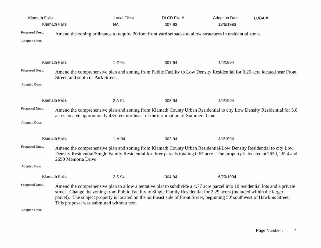
LUBA #Adoption DateLocal File # DLCD File #Klamath FallsNA 007-93Klamath Falls 12/6/1993
Adopted Desc.
Amend the zoning ordinance to require 20 foot front yard setbacks to allow structures in residential zones.Proposed Desc.
1-Z-94 001-94Klamath Falls 4/4/1994
Adopted Desc.
Amend the comprehensive plan and zoning from Public Facility to Low Density Residential for 0.20 acre located near Front Street, and south of Park Street.
Proposed Desc.
2 A 94 003-94Klamath Falls 4/4/1994
Adopted Desc.
Amend the comprehensive plan and zoning from Klamath County Urban Residential to city Low Density Residential for 5.0acres located approximatly 435 feet northeast of the termination of Summers Lane.
Proposed Desc.
1-A-94 002-94Klamath Falls 4/4/1994
Adopted Desc.
Amend the comprehensive plan and zoning from Klamath County Urban Residential/Low Density Residential to city Low Density Residential/Single Family Residential for three parcels totaling 0.67 acre. The property is located at 2620, 2624 and2650 Memoria Drive.
Proposed Desc.
2 S 94 004-94Klamath Falls 6/20/1994
Adopted Desc.
Amend the comprehensive plan to allow a tentative plat to subdivide a 4.77 acre parcel into 10 residential lots and a private street. Change the zoning from Public Facility to Single Family Residential for 2.29 acres (included within the larger parcel). The subject property is located on the northeast side of Front Street, beginning 50' southwest of Hawkins Street. This proposal was submitted without text.
Proposed Desc.
Page Number : 4

LUBA #Adoption DateLocal File # DLCD File #Klamath Falls3-Z-94 005-94Klamath Falls 10/17/1994
Adopted Desc.
Amend the comprehensive plan from High/Low Density Residential to Planned Unit Development and zoning from Single/Multiple Family to Planned Unit Development/Multiple Family Resiential for 0.36 acre located on Bismark Street Front Street and Hanks Street, which is known as the Harbor View Development.
Proposed Desc.
1-CDO-94 006-94Klamath Falls 11/7/1994
Adopted Desc.
Revise the city's code (section 10.530) to increase fees for selected development review applications.Proposed Desc.
2-CDO-94 008-94Klamath Falls 1/3/1995
Adopted Desc.
Amend the Community Development Ordinance to 1) Not require partitions over 40 acres to be surveyed; 2) Not allow manufactured homes to be placed in historic districts; 3) Add definition for historic district; 4) Change notification distances to property owners for annexation, design reviews, partitions, and vacations; 5) Allow public facilities in planned unit development; and 6) Require design reviews for business requiring change of occupancy.
Proposed Desc.
I-Z-95/1P95 002-95Klamath Falls 4/3/1995
Adopted Desc.
Amend the zoning ordinance from Planned Unit Development to Public Facilities on 4.68 acres located at the north end of Patterson Street as proposed for a church.
Proposed Desc.
4-Z-95 004-95Klamath Falls 7/17/1995
Adopted Desc.
Amend the comprehensive plan map (and zoning map) from Commercial (and Office Commercial) to Residential (and Medium Density) for .70 acres located at the northeast corner of Union Avenue and Martin Street.
Proposed Desc.
Page Number : 5

LUBA #Adoption DateLocal File # DLCD File #Klamath Falls5-Z-95 006-95Klamath Falls 9/5/1995
Adopted Desc.
Amend the Campus Planned Unit Development Master Plan from PUD (and Highway Commercial) to PUD (and Medical/ Professional) located on the south side of Eldorado Boulevard, at Daggatt Street, in the Eldorado Addition. This proposal was received without text.
Proposed Desc.
7-Z-95/2-CPA 004-95Klamath Falls 10/2/1995
Adopted Desc.
Amend the comprehensive plan (and zoning) from Residential (and Single Family) to Residential (and Medium Density) on 10.53 acres located on the east side of Homedale Road, beginning 157 feet south of Bartlett Avenue. This proposal was submitted without text.
Proposed Desc.
10-Z-95 010-95Klamath Falls 2/5/1996
Adopted Desc.
Amend the comprehensive plan (and zoning) from Residential (and Apartment) to Commercial (and General Commercial) on approximately 18 acres located between Industrial Park Drive and West Campus Way.
Proposed Desc.
1-CDO-95 001-96Klamath Falls 3/4/1996
Adopted Desc.
Amend the Community Development Ordinance of the land use regulations restricting the siting of businesses which discriminate on the basis of age.
Proposed Desc.
3-CDO-95 003-96Klamath Falls 3/4/1996
Adopted Desc.
Amend the Community Development Ordinance of the land use regulations for the development of a Downtown Business Zone Design Review Commission from Payne Alley to Spring Street, between Pine Street and Klamath Avenue.
Proposed Desc.
Page Number : 6

LUBA #Adoption DateLocal File # DLCD File #Klamath Falls3-A-95 004-96Klamath Falls 3/29/1996
Adopted Desc.
Amend the comprehensive plan to annex land on both sides of Washburn Way, between the current city limits south to Laverne Avenue. This proposal was submitted without text.
Proposed Desc.
2-CDO-95 002-96Klamath Falls 4/15/1996
Adopted Desc.
Amend the Community Development Ordinance of the land use regulations to create a Downtown Business Zone from Payne Alley to Spring Street, between Pine Street and Klamath Avenue.
Proposed Desc.
4-CDO-96 005-96Klamath Falls 5/20/1996
Adopted Desc.
Amend the Community Development Ordinance regarding placement of manufactured homes.Proposed Desc.
6-CDO-96 006-96Klamath Falls 7/1/1996
Adopted Desc.
Amend the Communtiy Development Ordinance regarding application fees for land use permits.Proposed Desc.
7-CDO-96 007-96Klamath Falls 7/1/1996
Adopted Desc.
Amend the Community Development Ordinance regarding landscaping of parking areas.Proposed Desc.
Page Number : 7

LUBA #Adoption DateLocal File # DLCD File #Klamath Falls3-A-96 012-96Klamath Falls 9/4/1996
Adopted Desc.
Amend the zoning map from county Medium Density Residential (and MD) to city Single Family Residential (and SF), to annex a 1.44 acre parcel located on the northeast corner of Loma Linda and Wendling Street.
Proposed Desc.
3-Z-96 013-96Klamath Falls 9/4/1996
Adopted Desc.
Amend the zoning map from Apartment Residential (and AR) to General Commercial (and GC) located at 228 North 7th Street.
Proposed Desc.
12-CDO-96 016-96Klamath Falls 10/21/1996
Adopted Desc.
Amend the community development ordinance regarding access and driveways.Proposed Desc.
4-A-96 014-96Klamath Falls 11/4/1996
Adopted Desc.
Amend the comprehensive land use plan and zoning maps to annex from County to City the property located at 2810 Washburn Way. (Use designations remain Commercial and General Commercial.) This amendment was received without text.
Proposed Desc.
5-Z-96 020-96Klamath Falls 11/18/1996
Adopted Desc.
Amend the zoning map from Single Family Residential to Apartment Residential on .25 acres located at the corner of Laguna and Lexington Streets. Comprehensive plan map designation remains Residential. This proposal was received with only 25 days notice.
Proposed Desc.
Page Number : 8

LUBA #Adoption DateLocal File # DLCD File #Klamath Falls5-A-96 015-96Klamath Falls 11/18/1996
Adopted Desc.
Amend the comprehensive plan and zoning map from Recreational (and Recreational Commercial) to Commercial (and General Commercial) to annex from County to City, 19.55 acres, located at Klamath Raceway, Eberlein Avenue, off Eastside Bypass. This amendment was received without text.
Proposed Desc.
13-CDO-96 021-96Klamath Falls 12/2/1996
Adopted Desc.
Amend the community development ordinance to revise and add the enforcement fees section. This proposal was received with only 39 days notice.
Proposed Desc.
15-CDO-96 022-96Klamath Falls 1/16/1997
Adopted Desc.
Amend the community development ordinance to revise and add telecommunication related regulations. This proposal was received with only 25 days notice.
Proposed Desc.
6-A-96 023-96Klamath Falls 1/21/1997
Adopted Desc.
Amend the comprehensive plan map (and zoning map) from county Commercial (and county General Commercial) to city Commercial (and city General Commercial) to annex in .43 acres located at 2120 Washburn Way. This proposal was received without text.
Proposed Desc.
11-Z-95 011-95Klamath Falls 2/5/1997
Adopted Desc.
Amend the comprehensive plan (and zoning) from Residential (and Single Family) to Residential (and Apartment Residential) on 34.5 acres located on Homedale Road, between Bartlett Avenue and the Americana Subdivision.
Proposed Desc.
Page Number : 9

LUBA #Adoption DateLocal File # DLCD File #Klamath Falls16-CDO-96 001-97Klamath Falls 4/7/1997
Adopted Desc.
Amend the community development ordinance to revise developer improvement guarantee section.Proposed Desc.
2-CDO-97 003-97Klamath Falls 4/7/1997
Adopted Desc.
Amend the community development ordinance (CDO) and zoning map to revise the definition of Industrial, change the zoning designation title from Commercial-Light Industrial (CL) to Light Industrial, and to specify permitted uses and their conditions including landscape buffers. This proposal was received with only 42 days notice.
Proposed Desc.
1-CDO-97 004-97Klamath Falls 4/7/1997
Adopted Desc.
Amend the Community Development Ordinance (CDO) to revise Partitioning, Tentative Subdivision Plan , Final Subdivision Plats, and Dedication of Lands for Public Use. This proposal was received with 42 days notice.
Proposed Desc.
KL 017-96 017-96Klamath Falls 4/21/1997
Adopted Desc.
Amend the zoning ordinance changing the campus planned unit development standards to allow the community development director and the planning commission to decide whether a project needs a public hearing, and an amendment to the sign requirements.
Proposed Desc.
4-Z-96 018-96Klamath Falls 5/5/1997
Adopted Desc.
Amend the comprehensive plan (and zoning) from Public Facility (and Public Facility) to Residential (and Single Family Residential) at corner of Front Street & W. Oregon Avenue. This proposal was received without text and without exact total of acreage involved given.
Proposed Desc.
Page Number : 10

LUBA #Adoption DateLocal File # DLCD File #Klamath FallsSIGNS/CHPT14 002-97Klamath Falls 5/5/1997
Adopted Desc.
Amend the community development ordinance to revise the sign act section.Proposed Desc.
3-CDO-97 005-97Klamath Falls 7/7/1997
Adopted Desc.
Amend the community development code to revise the downtown business design review standards.Proposed Desc.
1-A-97 006-97Klamath Falls 7/21/1997
Adopted Desc.
Amend the comprehensive plan map (and zoning map) from County, Commercial (and County, General Commercial) to City, Commercial (and City, General Commercial) and annex in 2.01 acres located at 2650 Washburn Way. This proposal was received without any text.
Proposed Desc.
4-CDO-97 008-97Klamath Falls 8/4/1997
Adopted Desc.
Amend the community development ordinance to create a new section, Minor Design Review process and add a new section regarding the fees. This proposal was received with only 39 days notice.
Proposed Desc.
1-Z-97 007-97Klamath Falls 9/2/1997
Adopted Desc.
Amend the comprehensive plan map (and zoning map) from Medical Professional (and Commercial) to Medical Professional (and Neighborhood Commercial) and apply for a Conditional Use Permit for the construction of a restaurant located on Campus Drive. This proposal was received without any text and only 39 days notice. Requested text to be sent on 6/30/97. Deidre Sessler said she would get it faxed.
Proposed Desc.
Page Number : 11

LUBA #Adoption DateLocal File # DLCD File #Klamath Falls1-95 007-95Klamath Falls 9/5/1997
Adopted Desc.
Amend the Community Development Ordinance pertaining to Definitions, Review on the Record, Appealed Decisions, Application Fees, Property Line Adjustments, Principle Uses Permitted in a Single Family Residential Zone, Structure Size in a Medium Density Zone, Development Standards in a Special Reserve Zone, Termination of a Change of Zone and of a Conditional Use Permit, and General Yard Exceptions.
Proposed Desc.
2-A-97 & 3-S-97 012-97Klamath Falls 12/1/1997
Adopted Desc.
Amend the zoning map from High Density Residential to Apartment Residential for the annexation and subdivision of approximately 20 acres located north of the OIT Campus and College Industrial Park. The property is adjacent to City property and is within the Urban Growth Boundary. This proposal was received without text.
Proposed Desc.
5-CDO-97 010-97Klamath Falls 12/15/1997
Adopted Desc.
Amend the community development ordinance relating to these sections: Design Review, Conditional Use, Tentative Subdivision, Uses Permitted by Zone, Site Standards by Zone, Manufactured Home Placement Standards, Home Occupation, Planned Unit Developments, Downtown Business Zone, Off Street Parking, Recycling, Vision Clearance, and Landscaping.
Proposed Desc.
4-A-97 013-97Klamath Falls 1/5/1998
Adopted Desc.
Amend the zoning map to annex a parcel of land currently being developed as a Big 5 Sporting Goods Store located at Washburn Way.
Proposed Desc.
3-A-97 014-97Klamath Falls 1/5/1998
Adopted Desc.
Amend the zoning map to annex a 2.02 acre parcel of land being developed as Staples Office Supply Store located on Washburn Way.
Proposed Desc.
Page Number : 12

LUBA #Adoption DateLocal File # DLCD File #Klamath Falls2-Z-97 011-97Klamath Falls 3/2/1998
Adopted Desc.
Amend the Basin View Master Plan for a mixed use development on 1,330 acres of vacant land including single and multifamily residential, commercial, professional and medical offices, parks, schools (public & private), a cultural center, fire and police facilities, medical facilities, research facilities and a trail system. This proposal was received with only 38 days notice.
Proposed Desc.
1-A-98 001-98Klamath Falls 7/22/1998
Adopted Desc.
Amend the comprehensive plan map (and zoning map) to annex into the city and rezone from county Commercial (and county General Commercial) to city Commercial (and city General Commercial) 3.7 acres located at 2977 Washburn Way, north of Hilyard Avenue and west of Broadmore Street. Property is within the urban growth boundary.
Proposed Desc.
2-A-98 002-98Klamath Falls 8/17/1998
Adopted Desc.
Amend the zoning map to annex and rezone from Klamath County Industrial to City of Klamath Falls Light Industrial / General Commercial 2.25 acres located at the SE corner of Washburn Way and Onyx Avenue.
Proposed Desc.
3-A-98 003-98Klamath Falls 11/2/1998
Adopted Desc.
Amend the zoning map to annex into the city and change designations from Klamath County to city on approximately 1 acre located at 410 Old Fort Road, west of Wendling Street.
Proposed Desc.
2-Z-98 005-98Klamath Falls 12/7/1998
Adopted Desc.
Amend the zoning map from Single Family, Medium Density, Apartment, and General Commercial to Public Facility on approximately 120 acres located south of Foothill Boulevard, west of Wiard Street, north of Frieda Avenue, and east of Summers Lane.
Proposed Desc.
Page Number : 13
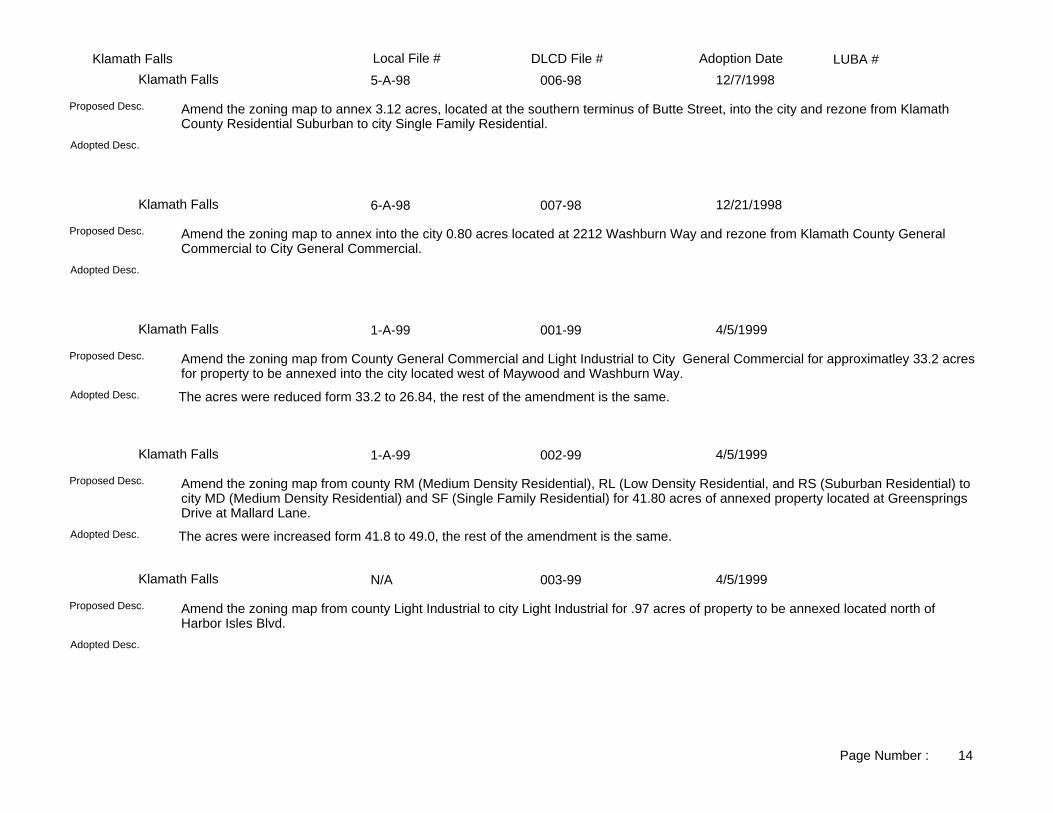
LUBA #Adoption DateLocal File # DLCD File #Klamath Falls5-A-98 006-98Klamath Falls 12/7/1998
Adopted Desc.
Amend the zoning map to annex 3.12 acres, located at the southern terminus of Butte Street, into the city and rezone from Klamath County Residential Suburban to city Single Family Residential.
Proposed Desc.
6-A-98 007-98Klamath Falls 12/21/1998
Adopted Desc.
Amend the zoning map to annex into the city 0.80 acres located at 2212 Washburn Way and rezone from Klamath County General Commercial to City General Commercial.
Proposed Desc.
1-A-99 001-99Klamath Falls 4/5/1999
The acres were reduced form 33.2 to 26.84, the rest of the amendment is the same.Adopted Desc.
Amend the zoning map from County General Commercial and Light Industrial to City General Commercial for approximatley 33.2 acresfor property to be annexed into the city located west of Maywood and Washburn Way.
Proposed Desc.
1-A-99 002-99Klamath Falls 4/5/1999
The acres were increased form 41.8 to 49.0, the rest of the amendment is the same.Adopted Desc.
Amend the zoning map from county RM (Medium Density Residential), RL (Low Density Residential, and RS (Suburban Residential) to city MD (Medium Density Residential) and SF (Single Family Residential) for 41.80 acres of annexed property located at Greensprings Drive at Mallard Lane.
Proposed Desc.
N/A 003-99Klamath Falls 4/5/1999
Adopted Desc.
Amend the zoning map from county Light Industrial to city Light Industrial for .97 acres of property to be annexed located north of Harbor Isles Blvd.
Proposed Desc.
Page Number : 14

LUBA #Adoption DateLocal File # DLCD File #Klamath FallsN/A 004-99Klamath Falls 4/20/1999
Adopted Amendment - the acreage was change from 30.79 to 28.95.Adopted Desc.
Amend the zoning map from Klamath County General Commercial and Medium Density Residential to city General Commercial and Medium Density Residential for 30.79 acres of annexed property located north of the intersection of Highway 66 and Orindale Road.
Proposed Desc.
2-Z-99 006-99Klamath Falls 9/20/1999
Same.Adopted Desc.
Amend the zoning map from GC, General Commercial to LI, Light Industrial for 12.64 acres, located west of Maywood Drive between Crosby and Hilyard. This proposal was received without text.
Proposed Desc.
1-A-00; 1-CPA-00 002-00Klamath Falls 5/15/2000
Same.Adopted Desc.
Amend the comprehensive plan map (and the zoning map) from MDR, Medium Density Residential to PF, Public Facility (and from CountyRM, County Medium Density Residential to CityPF, City Public Facility) for 26.5 acres, located south of Anderson Avenue, north of Laurel Wood Drive, west of Glenwood Drive and east of Gettle Street extension. This proposal was received without text.
Proposed Desc.
4-Z-99 008-99Klamath Falls 8/22/2000
Same.Adopted Desc.
Amend the zoning map from SFR, Single Family Residential to PUD, Planned Unit Development for 40 acres and create a new Master Plan for 565 acres, both located north of Highway 140W and Orindale Road. This proposal was received without text, and 42 days notice before the first evidentiary hearing.
Proposed Desc.
1-Z-00 003-00Klamath Falls 9/6/2000
Same.Adopted Desc.
Amend the zoning map from MDR, Medium Density Residential to NC, Neighborhood Commercial for 0.36 acres, located at 437 Adams Street. This proposal was received without text.
Proposed Desc.
Page Number : 15

LUBA #Adoption DateLocal File # DLCD File #Klamath FallsZ-A-00 004-00Klamath Falls 9/6/2000
Same.Adopted Desc.
Amend the zoning map from CountyCG, County General Commercial to CityCG, General Commercial for 0.32 acres, located at 2226 Washburn Way, and annex the parcel into the City. This proposal was received without text, and 28 days notice before the first evidentiary hearing, and was received without text.
Proposed Desc.
NONE 005-99Klamath Falls 10/16/2000
Adopted amendment differs due to the adoption of 22 conditions placed on the applicant which must be filled.Adopted Desc.
Amend the comprehensive plan map (and zoning map) from IND, Industrial to UC, Urban Commercial (and from IND, Industrial to MU, Mixed Use) for 40.0 acres along Lake Ewauna and the north portion of Modoc Mill Site, SE of Klamath Avenue and NW of Spring Street.
Proposed Desc.
4-A-00 / 27-DR-00 007-00Klamath Falls 11/20/2000
Same.Adopted Desc.
Amend the zoning map from CountyGC, County General Commercial to CityGC, City General Commercial for 5.56 acres, located at 2675 Washburn Way; and annex the property into the City. This proposal was received 42 days notice before the first evidentiary hearing.
Proposed Desc.
3-A-00 006-00Klamath Falls 11/21/2000
Same.Adopted Desc.
Amend the zoning map from CountyI, County Industrial to CityI, City Industrial for three parcels (A, B, C) on approximately 193.77 acres, located (A) east along the shoreline of Lake Klamath, south of Spruce Street, west of Lakeport Boulevard, and north of Harbor Isle Boulevard; (B) east of Alma Alley Street, south of Lakeport Boulevard, west of Montelius Street, and north of Gage Road; (C) east of Alma Alley Street, south of Gage Road, west of Montelius Street, and north of Princeton Street. All three parcels are to be annexed into the City.
Proposed Desc.
2-Z-01 003-01Klamath Falls 6/19/2001
Same.Adopted Desc.
Amend the comprehensive plan map (and the zoning map) from Residential to Public Facility (and from RS, Single Family Residential to PF, Public Facility) for 8.57 acres, located east of Orindale Road near the northwest corner of Balsam Drive and Iron Street, and annex the property into the City. This proposal was received with 42 days notice before the first evidentiary hearing.
Proposed Desc.
Page Number : 16
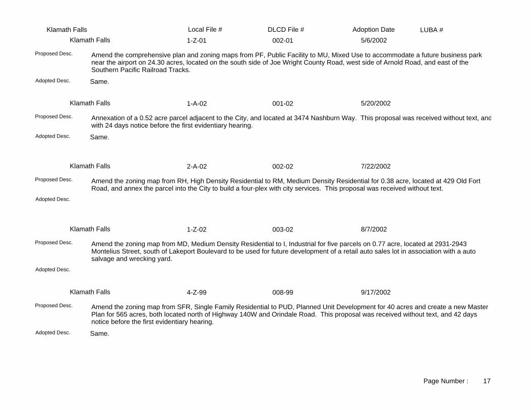
LUBA #Adoption DateLocal File # DLCD File #Klamath Falls1-Z-01 002-01Klamath Falls 5/6/2002
Same.Adopted Desc.
Amend the comprehensive plan and zoning maps from PF, Public Facility to MU, Mixed Use to accommodate a future business park near the airport on 24.30 acres, located on the south side of Joe Wright County Road, west side of Arnold Road, and east of the Southern Pacific Railroad Tracks.
Proposed Desc.
1-A-02 001-02Klamath Falls 5/20/2002
Same.Adopted Desc.
Annexation of a 0.52 acre parcel adjacent to the City, and located at 3474 Nashburn Way. This proposal was received without text, andwith 24 days notice before the first evidentiary hearing.
Proposed Desc.
2-A-02 002-02Klamath Falls 7/22/2002
Adopted Desc.
Amend the zoning map from RH, High Density Residential to RM, Medium Density Residential for 0.38 acre, located at 429 Old Fort Road, and annex the parcel into the City to build a four-plex with city services. This proposal was received without text.
Proposed Desc.
1-Z-02 003-02Klamath Falls 8/7/2002
Adopted Desc.
Amend the zoning map from MD, Medium Density Residential to I, Industrial for five parcels on 0.77 acre, located at 2931-2943 Montelius Street, south of Lakeport Boulevard to be used for future development of a retail auto sales lot in association with a auto salvage and wrecking yard.
Proposed Desc.
4-Z-99 008-99Klamath Falls 9/17/2002
Same.Adopted Desc.
Amend the zoning map from SFR, Single Family Residential to PUD, Planned Unit Development for 40 acres and create a new Master Plan for 565 acres, both located north of Highway 140W and Orindale Road. This proposal was received without text, and 42 days notice before the first evidentiary hearing.
Proposed Desc.
Page Number : 17

LUBA #Adoption DateLocal File # DLCD File #Klamath Falls2-Z-02 005-02Klamath Falls 10/8/2002
Same.Adopted Desc.
Amend the zoning map from PF, Public Facility to MD, Medium Density Residential for 13.15 acres, located at 25 Hawkins Street, and subdivide the acreage into twenty-five parcels for residential homes.
Proposed Desc.
3-Z-02 006-02Klamath Falls 10/8/2002
Same.Adopted Desc.
Amend the zoning map from from Single Family Residential to Public Facility for 5.00 acres, located at 905 Wiard Street and develop the property into a sports complex for the surrounding neighborhood.
Proposed Desc.
4-Z-02 007-02Klamath Falls 10/8/2002
Same.Adopted Desc.
Amend the zoning map from GC, General Commercial to LI, Light Industrial for two parcels on approximately 10.00 acres, located at 4100 and 3844 Highway 97N, and expand the current mini-storage facility on to the adjacent parcel.
Proposed Desc.
5-Z-02 008-02Klamath Falls 10/21/2002
Same.Adopted Desc.
Amend the Comprehensive Plan Map and the Zoning Map from Public Facility to Planned Unit Development on 5.7 acres located at 6775 Arnold Avenue (Klamath Falls Airport Business Park Planned Unit Development) that was intended to be part of the original zone change (1-Z-01) but inadvertantly omitted from the adopting ordinance (Ord. No. 02-08). Related DLCD file 002-01.
Proposed Desc.
6-Z-02 010-02Klamath Falls 12/17/2002
Same.Adopted Desc.
Amend the zoning map from SF, Single Family Residential to PUD, Planned Unit Development for three parcels on 0.82 acres, located along the northern side of Bismark Street east of Front Street, the map change is needed to enlarge the Harbor Isles PUD to allow for the expansion of a tennis club facility. This proposal was received after the first evidentiary hearing of November 12, 2002, and 14 daysbefore the final hearing.
Proposed Desc.
Page Number : 18

LUBA #Adoption DateLocal File # DLCD File #Klamath FallsNone 002-03Klamath Falls 7/21/2003
Same.Adopted Desc.
Amend the Urban Growth Boundary map to add 2.26 acres, to correct a mapping error dating back to the year 1930 when two parcels were annexed into the City. The parcels are northeast of Loma Linda Drive and west of Duffy Avenue. Both parcels are zoned single family residential and one parcel is developed with a City Water Tank on it. This proposal was received without text.
Proposed Desc.
3-A-03 004-03Klamath Falls 11/17/2003
Same.Adopted Desc.
Amend the comprehensive plan and zoning maps from County Commercial to City Commercial General for 2.85 acres, located at 3045 South 6th Street, to redevelop a vacant store into three retail areas. The parcel will be annexed into the City.
Proposed Desc.
None 005-03Klamath Falls 11/17/2003
Same.Adopted Desc.
Amend the zoning ordinance Section 14.35 - Manufactured Home Standards to change the elevation of Manufactured Homes, on foundations from the base flood elevation to at least one foot above the base flood elevation, making the standard the same as site builthomes. This proposal was received with 26 days notice before the first evidentiary hearing.
Proposed Desc.
2-Z-03 006-03Klamath Falls 1/5/2004
Same. Acknowledged.Adopted Desc.
Amend the comprehensive plan and zoning maps from PUD, Planned Unit Development to MD, Medium Density Residential for two parcels on 1.10 acres to allow single family residences and duplexes to be built, located at 766 Lake Shore Drive. This proposal was received with 34 days notice before the first evidentiary hearing.
Proposed Desc.
5-Z-03 009-03Klamath Falls 2/17/2004
Same.Adopted Desc.
Amend the zoning map from PF, Public Facility to GC, General Commercial for .090 acres, located east of Board Street and south of Wall Street. This proposal was received without text.
Proposed Desc.
Page Number : 19

LUBA #Adoption DateLocal File # DLCD File #Klamath Falls4-Z-03 008-03Klamath Falls 3/2/2004
Same.Adopted Desc.
Amend the zoning map from A, Apartments to GC, General Commercial for four parcels on approximately 1.41 acres, located on the northwest corner of Shasta Way Avenue and Washburn Way to establish a car wash facility. This proposal was received without text.
Proposed Desc.
1-Z-04 001-04Klamath Falls 5/3/2004
Same.Adopted Desc.
Amend the comprehensive plan map (and the zoning map) from Public Facility to Commercial (and from PF, Public Facility to GC, General Commercial) for 1.67 acres, located at 3201 Eberlein Avenue, to develop a medical care facility. This proposal was received without text.
Proposed Desc.
1-Z-03 001-03Klamath Falls 5/5/2004
Same. Ordinance 03-11Adopted Desc.
Amend the zoning map from Public Facility to Medium Density for approximately twenty parcels on 1.20 acres, located east of Wilford Avenue, between Carlyle Street and Upham Street. This proposal was received without text.
Proposed Desc.
2-Z-04 002-04Klamath Falls 10/4/2004
Same.Adopted Desc.
Amend the zoning map from PUD-SF, Planned Unit Development-Single Family Residential to PUD-MFR, Planned Unit Development-Multiple Family Residential for four parcels on 1.00 acre, two parcels are located on the southwest corner of the intersection of Glenridge Way and Springcrest Way, and two parcels are located northwest of the intersection of Glenridge Way and Springcrest Way; the zoning will allow the construction of a duplex and bring two other lots into zoning conformance with the other parcels in the area. This proposal was received without text.
Proposed Desc.
Page Number : 20
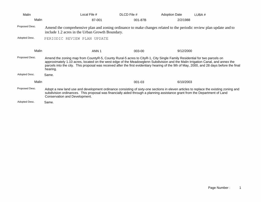
LUBA #Adoption DateLocal File # DLCD File #Malin87-001 001-87BMalin 2/2/1988
PERIODIC REVIEW PLAN UPDATEAdopted Desc.
Amend the comprehensive plan and zoning ordinance to make changes related to the periodic review plan update and to include 1.2 acres in the Urban Growth Boundary.
Proposed Desc.
ANN 1 003-00Malin 9/12/2000
Same.Adopted Desc.
Amend the zoning map from CountyR-5, County Rural-5 acres to CityR-1, City Single Family Residential for two parcels on approximately 1.10 acres, located on the west edge of the Meadowglenn Subdivision and the Malin Irrigation Canal, and annex the parcels into the city. This proposal was received after the first evidentiary hearing of the 9th of May, 2000, and 28 days before the final hearing.
Proposed Desc.
001-03Malin 6/10/2003
Same.Adopted Desc.
Adopt a new land use and development ordinance consisting of sixty-one sections in eleven articles to replace the existing zoning and subdivision ordinances. This proposal was financially aided through a planning assistance grant from the Department of Land Conservation and Development.
Proposed Desc.
Page Number : 1

LUBA #Adoption DateLocal File # DLCD File #Merrill87-001 001-87BMerrill 2/2/1988
PERIODIC REVIEW PLAN UPDATEAdopted Desc.
Amend the comprehensive plan and zoning ordinance to make changes related to the periodic review plan update.Proposed Desc.
91-001 001-91Merrill 12/3/1991
Adopted Desc.
Amend the comprehensive plan and zoning from R (Residential) to C (Commercial) for approximately 12 lots near Front Street and First Street.
Proposed Desc.
Page Number : 1