Embed Size (px)
Citation preview

Page 1 of 63
Kislingbury Parish
Neighbourhood Development Plan 2014 - 2029
Prepared by the NDP Steering Groupon behalf of the Kislingbury Parish Council, and the Parish Community

CONTENTSPage
Foreword 4
Section 1: Introduction and Background 51.1 Purpose 51.2 Submitting Body 51.3 Neighbourhood Area 51.4 The Context 51.5 Plan Period, Monitoring and Review 51.6 What is a Neighbourhood Development Plan 6
Section 2: Process Summary 72.1 Plan Development Process 72.2 Community Engagement 82.3 Evidence Base Overview 102.4 Sustainability Assessment 10
Section 3: Goals and Objectives 113.1 Goals 113.2 Plan Objectives 11
Section 4: Kislingbury - Our Village 134.1 The Parish 134.2 Kislingbury NDP Policy Coding 174.3 Living in the Village 17
4.3.1 Rural Look and Feel 184.3.2 Community and Recreation Facilities 184.3.3 Health and Health Care 184.3.4 Broadband Services 194.3.5 Village Services 194.3.6 Education 194.3.7 Traffic in the Village 204.3.8 Local Travel 214.3.9 Employment 214.3.10 Countryside and Environment 224.3.11 The Historic Environment 224.3.12 An Ageing Population 224.3.13 Housing 23
Section 5: Housing Policies 24 5.1 Housing Strategy 245.2 Housing Numbers, Mix and Tenancy 245.3 Affordable Homes for Local People 255.4 New Home Type and Size 265.5 Retirement Housing Provision 275.6 Development Site 275.7 Infill 275.8 Design 285.9 Community Facilities 295.10 Site Allocation 295.11 Specific Site Requirements 31
Page 2 of 63

Section 6: Our Village – Our Future 326.1 The Kislingbury Parish Action Plan 2015 326.2 Traffic 32
Appendices 33
Appendix A Glossary 33 Included in Plan DocumentAppendix B Neighbourhood Development Plan Policies 36 Included in Plan DocumentAppendix C The Number of New Homes 39 Included in Plan DocumentAppendix D Housing Needs Assessment 40 Available for Consultation attachedAppendix E Consultation Statement 40 (Only Available after Consultation)Appendix F Basic Conditions Statement 40 (Only Available after Consultation)
Attachment A: Sustainability Framework 40 Available for Consultation attached Attachment B: Sustainability Assessment 40 Available for Consultation attached Attachment C: Equality Impact Assessment 40 Available for Consultation attached
Appendix G Landscape and Village Character Assessment 40 Available for Consultation attachedAppendix H Baseline Report for Kislingbury
and Evidence Inventory 40 Available for Consultation attachedAppendix I SEA Screening Request and SNC Response 41 Included in Plan DocumentAppendix J Conservation Area Vantage Point Views 59 Included in Plan Document
Acknowledgements 60
Kislingbury Parish Council The Parish Office The PaddocksBaker StreetGaytonNN7 3EZ
Email: [email protected] http://www.kislingburyonline.co.uk/index.php
Page 3 of 63
ForewordNeighbourhood Development Plans come out of the Government’s determination to ensure that local communities are closely involved in the decisions which affect them. The Kislingbury Neighbourhood Development Plan (NDP) has been developed to establish a vision for the village and to help deliver the local community’s aspirations and needs for the NDP period 2014 – 2029. Unlike the Kislingbury Parish Plan 2005, upon which it builds, our Neighbourhood Development Plan is a statutory document that will be incorporated into the district planning frameworks and must be used by South Northants District Council to determine planning applications.
Our Plan has been produced by local residents, with the support of the Parish Council, using the views of the residents of Kislingbury. The Steering Group has consulted and listened to the community and local organisations on a wide range of issues that will influence the well-being, sustainability and long-term preservation of our rural community. Every effort has been made to ensure that the views and policies contained in this document reflect those of the majority of Kislingbury residents.
A NDP has many benefits. The Kislingbury NDP has been developed by volunteers from the village to:
• protect the village from uncontrolled, large scale, or poorly placed development;• meet the development required by West Northants Joint Core Strategy Plan (JCS Plan) of the
village on an acceptable and viable site;• protect the Gap between the Village and Northampton Town;• ensure that development is sympathetic to, and improves, the look and feel of the village;• take steps to give residents preferred access to many of the new homes;• protect the important green spaces around the Village and the Open Countryside; • give the Village the potential to access S106 and/or Community Infrastructure Levy funding to
improve Village facilities
Kislingbury Parish Council received over XXX separate responses to the pre-submission version of NDP. In total the responses contained over XXX distinct comments from residents, businesses, and landowners. Each comment was reviewed by the Steering Group working with the Parish Council and considered individually. Overall, the NDP was well received, with XXX out of XXX respondents recording their support, and the bulk of the comments required no change to the NDP. Others clarified policies or produced minor changes to the NDP. A full list of these comments and the response of the Parish Council can be found in the Kislingbury NDP Consultation Statement (Appendix E).
An electronic copy of this Plan, together with the Basic Conditions Statement and the Consultation Statement, as well as other Appendices, can be found online at http://www.kislingburyonline.co.uk/index.php
The Parish Council would like to thank the members of the Steering Group and pay tribute to their work since late 2011. The Parish Council is also grateful for the help and the engagement of many others in the village without which it would not have been possible to produce this Neighbourhood Development Plan.
Chair, Kislingbury Parish Council Chair, Neighbourhood Development Plan Steering Group
Page 4 of 63
This will be updated after the Consultation

Section 1: Introduction and Background
1.1 Purpose
In April 2012 the Localism Act 2011 amended the Town and Country Planning Act 1990 (the Act) introducing new rights and powers to allow local communities to shape new development in their community by preparing a Neighbourhood Development Plan which can establish general planning policies for the development and use of land in the neighbourhood. This document is a Neighbourhood Development Plan as defined in the Act.
1.2 Submitting Body
This Neighbourhood Development Plan is submitted by Kislingbury Parish Council, which is a qualifying body as defined by the Localism Act 2011.
1.3 Neighbourhood Area
The Neighbourhood Development Plan applies to the Parish of Kislingbury in the South Northants District of Northamptonshire.
In accordance with Part 2 of the Regulations, South Northants District Council (SNC), the local planning authority, publicised the application from Kislingbury Parish Council and advertised a consultation period beginning 22nd August 2013 and ending on 4th October 2013. The application was approved by the Committee of SNC on 10th February 2014 and the Kislingbury Parish designated as the Neighbourhood Area.
Kislingbury Parish Council confirms that this:i. Neighbourhood Development Plan relates only to the Parish of Kislingbury and to no other
Neighbourhood Areas.ii. Is the only Neighbourhood Development Plan in the designated area. No other Neighbourhood
Development Plan exists or is in development for part or all of the designated area.
1.4 The Context
The Kislingbury Neighbourhood Development Plan must:a. have appropriate regard to national planning policy;b. contribute to sustainable development;c. be in general conformity with strategic policies in the development plan for the local area; andd. be compatible with EU obligations and human rights requirements.
The Parish of Kislingbury is part of the District of South Northants, which is part of the wider region of West Northants. The local strategic context (condition (c) above) is, therefore, set by the West Northants Joint Core Strategy Plan (JCS Plan) which was adopted on 15th December 2014.
1.5Plan Period, Monitoring and Review
The Kislingbury Neighbourhood Development Plan will run concurrently with the West Northants Joint Core Strategy Plan and will apply until the 31st March 2029. It is, however, a response to the needs and aspirations of the local community as understood today and it is recognised that current challenges and concerns are likely to change over the NDP period.
Kislingbury Parish Council, as the NDP authority, will be responsible for maintaining and periodically
Page 5 of 63

revisiting the NDP to ensure relevance and to monitor delivery.
It is expected that the majority of the new homes will be developed within the first five years of the NDP period.
If, in March 2021:
i. planning permission has not been granted for the Development on the Allocated Site; orii. development has not started on the allocated site in accordance with the Kislingbury NDP
policies; oriii. the site has been withdrawn from the NDP by the landowner giving written notice to
Kislingbury Parish Council and SNC.
then the NDP allocation for the site listed in Table 6.i will lapse and the Parish Council will form a Plan Review Committee charged with identifying alternative Sites that are available and which can, either singly or together, deliver the required number of Houses.
This will ensure that the NDP will be reviewed well be before the end of its term in order that the number of new homes required by the Core Strategy will be delivered before 2029.
1.6 What Is the Neighbourhood Development Plan?
Although deciding where new housing, additional leisure, retail and employment should go is an important part of the NDP, it is about much more than this. The NDP is a plan for the village as a whole. It looks at a wide range of issues, including:
• The development of housing (location, type, tenure etc.)• Local employment and opportunities for businesses.• Transport and access issues (roads, cycling, walking etc.)• The provision of leisure facilities, schools, places of worship, health, entertainment, and
youth facilities.• The protection and creation of open spaces (nature reserves, allotments, sports pitches, play
areas, parks and gardens).• Protection of important buildings and historic assets.
Page 6 of 63

Choose Sites Draft the recommendations
Sustainability Assessment
Village site preferences
Identify Possible Sites
Identify Housing Need
Living in the Village
Development Design
Figure 2.i Outline Plan Development Process
AllocateHousing
Section 2: Process Summary
2.1 Plan Development Process
Kislingbury Parish Council resolved to develop a Neighbourhood Development Plan for Kislingbury on 20th October 2011 and on that date the Parish Council formed a Neighbourhood Development Plan Steering Group made up of Councillors and volunteers. Since then a total of 10 residents have served on the Steering Group.
In early 2013 the Steering Group sent a Questionnaire to all households in the Village. The results of this Questionnaire, together with the Village Plan of 2005, helped the Steering Group to identify the issues that could be addressed by a Neighbourhood Development Plan.
Six such issues were identified:1. What is the housing need in Kislingbury?2. Where might new housing be located?3. What is important to residents when considering new sites for housing?4. What design requirements are there for new developments and homes?5. What other aspects of living in the village should be considered?6. How do we ensure that we meet the sustainability requirements?
Figure 2.i Outlines the NDP development process. In this:
The Housing Need was established by: considering:
Page 7 of 63

• trends in the population of the Parish, household size and residents’ age;• information from the 2005 Parish Plan; and• the views of the residents who attended the Village Meetings in March 2014. October 2014, and
May 2015; conducting an independent housing needs survey across the whole village (Survey October 2014 and
SNC HNS Survey); considering data from SNC Housing Department; hearing the views of owners and interested developers of potential sites; and discussing with SNC housing numbers required of Kislingbury to meet the target set for South
Northants District by the JCS Plan.
The proposed housing mix was approved by XX% of residents who completed the questionnaire during the Reg 14 Consultation.
Potential Sites were identified by: including all sites in the West Northants JCS Strategic Housing Land Availability Assessment (SHLAA); removing any SHLAA sites that were no longer available for development; removing any SHLAA sites that were not suitable for housing development; assessing the remaining sites for suitability based on a wide range of objective criteria.
The Choice of the Sites was guided by: the views expressed by the village in completed questionnaires in January 2013 and October
2014; publishing a summary of these initial conclusions on the Kislingbury NDP website for comment; the outcome of the open meetings in March 2014, and October 2014; the sustainability objectives; and the response of residents to the Village Meeting in May 2015.
From these consultations a strong consensus emerged regarding the preferred site for development.
A picture of Life in the Village was drawn by: creating a Character Assessment of the Village using the results of previous community endeavours including the 2005 Parish Plan; using information gathered at the March 2014 and October 2014 consultations; holding meetings with groups such as the Primary School, the Bugbrooke Medical practice,
Statutory Consultees, Landowners ; and using the results of a survey that went to all homes in the village in January 2013 and October 2014.
The conclusions were presented at the May 2015 Village Meeting and were confirmed by over 90% of those attending, with only 2 people raising issues that required changes to the Draft Policies. The Meeting confirmed that the Steering Group had identified the key aspects of living in the village.
The Design of Development and Housing was determined by: the Character Assessment of the Village; the design requirements of the Joint Core Strategy Plan; answers to the Village Questionnaire of January 2013; and consideration of the Building for Life Partnership guide for the design of homes and neighbourhoods
(2012), and the LifeTimes Homes Standards.
2.2 Community Engagement
A Neighbourhood Development Plan is a community plan and must derive its objectives, actions and authority from the community. From the outset the Steering Group has been determined that the
Page 8 of 63
We shall complete this after the Reg 14 consultation

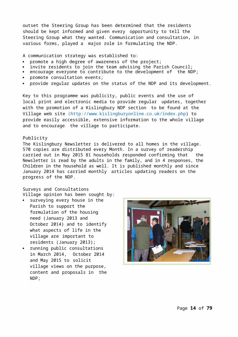
residents should be kept informed and given every opportunity to tell the Steering Group what they wanted. Communication and consultation, in various forms, played a major role in formulating the NDP.
A communication strategy was established to: promote a high degree of awareness of the project; invite residents to join the team advising the Parish Council; encourage everyone to contribute to the development of the NDP; promote consultation events; provide regular updates on the status of the NDP and its development.
Key to this programme was publicity, public events and the use of local print and electronic media to provide regular updates, together with the promotion of a Kislingbury NDP section to be found at the Village web site (http://www.kislingburyonline.co.uk/index.php) to provide easily accessible, extensive information to the whole village and to encourage the village to participate.
PublicityThe Kislingbury Newsletter is delivered to all homes in the village. 570 copies are distributed every Month. In a survey of readership carried out in May 2015 81 households responded confirming that the Newsletter is read by the adults in the family, and in 4 responses, the Children in the household as well. It is published monthly and since January 2014 has carried monthly articles updating readers on the progress of the NDP.
Surveys and ConsultationsVillage opinion has been sought by: surveying every house in the Parish to
support the formulation of the housing need (January 2013 and October 2014) and to identify what aspects of life in the village are important to residents (January 2013);
running public consultations in March 2014, October 2014 and May 2015 to solicit village views on the purpose, content and proposals in the NDP;
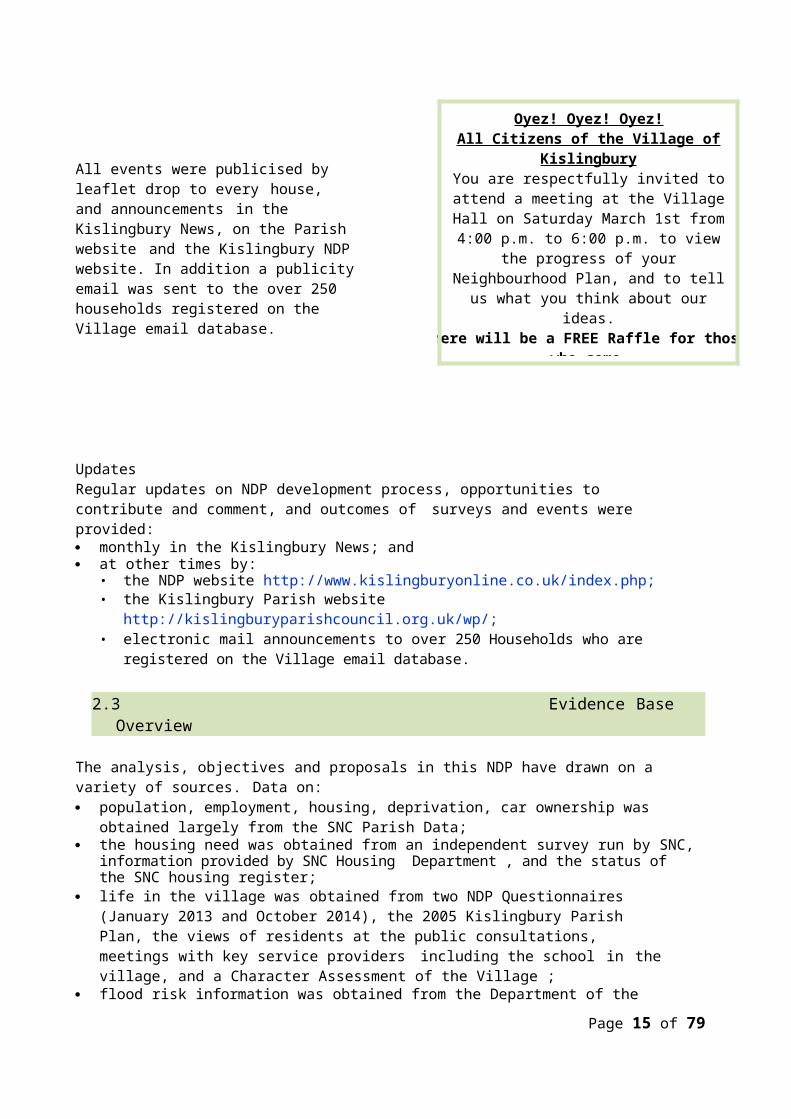
All events were publicised by leaflet drop to every house, and announcements in the Kislingbury News, on the Parish website and the Kislingbury NDP website. In addition a publicity email was sent to the over 250 households registered on the Village email database.
Page 9 of 63
Oyez! Oyez! Oyez!All Citizens of the Village of KislingburyYou are respectfully invited to attend a
meeting at the Village Hall on Saturday March 1st from 4:00 p.m. to 6:00 p.m. to view the
progress of your Neighbourhood Plan, and to tell us what you think about our ideas.
There will be a FREE Raffle for those who come and the prize is a FREE Meal for TWO at The Sun Inn! (drinks not included)
All ages are Welcome! Please bring your Mum and Dad with you!
Oyez! Oyez! Oyez!

UpdatesRegular updates on NDP development process, opportunities to contribute and comment, and outcomes of surveys and events were provided: monthly in the Kislingbury News; and at other times by:
• the NDP website http://www.kislingburyonline.co.uk/index.php;• the Kislingbury Parish website http://kislingburyparishcouncil.org.uk/wp/;• electronic mail announcements to over 250 Households who are registered on the Village email
database.
2.3 Evidence Base Overview
The analysis, objectives and proposals in this NDP have drawn on a variety of sources. Data on: population, employment, housing, deprivation, car ownership was obtained largely from the SNC
Parish Data; the housing need was obtained from an independent survey run by SNC, information provided by SNC
Housing Department , and the status of the SNC housing register; life in the village was obtained from two NDP Questionnaires (January 2013 and October 2014),
the 2005 Kislingbury Parish Plan, the views of residents at the public consultations, meetings with key service providers including the school in the village, and a Character Assessment of the Village ;
flood risk information was obtained from the Department of the Environment; landscape character assessment was obtained from the evidence supporting the JCS Plan: the views of Statutory Consultees as well as many other interested parties were sought to provide
input to the Site Selection process. The detailed analysis of the January 2013 and October 2014 Questionnaires can be found in the
Evidence base.
More detailed information on this extensive evidence base, including reports on the village consultations, can be found in the Kislingbury NDP Evidence documents on the Kislingbury NDP website (http://www.kislingburyonline.co.uk/index.php) and in Appendix H.
2.4 Sustainability Assessment
Neighbourhood Development Plans are not technically subject to sustainability appraisal, provided they are in conformity with the development plan of the local planning authority in terms of the scale and distribution of growth planned.
However, the land use planning process provides an important means by which sustainabledevelopment can be achieved. The Kislingbury NDP is in conformity with, and refines, the West Northants JCS Plan Policies relating to Kislingbury and forms a formal part of JCS’s Development Plan.
As such, the Kislingbury NDP will help to achieve sustainable development by ensuring that its development policies and proposals will meet the needs of people living and working in the Parish.
The Kislingbury NDP identifies the sustainability issues within the Parish and sets out a framework within which these economic, social and environmental issues have been considered when determining the NDP’s detailed policies and proposals.
Page 10 of 63
Page 11 of 63

Section 3: Goals and Objectives
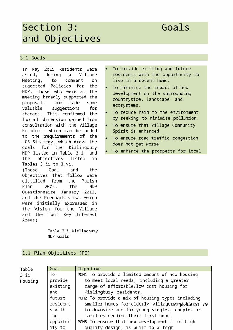
3.1 Goals
In May 2015 Residents were asked, during a Village Meeting, to comment on suggested Policies for the NDP. Those who were at the meeting broadly supported the proposals, and made some valuable suggestions for changes. This confirmed the l o c a l dimension gained from consultation with the Village Residents which can be added to the requirements of the JCS Strategy, which drove the goals for the Kislingbury NDP listed in Table 3.i. and the objectives listed in Tables 3.ii to 3.vi.(These Goal and the Objectives that follow were distilled from the Parish Plan 2005, the NDP Questionnaire January 2013, and the Feedback views which were initially expressed in the Vision for the Village and the four Key Interest Areas)
Table 3.i Kislingbury NDP Goals
1.1Plan Objectives (PO)
Table 3.ii Housing
Page 12 of 63
To provide existing and future residents with the opportunity to live in a decent home.
To minimise the impact of new development on the surrounding countryside, landscape, and ecosystems.
To reduce harm to the environment by seeking to minimise pollution.
To ensure that Village Community Spirit is enhanced
To ensure road traffic congestion does not get worse
To enhance the prospects for local business enterprise and employment.
To maintain the character and vitality of the village.
Goal ObjectiveTo provide existing and future residents with the opportunity to live in a decent home.
POH1 To provide a limited amount of new housing to meet local needs; including a greater range of affordable/low cost housing for Kislingbury residents.
POH2 To provide a mix of housing types including smaller homes for elderly villagers wishing to downsize and for young singles, couples or families needing their first home.
POH3 To ensure that new development is of high quality design, is built to a high sustainability standard and reinforces local distinctiveness.
POH4 To ensure that the design and location of new development is resilient to the effects of climate change and flooding.

Table 3.iii Environment
Table 3.iv Pedestrians, Traffic and Transport
Table 3.v Economy
Table 3.vi Community
Page 13 of 63
Goal ObjectivesTo minimise the impact of new development on the surrounding countryside, landscape, and ecosystems.
POE1 To protect and enhance the village’s open spaces.POE2 To protect, enhance and conserve the landscape and views.POE3 To protect and enhance the historic environment of the
village. POE4 To conserve and enhance biodiversity.POE5 To use land efficiently and to preserve high quality
agricultural land.To reduce harm to the environment by seeking to minimise pollution.
POE6 To position development in order to avoid increasing pollution from traffic congestion.
Goal ObjectivesTo ensure Village Community Spirit is enhanced
POT1 To link all developments to the village centre with footpaths, where appropriate.
To ensure road traffic congestion does not get worse
POT2 To position new development such that current problems with congestion, parking and road safety are not exacerbated and, if possible, reduced.
Goal ObjectivesTo enhance the prospects for local business enterprise and employment.
POEC1 To encourage and support home working.POEC2 To provide local low cost market housing for local employees.
Goal ObjectivesTo maintain the character and vitality of the village
POC1 To give preferential access to some new homes for people with a strong local connection.
POC2 To integrate new housing into Kislingbury such that today’s rural look and feel is maintained.
POC3 To provide homes for younger people and young families and so counter the growing demographic imbalance.
POC4 To preserve important village assets.
Section 4: Kislingbury - Our Village4.1 The Parish
In 1870-72, John Marius Wilson's Imperial Gazetteer of England and Wales described Kislingbury like this:
“KISLINGBURY, a parish in the district and county of Northampton; on the river Nene, 3¼ miles West of Northampton railway station. Post town, Northampton. Acres, 2, 170. Real property, £4, 559. Pop., 723. Houses, 161. The property is much subdivided. The living is a rectory in the diocese of Peterborough. Value, £547. Patron, the Rev. W. H. Hughes. The church is decorated English, in good condition; and has a spire. There are chapels for Baptists and Wesleyans, a national school, and charities about £120.”
The Parish of Kislingbury and the wishes of those who live and work in the Parish provide the essential context to the Kislingbury NDP. This section of the NDP:
provides a brief overview of the Parish; its location, surroundings, size, housing, heritage and a summary of what residents think about life in the village;
identifies the challenges facing the Parish; and establishes policies to address, where possible, these challenges.
All the evidence shows that housing is the major challenge. Because of that, and although this section contains policies that have a direct influence on the location and type of housing, the policies governing housing provision are provided in Section 5.
LocationKislingbury is a village situated within a rural parish area. It is south-west of the town of Northampton. The River Nene flows along the northern edge of the Village and there is an ancient bridge over it giving access to the A4500. The South side of the Village confines lies along the M1 and Junction 16 is 2.2 miles from the Village.
The Parish is essentially rural and surrounded by Nene River Valley Flood Plain to the North and West and open farmland to the East.
ConnectionsKislingbury is 3.5 miles from the nearest railway station (Northampton) and four miles from the centre of Northampton, the nearest major town. To the South the nearest town is Towcester some ten miles distant and the town of Daventry lies ten miles due west.
Kislingbury is linked to Northampton and Daventry by hourly bus services.
Page 14 of 63
Kislingbury is located on the edge of Northampton Town Boundary.
Page 15 of 63
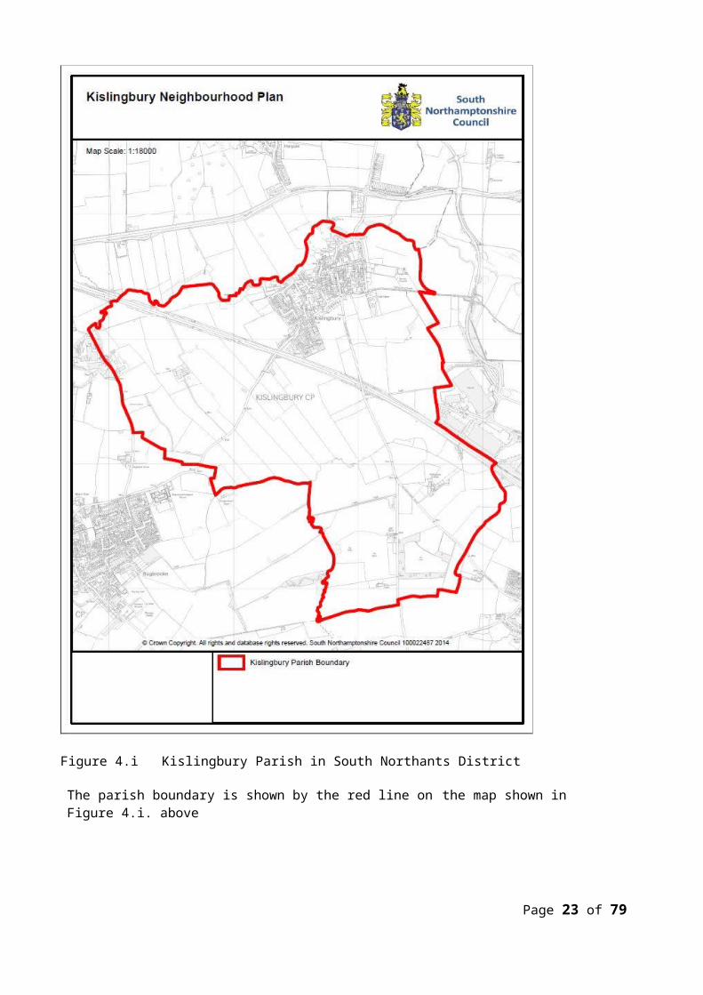
Kislingbury
Figure 4.i Kislingbury Parish in South Northants District
The parish boundary is shown by the red line on the map shown in Figure 4.i. above
Page 16 of 63
Page 17 of 63
The Natural EnvironmentKislingbury is a very old Village situated on the River Nene Flood Plan. It is mentioned in the Domesday Book (1086) – spelling at that time Ceselingeberie – so obviously had been in existence for some time prior.
There are no Sites of Special Scientific Interest, Special Areas of Conservation, National Nature Reserves or Conservation Target Areas within, or likely to be affected by development in, Kislingbury.
There are no local level designations although Kislingbury is situated on the Banks of the River Nene. To the North there are Zone 2 and 3 flood risk areas. However, in 2003 Flood Defences were built which should protect the Village against major flooding.
HeritageThere are 33 listed buildings within the Parish, of which one is St Luke’s Church, which is a Grade 1 Listed building dating from the 14th Century still in use.
The NDP aims to ensure that the historical features of the Village are retained, and that any development permitted respects the character of the village zone in which it takes place. This varies from the old centre of the Village contained within the Conservation Area to zones which reflect waves of building since the Second World War.
PopulationKislingbury’s population has expanded from 731 in the 1950’s to 1221 in 2001. Today the population is reasonably static (1237 in 2011) though recent small developments since the last Census will have increased the population by a small percentage. The average age of Residents has hardly changed from 2001 to 2011 at 45 years, but the proportion of Residents over 65 has increased. This trend is likely to continue, though the NDP aims to attract younger families to the Village.
Page 18 of 63

Fig. 4.ii. Village Environment Constraints Fig. 4.iii Listed BuildingsHousingIn March 2011 Kislingbury had 517 dwellings, an increase of 2% on the 506 in 2001. The average number of people resident in each dwelling has risen slightly from the 2001 figure of 2.44 per household to 2.5 per household.
Kislingbury has a wide range of property values from under £200,000 to over £1,000,000. In January 2015 the average value of properties in Kislingbury was £301,000. The average sale price of all properties sold in the village in the year to end of 2014 was £319,738. In comparison, the UK national average value was £268,000. For Northampton the average value was £211,000 and Northamptonshire £201,000. The surrounding villages had average values as follows: Bugbrooke £259,000, Harpole £277,000 and Rothersthorpe £319,000. (Information obtained from Zoopla)
Kislingbury has roughly the same percentage of Detached houses as the rest of the SNC District, more Terraced Houses, but fewer flats. Kislingbury has significantly fewer one bedroom Dwellings than the rest of the District, but slightly more 3 and 5 bedroom houses.
Owner Occupation declined slightly over the period 2001 to 2011 from 378 to 371. The percentage of Owner Occupied Dwellings is 74.2% slightly below the figure of 76.3% for the District.
4.2 Kislingbury NDP Policy Coding
The following sections contain polices derived from the views expressed by residents in Village Meetings and the Parish Plan and the consultations and surveys held as part of the evidence gathering for the NDP. To aid identification, policies have been coded as indicated in Table 4.i
Table 4.i Policy Coding
4.3 Living in the Village
The 2005 Parish Plan identified many pluses for the Village, but also many issues that needed to be addressed to make life in the Village more agreeable. The proximity of the Village to Northampton, as well as to Towcester and Daventry meant that villagers had access to a wide range of vital services and amenities. Public Transport was very good, though the Bus service was not widely used, with easy access to the Mainline Train service in Northampton. The General Hospital in the town was a short distance from the Village. The quality of life in the Village was generally high with little or no deprivation.
A strong sense of community is supported by over 30 clubs, services, and societies, the social facilities offered by the Village Hall, the Kislingbury Newsletter (the monthly village magazine) and major community events such as the annual Kislingbury Fayre.
All residents live within easy walking distance of the churches, post office, the village shop, the butcher, and primary school. The secondary school is less than 2 miles from the Village in Bugbrooke, as is the most used Doctor’s Surgery.
Despite these advantages no community is perfect and, as identified in the Parish Plan, Kislingbury faces challenges. These challenges were evident in the consultations undertaken during the
Page 19 of 63
Code Policy AreaC Community well-beingD Design
EM Employment and the local economyH Housing
HE Historic EnvironmentHS Housing sitesT Traffic and Transport

development of the NDP.
This section provides an overview of life in Kislingbury today, introduces the challenges facing the community and identifies, where possible, how the NDP will address these.
4.3.1 Rural Look and Feel• Development threatens the openness and rural look and feel of the village (2013 Questionnaire)
The openness of the village and its location in the Nene River Valley are greatly valued by all who live in Kislingbury and residents see any development as a threat to the rural look and feel of the village.
C1: Green space and LandscapingWhen appropriate, a landscape strategy shall be submitted with all new development proposals which will incorporate the following details: (i) existing and proposed hard and soft landscaping; (ii) a condition survey of all existing trees and hedgerows; (iii) an outline of the measures to be taken to protect existing trees and hedgerows during construction; (iv) consideration of both near and distant views of the development from the Conservation Area vantage points (see Map Appendix J) showing existing landscaping and how it will appear after 10 years; and (v) details, where appropriate, of how those areas to be retained for open space, as well as any retained trees and hedgerows, will be managed in the future.
4.3.2 Community and Recreational Facilities• There is a concern that development could lead to a loss of open spaces in and around Kislingbury
and reduce the Gap that separates the Village from Northampton Town. (2013 Questionnaire)• There is a strong feeling that important village assets need safeguarding. (2013 Questionnaire)
For a community of 1200 residents Kislingbury is well endowed with community and recreational facilities. The village has: a substantial Village Hall with a kitchen, a large Main Hall, several smaller rooms; A Playing Field area equipped for Children; Sports Grounds for Bowls, Cricket and Football; and There are 33 allotments all within 10 minutes walking distance of the centre of the village. The rural surroundings are an important leisure asset and Kislingbury’s position within the Nene
River Valley provides many opportunities for walking, cycling, horse riding and other outdoor pursuits.
C2: Assets of Community ValueProposals that will result in either the loss of an Asset of Community Value or in significant harm to the community value of an asset will be strongly resisted.
Additional community facilities are provided by: Village greens which provide green spaces for the Village and are used for Community events, e.g.
Village Fayre; Judo, yoga and other indoor activities in the village hall;
Local sports provision is enhanced for the local community by: The Village Play Ground The Bowls Club The Cricket Club
Page 20 of 63

The Football Club
4.3.3 Health and Health Care• The dispensary attached to the Bugbrooke Surgery is highly valued.• There is no Village optician or NHS dentist, but Northampton Town services are very close• The ageing of the Village, and neighbouring villages that use it, could strain the Bugbrooke Medical
Practice particularly after the Northampton SUEs are completed which are close to the Village.• Road safety is a major concern.
The Bugbrooke Medical Practice has a surgery and dispensary in Bugbrooke which provides a valued service to patients from Kislingbury and the surrounding rural area.
4.3.4 Broadband Services• Residents considered broadband service to be poor at the start of the development of the NDP. BT
Infinity has since been extended to the Village. (2013 Questionnaire and Consultation)
The provision of good telecommunications is particularly important in rural areas and for the support of rural enterprise and home-working. Currently fibre optic connections are the most robust and future-proof method of delivering high performance connectivity and this should be the aim for all new developments.
C3: Broadband – fibre to the premisesProposals which seek the expansion of electronic communication networks and high speed broadband along with improvements to connectivity will be supported, so long as it is consistent with an efficient operational network without harming the character or appearance of the Village.
Applications for Housing development must contain a ‘Connectivity Statement’ and will provide for appropriate facilities to enable more than one service provider to provide a fibre connection to individual properties from connection chambers located on the public highway, or some alternative connection point available to different service providers.
4.3.5 Village ServicesKislingbury currently has a range of shops, including a Village Shop, a butcher, general tradesmen and services, and a Post Office. In addition there is a gastro-pub, and two public houses which also serve food. These Services are greatly valued by the Residents. (2013 Questionnaire)
Many residents also shop in Northampton, Milton Keynes, or the other nearby towns or, increasingly, on the internet.
C4: Community Facilities and ServicesProposals for additional services and facilities within the village Confines will be supported subject to the following criteria being met: (i) the individual proposal will not generate unacceptable noise, fumes, smell or other disturbance to neighbouring residential properties; (ii) the particular proposal will not lead to traffic congestion or adversely affect the free-flow of traffic on the adjoining highway; and (iii) access arrangements and off- street parking can be satisfactorily provided without impinging on adjoining residential and non-residential uses.
4.3.6 Education• Kislingbury Primary School may be unable to cope with increased pupil numbers coming from
development in the Village, but also from the huge housing schemes planned in Northampton not Page 21 of 63

far from the Village.• School buses and cars, taking and collecting pupils to and from school, add to the congestion on
the High Street and Bugbrooke Road.
There is a state primary school in Kislingbury, and Campion Secondary School is less than two miles away on the edge of Bugbrooke Village.
Kislingbury Primary SchoolThe school is a Northants County Council coeducational school for children aged 4+ to 11 years mostly from the Parish. Kislingbury Primary School has a theoretical capacity of 175 but the governors believe that the current enrolment of 22 per year, giving a maximum capacity of 154 represents, because of unhelpful historic classroom design and a lack of hall and playground space, a practical upper limit to the number of pupils. The current numbers on role is 146. (This has grown over the last 5 years from just over 100).
The School is currently housed on a cramped site on the High Street with limited provision for staff to park their cars. If faced with an increase in demand for places, resulting from the planned housing growth, the School may struggle to meet the future needs of the village.
Campion Secondary SchoolCampion School is a co-educational secondary school in Bugbrooke, about 2 miles from Kislingbury. Founded in 1967, it became a Language College in September 1997, and in 2011 the school became an academy. Languages taught include French, German, Japanese, Italian, Welsh and Spanish. The school takes about 230 pupils a year into its year 7, and teaches students aged 11 to 18. Between 55% and 60% of pupils stay on to the sixth form.
The Village Play School operates in the Village Hall during term time.
During the course of the consultation process issues arose concerning:• the ability of the primary school to grow and provide for the additional children from the new family
homes, both in Kislingbury and the surrounding villages and Northampton Town;• the ability of the school to respond to rising local demand
4.3.7 Traffic in the Village• Congestion in the High Street, at the Bridge, and on Bugbrooke Road• Volumes of Traffic using Kislingbury as a “rat-run” route• The Number of HGVs using Kislingbury• Pedestrians safety; speeding and parking are key issues of concern(Supported by evidence from 2013 Survey, Police Traffic Volume Survey 2014)
The Residents of Kislingbury have identified Traffic Issues as a major concern. These take the form of three distinct concerns:
• Danger to Pedestrian and particularly school children in Bugbrooke Road, and at the drop off point for the Primary School in the High Street• Speeding through the Village, particularly in Bugbrooke Road coming from the Bugbrooke direction.• Kislingbury being used as a “rat –run” by commuters, normal traffic, and HGVs creating, as a result, unnaturally high volumes of traffic through the Village.
Kislingbury is used as a short cut by drivers moving between the A5 and the A4500 and M1 at Junction 16. There are as many as 2million traffic movements per annum through the Village, and 20% of them speed
Page 22 of 63
according to research carried out by Northants Police.The 2013 Questionnaire Responses highlighted concerns over traffic volumes; access difficulties; speeding; and parking. Residents have continuously expressed a strong view in all consultations that measures are needed to control the speed of traffic travelling through the village along the Bugbrooke Road and the High Street.
In addition to the school, the village shop and pubs also attract traffic from the villages surrounding Kislingbury, leading to congestion and parking problems at certain times of the day around their locations. Traffic congestion, road safety, speeding and parking are all major concerns to residents.
T1: Traffic CongestionProposals that accord with the policies in the NDP and do not exacerbate Traffic Congestion will be supported. Proposals requiring planning permission and which seek to increase the number of access points or which would involve an increase in traffic generation will need to demonstrate that they do not exacerbate traffic congestion in the following areas: (i) Bugbrooke Road; (ii) The Green; (iii) The High Street; (iv) Beech Lane; (v) Church Lane
The developers of the allocated housing site will be required to provide pedestrian footways along the full length of the site frontage in order to contribute to the provision of continuous safe pedestrian access to the centre of the Village.
T2: Pedestrian FootwaysAll new housing developments must when appropriate and practical provide safe pedestrian access to link up with existing or proposed footpaths, ensuring that residents can walk safely to bus stops, schools and other village facilities.
Inadequate provision for cars has led to high levels of on-street parking on narrow village streets. Future development in Kislingbury must provide adequate off-street parking for residents.
4.3.8 Local Travel• Additional traffic from new homes will add to existing congestion and road safety problems.
There is a regular hourly bus service to Northampton and Daventry.Car ownership in Kislingbury is less than that for the rest of the SNC District with 12% of Households not owning a car compared to 9.3% for the District. 53.4% of Households own 2 or more cars which even at that level is still below the District at 55.6%.
4.3.9 Employment • Housing is inaccessible for workers on lower incomes.• Income and deprivationIncome levels are relatively high and deprivation is very low. A Study by the Department for Communities and Local Government, Indices of Deprivation 2010 showed that the SNC District was among the least deprived areas in the country.
The future economic development of Kislingbury is considered in the NDP. Surveys have produced some requests to improve the prospects for local employment but these do not appear to be a priority. The number of home workers continues to increase which puts pressure on the speed and consistency of the broadband service.
Page 23 of 63

Feedback from the consultations reveals that there is no appetite for additional business or industrial development, but the community gives support to maintaining existing commercial enterprises and some support to encouraging home working using the Internet as the main facilitating tool. (2013 Questionnaire)
EM1: Heavy Goods TrafficAny proposal requiring planning permission to change the use of land in the Parish to General Industrial Use, or other uses, which would generate heavy goods traffic, must demonstrate with the assistance of a Transport Statement that the proposal will not have a severe traffic impact within the Parish.
4.3.10 Countryside and Environment• Development might increase water runoff into the River Nene and thereby increase flooding risks• Development will damage the Nene River Valley Nature Improvement Area (NIA) and
landscape and could lead to a loss of valued views across open countryside from within, and into the village.
• Development could lead to a loss of open countryside • There are Sites which make up the Gap which separates the Village from Northampton Town.
Development on these would open up the Gap to further development thereby eliminating the Gap.
• Development might damage the local ecology.• Development will damage the historical legacy of the Parish
Conservation is a high priority and protection of the countryside and the environment are major considerations when assessing potential sites and weighed heavily in the selection process.
There are no local level designations but Kislingbury residents place a high value on the environment of the Nene River Valley and on the continued protection of the Gap that separates the Village from Northampton.
4.3.11 The Historic Environment
The responses to the 2013 Questionnaire show that the Residents wish the Heritage Environment to be protected.
HE1: Historic EnvironmentAny designated historic heritage assets in the Parish and their settings, both above and below ground and including listed buildings, and any monuments that have or may be scheduled, or conservation areas that have been or may be created, will be conserved and enhanced for their historic significance and their importance to local distinctiveness, character and sense of place.
This Policy aims to ensure that any historic heritage assets that come to light during a development receive full protection until they are properly designated, as well as protecting those already clearly identified.
4.3.12 An Ageing Population Increased demand on health services Access to shops and services for older people Loss of vitality in the community Housing unsuited to an ageing population
The population is ageing. The number aged 65 and over has increased in the period 2001 to 2011 and Page 24 of 63
is higher proportionally than the rest of the District. During that same period the number of Adults in the age group 25-44 dropped from 26.7% to 22.6% and is lower than the District. There has been growth in the age group 16-24 from 7% to 10%, but the Village is unable to offer these young adults dwellings which would allow them to stay in the Village. This threatens the vitality of the community and the ageing population places extra, and different, demands on local health, transport and housing.
4.3.13 Housing
The housing stock is unbalanced with a lack of smaller houses. There is a shortage of available Affordable Housing The housing stock is unsuited to an ageing population. There are very few low cost market houses for sons and daughters of Residents to purchase. Those with a strong local connection are not given preferential access to housing. New development must be integrated into the community – not creating communities within
the community.
(Information received from the Parish Pack supplied by SNC, Housing Needs Survey by SNC and the Parish, views of Residents expressed in the 2013 and 2014 Questionnaire responses)
Kislingbury has a wide range of property values from under £200,000 to over £1,000,000. In January 2015 the average value of properties in Kislingbury was £301,000. The average sale price of all properties sold in the village in the year to2014 was £319,738. In comparison, the UK national average value was £268, 000. For Northampton the average value was £211,000 and Northamptonshire £201,000. The surrounding villages had average values as follows: Bugbrooke £259,000, Harpole £277,000 and Rothersthorpe £319,000. (Information obtained from Zoopla)
When asked what type of housing was needed in Kislingbury 88% said that the Village needed Low Cost Houses which could be afforded by Local people and 79% said Small Family Homes.
Kislingbury needs more young people and families for the community to retain its age balance but the current shortage of low cost housing denies young people and families the opportunity to live in the village where they grew up. The village needs smaller homes for elderly villagers wishing to downsize and remain in Kislingbury and for young singles or couples.
Page 25 of 63

Section 5: Housing and Site Policies5.1 Housing Strategy
This housing strategy is directed towards improving the sustainability of Kislingbury as a demographically mixed and balanced community. It therefore targets:(i) priority for smaller dwellings to address the imbalances identified. This includes:
• starter and smaller homes for private purchase;• affordable housing for rent or shared ownership;• smaller dwellings for residents to downsize.
(ii) low priority for larger dwellings. It is accepted that a number of larger homes may be necessary in order to secure viability of the allocated site and deliver the required affordable housing.
5.2 Housing Number, Mix and Tenancy
The goals and objectives of the NDP are realised by a set of policies that:i. conform to and develop the relevant policies in the NPPF and West Northants JCS Plan;ii. address the particular sustainability or any other requirements that arise from a specific site proposal.
This section provides those policies that fall into (i) and (ii) above. Site specific policies are addressed in Policy HS5 in this section.
The Number of New HomesA large majority of residents do not wish to see major new housing developments in Kislingbury which would inevitably lead to a significant change in the character of the village. The West Northants JCS Plan allocates 2360 homes to be shared between the Primary and Secondary Service villages in the district. These villages have been identified as the most sustainable settlements in the Rural area of the District and the SNC Part 2 Plan will seek to increase housing in these villages to provide a network of sustainable villages providing services to the district.
SNC’s current view is that:
i. the general starting point for the Site Allocations in distributing housing allocations among the Primary and Secondary service villages will be in propotion to their existing number of dwellings,
ii. this will be modified by consideration of factors such as the individual vision for each village, the existence of designations such as Green Belt, the individual sustainability credentials of villages in relation to local facilities and transport links, and the existence of particular local needs and opportunities.
In discussions with SNC Planning it has been made clear to us that Kislingbury will be asked to contribute approximately 50 new dwellings, 40 by way of an Allocated site, and 10 from windfall housing that comes from infill development in the Village. (See Appendix D for Housing Needs Assessment and more detailed information)
The Kislingbury NDP identifies and allocates a site for approximately 40 new homes to be built in the village by 2029. The additional 10 houses to be developed on infill sites will be proposed by site owners during the Plan period. This will make the total of approximately 50 houses. (See Appendix F – Attachment B Sustainability Assessment for details on Site Selection).
Planning permission will be granted for approximately 40 new homes to be built in Kislingbury in the period 2014 to 2029 on the site specifically allocated in the Kislingbury Neighbourhood Development Plan (Policy HS4) in order to meet the targets set in the West Northants JCS Plan. Planning permission will
Page 26 of 63
be granted for at least 10 Houses on Infill sites that meet the planning requirements (Policy HS2)
H1: Tenancy and Ownership MixProposals for development will need to consider local housing need and should normally provide a tenure mix of a maximum 50% of Affordable Houses, unless viability or other local factors show a robust justification for a different mix, as well as a mix of low cost market housing.
All proposals for new development should be accompanied by an up to date Housing Needs Assessment based on the needs of the Community, and agreed with the Kislingbury Parish Council, and the Planning and Housing Departments of SNC. This will ensure that the proposal delivers the required mix of Affordable Housing, Low Cost Housing, and normal Market Housing (See Policies H3 and H5 below) (Recommended by SNC Housing Department)
The NDP supports the development of affordable housing in Kislingbury for rent, shared-ownership, and for low cost housing for sale to local people. Residents have consistently expressed an overwhelming desire that affordable and low cost housing should meet the needs of local people with strong local connection to Kislingbury. The sustainability and balance of the community is threatened because young people brought up in Kislingbury are forced to move away because the village is unable to meet their housing needs in the open market. Starter homes and family homes with adequate gardens or shared green space are priorities for a community that needs to retain its young families.
The Kislingbury NDP delivers the requirement for Affordable housing while maintaining the flexibility necessary to meet the specific local requirements for smaller and low cost housing needed within our proposed housing developments.
Many Respondents to the Questionnaires and the Visitors to the Village Open Meetings expressed the view that new Housing should be made available to Local Families in preference to bringing in more outsiders. Policies H2, and H4 are a response to this.
H2 Homes for Sale to Local ResidentsProposals for housing on the allocated site which aim to give Local Residents preferential access to Waiting Lists, or released phases for Sale, of the development will be supported.
This will not be a condition of granting planning permission but proposals that give some initial priority to young people who have grown up, and want to set up home, in Kislingbury and older residents in under-occupied properties to downsize whilst remaining in their community, will be more favourably considered than those that do not.
5.3 Affordable Homes for Local People
Affordable homes comprise social rented and shared ownership provided to eligible households whose needs are not met by the open market.
H3: Affordable HousingProposals for developments for five or more dwellings will be expected to provide a maximum of 50% of Affordable Housing on the site which will be fully integrated into the development unless a Financial Viability Assessment or other material consideration demonstrates a robust justification for a different percentage.
Page 27 of 63
H4: Allocation of Affordable HousingAll new Affordable Housing in Kislingbury developed after the Policies of the NDP are adopted will initially be subject to a local connection. This means that people with a strong local connection to the Parish, and whose needs are not met by the open market, will be the first to be nominated (by the Council) accommodation for either rent or shared ownership. In this context a strong local connection means an applicant(s):(i) who has lived in the Parish for 5 of the last 8 years and is currently resident there, or(ii) who has immediate family members who have lived in the village continuously for at least 5
years prior to the date of application
5.4 New Home Type and Size
Kislingbury has 3 times fewer Flats as a proportion of its Dwellings compared to the District, and 20.7% of Terraced Houses compared to 15.2% in the District. Other Housing types are in line with the District. However, recent in-fill developments have tended to increase the stock of larger 4/5 bedroom houses, and the number of Terraced Houses is a historical legacy from the days when there were factory workers living in the Village. There are insufficient less expensive homes in a village where housing is very expensive. (Information supplied by SNC Parish Pack, and House Price Data)
H5: Size of HomesThis policy directs that new development on the Allocated Site should favour smaller dwellings with a mix of 3 bedrooms and 2 bedroom dwellings, as well as some 1 bedroom dwellings.
This requirement: reflects the response to Question S6 of the Kislingbury Supplementary Questionnaire
which showed 88% of Respondents wanting developments to deliver low cost small Houses for Local families.
redresses a housing imbalance in the village where 34% of homes have 4 or more bedrooms; produces smaller, and therefore, more affordable family homes; and provides options for elderly residents wishing to downsize. complies with JCS’s requirement for a mix of dwelling types and sizes (Policies H1 and H2 of the JCS
Plan). Delivers the type of homes that were identified in the Housing Needs Survey as being needed.
Overall, the NDP delivers the requirement for Affordable housing while maintaining the flexibility needed to meet the specific requirements of the Parish within the housing developments.
5.5 Retirement Housing Provision
Demographics indicate that there will be an increasing need for housing provision for the elderly in Kislingbury. Many residents are content to continue into retirement in their current homes; others seek alternative housing in the village with needs falling into three general categories: homes for those who wish to downsize and for surviving partners. There is a need for two-
bedroom, high specification dwellings, mainly single storey and with modest gardens; sheltered housing, for those capable of independent living with limited support. The existing
provision in Kislingbury is in the Nene Way bungalows; care home provision for those no longer capable of independent living. Kislingbury does not
have a Care Home and residents must move to Northampton for specialist care.
Page 28 of 63

H6: Lifetime home standardsAll development proposals for New Houses should meet current Lifetime Home standards, unless viability or other local factors show a robust justification for a different design.
This requirement complies with JCS Policy H4 and supports homes for occupants as their needs change.
5.6 Development Sites
Large scale development over and above that proposed in this Plan is not acceptable to the community. If new housing is proposed in Kislingbury in addition to the main proposal the consensus is that it should be delivered through several smaller infill sites within the Village Confines.
HS1: Scale of New DevelopmentPlanning permission will be granted for approximately 40 new homes on the site identified in this Plan.
In consultations Kislingbury residents have consistently expressed their strong opposition to large developments. However in the Supplementary Questionnaire, Question S5, 80% of Respondents accepted that there is a need to allow the Village to grow by a limited number of houses in order to meet the needs of local people.
5.7 Infill
The JCS Plan Policy on housing in villages within the Rural Hierarchy definitions allows applications for infill development within the built-up area of Kislingbury to be considered. The Kislingbury NDP, through the allocated site, provides adequate provision for new housing to meet identified local needs up to 2029. From the information currently available housing over and above this number is not required to contribute to the present and future economic, environmental and social sustainability of the village. However, the NDP provides for a number of windfall infill developments that will contribute to the overall number of dwellings in the Village.
Kislingbury is designated a Secondary Service Village in the hierarchy of Rural Villages in South Northants. The JCS Plan allows for limited infill in the village and in Policy R1 specifies that development should have regard to the character of the Settlement. O nly suitably designed and located development at an appropriate scale that facilitates the economic and social well-being of the area will be supported. The Kislingbury NDP draws attention to this part of the policy in order to reflect the strong views of local residents. (See Appendix G for Landscape and Character Assessment)
Kislingbury is a compact ancient Village with narrow streets, particularly in the Conservation area, with other parts of the Village having houses reflecting different eras of design, and is surrounded by Open Countryside and the River Nene Valley. It has several Village Greens which make an important contribution to the character of the Village. It is important that infill development does not destroy the essential varied character of the Village by designs which are out of context with the existing dwellings.
Infill sites could provide an opportunity for a small number of homes to be constructed in Kislingbury.
Page 29 of 63

HS2: Infill Housing Applications for small residential developments on infill and redevelopment sites within Kislingbury will be supported subject to proposals being well designed and meeting all relevant requirements set out in other policies in this plan and the JCS Plan, and where such development:
a) fills a small, restricted gap in the continuity of existing frontage buildings or on other sites within the built-up area of the village where the site is closely surrounded by buildings.
b) will not involve the outward extension of the built-up area of the village;c) is not considered to be intrusive development that requires unsuitable access, reduces the
privacy of adjoining properties or is inconsistent with the character of the locality
5.8 Design
Much of the newer housing in Kislingbury is architecturally undistinguished and not in keeping with the older buildings in the Conservation Area, and does not reflect the character of villages within the South Northants District rural area. However, over time it has created a Village of pleasant varied character and the NDP will aim to maintain the characteristics of each zone within the Village. (See Appendix G for Landscape and Character Assessment)
The construction of housing developments in the 30 years since 1960 such as The Orchard and Hall Close was in sharp contrast to the older style of the village. There is an opportunity to enhance the built environment and improve the quality of the design aesthetic within the village. (See Appendix G for Landscape and Character Assessment)
D1: Good DesignProposals for all forms of new development must plan positively for the achievement of high quality and inclusive design, at the same time demonstrating they have sought to conserve local distinctiveness and the aesthetic qualities of traditional rural settlements and buildings found in South Northants. Applications proposing unsympathetic designs which fail to respect the connections between people and places, or are inappropriate to its location, or pay inadequate regard to issues of renewable energy technologies, landscape and biodiversity considerations will be refused.
Design and Access StatementsWhere required all proposals for new development should be accompanied by a design and access statement to show how they have responded to the policies in the JCS Plan (particularly Policy S11 – Low Carbon and Renewable Energy) and the NDP, and include a clear vision for the type of place that could be created by building on the character and needs of Kislingbury.
In addition, proposals for development of the allocated site will be expected to show that they:
i. have adopted, to the fullest extent practicable, the guidance produced in the Character Assessment for this Plan on designs, and building materials that meet the character of the Zone in which the development will take place.
ii. promote waste water management both in respect of sustainable drainage and water capture (for use in activities such as gardening, car washing);
iii. maximise the use of renewable energy opportunities offered by a particular site;iv. aim to prevent light pollution and maintain the rural nature of the village by adopting the appropriate
current street and external lighting guidelines for the District/County.v. have taken account of guidelines for the District/County for proposals that are of a high quality
and inclusive design that are designed to create safe communities and reduce the likelihood and fear of crime.
Page 30 of 63

vi. adopt the guidance produced by the Building for Life Partnership and, in particular, that proposals for development:• integrate the new homes into the existing neighbourhood and support a more pedestrian
and cycle friendly neighbourhood;• provide access to local facilities and public transport links via convenient, direct paths
suitable for those pushing a pushchair, in a wheelchair, walking with a stick or walking frame or using a mobility scooter;
• have designed streets in a way that encourages low vehicle speeds and allows them to function as social spaces;
• have designed streets to accommodate on-street parking, to prevent anti-social parking and to allow for plenty of trees and planting to balance the visual impact of parked cars;
• have not met the parking need only with large rear parking courts; and• have provided adequate storage space for bins and recycling, as well as vehicles and cycles.
5.9 Community Facilities
Communities with a NDP will receive 25% of the Community Infrastructure Levy (CIL). This is a new charge that Local Authorities can levy on new developments in their area. The charges are set by the local council and are based upon the size and type of development.
The money raised from development in Kislingbury might, for example, be spent on updating the Village Hall, improving the Traffic Calming measures, protecting the village greens, extending parking, or any other local community improvement. SNC have yet to confirm that they will be using CIL or to announce their CIL rates so a more precise description of what might be done cannot yet be provided. If the SNC implements CIL the Parish Council will use the Community Infrastructure Levy contribution generated by new homes in Kislingbury to improve the village facilities. In the absence of CIL the Parish Council will seek developer contributions for nominated projects by agreement with SNC and developers under existing rules (S106) to be used for the same purposes.
HS3 Developer ContributionNew development must provide appropriate new facilities onsite and contribute to offsite facilities as required by the West Northants JCS Plan, the NDP, and South Northants District policy.
5.10 Site Allocation
HS4: Site allocationResidential development will be permitted on the allocated site identified in Table 6.i. Sites proposed by the Owners/Developers for Infill Development are covered by Policy HS2. In the future it is possible that an Exception Site may be designated in order to meet a need for Affordable Housing in the Parish.
This policy allocates the Site to deliver the new homes required by the West Northants JCS Plan while meeting the strongly held wishes of Kislingbury residents that open spaces and surrounding countryside be protected, and as well as meeting the need for viability.
The Allocation of the Site indentified in this Policy for the development of approximately 40 Houses will require that the Village Confines be redefined as that site lies outside the existing Confines, though it is Contiguous with them. Following the completion of the Development on the Allocated Site the Parish Council will apply to SNC for the Confines to be redefined to incorporate the new Development, as well as the existing Watts Close development, into the Village Confines.
Page 31 of 63

(See Appendix F Basic Conditions Statement – Attachment B Sustainability Assessment for details of Site Selection process).
The position of the site is located in Green on the map in Figure 6.i.
Table 6.iSite for which Planning Permission will be granted
Figure 6.i Location of Allocated Site
Page 32 of 63
KNPRef
SHLAA32
ReferenceSite Name Address Approximate
Number of Homes01 SNC397 Rothersthorpe Road 40

5.11 Site Specific Requirements
In addition to the policies in the preceding sections there are specific policies that apply to the allocated site. HS5: SHLAA SNC397 Rothersthorpe Road, behind Watts Close Site Reference KNP01
Area to be developedApprox. Number of Homes
Approx. Number of Affordable homes
4.28 hectare4020
Site KNP01 is allocated for approximately 40 dwellings, subject to:(i) the proposed development conforming to the policies contained in the Kislingbury NDP and the
West Northants Joint Core Strategy; and(ii) the following site specific requirements:
a. The development will occupy the area shaded Green (SHLAA reference SNC397) shown on Map 6.i above and shown in more detail on the Map 6.i.1 below. (Note: Watts Close development, which was made on part of this site, is not shown on the SHLAA Map);
b. The development will be sited away from the rear of the Watts Close site so as not to crowd in on Watts Close.
c. No vehicular access for the development to be taken through Millers Close, except for Emergency Vehicles;
d. Access to the site will be taken from Rothersthorpe Road;e. Hedges and trees to the East should be planted to provide some screening from adjacent
fields and Pineham Warehouse extension;f. The existing hedge along the full length of the site adjacent to Rothersthorpe Road will be
retained with no additional vehicle access provided from Rothersthorpe Road;g. A pedestrian footpath to be provided through the site to link with the pedestrian ways in the
rest of the Village;h. The results of a tree and ecological survey will be provided and all significant trees and
habitats will be retained or replanted or compensated.
(iii) The landowner and any proposed developer notes that the allocation of the site in the Kislingbury NDP is subject to the grant of planning permission and the start of work on site not later than 31st
March 2021.Map 6.i.1
Page 33 of 63

Page 34 of 63
Section 6: Our Village – Our Future6.1 The Kislingbury Parish Action Plan 2013
An important investigation into life in Kislingbury was carried out as part of the preparation of the Kislingbury Parish Plan (2005). In conclusion, the Parish Plan made recommendations on eight aspects of Kislingbury life and facilities: Roads and Traffic, Crime and Safety, Environment, Health, Affordable Housing, Recreation and Leisure, Village Services, and Youth Issues.
Many of these issues re-emerged during the preparation of this NDP. The Steering Group received many comments touching on these eight aspects, and it is clearly evident that work remains to be done to follow up the recommendations made in the Parish Plan. Some of these, such as housing, are taken forward and specifically addressed in this NDP but others, such as the volume and speed of traffic on the village roads, with the associated concerns about safety and congestion, particularly on Bugbrooke Road and the High Street, are only partially addressed.
6.2 Traffic
The enduring concern for the residents of Kislingbury is traffic congestion, speeding, parking and road safety on the on the village roads especially on Bugbrooke Road and the High Street;
We believe that improvements in Traffic Issues would significantly enhance the quality of life for residents of Kislingbury and we propose that a working group be established to follow up this issue. This working group would work in association with the relevant responsible bodies, such as the local councils, the police, or the bus companies, to produce recommendations to the Parish Council.
Thus, a Traffic Working Group could be tasked to:i. describe the traffic problems, research solutions, engage with the highways authority and campaign
for measures to relieve the congestion;ii. identify the road safety threats, to recommend means of reducing these and to campaign for their
installation;
Page 35 of 63
APPENDIX
Appendix A: Glossary
Acronym Subject Explanation
ACRE Action with Communities in Rural England Affordable Housing Affordable housing includes social rented, affordable rented and shared
ownership housing, provided to eligible households whose needs are not met by the market
Affordable Rented Housing
Rented housing let by registered providers of affordable housing to households who are eligable for social rented housing. Affordable Rent is not subject to the national rent regime but is subject to other rent controls that require a rent of no more than 80% of the local market rent
Biodiversity The variety of life the world or in a particular habitat or ecosystemBREEAM Building Research Establishment Environmental Assessment Method. A
nationally recognised standard for sustainable design and constructionCIL Community
Infrastructure LevyA levy on developers made by the District Council which can be used for infrastructure dvelopment.
CLT Community Land Trust
A non-profit organisation that develops and manages affordable housing on behalf of the community
Conservation Area An area designated by the District Council under Section 69 of the Planning (Listed Buildings and Conservation Areas) Act 1990 as a area of special architectural or historic interest, the character or appearance of which it is desirable to preserve or enhance.
Code for Sustainable Homes
The Code sets out levels (1 to 6) specifying the sustainability perfromance of a house to reduce the environmenta impact of homes.
CRoW Planning Countryside & Rights of Way Act Ecohomes Quality standard applied to new homes by BREEAM and now replaced by
the Code for Sustainable Homes.DCLG Housing Department for Communities and Local GovernmentEU European Union
Floodplain/Flood Risk Zone
Flood risk areas identified by the Environment Agency, as high (zone 3), low to medium (zone 2), or no risk (zone 1)
Green Belt Designated land around a town or city to be kept permanently open and where there is a strong presumption against inapproporiate development.
Infilling The filling of a small gap in an otherwise built-up frontage or on other sites within settlements where the site is closely surrounded by buildings
Infrastructure All ancillary works and services which are necessary to support human activities, including roads, sewers, schools, hospitals, etc.
Intermediate Affordable
Housing at Prices and rents above those of social rent, but below market prices or rents. These can include shared equiyt products (e.g.Home-Buy), other low cost homes for sale and intermediate rent.
JCS Joint Core Strategy West Northamptonshire Joint Core Strategy which was adopted on 15th December 2015
KIA Key Interest Areas Key Interest Areas in the Kislingbury Neighbourhood Plan
Page 36 of 63

Acronym Subject Explanation
KPC Kislingbury Parish CouncilLEA Local Education
AuthorityThe term Local Education Authority is no longer in official use, but is still sometimes used informally to refer to the department of a local authority that deals with education.
Lifetime Homes Guidance incorporating 16 design criteria that can be applied to new homes at minimal cost to add to the comfort and convenience of the home and support the different needs of occunpants as they age.
Listed Buildings Buildings and structures which are listed by the Department for Culture, Media and Sport as being of special architectural and historic interest, and whose protection and maintenance is the subject of special legislation.
LNR Geology Local Nature ReserveLPA Planning Local Planning Authority. For Kislingbury this is South Northamptonshire
CouncilLWS Geology Local Wildlife Site (Open) Market
HousingPrivate housing for rent or sale, where the price is set in the open market.
NBC Northampton Borough CouncilNCC Northants County CouncilNP and NDP
Neighbourhood Plan A plan forming part of the development plan prepared by a Town or Parish Council. Kislingbury Neighbourhood Development Plan
NPPF National Planning Policy Framework
A document setting out the Government's planning policies for England and how these are expected to be applied
Parish Plan The Kislingbury Parish Plan (2005) (the) Plan The Kislingbury Neighbourhood Development PlanNPPG Planning National Planning Practice GuidanceOSS Sustainability Open Space StrategyPAMS Geology Protected Area for Minerals SitePPS Sustainability Playing Pitch StrategyPWS Geology Potential Wildlife Site Renewable Energy Energy generated from the sun, wind, oceans, plants, the fall of water,
biomass, and deep geothermal heat.SA Sustainability
AppraisalA Process of appraising policies for their social, economic and environmental effects, which must be applied to all Development Plan documents and Supplementary Planning Documents. See also SEA Directive.
SACs Environment Special Areas of ConservationSCS Sustainability Sustainable Communities StratgegySEA Strategic
Environmental Assessment
Assessments made compulsory by a European Directive (the SEA Directive). To be implemented in planning through Sustainability Appraisal of Development Plan Documents
SFRA Sustainability Strategic Flood Risk AssessmentSHLAA Strategic Housing
Land Availability Assessment
A study to identify sites with potential for housing, assess their housing potential and assess when they are likely to be developed.
SNC Planning South Northamptonshire Council Social Rented
(Affordable) HousingRented housing owned and managed by local authorities and registered social landlords, for which guideline target rents sre determined through the national rent regime.
Page 37 of 63
Acronym Subject Explanation
SPAs Environment Special Protected AreasSSSI Environment Site of Special Scientific InterestSUDS Sustainable Drainage
Systems(Previuosly Sustainable Urban Drainage Systems) Management practices and control structures designed to drain surface water in a sustainable manner (ie to reduce flood risk)
SUE Sustainable Urban Extensions
Areas for urban development identified in the West Northamptonshire Joint Core Strategy, which was adopted in December 2014
WTR Environment Wildlife Trust
Page 38 of 63
Appendix B: Summary of Policies
The NDP has been prepared to be in general conformity with the Core Strategy. This Appendix contains a summary of local policies in the NDP.
Code Policy Area Code Policy AreaCD
Community well-beingDesign
HEHS
Historic EnvironmentHousing sitesEM Employment and the local economy T Traffic and TransportH Housing
C1: Green space and LandscapingWhen appropriate, a landscape strategy shall be submitted with all new development proposals which will incorporate the following details: (i) existing and proposed hard and soft landscaping; (ii) a condition survey of all existing trees and hedgerows; (iii) an outline of the measures to be taken to protect existing trees and hedgerows during construction; (iv) consideration of both near and distant views of the development from the Conservation Area vantage points (see Map Appendix J) showing existing landscaping and how it will appear after 10 years; and (v) details, where appropriate, of how those areas to be retained for open space, as well as any retained trees and hedgerows, will be managed in the future.
C2: Assets of Community ValueProposals that will result in either the loss of an Asset of Community Value or in significant harm to the community value of an asset will be strongly resisted.
C3: Broadband – fibre to the premisesProposals which seek the expansion of electronics communication networks and high speed broadband along with improvements to connectivity will be supported, so long as it is consistent with an efficient operational network without harming the character or appearance of the Village.
Applications for Housing development must contain a ‘Connectivity Statement’ and will provide for appropriate facilities to enable more than one service provider to provide a fibre connection to individual properties from connection chambers located on the public highway, or some alternative connection point available to different service providers.
C4: Community Facilities and ServicesProposals for additional services and facilities within the village Confines will be supported subject to the following criteria being met: (i) the individual proposal will not generate unacceptable noise, fumes, smell or other disturbance to neighbouring residential properties; (ii) the particular proposal will not lead to traffic congestion or adversely affect the free-flow of traffic on the adjoining highway; and (iii) access arrangements and off- street parking can be satisfactorily provided without impinging on adjoining residential and non-residential uses.
D1: Good DesignProposals for all forms of new development must plan positively for the achievement of high quality and inclusive design, at the same time demonstrating they have sought to conserve local distinctiveness and the aesthetic qualities of traditional rural settlements and buildings found in South Northants. Applications proposing unsympathetic designs which fail to respect the connections between people and places, or are inappropriate to its location, or pay inadequate regard to issues of renewable energy technologies, landscape and biodiversity considerations will be refused.
Page 39 of 63
EM1: Heavy Goods TrafficAny proposal requiring planning permission to change the use of land in the Parish to General Industrial Use, or other uses, which would generate heavy goods traffic, must demonstrate with the assistance of a Transport Statement that the proposal will not have a severe traffic impact within the Parish.
H1: Tenancy and Ownership MixProposals for development will need to consider local housing need and should normally provide a tenure mix of a maximum 50% of Affordable Houses, unless viability or other local factors show a robust justification for a different mix, as well as a mix of low cost market housing.
H2: Homes for Sale to Local ResidentsProposals for housing on the allocated site which aim to give Local Residents preferential access to Waiting Lists, or released phases for Sale, of the development will be supported.
H3 Affordable HousingProposals for developments for five or more dwellings will be expected to provide a maximum of 50% of Affordable Housing on the site which will be fully integrated into the development unless a Financial Viability Assessment or other material consideration demonstrates a robust justification for a different percentage.
H4: Allocation of Affordable HousingAll new Affordable Housing in Kislingbury developed after the Policies of the NDP are adopted will initially be subject to a local connection. This means that people with a strong local connection to the Parish, and whose needs are not met by the open market, will be the first to be nominated (by the Council) accommodation for either rent or shared ownership. In this context a strong local connection means an applicant(s):(i) who has lived in the Parish for 5 of the last 8 years and is currently resident there, or(ii) who has immediate family members who have lived in the village continuously for at least 5 years
prior to the date of application
H5: Size of HomesThis policy directs that new development on the Allocated Site should favour smaller dwellings with a mix of 3 bedrooms and 2 bedroom dwellings, as well as some 1 bedroom dwellings.
H6: Lifetime home standardsAll development proposals for New Houses should meet current Lifetime Home standards, unless viability or other local factors show a robust justification for a different design.
HE1: Historic EnvironmentAny designated historic heritage assets in the Parish and their settings, both above and below ground and including listed buildings, and any monuments that have or may be scheduled or conservation areas that have been or may be created will be conserved and enhanced for their historic significance and their importance to local distinctiveness, character and sense of place.
HS1: Scale of New DevelopmentPlanning permission will be granted for approximately 40 new homes on the site identified in this Plan..
Page 40 of 63

HS2: Infill Housing Applications for small residential developments on infill and redevelopment sites within Kislingbury will be supported subject to proposals being well designed and meeting all relevant requirements set out in other policies in this plan and the JCS Plan, and where such development:
a) fills a small, restricted gap in the continuity of existing frontage buildings or on other sites within the built-up area of the village where the site is closely surrounded by buildings.
b) will not involve the outward extension of the built-up area of the village;c) is not considered to be intrusive development that requires unsuitable access, reduces the privacy of
adjoining properties or is inconsistent with the character of the locality
HS3 Developer ContributionNew development must provide appropriate new facilities onsite and contribute to offsite facilities as required by the West Northants JCS Plan, the NDP, and South Northants District policy.
HS4: Site allocationResidential development will be permitted on the allocated site identified in Table 6.i. Sites proposed by the Owners/Developers for Infill Development are covered by Policy HS2. In the future it is possible that an Exception Site may be designated in order to meet a need for Affordable Housing in the Parish.
HS5: SHLAA SNC397 Rothersthorpe Road, behind Watts Close Site Reference KNP01Area to be developed
Approx. Number of HomesApprox. Number of Affordable homes
4.28 hectare40Maximum 20
T1: Traffic CongestionProposals that accord with the policies in the NDP and do not exacerbate Traffic Congestion will be supported. Proposals requiring planning permission and which seek to increase the number of access points or which would involve an increase in traffic generation will need to demonstrate that they do not exacerbate traffic congestion in the following areas: (i) Bugbrooke Road; (ii) The Green; (iii) The High Street; (iv) Beech Lane; (v) Church Lane
T2: Pedestrian FootwaysAll new housing developments must when appropriate and practical provide safe pedestrian access to link up with existing or proposed footpaths, ensuring that residents can walk safely to bus stops, schools and other village facilities.
Page 41 of 63
Appendix C: The Number of New Homes
The West Northants Joint Core Strategy and SNC Local Plan Targets
Policy S3 in the West Northants JCS Plan, reproduced below as Table C-i, shows the Planned housing provision in the SNC District.
POLICY S3: SCALE AND DISTRIBUTION OF HOUSING DEVELOPMENT
PROVISION WILL BE MADE FOR ABOUT 42,620 NET ADDITIONAL DWELLINGS IN THE PLAN AREA DURING THE PLAN PERIOD 2011 TO 2029.
THIS PROVISION WILL BE DISTRIBUTED BETWEEN THE BOROUGH AND DISTRICT COUNCILS AS FOLLOWS:
DAVENTRY DISTRICT ABOUT 12,730
NORTHAMPTON BOROUGH ABOUT 18,870
SOUTH NORTHAMPTONSHIRE ABOUT 11,020 DISTRICT
BELOW THE BOROUGH AND DISTRICT LEVEL HOUSING DEVELOPMENT WILL BE DISTRIBUTED IN THE FOLLOWING WAY:
DAVENTRY DISTRICT
DAVENTRY TOWN ABOUT 4,620
DAVENTRY RURAL AREAS ABOUT 2,360
NORTHAMPTON RELATED DEVELOPMENT AREA ABOUT 5,750
NORTHAMPTON BOROUGH
NORTHAMPTON BOROUGH ABOUT 18,870
SOUTH NORTHAMPTONSHIRE
BRACKLEY TOWN ABOUT 2,160
TOWCESTER TOWN ABOUT 2,650
SOUTH NORTHANTS RURAL AREAS ABOUT 2,360
NORTHAMPTON RELATED DEVELOPMENT AREA ABOUT 3,850
In discussions with SNC Planning it has been made clear to us that Kislingbury will be asked to contribute approximately 40 new dwellings to the overall total of about 2360, not counting any windfall housing that comes from infill development in the Village.
SNC’s current view is that:
Page 42 of 63

iii. the general starting point for the Site Allocations in distributing housing allocations among the Primary and Secondary service villages will be proportional in relation to their existing number of dwellings,
iv. this will be modified by consideration of factors such as the individual vision for each village, the existence of designations such as Green Belt, the individual sustainability credentials of villages in relation to local facilities and transport links, and the existence of particular local needs and opportunities.
In the Context of the JCS Plan a Housing Needs Assessment was carried out and this document can be seen as Appendix D
Appendix D Housing Needs Assessment See Separate Document attached
Appendix E Consultation Statement Only Available after Consultation
Appendix F Basic Conditions Statement Only Available after Consultation Sustainability Assessment See Separate Document attached Sustainability Framework See Separate Document attached Equality Impact Assessment See Separate Document attached
Appendix G Landscape and Village Character Assessment See Separate Document attached
Appendix H Baseline Report for Kislingbury and Evidence Inventory See Separate Document attached
Page 43 of 63
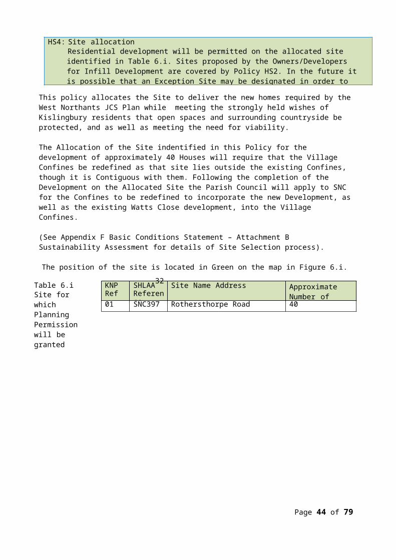
Appendix I SEA Screening Request and SNC Response
FAO Andy D’ArcySouth Northamptonshire District CouncilBy email: [email protected]
7 July 2015Dear Andy,Request for local planning authority screening opinion:Strategic Environmental Assessment of the Kislingbury Neighbourhood PlanHabitats Regulations Assessment of the Kislingbury Neighbourhood Plan
I write to you on behalf of Kislingbury Parish Council and following our recent discussions in relation the Kislingbury Neighbourhood Plan and with sight of the additional requirements in relation to Strategic Environmental Assessment (SEA) following the recent amendments to the Neighbourhood Planning (General) Regulations 2012. I also write to you seeking to gain an initial view on the likelihood that more detailed screening for potential assessment of the Plan in line with EU Directive 92/43/EEC will be required.
Strategic Environmental Assessment
With specific reference to SEA amended regulation 15 of the Neighbourhood Planning (General) Regulations now requires one of the following to be submitted alongside the ‘plan proposal’:
“(i) An environmental report prepared in accordance with paragraphs (2) and (3) of regulation 12 of the Environmental Assessment of Plans and Programmes Regulations 2004(a); or(ii) Where it has been determined under regulation 9(1) of those Regulations that the plan proposal is unlikely to have significant environmental effects (and, accordingly, does not require an environmental assessment), a statement of reasons for the determination.”
In which case, Kislingbury Parish Council is keen to work with South Northamptonshire Council (SNC) to ensure that the correct information is supplied to officers to allow consultation with the statutory bodies with a view to ensuring that this new requirement is satisfied in a robust fashion. At the very least a clear statement will be required at the point of submission that sets out the grounds against which the need for SEA has been determined.
We would therefore be grateful if SNC could secure a view from the three statutory bodies (Natural England, the Environment Agency and Historic England) on behalf of the Parish Council as to whether the current framework draft of the Plan is likely to give rise to any significant environmental effects when considered against Schedule 1 of the Environmental Assessment of Plans and Programmes Regulations 2004.
To aid the consideration of the statutory bodies it is worth clarifying scope of the Plan and the background against which it has been prepared:
The Plan area comprises the entirety of Kislingbury Parish, albeit it is anticipated that the majority of the policies of the Plan will predominantly cover the village area. A map of the extent of the Parish is included at Appendix 1 of this letter.
Page 44 of 63
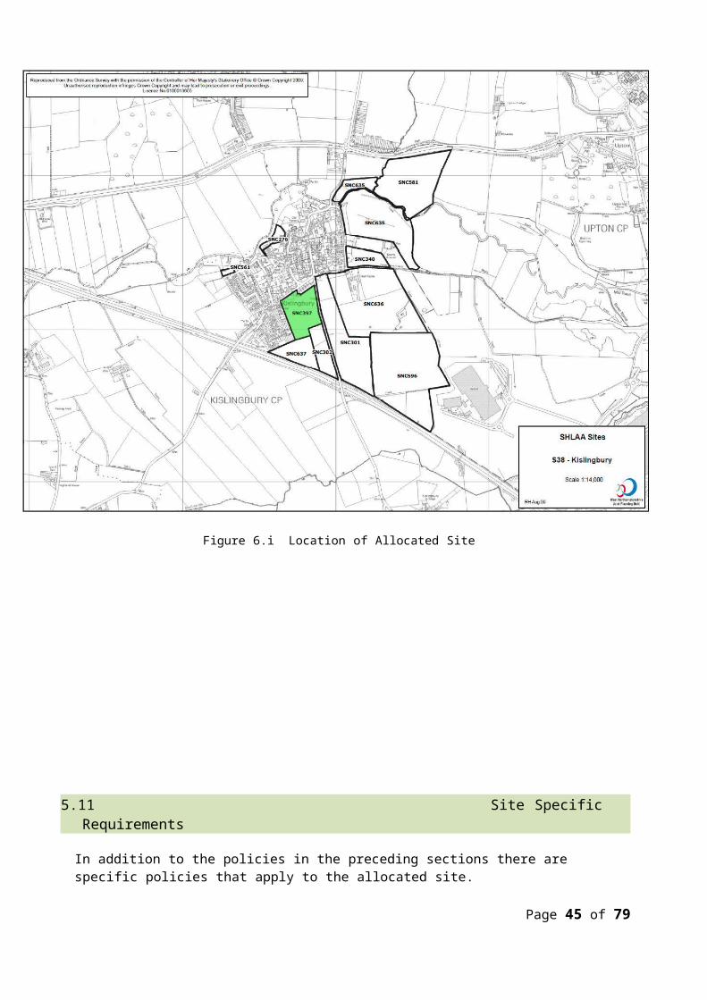
The Plan has been prepared following a rigorous assessment of all available evidence identifying the environmental constraints in the Parish. A map of the key known constraints is attached at Appendix 2 of this letter. An extensive assessment of the sustainability issues of the Parish was undertaken and catalogued in the background paper used to identify the sustainability framework against which the policies of the Plan will be tested. In addition, a full assessment of all of the potential development sites in the Parish has been conducted against set criteria to allow the promotion of sustainable locations for growth within the final document. The proposed Sustainability Framework that the Plan will be assessed against, regardless of need for SEA, can be found attached at Appendix 3 of this letter. It is based on the agreed Framework used to assess the environmental implications of the JCS. Copies of these documents in full are available on request, albeit they may still in draft form.
The Plan has been delivered against a clear set of community derived objectives (attached, below at Appendix 4 of this letter) which hold the preservation of the character of the village and the Parish, whilst accommodating much needed housing growth, at its heart.
The main environmental sensitivities in and around the village, and in the wider Parish, relate to a significant swathe of flood zone running along the northern boundary of the village as well as a collection of heritage assets including a conservation area, a number of Listed Buildings and evidence of archaeological activity on a number of areas of farmland. These sensitivities are all set out on the constraints map, attached below, and have been taken into account when developing the policies of the Plan, both in terms of identifying areas in need of protection and mitigation required when delivering development.
The Plan has taken into account all of the higher level policies of both the NPPF and the West Northamptonshire Joint Core Strategy (JCS) during the course of its preparation with the latter set of policies having already been subject of a recent full SEA that was tested during the course of the EiP during 2014. Principally, the Plan is seeking to deliver a single sustainable site for residential development in line with the requirements of Policy S1, Policy S3 and Policy R1 of the JCS. All other general policies of the JCS have also been considered. Copies of the full wording of the three specified policies can be found attached at Appendix 5 of this letter.
In response to the requirements of the JCS, the Plan is seeking to support the delivery of a minimum of 50 new homes in and around Kislingbury village. This figure is based on an analysis of local need, local demand and localised constraints in and around the village that have allowed an understanding of how much development Kislingbury should sustainably accommodate. It is the view of the Parish Council that this level of growth is reasonable for a village of Kislingbury’s size and sustainability, representing roughly a 10% increase in the built form of the village.
The current draft of the document proposes to deliver around 40 of these homes by way of a single large allocation to the south east of the village, to the rear of Watts Close (the eastern portion of SNC SHLAA site 397, referenced on the attached WNJPU SHLAA map included at Appendix 6 of this letter). This site has been selected following a rigorous assessment of all sites in the village made available to the Steering Group by local landowners. This assessment has taken into account existing constraints and designations alongside both the ability of the site to deliver against the housing needs of the village and the views of residents in terms of the most appropriate direction of growth. It is important to note that Natural England, Historic England and the Environment Agency were all contacted during the site assessment process and the received comments have been incorporated into the final site assessment proforma and sufficient mitigation will be built into the relevant policy of the Plan where required.
Page 45 of 63

Principally, consultation with the three statutory bodies identified that the current proposed development site comprises well drained soil free from flood risk or significant run off, does not comprise land that is host to any sensitive habitats and will not have any significant impact on any heritage assets if developed. It comprises regularly disturbed farmland with no visual merit or intrinsic importance when establishing the character of the village.
The current draft of the document also proposes a number of further general policies that seek to meet the objectives of the Plan either directly or in combination. The direction of the further policies of the Plan can be summarised as follows:
o The need for the visual impact of any new development on the surrounding countryside to be considered at design and application stage;
o The retention of community amenities and services in the village;o The requirement for all new properties to be served by available connectivity to the local
fibre optic broadband network;o The promotion of new shops and services in the village, provided they accord with all other
policies of the development plan;o A suite of policies dealing with safe traffic movement and the promotion of sustainable
modes of transport in and around the village and throughout the Parish;o A reiteration of support for the protection and enhancement of heritage assets within the
Parish;o The requirement for new housing in the village to deliver a range of tenure types and
house size where practical;o The requirement of conditions to ensure that a proportion of the affordable housing in the
village is secured for occupants with a local connection;o That all new development should be built with the quality of design in mind and should
represent a form of development that retains the character of the village and its surroundings.
Habitats Regulations
In addition to SEA there is also a requirement to ensure that neighbourhood plans do not have a likely significant effect on EU designated habitats under EU Habitats Directive 92/43/EEC. The following specific Natura 2000 designations were identified as requiring assessment for likely significant environmental effects during the preparation of the JCS:
Rutland Water SPA and Ramsar; and Upper Nene Valley Gravel Pits SPA and Ramsar.
Due to the strategic levels of growth proposed by the JCS, and bearing in mind its sub-regional significance, to ensure that any residual likely significant environmental effects posed by the JCS were accounted for and mitigated, the following designations were also considered:
Ensor’s Pool SAC; Oxford Meadows SAC; and Portholme SAC
As a result of the Appropriate Assessment prepared in support of the JCS we acknowledge that sufficient mitigation has been built into the strategic policies of the strategy to ensure that any likely significant
Page 46 of 63

environmental effects are managed appropriately and avoided wherever necessary. This includes the policies covering the spatial distribution of development and the rural area strategy.
The only designation listed above in reasonably close proximity to the Kislingbury Neighbourhood Plan area is the Upper Nene Valley Gravel Pits SPA and Ramsar site. Its location in relation to the Parish can be established on review of Appendix 7 of this letter, falling around 6 km to the east. No part of the SPA / Ramsar falls within the boundary of the Parish. Within the Appropriate Assessment accompanying the JCS the particular sensitivities relating to the SPA / Ramsar were as follows:
Loss of supporting habitat; Fragmentation of habitat; Water supply and water level management; Water quality; Disturbance; and Pet predation.
Due to the location of the designation outside the Parish and to the far east of the Northampton urban area it is not considered that loss or fragmentation of habitat, disturbance or pet predation will be issues that may arise as a result of the Kislingbury Plan. Whilst there may be residual issues around water level management and water quality it should be noted that the following factors will ensure that no likely significant effects will occur as a result of the Kislingbury Plan:
The levels of growth proposed are in proportion with the rural area strategy described in the JCS; Any likely effects will likely have to be considered in the context of the 18,870 homes that are to be
delivered over the Plan period in Northampton Borough and the further 9,600 homes that are to be delivered in the Northampton Related Development Area, all of which lie in closer proximity to the SPA / Ramsar than the neighbourhood plan area; and
The Appropriate Assessment accompanying the JCS identifies that sufficient mitigation has been built into the strategic suite of policies through the inclusion of policies dealing with water cycle and water conservation.
To this end, it is not considered that any further investigation into the potential for the Kislingbury Plan to give rise to likely significant effects would reasonably required and that the need for Appropriate Assessment can be ruled out at this stage. We would, however, be appreciative of an opinion from SNC and a formal view submitted to the Parish Council in writing.
Conclusion
The information included in this Screening Request Letter is designed to provide a full overview of the evidence that has been considered in the preparation of the draft plan to date, as well as its likely content. Whilst the information included is intended to be as exhaustive as possible in describing the intentions of the Plan, the Parish Council would be pleased to make any further relevant information available on request. We would, however, be grateful if you could approach this issue with the three statutory bodies in line with the requirements of the Environmental Assessment of Plans and Programmes Regulations 2004 to allow a comprehensive and conclusive view to be drawn on the need for further assessment prior to the first public consultation on the draft Plan. In the event that you consider there may be a further need for work in relation to the Habitats Directive, we would also be grateful if you could cover this point with Natural England for completeness.
I am sure we will remain in dialogue over this issue. Regardless, we look forward to hearing from you in
Page 47 of 63
due course.
Yours sincerelyTim WardNeighbourhood Development PlanOn behalf of the Kislingbury Parish CouncilLetter prepared with the help of Alex Munro, Director of Maroon Planning Ltd
Page 48 of 63
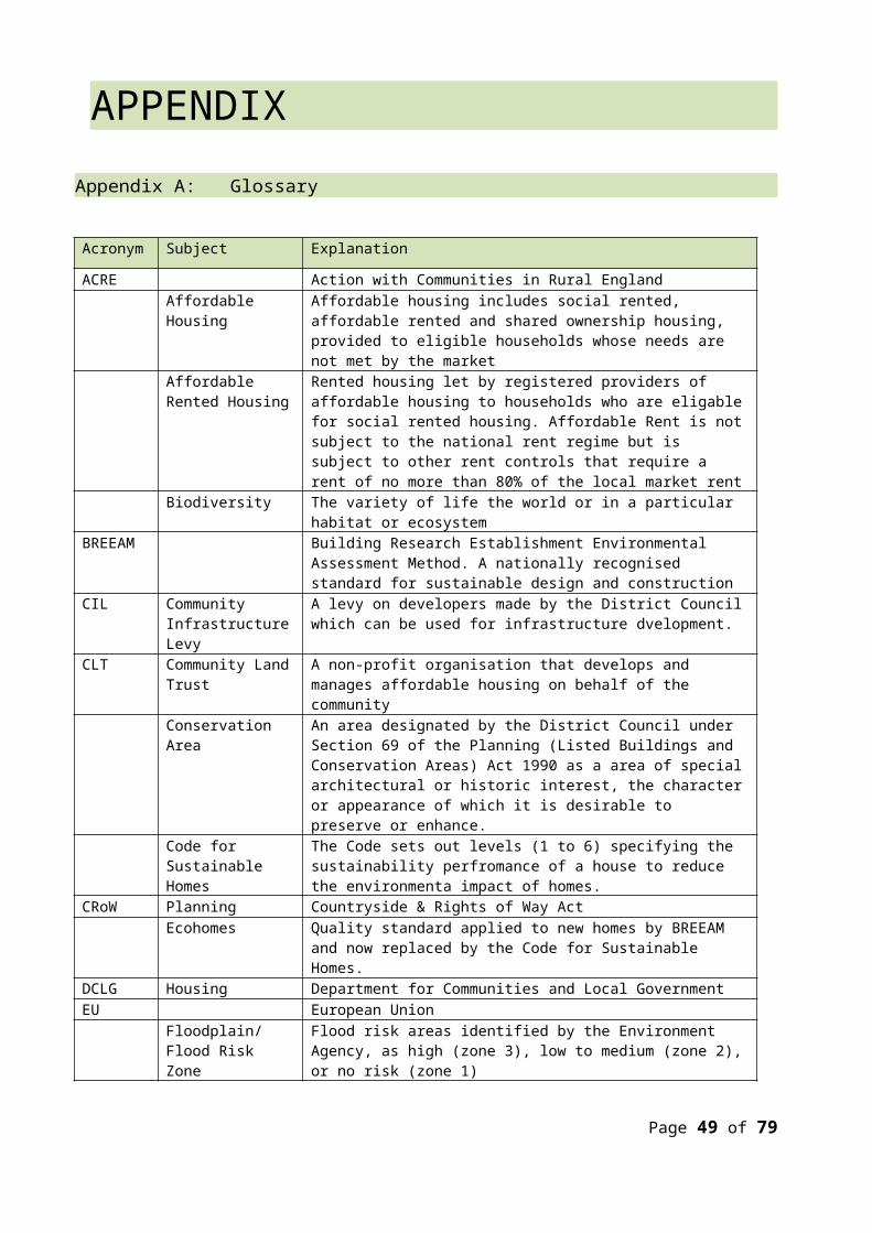
Appendix 1: Neighbourhood Plan Area
Page 49 of 63

Appendix 2: Map of local environmental constraints
Page 50 of 63
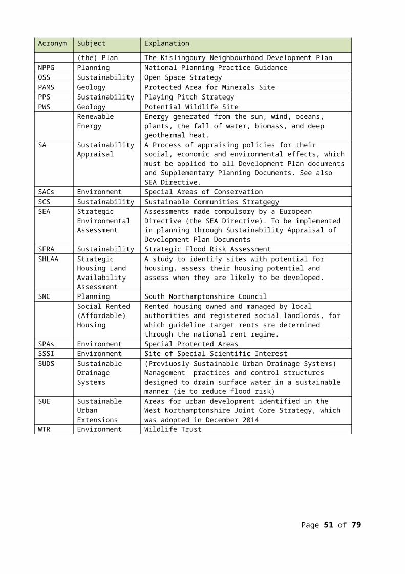
Appendix 3: Proposed sustainability frameworkSA Objective Kislingbury SA Indicators
Will the policy lead to…
SA1 Reduce the need to travel and facilitate modal shift
SA1.1 Development that encourages Residents to Cycle, Walk, and use Buses more than at present.
SA2 Reduce / minimise the potential increase in congestion
SA2.1 Development that does not exacerbate existing problems of Traffic Congestion and Parking, and potentially contributes to improving the situation.
SA3 Avoid sensitive development within areas of high noise levels or poor air quality
SA3.1 Development that will likely suffer an adverse impact by traffic noise from the M1 corridorSA3.2 Development that will not cause Fume, Noise and Light Pollution
SA4 Protect the fabric and setting of designated and undesignated heritage assets
SA4.1 Development that affects the character or setting of the Kislingbury Conservation AreaSA4.2 Development that reduces the Important Greenfield sites on the edge of the Village Confines, and reduces the Open Countryside in the ParishSA4.3 Development that damages historic assets.
SA5 Maintain and enhance the structure and function of habitats and populations of species, including those specifically protected.
SA5.1 Development that takes place on Sites where Biodiversity, Flora and Fauna are threatened or damaged
SA6 Enhance and protect greenspace networks and habitat connectivity, including river and stream corridors, to assist in species migration and dispersal.
SA6.1 Development that takes place on Sites where Biodiversity, Flora and Fauna are threatened or damaged
SA7 Increase the land area of UK Biodiversity Action Plan habitats within the area.
N/A
SA8 Maintain and improve the conservation status of selected non-designated nature conservation sites.
N/A
SA9 To improve community safety, reduce crime and the fear of crime
SA9.1 Development that makes the Village more vulnerable to Crimes of Breaking and Entering, Speeding, Vandalism, and Anti-Social behaviour
SA10 Improve educational attainment and promote lifelong learning
N/A
SA11 Promote sustainable modes of travel to N/APage 51 of 63
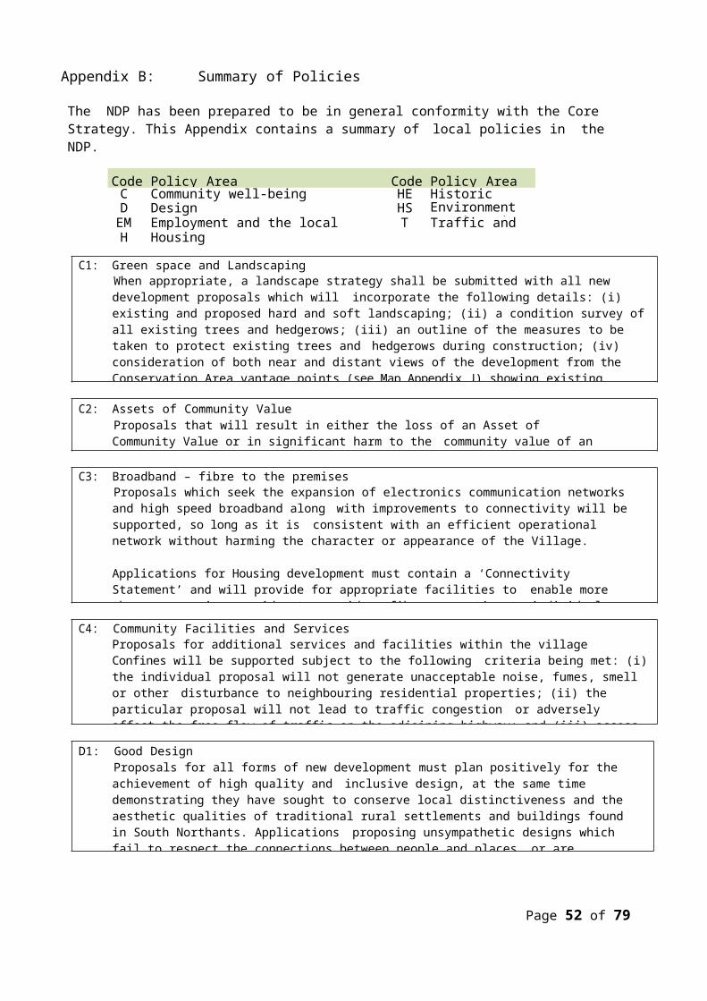
SA Objective Kislingbury SA IndicatorsWill the policy lead to…
access education
SA12 Continue to improve energy efficiency of dwellings
SA12.1 Development that incorporates Design Standards for Eco Efficiency in all dwellings
SA13 Continue to increase the provision of ‘affordable warmth’
N/A
SA14 To decrease the dependency on oil for space heating
N/A
SA15 To increase the local renewable energy generating capacity
N/A
SA16 To improve health and reduce health inequalities
SA16.1 Development that contributes to Health, Safety, and Well-being of ResidentsSA16.2 Development that does not expose new Residents to Health risks that are greater than those that already exist in the Village
SA17 To create high quality employment opportunities and develop a strong culture of enterprise and innovation
SA17.1 Development that delivers High Speed Broadband access to all Dwellings
SA18 Ensure that the quality, character and local distinctiveness of the landscape, and the features within them are conserved and enhance
SA18.1 Development that has the least impact on reducing the undeveloped gap between Kislingbury and NorthamptonSA18.2 Development that respects the Character of the Village, and the features within each Character ZoneSA18.3 Development that enhances the Village integrity by not creating isolated enclaves on the edge of the Confines.
SA19 Enhance the form and design of the built environment
SA19.1 Development that fits in with the identified Characteristics of the site and its surroundings.SA19.2 Development that enhances the Character of the Village
SA20 To ensure that the housing stock meets the housing needs of the local people
SA20.1 A mix of housing that meets the identified needs of the village and the parishSA20.2 A supply of housing that is deliverable over the plan period to ensure a consistent delivery against future needs
SA21 To develop and maintain a balanced and sustainable population structure with good access to services and facilities
SA21.1 The retention and enhancement of local services and amenities for which there is a proven local need
Page 52 of 63

SA Objective Kislingbury SA IndicatorsWill the policy lead to…
SA22 To reduce spatial inequalities in social opportunities
SA22.1 Provision of local facilities that are accessible by walking, cycling and public transport
SA23 Reduce land contamination, and safeguard soil and geological quality and quantity
N/A
SA24 To reduce waste generation and disposal, increase recycling and achieve the sustainable management of waste
N/A
SA25 Maintain and continue to improve the quality of ground and river water
SA25.1 Development likely to effect the ecological status of groundwater and surface water
SA26 Reduce risk of flooding SA26.1 Development that seeks to avoid areas of flood riskSA26.2 Development that incorporates sufficient SUDS drainage to ensure the flood risk is further minimised
SA27 Improve efficiency of water use SA27.1 Water efficient design, including promotion of rainwater recycling and reuse
SA28 Identify opportunities to implement strategic flood risk management options/measures to reflect the objective in the River Nene Catchment Flood Risk Management Plan
SA28.1 Development that incorporates advice set out in the FRMP where appropriate
Page 53 of 63

Appendix 4: Draft Plan objectives To provide existing and future residents with the opportunity to live in a decent home. To minimise the impact of new development on the surrounding countryside, landscape, and
ecosystems. To reduce harm to the environment by seeking to minimise pollution. To ensure that Village Community Spirit is enhanced To ensure road traffic congestion does not get worse To enhance the prospects for local business enterprise and employment. To maintain the character and vitality of the village.
Page 54 of 63
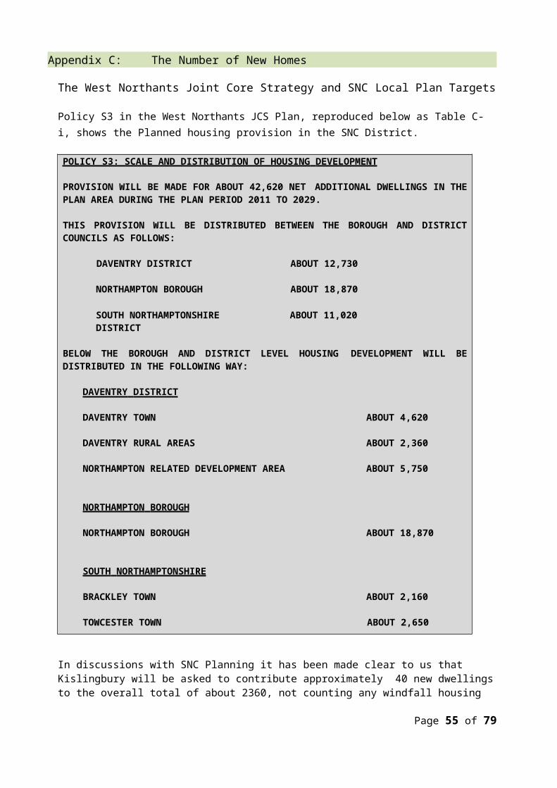
Appendix 5: Relevant policies of the JCS governing distribution and location of development
Page 55 of 63
Page 56 of 63

Page 57 of 63

Page 58 of 63

Page 59 of 63
Appendix 6: Kislingbury Parish SHLAA sites
Page 60 of 63

KislingburyGravel Pits
Appendix 7: Location of Kislingbury Parish in relation to Upper Nene Valley Gravel Pits
Page 61 of 63
Appendix J Vantage Point Views
Page 62 of 63

AcknowledgementsThe Parish Council and the Steering Group would like to record their thanks for the cooperation, assistance, encouragement and patience of:
The Plan is dedicated to Pauline Cook, who served the Village for many Years, and was the driving force behind its launch in 2011.
• The Residents of Kislingbury• Alison Ward, Chair PC• Kay Longland, PC, and Steering Group• Sarah Parker, PC• Sharon O’Connell, PC• Roger Minchin, PC and Steering Group• Miriam Harris, PC• Tom Payne, PC• Tim Ward, Steering Group• Bob Wallis, Steering Group• Alan Roberts, Steering Group• Paul Huband, Steering Group• Andy Clarke, Steering Group• Paul Southworth OBE• Andy D’Arcy, SNC Planning• Susan Jobbins, Shaping Communities Ltd• Alex Munro, Maroon Planning Ltd• Diane Ward• Mike Prince• Sue Deane• Bernard Gent• Mike Green• Dennis Tidmarsh
• Tony Tutchener• Keith Marsden, The Village and Plan Web Site• Head, Staff, Pupils, and Governors of Kislingbury
Primary School• The Sun Inn• The Olde Red Lion• The Village Shop • Alice Kirkahm, Persimmons• Jim Robinson, Davidsons Homes• Sean Cummings• Andrew Cowling• Stephen Hopewell• Roger Elliott• KOFS Committee• Village Hall Committee• KPFA Committee• The Village Churches• Valerie Skidmore, Bugbrooke Medical Practice• Christopher Heaton-Harris, MP• Joan Kirkbride, County Council Member• Ann Addison, District Member• Karen Cooper, District Member• All Statutory Consultees•
This List is not yet complete. If we have not included your name, please accept our apologies. The Final Plan list will be complete.
Page 63 of 63