Embed Size (px)
Citation preview

COLVILLE NATIONAL FOREST
TRAILS & RECREATION
Kettle Falls
Barnaby Buttes Trail #70
Kettle Crest Trail #13
Hoodoo Canyon Trail #17
Log Flume Interpretive Trail #77
Jungle Hill Trail #16
Old Stage Trail #75
Sherman Pass Tie Trail #96
Wapaloosie Trail #15
Stick Pin Trail #71
Pierre Lake Trail #91
Taylor Ridge Trail #74
Stick Pin Trail #71
U.S. Mountain Trail #76

Barnaby Buttes Trail #70
LENGTH 2.8 miles
ELEVATION Beginning:4500'at trailhead
Ending: 6050'
ACCESS From Kettle Falls follow U.S. Highway 395 to state Route 20. Travel state Route 20 for 15 miles and turn left on South Sherman Road 2020.
Follow road 2020 for 6.2 miles to the junction with road 2014-500. Take road 2014 for 1/2 mile to 2014-500. From this junction it is 2 miles to the
trailhead.
ATTRACTIONS AND CONSIDERATIONS This 2.8 mile trail through wildlife habitat includes vistas and stream crossings. A few dispersed
campsites are located along the trial that once served as the access to Barnaby Buttes lookout tower. A four-wheel drive vehicle is recommended for
travel on access road.
USE Light
DIFFICULTY Difficult
RECOMMENDED SEASON Summer, Fall, Winter
USGS MAP(S) Sherman Peak
Kettle Crest Trail #13 South
LENGTH 2.5 miles
ELEVATION Beginning:5575'at trailhead
Ending: 5250'
ACCESS From Kettle Falls travel U.S. Highway 395 to state Route 20. Follow state Route 20 for 25 miles to Sherman Pass. Turn right on the trailhead
access road.
ATTRACTIONS AND CONSIDERATIONS The trail climbs from Sherman Pass (5575') to Sherman Peak (6500') then follows the mountainside
and gradually descends to 6000'. The trail continues to the junction of Bald Mountain and Edds Mountain trail. The trail travels through the site of the
White Mountain Complex, the August 1988 fire ignited by lighting strikes.
USE Medium
DIFFICULTY Easy to Difficult
RECOMMENDED SEASON Summer, Fall, Winter
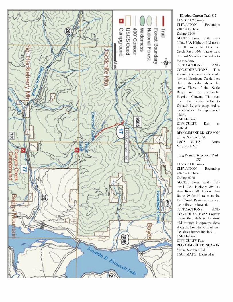
Hoodoo Canyon Trail #17
LENGTH 2.5 miles
ELEVATION Beginning:
2800' at trailhead
Ending: 3100'
ACCESS From Kettle Falls
follow U.S. Highway 395 north
for 10 miles to Deadman
Creek Raod 9565. Travel west
on road 9565 for ten miles to
the meadow.
ATTRACTIONS AND
CONSIDERATIONS This
2.5 mile trail crosses the south
fork of Deadman Creek then
climbs the ridge above the
creek. Views of the Kettle
Range and the spectacular
Hoodoo Canyon. The trail
from the canyon ledge to
Emerald Lake is steep and is
recommended for experienced
hikers.
USE Medium
DIFFICULTY Easy to
Difficult
RECOMMENDED SEASON
Spring, Summer, Fall
USGS MAP(S) Bangs
Mtn/Boyds Mtn
Log Flume Interpretive Trail
#77
LENGTH 0.5 miles
ELEVATION Beginning:
2060' at trailhead
Ending: 2060'
ACCESS From Kettle Falls
travel U.S. Highway 395 to
state Route 20. Follow state
Route 20 for 10 miles to the
East Portal Picnic area where
the trailhead is located.
ATTRACTIONS AND
CONSIDERATIONS Logging
during the 1920s is the story
told through interpretive signs
along the Log Flume Trail. Site
includes a barrier-free loop.
USE Medium
DIFFICULTY Easy
RECOMMENDED SEASON
Spring, Summer, Fall
USGS MAP(S) Bangs Mtn

Jungle Hill Trail #16
LENGTH 2.5 miles
ELEVATION Beginning: 4300' at trailhead
Ending: 5550' ACCESS From Kettle Falls follow U.S. Highway 395 to state Route 20. Follow state Route 20 for 22 miles to the Albian Hill Road 2030.
Travel north on road 2030 for 0.6 miles to trail sign and west 0.2 miles to trail.
ATTRACTIONS AND CONSIDERATIONS The Jungle Hill Trail is a steep climb that begins near a mountain stream, winds through forest canopy,
and ends with panoramic views to the east.
USE Medium
DIFFICULTY Most Difficult
RECOMMENDED SEASON Summer, Fall
Old Stage Trail #75
LENGTH 1.7 miles
ELEVATION Beginning: 5500' at trailhead
Ending: 6000'
ACCESS From Kettle Falls follow U.S.
Highway 395 to state Route 20. Follow state
Route 20 for 22 miles and turn north at the
Albian Hill Road 2030. Continue for 7.1 miles
to trailhead.
ATTRACTIONS AND
CONSIDERATIONS This 1.7 mile trail
which was once a stage coach road provides
access to the Kettle Crest Trail and Copper
Butte, the highest peak in Ferry County.
USE Light
DIFFICULTY Difficult
RECOMMENDED SEASON Summer, Fall
USGS MAP(S) Copper Butte
Sherman Pass Tie Trail #96
LENGTH 0.5 miles
ELEVATION Beginning: 5150' at trailhead
Ending: 5300'
ACCESS From Kettle Falls follow U.S.
Highway 395 to state Route 20. Follow state
Route 20 for 24 miles and turn at the Kettle
Range Campground. Trailhead is located at
the end of the campground loop.
ATTRACTIONS AND
CONSIDERATIONS Only foot traffic is
allowed on this .5 mile wooded trail that
crosses three small streams.
USE Medium
DIFFICULTY Easy
RECOMMENDED SEASON Summer, Fall
USGS MAP(S) Sherman Peak
Wapaloosie Trail #15
LENGTH 2.5 miles
ELEVATION Beginning: 5000' at trailhead
Ending: 6850'
ACCESS From Kettle Falls follow U.S.
Highway 395 to state Route 20. Follow state
Route 20 for 20 miles and turn right on Albian
Hill Road 2030. Follow road 2030 for 3.2
miles to trailhead sign and west 0.2 miles to
trail. ATTRACTIONS AND
CONSIDERATIONS This 2.5 mile trail
crosses the north fork of Sherman Creek and
continues at a moderate incline. Views to the
east of Graves Mountain and Mack Mountain.
Near the summit the trail crosses a meadow on
Wapaloosie Mountain and connects to the
Kettle Crest Trail.
USE Medium
DIFFICULTY Easy to Difficult
RECOMMENDED SEASON Summer, Fall

Pierre Lake Trail #91
LENGTH 0.82 miles
ELEVATION Beginning:
2020' at trailhead
Ending: 2020'
ACCESS From Kettle Falls
follow U.S. Highway 395 to
Barstow. Turn right at
Barstow and follow signs to
Pierre Lake.
ATTRACTIONS AND
CONSIDERATIONS This
short hiking trail follows the
shore of Pierre Lake.
USE Medium
DIFFICULTY Easy
RECOMMENDED
SEASON Spring, Summer,
Fall
USGS MAP(S) Laurier
Taylor Ridge Trail #74
LENGTH 9.5 miles
ELEVATION Beginning:
2350' at trailhead
Ending: 5900'
ACCESS From Kettle Falls
travel U.S. Highway 395
north for 22 miles to
Boulder-Deer Creek Road
6100. Turn west on road
6100 and follow for 2 miles
to South Boulder Road
6110. Turn left and follow
road 6110 for 2 miles to
trailhead.
ATTRACTIONS AND
CONSIDERATIONS This
9.5 mile trail climbs from
the valley to ridges where on
a clear day one can see
Alligator Ridge, Thompson
Ridge and several
mountains including
Copper, Midnight, Twin
Sisters, and Stick Pin. There
are two dispersed campsites
along the trail. Day hikers
can access the trail from
road 6113 or road 6110 to
hike a four-mile segment of
the trail.
USE Medium
DIFFICULTY Difficult
RECOMMENDED
SEASON Spring, Summer,
Fall
USGS MAP(S) Bulldog
Mtn Mt Leona
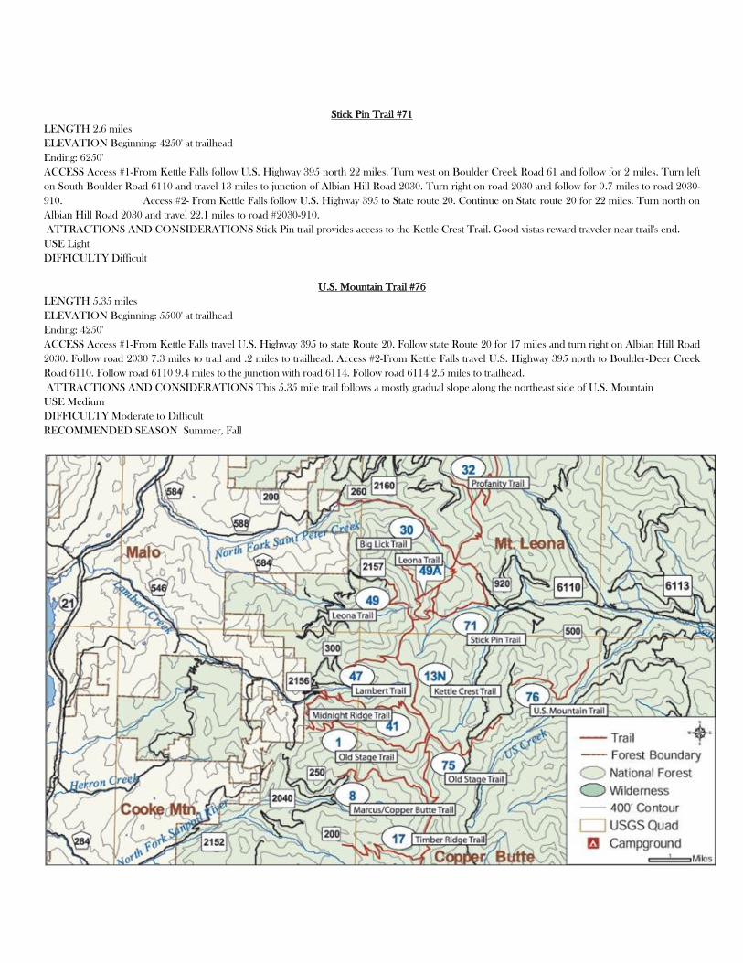
Stick Pin Trail #71
LENGTH 2.6 miles
ELEVATION Beginning: 4250' at trailhead
Ending: 6250'
ACCESS Access #1-From Kettle Falls follow U.S. Highway 395 north 22 miles. Turn west on Boulder Creek Road 61 and follow for 2 miles. Turn left
on South Boulder Road 6110 and travel 13 miles to junction of Albian Hill Road 2030. Turn right on road 2030 and follow for 0.7 miles to road 2030-
910. Access #2- From Kettle Falls follow U.S. Highway 395 to State route 20. Continue on State route 20 for 22 miles. Turn north on
Albian Hill Road 2030 and travel 22.1 miles to road #2030-910.
ATTRACTIONS AND CONSIDERATIONS Stick Pin trail provides access to the Kettle Crest Trail. Good vistas reward traveler near trail's end.
USE Light
DIFFICULTY Difficult
U.S. Mountain Trail #76
LENGTH 5.35 miles
ELEVATION Beginning: 5500' at trailhead
Ending: 4250'
ACCESS Access #1-From Kettle Falls travel U.S. Highway 395 to state Route 20. Follow state Route 20 for 17 miles and turn right on Albian Hill Road
2030. Follow road 2030 7.3 miles to trail and .2 miles to trailhead. Access #2-From Kettle Falls travel U.S. Highway 395 north to Boulder-Deer Creek
Road 6110. Follow road 6110 9.4 miles to the junction with road 6114. Follow road 6114 2.5 miles to trailhead.
ATTRACTIONS AND CONSIDERATIONS This 5.35 mile trail follows a mostly gradual slope along the northeast side of U.S. Mountain
USE Medium
DIFFICULTY Moderate to Difficult
RECOMMENDED SEASON Summer, Fall