Embed Size (px)
Citation preview
Kettering Strategic Flood Risk Assessment
Level 1
Main Report Northamptonshire County Council
August 2019
Revision Schedule
Kettering Borough Level 1 Strategic Flood Risk Assessment 2019
Revision Date Details Prepared by Reviewed by Approved by
01 21/06/2019 1st Draft for client
consultation Phil Jones Ruth Burnham Alison Parry
02 09/07/2019 2nd Draft for partner
consultation Phil Jones Ruth Burnham Alison Parry
03 16/08/2019 Final for publication Phil Jones Ruth Burnham Alison Parry
Northamptonshire County Council Flood and Water Management
One Angel Square 4 Angel Street Northampton
NN1 1ED
Contents Executive Summary ................................................................................................................................. 6
1 Introduction .................................................................................................................................... 8
Applying the Sequential Test for Plan Making Purposes ........................................................................ 9
Applying the Exception Test for Plan Making Purposes ....................................................................... 10
Flood Risk Objectives ............................................................................................................................ 10
The Strategic Flood Risk Assessment Structure .................................................................................... 11
Study Area ............................................................................................................................................. 12
2 Methodology ................................................................................................................................. 13
Overview ............................................................................................................................................... 13
Tasks ...................................................................................................................................................... 13
Stakeholders ......................................................................................................................................... 13
Data Collection and Review .................................................................................................................. 13
Data Gaps and Assumptions ................................................................................................................. 14
3 Relevant Flood Risk Management Plans, Strategies and Studies ................................................. 16
National Flood and Coastal Erosion Management Strategy for England.............................................. 16
Preliminary Flood Risk Assessments ..................................................................................................... 16
Flood Risk Management Plans and River Basin Management Plans .................................................... 17
Flood and Water Related Work ............................................................................................................ 20
4 Local Plans ..................................................................................................................................... 27
North Northamptonshire Joint Core Strategy (Local Plan Part 1) ........................................................ 27
Kettering Part 2 Local Plan .................................................................................................................... 29
North Northamptonshire Brownfield Land Assessment ....................................................................... 30
Neighbourhood Planning ...................................................................................................................... 30
5 Understanding Flood Risk in Kettering Borough ........................................................................... 32
Historic Flooding ................................................................................................................................... 32
Topography, Natural Landform and Geology ....................................................................................... 34
Surface Water Flood Risk ...................................................................................................................... 35
Drainage and Sewerage Flood Risk ....................................................................................................... 37
Fluvial Flood Risk ................................................................................................................................... 38
Groundwater Flood Risk ....................................................................................................................... 39
Reservoir Flood Risk .............................................................................................................................. 41
Residual Flood Risk................................................................................................................................ 41
6 Site-Specific Information ............................................................................................................... 43
Further Site-Specific Requirements ...................................................................................................... 44
7 Flood Risk Management in Kettering Borough ............................................................................. 54

Existing Flood Defences and Assets ...................................................................................................... 54
Flood Warning and Hydrometric Stations ............................................................................................ 54
Emergency Planning and New Development........................................................................................ 56
Flood Resilience .................................................................................................................................... 56
Flood Resistance ................................................................................................................................... 57
Reducing Flood Risk through Site Layout and Design ........................................................................... 57
Modification of Ground Levels ............................................................................................................. 57
Buffer Strips .......................................................................................................................................... 58
Houses in Multiple Occupation ............................................................................................................. 58
Developer Contributions ....................................................................................................................... 58
8 Cumulative Impact of Development ............................................................................................. 60
Understanding Cumulative Impact ....................................................................................................... 60
Cumulative Impact of Development in Kettering Borough .................................................................. 60
SWMP Critical Drainage Catchments .................................................................................................... 61
Recommendations for Cumulative Impact ........................................................................................... 62
9 Sustainable Drainage Systems ...................................................................................................... 64
Statutory Consultee Role ...................................................................................................................... 64
Sustainable Drainage Systems .............................................................................................................. 64
General SuDS Advice for Developers in Northamptonshire ................................................................. 64
Local Standards and Guidance for Surface Water Drainage in Northamptonshire .............................. 64
Adoption of Drainage Systems and Water Company Guidance ........................................................... 64
Flood Data and Information Requests .................................................................................................. 65
Technical Flood Advice Services............................................................................................................ 65
10 Responsibility for Risk Management Authorities ......................................................................... 66
Overview ............................................................................................................................................... 66
The Environment Agency ...................................................................................................................... 66
Lead Local Flood Authority ................................................................................................................... 68
Water and Sewerage Companies .......................................................................................................... 71
Borough and District Councils ............................................................................................................... 71
Highway Authority ................................................................................................................................ 73
Highway England ................................................................................................................................... 73
Riparian Owners .................................................................................................................................... 73
Parish Councils ...................................................................................................................................... 73
Other Bodies ......................................................................................................................................... 74
11 Conclusions and Recommendations ............................................................................................. 75
Conclusions ........................................................................................................................................... 75
Recommendations ................................................................................................................................ 76
Appendix 1: Glossary of Terms ............................................................................................................. 79
Appendix 2: Abbreviations .................................................................................................................... 86
Appendix 3: Guidance on the Preparation of Flood Risk Assessments ................................................ 87
Standing Advice ..................................................................................................................................... 87
Information to Support a Flood Risk Assessment ................................................................................. 87
Requirements for Flood Risk Assessments ........................................................................................... 88
Finished Floor Levels ............................................................................................................................. 89
Modifying Ground Levels ...................................................................................................................... 89
Appendix 4: Guidance on Climate Change Allowances ........................................................................ 91
Climate Change Allowances .................................................................................................................. 91
Climate Change Allowances Update ..................................................................................................... 91
Climate Change Allowances for Rainfall ............................................................................................... 91
Climate Change Allowances for Fluvial Flooding .................................................................................. 91
Appendix 5: Developer Checklist .......................................................................................................... 92

Kettering Borough Council Level 1 SFRA Update (August 2019) 6
Executive Summary
A Stage 1 and Stage 2 Strategic Flood Risk Assessment (SFRA) were produced in 2005 by the
Environment Agency (EA) covering Kettering and Wellingborough to ensure compliance with PPG25:
Development and Flood Risk. A Level 1 and Level 2 SFRA update were produced in 2011 and 2010
respectively by Royal Haskoning, on behalf of Kettering Borough Council (KBC) and Borough Council
of Wellingborough (BCW), to ensure compliance with PPS25: Development and Flood Risk, and in
light of proposed development in Kettering Town Centre.
PPS25 has since been replaced by the National Planning Policy Framework (NPPF) and associated
Planning Practice Guidance. There have also been a number of legislative and procedural changes,
alongside updates to a number of flood and water data sets, modelling and mapping layers. These
changes need to be reflected within the SFRA, to ensure that a sound flood and water management
evidence base is available to support the plan-making process for development. In light of these
changes, in May 2019 KBC commissioned Northamptonshire County Council (NCC) to prepare an
updated Level 1 SFRA to satisfy the requirements of the NPPF.
The NPPF states that an SFRA is required to assess the risk to an area from flooding from all sources,
now and in the future, taking account of the impacts of climate change, and to assess the impact
that land use changes and development in the area will have on flood risk.
The NPPF requires Local Planning Authorities (LPAs) to review the variation in flood risk across their
area, and to steer all development towards areas with the lowest probability of flooding from any
source (now and in the future). Where there are no reasonably available sites and this cannot be
achieved, the NPPF requires the LPA to demonstrate that there are sustainable mitigation solutions
available that will ensure that the flood risk can be managed now and over the lifetime of the
development should flooding occur.
Kettering Borough has undergone significant expansion historically and in recent years, with more
growth still planned. This Level 1 SFRA update has considered all sources of flood risk based on
information obtained through consultation with all Risk Management Authorities (RMAs) as
specified within the NPPF. The assessment is compliant with the NPPF and will continue to inform all
future land allocation and flood risk management needs within the Borough of Kettering.
A significant number of studies and strategies have previously reviewed the level of flood risk in the
Borough, including the North Northamptonshire Flood Risk Management Study 2007, North
Northamptonshire Flood Risk Management Study Update 2012, North Northamptonshire Detailed
Water Cycle Strategy 2009, Kettering Green Infrastructure Delivery Plan 2018, Kettering Surface
Water Management Plan 2019, KBC Stage 1 SFRA 2005, KBC Stage 2 SFRA 2005, KBC Level 1 SFRA
2011, KBC Level 2 SFRA 2010. This Level 1 SFRA updates this information and incorporates relevant
data, recommendations and policies from these studies and strategies as appropriate, but no new
modelling has been undertaken as part of this report.
The Borough covers an area of 23,350 hectares with an approximate population of 100,252 (ONS
mid-2018 population projections). The Borough is expected to accommodate significant growth in
the period to 2031, most of which will be focused in the town of Kettering. Smaller scale
development will also take place at Burton Latimer, Desborough and Rothwell.
Housing and employment development will be accompanied by extensive development in Kettering
Town Centre and by other infrastructure to support the growth. A significant proportion of the
growth in Kettering Borough will take place through the East Kettering Sustainable Urban Extension,

Kettering Borough Council Level 1 SFRA Update (August 2019) 7
which is planned to deliver 5,500 dwellings and associated development. In addition to this the
Kettering Town Centre Area Action Plan makes provision for significant levels of retail, employment
and residential development.
The Borough falls within both the River Nene catchment and the River Welland catchment. The main
watercourses in the Borough are the River Ise (a tributary of the River Nene) and its tributary the
Slade Brook. Two other tributaries of the River Nene, Harpers Brook and Alledge Brook, both rise in
the Borough.
There has been a history of flooding in the Borough, with a total of 415 flooding incidents recorded
since 1973 to the present day. These are from all sources of flood risk. Historically the primary
source of flood incidents in Kettering has been fluvial, from the River Ise and Slade Brook, however
more recently surface water, agricultural run-off and sewer flooding have been the main causes. The
Borough has also been affected by several incidents of groundwater flooding.
Surface water flooding has been identified as a more recent concern and a key consideration for all
new development. Major new developments have to address surface water drainage requirements
set out in the National Standards and local guidance produced by NCC. This guidance ensures that
careful design of the site layout and drainage system gives due consideration to the implementation
of SuDS solutions and their ongoing maintenance where appropriate.
Groundwater flooding is also a key consideration to future growth and detailed guidance has been
produced by NCC as the Lead Local Flood Authority (LLFA) and should be considered at all stages of
the planning process.
There are a number of flood storage reservoirs located within the Borough, which may pose a
residual flood risk to local communities if they were to breach. Also, the over-topping of flood
defences could affect properties within the potential flow path or located behind defences. This risk
should be incorporated within any assessment at all stages of the planning application process.
There is significant potential for cumulative impact of development on flood risk in Kettering
Borough, particularly from unconstrained surface water drainage from minor developments.
Considering the sites that been identified for potential future development, the effects of
cumulative impact are most likely to be seen in Kettering town centre, Burton Latimer, Broughton,
Rothwell, Geddington and Desborough. Recommendations have been made for KBC to consider
applying stricter requirements on surface water drainage proposals for sites located in areas
draining into the Critical Drainage Catchments (CDCs) identified in the Kettering Surface Water
Management Plan (SWMP).
Existing planning policy within the North Northamptonshire Joint Core Strategy is considered to be
robust and fully up-to-date. Therefore no additional strategic policies are recommended as part of
the development of the Part 2 Local Plan. Site-specific policies have however been recommended.
The site-specific assessment (Sequential Test) has identified one third of the sites as having an
‘Amber’ rating, as they are either at risk of surface water or groundwater flooding, have experienced
flooding on the site or in close proximity of the site in the past, or have capacity issues within the
existing drainage systems. These sites will require site-specific policies to be incorporated as part of
the allocation process. Approximately half of the sites have been rated as ‘Green’ (low risk) and half
as ‘amber’ (moderate risk which can be mitigated through application of suitable site-specific
recommendations). Two sites have been rates as ‘red’ due to the high level of flood risk to the sites
from various sources, and therefore will require further assessment prior to allocation.
Kettering Borough Council Level 1 SFRA Update (August 2019) 8
1 Introduction
1.1 The North Northamptonshire Joint Core Strategy was adopted on 14 July 2016 and is the
strategic part of the Local Plans for Corby, East Northamptonshire, Kettering and
Wellingborough Councils. It was prepared by the North Northamptonshire Joint Committee,
a plan making authority made up of elected representatives from the District, Borough and
County Councils, and provides the basis for more detailed plans prepared by the District and
Borough Councils and by Neighbourhood Planning Groups.
1.2 A Stage 1 and Stage 2 Strategic Flood Risk Assessment (SFRA) were produced in 2005 by the
Environment Agency (EA) covering Kettering and Wellingborough to ensure compliance with
PPG25: Development and Flood Risk. A Level 1 and Level 2 SFRA update were produced in
2011 and 2010 respectively by Royal Haskoning, on behalf of Kettering Borough Council
(KBC) and Borough Council of Wellingborough (BCW), to ensure compliance with PPS25:
Development and Flood Risk, and in light of proposed development in Kettering Town
Centre.
1.3 This Level 1 SFRA updates this existing information and incorporates relevant data,
recommendations and policies from these studies and strategies as appropriate. This Level 1
SFRA covers Kettering Borough only; an updated Level 1 SFRA for Wellingborough was
produced by NCC in February 2017.
1.4 PPS25 has since been replaced by the National Planning Policy Framework (NPPF) and
associated Planning Practice Guidance (PPG). There have also been a number of legislative
and procedural changes, alongside updates to a number of flood and water data sets,
modelling and mapping layers. These changes need to be reflected within the SFRA, to
ensure that a sound flood and water management evidence base is available to support the
plan-making process for development. In light of these changes, in May 2019 KBC
commissioned Northamptonshire County Council (NCC) to prepare an updated Level 1 SFRA
to satisfy the requirements of the NPPF.
1.5 One of the aims of the NPPF is to ensure that flood risk is taken into consideration at all
stages in the plan-making process to avoid inappropriate development in areas at risk of
flooding, and to direct development away from areas at highest flood risk (whether existing
or future). Where new development is necessary in such areas, it aims to test this concept
and make it safe without increasing flood risk elsewhere and, where possible, reduce flood
risk overall. The NPPF also introduces the need to consider cumulative impacts of
development in, or affecting, local areas susceptible to flooding.
1.6 The NPPF requires Local Planning Authorities (LPAs) to apply a risk-based sequential
approach as part of the identification of land for development in areas at risk of flooding.
The purpose of the sequential approach is to ensure that areas of low flood risk are
developed in preference to areas of higher flood risk (now or in the future); and within this,
ensuring that the developments that are most vulnerable to flood risk are located in the
lowest flood risk areas. The application of the Sequential Test needs to be underpinned by
an appropriate assessment of flood risk. The sequential approach process uses this
information to avoid the highest flood risk areas (now or in the future) and where this is not
possible, take opportunities to steer more vulnerable development to lower flood risk areas,
or mitigate the risk of flooding.

Kettering Borough Council Level 1 SFRA Update (August 2019) 9
Applying the Sequential Test for Plan Making Purposes
1.7 The Sequential Test ensures that a sequential approach is followed to steer new
development to areas with the lowest risk of flooding and away from areas at highest risk of
flooding, now or in the future. The detailed mapping, found within the accompanying Site
Specific and Strategic Map Documents, provides the basis for applying the Test. The aim is to
steer new development to Flood Zone 1 (areas with the lowest risk of flooding from rivers or
sea). Where there are no reasonably available or sufficient sites located within Flood Zone 1,
LPAs in their decision-making process should take into account the flood risk vulnerability of
land uses and consider reasonably available sites located within Flood Zone 2 (areas with a
medium risk of flooding from rivers or sea), applying the Exception Test, if required. Only
where there are no reasonably available sites located within Flood Zone 1 or Flood Zone 2
should the suitability of sites located within Flood Zone 3 (areas with a high risk of flooding
from rivers or sea) be considered, taking into account the flood risk vulnerability of land uses
and applying the Exception Test, if required (see Image 1).
1.8 Robust application of the Sequential Test in the plan-making process will help to ensure that
development can be safely and sustainably delivered and developers do not waste time and
resources promoting proposals which are inappropriate on flood risk grounds.
1.9 All sources of flooding should be treated consistently with river flooding in terms of mapping
probability and assessing vulnerability to ensure that the Sequential Test and approach are
properly applied across all flood zones.
Image 1: Extract from the Planning Practice Guidance
Kettering Borough Council Level 1 SFRA Update (August 2019) 10
Applying the Exception Test for Plan Making Purposes
1.10 The Exception Test is a method to demonstrate and ensure that flood risk to people and
property will be managed satisfactorily, while allowing necessary development to go ahead
in situations where suitable sites at lower risk of flooding are not available.
1.11 Essentially, the two parts to the Test (see Image 1) require proposed development to show
that it will provide wider sustainability benefits to the community that outweigh flood risk,
and that it will be safe for its lifetime, without increasing flood risk elsewhere and where
possible seek to reduce flood risk overall.
1.12 This process is summarised in Image 2. The Exception Test should only be applied as set out
in National Planning Practice Guidance Flood Risk and Coastal Change (6th March 2014).
Image 2: Extract from the Planning Practice Guidance
Flood Risk Objectives
1.13 The general aim of the NPPF is to ensure that flood risk is taken into account at all stages in
the planning process to avoid inappropriate development in areas at risk of flooding and to
direct development away from areas at highest flood risk.
1.14 The NPPF states that Local Plans should take account of climate change over the longer
term. Furthermore, when new development is brought forward in areas which are
vulnerable, “care should be taken to ensure that risks can be managed through suitable
adaptation measures, including through the planning of green infrastructure”.
1.15 The SFRA is a strategic assessment of flood risk which all LPAs are required to carry out in
preparation of their Local Development Documents (LDDs). It aims to enable sound and
reliable sustainability appraisals, land allocations and development control policies, to be
informed by an understanding of the catchment-wide flooding issues affecting the area and
the implications of climate change.

Kettering Borough Council Level 1 SFRA Update (August 2019) 11
1.16 This updated SFRA will form a key part of the evidence base to help inform the Local Plan
Part 2 preparation. A Level 1 SFRA is principally a desk-based study required to provide the
LPAs with flood risk information to apply the Sequential Test. Where it is clear that a
proposed development and infrastructure cannot be accommodated in accordance with the
Sequential Test, taking account of the flood vulnerability of the intended use, then a more
detailed Level 2 SFRA is required to facilitate the application of the Exception Test.
1.17 At the planning application stage, an appropriate site-specific flood risk assessment (FRA)
will be required for all major development proposals, sites of 1 hectare or greater located
within Flood Zone 1; land identified in a SFRA as being at increased flood risk in future; or
land that may be subject to other sources of flooding, where it’s development would
introduce a more vulnerable use. All proposals for new development located in Flood Zone 2
and Flood Zone 3 are required to have a site-specific FRA. This is required to demonstrate
how flood risk from all sources of flooding within the development itself, and flood risk to
others, will be managed taking climate change into account. Developers, and those
promoting sites, should ensure that all site-specific FRAs use the information included within
this assessment to inform their production.
1.18 The aims of the updated Level 1 SFRA are to:
Provide a sound evidence base for site allocation purposes;
Improve the understanding of flood risk within Kettering Borough;
Provide information that reflects the changes to planning policy and guidance;
Incorporate updated flood and water mapping;
Include a climate change position statement;
Provide an assessment of the flood risk (fluvial, pluvial, reservoir and groundwater) to
inform the suitability of proposed development sites;
Provide updated information on existing flood defences within the area;
Provide sufficient information to enable the Sequential Test and approach (as defined in
the NPPF) to be undertaken where required; and
Include recommended policies and practices to ensure that development at risk of
flooding can incorporate appropriate mitigation measures.
The Strategic Flood Risk Assessment Structure
1.19 The NPPF and associated guidance recommends that SFRAs are completed in two
consecutive stages, which follow an iterative approach to provide LPAs with sufficient
information to inform and update decisions regarding development sites. The two stages
are:
Level 1 SFRA - the objective of this document is to collate and review available
information on flood risk for the study area. This enables a review of the preliminary
site allocations, through the Sequential Test process, to determine if a Level 2 SFRA is
required along with the scope.
Level 2 SFRA - the principal objective of this document is to facilitate the application of
the Exception Test. The Level 2 SFRA uses information from the Level 1 SFRA and
potential additional work for sites allocated in areas at risk of flooding, which have been

Kettering Borough Council Level 1 SFRA Update (August 2019) 12
identified following Level 1 Sequential Testing. Modelling of key watercourses may be
required to define the functional floodplain as well as the extent of the floodplain,
taking into account climate change, where there is no data. Clear guidance will be given
on appropriate policies for the application of the Exception Test and the preparation of
site-specific FRAs will be provided.
Study Area
1.20 The study area is defined as the Borough of Kettering, as shown on Map 1: Study Area and
Watercourse Network, in the accompanying Strategic Map Document. The Borough of
Kettering falls within North Northamptonshire along with Corby, Wellingborough and East
Northamptonshire. The Borough comprises the main town of Kettering and three smaller
market towns (Burton Latimer, Desborough and Rothwell), with the rest of the borough
being mostly rural with 27 villages of varying scale and character.
1.21 The Borough covers an area of 23,350 hectares with an approximate population of 100,252
(ONS mid-2018 population projections). The Borough is expected to accommodate
significant growth in the period to 2031, most of which will be focused in the town of
Kettering. Smaller scale development will also take place at Burton Latimer, Desborough and
Rothwell. Housing and employment development will be accompanied by extensive
development in Kettering Town Centre and by other infrastructure to support the growth. A
significant proportion of the growth in Kettering Borough will take place through the East
Kettering Sustainable Urban Extension, which is planned to deliver 5,500 dwellings and
associated development. In addition to this the Kettering Town Centre Area Action Plan
makes provision for significant levels of retail, employment and residential development.

Kettering Borough Council Level 1 SFRA Update (August 2019) 13
2 Methodology
Overview
2.1 As outlined in Section 1.18 the aim of the Level 1 SFRA is to collect, collate and review the
information available relating to flooding in the study area. It also aims to review existing
documents and guidance, making recommendations to ensure that the document follows
current best practice and guidance.
Tasks
2.2 The following sets out the sequence of tasks undertaken in the preparation of the updated
Level 1 SFRA:
KBC organised an inception meeting with NCC on 21st May 2019;
Identified the local stakeholders;
Contacted the EA requesting data / information;
Collated and reviewed the data;
Undertook the Sequential Test for all proposed sites;
Consulted the key local stakeholders on the SFRA; and
Presented the available and relevant information on all flood sources.
2.3 All of the tasks set out above were completed between May 2019 and August 2019.
Stakeholders
2.4 The stakeholders relevant to Kettering Borough are as follows:
KBC;
NCC as LLFA;
NNJPDU;
EA; and
AWS.
2.5 Where relevant, all flood and water management related information and data received
from the stakeholders has been reviewed and incorporated into this document.
Data Collection and Review
2.6 In order to inform the production of this SFRA, all data related to flood risk and proposed
development has been reviewed.
2.7 Data has been obtained from KBC, the EA, AWS, the Highways Authority and existing data
held by the LLFA. This data includes:
Growth aspirations for the area;
Existing flood risk management plans, strategies and studies;
Local development plans;
Flood warning and alert areas;
EA Flood Maps – fluvial and surface water;
NCC Groundwater mapping;
Flood related asset information from all stakeholders;
Historical flooding information including the sewer flooding register from AWS;
Details relating to reservoirs within and adjacent to the study area;

Kettering Borough Council Level 1 SFRA Update (August 2019) 14
Terrain/topography maps; and
Geological maps.
2.8 Using the data collected from a variety of partners, a series of Geographic Information
System (GIS) layers were collated to assist the findings of this report and any site allocation
decisions. Using GIS, the data was analysed and interrogated to produce flood related
statistics. Broadly, the layers can be classified into three main categories; planning policy,
informative, and flood risk, as detailed in Table 1.
Topic Data Source
Planning
Policy
LPA boundaries NCC
Potential development sites KBC
Informative Historic OS Maps NCC
Geology mapping BGS
Background mapping OS
Detailed River Network OS
Terrain 5 topography OS
Flood Risk Flood Map for Planning
Risk of Flooding from Rivers and Sea
Risk of Flooding from Surface Water
Flood mapping for functional floodplain delineation
Flood mapping for climate change assessment
Outline reservoir flood maps
Spatial flood defences
Major reservoirs and water bodies
Main River
Flood Alert and Warning Areas
EA
Sewer Flooding Register AWS
Historic flood hotspot data
Asset Register (includes data from all partners)
Risk of Flooding from Groundwater (Northamptonshire)
NCC
Table 1: List of GIS layers used
Data Gaps and Assumptions
2.9 Table 2 below sets out the details of the detailed hydraulic models for which the EA have
been able to provide fluvial flood mapping outputs for the Borough.
Watercourse Model type and version Extent within Kettering Borough
Alledge Brook Alledge Brook Model, 1D
ISIS model, August 2013
Full extent of main river designation of Alledge Brook
within Borough (through Grafton Underwood,
downstream to Borough boundary)
Harpers Brook Harpers Brook Model, 1D
ISIS model, August 2013
Full extent of main river designation of Harpers Brook
within Borough (just upstream of A6003 crossing,
downstream to Borough boundary)
River Jordan River Jordan Model, 1D
Mike11 model, July 2016
Full extent of main river designation of River Jordan
within Borough (through Braybrooke, downstream to
Borough boundary)
Kettering Borough Council Level 1 SFRA Update (August 2019) 15
Watercourse Model type and version Extent within Kettering Borough
River Ise and
tributaries
River Ise Model, 1D ISIS
model, August 2013
Full extent of main river designation of River Ise
through Borough (from Borough boundary upstream
of Thorpe Underwood, to Borough boundary
downstream of Burton Latimer); full extent of main
river designation of Slade Brook (from just
downstream of Orton, to confluence with River Ise in
Kettering town)
River Welland River Welland Model, 1D
Mike11 model (upper
reach) and 2D Mike21
model (lower fenland
reach), September 2016
Full extent of main river designation of River Welland
along Borough’s northern boundary (from Borough
boundary at A6 crossing, to Borough boundary
downstream of Ashley)
Table 2: Model details
2.10 One of the requirements of the NPPF is that the functional floodplain, Flood Zone 3b, should
be identified and mapped as part of an SFRA to highlight those areas where only water-
compatible development and land use is recommended. Planning practice guidance states
that the extent of the functional floodplain should be agreed in discussion with the LPA and
EA to account for local circumstances, and that the extent of the 5% AEP floodplain is
considered an appropriate initial definition. Therefore, it is locally agreed that for those
watercourses in the Borough that have been subject to detailed modelling and mapping (see
Table 2 above), the 5% AEP flood extent can be used (except for the Harpers Brook
catchment where data is only available for the 4% AEP flood extent). Elsewhere, for
watercourses without appropriate detailed hydraulic modelling, the best available
information to define the functional floodplain is the full extent of Flood Zone 3 i.e. 1% AEP
flood event. Map 8: Functional Floodplain, in the accompanying Strategic Map Document
shows the locally agreed definition of the functional floodplain across Kettering Borough.
2.11 The NPPF also requires that SFRAs consider the impacts of climate change on flood risk in
the study area, and specifically to support application of the sequential approach for new
development. For the modelled watercourses set out in Table 2 above, only the 20% climate
change allowance on river flows has been modelled, and therefore maps of floodplain extent
accounting for updated climate change scenarios are not available. No climate change
information is available for other unmodelled watercourses in the Borough.
2.12 As intimated from the above sections, the main gap in the available data relates to
information on flood risk from smaller watercourses. Smaller non-main river watercourses
are unlikely to have had strategic flood modelling undertaken in order to accurately assess
the risk of flooding they pose. As set out above, this includes information on climate change
impacts and delineation of their functional floodplain.
Kettering Borough Council Level 1 SFRA Update (August 2019) 16
3 Relevant Flood Risk Management Plans, Strategies and Studies
3.1 The plans, studies and strategies that have been reviewed to inform the update of this
assessment are set out below. The key points, policies and recommendations with specific
reference to flood and water management have been extracted and should be used to
inform the development of future planning policy and site-specific FRAs.
National Flood and Coastal Erosion Management Strategy for England
3.2 The National Flood and Coastal Erosion Management Strategy for England was published in
September 2011 and provides guidance on “Understanding the risks, empowering
communities and building resilience.”
3.3 The document builds upon existing approaches to flood and coastal erosion risk
management and promotes the use of a wide range of measures to manage risk. The
strategy promotes a framework to enable communities to have a greater role in local flood
risk management decisions. The strategy encourages more effective flood risk management
by enabling people, communities, business, infrastructure operators and the public sector to
work together to:
Ensure a clear understanding of the risks of flooding and coastal erosion, nationally and
locally, so that investment in risk management can be prioritised more effectively;
Set out clear and consistent plans for risk management so that communities and
businesses can make informed decisions about the management of the remaining risk;
Manage flood and coastal erosion risks in an appropriate way, taking account of the
needs of communities and the natural environment;
Ensure that emergency plans and responses to flood incidents are effective and that
communities are able to respond effectively to flood forecasts, warnings and advice;
and
Help communities to recover more quickly and effectively after incidents.
3.4 This document is relevant because it promotes the concept of “the better understanding of
flood risk through detailed assessment”. Therefore this SFRA contributes towards providing
this improved awareness and understanding.
3.5 At the time of writing this SFRA, the update to the National Flood and Coastal Erosion Risk
Management Strategy for England is currently in draft format and open for public
consultation. The aim is that this new strategy will be published in 2020. Future updates to
the SFRA should incorporate any relevant information from this new strategy.
Preliminary Flood Risk Assessments
3.6 A Preliminary Flood Risk Assessment (PFRA) is a requirement under the Flood Risk
Regulations (2009), which implement the European Floods Directive (2007) into UK law. The
PFRA is an assessment of flooding that has taken place in the past and flooding that could
take place in the future.

Kettering Borough Council Level 1 SFRA Update (August 2019) 17
3.7 It considers flooding from surface water runoff, groundwater and ordinary watercourses,
and is updated on a six year basis.
3.8 PFRAs are used to identify areas that are at risk of significant flooding and the first were
prepared by LLFAs in 2011. These areas are called Flood Risk Areas (FRAs). LLFAs are
responsible for preparing preliminary assessment reports and reviewing indicative Flood Risk
Areas (iFRAs) identified nationally through an assessment of surface water flood risk, or
determining new FRAs based on local knowledge and understanding.
3.9 For the 2011 to 2017 planning cycle, NCC were required to identify FRAs for local sources
using guidance produced by Defra. The areas represent ‘clusters’ where flood risk is an issue
and where 30,000 people or more live. The Northamptonshire PFRA and associated FRA Map
illustrated that there were none in Northamptonshire.
3.10 LLFAs are responsible for mapping local flood hazard and flood risk for each FRA and the EA
is responsible for mapping flood hazard and flood risk for rivers, the sea and reservoirs, and
for publishing the maps. These are reviewed and if required, updated and re-published every
six years. These flood hazard and flood risk maps are used by the EA to prepare the Flood
Risk Management Plans (FRMPs).
3.11 Following on from the previous six years, the EA published the updated PFRAs and FRAs in
2018 and these will be valid until 2023. The updated Northamptonshire PFRA has identified
one FRA within Northampton Borough.
3.12 The PFRA review has also necessitated an assessment of flooding incidents since 2011 that
have had ‘significant’ human health, economic, cultural or environmental consequences. For
the purposes of the review, and in accordance with guidance issued by the EA, all incidents
investigated under Section 19 (Local Authorities: Investigations) of the Flood and Water
Management Act (FWMA) (the Act) have been assessed, a total of 51 incidents across the
county with four of these located within Kettering Borough.
Flood Risk Management Plans and River Basin Management Plans
3.13 FRMPs build on Catchment Flood Management Plans (CFMPs) and highlight the hazards and
risks of flooding from rivers, the sea, surface water, groundwater and reservoirs. They also
set out how Risk Management Authorities (RMAs) work together with communities to
manage flood risk. By law (EU Floods Directive 2007) the EA must produce FRMPs for each
River Basin District. Map 1: Study Area and Watercourse Network, in the accompanying
Strategic Map Document, shows the two major river catchments that cover the Borough of
Kettering: the Nene Catchment and the Welland Catchment. It is for these that CFMPs have
been prepared.
3.14 Each FRMP covers a specific River Basin District. There are 11 River Basin Districts in England
and Wales, as defined in the legislation. A River Basin District is an area of land covering one
or more river catchments. A river catchment is the area of land from which rainfall drains to
a specific river.
Anglian Flood Risk Management Plan
3.15 Kettering Borough is wholly located within the Anglian River Basin District. The relevant
FRMP is therefore the Anglian River Basin District Flood Risk Management Plan (Anglian
FRMP).
Kettering Borough Council Level 1 SFRA Update (August 2019) 18
3.16 There are a number of sub-areas within the Anglian FRMP. Kettering Borough is located
within the Nene catchment and Welland catchment sub-areas, as shown within Image 3 and
Image 4.
Image 3: Nene catchment - March 2016
Image 4: Welland catchment - March 2016

Kettering Borough Council Level 1 SFRA Update (August 2019) 19
3.17 The FRMPs describe the river basin and the likely source and characteristics of flooding, as
well as the key objectives for managing the flood risk. The FRMPs set out actions, known as
‘measures’, which demonstrate the ways in which RMAs focus efforts to reduce flood risk.
The plans promote four key themes as follows:
Preventing risk - Identifying and mitigating flood risk through the development of
schemes and appropriate maintenance programmes;
Preparing for risk - Working with communities to help them recognise their flood risk
and ensure that they are adequately prepared for flooding;
Protecting from risk - Actively reducing the likelihood of flooding affecting people and
property, including maintaining watercourses that pose the most significant risk; and
Recovery and review - Investigating instances of flooding to help communities recover
from their impact and consider actions that may mitigate future risk.
3.18 FRMPs set out how RMAs (including LPAs) and communities will work together to reduce the
potential adverse consequences of flooding. The EA worked in partnership with LLFAs and
other RMAs to develop these plans at a catchment scale by pooling information from various
existing plans such as CFMPs and Reservoir Plans. The FRMPs are high-level documents that
should be referred to when developing spatial policies.
3.19 To meet the requirements of the Water Framework Directive (WFD), each River Basin
District also has a River Basin Management Plan (RBMP), which looks at how to protect and
improve water quality and ecology, and use water in a sustainable way. FRMPs and RBMPs
work to a six-year planning cycle. The current cycle is from 2015 to 2021. Both flood risk
management and river basin management form an important part of a collaborative and
integrated approach to catchment planning for water.
Northamptonshire Local Flood Risk Management Strategy and Action Plan
3.20 The Act (Section 9) requires the LLFA, in this case NCC, to develop, maintain, apply and
monitor a strategy for local flood risk management in its area. Local flood risk includes
surface runoff, groundwater and ordinary watercourse flooding. The Northamptonshire
LFRMS was first published in November 2013 and was then reviewed and updated every
three years.
3.21 The LFRMS provides an overall picture of flood risk at a county scale and outlines how NCC,
as the LLFA, will coordinate and manage flood risk along with its RMAs. The strategy sets out
the policy direction for flood defence consenting, thresholds for formal flood investigations,
formal partnership and management arrangements, details regarding the asset register, and
a great deal of general advice and guidance relating to flood mitigation and resilience.
3.22 The updated LFRMS and associated documents were approved by the NCC Cabinet in
November 2016 (with minor amendments approved in November 2017). The latest LFRMS is
now reviewed and updated every five years and is available on the Flood Toolkit, together
with the annual action plan, which incorporates the following partner actions, projects and
flood alleviation schemes for Kettering as shown in Table 3 below. There are a large number
of general actions covering Northamptonshire that have not been captured in the table
below, but should be considered as part of any flood risk management work undertaken.

Kettering Borough Council Level 1 SFRA Update (August 2019) 20
Action / Project Aim Lead body Broad
phasing
Estimated
total cost
Welland and Nene
Property Level
Resilience (PLR)
Survey and install PLR on
properties in Pytchley in
high flood risk areas and
which have previously
flooded
EA (NCC) 2017-2019 £250,000
East Brook Culvert Determine current
condition and future works
required
NCC (KBC,
EA, AWS)
2018-2019 £135,000
(£725,000 for
potential
future works)
Kettering Rain
Water Garden
(SuDS) Schemes
Review locations for rain
water gardens in local
communities
KBC Ongoing To be
confirmed
Flood Risk
Improvement works
at Barton Seagrave
Flood alleviation scheme –
develop and deliver
scheme following Section
19 Investigation
NCC (KBC) To be
determined
(post 2021)
£50,000
Harpers Brook Partnership approach to
catchment management
EA (River
Nene
Regional
Park)
2017-2019 To be
confirmed
Kettering Borough
Surface Water
Management Plan
(SWMP)
Gain a better
understanding of surface
water flooding within
Kettering Borough and
identification of potential
flood alleviation measures
KBC 2017-2019
(complete)
£45,000
Flood Risk
Improvement Works
at Woodland Ave
and Grosvenor
Road, Barton
Seagrave
Flood alleviation scheme –
highway drainage
improvements
NCC (KBC,
AWS, EA)
2014
(complete)
£2,815,000
Table 3: Projects identified in the LFRMS for Kettering
Flood and Water Related Work
North Northamptonshire Detailed Water Cycle Strategy – 2009
3.23 The North Northamptonshire detailed Water Cycle Strategy was commissioned and
managed by the North Northants Development Company (NNDC) in partnership with the
North Northamptonshire Joint Planning Unit (NNJPU), AWS and the EA. The purpose of the
strategy was to identify the water services infrastructure requirements to support the levels
of growth identified within the North Northamptonshire Joint Core Spatial Strategy and to
also provide a framework for the ongoing detailed technical work and delivery programme
needed to achieve these requirements.

Kettering Borough Council Level 1 SFRA Update (August 2019) 21
3.24 The WCS comprises an interactive PDF accompanied by six technical sections. The Flood Risk
Investigation Report is the most relevant to this study as it provides an overview of flood risk
in the study area.
3.25 The 2009 report made a number of area-specific recommendations for strategic flood risk
management within North Northamptonshire. For Kettering, two were included:
Strategic storage in the Slade Brook and River Ise catchment areas to create capacity
for new development and reduce flood risk to existing properties. It was recommended
that new developments should contribute to this.
This has been identified within KBC’s Green Infrastructure Delivery Plan.
On-site storage (utilising SuDS) for developments within Alledge Brook sub-catchment
to avoid increasing flood risk downstream. Specifically for Kettering East – developers
should investigate options for expanding on-site SuDS measures to create new flood
storage facilities.
North Northamptonshire Flood Risk Management Study. Final Report – June 2007
3.26 The North Northamptonshire Flood Risk Management Study (FRMS) was the first iteration of
this document, commissioned by the Environment Agency and undertaken by Royal
Haskoning. The key findings for the region are summarised below:
Surface water management was found to be a key issue in all four Local Authority areas
(Corby, Kettering, Wellingborough and East Northamptonshire);
The study recommended that updates to the SFRA’s were needed to ensure full compliance
with PPS25: Development and Flood Risk, to address the latest guidance on climate change,
to assess all sources of flooding in more detail and to map the functional floodplain;
At the time of the study, the Core Spatial Strategy for North Northamptonshire was
emerging. The study found that the Councils had generally taken a sequential approach
when identifying broad locations for the proposed Sustainable Urban Extensions; and
A robust flood risk management strategy for North Northamptonshire was recommended,
even if the proposed development sites were located in low risk areas, in order to address
extra runoff and residual risk issues resulting from planned growth proposals and the
existing flooding problems on receiving watercourses.
3.27 The study outlined key requirements to be addressed by a flood risk management strategy,
to be delivered through policies, planning conditions, physical measures, residual risk
management and guidance. The 2007 report recommended a strategy that:
Implemented strategic flood risk management measures in advance or in parallel with
the proposed developments in order to obtain financial contributions from prospective
developers through Section 106 agreements including long term management.
Sought opportunities using a partnership approach across North Northamptonshire to
avoid managing flood risk within individual administrative areas.
Provided a combination of source control and strategic SuDS measures within individual
development sites where the opportunities for catchment-wide strategic measures are
limited.

Kettering Borough Council Level 1 SFRA Update (August 2019) 22
Incorporated sufficient capacity in strategic flood management measures allowing for
planned growth and future climate change.
Avoided a piecemeal approach to managing runoff from small individual sites whilst
providing strategic and local green corridors to incorporate SUDS for managing
additional runoff from new developments.
Restored floodplains as land becomes available for redevelopment, through set back
options and creation of green space.
Incorporated SuDS within strategic and local green corridors where possible.
Identified locations of known surface water flooding problems from sewers and
overland flow routes and explores possible solutions for them through new
development proposals.
Recognised the importance of accommodating imminent development currently
planned in North Northamptonshire ahead of the final JCS.
North Northamptonshire Flood Risk Management Study Update – March 2012
3.28 This report updated the FRMS that Royal Haskoning produced in 2007 to inform the Joint
Core Strategy evidence base, which was subsequently adopted.
3.29 The aim of the report was to update the North Northamptonshire FRMS to provide a sound
basis for further developing local policy, along with related project priorities and delivery
actions. The key objectives in delivering this were to:
Identify key priorities for the future, arising from updated Level 1 SFRAs and all other
relevant studies;
Provide clear policy recommendations that can be taken forward at all levels of plan-
making;
Assess requirements arising from the proposed strategic land allocations;
Estimate broad costs and potential funding mechanisms to support priority
infrastructure projects; and
Provide a sound evidence base to support infrastructure planning and the Section 106
legal agreements.
3.30 The main findings of the study included:
Most of the areas identified for future development were at low risk from flooding.
A strategic approach to managing flood risk should include the development of strategic
flood storage on floodplains upstream of urban areas. Replacement of small storage
schemes with larger strategic schemes is favoured.
Several flood storage schemes were identified as priority schemes along with
investigation of other potential strategic schemes.
Surface Water Management Plans (SWMP) were recommended for Corby, Kettering
and Wellingborough.
Recommendations to identify watercourses in each urban area where channel
improvements and routine maintenance programmes would be beneficial.
3.31 Key recommended actions for Kettering Borough included:

Kettering Borough Council Level 1 SFRA Update (August 2019) 23
Carry out a SWMP for Kettering (this has now been completed);
Undertake an initial study to identify targeted maintenance and improvements to
ordinary watercourses/channels within key areas of Kettering to ensure their drainage
capacity is fully utilised;
Implement a Flood Storage Reservoir Facility for Slade Brook (up-stream storage
opportunities at Glendon being explored through the Kettering Borough Green
Infrastructure Delivery Plan);
Educate communities in Kettering on flood risk and encourage uptake of flood resilience
measures (this is being delivered by the Northamptonshire Community Flood Resilience
Pathfinder);
Investigate management of runoff from new developments within the Kettering East
SUE and explore options for strategic flood mitigation storage for Alledge Brook; and
Investigate the potential for a Reservoir Catchment Storage Facility at Thorpe Malsor
and Cransley.
Kettering Borough Council Strategic Flood Risk Assessments
3.32 Stage 1 and Stage 2 SFRAs were produced in 2005 by the EA covering Kettering and
Wellingborough to ensure compliance with PPG 25: Development and Flood Risk.
3.33 Following the initial SFRAs, a Level 1 SFRA update was then produced in 2011 by Royal
Haskoning, on behalf of Kettering Borough Council (KBC) and Borough Council of
Wellingborough (BCW), to ensure compliance with PPS 25: Development and Flood Risk.
3.34 In light of the proposed development plans for Kettering Town Centre and in order to inform
preparation of Local Development Documents, a Level 2 SFRA for Kettering Town Centre was
prepared in April 2010, preceding the Level 1 SFRA. However where relevant findings from
the Level 2 SFRA were acknowledged in the Level 1 SFRA.
3.35 The Level 2 SFRA update identifies Borough-wide flood risk and provides mapping to aid with
the application of the Sequential Test. It also included site-specific FRAs for the two areas
identified for proposed commercial use and the fifteen areas identified for proposed
residential (some with commercial and open space) use. These proposed development sites
were all in Kettering Town Centre adjacent to the Slade Brook and included:
Car Park West of the station;
Land west of the station;
Land at Lidl store site, west of Trafalgar Road;
Temporary car park, land west of Trafalgar Road;
Land north and east of Trafalgar Road;
B&Q and Comet site, Meadow Road / Jutland Way;
National Grid site north, Jutland Way;
National Grid site south, Jutland Way;
Meadow Road/Cromwell Road backland;
Commercial Road car park;
Meadow Road Recreation Ground;
ATS and Topps Tiles site, Northampton Road / Northfield Avenue;
Bus Depot Site, Northampton Road;
Hazelwood Lane;
Kettering Borough Council Level 1 SFRA Update (August 2019) 24
Northampton Road / Saunders Close backland;
Honda garage and petrol station
3.36 Any suitable and relevant information has been used to inform this SFRA update.
Kettering Green Infrastructure Delivery Plan – March 2018
3.37 A Green Infrastructure Delivery Plan (GIDP) was produced for KBC by River Nene Regional
Park, which builds on the strategic work of the North Northamptonshire Green
Infrastructure Delivery Plan and Joint Core Strategy.
3.38 The Plan identifies a GI network for Kettering Borough that supports and enhances the sub-
regional and local GI corridors, provides the evidence base supporting policies and proposals
in the previous Site Specific Plan 2 Local Plan, and provides partners and stakeholders with a
plan to guide and coordinate activities that support the development of GI in Kettering
Borough.
3.39 One of the key aims of the Plan is to “contribute to flood water management through the
identification of GI projects”.
3.40 The Plan also details 14 projects to enhance existing and create new GI for the area. A
number of these have specific identified flood risk management benefits as set out in Table 4
below:
Project Description Indicative Cost
Burton Latimer Park
Improvements
Strengthen the connection between the green spaces
within Burton Latimer and implement improvements to
the Ise Brook including bank reshaping, weed control and
planting, and ‘slow the flow’ measures to reduce flood
risk
£68,665
Harvest Close Open
Space, Burton
Latimer
Improve drainage by clearing out the Brook to allow free
water flow and creation of a two-stage channel to
increase storage and conveyance.
£13,000
Ise Valley County
Park, Desborough
Creation of a large-scale liner park with the River Ise at its
centre. The creation of the park would offer an
opportunity to enhance the function of the flood plain.
£201,000
Glendon Lake Originally identified as a location for a flood storage
reservoir in the Site Specific Plan 2 Local Plan. Creation of
an on-line lake to intercept and retain rural flood and run
off from Rothwell to reduce flood risk and provide
enhanced protection to Slade Brook.
£410,000 +
£11,000 per
annum
Slade Brook Urban
Corridor
Creation of town centre blue/green corridor along the
Brook to provide enhanced flood risk management
through ‘slow the flow’ measures.
£918,000
Table 4: Kettering Borough GI projects with flood risk management benefits
Kettering Surface Water Management Plan – October 2018
3.41 The Kettering Borough SWMP was commissioned by KBC and undertaken by AECOM.
SWMPs identify areas vulnerable to flooding, known as 'wet spots'. Once identified, these

Kettering Borough Council Level 1 SFRA Update (August 2019) 25
areas are then prioritised for further investigation, and eventual mitigation options are
assessed and implemented where economically viable.
3.42 The key stages of a SWMP are:
Stage 1 - Data Collection and Review
o Undertake a full catchment analysis and hydrological assessment to quantify the
rainfall generated over a range of return periods;
Stage 2 - Intermediate and Detailed Assessment
o Through the use of hydraulic modelling, identify the sources and mechanisms of
surface water flooding within the study area;
o Assess the current risk of surface water flooding in the settlements/areas to assist in
the identification of flood mitigation measures;
Stage 3 - Options Assessment undertaken for the identified wet spots
o Identify options available to reduce flood risk to the affected properties in the area;
o Identify the environmental impacts of all options; and
Stage 4 - Action Plan and Reporting
o Creation of an action plan including an estimation of the cost implications to fund
the preferred options, including year on year maintenance forecasts.
3.43 The Action Plan outlines actions required to implement the preferred options identified in
Stage 3. It also identifies the responsible parties for implementing the actions and prioritises
these alongside timescales for delivery.
3.44 These actions are divided into:
Flood risk management actions to integrate outcomes, recommendations and new
information from the SWMP into the practices of all Flood Risk Partner organisations;
Maintenance actions to prompt a review of ‘business as usual’ maintenance and
infrastructure improvement activities in the context of new information presented in
the SWMP; and
Planning policy and decision making actions to assist KBC (as the LPA), NCC (as the
LLFA) and the Environment Agency and AWS (as consultees for planning applications
and Local Plan development) to manage future developments in the context of local
flood risk management.
3.45 The SWMP identified three prioritised Critical Drainage Catchments (CDCs), defined as “a
discrete geographic area (usually a hydrological catchment) where multiple or interlinked
sources of flood risk cause flooding during a severe rainfall event thereby affecting people,
property or local infrastructure”. It should be noted that the CDCs as defined within the
SWMP are not the same as the EAs Critical Drainage Areas (“an area within flood zone 1
which has critical drainage problems as notified by the Environment Agency”), and therefore
the EA are not a statutory consultee within these CDCs. The conclusions and options for the
three prioritised CDCs are set out in Table 5 below.
Priority area Conclusion
Kettering
Town
(CDC 1)
High surface water flood risk to properties and the highway following the path of
Slade Brook and associated river valleys. The assessment identified the need for
further investigation of the Slade Brook Flood Alleviation Scheme (as detailed in the
North Northamptonshire FRMS 2012) to deliver multiple flood risk benefits to
properties in the Slade Brook Corridor and downstream. This should be alongside
retrofit of small scale SuDS schemes across the catchment and in new / re
Kettering Borough Council Level 1 SFRA Update (August 2019) 26
Priority area Conclusion
development. This included a recommendation to undertake a detailed flood risk
management and design study using up-to-date information to confirm feasibility
and benefits.
Desborough
(CDC 2)
High surface water flood risk in the more rural areas of the catchment and
predicted ponding to the north of the railway embankment to the east of the CDC.
The SWMP identified the need for a combination of measures in line with Borough-
wide options. Specifically seeking opportunities for delivering multiple benefits
through including flood risk measures within new green infrastructure schemes or
as part of those identified in the North Northamptonshire Green Infrastructure
Delivery Plan.
East Brook
(CDC 6)
High surface water flood risk to residential properties following the path of East
Brook culvert to the north and centre of the catchment, and open watercourse to
the south. The assessment identified the option for flood storage in Northern
Recreation Ground (North Park Drive / Weekley Glebe Road recreation ground).
There was a recommendation for further investigation of this flood storage scheme
as well as a combination of measures in line with Borough-wide options; this
included undertaking a CCTV survey of East Brook Culvert to identify its current
condition (this is due to be undertaken in 2019).
Table 5: Kettering SWMP 2018 – priority area conclusions and options
3.46 The Kettering SWMP was published in 2018 and the information gained will be incorporated
into the next annual update of the Northamptonshire LFRMS Action Plan.
Kettering Borough Council Level 1 SFRA Update (August 2019) 27
4 Local Plans
4.1 The Local Plans that comprise the Statutory Development Plan for KBC have been reviewed
to inform the update of this assessment. The key development sites have been provided by
the LPA and have been assessed in terms of flood risk in more detail. The key points with
specific reference to flood and water management have been extracted and should be used
to inform the development of future planning policy and the undertaking of site-specific
FRAs submitted as part of future planning applications. This SFRA will be used to inform the
development of future planning policy and key decisions on site-specific allocations.
4.2 The requirement to produce a Local Plan was introduced as part of the Planning and
Compulsory Purchase Act 2004. The Development Plan in North Northamptonshire (which
covers Kettering Borough) consists of a number of documents, all of which have been
reviewed as part of the update to this SFRA. These documents include the overarching
updated North Northamptonshire JCS Local Plan (Part 1), which was adopted in July 2016
and sets out the long-term vision (for the plan period up to 2031) and objectives for the
whole of the area covered by KBC. A number of site-specific or subject based Supplementary
Planning Documents have also been reviewed.
North Northamptonshire Joint Core Strategy (Local Plan Part 1)
4.3 This JCS Local Plan forms Part 1 of the suite of Local Plans in North Northamptonshire and
was updated and adopted in July 2016. It provides a long-term vision for the area with an
overall framework in which more detailed plans will be set out. It contains a broad planning
strategy which provides a strategic framework to guide the preparation of Part 2 Local Plans.
These will provide more detailed planning policies and site allocations for each of the
partner Borough and District Councils.
4.4 The Plan was prepared by the NNJPU on behalf of KBC, Corby Borough Council, Borough
Council of Wellingborough and East Northamptonshire Council, working together with NCC.
4.5 The JCS sets out the long-term vision and objectives for the whole of North
Northamptonshire area for the plan period from 2011 to 2031, including strategic policies
for steering and shaping development. It identifies specific locations for new strategic
housing and employment as well as changes to transport infrastructure and other
supporting community facilities, alongside defining areas where development will be limited.
It outlines the strategic picture for North Northamptonshire over the period to 2031,
including the provision of a minimum of 35,000 homes and 31,100 jobs and the necessary
supporting infrastructure. The JCS sets out policies to guide this development, including
focusing on how the places in North Northamptonshire can be changed for the better.
4.6 The identified minimum housing needs for Kettering Borough totals 10,400 over the plan
period, equivalent to 520 per year. This represents a 25% increase on 2011 housing stock.
4.7 An important part of the JCS is supporting North Northamptonshire’s resilience and self-
reliance by ensuring: that its water environment is protected; that there is sufficient water
and waste water infrastructure; and that the area is resilient to flood risk, particularly when
the impact of future climate change is considered. The Plan promotes the concept of
sustainable places that are naturally resilient to future climate change and in particular flood
Kettering Borough Council Level 1 SFRA Update (August 2019) 28
risk. This is demonstrated by the use of Policy 5 (as set out in Section 4.9 below), which helps
to achieve this outcome.
4.8 Policy 20 (as set out in Section 4.12 below) also highlights the Nene and Ise Valleys as
priorities for investment in green infrastructure and sets out how this can be achieved
through managing development and investment. With regards aspects of flood risk
management this specifies that development and investment should be managed to identify
opportunities and proposals for floodplain and river re-naturalisation, de-culverting within
urban areas and river habitat improvements.
Policy 5 – Water Environment, Resources and Flood Risk Management
4.9 Development should contribute towards reducing the risk of flooding and to the protection
and improvement of the quality of the water environment. This will be achieved through the
following criteria:
Development should, wherever possible, be avoided in high and medium flood risk
areas through the application of a sequential approach considering all forms of flooding
for the identification of sites and also the layout of development within site boundaries;
Development should meet a minimum 1% (1 in 100) annual probability standard of
flood protection with allowances for climate change unless local studies indicate a
higher annual probability, both in relation to development and the measures required
to reduce the impact of any additional run off generated by that development, to
demonstrate that there is no increased risk of flooding to existing and surrounding
properties;
Development should be designed from the outset to incorporate Sustainable Drainage
Systems wherever practical, to reduce flood risk, improve water quality and promote
environmental benefits;
Where appropriate, development should, subject to viability and feasibility, contribute
to flood risk management in North Northamptonshire;
Following any identified mitigation, development that would lead to deterioration or
may compromise the ability of a water body or underlying groundwater to meet good
status standards in the Anglian RBMP (required by the WFD) is unlikely to be permitted;
and
Development will only be permitted where it can be demonstrated that adequate and
appropriate water supply and wastewater infrastructure is available (or will be prior to
occupation).
4.10 The location of development can play a significant role in flood risk management. The use of
the Sequential Test for all proposed sites will ensure that development is focused towards
areas subject to a lower probability of flooding.
4.11 The JCS states that developers must manage flood risk on site for a 1% (1 in 100) annual
probability flood with an allowance for climate change (see Appendix 4: Guidance on Climate
Change Allowances for more information) without increasing risk to others. It also makes
reference to the need for developers and those promoting sites to apply the sequential
approach when locating development within the site boundary, where appropriate. New
Kettering Borough Council Level 1 SFRA Update (August 2019) 29
development should be located in areas at the lowest probability of flooding so that the
most vulnerable development is located in the lowest flood risk areas.
Policy 20 – Nene and Ise Valleys
4.12 The Nene and Ise Valleys will be priorities for investment in green infrastructure to
strengthen biodiversity and landscape character, support a prosperous local economy,
provide leisure and recreational opportunities and support the revitalisation of towns and
the protection and enhancement of their surrounding countryside. Proposals should ensure
the integrity of European designated sites such as the Upper Nene Valley Gravel Pits SPA are
protected. This will be achieved by managing development and investment to:
Improve visual and physical linkages between the rivers and waterways and adjacent
settlements by creating and maximising vistas to the valley/water and ensuring
development, public realm and access are orientated to the valley/water;
Develop the tourism potential of Wellingborough, Thrapston and Oundle as gateways to
the rivers and the wider valleys as focal points for the provision of waterside facilities;
Prioritise the protection and enhancement of existing visitor attractions and facilities
with appropriate infrastructure to ensure that these remain the focal points for visitors,
in order to take the pressure off more sensitive locations;
Support new green infrastructure and heritage based attractions of a type and scale
that can be accommodated by existing or new infrastructure and which strike an
appropriate balance between visitor numbers and biodiversity, landscape, local amenity
and heritage interests;
Provide a focus for improved navigation and enhanced waterways along the River Nene;
Improve strategic recreation trails along the length of the Nene Valley and developing
these in the Ise Valley;
Identify opportunities and proposals for floodplain and river re-naturalisation, de-
culverting within urban areas and river habitat improvements.
Kettering Part 2 Local Plan
4.13 The Council is preparing the Site-Specific Part 2 Local Plan for Kettering, which will cover the
plan period to 2031. It provides detailed planning policies to deliver the Part 1 North
Northamptonshire JCS. The housing requirement for Kettering Borough is 10,400 dwellings
by 2031.
4.14 The majority of development will be focused at Kettering, which is identified in the Joint
Core Strategy as the principle growth town. Smaller scale development will also take place at
Burton Latimer, Desborough and Rothwell.
4.15 A significant proportion of the growth in Kettering Borough will take place through the East
Kettering Sustainable Urban Extension (SUE), due to deliver 5,500 dwellings and associated
development (3,630 in the plan period and an additional 1,870 beyond 2031). The Kettering
Town Centre Action Plan also includes significant levels of residential development, retail
and employment.

Kettering Borough Council Level 1 SFRA Update (August 2019) 30
4.16 The timetable for the delivery of the Site-Specific Part 2 Local Plan for Kettering is set out on
the Council’s website. The pre-submission consultation is due to take place September –
October 2019 followed by the submission to Secretary of State in January 2020 with final
adoption planned for September 2020.
4.17 This SFRA should be used to inform site-specific policy considerations within the Part 2 Plan.
North Northamptonshire Brownfield Land Assessment
4.18 Through the Housing and Planning Act 2016, the Government introduced a requirement for
LPAs to publish and maintain registers of brownfield land suitable for housing development.
This was required to be in place by April 2017.
4.19 The NNJPU undertook this exercise on behalf of KBC. Each site reviewed was 0.25 hectares
or above in size and considered suitable for future housing development. Site-specific data
has been collated on each site following guidance set by the Department for Communities
and Local Government (now Ministry of Housing, Communities and Local Government).
4.20 The NNJPU engaged the services of NCC, as the LLFA, to screen each of the sites in relation
to flood and water management and this included applying the Sequential Test to each site.
This information has been used to inform the update of this SFRA (see Section 6: Site-
Specific Information for more details).
Neighbourhood Planning
4.21 Neighbourhood planning gives communities direct power to develop a shared vision for their
neighbourhood, and help shape the development and growth of their local area.
Communities are able to choose where they want new homes, shops and offices to be built,
have their say on what those new buildings should look like and what infrastructure should
be provided, and grant planning permission for the new buildings they want to see go ahead.
4.22 Neighbourhood planning provides a powerful set of tools for local people to ensure that they
get the right types of development for their community, in order to align the aims and
aspirations of the neighbourhood with the strategic needs and priorities of the wider local
area.
4.23 The Localism Act of 2011 states that “an LPA should be proactive in providing information to
communities about neighbourhood planning and fulfil its duties and take decisions as soon
as possible, and within statutory time periods where these apply”. It also suggests that the
LPA should set out a clear and transparent decision-making timetable and share this with
those wishing to prepare a Neighbourhood Plan.
4.24 Through the development of Neighbourhood Plans, flood risk should be considered early on
in the planning process and the LPA should promote this essential part of the process taking
into account the NCC-produced guidance on ‘Neighbourhood Planning and Flood Risk’.
Those wishing to develop Neighbourhood Plans in Kettering Borough should refer to this
guidance for more information.
4.25 A number of Neighbourhood Plans have been designated or “made”, and can be accessed on
the KBC website. These include:
Broughton (designated 15th January 2014);
Desborough (designated 16th October 2013);
Grafton Underwood (designated 3rd June 2019);

Kettering Borough Council Level 1 SFRA Update (August 2019) 31
Great Cransley (designated 27th May 2015);
Mawsley (designated 15th April 2015);
Pytchley (designated 7th December 2015);
Rothwell (designated 10th April 2013);
South West Kettering (Headlands Community) (designated 14th October 2015); and
Broughton (made 17th October 2018).
Kettering Borough Council Level 1 SFRA Update (August 2019) 32
5 Understanding Flood Risk in Kettering Borough
Historic Flooding
5.1 The historic flooding record held by the LLFA (NCC) shows that there has been a total of 415
incidents of flooding reported in the Borough of Kettering since 1973, affecting over 120
properties internally. The majority of the reports of flooding are within Kettering,
Desborough and Rothwell, although there are incidents within most of the towns and
villages of the Borough (see Map 2: Recorded Flood Incidents, in the accompanying Strategic
Map Document for more information).
5.2 Historically, the primary source of flood incidents in Kettering Borough have been the main
watercourses of the River Ise and Slade Brook, attributed to the location of urban
developments within close proximity to the watercourses. However surface water flooding
from agricultural runoff has also been a significant contributory factor given the rural nature
of the Borough. More recently, surface water runoff and sewer flooding in urban areas has
been the main cause of flooding.
5.3 Records of particularly historic flooding generally lack the detail required to accurately
report the source and/or extent of the flooding. The following information has been
extracted from the River Nene and River Welland Catchment Flood Management Plans:
March 1947: A combination of heavy rain on a frozen catchment caused high surface
runoff rates followed by a rapid snowmelt, which resulted in widespread flooding across
the River Nene catchment. This large scale flood caused flooding to properties. Extent
of impact upstream in Kettering is unknown.
June and July 1958: Fluvial flooding from the River Ise. Extent not reported.
July 1968: Fluvial flooding of the river valley in the Upper Welland.
1973: Surface water flooding along the River Ise affecting Geddington.
1980: Surface water flooding along the River Ise affecting Geddington.
June 1981: Widespread flooding to property and roads, caused by heavy rainfall on a
saturated catchment. Flooding was most severe in the smaller catchments due to the
intense nature of the storm.
1981: Fluvial and surface water flooding from River Ise and Slade Brook affecting
Geddington.
1992: Fluvial flooding along the River Ise, affecting Geddington.
April 1998: Large areas along the River Nene and River Ise were flooded due to heavy
rainfall and channel capacities being exceeded. Sites along the River Ise downstream
from Rushton (at A6003) through Kettering to Wellingborough were affected.
Approximately 2800 properties were affected, although approximately 90% of these
were in Northampton.
November 2000: Minor fluvial flooding from River Ise affected properties in
Geddington. Localised flooding from River Jordan.
August 2004: Sewer flooding in Kettering due to surface water runoff, flooded five
properties.
Kettering Borough Council Level 1 SFRA Update (August 2019) 33
June 2007: Intense rainfall (over 65mm in three hours at one gauge) fell on the
predominantly urbanised Slade Brook catchment leading to rapid surface runoff. In
Slade Brook, river levels rose by over two metres in one hour. The intensity of the
rainfall meant that drainage systems were completely overwhelmed, flooding 29
properties in Kettering along the Slade Brook. High flows from Slade Brook also caused
levels to rise on the River Ise flooding an industrial building and roads in the Pytchley
Lodge industrial estate. Other parts of Kettering were also affected. There were no
defence failures that occurred during this flood.
5.4 Since the creation of the LLFA role in 2010, NCC has undertaken to collect as much
information as possible relating to historic flood incidents within the county. The data
collected is not considered to be exhaustive, and data relating to flood incidents occurring
prior to 2010 is limited, however the record is considered comprehensive. It includes data
from all Risk Management Authorities including Anglian Water (flooding from water supply
and sewerage systems, collated on the Sewer Flooding Register), Environment Agency,
highways authorities and local authorities.
5.5 In the period 2010 to 2019, records of flood incidents are characterised as predominantly
surface water flooding, both in urbanised areas due to blockage or exceedance of artificial
drainage, and in rural areas due to agricultural runoff and condition of natural drainage.
Flooding tends to be localised small channel overflow in conjunction with surcharging of
drainage following short, intense storms rather than those of a longer duration. In the period
2010 to 2019, 74 properties have been reported as being flooded internally. The two most
notable incidents in this period were in November 2012 and March 2016, as summarised
below:
November 2012: A total of 20-30mm of rain fell across Northamptonshire on 21st
November 2012 with some parts getting as much as 40mm, causing widespread surface
water and fluvial flooding. An additional approximately 20mm of rain fell on the night of
24th November, which resulted in further flooding as a result of heavy rainfall, sewer
incapacity, channel exceedance and agricultural runoff. 23 properties were flooded
internally across the Borough.
March 2016: Over 30mm of rain fell over approximately 10 hours on the morning of 9th
March 2016, approximately 75% of the average monthly rainfall total. This heavy rainfall
fell on a saturated catchment and land drainage systems were unable to convey
rainwater effectively. 10 properties were flooded internally in the Borough.
5.6 Incidents of flooding from sewers are captured on Anglian Water’s Sewer Flooding Register.
There are a total of 172 reported flood incidents on the Sewer Flooding Register within the
study area. These incidents are clustered within the main settlements of the Borough
(Kettering town, Rothwell, Desborough, Burton Latimer) as well as incidents in Broughton,
Cranford, Geddington, Rushton and Willbarston.
5.7 Groundwater flooding occurs when water levels in the ground rise above the surface or into
structures such as basements. There are five reports of flooding from rising ground water
levels or springs emerging, two of which have affected properties internally. However, the
effects of groundwater flooding are often indistinguishable from the effects of fluvial
flooding or agricultural runoff, and are not always correctly attributed as ground water
flooding. As a result, the recording of groundwater flooding tends to be less consistent or
reliable.
Kettering Borough Council Level 1 SFRA Update (August 2019) 34
5.8 The table below is indicative of reported flood incidents from all sources that are
geographically defined, and so does not include the small number of broader reported
incidents of flooding spanning a number of wards, including 29 properties in Kettering in
2007 and other more widespread historic incidents.
Ward No. of incidents No. of properties
affected internally
All Saints 19 5
Avondale Grange 9 2
Barton 18 2
Brambleside 16 1
Burton Latimer 35 2
Desborough Loatland 17 10
Desborough St Giles 9 1
Ise Lodge 17 7
Northfield 14 0
Pipers Hill 26 4
Queen Eleanor and Buccleuch 50 18
Rothwell 41 9
Slade 46 11
St Michaels and Wicksteed 17 3
St Peters 18 0
Welland Ward 49 10
William Knibb 14 7
Table 6: Flooding incidents affecting properties in Kettering Borough
5.9 Where incidents are located within 400m of a proposed development site, consideration of
the potential effects of capacity resulting in surcharging have been assessed as part of the
Sequential Testing process, and should also be considered as part of any site-specific FRA.
Topography, Natural Landform and Geology
5.10 The Borough of Kettering falls within both the River Nene catchment (78% of the Borough)
and the River Welland catchment (22% of the Borough). The main watercourses in the
Borough are the River Ise (a tributary of the River Nene) and its tributary the Slade Brook.
Two other tributaries of the River Nene, Harpers Brook and Alledge Brook, both rise in the
Borough. The River Welland forms the northern boundary of the Borough, and its tributary
River Jordan emerges in the west of the Borough. Watercourses are shown on Map 1: Study
Area and Watercourse Network in the accompanying Strategic Map Document
5.11 The River Ise emerges west of the Borough, in the north of Daventry District, and crosses
the centre of the Borough in a west to east direction through Desborough and Rushton,
before turning south at Geddington and flowing through Kettering town, Barton Seagrave
and Burton Latimer. When it leaves the Borough, the River Ise drains over half the Borough
and a catchment totalling approximately 17,000 hectares. Within Kettering, the Ise flows
through Wicksteed Park Lake, a privately-owned lake.
5.12 Slade Brook is the main tributary of the River Ise. It flows from the Borough’s western
boundary, through Rothwell. It flows through the centre of Kettering town before joining the
River Ise. Its catchment of around 2,500 hectares falls entirely within the Borough, and

Kettering Borough Council Level 1 SFRA Update (August 2019) 35
includes the Thorpe Malsor and Cransley private reservoirs, and KBC-owned Slade Brook
Balancing reservoir.
5.13 East Brook is a small tributary of the Slade Brook, the extent of which is relatively unknown
as it is largely culverted through Kettering town.
5.14 The headwaters of the Harpers Brook rise just north of Desborough, and the watercourse
flows east through Little Oakely and then out of the Borough to Brigstock.
5.15 Alledge Brook rises in Grafton Underwood to the east of the Borough, then flows south to
Cranford before flowing east out of the Borough to the River Nene.
5.16 The River Welland forms the northern boundary and flows through predominantly rural
areas. Its tributary River Jordan emerges just west of Desborough before flowing west
through Braybrooke then out of the Borough.
5.17 The Borough has a history of flooding from a range of sources. The most notable events
occurred in June 1981, April 1998, 2007 and 2012, with greatest impacts to the urban
waterside areas of Kettering town.
5.18 The topography of the Borough varies between 50mAOD and 150mAOD as can be seen on
Map 3: Topography, in the accompanying Strategic Map Document. The Borough’s south-
western boundary forms a high ridge of 125-150mAOD, between the River Ise catchment
and the adjacent Northampton tributaries of the Nene. There is also a similar height ridge
line across the central part of the Borough just north of Desborough, forming the watershed
between the Welland and Nene catchments. The northern extent of the Borough along the
River Welland is at a low point of 55-60mAOD, and low points along the River Ise to the
south of Kettering town are also at 55-60mAOD.
5.19 The bedrock geology in the Borough is complex, as can be seen on Map 4a: Bedrock Geology,
in the accompanying Strategic Map Document. The River Ise catchment is characterised by
valleys of Whitby Mudstone and high grounds of Northampton Sands. The Welland
catchment valleys consist of Blue Lias and Charmouth Mudstone and Dyrham Formation.
There are significant outcrops of Blisworth Limestone in the south-eastern part of the
Borough and Lowe Lincolnshire Limestone in the centre of the Borough. Approximately a
third of the Borough also has significant superficial deposits of Till on the highest ground and
to the east of the Borough, as can be seen on Map 4b: Superficial Geology, in the
accompanying Strategic Map Document.
Surface Water Flood Risk
5.20 Also known as pluvial flooding, surface water flooding occurs when rainfall generates runoff
which flows over the surface of the ground and ponds in low lying areas. It is usually
associated with high intensity rainfall events and can be exacerbated when the ground is
saturated or when the drainage network has insufficient capacity to cope with the additional
flow.
5.21 Flooding occurs as a result of the rainfall that does not soak into the land or enter a drainage
system or watercourse, but remains on the surface. Runoff does not necessarily cause a
problem if it flows straight into drains or watercourses, or on to land where it can quickly
soak away. However, in some cases runoff flows onto the road network creating a hazard,
particularly in winter conditions, or into homes or onto their land where it can cause damage
Kettering Borough Council Level 1 SFRA Update (August 2019) 36
and disruption. Runoff may also pass into small ditches or channels that run through or
adjacent to property. If not maintained these flow routes can become ineffective and
flooding may occur. Surface water can also be caused by flood water coming out of a
drainage system where capacity has been exceeded.
5.22 Surface water flooding can also originate from farmland, often termed agricultural runoff.
This is a particular risk where soil has been compacted or vegetation removed, either
seasonally by ploughing or temporarily as topsoil is stripped to allow for development, as
rainwater is no longer able to quickly soak into the ground. Instead the rainwater flows over
the land, carrying soil with it to create a “muddy flood”. The farmland itself can be damaged
because the floodwater can carry away topsoil and even crops.
5.23 The updated Flood Map for Surface Water, produced by the EA, has been used to inform the
findings of this report and in particular the site-specific assessment found in Section 6 of this
document. This mapping layer assesses flooding scenarios as a result of rainfall with the
following chance of occurring in any given year (annual exceedance probability (AEP) of
flooding is shown in brackets): 1 in 30 (3.3% AEP); 1 in 100 (1% AEP); and 1 in 1000 (0.1%
AEP).
5.24 For each flooding scenario the data shows the extent, depth, velocity (including flow
direction at maximum velocity), and hazard (as a function of depth and velocity).
5.25 It includes information about the source of the data (i.e. whether it was from nationally or
locally produced modelling) and the confidence in the data outputs.
5.26 Map 5: Risk of Flooding from Surface Water, in the accompanying Strategic Map Document,
shows the Borough of Kettering is at significant risk of flooding from surface water, with all
of the main settlements shown to be at risk. The town of Kettering is shown to be at
particularly high risk. A significant proportion of the rural land in the Borough is also at risk of
surface water flooding, along the routes of small watercourses, in local valleys and following
topographic depressions. Notable areas with clusters of properties at risk of surface water
flooding are:
Kettering Town – properties along the route of the East Brook culvert (vicinity of Bath
Road, Lobelia Road, Laurel Road, Avondale Road, Linden Avenue, Waverley Road,
Woodcroft Road, Boddington Road), Kathleen Drive, along the Slade Brook corridor,
Langley Way, and Pytchley Lodge industrial estate;
Burton Latimer - properties off Finedon Road and Wheatfield Drive;
Desborough – properties off Harrington Road, Millholm Road, and Rushton Road
(Sycamore Drive, Watermill Close, Eastbrook Hill);
Rothwell – properties off Horsefair Lane, Evison and Meadow Road, Columbus Crescent,
and Slade Valley Avenue;
Geddington – properties off Wood Street;
Grafton Underwood – properties on High Street;
Mawsley – properties off Cransley Rise and Saxon Close;
Braybrooke - properties along Newland Street; and
Broughton - properties off Church Street and High Street.
Kettering Borough Council Level 1 SFRA Update (August 2019) 37
5.27 In total, there are 1488 properties at risk of surface water flooding in the study area. Of
these, 166 properties are at risk from the 1% AEP storm and 71 from the 3.3%AEP storm1.
5.28 The data has also been used to inform the site-specific assessments and the associated maps
show that there are numerous potential development sites at risk from surface water flooding,
particularly those close to the watercourses and with undulating topography. Where areas of
surface water flood risk fall within a proposed development site, these should be considered as
part of any site-specific FRA.
Drainage and Sewerage Flood Risk
5.29 Overflowing surface water drains (both public and private systems) can lead to flooding,
either due to under capacity of drainage or failure of a drainage system, such as blocked
pipes, mechanical breakdown or operational errors. Gravity drained systems can also back
up due to an inability to flow into the river due to high water levels occurring in the
receiving watercourse.
5.30 Existing combined sewer systems (where surface water and foul water use the same
network) generally have more limited capacity than separate surface water and foul water
systems. They often do not have the capacity to convey all flows during a significant event,
with excess flows being discharged into adjacent watercourses via combined sewer
overflows. Furthermore, during high flow events, excess flood water can flow out of the
combined sewer system at manholes, and flood roads and properties in the vicinity..
5.31 There is no strategic or publicly available mapping to show the risk of flooding directly from
drains and sewers, although the capacity of existing drainage systems is considered to
some degree in the EA’s Risk of Flooding from Surface Water map (see paragraph 5.23
above). Water companies have a duty to maintain a register of sewer flood incidents from
public sewers (as set out in section 5.6) which can help give a picture of areas at risk from
sewer flooding.
5.32 New development has the potential to increase pressure on existing drainage and
sewerage systems, where there is no ability to drain to ground or nearby watercourses.
Water companies are unable to request that developers, wishing to connect to the existing
public sewerage network, resolve historic issues within the network. However, water
companies are able to undertake investment through their business plans to address
historic flooding as well as promoting behavioural change to avoid a reoccurrence of
blockages within the sewerage network.
5.33 Given the rural historic nature of the Borough, the majority of the smaller rural
communities (such as Ashley, Wilbarston & Stoke Albany, Braybrooke, Rushton,
Loddington, Cranford and Pytchley) and some of the historic cores of larger urban areas
such as Desborough and Burton Latimer, are served by surface water drainage systems
which are not adopted by any public body, and therefore remain in riparian ownership.
There is a lack of knowledge or understanding of these antiquated systems, and therefore
limited maintenance undertaken, resulting in a higher risk of flooding from the surface
water drainage network in these communities.
1 These figures have been calculated using address points data, and therefore may be an underestimation as properties only partially within the flood risk area may not have been included in the calculation.

Kettering Borough Council Level 1 SFRA Update (August 2019) 38
5.34 It is clear from the number of instances of sewer network flooding in the study area,
combined with the increased pressure for development and the impacts of climate change,
that localised flood risk from public and private drainage systems will need to be managed
effectively to deliver an overall reduction in flood risk. Where known sewer network
capacity issues have been identified, as part of the site-specific assessments, these have
been highlighted. Detailed consideration and assessment will be required for certain sites
as part of the planning application process, and this has been outlined within Table 8.
Fluvial Flood Risk
5.35 Fluvial flooding occurs when a watercourse cannot accommodate the volume of water that
is flowing into it. Rivers are categorised into main rivers and ordinary watercourses. Main
rivers are usually large watercourses, but also include smaller watercourses of strategic
drainage importance. These are coordinated, in flood risk terms, by the EA. Smaller
watercourses, ditches and streams are classified as ordinary watercourses. Ordinary
watercourses in Northamptonshire are those not defined as main rivers and are
coordinated in flood risk terms by NCC. All Borough and District Councils have permissive
powers under the Land Drainage Act (1991 as amended) to undertake works on these
watercourses.
5.36 The fluvial flooding risk to Kettering Borough is identified on Map 6: Risk of Flooding from
Rivers and Seas, in the accompanying Strategic Map Document. The Risk of Flooding from
Rivers and Seas shows the chance of flooding from rivers and the sea, presented in
categories taking account of flood defences and the condition they are in. The data is
based on cells of 50m, each of which is allocated one of four flood risk categories: High risk
(greater than 3.3% chance of flooding each year), Medium risk (between 1% and 3.3%
chance of flooding each year), Low risk (between 0.1 and 1% chance of flooding each year)
and Very Low risk (less than 0.1% chance of flooding each year).
5.37 The Flood Map for Planning also shows the risk of fluvial flooding, but is designed to
delineate the risk into Flood Zones for land use planning purposes, and ignores the
presence of flood defences. The dataset is designed to support flood risk assessments in
line with Planning Practice Guidance. Flood Zone 3 shows areas at greater than 1% chance
of flooding each year when the presence of flood defences are ignored, and Flood Zone 2
shows areas at 1% to 0.1% chance of flooding each year when the presence of flood
defences are ignored. The flood zones for Kettering Borough can be seen on Map 7: Fluvial
Flood Zones, in the accompanying Strategic Map Document.
5.38 These two maps together show that the risk of flooding from watercourses in the Borough
is mainly limited to natural rural floodplains or physically constrained adjacent to urban
areas. Notable areas at risk of fluvial flooding are:
a large number of commercial properties in Pytchley Lodge industrial estate, which is at
risk of flooding from Slade Brook;
a block of flats off Mariners Way at risk from Slade Brook;
small tributary of the River Ise south of Burton Latimer affects some properties off
Higham Road, Finedon Road and Wheatfield Drive;
a number of residential properties are at risk of flooding from the River Ise in Geddinton
along Bridge Street and Queen Street;
some properties are at risk of flooding from Alledge Brook in Grafton Underwood.

Kettering Borough Council Level 1 SFRA Update (August 2019) 39
5.39 Within the Borough there are 318 properties identified as being located in Flood Zone 2 (1%
AEP) and 80 properties located in Flood Zone 3 (0.1%AEP)2.
5.40 There are no formal raised flood defence structures present within the Borough, other than
high ground and Flood Storage Reservoirs, and therefore there are no areas defined as
benefitting from flood defences.
5.41 It is a requirement within the NPPF that LPAs identify, in their SFRAs, areas of functional
floodplain. The functional floodplain is a very important planning tool in ensuring that space
is made for flood waters when flooding occurs. Development should be directed away from
these areas. This functional floodplain is generally defined as areas with an annual
probability of flooding of 1 in 20 (5%) or 1 in 25 (4%) or greater in any year. It also highlights
areas that are designed to flood (such as flood storage reservoirs) in an extreme flood (0.1%
annual probability).
5.42 For several watercourses within the study area, the EA hold detailed modelled flood outlines
for the 1 in 20 year (5% annual probability) and 1 in 25 year (4% annual probability) flood
events. Where this is the case, this data has been used to define the functional floodplain.
Where this information is not available, the EA Flood Map for Planning (Rivers and Sea),
Flood Zone 3, is considered as a suitable proxy. This provides the best estimate for the areas
of land at risk of flooding, when the presence of flood defences are not considered. This
zone also covers land with a 1 in 100 (1%) or greater chance of flooding each year from
rivers.
5.43 Map 8: Functional Floodplain, in the accompanying Strategic Map Document, identifies that
the areas of the Borough that are found within this extent are primarily rural, or within
designated open space along river frontages in the main settlements. 73 properties are
located within the Functional Floodplain3.
5.44 Detailed consideration should be given to fluvial flood risk as part of the preparation of any
site-specific FRA and should include the updated climate change allowances. See Appendix 3
‘Guidance on the preparation of FRAs’ and Appendix 4 ‘Guidance on Climate Change
Allowances’ for more information. This information should also be used to inform future
planning policy considerations.
Groundwater Flood Risk
5.45 This type of flooding occurs when the water table rises and water levels in the ground rise
above the surface of the land. Flooding tends to occur after long periods of sustained heavy
rainfall and can last for weeks or even months. The areas at most risk are often low-lying
areas where the water table is more likely to be at a shallow depth and flooding can be
experienced through water rising up from the underlying aquifer, or from water flowing
from springs. Flooding from groundwater is most common in areas where the underlying
bedrock is chalk, but it can also happen in locations with sand and gravel, such as in the
Northamptonshire river valleys. There is also a risk of ground water flooding along lines of
changes in geology that result in potential spring emergence.
2 These figures have been calculated using address points data, and therefore may be an underestimation as properties only partially within the flood risk area may not have been included in the calculation. 3 This figure has been calculated using address points data, and therefore may be an underestimation as properties only partially within the flood risk area may not have been included in the calculation.

Kettering Borough Council Level 1 SFRA Update (August 2019) 40
5.46 Groundwater flooding mostly affects below surface infrastructure and buildings (for
example, tunnels, basements and car parks) before it affects above-ground. The main causes
of groundwater flooding include:
Rise of typically high groundwater levels to extreme levels in response to prolonged
intense rainfall;
Rising groundwater levels in response to reduced groundwater abstraction in an urban
area (termed groundwater rebound) or a mining area (termed mine water rebound);
Subsidence of the ground surface below the current groundwater level;
Rise of groundwater levels due to leaking sewers, drains and water supply mains;
Faulty borehole headworks or casings, causing upward leakage of groundwater driven
by high pressure underground; and
Increases in groundwater levels and changed flow paths due to artificial obstructions or
pathways, and loss of natural storage and drainage paths.
5.47 The only freely available Groundwater Flood Risk maps are the “Areas Susceptible to
Groundwater Flooding” provided by the EA, which are quite outdated and would not be
detailed enough for assessing site-specific risk. However as part of a wider Groundwater
Flood Risk Study for Northamptonshire, NCC has produced a detailed Groundwater Flood
Risk map for the county which provides a more robust assessment of groundwater flooding.
The study identified areas at risk from bedrock aquifers, permeable superficial deposits (e.g.
sands and gravels within river beds), and spring flow, and classifies them into bands of very
high, high, moderate, low or very low risk. Full details of the study and associated planning
guidance can be found in the detailed Northamptonshire Groundwater Flood Risk Study
(2016).
5.48 The extent and level of risk posed by groundwater flooding across Kettering Borough can be
seen on Map 9: Groundwater Flood Risk, in the accompanying Strategic Map Document. The
map shows there are areas at significant risk of groundwater flooding. The areas at greatest
risk are:
Very high risk of bedrock flooding in Pipewell;
Very high risk of spring flows east of Desborough;
Very high risk of spring flows at North Park Recreation Ground and properties to the
north;
Very high risk of spring flows in the north-east of Burton Latimer;
Very high risk of bedrock and spring flows in Cranford St John and Cranford St Andrew;
High risk of spring flows at Telford Way industrial estate;
5.49 A total of 769 properties in the study area are located in areas at very high risk of
groundwater flooding, and 962 properties at high risk4.
5.50 Further investigation should be carried out as part of the preparation of a site-specific FRA,
for any site deemed to be at risk of groundwater flooding. The FRA should incorporate a site-
based assessment of the potential risk of groundwater flooding to the site, confirming from
borehole data whether groundwater is a source of flood risk for the site, and setting out any
mitigation measures proposed.
4 These figures have been calculated using address points data, and therefore may be an underestimation as properties only partially within the flood risk area may not have been included in the calculation.

Kettering Borough Council Level 1 SFRA Update (August 2019) 41
Reservoir Flood Risk
5.51 Reservoir flooding may occur as a result of the facility being overtopped and / or as a result
of a breach developing in the dam wall. The latter can happen suddenly resulting in rapidly
flowing, deep water that can cause a significant threat to life and major property damage.
5.52 The EA is responsible for enforcing the Reservoirs Act 1975 (as amended by the Act 2010),
which is the safety legislation for reservoirs in the United Kingdom. However, the
responsibility for safety lies with reservoir owners. There are different requirements for
reservoirs that hold 25,000m3 or more of water above ground level (known as large raised
reservoirs), and for reservoirs that hold less than 25,000m3 of water above ground level.
Reservoirs must be registered with the EA if it holds or could hold 25,000m3 or more of
water above ground level.
5.53 The EA is also responsible for establishing and maintaining a register of reservoirs, and
making this information available to the public. The following table sets out the reservoirs on
this register that either fall within the study area or where significant failure / breach would
have an effect upon watercourses within the study area. The EA’s Long Term Flood Risk Map
shows the maximum flood extent of these reservoirs.
Reservoir Location Capacity (m3)
Thorpe Malsor Reservoir Thorpe Malsor, near Kettering 591,000
Cransley Reservoir Cransley, near Kettering 727,000
Slade Brook Balancing Reservoir Kettering 111,000
Wicksteed Park Lake Kettering 127,000
Table 7: Reservoirs in close proximity to and within the Study Area
5.54 Map 10: Flood Storage and Water Supply Reservoirs, in the accompanying Strategic Map
Document, shows the location of these reservoirs within the study area.
5.55 Reservoirs overtopping or breaching could result in extensive flooding, with potentially
severe consequences on properties and infrastructure. If development is proposed in an area
encompassing a flood storage area or reservoir, or within the extent of flood risk of reservoirs, as
shown in the EA’s Long Term Flood Risk Map, then it is recommended that a site-specific FRA be
produced and that this FRA should consider flood risk from a breach of the reservoir.
5.56 Emergency planners have prepared specific plans for high priority reservoirs. The NCC
Emergency Planning Team has used these maps to develop emergency flood plans in partnership
with the Local Resilience Forum (LRF). Developers and those promoting sites may need to refer
to this information to support their site-specific FRAs and therefore more information can be
obtained by contacting the NCC Emergency Planning Team.
5.57 Where there is a risk of flooding to proposed development sites as a consequence of
reservoir breach, failure or overtopping, this has been captured within the site-specific review.
An appropriate analysis should be undertaken as part of any site specific FRA for any
development site that falls within a breach location.
Residual Flood Risk
5.58 Flood defence infrastructure data has been provided in the study area to control floodwater
and to reduce fluvial flood risk. Flood defence infrastructure comes in a variety of forms

Kettering Borough Council Level 1 SFRA Update (August 2019) 42
(flood walls, flood embankments, flood relief channels and flood storage reservoirs), and it is
important to stress that this infrastructure does not altogether alleviate the risk of flooding.
5.59 Residual flood risk will remain if there is a system malfunction and / or if the magnitude of
the flood event exceeds the flood management design standard of the infrastructure.
Regular maintenance of the flood defence assets, as well emergency preparedness, will help
keep this residual risk as low as possible. A key element of emergency preparedness is the
maintenance of a flood warning service.
5.60 The NPPF defines residual risks as those remaining after applying the sequential approach to
the location of development and taking mitigating actions. Examples of residual flood risk
include:
The failure of flood management infrastructure, such as a breach of a raised flood
defence, blockage of a surface water conveyance system, overtopping of an upstream
storage area, or failure of a pumped drainage system;
Failure of a reservoir; or
A severe flood event that exceeds a flood management design standard, such as a flood
that overtops a raised flood defence, or an intense rainfall event which the drainage
system cannot cope with.
5.61 Development areas located behind flood defences are at particular risk from rapid onset of
fast-flowing and deep water flooding, with little or no warning if defences are overtopped or
breached. Therefore, where development is located in areas behind formal or informal
defences, this should be considered as part of the preparation of any site-specific FRA.

Kettering Borough Council Level 1 SFRA Update (August 2019) 43
6 Site-Specific Information
6.1 Map 11: Potential Development Sites, in the accompanying Strategic Map Document,
identifies all of the sites that have been reviewed in terms of flood risk within Kettering
Borough, as set out in Table 8.
6.2 This site-specific review has included an assessment of the fluvial, surface water, sewer,
ground water and reservoir breach flood risk. To illustrate the various sources of flood risk,
maps have been produced for each site in the accompanying Site Specific Map Document.
Where a site has experienced flooding in the past, or flooding has been experienced in close
proximity (i.e. within 400m), this has been highlighted. Where a site has a watercourse
located adjacent or flowing through it, the need for a Land Drainage Consent (for Ordinary
Watercourses) or Environmental Permit (for Main Rivers) has also been highlighted.
6.3 Site-specific development considerations have been provided for each site and additional
advice provided where considered appropriate. The data displayed in Table 8 includes a Red,
Amber, and Green (RAG) Assessment, which has been used to communicate the following:
Limited flood risk to site, acceptable for allocation in flood risk management terms
Site deliverable in flood risk management terms, providing the site-specific considerations e.g. sequential approach are incorporated into the policy requirement for the site
Additional work required before allocation
6.4 Where potential development sites are at risk from flooding, ideally they should be
relocated to Flood Zone 1, if possible, in line with the Sequential Test. However, in the
absence of other suitable locations, the development sites may be located in Flood Zone 2
and Flood Zone 3 (in order of preference respectively). Where the sequential approach to
the site layout can be taken this has also been recommended. Development sites that are
either wholly or largely situated in Flood Zone 2 or Flood Zone 3 will require further
assessment or justification through the Exception Test.
6.5 It should be noted and acknowledged that sites which are located within Flood Zone 2 and
Flood Zone 3, often have an area also located within Flood Zone 1. Therefore a sequential
approach to the site layout can be adopted, providing the scale and density of the proposed
development is known, with a view to locating more vulnerable land uses in Flood Zone 1
and less vulnerable uses in the higher risk Flood Zones. Site boundaries can also be redefined
to avoid areas of high flood risk if required.
6.6 Half of the sites have been assessed as ‘green’ (16 of 29 sites), however there are a number
of ‘amber’ sites (10 of 29), because they are either at risk of surface water or groundwater
flooding, have experienced flooding on the site or in close proximity of the site in the past, or
have capacity issues within the existing drainage systems. These sites will require site-
specific policies to be incorporated as part of the allocation process, to ensure that the risk
of flooding is adequately assessed and mitigated prior to development.
6.7 Two sites have been classed as ‘red’, requiring additional work before allocation:
KE/184a McAlpine's Yard, Pytchley Lodge Road, Kettering – as it is partly within Flood
Zone 2, has been affected by flooding incidents in the past, and is entirely at risk of
reservoir breach flooding; and
Kettering Borough Council Level 1 SFRA Update (August 2019) 44
RA/170 South of New Stone House, Duck End, Cranford – as it has a high level of surface
water flood risk.
6.8 At the time of writing, neither of the ‘red’ sites have had planning applications submitted.
Further Site-Specific Requirements
6.9 For all sites assessed, site-specific recommendations for planning requirements have been
made in Table 8, some of which will be covered by existing strategic policy and some of
which will be required to be implemented as site-specific policy if they are to be allocated
for development.
6.10 Those sites with a low to moderate risk of flooding (‘amber’ sites) can be put forward for
allocation in the LPP2 as long as adequate policies are in place to ensure a sequential
approach to site layout is taken to ensure that more vulnerable development is located in
areas at low risk of flooding. Recommended policy wording for these sites is:
A sequential approach to site layout must be applied, taking into consideration the
impacts of climate change on flood risk, to ensure that development is appropriate. No
‘highly vulnerable’ development can be located within Flood Zone 2 or areas at high risk
of surface water flooding.
6.11 For ‘red’ site KE/184a McAlpine's Yard, Pytchley Lodge Road, Kettering, it is recommended
that a Level 2 SFRA is undertaken in order to more accurately assess the risks of flooding to
the site, to ensure that the exception test can be passed and development of the site made
safe without increasing flood risk elsewhere. This should include further analysis of the risk
to the site from reservoir breach.
6.12 For ‘red’ site RA/170 South of New Stone House, Duck End, Cranford, it is recommended that
a Level 2 SFRA is undertaken in order to more accurately assess the risk of surface water
flooding to the site. Alternatively, the site could be allocated within the Part 2 Local Plan,
with associated policy put in place to ensure that adequate assessment is undertaken of the
flood risk and that a sequential approach to site layout is taken to ensure that more
vulnerable development is located in areas at low risk of flooding. Recommended policy
wording for this site would be:
Detailed site-specific modelling is required in order to accurately assess the risk of
surface water flooding to the site. This must include the impacts of climate change using
latest guidance on allowances.
A sequential approach to site layout must be applied to ensure that development is
appropriate. No ‘highly vulnerable’ development can be located within Flood Zone 2 or
areas at high risk of surface water flooding.
Kettering Borough Council Level 1 SFRA Update (August 2019) 45
SITE Sources of flood risk Overall
Risk
(RAG)
Sequential
Test
passed?
Site-specific development requirements Ref.
Name/
Location
Fluvial and watercourses
within 100m Surface Water Ground Water
Reservoir Recorded history of risk (within
400m)
BL/
038
Land adjacent
to the
Bungalow,
Higham Road,
Burton Latimer.
Residential.
Entirely Flood Zone 1. Negligible risk. Negligible risk. Negligible risk
from large
raised
reservoirs.
No records of flooding within 100m of
site. 4x AWS sewer incidents within
400m of site. Record of flooding to
one property on Finedon Road
02/01/2014, source unknown.
Yes Likely to be a minor development however Surface Water
Drainage Assessment should be provided to demonstrate
that SuDS are being used and to ensure that the
development is safe and does not increase flood risk to
any adjacent land.
BL/
039
Land to the rear
of 23 Regent
Road, Burton
Latimer.
Residential.
Entirely Flood Zone 1. Negligible risk - small
isolated area at low
risk.
Negligible risk. Negligible risk
from large
raised
reservoirs.
One AWS sewer incident 75m from
site boundary. Record of surface
water flooding due to blocked gully on
Nene Road, 28/10/2013. Record of
surface water flooding on Polwell Lane
junction with Station Road,
30/01/2014. Record of surface water
flooding due to blocked drain on
Polwell Lane, 24/08/2014.
Yes Likely to be a minor development however Surface Water
Drainage Assessment should be provided to demonstrate
that SuDS are being used and to ensure that the
development is safe and does not increase flood risk to
any adjacent land.
BL/
044
Land to west of
Kettering Road,
Burton Latimer.
Residential.
Entirely Flood Zone 1. Western area of site
at high risk of surface
water flooding
(pooling); otherwise
negligible risk.
Negligible risk, but band
of high risk of spring
emergence 75m east of
site.
Negligible risk
from large
raised
reservoirs.
No records of flooding within 150m of
site. 5x AWS sewer incidents within
400m of site.
Yes Major development, therefore Surface Water Drainage
Assessment must be provided to demonstrate that SuDS
are being used and to ensure that the development is safe
and does not increase flood risk to any adjacent land.
Site >1ha therefore a site-specific Flood Risk Assessment
(FRA) will be required.
BL/
057
Bosworth
Nurseries and
Garden Centre,
Finedon Road,
Burton Latimer.
Residential.
Entirely Flood Zone1 but
Flood Zone 2 and 3
immediately adjacent south-
west corner of site,
associated with main river
River Ise, and 20m from
south-east corner of site,
associated with main river
Latimer Brook. Two ordinary
watercourses/land drains
originating 30m from south-
west corner of site, and
another flowing 75m north-
west of site, all draining to
River Ise.
Areas of low to
medium risk on south-
west boundary of site,
and low to high risk
along southern
boundary and eastern
edge of site; high risk
immediately adjacent
eastern extent of site.
South-west area of site
at very low to moderate
risk of flooding from
permeable superficial
deposits.
Site is just
outside the
maximum flood
extent for the
Thorpe Malsor,
Cransley
Waters, Slade
Brook
Balancing
Reservoir, and
Wicksteed Park
reservoirs.
Record of flooding to Finedon Road
immediately adjacent site, 13/10/2013.
Record of surface water/ordinary
watercourse flooding to Finedon Road
at crossing with Latimer Brook 50m
from site, 25/11/2012. Record of
flooding from River Ise within 60m of
site boundary. Record of two incidents
of main river flooding to commercial
property 300m south of site, 21 &
25/11/2012. One AWS foul sewer
incident 250m north of site.
Yes Flooding has been experienced on the site or within close
proximity, therefore a detailed site-specific FRA will be
required to investigate this history of risk ensure that the
development is safe and does not increase flood risk to
any adjacent land (FRA also required as site is >1ha).
Major development, therefore Surface Water Drainage
Assessment must be provided to demonstrate that SuDS
are being used and to ensure that the development is safe
and does not increase flood risk to any adjacent land.
D/1 Land at
Magnetic Park,
employment
B2/B8
Entirely Flood Zone 1. Area of high risk of
ponding in western
corner of site. Very
low risk flow path
along south-eastern
part of site.
Negligible risk. Negligible risk
from large
raised
reservoirs.
Record of flooding 300m south of site
- blockage to ordinary watercourse
headwall causing flooding of highway
and adjacent land, 08/01/2015 and
09/03/2016.
Yes Flooding has been experienced on the site or within close
proximity, therefore a detailed site-specific FRA will be
required to investigate this history of risk ensure that the
development is safe and does not increase flood risk to
any adjacent land (FRA also required as site is >1ha).
Major development, therefore Surface Water Drainage
Assessment must be provided to demonstrate that SuDS
are being used and to ensure that the development is safe
and does not increase flood risk to any adjacent land.
Surface water flow risk within the site will need to be
protected and/or mitigated against through sequential
approach to site layout and SuDS design.

Kettering Borough Council Level 1 SFRA Update (August 2019) 46
SITE Sources of flood risk Overall
Risk
(RAG)
Sequential
Test
passed?
Site-specific development requirements Ref.
Name/
Location
Fluvial and watercourses
within 100m Surface Water Ground Water
Reservoir Recorded history of risk (within
400m)
DE/
210
Land to the
south of
Desborough,
Desborough.
Residential.
Almost entirely Flood Zone 1
but Flood Zone 2 and 3
immediately adjacent
southern boundary of site,
associated with the River Ise
0-100m from site. Unnamed
ordinary watercourse flowing
south along western
boundary of site. Unnamed
ordinary watercourse/land
drain originating within
central part of site and
draining south to River Ise.
High risk: six surface
water flow paths
crossing the site
(north to south)
presenting areas
(approx 30% of the
site) of low to high
risk; highest risk area
near western extent of
site.
Band of high risk of
spring flow across
central part of site.
Southern boundary at
moderate risk of
permeable superficial
deposits.
Negligible risk
from large
raised
reservoirs.
Record of recurring flooding of B576
Rothwell Road at crossing with River
Ise adjacent to south-west corner of
site, from combination of sources,
reported 2013. One AWS sewer
incident record 30m north of site and
two records 300m north of site.
Record of surface water flooding to St
Anthony's Hill, 09/03/2016.
Yes Flooding has been experienced on the site or within close
proximity, therefore a detailed site-specific FRA will be
required to investigate this history of risk ensure that the
development is safe and does not increase flood risk to
any adjacent land (FRA also required as site is >1ha).
Surface water flow paths across the site will need to be
protected and/or mitigated against through site layout and
SuDS design.
If any development is proposed in the vicinity of the
ordinary watercourse within the south-western part of the
site, a site-specific FRA will be required to include
modelling of the ordinary watercourse in order to
accurately define the level of risk posed, including any
functional floodplain to be protected.
Major development, therefore Surface Water Drainage
Assessment must be provided to demonstrate that SuDS
are being used and to ensure that the development is safe
and does not increase flood risk to any adjacent land.
Consent will be required for work with 9m of ordinary
watercourses.
DE/
212
Land off Buxton
Drive and Eyam
Close,
Desborough.
Residential.
Entirely Flood Zone 1.
Unnamed ordinary
watercourse originates at
north-east corner of site,
flowing east.
Mostly negligible risk,
areas of low risk at
south-eastern end of
site. Moderate risk
associated with
ordinary watercourse
to east of site.
Band of very low risk of
spring flow across
central part of site. High
risk of spring flow 175m
south of site.
Negligible risk
from large
raised
reservoirs.
No records of flooding within 150m of
site. 2x records of surface water
flooding at Langdale, affecting 2
properties on 21/11/2012, affecting
road and garages on 28/10/2013.
Yes Major development, therefore Surface Water Drainage
Assessment must be provided to demonstrate that SuDS
are being used and to ensure that the development is safe
and does not increase flood risk to any adjacent land.
Site >1ha therefore a site-specific FRA will be required.
KE/
001
Scott Road
Garages,
Kettering.
Residential.
Entirely Flood Zone 1. Area of low to high
risk along western
part of site, associated
with flow path from
Kipling Road to Scott
Road.
Whole site at very high
risk of spring flow.
Negligible risk
from large
raised
reservoirs.
No records of flooding within 250m of
site. 3x AWS sewer incident records
250-300m from site.
Yes Major development, therefore Surface Water Drainage
Assessment must be provided to demonstrate that SuDS
are being used and to ensure that the development is safe
and does not increase flood risk to any adjacent land.
Groundwater flood risk will need to be assessed as part of
a site-specific FRA and mitigated against through site
design.
A site-specific FRA should consider impacts of
development on East Brook Culvert which is understood
to be located near or within the site.
Surface water flow paths across the site will need to be
protected and/or mitigated against through site layout and
SuDS design.
KE/
002
Land adjacent
A14 opposite
crematorium,
Kettering.
Residential.
Entirely Flood Zone 1. Negligible risk. Negligible risk, but high
risk of spring flow
immediately adjacent to
southern corner of site.
Negligible risk
from large
raised
reservoirs.
No records of flooding within 400m of
site.
Yes Major development, therefore Surface Water Drainage
Assessment must be provided to demonstrate that SuDS
are being used and to ensure that the development is safe
and does not increase flood risk to any adjacent land.
Site >1ha therefore a site-specific FRA will be required.

Kettering Borough Council Level 1 SFRA Update (August 2019) 47
SITE Sources of flood risk Overall
Risk
(RAG)
Sequential
Test
passed?
Site-specific development requirements Ref.
Name/
Location
Fluvial and watercourses
within 100m Surface Water Ground Water
Reservoir Recorded history of risk (within
400m)
KE/
003
Former
Kettering Town
Football Club,
Rockingham
Road, Kettering.
Residential.
Entirely Flood Zone 1. Approx 30% of the
site at low to high risk
of surface water
ponding. Moderate
risk flow path along
Britannia Road and
low risk flow path
along Beatrice Road,
either side of site.
Western quarter of site
at very low risk of spring
flow, remainder of site
negligible risk. 175m
from area of moderate
risk from permeable
superficial deposits
along Slade Brook.
Negligible risk
from large
raised
reservoirs.
No records of flooding within 200m of
site. 3x AWS sewer incident records
within 300m of site. Records of
flooding to Kettering Town Centre
from surface water and watercourses
in June 1981, 2007 and April 1998,
extent unknown.
Yes Major development, therefore Surface Water Drainage
Assessment must be provided to demonstrate that SuDS
are being used and to ensure that the development is safe
and does not increase flood risk to any adjacent land.
Surface water flood risk to the site will need to be
mitigated against through site layout and SuDS design.
Site >1ha therefore a site-specific FRA will be required.
KE/
007
Kettering Fire
Station,
Headlands,
Kettering.
Residential.
Entirely Flood Zone 1. Negligible risk to site.
Low to moderate risk
flow path adjacent to
the western boundary
of the site.
South-west third of site
at very low risk of spring
flow.
Negligible risk
from large
raised
reservoirs.
No records of flooding within 300m of
the site. Record of surface water
flooding of highway at The Oval,
28/10/2018. Record of surface water
flooding from railway embankment at
The Fairway, 04/11/2015. Records of
flooding to Kettering Town Centre
from surface water and watercourses
in June 1981, 2007 and April 1998,
extent unknown.
Yes Major development, therefore Surface Water Drainage
Assessment must be provided to demonstrate that SuDS
are being used and to ensure that the development is safe
and does not increase flood risk to any adjacent land.
KE/
011
Land west of
Kettering,
Kettering.
Residential.
Entirely Flood Zone 1 but
southern corner of site
immediately adjacent to
Flood Zone 3 associated
with main river Slade Brook
Thorpe Malsor Arm.
Mostly negligible risk,
but one flow path of
low to high risk across
centre of site, flowing
from Buttermere Close
to A14, with ponding
adjacent A14
embankment on
western boundary of
site.
Approx. 15% of central
and western part of site
at high risk of spring
flow, and further 35% at
very low risk.
Southern corner
of the site is just
within the
predicted
maximum
extent for both
the Cransley
Waters and
Thorpe Malsor
reservoirs.
Negligible risk.
Record of surface water flooding to
Gipsy Lane on site boundary,
09/06/2010.
Yes Major development, therefore Surface Water Drainage
Assessment must be provided to demonstrate that SuDS
are being used and to ensure that the development is safe
and does not increase flood risk to any adjacent land.
Surface water flow paths across the site will need to be
protected and/or mitigated against through site layout and
SuDS design.
Groundwater flood risk will need to be assessed as part of
a site-specific FRA and mitigated against through site
design (site specific FRA also required as site is >1ha).
An Environmental permit will be required for works near
Slade Brook Thorpe Malsor Arm.
KE/
151
Glendon
Ironworks,
Sackville Street,
Kettering.
Residential.
Entirely Flood Zone 1.
Nearest Flood Zone 75m
west of site associated with
main river Slade Brook.
Low risk flow path
across northern part
of site but otherwise
negligible risk.
Nearest high risk area
75m west of site.
Negligible risk. Band of
moderate risk from
permeable superficial
deposits 30m north-
west of site.
Negligible risk
from large
raised
reservoirs.
4x AWS sewer incident records within
100m of the site and 3x at 350-400m
from site. Records of flooding to
Kettering Town Centre from surface
water and watercourses in June 1981,
2007 and April 1998, extent unknown.
Yes Major development, therefore Surface Water Drainage
Assessment must be provided to demonstrate that SuDS
are being used and to ensure that the development is safe
and does not increase flood risk to any adjacent land.
KE/
152
Ise Garden
Centre,
Warkton Lane,
Kettering.
Residential.
Entirely Flood Zone 1. Negligible risk. 200m
to nearest high risk
area.
Negligible risk. Bands of
very low risk from
spring flow 100m west
and 150m north of site.
Negligible risk
from large
raised
reservoirs.
AWS sewer incident record 150m from
site and 2x 400m from site.
Yes Major development, therefore Surface Water Drainage
Assessment must be provided to demonstrate that SuDS
are being used and to ensure that the development is safe
and does not increase flood risk to any adjacent land.
Kettering Borough Council Level 1 SFRA Update (August 2019) 48
SITE Sources of flood risk Overall
Risk
(RAG)
Sequential
Test
passed?
Site-specific development requirements Ref.
Name/
Location
Fluvial and watercourses
within 100m Surface Water Ground Water
Reservoir Recorded history of risk (within
400m)
KE/
153
Factory
adjacent to 52
Lawson Street,
Kettering.
Residential.
Entirely Flood Zone 1. Negligible risk. Low
risk flow paths along
Clarence Road,
Lawson Street and
Stamford Road
adjacent to the site.
High risk flow path
100m west of site.
South western third of
site at very low risk from
spring flow.
Negligible risk
from large
raised
reservoirs.
10x AWS sewer incident records 100-
400m from the site. Record of
repeated surface water and culvert
flooding at Cambridge Street, 2015-
2016. Record of surface water
flooding to a property at Alfred Street,
09/08/2015.
Yes Flooding has been experienced on the site or within close
proximity, therefore a detailed site-specific FRA will be
required to investigate this history of risk ensure that the
development is safe and does not increase flood risk to
any adjacent land.
Major development, therefore Surface Water Drainage
Assessment must be provided to demonstrate that SuDS
are being used and to ensure that the development is safe
and does not increase flood risk to any adjacent land.
An assessment should consider impacts of development
on East Brook Culvert which is understood to be located
near or within the site.
KE/
154
Land to the rear
of Cranford
Road, Kettering.
Residential.
Entirely Flood Zone 1.
Drainage ditches from
spinney to west of site.
Low to moderate risk
at northern extremity
of site, otherwise
negligible risk.
Moderate risk from
bedrock flooding in
north-west corner and
northern extremity of
site.
Negligible risk
from large
raised
reservoirs.
Records of surface water and culvert
blockage causing flooding to property
and gardens at Cranford Road
adjacent to site, 25/11/2012,
08/01/2014, April 2018.
Yes Flooding has been experienced on the site or within close
proximity, therefore a detailed site-specific FRA will be
required to investigate this history of risk ensure that the
development is safe and does not increase flood risk to
any adjacent land (site specific FRA also required as site
is >1ha).
Major development, therefore Surface Water Drainage
Assessment must be provided to demonstrate that SuDS
are being used and to ensure that the development is safe
and does not increase flood risk to any adjacent land.

Kettering Borough Council Level 1 SFRA Update (August 2019) 49
SITE Sources of flood risk Overall
Risk
(RAG)
Sequential
Test
passed?
Site-specific development requirements Ref.
Name/
Location
Fluvial and watercourses
within 100m Surface Water Ground Water
Reservoir Recorded history of risk (within
400m)
KE/
184a
McAlpine's
Yard, Pytchley
Lodge Road,
Kettering.
Mixed use –
B1c/B2 and
residential.
Southern third of site is
within Flood Zone 2,
remainder of site Flood Zone
1. Eastern and southern
boundaries of site are
adjacent to Flood Zone 3
associated with main river
Slade Brook and an ordinary
watercourse tributary, which
are located within 10m of the
site boundaries. Flood Zone
3 is just within the southern
site boundary, and at this
location is considered the
Functional Floodplain.
High risk - greater
than half the site is at
risk of flooding
although the risk is
mainly low, with
isolated areas of
pooling at moderate to
high risk.
Western and southern
edge of site at
moderate risk from
permeable superficial
deposits.
Site is entirely
at risk from
Cransley
Waters, Thorpe
Malsor and
Slade Brook
Balancing
Reservoirs.
Given proximity
of the site to
Slade Brook
Balancing
Reservoir,
warning time is
likely to be
minimal.
Record of flooding to southern third of
site, as well as multiple units on Orion
Way, from surface water and from
Slade Brook, 19/06/2007. Record of
standing water on A14 south of site,
28/10/2013. 2x AWS sewer incident
records 300-400m north-east of site.
Records of flooding to Kettering Town
Centre from surface water and
watercourses in June 1981, 2007 and
April 1998, extent unknown.
Yes Site is at high risk of flooding from reservoir breach. A
Level 2 SFRA will be required to accurately assess the
risk of flooding from nearby reservoirs, particularly Slade
Brook Balancing Reservoir. This assessment should
include:
Evaluation of the potential damage to buildings or loss
of life in the event of dam failure;
Discussions with the reservoir undertaker to avoid an
intensification of development within areas at risk from
reservoir failure, and to ensure that reservoir
undertakers can assess the cost implications of any
reservoir safety improvements required due to changes
in land use downstream of their assets; and
Assessment to inform preparation of an emergency
plan.
Site is partly in Flood Zone 2 and with a history of flooding,
therefore sequential approach to site layout will be
required, taking into consideration the impacts of climate
change to ensure that development is appropriate. Limit
development within Flood Zone 2 to ‘less vulnerable’
development classes, with all residential uses restricted to
Flood Zone 1 areas.
Flooding has been experienced on the site or within close
proximity, therefore a detailed site-specific FRA will be
required to investigate this history of risk ensure that the
development is safe and does not increase flood risk to
any adjacent land (site specific FRA also required as site
is >1ha).
Major development, therefore Surface Water Drainage
Assessment must be provided to demonstrate that SuDS
are being used and to ensure that the development is safe
and does not increase flood risk to any adjacent land.
Surface water flood risk within and flow paths across the
site will need to be protected and/or mitigated against
through site layout and SuDS design.
An Environmental permit will be required for works near
Slade Brook and consent will be required for works near
ordinary watercourses.
KE/
200
Land at
Wicksteed Park,
housing
Entirely Flood Zone 1. Low to moderate risk
at western side of,
otherwise negligible
risk. High risk on
Sussex Road
immediately west of
site.
Southern half of site at
very low risk of spring
flow.
Negligible risk
from large
raised
reservoirs.
3x AWS sewer incident records within
50m of the site. Records of fluvial
flooding Easter 1998 and June 2007,
to within approx. 200m of site from
Slade Brook and within 300m from
River Ise.
Yes Flooding has been experienced on the site or within close
proximity, therefore a detailed site-specific FRA will be
required to investigate this history of risk ensure that the
development is safe and does not increase flood risk to
any adjacent land (FRA also required as site is >1ha).
Major development, therefore Surface Water Drainage
Assessment must be provided to demonstrate that SuDS
are being used and to ensure that the development is safe
and does not increase flood risk to any adjacent land.

Kettering Borough Council Level 1 SFRA Update (August 2019) 50
SITE Sources of flood risk Overall
Risk
(RAG)
Sequential
Test
passed?
Site-specific development requirements Ref.
Name/
Location
Fluvial and watercourses
within 100m Surface Water Ground Water
Reservoir Recorded history of risk (within
400m)
R/6 Land south of
A14 Junction 4,
employment
B2/B8
South-eastern quarter of site
is within Flood Zone 2, and a
very small amount of Flood
Zone 3 and 3b on southern
boundary; remainder of site
is Flood Zone 1.Southern
boundary of site is adjacent
to FZ3 associated with main
river Slade Brook, which is
located within 10m of the
site boundary.
A third of the site
(western and
southern) is at low to
high risk of flooding.
High risk to the south
of the site associated
with the Slade Brook.
Negligible risk. Negligible risk
from large
raised
reservoirs.
Records of flooding to A14 underpass
and emergency services access, 50-
200m east of site, source unknown,
January 2014. Records of Kettering
Road 150m north of site flooding from
surface water runoff, 28/10/2013 and
16/09/2016. Record of flooding to
property on Meadow Road, source
unknown, 28/10/2013. 1x AWS sewer
incident record 350m from site.
Yes Site is partly in Flood Zone 2 and at high risk of surface
water flooding, therefore sequential approach to site
layout will be required, taking into consideration the
impacts of climate change to ensure that development is
appropriate. It is proposed to allocate Flood Zone 2 area
as open space / ‘less vulnerable’ development classes
only, with no development in Flood Zone 3a/3b, and all
residential uses restricted to Flood Zone 1 areas.
Surface water flood risk within the site will need to be
protected and/or mitigated against through site layout and
SuDS design.
Major development, therefore Surface Water Drainage
Assessment must be provided to demonstrate that SuDS
are being used and to ensure that the development is safe
and does not increase flood risk to any adjacent land.
An Environmental permit will be required for works near
Slade Brook.
RA/
10
Geddington
South West,
employment
B1c
Entirely Flood Zone 1. Negligible risk. Northern quarter of site
is at very high risk of
bedrock aquifer
flooding. Remainder of
site is at very low risk of
spring emergence.
Negligible risk
from large
raised
reservoirs.
Records of main river and surface
water flooding of Bridge Street and
Queen Street, April 1998, 20/11/2012,
25/11/2012, 20/12/2012, and
09/03/2016. Record of main river
flooding within 200m of site boundary,
April 1998. Records of Geddington
affected by flooding from River Ise in
1973, 1980 and 1981, extent
unknown.
Yes Unclear whether likely to be a minor or major
development, however Surface Water Drainage
Assessment should be provided to demonstrate that
SuDS are being used and to ensure that the development
is safe and does not increase flood risk to any adjacent
land.
Groundwater flood risk will need to be assessed as part of
a site-specific FRA and mitigated against through site
design (FRA also required as site is >1ha).
RA/
107
Geddington
Sawmill,
Grafton Road,
Geddington.
Residential.
Entirely Flood Zone 1. Moderate risk flow
path along northern
extent of site,
otherwise negligible
risk.
Majority of site at very
low risk of spring flow,
with moderate risk
immediately south of
site and very high risk
100m west of site.
Negligible risk
from large
raised
reservoirs.
Record of flooding to Grafton Road
south of site, 21/11/2012. Records of
main river and surface water flooding
of Bridge Street and Queen Street,
April 1998, 20/11/2012, 25/11/2012,
20/12/2012, and 09/03/2016. Record
of main river flooding within 75m of
site boundary, April 1998. Records of
Geddington affected by flooding from
River Ise in 1973, 1980 and 1981,
extent unknown. 2x AWS sewer
incident records 200-300m from site.
Yes Flooding has been experienced on the site or within close
proximity, therefore a detailed site-specific FRA will be
required to investigate this history of risk ensure that the
development is safe and does not increase flood risk to
any adjacent land.
Major development, therefore Surface Water Drainage
Assessment must be provided to demonstrate that SuDS
are being used and to ensure that the development is safe
and does not increase flood risk to any adjacent land.
RA/
109
Geddington
South East,
Geddington.
Residential.
Entirely Flood Zone 1.
Nearest Flood Zone 75m
east of site associated with
the main river River Ise.
Negligible risk.
Moderate risk on
Kettering Road and
adjacent gardens.
Half of the site at high
risk and a third at very
low risk from spring
flow.
Negligible risk
from large
raised
reservoirs.
Records of main river and surface
water flooding of Bridge Street and
Queen Street, April 1998, 20/11/2012,
25/11/2012, 20/12/2012, and
09/03/2016. Record of main river
flooding within 60m of site boundary,
April 1998. Records of Geddington
affected by flooding from River Ise in
1973, 1980 and 1981, extent
unknown.
Yes Major development, therefore Surface Water Drainage
Assessment must be provided to demonstrate that SuDS
are being used and to ensure that the development is safe
and does not increase flood risk to any adjacent land.
Groundwater flood risk will need to be assessed as part of
a site-specific FRA and mitigated against through site
design (site specific FRA also required as site is >1ha).
Kettering Borough Council Level 1 SFRA Update (August 2019) 51
SITE Sources of flood risk Overall
Risk
(RAG)
Sequential
Test
passed?
Site-specific development requirements Ref.
Name/
Location
Fluvial and watercourses
within 100m Surface Water Ground Water
Reservoir Recorded history of risk (within
400m)
RA/
110
Old Nursery
Site, Grafton
Road,
Geddington.
Residential.
Western edge of site in
Flood Zone 2, remainder
Flood Zone 1. Flood Zone 3
associated with the main
river River Ise 15m west of
site. River Ise 25m from
western corner of site.
Negligible risk. Southern half of site at
moderate risk from
spring flow, and
northern half at very low
risk.
Negligible risk
from large
raised
reservoirs.
Record of main river flooding from
River Ise affecting the western edge of
the site, April 1998. Record of flooding
to Grafton Road south of site,
21/11/2012. Records of main river and
surface water flooding of Bridge Street
and Queen Street, April 1998,
20/11/2012, 25/11/2012, 20/12/2012,
and 09/03/2016. Records of
Geddington affected by flooding from
River Ise in 1973, 1980 and 1981,
extent unknown. 2x AWS sewer
incident records 200-300m from site.
Yes Site is partly in Flood Zone 2 and with a history of flooding,
therefore sequential approach to site layout will be
required, taking into consideration the impacts of climate
change to ensure that development is appropriate. It is
proposed to allocate Flood Zone 2 area as open space /
‘less vulnerable’ development classes only, with all
residential uses restricted to Flood Zone 1 areas.
Flooding has been experienced on the site or within close
proximity, therefore a detailed site-specific FRA will be
required to investigate this history of risk ensure that the
development is safe and does not increase flood risk to
any adjacent land.
Major development, therefore Surface Water Drainage
Assessment must be provided to demonstrate that SuDS
are being used and to ensure that the development is safe
and does not increase flood risk to any adjacent land.
RA/
117
Two fields on
the outskirts of
Pytchley,
Pytchley.
Residential.
Entirely Flood Zone 1. Negligible risk. Negligible risk. Negligible risk
from large
raised
reservoirs.
Record of 5 properties on High Street
flooding from agricultural runoff, and
incapacity of historic culverts under
village, June 2007. Record of surface
water flooding to Isham Road adjacent
to the site from agricultural runoff,
19/02/2013.
Yes Likely to be a minor development however Surface Water
Drainage Assessment should be provided to demonstrate
that SuDS are being used and to ensure that the
development is safe and does not increase flood risk to
any adjacent land.
RA/
120
Stoke Farm,
Stoke Albany.
Residential.
Entirely Flood Zone 1. Negligible risk. High
risk flow path along
Ashley Road adjacent
to north-eastern
boundary of site.
Negligible risk. Band of
very high risk from
spring flow 200m east
of site.
Negligible risk
from large
raised
reservoirs.
No records of flooding within 400m of
site.
Yes Major development, therefore Surface Water Drainage
Assessment must be provided to demonstrate that SuDS
are being used and to ensure that the development is safe
and does not increase flood risk to any adjacent land.
RA/
128
Top Orchard,
Braybrooke.
Residential.
Entirely Flood Zone 1. Negligible risk. Negligible risk. Negligible risk
from large
raised
reservoirs.
Records of ordinary watercourse and
main river flooding of Newland Street
and Desborough Road and gardens
and property, 21/11/2012, 09/03/2016,
December 2017. Record of flooding
on the River Jordan at Braybrook,
April 1998.
Yes Likely to be a minor development however Surface Water
Drainage Assessment should be provided to demonstrate
that SuDS are being used and to ensure that the
development is safe and does not increase flood risk to
any adjacent land.
RA/
136
Home Farm,
Weston by
Welland.
Residential.
Entirely Flood Zone 1.
Ordinary watercourse
tributary of River Welland
60m south of site.
Negligible risk. High
risk flow path and
pooling along Valley
Road immediately
south of site attributed
to ordinary
watercourse crossing.
Negligible risk. Negligible risk
from large
raised
reservoirs.
Records of surface water flooding
immediately east of site, affecting a
property, attributed to private drainage
infrastructure, July 2013 and
December 2014. Record of surface
water flooding to Mickelborough
Close, 20/12/2012.
Yes Flooding has been experienced on the site or within close
proximity, therefore a detailed site-specific FRA will be
required to investigate this history of risk ensure that the
development is safe and does not increase flood risk to
any adjacent land.
Major development, therefore Surface Water Drainage
Assessment must be provided to demonstrate that SuDS
are being used and to ensure that the development is safe
and does not increase flood risk to any adjacent land.
RA/
146
Land north of
Loddington
Road, Great
Cransley.
Residential.
Entirely Flood Zone 1. Negligible risk. Negligible risk. Negligible risk
from large
raised
reservoirs.
No records of flooding within 400m of
site.
Yes Major development, therefore Surface Water Drainage
Assessment must be provided to demonstrate that SuDS
are being used and to ensure that the development is safe
and does not increase flood risk to any adjacent land.

Kettering Borough Council Level 1 SFRA Update (August 2019) 52
SITE Sources of flood risk Overall
Risk
(RAG)
Sequential
Test
passed?
Site-specific development requirements Ref.
Name/
Location
Fluvial and watercourses
within 100m Surface Water Ground Water
Reservoir Recorded history of risk (within
400m)
RA/
170
South of New
Stone House,
Duck End,
Cranford.
Residential.
Entirely Flood Zone 1, but
Flood Zone immediately
south of site associated with
main river Alledge Brook.
Ordinary watercourse
tributary of Alledge Brook
located along Duck End road
10m west of site.
High risk - southern
half of site at high risk,
and significant flow
path along Duck End
road extends into
western half of site.
Entire site at very high
risk from spring flow.
Negligible risk
from large
raised
reservoirs.
1x AWS sewer incident record 300m
south west of site.
Yes A site-specific FRA will be required to refine
understanding of surface water flood risk to the site. It is
recommended that this is undertaken as part of a Level 2
SFRA prior to allocation for development.
Sequential approach to site layout must be taken, despite
this limiting the developable area to half the site, which
may affect viability of the site for development. Surface
water flow paths across the site will need to be protected
and/or mitigated against through site layout and SuDS
design.
Likely to be a minor development however Surface Water
Drainage Assessment should be provided to demonstrate
that SuDS are being used and to ensure that the
development is safe and does not increase flood risk to
any adjacent land.
Groundwater flood risk will need to be assessed as part of
a site-specific FRA and mitigated against through site
design.
RA/
173
Land east of the
corner of Duck
End and
Thrapston
Road, Cranford.
Residential.
Entirely Flood Zone 1. Negligible risk. Northern corner of site
at very low risk from
spring flow. Very high
risk bands 125m north
and east of site from
spring flow.
Negligible risk
from large
raised
reservoirs.
1x AWS sewer incident record 300m
west of site.
Yes Major development, therefore Surface Water Drainage
Assessment must be provided to demonstrate that SuDS
are being used and to ensure that the development is safe
and does not increase flood risk to any adjacent land.
RA/
174
Land to the
west of
Mawsley,
Mawsley.
Residential.
Entirely Flood Zone 1. High risk - significant
flow path across
centre of site plus
other areas at low risk
of ponding.
South-eastern half of
site at high risk and
remainder of site at very
low risk from spring
flow.
Negligible risk
from large
raised
reservoirs.
Record of surface water flooding to
Cransley Rise immediately east of
site, 25/11/2012.
Yes Flooding has been experienced on the site or within close
proximity, therefore a detailed site-specific FRA will be
required to investigate this history of risk ensure that the
development is safe and does not increase flood risk to
any adjacent land.
A site-specific FRA will be required to refine
understanding of surface water flood risk to the site, which
is likely to require hydraulic modelling. Sequential
approach to site layout would limit the developable area of
the site. Surface water flow paths across the site will need
to be protected and/or mitigated against through site
layout and SuDS design, and supported by the refined
understanding of surface water risk.
The surface water flood risk immediately downstream of
the site is significant, therefore there are opportunities for
this site to deliver betterment to the local community by
providing additional flood attenuation within the site.
Groundwater flood risk will need to be assessed as part of
a site-specific FRA and mitigated against through site
design (site specific FRA also required as site is >1ha).
Major development, therefore Surface Water Drainage
Assessment must be provided to demonstrate that SuDS
are being used and to ensure that the development is safe
and does not increase flood risk to any adjacent land.

Kettering Borough Council Level 1 SFRA Update (August 2019) 53
SITE Sources of flood risk Overall
Risk
(RAG)
Sequential
Test
passed?
Site-specific development requirements Ref.
Name/
Location
Fluvial and watercourses
within 100m Surface Water Ground Water
Reservoir Recorded history of risk (within
400m)
RA/
221
Land south of
Harborough
Road, Stoke
Albany.
Residential.
Entirely Flood Zone 1. Negligible risk. High
risk flow path along
Ashley Road adjacent
to south-corner
boundary of site.
Eastern extent and
northern boundary at
very low risk from
spring flow.
Negligible risk
from large
raised
reservoirs.
No records of flooding within 400m of
site.
Yes Major development, therefore Surface Water Drainage
Assessment must be provided to demonstrate that SuDS
are being used and to ensure that the development is safe
and does not increase flood risk to any adjacent land.
Site >1ha therefore a site-specific FRA will be required.
RO/
088a
Rothwell
North/Land to
the west of
Rothwell,
Rothwell.
Residential.
Entirely Flood Zone 1. Negligible risk. High
risk adjacent to
properties immediately
south of site.
Negligible risk. Negligible risk
from large
raised
reservoirs.
No records of flooding within 400m of
site.
Yes Major development, therefore Surface Water Drainage
Assessment must be provided to demonstrate that SuDS
are being used and to ensure that the development is safe
and does not increase flood risk to any adjacent land.
Site >1ha therefore a site-specific FRA will be required.
Table 8: Sequential Testing of key development sites within Kettering Borough
Kettering Borough Council Level 1 SFRA Update (August 2019) 54
7 Flood Risk Management in Kettering Borough
Existing Flood Defences and Assets
7.1 Flood defences and assets within Northamptonshire have been identified within the Section
21 (the Act 2010) Asset Register. This register has been created by NCC as the LLFA and is a
legal duty. This register is available to view on the NCC Flood Toolkit.
7.2 The asset register contains information about assets that could have an effect on flood risk
in the county, including raised defences such as embankments and flood walls, as well as
flood storage reservoirs and flood relief channels. Additionally the EA holds data along the
defined main rivers.
7.3 The key defences within and affecting the study area are tabulated below.
River Location Defence Type Standard of
Protection
Date
Constructed Responsibility
Slade
Brook
Kettering Leisure
Village
Flood Storage
Reservoir 2% KBC
River Ise Geddington Flood Relief
Channel 1% 2000 EA
River Ise Clipston Flood Storage
Reservoir EA
River
Jordan Braybrook
Flood Storage
Reservoir 2% EA
Table 9: Key flood defences within the study area
Flood Warning and Hydrometric Stations
7.4 The EA measures river levels, river flows and rainfall across England at strategic locations.
The hydrometric data, combined with flood forecasting models, are used to inform the EA’s
Flood Warning System. The details for those located within Kettering Borough are provided
in Table 10 below. Real-time information is available for these stations, which can be viewed
through the hyperlinks provided. This data can be used to inform site-specific FRAs and
associated flood model data.
Location Type
River Ise at Barford
Bridge
Station name: Barford Bridge
Station ID: 6109
River name: River Ise
Typical range: 0.02m to 1.54m
Highest level on record: 1.86m on 10 April 1998
Site datum: 76.85mAOD
Website: https://flood-warning-information.service.gov.uk/station/6109
River Welland at
Ashley
Station name: Ashley
Station ID: 6025
River name: River Welland
Typical range: 0.03m to 2.08m
Highest level on record: 2.87m on 06 November 2000
Site datum: 55.70mAOD

Kettering Borough Council Level 1 SFRA Update (August 2019) 55
Location Type
Website: https://flood-warning-information.service.gov.uk/station/6025
River Ise at Slade
Brook
Station name: Slade Brook
Station ID: 6113
River name: River Ise
Typical range: 0.08m to 1.30m
Highest level on record: 2.07m on 14 June 2007
Site datum: 56.20mAOD
Website: https://flood-warning-information.service.gov.uk/station/6113
Table 10: Hydrometric Stations within the study area
7.5 The timely issue, receipt and response to warnings of floods are essential elements in the
management of the residual risk of flooding. Where development is located in flood risk
areas this provides an essential early warning service. The EA is responsible for monitoring
flood events and for issuing warnings to people, properties and businesses at risk of
flooding.
7.6 Flood forecasting requires real time data and forecast model data to provide accurate and
timely flood warnings to the public. The EA’s procedures for distributing warnings are
activated by triggers for individual river level and flow sites. Once a rain gauge and/or a river
level gauge reaches pre-determined levels, catchment conditions are assessed using a
combination of soil moisture deficit data, rainfall information from radar, and real-time
rainfall and river responses. When conditions suggest that a flood is expected, a flood
warning is issued and the EA’s flood warning service is activated. This is known as the
Floodline Warnings Direct (FWD).
7.7 Four codes are used, which are:
Flood Alert: when flooding of low-lying land and roads is possible;
Flood Warning: when flooding of homes, businesses and main roads is expected;
Severe Flood Warning: when severe flooding is expected. Under such conditions, there
will be significant risk to life and property; and
Warning no longer in force: when flood alerts or flood warnings are no longer in place.
7.8 Upon reaching an action trigger there is a built-in two-hour lead time before the onset of
flooding. This lead time allows people to take remedial action in the face of an oncoming
flood, such as lifting carpets, moving furniture and evacuating buildings.
7.9 Three EA designated flood warning areas intersect the Borough of Kettering: the River Ise in
Geddington, the Slade Brook in the Venture Park area of Kettering, and the River Jordan in
Braybrooke and Little Bowden. These can be seen on Map 12: Flood Warning and Alert
Areas, in the accompanying Strategic Map Document. The River Welland and Tribuaries in
Welham flood warning area and the River Welland in Market Harborough flood warning area
intersect with the Borough’s northern and western boundaries but have no interaction with
settlements within the Borough.
7.10 All new development being promoted within these areas should be by exception and should
detail within their FRA a robust strategy for ensuring new residents sign up to the FWD
service.

Kettering Borough Council Level 1 SFRA Update (August 2019) 56
7.11 Local Authorities are encouraged to work with the EA to ensure that as many homeowners
as possible are signed up to FWD and that any new properties are made aware of this
service.
Emergency Planning and New Development
7.12 Where efforts to avoid and reduce flood risk have been exhausted at the planning
application stage, flood risk can be further managed by mitigating the damages caused by
flooding on homes, businesses and infrastructures. This can be achieved by promoting flood
resilience and flood resistance measures as set out below.
7.13 During flood events, the EA and Local Authorities are required (under the Civil Contingencies
Act 2004) to liaise closely, and the Councils will implement a range of contingency plans to
detail how local services are to work together to respond to any incident or disaster. These
plans include but are not limited to a Civil Emergency Manual, Flood Plan, and Emergency
Communication plan.
7.14 Evacuation plans should be designed and put in place for new development areas identified
as being at risk of flooding and should take into account that the occupiers are likely to lack
local knowledge. The mobility of occupants also needs to be considered.
7.15 Developers and those promoting sites should refer to the guidance produced by NCC
regarding New Development and Emergency Flood Plans, which can be found on the NCC
Flood Toolkit, when producing their site-specific FRAs.
Flood Resilience
7.16 The concept of flood resilience refers to the ability of a building to recover following
inundation from flood water. Flood resilient buildings are designed to reduce the
consequences of flooding and facilitate recovery from the effects of flooding sooner than
conventional buildings.
7.17 Flood resilience may be achieved through the use of water-resistant materials for floors,
walls and fixtures, and by ensuring electrical controls, cables and appliances are placed at a
higher than normal level. More information is available, including interactive diagrams, on
the Flood Prevention pages of the NCC Flood Toolkit.
7.18 Where possible, the finished floor levels (lowest floor level) should be raised above the
predicted flood level to prevent the ingress of flood water. For fluvial flooding this should
generally be 300mm above the 1% (1 in 100) probability flood, including an allowance for
climate change (see Appendix 4 for more information).
7.19 For single storey residential development (bungalows and ground floor flats), finished floor
levels should be set 300mm above the 0.1% (1 in 1000) annual probability flood event,
including an allowance for climate change (see Appendix 4 for more information).
7.20 Consideration must be given to providing access for those with restricted mobility. In
considering appropriate resilience measures, it will be necessary to plan for specific
circumstances and have a clear understanding of the mechanisms that lead to flooding and
the nature of the flood risk. This information will need to be included within any FRA
supporting the planning application where a risk of flooding has been demonstrated (see
Appendix 3: Guidance on Preparation of FRAs, for more information).
Kettering Borough Council Level 1 SFRA Update (August 2019) 57
Flood Resistance
7.21 The concept of flood resistance refers to the ability of a building to keep floodwater from
entering it, even if surrounded by it. Flood resistant construction prevents the entry of water
or minimises the amount of water that may enter a building where there is flooding outside
and therefore relies on the operational deployment of flood defences at the property scale.
This can be achieved by raising finished floor levels for instance, and often these measures
rely on the availability of a reliable flood forecasting and warning system, and well
established mobilisation and closure processes.
7.22 This form of construction should be used with caution and accompanied by resilience
measures, as flood exclusion may rely on the effective deployment of elements such as
barriers to doorways. Temporary and demountable defences are not normally appropriate
for new developments.
7.23 Resilient construction is favoured because it can be achieved more consistently and is less
likely to encourage occupiers to remain in buildings surrounded by rapidly rising water
levels, thereby making access for emergency services difficult and possibly hazardous.
7.24 Essential infrastructure which has to be located in flood risk areas should be designed to
remain operational when floods occur. More information is available on flood resistance and
can be found on the NCC Flood Toolkit.
Reducing Flood Risk through Site Layout and Design
7.25 Flood risk should be considered at an early stage in designing the layout and development of
a site in order to provide an opportunity to reduce flood risk within the development.
7.26 The NPPF states that a sequential, risk-based approach should be applied to try to locate
more vulnerable land-use to higher ground, while more flood-compatible development (e.g.
vehicular parking, recreational space) can be located in higher risk areas. However, vehicular
parking in floodplains should be based on the nature of flooding, flood depths and hazard,
including evacuation procedures and flood warnings.
7.27 Waterside areas, or areas along known flow routes, can act as green infrastructure, being
used for recreation, amenity and environmental purposes, allowing the preservation of flow
routes and flood storage, and at the same time providing valuable social and environmental
benefits to contribute towards other sustainability objectives. Landscaping should ensure
safe access to higher ground from these areas, and avoid the creation of isolated islands as
water levels rise.
Modification of Ground Levels
7.28 Modifying ground levels to raise the land above the required flood level is an effective way
of reducing flood risk to a particular site in circumstances where the risk is entirely from tidal
flooding or the land does not act as conveyance for flood waters. However, care must be
taken at locations where raising ground levels could adversely affect existing communities
and properties.
7.29 In most areas of fluvial flood risk, raising land above the floodplain would reduce conveyance
or flood storage in flood cells and could adversely impact flood risk downstream or on
neighbouring land.

Kettering Borough Council Level 1 SFRA Update (August 2019) 58
7.30 Compensatory flood storage should be provided, and would normally be on a level for level,
volume for volume basis, on land that does not currently flood but is adjacent to the
floodplain (in order for it to fill and drain). It should be in the vicinity of the site and within
the red line of the planning application boundary (unless the site is strategically allocated).
7.31 Raising ground levels can also deflect flood flows, so appropriate assessment should be
performed to demonstrate that there are no adverse effects on third party land.
7.32 Raising levels can also create areas where surface water might pond during significant
rainfall events. Any proposals to raise ground levels should be tested to ensure that it would
not cause increased ponding or build-up of surface runoff on third party land.
Buffer Strips
7.33 As a minimum, developers should set back development eight metres from the landward toe
of a main river (fluvial defences or top of bank where defences do not exist) and nine metres
for ordinary watercourses. This provides a buffer strip to ‘make space for water’, allow
additional capacity to accommodate climate change, ensure access to defences is secured
for maintenance purposes and provide added resistance to the site. Where works are
required within eight metres of main river an Environmental Permit for flood risk activities
may be required. Where works are required within nine metres of an ordinary watercourse
Flood Defence Consent will be required.
Houses in Multiple Occupation
7.34 Houses in multiple occupation can put residents at greater risk in areas of high flood risk, as
they often have bedrooms on the ground floor or have basements that are converted into living
accommodation. Basements, by their very nature, are susceptible to flooding particularly in
areas that are located in flood risk areas or have a residual flood risk from being located behind
flood defences.
7.35 Proposals in areas of flood risk may not be appropriate where previously unoccupied ground
floor rooms are proposed to be converted to living accommodation. Therefore, all planning
applications for the conversion of dwellings into homes of multiple occupation, must be
accompanied by a site-specific FRA demonstrating that the accommodation (and indeed the
whole development) is safe from the risk of flooding from all sources, and includes safe refuge. It
is recommended that full consideration is given to whether or not planning permission should be
granted for proposals for houses in multiple occupation, if it cannot be demonstrated that there
would not be an increase in the number of people at risk from flooding.
Developer Contributions
7.36 In some cases, and following the application of the Sequential Test, it may be necessary for
the developer to make a contribution to the improvement of flood defence provision that
would benefit both the proposed new development and the existing local community. This
would be subject to a S106 legal agreement.
7.37 For new development in locations without existing defences, or where the development is
the only beneficiary, the full costs of appropriate risk management measures for the life of
the assets proposed must be funded by the developer.
7.38 Funding from developers should be explored prior to the granting of planning permission
and in partnership with the LPA and the EA and/or LLFA.

Kettering Borough Council Level 1 SFRA Update (August 2019) 59
7.39 The appropriate route for the consideration of strategic measures to address flood risk
issues is the Northamptonshire LFRMS. The LFRMS and associated documents can be found
on the NCC Flood Toolkit and describes the priorities with respect to local flood risk
management. The action plan includes the measures to be taken, their timescale for
completion and how they will be funded. Developers should be able to demonstrate that
strategic provisions are in accordance with the LFRMS, and can be afforded and maintained
for their lifetime.

Kettering Borough Council Level 1 SFRA Update (August 2019) 60
8 Cumulative Impact of Development
Understanding Cumulative Impact
8.1 Under the revised 2018 NPPF, strategic policies and their supporting SFRAs, are required to
‘consider cumulative impacts in, or affecting, local areas susceptible to flooding’ (para. 156).
8.2 Development of greenfield sites results in an increase in impermeable area. Without mitigation
this can cause an associated increase in surface water runoff rates and volumes, and a
consequent potential increase in downstream flood risk due to overloading of sewers,
watercourses, culverts and other drainage infrastructure. Over time, development (both planned
for and urban creep) has increased the coverage of impermeable surfaces, particularly in the
urban settlements of the Borough. This has increased flow into the sewer network, which is
known to be at capacity in many places.
8.3 Managing surface water discharges from new development is therefore crucial in managing and
reducing flood risk. The planning system has a key role to play in settings standards for
sustainable drainage from new developments and ensuring that developments are designed to
take account of the risk from surface water flooding.
8.4 It has previously been assumed that if each individual development does not increase the risk of
flooding, the cumulative impact will also be minimal. However, if there is a lot of development
occurring within one catchment, particularly where there is flood risk to existing properties or
where there are few opportunities for mitigation, the cumulative impact may be to change the
flood response of the catchment.
8.5 For example, in Kettering Borough, inappropriately designed development in Desborough and
Rothwell could impact on flood risk to properties in Kettering town; and uncontrolled
development in Kettering town could impact on flood risk to properties downstream in
Wellingborough.
8.6 However it should also be noted that redevelopment of brownfield sites has the potential to
provide benefit and reduce flood risk by storing water onsite that would previously have been
freely discharged. Therefore strong development control policies to reduce surface water runoff
could have benefits to flood risk as a result of brownfield redevelopment.
Cumulative Impact of Development in Kettering Borough
8.7 The majority of Kettering Borough is at the top of the hydrologic catchments, and therefore
the impacts of development control policy within the Borough could have an impact on flood
risk in the neighbouring (downstream) authorities of Wellingborough, East
Northamptonshire, Corby, Market Harborough and Leicestershire. However approximately
3,500 ha of upper reaches of the River Ise catchment are upstream of Kettering Borough in
Daventry district, so management of development in Daventry district could have an impact
on flood risk in Kettering Borough.
8.8 A detailed assessment of cumulative impacts of the developments being considered for
allocation as part of Kettering’s Local Plan Part 2 is beyond the scope of this Level 1 SFRA.
However a basic review of the extent potential development in the Borough has been
undertaken to determine the potential scale of the issue.

Kettering Borough Council Level 1 SFRA Update (August 2019) 61
8.9 Taking into account all sites that have come forward through Strategic Housing Land
Availability Assessments (SHLAAs), Brownfield Land Registers and Employment Allocations,
and more strategic development areas, there is an area of approximately 1,900ha that could
be brought forward for development in Kettering Borough (although it is understood that
some of this has now already been built out). Compared to an existing (2011) built-up area
of approximately 2,500ha, this potential increase in development represents in the region of
a 75% increase in urban areas within the Borough.
8.10 These development areas are dispersed across the Borough, however the Slade Brook
catchment contains the greatest proportion of areas (mainly around Kettering town) and
therefore has the greatest potential to be affected by proposed development. The Ise
catchment also has a large number of potential development areas, and there are a number
of areas identified in the upper reaches of the Harpers Brook. Almost no areas are identified
in the north part of the Borough (i.e. the Welland catchment).
8.11 There is a strong policy base in Northamptonshire for provision of sustainable drainage on
major developments, through NCCs role as a statutory consultee and the production of the
Local Standards (see Section 10 below). These ensure that major developments meet strict
requirements for surface water drainage and where possible (particularly for brownfield
sites) provide betterment.
8.12 However there is a high risk of cumulative impacts from uncontrolled discharge on minor
developments and permitted development, which are currently not assessed for their
surface water drainage impacts.
SWMP Critical Drainage Catchments
8.13 The Kettering SWMP assessed the risk of flooding across the Borough (based on the EAs Risk
of Flooding from Surface Water) and the identified areas at more significant risk. These were
delineated into Critical Drainage Catchments (CDCs), defined within the SWMP as “a discrete
geographic area (usually a hydrological catchment) where multiple or interlinked sources of
flood risk cause flooding during a severe rainfall event thereby affecting people, property or
local infrastructure.”
8.14 It should be noted that the CDCs as defined within the SWMP are not the same as the EAs
Critical Drainage Areas (“an area within flood zone 1 which has critical drainage problems as
notified by the Environment Agency”), and therefore the EA will not be a statutory consultee
for applications within the SWMP’s CDCs.
8.15 In total, 10 CDCs were identified across the Borough and for each CDC an assessment was
undertaken of the flooding sources and mechanisms, historical flooding records, the number
of properties potentially at risk from surface water flooding and any significant new
development (which offers the opportunity to incorporate improved surface water
management).
8.16 A ranking and prioritisation process was applied to the identified CDCs, including, but not
limited to, information on number and vulnerability of properties / receptors at ‘Moderate’
and ‘High’ Risk of surface water flooding, recorded historic impacts, potential for future
development impacts / opportunities and potential positive environmental impacts.
Kettering Borough Council Level 1 SFRA Update (August 2019) 62
8.17 It is considered that this assessment provides a suitable indication of those critical
catchments that would be most affected by cumulative impact of development as discussed
above. The Critical Drainage Catchments identified in the SWMP are, in priority order:
Catchment Name SWMP CDC reference
Flood Sources
Kettering Town CDC 1 Surface water, sewer and fluvial
Desborough South CDC 2 Surface water, ordinary watercourses / land drainage, sewer and fluvial
East Brook CDC 6
Surface water, ordinary watercourses / land drainage and sewer
Rothwell South CDC 3 Surface water, ordinary watercourses / land drainage and fluvial
Burton Latimer East) CDC 7 Surface water, ordinary watercourses / land drainage, sewer and fluvial
Broughton CDC 4 Surface water and ordinary watercourses / land drainage
Geddington CDC 9 Surface water and fluvial
Ise Lodge Estate CDC 5 Surface water, ordinary watercourses / land drainage and fluvial
Grafton Underwood CDC 10 Surface water, ordinary watercourses / land drainage, and fluvial
Braybrooke CDC 8 Surface water, ordinary watercourses / land drainage, and fluvial
Table 2: SWMP Critical Drainage Catchments
8.18 The CDCs and the catchments which drain to them are shown in Map 13: Critical Drainage
Catchments in the accompanying Strategic Map Document. Developments in these areas
have the potential to have a cumulative impact on flood risk in the CDCs (positive or
negative).
8.19 A simple comparison of the CDCs with catchments having greatest volume of likely future
development (as summarised in paragraph 8.9 above), indicates that the effects of
cumulative impact are most likely to be seen in Kettering town centre, Burton Latimer,
Broughton, Rothwell, Geddington and Desborough.
Recommendations for Cumulative Impact
8.20 The following recommendations for KBC are made for the catchments where cumulative
development is likely to have the greatest impact on flood risk:
1. A Level 2 SFRA could consider further how the cumulative effects of potential peak rates
and volumes of water from development sites would impact on peak flows, duration of
flooding and timing of flood peaks on receiving watercourses. Such study could be used
to justify greater restrictions/enforce through Local Planning Policy development site
runoff rates and volumes specific to each catchment that are over and above those
required by the Local SuDS Standards. They could also identify where there are
opportunities with allocated sites to provide off-site betterment e.g. online/ offline

Kettering Borough Council Level 1 SFRA Update (August 2019) 63
flood storage and where land should be safeguarded within proposed site allocations to
fulfil this purpose.
2. KBC should consider requiring developers in areas draining to the SWMP CDCs to
provide additional surface water management within their sites in order to minimise
the risk of cumulative impact of development. Where infiltration of surface water
runoff is not feasible within the site, this should include a requirement for long term
storage, and an assessment of the impact of additional volumes of runoff on the
receiving watercourse/sewer system.
3. KBC should consider requiring developers in areas draining to the SWMP CDCs to
contribute to community flood management schemes outside of their red line boundary
to provide wider benefit to the catchment and help offset the cumulative impact of
development.
Kettering Borough Council Level 1 SFRA Update (August 2019) 64
9 Sustainable Drainage Systems
Statutory Consultee Role
9.1 As of April 2015, all major planning applications have to demonstrate the use of sustainable
drainage as part of their development. NCC, as LLFA, is now a statutory consultee on these
planning applications.
Sustainable Drainage Systems
9.2 Sustainable Drainage Systems (SuDS) mimic natural drainage in a built environment. Instead
of surface water being piped underground, water remains at the surface, where it is cleaned
and stored, reducing flood risk and improving the quality of the water before it either soaks
into the ground or discharges to a watercourse. This allows for greater biodiversity, habitat
creation and visual amenity.
9.3 NCC encourages all new development and redevelopment that requires planning permission
to use SuDS in order to reduce flood risk, improve water quality and present options for
biodiversity and public amenity gains. This is consistent with existing national guidance and
local planning policy.
General SuDS Advice for Developers in Northamptonshire
9.4 The demands of each individual development will lead to a wide variety of solutions.
Understanding NCC’s priorities in terms of SuDS will help ensure the solutions are
appropriate to the defined requirements.
9.5 It is important that developers establish the geological and hydrological conditions of their
site at an early stage through ground investigations, before coming to any conclusions about
the suitability of any particular SuDS system.
9.6 SuDS incorporate cost-effective techniques that are applicable to a wide range of schemes,
from small developments to major residential, leisure, commercial or industrial operations
with large areas of hard standing and roof.
9.7 They can also be successfully retro-fitted into existing developments.
Local Standards and Guidance for Surface Water Drainage in Northamptonshire
9.8 NCC updated this document in September 2017, which is intended to assist developers in
the design of all surface water drainage systems, and to support LPAs in considering
drainage proposals for new development in Northamptonshire. The guide sets out the
standards that NCC applies in assessing all surface water drainage proposals. The Local
Standards and Guidance for Surface Water Drainage in Northamptonshire provides more
information including local SuDS standards for the relevant water and sewerage companies,
specifically AWS for Kettering Borough.
Adoption of Drainage Systems and Water Company Guidance
9.9 Water UK has recently published Sewers for Adoption (version 8 at the time of this report),
which sets out the standards for which sustainable drainage systems must be designed to for
water authorities to adopt them.
Kettering Borough Council Level 1 SFRA Update (August 2019) 65
9.10 Anglian Water Services also have guidance and policies, which sets out their position
regarding the management of surface water drainage and adoption of drainage systems.
Flood Data and Information Requests
9.11 NCC can provide the following information to inform and supplement any flood
risk/drainage assessment, regardless of the size or nature of the development:
A review of surface water drainage constraints from national mapping;
A review of site-specific flood risk issues;
A summary of any historic flood incidents that have occurred on the site or within the
related locality;
A review of flood related assets that are within the related locality;
A statement of any flood related issues you should consider further;
Advice on the type and nature of surface water drainage that could be designed into the
relevant development; and
Information about flood risk consenting that may be required for your proposed
development.
9.12 For more information about these data requests, contact the NCC Surface Water Drainage
Team.
Technical Flood Advice Services
9.13 NCC also provides technical advice on the surface water drainage design and other local
sources of flood risk, for any proposed development in the County. The use of formal pre-
application discussions is advocated to ensure SuDS and their management can be
incorporated into developments in a well-planned manner from the early stages of design
formation, which will then streamline the planning determination process.
9.14 For more information about the technical flood advice service, contact the NCC Surface
Water Drainage Team.
9.15 In addition, AWS offer a Pre-Application Service which can be used to identify feasible
drainage solutions for development sites prior to the submission of planning applications.
Kettering Borough Council Level 1 SFRA Update (August 2019) 66
10 Responsibility for Risk Management Authorities
Overview
10.1 Numerous organisations, agencies, authorities and individuals have roles and responsibilities
relating to flood risk management. This section sets out what these roles and responsibilities
are for each of the different organisations, agencies and authorities.
10.2 Part 1, Section 6 (13) of the Act 2010 defines the following as flood risk management
authorities:
The EA;
An LLFA;
A District or Borough Council for an area for which there is no unitary authority;
An Internal Drainage Board;
A Water Company; and
A Highway Authority.
10.3 Under Section 13(4) of the Act 2010, an RMA can arrange for a flood risk management
function to be exercised on its behalf by another RMA. A flood risk management function is
defined in the Land Drainage Act 1991 as including anything done to maintain, operate,
improve, alter or remove existing works; and to construct or repair new works, to maintain
or restore natural processes, to monitor, investigate or survey a location or natural process,
or to increase or reduce the level of water.
The Environment Agency
10.4 The EA is responsible for the management of flood risk from the sea, main rivers and
reservoirs. It has a strategic overview role for all forms of flooding in addition to
responsibilities for the prevention, mitigation and remedying of flood damage for main rivers
and coastal areas.
10.5 Main rivers are watercourses shown on the statutory main river map held by the EA and
Defra. The EA has permissive powers to carry out works of maintenance, improvement and
flood defence on main rivers. This can include any structure or appliance for controlling or
regulating the flow of water into or out of the channel. The overall responsibility for
maintenance of main rivers, however, lies with the riparian owner.
10.6 The EA is the lead organisation responsible for all flood and erosion risk management around
the coastline of England, including tidal flood risk. The EA leads the country in developing a
coastal management plan that works at a local, regional and national level, with partner
organisations, including local authorities, putting agreed plans into practical action. The EA
supports this by administering Grant-in-Aid funding and overseeing the work carried out.
10.7 The EA enforces the Reservoirs Act 1975, which is the safety legislation for reservoirs in the
United Kingdom. Although the responsibility for safety lies with the owners, the EA is
responsible as Enforcement Authority of reservoirs in England and Wales that are greater
than 25,000m3. The EA is also responsible for establishing and maintaining a register of
reservoirs, and making this information available to the public. As Enforcement Authority the
EA must ensure flood plans are produced for specified reservoirs.

Kettering Borough Council Level 1 SFRA Update (August 2019) 67
10.8 The EA is responsible for controlling works which affect main rivers and flood defences
through permitting works under the Environmental Permitting Regulations.
10.9 The EA is also responsible for providing advice to planning authorities, providing fluvial and
coastal flood warnings, monitoring flood and coastal erosion risks and supporting emergency
responders when flooding occurs.
10.10 In support of its objectives, the EA is involved in land use planning, including advising on
strategic planning guidance, development plans and planning applications. Its primary role,
subject to any changes in light of the Planning Green Paper, is to advise on those aspects of
draft plans, planning applications, environmental statements and hazardous substances
consent applications, which relate to its operational functions and particular expertise, using
information it already has. The EA also has a role in providing advice at the early stages in
the planning process: both to help shape development briefs and draft plans before they go
out to consultation; and to advise prospective applicants on the potential implications of
their proposals before an application is made to the LPA. If the EA considers there to be gaps
in the evidence base underpinning a planning authority’s draft plan or appraisal of an
application from the wider sustainability point of view, it should draw the authority’s
attention to this. Where the EA provides advice it should do so in a timely, consistent,
justifiable and understandable way.
10.11 The EA is a statutory consultee on a number of types of development, for the purposes of
responding on planning application consultations from LPAs and pre-planning application
enquiries from developers. In addition they provide consultation responses on some types of
development on which they are not a statutory consultee.
10.12 When planning proposals are brought forward for major new road, rail or airport
developments, the EA will require that:
Drainage is via SuDS, designed and maintained to current good practice standards,
including the provision of suitable treatment or pollution prevention measures. The
point of discharge of such systems should normally be outside Source Protection Zone
(SPZ) 1 and ideally outside SPZ2; and
Where there is an existing or unavoidable need to discharge in SPZ1, the EA requires a
detailed risk assessment to demonstrate that pollution of groundwater will not occur.
10.13 The Government’s expectation is that SuDS will be provided in new developments wherever
this is appropriate.
10.14 Where infiltration SuDS are to be used for surface run-off from roads, car parking and public
or amenity areas, they should:
Be suitably designed;
Meet the Government’s non-statutory technical standards for SuDS - these standards
should be used in conjunction with the NPPF and PPG; and
Use a SuDS management treatment train - that is, use drainage components in series to
achieve a robust surface water management system that does not pose an
unacceptable risk of pollution to groundwater.
Kettering Borough Council Level 1 SFRA Update (August 2019) 68
10.15 Where infiltration SuDS are proposed for anything other than clean roof drainage in an SPZ1,
a hydrogeological risk assessment should be undertaken, to ensure that the system does not
pose an unacceptable risk to the source of supply.
10.16 Discharges of surface water run-off to ground at sites affected by land contamination, or
from sites used for the storage of potential pollutants, are likely to require an Environmental
Permit.
10.17 This applies especially to sites where storage, handling or use of hazardous substances
occurs (for example, garage forecourts, coach and lorry parks/turning areas and metal
recycling/vehicle dismantling facilities). These sites will need to be subject to risk assessment
with acceptable effluent treatment provided.
10.18 In its strategic overview of all sources of flood risk role, the EA provides:
Advice to Government on flood and coastal erosion risk, supporting future national
responses, policy and strategy;
Supervision of flood and coastal erosion risk management;
Allocation of flood and coastal erosion risk management capital funding; and
Support to LLFAs by providing data and guidance on assessing, planning and carrying
out flood risk management for flooding from ordinary watercourses, surface runoff and
groundwater.
Lead Local Flood Authority
10.19 NCC is a LLFA and as such is responsible for the coordination and management of flood risk
from surface water runoff, ordinary watercourses and groundwater.
10.20 Table 11 sets out all of the functions that the County Council can exercise under the Act
2010 and the Flood Risk Regulations (2009).

Kettering Borough Council Level 1 SFRA Update (August 2019) 69
Function Legislation Explanation
Local Flood Risk
Management
Strategy
Flood & Water
Management
Act (2010)
Develop, maintain, apply and monitor a strategy for local flood risk management of the area for surface water runoff, groundwater and ordinary watercourses.
The strategy must specify:
The RMAs in the authority’s area;
The flood and coastal erosion risk management functions that may be exercised by those authorities in relation to the area;
The objectives for managing local flood risk;
The measures proposed to achieve those objectives;
How and when the measures are expected to be implemented;
The costs and benefits of those measures, and how they are to be paid for;
The assessment of local flood risk for the purpose of the strategy;
How and when the strategy is to be reviewed; and
How the strategy contributes to the achievement of wider environmental objectives.
Co-operation
and joint
working
arrangements
Flood & Water
Management
Act (2010)
Authorities must co-operate with each other in exercising
functions. Authorities can also delegate functions to each
other by local agreement.
Power to
request
information
Flood & Water
Management
Act (2010)
LLFAs and the EA may request information from an
individual in relation to the authority’s risk management
functions. The information must be provided in the
form/manner and period specified within the request.
Enforcement action may be taken if the individual neglects
to comply with the request. A financial penalty may also
be imposed.
Creation and
maintenance of
an asset
register
Flood & Water
Management
Act (2010)
This section requires LLFAs to establish and maintain a
register of structures, or features, which may significantly
affect flood risk in their administrative area and also
provide a record of information about such structures and
features, including ownership and state of repair. The
register must be available for public inspection at all
reasonable times. This requirement does not apply to the
record which may contain personal or other confidential
data. The method by which inspection of the register is
provided is not specified in the legislation.

Kettering Borough Council Level 1 SFRA Update (August 2019) 70
Function Legislation Explanation
Investigation of
flooding
incidents
Flood & Water
Management
Act (2010)
The purpose of this provision is to require the LLFA to
investigate flooding incidents where appropriate, so as to
try and ascertain where responsibility for managing the
flood risk lies and what is being done about it. The LLFA
must publish the results of any investigation and notify any
relevant flood risk management authority of those results.
Designation of
features
Flood & Water
Management
Act (2010)
This Schedule to the Act provides additional legal powers
for certain authorities in England and Wales to formally
designate assets or features which affect flood risk. It
increases the regulatory control of the significant number
of assets or features that form flood risk management
systems, but which are not maintained or operated by
those formally responsible for managing the risk.
Once a feature is designated, the owner must seek consent from the designating authority to alter, remove, or replace it. A series of conditions have to be met prior to designation.
Land Drainage
Act 1991
consenting and
enforcement
powers
Flood & Water
Management
Act (2010)
With the provisions in the Flood and Water Management Act 2010, powers relating to consenting and enforcement on ordinary watercourses moved from the EA to LLFAs outside areas under the jurisdiction of an IDB where relevant.
Surface Water
Drainage –
Statutory
Consultee Role
to the planning
application
process.
Article 2(1) of
the Town and
Country
Planning
Development
Management
Procedure
(England) Order
2015
On the 24th March 2015, the Government laid a statutory
instrument making the County Council, as LLFA, a statutory
consultee to the planning application process for major
development that has surface water drainage implications.
Major development is defined as development involving
any one or more of the following;
a) The winning and working of minerals or the use of land
for mineral-working deposits;
b) Waste development;
c) The provision of dwellinghouses where -
i. the number of dwellinghouses to be provided is 10
or more; or
ii. the development is to be carried out on a site
having an area of 0.5 hectares or more and it is not
known whether the development falls within sub-
paragraph (c)(i);
d) The provision of a building or buildings where the floor
space to be created by the development is 1,000
square metres or more; or
e) Development carried out on a site having an area of 1
hectare or more.
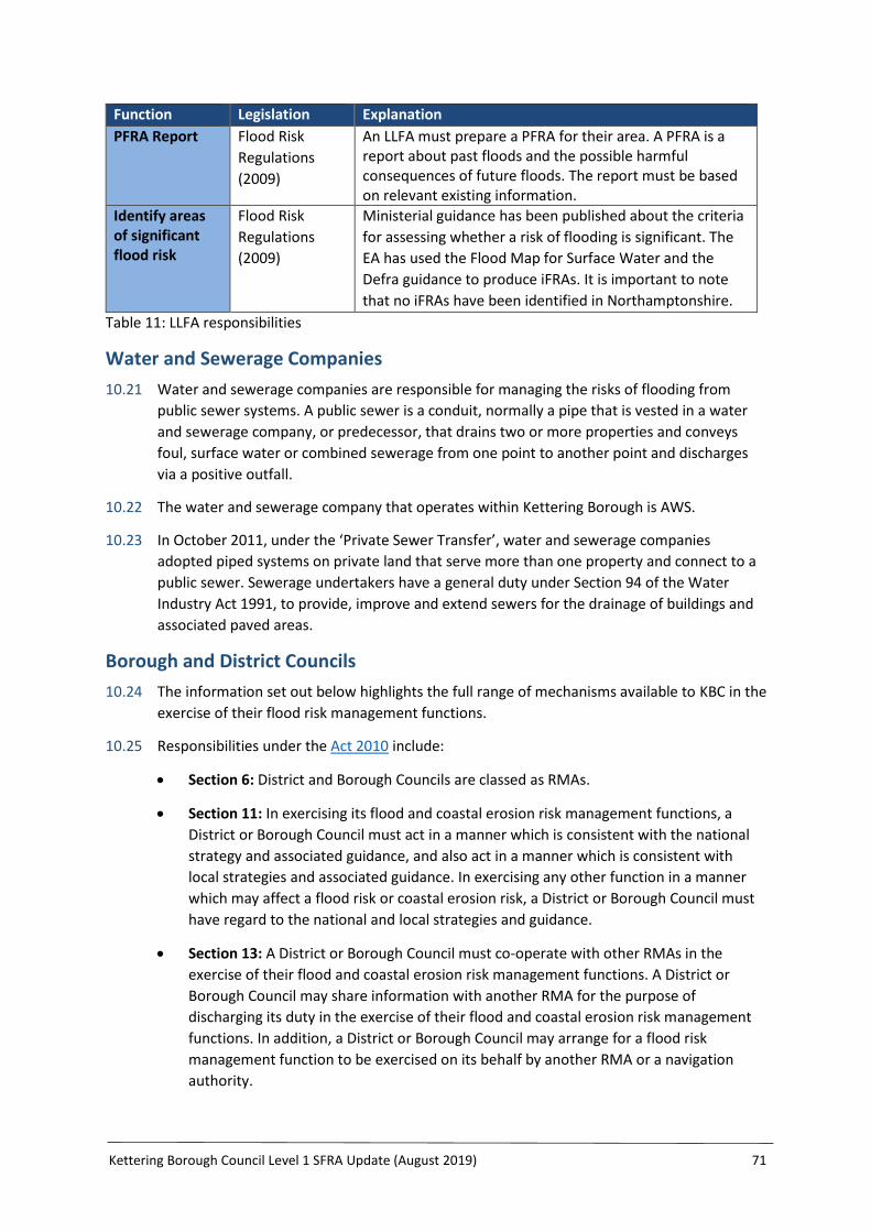
Kettering Borough Council Level 1 SFRA Update (August 2019) 71
Function Legislation Explanation
PFRA Report Flood Risk
Regulations
(2009)
An LLFA must prepare a PFRA for their area. A PFRA is a report about past floods and the possible harmful consequences of future floods. The report must be based on relevant existing information.
Identify areas of significant flood risk
Flood Risk
Regulations
(2009)
Ministerial guidance has been published about the criteria
for assessing whether a risk of flooding is significant. The
EA has used the Flood Map for Surface Water and the
Defra guidance to produce iFRAs. It is important to note
that no iFRAs have been identified in Northamptonshire.
Table 11: LLFA responsibilities
Water and Sewerage Companies
10.21 Water and sewerage companies are responsible for managing the risks of flooding from
public sewer systems. A public sewer is a conduit, normally a pipe that is vested in a water
and sewerage company, or predecessor, that drains two or more properties and conveys
foul, surface water or combined sewerage from one point to another point and discharges
via a positive outfall.
10.22 The water and sewerage company that operates within Kettering Borough is AWS.
10.23 In October 2011, under the ‘Private Sewer Transfer’, water and sewerage companies
adopted piped systems on private land that serve more than one property and connect to a
public sewer. Sewerage undertakers have a general duty under Section 94 of the Water
Industry Act 1991, to provide, improve and extend sewers for the drainage of buildings and
associated paved areas.
Borough and District Councils
10.24 The information set out below highlights the full range of mechanisms available to KBC in the
exercise of their flood risk management functions.
10.25 Responsibilities under the Act 2010 include:
Section 6: District and Borough Councils are classed as RMAs.
Section 11: In exercising its flood and coastal erosion risk management functions, a
District or Borough Council must act in a manner which is consistent with the national
strategy and associated guidance, and also act in a manner which is consistent with
local strategies and associated guidance. In exercising any other function in a manner
which may affect a flood risk or coastal erosion risk, a District or Borough Council must
have regard to the national and local strategies and guidance.
Section 13: A District or Borough Council must co-operate with other RMAs in the
exercise of their flood and coastal erosion risk management functions. A District or
Borough Council may share information with another RMA for the purpose of
discharging its duty in the exercise of their flood and coastal erosion risk management
functions. In addition, a District or Borough Council may arrange for a flood risk
management function to be exercised on its behalf by another RMA or a navigation
authority.

Kettering Borough Council Level 1 SFRA Update (August 2019) 72
Section 27: In exercising a flood or coastal erosion risk management function, District
and Borough Councils must aim to make a contribution towards the achievement of
sustainable development.
Section 39: A District or Borough Council may carry out work (as specified by Section 3
(3) (a) to (e) of the Act) that will or may cause flooding, increase water below the
ground, or coastal erosion.
Schedule 1: District and Borough Councils are classed as designating authorities under
Schedule 1 of the Act. This allows the Councils, where the conditions outlined in
Schedule 1 are satisfied, to designate a structure, or a natural or man-made feature of
the environment, where the authority thinks that the existence or location of the
structure or feature affects flood risk. The effect of designation is that a person may not
alter, remove or replace a designated structure or feature without the consent of the
responsible authority.
10.26 Responsibilities under the Land Drainage Act 1991 (as amended by the Act) include:
Section 14A: A District or Borough Council may carry out flood risk management work
where the authority considers the work desirable, having regard to the local flood risk
management strategy for its area, and that the purpose of the work is to manage flood
risk in the authority's area from an ordinary watercourse.
Section 66: A District or Borough Council may make byelaws to secure the efficient
working of a drainage system in the authority's district or area, to regulate the effects
on the environment, to secure the effectiveness of flood risk management work within
the meaning of section 14A and/or to secure the effectiveness of works done in reliance
on Section 39 of the Act 2010.
10.27 Responsibilities under the Public Health Act 1936 include:
Section 260: A District or Borough Council may undertake works to manage statutory
nuisances in connection with watercourses, ditches, ponds, etc. as outlined by Section
259 of the Public Health Act 1936. This includes the clearance of any obstruction or
impediment to the proper flow of water. Other provisions within the Public Health Act
1936 outline further provisions related to watercourses, culverting and land drainage.
10.28 Responsibilities under the Environmental Protection Act 1990 include:
Section 79: Section 79 (Statutory nuisances and inspections therefore) outlines that the
following would constitute a statutory nuisance; that any water covering land or land
covered with water which is in such a state as to be prejudicial to health or a nuisance.
10.29 Responsibilities under the Localism Act 2011 include:
Section 9FH and 9JB: A District or Borough Council (as an RMA) must comply with a
request made by an LLFA’s overview and scrutiny committee, in the course of its
arrangements to review and scrutinise the exercise by RMAs of flood risk management
functions, which may affect the local authority's area. District and Borough Councils
must have regard to reports and recommendations of an overview and scrutiny
committee in the course of the arrangement outlined above.

Kettering Borough Council Level 1 SFRA Update (August 2019) 73
10.30 Under planning legislation, Borough and District Councils operate their development
planning and control functions, having due regard to the NPPF and associated technical
guidance.
Highway Authority
10.31 Northamptonshire Highways is the Highway Authority responsible for the provision and
management of highway drainage under the Highways Act (1980). This excludes motorways
and trunk roads that are the responsibility of Highways England.
10.32 Northamptonshire Highways has various duties and powers in relation to flooding and
drainage on the highway. The Highway Authority is not responsible for flooding or drainage
on private land – this is the responsibility of the owner or occupier of the land. Where
flooding on a highway is caused by another person (e.g. an adjoining landowner), the
Highway Authority can take action against the person responsible.
10.33 Highway drainage systems are for the primary purpose of accepting surface water runoff
from the highway and are the responsibility of the Highway Authority unless they have been
specifically adopted by the sewerage undertaker.
Highway England
10.34 Highways England is responsible for the strategic road network. In Kettering this includes the
A14.
10.35 Where a motorway or trunk road is identified as being at risk from flooding, contingency
plans are prepared to warn road users and, where necessary, divert them away from the
problem. Where possible, weather data from the Met Office is analysed and if intense
rainfall events are forecast in sensitive flood areas, suitable warnings are posted using the
variable message signs.
Riparian Owners
10.36 Under common law, a riparian owner is someone who has a watercourse within or adjacent
to any boundary of their property. Where a watercourse is sited between two or more
property boundaries each owner may be equally responsible up to the centre line of the
watercourse.
10.37 Although not defined as a flood risk management authority under the Act, riparian owners
retain their own duties and responsibilities for watercourses on or adjacent to their land, as
set out in the Land Drainage Act 1991. This includes the responsibility for the maintenance of
any river, stream, ditch, drain, cut, dyke, sluice, culvert, sewer (excluding public sewers) or
any other passage through which water flows.
10.38 The NCC Flood Toolkit provides a vast amount of guidance to help clarify the rights and
responsibilities of riparian owners.
Parish Councils
10.39 Parish Councils have the powers to undertake maintenance works on ponds, ditches and
other open drainage in order to prevent the feature from becoming a risk to health. Parish
Councils can also play an important role in managing flood risk at the community level by
preparing community flood plans, raising additional funding for local flood resilience and

Kettering Borough Council Level 1 SFRA Update (August 2019) 74
flood defence measures, and gathering information on flooding by reporting any flood
incidents in their area. For further details on the roles of Parish Councils please see Flood
Guide 19 on the Flood Toolkit.
Other Bodies
10.40 There are many other bodies that play an important role in flood risk management: for
example, Natural England, The Met Office, the Flood Forecasting Centre; and charities such
as the National Flood Forum, Red Cross and Salvation Army, and the National Farmers
Union.

Kettering Borough Council Level 1 SFRA Update (August 2019) 75
11 Conclusions and Recommendations
Conclusions
11.1 Kettering Borough has undergone significant expansion historically and in recent years, with
more growth still planned. This Level 1 SFRA update has considered all sources of flood risk
based on information gained through consultation with all RMAs as specified within the
NPPF. The assessment is compliant with the NPPF and will continue to inform all future land
allocation and flood risk management needs within the Borough of Kettering.
11.2 A vast amount of data and a significant number of studies and strategies have previously
reviewed the level of flood risk in the Borough. This SFRA updates this information. There
has been a history of flooding in the Borough with a total of 415 incidents recorded since
1973 to the present day. These are from all sources of flooding.
11.3 In terms of the number of properties at risk, ground water flood risk poses the greatest risk
in the Borough, followed by surface water flood risk, then fluvial flood risk.
11.4 Surface water flooding has been identified as a more recent concern and a key consideration
for all new development. Major new developments now have to address surface water
drainage requirements set out in the National Standards, and local guidance produced by
NCC. This guidance will ensure that careful design of the site lay-out and drainage system is
factored into new development, giving due consideration to the implementation of SuDS
solutions and their ongoing maintenance where appropriate.
11.5 Groundwater flooding is also a key consideration to future growth and detailed guidance has
been produced by NCC as the LLFA and should be considered at all stages of the planning
process.
11.6 There are a number of reservoirs located within the Borough, which may pose a residual
flood risk to local communities if they were to breach. Also, the over-topping of flood
defences could affect properties within the potential flow path or located behind defences.
This risk should be incorporated within any assessment at all stages of the planning
application process.
11.7 Existing planning policy within the North Northamptonshire JCS is considered to be robust
and fully up-to-date. Therefore no additional strategic policies in relation to flood risk are
recommended as part of the development of the Part 2 Local Plan. Site-specific policies have
however been recommended, and should be adopted if KBC brings forward additional non-
strategic land allocations in the Part 2 Local Plan or if planning applications come forward for
the assessed sites.
11.8 The site-specific assessment has identified the majority of sites as having a ‘green’ rating, as
they are at low risk of flooding. There are however a number of sites with an ‘amber’ rating,
as they are either at risk of surface water, fluvial and/or groundwater flooding, have
experienced flooding on the site or in close proximity of the site in the past, or have capacity
issues within the existing drainage systems. Site-specific recommendations have been made
for all sites, some of which will be covered by existing strategic policy and some of which will
be required to be implemented as site-specific policy if the sites are to be allocated for
development.

Kettering Borough Council Level 1 SFRA Update (August 2019) 76
11.9 Two sites have been given a ‘red’ rating (KE/184a McAlpine's Yard, Pytchley Lodge Road,
Kettering and RA/170 South of New Stone House, Duck End, Cranford) due to the level of
floor risk to the sites from a range of sources. For these sites it is recommended that further
work is undertaken prior to allocation, to better understand the level of risk to the sites,
such as through a Level 2 SFRA.
Recommendations
Robust Evidence Base
11.10 This SFRA is compliant with the NPPF and therefore if this framework is significantly altered,
along with any associated guidance, the SFRA will need to once again be reviewed and
updated to reflect these changes. A robust SFRA can be achieved by ensuring the following
actions take place:
During future iterations the key stakeholders should be contacted to ensure that the
most up-to-date records are included in the SFRA;
Information on all sources of flooding should continue to be collected, where possible;
When more detailed or updated hydraulic modelling becomes available, these should
be included in the SFRA;
When more detailed assessment is carried out by developers and land owners,
information should be captured and submitted to KBC as part of the development
control process;
Datasets that are updated regularly should be identified, saved and recorded;
Continued partnership working between all RMAs should be promoted to maximise
opportunities for holistic flood risk management and natural resilience;
Early consultation between developers and KBC, the EA, and the LLFA should be
encouraged for any proposed development; and
Emergency planning is imperative to minimise the risk to life posed by flooding within
the area. It is recommended that the Borough Council has regard to the guidance set
out in Flood Guide 23: New Development and Emergency Flood Plans, and advise the
LRF of the risks raised in light of this SFRA, ensuring that the planning for future
emergency response can be reviewed accordingly.
Development Principles
11.11 In accordance with the NPPF, a specific policy on flood risk should be included within the
Local Plan Part 2 document to ensure that the advice provided for each site, outlined within
the Sequential Test table, is incorporated if necessary to support land allocation.
11.12 KBC should adopt a sequential approach to land allocation and no inappropriate
development in Flood Zone 2 or 3, or areas at high risk of flooding from any source should be
promoted.
11.13 The information provided within this report should be used to inform the scope of
information required to support a planning application e.g. FRA (see the Developer Checklist
in Appendix 5). This information should also be used to inform planning application decisions
taken by KBC.

Kettering Borough Council Level 1 SFRA Update (August 2019) 77
11.14 Three recommendations relating to the cumulative impacts of development have been
provided, for further assessment of cumulative effects on watercourses across the Borough,
requiring developers of sites draining to CDCs to provide additional storage and/or
assessment of runoff impacts, and consideration of requiring contributions to community
flood management schemes.
Technical Matters
11.15 Flood Risk Assessments should assess the risk of flooding to the development from all
sources and should identify options to mitigate the flood risk to the development, site users
and surrounding area. The detailed guidance provided in Appendix 3, relating to site specific
Flood Risk Assessments, should be followed.
11.16 Sites adjacent (typically within 9m) to a stretch of watercourse without flooding information
(i.e. broad-scale flood zone maps) should be examined as part of a site-specific FRA. This may
require modelling to define the functional floodplain and impact of climate change.
11.17 Post-development surface water flows and volumes should be restricted based on the
standards set out in the Local Standards and Guidance for Surface Water Drainage in
Northamptonshire. These standards should apply to all development, although the LLFA can
only comment on major development. The standards include the following:
No flooding for a 1 in 100 year (plus climate change) event (as per Policy 5 of the North
Northamptonshire JCS) - achieved by a combination of measures;
Run-off from new developments restricted to greenfield run-off rates (or a minimum
40% betterment over brownfield rates);
SuDS features required for all major developments;
No net increase in flood risk to upstream or downstream communities; and
As Flood Estimation Handbook (FEH) rainfall data is more up to date, calculations should
use FEH data for surface water drainage design, except where the critical storm
duration is less than 60 minutes, as it is recognised that FEH data is less robust than
Flood Studies Report for short duration storms.
Flood Risk Mitigation, Resistance and Resilience
11.18 Piecemeal flood mitigation measures should be avoided by implementing strategic flood risk
management infrastructure projects through partnership schemes. Furthermore, as the
North Northamptonshire JCS Infrastructure Delivery Plan identifies, large developments
taking place across North Northamptonshire offer opportunities to encourage
comprehensive water management schemes, that can help to reduce the risk of flooding
across wide catchment areas. Small-scale flood mitigation should consider natural flood
management measures wherever appropriate.
11.19 Where a watercourse runs through a development site, incorporation of river naturalisation
and environmental enhancement should be considered where feasible, providing these do
not increase flood risk. Opportunities should be sought for retrofitting Green Infrastructure
and SuDS in urban areas, particularly in high risk catchments.

Kettering Borough Council Level 1 SFRA Update (August 2019) 78
11.20 Resistance and resilience measures should be introduced into new developments within
areas at risk of fluvial or surface water flooding. Reference to existing guidance, such as
Flood Guide 23 on the NCC Flood Toolkit, within LPA’s Local Plan Part 2 policies should be
considered.
Land Drainage Consent, Environmental Permits and Riparian Matters
11.21 No development should be located within 8 metres of a main river without Environmental
Permit, or within 9m of an ordinary watercourse without Land Drainage Consent, to ensure
adequate access for maintenance is preserved and that a riparian corridor is maintained.
11.22 Culverting of watercourses is only acceptable where it can be demonstrated that there is an
overriding need, i.e. to gain access to a site. This is due to the loss of riparian habitat,
increased risk of blockage, and difficulty of maintenance. Culverting of watercourses should
be designed to minimise risk of blockage and must secure the correct consents and permits.
Developer Contributions
11.23 There should be continued identification of the locations that are known to have surface
water flooding problems from sewers and overland flow routes, and explore possible
solutions for them through new development proposals.
11.24 There should be consideration of strategic flood risk management measures in advance, or
in parallel with, proposed development with the intent of obtaining appropriate financial
contributions from the prospective developers through a Section 106 Agreement, including
for long-term management.

Kettering Borough Council Level 1 SFRA Update (August 2019) 79
Appendix 1: Glossary of Terms
Aquifer A source of groundwater comprising water-bearing rock, sand or gravel,
capable of yielding significant quantities of water.
Breach Flooding caused by the constructional failure of a flood defence or other
structure that is acting as a flood defence.
Catchment
Flood
Management
Plans
Catchment Flood Management Plans (CFMPs) have been produced by the
EA and are high-level planning tools that set out objectives for flood risk
management for each river catchment and estuary. CFMPs consider inland
risk from rivers, surface water, groundwater and tidal flooding but do not
consider sewer flooding. The CFMPs that cover Kettering Borough are:
River Nene Catchment Flood Management Plan (December 2009) and the
River Welland Catchment Flood Management Plan (December 2009). Flood
Risk Management Plans build upon Catchment Flood Management Plans.
Climate
Change
A long-term change in the statistical distribution of weather patterns over
periods of time that range from decades to millions of years. It may be a
change in the average weather conditions or a change in the distribution of
weather events with respect to an average, for example, greater or fewer
extreme weather events. Climate change may be limited to a specific
region, or may occur across the whole planet.
Culvert A closed conduit or pipe used for the conveyance of water under a road,
railway, canal, property, or other impediment.
Defence A structure that alters the natural flow of water or flood water for the
purposes of flood defence, thereby reducing the risk of flooding. A defence
may be ‘formal’ (a structure built and maintained specifically for flood
defence purposes) or ‘informal’ (a structure that provides a flood defence
function but has not been built and/or maintained for this purpose).
Environment
Agency
An Executive non-departmental Public Body responsible to the Secretary of
State for Environment, Food and Rural Affairs and an Assembly Sponsored
Public Body responsible to the National Assembly for Wales. The
Environment Agency’s principal aims are to protect and improve the
environment, and to promote sustainable development. They play a
central role in delivering the environmental priorities of central
government and the Welsh Assembly Government through our functions
and roles.
Environmental
Permit for
Flood Risk
Activities
A permit required under the Environmental Permitting (England and
Wales) Regulations 2010 from the Environment Agency for any proposed
works or structures, in, under, over or within eight metres of the top of the
bank of any watercourse, designated a ‘main river’. This was formerly
called a Flood Defence Consent. Some activities are also now excluded or
exempt. A permit is separate to, and in addition to, any planning
permission granted. Further details and guidance are available on the
GOV.UK website: https://www.gov.uk/guidance/flood-risk-activities-
environmental-permits
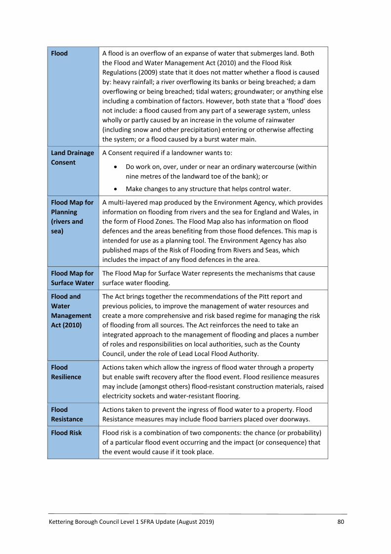
Kettering Borough Council Level 1 SFRA Update (August 2019) 80
Flood A flood is an overflow of an expanse of water that submerges land. Both
the Flood and Water Management Act (2010) and the Flood Risk
Regulations (2009) state that it does not matter whether a flood is caused
by: heavy rainfall; a river overflowing its banks or being breached; a dam
overflowing or being breached; tidal waters; groundwater; or anything else
including a combination of factors. However, both state that a ‘flood’ does
not include: a flood caused from any part of a sewerage system, unless
wholly or partly caused by an increase in the volume of rainwater
(including snow and other precipitation) entering or otherwise affecting
the system; or a flood caused by a burst water main.
Land Drainage
Consent
A Consent required if a landowner wants to:
Do work on, over, under or near an ordinary watercourse (within
nine metres of the landward toe of the bank); or
Make changes to any structure that helps control water.
Flood Map for
Planning
(rivers and
sea)
A multi-layered map produced by the Environment Agency, which provides
information on flooding from rivers and the sea for England and Wales, in
the form of Flood Zones. The Flood Map also has information on flood
defences and the areas benefiting from those flood defences. This map is
intended for use as a planning tool. The Environment Agency has also
published maps of the Risk of Flooding from Rivers and Seas, which
includes the impact of any flood defences in the area.
Flood Map for
Surface Water
The Flood Map for Surface Water represents the mechanisms that cause
surface water flooding.
Flood and
Water
Management
Act (2010)
The Act brings together the recommendations of the Pitt report and
previous policies, to improve the management of water resources and
create a more comprehensive and risk based regime for managing the risk
of flooding from all sources. The Act reinforces the need to take an
integrated approach to the management of flooding and places a number
of roles and responsibilities on local authorities, such as the County
Council, under the role of Lead Local Flood Authority.
Flood
Resilience
Actions taken which allow the ingress of flood water through a property
but enable swift recovery after the flood event. Flood resilience measures
may include (amongst others) flood-resistant construction materials, raised
electricity sockets and water-resistant flooring.
Flood
Resistance
Actions taken to prevent the ingress of flood water to a property. Flood
Resistance measures may include flood barriers placed over doorways.
Flood Risk Flood risk is a combination of two components: the chance (or probability)
of a particular flood event occurring and the impact (or consequence) that
the event would cause if it took place.
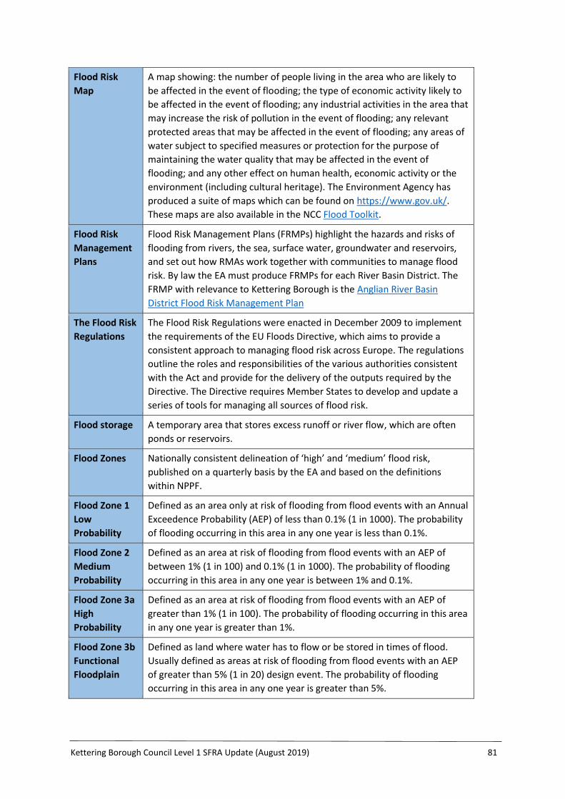
Kettering Borough Council Level 1 SFRA Update (August 2019) 81
Flood Risk
Map
A map showing: the number of people living in the area who are likely to
be affected in the event of flooding; the type of economic activity likely to
be affected in the event of flooding; any industrial activities in the area that
may increase the risk of pollution in the event of flooding; any relevant
protected areas that may be affected in the event of flooding; any areas of
water subject to specified measures or protection for the purpose of
maintaining the water quality that may be affected in the event of
flooding; and any other effect on human health, economic activity or the
environment (including cultural heritage). The Environment Agency has
produced a suite of maps which can be found on https://www.gov.uk/.
These maps are also available in the NCC Flood Toolkit.
Flood Risk
Management
Plans
Flood Risk Management Plans (FRMPs) highlight the hazards and risks of
flooding from rivers, the sea, surface water, groundwater and reservoirs,
and set out how RMAs work together with communities to manage flood
risk. By law the EA must produce FRMPs for each River Basin District. The
FRMP with relevance to Kettering Borough is the Anglian River Basin
District Flood Risk Management Plan
The Flood Risk
Regulations
The Flood Risk Regulations were enacted in December 2009 to implement
the requirements of the EU Floods Directive, which aims to provide a
consistent approach to managing flood risk across Europe. The regulations
outline the roles and responsibilities of the various authorities consistent
with the Act and provide for the delivery of the outputs required by the
Directive. The Directive requires Member States to develop and update a
series of tools for managing all sources of flood risk.
Flood storage A temporary area that stores excess runoff or river flow, which are often
ponds or reservoirs.
Flood Zones Nationally consistent delineation of ‘high’ and ‘medium’ flood risk,
published on a quarterly basis by the EA and based on the definitions
within NPPF.
Flood Zone 1
Low
Probability
Defined as an area only at risk of flooding from flood events with an Annual
Exceedence Probability (AEP) of less than 0.1% (1 in 1000). The probability
of flooding occurring in this area in any one year is less than 0.1%.
Flood Zone 2
Medium
Probability
Defined as an area at risk of flooding from flood events with an AEP of
between 1% (1 in 100) and 0.1% (1 in 1000). The probability of flooding
occurring in this area in any one year is between 1% and 0.1%.
Flood Zone 3a
High
Probability
Defined as an area at risk of flooding from flood events with an AEP of
greater than 1% (1 in 100). The probability of flooding occurring in this area
in any one year is greater than 1%.
Flood Zone 3b
Functional
Floodplain
Defined as land where water has to flow or be stored in times of flood.
Usually defined as areas at risk of flooding from flood events with an AEP
of greater than 5% (1 in 20) design event. The probability of flooding
occurring in this area in any one year is greater than 5%.

Kettering Borough Council Level 1 SFRA Update (August 2019) 82
Fluvial The processes associated with rivers and streams and the deposits and
landforms created by them.
Functional
Floodplain
This zone comprises land where water has to flow or be stored in times of
flood. LPAs are required to identify in their SFRAs, areas of functional
floodplain and its boundaries accordingly.
Geographical
Information
Systems
GIS is any system which stores geographical data, such as elevations,
location of buildings and extent of flood outlines.
Groundwater Water located beneath the ground surface, either in soil pore spaces or
fractures in rock.
Internal
Drainage
Board
Independent body with responsibility for ordinary watercourses within a
specified district or borough.
Inundation To cover with floodwater.
Local Planning
Authority
The body that is responsible for controlling planning and development
through the planning system.
Main River All watercourses shown on the statutory main river maps held by the
Environment Agency. This can include any structure for controlling or
regulating the flow of water into or out of the channel. The Environment
Agency has permissive power to carry out works of maintenance and
improvement on these rivers.
Mitigation
Measure
An element of development design which may be used to manage flood
risk or avoid an increase in flood risk elsewhere.
National Flood
and Coastal
Erosion Risk
Management
Strategy
The Environment Agency’s National Strategy was published in May 2011
and provides an overview of how flood risk and the risk of coastal erosion
will be managed across England. The aims and objectives of the National
Strategy have been translated onto a local scale through this Local Strategy
for the County Council.
National
Planning
Policy
Framework
Sets out the Government’s planning policies for England and how these are
expected to be applied. It sets out the Government’s requirements for the
planning system only to the extent that it is relevant, proportionate and
necessary to do so. It provides a framework within which local people and
their accountable councils can produce their own distinctive local and
neighbourhood plans, which reflect the needs and priorities of their
communities.
National
Planning
Practice
Guidance
A planning practice guidance web-based resource. Links between the
National Planning Policy Framework and relevant planning practice
guidance.
Ordinary
Watercourse
Any section of watercourse not designated as a main river.

Kettering Borough Council Level 1 SFRA Update (August 2019) 83
Pitt Review Sir Michael Pitt carried out an independent review of the 2007 floods and
made a number of recommendations for future flood risk management. In
particular, he recommended that local authorities should play a more
significant role in tackling local problems of flooding and coordinating all
relevant agencies. Many of the recommendations of The Pitt Review have
been enacted through the Act.
Pluvial Direct runoff as a result of rainfall and the processes associated with it.
Precipitation Describes rain, sleet, hail, snow and other forms of water falling from the
sky.
Preliminary
Flood Risk
Assessment
The PFRA is a process involving an assessment of past floods and the
possible harmful consequences of future floods, leading to the
identification of areas of significant risk. All LLFAs must prepare a PFRA
report in relation to flooding in the LLFA’s area. The floods to be included
are those which had significant harmful consequences for human health,
economic activity or the environment (including cultural heritage), or
which would have significant harmful consequences for those matters if
they were to occur now.
Reservoir Artificial lake used to store water. Reservoirs may be created in river
valleys by the construction of a dam, or may be built by excavation in the
ground or by conventional construction techniques, such as brickwork or
cast concrete. Reservoirs greater than 25,000m3 are governed by the
Reservoirs Act.
Residual Risk The risk which remains after all risk avoidance, reduction and mitigation
measures have been implemented.
Return Period The probability of a flood of a given magnitude occurring within any one
year e.g. a 1% (1 in 100) AEP flood event has a 1% probability of occurring
once in any one year.
Riparian
Owner
All landowners whose property is adjoining to a body of water have the
right to make reasonable use of it and the responsibility to suitably
maintain it.
Risk The probability or likelihood of an event occurring.
Risk
Management
Authority
Flood Risk Management Authorities have a range of roles and
responsibilities relating to flood risk management. These authorities
include:
The Environment Agency;
An LLFA;
A District or Borough Council for an area for which there is no
unitary authority;
An Internal Drainage Board;
A water company; and
A highway authority.
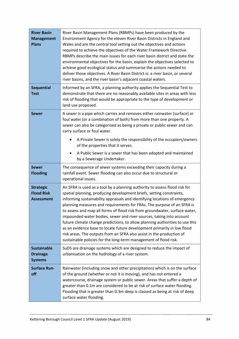
Kettering Borough Council Level 1 SFRA Update (August 2019) 84
River Basin
Management
Plans
River Basin Management Plans (RBMPs) have been produced by the
Environment Agency for the eleven River Basin Districts in England and
Wales and are the central tool setting out the objectives and actions
required to achieve the objectives of the Water Framework Directive.
RBMPs describe the main issues for each river basin district and state the
environmental objectives for the basin, explain the objectives selected to
achieve good ecological status and summarise the actions needed to
deliver those objectives. A River Basin District is: a river basin, or several
river basins, and the river basin’s adjacent coastal waters.
Sequential
Test
Informed by an SFRA, a planning authority applies the Sequential Test to
demonstrate that there are no reasonably available sites in areas with less
risk of flooding that would be appropriate to the type of development or
land use proposed.
Sewer A sewer is a pipe which carries and removes either rainwater (surface) or
foul water (or a combination of both) from more than one property. A
sewer can also be categorised as being a private or public sewer and can
carry surface or foul water.
A Private Sewer is solely the responsibility of the occupiers/owners
of the properties that it serves.
A Public Sewer is a sewer that has been adopted and maintained
by a Sewerage Undertaker.
Sewer
Flooding
The consequence of sewer systems exceeding their capacity during a
rainfall event. Sewer flooding can also occur due to structural or
operational issues.
Strategic
Flood Risk
Assessment
An SFRA is used as a tool by a planning authority to assess flood risk for
spatial planning, producing development briefs, setting constraints,
informing sustainability appraisals and identifying locations of emergency
planning measures and requirements for FRAs. The purpose of an SFRA is
to assess and map all forms of flood risk from groundwater, surface water,
impounded water bodies, sewer and river sources, taking into account
future climate change predictions, to allow planning authorities to use this
as an evidence base to locate future development primarily in low flood
risk areas. The outputs from an SFRA also assist in the production of
sustainable policies for the long-term management of flood risk.
Sustainable
Drainage
Systems
SuDS are drainage systems which are designed to reduce the impact of
urbanisation on the hydrology of a river system.
Surface Run-
off
Rainwater (including snow and other precipitation) which is on the surface
of the ground (whether or not it is moving), and has not entered a
watercourse, drainage system or public sewer. Areas that suffer a depth of
greater than 0.1m are considered to be at risk of surface water flooding.
Flooding that is greater than 0.3m deep is classed as being at risk of deep
surface water flooding.

Kettering Borough Council Level 1 SFRA Update (August 2019) 85
Surface Water
Management
Plans
SWMPs are produced by local authorities and are described as a
framework through which key local partners with a responsibility for
surface water and drainage in their area work together to understand the
causes of surface water flooding and agree the most cost effective way of
managing that risk. The purpose is to make sustainable surface water
management decisions that are evidence based, risk based, future proofed
and inclusive of stakeholder views. A SWMP should establish a long-term
action plan to manage surface water in an area and should influence future
capital investment, drainage maintenance, public engagement and
understanding, land-use planning, emergency planning and future
developments.
1% annual
probability
flood event
Event that on average will occur once every 100 years. Expressed as an
event which has a 1% probability of occurring in any one year.
0.5% annual
probability
flood event
Event that on average will occur once every 200 years. Expressed as an
event which has a 0.5% probability of occurring in any one year.
0.1% annual
probability
flood event
Event that on average will occur once every 1000 years. Expressed as an
event, which has a 0.1% probability of occurring in any one year.

Kettering Borough Council Level 1 SFRA Update (August 2019) 86
Appendix 2: Abbreviations
Abbreviation Meaning / Definition
AEP Annual Exceedance Probability
AWS Anglian Water Services
BCW Borough Council of Wellingborough
BGS British Geological Survey
CDC Critical Drainage Catchment
CFMP Catchment Flood Management Plan
CRT Canal and Rivers Trust
Defra The Department for Food and Rural Affairs
DPD Development Plan Document
EA Environment Agency
ENDC East Northamptonshire District Council
FCERM Flood and Coastal Erosion Risk Management
FEH Flood Estimation Handbook
FRMP Flood Risk Management Plan
FMfSW Flood Map for Surface Water
FRA Flood Risk Assessment and/or Flood Risk Area
FSR Flood Storage Reservoir
FWD Floodline Warnings Direct
FWMA Flood and Water Management Act 2010
GIS Geographical Information System
IDB Internal Drainage Board
JCS Joint Core Strategy
KBC Kettering Borough Council
LDD Local Development Document
LFRMS Local Flood Risk Management Strategy
LiDAR Light Detection and Ranging
LLFA Lead Local Flood Authority
LPA Local Planning Authority
LDF Local Development Framework
LRF Local Resilience Forum
NCC Northamptonshire County Council
NNJPDU North Northamptonshire Joint Planning Development Unit
NPPF National Planning Policy Framework
PFRA Preliminary Flood Risk Assessment
PPG Planning Policy Guidance
PPS25 Planning Policy Statement 25
RBMP River Basin Management Plan
RMA Risk Management Authority
SFRA Strategic Flood Risk Assessment
SoP Standard of Protection
SPD Supplementary Planning Document
SuDS Sustainable Drainage Systems
SWMP Surface Water Management Plan
WFD Water Framework Directive
WCS Water Cycle Study or Strategy
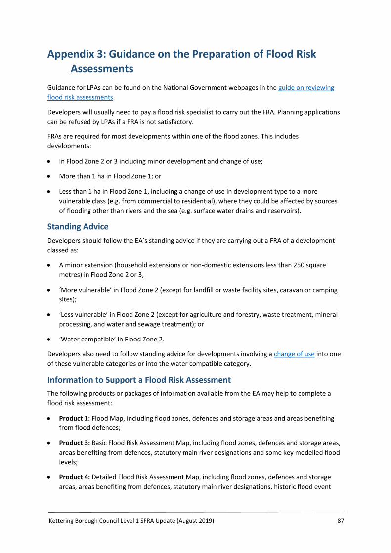
Kettering Borough Council Level 1 SFRA Update (August 2019) 87
Appendix 3: Guidance on the Preparation of Flood Risk Assessments
Guidance for LPAs can be found on the National Government webpages in the guide on reviewing
flood risk assessments.
Developers will usually need to pay a flood risk specialist to carry out the FRA. Planning applications
can be refused by LPAs if a FRA is not satisfactory.
FRAs are required for most developments within one of the flood zones. This includes
developments:
In Flood Zone 2 or 3 including minor development and change of use;
More than 1 ha in Flood Zone 1; or
Less than 1 ha in Flood Zone 1, including a change of use in development type to a more
vulnerable class (e.g. from commercial to residential), where they could be affected by sources
of flooding other than rivers and the sea (e.g. surface water drains and reservoirs).
Standing Advice
Developers should follow the EA’s standing advice if they are carrying out a FRA of a development
classed as:
A minor extension (household extensions or non-domestic extensions less than 250 square
metres) in Flood Zone 2 or 3;
‘More vulnerable’ in Flood Zone 2 (except for landfill or waste facility sites, caravan or camping
sites);
‘Less vulnerable’ in Flood Zone 2 (except for agriculture and forestry, waste treatment, mineral
processing, and water and sewage treatment); or
‘Water compatible’ in Flood Zone 2.
Developers also need to follow standing advice for developments involving a change of use into one
of these vulnerable categories or into the water compatible category.
Information to Support a Flood Risk Assessment
The following products or packages of information available from the EA may help to complete a
flood risk assessment:
Product 1: Flood Map, including flood zones, defences and storage areas and areas benefiting
from flood defences;
Product 3: Basic Flood Risk Assessment Map, including flood zones, defences and storage areas,
areas benefiting from defences, statutory main river designations and some key modelled flood
levels;
Product 4: Detailed Flood Risk Assessment Map, including flood zones, defences and storage
areas, areas benefiting from defences, statutory main river designations, historic flood event
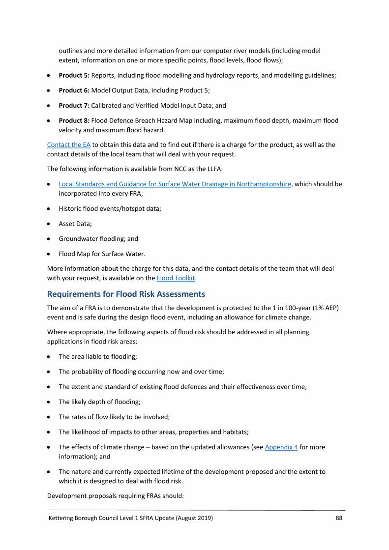
Kettering Borough Council Level 1 SFRA Update (August 2019) 88
outlines and more detailed information from our computer river models (including model
extent, information on one or more specific points, flood levels, flood flows);
Product 5: Reports, including flood modelling and hydrology reports, and modelling guidelines;
Product 6: Model Output Data, including Product 5;
Product 7: Calibrated and Verified Model Input Data; and
Product 8: Flood Defence Breach Hazard Map including, maximum flood depth, maximum flood
velocity and maximum flood hazard.
Contact the EA to obtain this data and to find out if there is a charge for the product, as well as the
contact details of the local team that will deal with your request.
The following information is available from NCC as the LLFA:
Local Standards and Guidance for Surface Water Drainage in Northamptonshire, which should be
incorporated into every FRA;
Historic flood events/hotspot data;
Asset Data;
Groundwater flooding; and
Flood Map for Surface Water.
More information about the charge for this data, and the contact details of the team that will deal
with your request, is available on the Flood Toolkit.
Requirements for Flood Risk Assessments
The aim of a FRA is to demonstrate that the development is protected to the 1 in 100-year (1% AEP)
event and is safe during the design flood event, including an allowance for climate change.
Where appropriate, the following aspects of flood risk should be addressed in all planning
applications in flood risk areas:
The area liable to flooding;
The probability of flooding occurring now and over time;
The extent and standard of existing flood defences and their effectiveness over time;
The likely depth of flooding;
The rates of flow likely to be involved;
The likelihood of impacts to other areas, properties and habitats;
The effects of climate change – based on the updated allowances (see Appendix 4 for more
information); and
The nature and currently expected lifetime of the development proposed and the extent to
which it is designed to deal with flood risk.
Development proposals requiring FRAs should:

Kettering Borough Council Level 1 SFRA Update (August 2019) 89
Apply the sequential approach;
Apply the Sequential Test and, when necessary, Exception Test;
Not increase flood risk, either upstream or downstream, of the site, taking into account the
impacts of climate change;
Not increase surface water volumes or peak flow rates, which would result in increased flood
risk to the receiving catchments;
Use opportunities provided by new development to, where practical, reduce flood risk within
the site and elsewhere;
Ensure that where development is necessary in areas of flood risk (after application of
Sequential and Exception Tests), it is made safe from flooding for the lifetime of the
development, taking into account the impact of climate change; and
All sources of flood risk, including fluvial, surface water, groundwater, reservoir and drainage
need to be considered.
FRAs should follow government guidance on development and flood risk, complying with the
approach recommended by the NPPF (and its associated guidance) and guidance provided by the EA.
The NPPF advocates a risk-based approach to flood risk management in terms of appraising,
managing and reducing the consequences of flooding both to and from a development site.
In circumstances where FRAs are prepared for windfall sites then they should include evidence that
demonstrates the proposals are in accordance with the policies described in the Local Plan.
Finished Floor Levels
Where possible, the finished floor levels (lowest floor level) should be raised above the predicted
flood level to prevent the ingress of flood water. For fluvial flooding this should generally be 300mm
above the 1% (1 in 100) probability flood level, including an allowance for climate change (see
Appendix 4 for more information).
For single storey residential developments (bungalows and ground floor flats), finished floor levels
should be set 300mm above the 0.1% (1 in 1000) annual probability flood event, including an
allowance for climate change (see Appendix 4 for more information).
Modifying Ground Levels
In most areas of fluvial flood risk, developments which propose to raise land levels above the
floodplain risk reducing conveyance or flood storage, which could adversely impact flood risk
upstream, downstream or on neighbouring land.
In such cases, details of compensatory flood storage should be provided as part of a FRA. It is
expected that this will be on a level for level, volume for volume basis to ensure that there is no loss
in flood storage capacity, and on land that does not currently flood but is adjacent to the floodplain
(in order for it to fill and drain). It should be in the vicinity of the site and within the red line of the
planning application boundary (unless the site is strategically allocated).
Raising ground levels can also deflect flood flows, so appropriate assessment should be performed
to demonstrate that there are no adverse effects on third party land.

Kettering Borough Council Level 1 SFRA Update (August 2019) 90
Raising levels can also create areas where surface water might pond during significant rainfall
events. Any proposals to raise ground levels should be tested to ensure that it would not cause
increased ponding or build-up of surface runoff on third party land.
Kettering Borough Council Level 1 SFRA Update (August 2019) 91
Appendix 4: Guidance on Climate Change Allowances
Climate Change Allowances
The NPPF sets out how the planning system should help minimise vulnerability and provide
resilience to the impacts of climate change. The NPPF and supporting PPG on Flood Risk and Coastal
Change explain when and how FRAs should be used. This includes demonstrating how flood risk will
be managed now and over the development’s lifetime, taking climate change into account. LPAs
refer to this when preparing local plans and considering planning applications.
Making an allowance for climate change in your FRA will help to minimise vulnerability and provide
resilience to flooding and coastal change in the future. The climate change allowances are
predictions of anticipated change for:
Peak river flow by River Basin District;
Peak rainfall intensity;
Sea level rise; and
Offshore wind speed and extreme wave height.
Climate Change Allowances Update
On 19th February 2016, the EA published new guidance on the climate change allowances that
should be used in the assessment of flood risk. This guidance can be found on the GOV.UK website.
For assessment of rainfall intensity allowances, Table 2 of the guidance provides two allowances
based on central and upper end predictions of climate change impacts.
Climate Change Allowances for Rainfall
Under the new guidance, for development with a design life to 2060-2115, NCC expects that all
developers should design the surface water attenuation on site to accommodate the +20% climate
change allowance, and undertake a sensitivity analysis to understand the flooding implications of the
+40% climate change allowance.
If the implications are significant, i.e. the site could flood existing development (by allowing
additional flow of runoff from the site) or put people at risk (as a result of increased hazard levels
within or off the site), then a view may be taken to provide more attenuation within the drainage
design up towards the +40% allowance, or to provide additional mitigation, for example a higher
freeboard to ensure no risk to third parties/onsite users for the +40% allowance. This will tie into
existing principles for designing for exceedance. NCC may also request that the +40% allowance is
accounted for on development sites which could have a direct impact on sites of known flood risk,
where no other mitigation is proposed.
This climate change guidance needs to be considered in the FRA/drainage design for all
developments submitted for planning permission on and after 19th February 2016, even if the
technical work was completed in advance of this date.
Climate Change Allowances for Fluvial Flooding
To ensure that the appropriate climate change allowances are considered within a site-specific FRA
for fluvial flood risk matters, it is recommended that developers consult directly with the EA.

Kettering Borough Council Level 1 SFRA Update (August 2019) 92
Appendix 5: Developer Checklist
This list, although not exhaustive, will give developers a useful reference to ensure relevant advice is
incorporated into site design.
Checklist Items Completed Y/N?
Development site and location – describe the site you are proposing to develop.
Where is the development site located?
What is the current use of the site? (e.g. undeveloped land, housing, shops, offices)
Which Flood Zone (for river or sea flooding) is the site within? (I.e. Flood Zone 1, Flood Zone 2, Flood Zone 3). As a first step, you should check the Flood Map for Planning (Rivers and Sea). It is also a good idea to check the Strategic Flood Risk Assessment for the area available from the local planning authority.
Development proposals - provide a general summary of the development proposals.
What is the development proposal(s) for this site? Will this involve a change of use of the site and, if so, what will that change be?
In terms of vulnerability to flooding, what is the vulnerability classification of the proposed development? See Table 2 of this guidance for an explanation of the vulnerability classifications.
What is the expected or estimated lifetime of the proposed development likely to be? (E.g. less than 20 years, 20-50 years, 50-100 years?). See Paragraph 026 of this guidance for further advice on how to assess the lifetime of developments for flood risk and coastal change purposes. It may also be advisable to seek advice from the local planning authority.
Sequential Test - describe how you have applied the sequential test.
What other locations with a lower risk of flooding have you considered for the proposed development?
If you have not considered any other locations, what are the reasons for this?
Explain why you consider the development cannot reasonably be located within an area with the lowest probability of flooding (Flood Zone 1). If your chosen site is within Flood Zone 3, explain why you consider the development cannot reasonably be located in Flood Zone 2.
As well as flood risk from rivers or the sea, have you taken account of the risk from any other sources of flooding in selecting the location for the development?
Site-specific flood risk.
What is/are the main source(s) of flood risk to the site? (E.g. fluvial, surface water, groundwater, reservoir). See the NCC Flood Toolkit mapping and the Strategic Flood Risk Assessment for any relevant and available information.
What is the probability of the site flooding, taking account of the maps?
What is the expected depth and level for the design flood?
Are properties expected to flood internally in the design flood, and to what depth?
Are there any opportunities offered by the development to reduce the causes and impacts of flooding? See Paragraph 050 of this guidance for further advice.
Climate Change - how is flood risk at the site likely to be affected by climate change?
How will the development be made safe from the impacts of climate change, for its lifetime? Further information can be found in Paragraph’s 054 and 059 (including on the use of flood resilience and resistance measures) of this guidance. Further advice on how to take account of the impacts of climate change in flood risk assessments is available from the Environment Agency.
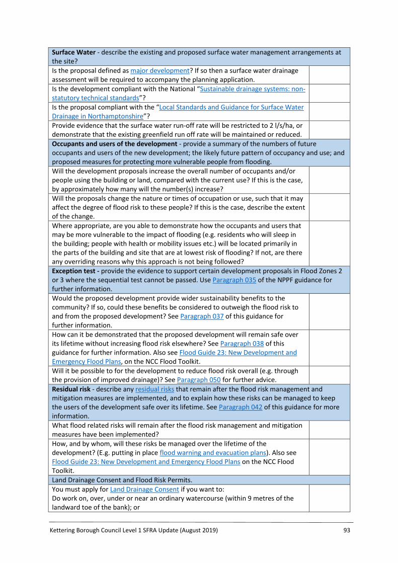
Kettering Borough Council Level 1 SFRA Update (August 2019) 93
Surface Water - describe the existing and proposed surface water management arrangements at the site?
Is the proposal defined as major development? If so then a surface water drainage assessment will be required to accompany the planning application.
Is the development compliant with the National “Sustainable drainage systems: non-statutory technical standards”?
Is the proposal compliant with the “Local Standards and Guidance for Surface Water Drainage in Northamptonshire”?
Provide evidence that the surface water run-off rate will be restricted to 2 l/s/ha, or demonstrate that the existing greenfield run off rate will be maintained or reduced.
Occupants and users of the development - provide a summary of the numbers of future occupants and users of the new development; the likely future pattern of occupancy and use; and proposed measures for protecting more vulnerable people from flooding.
Will the development proposals increase the overall number of occupants and/or people using the building or land, compared with the current use? If this is the case, by approximately how many will the number(s) increase?
Will the proposals change the nature or times of occupation or use, such that it may affect the degree of flood risk to these people? If this is the case, describe the extent of the change.
Where appropriate, are you able to demonstrate how the occupants and users that may be more vulnerable to the impact of flooding (e.g. residents who will sleep in the building; people with health or mobility issues etc.) will be located primarily in the parts of the building and site that are at lowest risk of flooding? If not, are there any overriding reasons why this approach is not being followed?
Exception test - provide the evidence to support certain development proposals in Flood Zones 2 or 3 where the sequential test cannot be passed. Use Paragraph 035 of the NPPF guidance for further information.
Would the proposed development provide wider sustainability benefits to the community? If so, could these benefits be considered to outweigh the flood risk to and from the proposed development? See Paragraph 037 of this guidance for further information.
How can it be demonstrated that the proposed development will remain safe over its lifetime without increasing flood risk elsewhere? See Paragraph 038 of this guidance for further information. Also see Flood Guide 23: New Development and Emergency Flood Plans, on the NCC Flood Toolkit.
Will it be possible to for the development to reduce flood risk overall (e.g. through the provision of improved drainage)? See Paragraph 050 for further advice.
Residual risk - describe any residual risks that remain after the flood risk management and mitigation measures are implemented, and to explain how these risks can be managed to keep the users of the development safe over its lifetime. See Paragraph 042 of this guidance for more information.
What flood related risks will remain after the flood risk management and mitigation measures have been implemented?
How, and by whom, will these risks be managed over the lifetime of the development? (E.g. putting in place flood warning and evacuation plans). Also see Flood Guide 23: New Development and Emergency Flood Plans on the NCC Flood Toolkit.
Land Drainage Consent and Flood Risk Permits.
You must apply for Land Drainage Consent if you want to: Do work on, over, under or near an ordinary watercourse (within 9 metres of the landward toe of the bank); or

Kettering Borough Council Level 1 SFRA Update (August 2019) 94
Make changes to any structure that helps control water.
For works on main rivers (within 8 metres of the landward toe of the bank) in Northamptonshire you need to apply for an Environmental Permit from the Environment Agency.
Water Quality.
The number of outfalls from the site should be minimised. Any new or replacement outfall designs should adhere to Statutory Guidance Form SD27.
Provide details of measures to minimise pollution to watercourses during construction.
Provide details of pollution prevention measures for the life of the development, such as oil and silt interceptors. Consider whether permeable pavement areas are protected from siltation.
Water Consumption.
Confirm that the development can meet a water consumption target as set out in the North Northamptonshire JCS of 110 litres/person/day (105 litres within the home and 5 litres external use) and enclose supporting details (e.g. proposals for measures such as rainwater harvesting, low/dual flush toilets and water saving tap and shower fittings).
Has a practical strategy been included for the supply of water for firefighting?
Confirm whether grey water recycling is to be utilised and provide details.
Provide details of any proposed measures to increase public awareness and community participation.
Water Supply and Sewage Treatment.
Provide evidence to confirm that water supply capacity is available, and that demand can be met.
Provide evidence to confirm that sewerage and wastewater treatment capacity is available, and that demand can be met in accordance with the Water Cycle Strategy (see Section 4.4.3 for more information).
Flood risk assessment credentials - provide details of the author and date of the flood risk assessment.
Who has undertaken the flood risk assessment?
When was the flood risk assessment completed?