Embed Size (px)
Citation preview
Kerang Wetlands Ramsar site
Ecological Character Description
May 2011

Blank page
ii
Contents
EXECUTIVE SUMMARY................................................................................................................ IX
1. INTRODUCTION....................................................................................................................... 1
1.1 Statement of purpose....................................................................................................................... 1
1.2 Preparing the Ecological Character Description.................................................................................2
1.3 Relevant treaties, legislation or regulations......................................................................................31.3.1 International........................................................................................................................................31.3.2 National legislation..............................................................................................................................31.3.3 Victorian policy and legislation............................................................................................................41.3.4 Local policy...........................................................................................................................................6
2 GENERAL DESCRIPTION OF THE KERANG WETLANDS RAMSAR SITE...................7
2.1 Site details....................................................................................................................................... 7
2.2 Climate........................................................................................................................................... 11
2.3 Management of hydrological regimes.............................................................................................12
2.4 Description of the Ramsar site........................................................................................................182.4.1 Ramsar wetland classification............................................................................................................182.4.2 Ramsar criteria...................................................................................................................................22
3 COMPONENTS, PROCESSES, SERVICES AND BENEFITS............................................26
3.1 Critical components, processes and services...................................................................................273.1.1 Hydrology...........................................................................................................................................283.1.2 Physiochemical – salinity....................................................................................................................313.1.3 Waterbirds – abundance....................................................................................................................343.1.4 Waterbirds – colonial breeding/nesting.............................................................................................39
3.2 Components, processes and services..............................................................................................413.2.1 Physical form......................................................................................................................................453.2.2 Soils....................................................................................................................................................463.2.3 Climate...............................................................................................................................................463.2.4 Physiochemical – nutrients and nutrient cycling................................................................................473.2.5 Species interaction and population dynamics....................................................................................483.2.6 Vegetation..........................................................................................................................................503.2.7 Services and benefits – descriptions and associations.......................................................................533.2.8 Provisioning services..........................................................................................................................543.2.9 Regulating services.............................................................................................................................543.2.10 Cultural services.............................................................................................................................543.2.11 Supporting services........................................................................................................................553.2.12 Threatened species and communities – habitat for threatened species.......................................553.2.13 Priority wetland species and ecosystems.......................................................................................55
iii
4 CONCEPTUAL MODELS....................................................................................................... 57
5 LIMITS OF ACCEPTABLE CHANGE...................................................................................62
5.1 Introduction................................................................................................................................... 62
6 THREATS TO THE ECOLOGICAL CHARACTER OF THE RAMSAR SITE..................77
6.1 Alterations to hydrology................................................................................................................. 786.1.1 Changes in groundwater intrusion.....................................................................................................81
6.2 Climate change............................................................................................................................... 81
6.3 Threats to water quality................................................................................................................. 836.3.1 Salinity................................................................................................................................................836.3.2 Nutrients............................................................................................................................................836.3.3 Acid sulfate soils.................................................................................................................................84
6.4 Bed and bank erosion..................................................................................................................... 84
6.5 Pest plants and animals.................................................................................................................. 85
6.6 Changes to surrounding land use....................................................................................................85
6.7 Unsustainable recreation activities.................................................................................................85
7 CHANGES TO ECOLOGICAL CHARACTER SINCE THE TIME OF LISTING...............86
7.1 Salinity........................................................................................................................................... 86
7.2 Hydrology....................................................................................................................................... 88
7.3 Waterbirds..................................................................................................................................... 89
8 KNOWLEDGE GAPS.............................................................................................................. 97
9 MONITORING REQUIREMENTS........................................................................................ 99
10 COMMUNICATION, EDUCATION, PARTICIPATION AND AWARENESS...........102
11 REFERENCES.................................................................................................................... 105
12 APPENDIX......................................................................................................................... 110
12.1 Appendix A – Significant flora and fauna species.................................................................................110
iv

Citation
Kellogg, Brown & Root Pty Ltd (2011). Ecological Character Description for the Kerang Wetlands Ramsar site. Report to the Department of Sustainability, Environment, Water, Population and Communities (DSEWPaC).
Copyright
© Copyright Commonwealth of Australia, 2011.
The Ecological Character Description for the Kerang Wetlands Ramsar site is licensed by the Commonwealth of Australia for use under a Creative Commons By Attribution 3.0 Australia licence with the exception of the Coat of Arms of the Com-monwealth of Australia, the logo of the agency responsible for publishing the report, content supplied by third parties, and any images depicting people. For licence conditions see: http://creativecommons.org/licenses/by/3.0/au/
This report should be attributed as ‘Ecological Character Description for the Kerang Wetlands Ramsar site, Commonwealth of Australia 2011’.
The Commonwealth of Australia has made all reasonable efforts to identify content supplied by third parties using the fol-lowing format ‘© Copyright, [name of third party] ’.
Acknowledgments
The authors would like to thank the members of the Steering Committee for their input during workshops and throughout document production: John Foster (DSEWPaC), Andrea Joyce and Janet Holmes (DSE), Emer Campbell and Michelle Maher (NCCMA), John Ginnivan (Goulburn-Murray Water) and Mark Tscharke (Parks Victoria). The authors would also like to thank Rob O’Brien of DPI Kerang for providing data and local knowledge regarding the Ramsar site. The authors would also like to acknowledge the considerable amount of work by Pam Clunie (DSE 2010a) in the production of the Ecological Character Description (originally prepared in 2006).
Introductory Notes
This Ecological Character Description (ECD Publication) has been prepared in accordance with the National Framework and Guidance for Describing the Ecological Character of Australia’s Ramsar Wetlands (National Framework) (Department of the Environment, Water, Heritage and the Arts, 2008).
The Environment Protection and Biodiversity Conservation Act 1999 (EPBC Act) prohibits actions that are likely to have a significant impact on the ecological character of a Ramsar wetland unless the Commonwealth Environment Minister has approved the taking of the action, or some other provision in the EPBC Act allows the action to be taken. The information in this ECD Publication does not indicate any commitment to a particular course of action, policy position or decision. Further, it does not provide assessment of any particular action within the meaning of the EPBC Act, nor replace the role of the Minister or his delegate in making an informed decision to approve an action.
The Water Act 2007 requires that in preparing the [Murray-Darling] Basin Plan, the Murray-Darling Basin Authority (MDBA) must take into account Ecological Character Descriptions of declared Ramsar wetlands prepared in accordance with the National Framework.
This ECD Publication is provided without prejudice to any final decision by the Administrative Authority for Ramsar in Australia on change in ecological character in accordance with the requirements of Article 3.2 of the Ramsar Convention.
Disclaimer
The views and opinions expressed in this publication are those of the authors and do not necessarily reflect those of the Australian Government or the Minister for the Environment.
While reasonable efforts have been made to ensure that the contents of this publication are factually correct, the Commonwealth does not accept responsibility for the accuracy or completeness of the contents, and shall not be liable for any loss or damage that may be occasioned directly or indirectly through the use of, or reliance on, the contents of this publication.
Note: There may be differences in the type of information contained in this ECD Publication, to those of other Ramsar wetlands.
Cover photos (left to right)
Australian white ibis (© Copyright Brian Furby); aerial view of the Kerang Wetlands looking north-west with Reedy, Middle and Third Lakes in the foreground (© Copyright Jim Mollison); banded stilts (© Copyright Brian Furby); birdlife at Kerang Wetlands (© Copyright Cecilia Burke).
v
Acronyms and abbreviations
AAV Aboriginal Affairs Victoria
ARI Arthur Rylah Institute
AVW Atlas of Victorian Wildlife
BOCA Bird Observation and Conservation Australia
BOM Bureau of Meteorology
CAMBA China-Australia Migratory Birds Agreement
CMA Catchment Management Authority
CMS The Convention on the Conservation of Migratory Species of Wild Animals (also known as CMS or Bonn Convention)
CSIRO Commonwealth Scientific and Industrial Research Organisation
DSEWPaC Department of Sustainability, Environment, Water, Population and Communities (now Department of the Environment) (Australian Government)
DIWA Directory of Important Wetlands in Australia
DPI Department of Primary Industries
DSE Department of Sustainability and Environment (now Department of Environment and Primary Industries) (Victorian Government)
ECD Ecological Character Description
EPA Environment Protection Authority
EPBC Act Environment Protection and Biodiversity Conservation Act 1999 (Commonwealth)
EWA Environmental Water Allocation
FFG Act Flora and Fauna Guarantee Act 1988 (Victoria)
FIS Flora Information System
G-MW Goulburn-Murray Water
JAMBA Japan-Australia Migratory Birds Agreement
KBR Kellogg Brown & Root Pty Ltd
LAC Limit of Acceptable Change
MDB Murray-Darling Basin
MDBA Murray-Darling Basin Authority
RIS Ramsar Information Sheet
ROKAMBA Republic of Korea-Australia Migratory Birds Agreement
vi
Glossary
Benchmark
A standard or point of reference (ANZECC and ARMCANZ 2000b).
A predetermined state (based on the values that are sought to be protected) to be achieved or maintained (Lambert and Elix 2006).
In this ECD Publication, benchmarks are related to the baseline description at the time of listing (1982) of a Ramsar site.
Benefits
Benefits here refer to the economic, social and cultural benefits that people receive from ecosystems (Ramsar Convention 2005a, Resolution IX.1 Annex A). These benefits often rely on the underlying ecological components and processes in the wetland.
See also ‘Ecosystem services’.
Bioregion/ Biogeographic region
A scientifically rigorous determination of regions as established using biological and physical parameters such as climate, soil type and vegetation cover (Ramsar Convention 2005b).
Catchment The total area draining into a river, reservoir or other body of water (ANZECC and ARMCANZ 2000a).
Change in ecological character
Human-induced adverse alteration of any ecosystem component, process, and/or ecosystem benefit/service (Ramsar Convention 2005a, Resolution IX.1, Annex A).
Community An assemblage of organisms characterised by a distinctive combination of species occupying a common environment and interacting with one another (ANZECC and ARMCANZ 2000a).
Contracting Party
Country that is a Member State to the Ramsar Convention on Wetlands (http://www.ramsar.org/cda/en/ramsar-about-parties/main/ramsar/1-36-123_4000_0__).
Diversity (biological)
The variability among living organisms from all sources, including, inter alia, terrestrial, marine and other aquatic ecosystems and the ecological complexes of which they are a part; this includes diversity within species (genetic diversity), between species (species diversity), of ecosystems (ecosystem diversity) and of ecological processes. This definition is based largely on the one contained in Article 2 of the Convention on Biological Diversity (Ramsar Convention 2005b).
Ecological character
The combination of the ecosystem components, processes, and benefits and services that characterise the wetland at a given point in time. Within this context, ecosystem benefits are defined in accordance with the variety of benefits to people (ecosystem services).
The phrase ‘at a given point in time’ refers to Resolution VI.1 paragraph 2.1, which states that, ‘It is essential that the ecological character of a site be described by the Contracting Party concerned at the time of designation for the Ramsar List, by completion of the Information Sheet on Ramsar Wetlands (as adopted by Recommendation IV. 7).’
Ecological communities
Any naturally occurring group of species inhabiting a common environment that interacts with each other, especially through food relationships, and that is relatively independent of other groups. Ecological communities may be of varying sizes and larger ones may contain smaller ones (Ramsar Convention 2005b).
Ecosystems
Within the Millennium Ecosystem Assessment, ecosystems are described as the complex of living communities (including human communities) and non-living environment (ecosystem components) interacting (through ecological processes) as a functional unit, which provides, inter alia, a variety of benefits to people (ecosystem services) (Ramsar Convention 2005a, Resolution IX.1 Annex A).
Ecosystem components
Include the physical, chemical and biological parts of a wetland (from large scale to very small scale, e.g. habitat, species and genes) (Ramsar Convention 2005a, Resolution IX.1 Annex A).
Ecosystem processes
Dynamic forces within an ecosystem. They include all those processes that occur between organisms and within and between populations and communities, including interactions with the non-living environment, which result in existing ecosystems and that bring about changes in ecosystems over time (Australian Heritage Commission 2002). They may be physical, chemical or biological.
vii
Ecosystem services
Benefits that people receive or obtain from an ecosystem (Ramsar Convention 2005a, Resolution IX.1, Annex A). The components of ecosystem services include (Millennium Ecosystem Assessment 2005):
provisioning services – such as food, fuel and fresh water;
regulating services – the benefits obtained from the regulation of ecosystem processes such as climate regulation, water regulation and natural hazard regulation;
cultural services – the benefits people obtain through spiritual enrichment, recreation, education and aesthetics; and
supporting services – the services necessary for the production of all other ecosystem services such as water cycling, nutrient cycling and habitat for biota. These services will generally have an indirect benefit to humans or a direct benefit in the long-term.
See also ‘Benefits’.
Ecological vegetation class (EVC)
An EVC is a native vegetation classification based on a combination of its floristics, life form and ecological characteristics, and through an inferred fidelity to particular environment attributes (DSE 2004).
Essential element
An essential element is a component or process that has an essential influence on the critical components, processes and services/benefits of the wetland. Should the essential element cease, reduce, or become lost, it would result in a detrimental impact on one or more critical component, process and services/benefits. Critical components, processes and services/benefits depend in part or fully on an essential element, but an essential element is not in itself critical for defining the ecological character of the site.
Limits of acceptable change
Variation that is considered acceptable in a particular component or process of the ecological character of the wetland without indicating change in ecological character that may lead to a reduction or loss of the criteria for which the site was Ramsar listed (modified from definition adopted by Phillips 2006).
RamsarCity in Iran where the Convention on Wetlands was signed on 2 February 1971; thus the Convention’s short title, ‘Ramsar Convention on Wetlands’ (http://www.ramsar.org/cda/en/ramsar-about/main/ramsar/1-36_4000_0__).
Ramsar criteria
Criteria for identifying wetlands of international importance, used by Contracting Parties and advisory bodies to identify wetlands as qualifying for the Ramsar List on the basis of representativeness or uniqueness or of biodiversity values (http://www.ramsar.org/cda/en/ramsar-about-sites-criteria-for/main/ramsar/1-36-55%5E20740_4000_0__).
Ramsar convention
Convention on Wetlands of International Importance especially as Waterfowl Habitat. Ramsar (Iran), 2 February 1971. UN Treaty Series No. 14583. As amended by the Paris Protocol, 3 December 1982 and Regina Amendments, 28 May 1987. The abbreviated names ‘Convention on Wetlands (Ramsar, Iran 1971)’ and ‘Ramsar Convention’ are more commonly used (http://www.ramsar.org/cda/en/ramsar-sept13-homeindex/main/ramsar/1%5E26292_4000_0__).
Ramsar Information Sheet (RIS)
Form upon which Contracting Parties record relevant data on proposed Wetlands of International Importance for inclusion in the Ramsar Database; covers identifying details like geographical coordinates and surface area, criteria for inclusion in the Ramsar List and wetland types present, hydrological, ecological, and socioeconomic issues among others, ownership and jurisdictions, and conservation measures taken and needed(http://www.ramsar.org/cda/en/ramsar-documents-info/main/ramsar/1-31-59_4000_0__).
Ramsar site The area of Kerang Wetlands situated within the Ramsar site boundary.
WetlandsAreas of marsh, fen, peatland or water, whether natural or artificial, permanent or temporary with water that is static or flowing, fresh, brackish or salt, including areas of marine water the depth of which at low tide does not exceed six metres (Ramsar Convention 1987).
Wetland typesAs defined by the Ramsar Convention’s wetland classification system (http://www.ramsar.org/cda/ramsar/display/main/main.jsp?zn=ramsar&cp=1-26-76%5E21235_4000_0__).
viii
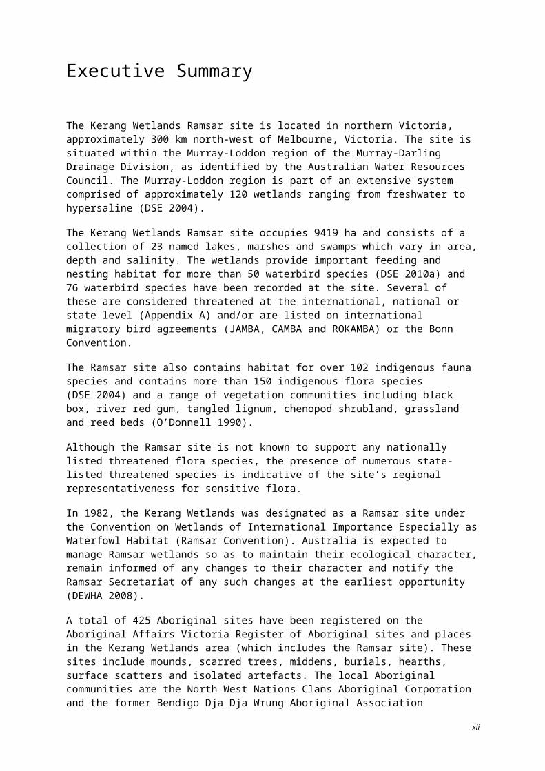
Executive Summary
The Kerang Wetlands Ramsar site is located in northern Victoria, approximately 300 km north-west of Melbourne, Victoria. The site is situated within the Murray-Loddon region of the Murray-Darling Drainage Division, as identified by the Australian Water Resources Council. The Murray-Loddon region is part of an extensive system comprised of approximately 120 wetlands ranging from freshwater to hypersaline (DSE 2004).
The Kerang Wetlands Ramsar site occupies 9419 ha and consists of a collection of 23 named lakes, marshes and swamps which vary in area, depth and salinity. The wetlands provide important feeding and nesting habitat for more than 50 waterbird species (DSE 2010a) and 76 waterbird species have been recorded at the site. Several of these are considered threatened at the international, national or state level (Appendix A) and/or are listed on international migratory bird agreements (JAMBA, CAMBA and ROKAMBA) or the Bonn Convention.
The Ramsar site also contains habitat for over 102 indigenous fauna species and contains more than 150 indigenous flora species (DSE 2004) and a range of vegetation communities including black box, river red gum, tangled lignum, chenopod shrubland, grassland and reed beds (O’Donnell 1990).
Although the Ramsar site is not known to support any nationally listed threatened flora species, the presence of numerous state-listed threatened species is indicative of the site’s regional representativeness for sensitive flora.
In 1982, the Kerang Wetlands was designated as a Ramsar site under the Convention on Wetlands of International Importance Especially as Waterfowl Habitat (Ramsar Convention). Australia is expected to manage Ramsar wetlands so as to maintain their ecological character, remain informed of any changes to their character and notify the Ramsar Secretariat of any such changes at the earliest opportunity (DEWHA 2008).
A total of 425 Aboriginal sites have been registered on the Aboriginal Affairs Victoria Register of Aboriginal sites and places in the Kerang Wetlands area (which includes the Ramsar site). These sites include mounds, scarred trees, middens, burials, hearths, surface scatters and isolated artefacts. The local Aboriginal communities are the North West Nations Clans Aboriginal Corporation and the former Bendigo Dja Dja Wrung Aboriginal Association Incorporated (now defunct). Traditional owner groups are the Wamba Wamba and the Barapa Barapa (DSE 2004).
The Ramsar site also provides recreational value for camping, boating, fishing and bird watching, as well as providing water supply services.
Land tenure within the Ramsar site includes Crown Land reserved as natural feature/wildlife reserves, water supply reserves, salinity disposal reserves, a sewage purpose reserve, as well as combinations of these purposes.
Preparing a detailed description of the ecological character of a Ramsar wetland is critical to maintaining and protecting wetland values and establishing a benchmark at a given point in time from which change can be assessed and monitoring can be effectively planned and implemented. This report forms an Ecological Character Description for the Kerang Wetlands Ramsar site at the time it was listed in 1982. The main objectives of this ECD are to:
describe the critical ecosystem components, processes and services of the Ramsar site; set limits of acceptable change for critical ecosystem components and processes, where baseline condi-
tion and the range of natural variation is known; describe threats to the ecological character of the Ramsar site;
ix
describe the current status and any evident change to the critical components and processes of the site; and
describe knowledge gaps and monitoring requirements in order to adequately assess and detect change.
In 1982, the site was formally recognised as a Wetland of International Importance, meeting four criteria of importance to waterbirds. In 2005, the Ramsar Convention updated the criteria. Table 1 outlines the criteria satisfied under the Ramsar Convention at the time of listing in 1982 and under the revised 2005 criteria.
Table 1. Criteria met by the Kerang Wetland Ramsar site at the time of listing (1982) and in 2005.
Criteria met at the time of listing (1982)
Criterion 1(a) It regularly supports 10 000 ducks, geese and swans; or 10 000 coots or 20 000 waders.
Criterion 1(b) It regularly supports 1% of the individuals in a population of one species or subspecies of waterfowl.
Criterion 2(b) It is of special value for maintaining the genetic and ecological diversity of a region because of the quality and peculiarities of its flora and fauna.
Criterion 3 It is a particularly good example of a specific type of wetland characteristic of its region.
Criteria met currently (Ramsar 2005)
Criterion 1A wetland should be considered internationally important if it contains a representative, rare, or unique example of a natural or near-natural wetland type found within the appropriate biogeographic region.
Criterion 2 A wetland should be considered internationally important if it supports vulnerable, endangered, or critically endangered species or threatened ecological communities.
Criterion 3A wetland should be considered internationally important if it supports populations of plant and/or animal species important for maintaining the biological diversity of a particular biogeographic region.
Criterion 4A wetland should be considered internationally important if it supports plant/or animal species at a critical life stage in their life cycles, or provides refuge during adverse conditions.
Criterion 5 A wetland should be considered internationally important if it regularly supports 20 000 or more waterbirds.
Criterion 6 A wetland should be considered internationally important if it regularly supports 1% of the individuals in a population of one species or subspecies of waterbird.
The collective ecological components and processes of the Ramsar site are the foundation to its recognised ecosystem value and importance. A summary of the critical components, processes and services of the Kerang Wetlands Ramsar site is provided in Table 2. A series of conceptual models that visually link the components, processes and services within the Ramsar site are presented by wetland hydrological types in Figures 1–4.
x
Table 2. Summary of critical components, processes and services of the Ramsar site at the time of listing.
Wetland element Critical component, process or service
Element description
Hydrology (percentage full, depth/volume, frequency of inundation)
Critical process
The Ramsar site has been influenced by the Torrumbarry Irrigation System since its establishment in 1923. This is approximately six decades prior to the listing of the site.
Four types of hydrological grouping occur at the site including irrigation/regulated wetlands maintained as permanent open water (for storage), terminal/regulated drainage wetlands managed as salt disposal basins (evaporation basins to reduce salt discharge into the Murray), regulated fresh supply, non-irrigation wetlands reserved to protect natural features and natural/unregulated freshwater wetlands that are influenced by flows from the Avoca River.
The hydrology of the site has directly influenced habitat and resource availability for internationally/nationally listed waterbirds and colonially nesting bird species breeding in both permanently inundated and unregulated wetlands. These values contributed to meeting the Ramsar criteria in Table 1.
Hydrology is identified as a critical process in the system as it has the potential to impact directly on salinity (including risks of hypersalinity), biodiversity, community vegetative structure, species distributions, habitat and food resources.
Salinity Critical component
The Ramsar site exhibits a full range of salinities from very fresh to hypersaline, including deep permanent freshwater lakes with salinities typically less than 500 EC, wetlands that range between 4000 EC to 50 000 EC and hypersaline salt disposal basins.
Salinity is identified as a critical component in the system as it directly impacts on the ability of biota to survive. Salinity is exacerbated by rising saline groundwater, saline surface water run-off, disposal of saline water into salt disposal basins and lack of regular flushing.
Waterbirds – abundance Critical component
The site supports a high abundance and diversity of waterbird species including 25 that are threatened in Victoria and 21 species listed under international bilateral agreements for migratory bird species (Bonn, JAMBA, CAMBA or ROKAMBA).
Waterbird counts at the Ramsar site are highly variable over time and across individual wetlands of the site. The average annual count of waterbirds for the site for the period 1979–2003 is 31,772. During this period, counts of more than 20,000 waterbirds were recorded on 10 occasions.
The Ramsar site regularly supports more than 1% of the estimated flyway population of the banded stilt (Cladorhynchus leucocephalus).
Waterbirds – colonially breeding/nesting waterbirds (ibis, darters, cormorants, spoonbills)
Critical component Twenty-eight waterbird species have been recorded breeding in the wetlands since 1980. Up to 13 species were recorded breeding each year between 1987 and 1993 (DSE 2010a).
xi
Colonial waterbird breeding has been recorded at Reedy Lake, Middle Lake, Avoca Marshes and Hird Swamp.
The Ramsar site regularly supports over 20 000 waterbirds. Large aggregations of particular species have occurred at Middle Lake, Hird and Johnson Swamps, Lake Cullen and Lake Tutchewop. The species include: straw-necked ibis (Threskiornis spinicollis), sacred (Australian white) ibis (Threskiornis molucca), grey teal (Anas gracilis), Eurasian coot (Fulica atra), banded stilt, sharp-tailed sandpiper (Calidris acuminata), black swan (Sygnus atrutus), Australian shelduck (Tadorna tadornoides) and pink-eared duck (Malacorhynchus membranaceus) (DSE 2010a).
According to the original Ramsar site documentation on the official files of the (then) Ministry of Conservation, in1982, the largest colonies of sacred ibis and straw-necked ibis in Victoria occurred within the Kerang region. In 1979–80, Middle Lake and Hird Swamp together supported 45% of the breeding straw-necked ibis and 73% of the breeding sacred ibis in Victoria.
Within the Ramsar site, Third, Middle and Reedy Lakes have supported more than 10% of the regional breeding population of straw-necked ibis and sacred ibis and more than 5% of the Victorian breeding population of royal spoonbill (Parks Victoria 1999).
xii
Figure 1. Regulated fresh supply for irrigation (© Copyright Kellogg, Brown & Root Pty Ltd).
xiii
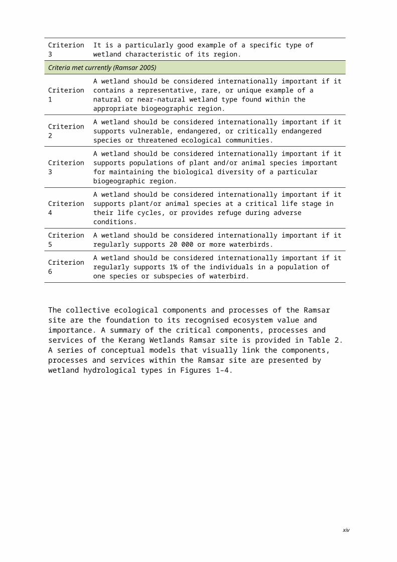
Figure 2. Regulated drainage supply (© Copyright Kellogg, Brown & Root Pty Ltd).
xiv
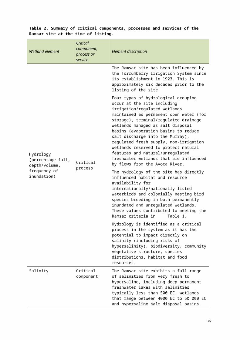
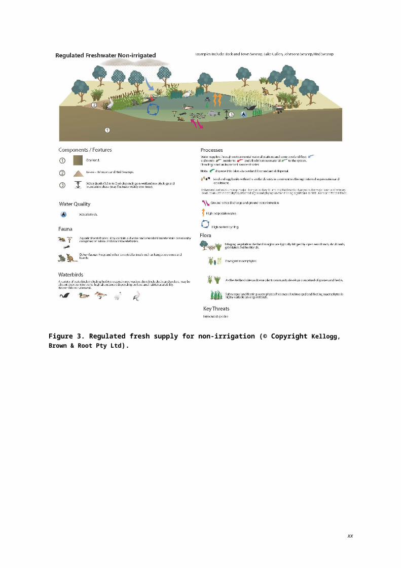
Figure 3. Regulated fresh supply for non-irrigation (© Copyright Kellogg, Brown & Root Pty Ltd).
xv
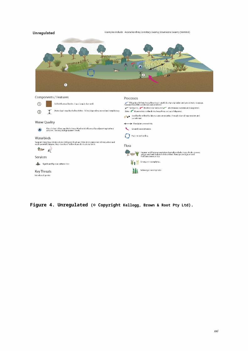
Figure 4. Unregulated (© Copyright Kellogg, Brown & Root Pty Ltd).
xvi
A number of components and process within the Ramsar site have been subject to change since 1982 (as summarised in Table 3). This has resulted from a variety of causes, including historical and current activities that may change (improve or degrade) the character of the site, including: levee and weir removal;
environmental water allocations;
increasing salinity;
presence of pest plants and animals;
climate change; and
grazing.
Although changes have occurred at individual wetlands within the Ramsar site, the ecological character of the Ramsar site as a whole has been maintained since listing.
Table 3. Summary of changes to components and processes for the Ramsar site.
Wetland element Summary of change since listing Potential change to site
Hydrology
Removal of sill at Third Marsh (Avoca Marshes).
Environmental Water Allocations to Johnson Swamp, Hird Swamp and Lake Cullen.
Removal of levee at Town Swamp.
Inlet/outlet improvements at Cemetery Swamp.
Decline in vegetation health at Avoca Marshes.
Unable to determine change to other sites.
Water quality – salinity
Increased salinity at Tutchewop Lakes.
Several sites have experienced increases in salinity levels with wetting and drying cycles.
Decline in value for waterbird breeding.
Unable to determine change.
Limits of Acceptable Change (LACs) acknowledge the natural variability exhibited by critical components, process and services within the wetland ecosystem and establish guidelines that facilitate the assessment of change (either positive or negative) to the ecological character resulting from human activities.
Where possible, LACs have been set for the critical ecosystem components, processes and services that were identified during the preparation of this ECD. It is envisaged that the LACs identified may be updated as new information and data become available. A summary of the baseline condition and corresponding LACs for the Ramsar site (per wetland) for each identified critical component, process and service is provide in Tables 4–7.
Additional explanatory notes on LACs
Limits of Acceptable Change are a tool by which ecological change can be measured. However, ECDs are not management plans and LACs do not constitute a management regime for the Ramsar site.
Exceeding or not meeting LACs does not necessarily indicate that there has been a change in ecological character within the meaning of the Ramsar Convention. However, exceeding or not meeting LACs may require investigation to determine whether there has been a change in ecological character.
In reading the ECD and the LACs, it should be recognised that the hydrology of many catchments in the Murray-Darling Basin is highly regulated, despite many of the wetlands forming under natural hydrological regimes that were more variable and less predictable. Many of the Ramsar wetlands of
xvii
the Murray-Darling Basin were listed at a time when the rivers were highly regulated and water over allocated, with the character of these sites reflecting the prevailing conditions. When listed under the Ramsar Convention, many sites were already on a long-term trend of ecological decline.
While the best available information has been used to prepare this ECD and define LACs for the site, a comprehensive understanding of site character may not be possible as in many cases only limited information and data is available for these purposes. The LACs may not accurately represent the variability of the critical components, processes, benefits or services under the management regime and natural conditions that prevailed at the time the site was listed as a Ramsar wetland.
Users should exercise their own skill and care with respect to their use of the information in this ECD and carefully evaluate the suitability of the information for their own purposes.
LACs can be updated as new information becomes available to ensure they more accurately reflect the natural variability (or normal range for artificial sites) of critical components, processes, benefits or services of the Ramsar wetland.
xviii
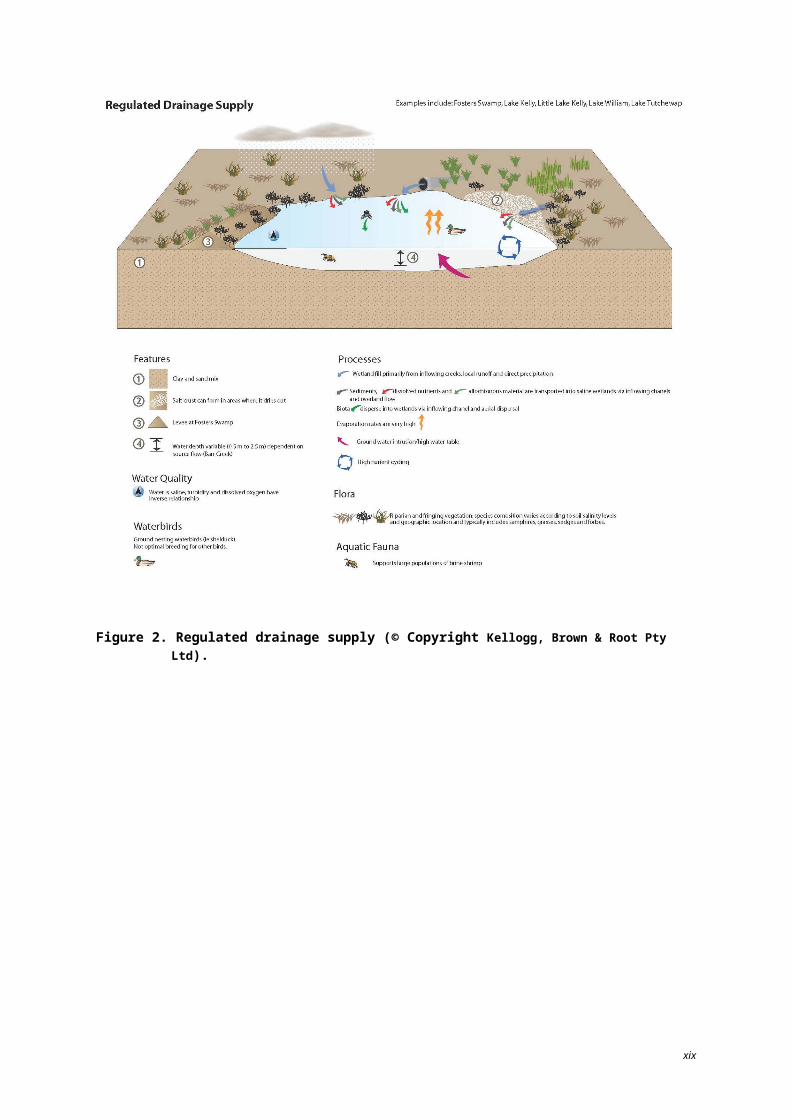
Table 4. Baseline condition and Limits of Acceptable Change for the critical process of hydrology – percentage full, depth, volume and frequency of inundation.
Water body Baseline condition and range of natural variation (where known) LAC Basis of LAC Level of confidence
Lake Tutchewop
Lake Kelly
Little Lake Kelly
These lakes are salt disposal basins managed as part of the Tutchewop Lakes (Barr Creek Drainage Diversion). Over the benchmark period (1980-2003), all three lakes were permanently inundated (held water every year, throughout the year). Information on fluctuation in lake levels during this period is not available. The lakes dried out in 2006 and 2010 due to very dry catchment conditions. These resulted in a lack of drainage water in Barr Creek from where it is normally diverted to the lakes.
In an extreme flood event in February 2011, 12 ML of flood water was diverted to Lake Tutchewop. No flood water was received at Lake Kelly or Little Lake Kelly, except for spillover and leakage from Lake Tutchewop which freshened them.
The water regimes of these wetlands are subject to diversions from Barr Creek which may decline in the future as irrigation water is traded out of the Barr Creek catchment. There is uncertainty about whether such a change to the water regime would be unacceptable and therefore no LAC is set.
Insufficient information to develop a LAC. – –
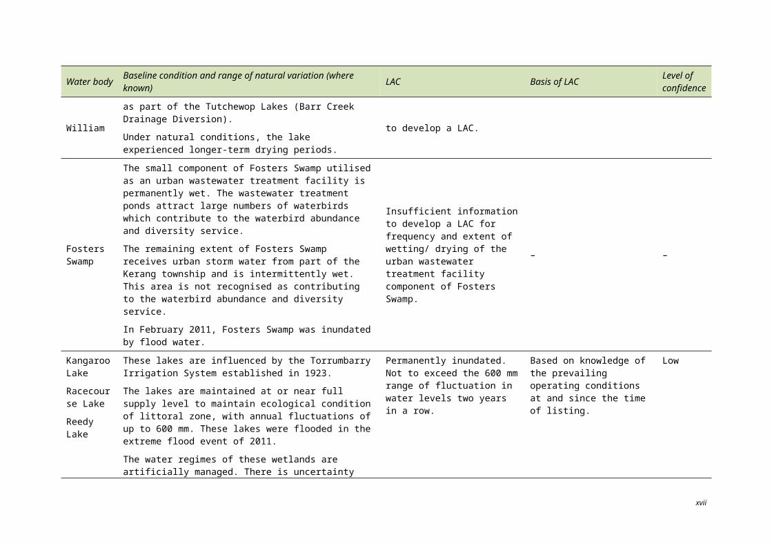
Lake William
Lake William is a salt disposal basin managed as part of the Tutchewop Lakes (Barr Creek Drainage Diversion).
Under natural conditions, the lake experienced longer-term drying periods.
Insufficient information to develop a LAC. – –
Fosters Swamp
The small component of Fosters Swamp utilised as an urban wastewater treatment facility is permanently wet. The wastewater treatment ponds attract large numbers of waterbirds which contribute to the waterbird abundance and diversity service.
The remaining extent of Fosters Swamp receives urban storm water from part of the Kerang township and is intermittently wet. This area is not recognised as contributing to the waterbird abundance and diversity service.
In February 2011, Fosters Swamp was inundated by flood water.
Insufficient information to develop a LAC for frequency and extent of wetting/ drying of the urban wastewater treatment facility component of Fosters Swamp.
– –
xvi
Water body Baseline condition and range of natural variation (where known) LAC Basis of LAC Level of confidence
Kangaroo Lake
Racecourse Lake
Reedy Lake
These lakes are influenced by the Torrumbarry Irrigation System established in 1923.
The lakes are maintained at or near full supply level to maintain ecological condition of littoral zone, with annual fluctuations of up to 600 mm. These lakes were flooded in the extreme flood event of 2011.
The water regimes of these wetlands are artificially managed. There is uncertainty about whether a more natural water regime, such as that which existed prior to 1923 would represent an unacceptable change, thus the LAC is set around conditions prevailing at the time of listing.
Permanently inundated. Not to exceed the 600 mm range of fluctuation in water levels two years in a row.
Based on knowledge of the prevailing operating conditions at and since the time of listing.
Low
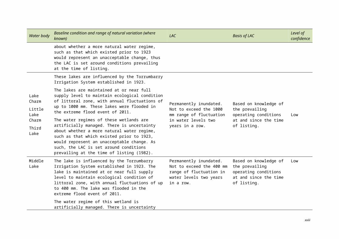
Lake Charm
Little Lake Charm
Third Lake
These lakes are influenced by the Torrumbarry Irrigation System established in 1923.
The lakes are maintained at or near full supply level to maintain ecological condition of littoral zone, with annual fluctuations of up to 1000 mm. These lakes were flooded in the extreme flood event of 2011.
The water regimes of these wetlands are artificially managed. There is uncertainty about whether a more natural water regime, such as that which existed prior to 1923, would represent an unacceptable change. As such, the LAC is set around conditions prevailing at the time of listing (1982).
Permanently inundated. Not to exceed the 1000 mm range of fluctuation in water levels two years in a row.
Based on knowledge of the prevailing operating conditions at and since the time of listing.
Low
Middle Lake
The lake is influenced by the Torrumbarry Irrigation System established in 1923. The lake is maintained at or near full supply level to maintain ecological condition of littoral zone, with annual fluctuations of up to 400 mm. The lake was flooded in the extreme flood event of 2011.
The water regime of this wetland is artificially managed. There is uncertainty about whether a more natural water regime, such as that which existed prior to 1923 would represent an unacceptable change, thus the LAC is set around conditions prevailing at the time of listing
Permanently inundated. Not to exceed the 400 mm range of fluctuation in water levels two years in a row.
Based on knowledge of the prevailing operating conditions at and since the time of listing.
Low
xvii
Water body Baseline condition and range of natural variation (where known) LAC Basis of LAC Level of confidence
Stevenson Swamp
Unregulated system. Stevenson Swamp is a terminal lake with no recognised water supply except in large floods. Supports few values. In February 2011, the swamp was inundated by flood water.
Insufficient information to develop a LAC. – –
Cemetery Swamp
Number of years in which the swamp filled over the benchmark period (1980-2003) – four. Maximum numbers of years over the benchmark period that the swamp remained continuously dry – six.
The swamp relies on flood flow from Loddon River and/or Pyramid Creek. There were flood flows 1992-94 and 1995-96, and channel outfall in 1997-98. The swamp received flood flow in 2010 and experienced total inundation in February 2011.
Not dry for 10 or more consecutive years. Not continuously wet for more than two years.
Based on expert opinion of project steering committee. Low
Lake Bael Bael
Number of years in which the lake filled over the benchmark period (1980-2003) – 18. Maximum number of years over the benchmark period that the lake remained continuously dry – nine.
Lake Bael Bael held water until mid 1990s with a drying period in 1998-99. The lake received some water in early 2000 and was then recorded as continuously dry until 2010.
In February 2011, Lake Bael Bael was inundated by flood water.
Not dry for nine or more consecutive years.
Based on expert opinion of project steering committee and unpublished watering requirement data from Lakey and Hanson (1988), cited in Lugg et al. (1989).
Low
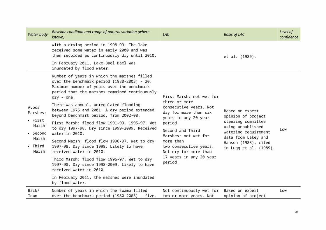
Avoca Marshes:
First Marsh
Second Marsh
Third Marsh
Number of years in which the marshes filled over the benchmark period (1980-2003) – 20. Maximum number of years over the benchmark period that the marshes remained continuously dry – one.
There was annual, unregulated flooding between 1975 and 2001. A dry period extended beyond benchmark period, from 2002-08.
First Marsh: flood flow 1991-93, 1995-97. Wet to dry 1997-98. Dry since 1999-2009. Received water in 2010.
Second Marsh: flood flow 1996-97. Wet to dry 1997-98. Dry since 1998. Likely to have received water in 2010.
Third Marsh: flood flow 1996-97. Wet to dry 1997-98. Dry since 1998-2009. Likely to have received water in 2010.
In February 2011, the marshes were inundated by flood water.
First Marsh: not wet for three or more consecutive years. Not dry for more than six years in any 20 year period.
Second and Third Marshes: not wet for more than two consecutive years. Not dry for more than 17 years in any 20 year period.
Based on expert opinion of project steering committee using unpublished watering requirement data from Lakey and Hanson (1988), cited in Lugg et al. (1989).
Low
xviii
Water body Baseline condition and range of natural variation (where known) LAC Basis of LAC Level of confidence
Back/ Town Swamp
Number of years in which the swamp filled over the benchmark period (1980-2003) – five. Maximum number of years over the benchmark period that the swamp remained continuously dry – three.
A dry period extended beyond the benchmark period, from 2000 to 2009. The swamp received flood flow in 2010. The swamp has a regulated supply and is influenced by Kerang Weir.
In February 2011, the swamp was inundated by flood water.
Not continuously wet for two or more years. Not dry for five or more consecutive years.
Based on expert opinion of project steering committee. Low
Lake Cullen
Number of years in which the lake filled over the benchmark period (1980-2003) – seven. Maximum number of years over the benchmark period that the lake remained continuously dry – two years between 1991 and 2003 (dry from 2002 through to 2006).
Utilised for flood storage until 1969. Since 1993, the lake has been managed via environmental flows with the objective of flushing salt out of the bed – periods of draw down and drying out. Channel outfall 1991-93, flood flow 1995-96, environmental water allocation 1996-98, 2000-01, dry 2001-07. Received environmental water in 2010.
In February 2011, Lake Cullen was inundated by flood water.
Not dry for more than 10 years in any 20 year period (Nolan ITU 2001).
Based on expert opinion of project steering committee and Operational Guidelines (Nolan ITU 2001).
Low
Johnson Swamp
Number of years in which the swamp filled over the benchmark period (1980-2003) – 10 years between 1991 and 2003.
Maximum number of years over the benchmark period that the swamp remained continuously dry – one year between1991 and 2003.
The swamp is disconnected from a natural water source via a levee (except during major floods), erected in 1969. Utilised for freshwater irrigation storage. Received environmental water in1991-92. Flood flow in 1993-94 and environmental water in1995-96. Channel outfall water in 1996-97. Environmental water in 1997-2002, 2003-04 and 2005-06
In February 2011, Johnson Swamp was inundated by flood water.
Not dry for five or more consecutive years. Not wet for two or more consecutive years.
Based on expert opinion of project steering committee. Low
xix
Water body Baseline condition and range of natural variation (where known) LAC Basis of LAC Level of confidence
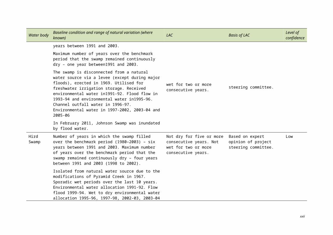
Hird Swamp
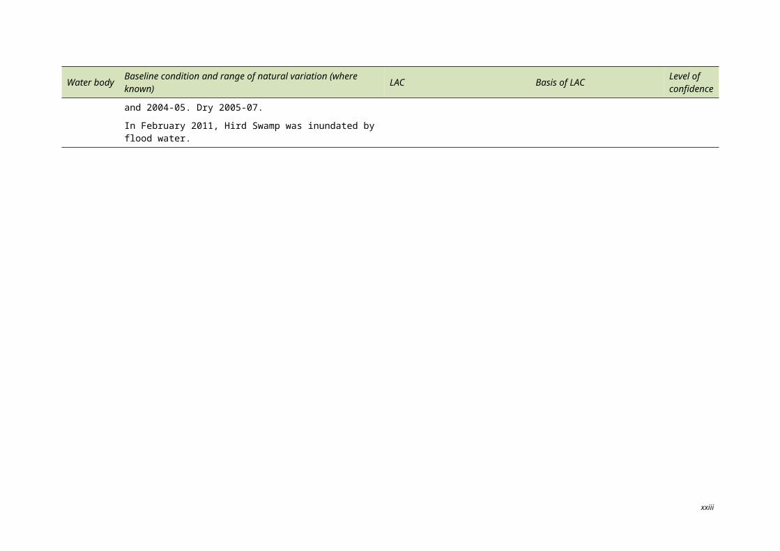
Number of years in which the swamp filled over the benchmark period (1980–2003) – six years between 1991 and 2003. Maximum number of years over the benchmark period that the swamp remained continuously dry – four years between 1991 and 2003 (1998 to 2002).
Isolated from natural water source due to the modifications of Pyramid Creek in 1967. Sporadic wet periods over the last 10 years. Environmental water allocation 1991-92. Flow flood 1999-94. Wet to dry environmental water allocation 1995-96, 1997-98, 2002-03, 2003-04 and 2004-05. Dry 2005-07.
In February 2011, Hird Swamp was inundated by flood water.
Not dry for five or more consecutive years. Not wet for two or more consecutive years.
Based on expert opinion of project steering committee. Low
xx
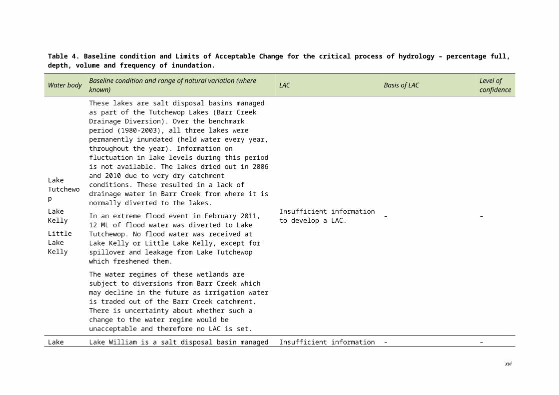
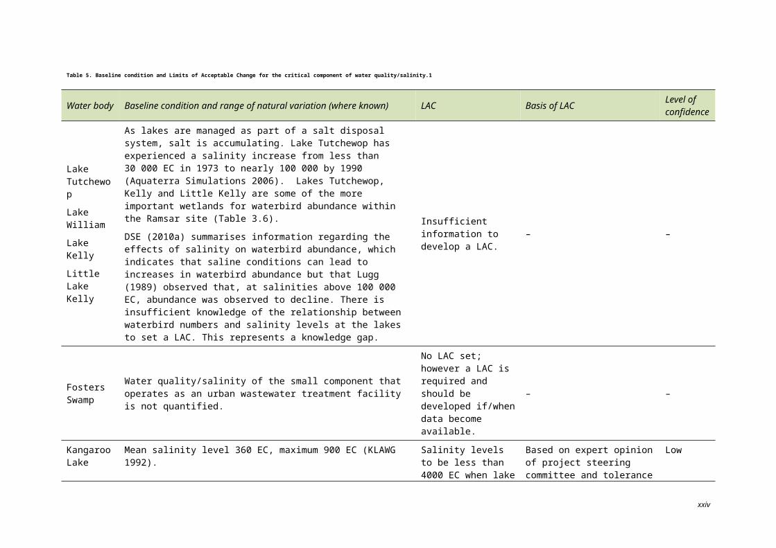
Table 5. Baseline condition and Limits of Acceptable Change for the critical component of water quality/salinity.1
Water body Baseline condition and range of natural variation (where known) LAC Basis of LAC Level of confidence
Lake Tutchewop
Lake William
Lake Kelly
Little Lake Kelly
As lakes are managed as part of a salt disposal system, salt is accumulating. Lake Tutchewop has experienced a salinity increase from less than 30 000 EC in 1973 to nearly 100 000 by 1990 (Aquaterra Simulations 2006). Lakes Tutchewop, Kelly and Little Kelly are some of the more important wetlands for waterbird abundance within the Ramsar site (Table 3.6).
DSE (2010a) summarises information regarding the effects of salinity on waterbird abundance, which indicates that saline conditions can lead to increases in waterbird abundance but that Lugg (1989) observed that, at salinities above 100 000 EC, abundance was observed to decline. There is insufficient knowledge of the relationship between waterbird numbers and salinity levels at the lakes to set a LAC. This represents a knowledge gap.
Insufficient information to develop a LAC. – –
Fosters Swamp
Water quality/salinity of the small component that operates as an urban wastewater treatment facility is not quantified.
No LAC set; however a LAC is required and should be developed if/when data become available.
– –
Kangaroo Lake Mean salinity level 360 EC, maximum 900 EC (KLAWG 1992).
Salinity levels to be less than 4000 EC when lake is more than 75% full.
Based on expert opinion of project steering committee and tolerance levels of biota to salinity cited in PPK Environment and Infrastructure (2000).
Low
Racecourse Lake Mean salinity level 360 EC, maximum 1750 EC (KLAWG 1992).
Salinity levels to be less than 4000 EC when lake is more than 75% full.
Based on expert opinion of project steering committee and tolerance levels of biota to salinity cited in PPK Environment and Infrastructure (2000).
Low
Lake Charm
Mean salinity level 3300 EC, maximum 4300 EC (KLAWG 1992). Lake to be used as irrigation supply storage in the near future. Under this scenario, historic 3000 EC to 4000 EC levels are anticipated to decline. It is uncertain whether fresher conditions would adversely change the ecological character of the site.
Insufficient information to develop a LAC. – –
xxi
Water body Baseline condition and range of natural variation (where known) LAC Basis of LAC Level of confidence
Little Lake Charm Mean salinity level 200 EC, maximum 600 EC (Lugg et al. 1989).
Salinity levels to be less than 4000 EC when lake is more than 75% full.
Based on expert opinion of project steering committee and tolerance levels of biota to salinity, cited in PPK Environment and Infrastructure (2000).
Low
Reedy Lake Mean salinity level is 420 EC; maximum is 1600 EC (KLAWG 1992).Salinity levels to be less than 4000 EC when lake is more than 75% full.
Based on expert opinion of project steering committee and tolerance levels of biota to salinity cited in PPK Environment and Infrastructure (2000).
Low
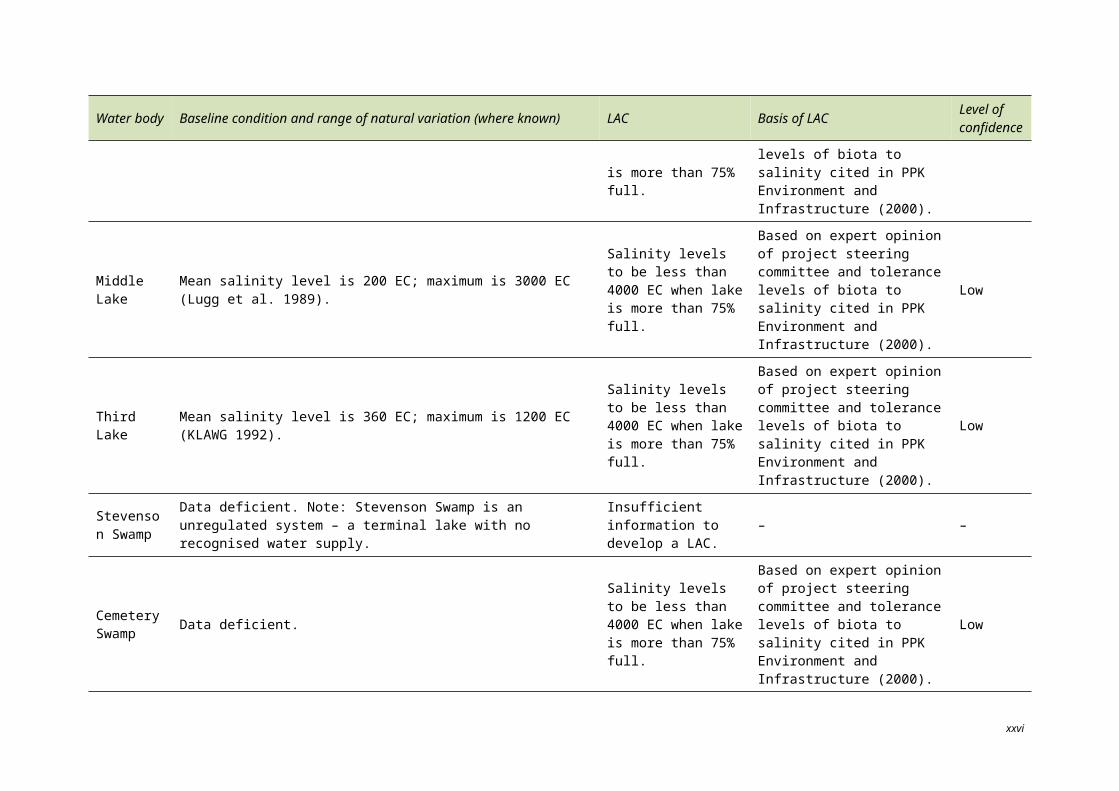
Middle Lake Mean salinity level is 200 EC; maximum is 3000 EC (Lugg et al. 1989).Salinity levels to be less than 4000 EC when lake is more than 75% full.
Based on expert opinion of project steering committee and tolerance levels of biota to salinity cited in PPK Environment and Infrastructure (2000).
Low
Third Lake Mean salinity level is 360 EC; maximum is 1200 EC (KLAWG 1992).Salinity levels to be less than 4000 EC when lake is more than 75% full.
Based on expert opinion of project steering committee and tolerance levels of biota to salinity cited in PPK Environment and Infrastructure (2000).
Low
Stevenson Swamp
Data deficient. Note: Stevenson Swamp is an unregulated system – a terminal lake with no recognised water supply.
Insufficient information to develop a LAC. – –
Cemetery Swamp Data deficient.
Salinity levels to be less than 4000 EC when lake is more than 75% full.
Based on expert opinion of project steering committee and tolerance levels of biota to salinity cited in PPK Environment and Infrastructure (2000).
Low
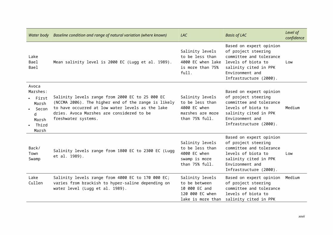
Lake Bael Bael Mean salinity level is 2000 EC (Lugg et al. 1989).
Salinity levels to be less than 4000 EC when lake is more than 75% full.
Based on expert opinion of project steering committee and tolerance levels of biota to salinity cited in PPK Environment and Infrastructure (2000).
Low
xxii
Water body Baseline condition and range of natural variation (where known) LAC Basis of LAC Level of confidence
Avoca Marshes: First
Marsh Second
Marsh Third
Marsh
Salinity levels range from 2000 EC to 25 000 EC (NCCMA 2006). The higher end of the range is likely to have occurred at low water levels as the lake dries. Avoca Marshes are considered to be freshwater systems.
Salinity levels to be less than 4000 EC when marshes are more than 75% full.
Based on expert opinion of project steering committee and tolerance levels of biota to salinity cited in PPK Environment and Infrastructure (2000).
Medium
Back/Town Swamp Salinity levels range from 1800 EC to 2300 EC (Lugg et al. 1989).
Salinity levels to be less than 4000 EC when swamp is more than 75% full.
Based on expert opinion of project steering committee and tolerance levels of biota to salinity cited in PPK Environment and Infrastructure (2000).
Low
Lake Cullen Salinity levels range from 4000 EC to 170 000 EC; varies from brackish to hyper-saline depending on water level (Lugg et al. 1989).
Salinity levels to be between 10 000 EC and 120 000 EC when lake is more than 75% full.
Based on expert opinion of project steering committee and tolerance levels of biota to salinity cited in PPK Environment and Infrastructure (2000).
Medium
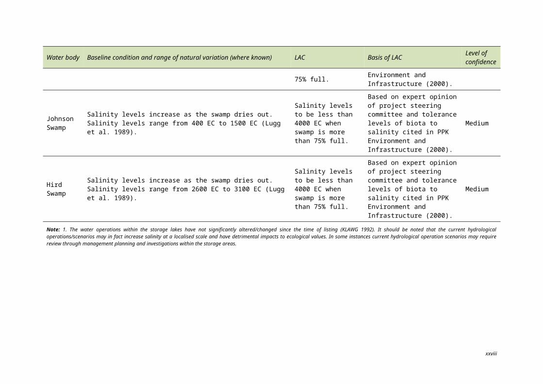
Johnson Swamp
Salinity levels increase as the swamp dries out. Salinity levels range from 400 EC to 1500 EC (Lugg et al. 1989).
Salinity levels to be less than 4000 EC when swamp is more than 75% full.
Based on expert opinion of project steering committee and tolerance levels of biota to salinity cited in PPK Environment and Infrastructure (2000).
Medium
Hird Swamp Salinity levels increase as the swamp dries out. Salinity levels range from 2600 EC to 3100 EC (Lugg et al. 1989).
Salinity levels to be less than 4000 EC when swamp is more than 75% full.
Based on expert opinion of project steering committee and tolerance levels of biota to salinity cited in PPK Environment and Infrastructure (2000).
Medium
Note: 1. The water operations within the storage lakes have not significantly altered/changed since the time of listing (KLAWG 1992). It should be noted that the current hydrological operations/scenarios may in fact increase salinity at a localised scale and have detrimental impacts to ecological values. In some instances current hydrological operation scenarios may require review through management planning and investigations within the storage areas.
xxiii
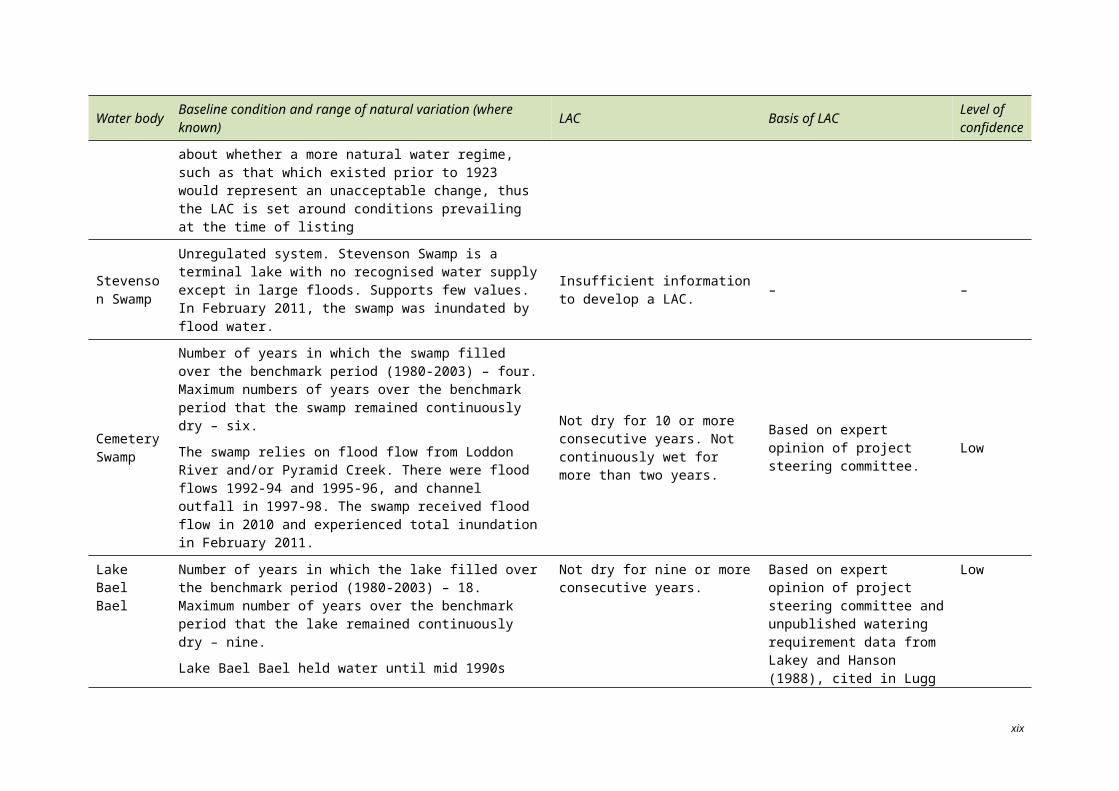
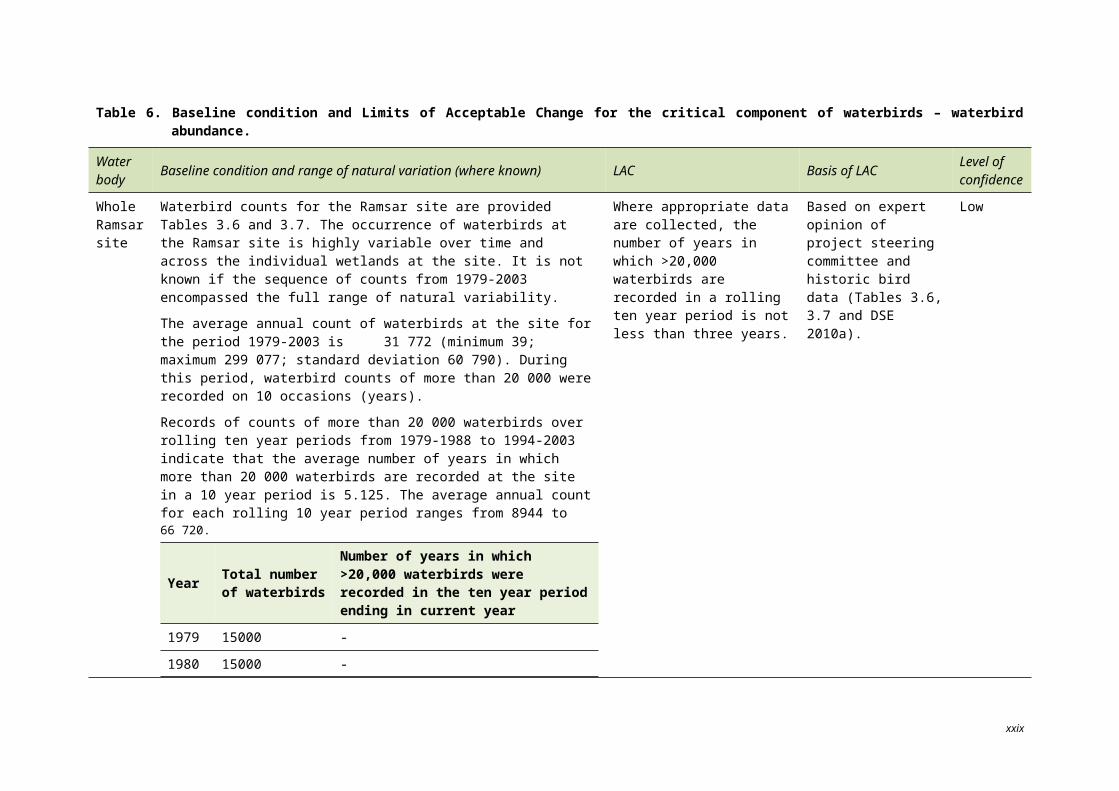
Table 6. Baseline condition and Limits of Acceptable Change for the critical component of waterbirds – waterbird abundance.
Water body Baseline condition and range of natural variation (where known) LAC Basis of LAC Level of
confidence
Whole Ramsar site
Waterbird counts for the Ramsar site are provided Tables 3.6 and 3.7. The occurrence of waterbirds at the Ramsar site is highly variable over time and across the individual wetlands at the site. It is not known if the sequence of counts from 1979-2003 encompassed the full range of natural variability.
The average annual count of waterbirds at the site for the period 1979-2003 is 31 772 (minimum 39; maximum 299 077; standard deviation 60 790). During this period, waterbird counts of more than 20 000 were recorded on 10 occasions (years).
Records of counts of more than 20 000 waterbirds over rolling ten year periods from 1979-1988 to 1994-2003 indicate that the average number of years in which more than 20 000 waterbirds are recorded at the site in a 10 year period is 5.125. The average annual count for each rolling 10 year period ranges from 8944 to 66 720.
Year Total number of waterbirds
Number of years in which >20,000 waterbirds were recorded in the ten year period ending in current year
1979 15000 -
1980 15000 -
1981 3383 -
1982 11416 -
1983 7207 -
1984 2209 -
1985 25496 -
1986 39 -
1987 299077 -
1988 45328 3
Where appropriate data are collected, the number of years in which >20,000 waterbirds are recorded in a rolling ten year period is not less than three years.
Based on expert opinion of project steering committee and historic bird data (Tables 3.6, 3.7 and DSE 2010a).
Low
xxiv
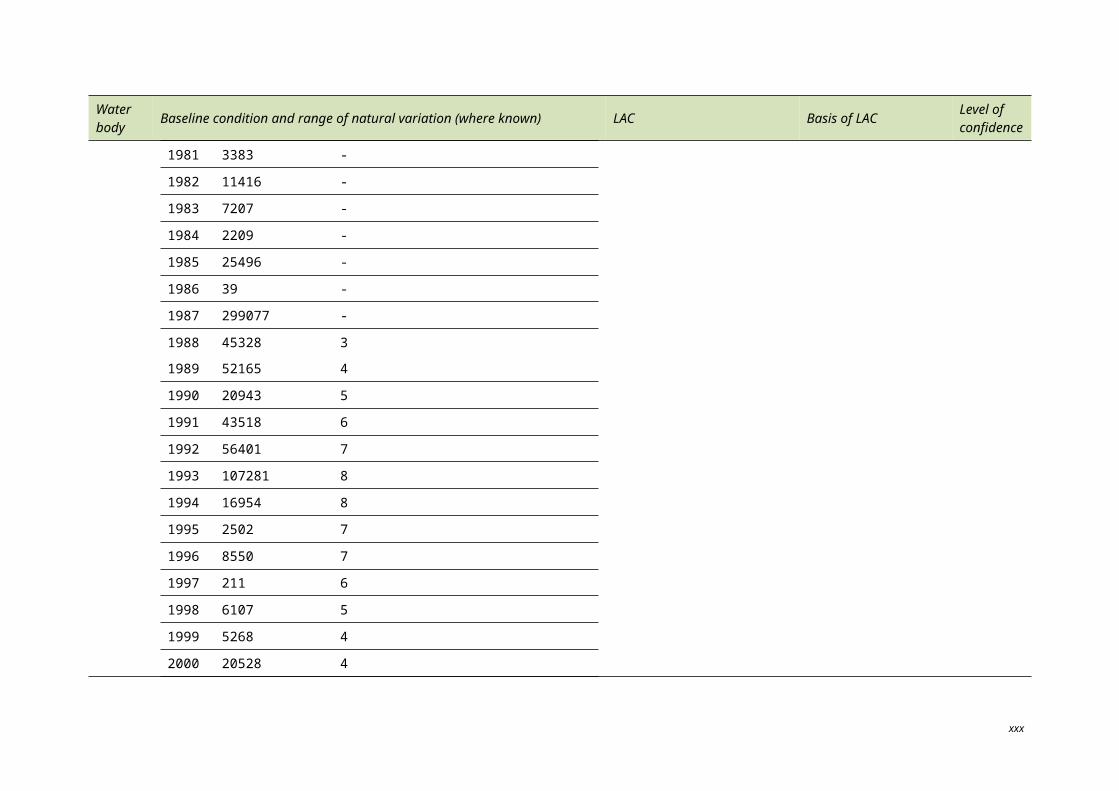
Water body Baseline condition and range of natural variation (where known) LAC Basis of LAC Level of
confidence
1989 52165 4
1990 20943 5
1991 43518 6
1992 56401 7
1993 107281 8
1994 16954 8
1995 2502 7
1996 8550 7
1997 211 6
1998 6107 5
1999 5268 4
2000 20528 4
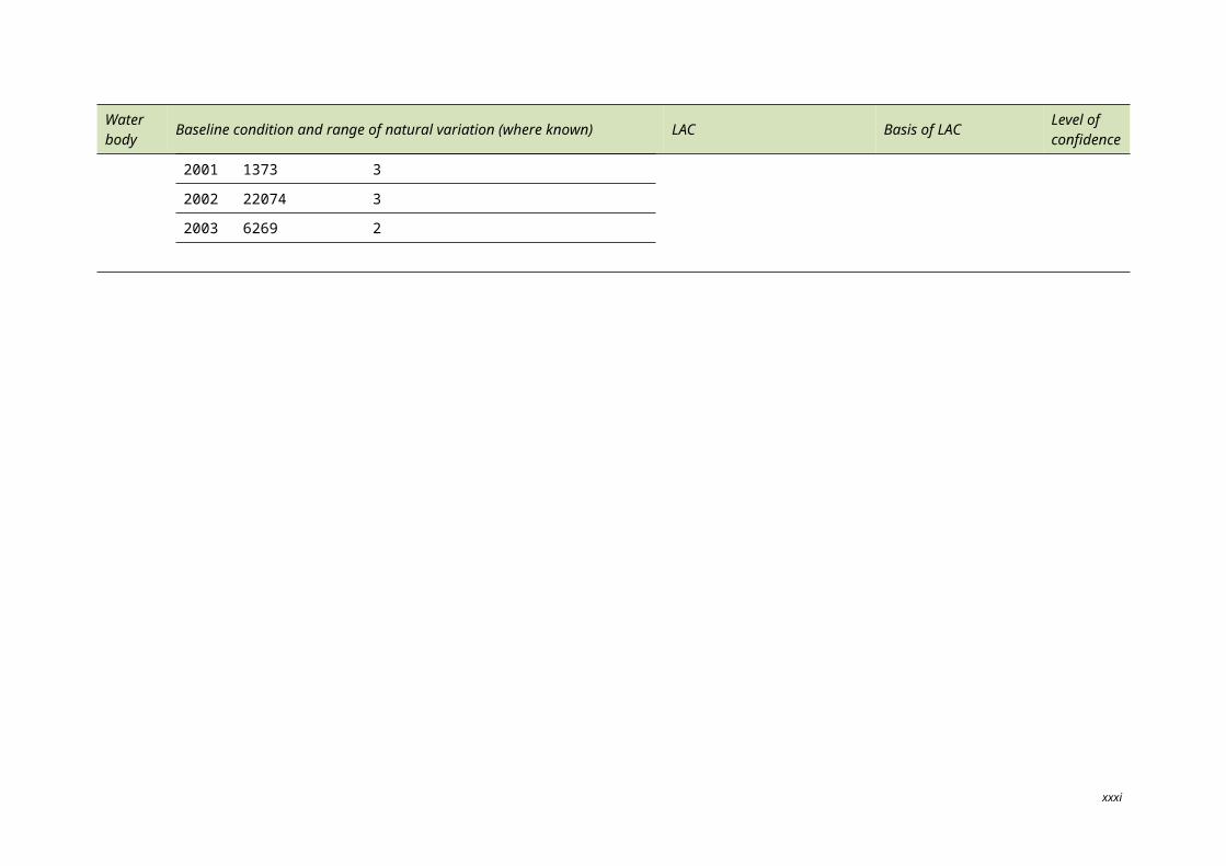
2001 1373 3
2002 22074 3
2003 6269 2
xxv
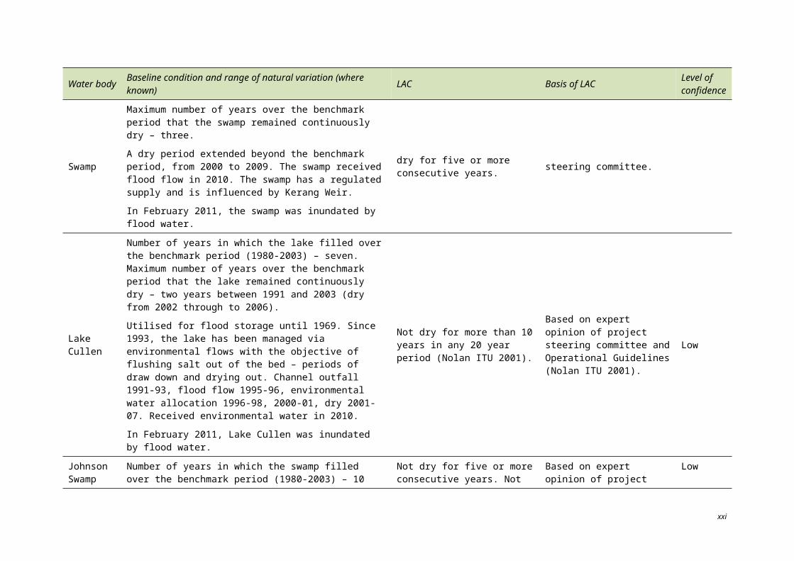
Table 7. Baseline condition and Limits of Acceptable Change for the critical component of waterbirds – colonial breeding/nesting waterbirds (ibis, darters, cormorants, spoonbills).
Water body
Baseline condition and range of natural variation (where known) LAC Basis of LAC Level of
confidence
Whole Ramsar site
Range of variability is unknown.
Median number of colonial nesting waterbird species that bred between 1980 and 2003 – three.
Maximum period (consecutive years) in which no colonial nesting waterbird species were recorded breeding – two years.
Number of colonial nesting waterbird species breeding between 1980 to 2003 across the site:
Year No. of species Year No. of species
1980 1 1993 12
1981 8 1994 0
1982 2 1995 0
1983 0 1996 4
1984 10 1997 1
1985 11 1998 2
1986 2 1999 2
1987 11 2000 1
1988 8 2001 4
1989 8 2002 0
1990 3 2003 2
1991 3 2004 0
1992 1 2005 3
Insufficient information to develop a LAC for the entire Ramsar site.
– –
xxvi
Water body
Baseline condition and range of natural variation (where known) LAC Basis of LAC Level of
confidence
Reedy Lake
Maximum period (consecutive years) in which no colonial nesting waterbird species were recorded breeding – 16 years.
Years of colonial nesting waterbird breeding events from 1980 to 2003 by species:
Australian white ibis: 1996, 2001
royal spoonbill: 1996, 2001
yellow spoonbill: 1996
Insufficient information to develop a LAC. – –
Middle Lake
Maximum period (consecutive years) in which no colonial nesting waterbird species were recorded breeding – five years.
Years of colonial nesting waterbird breeding events by species:
Australian white ibis: 1985, 1988, 1993, 1998, 2001, 2003, 2005
straw-necked ibis: 1985, 1988, 1991, 1993, 2003, 2005
royal spoonbill: 1985, 1988, 2001
yellow spoonbill: 1987, 1991
Ten per cent of the regional breeding population of straw-necked ibis and Australian white ibis and more than 5% of the Victorian breeding population of royal spoonbill have been recorded within the Ramsar site (DSE 2010a).
No more than 10 consecutive years in which there is no breeding of Australian white ibis and straw-necked ibis.
Insufficient information to develop a LAC for royal spoonbill or yellow spoonbill.
Based on expert opinion of project steering committee, on the assumption that the data obtained over the recorded 24 year period accurately reflect breeding events and are representative of natural variability (Table 3.11 in Section 3, DSE 2010a).
Low
Hird swamp
Maximum period (consecutive years) where no colonial nesting waterbird species were recorded breeding – 10 years.
Years of colonial nesting waterbird breeding events by species:
Australian white ibis 1988, 1989, 1993
Insufficient information to develop a LAC.
– –
xxvii
Water body
Baseline condition and range of natural variation (where known) LAC Basis of LAC Level of
confidence
straw-necked ibis 1988, 1993
Avoca marshes
Maximum period (consecutive years) where no colonial nesting waterbird species were recorded breeding – 10 years (1993-2003).
Years of colonial nesting waterbird breeding events by species:
royal spoonbill: 1981, 1982, 1986, 1987 (Third Marsh)
darter: 1985 (First Marsh); 1981, 1984, 1989, 1990, 1993, 1997 (Second Marsh); 1984, 1987, 1993 (Third Marsh)
great cormorant: 1985, 1989, 1993 (First Marsh); 1993 (Second Marsh); 1993 (Third Marsh)
pied cormorant: 1985, 1989, 1990 (Second Marsh); 1984, 1993 (Third Marsh)
yellow spoonbill: 1989, 1990 (Second Marsh); 1981, 1982, 1984, 1985, 1986, 1987, 1993 (Third Marsh)
No more than 10 consecutive years in which there is no breeding of royal spoonbill, darter, great cormorant, pied cormorant and yellow spoonbill.
Based on expert opinion of project steering committee, on the assumption that the data obtained over the recorded 24 year period accurately records breeding events and is representative of natural variability (Table 3.11 in Section 3, DSE 2010a).
Low
xxviii
A number of knowledge gaps pertaining to the critical ecosystem components and processes have been identified (Table 8), in particular water regime records and quantitative information on salinity. It is acknowledged that many of the knowledge gaps from 1982 cannot be resolved and additional investigations and monitoring of elements within the Ramsar site are likely to be required (Table 9).
Table 8. Summary of knowledge gaps identified in preparing the ECD.
Component / process Identified knowledge gap
Hydrology Understanding water regimes to sustain wetland health and values.
Water quality – salinityQuantitative information on salinity within the site in 1982.
Quantitative information on salinity within the site is inconsistent.
Waterbirds
Relationships between waterbird numbers in relation to habitat availability, salinity and hydrology.
Habitat use as a function of hydrology and vegetation.
Breeding success rate.
Fauna – fish Native fish distribution and abundance.
Habitat – ecological vegetation classes
Flora
Vegetation community distribution and condition information.
Increased resolution of vegetation mapping.
There are five flora species listed under the EPBC Act which may occur at the Ramsar site. However, available scientific reports and survey data present conflicting information as to whether these species are ‘known to occur’ or ‘likely to occur’.
xxiii
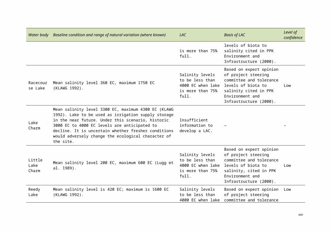
Table 9. Summary of identified monitoring requirements.
Ecosystem element Objective of monitoring Indicator / measure Suggested frequency of
reporting
Hydrology
Ongoing condition and detection of change.
Establish relationship between hydrology, salinity and waterbird use.
Determine hydrology required to maintain significant vegetation communities and wetland types.
Efficiency of water delivery of EWA and irrigation system.
Surface water/ groundwater interaction.
Monitor efficiency every five years or following modifications.
Monitor surface water/ groundwater quarterly or in conjunction with monthly water quality monitoring.
Water quality – salinity
Ongoing condition and detection of change.
Establish relationship between hydrology, salinity and waterbird use.
Salinity
Continue monthly monitoring by DPI and G-MW.
Report on trends every5–10 years.
Threatened species
Establish baseline, detection of change and ongoing condition.
Abundance
Condition
Distribution
Monitor threatened fauna species annually (coordinate with annual and national counts as applicable).
Monitor threatened flora species.
Report annually.
Flora Detect change and ongoing condition.
Distribution
Health
Habitat availability (i.e. habitat mapping)
Continue current monitoring through Biodiversity Action Plans.
Use the wetland index of condition to monitor threatened vegetation communities (assuming accurate mapping is available) every 10 years.
Waterbirds – internationally/ nationally listed
Detect change and ongoing health.
Establish relationship between hydrology, salinity and waterbird use.
Establish ‘regularity’ of supporting 1% of populations.
Abundance
Diversity
Habitat use
Monitor waterbird species annually (as part of summer waterfowl counts) for priority sites; every five years or following flooding for lower priority sites.
Confirm 1% population thresholds with updated information from Wetlands International.
Waterbirds – colonially nesting
Detect change and ongoing health
Establish relationship between breeding, hydrology, vegetation condition and salinity
Abundance
Diversity
Habitat use
Success
Monitor breeding sites annually.
Habitat – ecological vegetation classes
Establish limits, detection of change and ongoing condition.
Distribution
Health
Habitat availability
Every 10 years for lignum communities.
Every 20 years for woodland communities.
xxiv
(i.e. habitat mapping)
xxv
1. Introduction
1.1 STATEMENT OF PURPOSE
The Kerang Wetlands were listed as a Ramsar site under the Convention on Wetlands of International Importance Especially as Waterfowl Habitat (known as the Ramsar Convention) in December 1982.
As a Contracting Party to the Ramsar Convention, Australia is responsible for managing the Ramsar sites within its territory. This responsibility includes maintaining the ecological character of those Ramsar sites, remaining informed of any changes to the ecological character of Ramsar sites and notifying the Ramsar Secretariat of any changes to ecological character at the earliest opportunity (DEWHA 2008). In order to assess changes in the ecological character of a Ramsar wetland, a documented assessment of baseline conditions (i.e. the character of the wetland at the time of listing) is required (DEWHA 2008).
The primary purpose of this Ecological Character Description (ECD) is to provide the baseline description of the ecological character of the Kerang Wetlands Ramsar site at the time of its listing on 15 December 1982, using the National Framework and Guidance for Describing the Ecological Character of Australian Ramsar Wetlands (the National Framework) (DEWHA 2008).
In line with the National Framework, the statement of purpose for this ECD is:
1. To assist in implementing Australia’s obligations under the Ramsar Convention, as stated in Schedule 6 (Managing wetlands of international importance) of the Environment Protection and Biodiversity Conservation Regulations 2000 (Commonwealth):
a) to describe and maintain the ecological character of declared Ramsar wetlands in Australia; and
b) to formulate and implement planning that promotes:
i) conservation of the wetland; and
ii) wise and sustainable use of the wetland for the benefit of humanity in a way that is compatible with maintenance of the natural properties of the ecosystem.
2. To assist in fulfilling Australia’s obligation under the Ramsar Convention, to arrange to be informed at the earliest possible time if the ecological character of any wetland in its territory and included in the Ramsar List has changed, is changing or is likely to change as the result of technological developments, pollution or other human interference.
3. To supplement the description of the ecological character contained in the Ramsar Information Sheet submitted under the Ramsar Convention for each listed wetland and, collectively, to form an official record of the ecological character of the site.
4. To assist the administration of the EPBC Act, particularly:
a) to determine whether an action has, will have or is likely to have a significant impact on a declared Ramsar wetland in contravention of Sections 16 and 17B of the EPBC Act, or
b) to assess the impacts that actions referred to the Minister under Part 7 of the EPBC Act have had, will have or are likely to have on a declared Ramsar wetland.
1
5. To assist any person considering taking an action that may impact on a declared Ramsar wetland in deciding whether to refer the action to the Minister under Part 7 of the EPBC Act for assessment and approval.
6. To inform members of the public who are interested generally in declared Ramsar wetlands to understand and value those wetlands.
1.2 PREPARING THE ECOLOGICAL CHARACTER DESCRIPTION
The method used to develop the ECD for the Kerang Wetlands Ramsar site follows the 12 step approach outlined in the National Framework:
1. Introduce the ECD
2. Describe the site
3. Identify and describe the critical components, processes, benefits and services
4. Develop a conceptual model of the wetland
5. Set limits of acceptable change (LAC)
6. Identify threats to the ecological character of the site
7. Describe changes to the ecological character
8. Summarise knowledge gaps
9. Identify site monitoring needs
10. Identify communication and education messages
11. Compile the description of the ecological character
12. Prepare or update the Ramsar Information Sheet.
This ECD was compiled primarily through a desktop review of existing investigative data, historic database information and reports.
This ECD reports retrospectively on the character of the site at the time of listing in 1982. Key data sources include past ECDs of the site, in particular DSE 2010a (drafted in 2006). Although retrospective, a pragmatic approach has been adopted and recent data (where available) have been included and referenced appropriately. Where quantitative information is not available for 1982 and other data has been used, this is explicitly stated.
This ECD has been technically reviewed by a project steering committee and an independent reviewer commissioned by DSEWPaC.
2
1.3 RELEVANT TREATIES, LEGISLATION OR REGULATIONS
This section provides a list of legislation or treaties that are relevant to the site and/or to species or communities that are present at the site.
1.3.1 InternationalRamsar convention
The Convention on Wetlands of International Importance, Especially as Waterfowl Habitat, otherwise known as the Ramsar Convention, came into being in Ramsar, Iran on 2 February 1971. It was signed by Australia in May 1974. The Convention provides the framework for local, regional and national actions, and international cooperation, for the conservation and wise use of wetlands. Wetlands of International Importance (Ramsar sites) are selected on the basis of their international significance in terms of ecology, botany, zoology, limnology and or hydrology.
Bilateral agreements and conventions for migratory species
Australia is a signatory to a number of bilateral agreements, initiatives and conventions for the conservation of migratory birds which are relevant to the Kerang Wetlands Ramsar site. These include:
Japan–Australia Migratory Bird Agreement (JAMBA): the Agreement between the Government of Australia and the Government of Japan for the Protection of Migratory Birds in Danger of Extinction and their Environment, 1974;
China–Australia Migratory Bird Agreement (CAMBA): the Agreement between the Government of Australia and the Government of the People’s Republic of China for the Protection of Migratory Birds and their Environment, 1986;
Republic of Korea–Australia Migratory Bird Agreement (ROKAMBA): the Agreement between the Government of Australia and the Republic of Korea for the Protection of Migratory Birds and their Environment, 2006; and
Convention on the Conservation of Migratory Species of Wild Animals (known as CMS or Bonn Convention): adopts a framework in which countries with jurisdiction over any part of the range of a particular species cooperate to prevent migratory species becoming endangered. For Australian purposes, many of the species are migratory birds.
1.3.2 National legislationEnvironment Protection and Biodiversity Conservation Act 1999 (EPBC Act)
The EPBC Act provides a framework to facilitate the protection and management of nationally and internationally important flora, fauna, ecological communities and places of heritage (matters of national environmental significance) (DEWHA 2009). Nine matters of national environmental significance have been identified under the Act and include Ramsar wetlands and listed migratory species. Actions that will or are likely to have a significant impact on a matter of national environmental significance, including Ramsar wetlands, are subject to environmental assessment and approval under the Act. Actions, as defined by the Act, may be a project, a development, an undertaking, an activity or a series of activities, or an alteration of any of these (DEWHA 2009).
3
Environment Protection and Biodiversity Conservation Regulations 2000 (EPBC Regulations)
The Australian Ramsar Management Principles are identified in Schedule 6 of the EPBC Regulations. These principles provide a framework for the management of Ramsar wetlands within Australia in a way that is consistent with Australia’s obligations under the Ramsar Convention (DEWHA 2009).
Water Act 2007 and Water Amendment Act 2008
The Water Act 2007 establishes the Murray-Darling Basin Authority (MDBA) with the functions and powers, including enforcement powers, needed to ensure that MDB water resources are managed in an integrated and sustainable way. The Act requires the MDBA to prepare the Basin Plan and establishes a Commonwealth Environmental Water Holder to manage the Commonwealth’s environmental water to protect and restore the environmental assets of the Murray-Darling Basin, and outside the Basin where the Commonwealth owns water.
The Water Amendment Act 2008 amends the Water Act 2007 to transfer functions and powers from the Murray-Darling Basin Commission to the MDBA.
1.3.3 Victorian policy and legislationVictorian Water Act 1989
The Victorian Water Act 1989 provides the framework for allocating surface water and groundwater throughout Victoria. The Act details the Crown’s entitlements to water and private entitlements to water from all rivers, streams and groundwater systems in Victoria.
The main provisions of the Act relate specifically to private consumptive rights, meeting the needs of the environment and other purposes such as provision for the integrated management of all elements of the terrestrial phase of the water cycle, and to eliminate inconsistencies in the treatment of surface and ground water resources and waterways.
Environment Protection Act 1970
The Environment Protection Act 1970 provides a regulatory framework for protection of environmental assets, particularly water quality.
Wildlife Act 1975
The Wildlife Act 1975 provides for the protection of native wildlife and habitat.
Environmental Effects Act 1978
The Environmental Effects Act 1978 allows for the development of environmental effects statements in order to assess the potential impacts of proposed developments.
Crown Land (Reserves) Act 1978
Under the Crown Land (Reserves) Act 1978, land is reserved for a variety of public uses, managed either by the DEPI or another land manager on their behalf, for example, Parks Victoria, or as a Committee of Management.
4
Planning and Environment Act 1987
The Planning and Environment Act 1987 establishes objectives for planning in Victoria and outlines the planning process and requirements for planning schemes. Of particular relevance, the Act provides for the assessment of proposals to disturb or remove native vegetation.
Flora and Fauna Guarantee Act 1988
The Flora and Fauna Guarantee Act 1988 (FFG Act) is Victoria’s key piece of legislation promoting the conservation of threatened species and communities and for the management of potentially threatening processes (DSE 2009a).
Catchment and Land Protection Act 1994
The Catchment and Land Protection Act 1994 provides for an integrated catchment management framework and facilitates the wise management of land and water resources in a whole of catchment framework. Catchment management authorities (CMAs) are established under this Act to develop and implement a regional catchment strategy, which sets out how the catchments in a region are to be managed. It identifies objectives for the quality of the land and water resources of the catchments in the region and sets a program of measures to promote improved use of land and water resources and to treat land degradation.
Fisheries Act 1995
The Fisheries Act 1995 provides for the regulation, management, and conservation of fisheries and aquatic habitats, together with the reform of law relating to fisheries.
Heritage Act 1995
The Heritage Act 1995 provides for the protection and conservation of places and objects of cultural heritage significance and the registration of such places and objects on the Victorian Heritage Register. The Act serves to protect all categories of historic cultural heritage relating to the non-Aboriginal settlement of Victoria, including historic buildings, shipwrecks and archaeological sites. It is an offence to excavate, damage or disturb relics and sites without a permit or unless consent has been issued under Section 129 of the Act.
Parks Victoria Act 1998
The Parks Victoria Act 1998 enables Parks Victoria to provide, on behalf of the Secretary of DSE, management services for the parks.
Aboriginal Heritage Act 2006
All Aboriginal places, objects and human remains are protected under the Victorian Aboriginal Heritage Act 2006. This Act replaces the former Victorian Archaeological and Aboriginal Relics Preservation Act 1972 and Part IIA of the Federal Aboriginal and Torres Strait Islander Heritage Protection Act 1984.
Victoria’s Biodiversity Strategy 1997
Victoria’s Biodiversity Strategy 1997 provides guidance and fulfils commitments outlined in the national Strategy for the Conservation of Biodiversity and requirements under the FFG Act.
5

The Victorian River Health Strategy 2002
The Victorian River Health Strategy (VRHS) details the government’s long-term direction for the management of Victoria’s rivers (DNRE 2002a). The VRHS provides a clear vision and policy direction for the management of rivers in Victoria. The VRHS also provides a decision making framework for regional communities.
Victoria’s Native Vegetation Management: A Framework for Action 2002
Victoria’s Native Vegetation Management: A Framework for Action (DNRE 2002b) provides a strategy for the protection and enhancement of Victoria’s native vegetation. The strategy endeavours to achieve a net gain in native vegetation across Victoria.
The Indigenous Partnership Framework 2007–2010
DSE’s Indigenous Partnership Framework is an over-arching Indigenous policy that provides direction for all departmental Indigenous partnering initiatives (DSE 2007). This forms the foundation upon which the department’s business areas and activities align with their commitment to:
work inclusively with Victoria’s native title holders, traditional owners and Indigenous people in Victoria; and
ensure traditional owners and Indigenous people in Victoria have a real say in the future management (DSE 2007) of Victoria’s biodiversity, water and land (DSE 2007).
1.3.4 Local policyKerang Wetlands Ramsar Site Strategic Management Plan 2004
The strategic management plan applies management objectives and state-wide management strategies, promoting a range of specific management actions that will maintain, and in some cases restore the ecological character of the Ramsar site (DSE 2004).
In addition, there are a number of other local plans and strategies which direct aspects of management relating to the Ramsar site, such as local planning schemes and environmental watering plans.
6
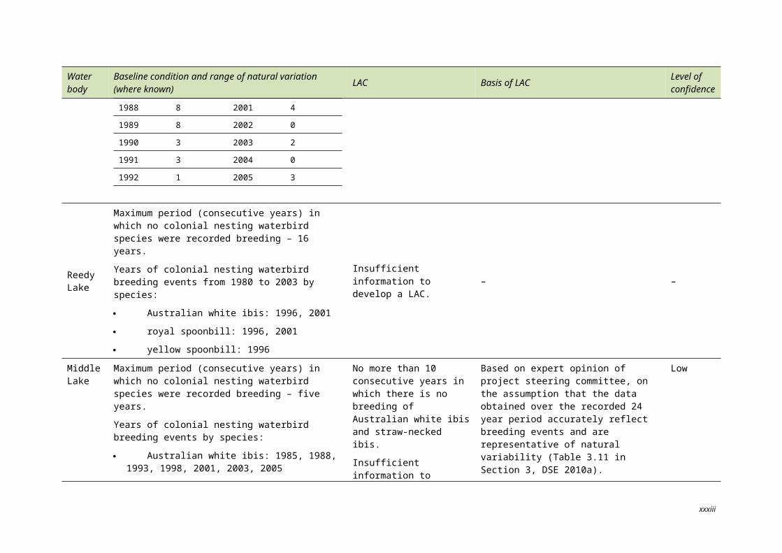
2 General description of the Kerang Wetlands Ram-sar Site
2.1 SITE DETAILS
The Ramsar site covers an area of 9419 ha and is located approximately 300 km northwest of Melbourne. The Ramsar site consists of 23 named marshes, lakes and swamps that range from freshwater to hypersaline. The Ramsar site is part of an extensive wetland system of approximately 120 wetlands of variable type, size, values and uses (Figure 2.1). In addition to the 23 wetlands within the Ramsar site boundary, a further 25 wetlands within the system are listed in A Directory of Important Wetlands in Australia (DIWA) and a further six wetlands are listed on the Register of National Estate.
The Ramsar site contains black box, river red gum and tangled lignum vegetation communities and contains important feeding and nesting habitat for a diverse array of native waterbird species (DSE 2010a). As well as its importance for waterbirds, the Ramsar site provides important habitat for indigenous flora and and other native fauna species in a relatively cleared, modified environment. Contextually within the landscape, the Ramsar site is within a rural agricultural region of cattle and sheep grazing, irrigated crops and pasture, vineyards and orchards (Figure 2.2).
The Ramsar site is also significant economically, culturally, spiritually and for recreation.
Key details for the Ramsar site are outlined in Table 2.1.
7
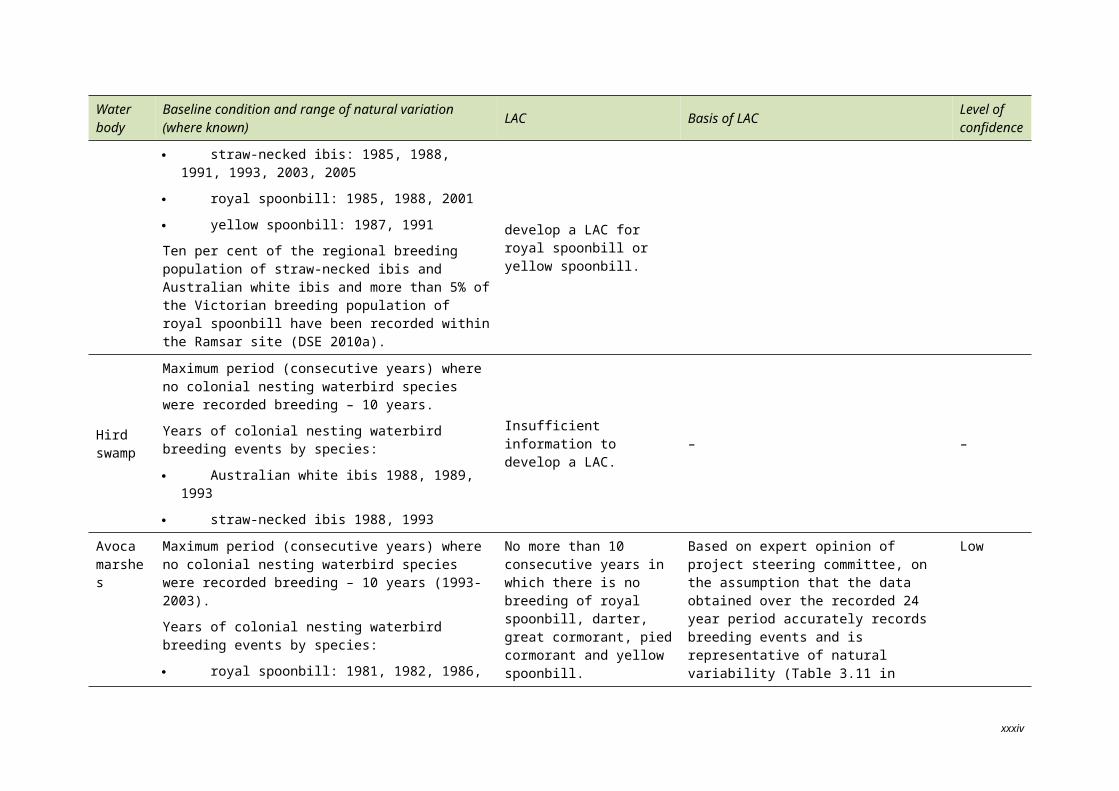
Figure 2.1. Location of the Kerang Wetlands Ramsar site (© Copyright Kellogg, Brown & Root Pty Ltd).
8
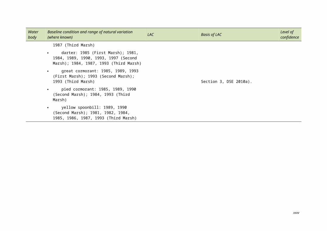
Figure 2.2. Aerial image showing the landscape setting of the Kerang Wetlands Ramsar site (© Copyright Kellogg, Brown & Root Pty Ltd).
9
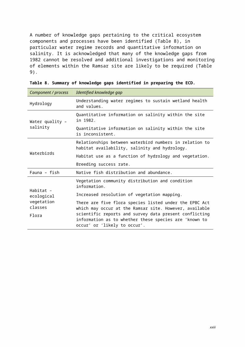
Table 2.1. Site details for the Kerang Wetlands Ramsar site.
Site descriptor Details
Name Kerang Wetlands Ramsar site
Location in coordinates Latitude: (approximately) 35 30’ to 35 50’S Longitude: (approximately) 143 42’ to 144 10’E
General locationThe Kerang Wetlands Ramsar site is located 300 km north of Melbourne within the lower reaches of the Avoca and Loddon Rivers and Pyramid Creek, near Kerang in northern Victoria.
Area 9419 ha
Date of Ramsar designation 15 December 1982
Ramsar criteria met
Original listing criteria from 1982:
1(a): it regularly supports 10 000 ducks, geese and swans; or 10 000 coots or 20 000 waders;
1(b): it regularly supports 1% of the individuals in a population of one species or subspecies of waterfowl;
2(b): it is of special value for maintaining the genetic and ecological diversity of a region because of the quality and peculiarities of its flora and fauna; and
3: it is a particularly good example of a specific type of wetland characteristic of its region.
The criteria have been updated since listing (Table 2.4). The site meets current (2005) Criteria 1, 2, 3, 4, 5 and 6.
Management authorities Parks Victoria, Goulburn-Murray Water, Victorian Department of Sustainability and Environment, the Shire of Gannawarra and Lower Murray Water.
Date the ecological character description applies
This description applies to the Ramsar site at the time of listing in1982.
Status of descriptionThe first ECD (drafted 2006) was compiled by Pam Clunie (DSE 2010a).
This description was prepared using the methods outlined in the National Framework (DEWHA 2008) and updates DSE (2010a).
Name(s) of compilerKBR, Level 3, 441 St Kilda Road, Melbourne, Victoria 3004
On behalf of DSEWPaC.
Date of completion May 2011
Reference for Ramsar Information Sheet (RIS) Parks Victoria 1999. Draft Kerang Wetlands information sheet, Clunie, P. 2010.
Reference for management plan
Department of Sustainability and Environment (2004). Kerang Wetlands Ramsar Site Strategic Management Plan, Department of Sustainability and Environment, East Melbourne, 51 pp.
10
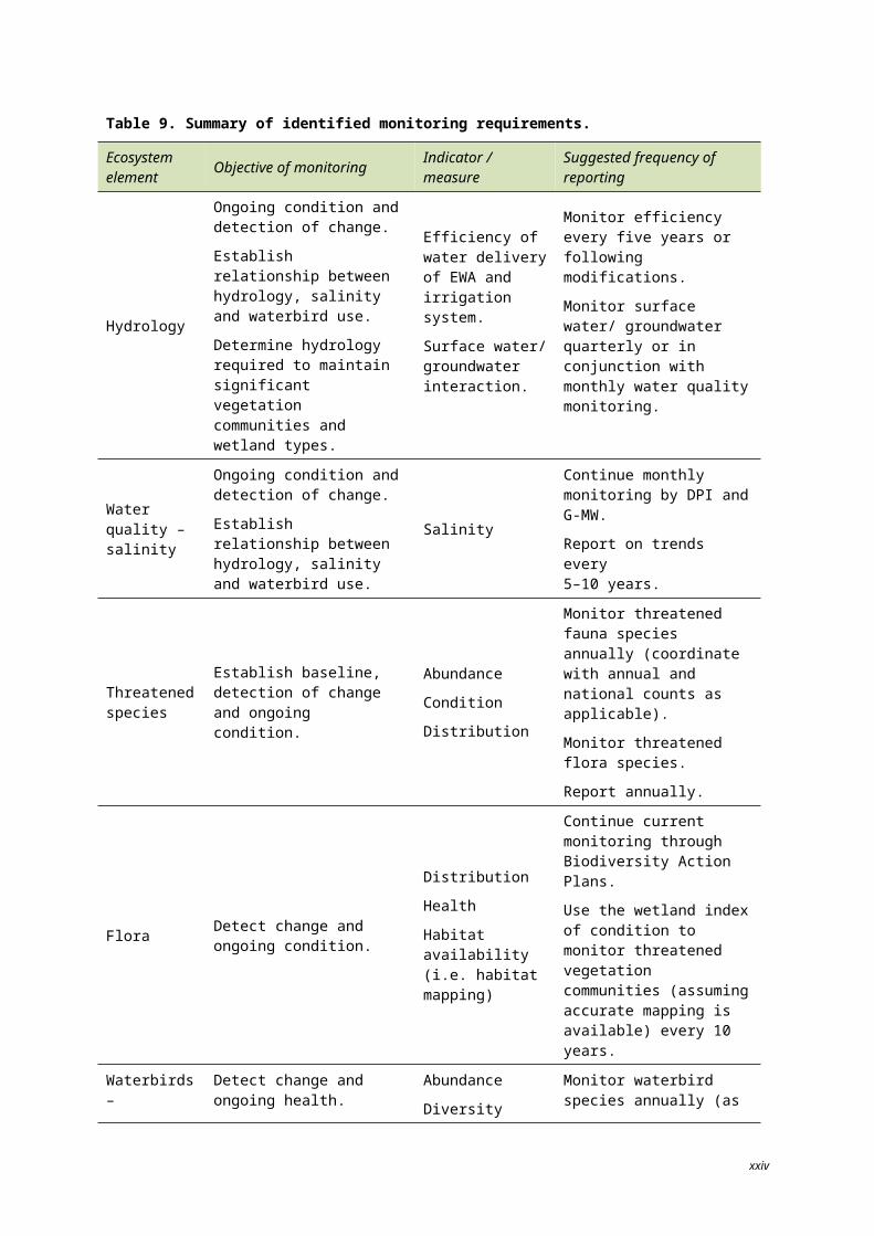
2.2 CLIMATE
The Kerang region is ‘semi-arid’ experiencing hot dry summers, cold winters and low rainfall. The average annual temperature is 22.8C. January is typically the hottest month of year (average maximum temperature 31.5C, Figure 2.3) and July the coldest (average maximum temperature 14.1C) (BOM 2010).
Figure 2.3. Average monthly temperature maximums and minimums, based on Bureau of Meteorology data for Kerang Station, 1961–1990 (© Copyright Kellogg, Brown & Root Pty Ltd).
The average annual rainfall in the region (since 1880) is 372.7 mm. The highest monthly rainfall is typically October, while January is usually the driest month (Figure 2.4).
Over the last 10 years, the Kerang region has recorded above average evaporation rates within the local region, with between 1600 mm and 1800 mm recorded per year on average.
11
0
5
10
15
20
25
30
35
Deg
rees
Cel
cius
MaximumMinimum
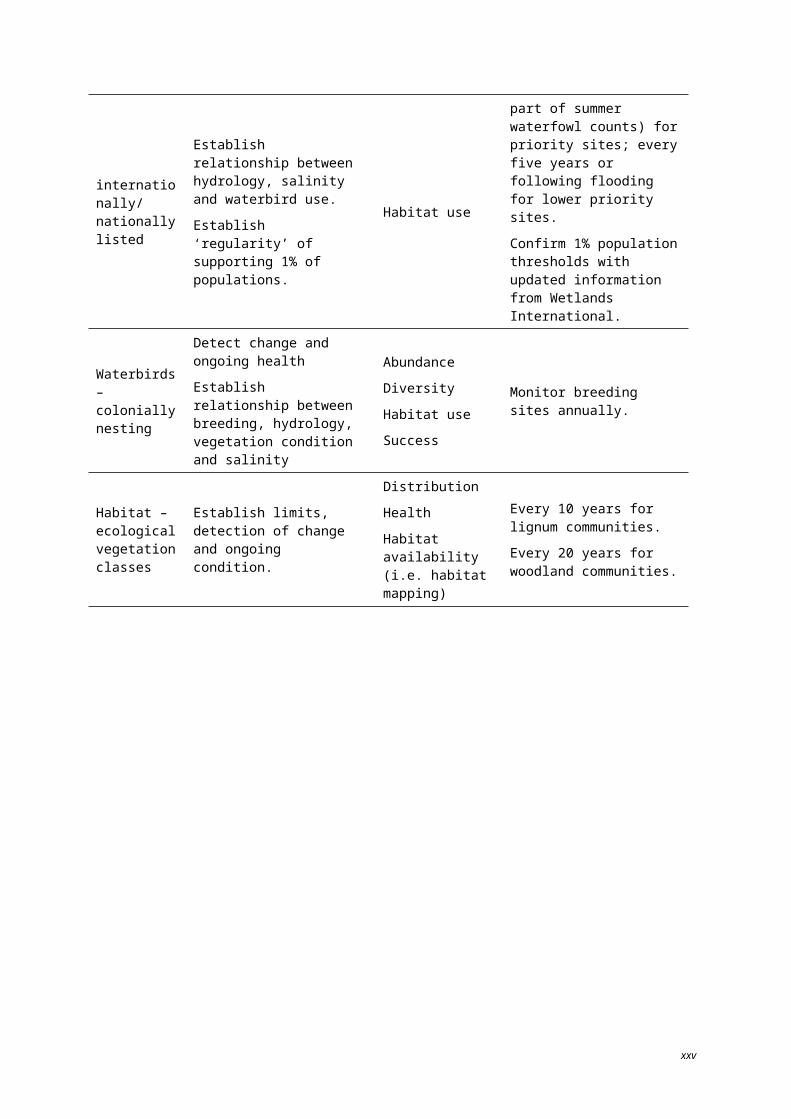
Figure 2.4. Average monthly rainfall, based on Bureau of Meteorology data for Kerang Station, 1880–1990 (© Copyright Kellogg, Brown & Root Pty Ltd).
2.3 MANAGEMENT OF HYDROLOGICAL REGIMES
The Ramsar site is part of the Murray-Loddon region of the Murray-Darling Drainage Division and is located within the Torrumbarry irrigation area of the Loddon-Campaspe irrigation region of northern Victoria (KLAWG 1992) (Figure 2.6).
At the time of listing, some wetlands within the Ramsar site had been modified from their pre-European state for approximately six decades, by the installation of water management infrastructure (Torrumbarry Weir first diversion release was in 1923) for catchment claims and water extraction for agriculture through the Torrumbarry Irrigation System (TIS) (Figure 2.7). The Torrumbarry Weir diverts water from the Murray River at Torrumbarry, to the Loddon River at Kerang, where it flows through several lakes within the Kerang Wetlands system (namely, the Reedy Lakes, Racecourse Lake, Lake Charm and Kangaroo Lake) (G-MW 2010). Some of the wetlands in the Kerang Wetlands Ramsar site are used as salt disposal basins (e.g. Lake Tutchewop) in order to reduce salt loads entering the Murray River.
The wetlands within the Ramsar site can be broadly grouped by water source and management category. Four broad hydrological categories apply to the wetlands (Heron and Joyce 2008a):
regulated fresh supply for irrigation;
regulated fresh supply for non-irrigation;
regulated drainage; and
unregulated.
12
0
5
10
15
20
25
30
35
40m
m
Regulated fresh supply for irrigation
‘Regulated fresh supply for irrigation’ wetlands receive water from riverine sources via irrigation system channels. These wetlands also function within the irrigation system as supply basins, holding water throughout the year.
Little Lake Charm, Lake Charm, (First) Reedy Lake, Middle (Second) Reedy Lake, Third Reedy Lake, Racecourse Lake and Kangaroo Lake are maintained at a relatively constant water level via the Kerang Weir (via the Washpen Creek regulator), located at the confluence of Pyramid Creek (tributary to the Loddon River) and the Loddon River. Freshwater is supplied from diversions at the Murray River which outfalls at Kow Swamp (a non-Ramsar wetland) which then outfalls into Pyramid Creek and flows to the Kerang Weir. The water level in these wetlands has been maintained to varying levels for irrigation for approximately 80 years (DSE 2010a).
From Washpen Creek, water flows into Reedy Lake, Middle Lake and Third Lake. The Reedy Lakes (Reedy, Middle and Third Lakes) also receive flood flows from the Loddon River. The water supply into Middle Lake is managed for irrigation water supply and to support colonial waterbird breeding as the site supports a large rookery of sacred (Australian white) ibis (Threskiornis molucca) and straw-necked ibis (Threskiornis spinicollis). Between August and December, the water level is maintained using the Middle Lake regulator (KBR 2007).
Third Lake is usually held at full supply level during the irrigation season. Flows from Third Lake outfall at Scotts Creek, Torrumbarry Irrigation System Channel No. 7. This channel carries water to Little Lake Charm (through to Lake Charm), Racecourse Lake and Kangaroo Lake. Water used for irrigation and domestic and stock supply is drawn from Lake Charm. A pumping station at Lake Charm outfalls into the Loddon River, downstream of the Barr Creek confluence, which enables flushing events to control Lake Charm salinity levels. From Racecourse Lake, water flows into Kangaroo Lake where it outfalls into the 6/7 Channel which flows north and outfalls into Little Murray River.
Kangaroo Lake is a major irrigation supply storage basin. High operational water levels in the lake are required to optimise water supply for regional irrigators with downstream water user demands on the Murray River. Water levels in the lake are managed to both reduce downstream flooding impacts on the Loddon River and prevent foreshore erosion (KBR 2007).
Regulated fresh supply for non-irrigation
‘Regulated fresh supply for non-irrigation’ wetlands receive freshwater from riverine sources via irrigation system channels; however, the wetlands themselves are not used for irrigation purposes. These wetlands within the Ramsar site are most commonly used as natural feature reserves.
Natural feature reserves are managed for fish and wildlife conservation and public recreation. Within the Ramsar site, such reserves include Lake Cullen, Hird Swamp and Johnson Swamp which receive environmental water allocations (EWA) to promote and support their values. Johnson and Hird swamps may also receive floodwater from Pyramid Creek. Although Lake Cullen is not used as part of the irrigation system, land around Lake Cullen is supplied by the 3/7 channel system which is supplied from Racecourse Lake. Lake Cullen receives environmental water through the 3/7 channel and from Racecourse Lake. Lake Cullen is a terminal water body and can become very saline as the water levels recede.
Town and Back Swamps are also classified as regulated fresh supply for non-irrigation purposes. The swamps receive flood flows from the Loddon River.
13
Regulated drainage
Five sites within the Ramsar site are used for regulated drainage purposes. Lake Kelly, Little Lake Kelly, Lake William and Lake Tutchewop are used as salt disposal basins to store and evaporate drainage water that would otherwise impact adversely on salinity levels in the Murray River. The salt disposal basins receive drainage water from the Barr Creek Pump Station. A small portion (6 ha) of Fosters Swamp is used for tertiary treatment of wastewater from the town of Kerang.
Figure 2.6. Location of the Kerang Wetlands Ramsar site within the Murray-Darling Basin Drainage Division (© Copyright Kellogg, Brown & Root Pty Ltd).
14
Figure 2.7. Location of the Kerang Wetlands Ramsar site within the Torrumbarry Irrigation Area (© Copyright NCCMA, 2010).
Unregulated
‘Unregulated’ wetlands receive water through natural sources (river flows, and also local run-off and precipitation) and are not part of the irrigation system.
The Avoca Marshes (First, Second and Third Marsh), Stevensons Swamp, Lake Bael Bael and Cemetery Swamp only receive water from unregulated, natural sources. The Avoca Marshes receive water from the Avoca River, via Lake Bael Bael. As outfall flows from the river increase, Lake Bael Bael fills and then each of the marshes fill in a sequence from First Marsh to Third Marsh (DSE 2010a).
The hydrology of these sites is highly variable due to the variable and unpredictable nature of rainfall in the catchment and the local region. Land clearing and levee construction have reduced floodplain connectivity around the Avoca Marshes, increasing the flood frequency of the lower marshes over the longer-term. At the time of listing, this area was experiencing a period of increased flood flows (1970s to early 1990s); this period was then following by an extended drought (DSE 2010a).
15
Stevensons Swamp is a terminal wetland now separated from Loddon River floodwater but is otherwise largely unmodified since listing. At the time of listing, Cemetery Swamp was not directly connected to any regular water source, but occasionally received floodwater from the Loddon River and Pyramid Creek. Since listing, inlet and outlet structures have been improved to increase hydrologic connectivity (DSE 2010a).
Land tenure and management responsibilities
Management responsibilities for the Ramsar site are varied. Land managers include Parks Victoria, Goulburn-Murray Water, DSE, the Shire of Gannawarra and Lower Murray Water under the provisions of relevant legislation.
The area is Crown land. The majority (89%) consists of conservation reserves managed by Parks Victoria (Parks Victoria 1999). The remaining area is managed by DSE (169 ha, 1.8%) and water authorities (861 ha, 9.2%) (Parks Victoria 1999).
Table 2.2 describes the various land tenure and management agencies responsible for each of the wetlands which make up the Ramsar site.
Table 2.2. Land tenure and management agencies within the Ramsar site (DSE 2004).
Wetland Land tenure Legal status Management agency
Regulated drainage
Lake Tutchewop
Salinity disposal reserve
Crown Land (Reserves) Act 1978
Goulburn-Murray Water (on behalf of the Murray-Darling Basin Commission)
Lake William Salinity disposal reserve
Crown Land (Reserves) Act 1978
DSE, Goulburn-Murray Water (on behalf of the Murray-Darling Basin Commission)
Lake Kelly Salinity disposal reserve
Crown Land (Reserves) Act 1978
DSE, Goulburn-Murray Water (on behalf of the Murray–Darling Basin Commission)
Little Lake Kelly
Salinity disposal reserve
Crown Land (Reserves) Act 1978
DSE, Goulburn-Murray Water (on behalf of the Murray-Darling Basin Commission)
Fosters Swamp
Sewerage purposes reserve
Crown Land (Reserves) Act 1978 Lower Murray Water
Regulated, fresh supply for irrigation
Little Lake Charm Water supply reserve Freehold land owned by
Goulburn–Murray Water Goulburn-Murray Water
Lake Charm Water supply reserve Crown Land (Reserves) Act 1978 Goulburn-Murray Water
Racecourse Lake Water supply reserve Crown Land (Reserves)
Act 1978 Goulburn-Murray Water
Kangaroo Lake Water supply reserve Crown Land (Reserves)
Act 1978 Goulburn-Murray Water
Reedy Lake Water supply reserve and wildlife reserve
Crown Land (Reserves) Act 1978 DSE, Goulburn-Murray Water
Middle Lake Water supply reserve and wildlife reserve
Crown Land (Reserves) Act 1978 DSE, Goulburn-Murray Water
Third Lake Water supply reserve Crown Land (Reserves) DSE, Goulburn-Murray Water
16
Wetland Land tenure Legal status Management agency
and wildlife reserve Act 1978
Unregulated
First Marsh Natural features reserve – wildlife reserve
Crown Land (Reserves) Act 1978 Parks Victoria
Second MarshNatural features reserve – wildlife reserve
Crown Land (Reserves) Act 1978 Parks Victoria
Third MarshNatural features reserve – wildlife reserve
Crown Land (Reserves) Act 1978 Parks Victoria
Lake Bael Bael
Natural features reserve – wildlife reserve
Crown Land (Reserves) Act 1978 Parks Victoria
Stevensons Swamp
Natural features reserve – wildlife reserve
Crown Land (Reserves) Act 1978 Parks Victoria
Cemetery Swamp
Natural features reserve – wildlife reserve
Crown Land (Reserves) Act 1978 Parks Victoria
Timber reserve
Municipal purposes reserve
Forests Act 1958
Crown Land (Reserves) Act 1978
DSE
Gannawarra Shire
Regulated fresh supply for non-irrigation
Hird SwampNatural features reserve – wildlife reserve
Crown Land (Reserves) Act 1978 Parks Victoria
Johnson Swamp
Natural features reserve – wildlife reserve
Crown Land (Reserves) Act 1978 Parks Victoria
Lake CullenNatural features reserve – wildlife reserve
Crown Land (Reserves) Act 1978 Parks Victoria
Town Swamp Public land vested in water authority Water Act 1989 Goulburn-Murray Water
Back Swamp Public land vested in water authority Water Act 1989 Goulburn-Murray Water
17
2.4 DESCRIPTION OF THE RAMSAR SITE
2.4.1 Ramsar wetland classificationThe Ramsar site is composed of several of the different Ramsar Convention wetland types. Wetlands types have been approved and amended by the Ramsar Conference of the Contracting Parties. Wetland types were derived to provide only a very broad framework to aid rapid identification of the main wetland habitats represented at each site. The wetland types recognised under the classification system used by the Ramsar Convention (Ramsar Convention Bureau 1997) which are represented within the Ramsar site are:
five inland wetland types
o O: permanent freshwater lakes (over 8 ha); includes large oxbow lakes
o Tp: permanent freshwater marshes/pools; ponds (below 8 ha), marshes and swamps on inorganic soils; with emergent vegetation water-logged for at least most of the growing season
o Q: permanent saline/brackish/alkaline lakes
o R: seasonal/intermittent saline/brackish/alkaline lakes and flats
o Xf: freshwater, tree-dominated wetlands; includes freshwater swamp forests, seasonally flooded forests, wooded swamps on inorganic soils
one human-made wetland type
o 8: wastewater treatment areas; sewage farms, settling ponds, oxidation basins, etc.
The wetlands types represented at the Ramsar site are provided in Table 2.3 and displayed by hydrology source in Figure 2.8.
18
Table 2.3. Wetland area (ha) and Ramsar wetland types represented at the Ramsar site (DSE 2004, DSE 2010a).
Wetland (per primary hydrological driver)
Area
(ha)
Wetland type/Ramsar Classification
Freshwater tree-dominated wetlands
Permanent freshwater lakes
> 8 ha
Seasonal/intermittent saline/brackish/alkaline lakes and
flats
Permanent saline/brackish/alkaline
lakes
Permanent freshwater
marshes/pools
Wastewater treatment areas
Xf O R Q Tp Human-made – 8
Regulated drainage
Lake Tutchewop 752
Lake William 96
Lake Kelly and Little Lake Kelly 192
Fosters Swamp 225
Regulated, fresh supply for irrigation
Kangaroo Lake 984
Racecourse Lake 235
Lake Charm 520
Little Lake Charm 113
Reedy Lake 196
Middle Lake 196
Third Lake 234
Unregulated
Lake Bael Bael 648
Stevenson Swamp1 80
Cemetery Swamp 89
19
Wetland (per primary hydrological driver)
Area
(ha)
Wetland type/Ramsar Classification
Freshwater tree-dominated wetlands
Permanent freshwater lakes
> 8 ha
Seasonal/intermittent saline/brackish/alkaline lakes and
flats
Permanent saline/brackish/alkaline
lakes
Permanent freshwater
marshes/pools
Wastewater treatment areas
Xf O R Q Tp Human-made – 8
Avoca Marshes:
First Marsh
Second Marsh
Third Marsh
780
236
946
Regulated, fresh supply for non-irrigation
Back Swamp 46
Lake Cullen 632
Town Swamp 80
Johnson Swamp 411
Hird Swamp 344
Note:1 Noted as freshwater in DSE 2004 and saline in DSE 2010a.2 Wastewater treatment areas include sewage farms, settlement ponds, oxidation basins, etc.
20
Figure 2.8. Wetland hydrology and Ramsar classification (© Copyright Kellogg, Brown & Root Pty Ltd).
21
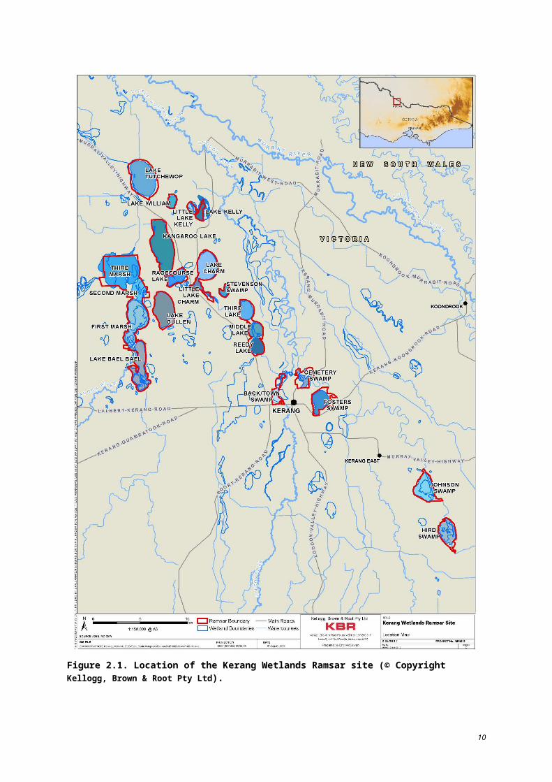
2.4.2 Ramsar criteriaTo be designated as a Ramsar site, a wetland must meet at least one of the Ramsar Convention criteria for identifying wetlands of international importance. At their time of listing in 1982, the Kerang Wetlands met four of the eight criteria. Since the time of listing, the criteria have been updated and slightly modified. There are now nine criteria used to identify a Ramsar site. The criteria met by the Ramsar site at the time of listing and currently (2005 criteria) are provided in Table 2.4.
Table 2.5 provides an overview of each criterion met by the Ramsar site and indicates which of the individual wetlands in the Ramsar site contributes to the site meeting that criterion.
Table 2.4. Criteria satisfied by the Ramsar site in 1982 and currently.
Criteria met at the time of listing (1982)
Criterion 1(a) It regularly supports 10 000 ducks, geese and swans; or 10 000 coots or 20 000 waders.
Criterion 1(b) It regularly supports 1% of the individuals in a population of one species or subspecies of waterfowl.
Criterion 2(b) It is of special value for maintaining the genetic and ecological diversity of a region because of the quality and peculiarities of its flora and fauna.
Criterion 3 It is a particularly good example of a specific type of wetland characteristic of its region.
Criteria met currently (Ramsar 2005)
Criterion 1A wetland should be considered internationally important if it contains a representative, rare, or unique example of a natural or near-natural wetland type found within the appropriate biogeographic region.
Criterion 2 A wetland should be considered internationally important if it supports vulnerable, endangered, or critically endangered species or threatened ecological communities.
Criterion 3A wetland should be considered internationally important if it supports populations of plant and/or animal species important for maintaining the biological diversity of a particular biogeographic region.
Criterion 4A wetland should be considered internationally important if it supports plant/or animal species at a critical life stage in their life cycles, or provides refuge during adverse conditions.
Criterion 5 A wetland should be considered internationally important if it regularly supports 20 000 or more waterbirds.
Criterion 6 A wetland should be considered internationally important if it regularly supports 1% of the individuals in a population of one species or subspecies of waterbird.
22
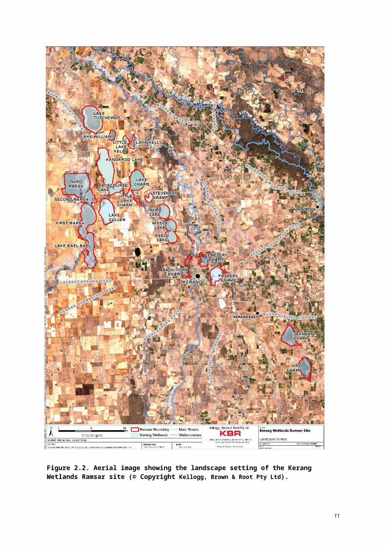
Table 2.5. Contribution of individual wetlands in the Ramsar site to meeting the 1982 criteria for which the Ramsar site was listed (DSE 2010a).
Wetland
1a: regularly supports 10 000 ducks, geese and swans, or 10 000 coots or 20 000 waders
1b: regularly supports 1% of the individuals in a population of one species or subspecies of waterfowl
2b: is of special value for maintaining the genetic and ecological diversity of a region because of the quality and peculiarities of its flora and fauna
3: is a particularly good example of a specific type of wetland characteristic of its region
Avoca Marshes*
Lake Kelly, Little Lake Kelly
Lake William
Lake Tutchewop
Reedy Lakes**
Lake Charm
Little Lake Charm
Racecourse Lake
Kangaroo Lake
Lake Cullen
Hird Swamp
Johnson Swamp
Stevensons Swamp
Fosters Swamp
Town Swamp
Back Swamp
Cemetery Swamp
* Avoca Marshes: First, Second and Third Marshes and Lake Bael Bael.** Reedy Lakes: Third, Middle and Reedy Lakes.
2005 Criterion 1 (Criterion 3 at the time of listing)
The Ramsar site represents a unique example of a wetland within the Murray-Darling Drainage Division biogeographical region. The Ramsar site is considered unique due to its system of diverse wetlands; five inland and one human-made Ramsar wetland types are represented. The human-made wetland type is represented only by a small portion of a large, natural wetland (Foster Swamp). Additionally, the Ramsar site is composed of wetlands, which individually are representative examples of wetlands within the biogeographic region, with various sizes (46 to 984 ha), maximum depths (1 m to 8.4 m) (Lugg et al. 1989), salinity levels (hypersaline to freshwater) and varying associations with several surface water systems (i.e. Avoca River, Loddon River and Pyramid Creek) within the Murray-Darling Drainage Division. The Ramsar site also contains seven of the 27 wetlands within the entire Murray-Darling Drainage Division which are larger than 500 ha.
23
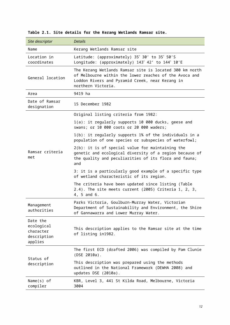
2005 Criterion 3 (Criterion 2(b) at the time of listing)
The Ramsar site provides habitat for a diverse range of waterbird species and is important in maintaining the biological diversity of the Murray-Darling Drainage Division.
Between 1980 and 2003, 76 waterbird species were observed within the Ramsar site, with 56 species recorded at Lake Cullen (DSE 2010a).
Around the time the site was listed, the largest colonies of sacred ibis and straw-necked ibis recorded in Victoria occurred within the Kerang region. In 1979–80, Middle Lake and Hird Swamp together supported 45% of the breeding straw-necked ibis and 73% of the breeding sacred ibis in Victoria, as noted in the original Ramsar documentation in the files of the (then) Ministry of Conservation.
2005 Criterion 5 (Criterion 1(a) at the time of listing)
The Ramsar site regularly supports over 20 000 waterbirds. In 1979 to 1980, an estimated 20 000 straw-necked ibis were recorded at Hird Swamp, as noted in the original Ramsar documentation in the files of the (then) Ministry of Conservation. In years since (1980 to 2003), over 20 000 waterbirds were recorded at the Ramsar site on 10 different occasions. During 1987, 1989, and 1991 to 1993, Lake Cullen alone supported over 20 000 waterbirds annually with the highest number, 250 196 in 1987 (DSE 2010a).
The majority of occurrences were recorded after 1987, when data collection is likely to have become more consistent (DSE 2010a). Based on counts between 1987 and 2003, the site supported over 20 000 waterbirds nine out of 17 years. The regularity with which high numbers of waterbirds utilise the Ramsar site is also likely to correlate to water availability, natural and allocated, throughout the wetland system. For example, over 100 000 waterbirds were observed at the Ramsar site in 1993, a year in which rainfall was nearly twice the annual average (DSE 2010a, BOM 2010).
2005 Criterion 6 (Criterion 1(b) at the time of listing)
The Ramsar site regularly supports over 1% of the population of one species of waterbird (banded stilt). The Ramsar site was originally listed under this criterion for its sacred (Australian white) and straw-necked ibis populations; although no 1% population thresholds were provided in the original nomination document.
Between 1982 and 2003, the site has supported 1% (2100, Wetlands International 2006) of the banded stilt population on four occasions.
* * *
In addition to the four criteria met at the time of listing, data suggest that the Kerang Wetlands also meet current (2005) Criterion 2 and Criterion 4 (see Table 2.4).
2005 Criterion 2 (formerly 2(a))
The Ramsar site is known to support several species listed on the International Union for Conservation of Nature (IUCN) Red List, including the critically endangered Murray cod (Maccullochella peelii) and the endangered Murray hardyhead (Craterocephalus fluviatilis), growling grass frog (Litoria reniformis), Australian painted snipe (Rostratula australis) and plains wanderer (Pedionomus torquatus) (DSE 2004, DSE 2010a).
24
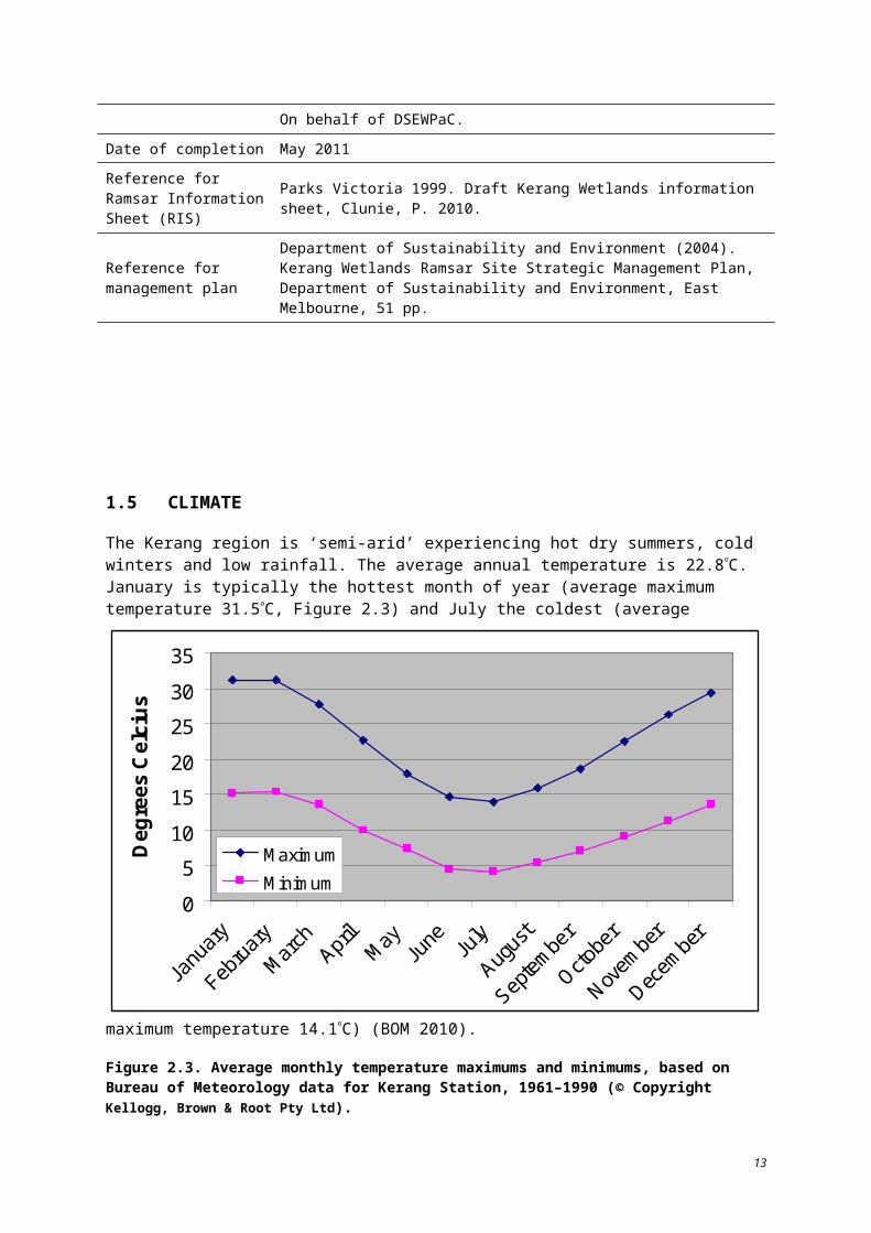
Eight EPBC Act-listed fauna species are found at the site: Murray cod (Maccullochella peelii), Australian painted snipe (Rostratula australis), regent honeyeater (Xanthomyza phrygia), plains wanderer (Pedionomus torquatus), growling grass frog (Litoria raniformis), Murray hardyhead (Craterocephalus fluviatilis), Macquarie perch (Macquaria australasica) and silver perch (Bidyanus bidyanus).
See Appendix A for a complete list of significant (including threatened) species.
2005 Criterion 4 (formerly 2(c))
Within the Ramsar site, Third, Middle and Reedy Lakes have supported more than 10% of the regional breeding population of straw-necked ibis and sacred ibis and more than 5% of the Victorian breeding population of royal spoonbill (Parks Victoria 1999).
The Ramsar site supports several species during critical life stages.
For the migration life stage, the Ramsar site supports waterbirds, such as the eastern great egret (Andrea modesta), freckled duck (Stictonetta naevosa) and Latham’s snipe (Gallinago harwikkii); and fish including silver perch (Bidyanus bidyanus), golden perch (Macquaria ambigua), bony herring (Nematalosa erebi), Australian smelt (Retropinna semoni) and Murray cod (Maccullochella peelii).
For the moulting life stage, the Ramsar site supports shelduck (Tadorna tadornoides) and musk duck (Biziura lobata), which use the open water of the permanent lakes to aggregate and moult, at which time they are flightless and vulnerable to predators.
For the breeding life stage, the Ramsar site supports regionally and nationally significant colonies of cormorants and pelicans in the Avoca Marshes and Lake Bael Bael, sacred and straw-necked ibis and royal spoonbill at Middle Lake and Hird Swamp, and eight fish species.
The Ramsar site was known to provide drought refuge for several waterbird species at the time of listing and continues to provide refuge today. During summer and particularly during drought, large flocks of waterfowl concentrate on the more open lakes (e.g. 100 000 hardhead at Lake Cullen in 1975, 70 000 grey teal in 1988). During 1994, a year of below average rainfall, nearly 17 000 waterbirds were recorded within the Ramsar site (DSE 2010a). In 2002, a year of less than half the annual average rainfall following below average rainfall amounts in 2001, regulated, fresh supply non-irrigation wetlands alone recorded over 21 000 waterbirds (DSE 2010a).
25
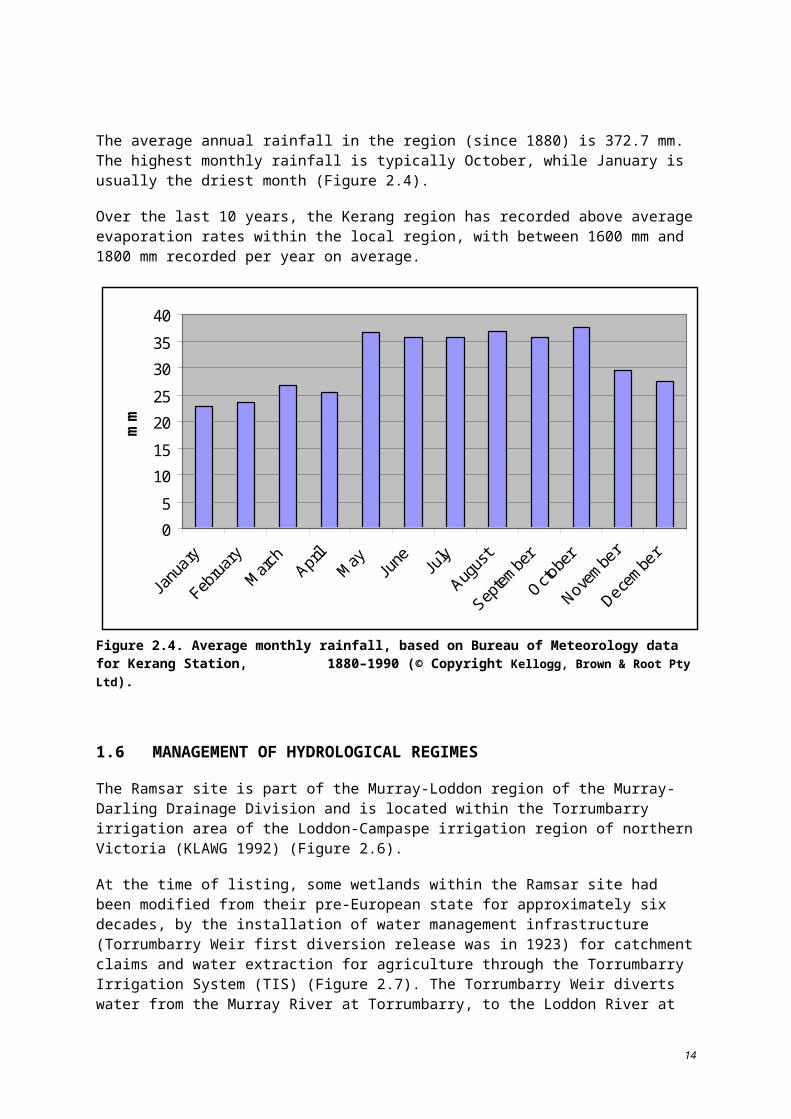
3 Components, processes, services and benefits
The collective ecological components and processes of the Ramsar site support the ecosystem values which have contributed to the recognised international importance of the Kerang Wetlands. Ecosystem components are physical, chemical and biological parts of a wetland. Ecosystem processes are the dynamic forces within an ecosystem and ecosystem services are the benefits that people receive (DEWHA 2008). A diagrammatic representation of the relationship between the components, processes and services and benefits that contribute to the ecological character of the Ramsar site is presented in Figure 3.1.
Figure. 3.1. Components, processes and services within the Ramsar site that contribute to its ecological character (© Copyright Kellogg, Brown & Root Pty Ltd).
26
3.1 CRITICAL COMPONENTS, PROCESSES AND SERVICES
Four critical components, processes and services have been identified that significantly contribute to the recognised ecosystem value and importance of the site:
Hydrology (percentage full, depth/volume, frequency of inundation) is a critical process that influences water quality, habitat and wetland type.
Salinity is a critical physiochemical component that maintains wetland type and distinctive flora and fauna assemblages.
Waterbird abundance is a critical component that contributes to the site’s Ramsar listing.
Colonial breeding/nesting waterbirds (ibis, darters, cormorants, spoonbills) are a critical component that contributes to the site’s Ramsar listing.
Table 3.1 lists and describes each critical element and identifies recognised linkages to other components and processes across the site.
Table 3.1. Critical components, processes, benefits and services of the Ramsar site at the time of listing.
Element Component/ process/ service
Element description Linkages with other components or processes
Hydrology (percentage full, depth/volume, frequency of inundation)
Critical process
Highly modified flow regime in some wetlands on the site.
Both regulated and unregulated water supplies.
Permanent, seasonal and intermittent wetlands.
Influences water quality (particularly salinity) and floodplain connectivity.
Provides open water habitat for waterbirds and fish.
Determines wetland and habitat types.
Physiochemical – salinity
Critical component
Variable levels throughout the site, influenced by catchment inflows, irrigation, salinity disposal and evaporation (transition from fresh to saline with drying in some wetlands).
Key factor in maintaining wetland type and habitats through effects on flora and fauna of varying salinity tolerances across the site.
Maintains suitable habitat for fish and waterbirds.
Contributes to habitat availability for invertebrates, fish and waterbirds.
Species composition dependent upon salinity tolerances.
Waterbirds – abundance
Critical component
The site supports a high abundance of waterbirds, including 25 listed threatened species and 21 species listed under international migratory species agreements.
Climatic conditions, hydrology, soils and fluvial geomorphology are all critical in determining the suitability of an area as waterbird habitat.
Waterbirds – colonial breeding/ nesting (ibis, darters, cormorants, spoonbills) and large numbers
Critical component
The site supports a high diversity and abundance of waterbird species that breed within the Ramsar site; colonial waterbird breeding at Reedy Lake, Middle Lake, Avoca marshes and Hird swamp.
Dependent upon hydrology, climate, salinity and population dynamics.
27
3.1.1 Hydrology Key aspects which shape the hydrology of the Ramsar site include the source of water, its movement (connectivity) and the frequency, duration and timing of inundation. The hydrology of much of the Kerang area was significantly modified from natural conditions in 1923, prior to listing of the Ramsar site. Connectivity, particularly on the Loddon floodplain and on Pryramid Creek, had been significantly reduced by the construction of levees and dredging and regulation of natural water carriers to increase capacity. Hydrology is identified as a critical process in the system as it has the potential to impact directly on salinity (including risks of hypersalinity), and reduction in biodiversity, loss of community vegetative structure and species distribution and loss of habitat and food resources.
Process description and driving forces
By the late 1920s, the Torrumbarry Irrigation System (TIS) had been established and weirs and regulators along the Murray and Loddon Rivers and their tributaries had been constructed to control flows which modified the region’s flow regimes (Table 3.2). Hydrological changes to some of the wetlands in the Ramsar site occurred after the TIS (1923) but by the time of listing (1982), the ecology of the affected wetlands had stabilised around a new hydrological regime.
At the time of listing, the regulated, fresh supply irrigation wetlands were used as storage supply and flood control basins. The level of irrigation in the surrounding area affected the frequency and duration of freshwater flowing through the system. These wetlands had been maintained as permanent, open water bodies prior to listing and continue to function in the same manner today.
Regulated, fresh supply non-irrigation wetlands had been largely disconnected from their natural water source at the time of listing (Johnson and Hird Swamps). Lake Cullen which had been part of the irrigation system, was removed from the system prior to listing and has since experienced regular wetting and drying cycles (NCCMA 2006), similar to the other wetlands of this type. Since the time of listing, Johnson and Hird Swamps and Lake Cullen have received flows from environmental water allocations (DSE 2010a) to support the habitat that was present at the time of listing when the water regime was wetter than under natural conditions. Available data from 1990 to 2005 (DSE 2010a), suggests that Johnson Swamp has received environmental flows in nine of 15 years, Hird Swamp six of 15 years, and Lake Cullen three of nine years (EWA established in 1996). Without EWA, these wetlands are dependent upon flood flows and are likely to be dry otherwise. Town Swamp has been wet for 15 years, while Back Swamp has been wet five of the 10 years data has been recorded for the site (DSE 2010a).
28
Table 3.2. Summary of management uses of wetlands within Ramsar site in relation to connectivity at the time of listing (DSE 2010a).
Management unit Wetland name Connectivity at listing in 1982
Unregulated
Avoca Marshes
Receives water from Avoca River – highly variable flow. Over the last 100 years, no long-term trend in surface water regime. Flood period 1973 to 1983.
Cemetery Swamp
Separated from Pyramid Creek by levee. Receives water via flood flows from creek and moderate flooding of Loddon River, pipe and discharge from town stormwater. Prior to 1987, no outlet in levee bank, so water ponded until evaporated.
Stevenson Swamp
Isolated from flooding from Murray River. Used to fill from local storm events and was cut off from its watershed.
Regulated, drainage
Lake Kelly, Little Lake Kelly
Saline evaporative basin since 1968, receives water from Barr Creek diversion scheme.
Lake William Saline evaporative basin since 1968, receives water from Barr Creek diversion scheme.
Lake Tutchewop
Saline evaporative basin since 1968, receives water from Barr Creek diversion scheme.
Fosters Swamp
Cut off from floodplain. Receives sewage effluent, regional and local drainage water, rural surface water run-off and urban stormwater.
Regulated, fresh supply, irrigation
Lake Charm, Little Lake Charm
Incorporated into irrigation supply system in early 1900s. Maintained permanently full with good quality water diverted from the Murray River. Water levels do not fluctuate significantly. These wetlands can be used to transmit and store floodwaters. During floods they are filled at a level higher than normal.
Lake Charm was considered an appendage, being associated with the irrigation supply but not managed for this purpose. There were operating rules on how it was managed.
Reedy Lakes
Kangaroo Lake
Racecourse Lake
Regulated, fresh supply, non-irrigation
Back and Town Swamps
Receive water from irrigation supply system but are not used for irrigation. Town Swamp has an inlet and outlet and is kept at the same height as the Loddon River. Back Swamp receives water when the river is in flood.
Pyramid Creek was dredged in 1967 which removed Johnson and Hird Swamps from all but major flood flows. Until late 1980s, filled by pumping from Pyramid Creek, then filled through EWA.
Lake Cullen
Johnson Swamp
Hird Swamp
29
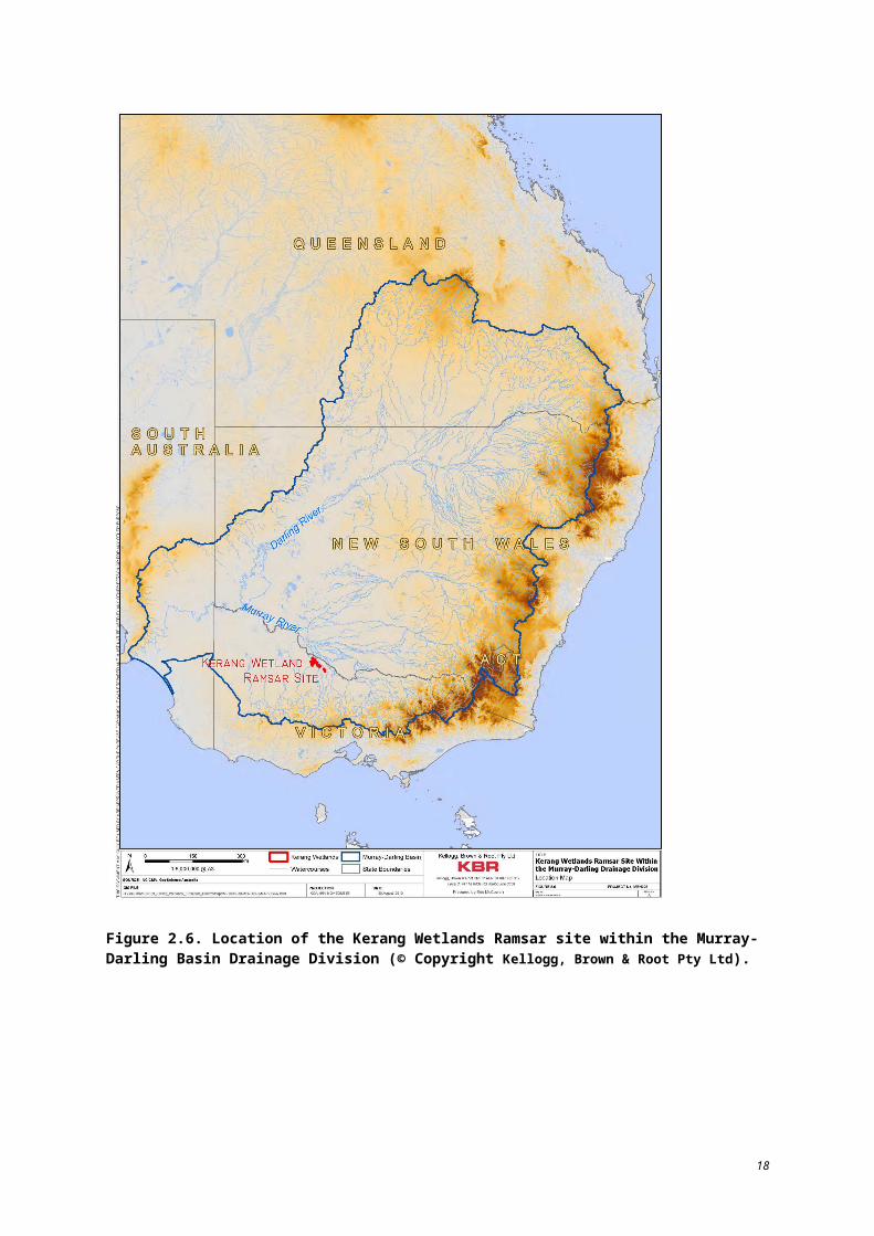
The water regime of unregulated wetlands was predominantly natural (primarily reliant on Avoca River flows, and also precipitation and local run-off) at the time of listing. Levee banking and a sill at Third Marsh influenced the hydrology of the Avoca Marshes at the time of listing. Prolonged inundation for Second and Third Marsh was largely due to the sill, which was in place from 1970 until 2000, with most removal occurring in 1988 (NCCMA 2006). Prolonged inundation due to the sill resulted in tree death in Second and Third Marsh (NCCMA 2006). As further discussed below in Section 3.1.2, each of the marshes has a distinct relationship with groundwater. In addition, the hydrology and salinity of First Marsh is strongly influenced by Lake Cullen.
Prior to listing, Lake Cullen was part of the irrigation system and maintained as a full irrigation lake (NCCMA 2006). When Lake Cullen was held near full supply level, regional saline groundwater and very saline groundwater beneath Lake Cullen would flow towards First Marsh, 700 m away. Since its removal from the irrigation system, the volume within Lake Cullen has varied, reducing its influence on saline groundwater intrusion at First Marsh and resulting in fresh groundwater inflow towards Lake Cullen (NCCMA 2006).
Regulated drainage wetlands receive water from the Barr Creek diversion scheme (with the exception of Fosters Swamp). The hydrology of these wetlands is highly dependent upon Barr Creek disposal flows, evaporation and lake-aquifer interaction (Aquaterra Simulations 2006). The current scheme, operated by Goulburn-Murray Water under the Murray-Darling Basin Agreement, diverts approximately 10 000 ML of saline drainage water, including about 30 000 t of salt, annually to the disposal basins (Aquaterra Simulations 2006). Fosters Swamp has been disconnected from its floodplain and is not connected to the Barr Creek scheme. Instead, it relies upon regional and local drainage and surface water run-off as water sources. Fosters Swamp is located southeast of the town of Kerang and also receives urban stormwater and a small portion of the wetland (6 ha) is used for effluent treatment (DSE 2010a).
In general, local and regional groundwater are an underlying factor in the hydrology of the Ramsar site. Groundwater levels fluctuate with rainfall and irrigation water use, remaining low during dry conditions and rising under wet conditions (such as the late 1970s) which results in closer connection with wetlands.
It should be noted, that since the time of listing, a number of hydrological changes have occurred at the Ramsar site. This includes the removal of levees in Third Marsh in 2000, and environmental watering allocations were established for Johnson and Hird Swamps (1986) and later (1996) for Lake Cullen (DSE 2010a). These hydrological changes were undertaken to address factors that impacted negatively on the ecological functioning of the individual wetlands.
Linkages to other components, processes and services
The current hydrology of the Ramsar site is influenced by the fluvial geomorphology of the region and the management of irrigation and environmental flows. Although the hydrology of much of the Ramsar site had been modified through the establishment of irrigation systems prior to listing, the overarching landscape and topography (consisting of large depression basins) lends itself to use as irrigation storage basins, a service provided by the Ramsar site.
The diverse range of hydrological regimes that existed at the time of listing has supported extensive areas of habitat for waterbirds and has supported wetland types which are depleted within Victoria, such as deep and shallow freshwater marshes (DSE 2010a). Whether through natural or artificial flooding, the current hydrology of the Ramsar site maintains many of the characteristics for which the site was originally listed. The variety of hydrological regimes support the listing of the Ramsar site as a unique site within the Murray-Darling Drainage Division and contribute to the site meeting six of the nine Ramsar criteria.
30
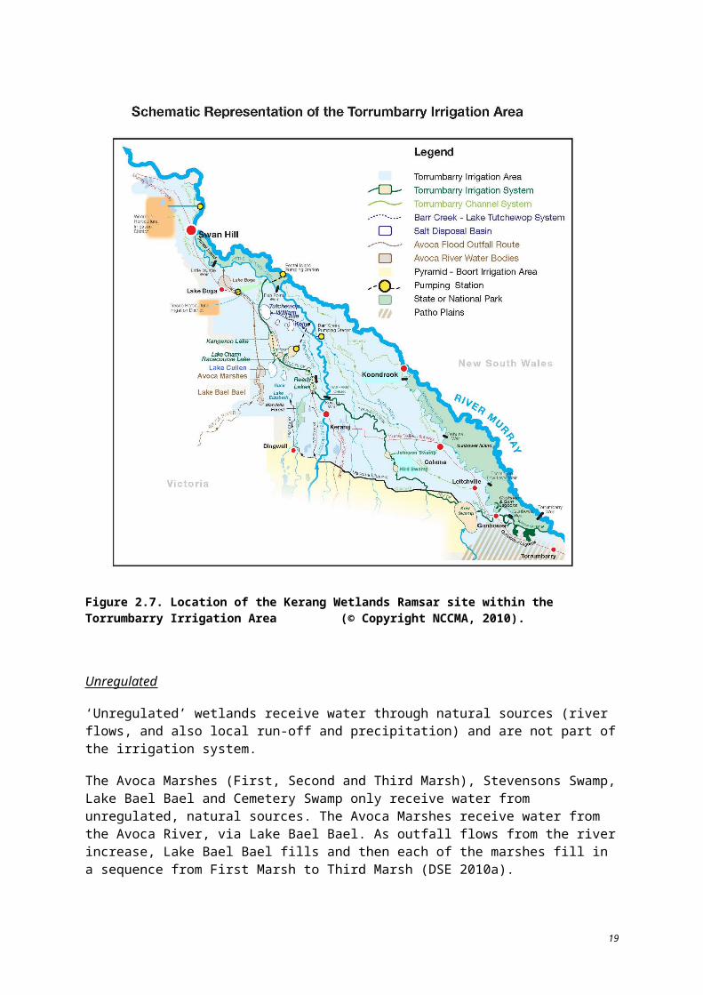
3.1.2 Physiochemical – salinityThe Ramsar site exhibits a full range of salinities from very fresh to hypersaline, including deep permanent freshwater lakes with salinities typically less than 500 EC, wetlands that ranges between 4000 EC to 50 000 EC and salt disposal basins.
Salinity is identified as a critical component in the system as it directly impacts on the ability of biota to survive. Salinity is affected by rising saline groundwater, saline surface water run-off, disposal of drainage water, lack of regular flushing and prolonged inundation.
In this report, salinity is described according to the following categories:
fresh: less than 4000 EC
brackish: between 4000 EC and 10 000 EC
saline: between 10 000 EC and 100 000 EC
hypersaline: greater than 100 000 EC
Component description and driving forces
Climate, irrigation and vegetation clearing prior to listing have influenced salinity levels in surface water and groundwater throughout the Kerang area. Changes in regional hydrology in conjunction with above average rainfall which occurred prior to listing had also led to rising water tables (KBR 2007). Wetlands within the Kerang region generally have a close connection to groundwater acting as both discharge zones and recharge sources which contribute to fluctuations in salinity levels.
In the 10 years prior to listing, above average annual rainfall (BOM 2010) supported a large irrigation footprint. With irrigators using large volumes of available water in the early 1980s, water flowing through the regulated wetlands provided regular flushing. From 1981 to 1985, regulated wetlands, such as Kangaroo Lake, Racecourse Lake, Third Lake and Reedy Lake, had average salinity levels between 300 and 500 EC (Aquaterra Simulations 2006).
The Tutchewop Lakes (Lake Kelly, Little Lake Kelly, Lake William and Lake Tutchewop), which function as regulated drainage wetlands, receive water via the Barr Creek Diversion. Prior to the construction of the Barr Creek Drainage Diversion Scheme by the Victorian Government in the late 1960s, the Barr Creek was the single largest point source of salt entering the Murray River (Aquaterra Simulations 2006). Since that time, the Tutchewop Lakes have been used a salt disposal basins and have experienced increasing salinity levels in general, with some fluctuation due to inflows. Lake Tutchewop itself experienced a salinity increase from less than 30 000 EC in 1973 to nearly 100 000 EC by 1990 (Aquaterra Simulations 2006). Fosters Swamp, another regulated drainage wetland, does not have sufficient data available to describe the salinity at the time of listing.
The unregulated Avoca Marshes and Lake Bael Bael are highly influenced by changes in groundwater which result from irrigation and rainfall variability. Information regarding the salinity of the unregulated wetlands at the time of listing has been gleaned from analysis of groundwater bore data. Lake Bael Bael, which receives floodwaters from the Avoca River, has a thick freshwater to slightly brackish lens of 5000 EC. Overflow from Lake Bael Bael outfalls into First Marsh which has a brackish groundwater lens. The saline groundwater beneath Second and Third Marsh indicates that historically, these wetlands have not held freshwater for a duration sufficient enough to establish a freshwater lens (NCCMA 2006). Salinities within the groundwater lenses range from a few thousand EC up to 25 000 EC (NCCMA 2006). A wet regime prevailed during the time of listing which lead to high water tables. The groundwater lens respective to each wetland was influential in the salinity level of each wetland. Quantitative data on salinity of the two additional unregulated wetlands (Cemetery and Stevensons Swamp) around the time of listing were not available at the time of this report.
31
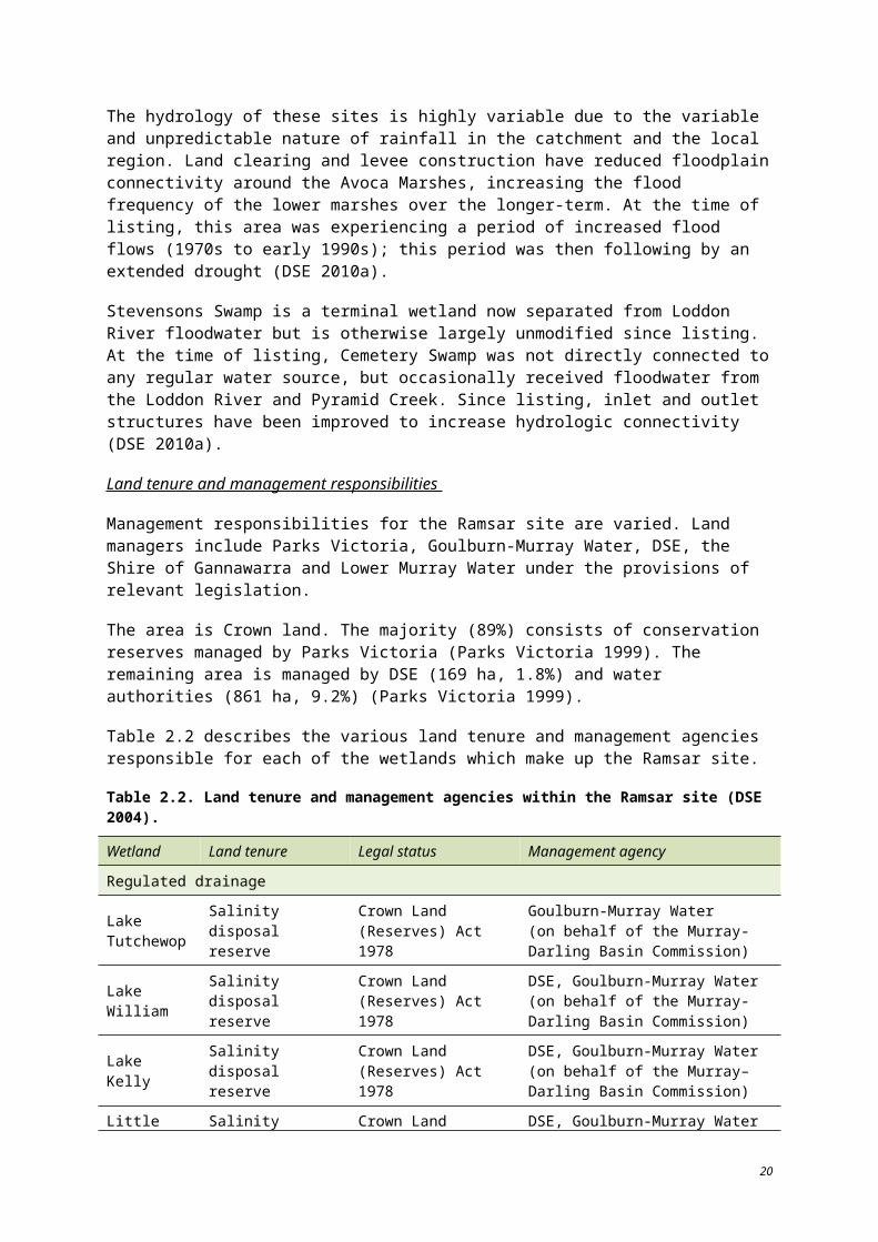
Regulated fresh supply, non-irrigation wetlands do not receive the regular flushing events or the prolonged inundation common to the irrigation supply wetlands. Salinity of these wetlands is highly dependent upon the frequency and duration of watering and increase in salinity as they dry. Prior to 1989, the salinity at Johnson Swamp, a regulated, fresh supply wetland for non-irrigation, ranged from 400 EC to 1500 EC (Lugg et al. 1989). Salinity levels at Hird Swamp, which receives water from Pyramid Creek upstream of Johnson Swamp, prior to 1989 suggests a range from 400 to 1500 EC (Lugg et al. 1989). Prior to listing, Lake Cullen was managed as part of the irrigation system (NCCMA 2006), when it was likely a brackish wetland. Lugg et al. (1989) suggests the salinity of Lake Cullen is highly dependent upon the water level (due to a highly saline groundwater lens), ranging from 4000 EC to 170 000 EC.
Increases in salinity are predicted for the Kerang region. Without management actions, the salinity level of the Loddon River downstream of Kerang is predicted to increase by 1% over the 2000 levels by 2020 and 3% by 2050. The salinity of the Avoca River downstream of the Avoca Marshes was modelled to rise 2% over the 2000 levels by 2020 and over 50% by 2050 (SKM 2000). The absence of regular flushing and prolonged inundation has lead to increased salinity levels for many wetlands within the Ramsar site since the time of listing. Table 3.3 provides a range of salinities known to occur across the various hydrological wetland types.
Table 3.3. Common salinity levels by wetland type (DSE 2004, DPI 2010a, DSE 2010a, Lugg et al. 1989).
Wetland type Salinity range (EC*) Characteristics
Regulated, fresh supply for irrigation < 500 Regularly flushed with good quality water;
permanent open water
Regulated, fresh supply for non-irrigation 400–50 000 Isolated from floodplain; wet/dry cycle
Regulated drainage > 100 000 Salt disposal basins. Estimated storage of 1.3 million tonnes of salt
Unregulated 2000 Water levels fluctuate; influenced by flows from Avoca River
Sea water (for comparison only) 50 000 –
*The standard EC unit used by the Victorian Salinity Program and the Murray-Darling Basin Commission is microSiemens per centimetre (µS/cm) at 25oC (DPI 2010b).
Water quality data collected around the time of listing is described in Table 3.4. Since the listing of the Ramsar site, additional water quality monitoring has been undertaken. Results from this monitoring are presented in Section 6.
32
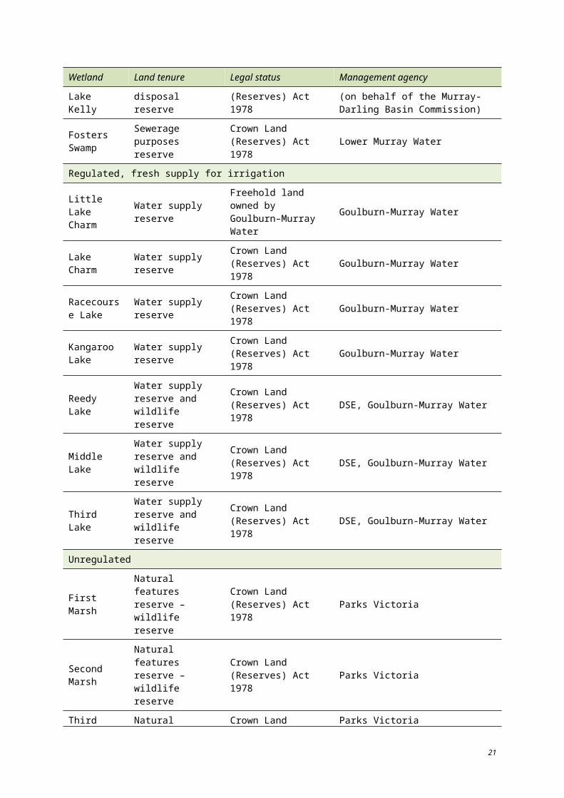
Table 3.4. Water quality data from available sources for the Loddon River and wetlands within the Kerang Ramsar site (VWRDW 2010, SKM 2001, KLAWG 1993, Aquaterra Simulations 2006).
Variable
Loddon River at Kerang (1976–2010)
Reedy Lake (1981–85)
Third Lake (1981–85)
Lake Charm (1981–85)
Racecourse Lake (1981–85)
Kangaroo Lake (1981–85)
Lake Tutchewop (1973–90)
Salinity, mean (EC)
797 420 360 3300 360 360 50 000
Salinity, maximum (EC)
– 1600 1200 4300 1750 900 200 000
Linkages to other components, processes and services
Salinity levels of wetlands are affected by several processes, such as climate (temperature, precipitation and wind), hydrology (groundwater and surface water interactions) and fluvial geomorphology (soil properties of alluvial landscapes). Salinity itself influences components of the wetland such as water quality and biota.
The salinity of the Ramsar site water and soils play a highly influential role in the survival of flora and fauna species that it supports. Freshwater to brackish water wetlands (such as Lake Cullen) regularly support the highest diversity and greatest number of waterbird species (DSE 2010a).
Salinity levels are also critical in supporting threatened fish. The range of salinity found within the Ramsar site allows a variety of species to inhabit the area. Native flat-headed gudgeon (Philypnodon grandiceps) have been found within the Ramsar site within 286 EC to 4290 EC while the threatened Murray hardyhead (Craterocephalus fluviatilis) has been recorded within lakes of 23 300 EC to 35 400 EC (Fleming 1990). However, increasing or elevated salinity is noted as being the greatest threat to fish species in the Kerang region. Lake Tutchewop’s use as an evaporation basin is the most likely cause of the complete loss of all fish from the lake (Fleming 1990).
Salinity can also play a critical role in the success of macrophytes and invertebrates. Adverse effects have been recorded when salinity increases beyond 1667 EC (DSE 2010a). Macrophytes and invertebrates form the food base for most waterbird and fish species which are known to occur at the Ramsar site and their role in the food chain is essential. Ruppia is a macrophyte common to Lake Cullen, the wetland with the greatest number of waterbird species recorded from 1980 to 2003 (56 species) (DSE 2010a). Ruppia serves as a food source for many waterbirds and can withstand salinity levels greater than 2680 EC, the upper limit for most freshwater aquatic plants (Nielsen et al. 2003).
Rising salinity can reduce competition and predation within macroinvertebrate and fish populations which can result in increases in abundance (DSE 2010a) (i.e. increased food supply for waterbirds). However, salt tolerance varies greatly between species. Most waterbird breeding occurs in habitat with salinities less than 25 500 EC but some species exhibit low breeding success when salinity is above 5000 EC (DSE 2010a).
33
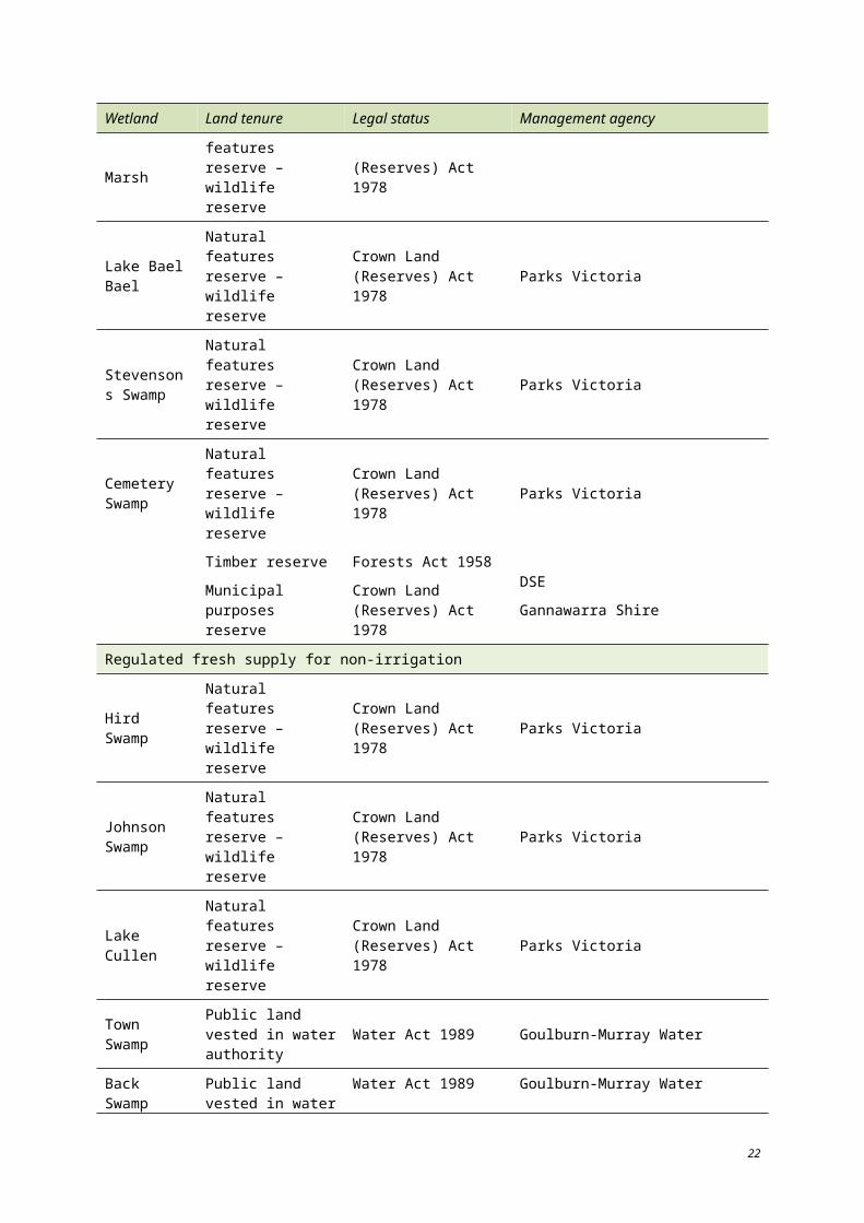
3.1.3 Waterbirds – abundanceBetween 1980 and 2003, 76 waterbird species have been recorded at the Ramsar site (see Table 7.2). Of these, 25 are threatened in Victoria, two are listed as nationally threatened (under the EPBC Act) and three are listed as threatened internationally (IUCN Red List). In addition, 21 avian species known to occur within the Ramsar site are listed under international migratory species agreements (Table 3.5). Two of the four original criteria for which the site was listed (1a and 1b) are based to the site’s value as waterbird habitat.
Table 3.5. Birds on international migratory species lists (DSE 2010a, DSE 2004, DSE 2010b).
Species name CAMBA JAMBA Bonn ROKAMBA
Black-tailed godwit Limosa limosa
Caspian tern Sterna caspia
Common greenshank Tringa nebularia
Common sandpiper Tringa hypoleucos
Curlew sandpiper Salidris ferruginea
Eastern curlew Numenius madagascariensis
Eastern great egret Ardea modesta
Fork-tailed swift Apus pacificus
Glossy ibis Plegadis falcinellus
Great knot Calidris tenuirostris
Great sand plover Charadrius leschenaultii
Latham’s snipe Gallinago hardwickii
Marsh sandpiper Tringa stagnatilis
Painted snipe Rostratula australis
Pectoral sandpiper Calidris melanotos
Red knot Calidris canutus
Red-necked stint Calidris ruficollis
Ruddy turnstone Arenaria interpres
Sanderling Calidris alba
White-bellied sea eagle Haliaeeatus leucogaster
White-winged black tern Chlidonias leucoptera
Waterbird counts for the Ramsar site are provided Table 3.6. The site meets the original criteria of regularly supporting 10 000 ducks, geese and swans; or 10 000 coots or 20 000 waders. Table 3.7 displays the years in which waterbird counts exceeded 10 000. Data used to describe waterbird species counts show numbers less than 20 000 for the years surrounding the time of listing. The occurrence of waterbirds at the Ramsar site is highly variable over time and across the individual wetlands at the site.
The average annual count of waterbirds at the site for the period 1979-2003 is 31 772 (minimum 39 (in 1986); maximum 299 077 (in 1987); standard deviation 60 790). During this period, waterbird counts of more than 20 000 were recorded on 10 occasions (years). Records of counts of more than 20 000 waterbirds over rolling ten year periods from 1979-1988 to 1994-2003 indicate that the
34
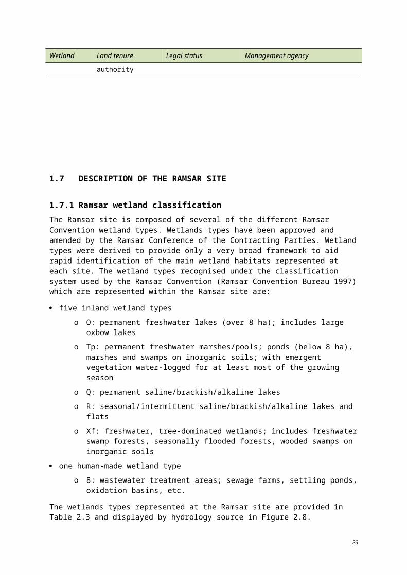
average number of years in which more than 20 000 waterbirds are recorded at the site in a 10 year period is 5.125. The average annual count for each rolling 10 year period ranges from 8944 to 66 720.
35
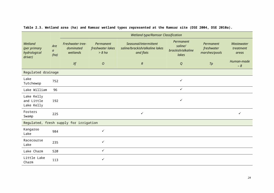
Table 3.6. Waterbird counts for each wetland with the Ramsar site from 1980 to 2003. Data sources are DSE (2010a) and Ramsar nomination documentation on the official files of the (then) Ministry of Conservation which are indicated with an *.
Year
Unregulated Regulated drainage Regulated, fresh supply, irrigation Regulated, fresh supply, non-irrigation
Total
Firs
t, Se
cond
and
Thi
rd M
arsh
es
Lak
e B
ael B
ael
Cem
eter
y Sw
amp
Ste
vens
on
Swam
p
Lak
e K
elly
, Litt
le L
ake
Kel
ly
Fos
ters
Sw
amp
Lak
e Tu
tche
wop
Lak
e W
illia
m
Lak
e C
harm
, L
ittle
Lak
e C
harm
Third
, Mid
dle
an
d R
eady
Lak
es
Kan
garo
o La
ke
Rac
ecou
rse
Lake
Bac
k an
d To
wn
Sw
amps
Lak
e C
ulle
n
John
son
Swam
p
Hird
Sw
amp
1979 15 000* 15 000* 15 000
1980 15 000* 15 000* 15 000
1981 224 213 17 2897 17 15 3383
1982 8 32 9000* 855 520 1 11 416
1983 27 2850 4330 7207
1984 2198 11 2209
1985 23 479 3 30 2 2 1980 25 496
1986 22 17 39
1987 5573 801 13 354 404 7001 7929 1265 129 250 196 7250 5175 299 077
1988 14 104 77 3 5918 1104 13 867 215 8 796 9 69 117 2950 1044 5047 45 328
1989 5200 1051 6269 1907 8 20 43 1340 4 740 59 25 129 7611 2784 52 165
1990 857 1021 817 1173 55 2596 1 10 11 802 1789 822 20 943
1991 76 458 4374 1036 6239 20 5153 1 21 668 1796 2697 43 518
1992 3186 352 774 3415 1758 1 44 726 2189 56 401
1993 7423 4352 2902 15 930 24 003 35 202 81 17 388 107 281
1994 2899 38 6 610 231 1 1 64 1838 209 39 107 1792 7146 1973 16 954
1995 911 171 156 72 2 5 371 814 2502
36
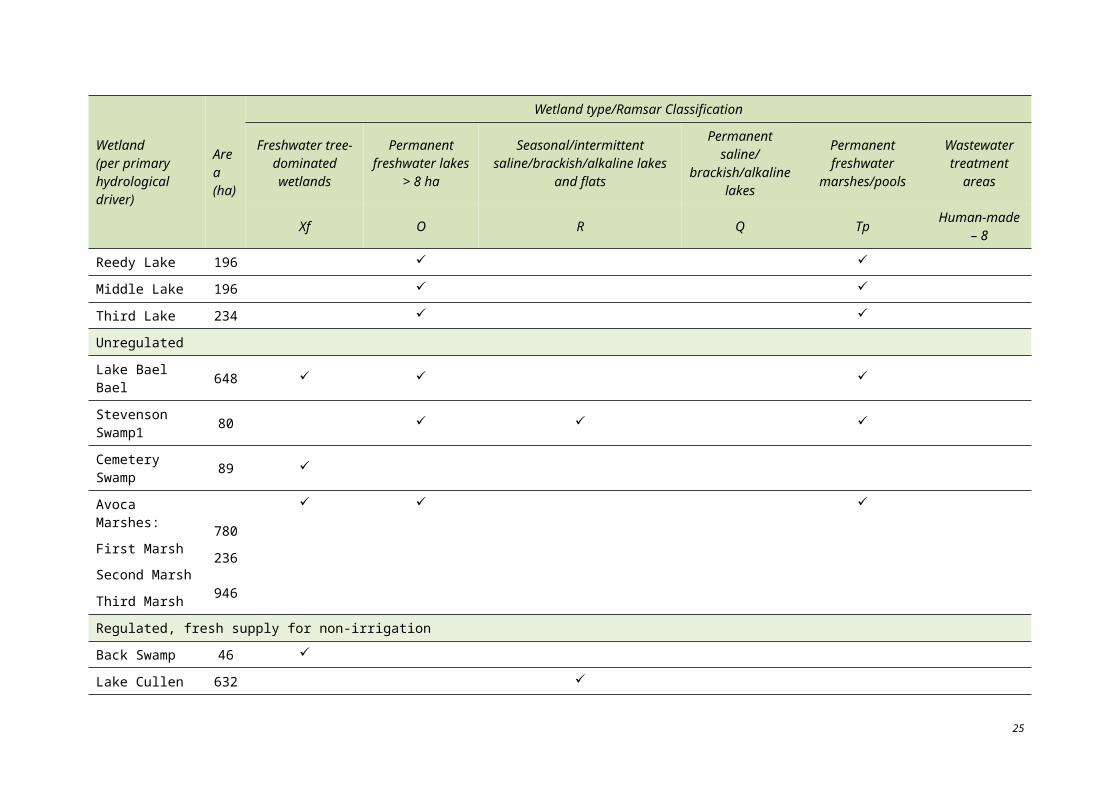
Year
Unregulated Regulated drainage Regulated, fresh supply, irrigation Regulated, fresh supply, non-irrigation
Total F
irst,
Seco
nd a
nd T
hird
Mar
shes
Lak
e B
ael B
ael
Cem
eter
y Sw
amp
Ste
vens
on
Swam
p
Lak
e K
elly
, Litt
le L
ake
Kel
ly
Fos
ters
Sw
amp
Lak
e Tu
tche
wop
Lak
e W
illia
m
Lak
e C
harm
, L
ittle
Lak
e C
harm
Third
, Mid
dle
an
d R
eady
Lak
es
Kan
garo
o La
ke
Rac
ecou
rse
Lake
Bac
k an
d To
wn
Sw
amps
Lak
e C
ulle
n
John
son
Swam
p
Hird
Sw
amp
1996 1530 7000 4 16 8550
1997 211 211
1998 2 8 198 1 21 5877 6107
1999 763 2575 65 138 2 58 102 104 1 452 9 5268
2000 8 7621 823 571 8744 10 440 94 136 60 9 2 2006 4 20 528
2001 4 214 2 965 18 36 62 8 64 1373
2002 320 9379 3121 9254 22 074
2003 45 100 6124 6269
Total 67 915 15 805 6 5 39 667 9901 63 652 8252 555 39 197 363 1050 441 413 468 36 836 57 186
37
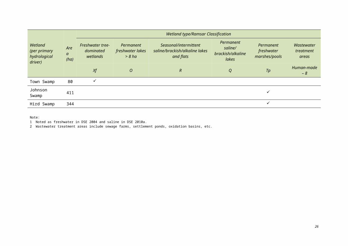
Table 3.7. Waterbird count at the Kerang Wetlands Ramsar site between 1979 and 2003. The average count is 31 772 for the period (© Copyright Atlas of Victorian Wildlife, data analysed from DSE 2010a).
Total
0100002000030000400005000060000700008000090000100000110000120000130000140000150000160000170000180000190000200000210000220000230000240000250000260000270000280000290000300000310000320000
1979
1980
1981
1982
1983
1984
1985
1986
1987
1988
1989
1990
1991
1992
1993
1994
1995
1996
1998
1999
2000
2001
2002
2003
Year
No.
wat
erbi
rds
Interpretation of the 1% threshold of a ‘population’ has varied since the time of listing. The site was originally listed under the 1% threshold criterion based on the following:
Kangaroo Lake, Lake Cullen and Lake Tutchewop: regularly supporting flocks of up to 1000 blue-billed duck (Oxyura australis);
Hird Swamp: 10 000 sacred ibis and 20 000 straw-necked ibis recorded in 1979–80;
Middle Lake: 15 000 sacred ibis and 15 000 straw-necked ibis recorded in 1979–80;
Hird Swamp and Middle Lake together: supported 45% of the straw-necked ibis and 73% of the sacred ibis breeding population within Victoria;
Lake Tutchewop: 9000 waders observed in 1982; and
Ramsar site: over 11 000 waders observed in 1982, 9% of the Victorian population.
It is not likely that these data would be suitable to meet the 1% criterion today; however, they are the best available data to describe how the criterion was met in 1982.
38
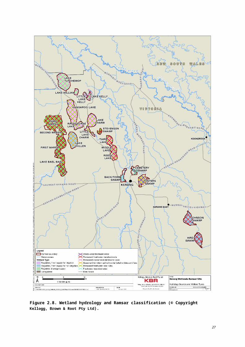
In addition to waterbird abundance, the site also supports a large diversity of waterbird species (see Table 7.2). Some individual wetlands support a high number of species (Table 3.8).
Table 3.8. Number of species recorded from several wetlands within the Ramsar site between 1980 and 2003 (DSE 2010a).
Wetland No. of species Wetland No. of species
Lake Cullen 56 Avoca Marshes 32
Lake Tutchewop 51 Kangaroo Lake 30
Reedy Lakes 48 Lake Charm, Little Lake Charm 26
Hird Swamp 44 Racecourse Lake 22
Fosters Swamp 44 Lake William 19
Johnson Swamp 41 Cemetery Swamp 10
Lake Kelly, Little Lake Kelly 41 Stevensons Swamp 2
Back and Town Swamp 33
Linkages to other components, processes and services
The biota of the Ramsar site are highly dependent upon the ecosystem components and processes. Climatic conditions, hydrology, soils and fluvial geomorphology are all critical in determining the suitability of an area as habitat for each flora and fauna species. Flora and fauna are also dependent upon each other. Vegetation serves as habitat and the primary food source for many fauna species while many plant species depend upon fauna for pollination, seed dispersal and nutrient deposition.
Biota play a critical role in the nutrient cycle. Biota also function in competition and predation roles which contribute to population dynamics and genetic diversity. The biota which characterise the Ramsar site were key aspects that led to the site’s listing as a Wetland of International Importance (meeting Criteria 1(a) 1(b) at the time of listing).
39
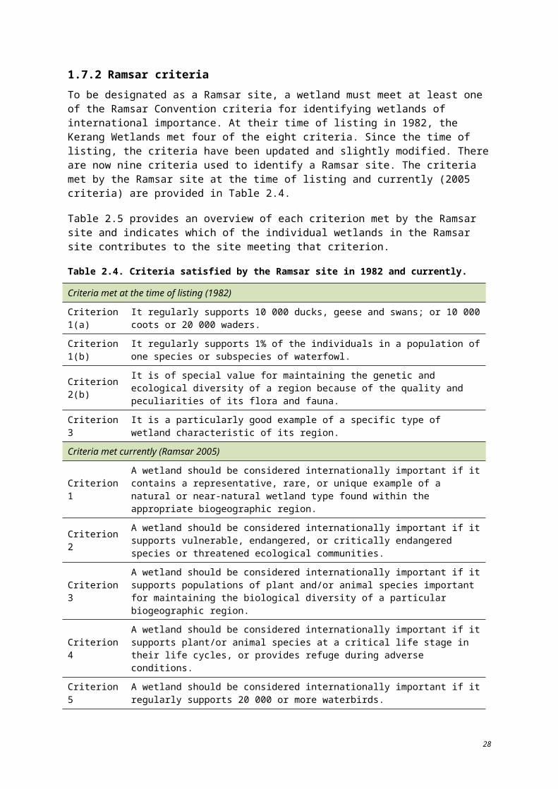
3.1.4 Waterbirds – colonial breeding/nesting Since 1980, 28 species of colonially breeding waterbirds (ibis, darters, cormorants, spoonbills) have been recorded at the site (DSE 2010a). Ninety-nine colonial nesting breeding events have been recorded across the site between the years of 1980 and 2005 (Table 3.9). Third Marsh, Second Marsh, Middle Reedy Lake and First Marsh are particularly important colonial nesting areas in terms of number of events recorded.
In general, the suitability of an area for waterbird breeding is dependent upon food supply, nesting sites, cover, water level and salinity. The Ramsar site provides a diverse range of breeding habitat which varies by wetland type and hydrology source. For this discussion, the Ramsar site is described in terms of hydrology source.
Table3.9. Number of colonial nesting breeding events per wetland, 1980–2003 (Source DSE 2010a).
Firs
t Ree
dy L
ake
Mid
dle
Ree
dy
Lake
Hird
Sw
amp
Lak
e B
ael B
ael
Firs
t Mar
sh
Sec
ond
Mar
sh
Thi
rd M
arsh
Kan
garo
o La
ke
Lak
e C
ulle
n
Lak
e Tu
tche
wop
Lak
e K
elly
1980 11981 4 2 2
1982 21983
1984 1 2 6 11985 2 3 3 3
1986 21987 2 1 7 1
1988 3 2 1 1 11989 1 2 4 1
1990 2 11991 2 1
1992 11993 1 2 1 3 5
19941995
1996 3 11997 1
1998 1 11999 1 1
2000 12001 2 2
20022003 2
20042005 2 1
Total 5 17 5 2 11 18 27 4 1 6 3
40

Regulated, fresh supply for irrigation
In general, these open lakes have few plants and serve as poor food sources. Little breeding occurs in these areas as they are also subject to disturbance from recreational activities. Available areas of fringe reed beds however, may be used for nesting by black duck and purple swamphen.
The exception to the general description of this wetland type is Middle Reedy Lake which has large lignum bushes covering approximately 30% of its surface area. Middle Reedy Lake is the only wetland within the Ramsar site with lignum growing in permanent fresh water. The lake is known to regularly support more than 1000 nesting straw-necked and sacred ibis and provides breeding habitat for royal spoonbill.
Regulated, fresh supply for non-irrigation
Lake Cullen, a deep semi-saline (terminal) lake, is valued as a general waterbird breeding site, although the only available record of a colonial breeding event is from 1998 (Table 3.9). The semi-saline condition limits vegetation growth to submerged species, such as ruppia. This vegetation can be dense which makes foraging for fish difficult.
Johnson and Hird Swamps are shallow freshwater lakes with a wide distribution of emergent vegetation, promoted through wetting and drying phases. Vegetation at these sites includes overstorey and understorey species such as river red gum, lignum, cumbungi, rush and dead timber. The sites also support aquatic vegetation species (ruppia, pondweeds and eel grass).
The variety of vegetation species across different strata provides breeding habitat for several species. Black swan, straw-necked and sacred ibis, black duck, purple swamphen and dusky moorhen have all been recorded as breeding at one or both of these wetlands. Hird Swamp regularly contains more than 1000 nesting straw-necked and sacred ibis (Parks Victoria 1999).
Town and Back Swamps are very shallow swamps heavily vegetated with black box, lignum and river red gum. Areas of open water can provide deep water habitat while larger areas of shallows and mudflats persist. The bathymetry and hydrology allow for production of food, cover and nesting sources. Black swan, black duck, grey teal, purple swamphen, dusky moorhen and little pied cormorant are all known to utilise this habitat type for breeding within the Ramsar site.
Drainage regulated
Lakes Tutchewop, Kelly and Little Kelly are saline lakes with minimal emergent vegetation. These areas do not provide optimal breeding habitat as they lack food sources and cover and the salinity of the lakes is not ideal for most waterbird species. Lake William is a shallow, hypersaline lake that has similar vegetation characteristics to Lake Tutchewop. Following flooding however, the lake supports a very large population of brine shrimp. The slopes of the wetland however, are too steep for most wading birds to take advantage of this abundant food source. Although the numbers are low, Australian shelduck has been recorded as nesting at this site during high water.
Fosters Swamp is a very shallow saline swamp which also supports shrimp following flooding. This site is also known to support small numbers of nesting Australian shelduck.
Unregulated
In the Avoca Marshes, Second and Third Marsh support breeding colonies of pied, little pied, black and little black cormorants, darter, yellow and royal spoonbill and high densities of hollow nesting waterfowl (Parks Victoria 1999).
41
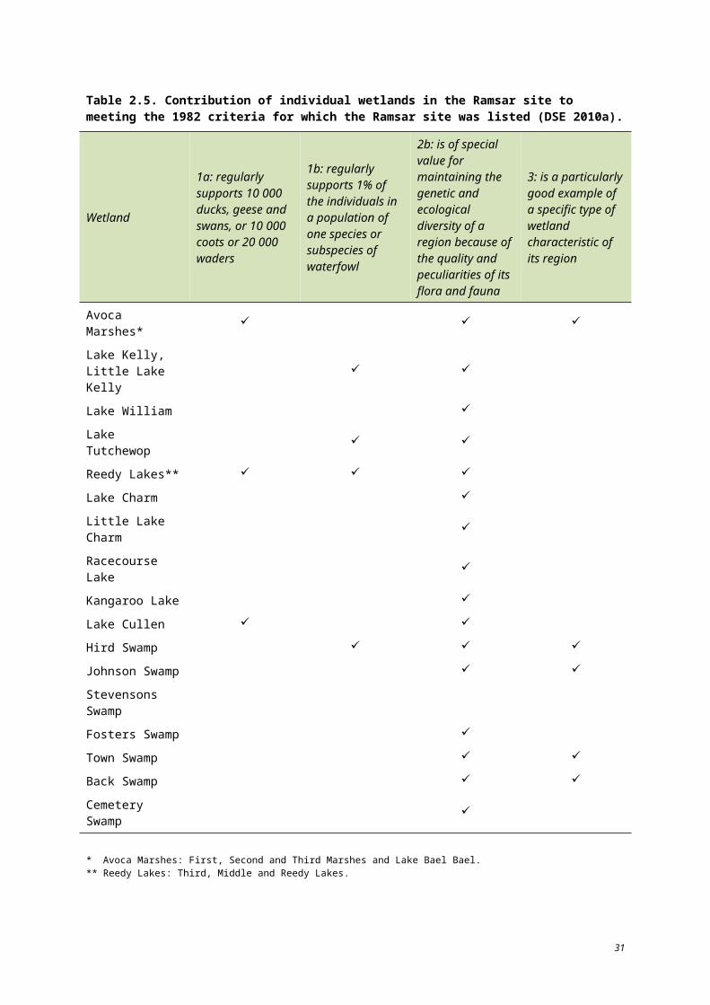
Linkages to other components, processes and services
Naturally suitable breeding habitat for waterbirds is created through geomorphic processes which shape depressions into the land. Clay soils enable water to be retained. Vegetation types, salinity and inundation patterns (hydrology and climate) then determine which species are able to utilise the area. Formation of the Loddon, Avoca and Murray Rivers has created a unique area of depressions suitable as breeding habitat for many waterbird species within the Ramsar site. Interactions of surface water (including irrigation water) and groundwater further determine the species which are most suited to an area as these interactions influence water and salinity levels throughout the year.
Beyond the physical aspects of the site, competition and predation between species further determine the level of success that a population has at a chosen breeding site. Because areas of the Ramsar site have become well established breeding locations for several species, they now provide bird watching and wildlife educational areas.
Since the 1970s, the Kerang region has experienced approximately two dry periods per decade, each lasting one to two years. In addition, there was a prolonged drought from 1997–2010. During these periods, when ephemeral and semi-permanent wetlands may dry out, regulated wetlands used for irrigation supply basins can provide drought refuge. The use of irrigation lakes is not well documented; however, they do provide a drinking water source and areas for roosting (DSE 2010a).
3.2 COMPONENTS, PROCESSES AND SERVICES
The character of the site and its associated value and importance is characterised by a range of recognised components, processes and services. These include:
Physical form – component
Soils – component
Climate – process
Physiochemical (nutrients and nutrient cycling) – process
Species interaction and population dynamics (competition, predation, herbivory) – process
Vegetation – component
Agriculture – service (provisioning)
Irrigation – service (provisioning)
Flood mitigation – service (regulating)
Salt disposal – service (regulating)
Water quality – component
Spiritual – service (cultural)
Recreational – service
Biodiversity – service (supporting).
Table 3.10 lists and describes each element and identifies recognised linkages to other components and processes across the site.
42
Table 3.10. Summary of the components, processes, services and benefits of the Ramsar site at the time of listing in 1982.
Element Component/ process/service
Element description Linkages with other components or processes
Physical form Component
Wetland depth influences duration of inundation.
Deep wetlands have a lower surface area to volume ratio which correlates to lower evaporation and rates of salinity increase.
Fluvial geomorphology, bathymetry and area are all factors which contribute to the current day landscape of the site and therefore provide a diverse range of habitat for waterbirds (2005 Criteria 3, 4, 5 and 6) and supporting rare wetland types (2005 Criterion 1).
Water depths vary from very shallow (less than 1 m to greater than 8 m). Kangaroo Lake is the deepest lake at 8.4 m (Parks Victoria 1999).
Maintains suitable habitat for fish and waterbirds.
Contributes to habitat availability for invertebrates, fish and waterbirds.
Contributes to diversity of wetland types.
Depressions and soil type enables water storage.
Soils/ geomorphology Component
Tertiary alluvium overlaid by Quaternary alluvium from Avoca and Loddon Rivers.
Characteristic lunettes formed along eastern flanks of many wetlands.
Influences flora communities. In addition to serving as a seed bank for local flora species, floodplain soils contain many organisms which are thought to remain dormant until they are extensively saturated by floodwaters.
Influenced by long-term hydrogeomorphic processes and medium to long-term regional hydrology. Wet and dry cycles can encourage the emergence of these species which contributes to the local food web and ultimately to the biodiversity of the site (Ramsar Criterion 2(b) at the time of listing).
Climate Process
Climate characterised by hot, dry summers and cold winters with January typically being the hottest month of and July the coldest. The area is classified as a warm, persistently dry grassland zone (BOM 2010).
Influences the distribution of vegetation species at the Ramsar site e.g. spiny lignum (Muehlenbeckia horrida).
Contributes to catchment inflows and water quality.
Influences evaporation rates.
Influences habitat for threatened flora and fauna species and vegetation communities and wetland types for which the site meets the 2005 Ramsar Criteria 1 and 2.
43
Element Component/ process/service
Element description Linkages with other components or processes
Physiochemical – nutrients and nutrient cycling
Process
Regional agricultural practices contribute nitrogen and phosphorous to the Loddon and Avoca rivers (NCCMA 2007).
Level of nutrient cycling depends upon wetland type.
Influenced by hydrology, climate, bathymetry and biological activity.
Affects flora and fauna habitat and food resources.
Species interaction and population dynamics: competition predation herbivory
Process
Exotic flora and fauna species are present throughout the Ramsar site
Foxes and rabbits compete with and prey on native fauna and the rabbit and carp have displaced native fauna by destroying their habitats, increasing soil erosion and decreasing water quality (NCCMA 2005).
Influenced by area of suitable habitat.
Affected by introduced species.
Vegetation Component
The site supports a large number of native plant species, including a community of tangled lignum shrubland which is under represented in Victorian wetland reserves (Parks Victoria 1999).
Determined by hydrology, salinity, climate and soils.
Serves as habitat and the primary food source for many fauna species while many plant species depend upon fauna for pollination, seed dispersal and nutrient deposition.
Agriculture Service (provisioning)
Grazing, horticulture and viticulture activities occur throughout the region and rely upon irrigation water supplied through the Torrumbarry Irrigation System.
Agricultural services rely on irrigation water from the Murray River which is provided via the local hydrologic system; regional geomorphology has led to the development of soils suitable for grazing and viticulture.
Fluvial geomorphology has shaped channels and depressions which have been adapted to transport and store water for irrigation.
Irrigation Service (provisioning) The Ramsar site is used for water storage basins and system
components which are used for irrigation and flood management.
An area of Fosters Swamp is used as tertiary wastewater treatment.
Barr Creek–Tutchewop system is used for salt disposal.
Hydrology of the Ramsar site is used to move and store water for irrigation, flood mitigation and salt disposal.
Fluvial geomorphology of the area has created natural depressions for water storage.
Biological processes and nutrient cycling at Fosters Swamp are essential to its function in the treatment of wastewater.
Flood mitigation Service (regulating)
Salt disposal Service (regulating)
Water quality Component
44
Element Component/ process/service
Element description Linkages with other components or processes
Spiritual
RecreationalService (cultural)
Many historical and archaeological sites have been documented within the Ramsar site (DSE 2004).
Wetlands provide access to water sports, wildlife viewing, fishing, bushwalking, camping and hunting.
Climate and hydrology influenced settlement of the area by Aboriginal people.
Bathymetry and area of large lakes (Kangaroo, Reedy Lakes) make them suitable for boating and waterskiing activities; fish stocking within lakes provides recreational angling opportunities.
High diversity and large populations of waterbirds attract bird watchers to the area.
Biodiversity Service (supporting)
High waterbird diversity.
High use of the area by many species of waterbirds and large populations of several species; the site provides breeding and rearing habitat for avian and aquatic species and supports rare wetland types, vegetation communities and flora and fauna species.
Supports a number of migratory waterbirds protected under bilateral and international agreements and conventions, including JAMBA, CAMBA and ROKAMBA and the Bonn Convention.
Critical habitat – drought refuge and breeding habitat for waterbirds.
Third, Middle and Reedy lakes have supported more than 10% of the regional breeding population of straw-necked ibis and Australian white ibis and more than 5% of the Victorian breeding population of royal spoonbill (Parks Victoria 1999).
The Ramsar site regularly supports more than 1% of the estimated flyway population of the banded stilt.
Threatened species and communities – habitat for threatened species.
Priority wetland species and ecosystems.
Wetland depth, hydrology, and climate contribute to diverse habitats, e.g. freshwater lakes, shallow marshes.
Critical flora and fauna components provide primary food sources for waterbirds, e.g. invertebrates, fish.
Dependent upon vegetation communities, hydrology and climate.
Affected by salinity levels within adjacent water bodies.
45
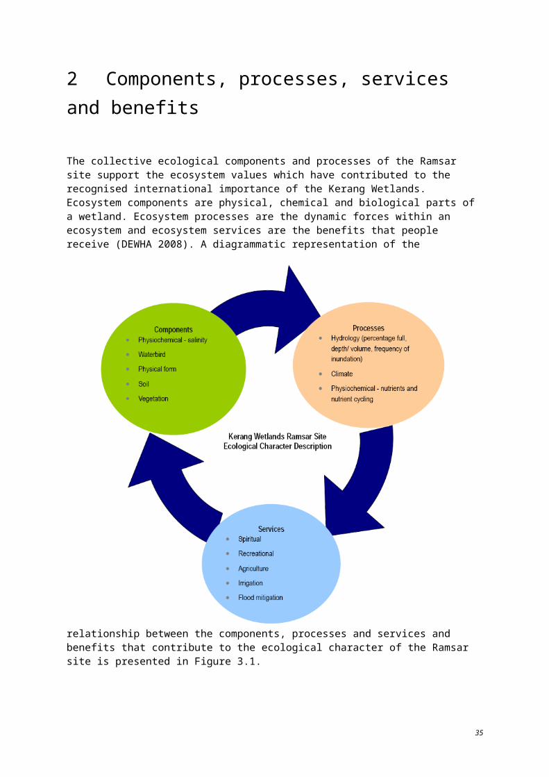
3.2.1 Physical form Physical form plays a crucial role in determining the character of each of the individual wetlands of the Ramsar site. Although fluvial geomorphology is a geologic process, it is viewed here as a component of the Ramsar site at the time of listing (not over a continuous geologic time frame).
Component description and driving forces
The characteristic wide floodplain areas associated with major river systems (including the Avoca, Loddon and Murray Rivers) encouraged the formation of depressional wetlands following times of flooding. Before the time of listing, many of these naturally formed basins and their channels had been modified to increase their water storage capacity for irrigation. This increased capacity in turn supports numerous human-related services, including irrigation water supply and recreational fishing opportunities.
Wetland depth influences duration of inundation. Deep wetlands have a lower surface area to volume ratio which correlates to lower evaporation and rates of salinity increase (through decreased exposure to wind and solar radiation). The different wetlands of the Ramsar site range in maximum depth from 0.8 m (Town Swamp) to 8.4 m (Kangaroo Lake) (Lugg et al. 1989).
Regulated irrigation wetlands have the greatest depth with maximum depths ranging from 1.5 m (Third Lake) to 8.4 m (Kangaroo Lake) (Lugg et al. 1989). The unregulated wetlands are the shallowest with maximum depths between 0.8 m and 3 m (Lugg et al. 1989).
Although bathymetric data is currently unavailable for the majority of the wetlands within the Ramsar site, a comparison of average to maximum depth ratios (Lugg et al. 1989) suggests minor variations in bathymetry. The greatest ratio of maximum to average depth is at Fosters Swamp and the Avoca Marshes. Based on data from 1989, these wetlands have a 2:1 maximum to average depth ratio. The difference in maximum depths to average depths is 0.5 to 1 m for the majority of wetlands within the Ramsar site and recent drying of wetlands such as Johnson and Hird Swamps has revealed the flat nature of the wetland beds.
Linkages to other components, processes and services
Fluvial geomorphology and bathymetry are intertwined with many of the processes and components of the wetland systems. Fluvial geomorphology and resulting soil composition form the structure for the area’s hydrology and influence groundwater interactions. Wetland bathymetry and area which formed as a result of geomorphological processes have created depressions and sediment depositions across the landscape. Bathymetry is also a factor of rainfall within the catchment which influences groundwater interactions, watertable elevation and the volume of groundwater inflow (SKM 2001). The variability in wetland depth throughout the Ramsar site allows for a variety of flora and fauna species to inhabit the area while supporting species during different life stages. Wetland depth can influence the diversity of birds which may utilise the site. Foraging waders utilise shallows while diving ducks prefer deep areas (DSE 2010a). Deep wetlands which hold water year-round can also provide drought refuge for fish and waterbird species.
Shallow wetlands which experience flooding and drying can provide valuable habitat for species that depend on flooding to stimulate breeding (e.g. ibis, herons and egrets). Flooding results in high productivity of food sources, supporting breeding adults and young (DSE 2010a).
46

3.2.2 SoilsThe soil types and composition which persist within the Ramsar site are indicative of its position and history within the Murray-Darling Drainage Division.
Component description and driving forces
Much of the Kerang Lakes area consists of Tertiary alluvium, some being overlain by Quaternary alluvium from the Avoca and Loddon Rivers. Lunettes (Quaternary aeolian deposits) occur on the eastern flanks of many of the wetlands. These features plus the adjacent lakes represent small localised land systems upon the broad alluvial plains. The lake sediments are grey (vertosols), often saline calcareous clays, while the lunette deposits are finely textured duplex soils of red sands and calcareous clays (sodosols). Soil erosion and salting are common problems (DSE 2004).
Grey and brown vertosols, or cracking clay soils, which occur on floodplains, ridged plains, volcanic plains and palaeolacustrine plains, are the primary soil type of the Ramsar site. In this case, they make up the soils in the area surrounding the wetlands (old alluvial plains) and form the large floodplains of the Loddon and Murray Rivers. Soil salinity is generally low. Poor surface structure usually limits agricultural use to grazing.
Linkages to other components, processes and services
The soil characteristics (mixed sand and clay types) allow for groundwater interactions and water storage capacity. Variability in water storage capacity across the site creates a range of habitats for flora and fauna species and collectively forms a unique wetland system characteristic of the Murray-Darling Drainage Division (meeting Ramsar Criteria 1(b) at time of listing).
3.2.3 ClimateThe climate of the Kerang region contributes to the provision of suitable habitat for characteristic populations, specifically waterbird species and influences sediment distribution and water quality (through wind and water movement).
Process description and driving forces
Climatic processes include precipitation, temperature, evaporation and wind. Local precipitation and temperature data were discussed in Section 2. These processes, particularly evaporation, have a large influence on the hydrology of the Ramsar site. Regional rainfall affects the amount of water available to and required by irrigators, which impacts the hydrology of wetlands associated with the irrigation system. At the time of listing, a wet regime prevailed which supported a larger irrigation footprint than that which the wetlands support today as a result of drier conditions.
The wet conditions of the late 1970s and early 1980s provided flow to fill the Avoca Marshes. However, since 1997 extremely dry conditions have prevailed (NCCMA 2006). The wetlands serving as drainage basins which rely heavily on regional precipitation, and subsequent flood flows and run-off, were held at high levels during the time of listing, from 1968 until 1990 (Aquaterra Simulations 2006).
The hydrology and salinity of non-irrigation wetlands are highly influenced by inputs from precipitation, run-off and evaporation. Since the dredging of Pyramid Creek in 1967, Hird and Johnson Swamps only receive major flood flows (DSE 2010a). Since the time of listing, drier conditions have prevailed making non-irrigation wetlands (including drainage basins) more susceptible to drying out.
47
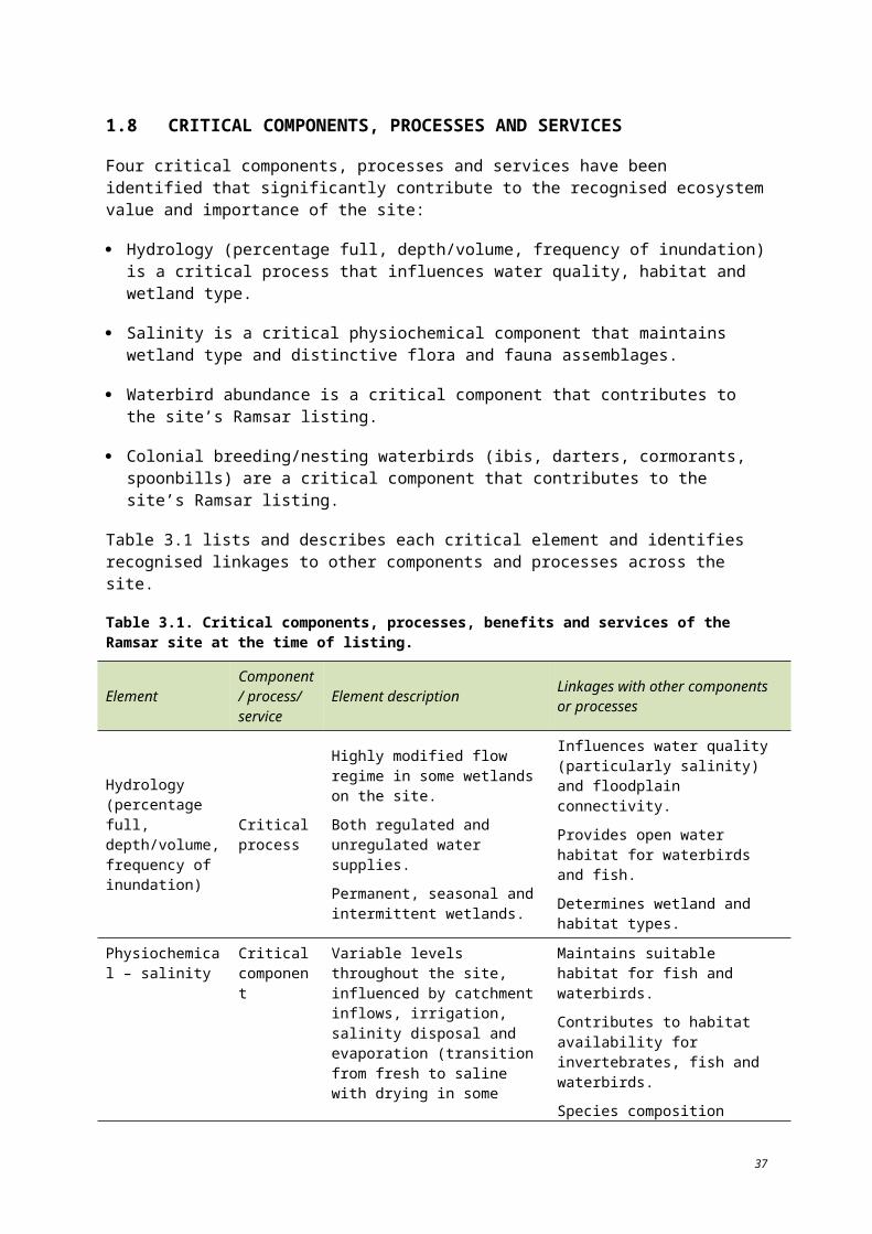
Wind speed at the Ramsar site is not currently measured but is known to be highly variable across the region (SKM 2009). Evaporation rates have been calculated by SKM (2009) for several of the Ramsar wetlands using methods which do not require wind data (pan coefficient). Results from this investigation show a general increase in net evaporation rates (the difference between evaporation rate and rainfall) of approximately 22% across all sites since the time of listing (Table 3.11). The increase is likely a result of more recent prolonged dry conditions across the region.
Table 3.11. Estimated net evaporation losses (SKM 2009).
Wetland Average annual net evaporation, 1980–2007 (ML/annum)
Net evaporation in 2007 (ML/annum)
Variation in average net evaporation rates (%)
Reedy Lake 1883 2423 22.29
Middle (Second) Lake 1883 2423 22.29
Third Lake 2131 2742 22.28
Little Lake Charm 565 727 22.28
Lake Charm 4500 5800 22.41
Racecourse Lake 2182 2808 22.29
Lake Kangaroo 8600 11 000 21.82
Linkages to other components, processes and services
Climate directly affects hydrology and salinity within the Ramsar site. Evaporation decreases available water while increasing salinity levels. Variations in climatic conditions maintain wetting and drying cycles and determine the amount of water required from the irrigation system which depends on storage volumes within the Ramsar site.
Climate also influences flora and fauna proliferation as biota responds to the changing seasons and conditions of the hydrology, soil, habitat and water quality within the Ramsar site. Abrupt or abnormal climatic conditions, such as above average amounts of precipitation, can alter available habitat and timing of critical life stages, particularly during reproductive seasons.
3.2.4 Physiochemical – nutrients and nutrient cyclingNutrients, including nitrogen and phosphorus specifically from fertilisers, animal industries, sewage and stormwater drains are likely to affect the Ramsar site wetlands to varying degrees, although no documentation of these affects at the time of listing is available.
Process description and driving forces
Nutrient cycling is driven by inputs from hydrology, climate and biological activity. Nutrients enter the system via rainfall, run-off, wind and surface and groundwater inflows. The duration of inundation plays a major role in the availability and form of nutrients within a wetland. Wetting and drying of a wetland affects the availability of nitrogen, phosphorus and other trace elements essential for plant growth. Ammonium nitrogen is typically the most readily available form of nitrogen to plants in wetland soils due to the anaerobic environment which favours this ionic form over nitrate, which is common in agricultural soils (Mitsch and Gosselink 2000). The rate of nutrient cycling can be affected by wind and temperature which increase or decrease the amount of dissolved oxygen in the water column.
48
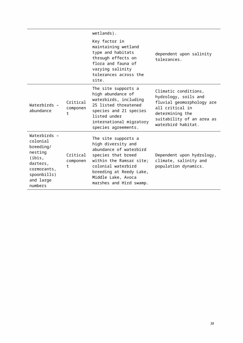
Water quality monitoring, including nutrient levels, was not being conducted across the Ramsar site at the time of listing. As such, the impacts of processes known to contribute to changes in nutrient levels is not available, although it is likely that local irrigation and agricultural practices in the years preceding listing had impacted the nutrient loads of wetlands within Ramsar site.
Linkages to ecological components, processes and services
High nutrient levels have an impact on water quality, particularly in relation to flora and fauna habitat, recreational use and domestic water supply. The stability of the water column (a function of climatic conditions) affects the rate of nutrients released from sediments through controlling the amount of dissolved oxygen available and thus, the level of benthic microbe activity (SKM 2001). Considerable work has been undertaken to mitigate the introduction of nutrients and salt to the lakes within the Ramsar site (DSE 2004).
Water quality conditions affect the rate of primary production which forms the base of the food chain. From there, types of animals which utilise the wetland can be determined by their primary food source preference, whether it is dominated by vascular plants versus algal-based sources (SKM 2001). High levels of turbidity limit primary productivity and can also affect fish populations which rely on visual acuity to find prey.
Water quality is also a factor in the attractiveness of the site for recreation. Blue-green algae blooms can affect water quality by causing peculiar tastes and odours, discolouration and unsightly scums. As the bloom dies, the decaying algal cells reduce the oxygen concentration in the water and produce toxins that can be poisonous to humans and animals (G-MW 2010). Due to health considerations, lakes which experience blue-green algae blooms are not recommended for boating, swimming or fishing.
Nutrient cycling affects flora and fauna species as the base of food webs and functions as a habitat component (available food resources). Major processes such as hydrology, climate and geomorphology affect the amount and type of nutrients available within the Ramsar site. Land use can also affect the nutrient cycle, particularly in an agricultural region such as Kerang. Run-off from local agricultural fields can contain fertilizers which can change the nutrient balance of the receiving waters. For example, the Avoca Marshes are fed by inflows from the Avoca River which derives its water primarily from surface flows from a catchment dominated by agriculture.
Regulated, fresh supply wetlands used as irrigation storage basin have the least amount of vegetation of the four wetland types discussed. Their depth decreases light penetration required for photosynthesis, a critical path in the nutrient cycle (primary producers). The stable water level also suppresses the germination of seeds buried within the fringe areas of the lake (unlike wetlands with variable water levels). This reduces recruitment levels thereby limiting the extent of vegetation growth. These wetlands, as previously discussed, are not widely used as waterbird habitat, with the exception of Middle Reedy Lake. However, the open water offers recreational boating opportunities. These wetlands (Reedy Lakes, Kangaroo and Racecourse Lakes in particular) are stocked with fish which support local angling (DPI 2010). However, once fish are caught and removed from the lake, they no longer contribute to the nutrient cycle.
3.2.5 Species interaction and population dynamicsProcess description and driving forces
The Ramsar site is highly valued as waterbird habitat. Biological processes and interactions function in varying degrees to suit the diverse range and numbers of waterbirds which utilise the site. In general, variability in climatic and hydrologic conditions can influence flora and fauna populations in number and distribution. Changing conditions result in ongoing interspecies competition for habitat.
49
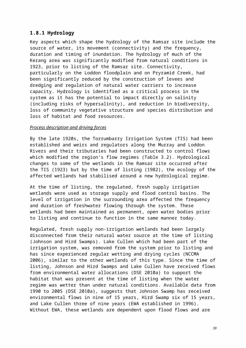
Impacts to flora occurs following disturbance due to stock grazing which can lead to weeds becoming established and competing with native vegetation. Wetlands are particularly vulnerable, as many introduced weeds are adapted to high moisture levels but lack the pests and diseases to keep them in check (NCCMA 2005).
Fauna species also compete for habitat and resources. Deep lake systems such as the regulated irrigation lakes are better suited for fish species that are more adept at utilising available food resources than waterbird species in these conditions (Lugg 1989). Given deep water sites are not a suitable for wading birds (due to water depth), non-diving birds can only utilise food around the margin. Near the water surface, fish species out compete diving bird species (Lugg 1989). As a result, competition for food resources in productive shallow wetlands is much higher.
These general concepts can be applied across the Ramsar site based on trends in data collected following listing (Lugg 1989). There are insufficient data available, however, to describe specific relationships between species and to describe population dynamics at the Ramsar site at the time of listing. Information regarding the 1% criteria (presented in Section 3.8) is the greatest level of detail to describe species use of the site at the time of listing. Although the agricultural practices surrounding the Ramsar site are well known, there is little data to describe the effects of these practices on vegetation at the site at the time of listing.
Linkages to ecological components, processes and services
Variability in water quality from run-off and groundwater sources and evaporation is influential in determining the number and species of waterbirds which may breed at a wetland. Increasing salinity for example, shows a negative correlation to the number of breeding waterbirds (Lugg 1989).
Water quality can also affect lower levels of the food chain which can have widespread effects. Without invertebrates and smaller species of fish which provide food for fauna at higher trophic levels, the Ramsar site would not be able to sustain the range or abundance of waterbirds which support a number Ramsar listing criteria (Fleming 1990).
Introduced species can also affect population dynamics by reducing available habitat, increasing predation and reducing food resources. At Lake Cullen, extensive grazing by rabbits and continued insect attack of trees have affected vegetation communities (DPI 2010c). Rabbits and foxes living within the Ramsar site compete with and prey on native fauna, while rabbits and European carp have displaced native fauna by destroying their habitats, increasing soil erosion and decreasing water quality (NCCMA 2005).
Introduced fish species (European carp (Cyprinus carpio) and mosquito fish (Gambusia sp.) increase predation directly and indirectly. Mosquito fish are direct predators to other smaller fish species while carp are detritivores which compete with yabbies for food resources (Fleming 1990). Stocked fish species for recreational fishing have also changed the food webs of the lake environments. Fish stocked for angling are typically top predator species (e.g. Murray cod).
50

3.2.6 VegetationOver 150 species of indigenous flora have been recorded at the Ramsar site since the time of listing (DSE 2004). Although changes to species’ status have been made over time, 23 species currently listed at the state level have been recorded at the site since 1980 (Table 3.12) (DSE 2010a, O’Donnell 1990, DSE 2010b). O’Donnell (1990) notes the presence of five state-listed flora species and DSE (2010a) notes an additional 16 state-listed species. An additional four species have been reported as threatened by O’Donnell (1990), Parks Victoria (1999) and DSE (2004), but have since been delisted (white cypress pine, Callistris columellaris; Australian millet, Panicum decompositum; Forde poa, Poa poafodeana; and matted starwort, Callitriche sonderi). The high number of species noted at the Avoca Marshes is likely a factor of more intense surveys, such as Riparian Australia (2003), in this area. Although the Ramsar site does not contain nationally threatened flora species, the prevalence of state threatened species indicates the importance of the Ramsar site for supporting flora representative of the southern extent of the Murray-Darling Drainage Division.
Component description and driving forces
The Ramsar site supports a range of vegetation species and communities, including black box and river red gum, tangled lignum, chenopod shrubland, grassland, reed bed and aquatic plant communities. Although the EVC descriptions were developed over 20 years after listing of the Ramsar site, they represent the only comprehensive vegetation distribution mapping for the site. The current mapping recognises 16 EVCs. The bioregional conservation status is endangered for six of these EVCs and vulnerable for another five. The Ramsar site is largely comprised of lignum swampy woodland (vulnerable in the Murray Fans and Victorian Riverina IBRA subregions), freshwater lake mosaic and lake bed herbland (DSE 2010a) (vulnerable in the Murray Fans IBRA subregion and depleted in Victorian Riverina IBRA subregion).
Buloke woodlands of the Riverina and Murray-Darling Depression IBRAs are nationally-listed as endangered (DEWHA 2010a). Buloke has been recorded at Lake Bael Bael and Lake Cullen (O’Donnell 1990). The Ramsar site is located within the buloke woodlands distribution area and is likely to have supported this community at the time of listing.
The black box woodland communities such as those at the unregulated wetlands of Third Marsh and Cemetery Swamp are a particularly valuable vegetation community. Spiny lignum is suspected of being threatened in Victoria and occurs at many of the wetlands in the Ramsar site (DSE 2004). Changes to the hydrology of the area have had detrimental impacts to several of these communities with naturally occurring species being displaced by species which are better suited to the managed conditions which prevailed at the time of listing (O’Donnell 1990).
51
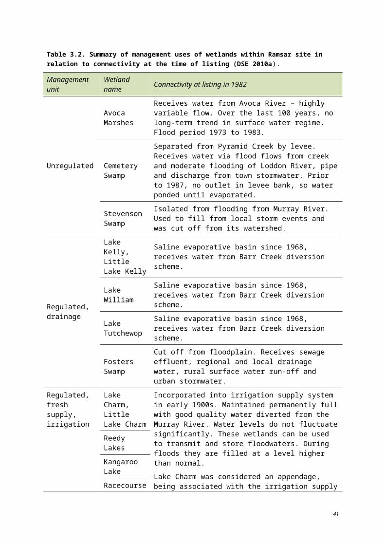
Table 3.12. Rare and threatened flora species records in the Ramsar site since 1980 (Sources: DSE 2010a, O’Donnell 1990, DSE 2010b).
Common name Scientific name
Con
serv
atio
n st
atus
stat
e
List
ed u
nder
FFG
Act
198
8
Lake
Tut
chew
op
Lake
Will
iam
Lake
Kel
ly
Littl
e La
ke K
elly
Kan
garo
o La
ke
Rac
ecou
rse
Lake
Lake
Cha
rm
Littl
e La
ke C
harm
Avo
ca M
arsh
es
Lake
Cul
len
Stev
enso
n Sw
amp
Third
, Mid
dle,
R
eedy
Lak
es
Bac
k an
d To
wn
Sw
amps
Cem
eter
y Sw
amp
Fost
ers S
wam
p
John
son
Swam
p
Hird
Sw
amp
Bladder saltbush Atriplex vesicaria ssp. macrocystidia r
Blackseed glasswort#
Halosarcia pergranulata subsp. divaricata
v
Brown beetle-grass Leptochloa fusca ssp. fusca r
Bundled peppercress
Lepidium fasciculatum k
Buloke* Allocasuarina leumanii
Downy swainson-pea
Swainsona swainsoniodes e
Flat spike-sedge# Eleocharis plana v
Hoary scurf-pea Cullen cinereum e
Mallee cucumber Mukia micranthar
Sickle love-grass Eragrostis falcata k
Six-point arrowgrass
Triglochin hexagona v
Small-flower tobacco
Nicotiana goodspeedii r
52
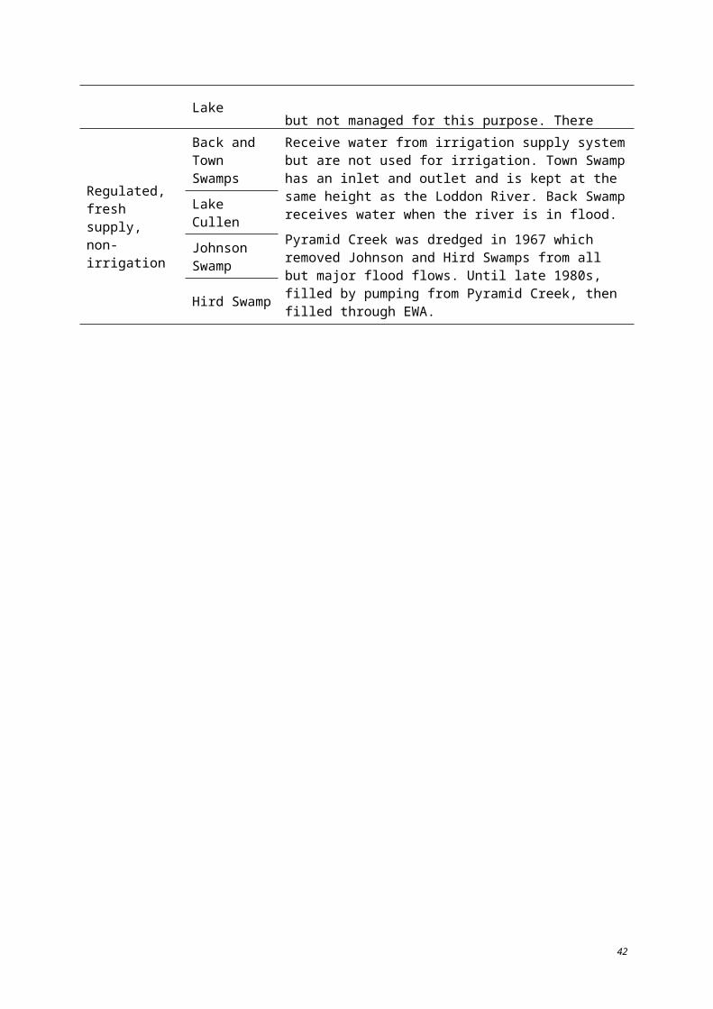
Common name Scientific name
Con
serv
atio
n st
atus
stat
e
List
ed u
nder
FFG
Act
198
8
Lake
Tut
chew
op
Lake
Will
iam
Lake
Kel
ly
Littl
e La
ke K
elly
Kan
garo
o La
ke
Rac
ecou
rse
Lake
Lake
Cha
rm
Littl
e La
ke C
harm
Avo
ca M
arsh
es
Lake
Cul
len
Stev
enso
n Sw
amp
Third
, Mid
dle,
R
eedy
Lak
es
Bac
k an
d To
wn
Sw
amps
Cem
eter
y Sw
amp
Fost
ers S
wam
p
John
son
Swam
p
Hird
Sw
amp
Small monkey-flower Mimulus prostratus r
Spiny lignum*Muehlenbeckia horrida ssp. horrida
r
Spreading emu-bush
Eremophila divaricata ssp. divaricata
r
Spreading scurf-pea Cullen patens e
Sweet fenugreek Trigonella suavissima r
Swamp buttercup* Ranunculus undosus v
Twiggy sida Sida intricata v
Twin-leaf bedstraw*
Asperula gemella r
Umbrella wattle* Acacia oswaldii v
Waterbush Myoporum montanum r
Yakka grass Sporobolus caroli r
Note: * noted only in O’Donnell (1990);# noted only in DSE (2010); Status in Victoria: r = rare; v = vulnerable; e = endangered; k = insufficiently known.
53
The wet regime of the late 1970s played a major role in changes to the vegetation communities of the area, particularly in the Avoca Marshes where the artificial sill at Third Marsh contributed to prolonged inundation of the marshes. At the time of listing, the healthy river red gum forest of Second and Third Marsh was experiencing die back due primarily to extended inundation but also to saline discharge and salt accumulation from irrigation of the lunette at Second Marsh (NCCMA 2006). Cemetery Swamp, another unregulated wetland, is noted as being slightly modified by human activities but supporting a high number and proportion of native species (O’Donnell 1990).
O’Donnell (1990) reported that over half of the flora species within the wetlands are introduced. Fosters Swamp (regulated drainage wetland) in particular has been heavily modified by human activities with a low number and proportion of native species present.
Regulated, fresh supply irrigation wetlands (namely Lake Charm, Little Lake Charm, Racecourse Lake and Kangaroo Lake) support good examples of representative spiny lignum populations (O’Donnell 1990) within the Murray-Darling Drainage Division. In addition, Middle Lake and the unregulated Lake Bael Bael have seasonally flooded margins which provide excellent conditions for many native species (O’Donnell 1990). The stable water level of most of the regulated irrigation wetlands limits the diversity of flora species.
Although water levels may fluctuate more at brackish wetlands within the site, O’Donnell (1990) found that saline and hypersaline wetlands within the Ramsar site had low species richness (< 70 species) and only two rare species were found during the survey of these areas.
Linkages to ecological components, processes and services
The hydrology and salinity of the area as well as the general climatic conditions drive the success or failure of vegetation communities. Changes in these components and processes can result in the introduction of new niche species and general vegetation composition of the site. Vegetation communities within the Ramsar site contribute to the suitability of the area for various fauna species for forage, refuge and breeding habitat.
3.2.7 Services and benefits – descriptions and associationsEcosystem benefits and services are currently defined as ‘the benefits that people receive from ecosystems’ (DEWHA 2008).
Four main categories of ecosystem benefits and services have been identified within the National Framework:
Provisioning services: the products obtained from the ecosystem such as food, fuel and fresh water;
Regulating services: the benefits obtained from the regulation of ecosystem processes such climate regulation, water regulation and natural hazard regulation;
Cultural services: the benefits people obtain through spiritual enrichment, recreation, education and aesthetics; and
Supporting services: the services necessary for the production of all other ecosystem services such as water cycling, nutrient cycling and habitat for biota. These services will generally have an indirect benefit to humans or a direct benefit over a long period of time.
54
3.2.8 Provisioning servicesThe Kerang region has traditionally supported an agricultural and a service-based economy. There is a strong focus on irrigated agriculture which produces horticultural, viticultural, dairy, meat and grain products (DSE 2004). The Ramsar site is used year-round to store and regulate water for irrigation and also for stock supplies. The irrigation system was in place prior to listing and continues to be used today. In an average irrigation season, the Torrumbarry Weir diverts an average of 300 000 ML to 500 000 ML of water to irrigators in Kerang, Cohuna and Swan Hill (KBR 2007). As water flows into the wetlands via natural and constructed channels, it can then be withdrawn from wetlands such as Lake Charm, for irrigation and stock while larger wetlands like Racecourse and Kangaroo Lakes are used for water storage (KBR 2007).
Grazing of stock occurs in certain wetlands during the summer months when feed levels in the paddocks are low (O’Donnell 1990).
The Ramsar site once supported a commercial fishery which has since closed (in 2002) to all species except European carp (DSE 2004).
3.2.9 Regulating services The Ramsar site is used for flood and drainage management. Lakes Tutchewop, William, Kelly and Little Kelly are used as salt disposal basins in order to reduce salt loads entering the Murray River. The regulated, fresh supply irrigation wetlands are used as flood control basins.
3.2.10 Cultural services Spiritual
The Ramsar site is rich in Aboriginal cultural heritage. A total of 425 Aboriginal sites have been registered on the Aboriginal Affairs Victoria (Department for Victorian Communities) Register of Aboriginal sites and places in the Kerang Lakes area. This area extends beyond the Ramsar listed wetlands (DSE 2004). These sites include mounds, scarred trees, middens, burials, hearths, surface scatters and isolated artefacts. The Reedy Lakes in particular are known as a highly significant area of cultural heritage value (SKM 2009).
The local Aboriginal organisations include the North West Nations Clans Aboriginal Corporation and the former Bendigo Dja Dja Wrung Aboriginal Association Incorporated (now defunct). Traditional owner groups are the Wamba Wamba and the Barapa Barapa (DSE 2004).
Recreation
The Ramsar site is a valuable resource for recreation and tourism. The value of the land for recreation, in part, stems from its natural ecological assets. With the implementation of the area’s irrigation system, large water bodies used as irrigation storage also provide for recreational activities. Activities include scenic driving, sightseeing, camping, picnicking, swimming, sailing, water skiing, boating, fishing, hunting, bird watching and nature study and appreciation (DSE 2004).
Since the time of listing, a native fish (Murray cod and golden perch) stocking program has been implemented for several wetlands which aims to improve native fish stocks while also providing areas for recreational fishing. Lakes which are part of the program include Kangaroo Lake, Lake Charm and Reedy Lake (DSE 2004, DPI 2010a).
55
The Reedy Lakes offer multiple types of recreation from picnicking at Reedy Lake and bird watching from the bird hide at Middle Lake to fishing at Third Lake (SKM 2009). The bird hide at Middle Lake was constructed as a bird blind from which to observe the tens of thousands of pairs of breeding ibis.
Natural features reserves (Table 2.2) are accessible for a variety of recreational activities, including bushwalking, bird watching, picnicking and duck hunting.
3.2.11 Supporting servicesBiodiversity – high diversity of waterbird species
The diverse range of habitat types across the Ramsar site enables it to support a high diversity of waterbirds. Seventy-six waterbird species have been recorded within the wetland since 1980 (DSE 2010a). Between 1980 and 2003, the greatest number of species (56) was observed at Lake Cullen while the lowest number (two) was observed at Stevenson Swamp (DSE 2010a). As previously mentioned, 36 species listed as migratory species of international significance have been recorded at the Ramsar site.
Although the majority of data used to support this service were collected in the years following listing, the trends which have become apparent as survey efforts have increased and data from various sources have been collated, suggest the site has a history of supporting a high diversity of birds prior to and since the time of listing.
3.2.12 Threatened species and communities – habitat for threatened species Ecological vegetation class mapping at the IBRA subregion level available in DSE (2010a) recognised six endangered and five vulnerable bioregional conservation status classifications of EVCs within the Ramsar site. The EVC mapping was conducted over 20 years after listing and is the only source of vegetation community data across the site. It provides a baseline from which to monitor future changes in vegetation.
Seventeen flora species which are currently state listed as vulnerable, rare or poorly known have been recorded within the Ramsar site since 1982 (DSE 2010a, Appendix A). In addition, one species recorded at the site is listed under the Flora and Fauna Guarantee Act 1988. No nationally listed threatened flora has been recorded (DSE 2004).
Between 1980 and 2003, 76 waterbird species have been recorded at the Ramsar site (see Table 7.2). Of these, 25 are threatened in Victoria, two are listed as nationally threatened (under the EPBC Act) and three are listed as threatened internationally (IUCN Red List). In addition to waterbirds, the site also supports other birds, reptiles, amphibians and fish that are listed as threatened at the state, national or international level. These species include the regent honeyeater, carpet python, tree goanna, growling grass frog, Macquarie perch, Murray cod and Murray hardyhead (see Appendix A).
3.2.13 Priority wetland species and ecosystemsThe Ramsar site supports many waterbird species listed on international migratory species agreements and on the international threatened species list (IUCN Red List). In addition to supporting threatened flora and fauna species, several sites, namely Lake Tutchewop, Middle Lake, Hird Swamp and Lake Kelly, have been recorded as supporting over 1% of the population of one or more waterbird species (DSE 2010a) since the time of listing. These species include the banded stilt, Australian white ibis, great crested grebe and red-necked avocet (see Table 7.1).
56
The site also supports deep and shallow freshwater marshes which are rare wetland types, using the Victorian wetland classification system. Throughout Victoria, the area of deep freshwater marshes has been reduced by 60% and the area of shallow freshwater marshes by 70% (DSE 2010a). The Ramsar site contains 3.8% and 0.5% of the remaining deep and shallow freshwater marshes in Victoria, respectively (DSE 2010a).
57
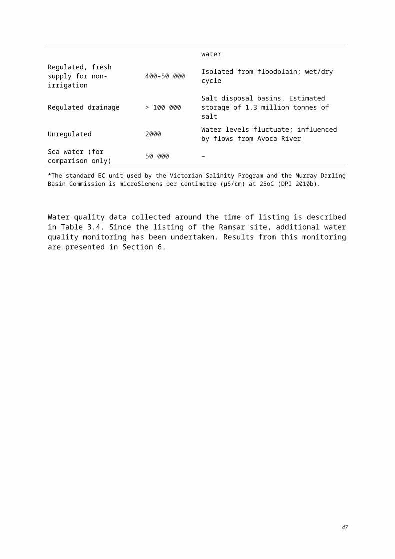
4 Conceptual models
Conceptual models are presented in Figures 4.1–4.4 for each hydrological regime group. The conceptual models illustrate the main components, processes and benefits or services outlined above for wetlands within the Ramsar site.
Conceptual models were developed by Dr Amina Price (The Murray-Darling Freshwater Research Centre), commissioned by the Murray-Darling Basin Authority and modified by KBR.
58
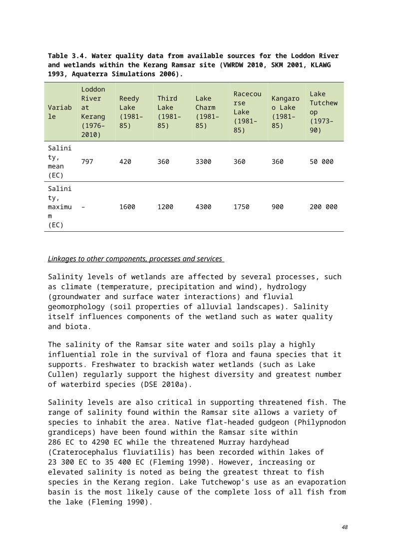
Figure 4.1. Regulated fresh supply for irrigation (© Copyright Kellogg, Brown & Root Pty Ltd).
59
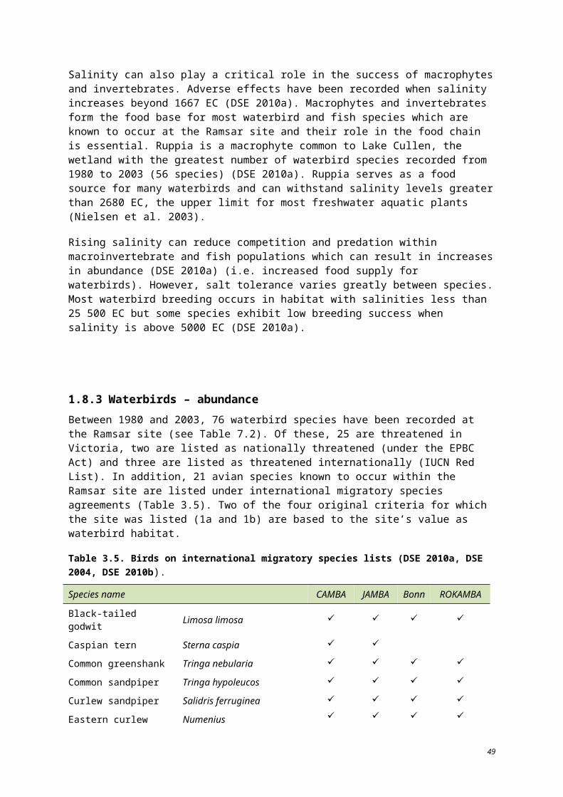
Figure 4.2. Regulated drainage supply (© Copyright Kellogg, Brown & Root Pty Ltd).
60
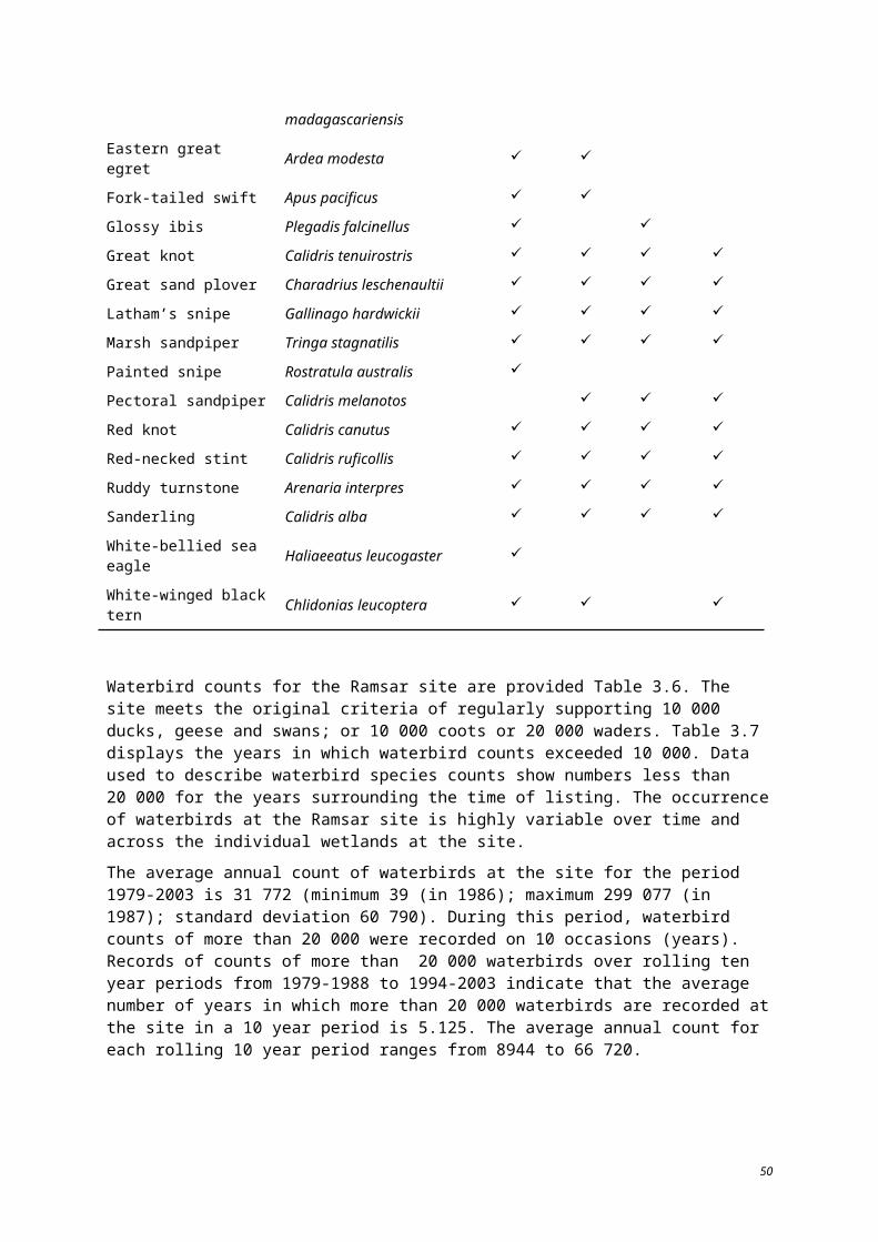
Figure 4.3. Regulated fresh supply for non-irrigation (© Copyright Kellogg, Brown & Root Pty Ltd).
61
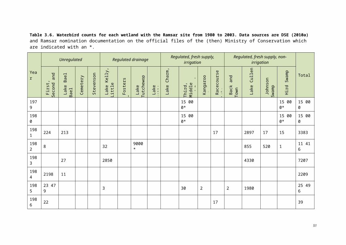
Figure 4.4. Unregulated (© Copyright Kellogg, Brown & Root Pty Ltd).
62
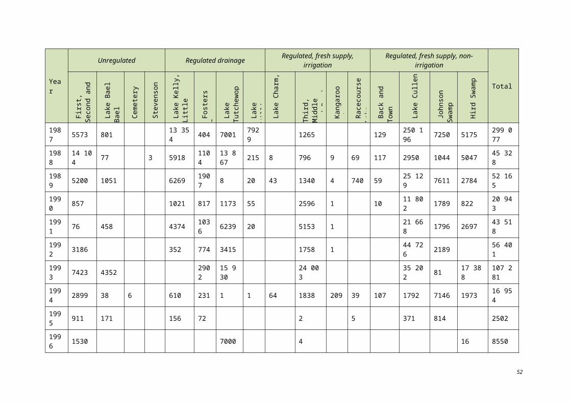
5 Limits of acceptable change
5.1 INTRODUCTION
This section provides quantitative baseline information for each of the critical components and processes outlined in Section 3 of this description, and identifies Limits of Acceptable Change (LACs) where possible. LACs are defined as:
The variation that is considered acceptable in a particular measure or feature of the ecological character of the wetland. This may include population measures, hectares covered by a particular wetland type, the range of certain water quality parameter, etc. The inference is that if the particular measure or parameter moves outside the ‘limits of acceptable change’ this may indicate a change in ecological character that could lead to a reduction or loss of the values for which the site was Ramsar listed. In most cases, change is considered in a negative context, leading to a reduction in the values for which a site was listed (Hale and Butcher 2007)
LACs acknowledge the natural variability exhibited by elements within the wetland ecosystem and establish upper and lower bounds to facilitate the detection of adverse change to the ecological character resulting from human activities.
Where available, quantitative baseline information for critical ecosystem components and processes from 1982 has been summarised in Tables 5.1 to 5.4. Following this, where possible, LACs from these baseline values have been established. Where current knowledge gaps inhibit the ability to set LACs, these have been stated in Tables 5.1 to 5.4, and discussed further in Section 8.
In acknowledging the difficulties associated with establishing LACs, the following confidence levels have been applied where possible:
High: based on long-term data considered to be adequate for establishing LACs
Moderate: based on empirical data; however considered unlikely to describe natural variability in time. This can include
o repeated measurements over a limited time frame, or no/limited data available pre-listing
o single measurement (no temporal context) of the extent of a particular habitat type, abundance of a species or diversity of an assemblage
Low: not based on empirical data describing patterns in natural variability. These may be based on a range of acceptable sources, including published documents, personal communication with relevant scientists and agency staff. They are established based on the best professional judgement of the authors where there is a distinct lack of quantitative data or published information.
Explanatory Notes for LACs
LACs are a tool by which ecological change can be measured. However, ECDs are not management plans and LACs do not constitute a management regime for the Ramsar site.
Exceeding or not meeting LACs does not necessarily indicate that there has been a change in ecological character within the meaning of the Ramsar Convention. However, exceeding or not meeting LACs may require investigation to determine whether there has been a change in ecological character.
63
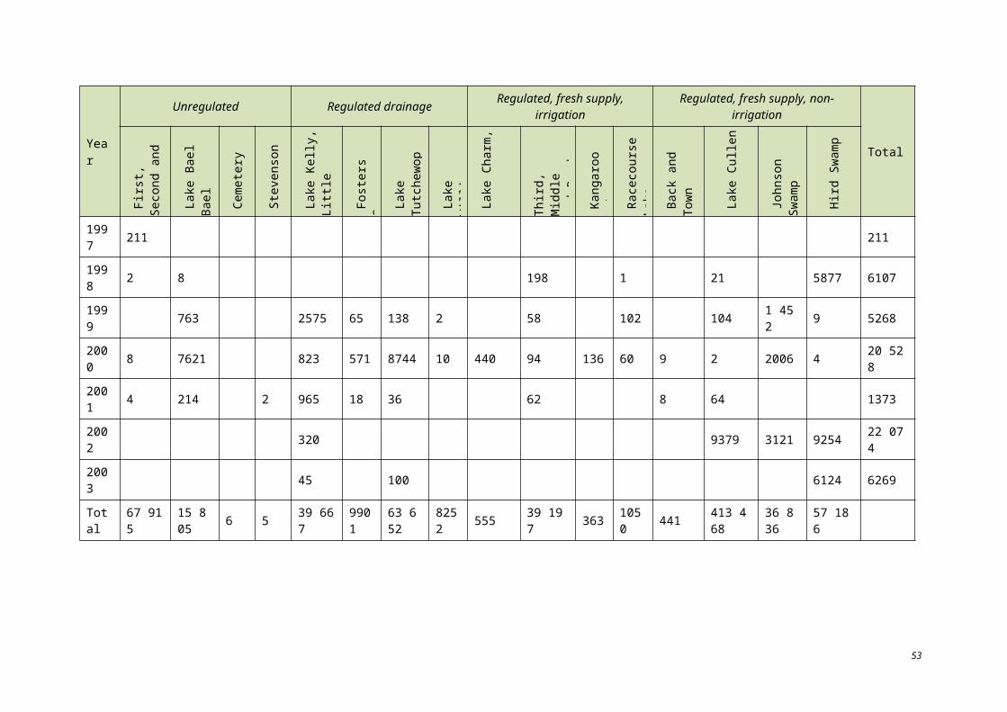
In reading the ECD and the LACs, it should be recognised that the hydrology of many catchments in the Murray-Darling Basin is highly regulated, despite many of the wetlands forming under natural hydrological regimes that were more variable and less predictable. Many of the Ramsar wetlands of the Murray-Darling Basin were listed at a time when the rivers were highly regulated and water over allocated, with the character of these sites reflecting the prevailing conditions. When listed under the Ramsar Convention, many sites were already on a long-term trend of ecological decline.
While the best available information has been used to prepare this ECD and define LACs for the site, a comprehensive understanding of site character may not be possible as in many cases only limited information and data is available for these purposes. The LACs may not accurately represent the variability of the critical components, processes, benefits or services under the management regime and natural conditions that prevailed at the time the site was listed as a Ramsar wetland.
Users should exercise their own skill and care with respect to their use of the information in this ECD and carefully evaluate the suitability of the information for their own purposes.
LACs can be updated as new information becomes available to ensure they more accurately reflect the natural variability (or normal range for artificial sites) of critical components, processes, benefits or services of the Ramsar wetland.
64
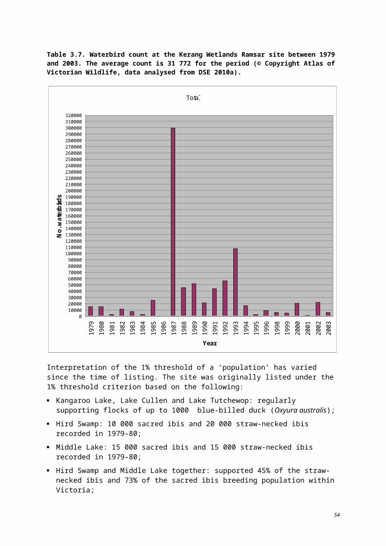
Table 5.1. Baseline condition and Limits of Acceptable Change for the critical process of hydrology – percentage full, depth, volume, frequency of inundation.
Water bodies Baseline condition and range of natural variation where known LAC Basis of LAC Level of
confidence
Lake Tutchewop
Lake Kelly
Little Lake Kelly
These lakes are salt disposal basins managed as part of the Tutchewop Lakes (Barr Creek Drainage Diversion). Over the benchmark period (1980-2003), all three lakes were permanently inundated (held water every year, throughout the year). Information on fluctuation in lake levels during this period is not available. The lakes dried out in 2006 and 2010 due to very dry catchment conditions. These resulted in a lack of drainage water in Barr Creek from where it is normally diverted to the lakes.
In an extreme flood event in February 2011, 12 ML of flood water was diverted to Lake Tutchewop. No flood water was received at Lake Kelly or Little Lake Kelly, except for spillover and leakage from Lake Tutchewop which freshened them.
The water regimes of these wetlands are subject to diversions from Barr Creek which may decline in the future as irrigation water is traded out of the Barr Creek catchment. There is uncertainty about whether such a change to the water regime would be unacceptable and therefore no LAC is set.
Insufficient information to develop a LAC. – –
Lake William
Lake William is a salt disposal basin managed as part of the Tutchewop Lakes (Barr Creek Drainage Diversion).
Under natural conditions, the lake experienced longer-term drying periods.
Insufficient information to develop a LAC. – –
Fosters Swamp
The small component of Fosters Swamp utilised as an urban wastewater treatment facility is permanently wet. The wastewater treatment ponds attract large numbers of waterbirds which contribute to the waterbird abundance and diversity service.
The remaining extent of Fosters Swamp receives urban storm water from part of the Kerang township and is intermittently wet. This area is not recognised as contributing to the waterbird abundance and diversity service.
In February 2011, Fosters Swamp was inundated by flood water.
Insufficient information to develop a LAC for frequency and extent of wetting/drying of the urban wastewater treatment facility component of Fosters Swamp.
– –
65
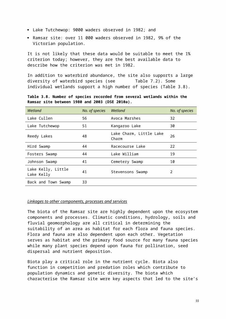
Water bodies Baseline condition and range of natural variation where known LAC Basis of LAC Level of
confidence
Kangaroo Lake
Racecourse Lake
Reedy Lake
These lakes are influenced by the Torrumbarry Irrigation System established in 1923.
The lakes are maintained at or near full supply level to maintain ecological condition of littoral zone, with annual fluctuations of up to 600 mm. These lakes were flooded in the extreme flood event of 2011.
The water regimes of these wetlands are artificially managed. There is uncertainty about whether a more natural water regime, such as that which existed prior to 1923 would represent an unacceptable change, thus the LAC is set around conditions prevailing at the time of listing.
Permanently inundated. Not to exceed the 600 mm range of fluctuation in water levels two years in a row.
Based on knowledge of the prevailing operating conditions at and since the time of listing.
Low
Lake Charm
Little Lake Charm
Third Lake
These lakes are influenced by the Torrumbarry Irrigation System established in 1923.
The lakes are maintained at or near full supply level to maintain ecological condition of littoral zone, with annual fluctuations of up to 1000 mm. These lakes were flooded in the extreme flood event of 2011.
The water regimes of these wetlands are artificially managed. There is uncertainty about whether a more natural water regime, such as that which existed prior to 1923, would represent an unacceptable change. As such, the LAC is set around conditions prevailing at the time of listing (1982).
Permanently inundated. Not to exceed the 1000 mm range of fluctuation in water levels two years in a row.
Based on knowledge of the prevailing operating conditions at and since the time of listing.
Low
Middle Lake
The lake is influenced by the Torrumbarry Irrigation System established in 1923. The lake is maintained at or near full supply level to maintain ecological condition of littoral zone, with annual fluctuations of up to 400 mm. The lake was flooded in the extreme flood event of 2011.
The water regime of this wetland is artificially managed. There is uncertainty about whether a more natural water regime, such as that which existed prior to 1923 would represent an unacceptable change, thus the LAC is set around conditions prevailing at the time of listing
Permanently inundated. Not to exceed the 400 mm range of fluctuation in water levels two years in a row.
Based on knowledge of the prevailing operating conditions at and since the time of listing.
Low
66

Water bodies Baseline condition and range of natural variation where known LAC Basis of LAC Level of
confidence
Stevenson Swamp
Unregulated system. Stevenson Swamp is a terminal lake with no recognised water supply except in large floods. Supports few values. In February 2011, the swamp was inundated by flood water.
Insufficient information to develop a LAC. – –
Cemetery Swamp
Number of years in which the swamp filled over the benchmark period (1980-2003) – four. Maximum numbers of years over the benchmark period that the swamp remained continuously dry – six.
The swamp relies on flood flow from Loddon River and/or Pyramid Creek. There were flood flows 1992-94 and 1995-96, and channel outfall in 1997-98. The swamp received flood flow in 2010 and experienced total inundation in February 2011.
Not dry for 10 or more consecutive years. Not continuously wet for more than two years.
Based on expert opinion of project steering committee. Low
Lake Bael Bael
Number of years in which the lake filled over the benchmark period (1980-2003) – 18. Maximum number of years over the benchmark period that the lake remained continuously dry – nine.
Lake Bael Bael held water until mid 1990s with a drying period in 1998-99. The lake received some water in early 2000 and was then recorded as continuously dry until 2010.
In February 2011, Lake Bael Bael was inundated by flood water.
Not dry for nine or more consecutive years.
Based on expert opinion of project steering committee and unpublished watering requirement data from Lakey and Hanson (1988), cited in Lugg et al. (1989).
Low
Avoca Marshes:
First Marsh
Second Marsh
Third Marsh
Number of years in which the marshes filled over the benchmark period (1980-2003) – 20. Maximum number of years over the benchmark period that the marshes remained continuously dry – one.
There was annual, unregulated flooding between 1975 and 2001. A dry period extended beyond benchmark period, from 2002-08.
First Marsh: flood flow 1991-93, 1995-97. Wet to dry 1997-98. Dry since 1999-2009. Received water in 2010.
Second Marsh: flood flow 1996-97. Wet to dry 1997-98. Dry since 1998. Likely to have received water in 2010.
Third Marsh: flood flow 1996-97. Wet to dry 1997-98. Dry since 1998-2009. Likely to have received water in 2010.
In February 2011, the marshes were inundated by flood water.
First Marsh: not wet for three or more consecutive years. Not dry for more than six years in any 20 year period.
Second and Third Marshes: not wet for more than two consecutive years. Not dry for more than 17 years in any 20 year period.
Based on expert opinion of project steering committee using unpublished watering requirement data from Lakey and Hanson (1988), cited in Lugg et al. (1989).
Low
67
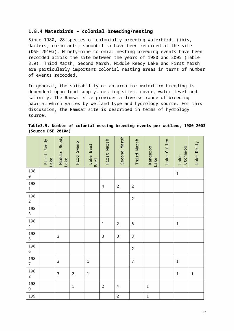
Water bodies Baseline condition and range of natural variation where known LAC Basis of LAC Level of
confidence
Back/ Town Swamp
Number of years in which the swamp filled over the benchmark period (1980-2003) – five. Maximum number of years over the benchmark period that the swamp remained continuously dry – three.
A dry period extended beyond the benchmark period, from 2000 to 2009. The swamp received flood flow in 2010. The swamp has a regulated supply and is influenced by Kerang Weir.
In February 2011, the swamp was inundated by flood water.
Not continuously wet for two or more years. Not dry for five or more consecutive years.
Based on expert opinion of project steering committee. Low
Lake Cullen
Number of years in which the lake filled over the benchmark period (1980-2003) – seven. Maximum number of years over the benchmark period that the lake remained continuously dry – two years between 1991 and 2003 (dry from 2002 through to 2006).
Utilised for flood storage until 1969. Since 1993, the lake has been managed via environmental flows with the objective of flushing salt out of the bed – periods of draw down and drying out. Channel outfall 1991-93, flood flow 1995-96, environmental water allocation 1996-98, 2000-01, dry 2001-07. Received environmental water in 2010.
In February 2011, Lake Cullen was inundated by flood water.
Not dry for more than 10 years in any 20 year period (Nolan ITU 2001).
Based on expert opinion of project steering committee and Operational Guidelines (Nolan ITU 2001).
Low
Johnson Swamp
Number of years in which the swamp filled over the benchmark period (1980-2003) – 10 years between 1991 and 2003.
Maximum number of years over the benchmark period that the swamp remained continuously dry – one year between1991 and 2003.
The swamp is disconnected from a natural water source via a levee (except during major floods), erected in 1969. Utilised for freshwater irrigation storage. Received environmental water in1991-92. Flood flow in 1993-94 and environmental water in1995-96. Channel outfall water in 1996-97. Environmental water in 1997-2002, 2003-04 and 2005-06
In February 2011, Johnson Swamp was inundated by flood water.
Not dry for five or more consecutive years. Not wet for two or more consecutive years.
Based on expert opinion of project steering committee. Low
68
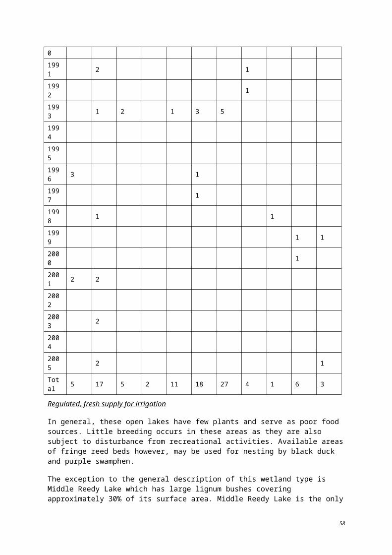
Water bodies Baseline condition and range of natural variation where known LAC Basis of LAC Level of
confidence
Hird Swamp
Number of years in which the swamp filled over the benchmark period (1980–2003) – six years between 1991 and 2003. Maximum number of years over the benchmark period that the swamp remained continuously dry – four years between 1991 and 2003 (1998 to 2002).
Isolated from natural water source due to the modifications of Pyramid Creek in 1967. Sporadic wet periods over the last 10 years. Environmental water allocation 1991-92. Flow flood 1999-94. Wet to dry environmental water allocation 1995-96, 1997-98, 2002-03, 2003-04 and 2004-05. Dry 2005-07.
In February 2011, Hird Swamp was inundated by flood water.
Not dry for five or more consecutive years. Not wet for two or more consecutive years.
Based on expert opinion of project steering committee. Low
69
Table 5.2. Baseline condition and Limits of Acceptable Change for the critical component of water quality/salinity.1
Water bodies Baseline condition and range of natural variation where known LAC Basis of LAC Level of
confidence
Lake Tutchewop
Lake William
Lake Kelly
Little Lake Kelly
As these lakes are managed as part of a salt disposal system, salt is accumulating in the lakes. Lake Tutchewop has experienced a salinity increase from less than 30 000 EC in 1973 to nearly 100 000 by 1990 (Aquaterra Simulations 2006). Lakes Tutchewop, Kelly and Little Kelly are some of the more important wetlands for waterbird abundance within the Ramsar site (Table 3.6).
DSE (2010a) summarises information regarding the effects of salinity on waterbird abundance, which indicates that saline conditions can lead to increases in waterbird abundance but that Lugg (1989) observed that, at salinities above 100 000 EC, abundance was observed to decline. There is insufficient knowledge of the relationship between waterbird numbers and salinity levels at the lakes to set a LAC. This represents a knowledge gap.
Insufficient information to develop a LAC. – –
Fosters Swamp
Water quality/salinity of the small component that operates as an urban wastewater treatment facility is not quantified.
No LAC set; however a LAC is required and should be developed if/when data become available.
– –
Kangaroo Lake Mean salinity level 360 EC, maximum 900 EC (KLAWG 1992).
Salinity levels to be less than 4000 EC when lake is more than 75% full.
Based on expert opinion of project steering committee and tolerance levels of biota to salinity cited in PPK Environment and Infrastructure (2000).
Low
Racecourse Lake Mean salinity level 360 EC, maximum 1750 EC (KLAWG 1992).
Salinity levels to be less than 4000 EC when lake is more than 75% full.
Based on expert opinion of project steering committee and tolerance levels of biota to salinity cited in PPK Environment and Infrastructure (2000).
Low
Lake Charm Mean salinity level 3300 EC, maximum 4300 EC (KLAWG 1992).
Lake to be used as irrigation supply storage in the near future. Under this scenario, historic 3000 EC to 4000 EC levels are anticipated to decline. It is uncertain whether fresher conditions would adversely change the
Insufficient information to develop a LAC.
– –
70
Water bodies Baseline condition and range of natural variation where known LAC Basis of LAC Level of
confidence
ecological character of the site.
Little Lake Charm Mean salinity level 200 EC, maximum 600 EC (Lugg et al. 1989).
Salinity levels to be less than 4000 EC when lake is more than 75% full.
Based on expert opinion of project steering committee and tolerance levels of biota to salinity, cited in PPK Environment and Infrastructure (2000).
Low
Reedy Lake Mean salinity level is 420 EC; maximum is 1600 EC (KLAWG 1992).Salinity levels to be less than 4000 EC when lake is more than 75% full.
Based on expert opinion of project steering committee and tolerance levels of biota to salinity cited in PPK Environment and Infrastructure (2000).
Low
Middle Lake Mean salinity level is 200 EC; maximum is 3000 EC (Lugg et al. 1989).Salinity levels to be less than 4000 EC when lake is more than 75% full.
Based on expert opinion of project steering committee and tolerance levels of biota to salinity cited in PPK Environment and Infrastructure (2000).
Low
Third Lake Mean salinity level is 360 EC; maximum is 1200 EC (KLAWG 1992).Salinity levels to be less than 4000 EC when lake is more than 75% full.
Based on expert opinion of project steering committee and tolerance levels of biota to salinity cited in PPK Environment and Infrastructure (2000).
Low
Stevenson Swamp
Data deficient. Note: Stevenson Swamp is an unregulated system – a terminal lake with no recognised water supply.
Insufficient information to develop a LAC.
– –
Cemetery Swamp Data deficient.
Salinity levels to be less than 4000 EC when lake is more than 75% full.
Based on expert opinion of project steering committee and tolerance levels of biota to salinity cited in PPK Environment and Infrastructure (2000).
Low
Lake Bael Bael
Mean salinity level is 2000 EC (Lugg et al. 1989). Salinity levels to be less than 4000 EC when lake is more than 75% full.
Based on expert opinion of project steering committee and tolerance levels of biota to salinity cited in
Low
71
Water bodies Baseline condition and range of natural variation where known LAC Basis of LAC Level of
confidence
PPK Environment and Infrastructure (2000).
Avoca Marshes:
First Marsh
Second Marsh
Third Marsh
Salinity levels range from 2000 EC to 25 000 EC (NCCMA 2006). The higher end of the range is likely to have occurred at low water levels as the lake dries. Avoca Marshes are considered to be freshwater systems.
Salinity levels to be less than 4000 EC when marshes are more than 75% full.
Based on expert opinion of project steering committee and tolerance levels of biota to salinity cited in PPK Environment and Infrastructure (2000).
Medium
Back/Town Swamp Salinity levels range from 1800 EC to 2300 EC (Lugg et al. 1989).
Salinity levels to be less than 4000 EC when swamp is more than 75% full.
Based on expert opinion of project steering committee and tolerance levels of biota to salinity cited in PPK Environment and Infrastructure (2000).
Low
Lake Cullen Salinity levels range from 4000 EC to 170 000 EC; varies from brackish to hyper-saline depending on water level (Lugg et al. 1989).
Salinity levels to be between 10 000 EC and 120 000 EC when lake is more than 75% full.
Based on expert opinion of project steering committee and tolerance levels of biota to salinity cited in PPK Environment and Infrastructure (2000).
Medium
Johnson Swamp
Salinity levels increase as the swamp dries out. Salinity levels range from 400 EC to 1500 EC (Lugg et al. 1989).
Salinity levels to be less than 4000 EC when swamp is more than 75% full.
Based on expert opinion of project steering committee and tolerance levels of biota to salinity cited in PPK Environment and Infrastructure (2000).
Medium
Hird Swamp Salinity levels increase as the swamp dries out. Salinity levels range from 2600 EC to 3100 EC (Lugg et al. 1989).
Salinity levels to be less than 4000 EC when swamp is more than 75% full.
Based on expert opinion of project steering committee and tolerance levels of biota to salinity cited in PPK Environment and Infrastructure (2000).
Medium
Note:
72
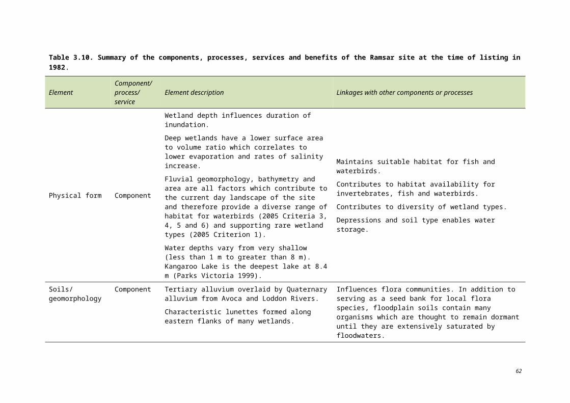
1. The water operations within the storage lakes have not significantly altered/changed since the time of listing (KLAWG 1992). It should be noted that the current hydrological operations/scenarios may in fact increase salinity at a localised scale and have detrimental impacts to ecological values. In some instances current hydrological operation scenarios may require review through management planning and investigations within the storage areas.
73
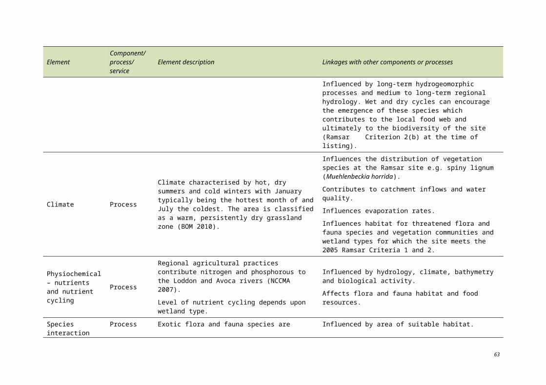
Table 5.3. Baseline condition and Limits of Acceptable Change for the critical component of waterbirds – waterbird abundance.
Water bodies to which the LAC applies
Baseline condition and range of natural variation where known LAC Basis of LAC Level of confidence
Whole Ramsar site
Waterbird counts for the Ramsar site are provided Tables 3.6 and 3.7. The occurrence of waterbirds at the Ramsar site is highly variable over time and across the individual wetlands at the site. It is not known if the sequence of counts from 1979-2003 encompassed the full range of natural variability.
The average annual count of waterbirds at the site for the period 1979-2003 is 31 772 (minimum 39; maximum 299 077; standard deviation 60 790). During this period, waterbird counts of more than 20 000 were recorded on 10 occasions (years).
Records of counts of more than 20 000 waterbirds over rolling ten year periods from 1979-1988 to 1994-2003 indicate that the average number of years in which more than 20 000 waterbirds are recorded at the site in a 10 year period is 5.125. The average annual count for each rolling 10 year period ranges from 8944 to 66 720.
Year Total number of waterbirds
Number of years in which >20,000 waterbirds were recorded in the ten year period ending in current year
1979 15000 -
1980 15000 -
1981 3383 -
1982 11416 -
1983 7207 -
1984 2209 -
1985 25496 -
1986 39 -
1987 299077 -
Where appropriate data are collected, the number of years in which >20,000 waterbirds are recorded in a rolling ten year period is not less than three years.
Based on expert opinion of project steering committee and historic bird data (Tables 3.6, 3.7 and DSE 2010a).
Low
74
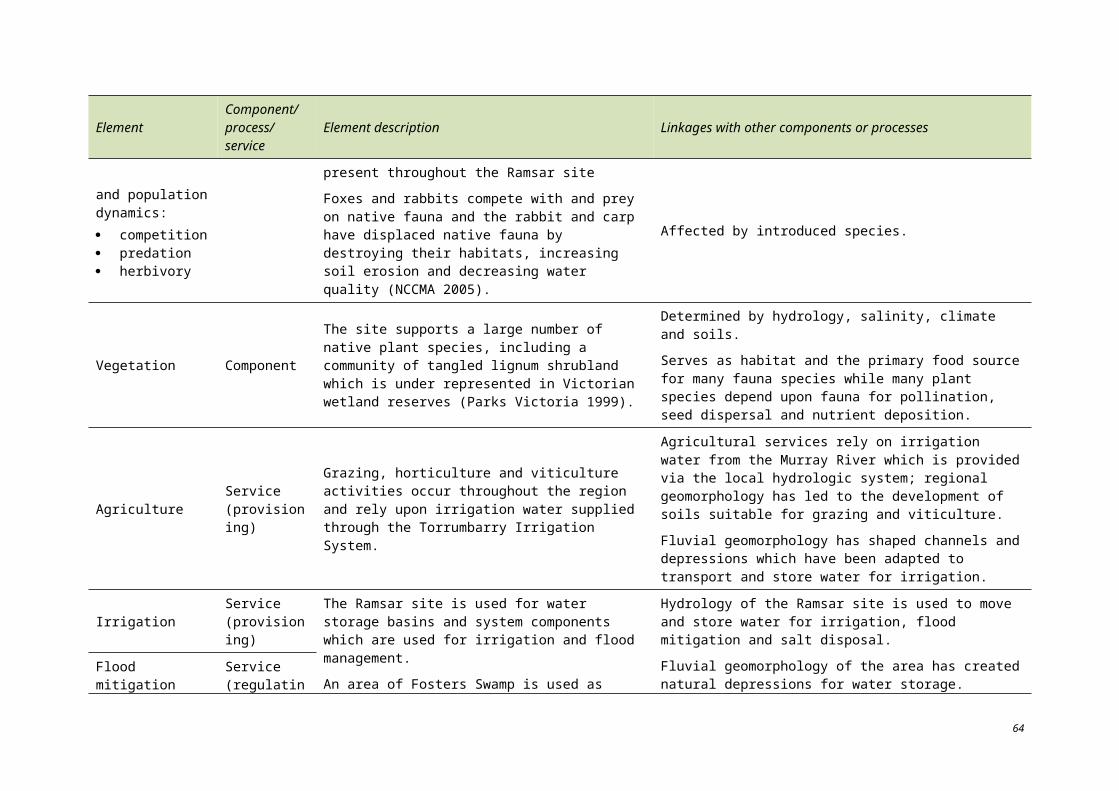
Water bodies to which the LAC applies
Baseline condition and range of natural variation where known LAC Basis of LAC Level of confidence
1988 45328 3
1989 52165 4
1990 20943 5
1991 43518 6
1992 56401 7
1993 107281 8
1994 16954 8
1995 2502 7
1996 8550 7
1997 211 6
1998 6107 5
1999 5268 4
2000 20528 4
2001 1373 3
2002 22074 3
2003 6269 2
75
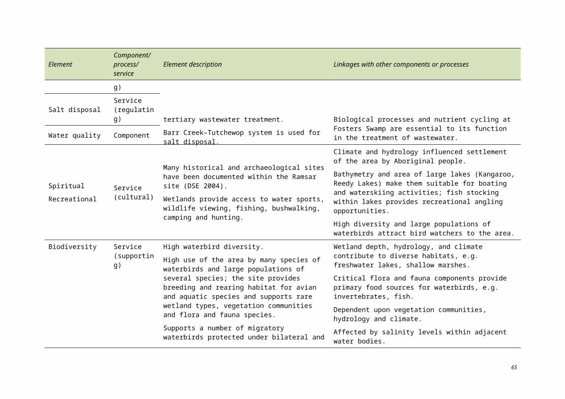
Table 5.4. Baseline condition and Limits of Acceptable Change for the critical component of waterbirds – colonially breeding/nesting waterbirds (ibis, darters, cormorants, spoonbills).
Water bodies
Baseline condition and range of natural variation where known LAC Basis of LAC Level of confidence1
Whole Ramsar site
Range of variability is unknown.
Median number of colonial nesting waterbird species that bred between 1980 and 2003 – three.
Maximum period (consecutive years) in which no colonial nesting waterbird species were recorded breeding – two years.
Number of colonial nesting waterbird species breeding between 1980 to 2003 across the site:
Year No. of species Year No. of
species
1980 1 1993 12
1981 8 1994 0
1982 2 1995 0
1983 0 1996 4
1984 10 1997 1
1985 11 1998 2
1986 2 1999 2
1987 11 2000 1
1988 8 2001 4
1989 8 2002 0
1990 3 2003 2
1991 3 2004 0
1992 1 2005 3
Insufficient information to develop a LAC for the entire Ramsar site.
– –
76
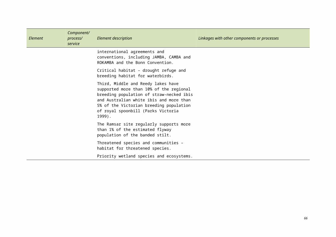
Water bodies
Baseline condition and range of natural variation where known LAC Basis of LAC Level of confidence1
Reedy Lake
Maximum period (consecutive years) in which no colonial nesting waterbird species were recorded breeding – 16 years.
Years of colonial nesting waterbird breeding events from 1980 to 2003 by species:
Australian white ibis: 1996, 2001
royal spoonbill: 1996, 2001
yellow spoonbill: 1996
Insufficient information to develop a LAC. – –
Middle Lake
Maximum period (consecutive years) in which no colonial nesting waterbird species were recorded breeding – five years.
Years of colonial nesting waterbird breeding events by species:
Australian white ibis: 1985, 1988, 1993, 1998, 2001, 2003, 2005
straw-necked ibis: 1985, 1988, 1991, 1993, 2003, 2005
royal spoonbill: 1985, 1988, 2001
yellow spoonbill: 1987, 1991
Ten per cent of the regional breeding population of straw-necked ibis and Australian white ibis and more than 5% of the Victorian breeding population of royal spoonbill have been recorded within the Ramsar site (DSE 2010a).
No more than 10 consecutive years in which there is no breeding of Australian white ibis and straw-necked ibis.
Insufficient information to develop a LAC for royal spoonbill or yellow spoonbill.
Based on expert opinion of project steering committee, on the assumption that the data obtained over the recorded 24 year period accurately reflect breeding events and are representative of natural variability (Table 3.11 in Section 3, DSE 2010a).
Low
Hird swamp
Maximum period (consecutive years) where no colonial nesting waterbird species were recorded breeding – 10 years.
Years of colonially nesting bird breeding events by species:
Australian white ibis 1988, 1989, 1993
Insufficient information to develop a LAC.
– –
77
Water bodies
Baseline condition and range of natural variation where known LAC Basis of LAC Level of confidence1
straw-necked ibis 1988, 1993
Avoca marshes
Maximum period (consecutive years) where no colonial nesting waterbird species were recorded breeding – 10 years (1993-2003).
Years of colonial nesting waterbird breeding events by species:
royal spoonbill: 1981, 1982, 1986, 1987 (Third Marsh)
darter: 1985 (First Marsh); 1981, 1984, 1989, 1990, 1993, 1997 (Second Marsh); 1984, 1987, 1993 (Third Marsh)
great cormorant: 1985, 1989, 1993 (First Marsh); 1993 (Second Marsh); 1993 (Third Marsh)
pied cormorant: 1985, 1989, 1990 (Second Marsh); 1984, 1993 (Third Marsh)
yellow spoonbill: 1989, 1990 (Second Marsh); 1981, 1982, 1984, 1985, 1986, 1987, 1993 (Third Marsh)
No more than 10 consecutive years in which there is no breeding of royal spoonbill, darter, great cormorant, pied cormorant and yellow spoonbill.
Based on expert opinion of project steering committee,
On the assumption that the data obtained over the recorded 24 year period accurately records breeding events and is representative of natural variability (Table 3.11 in Section 3, DSE 2010a).
Low
78
6 Threats to the ecological character of the Ramsar site
A number of threats to the ecological character of the Ramsar site have been identified, including:
altered watering regimes – surface water and groundwater;
climate change;
changes to level and trend in surface water quality, including salinity, nutrients, acid-sulfate soils, turbidity and pH;
loss of wetland connectivity;
bed and bank erosion;
presence of pest plants and animals;
surrounding land-use change, particularly agriculture, grazing and urban development; and
unsustainable recreational activities.
Table 6.1 provides a summary of threats and risks to the Ramsar site, including an assessment of the likelihood and timing of the threat or risk occurring.
The likelihood of threats has been defined as:
Highly likely: expected to occur in most circumstances, i.e. more than 85% chance of occurring within specified time frame;
Likely: will probably occur in most circumstances, i.e. 50–85% chance of occurring within specified time frame;
Moderately likely: might occur at some time, i.e. 21–49% chance of occurring;
Unlikely: could occur at some stage, i.e. 1–20% chance of occurring; and
Very unlikely: not expected to happen.
In addition, an anticipated timing has been provided for each threat. The timing of the threat may be:
immediate;
immediate–medium-term (1–5 years);
medium (five years); or
medium-long term (five years to decades).
79
Table 6.1. Summary of threats to the Ramsar site and their likelihood and timing of occurrence.
Actual or likely threat or threatening activities
Potential impact(s) to wetland components, processes and/or services
Likelihood of threat or risk
Timing of threat or risk
Presence of pest plants and animals
Vegetation communities, threatened flora, recreation Highly likely Immediate
Altered watering regimes
Significant wetland types, vegetation communities, fish species, soils, recreation Highly likely Immediate
Surrounding land-use change
Vegetation communities, water quality, threatened flora Likely Immediate
Unsustainable recreational activities
Vegetation communities, waterbird populations and habitat
Moderately likely
Immediate to medium-term
Changes to level and trend in surface water quality
Significant wetland types, threatened flora and fauna species, waterbird breeding habitat, aquatic species, recreation
Likely Immediate to medium term
Climate changeSignificant wetland types, hydrology, flora and fauna, waterbird breeding habitat, recreation, irrigation-related services
Likely Medium to long-term
Bed and bank erosion Cultural services Moderately likely
Medium to long-term
6.1 ALTERATIONS TO HYDROLOGY
The ecological character of the Ramsar sites is dependent on the hydrology (frequency, timing and duration of flows) of the system.
At the time of listing, a number of aspects of the hydrological regime, if altered, posed a threat to the continuing value of the site as a Ramsar wetland. These are:
increasing or decreasing the duration of inundation;
increasing or decreasing the volume of inundation; and
increasing or decreasing frequency of inundation.
The primary hydrological threats to the Ramsar site vary by hydrological wetland type. For the regulated fresh supply wetlands used for irrigation, changes to storage levels, inundation and frequency could be caused by some or all of the following factors: drought, climate change, changes to irrigation demand, changes in system operation and water savings projects. While the LACs have been set around the conditions that prevailed in these wetlands at the time of listing, the extent to which an altered hydrological regime would threaten the recognised services and benefits at these lakes, if at all, is unknown.
The ecological character of regulated drainage wetlands would change with modifications to irrigation drainage volumes which would also impact groundwater levels. The conditions at the drainage basins are dependent upon the timing, duration and volume of flow from the Barr Creek diversion scheme and the salinity of water received from the diversion. The salinity of the site is also influenced by management actions and salinity disposal requirements. Climate change also poses a threat to the drainage wetlands as higher temperatures and dryer conditions would lead to increases in evaporation rates which affect salinity and groundwater levels. In the opposite case of cooler, wetter conditions, the character of the sites would change due to freshening of the water.
80
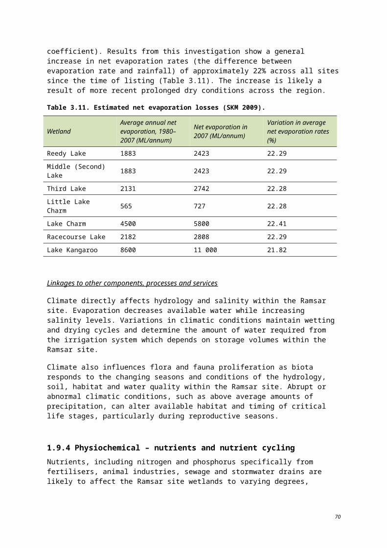
The character of regulated fresh supply wetlands not used for irrigation is threatened by climate change and the frequency of flooding and drought within the region. Changes in irrigation system management may affect the character of these sites. The establishment of Environmental Water Allocations (not present at the time of listing) is a management strategy available to mitigate these threats.
Unregulated sites may change from their condition at the time of listing with changes in flows from the Avoca River (for the Avoca Marshes and Lake Bael Bael sites) and local flooding. Land use within the catchment affects the condition of these wetlands in that local run-off may be increased or decreased based on the condition of surrounding land and its level of agricultural use and development.
Increasing or decreasing the duration of inundations
Permanent open freshwater wetlands, such as irrigation supply lakes with stable water levels (e.g. Kangaroo Lake), generally have lower biodiversity and conservation values, the exception being the presence of significant native fish (DSE 2004). A longer duration of inundation can result in longer periods of anaerobic and/or reduced dissolved oxygen conditions, which generally limits the plants that can survive (DSE 2005). Permanent or prolonged inundation changes the vegetation communities associated with wetlands (DSE 2004). Wetlands with longer flooding durations generally have lower plant species richness than wetlands of shorter flooding durations, inhibited breakdown of organic matter and greater development of hydric soil properties (DSE 2005a, KBR 2007).
The permanent open water hydrology of the irrigation supply wetlands could be changed if irrigation operations were to be modified or if drought conditions were to result in less water availability and increases in evaporation rates.
The duration of inundation at regulated wetlands not used for irrigation is dependent upon the availability of EWAs and climatic conditions, flooding and drought. The duration of inundation at drainage basins will change if modifications to the Barr Creek diversion scheme are made or if climatic changes result in prevailing drought or flooding regimes.
Changes to the inundation of unregulated wetlands are dependent upon climatic conditions (river and run-off flow, precipitation) and local land use. The inundation regime of the Avoca Marshes at the time of listing was due primarily to the sill at Third Marsh. At the time of listing, removal of the sill changed the duration of inundation at these sites but did not represent a threat to the ecological character of the Marshes at the time, as the prolonged inundation had lead to tree death (Section 3.1.1).
Increasing or decreasing the volume of inundations
At the time of listing, the expanding irrigation footprint in the area, influenced by the wet conditions of the late 1970s, was a threat to the character of the Ramsar site. Lack of knowledge about climate variability and climate change poses a risk in managing the site. Management objectives can be set in relation to the conditions over a particular period such as the wet conditions that prevailed in the years prior to listing, not recognising that these conditions may be subject to longer term cycles or changes in climate.
Management of the Barr Creek Diversion and other water management plans throughout the region have also posed a risk to the character of the site since the time of listing. These threats continue today with changes in inundation patterns, the frequency of wetting and drying and the volume of water available. These parameters may change in the future given more recent initiatives for irrigation infrastructure renewal, water savings and associated environmental watering under The Living Murray program (NVIRP 2010).
81
Altered timing of inundation
To the extent that there is the potential to change the operation of the regulated wetlands which are used for irrigation, alteration to the timing of inundation represents a possible threat. Under the current operation regime, these wetlands are held near full supply level throughout the year, with only minor fluctuations. Regulated wetlands not used for irrigation may, be affected by water management schemes put in place following listing. Timing of inundation may affect the success of dormant invertebrate populations known to inhabit these areas (Fleming 1990) and germination for native flora populations.
Timing of inundation is less of a threat to unregulated wetlands and the drainage basins. Unregulated wetlands fluctuate with natural conditions, a condition occurring at the time of listing, today and for the foreseeable future unless management of these sites changes or there is a significant change in climate affecting the seasonality of rainfall. River diversions and the use of waterways for storage and conveyance of water have the potential to change the timing of inundations to wetlands dependent on riverine sources of water. This could potentially result in the loss of habitat and movement between habitats (DNRE 2002). This is particularly important as natural seasonal changes in water regimes provide cues for fish spawning (DSE 2005), bird breeding and other vital biological processes. At the drainage basins, the timing of inundation is less likely to change the character of these sites as their condition is more dependent upon salinity levels than other aspects of their hydrology.
At the time of listing, streams in the Kerang Lakes area experienced low flows in winter and high flows in summer (KLAWG 1992). Activities such as water trading, water savings projects, improvements in efficiencies in agricultural water use, and proposals to manage irrigation systems differently have the potential to alter the flow regime of the Ramsar site in the future (DSE 2004, DSE 2009a).
Changed frequency of inundation
The frequency of inundation plays a major role in determining the physical and biological characteristics of wetlands, and alteration can lead to significant changes in these characteristics. For example, an increase in the frequency of inundation can lead to habitat loss through water logging, killing off of plants and seed banks, and has caused major tree deaths throughout the wetlands of North Central Victoria (KBR 2007). A decreased frequency of inundation can, for example, affect plant and animal species reliant on a regular flush of water to mitigate any anoxic conditions in a wetland, and can also affect the cycle of organic matter breakdown (DSE 2004).
For the regulated wetlands used for irrigation, changes to frequency of inundation would threaten the permanent nature of these sites. These sites may be susceptible to changes in inundation frequency due to climate change and the availability and demand for water. Water savings projects which may reduce the volume of water required by irrigators and thus the frequency by which the lakes would require filling to full supply level may also result in a change of the wetland character of these sites. Lower water levels for a sustained period may result in increased salinity; however, the exposure of banks would provide opportunity for flora to establish which would subsequently provide habitat for waterbirds and, upon refilling, foraging and refuge habitat for fish.
Regulated wetlands not used for irrigation did not have a regular inundation regime at the time of listing. Water regimes for these sites are not well documented prior to 1990 (DSE 2010a), although the wet regime of the 1970s and early 1980s is likely to have provided these sites with seasonal inundation in the years surrounding the time of listing. A change to the frequency of inundation which reduces or extends the wet–dry cycles of these wetlands may result in a change to their character.
82
The character of drainage basins which receive water from flood flows or the Barr Creek diversion are susceptible to changes from frequency in inundation (similar to duration) which would result in freshening (increased frequency of inundation) or increased salinity (decreased frequency of inundation).
Unregulated wetlands are largely subject to natural variability of inundation frequencies. At the time of listing, the sill at Third Marsh prolonged the inundation of Second and Third Marsh. Removal of the sill (which was completed in 2000, NCCMA 2006) returned these wetlands to a natural wet–dry cycle. Unregulated wetlands and sites such as Fosters Swamp, which also receive flood flows and run-off, are also more likely to experience changes from surrounding land use. As more water is captured in storages due to increased human demands, increased capture of rainfall through structures such as small catchment dams and climate change, the frequency of unregulated flows and spills from storages is likely to be reduced as a greater proportion of flows are captured. This will reduce the frequency and duration of overbank flows to wetlands during natural flooding events (DSE 2009a).
6.1.1 Changes in groundwater intrusionMany wetlands in the Kerang Lakes area are in close connection with the groundwater system and can function as groundwater discharge or recharge sites, depending on certain conditions.
Groundwater in the Kerang region can be highly saline, which adversely impacts on the ecology of the wetlands in the region (DSE 2004). For example, monitoring of the aquifer associated with the Ramsar site has revealed salinity levels commonly between 30 000 EC and 60 000 EC (DSE 2004a, KBR 2007). The very high level of salinity renders the groundwater unsuitable for most purposes, including irrigation, stock and domestic supply (DSE 2004), and could have severe ecological impacts on fresh or brackish wetlands. Evaluation and analysis of the level and condition of groundwater connected to the Ramsar site at the time of listing was not documented at that time, although recent studies have described what conditions may have been like (NCCMA 2006, SKM 2001).
The factors which contribute to groundwater fluctuations (changes in wetland volume, natural flows and recharge) and the overarching effects of groundwater intrusion is unlikely to be affected by wetland type. In general, changes in groundwater intrusion affect the water balance of wetlands and salinity levels (DSE 2004a). Rising water tables change the water regime of intermittent wetlands that are connected to groundwater sources by preventing the otherwise natural occurrence of drying out in summer (DSE 2004). Changes to wetland volumes, due either to irrigation demands or natural factors, affect the level of groundwater intrusion within each wetland.
6.2 CLIMATE CHANGE
Significant climatic changes have the potential to change the character of the Ramsar site, specifically its hydrology and salinity (which has repercussions on vegetation and fauna communities and habitat). At the time of listing, climate change was not as widely researched or forecasted as it has been since the 1990s.
Climate change is expected to impact on all aspects of the water cycle of the region; reduced rainfall and hotter temperatures producing less water for rivers and storages, drier soils resulting in less run-off to waterways, and more evaporation occurring from rivers, channels and storages (DSE 2009a). The effects of climate change on the hydrology of the various wetland types were discussed above. Here the discussion is focused on the medium to long term threat of climate changes to the components, processes and services of the Ramsar site as a whole.
83
With climate change there are likely to be more frequent and extended droughts, with longer dry spells and less frequent floods. The impact of this is that there will be less water for rivers and wetlands, irrigation use and a significant reduction in environmental flows. Extended drought will reduce the availability of waterbird habitat (through vegetation loss and reduced amounts of open water). Reduction of water volumes and flood frequency may also lead to stagnation of wetlands and changes to nutrient cycling. Climate change is a significant threat as it has the potential to cause the degradation and lead to the reduction or loss of the critical services and benefits of the Ramsar site.
Table 6.2 provides a summary of predicted changes to temperature and rainfall as a result of climate change in Victoria.
Table 6.2. Summary of predicted changes to temperature and rainfall in Victoria as a result of climate change by 2070 (adapted from CSIRO2006, CSIRO and BoM 2007).
FeatureLow global warming scenario High global warming scenario
Estimate of change Uncertainty Estimate of
change Uncertainty
Annual average temperature +0.5C ±0.2C +1.10C ±0.4C
Annual average rainfall –1.5% ±5% –3.5% ±11%
Seasonal average rainfall: – – – –
Summer 0% ±6.5% 0% ±15%
Autumn –1.5% ±5% –3.5% ±11%
Winter –1.5% ±5% –3.5% ±11%
Spring –5% ±5% –11% ±11%
Annual average potential evaporation +2.2% ±1.1% 5% ±2.5%
Annual average number of hot days (> 35oC) +1 day – +20 days
(inland) –
Annual average number of cold nights (< 0oC) –1 day –
–10 days (inland–20 days (highlands)
–
The Ramsar site could potentially be affected by climate change in a number of ways, including; reduced reliability of source water resulting in a reduction of the frequency and volume of water available; changes in the frequency and magnitude of unregulated flows and spills from storages as more flows are captured in storage and a reduction in the duration and frequency of overbank flows during natural flooding events (DSE 2009a). In summary, climate change has the potential to significantly alter rainfall run-off and resultant stream flows on unregulated systems such as the Avoca Marshes (that rely on natural water flows to support their wetland characteristics).
The predicted impacts of these hydrological changes to the Ramsar site as a result of climate change are outlined below.
Decreasing the frequency of flood events is likely to impact the vegetation and habitat composition of the wetlands. Increasing the amount of time between flood events may mean that wetlands within the system move more towards terrestrial vegetation systems. Reduced flooding frequency is also likely to impact breeding frequency of fauna.
84
Unregulated wetlands in the site that are no longer able to access natural flows could experience a loss of environmental values and loss of species, due to longer dry periods and/or increased salinity.
Lowered levels of water in permanent wetlands could increase the risk of saline groundwater intrusion, the loss of habitat for flora and fauna, and a reduction in breeding events of species such as ibis and spoonbills (Heron and Joyce 2008b).
6.3 THREATS TO WATER QUALITY
Poor water quality has major consequences for the health of wetlands. Water quality issues are usually caused by run-off from surrounding farmland and groundwater discharged from salt-affected areas. In the region of the Ramsar site, water quality issues can also be caused by the exposure of acid sulphate sediments. As previously mentioned, the water quality of the wetlands at the time of listing is not well documented.
6.3.1 SalinityDirect saline intrusions of groundwater, the disposal of saline drainage water and isolation from natural flushing flows have the potential to cause major salinity increases in wetlands of the Ramsar site (DSE 2004). Increased salinity is identified as a high priority risk for the Ramsar site (DSE 2004a, KBR 2007).
For all wetland types across the site, salinisation has serious implications for water quality and biodiversity by directly affecting plant growth and the fauna that breed, nest or forage in waterbodies, such as invertebrates, fish, amphibians and waterbirds (DSE 2004). As the diversity of plants and animals decreases with increasing salinity, relatively salt tolerant species usually remain (DSE 2004).
Salt-tolerant species may be very abundant and salt lakes can often support a very high biomass and some of the largest concentrations of waterbirds known. For example, although they are saline, the Tutchewop lakes (used as salinity disposal reserves) still qualify under the waterfowl abundance criteria of the Ramsar Convention and form a critical waterbird habitat component of the Ramsar site (NPSI 2009, DSE 2004). However, once lakes become hypersaline, both species diversity and abundance are severely affected (DSE 2004).
6.3.2 NutrientsChanges to the level and trend of nutrients is identified as a key threat to wetland health in the Kerang region, with nitrogen and phosphorus identified as significant threats to wetland significance, wetland rarity and significant fauna (DSE 2004).
Phosphorus and nitrogen occur naturally at low concentrations in water and are essential for life (DNRE 2002a). Increases in phosphorus and nitrogen levels in streams may result from erosion, discharge of sewage, detergents, urban stormwater and rural run-off containing fertilisers and animal and plant material (DNRE 2002a). High concentrations of nutrients in water or sediments promote weed and algal growth. High levels of algal populations can lead to very low oxygen concentrations, which threaten oxygen dependent aquatic biota such as fish (DSE 2004).
While nutrients present in water such as phosphorus and nitrogen are essential for growth of phytoplankton and macrophytes, excessive amounts can lead to high growth rates and biomass of phytoplankton and benthic algae which can smother and kill other plants and animals and threaten aquatic ecosystems (Boulton and Brock 1999, in DSE 2005). Some species of blue-green algae also
85
produce toxins that can have serious health implications for recreational users, native fauna and livestock which come into contact with it (DSE 2004).
The Loddon catchment has the highest incidence of blue-green algal blooms in Victoria (DSE 2004). Water quality in the Avoca River is considered poor due to high concentrations of salt, turbidity and nutrients (DSE 2004). Changed management practices upstream of the marshes and the building of farm dams in the upper catchment has lead to modified flow regimes at the lower end of the Avoca River (including the Avoca Marshes). This has also affected water quality (DSE 2004) and will continue to pose a threat to these unregulated wetlands.
6.3.3 Acid sulfate soilsAcid sulfate soils are soils that contain sulphuric acid, or have the potential to form sulphuric acid when exposed to oxygen through drying or disturbance (DSE 2009). The drying of wetlands can result in the exposure of acid sulfate soils. The presence of sulphuric acid lowers the soil and water pH which can have a dramatic effect on the number and diversity of species found in that water body (Waterwatch Victoria 1999). pH values less than 6.0 (acidic) can, among other things, cause spawning failure and diminished hatching success for fish (DNRE 2002a). Low pH can also reduce and alter species in macro invertebrate communities and cause pollutants to become mobile and toxic (DNRE 2002a).
Although data on the extent of acid sulphate soils at the time of listing is unavailable, the Australian Soil Resource Information System (2010) shows a high probability of acid sulfate soils in some of the Ramsar site wetlands. The areas noted are Second and Third Marsh, Fosters, Town and Back Swamps and the south-west corner of Kangaroo Lake. Acidification of several wetlands in the northern region of Victoria has been reported in the past two years (DSE 2009a), although it is not known if this includes any wetlands from the Ramsar site. The Murray-Darling Basin Authority is currently conducting an assessment of acid sulfate soils within the Murray-Darling Drainage Division to assess the spatial extent of, and risk posed by, acid sulfate soils at priority wetlands within the Murray-Darling Drainage Division and to identify management options.
6.4 BED AND BANK EROSION
Bed and bank erosion which results from irrigation operations, management operations, and water-related recreational activities poses a risk to the cultural service of the Ramsar site. All areas within 200 m of waterways are listed as Areas of Cultural Sensitivity. Erosion within these areas may lead to disturbance of cultural heritage artefacts and impact the cultural heritage services of the Ramsar site. Erosion can also have negative effects to water quality through the mobilisation of sediment into the water column (turbidity).
Although erosion is a risk to cultural and ecological components, it is not a major concern and is considered to be a low priority threat.
86
6.5 PEST PLANTS AND ANIMALS
The spread of introduced species threatens the character of the Ramsar site, specifically native vegetation communities and waterbird breeding habitat. Changes in hydrology, climate and land use may create opportunities for the establishment of non-native invasive species.
Rabbit grazing damages native vegetation and undermines the success of regeneration and causes erosion. Foxes are likely to impact breeding bird success through predation while weedy vegetation species are likely to out-compete native species for habitat and resources. Pest plants and animals can also impact the aesthetics and naturalness of the Ramsar site for ecology enthusiasts and other recreational users.
6.6 CHANGES TO SURROUNDING LAND USE
As previously discussed, some wetlands are used for seasonal livestock grazing while others are exposed to uncontrolled grazing, such as Lake Cullen (DSE 2004). Grazing within the wetlands alters the structure of the vegetation by preventing regeneration and reducing the diversity of species in the understorey. Stock also selectively graze palatable species, destroy vegetation cover used by native animals, compact, pug and erode the soils, and manure increases nutrient concentrations (DSE 2004). Grazing also has potential to impact on cultural site values, particularly on water frontages (DSE 2004).
6.7 UNSUSTAINABLE RECREATION ACTIVITIES
Camping on lake foreshores, particularly during the duck hunting season, can have adverse impacts on the wetlands’ natural and cultural values. These impacts include vegetation damage, soil compaction, collection of firewood and inappropriate rubbish disposal. Increasing regional populations are likely to result in increased recreational use of the Ramsar site. Improving signage at high-use recreational areas would assist in raising awareness of impacts associated with recreational use.
Recreational boating activities also occur within the Ramsar site. Recent research demonstrates that water-skiing and high-powered boats disturb waterbirds (Paton 2000). Although the open lakes where water sports are allowed are not known to support high numbers of waterbirds, the local impacts are poorly understood and further investigation into the effect these activities are having on Ramsar values, particularly waterbirds, is warranted. Wave action from motorboats can also result in bed and bank erosion.
87
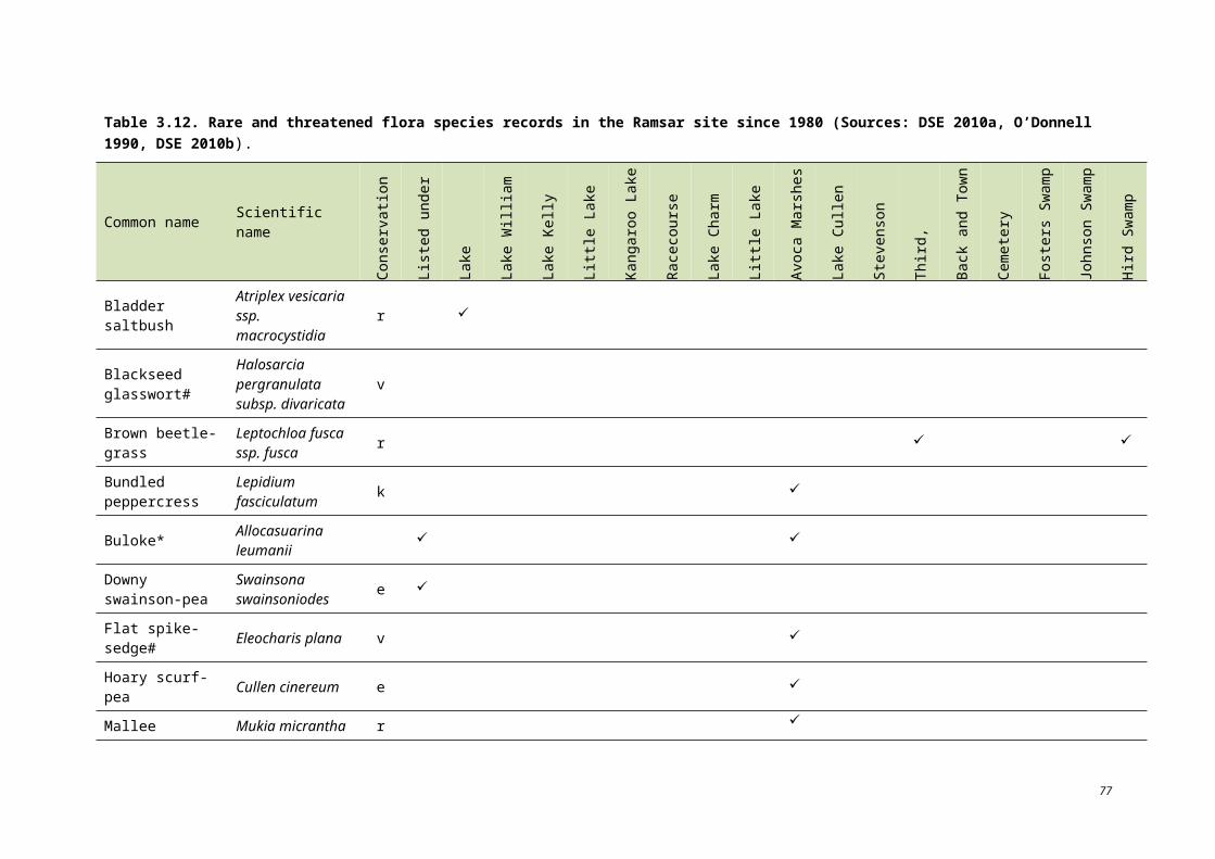
7 Changes to ecological character since the time of listing
This section briefly characterises the current state of each critical component, process and service and describes any evident changes in the ecological character since the time of listing in 1982. An assessment of change to the ecological character, which can be positive or negative, has been undertaken in relation to established LACs. Again, it should be noted that information regarding changes to ecological components, processes and services is not available for each wetland within the Ramsar site.
Although changes have occurred to certain aspects of individual wetlands, the character of the site as a whole has not changed significantly since being listed.
7.1 SALINITY
In the Kerang region, land clearing and irrigation practices have altered soil salinity and influenced variations in groundwater levels (DSE 2010a). Changes to the salinity of the Ramsar site have occurred and are discussed below by hydrology type due to the varying relationship between salinity and hydrology sources across the site.
Regulated, fresh supply for irrigation
The management of these lakes as storage basins means they are near full supply level year round. Lowering of the lakes may result in saline groundwater intrusion; however, the lakes have been maintained in a similar condition to their state at the time of listing. Ho et al. (2006) found that the mean salinity levels within these wetlands were still within levels described for slightly disturbed lowland rivers in southeast Australia and below the established LAC (less than 4000 EC, for those wetlands with sufficient information to set a LAC). The lakes continue to supply a source of freshwater for local fauna.
Regulated, fresh supply for non-irrigation
Since the time of listing, salinity in Pyramid Creek has been recognised as an environmental issue affecting local and downstream water quality. Salinity levels at Johnson Swamp have increased from 400–1500 EC (freshwater) in the late 1980s to 1183 EC in 1991 and 4800 EC (brackish) in 1995 (KBR 2009). This level is beyond the recommend LAC for salinity of this site of 4000 EC. Lake Cullen has also risen beyond the recommended LAC due to wetting and drying of the wetland and the intrusion of saline groundwater under the lake (NCCMA 2006). Specific salinity data for the other non-irrigation wetlands are not available for comparisons.
Following on from the increasing salinity levels, in 2001 the Murray-Darling Basin Commission funded construction of the Pyramid Creek Salt Interception Scheme. The scheme was constructed in stages between 2004 and 2008 and when fully operational the scheme will intercept approximately 22 000 tonnes of salt per year that would have otherwise discharged to Pyramid Creek. At present this salt is causing significant negative impacts upon the region’s agricultural production, the environmental attributes of the Ramsar site and downstream Murray River water users (DSE 2009). In 2006, the first stage of the scheme was modelled to have an effective removal of 1.3 EC at Morgan, SA (MDBC 2008). The effects of this scheme are also likely to reduce the salinity of downstream wetlands used for irrigation.
88
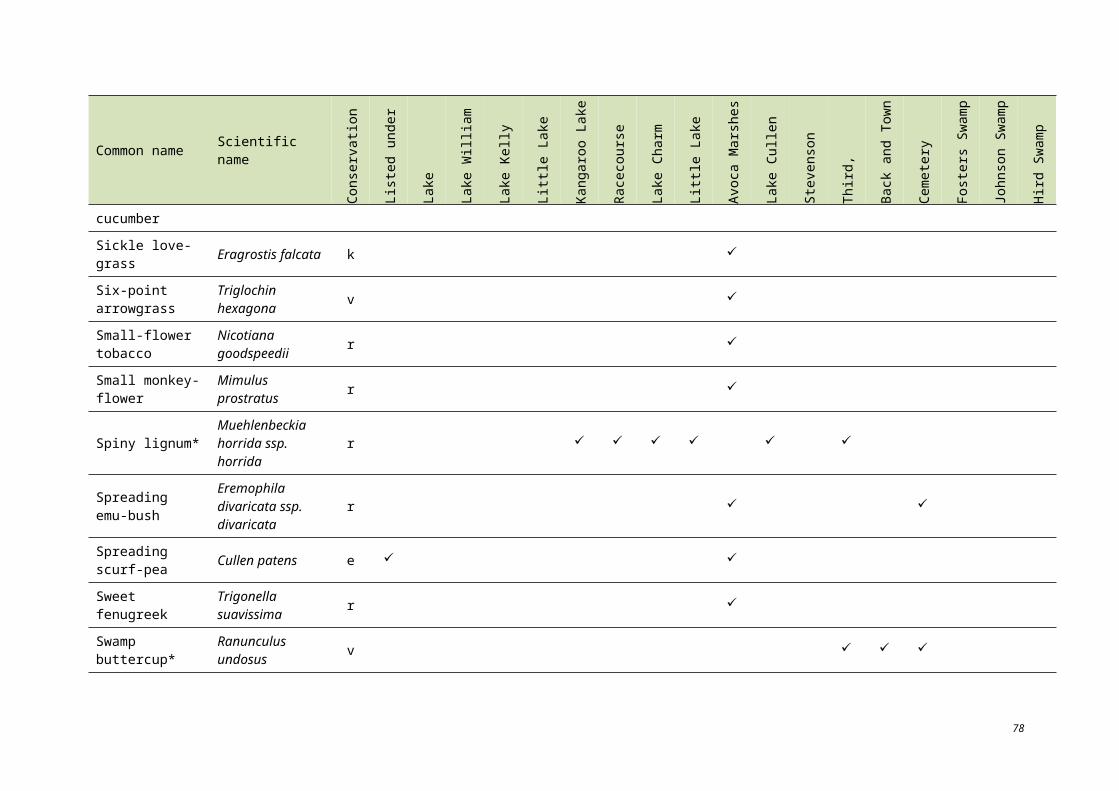
Regulated drainage basin
The quantity of salt being stored in the Tutchewop Lakes system has increased since the time of listing. Lakes Tutchewop, Kelly, Little Lake Kelly and William are used as salt disposal basins and this has caused their average salinity levels to rise steadily. The salinity of Lake Tutchewop increased from less than 30 000 EC in 1973 to approximately 100 000 EC by 1990 (Aquaterra Simulations 2006). This trend is likely to apply to the other drainage lakes as they all receive water from the Barr Creek diversion in succession.
The lakes are estimated to have received over 1.4 million tonnes of salt since operations began in the late 1960s (Aquaterra Simulations 2006). Approximately 50 000 t of salt accumulates in the Tutchewop Lakes each year. New operational rules have been developed on when to pump into the Tutchewop Lakes in relation to flow and salt loads in Barr Creek. With these changes in place, 67 500 t of salt will be diverted to the Tutchewop Lakes each year (DSE 2004). While the accumulation of salt will not change the wetland type, it has the potential to impact on waterbird abundance. There is insufficient knowledge of the relationship between waterbird numbers and salinity levels at the lakes to set a LAC. This represents a key knowledge gap.
Unregulated
Stevenson Swamp is a terminal lake with no recognised water supply. It is an example of a wetland which was historically fresh or brackish and has now become hypersaline, supporting virtually no flora or fauna within the flooded area (DSE 2004). Data required to address changes in salinity at Stevenson Swamp are unavailable. Similarly, salinity for Cemetery Swamp is not regularly monitored, but neighbouring Pyramid Creek has recorded seasonal fluctuations in salinity from 300 EC to 3500 EC (DSE 2010a).
Since monitoring of the Avoca Marshes began in 1988, a reduction in the frequency of small and medium-sized floods has allowed salt to accumulate at these sites (DSE 2010a). Salinity levels vary across the marshes. They generally range from 1000 EC to 6000 EC but maximums recorded have reached 18 290 EC (Third Marsh), 15 792 EC (Second Marsh), 15 678 EC (First Marsh) and 13 210 EC (Lake Bael Bael) (DSE 2010a). Since the time of listing, the sill at Third Marsh has been removed and Second and Third Marsh have experienced intermittent drying.
The sources of saline inputs to the Avoca Marshes include run-off from agricultural areas in the upper catchment, local seepage and agricultural returns. Water quality in the Avoca River is considered poor due to high concentrations of salt, turbidity and nutrients (Riparian Australia 2003). In conjunction with hydrology, local saline seepage into the marshes associated with irrigation on adjacent areas has been implicated in tree decline and death (Riparian Australia 2003). Upstream management practices such as the building of farm dams, has also affected water quality (Riparian Australia 2003) and is unlikely to be improved or reduced in the near future.
89
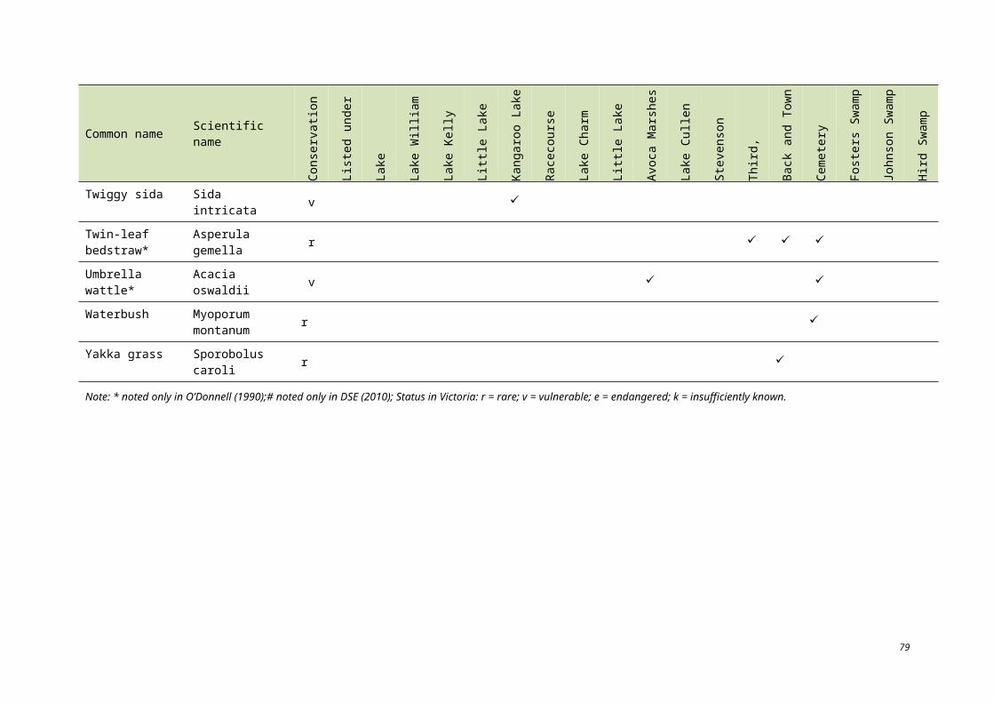
7.2 HYDROLOGY
Regulated fresh supply for irrigation
Aside from modifications to improve inlets and outfalls, the general hydrology to the irrigation storage basins has not changed since listing. Because of this, the wetlands continue to support lake fisheries and water-related recreational services.
Regulated fresh supply for non-irrigation
Several changes to the hydrology of this wetland type have occurred since the time of listing. Until the late 1980s, the Johnson and Hird Swamps were filled by pumping water through a pipe from Pyramid Creek. The pipe into Johnson Swamp is no longer used, but has not been removed and may function as a water source for the wetland when the creek water level is high (KBR 2009). In 1987, an annual allocation of 27 600 ML of high security water was committed to flora and fauna conservation in Victorian Murray wetlands through the Murray flora and fauna bulk entitlement (DSE 2006). An annual distribution program identifies wetlands that will receive a portion of the entitlement which has historically included Johnson Swamp (NVIRP 2009). Within the past six years, the wetland has been dry at least every other year (KBR 2009). Historically, one of the main driving forces for delivering water to the wetland had been duck hunting; however, environmental water from the entitlement is now used to support feeding and breeding habitat for waterbirds.
Hird Swamp and Lake Cullen have also received EWAs since the time of listing (Hird Swamp added in 1987 and Lake Cullen in 1996). Each of these sites has experienced wetting and drying cycles in the time since listing. Changes to the hydrology of Back Swamp since the time of listing have not been significant; however, the removal of a levee in the 1980s improved the condition of Town Swamp, both swamps still receiving flood flows from the Loddon River.
Wetting and drying cycles have changed recently with the drought conditions in the State. At Johnson and Hird Swamps and Lake Cullen, EWAs have contributed to the maintenance of wetland characteristics for which the site was listed.
The hydrology of these sites should be a regime which supports woodland and lignum communities (which provides habitat for breeding waterbirds). The recommended regime is inundation for two years and drying for five or more years.
Regulated drainage basin
At the time of listing, regulated drainage basins were functioning as part of the Barr Creek diversion scheme (with the exception of Fosters Swamp). The lakes functioned at relatively high levels from the time of listing through the early 1990s. Since then, the volume of inundation has decreased and lake levels have reduced (Murray-Darling Basin Ministerial Council 2006).
Since 1982, a new diversion weir has been constructed on Barr Creek where water is diverted to the Tutchewop Lakes. The new weir height will exclude high flows from the Murray River, which in the past overtopped the previous weir and had the effect of diluting the saline Barr Creek water that was diverted to the disposal basins (DSE 2004). The resultant impact of the new weir has been to increase the salinity concentration of drainage water reaching the disposal basins, and improve the level of salt load diversion away from the Murray River.
Changes to the hydrology of Fosters Swamp are not likely to have occurred since listing as it is dependent upon natural inputs and effluent. No LAC can be established for Lakes Tutchewop, Kelly, Little Kelly and William, and Fosters Swamp, due to low confidence levels and insufficient data.
90
Unregulated
Since the time of listing, artificial structures have been removed from unregulated waterways (i.e. Avoca Marshes). Prior to 1972, the Avoca Marshes experienced rare occurrences of overflow from Third Marsh. The period between 1973 and 1987 however, exhibited a significantly different pattern with overflow of Third Marsh occurring in eight of the fourteen years (Lugg 1989).
The sill, which was an artificial concrete structure designed to maintain a higher water level at the Avoca Marshes, was partially removed from Third Marsh in 1988 (Riparian Australia 2003). At the time of the sill removal, many trees were already in poor health and continued to deteriorate (likely due to the level of root damage that had already occurred), but some overall improvement was occurring, at least on the periphery of affected areas (Riparian Australian 2003). Through removal of the sill, floodwaters more readily overflow, improving local floodplain connectivity, but reducing the frequency and duration of inundation within the Avoca Marshes.
7.3 WATERBIRDS
Waterbird abundance
A comprehensive assessment of waterbird use and habitat availability at the Ramsar site was not available at the time of listing. As such, the following discussion is based primarily on data available since the time of listing and its implications.
The LAC for the abundance of waterbirds at the site is based on the period 1979 to 2003. Count data has not been analysed for counts after that date so it is not known if the LAC has been exceeded.
Based on waterbird abundance data from 1980 to 2003 (DSE 2010a), the wetland supported over 1% of the population of seven waterbird species on at least one occasion (Table 7.1). However, the site has only ‘regularly’ supported over 1% of the population of banded stilt since the time of listing. It is likely that the site supported 1% of the populations of the Australian white and straw-necked ibis on more occasions than indicated by Table 7.1, however published reports are limited. Because comprehensive data prior to listing is unavailable, it cannot be determined whether or not there has been a change in condition (positive or negative) or not. Therefore, due to data limitations from the time of listing, no LAC has been established for the 1% population criterion.
Salinity levels and hydrology can affect a site’s suitability for waterbird use. Lugg (1990) noted that tens of thousands of coots had been recorded at Lake Tutchewop in the mid-1970s; however, rising salinity levels from use of the lake as a salt disposal basin means that few, if any still use the site. Sea tassel, a food source for the Eurasian coots, had a very limited distribution in Lake Tutchewop at the time of the report when salinity levels ranged from 57 000 EC to 97 000 EC which could have implications for the reduced numbers. Lake Tutchewop also supported significant numbers of hoary-headed grebe, Australian shelduck and freckled duck at the time of listing in the 1980s. More recent counts indicate, however, that numbers have decreased (DSE 2004).
Water from environmental allocations provided since listing improved conditions for waterbirds which use Johnson and Hird Swamps and Lake Cullen during the 1990s; however, the amount of water allocated to these sites is dependent upon availability. Environmental water allocations were provided to Lake Cullen for three years from 1996 to 2001; Johnson Swamp for nine years from 1990 to 2005; Hird Swamp for six years between 1991 and 2005 (DSE 2010a).
91
Table 7.1. Occurrences of the Ramsar site meeting the 1% population estimate for waterbird species (DSE 2010a, Wetlands International 2006).
Species 1% populationnumber
Number of birds counted Site Year
Australian white ibis 700
5000 Middle Lake 1991
6000 Hird Swamp 1993
Banded stilt 2100
3000 Lake Kelly 1987
7000 Lake Tutchewop 1996
5000 Lake Tutchewop 2000
5000 Lake Kelly 2003
Freckled duck 250 436 Third Marsh 1985
Great crested grebe 250 270 First Marsh 1985
Red-necked avocet 1100 1380 Lake Tutchewop 2000
Sharp-tailed sandpiper 1600 2295 Lake Tutchewop 1988
Straw-necked ibis 10 000 22 000 Middle Lake 1993
Additional data regarding waterbird diversity by individual wetland has been collected since 1980. Although it is too difficult to make a distinction in waterbird numbers and diversity since the time of listing, due primarily to lower survey effort around the time of listing, the data in Table 7.2 can be used in the future as baseline information in monitoring investigations.
Waterbird breeding
Data regarding waterbird breeding has been collected across the Ramsar site since 1980. This data is detailed in Table 7.3 by species and year. This data can be used to set baseline conditions and to evaluate trends in breeding with hydrology and vegetation changes. However, natural conditions which affect waterbird migration patterns, such as weather conditions and available habitat in other areas of the migration route, cannot be easily assessed or controlled.
A comparison of two subjective waterbird habitat evaluations for the Ramsar site suggests that, between 1975 and 1989, the suitability of most sites for breeding and non-breeding waterbirds remained constant or declined slightly. Stevenson’s Swamp however, had the greatest decline in perceived habitat suitability with Third Lake and Reedy Lake having the next most notable decline (DSE 2010a).
The LAC established for waterbird breeding across the Ramsar site is based on the latest data from DSE (2010a); therefore, no change from the time of listing can be determined.
92
Table 7.2. Presence of waterbird species recorded across the Ramsar site between 1980 and 2003 (DSE 2010a).
Common name Scientific name
Firs
t Mar
sh
John
son
Swam
p
Hird
Sw
amp
Bac
k an
d To
wn
Swam
p
Cem
eter
y
Seco
nd a
nd T
hird
M
arsh
Lake
Bae
l Bae
l
Lake
Cha
rm, L
ittle
La
ke C
harm
Third
, Mid
dle
and
Ree
dy L
akes
Kan
garo
o La
ke
Rac
ecou
rse
Lake
Lake
Cul
len
Lake
Tut
chew
op
Lake
Kel
ly, L
ittle
La
ke K
elly
Lake
Will
iam
Fost
ers S
wam
p
Stev
enso
n Sw
amp
Australasian grebe Tachybaptus novaehollandiae
Australasian shoveler Anas rhynchotis
Australian pelican Pelecanus conspicillatus
Australian shelduck Tadorna tadornoides
Australian spotted crake Porzana fluminea
Australian white ibis Threskiornis molucca
Australian wood duck Chenonetta jubata
Baillion’s crake Porzana pusilla
Banded lapwing Vanellus tricolor
Banded stilt Cladorhynchus leucocephalus
Black-fronted dotterel Elseyornis melanops
Black kite Milvus migrans
Black swan Cygnus atratus
Black-tailed godwit Limosa limosa
Black tailed native-hen Gallinula ventralis
Black-winged stilt Himantopus himantopus
Blue-billed duck Oxyura australis
Brolga Grus rubicunda
93
Common name Scientific name
Firs
t Mar
sh
John
son
Swam
p
Hird
Sw
amp
Bac
k an
d To
wn
Swam
p
Cem
eter
y
Seco
nd a
nd T
hird
M
arsh
Lake
Bae
l Bae
l
Lake
Cha
rm, L
ittle
La
ke C
harm
Third
, Mid
dle
and
Ree
dy L
akes
Kan
garo
o La
ke
Rac
ecou
rse
Lake
Lake
Cul
len
Lake
Tut
chew
op
Lake
Kel
ly, L
ittle
La
ke K
elly
Lake
Will
iam
Fost
ers S
wam
p
Stev
enso
n Sw
amp
Buff-banded rail Gallirallus philippensis
Caspian tern Sterna caspia
Chestnut teal Anas castanea
Common greenshank Tringa nebularia
Common sandpiper Actitis hypoleucos
Curlew sandpiper Calidris ferruginea
Darter Anhinga melanogaster
Double-banded plover Charadrius bicinctus
Dusky moorhen Gallinula tenebrosa
Eastern curlew Numenius madagascariensis
Eurasian coot Fulica atra
Eastern great egret Adrea alba
Freckled duck Stictonetta naevosa
Glossy ibis Plegadis falcinellus
Great-crested grebe Podioceps cristatus
Great cormorant Phalacrocorax carbo
Great knot Calidris tenuirostris
Grey teal Anas gracilis
Great sand plover Charadrius ruficapillus
Gull-billed tern Sterna nilotica
Hardhead Aythya australis
94
Common name Scientific name
Firs
t Mar
sh
John
son
Swam
p
Hird
Sw
amp
Bac
k an
d To
wn
Swam
p
Cem
eter
y
Seco
nd a
nd T
hird
M
arsh
Lake
Bae
l Bae
l
Lake
Cha
rm, L
ittle
La
ke C
harm
Third
, Mid
dle
and
Ree
dy L
akes
Kan
garo
o La
ke
Rac
ecou
rse
Lake
Lake
Cul
len
Lake
Tut
chew
op
Lake
Kel
ly, L
ittle
La
ke K
elly
Lake
Will
iam
Fost
ers S
wam
p
Stev
enso
n Sw
amp
Hoary-headed grebe Poliocephalus poliocephalus
Intermediate egret Ardea intermedia
Latham’s snipe Gallinago hardwickii
Little bittern Ixobrychus minutus
Little black cormorant Phalacrocorax sulcirostris
Little egret Egretta garzetta
Little pied cormorant Phalacrocorax melanoleucos
Marsh sandpiper Tringa stagnatilis
Masked lapwing Vanellus miles
Musk duck Biziura lobata
Nankeen night heron Nycticorax caledonicus
Oriental plover Charadrius veredus
Pacific black duck Anas superciliosa
Pacific golden plover Pluvialis fulva
Painted snipe Rostratula benghalensi
Pied cormorant Phalacrocorax varius
Pink-eared duck Malacorhynchus membranaceus
Plumed whistling duck Dendrocygna eytoni
Purple swamphen Porphyrio porphyrio
95
Common name Scientific name
Firs
t Mar
sh
John
son
Swam
p
Hird
Sw
amp
Bac
k an
d To
wn
Swam
p
Cem
eter
y
Seco
nd a
nd T
hird
M
arsh
Lake
Bae
l Bae
l
Lake
Cha
rm, L
ittle
La
ke C
harm
Third
, Mid
dle
and
Ree
dy L
akes
Kan
garo
o La
ke
Rac
ecou
rse
Lake
Lake
Cul
len
Lake
Tut
chew
op
Lake
Kel
ly, L
ittle
La
ke K
elly
Lake
Will
iam
Fost
ers S
wam
p
Stev
enso
n Sw
amp
Red-capped plover Charadrius ruficapillus
Red-kneed dotterel Erythrogonys cinctus
Red knot Calidris canutus
Red-necked avocet Recurvirostra novaehollandiae
Red-necked stint Calidris ruficollis
Royal spoonbill Platalea regia
Ruddy turnstone Arenaria interpres
Sanderling Calidris alba
Sharp-tailed sandpiper Calidris acuminata
Silver gull Larus novaehollandiae
Straw-necked ibis Threskiornis spinicollis
Swamp harrier Circus approximans
Whiskered tern Chlidonias hybridus
White-bellied sea eagle Haliaeeatus leucogaster
White-faced heron Egretta novaehollandiae
White-necked heron Ardea pacifica
White-winged black tern Chlidonias leucoptera
Yellow-billed spoonbill Platalea flavipes
96
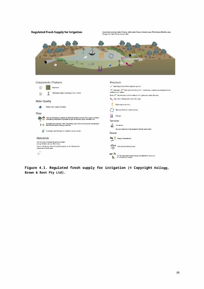
Table 7.3. Bird species breeding in the Ramsar site between 1980 and 2003 (Atlas of Victorian Wildlife, cited in DSE 2010a).
Date
Aus
tralia
n w
hite
ibis
Aus
tralia
n sh
eldu
ck
Bla
ck sw
an
Bla
ck-w
inge
d st
ilt
Dar
ter
Dus
ky m
oorh
en
Fre
ckle
d du
ck
Gre
at c
orm
oran
t
Gre
at-c
rest
ed g
rebe
Gre
at e
gret
Gre
y te
al
Gul
l-bill
ed te
rn
Har
dhea
d
Litt
le b
lack
cor
mor
ant
Litt
le p
ied
corm
oran
t
Nan
keen
nig
ht h
eron
Pac
ific
blac
k du
ck
Pie
d co
rmor
ant
Pin
k-ea
red
duck
Pur
ple
swam
p-he
n
Roy
al sp
oonb
ill
Silv
er g
ull
Stra
w ib
is
Sw
amp
harr
ier
Whi
sker
ed te
rn
Whi
te-n
ecke
d he
ron
Whi
te-b
ellie
d se
a
Yel
low
spoo
nbill
Tot
al n
o. sp
ecie
s
1980 1
1981 5
1982 2
1983 0
1984 10
1985 11
1986 2
1987 13
1988 10
1989 11
1990 8
1991 4
1992 1
1993 13
1994 0
1995 1
1996 5
1997 2
97
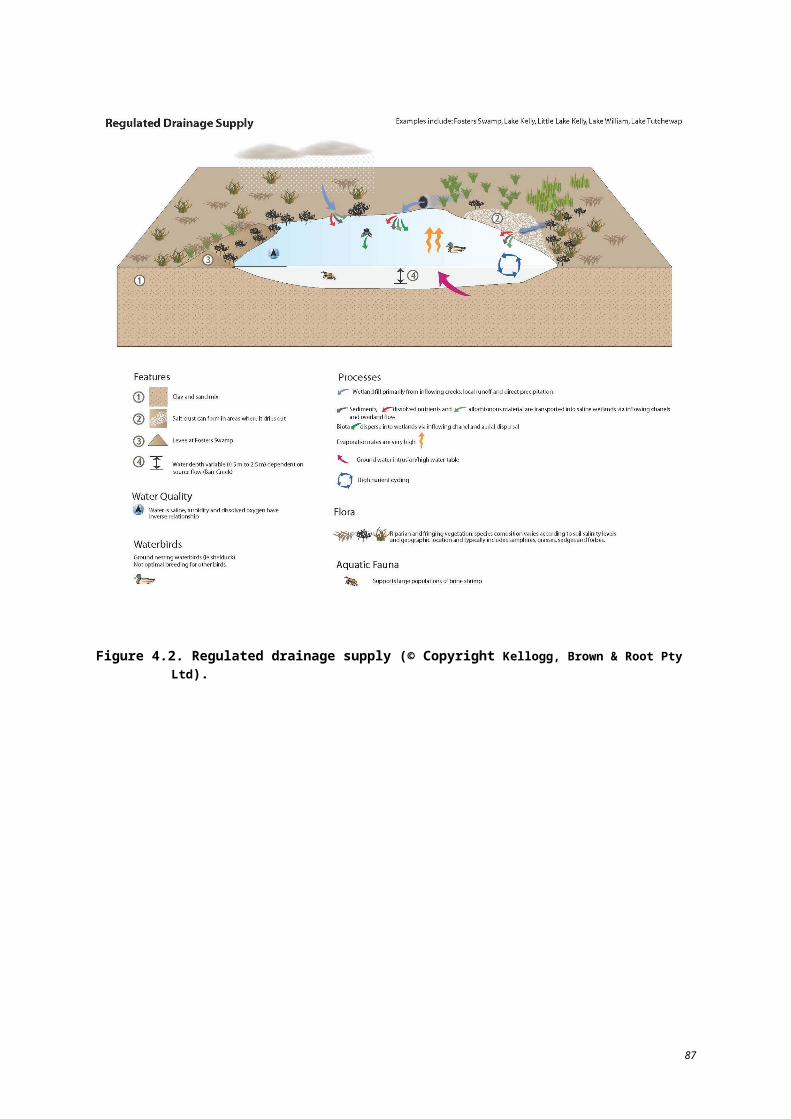
Date
Aus
tralia
n w
hite
ibis
Aus
tralia
n sh
eldu
ck
Bla
ck sw
an
Bla
ck-w
inge
d st
ilt
Dar
ter
Dus
ky m
oorh
en
Fre
ckle
d du
ck
Gre
at c
orm
oran
t
Gre
at-c
rest
ed g
rebe
Gre
at e
gret
Gre
y te
al
Gul
l-bill
ed te
rn
Har
dhea
d
Litt
le b
lack
cor
mor
ant
Litt
le p
ied
corm
oran
t
Nan
keen
nig
ht h
eron
Pac
ific
blac
k du
ck
Pie
d co
rmor
ant
Pin
k-ea
red
duck
Pur
ple
swam
p-he
n
Roy
al sp
oonb
ill
Silv
er g
ull
Stra
w ib
is
Sw
amp
harr
ier
Whi
sker
ed te
rn
Whi
te-n
ecke
d he
ron
Whi
te-b
ellie
d se
a
Yel
low
spoo
nbill
Tot
al n
o. sp
ecie
s
1998 6
1999 3
2000 4
2001 2
2002 0
2003 0
Total 7 6 6 1 8 1 1 3 3 1 5 1 1 5 8 4 5 5 1 2 9 4 6 1 1 5 2 11
98
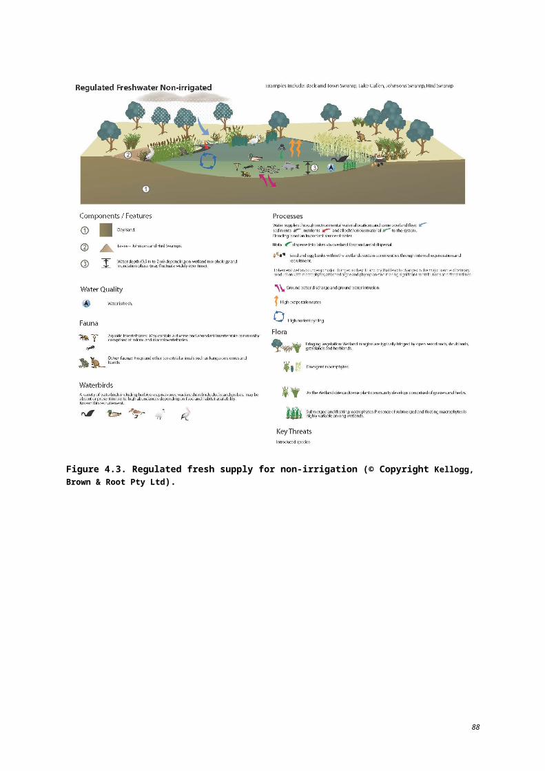
8 Knowledge gaps
The purpose of this section is to summarise the knowledge gaps identified in determining the ecological character of the Ramsar site. Throughout the ecological character description, data deficiencies and knowledge gaps have been identified. It is recognised that deficiencies in data from 1982 may not be able to be resolved; however, a number of additional investigations to assist in managing the wetland and assessing future change have been recommended.
During the literature review, the greatest amount of data available was for wetlands which function as part of the irrigation system or receive environmental flows. In general, surveys and data analysis for the Ramsar site have focused on the Avoca Marshes, Hird and Johnson Swamps and Reedy lakes. The recommended actions to address knowledge gaps should be applied without bias across the site to ensure a consistent data set will be available for analysis in the future. Stevenson’s, Cemetery, Town, Back and Fosters Swamps have a limited amount of data available compared to the other sites which make up the Ramsar site.
The range of data available on the extent and distribution of flora and fauna species within the Ramsar site is variable in terms of source confidence and accuracy. As such, during the development of this ECD it was found that various sources of flora and fauna data presented conflicting present/absent records for some species. In particular, the number of ‘listed’ species is variable between sources as some reference state and nationally listed while other reference national only.
A general knowledge gap, not related to a specific component, process or service, is how the Ramsar site meets the 2005 Criterion 1 based on the updated biogeographic region to which it is referenced against.
Table 8.1 summarises key knowledge gaps identified throughout the preparation of this description and will assist the allocation of resources for future management of the Ramsar site.
99
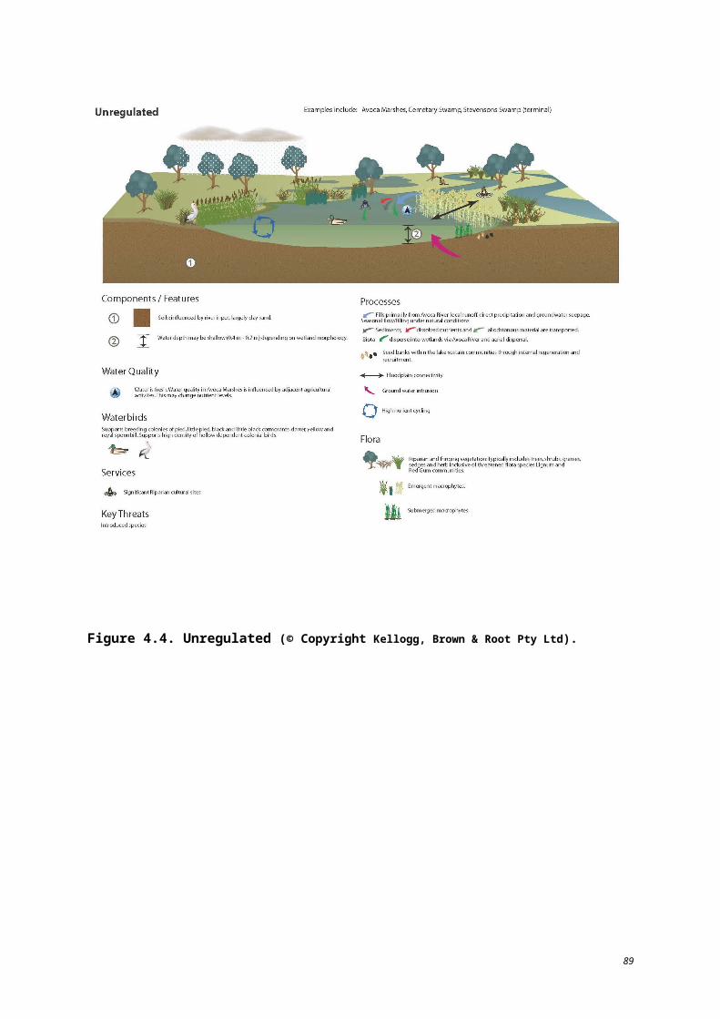
Table 8.1. Identified knowledge gaps and recommended actions.
Component/process Identified knowledge gaps Recommended action to address the gap
Hydrology Water regime management strategies to sustain wetland health and values.
Investigations into water regime modifications to sustain and improve wetland health and values which support the ecological character of the site.
Water quality – salinity
Quantitative information on salinity within the site in 1982 is not available.
Data deficient; unable to be resolved.
Quantitative information on salinity within the site is inconsistent.
Collate available data for ecological analysis; monitor the salinity of all sites as conditions allow.
Fauna – waterbirdsRelationships between waterbird numbers in relation to habitat availability and hydrology are unclear.
Investigations required to clarify relationships between waterbird numbers and habitat availability and condition, and hydrology.
Habitat use as a function of hydrology and vegetation has not been documented.
Monitor waterbird abundance, diversity and habitat use.
Fauna – fish Native fish distribution and abundance out of date. Conduct a comprehensive fish survey.
Vegetation communities
Flora
Vegetation community distribution and condition information is out of date.
Increased resolution of vegetation mapping is needed.
There are five flora species listed under the EPBC Act which may occur at the Ramsar site. However, available scientific reports and survey data present conflicting reports as to whether these species are ‘known to occur’ or ‘likely to occur’. The species are:
chariot wheels (Maireana cheelii);
river swamp wallaby grass (Amphibromus fluitans);
slender darling pea (Swainsona murrayana);
stiff groundsel (Senecio behrianus); and
winged peppercress (Lepidium monoplocoides).
Undertake comprehensive detailed flora survey.
Undertake high resolution mapping survey.
Verify presence/absence of listed flora species.
Waterbird breeding Current habitat use and success rate has not been documented.
Conduct regular breeding season surveys.
100
9 Monitoring requirements
The purpose of this section is to identify the elements of the Ramsar site, or threats to the site, that require monitoring in order to determine or maintain the site’s ecological character.
Table 9.1 provides a summary of the elements recommended for monitoring, objectives for monitoring, a suggested frequency and priority. It is not the intention of this section to provide a monitoring program as this will form an integral component of the management plan for the Ramsar site. Those considered as a high priority are essential for maintaining the character of the site and are considered the most vulnerable to threatening processes outlined in Section 6. Medium priority monitoring recommendations are considered less vulnerable to specific human activities or are driven by forces operating at a larger scale.
Some monitoring programs, such as nationally listed bird surveys and regional vegetation monitoring (biodiversity action plans) are established within the area and recommendations have been made to continue these programs.
Data collected from the recommended monitoring programs can be analysed to establish baseline conditions for sites which lack data, determine the extent and rate of changes and to forecast patterns and conditions. The data collected through monitoring is necessary in determining the extent of change, if any, to the Ramsar site elements and the conditions for which it was listed as a Wetland of International Importance.
101
Table 9.1. Site monitoring recommendations (adapted from DSE 2010a).
Component/ process/ benefit or service
2005 Criterion supported
Objective of monitoring
Indicator/ measure
Suggested frequency of reporting Priority
Hydrology 1
Ongoing condition and detection of change.
Establish relationship between hydrology, salinity and waterbird use.
Efficiency of water delivery of EWA and irrigation system
Surface water/groundwater interaction
Monitor efficiency every five years or following modifications.
Monitor surface water/groundwater quarterly or in conjunction with monthly water quality monitoring.
High
Maintain irrigation supply wetlands near full supply level to maintain wetland type.
Determine hydrology required to maintain significant vegetation communities.
Depth Annually in conjunction with water managers. High
Water quality – salinity
1
Ongoing condition and detection of change.
Establish relationship between hydrology, salinity and waterbird use.
Salinity
Continue monthly monitoring by DPI and G-MW.
Report on trends every 5–10 years.
High
Threatened species 2
Establish baseline, detection of change and ongoing condition.
Abundance
Condition
Distribution
Monitor threatened fauna species annually (coordinate with annual and national counts as applicable).
Monitor threatened flora species. Report annually.
High
Flora – EVC 2 and 3
Establish limits, detection of change and ongoing condition.
Distribution
Health
Habitat availability (i.e. habitat mapping)
Every 10 years for lignum communities.
Every 20 years for woodland communities.
High
Flora 3 Detect change and ongoing condition.
Distribution
Health
Habitat availability (i.e. habitat mapping)
Continue current monitoring through Biodiversity Action Plans.
Use the wetland index of condition to monitor threatened vegetation communities (assuming accurate mapping is available) every 10
High
102

years.
Fauna – waterbirds
3, 4, 5 and 6
Detect change and ongoing health.
Establish relationship between hydrology, salinity and waterbird use.
Establish ‘regularity’ of supporting 1% of populations.
Abundance
Diversity
Habitat use
Monitor waterbird species annually (as part of summer waterfowl counts) for priority sites; every five years or following flooding for lower priority sites.
Confirm 1% population thresholds with updated information from Wetlands International.
High
Waterbird breeding 3 and 4
Detect change and ongoing health.
Establish relationship between breeding, hydrology, vegetation condition and salinity.
Abundance
Diversity
Habitat use
Success
Monitor breeding sites annually. High
103

10 Communication, education, participation and awareness
Under the Ramsar Convention a Program of Communication, Education, Participation and Awareness (CEPA) was established to help raise awareness of wetland values and functions (DEWHA 2010b). At the Conference of Contracting Parties in Korea in 2008, a resolution was made to continue the CEPA program in its third iteration for the next two triennia (2009–15).
The vision of the Ramsar Convention’s CEPA Program is: ‘People taking action for the wise use of wetlands.’ To achieve this vision, three guiding principles have been developed:
The CEPA Program offers tools to help people understand the values of wetlands so that they are motivated to become advocates for wetland conservation and wise use and may act to become involved in relevant policy formulation, planning and management;
The CEPA Program fosters the production of effective CEPA tools and expertise to engage major stakeholders’ participation in the wise use of wetlands and to convey appropriate messages in order to promote the wise use principle throughout society; and
The Ramsar Convention believes that CEPA should form a central part of implementing the Convention by each Contracting Party. Investment in CEPA will increase the number of informed advocates, actors and networks involved in wetland issues and build an informed decision-making and public constituency.
The Ramsar Convention encourages communication, education, participation and awareness that is used effectively at all levels, from local to international, to promote the value of wetlands.
A comprehensive CEPA program for an individual Ramsar site is beyond the scope of an ECD, but key communication messages and CEPA actions, such as a community education program, can be used as a component of a management plan (DEWHA 2010b).
In response to the program encouraging coordinated international and national wetland education, public awareness and communication, Australia was the first contracting party to develop a Wetland CEPA National Action Plan 2001–2005. DEWHA (2010) states that Australia’s National Action Plan provides an umbrella for coordinated activities across Australia. It is endeavoured that this document provides a blueprint for wetland education and raising awareness in Australia.
Agencies and regional authorities, such as the North Central CMA and North Central Waterwatch, coordinated water quality and monitoring events and programs throughout the year to raise appreciation and awareness of the Ramsar site. These programs focus on communicating indigenous and ecological significance of the Ramsar site, the site’s value as waterbird habitat and particularly the significance of ibis breeding.
Local programs also function to increase awareness of local water quality conditions and how hydrology and human actions can affect our natural areas (NCCMA 2010a). This message is particularly important to stress the potential effects to vegetation communities and waterbird habitat which can be degraded (or improved) by local agricultural land use and development practices.
Through management and planning strategies, North Central CMA is actively educating stakeholders about the extent and condition of the North Central region’s wetlands. Maintaining strong partnerships between relevant agencies and the community for the protection and enhancement of
104
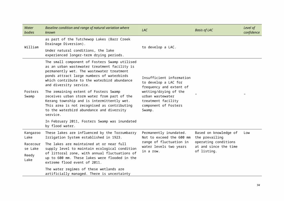
wetlands within the north central region, and promoting wetland values within the broader community via implementation of the Wetland Communication and Engagement Plan (NCCMA 2010a).
The impacts of weed infestation on wetland values are also an important message to communicate. The objectives of DPI’s Pest Plants Project are to implement community supported weed management programs that contribute to the protection of biodiversity and production outcomes of regional and state-wide strategies (NCCMA 2010a).
The following additional communication and education messages should be considered in conjunction with the above CEPA activities. These have been identified following review of the identified threats to the ecological character of the Ramsar site (Section 6):
Regional hydrology and water use: approximately eight decades of water management (Torrumbarry Irrigation System established in 1923) has influenced the assemblages of flora and fauna communities across the site. As such, a return to pre-settlement/pre listing hydrology may alter the listed ecological character of the site. However, future management considerations of natural wetting and drying cycles where appropriate may contribute to the site’s values.
Recreational activities: steps the community can take to minimise erosion caused by boating and recreational vehicles. Erosion can reduce wading bird habitat by undercutting banks and increase suspended soils in the water column which can affect fish populations.
Ecosystem interactions: the importance of interactions between climate, water quality, hydrology, bathymetry, flora and fauna in maintaining the character of the Ramsar site.
This ECD provides a benchmark of conditions to assist in future management of the Ramsar site and conservation of the site’s values. Monitoring by regional managers will contribute to ECD and management plan updates with objectives to minimise impacts from and control threats, and to sustain and improve values for which the site was listed.
105
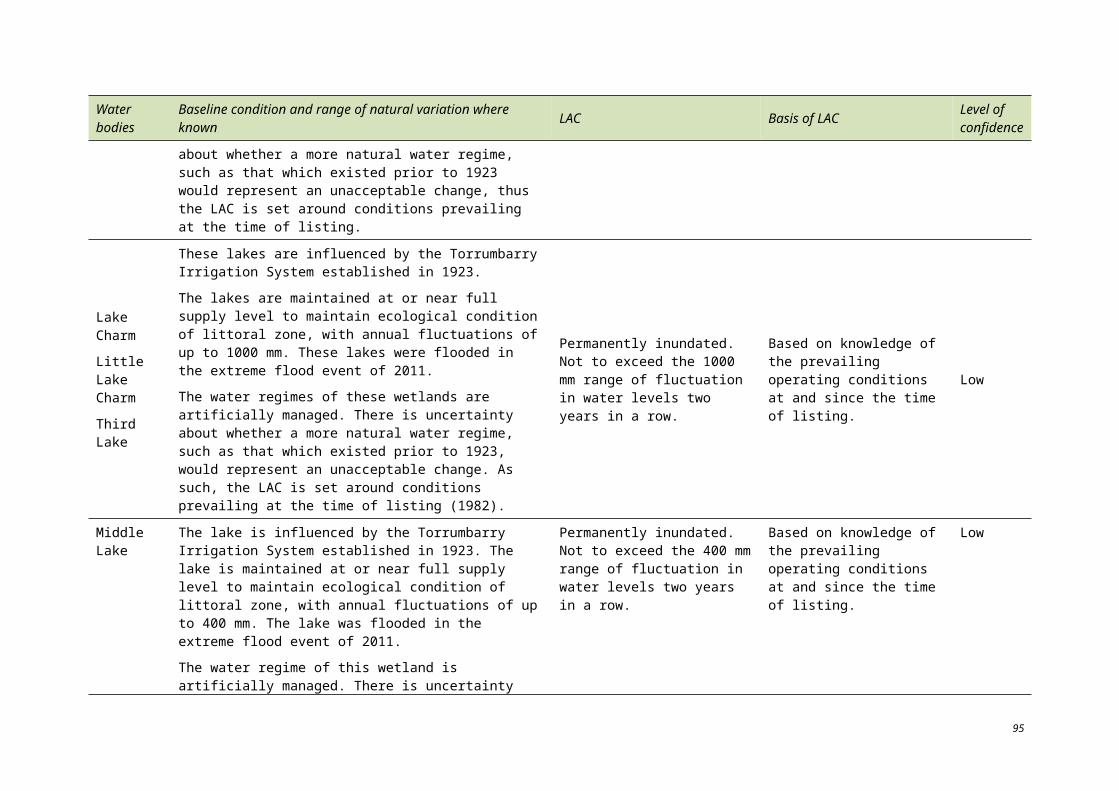
11 References
Aquaterra Simulations (2006). Goulburn-Murray Water Barr Creek – Tutchewop Reference Committee – Independent technical review of the hydrogeological understanding of the future management options for the Tutchewop Lakes, 46 pp.
Australian Soil Resource Information System (2010). http://www.asris.csiro.au/, accessed July 2010.
Boulton, A.J. and Brock, M.A (1999). Australian Freshwater Ecology: Processes and Management, CRCFE, Canberra.
Bureau of Meteorology (BoM) (2010). Climate data from Kerang weather station, http://www.bom.gov.au/climate/averages/tables/cw_080023.shtml.
Craik, W. (2005). Weather, Climate, Water and Sustainable Development – World meteorological day address 2005, Murray-Darling Basin Commission.
Commonwealth Scientific and Industrial Research Organisation (CSIRO) (2008). Water Availability in the Loddon-Avoca – A report to the Australian Government from the CSIRO Murray-Darling Basin Sustainable Yields Project, Australia 123 pp.
CSIRO (2006). Climate change scenarios for initial assessment of risk in accordance with risk management guidance – A report prepared for the Australian Greenhouse Office, Department of the Environment and Heritage.
CSIRO and BoM (2007). Climate change in Australia – Technical report by CSIRO Marine and Atmospheric Research and the Bureau of Meteorology, 148 pp. Available at www.climatechangeinaustralia.gov.au.
Department of the Environment, Water, Heritage and the Arts (DEWHA) (2010a). Buloke Woodlands of the Riverina and Murray-Darling Depression Bioregions in Community and Species Profile and Threats Database, Department of the Environment, Water, Heritage and the Arts, Canberra.
DEWHA (2010b). Communication, Education and Public Awareness Program, Department of Environment, Water, Heritage and the Arts, Canberra, Available at: http://www.environment.gov.au/water/environmental/wetlands/ramsar/cepa.html, accessed June 2010.
DEWHA (2009) Environment Protection and Biodiversity Conservation Act, Department of Environment, Water, Heritage and the Arts, Canberra. Available at: http://www.environment.gov.au/epbc/index.html, Accessed: March 2009.
DEWHA (2008). National Framework and Guidance for Describing the Ecological Character of Australia’s Ramsar Wetlands. Module 2 of the National Guidelines for Ramsar Wetlands – Implementing the Ramsar Convention in Australia. Australian Government Department of the Environment, Water, Heritage and the Arts, Canberra.
DEWHA (2008a). Water Requirements of Important Wetlands in the Murray-Darling Basin – Initial Overview Assessment, Final Report, Compiled by Fluvial Systems and Lloyd Environmental, Canberra.
Department of Natural Resources and Environment (DNRE) (2002a). Healthy rivers. Victorian river health strategy State of Victoria, Department of Natural Resources and Environment.
107
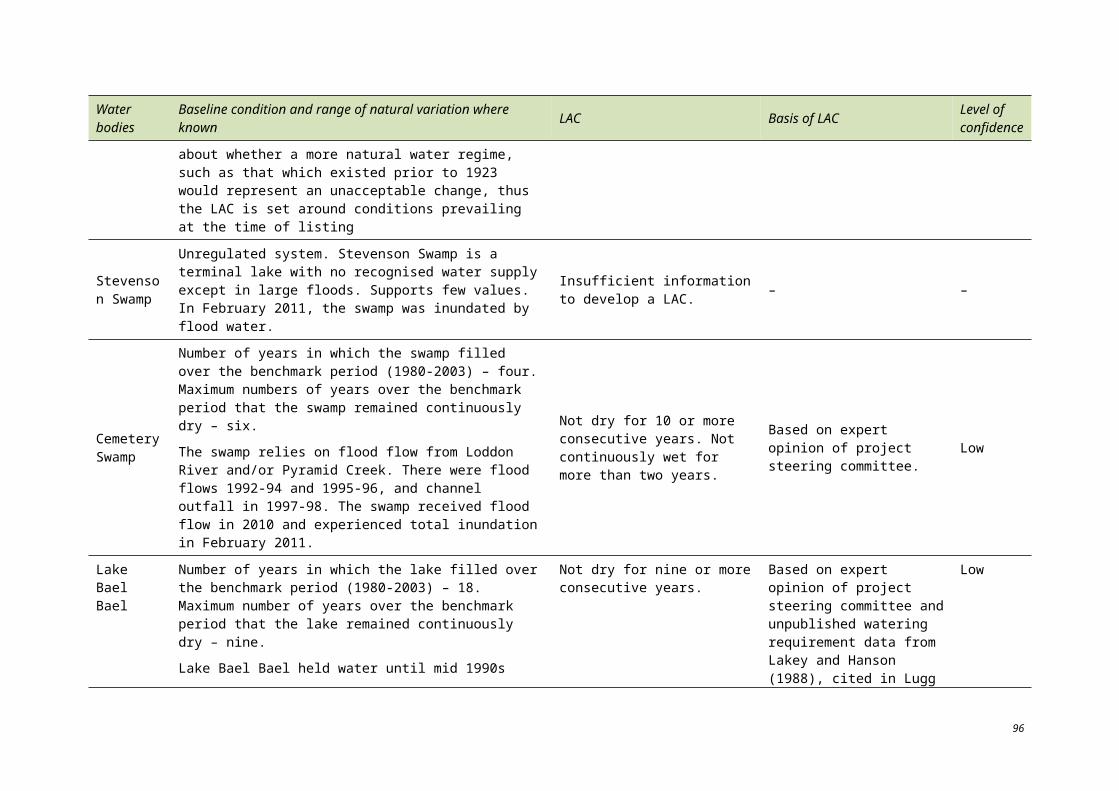
DNRE (2002b). Victoria’s Native Vegetation Management: a framework for action, department of Natural Resources and Environment, Melbourne.
Department of Sustainability and Environment (DSE) (2010a). Kerang Wetlands Ramsar site ecological character description. Department of Sustainability and Environment, Melbourne.
DSE (2010b). Victoria’s bioregions. Available at: http://www.dse.vic.gov.au/conservation-and-environment/native-vegetation-groups-for-victoria/victorias-bioregions
DSE (2009). Murray-Darling Basin Salinity Management Strategy – Victoria’s 2007–2008 Annual Report.
DSE (2009a). Northern Region Sustainable Water Strategy. State of Victoria, Department of Sustainability and Environment.
DSE (2007). Indigenous Partnership Framework 2007–2010 Victorian Government, Melbourne.
DSE (2006). 27 600 ML Murray Flora and Fauna Entitlement: Annual Distribution Program 2006/2007, Compiled by Andrea Joyce, Department of Sustainability and Environment, October, Melbourne.
DSE (2005). Index of wetland condition – Conceptual framework and selection of measures. State of Victoria, Department of Sustainability and Environment.
DSE (2004). Kerang wetlands Ramsar site strategic management plan, Department of Sustainability and Environment.
Department of Primary Industries (DPI) (2010). Fish stocking data, Joy Sloan, DPI. August 2010.
DPI (2010a). Angling waters of the Avoca River Basin 8. Available at: http://www.dpi.vic.gov.au/fisheries/recreational-fishing/inland-angling-guide/avoca-08/angling-waters-08, accessed 28 June 2010.
DPI (2010b). Measuring the salinity of water – Information notes LC0064, http://www.dpi.vic.gov.au/agriculture/farming-management/soil-water/salinity/measuring-the-salinity-of-water, accessed 30 June 2010.
DPI (2010c). Victorian resources online – North Central. Available at: http://www.dpi.vic.gov.au/vro, accessed 30 June 2010.
DPI (2010d). Wetland environmental monitoring data, DPI Kerang funded through DSE.
DPI (2010e). Loddon Campaspe Irrigation Region, DPI Environmental Monitoring Program, North Central CMA.
Ecological Associates (2007). Floodplain Options Investigations: Lindsay, Mulcra and Wallpolla Islands. Final Report for the Mallee Catchment Management Authority.
Fleming, G. (1990). The aquatic invertebrate and fish fauna of the Kerang Lakes area – Report No. 3, Report to Kerang Lakes Working Group, Department of Sustainability and Environment.
GHD (2007). Report for Review of Water Management Options for Wetlands – Lindsay and Mulcra Islands – Draft Report. GHD.
Goulburn-Murray Water (GBM) (2010). Environment webpage, accessed June 2010. Available at: http://www.g-mwater.com.au/environment/waterquality/b-g_algae/
108
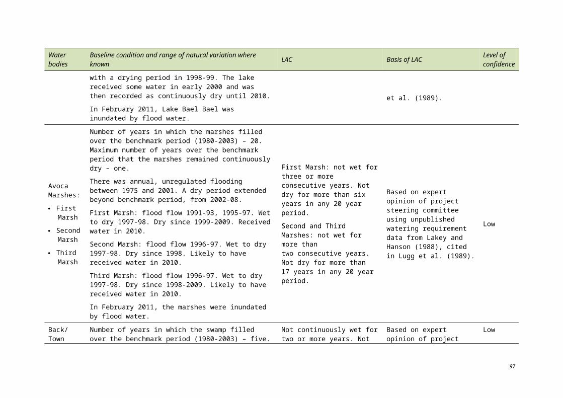
Hale J and Butcher R (2007). Ecological character description of the Peel-Yalgorup Ramsar site, Report to the Department of Environment and Conservation and the Peel-Harvey Catchment Council, Perth, Western Australia.
Hennessy, K. J. (2007). Climate change in Australian dairy regions, CSIRO Marine and Atmospheric Research, October 2007.
Heron, S. and A. Joyce (2008a). Northern Region Sustainable Water Strategy: impacts of water availability on significant wetlands. 36 pp.
Heron, S. and A. Joyce (2008b). Northern Victorian Wetlands: water requirements and impacts of climate change on the 27.6 GL Flora and Fauna Entitlement and dependant wetlands.
Ho, S., Roberts, J., Cheers. And Suitor, L. (2006). Development and application of an ecological monitoring and mapping program for targeted Kerang lakes. Report prepared for the North Central Catchment Management Authority by The Murray-Darling Freshwater Research Centre. Mildura, Victoria, Australia.
IUCN (2010). IUCN Red List of Threatened Species. Version 2010.2. Available at: http://www.iucnredlist.org/. Downloaded on 29 June 2010.
Kellogg Brown and Root Pty Ltd (KBR) (2007). Assessment framework of changed water management regimes on the health of the Kerang Lakes, MEN713-G-REP-001.
Kelly, M. J. (1996). Wetland management strategy: Lake Elizabeth Kerang, State of Victoria, Department of Conservation and Natural Resources.
Kerang Lakes Area Working Group (KLAWG) (1992). The Kerang Lakes area draft salinity management plan, The Kerang Lakes Area Working Group.
KLAWG (1993). The Kerang Lakes area salinity management plan, The Kerang Lakes Area Working Group.
Lugg, A. (1989). Waterbirds of the wetlands in the Kerang Lakes area – Report No. 4 to the Kerang Lakes Working Group, Department of Conservation, Forests and Lands, Bendigo.
Lugg, A., Heron, S., Fleming, G. and T. O’Donnell (1989). Conservation value o the wetlands in the Kerang Lakes area, Department of Conservation Forests and Lands, Bendigo.
Macumber, P.G. (1978). Hydrologic change in the Loddon Basin: the influence of groundwater dynamics on surface processes, proceedings of the Royal Society of Victoria, 90:125-138.
Mitsch, W. J. and J. G. Gosselink. (2000). Wetlands, J W Wiley Publishing, third edition.
Murray-Darling Basin Commission (MDBC) 2010. Murray-Darling Basin Commission: natural resource management website, http://www.mdbc.gov.au/nrm.html, accessed July 2010.
MDBC (2008). Report of the Independent Audit Group for Salinity 2006–2007, Murray-Darling Basin Commission Publication number 30/08, 47 pp.
MDBC (2002). Murray-Darling Basin Floodplain Management Strategy August 2002 MDBC, Publication No. 36/04.
Murray-Darling Basin Ministerial Council (2006). Barr Creek–Tutchewop Reference Committee – Independent technical review of the hydrogeological understanding of the future management options for the Tutchewop Lakes.
109
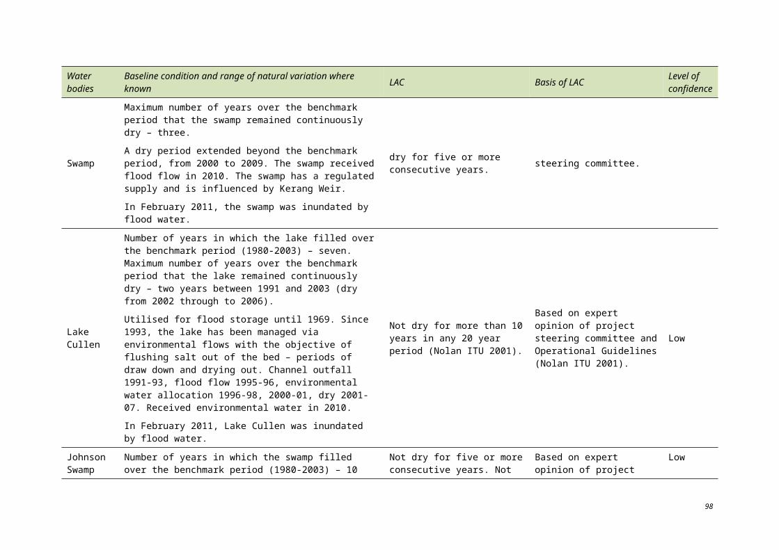
Nielsen, D.L., Brock, M.A., Rees, G.N. and D. Baldwin (2003). Effects of increasing salinity on freshwater ecosystems in Australia, Australian Journal of Botany, 51:655-665.
Nolan ITU (2001). Lake Cullen Feasibility Study and Operational Guidelines.
North Central Catchment Management Authority (NCCMA) (2010). Available at: http://www.nccma.vic.gov.au/, accessed 30 June 2010.
NCCMA (2010a). People. Available at: http://www.nccma.vic.gov.au/What_We_Do/People/index.aspx, accessed July 2010.
NCCMA (2009). Johnson Swamp Environmental Watering Plan.
NCCMA (2007). Loddon Campaspe Irrigation Region – Land and water management plan summary.
NCCMA (2006). Lower Avoca wetlands salinity and water management plan, 80 pp.
NCCMA (2005). North Central native vegetation management plan.
Northern Victoria Irrigation Renewal Project (NVIRP) 2010. Public environment report, prepared by the Northern Victoria Irrigation Renewal Project (NVIRP) for the Department of the Environment, Water, Heritage and the Arts under the Commonwealth Environment Protection and Biodiversity Conservation Act 1999.
NPSI 2009. Research Bulletin – Investigating lake/groundwater interactions at Lake Tutchewop.
O’Donnell, T. (1990). Vegetation of the wetlands in the Kerang Lakes area – Report to Kerang Lakes Area Working Group.
Parks Victoria (2004) Kerang Wetlands Ramsar Site Strategic Management Plan, Kerang. Victoria.
Parks Victoria (2002). Barmah Forest Ramsar Site. Draft Strategic Management Plan. Melbourne, Victoria.
Parks Victoria (2002). Strategic directions statement for the management of Victoria’s Ramsar wetlands, State of Victoria, Department of Natural Resources and Environment.
Parks Victoria (1999). Kerang Wetlands Ramsar Sheet – 1999.
Paton, D. (2002). ‘Migratory waders’, in Murray-Darling Basin Commission and Department of Water, Land and Biodiversity Conservation, The Murray mouth: exploring the implications of closure or restricted flow.
PPK Environmental (2000). Ecological Assessment of Future Management Options for the Tutchewop Lakes – Final Report – 17 Jan 2000. PPK Environment & PPK House, South Melbourne.
Ramsar 2005. The Criteria for Identifying Wetlands of International Importance. Available at: http://www.ramsar.org/cda/en/ramsar-about-sites-criteria-for/main/ramsar/1-36-55%5E20740_4000_0__
Riparian Australia (2003). Lower Avoca wetlands vegetation condition appraisal, prepared for the North Central Catchment Management Authority, Bendigo.
Sinclair Knight Merz (SKM) (2009). Kerang lakes water saving project – Review and refinement of water savings, 31 pp.
110
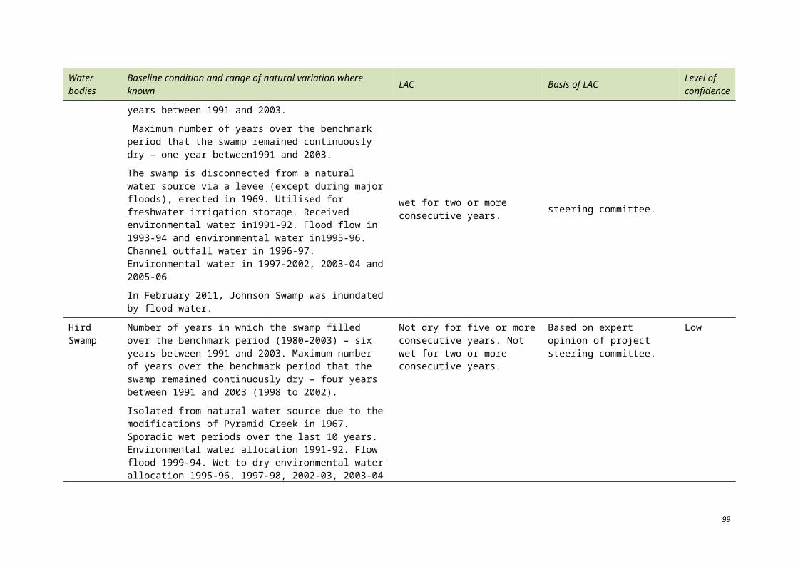
SKM (2001). Reedy Lakes environmental status report, 64 pp.
SKM (2000). National Land and Water Resources Audit: Theme 2 – Dryland Salinity Extent and impact of dryland salinity in Victoria, 95 pp.
Thorne, A. G. and Macumber, P. G. (1972). Discoveries of Late Pleistocene man at Kow Swamp. Nature 238:316-319.
Waterwatch Victoria (1999). Water Victoria methods manual, State of Victoria, Department of Natural Resources and Environment.
Wetlands International 2006. Waterbird population estimates, fourth edition. Available at: http://www.wetlands.org/, accessed August 2010.
Victoria Water Resource Data Warehouse (2010). Available at: http://www.vicwaterdata.net/vicwaterdata/home.aspx , accessed June 2010.
111
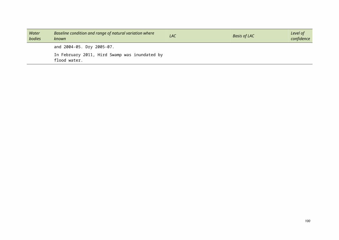
12 Appendix
12.1 APPENDIX A – SIGNIFICANT FLORA AND FAUNA SPECIES
Table A.1. Significant species recorded at the Kerang Wetlands Ramsar site since 1982 (Clunie 2006, DSE 2004, DSE 2010b, IUCN 2010).
Species name FFG Act
Conservation status in Victoria
EPBC Act
IUCN Red List
BIRDS
Australian painted snipe Rostratula australis L V E E
Australian shoveler Anas rhynchotis V LC
Baillon’s crake Porzana pusilla L V LC
Black falcon Falco subniger V LC
Black-chinned honeyeater Melithreptus gularis LR LC
Black-tailed godwit Limosa limosa V NT
Blue-billed duck Oxyura australis L E NT
Brolga Grus rubicunda L V LC
Brown treecreeper Climacteris picumnus LR LC
Caspian tern Sterna caspia L LR LC
Common sandpiper Actinis hypoleucos V LC
Eastern curlew Numenius madagascariensis LR LC
Eastern great egret Ardea modesta L V
Freckled duck Stictonetta naevosa L, A E LC
Glossy ibis Plegadis falcinellus LR LC
Great egret Ardea alba L V LC
Great knot Calidris tenuirostris L E LC
Great sand plover Charadrius leschenaultii V LC
Grey–crowned babbler Pomatostomus temporalis L E LC
Grey falcon Falco hypoleucos L E V
Gull-billed tern Sterna nilotica L E LC
Hardhead Aythya australis V LC
Hooded robin Melanodryas cucullata L LR LC
Intermediate egret Ardea intermedia L CE LC
Latham’s snipe Gallinago hardwickii LR LC
Little bittern Ixobrychus minutus L E LC
Little button-quail Turnix velox LR LC
112
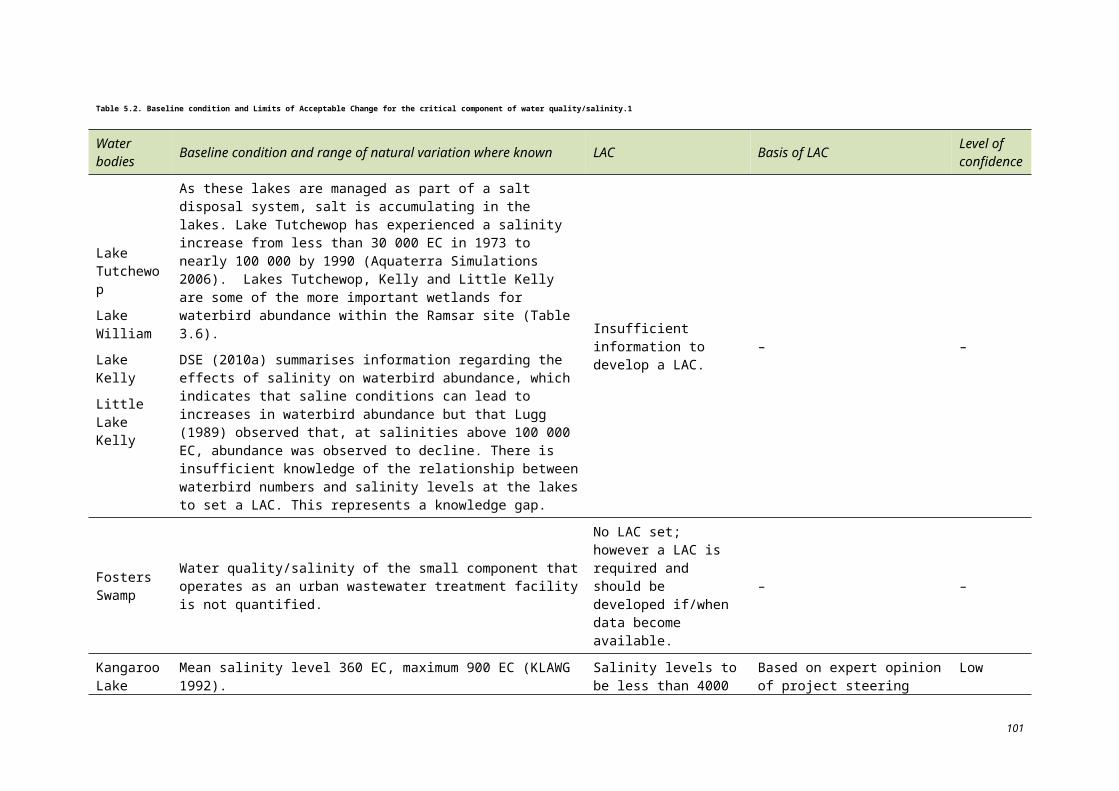
Species name FFG Act
Conservation status in Victoria
EPBC Act
IUCN Red List
Little egret Egretta garzetta L E LC
Long-toed stint Calidris subminuta DD LC
Magpie goose Anseranas semipalmata V LC
Musk duck Biziura lobata V LC
Nankeen night heron Nycticorax caledonicus LR LC
Pacific golden plover Pluvialis fulva LR LC
Pied cormorant Phalacrocorax varius LR LC
Plains wanderer Pedionomus torquatus L, A CE V E
Red knot Calidris canutus LR LC
Regent honeyeater Xanthomyza phrygia E E CE
Royal spoonbill Platalea regia V LC
Sanderling Calidris alba LR LC
Spotted harrier Circus assimilis LR LC
Whiskered tern Chlidonias hybridus LR LC
White-bellied sea eagle Haliaeeatus leucogaster L, A V LC
White-winged black tern Chlidonias leucoptera LR LC
MAMMALS
Fat–tailed dunnart Sminthopsis crassicaudata NT LC
REPTILES
Carpet python Morelia spilota metcalfei L E
Tree goanna Varanus varius V
AMPHIBIANS
Growling grass frog Litoria raniformis L E V E
FISHES
Flat-headed galaxias Galaxias rostratus L# DD V
Freshwater catfish Tandanus tandanus L, L# E
Golden perch Macquaria ambigua L# V
Macquarie perch Macquaria australasica L, L# E E DD
Murray cod Maccullochella peelii L, L# E V CE
Murray hardyhead Craterocephalus fluviatilis L, L# CE E E
Silver perch Bidyanus bidyanus L, L# CE CE V
Unspecked hardyhead
Craterocephalus stercusmuscarum fulvus L, L#
113
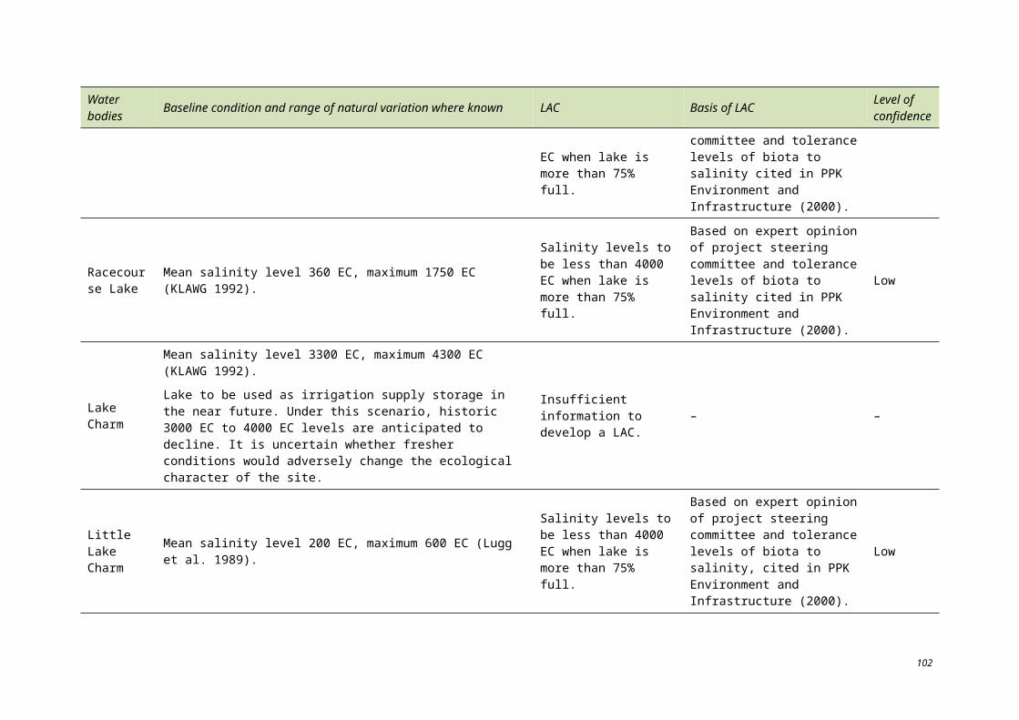
Species name FFG Act
Conservation status in Victoria
EPBC Act
IUCN Red List
FLORA
Australian millet Panicum decompositum k
Brown beetle-grass Leptochloa fusca ssp. fusca r
Buloke Allocasuarina leuhmanii L
Bundled peppercress Lepidium fasciculatum k
Flat spike-sedge Eleocharis plana r
Forde poa Poa fordeana k
Kidney saltbush Atriplex stipitata v
Matted water-starwort Callitriche sonderi k
Swamp buttercup Ranunculus undosus v
Sickle love-grass Eragrostis falcata k
Six-point arrowgrass Triglochin hexagonum v
Small monkey-flower Mimulus prostratus r
Spiny lignum Muehlenbeckia horrida ssp. horrida k
Spreading emu-bush
Eremophila divaricata ssp. divaricata r
Sweet fenugreek Trigonella suavissima r
Twin-leaf bedstraw Asperula gemella r
Umbrella wattle Acacia oswaldi v
Waterbush Myopoum montanum r
Conservation status under the FFG Act
L Listed under the Flora and Fauna Guarantee Act 1988.
L# Listed under the Flora and Fauna Guarantee Act 1988 as part of the Lowland Riverine Fish Community of the Southern Murray-Darling Basin.
A An action statement has been prepared for the management of this species.
Conservation status in Victoria (fauna)
CE Critically Endangered: a taxon that is facing an extremely high risk of extinction in the wild in the immediate future.
E Endangered: a taxon that is not Critically Endangered but is facing a very high risk of extinction in the wild in the immediate future.
V Vulnerable: a taxon that is not Critically Endangered or Endangered but is facing a high risk of extinction in the wild in the medium-term future.
114
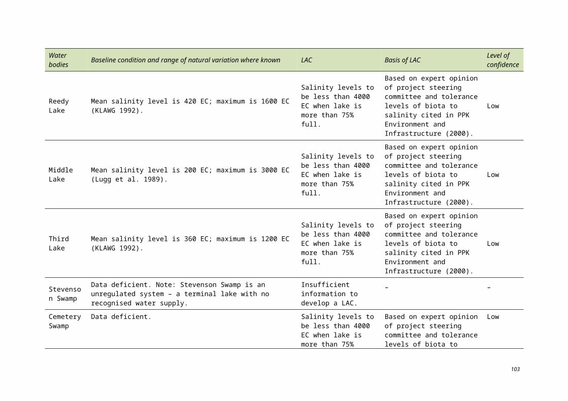
LR Lower Risk – near threatened: a taxon that has been evaluated, does not satisfy the criteria for any of the threatened categories, but which is close to qualifying for Vulnerable. In practice, these species are most likely to move into a threatened category should current declines continue or catastrophes befall the species.
DD Data Deficient: a taxon where there is inadequate information to make a direct or indirect assessment of its risk of extinction based on its distribution or population status. Listing of taxa in this category indicates that more information is required and acknowledges the possibility that future investigation will show that a threatened classification is appropriate.
Conservation status in Victoria (flora)
e Endangered in Victoria; rare and at risk of disappearing from the wild state if present land use and other causal factors continue.
v Vulnerable in Victoria: rare, not presently endangered but likely to become so soon due to continued depletion, or which largely occur on sites likely to experience changes in land use which threaten the survival of the species.
r Species that are rare in Victoria but which are not considered otherwise threatened. This category indicates relatively few known stands.
k Species that are poorly known, suspected of being in one of the above categories.
Conservation status under the EPBC Act 1999
CE A native species is eligible to be included in the critically endangered category at a particular time if, at that time, it is facing an extremely high risk of extinction in the wild in the immediate future, as determined in accordance with the prescribed criteria.
E A native species is eligible to be included in the endangered category at a particular time if, at that time:
(a) it is not critically endangered
(b) it is facing a very high risk of extinction in the wild in the near future, as determined in accordance with the prescribed criteria.
V A native species is eligible to be included in the vulnerable category at a particular time if, at that time:
(a) it is not critically endangered or endangered
(b) it is facing a high risk of extinction in the wild in the medium-term future, as determined in accordance with the prescribed criteria.
Conservation status on the International Union for Conservation of Nature (IUCN) Red List
CE A taxon is Critically Endangered when the best available evidence indicates that it meets any of the criteria A to E for Critically Endangered, and it is therefore considered to be facing an extremely high risk of extinction in the wild.
E A taxon is Endangered when the best available evidence indicates that it meets any of the criteria A to E for endangered, and it is therefore considered to be facing a very high risk of extinction in the wild.
V A taxon is Vulnerable when the best available evidence indicates that it meets any of the criteria A to E for Vulnerable, and it is therefore considered to be facing a high risk of extinction in the wild.
NT A taxon is Near Threatened when it has been evaluated against the criteria but does not qualify for Critically Endangered, Endangered or Vulnerable now, but is close to qualifying for or is likely to qualify for a threatened category in the near future.
LC A taxon is Least Concern when it has been evaluated against the criteria and does not qualify for Critically Endangered, Endangered, Vulnerable or Near Threatened. Widespread and abundant taxa are included in this category.
115
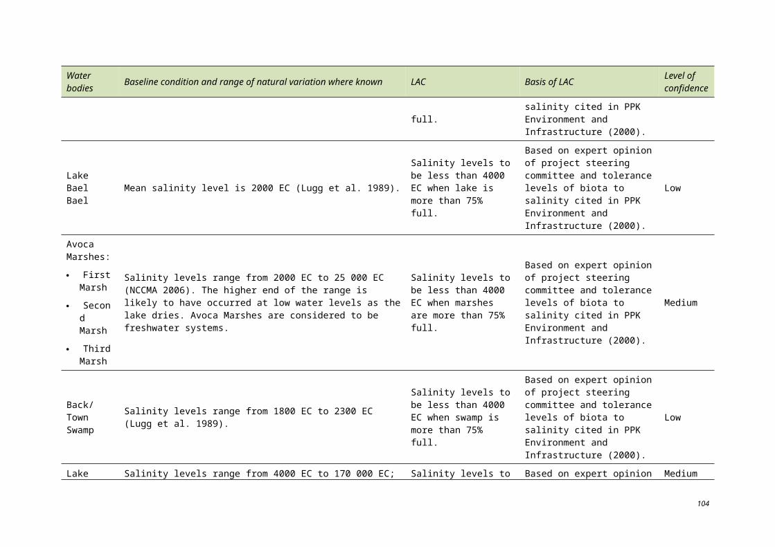
DD A taxon is Data Deficient when there is inadequate information to make a direct, or indirect assessment of its risk of extinction based on its distribution and/or population status.
116