Embed Size (px)
Citation preview
384
Journal of Sustainable Development in Africa (Volume 12, No.1, 2010)
ISSN: 1520-5509 Clarion University of Pennsylvania, Clarion, Pennsylvania
EROSION PROBLEMS IN A NIGERIAN RURAL COMMUNITY
By: Ajewole Davies Ojo & Oni Johnson
ABSTRACT
This work is an assessment of the impact of soil erosion on landscape degradation in Koro –
Ekiti, Kwara State, Nigeria. The primary objective of the work is as follows; investigation of the
nature of erosion problems, assessment of erosion influence on agricultural practices and
responses to erosion management in the study area. To achieve the stated objectives, data were
generated through questionnaire administration and direct field measurement of the width and
depth dimension of the selected erosion sites, also descriptive statistical techniques were
employed in the analysis of data generated. The analysis revealed some interesting features as
follows: there exist a relationship between settlement structure and erosion in the study area; (ii)
considerable loss in soil status led to decrease in agricultural productivity, (iii) gully erosion is
prominent on both road networks and farmlands in the study area. Various measures suggested
to curb the menace of soil erosion were as follows; design and construction of drainage
channels to prevent soil loss to surface runoff, massive afforestation, proper housing layout,
environmental education programmes among others.
Keywords: Nigerian Rural Community, Erosion problems, drainage channels, road networks
INTRODUCTION
The biospheric layers of the earth constitute the layer where the activities of both micro and
macro organisms take place (Jimoh, 1999). It is on this layer that the activities of man in his
environment take place. These activities undertaken by man include mining, quarrying,
agriculture, constructions, lumbering, among others (Geller, 1982; Jeje, 1982). In all these

385
activities, man gives little attention to their implications on the environment, such as soil
erosion (Howard and Remson, 1978; Kowal and Kassan, 1988; Hindson, 1983).
Soil erosion is a dynamic geomorphic event operating on the landscape. It is defined as the
process leading to the general degradation of the ground surfaces (Knapp, 1979; Morgan, 1980;
Blum, 1985). Similarly, Faniran and Areola (1980) defined soil erosion as a situation in which
soil is removed at a rate faster than that at which new soil is formed. Jimoh, 1994 defined soil
erosion as the removal of soil materials and/or soil nutrients by surface run-off from different
points of origin to other locations.
The earth’s landforms are closely inter-related and some of the observation which has been
made with the passing of time shows that these landforms are acted upon by the processes of
erosion causing the landforms to undergo a progressive change from initial forms sequentially
to ultimate forms (Sparks, 1995).
This geomorphic event may degenerate into sheet, rill or gully types of erosion (Cooke and
Doornkamp, 1974; Jimoh, 1994). Sheet erosion is essentially a process that involves the
uniform removal of soil surfaces, which is when the soil surface is undergoing a uniform
degradation. Rills are parallel grooves of little depth covering the land surface which can easily
be filled through normal cultivation; formation of rills is one of the consequences of flow water.
Sheet and rill erosion are the fore runners of gully erosion representing the incipient stage of the
development of gully erosion (Oyegun, 1980; Bergsma, 1981).
Gully erosion is any erosional channel that is so deep that it cannot be crossed by a wheeled
vehicle or eliminated by ploughing, unlike rills which can easily be filled through normal
cultivation (Dictionary of Geologic terms).
The major agents of soil erosion in the tropics includes rainfall, while some of the attributes of
rainfall are; intensity, duration, drop-size, amount and frequency. other factors that contribute to
the occurrence of soil erosion in the tropics includes soil type and its characteristics,

386
topography, geology, cultural practice carried out in the region and conservative practice
applied to the land (Faniran and Jeje, 1983).
However, it is the combined effect of these factors of soil erosion that makes its operation and
consequences hazardous and therefore of great relevance to man (Dent and Young, 1981). A
case in point is the fact that soil erosion has considerably initiated landscape destructions
(Jimoh, 1994; Jimoh, 2003; Jimoh and Ajibade, 1995).
Gullies are formed as a result of a combination of climatic and human influences. For instance,
over-cultivation of land in certain parts of Kwara State has resulted in gully erosion and such
arrears include the road linking Iloffa with Odo-Owa in Oke-Ero Local Government Area of
Kwara State, and most farmlands in Ekiti Local Government such as Osi, Araromi-Opin and
other neighboring villages.
In view of these occurrences, this research endeavor focuses on feeling the pulse in individuals
on erosion problems and the possible responses to such menace.
AIM AND OBJECTIVES OF THE STUDY
The primary aim of this work is on the impact of erosion on landscape degradation. To
accomplish this philosophy, the following objectives are being pursued as follows;
- To investigate the factor of erosion problems
- To assess the effects of erosion on agricultural practices in the study area
- To study the anthropogenic activities in the study area
- To examine the nature of erosion in the study area
- To assess the responses to erosion management in the study area.
LOCATION OF THE STUDY AREA
The study area is Koro town, located in the Ekiti Local Government Area of Kwara State. It lies
as the boundary between Kwara and Kogi States. Koro is located on latitude 80 02N and
longitude 40 07E in the South-Eastern part of Kwara State and situated within the geographical
entity of Western Nigeria.

387
CLIMATE
The climate of the study area is basically monsoonal in character and is consequently expressed
as a contrast between a dry and a wet season. These two regimes of the climate are very
dependent on the two prevailing air masses blowing over the country at different times of the
year-the dry North-Easterly air mass of Sahara origin and the humid maritime air mass blowing
over the Atlantic.
The two air masses blowing from nearly opposite directions meet at a zone of discontinuity
stretching East-West Africa, and variously called the inter tropical front (ITF), the inter tropical
convergence zone (ITCZ), the surface discontinuity and the inter-tropical discontinuity (ITD).
Whenever two air masses meet, convectional rain usually follows.
The mean annual rainfall is about 1168mm; it exhibits the double maxima pattern. There are
two rainfall periods: April/May and September/October, with the month of August as the break
period. Dry season begins in the month of November lasting till the month of February.
December and January are usually cold and dry due to the influence of harmattan wind from the
desert region of the North. The early rains of February and April, which come just after the end
of dry season, are very effective in the process of soil erosion.
The low relative characteristics of the dry season leave the surface of the soil dry and cracked at
various points. These “fractures” are rapidly exploited by the runoff of storms of the “early
rains” and greatly favour the inception and subsequent evolution of gullies.
GEOLOGY
The geology of Koro-Ekiti is characterized with basement complex which are the combination
of igneous and metamorphic rock which are found below the surface but allows substantial
percolation of rain water. Therefore, because of the nature of the geology if these environments,
more of surface water are found such as overflow and which influences the intensity of
erosional effect of this environment.

388
Geomorphologically, in terms of landscape and the configuration of this environment, the relief
of this part of the environment is classified as Inselbergs because it is located in humid tropical
environment and the topography of this environment is hilly.
SOIL OF THE STUDY AREA
The environment of Koro is characterized with ferallitic soil, the rate of biological turn-over in
this environment is high, and decomposition is higher because of adequate rainfall. Soil erosion
is a major problem in this environment.
However, because of the nature of climate, vegetation and bio-climate of this environment,
chemical weathering is mostly significant due to the high temperature, which speeds-up the rate
of chemical reaction in rocks. The end product of chemical weathering in this environment is
clay. This is because erosion has washed away the top soil, leaving behind the clay soil.
TOPOGRAPHY AND DRAINAGE PATTERN
Koro settlement is an area of highlands. The general land surface is of a basement complex rock
that displays a number of Inselbergs, structural hills and ridges, which are remnants of the
‘African’ denudational surface. The Inselbergs are bare domes whale backs or less regular hills
and display exfoliated capping and boulders. The major rivers draining Koro community are
river Iye and Agbaramoko that flow southward to River Niger. The geology of this area
influences the drainage system of this environment (Ayeni, 1978).
Therefore because of the nature of the geology of this environment, more of surface
water is found as overflow which influences the intensity of erosional event in this area.

389
Fig. 1. Map of the Study Area
EROSION PROBLEMS IN KORO
TABLE 1: KORO NORTH
S/n Location Land use type Depth
(m)
Width
(m)
1 ECWA dispensary Foundation of house 0.70 0.96
2 Water works site Farmland 1.60 1.00
3 Koro-Eruku road Road network 1.15 1.50
4 Akola road Road network 1.30 1.22
Total 4.75 4.68
Mean 1.18 1.17 Source: Author’s Fieldwork, 2009
TABLE 2: KORO SOUTH
s/n Location Land use type Depth (m) Width (m)
1 Teachers’ staff Quarters Road network 1.20 1.00
2 Koro Grammar School Farmland 1.48 3.11
3 Police station Road network 1.15 1.00
Total 3.83 5.10
Mean 1.28 1.70 Source: Author’s Fieldwork, 2009.

390
TABLE 3: KORO WEST s/n Location land use type Depth (m) Width (m)
1 Oketari road Road network 1.65 2.20
2 Koro-Egbe road Road network 2.81 2.15
3 Cemetery Road network 3.00 2.11
Total 7.46 6.46
Mean 2.49 2.15
Source: Author’s Fieldwork, 2009
TABLE 4: KORO CENTRAL s/n Location Land use type Depth (m) Width (m)
1 CAC road Road network 1.01 0.99
2 Post Office Foundation of House 1.20 0.98
3 Corpers’ lodge Road network 1.12 1.05
Total 3.36 3.02
Mean 1.11 1.01
Source: Author’s Fieldwork, 2009
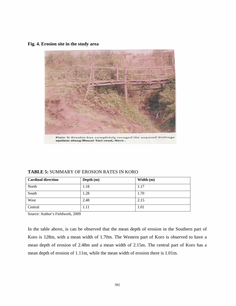
Erosion is the study area is best studied and understood in the four major zonal parts of the
study area, i.e North, South, West, and Central. This division is informed by the variations in
the intensity and rate of occurrence in the study area. Furthermore, in the Northern part of Koro,
the mean depth of erosion is 1.18m and the mean width is 1.17m (see Table 5).

391
Fig. 2. Gully Erosion site in the Study Area.
Fig. 3. Road network Erosion site in the study area
392
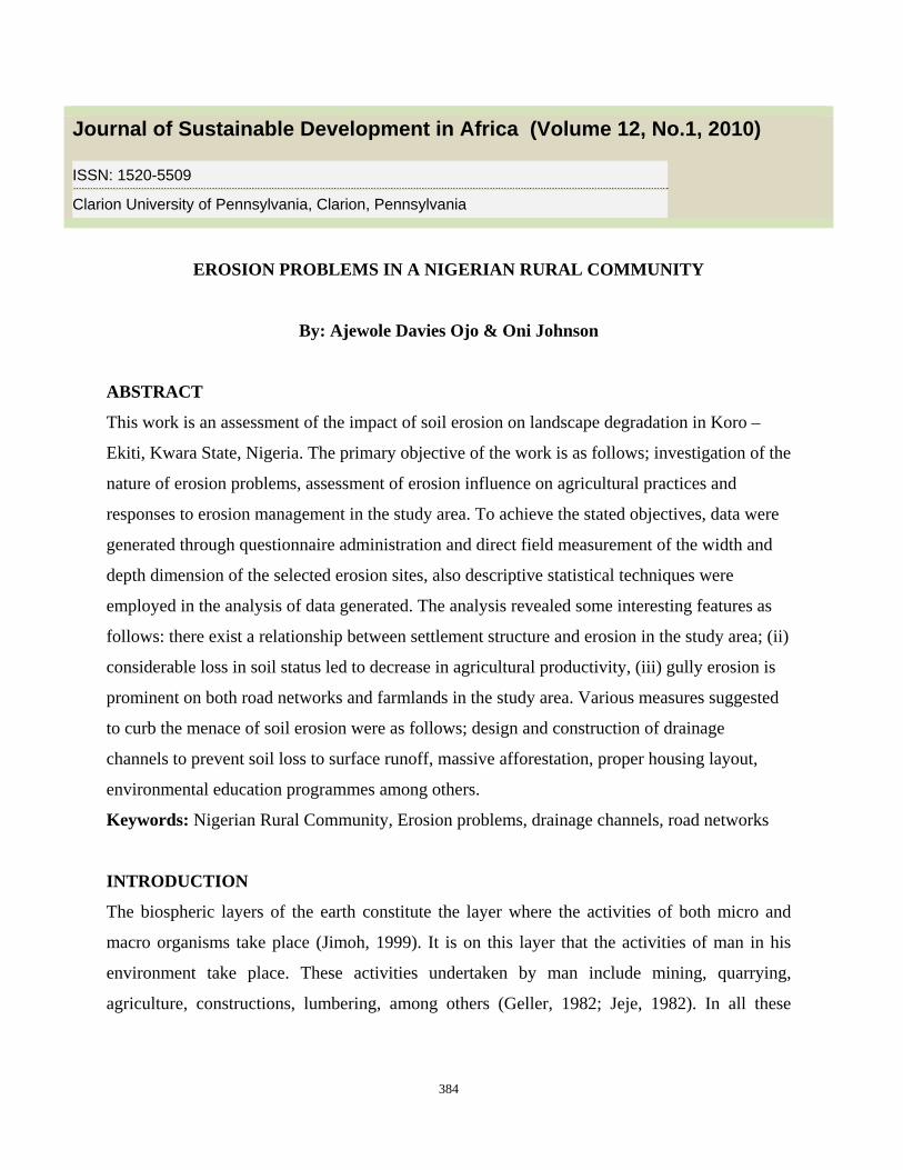
Fig. 4. Erosion site in the study area
TABLE 5: SUMMARY OF EROSION RATES IN KORO Cardinal direction Depth (m) Width (m)
North 1.18 1.17
South 1.28 1.70
West 2.48 2.15
Central 1.11 1.01
Source: Author‘s Fieldwork, 2009
In the table above, is can be observed that the mean depth of erosion in the Southern part of
Koro is 128m, with a mean width of 1.70m. The Western part of Koro is observed to have a
mean depth of erosion of 2.48m and a mean width of 2.15m. The central part of Koro has a
mean depth of erosion of 1.11m, while the mean width of erosion there is 1.01m.

393
Generally, erosion problem is most severe in Western part of Koro, while the South, North, and
Central follow respectively in the area.
SAMPLING FRAMEWORK
The reconnaissance survey of the study area assisted in the identification and accurate
delimitation of the study area. Essentially, the survey was done in order to collect proper data on
the extent and nature of erosion in occurrence. Also, many residents were interviewed to
ascertain the direct effect of soil erosion and management practices in the area.
Data collection was based on the administration of questionnaires. The study area was divided
into four parts/zones. The divisions are Koro North, South, West and Central. These zones were
sampled using Random sampling method. In a preliminary field reconnaissance survey, detailed
plans of gully network in the districts were produced. Each gully network within a zone was
divided into various parts for the purpose of field measurement. During each measurement, the
gully number, depth and width were measured and recorded.
Fifty questionnaires were administered due to the fact that the area has relatively low
population; the responses were later analyzed employing descriptive statistical technique and
tabulation method. The first part consist of questions on personal data, the second part consist of
questions on socio economic problems, while the third part deals with responses to erosion
problems.
SUMMARY OF FINDING
The analysis of the data collected revealed a number of interesting features about the impact of
erosion on the study area as follows:
a. The problem of soil erosion is most prominent in the central part of the study area. This
may be due to the fact that most human-based activities take place there.
b. Gully erosion is the most prominent in Koro Town (study area).
c. Erosion problems are most pronounced on both the road networks and farmlands.
RECOMMENDATION AND CONCLUSIONS

394
Erosion menace is one phenomenon to which the adage, “A stitch in time saves nine” is most
applicable. A number of the severe and devastating gullies would not have resulted had they
been attended to at their incipient stages.
It is against this background and based on the findings of this study that the following
recommendations have been made as follows:
Firstly, an integrated catchment drainage system is lacking in the study area and this can be
controlled. The control is surface run off and maintenance of stable soil slopes in gullies
involves engineering schemes. In controlling storm water runoff, drainage channels have to be
designed and constructed so as to prevent the gnawing away of soil by the runoff, especially at
high velocities in narrow earth ravines. The sediments carried by the run off may also be
extracted by the construction of filter check dams, to progressively reclaim an existing gully.
Secondly, considering the nature of the topography of Koro Town, it is noteworthy to say that
Koro can best be developed through a comprehensive contour planning of the layout of land
use. Consequently, buildings should be built along terrace rather than in the haphazard pattern
they were done in the area.
Thirdly, most of the human activities observed during the study portrayed lack of awareness by
the generality of the populace, of the nature and action of erosion as well as of the consequence
of their activities. Thus, a general awareness programme is necessary to enlighten and sensitize
the populace.
Fourthly, in conserving the vegetation cover, this required a biostructural scheme. Intercepting
of rock falls may be accomplished with a biostructural scheme or with an engineering structure,
but the biostructural schemes are more economical than engineering structures.
Fifthly, in view of the contribution of road construction to increase erosion problem in Nigeria,
it is recommended that the Federal, State and Local Government should provide adequate

395
drainage system along all the roads and ensure adequate maintenance of these road network
systems.
Finally, the impact of soil erosion on the affected area should be thoroughly assessed,
with a view to finding appropriate management techniques.
REFERENCES: Ayeni, T.A. (1978). ‘Iwe Itan Ilu Koro-Ekiti’, Kwara State (first edition), Owolara
printing works, Offa Kwara State. pp 35 Bergsma, K. (1981). Quantification of soil loss and sediment produced from
eroded land. American Journal of soil science. Vol. 46, pp 300. Blum, J.P. (1985). Techniques in Geomorphology. Edward Arnold (publishers)
Ltd, London. pp 57. Cooke, R.U. & J.C. Doornkamp. (1974). Geomorphology in Environmental
Management; an Introduction. Oxford University Press. Faniran & Areola. (1980). Essentials of soil study with special references to
Tropical areas. Heineman Educational Books Ltd, pp 200-204. Faniran, A. & Jeje, L.K. (1983). Humid Tropical Geomorphology Longman group
Ltd, pp94-96. Geller. (1982). Acclerated Soil erosion: A problem of Man-land relationship.
Longman Group, UK, pp3. Hindson. (1983). Management of the soils for continuous production: Controlling
erosion and maintain physical condition, pp5. Howard & Remson. (1978). Drainage Basin form and processes. Cambridge
University Press, Cambridge, pp120. Jeje, L.K. (1982). Soil erosion and changes in some physiochemical properties of
soil in Ejiba area, Kogi State. Silver Jubilee Conference papers of Nigerian Geographical Association, pp80-82.
Jimoh, H.I. (2003). Erosion Tolerance Range of Landuse and Management Techniques in Ilorin, Nigeria. Intern journal. Environ studies vol. 60 (5). Talyor and Francis group.
Jimoh, H.I. (1999). Effects of run-off on sediment transportation and deposition in Ilorin City. Nigeria. Centre point vol.7. No2. pp97-100

396
Kowal, R & Kassan, A (1988). Assessment of soil erosion under varied land management and vegetation cover. Nigerian Agricultural Journal, pp 88-92
Knapp, B.J. (1979). Earth and Man. George Allen and Unwin Ltd, London. Pp 84. Morgan, R.P.C. (1980). Soil erosion and conservation in Britain. Progress in
physical geography, vol.4, No.1, pp24-25. Oyegun, R.O. (1980). The effects of tropical rainfall on sediment yield from
different land use surfaces in sub-urban Ibadan. A PhD Dissertation submitted to the Department of Geography, University of Ibadan. Nigeria, pp80-82.
Sparks, B.W. (1995). Geomorphology; geographies for advanced study. Love and Brydone pp50