Embed Size (px)
Citation preview
8/2/2019 Journal of Field Archaeology 1991 Waters
http://slidepdf.com/reader/full/journal-of-field-archaeology-1991-waters 1/20
The Geoarchaeology of Gullies and Arroyos in Southern Arizona
Michael R. Waters
Journal of Field Archaeology, Vol. 18, No. 2. (Summer, 1991), pp. 141-159.
Stable URL:
http://links.jstor.org/sici?sici=0093-4690%28199122%2918%3A2%3C141%3ATGOGAA%3E2.0.CO%3B2-Z
Journal of Field Archaeology is currently published by Boston University.
Your use of the JSTOR archive indicates your acceptance of JSTOR's Terms and Conditions of Use, available athttp://www.jstor.org/about/terms.html. JSTOR's Terms and Conditions of Use provides, in part, that unless you have obtainedprior permission, you may not download an entire issue of a journal or multiple copies of articles, and you may use content inthe JSTOR archive only for your personal, non-commercial use.
Please contact the publisher regarding any further use of this work. Publisher contact information may be obtained athttp://www.jstor.org/journals/boston.html.
Each copy of any part of a JSTOR transmission must contain the same copyright notice that appears on the screen or printedpage of such transmission.
The JSTOR Archive is a trusted digital repository providing for long-term preservation and access to leading academic journals and scholarly literature from around the world. The Archive is supported by libraries, scholarly societies, publishers,and foundations. It is an initiative of JSTOR, a not-for-profit organization with a mission to help the scholarly community takeadvantage of advances in technology. For more information regarding JSTOR, please contact [email protected].
http://www.jstor.orgWed Sep 12 10:47:06 2007
8/2/2019 Journal of Field Archaeology 1991 Waters
http://slidepdf.com/reader/full/journal-of-field-archaeology-1991-waters 2/20
The Geoarchaeologyof Gullies andArroyos
in Southern Arizona
Michael R. Waters
Texas A&M University
College Station, Texas
Many of the major rivers and streams in the arid and semiarid American Southwest can beclassified asgullies and awoyos. The histoly of deposition, stability, and erosion ofgully andawoyo environments has had a profound injuence on the archaeological recmd containedwithin valley and bajada (piedmont) alluvium. The tempmal and spatial sample of archae-ological sites in southern Arizona is as much a reFeccion ofgeolog.ical processes as it is of cul-tural processes. Where bothgeolog.ical and archaeological data sets are well preserved, de-tailed lanhcape reconstructions are possible and prehistmzmzcctivity can be placed in the
context of the prehistwic lanhcape. In southern Arizona, the location of Hohokam agricul-tural settlements at any particular time, changes in position of these settlements throughtime, and agricultural technolog-y were affected by the confi;quration of the lanhcape, by the
hydrologic rgime of the bajadugullies and valley awqos, and by lanhcape changes thathave occuwed through time. In act, prebistoric Hohokam agriculturalists may have initi-
ated some of the environmental degradation observed in thegeological record.
Introduction that merge downstream into a single entrenched channel
Arroyos and gullies are dynamic components of the (FIGS.3,4; Leopold, Wolman, and Miller 1964; Packard
semiarid landscape of southern Arizona (FIGS. , 2 ) . Their 1974; Graf 1987). The walls of the entrenched channel
distribution, hydrologic characteristics, and history have gradually decrease in height downslope from the headcut,
shaped the archaeological record of the major alluvial val- because the slope of the channel bed is less than the slopeleys and affected the location of the late prehistoric agri- of the original valley floor into which the channel is en-
cultural settlements. Conversely, prehistoric human activ- trenched. Eventually the walls and bottom of the channel
ities have in turn affected these fluvial environments and merge downslope at a location known as the intersection
caused the landscape to change. While these concepts are point. Downslope of the intersection point sediment
illustrated with examples from southern Arizona, they are eroded from the channel accumulates to form an alluvial
broadly applicable to other arid and semiarid areas of the fan (FIGS. ,4 ; Graf 1987; Leopold, Wolman, and Miller
American Southwest where arroyos and gullies are com- 1964; Packard 1974). This gully-mouth fan is the terres-
mon. Before the relationship between the archaeological trial equivalent of a river delta (i.e., it forms on the land
record, prehistoric human behavior, and fluvial processes surface instead of underwater).
are dscussed, it is necessary to understand these processes Discharge through a gully system is initiated after rain-
and the alluvial deposits of gullies and arroyos. fall occurs in its watershed. Upslope of the intersection
point, flow is generally confined to the channel, withGullies and Arroyos floodwaters rarely overflowing the channel banks. During
Gullies and arroyos are entrenched channels that are dry times of flow, gravel and sand are transported and accu-
most of the year and flow for only a few hours or days mulated in the channel bed. Downslope of the intersection
after heavy tainfall occurs within their associated drainage point, shallow braided channels radiate across the proxi-
basins. As a result, fluvial activity is sporadic, with erosion mal fan surface. Because the channels are shallow, uncon-
and deposition occurring rapidly during catastrophic flash fined sheetflow is generated. Sheetflows transport a com-
flood events. Gullies and arroyos are characterized by sim- bination of sand and gravel bedload and a suspended load
ilar processes and deposits, differing only in scale: gullies of silt and clay. Vegetation on the fan slows the movement
are smaller than arroyos. of the water and deposition occurs. Coarse sedunent ac-
G d e s begin upslope at a headcut or series of headcuts cumulates in the braided channels and finer sediments on
8/2/2019 Journal of Field Archaeology 1991 Waters
http://slidepdf.com/reader/full/journal-of-field-archaeology-1991-waters 3/20
142 Gztllzes and A w q o s in ArizonalWaters
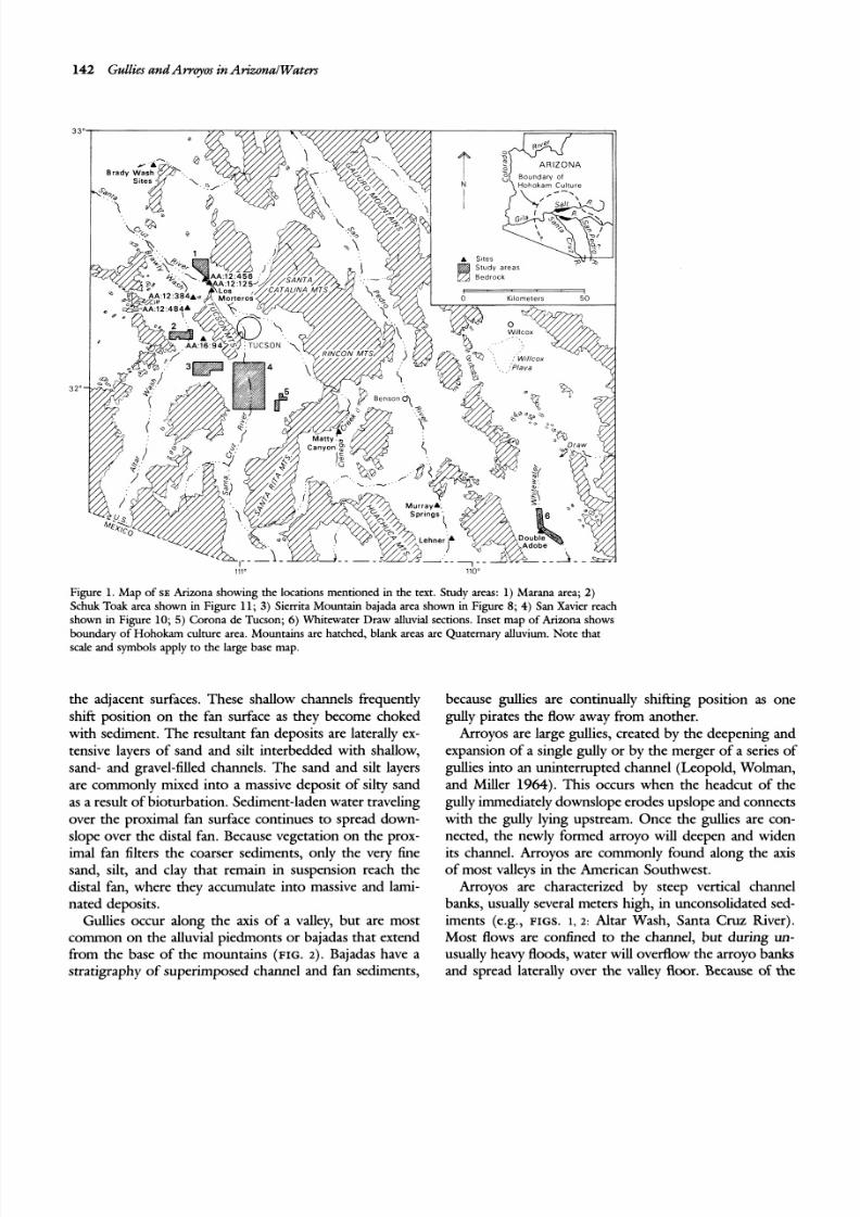
Figure 1. Ma p of SE Arizona show ing the locations mentioned in the text. Study areas: 1 ) Marana area; 2)Schuk Toak area shown in Figure 11; 3) Sierrita Mountain bajada area shown in Figure 8; 4) San Xavier reach
shown in Figure 10; 5) Corona de Tucson; 6 )Whitewater Draw alluvial sections. Inset map of Arizona shows
boundary of H ohoka m culture area. Mountains are hatched, blank areas are Qu aternary alluvium. Note that
scale and symbols apply to the large base map.
the adjacent surfaces. These shallow channels frequently
shifi position on the fan surface as they become choked
with sedment. The resultant fan deposits are laterally ex-
tensive layers of sand and silt interbedded with shallow,
sand- and gravel-filled channels. The sand and silt layers
are commonly mixed into a massive deposit of silty sand
as a result of bioturbation. Sedment-laden water traveling
over the proximal fan surface continues to spread down-slope over the distal fan. Because vegetation on the prox-
imal fan filters the coarser sediments, only the very fine
sand, silt, and clay that remain in suspension reach the
distal fan, where they accumulate into massive and lami-
nated deposits.
Gullies occur along the axis of a valley, but are most
common on the alluvial piedmonts or bajadas that extend
from the base of the mountains (FIG. 2) . Bajadas have a
stratigraphy of superimposed channel and fan sedments,
because gullies are continually shif'ting position as one
gully pirates the flow away from another.
Arroyos are large gullies, created by the deepening and
expansion of a single gully or by the merger of a series of
gullies into an uninterrupted channel (Leopold, Wolman,
and Miller 1964).This occurs when the headcut of the
gully immediately downslope erodes upslope and connects
with the gully lying upstream. Once the gullies are con-nected, the newly formed arroyo will deepen and widen
its channel. Arroyos are commonly found along the axis
of most valleys in the American Southwest.
Arroyos are characterized by steep vertical channel
banks, usually several meters high, in unconsolidated sed-
iments (e.g., FIGS. 1, 2: Altar Wash, Santa Cruz fiver).
Most flows are confined to the channel, but during un-
usually heavy floods, water will overflow the arroyo banks
and spread laterally over the valley floor. Because of the
8/2/2019 Journal of Field Archaeology 1991 Waters
http://slidepdf.com/reader/full/journal-of-field-archaeology-1991-waters 4/20
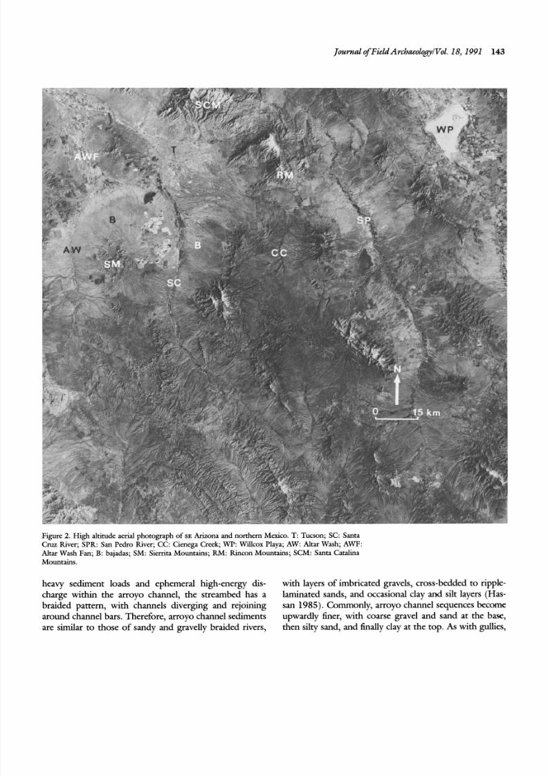
Figure 2. High altitude aerial photograph of s~ Arizona and northern Mexico. T: Tucson; SC: Santa
Cruz River; SPR: San Pedro River; CC: Cienega Creek; WP: Willcox Playa; AW: Altar Wash; AWF:
Altar Wash Fan; B: bajadas; SM: Sierrita Mountains; RM : Rincon M ountains; SCM : Santa Catalina
Mountains.
heavy sediment loads and ephemeral high-energy dis- with layers of imbricated gravels, cross-bedded to ripple-
charge within the arroyo channel, the streambed has a laminated sands, and occasional clay and silt layers (Has-
braided pattern, with channels diverging and rejoining san 1985).Commonly, arroyo channel sequences become
around channel bars. Therefore, arroyo channel sediments upwardly finer, with coarse gravel and sand at the base,
are similar to those of sandy and gravelly braided rivers, then silty sand, and finally clay at the top. As with gullies,
8/2/2019 Journal of Field Archaeology 1991 Waters
http://slidepdf.com/reader/full/journal-of-field-archaeology-1991-waters 5/20
144 Gullies and Af-rqos n Arizona1 Waters
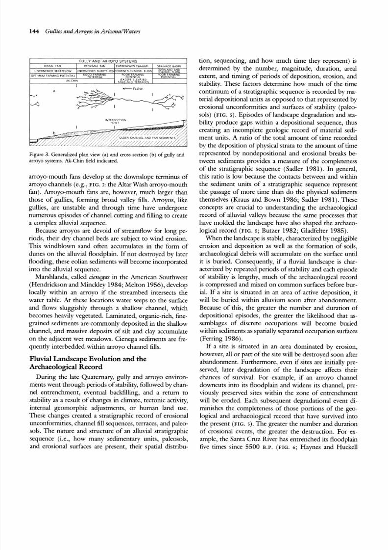
IC FLOW
INTERSECTIONPOINT
I / OLDER CHANNEL AND FAN SEDIMENT S 1,'/. ~ , > , , , , > , ,
Figure 3. Generalized plan view (a ) and cross section (b ) of gully and
arroyo systems. hk-Chin field indicated.
arroyo-mouth fans develop at the downslope terminus of
arroyo channels (e.g., FIG. : the Altar Wash arroyo-mouthfan). Arroyo-mouth fans are, however, much larger than
those of gullies, forming broad valley fills. Arroyos, like
gullies, are unstable and through time have undergone
numerous episodes of channel cutting and filling to create
a complex alluvial sequence.
Because arroyos are devoid of streamflow for long pe-
riods, their dnr channel beds are subject to wind erosion.
This windblown sand often accumulates in the form of
dunes on the alluvial floodplain. If not destroyed by later
flooding, these eolian sediments will become incorporated
into the alluvial sequence.
Marshlands, called cienegas in the American Southwest(Hendrickson and Mincklev 1984; Melton 1956),develop
locally within an arroyo if the streambed intersects the
water table. At these locations water seeps to the surface
and flows sluggishly through a shallow channel, which
becomes heavily vegetated. Laminated, organic-rich, fine-
grained sediments are commonly deposited in the shallow
channel, and massive deposits of silt and clay accumulate
on the adjacent wet meadows. Cienega sediments are fre-
quentlv interbedded within arroyo channel fills.
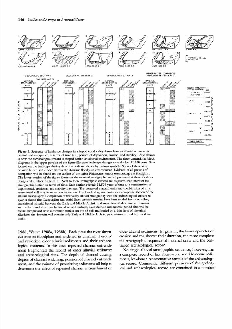
Fluvial Landscape Evolution and the
Archaeological RecordDuring the late Quaternary, gully and arroyo environ-
ments went through periods of stability, followed by chan-
nel entrenchment, eventual backfilling, and a return to
stability as a result of changes in climate, tectonic activity,
internal geomorphic adjustments, or human land use.
These changes created a stratigraphic record of erosional
unconformities, channel fill sequences, terraces, and paleo-
sols. The nature and structure of an alluvial stratigraphic
sequence (i.e., how many sedimentary units, paleosols,
and erosional surfaces are present, their spatial distribu-
tion, sequencing, and how much time they represent) is
determined by the number, magnitude, duration, areal
extent, and timing of periods of deposition, erosion, and
stability. These factors determine how much of the time
continuum of a stratigraphic sequence is recorded by ma-terial depositional units as opposed to that represented by
erosional unconformities and surfaces of stability (paleo-
sols) (FIG. ). Episodes of landscape degradation and sta-
bility produce gaps within a depositional sequence, thus
creating an incomplete geologic record of material sedi-
ment units. A ratio of the total amount of time recorded
by the deposition of physical strata to the amount of time
represented by nondepositional and erosional breaks be-
tween sediments provides a measure of the completeness
of the stratigraphic sequence (Sadler 1981). In general,
this ratio is low because the contacts between and within
the sediment units of a stratigraphic sequence representthe passage of more time than do the phvsical sediments
themselves (Kraus and Bown 1986; ~a dle r 981). These
concepts are crucial to understanding the archaeological
record of alluvial valleys because the same processes that
have molded the landscape have also shaped the archaeo-
logical record (FIG. ; Butzer 1982; Gladfelter 1985).
When the landscape is stable, characterized by negligible
erosion and deposition as well as the formation of soils,
archaeological debris will accumulate on the surface until
it is buried. Consequently, if a fluvial landscape is char-
acterized by repeated periods of stability and each episode
of stability is lengthy, much of the archaeological recordis compressed and mixed on common surfaces before bur-
ial. If ;site is situated in an area of active deposition, it
will be buried within alluvium soon after abandonment.
Because of this, the greater the number and duration of
depositional episodes, the greater the likelihood that as-
semblages of discrete occupations will become buried
within sediments as spatially separated occupation surfaces
(Ferring 1986).
If a site is situated in an area dominated bv erosion,
however, all or part of the site will be destroyed soon after
abandonment. Furthermore, even if sites are initially pre-
served, later degradation of the landscape affects theirchances of survival. For example, if an arroyo channel
downcuts into its floodplain and widens its channel, pre-
viously preserved sites within the zone of entrenchment
will be eroded. Each subsequent degradational event dt-
minishes the completeness of those portions of the geo-
logical and archaeological record that have survived into
the present (FIG. ) . The greater the number and duration
of erosional events, the greater the destruction. For ex-
ample, the Santa Cruz k ver has entrenched its floodplain
five times since 5500 B.P. (FIG.6; Haynes and Huckell
8/2/2019 Journal of Field Archaeology 1991 Waters
http://slidepdf.com/reader/full/journal-of-field-archaeology-1991-waters 6/20
Journal$Field ArchaeologyVol. 18,1991 145
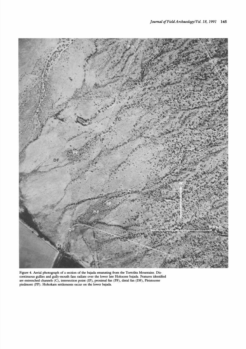
Figure 4. Aerial photograph of a section of the bajada emanating from the Tortolita Mountains. Dis-continuous @es and gully-mouth fans radiate over the lower late Holocene bajada. Features identifiedare entrenched channels (C), intersection point (IP), proximal fan (PF), distal fan (DF), Pleistocenepiedmont (PP). Hohokarn settlements occur on the lower bajada.
8/2/2019 Journal of Field Archaeology 1991 Waters
http://slidepdf.com/reader/full/journal-of-field-archaeology-1991-waters 7/20
146 Gullies and Arvcyos in Arizona1Waters
[A& S C A L E ,
4
1 1 , 3 00 - 1 0 8 0 0 B P 1 0 . 2 00 - 1 0 , 0 0 0 8 P 9 0 0 0 8 0 0 0 B P 7 0 0 0 5 0 0 0 B P 4 5 0 0 - 5 O O B P
GENERALIZED COMPOSITEGEOLOGICAL SECTION I GEOLOGICAL SECTION 2 GEOLOGICAL SECTION 3 G E O L O G I C A L S E Q U E N C E
T IM E INTE RV A L S O F
M A T E R I A L M A T E R I A L M A TE RIA L M A TE RIA L
S TRA TIG RA P HIC S TRA TIG RA P HIC S TRA TIG RA P HIC S TRA TIG RA P HIC
U N I T S L N I T S U N I T S U N I T S
CULTURE S
2 0 0 0 I-W
3 0 0 0
n
4 0 0 0
IL 5 0 0 0 2
M I D D L E m
Figure 5. Sequence o f landscape changes in a hy pothetical valley shows how an alluvial sequence is
created and interpreted in terms of time (i.e., periods of deposition, erosion, and stability). Also shown
is how the archaeological record is shaped within an alluvial environment. T he three-dimensional block
diagrams in the upper portion of the figure illustrate landscape changes over the last 11,500 years. Sites
located on the landscape during these intervals are shown by various symbols. Some of these sitesbecome buried and eroded within the dynamic floodplain environment. Evidence of all periods of
occupation will be fou nd o n the surface of the stable Pleistocene terrace ov e rl o o h g the floodplain.
Th e lower p ortion of the figure illustrates the material stratigraphic record preserved at three localities
designated in block diagram 11. Next to these stratigraphic sections are diagrams that interpret the
stratigraphic section in terms of time. Each section records 11,500 years of time as a combination of
depositional, erosional, an d stability intervals. Th e preserved material units an d comb ination of time
represented will vary from section to section. The fourth diagram illustrates a composite section of the
alluvial stratigraphy. C omp arison of th e valley alluvial stratigraphy w ith the archaeological culture se-
qyence shows that Paleoindian and initial Early Archaic remains have been eroded from the valley;
transitional material between the Early and Middle Archaic and some later Middle Archaic remains
were either eroded or may be found on soil surfaces; Late Archaic and ceramic period sites will be
found compressed onto a common surface on the S3 soil and buried by a thin layer of historical
alluvium; the dep osits will contain only Early and M iddle Archaic, protohistorical, and historical re-
mains.
198 6; Waters 19 88a, 19 88b ). Each time the river down- older alluvial sediments. In general, the fewer episodes of
cut in to its floodplain and widened its channel, it eroded erosion and the shorter their duration, th e more complete
and reworked older alluvial sediments and their archaeo- the stratigraphic sequence of material units and the con-
logical contents. In this case, repeated channel entrench- tained archaeological record.
ment fragmented the record of older alluvial sediments No single alluvial stratigraphic sequence, however, has
and archaeological sites. The depth of channel cutting, a complete record of late Pleistocene and Holocene sedi-
degree of channel widenin g, pos ition of channel entrench- ments, let alone a representative sample of the archaeolog-
ment, and the volume o f preexisting sediments all help to ical record. Commoniy, different portions of the geolog-
determine the effect of repeated channel entrenchment o n ical and archaeological record are contained in a number
8/2/2019 Journal of Field Archaeology 1991 Waters
http://slidepdf.com/reader/full/journal-of-field-archaeology-1991-waters 8/20
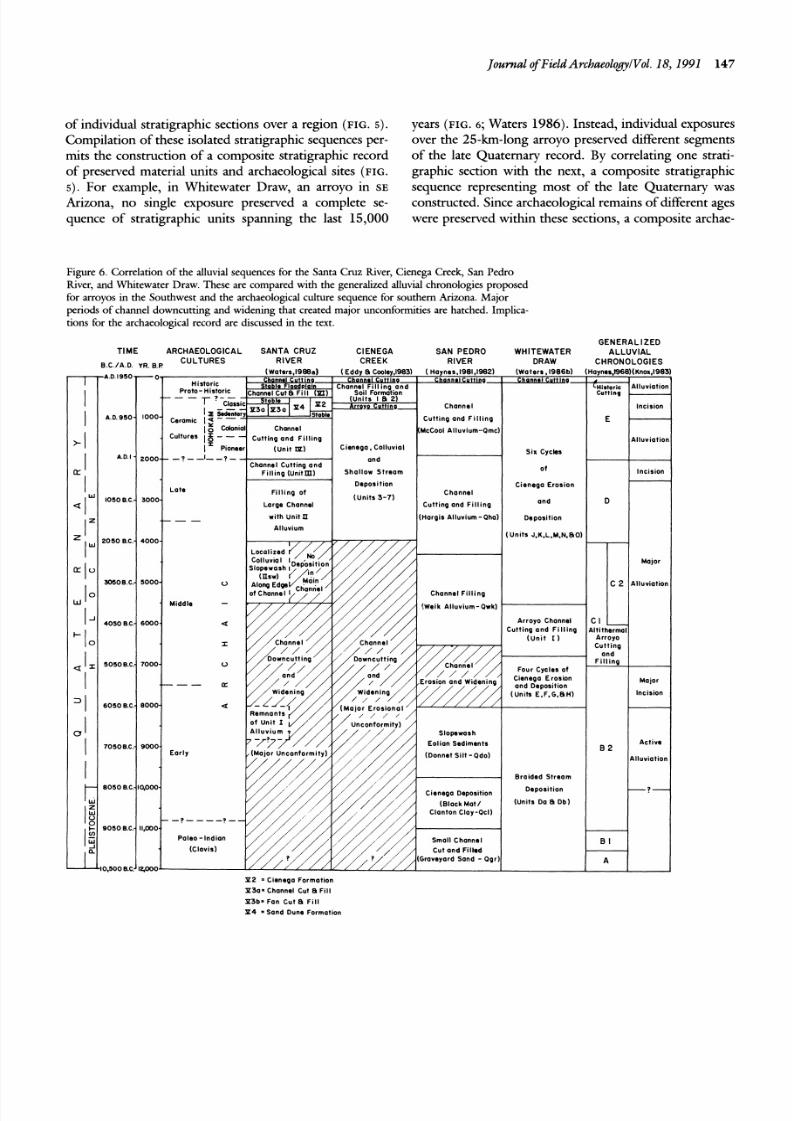
of individual stratigraphic sections over a region (F IG . 5 ) .
Compilation of these isolated stratigraphic sequences per-
rnits the construction of a composite stratigraphic record
of preserved material units and archaeological sites ( F IG .
5) . For example, in Whitewater Draw, an arroyo in SE
Arizona, no single exposure preserved a complete se-
quence of stratigraphic units spanning the last 15,000
Journal of Field ArchaeologyiVol. 18, 1991 147
years ( F I G . 6; Waters 1986).Instead, individual exposures
over the 25-km-long arroyo preserved different segments
of the late Quaternary record. By correlating one strati-
graphic section with the next, a composite stratigraphic
sequence representing most of the late Quaternary wasconstructed. Since archaeological remains of different ages
were preserved within these sections, a composite archae-
Figure 6. Correlation of the alluvial sequences for the Santa Cruz fiver, Cienega Creek, San Pedro
fiver, and Whitewater Draw. These are compared with the generalized alluvial chronologies proposed
for arroyos in the Southwest and the archaeological culture sequence for southern Arizona. Major
periods of channel downcutting and widening that created major unconformities are hatched. Implica-
tions for the archaeological record are discussed in the text.
TIM E ARCHAEOLOGICAL SANTA CRUZ
8 . C /A . D Y R. B P CULTURESRIVER
(Waters,1988a)A.D.1950-0
3 05 OB .C .- 5 0 0 0
Middle -
- - n
70508.C: 9000
- 8 0 5 0 8.C:IROOO
P a l e o - I n d i a n
P 2 = Cienega Formation
GENERALIZEDCIENEGA SAN PEDRO WHITEWATER ALLUVIAL
CREEK RIVER DRAW CHRONOLOGIES
(Eddy Cwley, l983) ( Haynes.1981,1982) (Wa ter s, 1986b ) (Hoynes,1968)(Knox,l983)
Cienega. Col luvial
S h o l l o w S t re a m
C i e n e g a E ro s i on
Cutting and Fi l l ing
(Units J.K.L.M.N,BO)
C h a n n e l F i l l i n p
Eolian Sediments
[D o n n e t S il t - a d o )
B ra i d e d S t re a m
(Units Da B Db)
P 3 0 * Ch an ne l C ut B F ~ l l
P 3 b ' F a n C ut 8 F i l l
P 4 S a n d D un e F o rm a ti on

8/2/2019 Journal of Field Archaeology 1991 Waters
http://slidepdf.com/reader/full/journal-of-field-archaeology-1991-waters 9/20
148 Gullies and Arvoyos in ArizonalWa ters
ological record also emerged, which illustrated the long
continuum of Archaic hunter-gatherer occupation along
Whitewater Draw.
In some cases, regional erosional events completely re-
move older sediments and soils that may contain archae-ological remains, as shown by Turnbaugh (1978);
Brookes, Levine, and D enn ell(1 982 ); and Thompson and
Bettis (1 98 2) . In these cases, no deposits or soils of a
certain time interval are present anywhere in a valley,
which creates a break in the material stratigraphic record
and, correspondingly, in the archaeological record. This is
well illustrated by the regional stratigraphic sequence of
the Santa Cruz River near Tucson, Arizona, where sedi-
ments older than 55 00 B .P. were eroded from the valley
during a regional episode when the channel of the Santa
Cruz k v e r downcut in to its floodplain, widened, and
scoured the valley. Deposition resumed only after 5500B.P.(FIG.6) . This erosional event was responsible for the
destruction o f most alluvial units and paleosols of greater
age together with their potentially associated artifact de-
bris (Haynes and Huckell 1986; Waters 1988a, 1988b).
As a result, there is no record of Paleoindian or Early
Archaic sites in the alluvial stratigraphic sequence of the
Santa Cruz River. Furthermore, the erosion appears to
have been a regional event that occurred throughout the
greater Tucson Basin. Quaternary sediments in the tribu-
tary drainages of the Santa Cruz k v er , such as the Rillito
and Pantano Rivers, also appear to have been eroded
during this middle Holocene erosional event. An uncon-formity spanning the period between 10,000 and 4000
B .P .occurs in the stratigrap hy of Cienega Creek, the head-
waters of the ~ a n t a n o iver (F IG. 6; Eddy and Cooley
19 83 ). Clearly, gaps in occupa tion at a specific locality or
within a valley may just as likely be the result of erosion
as of intentional abandonment.
The number, magnitude, duration, areal extent, and
timing of erosional, depositional, and stability intervals
may be different or the same between valleys. Spatially
separated valleys will have similar and synchronous land-
scape histories if the geomorphic variables of each valley
(e.g., relief, position o f the w ater table, lithology, sedimentyield from the hillslopes, internal landscape thresholds,
vegetation cover, tectonics, human land use) are similar
and if external changes in climate triggered similar re-
sponses within each valley. This circumstance will create
stratigraphic sequences that are similar and can be corre-
lated from one valley to the next (Haynes 1968; Knox
19 83 ). In this situ ation com parable archaeological se-
quences may be potentially preserved in adjacent valleys.
Spatially separated valleys, however, may have different
and nonsynch ronous landscape histories if the geom orphic
variables of each valley are different or if during the late
Quaternary climatic conditions varied from one valley to
the next (Butzer 198 0; Patton and Schurnm 19 75; Waters
198 5). This situation may trigger degradation, aggrada-
tion, or stability in one valley and not the other. This inturn results in stratigraphic sequences that are different
from one valley to the next (i.e., there is no one-to-one
correlation of depositional units, unconformities, and pa-
leosols between the valleys). Consequently, dfferent ar-
chaeological sequences may be potentially preserved in
adjacent valleys. For example, the late Quaternary strati-
graphic sequences preserved in four adjacent river valleys
in southern Arizona-the Santa Cruz k v e r , Cienega
Creek, San Pedro kver, and Whitewater Draw-show
only minimal similarity because each had an independent
landscape history (FIG.6). Correspondingly, the archaeo-
logical sample preserved in the alluvial sequence of eachvalley is unique (FIG.6). Because of the m iddle Holocene
period of erosion in the Santa Cruz k v e r Valley, only
archaeological remains dating from 550 0 B .P. o historical
times are present. A similar period o f erosion affected the
archaeological record along Cienega C reek (E ddy and
Cooley 1 98 3). In the San P edro drainage, the alluvial
sequence is well preserved, and as a result a nearly com-
plete record of Holocene occupation from 11,500 B.P. o
historical times is preserved in the sediments (Haynes
1981, 1982). The a lluvia l s e b e n t s in Whitewater Draw
are similarly well preserved and contain an archaeological
record dating from 10,000 B.P . through the historicalperiod.
The differential structure of the archaeological record
within and betw een valleys has im por tant implications for
archaeological interpretations. Archaeologists must con-
sider whether the observed patterns of occupation within
and between valleys accurately reflects the distribution of
human activity or the biases of geological preservation
processes. For example, consider the Paleoindlan record
of southern Arizona. In the San Pedro Valley a large
number of undisturbed Paleoindian sites are preserved
because of the favorable geological conditions that existed
in the valley during the late Pleistocene (Haynes 1981,1982). Clovis sites were rapidly buried beneath an or-
ganic-rich clay (the black mat) in a low-energy cienega
environment, and subsequent Holocene erosion did not
remove this record. On the other hand, no Paleoindan
sites have been found in Whitewater Draw, even though
sediments of this age are exposed in the arroyo (units Da
and D b in FIG. 6). This is in large part due to the fact
that, even though units Da and Db are time transgressive,
ranging in age from 15,000 to 8000 B.P., most of those
exposures date between 8 00 0 and 10,0 00 B.P. and only a
8/2/2019 Journal of Field Archaeology 1991 Waters
http://slidepdf.com/reader/full/journal-of-field-archaeology-1991-waters 10/20
few of the sand and gravel deposits are older than 10,000
B.P. What is more, if Paleoindan remains were found in
units Da and D b they would lie in secondary contexts,
because these sands and gravels were deposited in a high-
energy braided stream environment unconducive to thepreservation of und isturbed archaeological associations. In
both the Santa Cruz h v e r and Cienega Creek, erosional
episodes have removed any Paleoindan record that may
once have existed. Therefore, the intensity of Paleoindian
utilization of the Santa Cruz h v e r Valley, Whitewater
Draw, and Cienega Creek cannot be gauged. Conse-
quently, it cannot be determined if the Paleoindian record
of the San Pedro Valley represents a unique, intensive
occupation o f this valley alone dur ing the late Pleistocene
or if it reflects the biases imposed by different intervalley
geological processes. If the latter is true, then perhaps a
similar level of Paleoindlan activity occurred within theother valleys of sout hern A rizona. This, however, we shall
never know.
Changes in th e landscape also impose limitations on th e
discovery of archaeological sites (Bettis and Benn 1984;
Gladfelter 1985; Thom pson and Bettis 1 982 ). Many pre-
served sites are not visible or detectable at the surface
because of deep burial. Fo r example, along the San Xavier
reach of the Santa Cruz h v e r , late Archaic remains occur
at a depth of 7 m, Hohokam remains at depths of 1.25
to 5.5 m, and protohistorical remains at a depth of 0.5 m
below the surface (Waters 1988 a, 19 88b ). Further, a thin,
0. 5 m thick layer o f historical alluvium overlies the flood-plain; as a result, prehistoric sites are not visible at the
surface of the floodplain except in areas that are biotur-
bated. Buried archaeological sites are observable only in
the channel bank exposures. The same holds true for the
bajadas extendng from the mountains, where many sites
are not readly visible through regular surface survey be-
cause of their depth of burial. Yet, even though sites are
visible in the late Quaternary alluvium exposed along the
banks of arroyos such as the Santa Cruz River, this allu-
vium is only a small portion of the total volume of late
Quaternary sediments stored within the floodplain. The
majority of the Santa Cruz h v e r floodplain, Holocenefloodplain sediments in other valleys, and large tracts of
the late Quaternary alluvium covering the bajadas extend-
ing from the mountains are unentrenched, and this allu-
vium m ust surely contain archaeological sites. Therefore,
an indeterminate nu mb er o f undete cted archaeological re-
sources must lie beneath much of the undssected Holo-
cene valley and bajada alluvium. Buried Paleoindian and
Archaic sites are notably unknown on the bajadas ema-
nating from many of the m ountains in the Tucson Basin.
Sites of this age may be deeply buried in the bajada allu-
Journal ofField ArchaeologylVol. 18, 1991 149
vium and thus go undetected. Also, the depth of gully
and arroyo channel entrenchment is not uniform along its
length; older sediments may not be exposed everywhere
along the channel or they may be covered in places by
recent alluvial deposits, or w here the banks have slumped.Therefore, deep burial and limited exposures affect our
perception of the archaeological record. In some cases,
even if subsurface sites are detected, they may not be
accessible because they are buried at a depth beyond fea-
sible archaeological investigation.
To deal with the problem of differential site preserva-
tion, visibility, and detection, researchers must modify
traditional archaeological survey techniques to include
geomorphic site prediction modeling and testing (Bettis
and Benn 1984 ; Gardner and Donahue 1985; Thompson
and B ettis 19 82 ). Because the alluvial stratigraphic frame-
work dictates the spatial and tempo ral structuring of thearchaeological record, it provides the framework needed
to determine w hich parts of th e archaeological continuum
are absent or potentially preserved, and how fragmentary
the preserved portions of the record m ay be. By mapping
the spatial dstribution of the stratigraphic units and as-
sociated landforms of known age, a model is established
to predict the mos t probable 1o;ations of potential surface
and buried cultural resources. This stratigraphic frame-
work can be used to delineate s e b e n t s that are too old
to contain archaeological remains and to identify those
sediments dating to the time of human habitation of
North America. What is more, attention can be focusedon the low-energy depositional settings where sites would
most likely be preserved and away from high-energy de-
positional settings where artifacts would occur only in
secondary contexts. Geoarchaeological modeling maxi-
mizes valuable field time and allows archaeologists to ef-
fectively prospect for archaeological sites in alluvial set-
tings. Survey crews do not have to waste energy
prospecting for sites in deposits th at are to o old t o contain
sites and instead can direct their efforts to those deposits
that do. This procedure optimizes site recordng during
archaeological survey and helps obtain a representative
sample of buried sites. In s outh ern Arizona site predictionmodels must be valley specific, because each valley has a
different and unique sequence of s e b e n t s (FIG. 6) .
To summarize, the archaeological record of utilization
of the alluvial environments of southern Arizona has in
large part been shaped by the sam e processes that molded
the fluvial landscape. Deposition, erosion, and stability
worked in concert to preserve, arrange, and fragment the
evidence of human activity associated with gullies and
arroyos. The degree to which these geological processes
have affected the temporal and spatial sample of archaeo-
8/2/2019 Journal of Field Archaeology 1991 Waters
http://slidepdf.com/reader/full/journal-of-field-archaeology-1991-waters 11/20
150 Gullies and Awoyos in Arizona1Waters
logical sites must be evaluated before meaningful inter-
pretations of the archaeological record are possible (Butze r
198 2; Schiffer 19 87 ). In places where geoarchaeological
studies demonstrate that portions of the geological and
archaeological record are fairly complete and visible, de-tailed landscape reconstructions are possible, and prehis-
toric activity can be placed in its landscape context. In
southern Arizona, the late Holocene geological and ar-
chaeological records of bajadas, arroyo floodplains, and
arroyo-mouth fans are well preserved. Hence, analysis of
human-land interaction is possible.
Prehistoric Settlement Patterning Associatedwith GulliesandArroyos
A group of agriculturalists known as the Hohokam
occupied the Tucson Basin from approximately A.C. 300
to 15 00 (F IG.1). These prehistoric peop le exploited manydifferent environments, but were heavily dependent upon
bajada gullies, arroyo floodplains, and arroyo-mouth fans.
The location of late prehistoric settlements at a n y partic-
ular time, and changes in settlement location through
time, are closely tied t o th e distribu tion of fluvial systems,
the evolution of fluvial environments, and the farming
potential of the ancient landscape. Also to be considered
is the effect of human activity on the fluvial landscape.
T o clari@ the terminology used in this paper, the H o-
hokam cultural sequence is divided into four periods. In
sequence from oldest to youngest, these periods are the
Pioneer, Colonial, Sedental?; and Classic (FIG.6 ) . Theseperiods are further subdivided into the following phases:
the Colonial period is divided into the Caiiada del Oro
and Rillito phases; the Sedentary period into the Rincon
phase (which is subdivided into early, middle, and late
subphases); and the Classic period into the Tanque V erde
and Tucson phases. For a discussion of Tucson Basin
Ho hokam prehistory see Czaplicki and Ravesloot (19 89),
Fish (1 989), Doelle and Wallace (19 86) , and Dart (19 87).
Hohokanz Utilization of the Bajada Gzelly
Envi~onlnent
In the semiarid Tucson Basin, rainfall is sporadic andunevenly distributed over a wide area. Historical Indian
groups knew that the m oisture provided t o fields by direct
rainfall was inadequate for crops to mature on a reliable
basis and thus sustain a sedentary population. Additional
and mo re reliable sources of moisture w ere required for
successful farming. Consequently, historical peoples
turned to areas on the bajada that were naturally flooded
on a regular basis to pursue farming. The areas most
commonly used by the Papago (Bryan 192 9) and Pima
(Wilson 1985 ) were the fan environments (bo th proximal
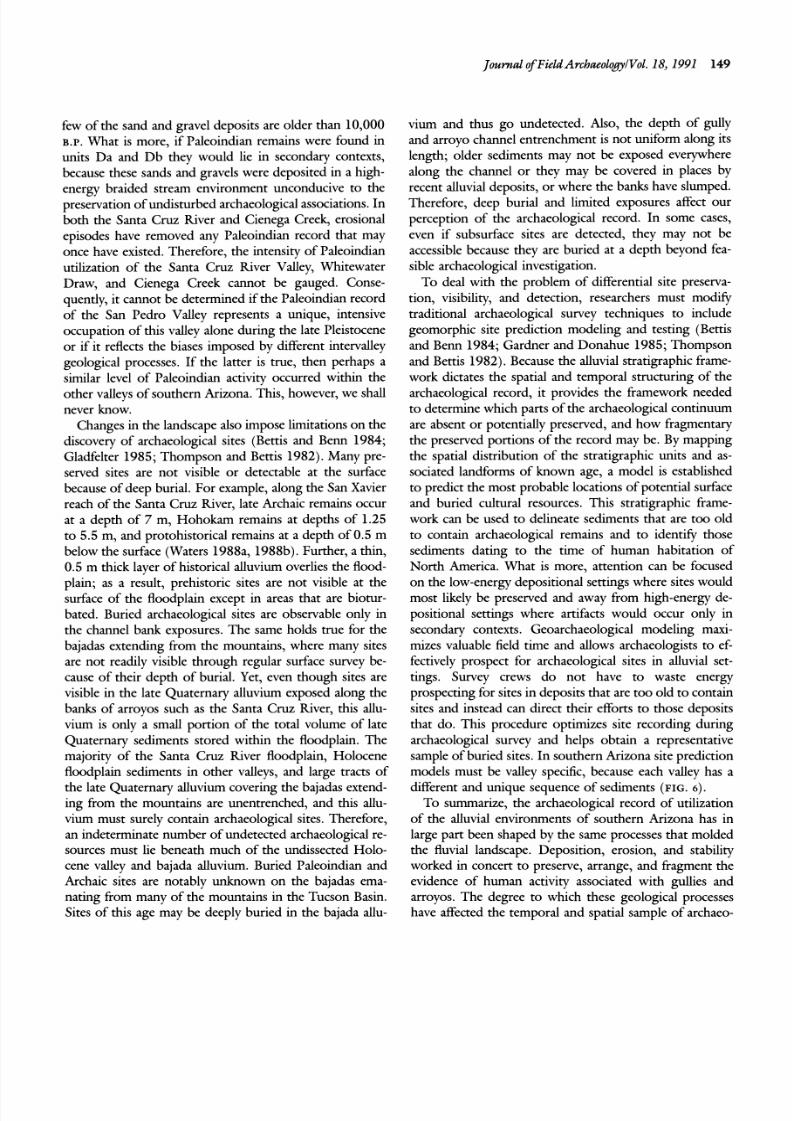
Figure 7. Two typical Ak-Chin fields farmed by the Hopi in the Talla-
hogan Valley, Arizona (from Hack 1942).Note that the house is lo-
cated slightly above intersection point.
and distal) at the terminus of ephemeral gullies on thebajadas (FIGS . .4 .7; Nabhan 1979, 1986a, 19 86b). These
gully-mouth fan surfaces were especially desirable for
farming because the runoff generated by rainfall in any
part of the watershed, even miles away from the fan,
would be funneled into the main gully channel and even-
tually make its way to fields on the fan surface. Th e gully-
m ou th fans are calledAk-Chin,a Papago term for "arroyo-
mouth" (Bryan 1929 ; Hack 194 2; Nabhan 1 986 b).These
areas required little or no modification to direct the
streamflow, except perhaps brush or rock structures to
slow and spread the water over a broader area.
Reconstructing the paleolandscape of several bajadas,delineating stable Pleistocene alluvial fan surfaces and late
Holocene gully and gully-mouth fan environments, and
comparing this information to the distribution of Hoho-
kam settlements, showed tha t H oho kam settlements were
consistently situated within areas dominated by gully-
mo uth fans (the prehistoric environmen t that was optimal
for floodwater farming; FIG.8) and n ot in areas dominated
by gully channels. This site distribution is analogous to
the po sition of historical sites where A k-Ch in farming was
pursued. This pattern is found on the bajadas (FIG. 1)
8/2/2019 Journal of Field Archaeology 1991 Waters
http://slidepdf.com/reader/full/journal-of-field-archaeology-1991-waters 12/20
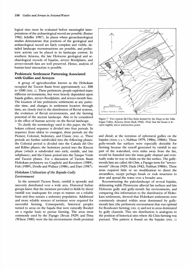
Journal of Field Archaeology1 Vol. 18, 1991 151
Q F a P le i s t o c e n e f a n s e d im e n t s H o h o k a m s e t t l e m e n t s
Q F b l E r o d e d P l e i st o ce n e f a n r e m n a n t s a n d H o l o c e n e g u l l y c h a n n e l s e d im e n t s H o h o k a m a c t l v l t y a r e a s
Q F b 2 H o l o c e ne g u l l y - m o u t h f a n s e d ~ m e n t s S u r v e y a r e a b o u n d a r y
p s P h a ne r oz o ic m e t a s e d i m e n t b e d r o c k - - - - - C o n t a c t b e t w e e n g e o m o r p h i c u n i t s- W a s h e s
Figure 8. Sierrita Mountains study area (see FIG. 1 for location) showing the distribution of H ohok am
settlements on the lower bajada where Ak-Chin farming could have been pursued. Generally, only
specialized activity sites occur in the area do minated by entrenched gullies; Ho hok am settlements clus-
ter in the lower bajada where proximal and distal fan environments occur at the mouths of these gullies
(after Waters 19 87a ).
emanating from the Tortolita Mountains (Marana sites; inated by gully-mouth fan environments on the lowerFish 1989; Rice 1987; Waters and Field 1986), Sierrita bajada (FIG. 4; Fish 1989; Waters and Field 1986). Hab-
Mountains (Waters 1987a; Dart 1987), Tucson Moun- itation sites are not present on the upper stable Pleistocenetains (Czapliclu and Ravesloot 1989), Picacho Mountains surfaces. Instead these areas were used for gathering wild(sites around Brady Wash and McClellan Wash; Ciolek- plant resources and growing agave (a plant with low mois-Torrello 1987; Field and Lombard 1987), and Santa f i t a ture and minimal soil requirements; Fish et al. 1985; Fish
Mountains (Huckell et al. 1987; Phillips 1984; Waters 1989). A regional archaeological survey of 1650 sq krn
198%). north of Marana to the Picacho Mountains and comple-The correspondence between the position of Hohokam mentary geomorphic mapping show that the lower bajada
agricultural settlements and gully-mouth fans becomes alluvial surfaces conducive to floodwater farming make upclearer when the bajada environment is placed within the only 23.5% of the total alluvial landscape (all Pleistocene
context of other landscape elements. Near Marana, Ari- and Holocene alluvial surfaces), but were the loci ofzona, large habitation sites are concentrated in areas dom- 56.3% of the Hohokam sites (Field and Lombard 1987).
8/2/2019 Journal of Field Archaeology 1991 Waters
http://slidepdf.com/reader/full/journal-of-field-archaeology-1991-waters 13/20
152 Gullies andArvoyos in Arizona1 Waters
This is more than would be expected by chance. By anal-
ogy with the historical Ak-Chin floodwater farming tech-
nique, strong correspondence between Hohokam settle-
ments and the distribution of late Holocene gully-mouth
fans, and avoidance of areas dominated by channelized
flow, it is clear that the Hohokam farmers preferred to
locate their settlements on the bajada in those areas well
suited for floodwater Ak-Chin farming. At the time of
occupation, Hohokam settlements were probably located
slightly above the intersection point, and farming was
pursued on both the distal and proximal gully-mouth fan
surfaces.
Not all bajadas were equally utilized, nor were settle-
ments evenly distributed over a single bajada. Other fac-
tors, especially the nature and thickness of the sediments
comprising the gully-mouth fan, fan slope (Dart 1987),
the substrate underlying it, and drainage basin character-
istics (e.g., size, the distance from the drainage basin to
the fan field, and hillslope composition) made some areas
better suited for farming than others and thus affected the
location of agricultural settlements. In general, the opti-
mum areas, characterized by soils with high water holding
and availability characteristics and desirable drainage basin
features (e.g., those of small size, with short distance from
field to drainage basin, and with impermeable slopes),
were used heavily while less desirable areas on the bajada
were used only marginally.
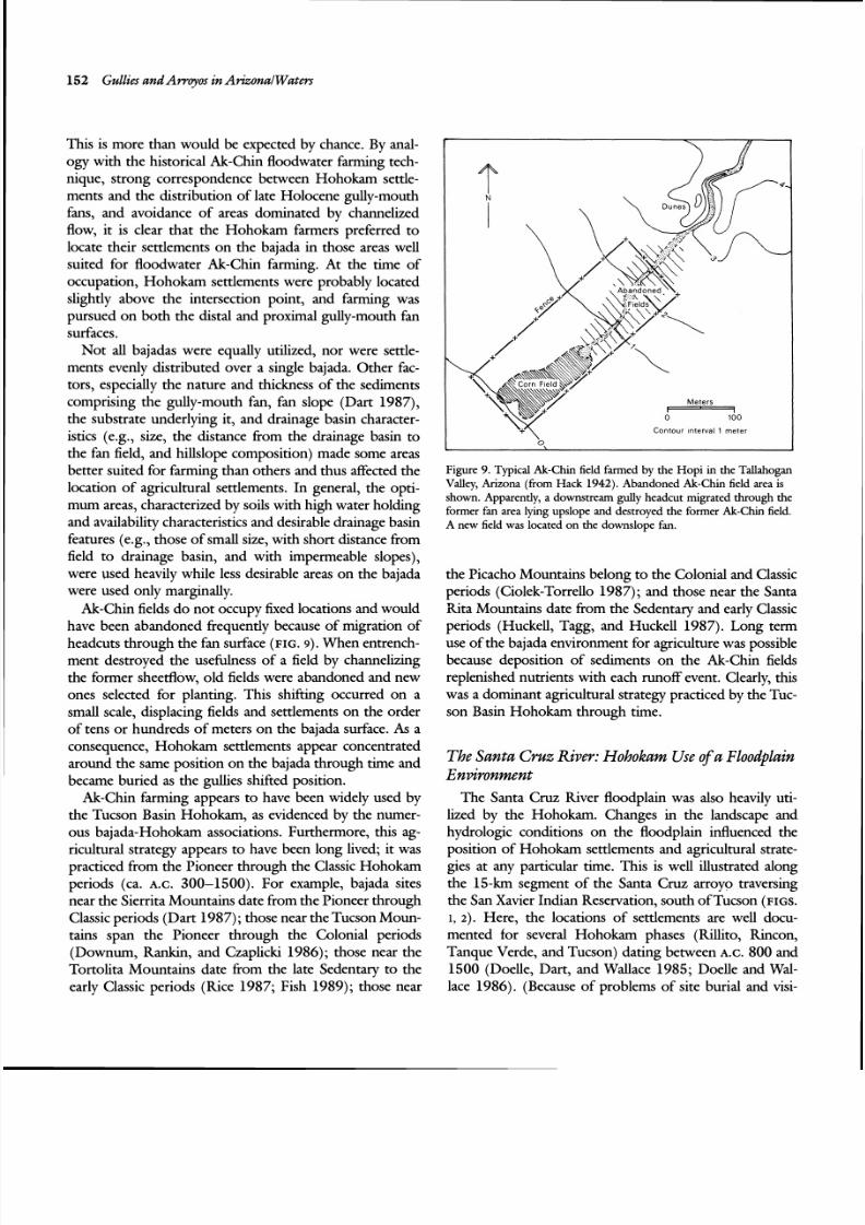
Ak-Chin fields do not occupy fixed locations and would
have been abandoned frequently because of migration of
headcuts through the fan surface (FIG. ). When entrench-
ment destroyed the usefulness of a field by channelizing
the former sheetflow, old fields were abandoned and new
ones selected for planting. This shifting occurred on a
small scale, displacing fields and settlements on the order
of tens or hundreds of meters on the bajada surface. As a
consequence, Hohokam settlements appear concentrated
around the same position on the bajada through time and
became buried as the gullies shifted position.
Ak-Chin farming appears to have been widely used by
the Tucson Basin Hohokam, as evidenced by the numer-
ous bajada-Hohokam associations. Furthermore, this ag-
ricultural strategy appears to have been long lived; it was
practiced from the Pioneer through the Classic Hohokam
periods (ca. A.C. 300-1500). For example, bajada sites
near the Sierrita Mountains date from the Pioneer through
Classic periods (Dart 1987); hose near the Tucson Moun-
tains span the Pioneer through the Colonial periods
(Downum, Rankin, and Czaplicki 1986); those near the
Tortolita Mountains date from the late Sedentary to the
early Classic periods (Rice 1987; Fish 1989); those near
Meters-ontour nterval 1 meter
0
Figure 9. Typical Ak-Chin field farmed by the Hopi in the Tallahogan
Valley, Arizona (from Hack 1942).Abandoned Ak-Chin field area is
shown. Apparently, a downstream gully headcut migrated through the
former fan area lying upslope and destroyed the former Ak-Chin field.
A new field was located on the downslope fan.
the Picacho Mountains belong to the Colonial and Classic
periods (Ciolek-Torrello 1987); and those near the Santa
Rita Mountains date from the Sedentary and early Classic
periods (Huckell, Tagg, and Huckell 1987). Long term
use of the bajada environment for agriculture was possible
because deposition of sediments on the Ak-Chin fields
replenished nutrients with each runoff event. Clearly, this
was a dominant agricultural strategy practiced by the Tuc-
son Basin Hohokam through time.
The Santa Cruz River: Hohokam Use of a Floodplain
Environment
The Santa Cruz River floodplain was also heavily uti-
lized by the Hohokam. Changes in the landscape and
hydrologic conditions on the floodplain influenced the
position of Hohokam settlements and agricultural strate-
gies at any particular time. This is well illustrated along
the 15-km segment of the Santa Cruz arroyo traversing
the San Xavier Indian Reservation, south ofTucson (FIGS.
1, 2) . Here, the locations of settlements are well docu-
mented for several Hohokam phases (Rillito, Rincon,
Tanque Verde, and Tucson) dating between A.C. 800 and
1500 (Doelle, Dart, and Wallace 1985; Doelle and Wal-
lace 1986). (Because of problems of site burial and visi-
8/2/2019 Journal of Field Archaeology 1991 Waters
http://slidepdf.com/reader/full/journal-of-field-archaeology-1991-waters 14/20
Journal $Field ArchueologyIVol. 18,1991 15 3
bility, pre-kllito settlement patterns are poorly known.)
The geomorphic history of the San Xavier reach, especially
for the period between A.C.800 and 1450, is well estab-
lished through stratigraphic and geochronologic studies
(Haynes and Huckell1986; Waters 1988a, 1988b).Whenthe settlement patterns are superimposed over the corre-
sponding landscape reconstructions, it becomes clear that
the varying distribution of processes and landforms on the
floodplain influenced prehistoric Hohokam utilization of
the riverine environment, and changes to the floodplain
affected the regional stability, dsruption, and reorgani-
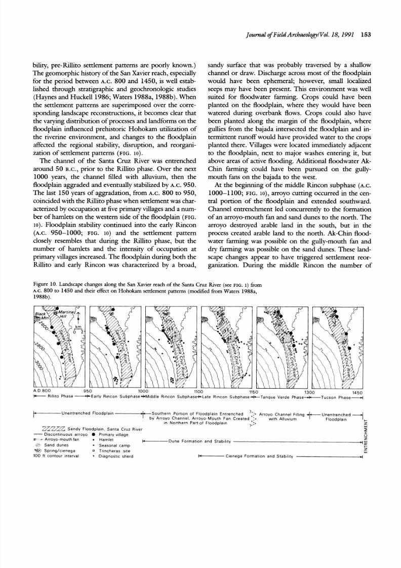
zation of settlement patterns (FIG.lo).
The channel of the Santa Cruz kv e r was entrenched
around 50 B.c., prior to the kllito phase. Over the next
1000 years, the channel filled with alluvium, then the
floodplain aggraded and eventually stabilized by A.C.950.
The last 150 years of aggradation, from A.C. 800 to 950,
coincided with the kl li to phase when settlement was char-
acterized by occupation at five primary villages and a num-
ber of hamlets on the western side of the floodplain (FIG.
lo). Floodplain stability continued into the early Rincon
(A.c. 950-1000; FIG. 10) and the settlement pattern
closely resembles that during the Rillito phase, but the
number of hamlets and the intensity of occupation at
primary villages increased.The floodplain during both the
kllito and early Rincon was characterized by a broad,
sandy surface that was probably traversed by a shallow
channel or draw. Discharge across most of the floodplain
would have been ephemeral; however, small localized
seeps may have been present. This environment was well
suited for floodwater farming. Crops could have beenplanted on the floodplain, where they would have been
watered during overbank flows. Crops could also have
been planted along the margin of the floodplain, where
gullies from the bajada intersected the floodplain and in-
termittent runoff would have provided water to the crops
planted there. Villages were located immediately adjacent
to the floodplain, next to major washes entering it, but
above areas of active flooding. Additional floodwater Ak-
Chin farming could have been pursued on the gully-
mouth fans on the bajada to the west.
At the beginning of the middle Rincon subphase (A.c.
1000-1100; FIG. lo), arroyo cutting occurred in the cen-
tral portion of the floodplain and extended southward.
Channel entrenchment led concurrently to the formation
of an arroyo-mouth fan and sand dunes to the north. The
arroyo destroyed arable land in the south, but in the
process created arable land to the north. Ak-Chin flood-
water farming was possible on the gully-mouth fan and
dry farming was possible on the sand dunes. These land-
scape changes appear to have triggered settlement reor-
ganization. During the middle kncon the number of
Figure 10. Landscape changes along the San Xavier reach of the SantaCruz
hver (see FIG. 1) fromA.C. 800 to 1450 and their effect on Hohokarn settlement patterns (modhed from Waters 1988a,
1988b).
1 4 5 0+Rtl l i to Phase -Ear ly R ~ n c onSubphase=k Middle Rtnco n Subpha seSc Late Rtnco n Subphase+Tanque Verde Phase+Tucson Phase*
I+----- Unen trenched F loodp la in Sou the rn Por t lon o f Floodplain E n t r e n ch e d "I, Arroyo Channel Ftl l ing- A r ro yo Channe l Ar ro yo M o u t h Fan C re a te d ::, wi th A l luv tum
In Nor th e rn Par t o f F loo dp la ln>- Z
wZ-7A.7,Sandy F loodp la in San ta Cruz Rlve r
,,,u". tsconttnuous arroyo Pr tmary village?U
= - A r r o yo - m o u th fa n . Hamle t -Dune Format io n and Stab i l i ty zwSand dunes a Seasona l camp c+
%? Spr tng /c tenega 0 Trtncheras si te LU 100 f t con tou r tn te rva l Diagnost ic she rd +----- Ctenega For rna t lon and Stab~ l t ty 4
8/2/2019 Journal of Field Archaeology 1991 Waters
http://slidepdf.com/reader/full/journal-of-field-archaeology-1991-waters 15/20
154 Gullies and Aw qo s in Arizona1Waters
primary villages decreased from five to one and settlements
generally shifted northward. A second entrenchment epi-
sode during the late Rincon subphase (A.c. 1100 to 1150;
FIG. lo ) resulted in the formation of a cienega in the
northern part of the floodplain. Also, the arroyo in the
southern portion of the floodplain continued to destroy
arable land to the south. Correspondingly, Hohokam set-
tlements shifted to the northern and eastern edges of the
floodplain.
During the subsequent Tanque Verde phase (A.c.
1150-1130; FIG. lo), the landscape remained much like
that of the previous 150 years. The cienega expanded and
stabilized, and the arroyo channel in the southern portion
of the floodplain began to backfill. During this time, the
number of settlements continued to decline on the western
side and increase on the eastern side of the floodplain.
New primary villages were established around Martinez
Hill and the dune complex, and the number of hamlets
also increased.
The settlement shift to the northern and eastern sides
of the floodplain, completed by the Tanque Verde phase,
appears to have been a response to the destruction of
arable land in the southern and western parts of the flood-
plain and the creation of environments suitable for farm-
ing to the north. Major villages were established next to
the cienega and sand dunes, and smaller sites occurred
around and within these two environments that repre-
sented the optimum areas for farming in the newly created
landscape. Water could have been drawn from the cienega
to fields situated on its margin, and dry farming could
have been pursued on the sand dunes. Floodwater farming
could have been conducted on the gully-mouth fan and
along the undissected portions of the floodplain-bajada
interface on the eastern side of the floodplain. Clearly, the
unentrenched northern and eastern portions of the flood-
plain offered favorable agricultural conditions.
By the beginning of the Tucson phase (A.c. 1300 to
1450; FIG. lo), the arroyo had filled with alluvium and
the floodplain was no longer entrenched, while the cienega
and sand dune environments remained. The population
appears to have become concentrated in the primary vil-
lages established during the Tanque Verde phase. A few
small sites are present and diagnostic sherds of the Tucson
phase are found on activity loci on the floodplain.
Major entrenchment of the Santa Cruz floodplain fol-
lowed the Tucson phase around A.C. 1450. This wide-
spread environmental degradation would have again ren-
dered the floodplain unfarmable; following the entrench-
ment, the large primary villages were abandoned. Occu-
pation is not documented along the San Xavier reach of
the Santa Cruz River until sometime after A.C.1650 when
the arroyo channel was largely filled (Ravesloot 1987).
From this, we can see that the landscape of the San
Xavier reach of the Santa Cruz fi ve r changed dramatically
during the period of Hohokam occupation and clearly
influenced Hohokam settlement patterns. In addition to
landscape changes, social factors may account for some of
the observed patterns. However, the adverse effect of
channel entrenchment on floodplain farming and the
emergence of the cienega, arroyo fan, and sand dune en-
vironments as alternative locations for agriculture were
probably the most important factors responsible for ds -
ruption of settlement stability.
Altar Wash: Hohokam Utilization of an Awoyo-
mouth Fan Environment
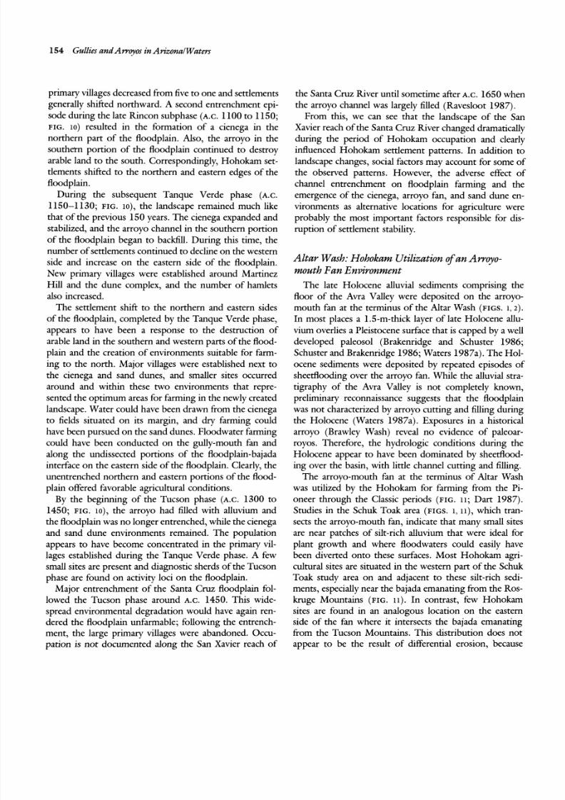
The late Holocene alluvial sediments comprising the
floor of the Avra Valley were deposited on the arroyo-
mouth fan at the terminus of the Altar Wash (FIGS. , 2 ) .
In most places a 1.5-m-thick layer of late Holocene allu-
vium overlies a Pleistocene surface that is capped by a well
developed paleosol (Brakenridge and Schuster 1986;
Schuster and Brakenridge 1986; Waters 1987a). The Hol-
ocene sediments were deposited by repeated episodes of
sheetflooding over the arroyo fan. While the alluvial stra-
tigraphy of the Avra Valley is not completely known,
preliminary reconnaissance suggests that the floodplain
was not characterized by arroyo cutting and filling during
the Holocene (Waters 1987a). Exposures in a historical
arroyo (Brawley Wash) reveal no evidence of paleoar-
royos. Therefore, the hydrologic conditions during the
Holocene appear to have been dominated by sheettlood-
ing over the basin, with little channel cutting and filling.
The arroyo-mouth fan at the terminus of Altar Wash
was utilized by the Hohokam for farming from the Pi-
oneer through the Classic periods (FIG.11; Dart 1987).
Studies in the Schuk Toak area (FIGS. , i i ) , which tran-
sects the arroyo-mouth fan, indicate that many small sites
are near patches of silt-rich alluvium that were ideal for
plant growth and where floodwaters could easily have
been diverted onto these surfaces. Most Hohokam agri-
cultural sites are situated in the western part of the Schuk
Toak study area on and adjacent to these silt-rich sedi-
ments, especially near the bajada emanating from the Ros-
kruge Mountains (FIG. 11). In contrast, few Hohokam
sites are found in an analogous location on the eastern
side of the fan where it intersects the bajada emanating
from the Tucson Mountains. This distribution does not
appear to be the result of dfferential erosion, because
8/2/2019 Journal of Field Archaeology 1991 Waters
http://slidepdf.com/reader/full/journal-of-field-archaeology-1991-waters 16/20
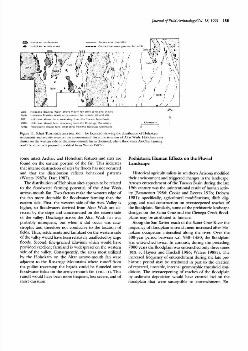
Journal $Field ArchaeologyIVol.18, 1991 155
Qala Holocene Brawley Wash arroyo-mouth fan (s ~lt y and and gravel)
Qalb Holocene Brawley Wash arr oyo-mouth fan (sandy s~l t nd %It)
I\QfT Holocene alluv~al ans emanating from the Tucson Mountains I
QfRb Holocene alluv~al ans emanating from the Roskruge Mount a~ns Kilometers
QfRa Ple~stocenealluv~al ans emanating from the Roskruge Mountai ns 0 1
Figure 11. Schuk Toak study area (see FIG. 1 for location) showing the distribution of Hohokam
settlements and activity areas on the arroyo-mouth fan at the termhus of Altar Wash. Hohokam sites
cluster on the western side of the arroyo-mouth fan as discussed, where floodwater Ak-Chin farming
could be effectively pursued (modified from Waters 1987a).
some intact Archaic and Hohokam features and sites are
found on the eastern portion of the fan. This indicates
that intense destruction of sites by floods has not occurred
and that the distribution reflects behavioral patterns
(Waters 1987a; Dart 1987).
The distribution of Hohokam sites appears to be related
to the floodwater farming potential of the Altar Wash
arroyo-mouth fan. Two factors make the western edge of
the fan more desirable for floodwater farming than the
eastern side. First, the western side of the Avra Valley is
higher, so floodwaters derived from Altar Wash are &-
rected by the slope and concentrated on the eastern side
of the valley. Discharge across the Altar Wash fan was
probably infrequent, but when it &d occur was cata-
strophic and therefore not conducive to the location of
fields. Thus, settlements and farmland on the western side
of the valley would have been relatively unaffected by large
floods. Second, fine-grained alluvium which would have
provided excellent farmland is widespread on the western
side of the valley. Consequently, the areas most utilized
by the Hohokam on the Altar arroyo-mouth fan were
adjacent to the Roskruge Mountains where runoff from
the gullies traversing the bajada could be funneled onto
floodwater fields on the arroyo-mouth fan (FIG. 11). This
runoff would have been more frequent, less severe, and of
short duration.
Prehistoric Human Effects o n the Eluvial
Landscape
Historical agriculturalists in southern Arizona mo&fied
their environment and triggered changes in the landscape.
Arroyo entrenchment of the Tucson Basin during the late
19th century was the unintentional result of human activ-
ity (Betancourt 1986; Cooke and Reeves 1976; Dobyns
1981) spechcally, agricultural modifications, ditch &g-
ging, and road construction on oversteepened reaches of
the floodplain. Similarly, some of the prehistoric landscape
changes on the Santa Cruz and the Cienega Creek flood-
plains may be attributed to humans.
Along the San Xavier reach of the Santa Cruz k ve r the
frequency of floodplain entrenchment increased after Ho-
hokam occupation intensified along the river. Over the
500-year period between A.C. 950-1450, the floodplain
was entrenched twice. In contrast, during the preceding
7000 years the floodplain was entrenched only three times
(FIG. 6; Haynes and Huckell 1986; Waters 1988a). The
increased frequency of entrenchment during the late pre-
historic period may be attributed in part to the creation
of repeated, unstable, internal geomorphic threshold con-
ditions. The oversteepening of reaches of the floodplain
by sedunent deposition would have created loci on the
floodplain that were susceptible to entrenchment. En-
8/2/2019 Journal of Field Archaeology 1991 Waters
http://slidepdf.com/reader/full/journal-of-field-archaeology-1991-waters 17/20
156 Cullies and Arvoyos in Arizona1 Waters
trenchment of these unstable reaches of the floodplain
could have been triggered during the late Holocene by
flooding associated with short climatic iterations lasting
less than 10 years or by changes in the rainfall patterns
caused by long-term climatic fluctuations lasting 100 to
1000 years. In conjunction with flooding, prehistoric hu-
man activity on the floodplain may have been a major
factor in late Holocene channel cutting.
As agriculturalists, the Hohokam modified the land-
scape. They probably cleared natural vegetation from fields
on the floodplain; concentrated the runoff from drainages
on the bajada to the edge of the floodplain; collected
undergrowth and deadfall from mesquite thickets for fire-
wood; created well worn, compacted paths across the
floodplain; and perhaps constructed small diversion struc-
tures, short canals, and ditches on the floodplain.All these
modifications would have unintentionally made the
ground more susceptible to erosion and allowed water
flowing over the floodplain to increase its velocity. The
disturbed areas and ditches, if present, could have served
as loci for the initiation of entrenchment that could have
expanded during floods to become the arroyos visible in
the alluvial record. Although there is no direct evidence
to support the hypothesis that human actions on the flood-
plain resulted in entrenchment, the temporal correlation
between the occupation of the Santa Cruz hver by the
Hohokam agriculturalists and the increased frequency of
floodplain entrenchment is strilung. It appears that the
Hohokam agriculturalists may have made the same mis-
takes that historical farmers made in the late 19th century,
which led to floodplain entrenchment and creation of the
modern Santa Cruz arroyo.
Late Holocene arroyo cutting is also documented along
Cienega Creek (FIG. 6; Eddy and Cooley 1983). This
occurred sometime during the late hn con and early Tan-
que Verde phases when there was an increase in both
arable land and intensity of occupation. It may be that the
entrenchment of Cienega Creek was also triggered by the
intensified use of the region for agriculture. Interestingly,
late Holocene channel cutting on Cienega Wash and the
Santa Cruz h ver floodplains was not synchronous. Ar-
royo entrenchment of the Cienega Creek floodplain began
at the end of the late hncon phase while the first en-
trenchment along the San Xavier reach began during the
early Rmcon phase. Because these arroyo cutting events
are out of phase, they were probably not triggered by a
simultaneous climatic iteration. Instead, the utilization of
both environments by agriculturalists and historical ana-
logs suggest that the nonsynchronous arroyo cutting ap-
pears to have been the result of human activity. A second
entrenchment episode occurred along the Santa Cruz
River at the end of the Tucson Phase at A.C. 1450, but
there was no similar event on the Cienega Creek flood-
plain. This later entrenchment of the Santa Cruz hver
floodplain also may have been human induced.
Conclusions
Geoarchaeological studies are crucial for the proper in-
terpretation of the archaeological record and provide the
landscape context for elucidation of human ecology. With-
out the crucial information geoarchaeological studes pro-
vide, archaeological interpretations will be incomplete and
in some cases inaccurate. In southern Arizona, hydrologic
conditions and landscape evolution clearly affected the
archaeological record, influenced the location of Hoho-
kam settlements, and accounted for changes in settlement
patterns through time. Finally, prehistoric Hohokam uti-
lization of arroyo floodplains may have led to environ-
mental degradation.
Acknowledgments
The geoarchaeological research in southern Arizona that
provided many of the specific examples in this paper was
funded by the U.S. Bureau of Reclamation, the Arizona
Department of Transportation, and the Wenner-Gren
Foundation. A preliminary version of this paper was pre-
pared for the Tucson Aqueduct Archaeological Synthesis
volume prepared for the Bureau of Reclamation by theArizona State Museum. John Ravesloot and Jon Czapliclu
are thanked for funds used to prepare this report and the
illustrations. Helpful criticisms of earlier drafts of this
manuscript were received from John Ravesloot, Jon Cza-
pliclu, Robert E. Dewar, Michael B. Schiffer, Julie K.
Stein, Randall H. McGuire, Jack Donahue, and Lain Ellis.
Randy McGuire and Robert Dewar provided helpful sug-
gestions that improved this manuscript. A1 Wesolowsky
improved both the text and illustrations. Dora Lopez
typed the many drafis of this paper. All are thanked for
their assistance.
Michael R. Watersis an assistant professm ofAnthropology
and Geography at TexasAOM University, where he has been
teaching since 1985. Waters received his doctmatefrom the
Department of Geosciences at the University ofArizona in
1983.His cuwent research interests includegeoarchaeolog~
peopling of the Americas, and prehistoric settlement patterns
in the American Southwest. Mazfing address: Depa~ment f
Anthropology, TexasAOM University, College Station, TX77843.
8/2/2019 Journal of Field Archaeology 1991 Waters
http://slidepdf.com/reader/full/journal-of-field-archaeology-1991-waters 18/20
Betancourt, Julio L.
1986 Historic Channel ChangesAlong the Santa Cn tz River, San
Xavier Re&, Southern Arizo na. Report prepared for Cul-
tural and Environmental Systems, Tucson, AZ.
Bettis, E . Arthur, 111, and Dean W. Benn
1984 "An Archaeological and Geomorphological Survey in the
Central Des Moines River Valley, Iowa," Plains Anthro-pologist 29: 21 1-227.
Brakenridge, G. Robert, and Janette H. Schuster
1986 "Late Quaternary Geology and Geomorphology in Re-
lation to Archaeological Site Locations, Southern Ari-
zona," Journal of Arid Environments 10: 225-239.
Brookes, Ian A,, Louis D. Levine, and Robin W. Demell
1982 "Alluvial Sequence in Central West Iran and Implications
for Archaeological Survey," Journal of Field Archaeology9: 285-299.
Bryan, Kirk
1929 "Flood-Water Farming," Geographical Review 19: 444-456.
Butzer, Karl W.
1980 "Holocene Alluvial Sequences: Problems of Dating and
Correlation," in R. A. Cullingford, Donald A. Davidson,
and J. Lewin, eds., Timescales in Geommphology. New
York: John Wiley and Sons, 131-142.
1982 Archaeology as Human Ecology. New York: Cambridge
University Press.
Ciolek-Torrello, &chard
1987 Hohokam Settlement Along the Slopes of the Picacho Mo un-tains. The Picacbo Area Sites. Museum of Northern Arizona
Research Paper 35. Flagstaff.
Cooke, Ronald U., and Richard W. Reeves
1976 Arroyos and Environmental Chan ge in the America n South -
west. Oxford: Clarendon Press.
Czaplicki, Jon S., and John C. Ravesloot
1989 Hohokam Archaeology Along Phase B of the Tucson AqueductCentral Arizona Project. Archaeological Series No. 178.
Tucson: Arizona State Museum.
Dart, Allen
1987 Archaeological Studies of the A w a Valley, Arizo na, fm thePapwo Water Supply Project. Institute fm American Re-search Anthropological Papers No. 9. Tucson.
Dobyns, Henry F.
1981 From Fire t o Flood: Historic Human Destruction of SonoranDesert Riverine Oases. Ballena Press Anthropological Papers20. Los Altos, CA.
Doelle, William H., Allen Dart, and Henry D. Wallace
1985 The Southern Tucson Basin Survey: Intensive Survey Alongthe Santa C w z River. Institute m American Research Tech-nical Report 85-3. Tucson.
Doelle, William H., and Henry D. Wallace
1986 Hohokam Settlement Pa tt m s in the San Xaviw ProjectArea , S outhern Tucson Basin. Institute fm America n Re-search Technical Report 84-6. Tucson.
Journal of Field Archaeology/Vol. 18, 1991 157
Downum, Christian E., Adrianne G. Rankin, and Jon S. Czaplicki
1986 A Class 111Archaeological Survey of the Phase B Cmridm,Tucson Aqued uct, Central Arizo na Project. Arizo na StateMu seum Archaeolo&cal Series 168. Tucson.
Eddy, Frank W., and Maurice E. Cooley
1983 Cultural and Environmental History of Cienega Valley,Southeastern Ari zon a. Anthropological Papers of the U nivw -sity ofArizona 43. Tucson: University of Arizona Press.
Ferring, C. Reid
1986 "Rates of Fluvial Sedimentation: Implications for Ar-
chaeological Variability," Geoarchaeology: A n I n t m a -twnal Journal 1: 259-274.
Field, John J., and James P. Lombard
1987 "Geomorphology as an Archaeological Tool in the Red
Rock Basin, Arizona," Geological Society of America Ab-stracts with Programs 19(7): 662.
Fish, Paul R.
1989 'The Hohokam: 1000years of Prehistory in the Sonoran
Desert," in Linda Cordell and George Gumerman, eds.,Dynamics of Southwest Prehistory. Washington, D.C.:
Smithsonian Institution, 19-56.
Fish, Suzanne, Paul Fish, Charles Miksicek, and John Madson
1985 "Prehistoric Agave Cultivation in Southern Arizona,"De-sert Plants 7: 107-1 14.
Gardner, George D., and Jack Donahue
1985 'The Little Platte Drainage, Missouri: A Model for Lo -
cating Temporal Surfaces in a Fluvial Environment," in
Julie K. Stein and William R. Farrand, eds., Archaeolog-ical Sediments in Context. Orono: Center for the Study
of Early Man, Institute for Quaternary Studies, Univer-
sity of Maine, 69-89.
Gladfelter, Bruce G.
1985 "On the Interpretation of Archaeological Sites in AlluvialSettings," in Julie K. Stein and William R. Farrand, eds.,
Archaeological Sediments in Context. Orono: Center for
the Study of Early Man, Institute for Quaternary Studies,
University of Maine, 41-52.
Graf, William L.
1987 Fluvial Processes in Dryland Rivers. New York: Springer-
Verlag.
Hack, John T.
1942 The Ch ang ing Physical Environ men t of the Hopi Indians ofAr izona. Papers of the Peabody Museu m 35( 1).Cambridge,
MA: Harvard University.
Hassan, Fekri A.
1985 "Fluvial Systems and Geoarchaeology in Arid Lands:With Examples from North Africa, the Near East, and
the American Southwest," in Julie K. Stein and William
R. Farrand, eds., Archaeological Sediments in Context.Orono: Center for the Study of Early Man, Institute for
Quaternary Studies, University of Maine, 53-68.
Haynes, C. Vance, Jr.
1968 "Geochronology of Late Quaternary Alluvium," in
Roger B. Morrison and H. E. Wright, Jr., eds., Means ofCmelatwn ofQuaternary Successions. Salt Lake City: Uni-
versity of Utah Press, 591-631.
1981 "Geochronology and Paleoenvironrnent of the Murray
8/2/2019 Journal of Field Archaeology 1991 Waters
http://slidepdf.com/reader/full/journal-of-field-archaeology-1991-waters 19/20
158 Gullies and Arvoyos in Arizona1Waters
Springs Clovis Site, Arizona," National Geographic SocietyResearch Repm ts 13: 243-25 1.
1982 "Archaeological Investigation at the Lehner Site, Ari-
zona," National Geographic Society Research Reports 14:
325-334.Haynes, C. Vance, Jr., and Bruce B. Huckell
1986 Sedimentary Successions of the Prehistmic Santa Cru z River ,Tuwon, Arizona. Arizona Bureau of Mines and Geology
open file report. Tucson.
Hendrickson, Dean A,, and W. L. Minckley
1984 "Cienegas-Vanishing Climax Communities of the
American Southwest," Desert Plants 6: 131-175.
Huckell, Bruce B., Martyn D. Tagg, and Lisa W. Huckell
1987 The Curona De Tucson Prq'ect: Prehistoric Use of a BajadaEnvironment. Arizona State Museum Archaeological Series174. Tucson.
Knox, J. C.
1983 "Responses of River Systems to Holocene Climates," inH. E. Wright, Jr., ed., Late-Qu aternary Environments ofthe United States-The Holocene. Minneapolis: University
of Minnesota Press, 26-41.
Kraus, Mary J. , and Thomas M. Bown
1986 "Paleosols and Time Resolution in Alluvial Stratigra-
phy," in V. P. Wright, ed., Paleosols: Their Recognitionand Interpretation. Princeton, NJ: Princeton University
Press, 180-207.
Leopold, Luna B., M. Gordon Wolman, and John P. Miller
1964 Fluvial Processes in Geomlphology. San Francisco: W. H .
Freeman.
Melton, Mark A.
1956 'The Geomorphic and Paleoclimatic Significance of Al-
luvial Deposits in Southern Arizona," Journal o Geology73: 1-38.
Nabhan, Gary P.
1979 'The Ecology of Floodwater Farming in Arid South-
western North America," Agro-Ecosystems 5: 235-255.
1986a "Papago Indian Desert Agriculture and Water Control
in the Sonoran Desert, 1697-1934," Applied Geography6: 43-59.
1986b "Ak-chin 'Arroyo Mouth' and The Environmental Set-
ting of the Papago Indian Fields in the Sonoran Desert,"
Applied Geography 6: 61-75.
Packard, Frank A.
1974 The Hydraulic Ge mn ety of a Discantinuous EphemeralStream on a Bajada near Tucson) Arizo na. Ph.D. disser-
tation, University of Arizona, Tucson. Ann Arbor: Uni-
versity Microfilms.
Patton, Peter C., and Stanley A. Schumm
1975 "Gully Erosion, Northwestern Colorado: A Threshold
Phenomenon," Geology 3: 88-90.
Phillips, David A,, Jr.
1984 ''Ceramic Period Settlement Patterns in the Rosemont
Area: A Discussion," in Alan Ferg, Kenneth C. Rozen,
William L. Deaver, Martyn D. Tagg, David A. Phillips,
Jr., and David A. Gregory, eds., Hohokam Habitation Sites
in the Nmthern Santa Rita Mou ntains.Archaeological SeriesNo. 147(2).Tucson: Arizona State Museum, 701-723.
Ravesloot, John C.
1987 The Archaeology of San Xa vier Site (AZBB:13:14) Tuwon
Basin, Southern Arizona. Arizona State Museum Archaeo-logical Series 171. Tucson.
Rice, Glen E.
1987 Studies in the Hohokam Community of Marana. Anthropo-logical Field Studies No. 15. Tempe: Arizona State Uni-
versity.
Sadler, Peter M.
1981 "Sediment Accumulation Rates and the Completeness of
Stratigraphic Sections,"Journal of Geology 89: 569-584.
Schiffer, Michael B.
1987 Formation Processes of the Archaeological Recurd. Albuquer-
que: University of New Mexico Press.
Schumm, Stanley A.
1977 The Fluvial System. New York: John Wiley & Sons.
Schuster, Janette H., and G. Robert Brakenridge
1986 "Late Quaternary Geology and Geomorphology along
the Phase B Corridor," in Christian E. Downum, Ad-
rianne G. Rankin, and Jon S. Czaplicki, eds., A ClassIIIArchaeological Survey af the Phase B Cwridm , Tuwon A q-ueduct, Central Arizona Project. Archaeological Series No.
168. Tucson: Arizona State Museum, 12-28.
Thompson, Dean M., and E. Arthur Bettis, I11
1982 "Out of Sight, Out of Planning: Assessing and Protecting
Cultural Resources in Evolving Landscapes," ContvactsAbstracts and CRM Archaeology 2(3) : 6-21.
Turnbaugh, William A.
1978 "Floods and Archaeology," American Antiquity 43: 593-
607.
Waters, Michael R.
1985 "Late Quaternary Alluvial Stratigraphy of Whitewater
Draw, Arizona: Implications for Regional Correlation of
Fluvial Deposits in the American Southwest," Geology 13:
705-708.
1986 The Geoarchaeology of W hit wa ter Draw, Arizona. A n t h -pological Papers of the U niversity of Ar izo na 45. Tucson.
1987a "Geoarchaeological Investigations of the Schuk Toak and
San Xavier Study Areas," in Allen Dart, ed., Archaeolog-ical Studies of the A w a Valley, Arizo na. Ins titute furA mer -ican Research Anthropological Paper 9. Tucson, 207-220.
1987b "Geomorphic Investigations of the Bajada Near CoronaDe Tucson, Arizona," in Bruce B. Huckell, Martyn D.
Tagg, and Lisa W. Huckell, eds., The Corona De TucsonProject: Prehistoric Use of a B ajadu E nviro nment. Ar izonaState Museum Archaeological Series No. 174. Tucson, 297-
306.
1988a "Holocene Alluvial Geology and Geoarchaeology of the
San Xavier Reach of the Santa Cruz River, Arizona,"
Geological Society of America Bulletin 100: 479-49 1.
1988b 'The Impact of Fluvial Processes and Landscape Evolu-
tion on Archaeological Sites and Settlement Patterns
Along the San Xavier Reach of the Santa Cruz River,

8/2/2019 Journal of Field Archaeology 1991 Waters
http://slidepdf.com/reader/full/journal-of-field-archaeology-1991-waters 20/20
Journal $Field ArchaeologyiVol. 18, 1991 159
Arizona," Geoarchaeology: An International Journal 3:
205-219.
Waters, Michael R., and John J. Field
1986 "Geomorphic Analysis of Hohokam Settlement Patterns
on Alluvial Fans Along the Western Flank of the Tor-tolita Mountains, Arizona," Geoarchaeology: An Interna-
tional Journal l : 329-345.
Wilson, J. P.
1985 "Early Pirnan Agriculture: A New Look," The Archaeo-
logical Society of New Mexb 10: 129-138.