Embed Size (px)
Citation preview
Desert Tortoise Survey and General Biological Resources Assessment
for the Joshua Tree Solar Farm
(Airport Site) San Bernardino County, CA
United States Geological Survey 7.5-minute Joshua Tree North and Sunfair quadrangle Township 1 N, Range 7 E, Section 21
Assessor’s Parcel Numbers: 0607-364-06, 0607-231-07, 0607-231-09, 0607-231-10, 0607-231-11, 0607-231-12, 0607-231-13, 0607-231-14, 0607-231-15, and 0607-231-18
Prepared For: Joshua Tree Solar Farm, LLC
700 Louisiana Street, 33rd floor Houston, TX 77002
Contact: Jim Shandalov, (925) 285-2510
Prepared By: Tetra Tech Inc.
143 Union Boulevard, Suite 1010 Lakewood, CO 80228
Contact: Emily Mix, 303-980-3509
and
Alice E. Karl, Ph.D. P.O. Box 74006
Davis, CA 95617 530-304-4121
Field Work Conducted By:
Dr. Alice Karl, Emily Mix, and Tim Thomas
July 2012
Joshua Tree Solar Farm General Biological Resources Assessment
ES-1
EXECUTIVE SUMMARY Joshua Tree Solar Farm, LLC (Applicant) is proposing to construct, own, and operate a 20 megawatt (MW) solar photovoltaic (PV) generating facility located on an approximately 115-acre footprint, referred to as the Joshua Tree Solar Farm (Project). The Project site would be on private land in unincorporated San Bernardino County, California, located approximately 3.5 miles east of the town of Joshua Tree and one mile north of Twentynine Palms Highway (Hwy 62) (Figure 1, Figure 2). The power produced by the Project would be transmitted to the local power grid via a 1-mile, 33-kilovolt (kV) generation-tie line (gen-tie) overbuild of an existing line connecting to Southern California Edison’s (SCE’s) existing Pinto line located south of the Project.
The Applicant contracted Tetra Tech EC, Inc. (Tetra Tech) to conduct comprehensive field surveys for biological resources in Spring 2012 to determine the potential presence or absence of special-status species and their habitat within the proposed Project site. Focused surveys were conducted for these species and concurrently, a general biological resource assessment was completed. This report satisfies the County of San Bernardino Report Protocol for Biological Assessment Reports.
Surveyors did not find any federally or state-threatened, endangered, or candidate plant species during surveys. However, botanists did observe one California Native Plant Society ranked plant: Utah vine milkweed (Funastrum utahense, California Rare Plant Rank 4). Surveyors observed and tallied four species protected by the California Desert Native Plants Act (CDNPA) and San Bernardino County code: Joshua tree (Yucca brevifolia), beavertail cactus (Opuntia basilaris), buckhorn cholla (Cylindropuntia acanthocarpa), and silver cholla (Cylindropuntiaechinocarpa). One California Natural Diversity Database vegetation community occurs within the survey area that is globally and state-ranked as a community of special concern (G or S rank 1-3): Big Galleta-Creosote Bush (Pleuraphis rigida-Larrea tridentata) Shrub Steppe Alliance. However, it is not considered a high quality representation of the community, due to intensive disturbance, or rare in the area.
No live tortoises or their sign were observed during surveys, indicating that tortoises are not present on the Project site and have not used the survey area in any biologically significant way in recent years. The majority of the survey area is highly disturbed due to the development and operation of the Roy Williams Airport and is poor or non-desert tortoise habitat. However, tortoises are known to occur within the valley within which the Project lies and adjacent parcels contain suitable habitat.
Other non-listed special-status species observed include prairie falcon (Falco mexicanus) and desert kit fox (natal dens and scat only, Vulpes macrotis). Potential habitat for burrowing owl (Athene cunicularia) is present within undeveloped portions of the survey area.
There is the potential for Project-related impacts on: four native plant species protected by the CDNPA and San Bernardino County code, Utah vine milkweed, desert tortoise, burrowing owl, nesting birds protected under the Migratory Bird Treaty Act (MBTA), and desert kit fox. If avoidance is not feasible, the CDNPA plants will be salvaged. Mitigation measures to avoid and minimize potential Project impacts include but are not limited to: desert tortoise exclusion fencing on the site perimeter, limiting construction disturbance, salvaging topsoil, having

Joshua Tree Solar Farm General Biological Resources Assessment
ES-2
biological monitors present during fence construction and in unfenced areas, enforcing the designated speed limit, and implementing a worker environmental awareness program.
Joshua Tree Solar Farm
1
TABLE OF CONTENTS
EXECUTIVE SUMMARY .............................................................................................................. 1
1.0 INTRODUCTION ............................................................................................................... 31.1 Project Description ................................................................................................... 3Grading ............................................................................................................................. 41.2 Operation.................................................................................................................. 51.3 Project Schedule ...................................................................................................... 5
2.0 PROJECT SETTING ......................................................................................................... 52.1 Project Location ........................................................................................................ 52.2 Environmental Setting .............................................................................................. 6
3.0 REGULATORY SETTING ................................................................................................. 73.1 Federal Laws and Regulations ................................................................................. 73.2 State Laws and Regulations ..................................................................................... 83.3 County Regulations ................................................................................................ 10
4.0 SURVEY METHODS ...................................................................................................... 104.1 Literature Review ................................................................................................... 104.2 Field Survey Methods, Spring 2012 ....................................................................... 17
4.2.1 Rare Plant and Vegetation Surveys ........................................................... 174.2.1.1 Special-status Plant Species ......................................................... 174.2.1.2 Species Protected by the California Desert Native Plants Act and
San Bernardino County Code ....................................................... 184.2.1.3 Vegetation Communities and Special Habitats ............................. 184.2.1.4 Non-native Plants .......................................................................... 18
4.2.2 Wildlife Surveys .......................................................................................... 184.2.2.1 Desert Tortoise .............................................................................. 194.2.2.2 Mojave Fringe-toed Lizard ............................................................. 194.2.2.3 Burrowing Owl ............................................................................... 194.2.2.4 Other Special-status Wildlife ......................................................... 20
5.0 SURVEY RESULTS AND DISCUSSION ........................................................................ 205.1 Rare Plants and Vegetation ................................................................................... 20
5.1.1 Special-status Plant Species ...................................................................... 205.1.2 CDNPA and San Bernardino County Protected Plant Species .................. 225.1.3 Sensitive Plant Communities ...................................................................... 225.1.4 Non-Native Plants ....................................................................................... 22
5.2 Wildlife .................................................................................................................... 235.2.1 Listed Species ............................................................................................ 23
5.2.1.1 Desert Tortoise (FWS: Threatened; CDFG: Threatened) ............. 235.2.2 Non-listed, Special-status Species ............................................................. 23
5.2.2.1 Reptiles and Amphibians ............................................................... 245.2.2.2 Birds .............................................................................................. 245.2.2.3 Special-status Mammals ............................................................... 25
5.3 Potential for Other Special-status Species to Occur .............................................. 255.3.1 Special-status Wildlife and Plant Species Not Observed, but Which
May Occur on the Project Area .................................................................. 255.3.2 Special-status Wildlife and Plant Species Not Observed, but Which
are Not Likely to Occur on the Project Area ............................................... 25
Joshua Tree Solar Farm
2
6.0 POTENTIAL IMPACTS AND PROPOSED MITIGATION ............................................... 266.1 Special-status Plants .............................................................................................. 26
6.1.1 Utah Vine Milkweed .................................................................................... 266.1.2 Other Special-status Plants Not Observed but Likely to Occur .................. 266.1.3 CDNPA species .......................................................................................... 26
6.2 Special-status Wildlife ............................................................................................ 266.2.1 Desert Tortoise ........................................................................................... 266.2.2 Burrowing Owl ............................................................................................ 276.2.3 Prairie Falcon ............................................................................................. 276.2.4 Nesting Birds .............................................................................................. 286.2.5 Kit Fox ........................................................................................................ 28
7.0 OTHER RECOMMENDATIONS ..................................................................................... 28
8.0 CERTIFICATION ............................................................................................................. 29
9.0 LITERATURE CITED ...................................................................................................... 30
LIST OF TABLES
Table 1. Project Site Assessor’s Parcel Numbers ........................................................................ 5Table 2. Vegetation and Land Cover Acreage .............................................................................. 7Table 3. Potential for Special-status and Other Target Plant and Wildlife Species on the
Project Site or that May Be Affected by the Project ...................................................... 11Table 4. Weather Conditions during Spring 2012 Field Surveys ................................................ 17Table 5. 2011 and 2012 Monthly Precipitation Data (in inches), Joshua Tree, CA ..................... 18Table 6. Special-status Plants and CDNPA Plant Observed during Spring 2012 Surveys ......... 21Table 7. CDNPA Species found during Spring 2012 Surveys within the Survey Area ............... 22Table 8. Non-listed, Special-status Wildlife Detected during Spring 2012 .................................. 24
LIST OF FIGURES Figure 1 Regional Map Figure 2 Project Vicinity Map Figure 3 2012 Biological Resources Survey Area Figure 4 Project Vegetation and Cover Types Figure 5 Special-status Plant Observations in Spring 2012 Figure 6 Other Special-status Wildlife Observations in Spring 2012
APPENDICES Appendix A Representative Project Photographs and Photograph Key Appendix B California Natural Diversity Database Results within 25 Miles of the Survey Area Appendix C Agency Correspondence – Approval of Survey Methods Appendix D Example of Survey Data Sheet Appendix E Key to Tortoise Sign Classes Appendix F Floral and Faunal Compendium
Joshua Tree Solar Farm
3
1.0 INTRODUCTION Joshua Tree Solar Farm, LLC (the Applicant) is proposing to construct, own, and operate a 20 megawatt (MW) solar photovoltaic (PV) generating facility located on an approximately 115-acre footprint, referred to as the Joshua Tree Solar Farm (Project). The Project site would be on private land in unincorporated San Bernardino County, California, located approximately 3.5 miles east of the town of Joshua Tree and one mile north of Twentynine Palms Highway (Hwy 62) (Figure 1, Figure 2). The power produced by the Project would be transmitted to the local power grid via a 1-mile, 33-kilovolt (kV) generation-tie line (gen-tie) overbuild of an existing line connecting to Southern California Edison’s (SCE’s) existing Pinto line located south of the Project.
The Applicant contracted Tetra Tech EC, Inc. (Tetra Tech) to conduct comprehensive field surveys for biological resources in Spring 2012 to determine the potential presence or absence of special-status species and their habitat. This report discusses the results of focused surveys conducted for these species in April and May 2012, during which a general biological resource assessment was completed. This report satisfies the County of San Bernardino Report Protocolfor Biological Assessment Reports.
1.1 Project Description
The Project will be designed to consist of 20 one-MW alternating current (AC) array blocks. Each array block will be laid in a grid pattern across the site and will use solar PV modules that will be installed in uniform rows. The Project will convert energy captured from the sun to direct current (DC) electricity and then to AC electricity. Energy is expected to be generated from this Project during daylight hours every day of the year for over 30 years. The generated power will be delivered to the electrical grid via a 33 kV interconnection to the SCE distribution system.
For the purposes of this document, the following terminology applies:
“Project” is the Joshua Tree Solar Farm
“Project site” is the area that the Applicant is currently considering for development. It includes the solar facility (modules, power conversion station, and switchgear and gen-tie). The area needed for development is expected to be approximately 115 acres, but remains flexible to accommodate grading requirements and solar technology. The proposed Project would be built within the Project site but the final layout was not yet determined at the time of surveys.
“Survey area” is the area that was surveyed in Spring 2012. It is equivalent to the currently proposed Project site (Figure 3) and includes approximately 115 acres (surveyed in May 2012), plus a 60-foot wide corridor for the gen-tie (7.4 acres, surveyed in April 2012).
Modules Solar photovoltaic modules will be the main component of the solar system. The modules will be installed in a way to gain maximum exposure to the sun. Solar modules consist of a flat plate of PV cells which are designed to convert the photons that hit the surface into DC electricity. This process of converting light (photons) to electricity (voltage), which happens at the time the light passes through the PV cell material, is called the PV effect. The module used for the Project will be a commercially available technology at the time of installation. The PV panels are planned to

Joshua Tree Solar Farm
4
be wired together in strings to maintain a DC voltage level always within the applicable ratings of the inverter under all design temperatures. The module strings are then paralleled for termination in combiner boxes distributed throughout the PV field for aggregated input into inverters.
Power Conversion Station
The Power Conversion Station (PCS) is where the electricity is converted from DC to AC through an inverter and the power is increased in voltage through a step up transformer to match the interconnection voltage of 33kV. Each 1 MW array block will have its own PCS. The output from each of the 20 power conversion stations distributed throughout the solar field will then be conveyed to the PV combining switchgear via a network of underground cables.
PV Combining Switchgear
The PV combining switchgear is the point where the underground cables coming from each of the 20 one-MW array blocks will be collected and where a circuit breaker will be installed. At this point the power will be transferred to SCE.
Generation Tie Line
The gen-tie line will be constructed, owned, and operated by SCE. SCE will retrofit the gen-tie line by overbuilding the existing distribution line that runs on the west side of Sunfair Road. The new utility line will be retrofitted by replacing existing poles with wooden poles approximately 60 feet high. SCE will place this upgraded line within the boundaries of its existing right of way.
Access Roads and Fencing
Security fencing will be installed around the perimeter of the solar site. The fencing will be eight feet tall and consist of a seven foot tall chain link fence topped with approximately one foot of barbed wire. Desert tortoise exclusion fencing is recommended to be attached to the lower two feet of the chain link fence, and buried at least one foot, according to specifications from the United States Fish and Wildlife Service (FWS 2009). Access roads will be constructed along the interior perimeter of the site and between the one-MW block solar arrays. Primary access to the Project will be via a gate which will also provide SCE access to the switchgear located within the perimeter fence.
Lighting
Lighting will be installed at the entry gates and the switchgear location. The limited amount of lighting to be installed will be designed to prevent spillover into neighboring properties.
Grading
Some earthwork, including grading, fill, compaction, and erosion control cultivation, will be required to accommodate the placement of PV arrays, access roads, and drainage features. The cut and fill plan will be balanced so that no export or import of soil will be necessary. Grading activities will result in a site that allows for sheet flow, which will distribute storm water and drainage across the property. In accordance with San Bernardino County and California State requirements, the existing drainage patterns of both tributaries to and water flows off the
Joshua Tree Solar Farm
5
site will remain largely unaffected by the Project’s grading, thereby minimizing any impact to neighboring properties.
1.2 Operation During operations, there will be no on-site personnel and maintenance requirements will be minimal. The Project will be monitored remotely, with periodic on-site personnel visits for security, maintenance, scheduled services, and system monitoring. Planned maintenance is expected to happen on a quarterly basis and unplanned maintenance will occur as needed. Periodic panel washings will be scheduled and completed depending on the substrate conditions at the site, but could be up to four times per year. It is expected that less than two acre feet of water will be used per year for washings; this water would be supplied by the Joshua Basin Water District. Due to evaporation and onsite ground percolation it is expected that little to no water from the washings will run offsite.
1.3 Project Schedule
Project construction work is expected to last for approximately six months and will consist of site preparation, grading, PV system installation, gen-tie construction, testing, and site cleanup. Construction is planned to begin in the second half of 2013 and last approximately six months.
2.0 PROJECT SETTING
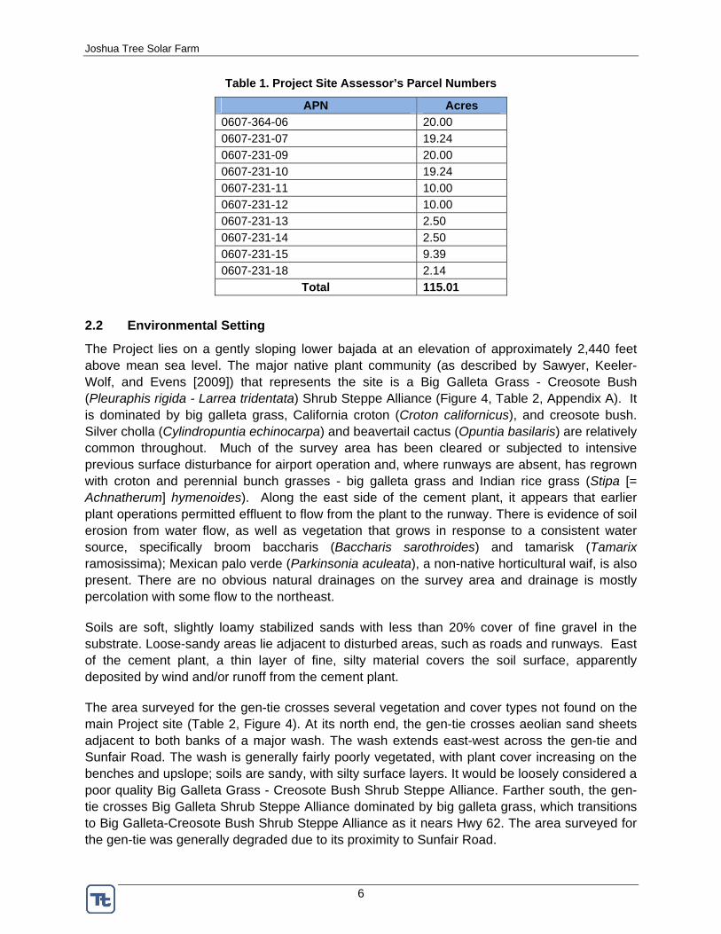
2.1 Project Location
The survey area is located on private land (Table 1) within the Mojave Desert, approximately 2.5 miles north of the Little San Bernardino Mountains (Figure 1, Figure 2). The site is within the Joshua Tree North and Sunfair United States Geological Survey 7.5-minute (1:24,000) quadrangles. Joshua Tree National Park is approximately 2.5 miles south of the site and the Twentynine Palms Marine Corps Base is approximately 6.5 miles north. The site is currently a small private airport, the Hi Desert/Roy Williams Airport. It is bordered by dirt roads to the north, west, and south, and paved Sunfair Road to the east. The major east-west freight and travel route for the area, Hwy 62, is one mile south. A cement factory (Hi-Grade Material Company) borders the survey area to the south. The parcels immediately surrounding the site are vacant; however, there are residences north and northeast of the survey area, as well as sparsely scattered throughout the valley.
Joshua Tree Solar Farm
6
Table 1. Project Site Assessor’s Parcel Numbers
APN Acres 0607-364-06 20.00 0607-231-07 19.24 0607-231-09 20.00 0607-231-10 19.24 0607-231-11 10.00 0607-231-12 10.00 0607-231-13 2.50 0607-231-14 2.50 0607-231-15 9.39 0607-231-18 2.14
Total 115.01
2.2 Environmental Setting
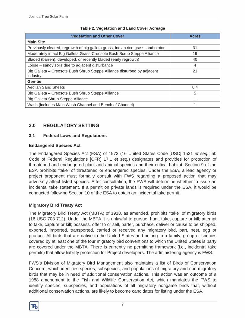
The Project lies on a gently sloping lower bajada at an elevation of approximately 2,440 feet above mean sea level. The major native plant community (as described by Sawyer, Keeler-Wolf, and Evens [2009]) that represents the site is a Big Galleta Grass - Creosote Bush (Pleuraphis rigida - Larrea tridentata) Shrub Steppe Alliance (Figure 4, Table 2, Appendix A). It is dominated by big galleta grass, California croton (Croton californicus), and creosote bush. Silver cholla (Cylindropuntia echinocarpa) and beavertail cactus (Opuntia basilaris) are relatively common throughout. Much of the survey area has been cleared or subjected to intensive previous surface disturbance for airport operation and, where runways are absent, has regrown with croton and perennial bunch grasses - big galleta grass and Indian rice grass (Stipa [= Achnatherum] hymenoides). Along the east side of the cement plant, it appears that earlier plant operations permitted effluent to flow from the plant to the runway. There is evidence of soil erosion from water flow, as well as vegetation that grows in response to a consistent water source, specifically broom baccharis (Baccharis sarothroides) and tamarisk (Tamarix ramosissima); Mexican palo verde (Parkinsonia aculeata), a non-native horticultural waif, is also present. There are no obvious natural drainages on the survey area and drainage is mostly percolation with some flow to the northeast.
Soils are soft, slightly loamy stabilized sands with less than 20% cover of fine gravel in the substrate. Loose-sandy areas lie adjacent to disturbed areas, such as roads and runways. East of the cement plant, a thin layer of fine, silty material covers the soil surface, apparently deposited by wind and/or runoff from the cement plant. The area surveyed for the gen-tie crosses several vegetation and cover types not found on the main Project site (Table 2, Figure 4). At its north end, the gen-tie crosses aeolian sand sheets adjacent to both banks of a major wash. The wash extends east-west across the gen-tie and Sunfair Road. The wash is generally fairly poorly vegetated, with plant cover increasing on the benches and upslope; soils are sandy, with silty surface layers. It would be loosely considered a poor quality Big Galleta Grass - Creosote Bush Shrub Steppe Alliance. Farther south, the gen-tie crosses Big Galleta Shrub Steppe Alliance dominated by big galleta grass, which transitions to Big Galleta-Creosote Bush Shrub Steppe Alliance as it nears Hwy 62. The area surveyed for the gen-tie was generally degraded due to its proximity to Sunfair Road.
Joshua Tree Solar Farm
7
Table 2. Vegetation and Land Cover Acreage
Vegetation and Other Cover Acres Main SitePreviously cleared, regrowth of big galleta grass, Indian rice grass, and croton 31 Moderately intact Big Galleta Grass-Creosote Bush Scrub Steppe Alliance 19 Bladed (barren), developed, or recently bladed (early regrowth) 40 Loose – sandy soils due to adjacent disturbance 4 Big Galleta – Creosote Bush Shrub Steppe Alliance disturbed by adjacent industry
21
Gen-tie Aeolian Sand Sheets 0.4 Big Galleta – Creosote Bush Shrub Steppe Alliance 5 Big Galleta Shrub Steppe Alliance 1 Wash (includes Main Wash Channel and Bench of Channel) 1
3.0 REGULATORY SETTING
3.1 Federal Laws and Regulations
Endangered Species Act
The Endangered Species Act (ESA) of 1973 (16 United States Code [USC] 1531 et seq.; 50 Code of Federal Regulations [CFR] 17.1 et seq.) designates and provides for protection of threatened and endangered plant and animal species and their critical habitat. Section 9 of the ESA prohibits “take” of threatened or endangered species. Under the ESA, a lead agency or project proponent must formally consult with FWS regarding a proposed action that may adversely affect listed species. After consultation, the FWS will determine whether to issue an incidental take statement. If a permit on private lands is required under the ESA, it would be conducted following Section 10 of the ESA to obtain an incidental take permit.
Migratory Bird Treaty Act
The Migratory Bird Treaty Act (MBTA) of 1918, as amended, prohibits “take” of migratory birds (16 USC 703-712). Under the MBTA it is unlawful to pursue, hunt, take, capture or kill; attempt to take, capture or kill; possess, offer to or sell, barter, purchase, deliver or cause to be shipped, exported, imported, transported, carried or received any migratory bird, part, nest, egg or product. All birds that are native to the United States and belong to a family, group or species covered by at least one of the four migratory bird conventions to which the United States is party are covered under the MBTA. There is currently no permitting framework (i.e., incidental take permits) that allow liability protection for Project developers. The administering agency is FWS.
FWS’s Division of Migratory Bird Management also maintains a list of Birds of Conservation Concern, which identifies species, subspecies, and populations of migratory and non-migratory birds that may be in need of additional conservation actions. This action was an outcome of a 1988 amendment to the Fish and Wildlife Conservation Act, which mandates the FWS to identify species, subspecies, and populations of all migratory nongame birds that, without additional conservation actions, are likely to become candidates for listing under the ESA.
Joshua Tree Solar Farm
8
Bald and Golden Eagle Protection Act
The Bald and Golden Eagle Protection Act (BGEPA) prohibits the take of any bald or golden eagle, alive or dead, including any part, nest, or egg. “Take” is defined as “pursue, shoot, shoot at, poison, wound, kill, capture, trap, collect, molest or disturb” a bald or golden eagle. “Disturb” means to agitate or bother an eagle to a degree that causes, or is likely to cause (1) injury to an eagle; (2) a decrease in its productivity, by substantially interfering with normal breeding, feeding, or sheltering behavior; or (3) nest abandonment, by substantially interfering with normal breeding, feeding, or sheltering behavior. The administering agency is FWS.
Clean Water Act
Section 404 of the Clean Water Act (CWA) (33 U.S.C. 1344) regulates all discharge of dredged and fill material into waters of the United States, including wetlands. The United States Army Corps of Engineers (USACE ) and United States Environmental Protection Agency (USEPA) share responsibility for administering and enforcing Section 404 including jurisdictional delineations, permitting decisions, and development of policy and guidance. Waters of the United States and wetlands are those defined by the USACE/USEPA in CWA regulations (33CFR 328.3). Field surveys to delineate jurisdictional waters were conducted in Spring 2012 and are addressed under a separate technical report.
3.2 State Laws and Regulations
California Environmental Quality Act
The California Environmental Quality Act (CEQA) requires review of any project that is undertaken, funded, or permitted by a state or local governmental agency. Typically, the state or local agency with overall project permitting authority takes the lead for CEQA compliance. The lead agency has the discretion to consider any non-listed species a de facto listed species by the statement that “a species not included in any listing in subsection (c) shall nevertheless be considered to be rare or endangered if the species can be shown to meet the criteria in subsection (b)” (CEQA Guidelines §15380, Subsection d). If significant project effects were identified, the lead agency would have the option of requiring mitigation for those effects through changes in the project or deciding that overriding considerations make mitigation infeasible (CEQA Sec. 21002). San Bernardino County is the lead state agency for CEQA review for the Joshua Tree Solar Project.
California Endangered Species Act
The California Endangered Species Act of 1984 (CESA, California Department of Fish and Game [CDFG] Code Sections 2050 et seq.) protects California’s rare, threatened, and endangered species. CDFG Code Sections 1900 et seq. designate rare, threatened and endangered plants under the Native Plant Protection Act of 1977. If a federal biological opinion is issued for a project, the CDFG can choose to find it consistent with state law (a 2080.1 consistency determination), or choose to require a separate state incidental take permit (ITP or 2081 permit) if species listed by CESA could be harmed or killed during construction or operation of the project. CDFG is the administering agency.
Joshua Tree Solar Farm
9
Title 14, California Code of Regulations, Sections 670.2 and 670.5
Under this code, animals are designated as threatened or endangered in California. California Species of Special Concern (SSC) is a category conferred by CDFG on those species that may have declining population levels, limited ranges or continued threats that may ultimately result in their CESA listing as protected species. These species do not have any special legal status, but are often considered during the CEQA process. The SSC designation is used by CDFG as a management tool for consideration when land use decisions are made.
Native Plant Protection Act; CDFG Code Sections 1900 et seq.
The Native Plant Protection Act (NPPA) includes measures to preserve, protect, and enhance rare and endangered native plant species. Definitions for “rare and endangered” are different from those contained in CESA, although CESA-listed threatened and endangered species are included in the list of species protected under the NPPA.
CDFG Code Sections 3503 and 3503.5
These codes state that it is unlawful to take, possess, or needlessly destroy the nest or eggs of any bird, including birds of prey, or take, possess, or destroy birds of prey, except as otherwise provided by this code or any regulation made pursuant thereto.
CDFG Code Sections 3511, 4700, 5050, and 5515
These state laws classify and prohibit the take of “fully protected” bird, mammal, amphibian/reptile, and fish species in California.
CDFG Code Section 3513
This code prohibits any take or possession of birds that are designated by the MBTA as migratory non-game birds, except as allowed by federal rules and regulations pursuant to the MBTA.
CDFG Code Section 4150
This state law makes it unlawful to take or possess any non-game mammal or parts thereof except as provided in the CDFG Code or in accordance with regulations adopted by the commission. However, Title 14 Section 460 prohibits the taking of desert kit foxes.
California Desert Native Plants Act; California Food and Agriculture Code §§ 80001-80006
The California Desert Native Plants Act (CDNPA) allows the harvest of certain species of non-listed native plants under permits issued by the county Agricultural Commissioner or Sheriff. The purpose of the CDNPA is to prevent the unlawful harvesting of native desert trees and cacti, either for wood, landscaping, or other purposes. Regulated species include: trees, cacti, ocotillo (Fouquieria splendens), yucca, and fan palms (Washingtonia filifera). Where feasible and practicable, individual plants can be salvaged and used for the project’s revegetation program or salvaged by an approved nursery, landscaper, or other group to indirectly reduce unlawful harvesting elsewhere. Species in the Joshua Tree Solar Project vicinity that are subject to permitting include Joshua tree (Yucca brevifolia) and several species of cacti (silver cholla,
Joshua Tree Solar Farm
10
buckhorn cholla [Cylindropuntia acanthocarpa], pencil cholla [C. ramossissima], and beavertail cactus [Opuntia basilaris]).
CDFG Streambed Alteration Agreement; CDFG Code Section 1600-1616
Waters of the state of California are subject to the jurisdiction of the CDFG. The CDFG monitors streambed alteration to conserve, protect, and manage California’s fish, wildlife, and native plant resources. CDFG Section 1602 requires any person, state or local governmental agency, or public utility to notify the CDFG before beginning an activity that will substantially divert, obstruct, or change the natural flow of the bed, channel, or bank (including associated riparian vegetation) of a river, stream, or lake; or use material from a streambed prior to commencement of the activity. If CDFG determines that the action could have an adverse effect on existing fish and wildlife resources, a Lake or Streambed Alteration Agreement is required. Jurisdictional waters were surveyed separately and are addressed under a separate report.
3.3 County Regulations
San Bernardino County Development Code; Title 8, Chapter 88.01 Plant Protection and Management
This County code augments and implements provisions of the California Desert Native Plants Act. The County manages the removal or relocation of native plant resources in unincorporated areas of the County. Species protected under County code are smoke tree (Psorothamnus spinosus), all mesquite (Prosopis) species, all species in the Agavaceae family, creosote rings 10 feet or larger in diameter, Joshua trees, ironwood (Olneya tesota), and all palo verde (Cercidium or Parkinsonia) species. No plants that are protected under the Code may be removed without a Tree or Plant Removal Permit.
4.0 SURVEY METHODS
4.1 Literature Review
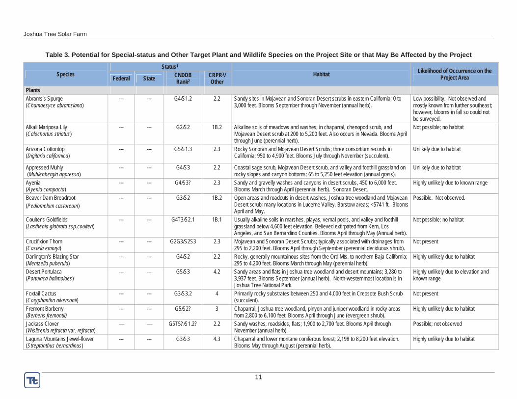
Several species known to occur on or in the vicinity of the Project are accorded “special-status” by federal and state agencies because of their recognized rarity or potential vulnerability to extinction. These species typically have a limited geographic range and/or limited habitat and are referred to collectively as “special-status” species. Prior to Spring 2012 field surveys, a target list of special-status species that might be affected by the Project was developed (Table 3) based on available literature and databases (e.g., California Native Plant Society [CNPS], California Natural Diversity Data Base [CNDDB, Appendix B]), and consultation with local experts. Nelson’s bighorn sheep (Ovis canadensis nelsoni) and burro deer (Odocoileushemionus eremicus) (both managed game species), burros (protected by the Wild, Free-Roaming Horse and Burro Act), and desert kit fox (Vulpes macrotis), a protected furbearer (CDFG Code 4000), were also included in the target list.
Joshua Tree Solar Farm
11
Table 3. Potential for Special-status and Other Target Plant and Wildlife Species on the Project Site or that May Be Affected by the Project
Species Status1
Habitat Likelihood of Occurrence on the Project AreaFederal State CNDDB
Rank2CRPR3/Other
PlantsAbrams’s Spurge (Chamaesyce abramsiana)
--- --- G4/S1.2 2.2 Sandy sites in Mojavean and Sonoran Desert scrubs in eastern California; 0 to 3,000 feet. Blooms September through November (annual herb).
Low possibility. Not observed and mostly known from further southeast; however, blooms in fall so could not be surveyed.
Alkali Mariposa Lily (Calochortus striatus)
--- --- G2/S2 1B.2 Alkaline soils of meadows and washes, in chaparral, chenopod scrub, and Mojavean Desert scrub at 200 to 5,200 feet. Also occurs in Nevada. Blooms April through June (perennial herb).
Not possible; no habitat
Arizona Cottontop (Digitaria californica)
--- --- G5/S1.3 2.3 Rocky Sonoran and Mojavean Desert Scrubs; three consortium records in California; 950 to 4,900 feet. Blooms July through November (succulent).
Unlikely due to habitat
Appressed Muhly (Muhlenbergia appressa)
--- --- G4/S3 2.2 Coastal sage scrub, Mojavean Desert scrub, and valley and foothill grassland on rocky slopes and canyon bottoms; 65 to 5,250 feet elevation (annual grass).
Unlikely due to habitat
Ayenia (Ayenia compacta)
--- --- G4/S3? 2.3 Sandy and gravelly washes and canyons in desert scrubs, 450 to 6,000 feet. Blooms March through April (perennial herb). Sonoran Desert.
Highly unlikely due to known range
Beaver Dam Breadroot (Pediomelum castoreum)
--- --- G3/S2 1B.2 Open areas and roadcuts in desert washes, Joshua tree woodland and Mojavean Desert scrub; many locations in Lucerne Valley, Barstow areas; <5741 ft. Blooms April and May.
Possible. Not observed.
Coulter’s Goldfields (Lasthenia glabrata ssp.coulteri)
--- --- G4T3/S2.1 1B.1 Usually alkaline soils in marshes, playas, vernal pools, and valley and foothill grassland below 4,600 feet elevation. Believed extirpated from Kern, Los Angeles, and San Bernardino Counties. Blooms April through May (Annual herb).
Not possible; no habitat
Crucifixion Thorn (Castela emoryi)
--- --- G2G3/S2S3 2.3 Mojavean and Sonoran Desert Scrubs; typically associated with drainages from 295 to 2,200 feet. Blooms April through September (perennial deciduous shrub).
Not present
Darlington’s Blazing Star (Mentzelia puberula)
--- --- G4/S2 2.2 Rocky, generally mountainous sites from the Ord Mts. to northern Baja California; 295 to 4,200 feet. Blooms March through May (perennial herb).
Highly unlikely due to habitat
Desert Portulaca (Portulaca halimoides)
--- --- G5/S3 4.2 Sandy areas and flats in Joshua tree woodland and desert mountains; 3,280 to 3,937 feet. Blooms September (annual herb). North-westernmost location is in Joshua Tree National Park.
Highly unlikely due to elevation and known range
Foxtail Cactus (Coryphantha alversonii)
--- --- G3/S3.2 4 Primarily rocky substrates between 250 and 4,000 feet in Creosote Bush Scrub (succulent).
Not present
Fremont Barberry(Berberis fremontii)
--- --- G5/S2? 3 Chaparral, Joshua tree woodland, pinyon and juniper woodland in rocky areas from 2,800 to 6,100 feet. Blooms April through June (evergreen shrub).
Highly unlikely due to habitat
Jackass Clover (Wislizenia refracta var. refracta)
— — G5T5?/S1.2? 2.2 Sandy washes, roadsides, flats; 1,900 to 2,700 feet. Blooms April through November (annual herb).
Possible; not observed
Laguna Mountains Jewel-flower (Streptanthus bernardinus)
--- --- G3/S3 4.3 Chaparral and lower montane coniferous forest; 2,198 to 8,200 feet elevation. Blooms May through August (perennial herb).
Highly unlikely due to habitat
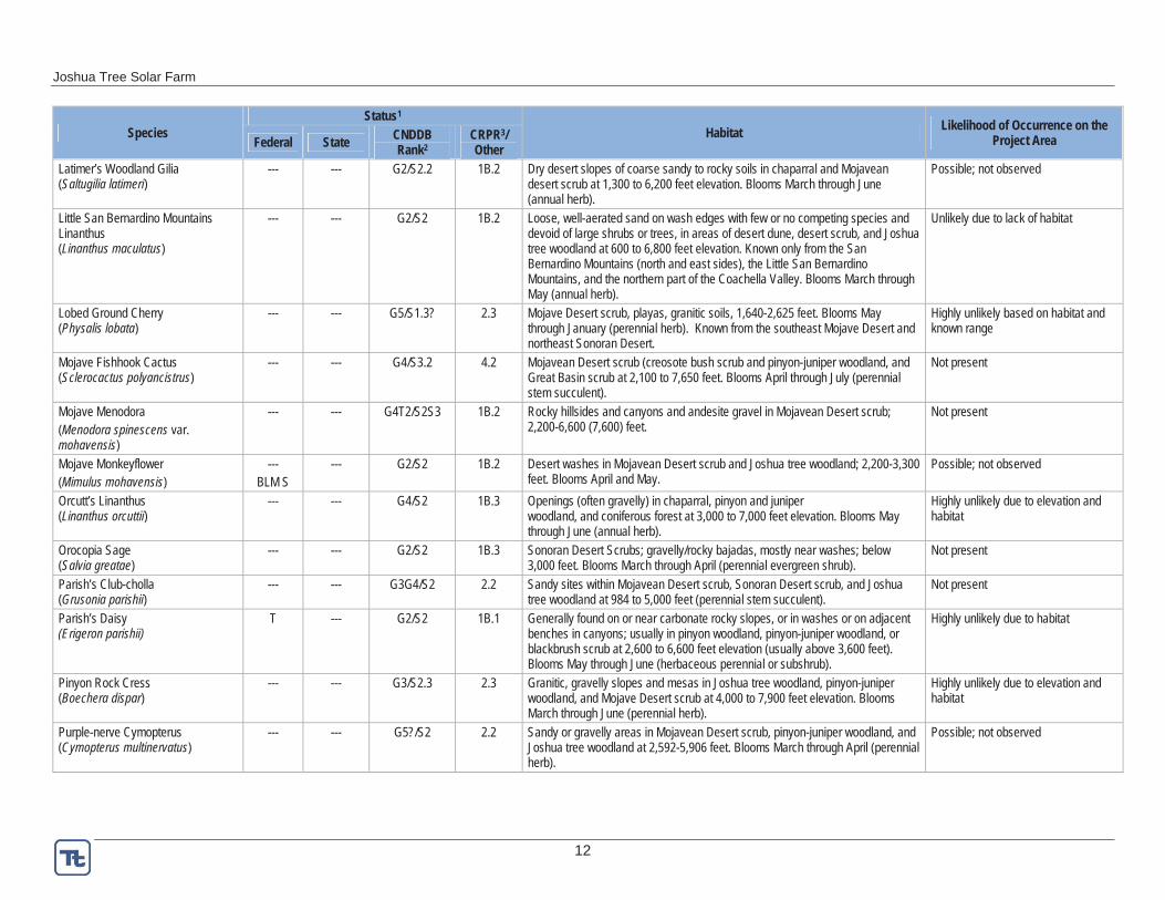
Joshua Tree Solar Farm
12
Species Status1
Habitat Likelihood of Occurrence on the Project AreaFederal State CNDDB
Rank2CRPR3/Other
Latimer’s Woodland Gilia (Saltugilia latimeri)
--- --- G2/S2.2 1B.2 Dry desert slopes of coarse sandy to rocky soils in chaparral and Mojavean desert scrub at 1,300 to 6,200 feet elevation. Blooms March through June (annual herb).
Possible; not observed
Little San Bernardino Mountains Linanthus (Linanthus maculatus)
--- --- G2/S2 1B.2 Loose, well-aerated sand on wash edges with few or no competing species and devoid of large shrubs or trees, in areas of desert dune, desert scrub, and Joshua tree woodland at 600 to 6,800 feet elevation. Known only from the San Bernardino Mountains (north and east sides), the Little San Bernardino Mountains, and the northern part of the Coachella Valley. Blooms March through May (annual herb).
Unlikely due to lack of habitat
Lobed Ground Cherry (Physalis lobata)
--- --- G5/S1.3? 2.3 Mojave Desert scrub, playas, granitic soils, 1,640-2,625 feet. Blooms May through January (perennial herb). Known from the southeast Mojave Desert and northeast Sonoran Desert.
Highly unlikely based on habitat and known range
Mojave Fishhook Cactus (Sclerocactus polyancistrus)
--- --- G4/S3.2 4.2 Mojavean Desert scrub (creosote bush scrub and pinyon-juniper woodland, and Great Basin scrub at 2,100 to 7,650 feet. Blooms April through July (perennial stem succulent).
Not present
Mojave Menodora (Menodora spinescens var. mohavensis)
--- --- G4T2/S2S3 1B.2 Rocky hillsides and canyons and andesite gravel in Mojavean Desert scrub; 2,200-6,600 (7,600) feet.
Not present
Mojave Monkeyflower (Mimulus mohavensis)
---BLM S
--- G2/S2 1B.2 Desert washes in Mojavean Desert scrub and Joshua tree woodland; 2,200-3,300 feet. Blooms April and May.
Possible; not observed
Orcutt’s Linanthus (Linanthus orcuttii)
--- --- G4/S2 1B.3 Openings (often gravelly) in chaparral, pinyon and juniper woodland, and coniferous forest at 3,000 to 7,000 feet elevation. Blooms May through June (annual herb).
Highly unlikely due to elevation and habitat
Orocopia Sage (Salvia greatae)
--- --- G2/S2 1B.3 Sonoran Desert Scrubs; gravelly/rocky bajadas, mostly near washes; below 3,000 feet. Blooms March through April (perennial evergreen shrub).
Not present
Parish’s Club-cholla (Grusonia parishii)
--- --- G3G4/S2 2.2 Sandy sites within Mojavean Desert scrub, Sonoran Desert scrub, and Joshua tree woodland at 984 to 5,000 feet (perennial stem succulent).
Not present
Parish’s Daisy(Erigeron parishii)
T --- G2/S2 1B.1 Generally found on or near carbonate rocky slopes, or in washes or on adjacent benches in canyons; usually in pinyon woodland, pinyon-juniper woodland, or blackbrush scrub at 2,600 to 6,600 feet elevation (usually above 3,600 feet). Blooms May through June (herbaceous perennial or subshrub).
Highly unlikely due to habitat
Pinyon Rock Cress (Boechera dispar)
--- --- G3/S2.3 2.3 Granitic, gravelly slopes and mesas in Joshua tree woodland, pinyon-juniper woodland, and Mojave Desert scrub at 4,000 to 7,900 feet elevation. Blooms March through June (perennial herb).
Highly unlikely due to elevation and habitat
Purple-nerve Cymopterus (Cymopterus multinervatus)
--- --- G5?/S2 2.2 Sandy or gravelly areas in Mojavean Desert scrub, pinyon-juniper woodland, and Joshua tree woodland at 2,592-5,906 feet. Blooms March through April (perennial herb).
Possible; not observed
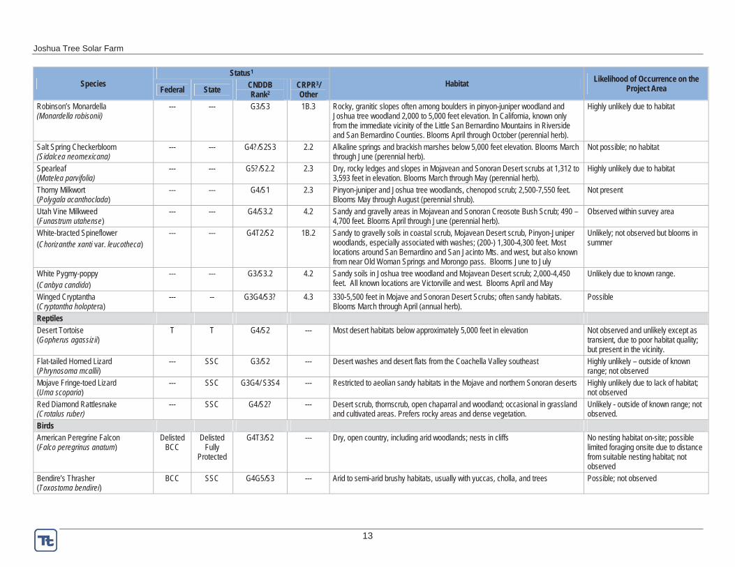
Joshua Tree Solar Farm
13
Species Status1
Habitat Likelihood of Occurrence on the Project AreaFederal State CNDDB
Rank2CRPR3/Other
Robinson’s Monardella(Monardella robisonii)
--- --- G3/S3 1B.3 Rocky, granitic slopes often among boulders in pinyon-juniper woodland and Joshua tree woodland 2,000 to 5,000 feet elevation. In California, known only from the immediate vicinity of the Little San Bernardino Mountains in Riverside and San Bernardino Counties. Blooms April through October (perennial herb).
Highly unlikely due to habitat
Salt Spring Checkerbloom(Sidalcea neomexicana)
--- --- G4?/S2S3 2.2 Alkaline springs and brackish marshes below 5,000 feet elevation. Blooms March through June (perennial herb).
Not possible; no habitat
Spearleaf (Matelea parvifolia)
--- --- G5?/S2.2 2.3 Dry, rocky ledges and slopes in Mojavean and Sonoran Desert scrubs at 1,312 to 3,593 feet in elevation. Blooms March through May (perennial herb).
Highly unlikely due to habitat
Thorny Milkwort (Polygala acanthoclada)
--- --- G4/S1 2.3 Pinyon-juniper and Joshua tree woodlands, chenopod scrub; 2,500-7,550 feet. Blooms May through August (perennial shrub).
Not present
Utah Vine Milkweed (Funastrum utahense)
--- --- G4/S3.2 4.2 Sandy and gravelly areas in Mojavean and Sonoran Creosote Bush Scrub; 490 – 4,700 feet. Blooms April through June (perennial herb).
Observed within survey area
White-bracted Spineflower (Chorizanthe xanti var. leucotheca)
--- --- G4T2/S2 1B.2 Sandy to gravelly soils in coastal scrub, Mojavean Desert scrub, Pinyon-Juniper woodlands, especially associated with washes; (200-) 1,300-4,300 feet. Most locations around San Bernardino and San Jacinto Mts. and west, but also known from near Old Woman Springs and Morongo pass. Blooms June to July
Unlikely; not observed but blooms in summer
White Pygmy-poppy (Canbya candida)
--- --- G3/S3.2 4.2 Sandy soils in Joshua tree woodland and Mojavean Desert scrub; 2,000-4,450 feet. All known locations are Victorville and west. Blooms April and May
Unlikely due to known range.
Winged Cryptantha (Cryptantha holoptera)
--- -- G3G4/S3? 4.3 330-5,500 feet in Mojave and Sonoran Desert Scrubs; often sandy habitats. Blooms March through April (annual herb).
Possible
ReptilesDesert Tortoise (Gopherus agassizii)
T T G4/S2 --- Most desert habitats below approximately 5,000 feet in elevation Not observed and unlikely except as transient, due to poor habitat quality; but present in the vicinity.
Flat-tailed Horned Lizard (Phrynosoma mcallii)
--- SSC G3/S2 --- Desert washes and desert flats from the Coachella Valley southeast Highly unlikely – outside of known range; not observed
Mojave Fringe-toed Lizard (Uma scoparia)
--- SSC G3G4/ S3S4 --- Restricted to aeolian sandy habitats in the Mojave and northern Sonoran deserts Highly unlikely due to lack of habitat; not observed
Red Diamond Rattlesnake (Crotalus ruber)
--- SSC G4/S2? --- Desert scrub, thornscrub, open chaparral and woodland; occasional in grassland and cultivated areas. Prefers rocky areas and dense vegetation.
Unlikely - outside of known range; not observed.
BirdsAmerican Peregrine Falcon (Falco peregrinus anatum)
Delisted BCC
Delisted Fully
Protected
G4T3/S2 --- Dry, open country, including arid woodlands; nests in cliffs No nesting habitat on-site; possible limited foraging onsite due to distance from suitable nesting habitat; not observed
Bendire’s Thrasher (Toxostoma bendirei)
BCC SSC G4G5/S3 --- Arid to semi-arid brushy habitats, usually with yuccas, cholla, and trees Possible; not observed
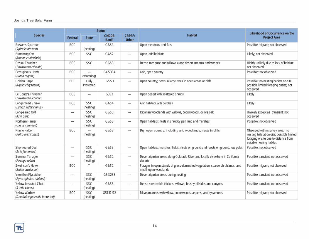
Joshua Tree Solar Farm
14
Species Status1
Habitat Likelihood of Occurrence on the Project AreaFederal State CNDDB
Rank2CRPR3/Other
Brewer’s Sparrow (Spizella breweri)
BCC --- (nesting)
G5/S3 --- Open meadows and flats Possible migrant; not observed
Burrowing Owl (Athene cunicularia)
BCC SSC G4/S2 --- Open, arid habitats Likely; not observed
Crissal Thrasher (Toxostoma crissale)
BCC SSC G5/S3 --- Dense mesquite and willows along desert streams and washes Highly unlikely due to lack of habitat; not observed
Ferruginous Hawk (Buteo regalis)
BCC --- (wintering)
G4/S3S4 --- Arid, open country Possible; not observed
Golden Eagle (Aquila chrysaetos)
BCC Fully Protected
G5/S3 --- Open country; nests in large trees in open areas or cliffs Possible; no nesting habitat on-site; possible limited foraging onsite; not observed
Le Conte’s Thrasher (Toxostoma lecontei)
BCC --- G3S3 --- Open desert with scattered shrubs Likely
Loggerhead Shrike (Lanius ludovicianus)
BCC SSC (nesting)
G4/S4 --- Arid habitats with perches Likely
Long-eared Owl (Asio otus)
--- SSC (nesting)
G5/S3 --- Riparian woodlands with willows, cottonwoods, or live oak. Unlikely except as transient; not observed
Northern Harrier (Circus cyaneus)
--- SSC(nesting)
G5/S3 --- Open habitats; nests in shrubby pen land and marshes Possible; not observed
Prairie Falcon (Falco mexicanus)
BCC --- (nesting)
G5/S3 --- Dry, open country, including arid woodlands; nests in cliffs Observed within survey area; no nesting habitat on-site; possible limited foraging onsite due to distance from suitable nesting habitat
Short-eared Owl (Asio flammeus)
--- SSC (nesting)
G5/S3 --- Open habitats: marshes, fields; nests on ground and roosts on ground, low poles Possible; not observed
Summer Tanager (Piranga rubra)
--- SSC (nesting)
G5/S2 --- Desert riparian areas along Colorado River and locally elsewhere in California deserts
Possible transient; not observed
Swainson’s Hawk (Buteo swainsoni)
BCC T G5/S2 --- Forages in open stands of grass-dominated vegetation, sparse shrublands, and small, open woodlands
Possible migrant; not observed
Vermilion Flycatcher (Pyrocephalus rubinus)
--- SSC (nesting)
G5 S2S3 --- Desert riparian areas during nesting Possible transient; not observed
Yellow-breasted Chat (Icteria virens)
--- SSC (nesting)
G5/S3 --- Dense streamside thickets, willows; brushy hillsides and canyons Possible transient; not observed
Yellow Warbler (Dendroica petechia brewsteri)
BCC SSC (nesting)
G5T3?/S2 --- Riparian areas with willow, cottonwoods, aspens, and sycamores Possible migrant; not observed
Joshua Tree Solar Farm
15
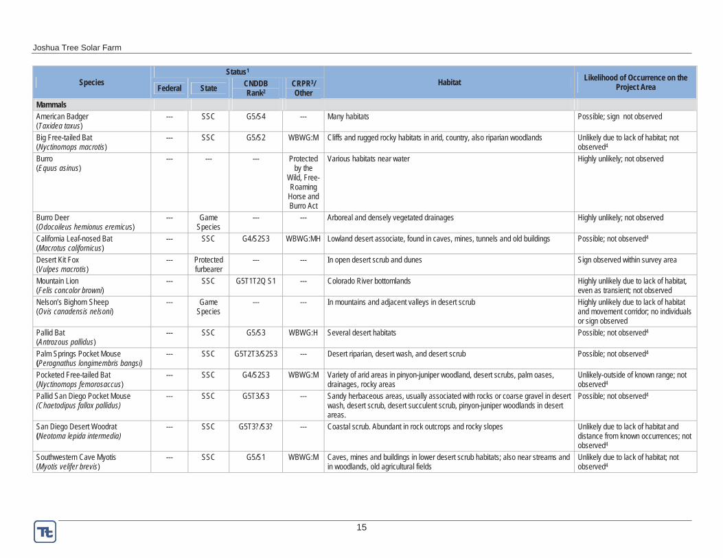
Species Status1
Habitat Likelihood of Occurrence on the Project AreaFederal State CNDDB
Rank2CRPR3/Other
Mammals American Badger (Taxidea taxus)
--- SSC G5/S4 --- Many habitats Possible; sign not observed
Big Free-tailed Bat (Nyctinomops macrotis)
--- SSC G5/S2 WBWG:M Cliffs and rugged rocky habitats in arid, country, also riparian woodlands Unlikely due to lack of habitat; not observed4
Burro(Equus asinus)
--- --- --- Protected by the
Wild, Free-Roaming
Horse and Burro Act
Various habitats near water Highly unlikely; not observed
Burro Deer (Odocoileus hemionus eremicus)
--- Game Species
--- --- Arboreal and densely vegetated drainages Highly unlikely; not observed
California Leaf-nosed Bat (Macrotus californicus)
--- SSC G4/S2S3 WBWG:MH Lowland desert associate, found in caves, mines, tunnels and old buildings Possible; not observed4
Desert Kit Fox (Vulpes macrotis)
--- Protected furbearer
--- --- In open desert scrub and dunes Sign observed within survey area
Mountain Lion (Felis concolor browni)
--- SSC G5T1T2Q S1 --- Colorado River bottomlands Highly unlikely due to lack of habitat, even as transient; not observed
Nelson’s Bighorn Sheep (Ovis canadensis nelsoni)
--- Game Species
--- --- In mountains and adjacent valleys in desert scrub Highly unlikely due to lack of habitat and movement corridor; no individuals or sign observed
Pallid Bat (Antrozous pallidus)
--- SSC G5/S3 WBWG:H Several desert habitats Possible; not observed4
Palm Springs Pocket Mouse (Perognathus longimembris bangsi)
--- SSC G5T2T3/S2S3 --- Desert riparian, desert wash, and desert scrub Possible; not observed4
Pocketed Free-tailed Bat (Nyctinomops femorosaccus)
--- SSC G4/S2S3 WBWG:M Variety of arid areas in pinyon-juniper woodland, desert scrubs, palm oases, drainages, rocky areas
Unlikely-outside of known range; not observed4
Pallid San Diego Pocket Mouse (Chaetodipus fallax pallidus)
--- SSC G5T3/S3 --- Sandy herbaceous areas, usually associated with rocks or coarse gravel in desert wash, desert scrub, desert succulent scrub, pinyon-juniper woodlands in desert areas.
Possible; not observed4
San Diego Desert Woodrat (Neotoma lepida intermedia)
--- SSC G5T3?/S3? --- Coastal scrub. Abundant in rock outcrops and rocky slopes Unlikely due to lack of habitat and distance from known occurrences; not observed4
Southwestern Cave Myotis (Myotis velifer brevis)
--- SSC G5/S1 WBWG:M Caves, mines and buildings in lower desert scrub habitats; also near streams and in woodlands, old agricultural fields
Unlikely due to lack of habitat; not observed4
Joshua Tree Solar Farm
16
Species Status1
Habitat Likelihood of Occurrence on the Project AreaFederal State CNDDB
Rank2CRPR3/Other
Spotted Bat (Euderma maculatum)
--- SSC G4 /S2S3 WBWG:H Arid scrub and grasslands, to coniferous forests, roosts in cliffs, forages along waterways
Unlikely due to lack of habitat; not observed4
Townsend’s Big-eared Bat (Corynorhinus townsendii)
--- SSC G4/S2S3 WBWG:H Broad habitat associations. Roosts in caves and manmade structures; feeds in trees
Possible; not observed4
Western Mastiff Bat (Eumops perotis californicus)
--- SSC G5T4/S3? WBWG:H Cliffs, trees, tunnels, buildings in desert scrub Possible; not observed4
Western Yellow Bat (Lasiurus xanthinus)
--- SSC G5/S3 WBWG:H Found in desert and riparian areas of the southwest U.S. Individuals roost in the dead fronds of palm trees, and have also been documented roosting in cottonwood trees.
Unlikely due to lack of habitat; not observed4
Sources: Unless noted, information is from CNDDB RareFind 2012, The Jepson Manual (Baldwin et al. 2002), CNPS Online Inventory (CNPS 2011), and Jepson Flora Project (http://ucjeps.berkeley.edu/), Calflora 2012 1 CDFG and CNDDB Habitat Data Analysis Branch, Biogeographic Data Branch January 2011, http://www.dfg.ca.gov/biogeodata/cnddb/pdfs/SPAnimals.pdf E Endangered T Threatened BCC USFWS Bird of Conservation Concern State SC CDFG Species of Special Concern (species that appear to be vulnerable to extinction) Fully Protected Species that cannot be taken without authorization from the Fish and Game Commission
WBWG = Western Bat Working Group (http://wbwg.org)H – High Priority – These species should be considered the highest priority for funding, planning, and conservation actions. M – Medium Priority – These species warrant closer evaluation, more research, and conservation actions of both the species and the threats L – Low Priority – Most of the existing data support stable populations of the species and that the potential for major changes in status is unlikely
2 CNDDB 2012: California Department of Fish and Game, California Natural Diversity Database, Special Animals, January 2011 (www.dfg.ca.gov/biogeodata/cnddb/pdfs/spanimals.pdf) and CDFG Special Vascular Plants, Bryophytes, and Lichens List, January 2012 (www.dfg.ca.gov/biogeodata/cnddb/pdfs/SPPlants.pdf). CNDDB Rank Interpretation (from http://www.natureserve.org/explorer/ranking.htm#interpret)
Global Rank State Rank G1 = Critically Imperiled S1 = Critically Imperiled G2 = Imperiled S2 = Imperiled G3 = Vulnerable S3 = Vulnerable G4 = Apparently Secure S4 = Apparently Secure G5 = Secure S5 = Secure ? = Inexact Numeric Rank SX= All California sites are extirpated
Subspecies or Variety Rank and Other Symbols T1-T5: same definition as global and state ranks, except that rank only applies to the particular variety or subspecies. X: species is considered extirpated
3 California Rare Plant Rank (CRPR) (CNPS 2011): List 1A - Plants presumed extinct in California List 1B - Plants rare and endangered in California and elsewhere List 2 - Plants rare and endangered in California but more common elsewhere List 3 - Plants about which CNPS needs more information List 4 - Plants of limited distribution (Watch List) (Note: CRPR 1 and 2 plants require CEQA consideration.)
Threat Ranks: 0.1-Seriously threatened in California (high degree/immediacy of threat) 0.2-Fairly threatened in California (moderate degree/immediacy of threat) 0.3-Not very threatened in California (low degree/immediacy of threats or no current threats known)
4 Not observed; however, no focused surveys were conducted (e.g., mist-netting, trapping).
Joshua Tree Solar Farm
17
4.2 Field Survey Methods, Spring 2012
Dr. Alice Karl, Emily Mix, and Tim Thomas conducted surveys of an approximately 117-acre area on May 16, 2012. All special-status species in Table 3 were sought concurrently with desert tortoise surveys. Surveys were conducted between 0600 and 1900 with a break between 1245 and 1630 when temperatures exceeded FWS limits for desert tortoise surveys. The 60-foot wide gen-tie corridor (on the west side of Sunfair Road) was surveyed on April 4, 2012 (Figure 3). Desert tortoise and burrowing owl buffer surveys generally were not conducted outside the survey area because of the complexity of surrounding private land ownership. However, access to several parcels was available to the south and southwest of the Project. These parcels were surveyed in April 2012 and the information gathered from these areas was used to provide an understanding of the quality of habitat and biological resources present in the surrounding area. Survey methods were reviewed and approved by FWS and CDFG prior to commencing field work (Tetra Tech and Karl 2012, Appendix C). Table 4 presents the weather conditions during surveys. Detailed methods are provided in the following sections.
Table 4. Weather Conditions during Spring 2012 Field Surveys
Date Temperature* (°C) Average
Cloud CoverDaily Wind
Speed Range (mph) Start End4-Apr 10.9 25.6 53% 0-9
16-May 32.8 38.9 0 0-5 *Temperatures were taken at 5 cm above ground level in the shade of the surveyor
4.2.1 Rare Plant and Vegetation Surveys
4.2.1.1 Special-status Plant Species
Prior to conducting surveys, surveyors reviewed the target species’ descriptions, photographs of live or herbarium specimens, and microhabitat associations. Surveyors carried plant keys and descriptions to ensure correct identification of all species observed. Because of the very poor rainfall during the previous winter, germination of annual native species was virtually non-existent, so no reference populations were available for examination. But, the surveyors were largely very familiar with all of the species in question, having seen them elsewhere in other years. All perennial species could be identified without blooms.
Surveys for special-status plants achieved 100 percent visual coverage (30-foot transects) of the survey area. However, below-average precipitation had fallen in Winter 2011-2012, resulting in well below-average germination and low biomass of annual forbs (Table 5); virtually no native annuals germinated this year at the site. Precipitation in February was closer to average which prompted several perennial species and a few individuals of exotic annuals to leaf out and/or bloom.
In addition to targeting special-status species, a complete inventory was made of all species observed growing on the survey area.
Joshua Tree Solar Farm
18
Table 5. 2011 and 2012 Monthly Precipitation Data (in inches), Joshua Tree, CA
YEAR Jan Feb Mar Apr May June Jul Aug Sept Oct Nov Dec Annual2011 0.00 0.57 0.14 0.06 0.00 0.00 0.32 0.69 0.27 0.01 0.16 0.08 2.30 2012 0.01 0.43 0.20 0.14 TBD TBD TBD TBD TBD TBD TBD TBD 0.78 Average 1959-2012 0.62 0.48 0.40 0.13 0.18 0.01 0.33 0.45 0.34 0.33 0.61 0.79 4.51
Source: Western Regional Climate Center (WRCC 2012) TBD: To Be Determined – Data not currently available for these months
4.2.1.2 Species Protected by the California Desert Native Plants Act and San Bernardino County Code
Surveyors counted all individuals of the native species protected by the CDNPA and San Bernardino County code within the survey area, except Joshua trees that were clearly planted for landscaping, and escaped landscape palo verde next to the cement plant. For naturally occurring Joshua trees (the only native tree on the survey area), the location, height, and diameter at breast height was recorded.
4.2.1.3 Vegetation Communities and Special Habitats
Surveyors described and mapped vegetation communities throughout the survey area. Vegetation communities were described based on biotic and abiotic features, including but not limited to, species composition, species density and dominance, shrub cover percent, shrub height, common understory species, soils, substrates, hydrology, and topography. Mapping included communities determined by CDFG to be sensitive (e.g., CNDDB Natural Communities1
with a G or S rank 1-3) or otherwise special. Surrounding anthropogenic and natural features that could provide insight into populations of special-status species, including population functioning (e.g., corridors), and existing or anticipated impacts to special-status species, were also identified and mapped.
4.2.1.4 Non-native Plants
Invasive plants are defined as any non-native plant species that are injurious to the public health, agriculture, recreation, wildlife habitat, or the biodiversity of native habitats. To determine which invasive species are currently present and their approximate abundance, surveyors inventoried all invasive plant species and recorded the location of concentrations. Special attention was given to the highly invasive and noxious Sahara mustard (Brassica tournefortii),Russian thistle (Salsola tragus), and tamarisk (Tamarix sp.). Filaree (Erodium cicutarium) and the nearly ubiquitous exotic annual, Mediterranean grass (Schismus sp.), was identified but not evaluated for concentrations.
4.2.2 Wildlife Surveys
Surveys were conducted only of the proposed Project site; no tortoise or burrowing owl buffer surveys were conducted of most of the surrounding lands due to difficulty in contacting landowners and obtaining their permission to access their parcels. However, access was available to several parcels to the south and southwest of the Project site, which were surveyed
1 http://www.dfg.ca.gov/bigeographicaldata/vegcamp/natural_comm_background.asp
Joshua Tree Solar Farm
19
to provide an understanding of wildlife presence and habitat suitability in the surrounding area. In surrounding locations that were not accessible, surveyors conducted a visual assessment of the habitat from the survey area’s borders. All transect data were recorded on specially-designed data forms (Appendix D) and representative areas photographed. Specific survey methods for each taxon are described below.
4.2.2.1 Desert Tortoise
On April 4 (gen-tie route only) and May 16, 2012, surveyors followed FWS protocols for surveying desert tortoise (FWS 2010) using ~30-foot (10-meter) wide, contiguous transects to achieve 100 percent visual coverage (Figure 3). During the hotter May survey, morning surveys were halted when ambient temperatures at 2 inches (5 centimeters) above the ground rose to 104°F (40°C) and resumed later in the afternoon when the ambient temperature again cooled to this survey threshold. Surveyors sought all tortoise sign (tortoises, burrows, shells, scat, tracks, drinking depressions) and if observed, surveyors measured, mapped, and described tortoise sign relative to condition, age and, if possible, gender (see Appendix E for a Key to Sign Classes). If observed, tortoises were photographed only if achieved without touching or otherwise harassing the tortoise. If observed, tortoise location relative to its burrow (i.e., aboveground, visible in burrow, not visible in burrow) was recorded because of its relevance to the FWS calculation for tortoise density. If observed, shells and shell parts were evaluated relative to the cause of death, if possible. Current and recent weather conditions were recorded and the topography, drainage patterns, soils, substrates, plant cover, and aspect-dominant, common and occasional plant species described and mapped. All incidental sightings of common ravens, other known tortoise predators, and other site features (e.g., anthropogenic influences) that could assist in the analysis of tortoise population impacts were recorded and mapped. Mapping was achieved using a Global Positioning System unit.
4.2.2.2 Mojave Fringe-toed Lizard
There are no formal survey protocols for Mojave fringe-toed lizards; therefore, surveys were conducted concurrently with desert tortoise surveys. Desert tortoise surveys achieved 100 percent visual coverage of the ground surface; therefore, survey intensity was sufficient to determine presence or absence of Mojave fringe-toed lizards as well as map the boundaries of potential Mojave fringe-toed lizard habitat.
4.2.2.3 Burrowing Owl
CDFG generally requires protocol surveys for burrowing owls that are consistent with the California Burrowing Owl Consortium (CBOC) Guidelines (CBOC 1993). The guidelines recommend a set of consecutive surveys, each following the previous based on the latter’s results:
Phase I: Habitat Assessment – This “first step in the survey process is to assess the presence of burrowing owl habitat on the Project site including a 150-meter (approx. 500 feet) buffer zone around the Project boundary...”
“The Phase II burrow survey is required if burrowing owl habitat occurs on the site. If burrowing owl habitat is not present on the Project site and buffer zone, the Phase II burrow survey is not necessary.”
Joshua Tree Solar Farm
20
Phase II: Burrow Survey – “A survey for burrows and owls should be conducted by walking through suitable habitat over the entire Project site and in areas within 500 feet (150 meters) () of the Project impact zone. This 500-foot buffer zone is included to account for adjacent burrows and foraging habitat outside the Project area and impacts from factors such as noise and vibration due to heavy equipment which could impact resources outside the Project area.”
Phase III: Owl Presence – “If the Project site contains burrows that could be used by burrowing owls, then...surveys in the breeding season are required to describe if, when, and how the site is used by burrowing owls. If no owls are observed using the site during the breeding season, a winter survey is required.” The survey methodology requires four site visits, each on a separate day. Birds are observed from two hours before sunset to one hour after sunset, or from one hour before sunrise to two hours after sunrise. The four visits are initially conducted during the nesting season, February 1 to August 31, although it is preferable to survey at the height of the breeding season, between April 15 and July 15. If no owls are observed during the nesting season, then “winter surveys should be conducted between December 1 and January 31... (to) count and map all owl sightings, occupied burrows, and burrows with owl sign.”
Surveys were generally conducted according to CBOC guidelines with the exception of buffer zone surveys. The Phase I survey was completed in April 2012 and it was determined that burrowing owl habitat is present throughout the survey area and vicinity. Phase II surveys were completed of the gen-tie route on April 4 and of the main Project site on May 16, 2012 during the desert tortoise protocol surveys. As no burrowing owl or sign was observed during Phase II surveys, Phase III nesting-season surveys were not conducted.
4.2.2.4 Other Special-status Wildlife
All incidental observations of special-status wildlife species listed in Table 3, their sign (e.g., scat, tracks, bones, feathers, nests), their habitats (e.g., water sources, nesting habitat), or movement corridors were included when compiling and mapping survey results. Although desert kit fox is not a special-status species, no take is permitted by CDFG. Therefore, in addition to recording kit foxes, surveyors recorded and mapped all kit fox natal dens or other burrow complexes. All sign of all special-status species was qualified relative to age, size, and other factors that could illuminate the potential use of the site by the species. Additionally, an entire inventory of all wildlife species observed was recorded.
5.0 SURVEY RESULTS AND DISCUSSION This section describes the results of the Spring 2012 surveys and focuses on special-status species observations. A complete list of plants and wildlife observed during surveys can be found in Appendix F.
5.1 Rare Plants and Vegetation
5.1.1 Special-status Plant Species
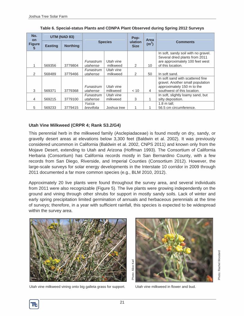
Surveyors did not find any federally or state-threatened, endangered, or candidate plant species during 2012 surveys. However, botanists did observe one CNPS-ranked plant within the survey area in 2012: Utah vine milkweed – CRPR 4 (Table 6, Figure 5).
Joshua Tree Solar Farm
21
Table 6. Special-status Plants and CDNPA Plant Observed during Spring 2012 Surveys
No.on
Figure 5
UTM (NAD 83) Species
Pop- ulation
SizeArea (m2) Comments
Easting Northing
1 569356 3779804 Funastrum utahense
Utah vine milkweed 2 10
In soft, sandy soil with no gravel. Several dried plants from 2011 are approximately 100 feet west of this location.
2 568489 3779466 Funastrum utahense
Utah vine milkweed 2 50 In soft sand.
3 569371 3779368 Funastrum utahense
Utah vine milkweed < 10 4
In soft sand with scattered fine gravel. Another small population approximately 150 m to the southwest of this location.
4 569215 3779100 Funastrum utahense
Utah vine milkweed 3 1
In soft, slightly loamy sand, but silty deposition.
5 569233 3779415 Yucca brevifolia Joshua tree 1 1
1.8 m tall;56.5 cm circumference.
Utah Vine Milkweed (CRPR 4; Rank S3.2/G4)
This perennial herb in the milkweed family (Asclepiadaceae) is found mostly on dry, sandy, or gravelly desert areas at elevations below 3,300 feet (Baldwin et al. 2002). It was previously considered uncommon in California (Baldwin et al. 2002, CNPS 2011) and known only from the Mojave Desert, extending to Utah and Arizona (Hoffman 1993). The Consortium of California Herbaria (Consortium) has California records mostly in San Bernardino County, with a few records from San Diego, Riverside, and Imperial Counties (Consortium 2012). However, the large-scale surveys for solar energy developments in the Interstate 10 corridor in 2009 through 2011 documented a far more common species (e.g., BLM 2010, 2012).
Approximately 20 live plants were found throughout the survey area, and several individuals from 2011 were also recognizable (Figure 5). The live plants were growing independently on the ground and vining through other shrubs for support in mostly sandy soils. Lack of winter and early spring precipitation limited germination of annuals and herbaceous perennials at the time of surveys; therefore, in a year with sufficient rainfall, this species is expected to be widespread within the survey area.
Pho
to: A
lice
Kar
l
Pho
to: R
ache
l Woo
dard
Utah vine milkweed vining onto big galleta grass for support. Utah vine milkweed in flower and bud.
Joshua Tree Solar Farm
22
5.1.2 CDNPA and San Bernardino County Protected Plant Species
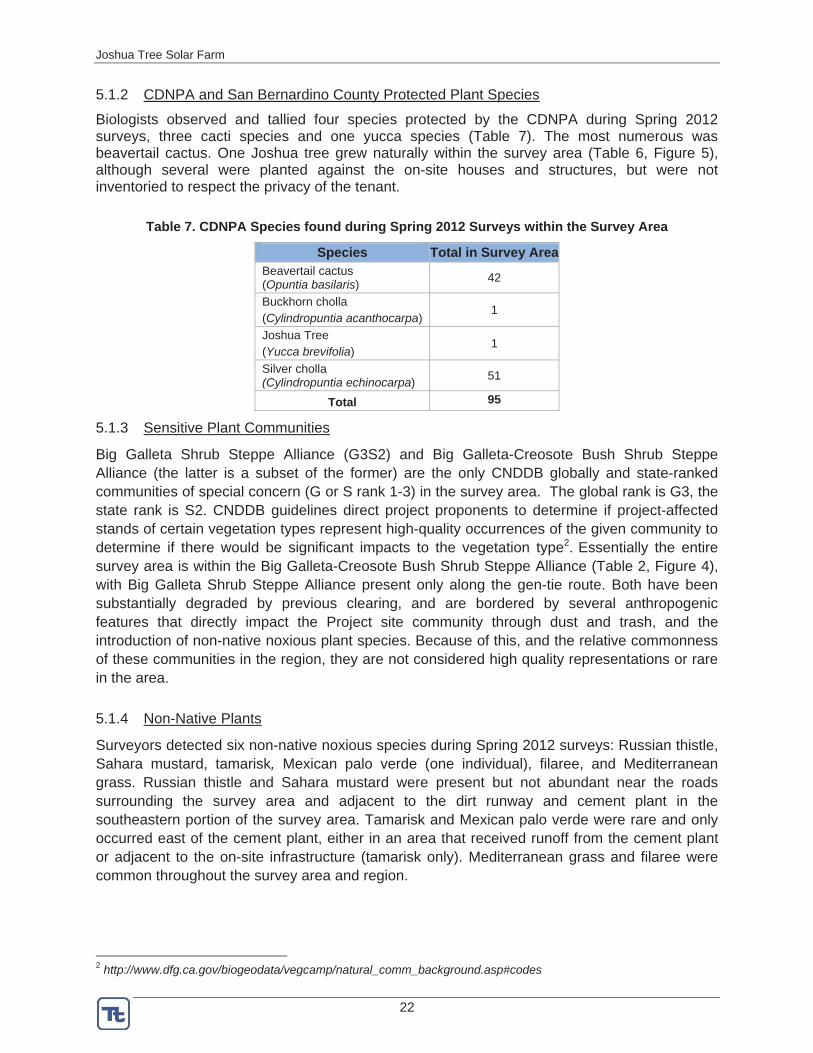
Biologists observed and tallied four species protected by the CDNPA during Spring 2012 surveys, three cacti species and one yucca species (Table 7). The most numerous was beavertail cactus. One Joshua tree grew naturally within the survey area (Table 6, Figure 5), although several were planted against the on-site houses and structures, but were not inventoried to respect the privacy of the tenant.
Table 7. CDNPA Species found during Spring 2012 Surveys within the Survey Area
Species Total in Survey Area Beavertail cactus (Opuntia basilaris) 42
Buckhorn cholla (Cylindropuntia acanthocarpa)
1
Joshua Tree(Yucca brevifolia)
1
Silver cholla (Cylindropuntia echinocarpa) 51
Total 95
5.1.3 Sensitive Plant Communities
Big Galleta Shrub Steppe Alliance (G3S2) and Big Galleta-Creosote Bush Shrub Steppe Alliance (the latter is a subset of the former) are the only CNDDB globally and state-ranked communities of special concern (G or S rank 1-3) in the survey area. The global rank is G3, the state rank is S2. CNDDB guidelines direct project proponents to determine if project-affected stands of certain vegetation types represent high-quality occurrences of the given community to determine if there would be significant impacts to the vegetation type2. Essentially the entire survey area is within the Big Galleta-Creosote Bush Shrub Steppe Alliance (Table 2, Figure 4), with Big Galleta Shrub Steppe Alliance present only along the gen-tie route. Both have been substantially degraded by previous clearing, and are bordered by several anthropogenic features that directly impact the Project site community through dust and trash, and the introduction of non-native noxious plant species. Because of this, and the relative commonness of these communities in the region, they are not considered high quality representations or rare in the area.
5.1.4 Non-Native Plants
Surveyors detected six non-native noxious species during Spring 2012 surveys: Russian thistle, Sahara mustard, tamarisk, Mexican palo verde (one individual), filaree, and Mediterranean grass. Russian thistle and Sahara mustard were present but not abundant near the roads surrounding the survey area and adjacent to the dirt runway and cement plant in the southeastern portion of the survey area. Tamarisk and Mexican palo verde were rare and only occurred east of the cement plant, either in an area that received runoff from the cement plant or adjacent to the on-site infrastructure (tamarisk only). Mediterranean grass and filaree were common throughout the survey area and region.
2 http://www.dfg.ca.gov/biogeodata/vegcamp/natural_comm_background.asp#codes
Joshua Tree Solar Farm
23
5.2 Wildlife
5.2.1 Listed Species
5.2.1.1 Desert Tortoise (FWS: Threatened; CDFG: Threatened)
No live tortoises or their sign were observed during Spring 2012 surveys of the Project site, and the entirety of the survey area is either poor quality desert tortoise habitat or developed and not habitat. The lack of recent or past sign indicates that tortoises do not currently use the Project site and have not used it in recent years. Most of the Project site is highly disturbed by the development and/or operation of the airport and the cement plant. The introduction of non-native plant species and the proximity to a well-traveled paved road (Sunfair Road) further contribute to the lowered quality of the habitat. There are only small patches of relatively undisturbed Big Galleta Grass-Creosote Bush Scrub Steppe Alliance (Figure 4). The version of this community that occurs at the Project site is inherently poor tortoise habitat and is further compromised by the surrounding disturbance.
As topography flattens toward Coyote Dry Lake east of the Project site, desert tortoise habitat quality declines due to lower coversite potential and reduced foraging opportunities. Accordingly, areas lower on the bajada likely support lower tortoise densities. Studies in the area have found tortoise sign higher on the bajada, while one study east of the airport found no sign (E. LaRue, Circle Mountain Biological Consultants, Inc., pers. comm. to A. Karl). Surveys of the proposed Cascade Solar Project, approximately one mile northeast of the Project near Coyote Dry Lake, did not detect any tortoise or tortoise sign in April 2011 (PCR 2011). The Project site is located on the lower bajada, approximately one mile from Coyote Dry Lake, and the lack of tortoise sign and poor habitat quality is consistent with these observations. Although the Project site contains no tortoises and poor habitat to non-habitat, there are no barriers to prevent tortoise movement onto the Project site from adjacent parcels that contain better habitat. The CNDDB (2012) records show tortoise occurrences in the valley surrounding the Project site (Appendix B), and one tortoise was observed in the vicinity of the Project site approximately 0.5 mile to the southwest in an area of higher quality tortoise habitat. The possibility of transient tortoise should be considered.
The survey area is not within FWS critical habitat. FWS designated critical habitat areas for the desert tortoise in 1994 (FWS 1994) and prescribed management actions to aid recovery, with critical habitat providing legal protection. The closest critical habitat unit to the survey area is the Pinto Mountain Critical Habitat Unit, approximately 12 miles to the southeast.
5.2.2 Non-listed, Special-status Species
Surveyors recorded all special-status wildlife observations and their habitat during the desert tortoise surveys (Table 8). The following discussion includes species that were not observed or otherwise detected during surveys but for which suitable habitat is present.
Joshua Tree Solar Farm
24
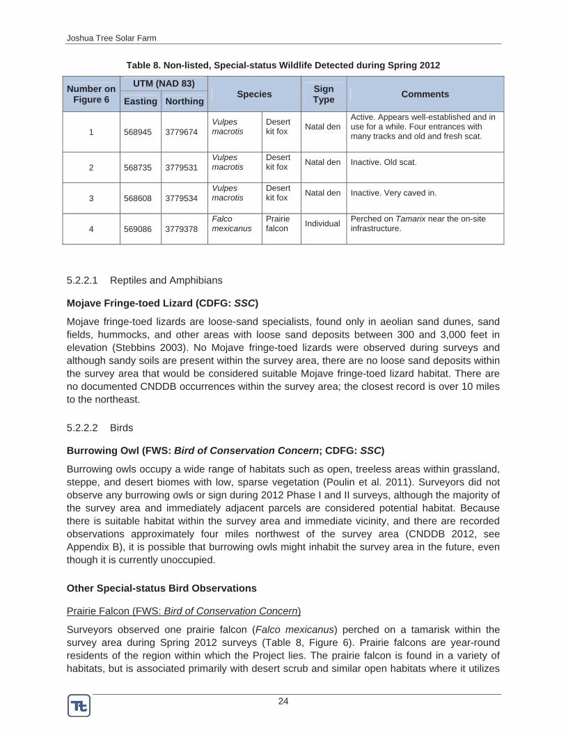
Table 8. Non-listed, Special-status Wildlife Detected during Spring 2012
Number on Figure 6
UTM (NAD 83) Species Sign
Type Comments Easting Northing
1 568945 3779674 Vulpesmacrotis
Desertkit fox Natal den
Active. Appears well-established and in use for a while. Four entrances with many tracks and old and fresh scat.
2 568735 3779531 Vulpesmacrotis
Desertkit fox Natal den Inactive. Old scat.
3 568608 3779534 Vulpesmacrotis
Desertkit fox Natal den Inactive. Very caved in.
4 569086 3779378 Falco mexicanus
Prairiefalcon Individual Perched on Tamarix near the on-site
infrastructure.
5.2.2.1 Reptiles and Amphibians
Mojave Fringe-toed Lizard (CDFG: SSC)
Mojave fringe-toed lizards are loose-sand specialists, found only in aeolian sand dunes, sand fields, hummocks, and other areas with loose sand deposits between 300 and 3,000 feet in elevation (Stebbins 2003). No Mojave fringe-toed lizards were observed during surveys and although sandy soils are present within the survey area, there are no loose sand deposits within the survey area that would be considered suitable Mojave fringe-toed lizard habitat. There are no documented CNDDB occurrences within the survey area; the closest record is over 10 miles to the northeast.
5.2.2.2 Birds
Burrowing Owl (FWS: Bird of Conservation Concern; CDFG: SSC)
Burrowing owls occupy a wide range of habitats such as open, treeless areas within grassland, steppe, and desert biomes with low, sparse vegetation (Poulin et al. 2011). Surveyors did not observe any burrowing owls or sign during 2012 Phase I and II surveys, although the majority of the survey area and immediately adjacent parcels are considered potential habitat. Because there is suitable habitat within the survey area and immediate vicinity, and there are recorded observations approximately four miles northwest of the survey area (CNDDB 2012, see Appendix B), it is possible that burrowing owls might inhabit the survey area in the future, even though it is currently unoccupied.
Other Special-status Bird Observations
Prairie Falcon (FWS: Bird of Conservation Concern)
Surveyors observed one prairie falcon (Falco mexicanus) perched on a tamarisk within the survey area during Spring 2012 surveys (Table 8, Figure 6). Prairie falcons are year-round residents of the region within which the Project lies. The prairie falcon is found in a variety of habitats, but is associated primarily with desert scrub and similar open habitats where it utilizes
Joshua Tree Solar Farm
25
open ledges and cliffs for perching and nesting and forages over the open terrain (Steenhof 1998). The Project does not provide suitable nesting habitat, although it could provide suitable foraging habitat.
5.2.2.3 Special-status Mammals
Desert Kit Fox (Protected by CDFG)
Surveyors detected one active and two inactive kit fox natal dens within the survey area (Table 8, Figure 6), and scat throughout. Desert kit fox inhabits many desert habitats, typically with less than 20 percent cover (NPS 2006). Suitable denning and foraging habitat for the desert kit fox occurs throughout the undeveloped portions of the survey area.
5.3 Potential for Other Special-status Species to Occur
5.3.1 Special-status Wildlife and Plant Species Not Observed, but Which May Occur on the Project Area
In addition to the special-status species observed during surveys, it is possible that some of the remaining special-status species from Table 3 could inhabit the survey area and immediately adjacent areas. These are noted in Table 3 and include species that may not have been observed during surveys because of their rarity, behavior, season of surveys (e.g., wintering birds or summer annuals), or lack of germination or above ground growth due to reduced rainfall. In addition, several annual plant species identified in Table 3 may not have been present during spring surveys because germination or growth occurs earlier or later in the year, or because rainfall was insufficient for germination. There are several species that have moderate potential to be present on the Project site, and may be available for surveying in fall or summer.
5.3.2 Special-status Wildlife and Plant Species Not Observed, but Which are Not Likely to Occur on the Project Area
There are some species listed in Table 3 that were determined unlikely to occur within the survey area, based on the survey area habitats or lack thereof. These are noted in Table 3. Golden eagles (Aquila chrysaetos) and Nelson’s bighorn sheep are among these species, but are of particular concern to FWS and CDFG and are therefore discussed in more detail, below.
Golden Eagle (FWS: MBTA and BGEPA; CDFG: Fully Protected)
Golden eagles are found in variety of habitats but generally prefer open spaces for hunting and cliffs, trees, or other tall structures (e.g., transmission line structures) for nesting (Kochert et al. 2002). No eagles were observed during surveys and the survey area does not contain suitable nesting habitat for eagles. The nearest CNDDB occurrence of nesting eagles is approximately 25 miles southwest of the Project. The closest mountain range to the Project with suitable nesting habitat is the Little San Bernardino Mountains, approximately 2.5 miles to the south-southwest. Therefore, it is possible that eagles nest in the Little San Bernardino Mountains and may hunt in the valley surrounding the Project. However, it is not expected that eagles will use the Project site due to the high level of disturbance on the Project and the adjacent residential and industrial development.
Joshua Tree Solar Farm
26
Bighorn Sheep (CDFG: Managed Game Species)
Nelson’s bighorn sheep require steep, rocky terrain to escape predators and raise lambs, and movement corridors among mountain ranges are important to maintaining healthy populations. CNDDB records indicate that the Little San Bernardino Mountains, approximately 2.5 miles south of the survey area, are occupied by bighorn sheep. However, the Project site does not contain suitable bighorn sheep lambing or foraging habitat; nor is it situated in a movement corridor between important mountain ranges. Residential and industrial development in the valley, lack of steep, rocky habitat on or near the Project site, and the absence of occupied mountain ranges north of the Project site preclude the use of this site by bighorn sheep. The Project site is not within a known bighorn sheep corridor as identified in A Linkage Design for the Joshua Tree-Twentynine Palms Connection (Penrod et al. 2008). Not surprisingly, no evidence of Nelson’s bighorn sheep was found during field surveys.
6.0 POTENTIAL IMPACTS AND PROPOSED MITIGATION
6.1 Special-status Plants
6.1.1 Utah Vine Milkweed
Utah vine milkweed is CRPR 4 and does not meet the requirements to trigger consideration under CEQA; therefore, no species-specific mitigation measures are required. However, the topsoil, which contains the native seed bank, should be separated and set aside during grading and redistributed over temporarily disturbed areas. Using the topsoil will facilitate passive revegetation of temporarily disturbed areas. Limiting construction disturbance to only the area required for development will further minimize impacts.
6.1.2 Other Special-status Plants Not Observed but Likely to Occur
Some species of plants listed in Table 3 could occur within the survey area but were not available for observation, mostly due to the dry conditions. However, if present, these species could be impacted by Project development. Impacts include removal of individuals and/or the seed bank. Redistributing the native topsoil on temporarily disturbed areas and limiting construction disturbance to only the area required for development will minimize impacts.
6.1.3 CDNPA species
Four species protected under the CDNPA (beavertail cactus, buckhorn cholla, Joshua tree, and silver cholla, Tables 6 & 7, Figure 5) could be directly impacted by development if they fall within the Project footprint. Where feasible, individuals of these species will be avoided. For those that cannot be avoided, removal will comply with the California Desert Native Plant Protection Act and the San Bernardino County Code.
6.2 Special-status Wildlife
6.2.1 Desert Tortoise
There is no evidence that tortoises are using the Project site or have used it in the recent past. Therefore, impacts to tortoises are expected to be negligible and limited to tortoises that may wander on site. If tortoises walk onto the Project site, they could be injured or killed (e.g.,

Joshua Tree Solar Farm
27
collision with vehicles or equipment). Because of these reasons, the following mitigation measures are recommended to avoid impacts to tortoises. The following is a summary, and each measure will be described in detail in a mitigation and monitoring plan that will be submitted to and reviewed by the relevant resource agencies and the County prior to construction.
Install permanent tortoise exclusion fencing around the perimeter of the main Project site to exclude tortoise during construction and operation. Clearance surveys of the fenced site will be conducted according to FWS protocol by qualified biologists, to ensure that no tortoises are inside the site. Any newly installed fence will be monitored appropriately to ensure that no tortoises exhibit fence walking behavior that could result in injury or death to the tortoise.
Prepare a plan to accommodate any tortoises found during the clearance surveys.
Monitor and maintain the fence at appropriate intervals throughout construction and operations. This includes monitoring during storm events or other circumstances that could damage the fence.
Implement a worker environmental awareness training for all Project personnel.
Enforce speed limits of 25 miles per hour on all roads used for Project access.
Ensure that biological monitors are present during construction of the perimeter fence and during ground disturbance in unfenced areas to properly implement mitigation measures. An authorized biologist must be on site during all initial surface grubbing and grading, in the event that a tortoise is encountered. An authorized biologist must be available (not onsite) during construction activities in fenced areas that have been surveyed for and cleared of tortoises and other biological resources to promptly implement protection measures for biological resources in the unlikely event that a tortoise or other biological resource is detected onsite.
6.2.2 Burrowing Owl
Because no burrowing owls or their sign were present within the survey area and ample, suitable habitat is present in the surrounding areas, the loss of habitat due to Project development is not considered a likely adverse impact. Owls could move onto the site prior to Project development, so focused burrowing owl surveys will be completed according to CDFG guidelines within 14 days of site grading. Depending on the results of those surveys, a plan may be developed to minimize impacts to onsite owls. Other standard measures such as speed limits, limiting the area of disturbance, and having a biological monitor present for construction outside of the fenced site will contribute toward avoiding and minimizing any potential impacts to this species and their habitat.
6.2.3 Prairie Falcon
Because the survey area does not provide suitable nesting habitat for prairie falcon, and ample, suitable foraging habitat is present in the surrounding areas, the loss of foraging habitat due to Project development is not considered a likely adverse impact. However, standard measures such as limiting the area of disturbance will contribute toward avoiding any potential impacts to this species and their habitat.
Joshua Tree Solar Farm
28
6.2.4 Nesting Birds
Vegetation removal during construction, and construction noise and activity, could potentially adversely impact nesting birds. Therefore, to the extent feasible, vegetation removal should take place outside of the breeding season, which is typically February 15 to August 31. If construction will take place during the breeding season, pre-construction clearance surveys to locate nesting birds should be conducted immediately prior to construction. If active nests are present within the construction area, they must be avoided by establishing a non-disturbance buffer until the young fledge or the nest fails (as determined by a qualified biologist, in consultation with CDFG and USFWS). Nesting birds that are adjacent to the construction will also be avoided by this approved buffer. The buffer areas should be delineated and flagged to ensure avoidance.
6.2.5 Kit Fox
Kit fox could be affected by Project development by loss of habitat. However, ample suitable habitat is present in the surrounding areas, and the loss of habitat due to Project development is not considered a likely adverse impact. Kit fox could move onto the site prior to Project development, so surveys should be completed within 30 days of site grading. Depending on the results of those surveys, a plan may be developed to address individuals that are denning within the Project site. Other standard measures such as speed limits, limiting area of disturbance, and having biological monitors present will contribute toward minimizing any potential impacts to this species and their habitat.
7.0 OTHER RECOMMENDATIONS
Plants
Although surveys were conducted in spring, some species were not available for observation due to the dry conditions or because germination occurs in late summer or fall. If there is adequate 2012/2013 precipitation, surveys should be conducted at the appropriate time for these species to determine their presence or absence.
Wildlife
Development within the vicinity of tortoise habitat has permitting implications and frequent communication with CDFG and FWS on avoidance and permitting requirements is recommended. According to FWS (2010) pre-project survey protocol, desert tortoise survey results are valid for one year. After one year, if the site has not been developed or begun permitting, FWS and CDFG should be contacted to determine whether another survey is required.
The survey results and recommended mitigation measures within this report do not constitute authorization for incidental take of listed species. Tortoises are protected by the California Endangered Species Act and the Federal Endangered Species Act. As such, if a tortoise if found on-site during construction, all activities likely to adversely affect the tortoise should cease immediately and the County, FWS, and CDFG should be contacted to determine the appropriate course of action.
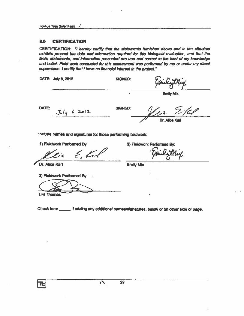
Joshua Tree Solar Farm
30
9.0 LITERATURE CITED Baldwin et al. 2002. The Jepson Desert Manual. Vascular plants of Southeastern California. University of
California Press. Berkeley, California.
Bureau of Land Management (BLM). 2010. Plan Amendment/Final EIS for the Blythe Solar Energy Power Project, Volume 1 of 2. Pages 3.18-14 – 3.18-15. August.
Bureau of Land Management (BLM). 2012. Draft Plan Amendment and Environmental Impact Statement for the McCoy Solar Energy Project, Volume 1 of 2. Page 3.3-16. May.
California Burrowing Owl Consortium (CBOC). 1993. Burrowing owl survey protocols and mitigation guidelines. Unpub. document. 13 pp.
California Department of Fish and Game (CDFG). 2009. Protocols for Surveying and Evaluating Impacts to Special Status Plant Populations and Natural Communities. 7 pp.
California Department of Fish and Game, Natural Diversity Data Base (CDFG, NDDB). 2011. http://www.dfg.ca.gov/biogeodata/cnddb/pdfs/SPAnimals.pdf. Updated January 2011.
California Natural Diversity Database (CNDDB). 2012. RareFind. Commercial Version 3.1.0. California Department of Fish and Game (CDFG), Registered to Biogeographic Data Branch. January 1, 2012; data will expire July 1, 2012.
California Native Plant Society (CNPS). 2011. Inventory of Rare and Endangered Plants (online edition, v7-12jan). California Native Plant Society. Sacramento, CA. Accessed on Fri, Feb. 17, 2012 from http://www.cnps.org/inventory
Calflora. 2012. Information on California plants for education, research and conservation. [web application]. Berkeley, California: The Calflora Database [a non-profit organization]. Available: http://www.calflora.org/
Consortium of California Herbaria (Consortium). 2012. Data provided by the participants of the Consortium of California Herbaria (ucjeps.berkeley.edu/consortium/; Wed Apr 18 12:09:36 2012).
Hoffman, C. 1993. Jepson Manual Treatment. Cynanchum vine milkweed. http://ucjeps.berkeley.edu/cgi-bin/get_JM_treatment.pl?583,602,603. Site accessed June 10, 2011.
Jepson Flora Project. 2012. University of California Berkeley. Available on-line at: http://ucjeps.berkeley.edu/jepsonflora/
Kochert, M. N., K. Steenhof, C. L. Mcintyre and E. H. Craig. 2002. Golden Eagle (Aquila chrysaetos), The Birds of North America Online (A. Poole, Ed.). Ithaca: Cornell Lab of Ornithology; Retrieved from the Birds of North America Online: http://bna.birds.cornell.edu/bna/species/684doi:10.2173/bna.684.
LaRue, E. 2012. Circle Mountain Biological Consultants, Inc. Personal Communication with Dr. Alice Karl.
National Park Service (NPS). 2006. Joshua Tree National Park; Desert Kit Fox. Available at http://www.nps.gov/jotr/naturescience/kitfox.htm.
PCR Services Corporation. 2011. General Biological Resources Assessment and Jurisdictional Determination. Cascade Solar Project, Unincorporated San Bernardino County. As submitted with the Application for CUP P201100142. May.
Joshua Tree Solar Farm
31
Penrod, K., C. Cabanero, P. Beier, C. Luke. W. Spencer, E. Rubin, and C. Paulman. 2008.. A Linkage Design of the Joshua Tree-Twentynine Palms Connection. South Coast Wildlands, Fair Oaks, CA www.scwildlands.org.
Poulin, Ray, L. Danielle Todd, E. A. Haug, B. A. Millsap and M. S. Martell. 2011. Burrowing Owl (Athene cunicularia), The Birds of North America Online (A. Poole, Ed.). Ithaca: Cornell Lab of Ornithology; Retrieved from the Birds of North America Online: http://bna.birds.cornell.edu/bna/species/061doi:10.2173/bna.61
Sawyer, T., T. Keeler-Wolf, and J.M. Evens. 2009. A Manual Of California Vegetation. Second Edition. California Native Plant Society Press. Sacramento, CA.
Stebbins, R.C. 2003. Peterson Field Guide to Western Reptiles and Amphibians. Houghton Mifflin Company. New York.
Tetra Tech and Karl. 2012. Biological Resources Survey Methods Joshua Tree Solar Farm. Prepared for BP Solar Energy North America LLC. March.
U.S. Fish and Wildlife Service (FWS). 1994. Federal Register, Department of the Interior, Fish and Wildlife Services. Rules and Regulations. Determination of Critical Habitat for the Mojave Population of the Desert Tortoise; Final Rule. 50 CFR Part 17. 59 FR 5820-5866. February 8.
__________________. 2010. Preparing for any action that may occur within the range of the Mojave desert tortoise (Gopherus agassizii). 2010 Field Season. Available at: http://www.fws.gov/ventura/speciesinfo/protocols_guidelines/ . 18 pp.
Western Regional Climate Center (WRCC). 2012. Joshua Tree, CA. http://www.wrcc.dri.edu/cgi-bin/cliMAIN.pl?ca4405 and http://www.wrcc.dri.edu/cgi-bin/cliMAIN.pl?ca4405. Accessed April 16, 2012.

Joshua Tree Solar Farm
FIGURES
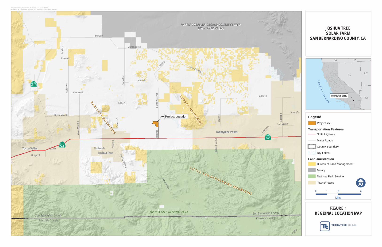
MARINE CORPS AIR GROUND COMBAT CENTERMARINE CORPS AIR GROUND COMBAT CENTERTWENTYNINE PALMSTWENTYNINE PALMS
JOSHUA TREE NATIONAL PARKSan Bernardino County
Riverside County
San Bernardino County
Riverside County
LL II TT TT LL EE SS AA NN BB EE RR NN AA RR DD II NN OO MM OO UU NN TT AA II NN SS
CCOO PPPP EERR MMOOUU NNTTAA II NN SS
BBAA RRTT LLEETT TT MMOOUUNN TTAA II NNSS
Project Location
RecheRd
IndianTrl
Giant RockRd
AberdeenDrAvalo
nAve
MonumentRd
Lear
Ave
Bord
erAv
e
YuccaTrl
Adob
eRd
La BrisaDr
Sunb
urstS
t
Yucc
a M
esaR
d
CoyoteRd
Indian
Cov
eRd
Alta LomaDr
Buena VistaDr
Quail SpringsRd
Land
ersL
n
OnagaTrl
Two MileRd
Coyo
te V
alley
Rd
LarreaAve
AmboyDrPa
rkBlvd
GoldenSt
PioneerRd
Sunf
airRd
Giant RockRd
LoopRd
Yucca ValleyYucca Valley
Twentynine PalmsTwentynine Palms
Joshua TreeJoshua Tree
PROJECT SITE
Pa
c i f i c Oc
e a n
NVUT
AZ
OR ID
FIGURE 1REGIONAL LOCATION MAP
JOSHUA TREESOLAR FARM
SAN BERNARDINO COUNTY, CA
Saved by michael.serrano on: 6/28/2012 10:25:44 AMFile Path: P:\GIS\Projects\4448_BP_Solar\ArcGIS\1_Regional.mxd
0 2 41
Miles
LegendProject site
Transportation FeaturesState Highway
Major Roads
County Boundary
Dry Lakes
Land JurisdictionBureau of Land Management
Miitary
National Park Service
Towns/Places
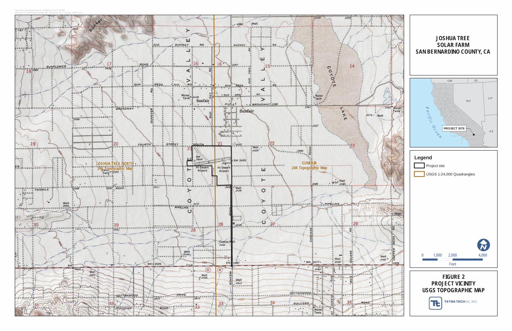
JOSHUA TREE NORTHJOSHUA TREE NORTH24K Topographic Map24K Topographic Map
SUNFAIRSUNFAIR24K Topographic Map24K Topographic Map
PROJECT SITE
Pa
c i f i c Oc
e a n
NVUT
AZ
OR ID
FIGURE 2PROJECT VICINITY
USGS TOPOGRAPHIC MAP
JOSHUA TREESOLAR FARM
SAN BERNARDINO COUNTY, CA
Saved by michael.serrano on: 6/28/2012 10:27:46 AMFile Path: P:\GIS\Projects\4448_BP_Solar\ArcGIS\2_Vicinity_USGS.mxd
0 2,000 4,0001,000
Feet
LegendProject site
USGS 1:24,000 Quadrangles
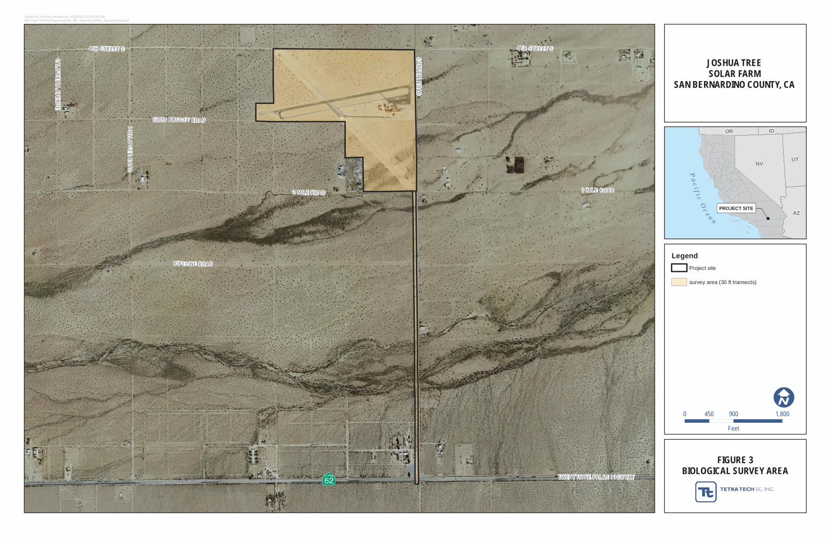
4TH STREET S
GOLD NUGGET ROAD
2 MILE ROAD
HOLLING
ER ROAD
CALIFORNIA AVENUE
SUNFAIR ROAD
4TH STREET S
PIPELINE ROAD
TWENTYNINE PALMS HIGHWAY
2 MILE ROAD
PROJECT SITE
Pa
c i f i c Oc
e a n
NVUT
AZ
OR ID
FIGURE 3BIOLOGICAL SURVEY AREA
JOSHUA TREESOLAR FARM
SAN BERNARDINO COUNTY, CA
Saved by michael.serrano on: 6/28/2012 10:34:19 AMFile Path: P:\GIS\Projects\4448_BP_Solar\ArcGIS\3_SurveyArea.mxd
0 900 1,800450
Feet
LegendProject site
survey area (30 ft transects)
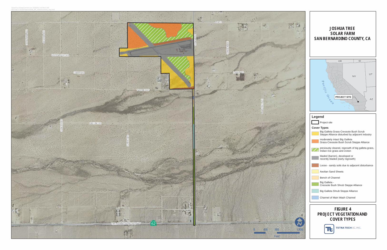
4TH ST
PIPELINE RD
SUNE
VER
RD
TWO MILE RD
COBALT RD
GOLD NUGGET RD
ARIZ
ONA
AVE
TWENTYNINE PALMS HIGHWAY
CALI
FORN
IA AV
E
SUNV
IEW
AVE
LAW
RENC
E AV
E
SUNF
AIR
RD
COBALT RD
SUNK
IST
RD
PROJECT SITE
Pa
c i f i c Oc
e a n
NVUT
AZ
OR ID
FIGURE 4PROJECT VEGETATION AND
COVER TYPES
JOSHUA TREESOLAR FARM
SAN BERNARDINO COUNTY, CA
Saved by michael.serrano on: 6/28/2012 10:39:07 AMFile Path: P:\GIS\Projects\4448_BP_Solar\ArcGIS\4_Veg.mxd
0 900 1,800450
Feet
Legend
Cover Types
Project site
Aeolian Sand Sheets
Bench of Channel
Big Galleta -Creosote Bush Shrub Steppe Alliance
Big Galleta Grass-Creosote Bush ScrubSteppe Alliance disturbed by adjacent industry
Big Galleta Shrub Steppe Alliance
Channel of Main Wash Channel
Loose - sandy soils due to adjacent disturbance
bladed (barren), developed orrecently bladed (early regrowth)
moderately intact Big GalletaGrass-Creosote Bush Scrub Steppe Alliance
previously cleared, regrowth of big galleta grass,Indian rice grass and croton
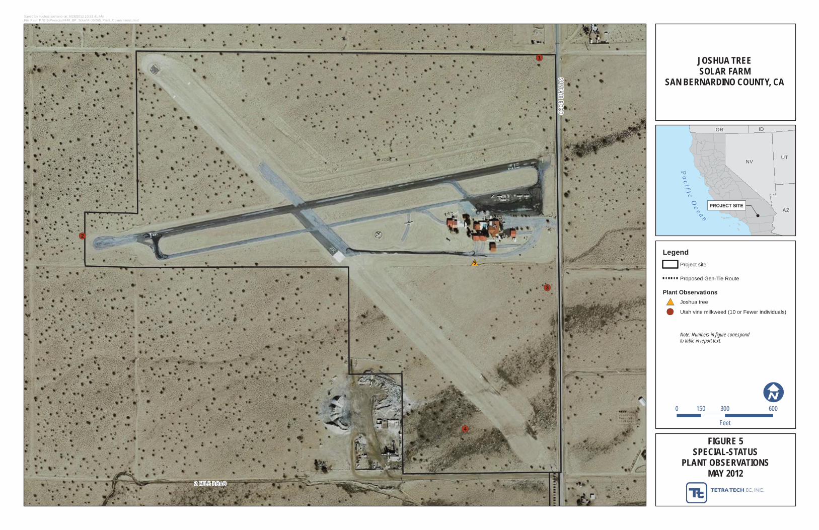
2 MILE ROAD
SUNFAIR ROAD
5
4
3
2
1
PROJECT SITE
Pa
c i f i c Oc
e a n
NVUT
AZ
OR ID
FIGURE 5SPECIAL-STATUS
PLANT OBSERVATIONSMAY 2012
JOSHUA TREESOLAR FARM
SAN BERNARDINO COUNTY, CA
Saved by michael.serrano on: 6/28/2012 10:39:41 AMFile Path: P:\GIS\Projects\4448_BP_Solar\ArcGIS\5_Plant_Observations.mxd
0 300 600150
Feet
LegendProject site
Proposed Gen-Tie Route
Plant ObservationsJoshua tree
Utah vine milkweed (10 or Fewer individuals)
Note: Numbers in figure correspondto table in report text.
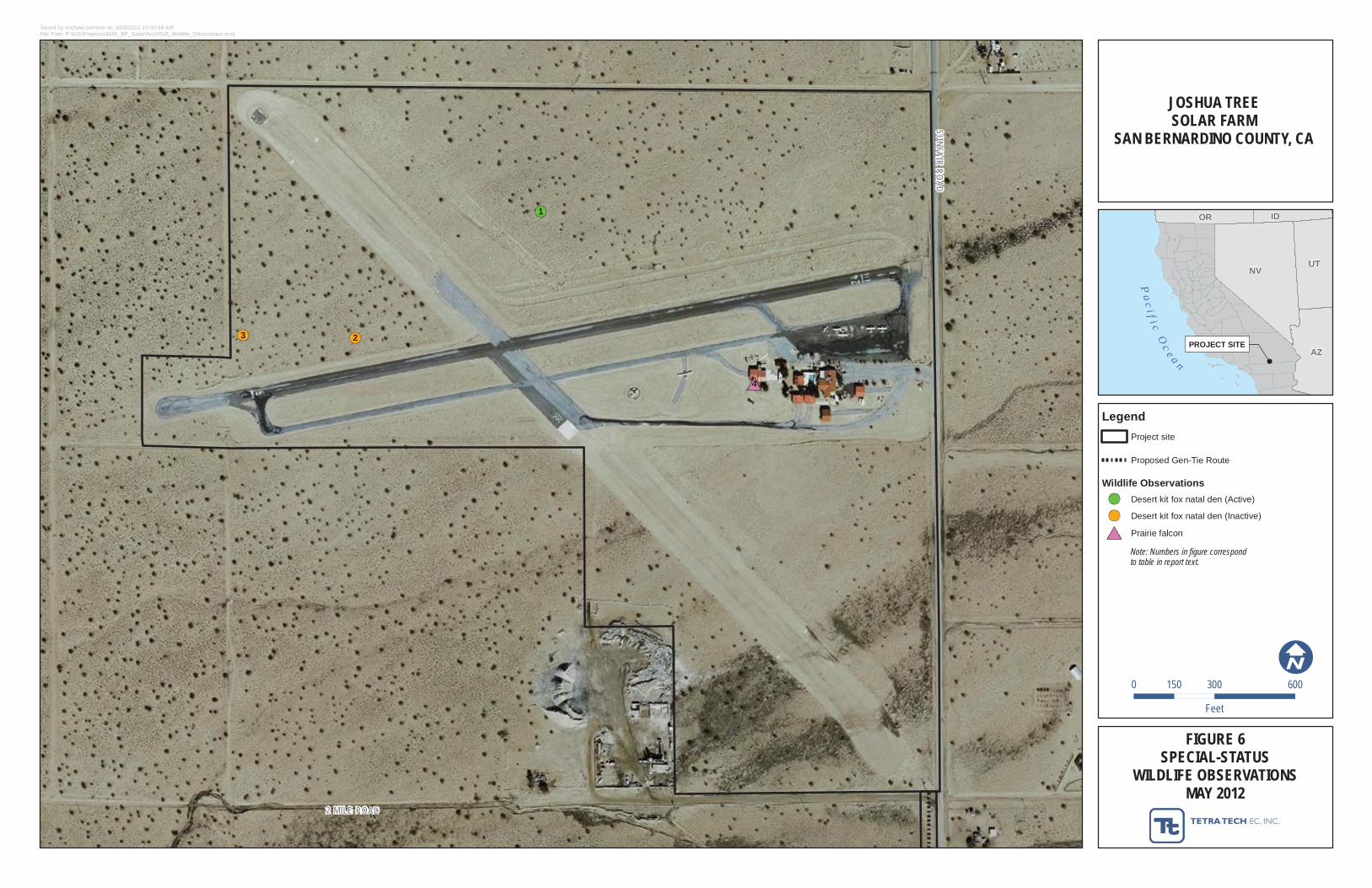
2 MILE ROAD
SUNFAIR ROAD
4
3 2
1
PROJECT SITE
Pa
c i f i c Oc
e a n
NVUT
AZ
OR ID
FIGURE 6SPECIAL-STATUS
WILDLIFE OBSERVATIONSMAY 2012
JOSHUA TREESOLAR FARM
SAN BERNARDINO COUNTY, CA
Saved by michael.serrano on: 6/28/2012 10:40:48 AMFile Path: P:\GIS\Projects\4448_BP_Solar\ArcGIS\6_Wildlife_Observation.mxd
0 300 600150
Feet
LegendProject site
Proposed Gen-Tie Route
Wildlife ObservationsDesert kit fox natal den (Active)
Desert kit fox natal den (Inactive)
Prairie falcon
Note: Numbers in figure correspondto table in report text.

Joshua Tree Solar Farm
APPENDIX A
REPRESENTATIVE PROJECT AREA PHOTOGRAPHS
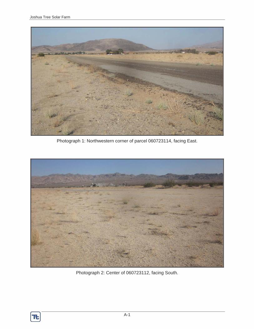
Joshua Tree Solar Farm
A-1
Photograph 1: Northwestern corner of parcel 060723114, facing East.
Photograph 2: Center of 060723112, facing South.
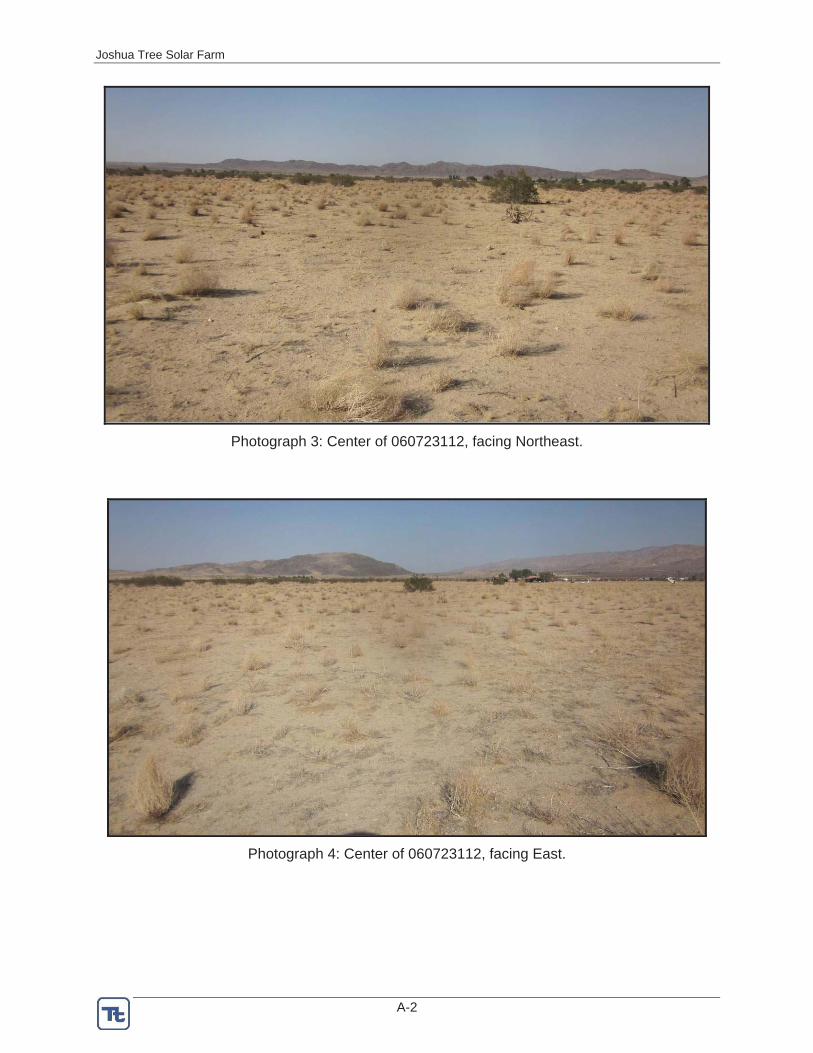
Joshua Tree Solar Farm
A-2
Photograph 3: Center of 060723112, facing Northeast.
Photograph 4: Center of 060723112, facing East.

Joshua Tree Solar Farm
A-3
Photograph 5: Northwestern corner of parcel 060723112, facing South through intact creosote bush scrub
Photograph 6: Depositional area east of the cement plant in parcel 060723115, facing East.
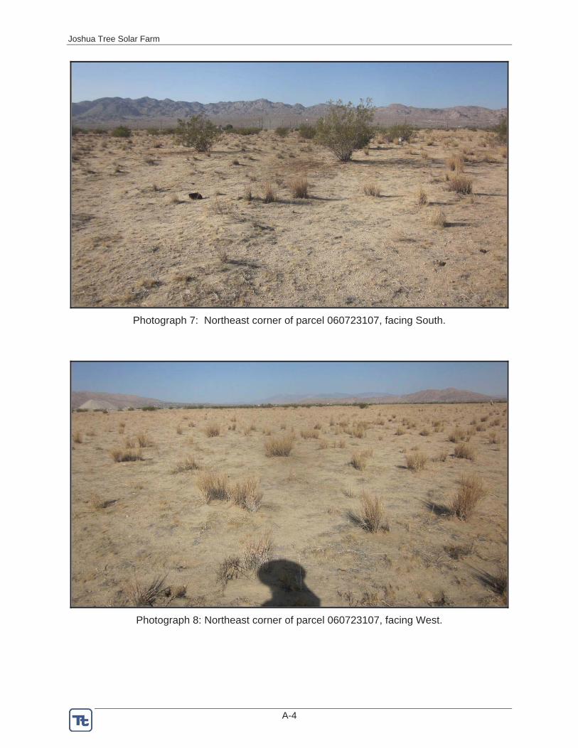
Joshua Tree Solar Farm
A-4
Photograph 7: Northeast corner of parcel 060723107, facing South.
Photograph 8: Northeast corner of parcel 060723107, facing West.
Joshua Tree Solar Farm
A-5
Photograph 9: Gen-tie on the west side of Sunfair Road. (southeast corner of parcel 060722105), facing South.
4TH STREET S
GOLD NUGGET ROAD
2 MILE ROAD
HOLLING
ER ROAD
CALIFORNIA AVENU
E
SUNFAIR ROAD
4TH STREET S
PIPELINE ROAD
TWENTYNINE PALMS HIGHWAY
2 MILE ROAD
060722104060722104
060723114060723114060723114060723114
060723112060723112 060723113060723113
060723111060723111
060723109060723109 060723107060723107
060723110060723110060723115060723115
060723118060723118
060722105060722105
060713104060713104
060711114060711114
060713144060713144
060712101060712101
060712213060712213060712214060712214060712215060712215
8
9
7
6
4 32
1
5
PROJECT SITE
Pa
c i f i c Oc
e a n
NVUT
AZ
OR ID
KEY TO PHOTOGRAPHS
JOSHUA TREESOLAR FARM
SAN BERNARDINO COUNTY, CA
Saved by michael.serrano on: 6/28/2012 10:42:19 AMFile Path: P:\GIS\Projects\4448_BP_Solar\ArcGIS\A_PhotoLocations.mxd
0 900 1,800450
Feet
LegendProject site
Proposed Gen-Tie Route
Parcels
PhotoLocations#
Joshua Tree Solar Farm
APPENDIX B
CALIFORNIA NATURAL DIVERSITY DATABASE RESULTS WITHIN 25 MILES OF THE SURVEY AREA
PROJECT SITE
Pa
c i f i c Oc
e a n
NVUT
AZ
OR ID
CNDDBSPECIAL-STATUS PLANT OCCURRENCES
WITHIN 25-MILES OF THE PROJECT
JOSHUA TREESOLAR FARM
SAN BERNARDINO COUNTY, CA
Saved by michael.serrano on: 6/28/2012 10:51:19 AMFile Path: P:\GIS\Projects\4448_BP_Solar\ArcGIS\B1_Plant_CNDDB.mxd
0 5.5 112.75
Miles
LegendProject site
25-Mile Buffer
CNDDB Special-Status Plant SpeciesAlverson's foxtail cactus
Arizona spurge
Baldwin Lake linanthus
Big Bear Valley woollypod
Booth's evening-primrose
Cienega Seca oxytheca
Coachella Valley milk-vetch
Coulter's goldfields
Cushenbury buckwheat
Cushenbury oxytheca
Darwin rock-cress
Emory's crucifixion-thorn
Fremont barberry
Johnston's buckwheat
Laguna Mountains jewel-flower
Latimer's woodland-gilia
Little San Bernardino Mtns. linanthus
Mecca-aster
Mojave menodora
Orcutt's linanthus
Palmer's mariposa-lily
Parish's club-cholla
Parish's daisy
Parish's rock-cress
Robison's monardella
Salt Spring checkerbloom
San Bernardino milk-vetch
Shockley's rock-cress
alkali mariposa-lily
appressed muhly
chaparral sand-verbena
desert spike-moss
flat-seeded spurge
jackass-clover
pinyon rock-cress
purple-nerve cymopterus
slender cottonheads
southern mountain buckwheat
spear-leaf matelea
triple-ribbed milk-vetch
white-bracted spineflower
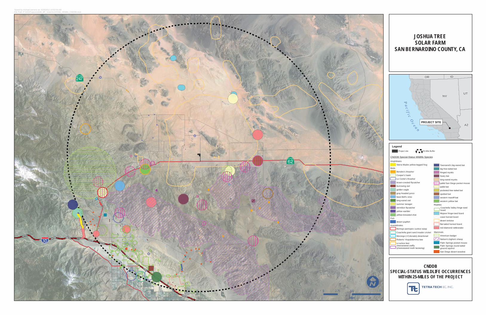
PROJECT SITE
Pa
c i f i c Oc
e a n
NVUT
AZ
OR ID
CNDDBSPECIAL-STATUS WILDLIFE OCCURRENCES
WITHIN 25-MILES OF THE PROJECT
JOSHUA TREESOLAR FARM
SAN BERNARDINO COUNTY, CA
Saved by michael.serrano on: 6/28/2012 10:52:06 AMFile Path: P:\GIS\Projects\4448_BP_Solar\ArcGIS\B2_Wildlife_CNDDB.mxd
0 5.5 112.75
Miles
LegendProject site 25-Mile Buffer
CNDDB Special-Status Wildlife Species
Amphibians
Sierra Madre yellow-legged frogBirds
Bendire's thrasher
Cooper's hawk
Le Conte's thrasher
brown-crested flycatcher
burrowing owl
golden eagle
gray-headed junco
least Bell's vireo
long-eared owl
summer tanager
vermilion flycatcher
yellow warbler
yellow-breasted chatFish
desert pupfish
InvertebratesBorrego parnopes cuckoo wasp
Coachella giant sand treader cricket
Morongo (=Colorado) desertsnail
Roberts' rhopalolemma bee
a cuckoo bee
Mammals
American badger
Nelson's bighorn sheep
Palm Springs pocket mouse
San Diego desert woodrat
Townsend's big-eared bat
big free-tailed bat
fringed myotis
hoary bat
long-eared myotis
pallid San Diego pocket mouse
pallid bat
pocketed free-tailed bat
spotted bat
western mastiff bat
western yellow bat
Reptiles
Mojave fringe-toed lizard
coast horned lizard
desert tortoise
flat-tailed horned lizard
red-diamond rattlesnake
Coachella Valley fringe-toedlizard
cheeseweed owlfly(cheeseweed moth lacewing)
Palm Springs round-tailedground squirrel

Joshua Tree Solar Farm
APPENDIX C
AGENCY CORRESPONDENCE – APPROVAL OF SURVEY METHODS
1
Mix, Emily
From: [email protected]: Wednesday, March 21, 2012 2:00 PMTo: Mix, EmilyCc: [email protected]; [email protected]: Proposed Joshua Tree Solar Farm Biological Resource Survey Methods
Emily Festger Mix, Biologist Tetra Tech EC, Inc. 143 Union Boulevard, Suite 1010 Lakewood, CO 80228-1875
Dear Ms. Mix:
On March 12, 2012 you requested that we concur with your approach to the survey methods outlined for desert tortoise (Gopherus agassizii) in the document Biological Survey Methods, Joshua Tree Solar Farm prepared by Tetra Tech EC, Inc. (Tetra Tech) in 2012.BP Solar Energy North America LLC is proposing to construct, own , and operate a 20 MW solar photovoltaic generating facility location on a portion of approximately 225 acres of private land. It is located in San Bernardino County approximately 3.5 miles east of the town of Joshua Tree and 0.5 miles north of Twentynine Palms Highway (Highway 62). On April 28 and 29, 2011, 120 acres of the proposed site were surveyed for desert tortoise using the U.S. Fish and Wildlife Service's (Service) 2010 survey protocol Preparing for any action that may occur within the range of the Mojave desert tortoise (Gopherus agassizii). Tetra Tech proposes to conduct additional surveys in the Spring 2012 because the desert tortoise survey results expire after one year, and the project has increased in size since the 2011 surveys. The Service's 2010 desert tortoise survey protocol will be used to conduct the additional surveys planned for April 2012. After reviewing the Tetra Tech document, we concur that your approach to the survey methods for desert tortoise is appropriate. We have reached this conclusion because the survey methods will follow the Service's 2010 desert tortoise survey protocol. If you have any questions regarding this matter, please contact Amy Torres of the Ventura Fish and Wildlife Office, San Bernardino sub-office at (909) 382-2654.
Sincerely,
Carl T. Benz
= = = = = = = = = = = = = = = = = = Assistant Field Supervisor Ventura Fish and Wildlife Office 2493 Portola Rd., Suite B Ventura, CA 93003

2
805-644-1766 Ext. 311
1
Mix, Emily
From: Wendy Campbell <[email protected]>Sent: Friday, March 30, 2012 9:45 AMTo: Mix, EmilyCc: Tonya MooreSubject: RE: Proposed Joshua Tree Solar Farm Biological Resource SurveyMethods
Thanks Emily for clarifying your survey efforts. The survey methods outlined in the Biological Resources Survey MethodsReport for the Joshua Tree Solar Farm dated March 2012 and the more detailed information provided in your emailbelow together are adequate survey methods for the Joshua Tree Solar Farm Project.
Wendy CampbellEnvironmental ScientistRenewable Energy ProgramCalifornia Dept. of Fish and Game407 W Line Street, Ste. 1Bishop, CA. 93514760 873 7355
>>> "Mix, Emily" <[email protected]> 3/29/2012 2:10 PM >>>Hi Wendy,Thanks for taking the time to talk with us to day.
Regarding the buffer surveys: We stated in our methods that the surrounding parcels are privately owned and thereforeno buffer surveys will be conducted due to access constraints. To date, BPAE’s ability to contact the site’s privatelandowners has been challenging. This is because many of the owners are not present and it is difficult to get in touchwith them and/or get a response from them. The buffer surveys for tortoise and burrowing owl would require thatBPAE contact approximately100 landowners for permission to access their land. Therefore, buffer surveys are not logistically feasible.
Regarding plant surveys: You requested that we space visits throughout the growing season to accurately determinewhat plants exist on site. As we discussed during the call, this may be a bad year for plant germination; however, we willfind out the level of germination on site when we conduct surveys next week. From that point we will determine, basedon the habitat on site and amount of germination, the likelihood for special status plants (specifically those listed inTable 1 of themethods) to occur on site. As appropriate, we will conduct spot checks in suitable habitat for any special status speciesthat blooms later in the season. If it appears that germination is insufficient this year then there would be no need toconduct spot checks.
Please let us know if this meets CDFG’s requests. We look forward to working with you on this project.Thanks again,
Emily
Emily Festger Mix | BiologistDirect: 303.980.3509 | Main: 303.988.2202 | Fax: 303.980.3539 | Cell:[email protected]
2
Tetra Tech EC, Inc. | Natural Resources143 Union Boulevard, Suite 1010 | Lakewood, CO 80228 1875 | www.tetratech.com
PLEASE NOTE: This message, including any attachments, may include confidential and/or inside information. Anydistribution or use of this communication by anyone other than the intended recipient is strictly prohibited and may beunlawful. If you are not the intended recipient, please notify the sender by replying to this message and then delete itfrom your system.P Think Green Not every email needs to be printed.
Original MessageFrom: Wendy Campbell [mailto:[email protected]]Sent: Friday, March 16, 2012 10:23 AMTo: Mix, EmilyCc: Tonya MooreSubject: Proposed Joshua Tree Solar Farm Biological Resource Survey Methods
After reviewing the Biological Resources Survey Methods Report I have the following comments:
1. From the aerial photos I looked at it appears a drainage with riparian habitat may be present within the project site.The project may require a Lake or Streambed Alteration Agreement, pursuant to Section1600 et seq. of the Fish and Game Code, with the applicant prior to the applicant’s commencement of any activity thatwill substantially divert or obstruct the natural flow or substantially change the bed, channel, or bank (which mayinclude associated riparian resources) of a river, stream or lake, or use material from a streambed. The Department’sissuance of a Lake or Streambed Alteration Agreement for a project that is subject to CEQA will require CEQAcompliance actions by the Department as a responsible agency. The Department as a responsible agency under CEQAmay consider the local jurisdiction’s (lead agency) Negative Declaration or Environmental Impact Report for the project.To minimize additional requirements by the Department pursuant to Section 1600 et seq. and/or under CEQA, thedocument should fully identify the potential impacts to the lake, stream or riparian resources and provide adequateavoidance, mitigation, monitoring and reporting commitments for issuance of the agreement.
2. General Comment The content of the document mentions that "Project site" includes the land within which theProject, including the gen tie, will be built. Figure 2, may want to consider putting the gen tie (redline) within the black project site boundary. This just makes it clearer for the reader that the gen tie is part of the projectbeing addressed in the document.
3. The document mentions that parcels surrounding the project site are privately owned and therefore no buffer surveysare planned due to access constraints. Please provide documentation in some form, such as a letter sent out to privateproperty owners requesting access to survey, an email to property owners, a contact list and phone numbers of whowas contacted.
4. Desert Tortoise To estimate the number of tortoises within the action area the Department takes into account alllive tortoises (not just live tortoises over 160 mmMCL) encountered within the action area during survey efforts.
5. Plant Species space visits throughout the growing season to accurately determine what plants exist on site.
6. NOTE Page 9, Burrowing Owl. Consider adding CDFG Code 3503.5.
I appreciate the opportunity to review your Survey Methods. If you would like to talk about my comments I am availablefor a phone meeting next week on Wednesday March 21st anytime after 12 noon.

3
Wendy CampbellEnvironmental ScientistRenewable Energy ProgramCalifornia Dept. of Fish and Game407 W Line Street, Ste. 1Bishop, CA. 93514760 873 7355

Joshua Tree Solar Farm
APPENDIX D
EXAMPLE OF SURVEY DATA SHEETS
Page 11'1 .,.f,
, , \ ..SURVEYORS: Navigator~m~ilc,=- _
GPS IIIIX I Tf-u.""""Data J4~!
LOCATION IN SITE __ A_I_"'_r_Y_lJ _or ZOIlROV; Desu ipti&&-
TRANSECT NOs COMPLETEDB":7C. "'7.$W ~STARTING UTM 05'10'138SE-6Tt1~1 c) NENDING UTMO £10 'is' '140 E 3 'i 'tI?N)
(NAD83)6;w ~ 4', 3"0)<:5 x-,TOTAL TRANSECT WIDTH'70')( '5 ;; 9< or M
~:-y63()-19~(}' 0
.' '- ~WindCloud Cover
PROJECT BP Solar - Joshua Tree Solar Farm2012 SPECIAL-STATUS SPECIES SURVEYS
Start
End
DATE v4 : <. 2011TIME: Sta';{ )t,2: gz. .' I 00 0 I
End IZtr 2c ~WEATHER:
T
~1.2-tz,"6/'1
.3.8' 38.'1 '10/.5" rGENERAL SITE DESCRIPTION:VEGETATION SHRUB LAYER AND BUNCH GRASSES)
ASPect~~ ~~.- ~t4-7(L thl2- {
?~o us i..; ~ CUJ9vI- /+11'2.-(. c{l.d c- ff-(...Common Species !
!.-"'(,. J- - Cf2PU'\-L
'PA..-t v. c.!?Lcv.uI - 012 tP'1Occasional Species Orf-C 0 i" B J*
~I (-T-) . fjJ'-UIl_c!&~0/ C ' ~ - ;z",.. ;3 <:. t+1~1 I h. ; "" ••.J- ~ :: S-IO? ~ - /0"2.-,o~~~"~ • \Avg. Heig-h-t-o-r-D-om-in-antShrub Specie", ~n", ~ G,S- - 3 ""'- (><-::1:- L ~ )
;YIlZ-I- 97 'Otu... ~ -:. <: 2.0 NUNDERSTORY J
Abundant Species It I'l'\ B jfc >"\
Exotics (Map concentrations and describe here relative to population size and geographic breadth.)SA- liZ- I'\.UVl.- f'()..~
TOPOGRAPHY tfI _ . "II. } "'-4'- _ILandform ~II-'U- /2) { ~
Drainage Type j'J~ ~I e--t....
Elevation (state meters or reet)~ 2 V5?/ /
SUBSTRATE .() 1/_Color r,r-'<:l/'-PCoarse Particles (Type, % Cover) ~ to '2.. ft''4. ~J;, ~ lt~ ~ 1I <J (~)SO~'I,ej'ture and Conj'ls~ence I I ~ J'1p XiI- ~ f'~ rf- dhr
~'3 1")'~ sf, (O~ S~. {Oo"S{ 5 ~ ~
PRES CE OF PHEDA TORS: Ra..tens - # Detedted r @ ;(p. ,r->-f # Nests cJ ..Coyotes. # DetectedV""' Scat? V Scat Piles _
HUMAN.RELA TED D1STURBANCE~ (Onsite and Adjacent) jJ,. rJJ a-t-I rj- ktF'i-<. / I~ '~A-..fA-£/~Cl{)57 ~ 1'-7 ~ Ib~ ~ ; 6;'SITE PICTURE: Photographer ?I ( . -t ./1
A-Form G]"'- , _ J_ __ . j i\l'--]' N ,.I-.r--?--='3-\'f) -1' i!'. 81'0ftom 1I:w-e-onrer 8 I:::' ~ "'-LQ.A u.J ~ .B t ""t?~..::..y;...-__ -lIf ..c-NWfromsECorner~ •. ~~:;:'" w~ I Ct-" :I'f-Other__ r4-k-vf:=l..-M1k'-'.kr~ ,c
IV !IV ~ ~--COMMENTS
,~
Sign Waypolnt um DESERT TORTOISE# I.D, (HADS3) Sign Type Class Size live Tortolse Photo
Widln (", """ ~ Burrow loeatfon'"""" Evtd&nce of Disease? _'s
MeL (shBII, tort) 8um>w? cameno
.
'.
,
,. ,
OTHER SPECIES
Sign Waypotnl UTM (HAD 83) Spe<1oo SIgn Ungulate Comments
# 1.0. Type Condition 9cslCollected
, (Check)
102:jAflt}J o.f."''?? ~~ Ii IL-il- ~r It!df Ao.J.,~ ~ r t:i.. «A.,(, - <t ~\02... " -b i", -rtW. rJ/d ro/_ ~ <I-~4~l\JIN oS"('91-~~ 1(.<.', :::" ""
\ ," 1'fCfl\A:: ,. V03 0::- ~.7~S~1 Dc>-! /1 ~N ,,<!111" OLD'~ .
0'/ JA1\. IV D90g41~~ ItUt w " ~.., ~i"lnC( 3n-'l~ b~ ~\ -J
-'
DATE: h1.9<j ''', "2912-LOCATION: lJe-r'f1l\.r:SIGN WYPT# UTM SPECIES PHENOLOGICAL PLANT VIGOR PHOTO VOUCHER COMMENTS,NUMBER: (NAD 83) STAGE (e.Q., height. (check, (check, who has,
robustness) whose camera) reference number)~ J~cN O,>\''l&~ FuN <.
~J.. ~ot S~L,....J oi 377'ifso'( ~iJIA
....
r~!CRm~,4I11TAT DESCRIPnON: Shrub Dominants other Shrubs Herbaceous Associates Topography SOIl~~'J:.SUb8trate~-~ It-lIZ- ( C~C-+L - ~s"',/
IV /'o /'POPIJLATION SIZE AND AREA: Number of Plants Area (m~ 0' )CJgt~ of populotlon (~~ra~ ~
=11 ~ /00 I ,I. ,Df (~t)L .L
POPULATION THREA~ Anth,oP~le ~ I.-<.;:., Invaolves (Sp, Ablmdonee) v , Natural ,'--' 51' CW/;1
O<)Jcz:/V O')74.8'rn FUN 6~r~ S~,
o~ 3rl1'1ft uiA- ,,MICROHABITAT DESCRIPTION: Shrub Dominants Other Shrubs Herbaceous Associates
T0Ft;ry
Soils and Substrates
AJ~ #1~ c,0;JcAt..---- 5eft-s~r-;opuu, rlON Size AND AREA: Number of Plants Area (m2) or length of ~ulation (If in drain~. :t- . ~,..-- Oh"1
I"0PULAnO~f\I;~ ~~:opogOnIC ~ ,,(1 Inv8slves ($P. A~Ce) Natural!Cl /.', ';;. CUOL@. y~
V / •MICROHA91TAT DESCRIPTION: Shrub Oomlnonts Other Shrubs Herbaceous Associates Topography Soils and Substrates
POPUlATION SIZE AND AREA: Number of Plants Aroe (102) 0' length of populotlon (ff In drainoge)
?OPlll~ATIONTHREATS: Anthropogenic lovaslves (Sp, Abundance) Natural
MiC!lO!lABITAT O.SCRIPTION: Shrub Dominants Other Shrubs Herbaceous Associates Topography Salls and Substrates
.
?OI"ULA TICi'll SIZE ..\ND AREA: Number of Plants Area (m2) or length of pop~118tlC?n (if in drainage)
?OPULA.Tii3N iHREATS: Anthropogenic Invasi\'os esp. Abundant:e) Natural
V N
1T~ans~ct,s:show start, and end by 4"-directIOn and transect number.
, .----<..t-
BP SOlar Joshua Tree Solar Farm "Page II
•.
\
~ .,c.t LJ I(J" ., 1c1PJJJU
"'""'>...• '
"'-.'
.f) PRUJJ<;CT
DATE lv/OM U. 2012LOCAtiON ~ SITE_ ....•!Y=".:.....~'-"h:.l--LEGEND: • ~
Joshua Tree Solar Farm
APPENDIX E
KEY TO DESERT TORTOISE SIGN CLASSES
Joshua Tree Solar Farm
E-1
KEY TO DESERT TORTOISE SIGN CLASSES
BURROWS 1 – DEFINITELY TORTOISE – FRESH (TRACKS, TORTOISE INSIDE, FRESHLY DISTURBED
SOIL ON MOUND/RUNWAY)
2 – DEFINITELY TORTOISE – USED THIS SEASON (CLEARED OF ANNUALS, BUT NO FRESHLY DISTURBED SOIL)
3 – DEFINITELY TORTOISE – NOT USED THIS SEASON (PROBABLY HAS ANNUALS GROWING IN RUNWAY)
4 – POSSIBLY TORTOISE – IN GOOD CONDITION BUT UNSURE OF SPECIES USING BURROW
5 – DEFINITELY TORTOISE – DETERIORATED SUCH THAT IT WOULD REQUIRE SUBSTANTIAL REMODELING TO BE USABLE
6 – POSSIBLY TORTOISE – DETERIORATED
SCATTY1 – WET OR FRESH DARK, ODORIFEROUS
TY2 – DRIED, POSSIBLE GLAZE ON PART; UNEXPOSED SURFACES DARK BROWN; SLIGHT ODOR
TY3 – DRIED, NO GLAZE; AT LEAST PARTIALLY FADED ON EXTERIOR; VERY SLIGHT ODOR
NTY3 – DRIED, NO GLAZE; AT LEAST PARTIALLY FADED ON EXTERIOR; NO ODOR (DISTINGUISHES FROM TY3)
NTY4 – DRIED, LOOSENING, PALE OR BLEACHED
CARCASSES – GENERAL INDICATORS FOR TIME SINCE DEATH<1 YR – UNEXPOSED SCUTES NORMAL COLOR AND SHEEN, ADHERE TIGHTLY.
EXPOSED SCUTES PALING AND MAY BE LIFTING OR OFF. UNEXPOSED BONE WAXY AND SOLID.
1–2 YRS – UNEXPOSED SCUTES NORMAL COLOR WITH SLIGHT SHEEN, MOSTLY TIGHTLY ATTACHED. EXPOSED SCUTES SLIGHTLY PALE WITH NO SHEEN AND NO TO SLIGHT GROWTH RING PEELING. NO ODOR. UNEXPOSED BONE SILKY.
2–3 YRS – UNEXPOSED SCUTES PALE AND WITHOUT SHEEN BUT NO GROWTH RING PEELING. EXPOSED SCUTES PALE WITH SLIGHT PEELING, SCUTES LOOSE, OFF AND/OR TIGHT. BONE SUTURES GENERALLY TIGHT.
4 YRS – UNEXPOSED SCUTES NORMAL COLOR TO SLIGHTLY PALE, NO SHEEN, NO PEELING. EXPOSED SCUTES LOOSE, PALE, DULL, WITH MODERATE PEELING. SUTURES SEPARATING AND BONE SURFACE IS FISSURED, EDGES ARE ROUGHENED (FISSURED UNDER HAND LENS) AND CHIP FAIRLY EASILY.
>>4 YRS – DISARTICULATED AND DISARTICULATING. BONE EDGES CHIP AND CRUMBLE EASILY. SCUTES ARE PEELING AND CURLED.
Joshua Tree Solar Farm
APPENDIX F
FLORAL AND FAUNAL COMPENDIUM
Joshua Tree Solar Farm
PLANTS
APOCYNACEAE DOGBANE FAMILY
Asclepias erosa desert milkweed
Funastrum utahense Utah vine milkweed
ASTERACEAE (Compositae) SUNFLOWER FAMILY
Ambrosia acanthicarpa annual burrweed
Ambrosia dumosa white burr sage
Ambrosia salsola cheesebush
Baccharis sarothoides broom baccharis
Brickellia incana brickellia
Chaenactis carphoclinia pebble pincushion
Encelia frutescens rayless encelia
Lepidospartum squamatum scale-broom
Nicolletia occidentalis hole-in-the-sand plant
Palafoxia arida var. arida Spanish needle
Stephanomeria exigua annual mitra
Stephanomeria pauciflora wire lettuce
BORAGINACEAE BORAGE or WATERLEAF FAMILY
Amsinckia tessellata fiddleneck
Cryptantha angustifolia narrow-leaved forget-me-not
Cryptantha maritima white-haired forget-me-not
Tiquilia plicata plicate coldenia
BRASSICACEAE (Cruciferae) MUSTARD FAMILY
Brassica tournefortii* Sahara mustard
CACTACEAE CACTUS FAMILY

Joshua Tree Solar Farm
Cylindropuntia acanthocarpa var. coloradoensis buckhorn cholla
Cylindropuntia echinocarpa silver cholla
Opuntia basilaris beavertail cactus
CHENOPODIACEAE GOOSEFOOT FAMILY
Atriplex canescens four-winged saltbush
Salsola tragus* Russian thistle
CONVOLVULACEAE MORNING GLORY FAMILY
Cuscuta sp. dodder
CUCURBITACEAE GOURD FAMILY
Cucurbita palmata coyote gourd
EUPHORBIACEAE SPURGE FAMILY
Croton californicus croton
Stillingia linearifolia stillingia
FABACEAE (Leguminosae) LEGUME FAMILY
Astragalus lentiginosus var. fremontii freckled milkvetch
Dalea mollis dalea
Parkinsonia aculeata Mexican palo verde
Psorothamnus arborescens indigo bush
Psorothamnus emoryi Emory dalea
Senna armata desert senna
GERANIACEAE GERANIUM FAMILY
Erodium cicutarium* filaree
LAMIACEAE (Labiatae) MINT FAMILY
Salvia columbariae chia
LOASACEAE LOASA FAMILY
Joshua Tree Solar Farm
Petalonyx thurberi sandpaper plant
ONAGRACEAE EVENING PRIMROSE FAMILY
Chylismia (= Camissonia) claviformis brown-eyed primrose
POLEMONIACEAE PHLOX FAMILY
Eriastrum diffusum phlox
Langloisia setosissima punctata spotted gilia
Loeseliastrum matthewsii desert calico
POLYGONACEAE BUCKWHEAT FAMILY
Eriogonum baileyi Bailey buckwheat
Eriogonum inflatum desert trumpet
Eriogonum plumatella flat-top
Eriogonum trichopes little trumpet
Rumex hymenosepalus dock
SOLANACEAE NIGHTSHADE FAMILY
Datura wrightii jimson weed
TAMARICACEAE TAMARISK FAMILY
Tamarix ramosissima tamarisk
ZYGOPHYLLACEAE CALTROP FAMILY
Larrea tridentata creosote bush
AGAVACEAE CENTURY PLANT FAMILY
Yucca brevifolia Joshua tree
POACEAE (Gramineae) GRASS FAMILY
Bromus tectorum cheat grass
Dasyochloa (= Erioneuron) pulchellum fluff grass
Pleuraphis (= Hilaria) rigida big galleta grass
Joshua Tree Solar Farm
Stipa (= Achnatherum) hymenoides rice grass
Schismus barbatus* split grass
* Non native
BIRDS
CATHARTIDAE AMERICAN VULTURES
Cathartes aura turkey vulture
FALCONIDAE FALCONS
Falco mexicanus prairie falcon
COLUMBIDAE PIGEONS AND DOVES
Zenaida macroura mourning dove
Columba livia rock pigeon
TROCHILIDAE HUMMINGBIRDS
Archilochus alexandri black-chinned hummingbird
Calypte anna Anna’s hummingbird
Calypte costae Costa’s hummingbird
TYRANNIDAE TYRANT FLYCATCHERS
Tyannus verticalis western kingbird
Sayornis saya Say’s phoebe
ALAUDIDAE LARKS
Eremophila alpestris horned lark
CORVIDAE JAYS, CROWS, AND RAVENS
Corvus corax common raven
TROGLODYTIDAE WRENS
Campylorhynchus brunneicapillus cactus wren
EMBERIZIDAE WARBLERS AND SPARROWS
Joshua Tree Solar Farm
Cardellina pusilla Wilson’s warbler
Amphispiza bilineata black-throated sparrow
Passer domesticus house sparrow
Zonotrichia albicollis white crowned sparrow
ICTERIDAE BLACKBIRDS AND ORIOLES
Quiscalus mexicanus great-tailed grackle
MAMMALS
LEPORIDAE
Lepus californicus black-tailed hare
Sylvilagus auduboni Audubon cottontail
SCIURIDAE
Ammospermophilus leucurus antelope ground squirrel
Spermophilus beecheyi California ground squirrel
Spermophilus tereticaudus round-tailed ground squirrel
CRICETIDAE
Neotoma lepida woodrat (nests)
CANIDAE
Canis latrans coyote (scat)
Vulpes macrotis desert kit fox (scat, natal dens)
REPTILES
VIPERIDAE
Crotalus scutulatus Mojave green rattlesnake

Joshua Tree Solar Farm
PHRYNOSOMATIDAE
Dipsosaurus dorsalis Desert iguana
Uta stansburiana side-blotched lizard
TEIIDAE
Aspidocelis trigris whiptail lizard


![[Teacher Name] presents: Saving Joshua Tree](https://img.dokumen.tips/doc/110x75/568130c3550346895d96e251/teacher-name-presents-saving-joshua-tree.jpg)

