Embed Size (px)
Citation preview

esa bulletin 123 - august 2005 21
GMES
Global Monitoringfor Environmentand Security– Europe’s next space
initiative takes shape
Global Monitoringfor Environmentand Security– Europe’s next space
initiative takes shape
The ozone hole over the Earth’s Northern Hemisphere in January 2002, based on measurements made by ESA’s Envisat satellite (courtesy of DLR)
At the first Space Council in November2004, Global Monitoring for Environmentand Security (GMES) was proclaimed as
the next flagship initiative for space in Europe,after Galileo. This underlines that GMES hascome a long way since its beginnings in 1998.Initially conceived as a relatively looselycoordinated forum for cooperation among spaceagencies, GMES today stands on firm ground.The European Commission has assumed politicalleadership for GMES, and the European Union’spolicy priorities have been confirmed. A stronguser base has been built up through numerousGMES projects funded since 2001 by ESA andthe Commission. Currently ESA is preparing,with its Member States, a firm proposal for the2005 Ministerial Council to start building up thespace infrastructure necessary to sustainoperational GMES services in the long term.
Why GMES ?At their 2001 Summit in Gothenburg, theEU Heads of State and Governmentrequested that: “the Community contributeto establishing by 2008 a Europeancapacity for global monitoring forenvironment and security (GMES)”.
GMES serves two main policyrequirements for Europe in terms of theneed for geo-spatial information services.Firstly, it provides independent access toinformation for policy and decision makersto advance European and national agendasrelated to environment and security.Secondly, it federates Europeancontributions to the international GlobalEarth Observation System of Systems,
Volker LiebigESA Directorate for Earth ObservationProgrammes, ESRIN, Frascati, Italy
Josef AschbacherProgramme Coordinator, Directorate for EarthObservation Programmes, ESA, Paris
Ascjbacher 9/13/05 10:47 AM Page 20
esa bulletin 123 - august 2005www.esa.int 23
repeatedly underlined the intention toprovide the European contribution toGEOSS via GMES. This will not includethe totality of GMES, but rather thoseelements that are deemed appropriate to beshared at international level. Likewise,GMES will also act as recipient of data andinformation from external sources for thebenefit of European users.
Through GMES, Europe has establishedintellectual leadership in developing aholistic space and in-situ basedobservation system coupled with Earthsystem prediction models which is drivenby policy needs identified by governmentauthorities. Indeed, the GEOSS 10-YearPlan has taken advantage of GMES,translating some of Europe’s challenges tothe global scale. In addition, a number ofcountries are establishing nationalsystems, which serve their policypriorities. Examples are the USA, Japan,India, China or Morocco.
IEOS – The US Equivalent of GMESThe United States is developing theIntegrated Earth Observation System,IEOS. A Strategic Plan for IEOS has beenestablished over the past two years, whichaddresses the same nine societal benefitareas as GEOSS, hence allowingcoherence between both systems from theoutset. The Strategic Plan identifies sixpriority areas from the nine GEOSSdomains that are to be tackled in the near-term. These are: data management, disasterwarning, global land observations, sea-level observations, national droughtinformation, and air-quality forecasts.
The IEOS Strategic Plan was developedby 17 federal agencies that are part of theInteragency Working Group on EarthObservation, IWGEO. It reports to theNational Science and TechnologyCouncil’s Committee on Environment andNatural Resources, which advises theoffice of President George W. Bush onscience and technology issues.
The Content of GMESThe overall GMES architecture comprises
four major elements, as outlined in the ECCommunication on GMES. These areservices, space observations, in-situobservations, and data integration andinformation management. The estab-lishment of a policy and regulatoryframework, as well as the setting up of aninstitutional structure to govern, financeand operate GMES as a whole, are alsorequired. They are dealt with in the GMESProgramme Office at the working level,and by the GMES Advisory Committee atMember State level.
From EU Policy Priorities to the GMES SpaceComponent The definition of the GMES SpaceComponent is based on a number of steps,such as: (i) the identification of EU policypriorities and the respective users withinthe EC and the EU/ESA Member States;(ii) the implementation of GMES serviceprojects responding to these policy needs,such as those funded by the EC and ESAover the past years; (iii) the retrieval ofservice requirements and space-observation requirements; and (iv) theidentification of gaps in the continuedprovision of Earth Observation data forEuropean policies, after analysing thecurrent and planned EO missions of ESA,EU/ESA Member States, Eumetsat andthird-party operators. The GMES‘Sentinel’ missions are defined as anoutput of these steps.
Gathering requirements from these usershas been a highly structured processconducted with their active participation.
Within the framework of current GMESprojects, the process has been based onpolicy review, traced down to the nature andscope of responsibilities of legallymandated organisations under the identifiedpolicies, followed by an assessment of theirrequirements for information as well as thenature of their working practices andapplicable standards that place constraintsto be met within such organisations.
Data gaps are expected to occur in thenear future. ERS-2 and Spot-4 havealready exceeded their nominal lifetimes in2002, Envisat and Spot-5 have a nominalend-of-life in 2007, and the ETM imagingsensor on Landsat-7 has already failed afew years ago.
Observation requirements for satelliteinstruments have been derived and thesatellite elements aggregated into thedefinition of the space component ofGMES, which is made up of componentsfrom ESA, Eumetsat and ESA/EU MemberStates.
Who Are the GMES Users?GMES is user driven and responds directlyto user requirements. In particular cases,requirements can come from userssufficiently expert in remote-sensingtechnologies. This is the case, for example,for the European Environment Agencyrequiring Landsat TM-class observationsfor operational updates to the Corine land-cover database, and for users involved inprogrammes such as Global Land Cover2000 (GLC2000) where there is a direct,demonstrated and endorsed requirement
GMES
22 esa bulletin 123 - august 2005 www.esa.int
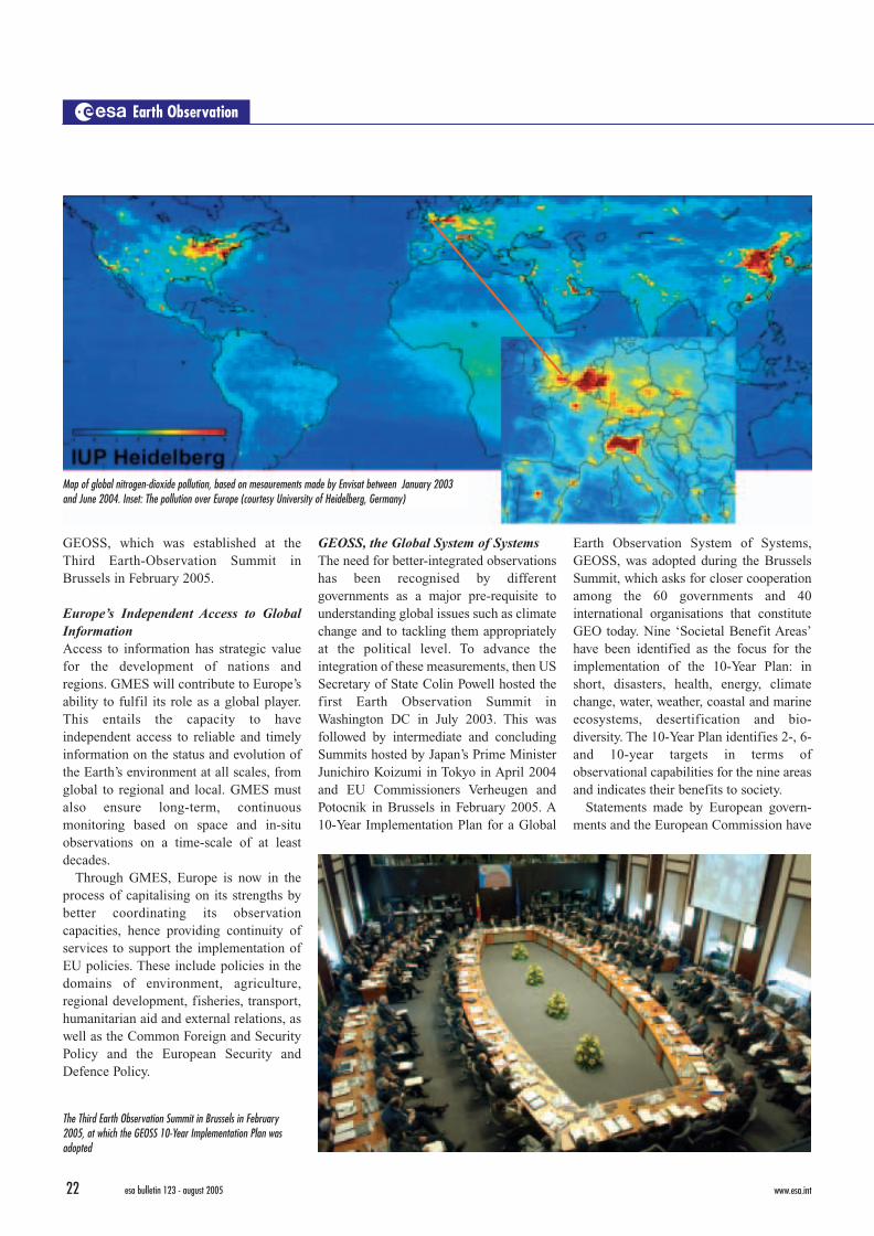
GEOSS, which was established at theThird Earth-Observation Summit inBrussels in February 2005.
Europe’s Independent Access to GlobalInformation Access to information has strategic valuefor the development of nations andregions. GMES will contribute to Europe’sability to fulfil its role as a global player.This entails the capacity to haveindependent access to reliable and timelyinformation on the status and evolution ofthe Earth’s environment at all scales, fromglobal to regional and local. GMES mustalso ensure long-term, continuousmonitoring based on space and in-situobservations on a time-scale of at leastdecades.
Through GMES, Europe is now in theprocess of capitalising on its strengths bybetter coordinating its observationcapacities, hence providing continuity ofservices to support the implementation ofEU policies. These include policies in thedomains of environment, agriculture,regional development, fisheries, transport,humanitarian aid and external relations, aswell as the Common Foreign and SecurityPolicy and the European Security andDefence Policy.
GEOSS, the Global System of SystemsThe need for better-integrated observationshas been recognised by differentgovernments as a major pre-requisite tounderstanding global issues such as climatechange and to tackling them appropriatelyat the political level. To advance theintegration of these measurements, then USSecretary of State Colin Powell hosted thefirst Earth Observation Summit inWashington DC in July 2003. This wasfollowed by intermediate and concludingSummits hosted by Japan’s Prime MinisterJunichiro Koizumi in Tokyo in April 2004and EU Commissioners Verheugen andPotocnik in Brussels in February 2005. A10-Year Implementation Plan for a Global
Earth Observation System of Systems,GEOSS, was adopted during the BrusselsSummit, which asks for closer cooperationamong the 60 governments and 40international organisations that constituteGEO today. Nine ‘Societal Benefit Areas’have been identified as the focus for theimplementation of the 10-Year Plan: inshort, disasters, health, energy, climatechange, water, weather, coastal and marineecosystems, desertification and bio-diversity. The 10-Year Plan identifies 2-, 6-and 10-year targets in terms ofobservational capabilities for the nine areasand indicates their benefits to society.
Statements made by European govern-ments and the European Commission have
Earth Observation
Map of global nitrogen-dioxide pollution, based on mesaurements made by Envisat between January 2003and June 2004. Inset: The pollution over Europe (courtesy University of Heidelberg, Germany)
The Third Earth Observation Summit in Brussels in February2005, at which the GEOSS 10-Year Implementation Plan wasadopted
Variation in sea-surface temperature between March 2003 andMarch 2004, based on measurements made by Envisat
Ascjbacher 9/13/05 10:47 AM Page 22

esa bulletin 123 - august 2005www.esa.int 23
repeatedly underlined the intention toprovide the European contribution toGEOSS via GMES. This will not includethe totality of GMES, but rather thoseelements that are deemed appropriate to beshared at international level. Likewise,GMES will also act as recipient of data andinformation from external sources for thebenefit of European users.
Through GMES, Europe has establishedintellectual leadership in developing aholistic space and in-situ basedobservation system coupled with Earthsystem prediction models which is drivenby policy needs identified by governmentauthorities. Indeed, the GEOSS 10-YearPlan has taken advantage of GMES,translating some of Europe’s challenges tothe global scale. In addition, a number ofcountries are establishing nationalsystems, which serve their policypriorities. Examples are the USA, Japan,India, China or Morocco.
IEOS – The US Equivalent of GMESThe United States is developing theIntegrated Earth Observation System,IEOS. A Strategic Plan for IEOS has beenestablished over the past two years, whichaddresses the same nine societal benefitareas as GEOSS, hence allowingcoherence between both systems from theoutset. The Strategic Plan identifies sixpriority areas from the nine GEOSSdomains that are to be tackled in the near-term. These are: data management, disasterwarning, global land observations, sea-level observations, national droughtinformation, and air-quality forecasts.
The IEOS Strategic Plan was developedby 17 federal agencies that are part of theInteragency Working Group on EarthObservation, IWGEO. It reports to theNational Science and TechnologyCouncil’s Committee on Environment andNatural Resources, which advises theoffice of President George W. Bush onscience and technology issues.
The Content of GMESThe overall GMES architecture comprises
four major elements, as outlined in the ECCommunication on GMES. These areservices, space observations, in-situobservations, and data integration andinformation management. The estab-lishment of a policy and regulatoryframework, as well as the setting up of aninstitutional structure to govern, financeand operate GMES as a whole, are alsorequired. They are dealt with in the GMESProgramme Office at the working level,and by the GMES Advisory Committee atMember State level.
From EU Policy Priorities to the GMES SpaceComponent The definition of the GMES SpaceComponent is based on a number of steps,such as: (i) the identification of EU policypriorities and the respective users withinthe EC and the EU/ESA Member States;(ii) the implementation of GMES serviceprojects responding to these policy needs,such as those funded by the EC and ESAover the past years; (iii) the retrieval ofservice requirements and space-observation requirements; and (iv) theidentification of gaps in the continuedprovision of Earth Observation data forEuropean policies, after analysing thecurrent and planned EO missions of ESA,EU/ESA Member States, Eumetsat andthird-party operators. The GMES‘Sentinel’ missions are defined as anoutput of these steps.
Gathering requirements from these usershas been a highly structured processconducted with their active participation.
Within the framework of current GMESprojects, the process has been based onpolicy review, traced down to the nature andscope of responsibilities of legallymandated organisations under the identifiedpolicies, followed by an assessment of theirrequirements for information as well as thenature of their working practices andapplicable standards that place constraintsto be met within such organisations.
Data gaps are expected to occur in thenear future. ERS-2 and Spot-4 havealready exceeded their nominal lifetimes in2002, Envisat and Spot-5 have a nominalend-of-life in 2007, and the ETM imagingsensor on Landsat-7 has already failed afew years ago.
Observation requirements for satelliteinstruments have been derived and thesatellite elements aggregated into thedefinition of the space component ofGMES, which is made up of componentsfrom ESA, Eumetsat and ESA/EU MemberStates.
Who Are the GMES Users?GMES is user driven and responds directlyto user requirements. In particular cases,requirements can come from userssufficiently expert in remote-sensingtechnologies. This is the case, for example,for the European Environment Agencyrequiring Landsat TM-class observationsfor operational updates to the Corine land-cover database, and for users involved inprogrammes such as Global Land Cover2000 (GLC2000) where there is a direct,demonstrated and endorsed requirement
GMES
22 esa bulletin 123 - august 2005 www.esa.int
GEOSS, which was established at theThird Earth-Observation Summit inBrussels in February 2005.
Europe’s Independent Access to GlobalInformation Access to information has strategic valuefor the development of nations andregions. GMES will contribute to Europe’sability to fulfil its role as a global player.This entails the capacity to haveindependent access to reliable and timelyinformation on the status and evolution ofthe Earth’s environment at all scales, fromglobal to regional and local. GMES mustalso ensure long-term, continuousmonitoring based on space and in-situobservations on a time-scale of at leastdecades.
Through GMES, Europe is now in theprocess of capitalising on its strengths bybetter coordinating its observationcapacities, hence providing continuity ofservices to support the implementation ofEU policies. These include policies in thedomains of environment, agriculture,regional development, fisheries, transport,humanitarian aid and external relations, aswell as the Common Foreign and SecurityPolicy and the European Security andDefence Policy.
GEOSS, the Global System of SystemsThe need for better-integrated observationshas been recognised by differentgovernments as a major pre-requisite tounderstanding global issues such as climatechange and to tackling them appropriatelyat the political level. To advance theintegration of these measurements, then USSecretary of State Colin Powell hosted thefirst Earth Observation Summit inWashington DC in July 2003. This wasfollowed by intermediate and concludingSummits hosted by Japan’s Prime MinisterJunichiro Koizumi in Tokyo in April 2004and EU Commissioners Verheugen andPotocnik in Brussels in February 2005. A10-Year Implementation Plan for a Global
Earth Observation System of Systems,GEOSS, was adopted during the BrusselsSummit, which asks for closer cooperationamong the 60 governments and 40international organisations that constituteGEO today. Nine ‘Societal Benefit Areas’have been identified as the focus for theimplementation of the 10-Year Plan: inshort, disasters, health, energy, climatechange, water, weather, coastal and marineecosystems, desertification and bio-diversity. The 10-Year Plan identifies 2-, 6-and 10-year targets in terms ofobservational capabilities for the nine areasand indicates their benefits to society.
Statements made by European govern-ments and the European Commission have
Earth Observation
Map of global nitrogen-dioxide pollution, based on mesaurements made by Envisat between January 2003and June 2004. Inset: The pollution over Europe (courtesy University of Heidelberg, Germany)
The Third Earth Observation Summit in Brussels in February2005, at which the GEOSS 10-Year Implementation Plan wasadopted
Variation in sea-surface temperature between March 2003 andMarch 2004, based on measurements made by Envisat
Ascjbacher 9/13/05 10:47 AM Page 22

esa bulletin 123 - august 2005www.esa.int 25
to consolidate and update existing userrequirements, develop an action plan for2006-2008, and define criteria for thesustainability of the three GMES pilotservices.
The ESA GMES Space-Component ProgrammeProposal for the 2005 Ministerial Conference The ESA programme currently beingnegotiated with Member States inpreparation for the 2005 MinisterialCouncil concentrates on the GMES spacecomponent, which comprises the spacesegment and the associated groundsegment, including access to national,Eumetsat and third-party missions.
In this context, it is worth recalling thatESA, several ESA Member States andEumetsat are funding a number of Earth-observation satellite programmes, whichshould become an integrated part of theoverall architecture of the GMES spacecomponent. ESA has duly taken account ofthese missions and has designed theproposed satellite missions – the‘Sentinels’ – in a complementary manner.
The following missions are candidatesfor contributions to GMES:National– Spot-5 (operating)– TerraSAR-X (1 satellite, launch 2006)– Cosmo Skymed (3 satellites, launches
2007, 2008, 2009)– Radarsat-2 (1 satellite, launch 2006); C-
band constellation (tbc)– Pleiades (2 satellites, launches 2008,
2009)– Other national missions (tbc).
Eumetsat– Jason-2 (with CNES, 1 satellite, launch
2006)– MSG (4 satellites, launches from 2002);
MTG (launch 2015, tbc)– MetOp (3 satellites, launches from
2006); Post-EPS (launch 2019, tbc).
Privately funded or third-party missions– DMC-UK (constellation of satellites,
launches from 2003)– RapidEye (5 satellites, launch 2007).
The architecture of the GMES SpaceComponent is designed in such a way that
a certain degree of dual-use capability canbe achieved. This involves investments inthe space segment, ground segment andinformation and service disseminationelement. Details of security-related aspectswill be defined during 2006-2007 andproposed in a later phase (post-2008) ofthe GMES Space-Component Programme.
GMES SentinelsThe following five members of the
Sentinel family have been identified ascore elements of the GMES SpaceComponent: Sentinel-1 a radar imaging mission
with interferometriccapability
Sentinel-2 a multispectral opticalimaging mission
Sentinel-3 an ocean and global-landsurface monitoringmission with altimetersand wide swath, low-tomedium resolution radio-meters
Sentinel-4, -5 two families of atmo-spheric chemistry missions,on geostationary (Sentinel4) and low Earth orbit(Sentinel-5) spacecraft.
GMES-1, the First GMES MissionThe core element of the ESA programmeproposal for the 2005 Ministerial
Conference includes the development of afirst GMES mission, GMES-1, planned forlaunch in 2010/11. This mission’sdefinition is driven by three factors. Firstly,as mentioned above gaps in data will occurin the 2009-2011 time frame. Secondly, nodefinitive financial commitments areexpected from the EC before 2007. Andthirdly, the developments must be the basisfor a robust and affordable operationalsystem, incorporating sufficient flexibilityand modularity to allow for the anticipatedevolution that will occur throughout theextended lifetime of the system.
The GMES-1 mission will satisfy themost urgent data needs by combiningselected instruments on one spacecraft, thedesign of which will allow for futurepayload growth. The envisaged instrumentpackage forms a coherent set ofinstruments, sharing similar constraints interms of orbit requirements. It isanticipated that the instruments developedfor GMES-1 will also be used on the futureoperational series of GMES satellites.
Aimed at addressing the observationalneeds of Sentinel-1 and -3, as a startingpoint GMES-1 will include a C-bandimaging radar capable of continuing theinterferometric and ocean/ice/landmeasurements of ERS and Envisat, as wellas an ocean-colour instrument providingcontinuity of MERIS-type measurements.An infrared instrument for fire monitoring
GMES
24 esa bulletin 123 - august 2005 www.esa.int
for continuity of MERIS/vegetation-typemeasurements.
In other cases, users have only recentlybeen exposed to GMES services throughdedicated GMES projects funded by ESA,the EC or Member States. The userscomprise European, national and local-government level organisations, andinclude environmental agencies, civilprotection and safety agencies, citycouncils, coastguards, geological surveys,meteorological offices, fishery-management authorities, transportauthorities, development and aid agencies,river-basin authorities, port authorities andhealth departments.
A recent survey identified some 330organisations as users of currently runningGMES service projects. As these areorganisations at European, national andregional level, they have a multiplier effectin terms of the numbers of citizensbenefiting from this information. Forexample, the European EnvironmentAgency is using and redistributingsatellite-based Corine land-cover maps ofthe European territory at 1:50 000 scale tonational environmental organisations forfurther use and distribution.
GMES Initial ServicesThe GMES Advisory Council hasendorsed a number of GMES InitialServices, which require immediateattention in terms of data provision andservice development. They have beenderived from on-going GMES projects,and they satisfy EU policy priorities thatare described in different documents. Theidentified GMES Initial Services cover: – Marine and coastal environment
monitoring (including pollution, oilspills)
– Risk management (floods and forestfires)
– Risk management (subsidence andlandslides)
– Air-pollution monitoring (local toregional scales)
– European water-quality monitoring– European land-use / land-cover state and
changes monitoring – Forest monitoring– Food security – early-warning systems– Global-change monitoring– Maritime security (marine transport,
coastal-area surveillance, ice monitoring)
– Humanitarian-aid support.
All of these services are set toprogressively enter the operational stagefrom 2010 onwards, provided that Earth-observation data are continuously availableto users.
GMES Pilot ServicesAmong the Initial Services that the EC hasidentified are a limited number of earlyGMES pilot services to which it wouldgive priority for operational implement-ation by 2008. These are:– Emergency management– Land monitoring– Ocean monitoring.
It is planned to establish a fourth pilotservice on atmospheric chemistry is in asecond stage.
The EC will engage in an intense user-consultation process through a series ofthree workshops at the end of 2005 in order
Earth Observation
Analysis of the GMES space component based on EU policypriorities
The 12 ESA GMES Service Element projects subscribed to at theESA Ministerial Council in Edinburgh in 2001
Flight models of MSG-2 and MSG-3 in the clean room at Alcatel Space in Cannes (F)POLICIES→USERS→SERVICES→REQUIREMENTS→GAP ANALYSIS→SOLUTIONS
Ascjbacher 9/13/05 10:47 AM Page 24

26 esa bulletin 123 - august 2005 www.esa.int
will also be included to demonstrate itscapabilities. The option of embarking aninfrared radiometer (AATSR-type SSTinstrument) or a radar altimeter will alsobe investigated early in the programme.
GMES Ground SegmentThe GMES ground segment related to space data comprises tasking, tele-command and tele-control, acquisition,archiving, processing up to appropriateproduct level and distribution of Earth-observation data according to GMESservice needs. It includes the payloadground segment, flight-operations segmentas well as access to historical data. Thepayload ground segment is based onexisting national and commercial facilitiesin a fully distributed approach. In addition,access to and integration of Earth-observation data from Eumetsat, nationaland third-party missions are provided tousers via the GMES ground segment.
GMES Service Portfolio Extension GMES services must serve many diverseuser communities in Europe andworldwide, continuously integrate newtechniques and research advances frommany different fields, exploit spatial andnon-spatial data from a multitude ofdifferent sources including newly availablesatellite data, and evolve to deliver newforecasting, prediction and early-warningcapabilities. The service extension willcontribute to bringing the current GMESservices to full operational status and todeveloping new Earth-observation-basedGMES services. It is understood that thiselement is to be funded through (future)European Commission budgets as part ofthe joint implementation of GMES by theCommission and ESA.
GMES OperationsThe operation of the GMES spacecomponent covers the space, ground andservice segments. The different GMESmissions (Sentinels, Eumetsat, national)and their related ground segments will beoperated by different entities, with ESAensuring the integrity and coordination ofthe GMES space component.
The operating entities for the GMES
Sentinel family will emerge over the nextyears in parallel with an agreement on thegovernance of GMES as a whole.
Cooperation with the European CommissionGMES has, from the outset, been acooperative effort involving all majorstakeholders in Europe. Over the pastyears, the Commission and ESA havecooperated on GMES on behalf of theirrespective Member States. Investments sofar have focused on the consolidation ofthe GMES user base and the provision ofinitial services. ESA and the Commissionhave each provided some 100 MEuro forthe development of services based on ECand EU/ESA Member State priorities. In2004, the ESA Member States haveapproved an additional 40 MEuro forpreparatory studies of the GMES spacecomponent.
The GMES Advisory Council andGMES Programme Office lead the GMESprocess. The GMES Advisory Council ischaired by the European Commission (DGEnvironment, to underline the user-drivenaspect of GMES). The GMES ProgrammeOffice is co-led by the Commission andESA.
The model of shared responsibility hasbeen a successful means to continuouslymove GMES forward. It has led to theconsolidation of a significant user baseacross Europe and has raised the politicalawareness in the EC and the EU and ESAMember States. On the international scale,GMES has been portrayed as a model forestablishing the Global Earth ObservationSystem of Systems, GEOSS.
Taking these considerations intoaccount, and making use of existing co-ordination and consultation mechanisms,ESA continues to closely coordinate thedefinition of the GMES space componentwith the EC and the EU/ESA MemberStates using existing mechanisms, such asthe GMES Advisory Council for thedefinition of the GMES Space-ComponentProgramme.
Implementation ApproachThe approach proposed has to becompatible with the fact that no definitivefinancial commitments will be available
from user entities, represented through theEuropean Commission, before 2007. Thesecond programme imperative is toanticipate potential data gaps that mightoccur in the period 2008-2012, particularlyin:– the C-band radar imaging and inter-
ferometric capability– Landsat-Spot type data– wide-swath radiometer data.
The implementation of the GMES Space-Component Programme is proposed totake place in two segments:– Segment-1 covering the period 2006
2012, and – Segment-2 covering the period 2008
2013.
Segment-1 will be funded through the ESAOptional Programme, while Segment-2 isexpected to be co-financed with theEuropean Commission according to afinancing model to be agreed in 2007.
OutlookData continuity over a period of decades isa key requirement for operational services.In order to prepare for the fullimplementation of GMES, the ESA Space-Component Programme assures datacontinuity for critical satellite observationsfrom 2010/2011 onwards. The MinisterialConference will be a decisive event, inparticular for ESA, to ensure that GMEScontinues to move forward.
Only a well-funded and stronglyimplemented GMES can serve theambitious goal of Europe becoming one ofthe most dynamic knowledge-basedsocieties in the World. Furthermore,GMES has provided intellectual leadershipin establishing the Global EarthObservation System of Systems, GEOSS.It is important that Europe continues tosupport this leadership through action, thus providing a favourable platform forEurope’s industry, institutions, organisa-tions and scientists to maintain a leadingedge in preserving the global environmentand ensuring security to Europe’s citizensand people everywhere. r
Earth Observation
Ascjbacher 9/13/05 10:47 AM Page 26