Embed Size (px)
Citation preview

Jordan Case Study:Jordan Case Study:Gulf of AqabaGulf of Aqaba
THE FOURTH BOARD MEETING THE FOURTH BOARD MEETING
Sep 13-15, 2004Sep 13-15, 2004
Hammamet, TunisHammamet, Tunis
ByBy
Muhammad R. ShatanawiMuhammad R. Shatanawi
University of JordanUniversity of Jordan

WP 08: Regional Case Study: WP 08: Regional Case Study: Jordan/Jordan/Gulf of AqabaGulf of Aqaba
WORK PROGRESSWORK PROGRESS

Contribution to WP04: Contribution to WP04: Data Compilation and AnalysisData Compilation and Analysis
Using the SUMER database, the data Using the SUMER database, the data related to Jordan case study has related to Jordan case study has been completed and sent to SUMERbeen completed and sent to SUMER
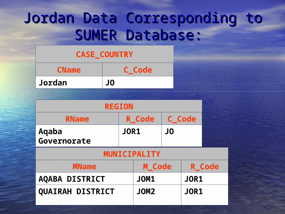
Jordan Data Corresponding to Jordan Data Corresponding to SUMER Database: SUMER Database:
CASE_COUNTRY
CName C_Code
Jordan JO
REGION
RName R_Code C_Code
Aqaba Governorate JOR1 JO
MUNICIPALITY
MName M_Code R_Code
AQABA DISTRICT JOM1 JOR1
QUAIRAH DISTRICT JOM2 JOR1

REG_POP
Year Value Pop_Char R_Code
2001 14582 U JOR1
2001 89578 R JOR1
MUN_POP
Year Value Pop_Char M_Code
2001 16665 NA JOM2
2001 87495 NA JOM1
2002 17140 NA JOM2
2002 89975 NA JOM1
Jordan Data Corresponding to Jordan Data Corresponding to SUMER Database: SUMER Database:

NAT_IND
Ind_Code Value C_Code
Population Growth Rate (%/year) 2.8 JO
Population Density (Number of people/Km2) 58 JO
Crude Death Rate (%/year) 5 JO
Crude Birth Rate (%/year) 28 JO
Life Expectancy at Birth (years) 69 JO
Growth of G.D.P. (%) 4.5 JO
Activity Rate (%) 38.2 JO
Jordan Data Corresponding to Jordan Data Corresponding to SUMER Database: SUMER Database:

REG_IND
Ind_Code Value R_Code
Population Growth Rate (%/year) 2.8 JOR1
Population Density (Number of people/Km2) 15.8 JOR1
Crude Death Rate (%/year) 0.35 JOR1
Crude Birth Rate(%/year) 2.84 JOR1
Activity Rate (%) 23.8 JOR1
Percentage of Tertiary employment (%) 80.9 JOR1
Water Price for the Domestic Use (EURO/M3) 0.71 JOR1
Water Price for the Agricultural Use (EURO/M3) 0.25 JOR1
Water Price for the industry(EURO/M3) 1.7 JOR1
Water Consumption per Capita (Liters/day) 392.2 JOR1
Domestic Water Consumption per Capita (Liters/day) 83 JOR1
Commercial Water Consumption per Capita (Liters/day) 12 JOR1
Industrial Water Consumption per Capita (Liters/day) 212.42 JOR1
Total Water Consumption (M3) 14950095 JOR1
Jordan Data Corresponding to Jordan Data Corresponding to SUMER Database: SUMER Database:

MUN_IND
Ind_Code Value M_Code
Population Growth Rate (%/year) 2.84 JOM1
Population Growth Rate (%/year) 2.85 JOM2
Population Density (Number of people/Km2) 6.51 JOM2
Population Density (Number of people/Km2) 20 JOM1
Jordan Data Corresponding to Jordan Data Corresponding to SUMER Database: SUMER Database:

NAT_IND_DTL
Ind_Code Class Value C_Code
Agricultural production By the main Types of Product (MILLION EURO)
Cereals 23.67 JO
Agricultural production By the main Types of Product (MILLION EURO)
Fruits 159.6 JO
Agricultural production By the main Types of Product (MILLION EURO)
Vegetables 135.48 JO
Jordan Data Corresponding to Jordan Data Corresponding to SUMER Database: SUMER Database:
REG_IND_DTL
Ind_Code Class Value R_Code
Agricultural production By the main Types of Product (MILLION EURO)
Cereals 1.69 JOR1
Agricultural production By the main Types of Product (MILLION EURO)
Fruits 2.1 JOR1
Agricultural production By the main Types of Product (MILLION EURO)
Vegetables 8.21 JOR1

Contributions to WP10 : Contributions to WP10 : Comparative Policy AnalysisComparative Policy Analysis
Contribution:Contribution:
Complete the data related to Jordan Case Complete the data related to Jordan Case study in the draft comparative database study in the draft comparative database that was prepared by UATLA that was prepared by UATLA

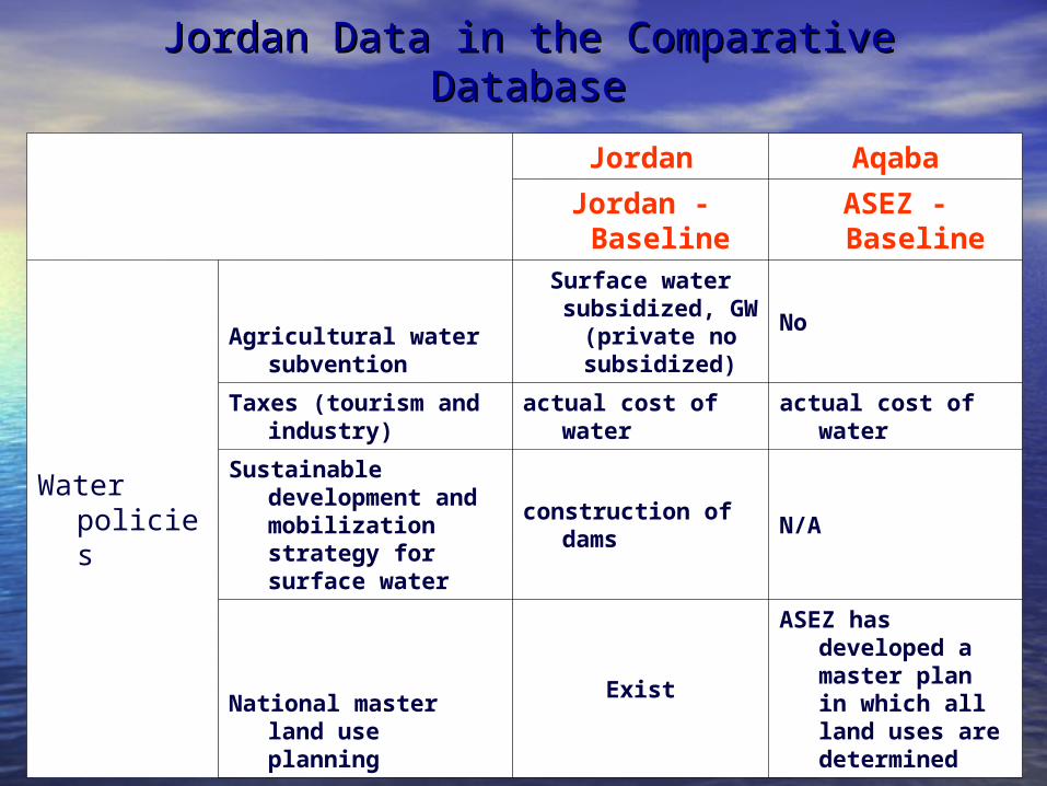
Jordan Data in the Comparative DatabaseJordan Data in the Comparative Database
Jordan Aqaba
Jordan - Baseline
ASEZ - Baseline
Population
Resident population increase % 2.3 2.8
Resident population annual increase
139,000 2795
Birth control policy No Policy No Policy
Natural growth rate % 2.8 2.8
Urban Population Growth % 2.8 2.8
Rural Population Growth % 2.3 2.3
Jordan Data in the Comparative DatabaseJordan Data in the Comparative Database
Jordan Aqaba
Jordan - Baseline
ASEZ - Baseline
Water policies
Agricultural water subvention
Surface water subsidized, GW
(private no subsidized)
No
Taxes (tourism and industry)
actual cost of water actual cost of water
Sustainable development and mobilization strategy for surface water
construction of dams N/A
National master land use planning
Exist
ASEZ has developed a master plan in which all land uses are determined
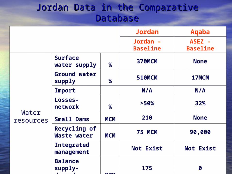
Jordan Data in the Comparative DatabaseJordan Data in the Comparative Database
Jordan Aqaba
Jordan – Baseline
ASEZ - Baseline
Water resources
Surface water supply %
370MCM None
Ground water supply %
510MCM 17MCM
Import N/A N/A
Losses-network %
>50% 32%
Small Dams MCM 210 None
Recycling of Waste water MCM
75 MCM 90,000
Integrated management
Not Exist Not Exist
Balance supply-demand MCM
175 0

Jordan Data in the Comparative DatabaseJordan Data in the Comparative Database
Jordan Aqaba
Jordan - Baseline ASEZ - Baseline
Water quality
Pollution Min Min
Salinity ppm 300-1000 250-450
Surface water quality ppm
700 N/A
Groundwater pollution
Limited Limited
Basin-out water supply (groundwater) mm/y
N/A 20MCM
Waste water ppm 1000-1200 700-1000
Wastewater industrial pollution
Limited Limited

Jordan Data in the Comparative DatabaseJordan Data in the Comparative Database
Jordan Aqaba
Jordan - Baseline
ASEZ - Baseline
Water uses
Domestic water use MCM 270 3.96
Industrial water use (groundwater) MCM
25 3.95
Industrial water use (surface water) MCM
20 None
Irrigation water use MCM 610 2.25 MCM
Water exploitation awareness
Exist Exist

Jordan Data in the Comparative DatabaseJordan Data in the Comparative Database
Jordan Aqaba
Jordan - BaselineASEZ -
Baseline
Water Supply Investments
Domestic Water Supply Investments
N/A N/A
Irrigation m/o Investments
N/A N/A
Land use
Residential growth
15% 20%
Aquaculture development
None None
Irrigated Area km²
700 10

Jordan Data in the Comparative DatabaseJordan Data in the Comparative Database
Jordan Aqaba
Jordan - Baseline
ASEZ - Baseline
Land use Change
Land use Change %
N/A N/A
Tourism areas
N/AN/A
Agricultural Areas
2-10 Km2N/A
Industrial Areas
N/AN/A

Jordan Data in the Comparative DatabaseJordan Data in the Comparative Database
Jordan Aqaba
Jordan - Baseline
ASEZ - Baseline
Tourism
National policy for tourism development
EXIST EXIST
Water overexploitation (in spite of the heavy taxes) %
150 0
Shortage of Institutional capabilities
No No
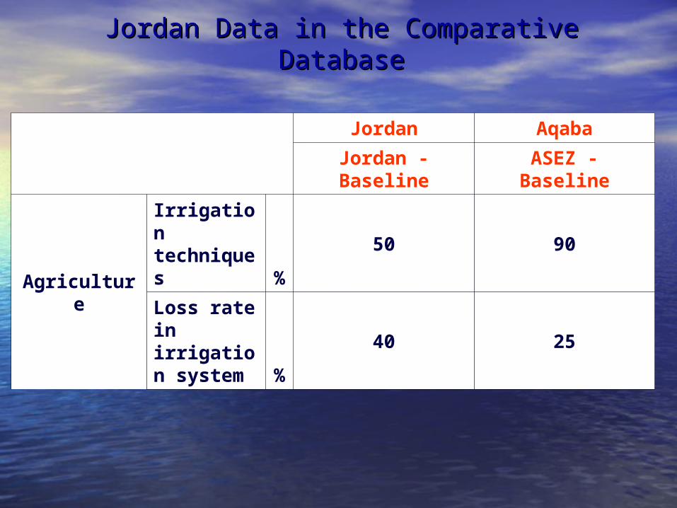
Jordan Data in the Comparative DatabaseJordan Data in the Comparative Database
Jordan Aqaba
Jordan - Baseline ASEZ - Baseline
Agriculture
Irrigation techniques %
50 90
Loss rate in irrigation system %
40 25

Jordan Data in the Comparative DatabaseJordan Data in the Comparative Database
Jordan Aqaba
Jordan - Baseline
ASEZ - Baseline
Climate Change
Salt water intrusion
No No
Frequent torrential rain
No None
More droughts Yes
Less precipitation
mm/y
300 35
Precipitation rate mm
95 35
Coastal erosion mm/y
No No

TELEMAC TELEMAC Modeling SystemModeling System

TELEMAC Modeling TELEMAC Modeling Work AchievedWork Achieved
1.1. A triangular mesh with a number of criteria was A triangular mesh with a number of criteria was generatedgenerated
2.2. The effect of the forcing parameters (Tide & The effect of the forcing parameters (Tide & Wind) on the current fields in the Gulf of Aqaba Wind) on the current fields in the Gulf of Aqaba was studied.was studied.
3.3. The influence of these both factors on the local The influence of these both factors on the local hydrodynamic (scalar velocity and water depth) hydrodynamic (scalar velocity and water depth) was underlined.was underlined.

• Criteria: Criteria: 3000 3000 mm, 1000 m, 1000 m, , 200 200 m, and m, and 20 m.20 m.
• Number of Number of Elements: Elements: 2453224532
I- Mesh GenerationI- Mesh Generation :: MATISSEMATISSE

Boundary Boundary ConditionsConditions1.1. Upstream Boundary: Upstream Boundary:
Begins at boundary point Begins at boundary point number 1 and coordinates ( number 1 and coordinates ( X=642127, Y=3110380), X=642127, Y=3110380), and ends at boundary point and ends at boundary point number 7 and coordinates number 7 and coordinates (X= 659332.0 Y= 3113890). (X= 659332.0 Y= 3113890).
Depth condition (open Depth condition (open boundary with boundary with prescribed depth)prescribed depth)
Velocity condition (open Velocity condition (open boundary with free boundary with free velocity)velocity)
2.2. Coastline: Begins at Coastline: Begins at boundary point number 7 boundary point number 7 (Global Number 65) and (Global Number 65) and coordinates (X= 659332.0, coordinates (X= 659332.0, Y= 3113890.), and ends at Y= 3113890.), and ends at boundary point number 1 boundary point number 1 (Global Number 24) and (Global Number 24) and coordinates (X= 642127.0, coordinates (X= 642127.0, Y= 3110380).Y= 3110380).
Depth condition (closed Depth condition (closed boundary ”wall”)boundary ”wall”)
Upstream Boundary
Coastline

Scenario I: TIDEScenario I: TIDE Three different Simulations were performed for Three different Simulations were performed for
the periods of : March, June and August. the periods of : March, June and August. The simulation time was three days The simulation time was three days
corresponding to six tides for each month. corresponding to six tides for each month.
Scenario II: TIDE & WINDScenario II: TIDE & WIND The same simulations performed in the first The same simulations performed in the first
scenario were repeated taking into account the scenario were repeated taking into account the effect of wind.effect of wind.
The simulations were performed for a period of The simulations were performed for a period of three days. three days.
Description of ScenariosDescription of Scenarios

Hydrodynamic Hydrodynamic Results: RUBENSResults: RUBENS

Scenario Scenario I: TideI: Tide
1)1) MarchMarch
Flood Currents Produced
From Rising Tides

Scenario Scenario I: TideI: Tide
1)1) MarchMarch
Flood Currents Produced From High
Tides

Scenario Scenario I: TideI: Tide
1)1) MarchMarch
Ebb Currents Produced
From Falling Tides

Scenario II: Scenario II: Tide & WindTide & Wind
1)1) MarchMarch
Wind has more effect on the flow direction than the tide
effect

Scenario II: Scenario II: Tide & WindTide & Wind
1)1) MarchMarch
Wind has more effect on the flow direction than the tide
effect

Scenario II: Scenario II: Tide & WindTide & Wind
1)1) MarchMarch
Wind has more effect on the flow direction than the tide
effect

Eddy currents produced at
different locations in the Gulf of
Aqaba during the month of
March.

TELEMAC Modeling TELEMAC Modeling Current Step: Current Step:
Calibration/ValidationCalibration/Validationthe data used in the calibration step were obtained from the the data used in the calibration step were obtained from the
Marine Science Station, these data include:Marine Science Station, these data include:
1)1) Measured currents (intensity & direction) at one location during the months Measured currents (intensity & direction) at one location during the months of March (from 06/03 to 31/03), June (from 01/06 to 22/06) and August (from of March (from 06/03 to 31/03), June (from 01/06 to 22/06) and August (from 01/08 to 22/08) of the year 2000. The projected coordinate of that location 01/08 to 22/08) of the year 2000. The projected coordinate of that location in UTM is: X=690861 Y= 3260258.in UTM is: X=690861 Y= 3260258.
2)2) Measured currents (intensity & direction) at two locations during the month Measured currents (intensity & direction) at two locations during the month of March 1999. The projected coordinates of those locations are: X=684850 of March 1999. The projected coordinates of those locations are: X=684850 Y= 3254935 and X= 651992 Y= 3135229. For the first location, the Y= 3254935 and X= 651992 Y= 3135229. For the first location, the available measured currents are only for 22 hrs period during the fifth day available measured currents are only for 22 hrs period during the fifth day of March. For the second location, it is for 30 hrs period during the second of March. For the second location, it is for 30 hrs period during the second and third day of March.and third day of March.
3)3) The water depth at which the measured currents were taken was The water depth at which the measured currents were taken was 35m. 35m.
4)4) Description of the bottom of the Gulf of Aqaba. It was known from the MSS Description of the bottom of the Gulf of Aqaba. It was known from the MSS that the bottom of the Aqaba Gulf consists of more than 90% Silicate and that the bottom of the Aqaba Gulf consists of more than 90% Silicate and the remaining part is Carbonate.the remaining part is Carbonate.

Location of the points at which measured currents for the year 2000 and 1999 are available.

0
20
40
60
80
100
120
140
160
180
0 50000 100000 150000 200000 250000
Time (sec)
Dir
ec
tio
n (
de
g)
simulated
measured
0
0.05
0.1
0.15
0.2
0.25
0.3
0.35
0.4
0 50000 100000 150000 200000 250000
Time (sec)
Ve
loc
ity
(m
/s)
simulated
measured

TELEMAC Modeling TELEMAC Modeling Current Step: Current Step:
Calibration/ValidationCalibration/ValidationQuestions:Questions:1)1) By comparing the simulated currents By comparing the simulated currents
with the measured ones, it is appeared with the measured ones, it is appeared that there is a difference of two order of that there is a difference of two order of magnitude between the two comparable magnitude between the two comparable currents, Why ?! currents, Why ?!
2)2) Which parameter are we going to Which parameter are we going to calibrate?calibrate?

TELEMAC Modeling TELEMAC Modeling Next StepNext Step
To validate the modelTo validate the model
To compute the pollutant evolution in the To compute the pollutant evolution in the Gulf. The pollutant to be studied is the Gulf. The pollutant to be studied is the dissolved nitrogen in the form of Nitrate dissolved nitrogen in the form of Nitrate (NO(NO33ˉ). ˉ).
The water quality data is not available till The water quality data is not available till nownow

Land Use Change Land Use Change ModelModelLUCLUC
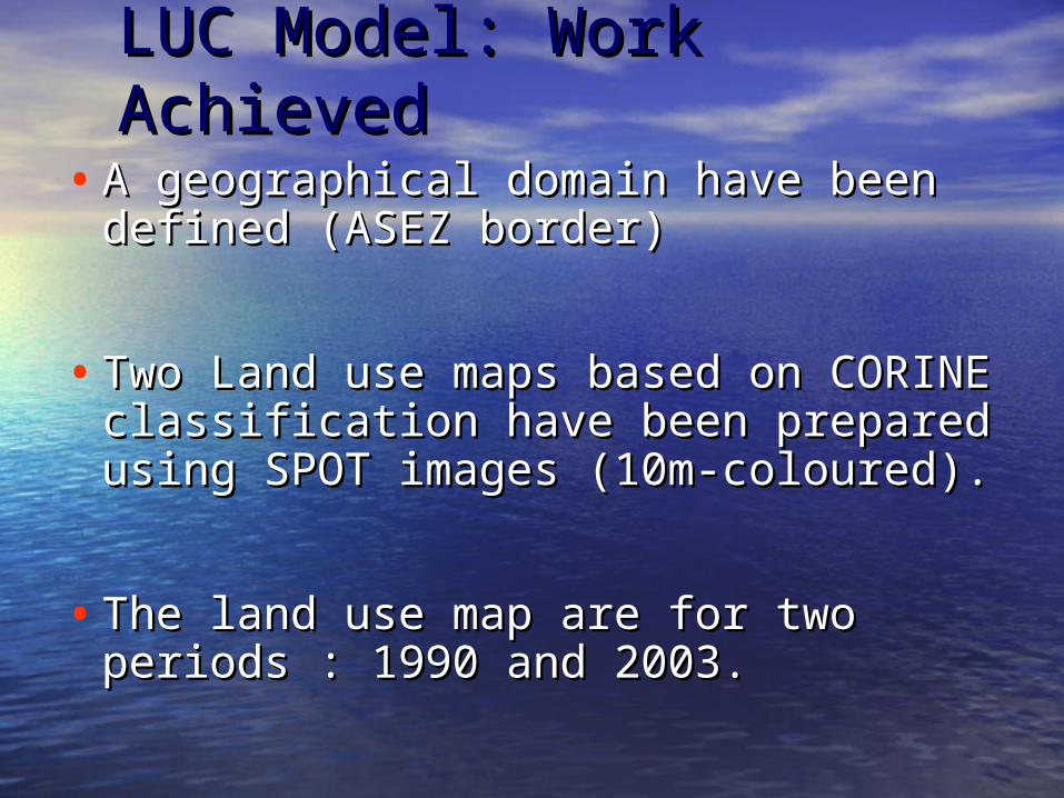
LUC Model: Work LUC Model: Work AchievedAchieved
• A geographical domain have been A geographical domain have been defined (ASEZ border)defined (ASEZ border)
• Two Land use maps based on CORINE Two Land use maps based on CORINE classification have been prepared classification have been prepared using SPOT images (10m-coloured).using SPOT images (10m-coloured).
• The land use map are for two The land use map are for two periods : 1990 and 2003.periods : 1990 and 2003.

Aqaba Special Economic Zone Border Aqaba Special Economic Zone Border (ASEZA)(ASEZA)

Land Use Map For Land Use Map For The Year 1990The Year 1990

Land Use Map For Land Use Map For The Year 2003The Year 2003

WATERWARE Modeling WATERWARE Modeling SystemSystem

WATERWARE Modeling System WATERWARE Modeling System Work AchievedWork Achieved
1.1. Define the application domain within which the Define the application domain within which the system is to be applied. The application domain system is to be applied. The application domain will be ASEZA area. will be ASEZA area.
2.2. Identify the network objects within the ASEZA Identify the network objects within the ASEZA border. A network objects are represented by:border. A network objects are represented by:
1.1. Type (Start, Demand, Confluence, Diversion or Supply)Type (Start, Demand, Confluence, Diversion or Supply)2.2. Location (X,Y,Z)Location (X,Y,Z)
3.3. Time series data for:Time series data for:1.1. The daily pumping rate from wells that supply Aqaba The daily pumping rate from wells that supply Aqaba
from 1998-2003from 1998-20032.2. Daily water consumption for all sectors at each demand Daily water consumption for all sectors at each demand
node from 1998-2003node from 1998-20033.3. Daily water consumption for sectors at each demand Daily water consumption for sectors at each demand
node from 1998-2003node from 1998-2003


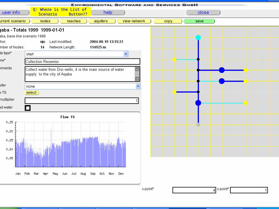
Q: Where is the List of Q: Where is the List of Scenario Button??Scenario Button??

WATERWARE Modeling SystemWATERWARE Modeling SystemNext StepNext Step
Check for suitability and adequacy Check for suitability and adequacy of the collected data.of the collected data.
Try to run the WRM model for our Try to run the WRM model for our case study.case study.
Try to run the LUC model for our Try to run the LUC model for our case study.case study.

Current Problems we are facingCurrent Problems we are facing How to deal with the sectorial demand data How to deal with the sectorial demand data
(Input format) ? (Input format) ?
In the manual, it is indicated that only scenarios In the manual, it is indicated that only scenarios owned by a user can be viewed, but what about owned by a user can be viewed, but what about the TIME SERIES. We observe that we can select the TIME SERIES. We observe that we can select a TS related to other case studies to be used in a TS related to other case studies to be used in our scenario and or delete it?our scenario and or delete it?
When do you expect the model to be ready for When do you expect the model to be ready for RUN? RUN?
What is the link between the WRM output and What is the link between the WRM output and LUC model output?LUC model output?

Dissemination PlanDissemination Plan

Dissemination Plan Dissemination Plan Participate in “Participate in “Wadi Hydrology Steering Wadi Hydrology Steering
Committee Meeting Committee Meeting “ that was held in “ that was held in Damascus, Syria in July 20,2004Damascus, Syria in July 20,2004
Participate in the “Participate in the “Second INCO-MED Water Second INCO-MED Water Conference Conference ” that was held in Amman, June-” that was held in Amman, June-14,2004. 14,2004.
Participate in the “Participate in the “International Water International Water Demand Management ConferenceDemand Management Conference” that was ” that was held in the Dead Sea, Jordan in May 30, held in the Dead Sea, Jordan in May 30, 2004 2004

END of SLIDE SHOWEND of SLIDE SHOW
THANK YOUTHANK YOU

![Centre For Tomorrow Hammamet, Hammamet - Brochure...Centre For Tomorrow Hammamet 2 CFT Hammamet at the Heart of Hammamet,uuu G}Á }( Z 'µo(Know us more Kµ µo] Ç Z Our courses Languages](https://img.dokumen.tips/doc/110x75/5f81e30e726bd1456f472f7e/centre-for-tomorrow-hammamet-hammamet-brochure-centre-for-tomorrow-hammamet.jpg)