Embed Size (px)
Citation preview
Intergovernmental Oceanographic CommissionReports of Meetings of Experts and Equivalent Bodies
Joint IOC-IHO Guiding Committeefor the General Bathymetric Chartof the OceansFifteenth SessionInternational Hydrographic BureauMonaco, 15-17 May 1995
UNESCO
Optical Character Recognition (OCR) document. WARNING! Spelling errors might subsist. In order to accessto the original document in image form, click on "Original" button on 1st page.

In this Series, entitled
Reports of Meetings of Experts and Equivalent Bodies, which was initiated in 1984 and which is published in English only, unless otherwisespecified, the reports of the following meetings have already been issued:
2.3.4.5.6.7.8.9.
10.11.12.13.14.15.16.17.18.19.
20.21.22.23.24.
25.
27.28.29.30.31.32.33.34.35.36.37.38.39.40.41.42.43.44.45.46.47.48.49.50.51.52.53.54.
55.
57.58.59.60.61.
62.63.64.65.66.67.68.69.70.71.72.73.
74.75.76.77.
78.79.80.81.
Third Meeting of the Central Editorial Board for the Geological/Geophysical Atlases of the Atlantic and Pacific OceansFourth Meeting of the Central Editorial Board for the Geological/Geophysical Atlases of the Atlantic and Pacific OceansFourth Session of the Joint IOC-WMO-CPPS Working Group on the Investigations of ‘El Niño’ (Also printed in Spanish)First Session of the IOC-FAO Guiding Group of Experts on the Programme of Ocean Science in Relation to Living ResourcesFirst Session of the IOC-UN(OETB) Guiding Group of Experts on the Programme of Ocean Science in Relation to Non-Living ResourcesFirst Session of the Editorial Board for the International Bathymetric Chart of the Mediterranean and Overlay SheetsFirst Session of the Joint CCOP(SOPAC)-IOC Working Group on South Pacific Tectonics and ResourcesFirst Session of the IODE Group of Experts on Marine Information ManagementTenth Session of the Joint CCOP-IOC Working Group on Post-lDOE Studies in East Asian Tectonics and ResourcesSixth Session of the IOC-UNEP Group of Experts on Methods, Standards and IntercalibrafionFirst Session of the IOC Consultative Group on Ocean Mapping (Also printed in French and Spanish)Joint IOC-WMO Meeting for Implementation of IGOSS XBT Ships-of-Opportunity programmesSecond Session of the Joint CCOP/SOPAC-IOC Working Group on South Pacific Tectonics and ResourcesThird Session of the Group of Experts on Format DevelopmentEleventh Session of the Joint CCOP-IOC Working Group on Post-lDOE Studies of South-East Asian Tectonics and ResourcesSecond Session of the IOC Editorial Board for the International Bathymetric Chart of the Mediterranean and Overlay SheetsSeventh Session of the IOC-UNEP Group of Experts on Methods, Standards and IntercalibrationSecond Session of the IOC Group of Experts on Effects of PollutantsPrimera Reunión del Comité Editorial de la COI para la Carta Batimétrica International del Mar Caribe y Parte del Océano Pacíficofrente a Centroamérica (Spanish only)Third Session of the Joint CCOP/SOPAC-IOC Working Group on South Pacific Tectonics and ResourcesTwelfth Session of the Joint CCOP-IOC Working Group on Post-l DOE Studies of South-East Asian Tectonics and ResourcesSecond Session of the IODE Group of Experts on Marine Information ManagementFirst Session of the IOC Group of Experts on Marine Geology and Geophysics in the Western PacificSecond Session of the IOC-UN(OETB) Guiding Group of Experts on the Programme of Ocean Science in Relation to Non-LivingResources (Also printed in French and Spanish)Third Session of the IOC Group of Experts on Effects of PollutantsEighth Session of the IOC-UNEP Group of Experts on Methods, Standards and IntercalibrationEleventh Session of the Joint IOC-IHO Guiding Committee for the General Bathymetric Chart of the Oceans (Also printed in French)Second Session of the IOC-FAO Guiding Group of Experts on the Programme of Ocean Science in Relation to Living ResourcesFirst Session of the IOC-IAEA-UNEP Group of Experts on Standards and Reference MaterialsFirst Session of the IOCARIBE Group of Experts on Recruitment in Tropical Coastal Demersal Communities (Also printed in Spanish)Second IOC-WMO Meeting for Implementation of IGOSS XBT Ship-of-Opportunity programmesThirteenth Session of the Joint CCOP-IOC Working Group on Post-l DOE Studies of East Asia Tectonics and ResourcesSecond Session of the IOC Task Team on the Global Sea-Level Observing SystemThird Session of the IOC Editorial Board for the International Bathymetric Chart of the Mediterranean and Overlay SheetsFourth Session of the IOC- UNEP-IMO Group of Experts on Effects of PollutantsFirst Consultative Meeting on RNODCs and Climate Data ServicesSecond Joint IOC-WMO Meeting of Experts on IGOSS-IODE Data FlowFourth Session of the Joint CCOP/SOPAC-IOC Working Group on South Pacific Tectonics and ResourcesFourth Session of the IODE Group of Experts on Technical Aspects of Data ExchangeFourteenth Session of the Joint CCOP-IOC Working Group on Post-lDOE Studies of East Asian Tectonics and ResourcesThird Session of the IOC Consultative Group on Ocean MappingSixth Session of the Joint IOC-WMO-CCPS Working Group on the Investigations of ‘El Niño’ (Also printed in Spanish)First Session of the IOC Editorial Board for the International Bathymetric Chart of the Western Indian OceanThird Session of the IOC-UN(OALOS) Guiding Group of Experts on the Programme of Ocean Science in Relation to Non-Living ResourcesNinth Session of the IOC-UNEP Group of Experts on Methods, Standards and IntercalibrationSecond Session of the IOC Editorial Board for the International Bathymetric Chart of the Caribbean Sea and the Gulf of MexicoFirst Session of the IOC Editorial Board for the International Bathymetric Chart of the Western Indian OceanTwelfth Session of the Joint IOC-IHO Guiding Committee for the General Bathymetric Chart of the OceansFifteenth Session of the Joint CCOP-IOC Working Group on Post-l DOE Studies of East Asian Tectonics and ResourcesThird Joint IOC-WMO Meeting for Implementation of IGOSS XBT Ship-of-Opportunity programmesFirst Session of the IOC Group of Experts on the Global Sea-Level Observing SystemFourth Session of the IOC Editorial Board for the International Bathymetric Chart of the MediterraneanFirst Session of the IOC Editorial Board for the International Chart of the Central Eastern Atlantic (Also printed in French)Third Session of the IOC Editorial Board for the International Bathymetric Chart of the Caribbean Sea and the Gulf of Mexico(Also printed in Spanish)Fifth Session of the IOC-UNEP-IMO Group of Experts on Effects of PollutantsSecond Session of the IOC Editorial Board for the International Bathymetric Chart of the Western Indian OceanFirst Meeting of the IOC ad hoc Group of Experts on Ocean Mapping in the WESTPAC AreaFourth Session of the IOC Consultative Group on Ocean MappingSecond Session of the IOC-WMO/lGOSS Group of Experts on Operations and Technical ApplicationsSecond Session of the IOC Group of Experts on the Global Sea-Level Observing SystemUNEP-IOC-WMO Meeting of Experts on Long-Term Global Monitoring System of Coastal and Near-Shore PhenomenaRelated to Climate ChangeThird Session of the IOC-FAO Group of Experts on the Programme of Ocean Science in Relation to Living ResourcesSecond Session of the IOC- IAEA-UNEP Group of Experts on Standards and Reference MaterialsJoint Meeting of the Group of Experts on Pollutants and the Group of Experts on Methods, Standards and IntercalibrationFirst Meeting of the Working Group on Oceanographic Co-operation in the ROPME Sea AreaFifth Session of the Editorial Board for the International Bathymetric and its Geological/Geophysical SeriesThirteenth Session of the IOC-IHO Joint Guiding Committee for the General Bathymetric Chart of the Oceans (Also printed in French)International Meeting of Scientific and Technical Experts on Climate Change and OceansUNEP-IOC-WMC-IUCN Meeting of Experts on a Long-Term Global Monitoring SystemFourth Joint IOC-WMO Meeting for Implementation of IGOSS XBT Ship-of-Opportunity programmesROPME-IOC Meeting of the Steering Committee on Oceanographic Co-operation in the ROPME Sea AreaSeventh Session of the Joint IOC-WMO-CPPS Working Group on the Investigations of ‘El Niño’ (Spanish only)Fourth Session of the IOC Editorial Board for the International Bathymetric Chart of the Caribbean Sea and the Gulf of Mexico(Also printed in Spanish)UNEP-IOC-ASPEI Global Task Team on the Implications of Climate Change on Coral ReefsThird Session of the IODE Group of Experts on Marine Information ManagementFifth Session of the IODE Group of Experts on Technical Aspects of Data ExchangeROPME-IOC Meeting of the Steering Committee for the Integrated Project Plan for the Coastal and Marine Environment of the ROPMESea AreaThird Session of the IOC Group of Experts on the Global Sea-level Observing SystemThird Session of the IOC-IAEA-UNEP Group of Experts on Standards and Reference MaterialsFourteenth Session of the Joint IOC-IHO Guiding Committee for the General Bathymetric Chart of the OceansFifth Joint IOC-WMO Meeting for Implementation of IGOSS XBT Ship-of-Opportunity programmes
CONTINUED ON INSIDE OF BACK COVER
Optical Character Recognition (OCR) document. WARNING! Spelling errors might subsist. In order to accessto the original document in image form, click on "Original" button on 1st page.

Intergovernmental Oceanographic CommissionReports of Meetings of Experts and Equivalent Bodies
Joint IOC-IHO Guiding Committeefor the General Bathymetric Chartof the OceansFifteenth SessionInternational Hydrographic BureauMonaco, 15-17 May 1995
UNESCO
Optical Character Recognition (OCR) document. WARNING! Spelling errors might subsist. In order to accessto the original document in image form, click on "Original" button on 1st page.

IOC-IHO/GEBCO-XV/3Paris, 7 December 1995
English only
SC-95/WS-30
Optical Character Recognition (OCR) document. WARNING! Spelling errors might subsist. In order to accessto the original document in image form, click on "Original" button on 1st page.

IOC-IHO/GEBCO-XV/3page (i)
TABLE OF CONTENTS
SUMMARY REPORT
1. Opening of the Session
2. Conduct of the Session
2.1 Adoption of the Agenda
2.2 Documentation; Administrative Arrangements; etc.
3. Composition of the Guiding Committee and itsSub-Committees
4. Matters arising from Reports of Previous Meetings
4.1 Summary Report of the Fourteenth Session of theJoint IOC-IHO Guiding Committee for the GEBCO(doc. IOC- IHO/GEBCO-XIV/3)
4.2 Summary Report of the Ninth Meeting of the
1
1
1
1
1
2
2
2GEBCO Officers (doc. IOC-IHO/GEBCO Officers-IX/3)
5. Reports on Work carried out by, and Activities of: 4
5.1 The GEBCO Bathymetric Editor 4
5.2 The GEBCO Digital Atlas Manager 4
5.3 The NERC Unit for Thematic Information Systems 5(NUTIS) - GEBCO Project
6. Sub-Committee on Undersea Feature Names, Eleventh 5Meeting, IHB, Monaco, 11-13 May 1995
6.1 Liaison and Co-operation with the U.S. Board 6on Geographic Names/Advisory Committee onUndersea Features (BGN/ACUF)
6.2 Standardization of Undersea Feature Names 7(publication B-6)
Optical Character Recognition (OCR) document. WARNING! Spelling errors might subsist. In order to accessto the original document in image form, click on "Original" button on 1st page.

IOC-IHO/GEBCO-XV/3page (ii)
7. Sub-Committee on Digital Bathymetry, Twelfth Meeting,SACLANT Undersea Research Centre, La Spezia, Italy,8-12 May 1995
7.1 IHO Data Centre for Digital Bathymetry (DCIDB)
7.2 Gridded Dataset
7.3 Bathymetric Exchange Formats
8. GEBCO Digital Atlas (GDA)
8.1 Progress with updating the 'GEBCO Digital Atlas’
8.2 Global Network of Reviewers
8.3 Preparation of a Prioritized Work List forwork on the GDA
9. Publication of a Revised Edition of Sheet 5.12(South Atlantic)
10. State of Preparation of the ‘Guidelines for the GEBCO'(publication B-7)
11. Sales, Publicity and Liaison with other MappingOrganisations
11.1 Publicity and Sales Arrangements for theGEBCO Digital Atlas (GDA)
11.2 Liaison with the Institut Geographique National(IGN)
7
10
10
11
12
12
13
13
15
15
16
16
17
11.3 Liaison with the IHO Committee on Exchange of 17Digital Data (CEDD)
11.4 Liaison with Bartholomew (a division of 17HarperCollins Publishers)
11.5 Liaison with the Ocean Mapping Group (OMG), 18University of New Brunswick, Canada
12. Implications for GEBCO of the entering into force of 18the UN Convention on the Law of the Sea (UNCLOS),and setting up of the Commission on the Limits ofthe Continental Shelf (CLCS)
13. International Hydrographic Bureau - Strategic Plan 18
Optical Character Recognition (OCR) document. WARNING! Spelling errors might subsist. In order to accessto the original document in image form, click on "Original" button on 1st page.

IOC-IHO/GEBCO-XV/3page (iii)
14. GEBCO Centenary (1999-2005)
15. Dates and Places of the Tenth Meeting of the GEBCOOfficers, and the Sixteenth Session of the JointGuiding Committee, together with meetings of theSub-Committees
16 Any Other Business
16.1 Draft Resolution submitted to the IOC Assemblyby the Consultative Group on Ocean Mapping
16.2 Approach to BODC by AA Petroleum Services forpermission to incorporate the GDA in theirPetroView product
16.3 Request by U.S. Defence Mapping Agency forpermission to combine the GDA with the WVSinto a single bathymetric database
16.4 Preparation of global coverage of sheets ofcontoured Gravity Anomalies from satellitealtimeter data
17. Approval of the Summary Report of the Session
18. Closure of the Session
ANNEXES
I Agenda
II List of Documents
III Report of GEBCO Digital Atlas Manager 1994-1995
IV List of Reviewers
V Coverage Diagram of Maps and Mapping Projects thatwould be suitable for updating the GDA
VI Resolution adopted by the IOC Assembly at itsEighteenth Session, Paris, 13-27 June 1995
VII List of Participants
VIII List of Acronyms
19
19
20
20
20
20
21
22
22
Optical Character Recognition (OCR) document. WARNING! Spelling errors might subsist. In order to accessto the original document in image form, click on "Original" button on 1st page.

IOC-IHO/GEBCO-XV/3
1. OPENING OF THE SESSION
The Fifteenth Session of the Joint IOC-IHO Guiding Committee forthe General Bathymetric Chart of the Oceans (GEBCO) was held at theInternational Hydrographic Bureau, Monaco. Sir Anthony Laughton,Chairman GEBCO, opened the session at 09.30 on Monday 15 May 1995.
Rear Admiral Christian Andreasen, President of the DirectingCommittee, welcomed the participants on behalf theInternational Hydrographic Organization, and Mr Dmitri Travin onbehalf of Dr Gunnar Kullenberg, Secretary IOC.
The Chairman welcomed:Lie. JOSé Luis Frias Salazar (Mexico)
to the first session of the Guiding Committee he had attended as afull member.
Captain James E.Ayres, U.S.Defense Mapping Agency, who waswell known to many members of the Guiding Committee and otherparticipants.
A full List of Participants is given in Annex VII.A full List of Acronyms used is given in Annex VIII.
Apologies for absence had been received from:
2.
3.
the
Mr David Monahan;Dr Robin K.H.Falconer;Dr Larry A.Mayer;Capitán de Navio J.M.Fernández de la Puente;Dr Andrey Popov;Mr William Rankin;Dr Kunio Yashima.
CONDUCT OF THE SESSION
2.1 Adoption of the Agenda
The Agenda was adopted - see Annex I.
2.2 Documentation; Administrative Arrangements; etc.
The Permanent Secretary introduced the documentation - seeAnnex II. The Administrative Arrangements and Social Programmewere presented.
COMPOSITION OF THE GUIDING COMMITTEE AND ITS SUB-COMMITTEES
It was reported that the following changes had taken place sinceThirteenth Session of the Guiding Committee in June 1991:
GEBCO Guiding Committee
Lie. José Luis Frias Salazar (Mexico) had been appointed to thevacancy left by the resignation of Dr Robert L.Fisher.
1
2
Optical Character Recognition (OCR) document. WARNING! Spelling errors might subsist. In order to accessto the original document in image form, click on "Original" button on 1st page.

IOC-IHO/GEBCO-XV/3page 2
10
11
12
13
14
15
4.
13
17
Scientific Advisers to the GEBCO
The names of Carl Brenner, Leonard Johnson and Carl Nelius wereremoved from the list and thanks were recorded for theirsupport over the years.
Dr Gary Robinson accepted an invitation to become a ScientificAdviser.
Sub-Committee on Undersea Feature Names (SCUFN)
Capitão-de-Fragata Roberto Figueria Carvalho (Brazil) had beenappointed to the Sub-Committee.
Mr Randall E.Flynn, Executive Secretary for Foreign Names,BGN/ACUF, had been provisionally listed as an adviser to SCUFNto replace Mr Anthony Gregory. Dr Richard R.Randall, formerExecutive Secretary BGN, had retired.
Sub-Committee on Digital Bathymetry (SCDB)
Mr William Rankin had replaced Mr Frank Marchant, USNOO, on theSub-Committee.
Mr Adam Kerr, Director IHO, now Chairman of the IHO Committeeon Electronic data (CoE) was appointed to the Sub-Committee,ex-officio as an observer, to replace Rear Admiral J.AustinYeager NOAA.
MATTERS ARISING FROM REPORTS OF PREVIOUS MEETINGS
4.1 Summary Report of the Fourteenth Session of the Joint IOC-IHOGuiding Committee for the GEBCO (doc. IOC-IHO/GEBCO-XIV/3)
All matters arising from this report were covered by item 4.2below or other agenda items.
4.2 Summary Report of the Ninth Meeting of the GEBCO Officers(doc. IOC-IHO/GEBCO Officers-IX/3)
P a t a g r a p h 1 9 T h e G E R C O B a t h y m e t r i c E d i t o rT h e G E B C 0 D i g i t a l A t l a s M a n a g e r
The Chairman reported that the United Kingdom NaturalEnvironment Research Council (NERC) had confirmed theextension of these two posts for 4 more years (until 1999) .These appointments form part of the U.K. contribution (inkind) to the IOC, so they can be assured for the next fewyears.
Optical Character Recognition (OCR) document. WARNING! Spelling errors might subsist. In order to accessto the original document in image form, click on "Original" button on 1st page.

IOC-IHO/GEBCO-XV/3page 3
The Guiding Committee placed on record its great appreciation to 18NERC for its continued support to the GEBCO project.
No further progress with this project has been reported. It 19will be retained as an information item only. Dr Gleb Udintsevand Dr Yuri Kiselev were invited to keep the Guiding Committeeinformed of any developments.
Two cruises by U.S. submarines, collecting bathymetry and gravity 20data, were announced at the American Geophysical Union (AGU)meeting in December 1994. The U.S. Navy will provide space asavailable.
P a r a g r a p h 2 1 L i a i s o n w i t h t h e N a t i o n a l G e o g r a p h i c S o c i e t y ( N G S )
Rear Admiral Andreasen reported that he had written to NGS in 2lan attempt to publicise the GDA. He was invited to maintaincontact with the Society.
Dr Meirion Jones reported that his contact was now Dr Terry 22Offield. The GDA bathymetry was being used and a preparatoryCD-ROM was expected in early summer 1995. It was noted that dueto USGS internal policy CAP was being given a much reduced levelof visibility.
P a r a g r a p h 2 6 P r o j e c t ‘ G l o b a l M a p p i n g f o r t h e G l o b a l E n v i r o n m e n t '
Dr Kunio Yashima would be invited to investigate whether 23there had been any new developments.
Rear Admiral Andreasen reported that the Italian (and 24Spanish) Hydrographers have withdrawn their proposal. There isa necessary follow-up now to obtain their data in digital form.Dr Michael Loughridge (NGDC) has agreed to digitize the Italianbathymetric plotting sheets.
Optical Character Recognition (OCR) document. WARNING! Spelling errors might subsist. In order to accessto the original document in image form, click on "Original" button on 1st page.

IOC-IHO/GEBCO-XV/3page 4
5. REPORTS ON WORK CARRIED OUT BY, AND ACTIVITIES OF:
5.1 THE GEBCO BATHYMETRIC EDITOR
25 Mr Peter Hunter reported that due to the imminent move of hisInstitute from Wormley to Southampton, no visits had been possibleover the past year. He had however kept up a close liaison with hiscontacts by correspondence. He had also been active in checking outthe colour proof of sheet 5.12 (revised) South Atlantic (see item 9below) and preparing material for updating the GDA, in particular inthe North-east Atlantic.
26 He was planning visits to: Germany, in particular the BSH facility atRestock; Spain, the University of Barcelona - of particular interestwas their work in the Antarctic in R/V ‘Hesperides’ (it was noted thatSpanish name proposals had not been received for consideration bySCUFN); and Norway. In addition, he planned to attend all IBCEditorial Board meetings which would provide an opportunity for him tovisit Mexico and countries in the Caribbean and Central America.Dmitri Travin confirmed that prior notification of all EB-IBC meetingswould be sent to Peter Hunter.
27 A Baltic Consortium (Dr Emelyan Emelyanov), based in Riga, had issueda set of maps in the late 1980s. Cherkis agreed to send a set to theGBE. Scott will send a copy of the Baltic Sea EnvironmentProceedings No.9 map ‘The Baltic Sea Area - Bathymetric Map’, 1981, tothe GBE.
28 Dr Michael Loughridge reported that he had received very littleinformation from IBCWP (Dr Hou Wenfeng). Dmitri Travin agreed toinvestigate this, with Dr Li Haiqing (IOC Secretariat).
5.2 THE GEBCO DIGITAL ATLAS MANAGER
29 Ms Pauline Weatherall submitted a report on her activities: Reportof GEBCO Digital Atlas Manager 1994-1995 (see Annex III). Her maintask had been co-operating with Dr Robert L. Fisher (SIO) overdigitizing his major work in the greater Indian Ocean area. The area10 W (in the Atlantic south of 24°S) to 100°E had been digitized andhe was now working to 120°E. Some three-quarters of the qualitycontrol work and edge matching had been completed.
30 Dr Fisher reported that due to major personality changes in Australia,data to 150°E from CSIRO and AGSO were now being released. IHB wasinvited to approach the Australian Hydrographer on behalf of SCDB, asno digital data had as yet been received from his office. Severalinstitutions in Australia were willing to supply digital data, butwith a restriction on further distribution. These data will besupplied for the ‘Alliance exotique’ project and GEBCO, but will notat this time be submitted to Data Centres.
Optical Character Recognition (OCR) document. WARNING! Spelling errors might subsist. In order to accessto the original document in image form, click on "Original" button on 1st page.

IOC-IHO/GEBCO-XV/3page 5
However, following a request, he agreed to the release of his ship 31track plot for the area of IBCWIO to the Chief Editor IBCWIO, so thata comparison could be made with ship cruise data held, with a view toidentifying and subsequently obtaining any missing data.
The Guiding Committee congratulated Pauline Weatherall on her work 32which was proving most valuable.
5.3 THE NERC UNIT FOR THEMATIC INFORMATION SYSTEMS(GEBCO PROJECT)
Dr Gary Robinson reported that he was the only person in the unit 33working on the GEBCO Project. He had been concentrating on ways ofestimating the accuracy and quality of results when interpolating rawbathymetric contour data, for use when updating the GDA. Furtherwork had also been carried out on the cartographic name placementproject, designed to integrate names from the Gazetteer with the GDAgeneralized coastlines. A demonstration was given to show thelatest developments.
The Guiding Committee thanked Dr Robinson for his work and asked him 34to continue developing both projects.
6. SUB-COMMITTEE ON UNDERSEA FEATURE NAMES, ELEVENTH MEETING, IHB,MONACO, 11-13 MAY 1995
Dr Robert L.Fisher, Chairman, Sub-Committee on Undersea Feature 35Names, introduced this item and presented the report of the EleventhMeeting of his Sub-Committee, which had been held at the InternationalHydrographic Bureau the previous week, 11-13 May 1995. In takingthe Guiding Committee through the draft report in some detail, hepointed out that, although approved in principle by the Sub-Committee,it would need a considerable amount of checking and editing by theSecretary of the Sub-Committee, Ing.en Chef Michel Huet, particularlythe many geographical co-ordinates listed, and cross-references,before the text (doc. IOC-IHO/GEBCO SCUFN-XI/3) could be finalized.
He drew attention to two concerns expressed by the Sub-Committee which 36are explained in the report in more detail under the heading‘Principles for Naming Features’. These are: i. the tendency todepart from a basic principle that ‘If names of living persons areused they should be limited to those who have made an outstanding orfundamental contribution to ocean sciences. ' , and ii. the frequent useof the term "seamount" (or "guyot") for topographically minor featuresthat do not meet the scale, dimensions and shape criteria laid downin the publication ‘ Standardization of Undersea Feature Names’ . TheGuiding Committee agreed fully with the concerns expressed andinstructed the Sub-Committee to reject such names if any such camebefore them. The Chairman BGN/ACUF was invited to take note of thisaction.
Optical Character Recognition (OCR) document. WARNING! Spelling errors might subsist. In order to accessto the original document in image form, click on "Original" button on 1st page.

IOC-IHO/GEBCO-XV/3page 6
37 It was recalled that a proposal had been made at an earlier meeting ofthe Sub-Committee that a seamount group at the north-east end of theGuinea Rise (9°04'N. 20°20'W. to 8°58'N. 19°52'W. ) be named theGrimaldi Seamounts after the Monegasque ruling family, and thatindividual seamounts in the group be named after Prince Albert I ofMonaco and his two research ships, Hirondelle and Princesse Alice,which had worked in that area. It was agreed that this would bdiscussed with BGN/ACUF (which body had been naming seamounts in thisregion) and, if agreement could be reached, that clearance would besought from Prince Rainier.
38 Ing.en Chef Michel Huet demonstrated the digitized version of theIHO/IOC Gazetteer which is maintained by IHB but now also forms partof the GEBCO Digital Atlas (GDA). It was noted that there is scopeto add a great deal of additional material, in particular historicalinformation on the origin of names. The IHB noted that it is plannedto hire a summer student (geography) to begin loading historicalinformation in 1995. Furthermore there is close linkage between theGazetteer database and the Cartographic Name Placement Project usingICON technology, being developed by Dr Gary Robinson (see item 5.3above).
39 The Guiding Committee expressed the need to record in the database themaximum and minimum depths (where known) of all named features, tohelp with their classification. Michel Huet said that at presentsuch information only appeared in the Remarks column, and that if thiswas a requirement the database will have to be restructured.
40 It was noted that: i. the International Arctic Science Committee(IASC) was revising their Arctic dataset; ii. the InternationalCartographic Association Working Group on Marine Cartography (which isto become a Commission) is preparing a new multi-lingual Gazetteer ofOcean Names - the Representative of the IHO was invited to enquirefrom the ICA Working Group what they are using as a database; andiii. the SCAR Working Group on Geodesy and Geographic Information/Sub-Working Group on Antarctic Place Names was developing an Antarcticdatabase (incorporating both land and sea names) - Dr Schenke agreedto maintain close liaison with this Sub-Working Group.
41 The Guiding Committee acknowledged with great appreciation theenormous amount of work, together with erudition and research, neededto ensure the provision of academically acceptable names for underseafeatures, in particular by the Chairman, Dr Robert L.Fisher, and theSecretary of the Sub-Committee, Ing.en Chef. Michel Huet.
6.1 LIAISON AND CO-OPERATION WITH THE U.S. BOARD ON GEOGRAPHICNAMES/ADVISORY COMMITTEE ON UNDERSEA FEATURES (BGN/ACUF)
42 The Chairman of the Sub-Committee on Undersea Feature Namesreported that following the appointment of Mr Norman Z.Cherkis, aScientific Adviser to the GEBCO, as Chairman BGN/ACUF, liaison andco-operation between the two bodies had improved greatly. AS a
Optical Character Recognition (OCR) document. WARNING! Spelling errors might subsist. In order to accessto the original document in image form, click on "Original" button on 1st page.

IOC-IHO/GEBCO-XV/3 page 7
result ‘Procedures to be adopted for the consideration of nameproposals ‘ (doc. IOC- IHO/GEBCO SCUFN-XI/3, item 7) had been agreed.
Following an enquiry, Mr Cherkis agreed to confirm whether Mr Trent 43Palmer, Executive Secretary ACUF, or Mr Randall E.Flynn, BGN ExecutiveSecretary for Foreign Names (who had replied to invitations), shouldbe listed as the Adviser to SCUFN (ex-officio).
6.2 Standardization OF UNDERSEA FEATURE NAMES (publication B-6)
The Permanent Secretary reported that no further work had been 44carried out on the English/German and English/Portuguese versions ofthis publication, and the English/Chinese version (although published)was incomplete as there were no references therein to usage of termsin the Chinese scientific literature. The full versions nowavailable were: English/French (2nd Edition), English/Japanese,English/Russian (2nd Edition) and English/Spanish (2nd Edition).
He pointed out that when this project was started, it had been the 45intention to publish all available language versions in a singlevolume and he asked whether this was still the intention. Afterdiscussion it was decided that there would be no significant advantagein so doing and the idea was dropped.
However it was considered that the definitions of some generic names 46of undersea features need updating and certain names, e.g. seamount,channel/seachannel, need clarification. This requirement wasreferred back to the Sub-Committee on Undersea Feature Names which wasalso invited to complete all examples and definitions given in theEnglish text.
7. SUB-COMMITTEE ON DIGITAL BATHYMETRY, TWELFTH MEETING, SACLANTUNDERSEA RESEARCH CENTRE, LA SPEZIA, 8-12 MAY 1995
Dr Meirion T.Jones, Chairman, Sub-Committee on Digital Bathymetry, 47introduced this item and presented the report of the Twelfth Meetingof his Sub-Committee (to be issued as doc. IOC- IHO/GEBCO SCDB-XII/3 ) ,which had been held at the SACLANT Undersea Research Centre, LaSpezia, Italy, the previous week, 8-12 May 1995. He reported thattwenty experts from nine countries had participated in the meeting andbenefited from the excellent facilities and organizational supportprovided by the Centre. The SACLANT Centre had indicated that it waskeen to establish working relationships with technical groups such asthis GEBCO Sub-Committee.
The agenda covered by the meeting was wide and varied, and included 48previews and discussion on bathymetric mapping activities worldwide;related activities of other national and international groups;development of the GDA; management of echo-sounding data; standardsand guidelines for the management and exchange of digital bathymetricdata; and the future development of GEBCO’s digital products.
Optical Character Recognition (OCR) document. WARNING! Spelling errors might subsist. In order to accessto the original document in image form, click on "Original" button on 1st page.

IOC-IHO/GEBCO-XV/3page 8
49 Progress was reported on a wide range of international and nationalefforts in the field of bathymetric mapping and data management, asfollows (more detail will appear in doc. IOC-IHO/GEBCO SCDB-XII/3):
Arctic Ocean50 i. U.S. Naval Research Laboratory (NRL) (Cherkis) - new
51 ii.
bathymetric map of the Arctic planned for’ release mid-1997;Bathymetry of Franz Josef Land to be printed October 1995;new version of Barents and Kara Seas digitized contours; workon Arabian Sea map continues;IASC Working Group on Geophysical Mapping [Jones (for Macnab)]- (former) Soviet Union Arctic seismic and invaluablebathymetric data being rescued (with NATO grant); Macnab hascreated a revised Arctic gridded dataset/image incorporatingGDA contours;
Atlantic Ocean52 iii. U.K. Institute of Oceanographic Sciences Deacon Laboratory
53 iv.
54 v.
55 vi.
54 vii.
(Hunter) - North-east Atlantic bathymetric chart series(5 sheets) being updated and recontoured;IOC International Bathymetric Chart of the Central EasternAtlantic (IBCEA) [Hunter and Loughridge (for Holcombe)] - goodprogress but concern for quality - see paragraphs 67 to 71below;Circum-Atlantic Project (CAP) (Cherkis) - see paragraph 22above;IFREMER (Hunter) - a high quality bathymetric chart of theGulf of Gascony (Bay of Biscay) has been produced;USA University of Rhode Island (Hall) - Russian multibeam datain the Atlantic is being processed;
Mediterranean Sea57 viii. IOC International Bathymetric Chart of the Mediterranean and
its Geological-Geophysical Series (IBCM) (Morelli and Hall) -plans leading to IBCM (bathymetry) 2nd Edition - see alsoparagraph 24 above;Hall is experimenting with new presentation techniques whichhe will test out on IBCM Sheet 10;
Caribbean Sea58 ix. IOC International Bathymetric Chart of the Caribbean Sea and
Gulf of Mexico (IBCCA) (Frias) - proggress with series;participating Member States will
)to digitize
their own sheets (guidance has been requested - see paragraph111 below;
Indian Ocean59 x. U.S.A. Scripps Institution of Oceanography (SIO) (Fisher/
Weatherall) - Fisher has continued. his work of contouring thegreater Indian Ocean, in collaboration with BODC - seeBODC - see paragraph 29 above and Annex III;
Optical Character Recognition (OCR) document. WARNING! Spelling errors might subsist. In order to accessto the original document in image form, click on "Original" button on 1st page.

IOC-IHO/GEBCO-XV/3 page 9
Pacific Oceanxi.
xii .
xiii.
xiv.
Australian Geological Survey Organization (AGSO) (Hunter) -approval has been given for- the release of AGSO’s bathymetricdata to the GDA and DCDB (and also to NMDIS for inclusion inthe WDC-D and IBCWP databases);South Pacific Applied Geoscience Commission (SOPAC) (Eade) -the EEZs of many island states in the region have been mappedbut no coherent digital bathymetric database yet exists;Servicio Hidrográfico y Oceanográfico de la Armada de Chile(Jones) - the work of digitizing the collected soundings inChile’s area of responsibility is well advanced;New Zealand Oceanographic Institute (NZOI) ( Hunter) - digital
xv.
xvi.
bathymetric contours have been provided for New Zealand watersbut these would be improved with closer contour spacing;
Antarctic WatersAlfred-Ne&ener-Institut, Bremerhaven, Germany (Schenke) -progress with bathymetric maps of the Weddell Sea; digitizedmap of Fram Strait available end-1995: recent cruisesPolarstern and Boris Petrov collected 250,000kms multibeamdata; liaising with British Antarctic Survey and Spanish(University of Barcelona) about mapping north of the WeddellSea; Polarstern offsetting tracks to and from Southern Oceanto build up multibeam coverage;IHO Permanent Working Group for Co-operation in the Antarctic(Schenke) - jointly agreed with SCAR-that IHO DCDB will be therepository for echo-sounding data, that SCUFN be the authorityfor undersea feature names, and that cruises would be reportedthrough IHB Publication B-4;
General (worldwide)xvii. ICA working Group on Marine Cartography (Jones) - preparation
of a new multi-lingual Gazetteer of Ocean Names - seeparagraph 40 above.
A colour proof copy of IBCEA Sheet 1.08 was tabled and came in forsome criticism regarding the delineation of contours, in particularthe absence of form lines for known canyons cutting the margin.Apart from circulation of copies to all members of the EditorialBoard, it was not clear to the Guiding Committee whether this sheethad been reviewed in any way by impartial experts, or even whetherthere are any arrangements for an internal assessment thecompilations.
The Guiding Committee considered that, if the regional bathymetricproducts are to be incorporated into the GDA, a review process similarto that used for the GEBCO sheets will be required to ensure that highstandards are maintained.
It was agreed that initially an informal discussion should be heldwith the President IBCEA, Ing.Gén. André Roubertou, pointing out thatit was questionable at the moment whether IBCEA sheets can be acceptedfor incorporation into the GDA because of their quality. Subsequently
Optical Character Recognition (OCR) document. WARNING! Spelling errors might subsist. In order to accessto the original document in image form, click on "Original" button on 1st page.
IOC-IHO/GEBCO-XV/3page 10
(and with the concurrence of Ing. Gén. Roubertou) a formal letter mightbe written to the Director EPSHOM suggesting that an internationalreview process be established.
70 The GBE was asked to take a new sheet and draw in where the canyonsshould appear, providing the necessary evidence for his compilation.He should then discuss the whole matter with IHB (Andreasen/Kerr/Huet)before arranging an informal meeting with Roubertou.
71 This action should be taken reasonably soon as it is known thatcompilations of IBCEA Sheets 1.06 and 1.09 are nearing completion.
7.1 IHO DATA CENTRE FOR DIGITAL BATHYMETRY (DCDB)
72 Dr Michael Loughridge reported that the flow of digitalbathymetric data into the DCDB, and on to the GEODAS database,continues at a healthy rate. Major contributions came in 1994 fromthe Lamont-Doherty Geophysical Observatory, Scripps Institution ofOceanography, United States Geological Survey, Institute of PolarResearch of Japan and the U.K. Natural Environment Research Council.First contributions had been received from India and Portugal. TheDCDB was encouraged to follow up known data sources not routinelysubmitting data.
73 In addition to GEODAS, which deals with cruise ordered, time sequenceddata, a HYDAS system has been developed to handle survey type data.
74 It was noted that some confusion exists as to whether a system existsfor handling collected soundings from Bathymetric Plotting Sheetswhich are being digitized by VHOs, e.g. as Chile - see paragraph 62above. The IHB was invited to undertake a review of the extent towhich VHOs were digitizing their Bathymetric Plotting Sheets, and toseek advice as to how these data might be incorporated into a propersystem with links to DCDB holdings.
7.2 GRIDDED DATASET
75 The Guiding Committee had noted that a small team had been invitedby the SCDB to work intercessionally on the ways and means by which a5’ uniform grid compatible with the GDA could be created. This teamhad been working by internet under the chairmanship of Dr Walter Smith(ref: doc. IOC-IHO/GEBCO Officers-IX/3, paragraphs 52 and 53). MikeCarron (USNOO) had recently joined the team while Frank Marchant hadretired.
76 Dr Smith reported that whereas the user community desires and has needfor a uniform global gridded dataset, there were a number ofdifficulties with the development of such a product and there weredifferences in opinion as to how it could be created. It wasrecognised that the global digital sounding database contained data ofvariable quality and that some level of interpretive quality control
Optical Character Recognition (OCR) document. WARNING! Spelling errors might subsist. In order to accessto the original document in image form, click on "Original" button on 1st page.

IOC-IHO/GEBCO-XV/3page 11
had been exercised when the data had been contoured for GEBCO. Itwas important not to lose this value added contribution. Furthermore,the global coverage of sounding data was highly variable withsignificant areas having little or no data and being dependent onscientific interpretation for their bathymetry. However, contoursalone were not the ideal base for constructing a grid and there were anumber of different gridding techniques that could be used, eachgiving different solutions.
The problem had been discussed in considerable detail by the SCDB and 77the team had been asked to develop a short report and recommendations,indicating clearly what can, and what cannot, be achieved in thepreparation of a gridded dataset, for the consideration of SCDB-XIII.The Guiding Committee endorsed this action.
7.3 BATHYMETRIC EXCHANGE FORMATS
This matter arose at the Ninth Meeting of the GEBCO Officers 78following receipt of, and comments upon, a discussion paper that hadbeen prepared for the IHO Committee on Exchange of Digital Data(CEDD), at their request, by Mr Ian W.Halls of the RAN HydrographicService (ref: IOC-IHO/GEBCO Officers-IX/3, paragraph 100).
The Chairman SCDB reported that he had responded to Mr Halls’ paper 79but unfortunately Halls is no longer with the RAN HydrographicService, and no response had been received. However a copy of hisletter had been sent to the President of the Directing Committee IHO.
Michel Huet reported that the exchange format for hydrographic data 80developed by CEDD, known as S.57, is already officially in use by theMember States. However, the current version of the format onlycovers single beam echo sounding data; it does not cover multibeamdata. In 1994, therefore, the IHO Data Base Working Group (DBWG) setup a Sub-group tasked to extend the capabilities of S.57 to handlemultibeam data. This Sub-group is chaired by Mr George Spoelstra ofthe Netherlands. The DBWG will be meeting in May 1995.
The Specifications for Multibeam Data (draft) which are being 81developed within GEBCO under the co-ordination of Dr George Sharman)DCDB, and are destined to become Part 4 of the GEBCO Guidelines (seeitem 10 below), will be tabled at this meeting as adocument.
referenceIn addition contact will be established between the
Sub-group Chairman and Dr Sharman, so as to ensure harmonisation ofany future development of the multibeam format and avoid duplicationof effort and differences of opinion.
On a relevant side matter, the reported availability of a study report 82on a format for multibeam data, produced at the University of RhodeIsland, USA, was noted. Captain James E.Ayres, USA/DMA~ offered-toenquire about the availability of this report with a view to providingMeirion Jones and Michel Huet with copies.
Optical Character Recognition (OCR) document. WARNING! Spelling errors might subsist. In order to accessto the original document in image form, click on "Original" button on 1st page.

IOC-IHO/GEBCO-XV/3page 12
It was generally agreed that further action should await theproduction of draft subsets ofwhich time SCDB will be invited
8. GEBCO DIGITAL ATLAS (GDA)
8.1 PROGRESS WITH UPDATING
S.57 geared to bathymetric data, atto submit comments.
THE 'GEBCO DIGITAL ATLAS'
Dr Meirion Jones reported that sales of the GDA on CD-ROM had beenvery satisfactory, and comments back had been highly complimentary.A User Registration Form was being distributed with each copy in orderto maintain contact with users, so that they can be kept informed ofdevelopments and notified of additional datasets or new softwarereleases as they become available. A Problem Report Sheet is alsoincluded in the package. To date only five minor software bugs inthe GDA user interface had been reported to BODC and these had beencorrected, with updated releases of the software distributed on floppydisk to all recipients of the GDA. All recipients had also been sentnotification of an error in one of the data files together withinstructions on how to overcome it.
He commented that the intention was to try to establish a worldauthority for bathymetry, moving away from the scale limitation of theGEBCO printed sheets. For this reason the biggest issue facing theproject at the present time was the need to show the User Communitythat the GDA was a living entity being continually updated with newdata as soon as possible after they become available. There was aneed to create and maintain the necessary momentum for this purpose asa matter of urgency. Initially BODC was concentrating on the greaterIndian Ocean area, being recontoured by Dr Robert Fisher - seeparagraph 29 above.
Dr Meirion Jones accepted that it might be practicable to considerupdating the GDA on an annual basis, although this would need to betested out onIt was agreedmid-1996.
He also notedGDA was stillIn some areasthe WVS. The
the experience gained” in producing the first update.that the next edition should be scheduled for issue in
that, with the exception of sheet 5.12 (revised), theon the old French Carte Générale du Monde coastline.there were shifts of 5-7kms between this coastline andmain problems of mismatch arise where there are steep
slopes close to the coast. The first task however will be to updatethe Antarctic coastline with the data recently published on CD-ROM bythe British Antarctic Survey (BAS) on behalf of the ScientificCommittee on Antarctic Research (SCAR). Dr Meirion Jones was pleasedto report that SCAR had granted permission to GEBCO for this materialto be included in the GDA in return for SCAR being able to use GDASouthern Oceans bathymetry in their product.
The Guiding Committee expressed its appreciation to Dr Meirion Jonesand all those involved with the development of the GDA. It pointed
Optical Character Recognition (OCR) document. WARNING! Spelling errors might subsist. In order to accessto the original document in image form, click on "Original" button on 1st page.

IOC-IH/GEBCO-XV/3page 13
out that there was a need to persuade other funding organizationsaddressing global problems - global syntheses, climate, etc. - that ahigh quality global bathymetric database is an essential element fortheir work.
8.2 GLOBAL NETWORK OF REVIEWERS
The ‘List of Reviewers ‘ (Annex IV) was studied and updated. It 89was reported that Dr Alfred Simpson had replaced Dr James Eade asDeputy Director of SOPAC and would accept responsibility as a Reviewerfor the SOPAC area. Dr Ian Wright, New Zealand OceanographicInstitute (NZOI) , had replaced Dr Lionel Carter for the New Zealandregion.
Dr George Sharman (NGDC) had accepted responsibility for the 90North-east Pacific Ocean region but this would only be on an interimbasis Sharman will step aside if someone, not in U.S. governmentemployment, can be found, who has a connection to the researchcommunity and a perspective on the wider use of global bathymetry.
Lie. José Frias offered the services of Dr Juan GARCIA Abdeslem and 91M.C. Luis DELGADO Argote, both from the Centro de InvestigaciónCientífica y Educación Superior de Ensenada (CICESE), to act asReviewers for the Central East Pacific Ocean from the Mexican coastout to 150°W. (both scientists subsequently accepted the task).
It was noted that there appears to be a breakdown in co-operation for 92the North-west Pacific Ocean region. Evgeniy Shchaulov (with DavidMonahan) had accepted responsibility for Arctic Ocean waters, and GlebUdintsev, with Alexander Svarichevskiy, for the North-west PacificOcean. However it appears that the sheets of the Sea of Okhotsk andSouth-east Kamchatka being submitted to the EB-IBCWP (see doc.IOC/INF-988, paragraph 7.4.1) are being compiled by Shchaulov withoutreference to Svarichevskiy. Dr Gleb Udintsev was asked toinvestigate and resolve this apparent discrepancy.
It was considered that the essence of the role of the Reviewers is to 93advise the Guiding Committee, through the GBE, on the availability ofnew data in their areas of responsibility. They should act as anawareness network and should so far as possible be independent of thebathymetric generators. The GBE should plan with the Reviewers on anannual cycle, inviting them to report to him each year (to adeadline), drawing up a list of new material in their area that couldbe considered for incorporation into the GDA. He will then be ableto report on the overall situation to either the Guiding Committee orthe GEBCO Officers.
8.3 PREPARATION OF A PRIORITIZED WORK LIST FOR WORK ON THE GDA
The GBE presented a World Coverage Diagram of Maps and Mapping 94Projects that would be suitable for updating the GDA (Annex V) This
Optical Character Recognition (OCR) document. WARNING! Spelling errors might subsist. In order to accessto the original document in image form, click on "Original" button on 1st page.

IOC-IHO/GEBCO-XV/3page 14
was accepted as a useful guide to show the areas from which themajority” of new material suitable for incorporation into the nextedition of the GDA can be expected to originate.
95 The following work list, in order of)priority, was approved:
A. Greater Indian Ocean (RLF ;B. Weddell Sea (AWI);C. Arctic Ocean (NRL1, NRL2, FJL, HDNO, KN);D. North-east Atlantic Ocean (IF, IOS1, IOS2);E. South-west Pacific Ocean (AGSO, NZOI).
96 Priority would also be given by the GEBCO Digital Atlas Manager toexamination of the following problems:
i. displacement of 2mm on GEBCO sheet 5.08;ii. displacement of tracks over the coast of Iceland (sheet 5.04);
iii. the coastline being used by HDNO which differs from the WVS usedby Cherkis.
A. Greater Indian Ocean97 The layout of contoured sheets consists of 16 sheets on a scale of
1:5 million (see Annex III, page 4). Sheets 7, 8, 12 and 13 in thesouth-west quadrant had been displayed at a joint poster-paperpresentation at the AGU fall meeting in San Francisco in December1994. Dr Fisher confirmed that the embargo on release of thesesheets (bathymetry and control) has therefore been lifted.
98 Dr Fisher was asked to release his contoured material south of 60°S toDr Schenke for rectifying with his Polarstern product (10°W-40°E). Hestated that Sheets 1, 2, 4 and 5 have been completed and he woulddiscuss clearance with his ‘Alliance exotique' colleagues. Heexpected all embargoes to be lifted by end-1996.
B. Weddell Sea99 Dr Hans-Werner Schenke tabled a prototype copy of the first
AWI Bathymetric Chart of the Weddell Sea (sheet 567, scale: 1:1million). This generated considerable discussion on the contour stepsand colour coding used, and also on the difficult specialist problemof how to display the edge of floating ice (if not made clear, thiscan result in contours running in and cutting the apparent coastline).The Guiding Committee expressed its liking for the Source andReliability Diagrams. Dr Schenke offered to supply his material indigital form for incorporation into the GDA; this was accepted withpleasure but Dr Meirion Jones queried trackline portrayal, inparticular the problem of how to represent multibeam tracks; he askedfor a copy to be released early, before printing, so that work couldbe carried out on this problem.
100 Dr Schenke reported that he was co-operating closely with the BritishAntarctic Survey (Peter Barker and Roy Livermore), and with theScientific Committee on Antarctic Research (SCAR) , as permission wasbeing sought to use their coastline. He was seeking advice onfinding a good bathymetric referee for these sheets.
Optical Character Recognition (OCR) document. WARNING! Spelling errors might subsist. In order to accessto the original document in image form, click on "Original" button on 1st page.

IOC-IHO/GEBCO-XV/3page 15
c. Arctic OceanThe GBE is co-operating with the three compilers: Norman Cherkis 101
(NRL1, NRL2 and FJL) , Andrey Popov (HDNO) and Jørn Thiede, GEOMAR(KN), for this region. David Monahan and Evgeniy Shchaulov would beinvited to act as reviewers for these sheets.
D. North-east AtlanticPeter Hunter, GBE, is himself the generator for these sheets. He 102
is working closely with IFREMER (Jean-Claude Sibuet) for their area ofinterest.
E. South-west PacificThere are two main sources for this area, the Australian Geological 103
Survey Organization (Chris Johnston) - see paragraphs 30 and 60 aboveand the New Zealand Oceanographic Institute (Lionel Carter and Ian
Wright) - but see paragraph 63 above.
9. PUBLICATION OF A REVISED EDITION OF SHEET 5.12 (SOUTH ATLANTIC)
A copy of this revised sheet was tabled and was well received by 104the Guiding Committee which expressed great appreciation to theCanadian Hydrographic Service, and in particular to David Monahan andhis Marine Geomatic group. Complimentary copies would be needed fordistribution to IHO Member States, as well as to individuals appearingin the GEBCO Personality List. It was confirmed that the materialfrom this revised sheet had already been incorporated into the GDA.
As a minor criticism, it was noted that a number of small islands were 105not named and were therefore difficult to locate.
The Representative of the IHO reported that the revised sheet had been 106publicised in the I.H.Bulletin; Michael Loughridge said it was on theWeb and Adam Kerr agreed to advertise it in ‘Marine Geodesy’.
10. STATE OF PREPARATION OF THE ‘GUIDELINES FOR THE GEBCO’(Publication B-7)
Prior to the meeting the Chairman SCDB had distributed a further 107draft of Part 4 Digital Bathymetric Data (Multibeam Echo-sounders),which had been prepared by Dr George Sharman, NGDC, followingextensive discussion with Larry Mayer, Walter Smith, Dale Chayes,Stuart Smith and Jim Charters.
The Guiding Committee reviewed the paper, reaffirming the importance 108of maintaining cleaned up, quality controlled multibeam data in a timesequenced form reflecting the original data. However it wasconsidered that it would be premature at this stage to attempt thespecification of a generic format for the storage and exchange of suchdata. In all cases comprehensive metadata (i.e. documentation) wasviewed as an essential component of multibeam data.
Optical Character Recognition (OCR) document. WARNING! Spelling errors might subsist. In order to accessto the original document in image form, click on "Original" button on 1st page.

IOC-IHO/GEBCO-XV/3page 16
109
110
111
112
113
It was agreed however that the paper had reached a sufficient level ofmaturity for it to be distributed widely for review and comments from:
a) IHO Member States, including the IHO Committee on Electronicdata (CoE) - IHB to distribute;
b) manufacturers and users of multibeam equipment/systems [IHB todistribute but in consultation with the Chairman SCDB who drewattention to the List of Ships equipped with Multibeam Systems(doc. IOC-IHO/GEBCO SCDB-XI/3, Annex VII)];
and c) a wider community to be contacted over the Internet (by NGDC).All comments should be directed to Dr George Sharman, copy to theChairman SCDB, with a view to preparing a final draft for review atSCDB-XIII (see paragraph 131 below).
Some minor editorial modifications were proposed and Dr Sharman wasinvited to append a set of documentation forms to his paper, along thelines of those already included in GEBCO Guidelines Parts 3 and 5.The Chairman commented that, compared with other parts of the‘Guidelines’ , there was too much philosophy in this paper and it mightbe improved if this could be moved into an Annex.
The Guiding Committee noted the difficulties being faced by themembers of the IBCCA community in producing standardized, digitalbathymetric contour charts - see paragraph 58 above. The GDA Manageralso reported similar problems when she received digitized contoursfrom a variety of sources, coupled with a lack of supportingdocumentation. It was agreed that there was an urgent need for aset of guidelines to cover the digitizing of bathymetric contours andthe specification of supporting documentation to accompany such data.It was decided that it would be appropriate for these guidelines toform an additional element in the ‘Guidelines for the GEBCO'(publication B-7) .
The GBE and GDA Manager were invited to prepare an initial draft forconsideration by the Chairman SCDB in the first instance. It wasnoted that some research would first be required to ascertain whetherappropriate material was already available from other sources, andDr Gary Robinson was invited to assist with this task. It wasagreed that if a sufficiently mature document could be prepared duringthe intersessional period, then comments should be sought fromrelevant experts with a view to submitting a further draft forconsideration at SCDB-XIII.
11. SALES, PUBLICITY AND LIAISON WITH OTHER MAPPING ORGANISATIONS
11.1 PUBLICITY AND SALES ARRANGEMENTS FOR THE GEBCO DIGITALATLAS (GDA)
Dr Meirion Jones tabled a paper detailing Promotion, Sales andService for the GDA. This showed that, as of 1 May 1995, 374 copieshad been sold or distributed as complimentary copies. He had beenpleased at the many unsolicited congratulatory comments that had beenreceived by BODC and by the widespread interest in the product from
—
Optical Character Recognition (OCR) document. WARNING! Spelling errors might subsist. In order to accessto the original document in image form, click on "Original" button on 1st page.

IOC-IHO/GEBCO-XV/3page 17
around the world. Full details on the distribution of the GDA willbe given in document IOC-IHO/GEBCO SCDB-XII/3, the Summary Report ofSCDB-XII. He noted that it will be necessary to make an extra printrun soon.
It was recognized that there are several large Conferences and 114meetings of appropriate bodies each year at which it would bedesirable to advertize the GDA. However the difficulties involved,i.e. provision of a suitable computer, setting up the equipment, andattendance of a knowledgeable and qualified demonstrator, as well ascosts for showing space (sometimes up to $2,000-$3,000), usually makethis impracticable. Should, however, any organization or individualbe in a position to mount a demonstration, BODC will be pleased toprovide: printed descriptive text, captions, a PC slide show loop anda supply of colour brochures.
11.2 LIAISON WITH THE INSTITUT GEOGRAPHIQUE NATIONAL (IGN)
The Permanent Secretary reported that the licencing agreement with 115IGN had terminated at the end of 1994. IGN had been sent a gratiscopy of the GDA and the sum of sterling f5,431, being half the licencefees accrued (from sales of the GDA on magnetic tape and CD-ROM) overa period of three years (1 January 1992 to 31 December 1994) , togetherwith a letter of thanks for IGN's constructive contribution to thework of GEBCO'.
11.3 LIAISON WITH THE IHO COMMITTEE ON EXCHANGE OF DIGITAL DATA(CEDD)
The Representative of the IHO explained that on the retirement of ll6Rear Admiral J.Austin Yeager, it had been decided to combine CEDD andthe Committee on ECDIS (CoE) into one group named the Committee onElectronic data (CoE) , under the chairmanship of Mr Adam Kerr,Director IHO. Mr Kerr would therefore become an ex-officio member ofSCDB and Dr Meirion Jones an ex-officio member of CoE.
The outstanding action under this item - the follow up to a discussion 117paper on Bathymetric Exchange Formats, prepared by Mr Ian W.Halls ofthe RAN Hydrographic Service, has been dealt with under item 7.3above.
11.4 LIAISON WITH BARTHOLOMEW (a Division of HarperCollinsPublishers)
Following an approach by the cartographic publishers Bartholomew 118concerning the supply of digital bathymetric data for inclusion intheir cartographic database (which was reported to the GEBCO Officersat their ninth meeting), the Chairman, the Permanent Secretary and theChairman SCDB visited Bartholomew’s offices in Edinburgh in October1994 and reached a satisfactory agreement.
Optical Character Recognition (OCR) document. WARNING! Spelling errors might subsist. In order to accessto the original document in image form, click on "Original" button on 1st page.
IOC-IHO/GEBCO-XV/3page 18
119 The advice given to the GEBCO Officers ‘not to get involved incommercialization , with its attendant pitfalls in the field of legalcopyright’ (ref: doc. IOC-IHO/GEBCO Officers-IX/3, paragraph 95) , wasfollowed carefully and the agreement is based on an exchange ofletters detailing a quid-pro-quo exchange of services in kind.
120 Bartholomew agreed inter alia to give full specific accreditation tothe use of GEBCO bathymetric material in their products, and haveoffered in exchange the use of their digitizing and plottingfacilities and/or provision of some of their digital data sets for useinternally. This offer has already been followed up by BODC.
11.5 LIAISON WITH THE OCEAN MAPPING GROUP(OMG), UNIVERSITYOF NEW BRUNSWICK. CANADA
121 Dr Meirion Jones reported that liaison with the Ocean MappingGroup was continuing on a regular basis and proving to be extremelyvaluable. Dr Larry Mayer, who very much regretted being unable toattend these meetings, had sent some useful computer printouts for theSCDB-XII meeting in La Spezia, and had been active in providing inputinto the studies of the Visualization of Topographic Surfaces and theHandling of Multibeam Data.
12 IMPLICATIONS FOR GEBCO OF THE ENTERING INTO FORCE OF THE UNCONVENTION ON THE LAW OF THE SEA (UNCLOS), AND SETTING UP OFTHE COMMISSION ON THE LIMITS OF THE CONTINENTAL SHELF (CLCS)
122 Attention was drawn to the ‘Response to the Secretary IOCregarding the Contribution of the General Bathymetric Chart of theOceans (GEBCO) to the U.N. Convention on the Law of the Sea’ (ref:doc. IOC-IHO/GEBCO Officers-IX/3, Annex VII), which had been submittedby the GEBCO Officers and placed before the IOC Executive Council inJuly 1994. Dmitri Travin informed the Committee that the IOCAssembly had set up an ad hoc intersessional Working Group on IOCResponsibilities and Actions in relation to UNCLOS. He was asked toascertain whether any task was being placed on GEBCO.
123 It was noted that membership of the Commission on the Limits of theContinental Shelf (CLCS) will have to be determined by 16 May 1996,with the closure date for nominations three months earlier. Whereasthe onus for limits of claims devolves on individual states, both IHOand IOC were preparing themselves for requests and enquiries fromtheir Member States. The decisions of the Commission are final withno right of appeal.
13. INTERNATIONAL HYDROGRAPHIC BUREAU - STRATEGIC PLAN
124 It was decided to defer this item until the tenth meeting of theGEBCO Officers (see item 15 below) when a working document will beready for consideration.
Optical Character Recognition (OCR) document. WARNING! Spelling errors might subsist. In order to accessto the original document in image form, click on "Original" button on 1st page.

IOC-IHO/GEBCO-XV/3page 19
14. GEBCO CENTENARY (1999-2005)
The Permanent Secretary reported that he had discussed thisproject with Mme Jacqueline Carpine-Lancre, Head Librarian at theMusée Océanographique, Monaco, who is very knowledgeable about theearly history of the GEBCO, and he had found her most helpful andreceptive to the idea. She had pointed out that the date ofpublication of the 1st Edition of GEBCO given in the GEBCO SupportingVolume, and copied in the Summary Report of GEBCO Officers-IX(paragraph 113) , was in fact May 1905 which is very much more feasiblethat the original 1904 date. “
.
The Guiding Committee decided that the history ofdeveloped in two stages, to fit in with the Centenary1999 to May 2005):
The first activity would be to prepare an editedthree parts: early history (1st and 2nd editions).
GEBCO would beperiod (December
publication into be prepared
by Mme Carpine-Lancre; Middle history (3rd and 4th editions) -IHB/ICSU period/SCOR Working Group; and the last 25 years or so(5th edition and modern developments) . This publication would beexpected to have limited circulation.
The second activity, to be completed later in the Centenary period,would be the publication of a well written book directed towardsthe general public, and possibly a television programme.
Desmond Scott accepted an invitation to act as Editor for the firstpublication and generally guide the project; an interested authorhaving an attractive style of presentation will, however, have to befound for the second part of the project.
It was suggested that a small group might be formed to developsuggestions for the end products.
15. DATES AND PLACES FOR THE TENTH MEETING OF THE GEBCO OFFICERS ANDTHE SIXTEENTH SESSION OF THE JOINT GUIDING COMMITTEE, TOGETHERWITH MEETINGS OF THE SUB-COMMITTEES
Following a suggestion from the Sub-Committee on DigitalBathymetry, the Guiding Committee agreed that it would be-desirable tohold SCDB-XIII and GEBCO Officers-X in Hawaii, so as to involvePacific rim countries to a greater extent than at present. One weekduring the second half of April 1996 was suggested but dates should beselected that allow large reductions in air fares and hotel prices.
The Guiding Committee asked Chris Andreasen, Meirion Jones and BrianHarper to negotiate, but suggested that Chris Andreasen makes aninitial enquiry with Barry Raleigh who should be asked to suggestconvenient dates.
Optical Character Recognition (OCR) document. WARNING! Spelling errors might subsist. In order to accessto the original document in image form, click on "Original" button on 1st page.

IOC-IHO/GEBCO-XV/3page 20
133 The Chairman reported that he had spoken with the Director of the newSouthampton Oceanography Centre in the United Kingdom and had receiveda positive response in principle. He was therefore invited tonegotiate for acceptable dates for SCDB-XIV and GEBCO-XVI, noting thatIHC-XV was scheduled to be held 14-25 April 1997, and US participantsadvised avoidance of the last two weeks in May. The twelfth meetingof the Sub-Committee on Undersea Feature Names (SCUFN-XII) might beheld either at the IHB, Monaco, or at the Hydrographic Office,Taunton, U.K.
16. ANY OTHER BUSINESS
16.1 DRAFT RESOLUTION SUBMITTED TO THE IOC ASSEMBLY BY THECONSULTATIVE GROUP ON OCEAN HAPPING
134 The Permanent Secretary presented, as an information item, adraft resolution which had been developed for submission to the IOCAssembly (IOC-XVIII, 13-27 June 1995), by the IOC Consultative Groupon Ocean Mapping. This was well received by the Guiding Committee.A copy of the final (adopted) resolution is attached as Annex VI.
16.2 APPROACH TO BODC BY AA PETROLEUM SERVICES FOR PERMISSIONTO INCORPORATE THE GDA IN THEIR PETROVIEW PRODUCT
135 Dr Meirion Jones reported on an approach. which had beenreceived from AA Petroleum Services for permission to incorporate theGDA in their PetroView product which comprises backdrop datasets, ofwhich bathymetry would be but one.
136 Dr Meirion Jones pointed out that the GDA is an evolutionary productso it was highly desirable to remain in touch with users. It wasimportant to protect the quality of the product and to do this, it isnecessary to know who holds copies. There was a danger in allowingthe product to get out into communities having no link back to theoriginators.
137 It was noted that there is an IHO Working Group looking at all aspectsof licensing digital data. It was agreed that IHB would keep MeirionJones fully appraised of developments.
16.3 REQUEST BY THE U.S.DEFENSE MAPPING AGENCY FOR PERMISSION TOCOMBINE THE GDA WITH THE WVS TO FORM A SINGLE BATHYMETRICDATABASE
138 Captain James Ayres, on behalf of the Project Manager WVS, saidhe was looking to the future in bringing this request to the GuidingCommittee. The present issues of DMA’s CD-ROMs use DBDB5 griddedbathymetry, but in future it would be good to have a singlebathymetric database.
Optical Character Recognition (OCR) document. WARNING! Spelling errors might subsist. In order to accessto the original document in image form, click on "Original" button on 1st page.

IOC-IHO/GEBCO-XV/3page 21
He pointed out that this would not be in competition with the GDA but 139would be to the advantage of GEBCO in that it would get its name morewidely known by the general public. DMA would give full credits(from the present text on the GDA CD-ROM) and may be prepared to makea financial contribution to cover external expenditures and costs ofupdating, etc.
No decision was taken by the Guiding Committee at this stage as 140Dr Meirion Jones said that he was apprehensive about the situationwhereby WVS, with a volume distribution way in excess of the GDA,would be proliferating outdated versions of the GDA at a time whenGEBCO was urgently considering how it could speed up its updatingprocess so as to produce a higher quality bathymetric product. Heand Captain Ayres would continue their discussions and negotiations onthis matter.
16.4 PREPARATION OF GLOBAL COVERAGE OF SHEETS OF CONTOUREDGRAVITY ANOMALIES FROM SATELLITE ALTIMETRY
Dr Walter Smith presented three sheets of contoured gravity 141anomalies on a scale of 1:10 million, based on a preliminary datasetcovering 72°N. to 72°S. He planned full global coverage when theseries was complete as well as a product CD-ROM with NGDC. Thecontours presented are based on: GEOSAT data south of 30°S. andERS-1 data north of 30°S., as these data are cleaner than those fromGEOSAT.
Dr Smith explained that some gravity images had been derived from the 142newly available ERS-1 Geodetic Phase data. These data had beenobtained from two 168-day cycles of ERS-l; although the first ofthese had been completed in September 1994, the second was scheduledto be terminated in December when only half complete, which would haveresulted in non-uniform coverage, with some areas having 8km tracksand some having 16km tracks. A plea by Walter Smith and colleaguesto the European Space Agency had resulted in a very difficult decisionbeing made to continue ERS-1 in Geodetic Phase orbit (at the expenseof other planned work) until full coverage had been obtained. TheChairman was invited to write to Dr Guy Duchossois, ERS-1/2 MissionManager, to thank the Agency most sincerely, on behalf of the GEBCO,for making this important alteration to his planned schedule.
For the marine geological/geophysical community, the chief value of 143this map series will be to show topographic trends and the possibilityof the existence of features, rather than definite bathymetry - thishad been demonstrated in the eastern equatorial Pacific. The keypeople who will need copies of these sheets are bathymetric generatorsand GEBCO Reviewers. Dr Smith was congratulated on this very valuabledevelopment and was asked to liaise with the GBE to arrange therequired distribution.
Optical Character Recognition (OCR) document. WARNING! Spelling errors might subsist. In order to accessto the original document in image form, click on "Original" button on 1st page.

IOC IHO/GEBCO-XV/3page 22
17. APPROVAL OF THE SUMMARY REPORT OF THE SESSION
This Summary Report has been approved by correspondence.
18. CLOSURE OF THE SESSION
145 The Chairman closed the Session at 16.15 on Wednesday 17 May1995, and in so doing thanked Rear Admiral Christian Andreasen,President of the Directing Committee, and his colleagues for theirhospitality and the support that had been provided for the GEBCOGuiding Committee Session and for the meeting of the Sub-Committee onUndersea Feature Names. This had been greatly appreciated.
Optical Character Recognition (OCR) document. WARNING! Spelling errors might subsist. In order to accessto the original document in image form, click on "Original" button on 1st page.

IOC-IHO/GEBCO-XV/3Annex I
ANNEX I
AGENDA
1.
2.
3.
4.
5.
6.
7.
8.
OPENING OF THE SESSION
CONDUCT OF THE SESSION
2.1 Adoption of the Agenda
2.2 Documentation; Administrative Arrangements; etc.
COMPOSITION OF THE GUIDING COMMITTEE AND ITS SUB-COMMITTEES
MATTERS ARISING FROM REPORTS OF PREVIOUS MEETINGS
4.1 Summary Report of the Fourteenth Session of the JointIOC-IHO Guiding Committee for the GEBCO(doc. IOC- IHO/GEBCO-XIV/3)
4.2 Summary Report of the Ninth Meeting of “the GEBCO Officers(doc. IOC-IHO/GEBCO Officers-IX/3)
REPORTS ON WORK CARRIED OUT BY, AND ACTIVITIES OF:
5.1 The GEBCO Bathymetric Editor
5.2 The GEBCO Digital Atlas Manager
5.3 The NERC Unit for Thematic Information Systems(GEBCO Project)
SUB-COMMITTEE ON UNDERSEA FEATURE NAMES, ELEVENTH MEETING, IHB,MONACO, 11-13 MAY 1995
6.1 Liaison and Co-operation with the U.S. Board on GeographicNames/Advisory Committee on Undersea Features (BGN/ACUF)
6.2 Standardization of Undersea Feature Names(Publication B-6)
SUB-COMMITTEE ON DIGITAL BATHYMETRY, TWELFTH MEETING,SACLANTCEN, LA SPEZIA, ITALY, 9-12 MAY 1995
7.1 IHO Data Centre for Digital Bathymetry (DCDB)
7.2 Gridded Dataset
7.3 Bathymetric Exchange Formats
GEBCO DIGITAL ATLAS (GDA)
8.1 Progress with updating the 'GEBCO Digital Atlas'
8.2 Global Network of Reviewers
Optical Character Recognition (OCR) document. WARNING! Spelling errors might subsist. In order to accessto the original document in image form, click on "Original" button on 1st page.
IOC-IHO/GEBCO-XV/3Annex I - page 2
9.
10.
11.
12.
13.
14.
15.
16.
17.
18.
8.3 Preparation of a prioritized work list for work on the GDA
PUBLICATION OF A REVISED EDITION OF SHEET 5.12 (SOUTH ATLANTIC)
STATE OF PREPARATION OF THE ‘GUIDELINES FOR THE GEBCO'(Publication B-7)
SALES, PUBLICITY AND LIAISON WITH OTHER MAPPING ORGANISATIONS
11.1 Publicity and Sales Arrangements for the GEBCO DigitalAtlas (GDA)
11.2 Liaison with the Institut Géographique National (IGN)
11.3 Liaison with the IHO Committee on Exchange of DigitalData (CEDD)
11.4 Liaison with Bartholomew (a division of HarperCollinsPublishers)
11.5 Liaison with the Ocean Mapping Group (OMG), University ofNew Brunswick, Canada
IMPLICATIONS FOR GEBCO OF THE ENTERING INTO FORCE OF THE UNCONVENTION ON THE LAW OF THE SEA (UNCLOS), AND SETTING UP OFTHE COMMISSION ON THE LIMITS OF THE CONTINENTAL SHELF (CLCS)
INTERNATIONAL HYDROGRAPHIC BUREAU - STRATEGIC PLAN
GEBCO CENTENARY (1999-2005)
DATES AND PLACES OF THE TENTH MEETING OF THE GEBCO OFFICERSAND THE SIXTEENTH SESSION OF THE JOINT GUIDING COMMITTEE,TOGETHER WITH MEETINGS OF THE SUB-COMMITTEES
ANY OTHER BUSINESS
16.1
16.2
16.3
16.4
Draft Resolution submitted to the IOC Assembly by theConsultative Group on Ocean Mapping
Approach to BODC by AA Petroleum Services for permissionto incorporate the GDA in their PetroView Product
Request by the U.S. Defense Mapping Agency for permissionto combine the GDA with the WVS to form a singleBathymetric Database
Preparation of Global Coverage of Sheets of ContouredGravity Anomalies from Satellite Altimetry
CLOSURE OF THE SESSION
Optical Character Recognition (OCR) document. WARNING! Spelling errors might subsist. In order to accessto the original document in image form, click on "Original" button on 1st page.

IOC-IHO/GEBCO-XV/3Annex II
ANNEX II
LIST OF DOCUMENTS *
IOC-IHO/GEBCO-XV/l prov. Provisional Agenda
IOC-IHO/GEBCO-XV/2 Annotated Provisional Agenda
IOC-IHO/GEBCO-XV/3 Summary Report of the Session
IOC-IHO/GEBCO-XV/4 List of Documents
IOC-IHO/GEBCO-XV/5 Report of the GEBCO Digital Atlas Manager1994-95
IOC-IHO/GEBCO-XV/6 GEBCO Digital Atlas - Promotion, Salesand Servicing
IOC-IHO.GEBCO-XV/7 Draft Resolution submitted by theConsultative Group on Ocean Mapping to theeighteenth session of the IOC Assembly,13-27 June 1995
IOC-IHO/GEBCO-XIV/3 Summary Report of the fourteenth session(in English & French) of the GEBCO Guiding Committee, Scripps
Institution of Oceanography, La Jolla,California, USA, 4-6 May 1993
IOC-IHO/GEBCO Officers-IX/3 Summary Report of the ninth meetingof the GEBCO Officers, Canadian
Hydrographic Service, Ottawa,Canada, 30 May - 1 June 1994
IOC-IHO/GEBCO SCGN-X/3 Summary Report of the tenth meeting ofthe GEBCO Sub-Committee on GeographicalNames and Nomenclature of Ocean Bottom
Features, Scripps Institution of Oceanography,La Jolla, California, USA, 29 April - 3 May 1993
* For reference only. Only stocks of Summary Reports ofSessions and Meetings are maintained.
Optical Character Recognition (OCR) document. WARNING! Spelling errors might subsist. In order to accessto the original document in image form, click on "Original" button on 1st page.

IOC-IHO/GEBCO-XV/3Annex II page 2
IOC-IHO/GEBCO SCDB-XI/3 Summary Report of the eleventh meetingof the GEBCO Sub-Committee on Digital
Bathymetry, University of New Brunswick,Canada, 25-27 May 1994
IOC/INF-988 Report of the Consultative Group on OceanMapping (CGOM) to the Eighteenth Session
of the IOC Assembly (15 May 1995)
B-7(in English
& French)
Guidelines for the General Bathymetric Chartof the OceansPart 1 GEBCO Organizational FrameworkPart 2A Bathymetric Data Management -
Analogue DataPart 2B Bathymetric Data Management -
Digital DataPart 3 Digital Bathymetric Data
(Single-Beam Echo Sounders)Part 5 Underway Geophysics Data
GEBCO Personality List Revised 20 March 1995
Optical Character Recognition (OCR) document. WARNING! Spelling errors might subsist. In order to accessto the original document in image form, click on "Original" button on 1st page.

ANNEX III
IOC/IHO/GEBCO-XV/3Annex III
Report of GEBCO Digital Atlas Manager 1994-1995
Indian Ocean Area Bathymetry Data
Work on the digitisation of Dr. R. L. Fisher’s bathymetric contour and trackline controlcharts for the Indian Ocean Area continued. A further 150 charts were digitised. The data setdigitised at BODC now covers the area 20- 100° East; 29° North to Antarctica, (shown on theattached diagram). The data were digitised from charts at a scale of approximately1:1,000,000, (4 inches to one degree of longitude).
Quality Control checks have been earned out on charts covering the area 22- 71° South; 20-80° East. Quality Control work is continuing on the remainder of the area.
P1Ots of the bathymetric contours and trackline control for the areas :
31- 71° South; 20- 71° East22- 31° South; 29- 74° East
were displayed at the meeting of the American Geophysical Union in San Francisco duringDecember 1994.
BODC has now received the majority of the bathymetric contour and trackline control datadigitised at Scripps Institution of Oceanography for the area 10° West to 20° East.; 23° Southto Antarctica. This data will now be incorporated with that held at BODC.
New Data- Sets for GEBCO
Digital coastline data were extracted from the Scientific Committee on Antarctic Research’sAntarctic Digital Database CD-ROM for future use in the GDA. There are 5 coastline datasets; the first comprises data at the original scale of the source material and the othersgeneralised to the following resolutions : 1:1,000,000; 1:3,000,000; 1:10,000,000;1.30,000,000.
The coastline is divided into a number of different future types, i.e. :
Ice coastline (definite)Rock coastline (definite)Grounding Line (definite)Rock against ice shelf (definite)Ice wall (approximate)Rock coastline (approximate)Grounding line (approximate)Rock against ice shelf (approximate)Iceberg tongueFloating glacier tongue
Optical Character Recognition (OCR) document. WARNING! Spelling errors might subsist. In order to accessto the original document in image form, click on "Original" button on 1st page.

IOC-IHO/GEBCO-XV/3Annex III - page 2
Ice shelf frontIce rumples (distinct)Ice rumples (indistinct)
Digital data sets for inclusion in the GDA were also received from :
1. NZOI for the area : 178° East - 165° West; 25 - 45° South (Kermadec Trench andSouthwest Pacific Basin)
The data were digitised from charts at a scale of 1:1 million, with contours at the followingdepths : 1000m and then at 1000m intervals down to 9000m. The file contains 335 contoursegments and 26643 points.
2. HDNO for the area : 78- 128° East; 72- 78° North (Kara and Laptev Seas)
Data set consists of contours at the following depths: 5m, 10m, 20m, 50m, 100m and 200m.The data set consists of 475 contour segments and 90818 data points.
3. NRL for the area : O - 80° East; 68- 82° North (Barents and Kara Seas)
Pauline Weatherall15 May 1995
Optical Character Recognition (OCR) document. WARNING! Spelling errors might subsist. In order to accessto the original document in image form, click on "Original" button on 1st page.

IOC-IHO/GEBCO-XV/3
Annex III -
page 3
Optical C
haracter Recognition (O
CR
) document. W
AR
NIN
G! S
pelling errors might subsist. In order to access
to the original document in im
age form, click on "O
riginal" button on 1st page.

IOC-IHO/GEBCO-XV/3
Annex III -
page 4
LAYOUT OF SHEETS OF THE GREATER INDIAN OCEAN
BEING CONTOURED BY DR.R.L.FISHER, SCALE: 1:5M.
Optical C
haracter Recognition (O
CR
) document. W
AR
NIN
G! S
pelling errors might subsist. In order to access
to the original document in im
age form, click on "O
riginal" button on 1st page.
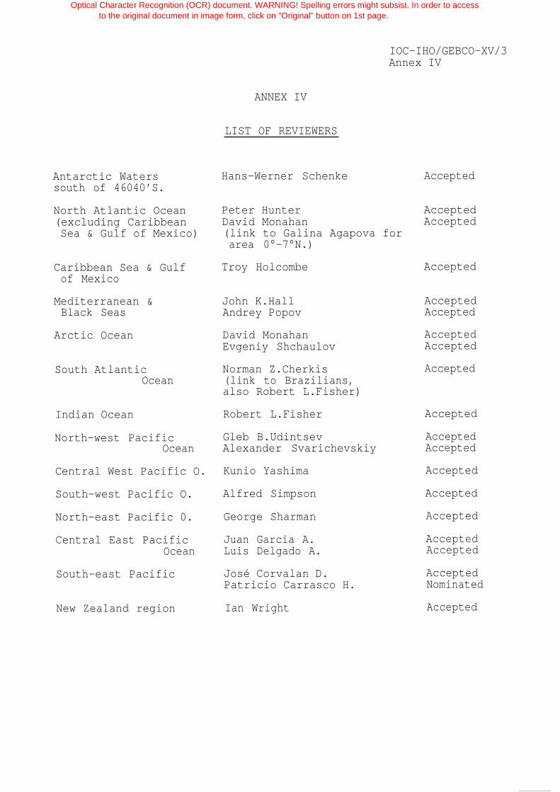
IOC-IHO/GEBCO-XV/3Annex IV
ANNEX IV
LIST OF REVIEWERS
Antarctic Waterssouth of 46040’S.
Hans-Werner Schenke Accepted
Peter Hunter AcceptedDavid Monahan Accepted(link to Galina Agapova forarea 0°-7°N.)
North Atlantic Ocean(excluding CaribbeanSea & Gulf of Mexico)
Caribbean Sea & Gulfof Mexico
Troy Holcombe Accepted
AcceptedAccepted
Mediterranean &Black Seas
John K.HallAndrey Popov
AcceptedAccepted
Arctic Ocean David MonahanEvgeniy Shchaulov
Norman Z.Cherkis(link to Brazilians,also Robert L.Fisher)
AcceptedSouth AtlanticOcean
Robert L.Fisher AcceptedIndian Ocean
AcceptedAccepted
North-west PacificOcean
Gleb B.UdintsevAlexander Svarichevskiy
AcceptedCentral West Pacific O. Kunio Yashima
Alfred Simpson AcceptedSouth-west Pacific O.
North-east Pacific 0. George Sharman Accepted
AcceptedAccepted
Central East PacificOcean
Juan Garcia A.Luis Delgado A.
José Corvalan D.Patricio Carrasco H.
AcceptedNominated
South-east Pacific
AcceptedNew Zealand region Ian Wright
Optical Character Recognition (OCR) document. WARNING! Spelling errors might subsist. In order to accessto the original document in image form, click on "Original" button on 1st page.

IOC-IHO/GEBCO-XV/3
Annex IV - page 2
Optical C
haracter Recognition (O
CR
) document. W
AR
NIN
G! S
pelling errors might subsist. In order to access
to the original document in im
age form, click on "O
riginal" button on 1st page.
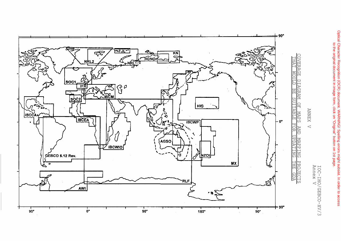
IOC-IHO/GEBCO-XV/3
Annex V
ANNEX V
COVERAGE DIAGRAM OF MAPS AND MAPPING PROJECTS
THAT WOULD BE SUITABLE FOR UPDATING THE GDA
Optical C
haracter Recognition (O
CR
) document. W
AR
NIN
G! S
pelling errors might subsist. In order to access
to the original document in im
age form, click on "O
riginal" button on 1st page.

IOC-IHO/GEBCO-XV/3Annex V - page 2
Key to Bathymetric Maps
AGSO
AWI
FJL
GL
HDNO
HIG
IBCCA
IBCEA
IBCM
IBCWIO
IBCWP
IFR
SOC1
SOC2
KN
MX
NRL1
NRL2
NZOI
RLF
Offshore Resource Map Series - Australian Geological Survey Organisation,scale 1:1 million.
Bathymetric Charts of the Weddell Sea - Alfred-Wegener-lnstitute, scale 1:1 million,
Bathymetric Map of the Franz Josef Land Area - Matishov et al., Murmansk (1 995),scale 1:500,000 @ 80° N.
Bathymetry of the Great Lakes - NGDC, USA and Canada.
Bathymetric maps the Kara and Laptev Seas - Head Department of Navigation andOceanography (1993), (digital files).
Hawaii Seafloor Atlas -Keating, Hawaii Institute of Geophysics (1995), scale 1:4 million
IBC Caribbean Sea and Gulf of Mexico, scale 1:1 million @ 15°N.
IBC Central Eastern Atlantic, scale 1:1 million@ 20°N.
IBC Mediterranean, scale 1:1 million @ 38°N.
IBC Western Indian Ocean, scale 1:1 million @ the Equator.
IBC Western Pacific, scale 1:1 million @ 33° latitude.
New Bathymetric Map of the Bay of Biscay -Sibuet et al., IFREMER (1994), scale 1:2.4 million @ 41°N.
Bathymetry of the Northeast Atlantic, sheets 1 & 2-Southampton Oceanography Centrej scale 1:1 million.
Bathymetry of the Madeira and Canary Abyssal Plains -Southampton Oceanography Centre, scale 1:1 million.
Bathymetry of the Laptev Seas - Kassens, GEOMAR.
Bathymetry of Southcentral Pacific - Mammerickx,Scripps Institution of Oceanography (1992), scale 1:6.4 million @ Equator.
Bathymetry of the Barents and Kara Seas -Cherkis, Naval Research Lab. (1991), scale 1:2.3 million@ 72°N.
Regional Bathymetry of the Northern Norwegian - Greenland Seas -Cherkis, Naval Research Lab. (1994), scale 1:3 million.
Oceanic Chart Series - New Zealand Institute of Water and Atmospheric Research(NZOI), scale 1:1 million @ 46°S.
Bathymetry of the Indian Ocean (Alliance Exotique) -Fisher, Scripps Institution of Oceanography, scale 1:2 million.
Optical Character Recognition (OCR) document. WARNING! Spelling errors might subsist. In order to accessto the original document in image form, click on "Original" button on 1st page.

IOC-IHO/GEBCO-XV/3Annex VI
ANNEX VI
RESOLUTION ADOPTED BY THE IOC ASSEMBLYat its Eighteenth Session, Paris, 13-27 June 1995
Resolution XVIII-10
SUPPORT TO THE JOINT IOC-IHO OCEAN MAPPING PROGRAMME
The Intergovernmental Oceanographic Commission,
Noting that the Assembly at its Seventeenth Session (March 1993)stressed that the Ocean Mapping Programme is a priority action of
the IOC and should be provided with necessary support,
Recognizing that the demand for an authoritative and globaldescription of the bathymetry of the world’s oceans from physicaland biological oceanographers who are involved in modelling theocean environment and predicting changes in global circulation, issteadily becoming more insistent, in addition to the increasinglyfine resolution requirements of marine geologists and geophysicists,
Recognizing also that on a global scale, existing bathymetric dataare widely scattered and of very variable quality in depth andposition, but that there are now available high quality multi beamswath-sounding techniques and accurate position control systems,
Emphasizing also that repeated routine ocean observations, as anticipatedin the IOC s Global Ocean Observing System (GOOS), will be requiredto monitor oceanic change, and that this will require a secureframework of global bathymetry,
Acknowledging that the entry into force of the UN Convention on theLaw of the Sea (UNCLOS) in November 1994 brings into focus the needsof coastal states to define and possibly exploit resources withinnational jurisdiction, and hence the requirement for detailed andaccurate bathymetry of the margins,
Thanks the Russian Federation for seconding staff to support theOcean Mapping Programme;
Optical Character Recognition (OCR) document. WARNING! Spelling errors might subsist. In order to accessto the original document in image form, click on "Original" button on 1st page.

IOC-IHO/GEBCO-XV/3Annex VI - page 2
Instructs the Executive Secretary IOC:
(i) to initiate discussions on how to establish scientificpriorities for bathymetric surveys of the world’s oceans and
then, in collaboration with the International HydrographicOrganization, to establish a well co-ordinated and comprehensiveplan for the coming decade;
ii) in the interim, to investigate the possibility of improvingthe level of funding in the regular programme for Ocean
Mapping, with a view to ensuring that the biennial cycle of meetingsof the Consultative Group on Ocean Mapping (CGOM) and the RegionalOcean Mapping projects is maintained, in order to retain thenecessary impetus in the various activities of these bodies, with,in particular, the paramount requirement for meetings of theEditorial Board for the International Bathymetric Chart of theCentral Eastern Atlantic (IBCEA) (possibly in Lisbon or Brest) in1996, of the Editorial Board for the International Bathymetric Chartof the Western Pacific (IBCWP) by 1996, and of CGOM early in 1997;
Invites the Director-General of UNESCO to establish one professionalpost for the Ocean Mapping Programme as of 1996;
Invites the International Hydrographic Organization to consider theabove proposal, and assist with the development of a plan for theproposed co-ordinated bathymetric surveys.
Optical Character Recognition (OCR) document. WARNING! Spelling errors might subsist. In order to accessto the original document in image form, click on "Original" button on 1st page.

IOC-IHO/GEBCO-XV/3Annex VII
ANNEX VII
LIST OF PARTICIPANTS
I - NEMBERS OF THE JOINT IOC-IHO GUIDING COMMITTEE FOR GEBCO
Sir Anthony Laughton PhD FRSOkelandsPickhurst RoadChiddingfold, GodalmingSurrey GU8 4TSUNITED KINGDOMTel: +44 (1428) 683941Time Zone: UT (Summer +1))
Capitão-de-Fragata Lucas de Campos CostaDiretoria de Hidrografia e Navegação Rua Barão de Jaceguay s/no Ponta da ArmaçãoCEP - 24048-900Niterói, RJBRAZILTelex: 21-53259 MMAR BRFax: +55 (21) 718 7941Tel: +55 (21) 719 2626 or 4824Time Zone: -3 (Summer -2)
Lie. José Luis Frias SalazarInstituto Nacional de Estadística,
Geografía e InformáticaAv. Patriotismo #711-PHCol. San Juan Mixcoac - C.P.O391OMéxico D.F.MEXICOFax: +52 (5) 563 9932Tel: +52 (5) 598 9946 or 615 0966Time Zone: -7 (Summer -6)
Mr Alexis E.HadjiantoniouHellenic Navy Hydrographic ServiceTGN 1040AthensGREECETelex: 215835 GEN GRFax: +30 (1) 651 7811 or 652 0224Tel: +30 (1) 644 2966Time Zone: +2 (Summer +3)
Chairman GEBCO(also representing SCOR)
Member, Sub-Committee onDigital Bathymetry (SCDB)
Member, Sub-Committee onDigital Bathymetry (SCDB)
Optical Character Recognition (OCR) document. WARNING! Spelling errors might subsist. In order to accessto the original document in image form, click on "Original" button on 1st page.
IOC-IHO/GEBCO-XV/3Annex VII - page 2
Dr. -Ing. Hans-Werner Schenke Member, Sub-Committee onAlfred-Wegener-Institut für Digital Bathymetry (SCDB)
Polar- und MeeresforschungPostfach 12 01 61ColumbusstrasseD-2850 BremerhavenGERMANYTelex: 238695 POLAR DFax: +49 (471) 4831 149Tel: +49 (471) 4831 222Email: [email protected] Zone: +1 (Summer +2)
Dr Gleb B.UdintsevVernadsky Institute of Geochemistry19 Kosygina Street117975 MoscowRUSSIAN FEDERATIONTelex: 411633 TERRA SU (for Udintsev)Fax: +7 (095) 938 2054 (for Udintsev)Tel: +7 (095) 137 8648 or 939 5226 (office)
+7 (095) 977 5125 (home evenings)Email: [email protected]
or [email protected] Zone: +3 (Summer +4)
II - SUB-COMMITTEE ON UNDERSEA FEATURE NAMES (SCUFN)
Dr Robert L.Fisher Chairman, Sub-Committee onGeological Research Division Undersea Feature Names (SCUFN)Scripps Institution of OceanographyLa JollaCalifornia 92093 - 0215UNITED STATES OF AMERICATelex: 188929Fax: +1 (619) 534 0784Tel: +1 (619) 534 3597Email: [email protected]
or [email protected] Zone: -8 (Summer -7)
Dr Galina AgapovaGeological Institute of the Russian Academy of SciencesPyzevskiy, 7109017 MoscowRUSSIAN FEDERATIONTelex: 411478 SGC SUFax: +7 (095) 231 8106Tel: +7 (095) 230 8180 or 8145Email: [email protected] Zone: +3 (Summer +4)
Optical Character Recognition (OCR) document. WARNING! Spelling errors might subsist. In order to accessto the original document in image form, click on "Original" button on 1st page.

IOC-IHO/GEBCO-XV/3Annex VII - page 3
Ing.en Chef Michel Huet Secretary, Sub-Committee onInternational Hydrographic Bureau Undersea Feature Names (SCUFN)7, avenue Président J.F.Kennedy also Member, Sub-Committee onB.P.445 - MC 98011 Monaco Cedex Digital Bathymetry (SCDB)PRINCIPALITY OF MONACOTelex: 479164 MC - INHORGFax: +33 93 25 20 03Tel: +33 93 50 65 87Email: [email protected] Zone: +1 (Summer +2)
III - SUB-COMMITTEE ON DIGITAL BATHYMETRY (SCDB)
Dr Meirion T.Jones Chairman, Sub-Committee onDirector Digital Bathymetry (SCDB)British Oceanographic Data Centre (BODC)Bidston Observatory, BirkenheadMerseyside L43 7RAUNITED KINGDOMTelex: 628591 OCEANB GFax: +44 (151) 652 3950Tel: +44 (151) 653 8633Time Zone: GMT (Summer +1)
Dr Michael S.LoughridgeDirectorWorld Data Center ‘A’ for Marine
Geology and GeophysicsNOAA E/GC3325 BroadwayBoulder, Colorado 80303UNITED STATES OF AMERICATelex: 6735123 WDCAFax: +1 (303) 497 6513Tel: +1 (303) 497 6487Email: [email protected] Zone: -7 (Summer -6)
Mr Adam Kerr Chairman, IHO Committee onDirector Electronic data (CoE),International Hydrographic Organization ex-officio as an observer7, avenue President J.F.KennedyB.P.445 - MC 98011 Monaco CedexPRINCIPALITY OF MONACOTelex: 479164 MC - INHORGFax: +33 93 25 20 03Tel: +33 93 50 65 87Email: [email protected] Zone: +1 (Summer +2)
Optical Character Recognition (OCR) document. WARNING! Spelling errors might subsist. In order to accessto the original document in image form, click on "Original" button on 1st page.

IOC-IHO/GEBCO-XV/3Annex VII - page 4
IV SCIENTIFIC ADVISERS TO THE GEBCO
Mr Norman Z.Cherkis Code 7420-CHMarine Physics BranchNaval Research LaboratoryWashington DC 20375-5350UNITED STATES OF AMERICAFax: +1 (202) 767 0167Tel: +1 (202) 767 6956Email: [email protected] Zone: -5 (Summer -4)
Chairman BGN/ACUF
Mr Brian Harper (Permanent Secretary GEBCO designate)Park HouseDonyattIlminsterSomerset TA19 0RNUNITED KINGDOMTelex: 46274Fax: +44 (1823) 284077Tel: +44 (1823) 337900 ext.4152 (Office)
+44 (1460) 52994 (Home)Time Zone: UT (Summer +1)
Mr Donald E.PryorNOAA - National Ocean ServicesNx2, SSMC41305 East West HighwaySilver SpringMaryland 20910UNITED STATES OF AMERICATelex: RCA 248376Fax: +1 (301) 713 4307Tel: +1 (301) 713 3070Email: [email protected] Zone: -5 (Summer -4)
Dr Gary J.RobinsonEnvironmental Systems Science CentreUniversity of ReadingWhiteknightsReadingBerkshire RG6 2ABUNITED KINGDOMTelex: 847813Fax: +44 (1734) 755865Tel: +44 (1734) 318742Email: [email protected] Zone: UT (Summer +1)
Optical Character Recognition (OCR) document. WARNING! Spelling errors might subsist. In order to accessto the original document in image form, click on "Original" button on 1st page.

IOC-IHO/GEBCO-XV/3Annex VII - page 5
Dr Walter H.F.SmithGeosciences LaboratoryNOAA/NOS: N/OES 12SSMC-IV, Sta.84231305 East-West HighwaySilver Spring, MD 20910UNITED STATES OF AMERICAFax: +1 (301) 713 4475Tel: +1 (301) 713 2860Email: [email protected] Zone: -5 (Summer -4)
V - GEBCO BATHYMETRIC EDITOR & GEBCO DIGITAL ATLAS MANAGER
Mr Peter M.HunterGEBCO Bathymetric EditorChallenger Division for Seafloor ProcessesSouthampton Oceanography Centre Room 786/14European WayEmpress DockSouthampton S014 3ZHUNITED KINGDONFax: +44 (1703) 596554Tel: +44 (1703) 596559Email: [email protected] Zone: UT (Summer +1)
Ms Pauline WeatherallGEBCO Digital Atlas ManagerBritish Oceanographic Data Centre (BODC)Proudman Oceanographic LaboratoryBidston Observatory, BirkenheadMerseyside L43 7RAUNITED KINGDOMTelex: 628591 OCEANB GFax: +44 (151) 652 3950Tel: +44 (151) 653 8633Email: [email protected] Zone: UT (Summer +1)
VI - PERMANENT SECRETARY GEBCO
Mr Desmond P.D.ScottCumbersMill LaneSidleshamChichesterWest Sussex P020 7LXUNITED KINGDOMFax: and Tel: (same line)
+44 (1243) 641222Time Zone: UT (Summer +1)
Permanent Secretary GEBCO
Optical Character Recognition (OCR) document. WARNING! Spelling errors might subsist. In order to accessto the original document in image form, click on "Original" button on 1st page.

IOC-IHO/GEBCO-XV/3Annex VII - page 6
VII - REPRESENTATIVES OF THE I.H.BUREAU AND THE IOC SECRETARIAT
Rear Admiral Christian Andreasen Member, Sub-Committee onPresident of the Directing Committee Undersea Feature NamesInternational Hydrographic Organization (SCUFN)7, avenue Président J.F.KennedyB.P.445 - MC 98011 Monaco CedexPRINCIPALITY OF MONACOTelex: 479164 MC - INHORGFax: +33 93 25 20 03Tel: +33 93 50 65 87Email: [email protected] Zone: +1 (Summer +2)
Mr Dmitri TravinIntergovernmental Oceanographic CommissionUnesco1, rue Miollis75732 Paris Cedex 15FRANCETelex: 204461 PARISFax: +33 (1) 40 56 93 16Tel: +33 (1) 45 68 39 65Time Zone: +1 (Summer +2)
VIII - BY INVITATION
Captain James E.Ayres USN (Ret)Scientific Advisor for HydrographyHQ, DMA/DH, Stop A-68613 Lee HighwayFairfaxVirginia 22031-2137UNITED STATES OF AMERICAFax: +1 (703) 275 8678Tel: +1 (703) 275 8578Email: [email protected] Zone: -5 (Summer -4)
Mr Jeremy M.EvansChallenger Division for Seafloor ProcessesSouthampton Oceanography Centre Room 786/13Empress DockEuropean WaySouthampton S014 3ZHUNITED KINGDOMFax: +44 (1703) 596554Tel: +44 (1703) 596561Email: [email protected] Zone: UT (Summer +1)
Optical Character Recognition (OCR) document. WARNING! Spelling errors might subsist. In order to accessto the original document in image form, click on "Original" button on 1st page.

IOC-IHO/GEBCO-XV/3Annex VIII
ANNEX VIII
LIST OF ACRONYMS
ACUF
AGSO
AGU
AWI
BAS
BGN
BODC
CAP
CD-ROM
CEDD
CGM
CGOM
CHS
CICESE
CLCS
Advisory Committee on Undersea Features (of BGN)
Australian Geological Survey Organization
American Geophysical Union
Alfred-Wegener-Institut fur Polar- und Meeresforschung(Bremerhaven, Germany)
British Antarctic Survey
Board on Geographic Names (USA)
British Oceanographic Data Centre (Bidston Observatory,Birkenhead, UK)
Circum-Atlantic Project (of IUGS)
Compact Disc - Read Only Memory
Committee on Exchange of Digital Data (IHO)
Carte générale du monde (IGN)
Consultative Group on Ocean Mapping (of IOC)
Canadian Hydrographic Service
Centro de Investigación Científica y Educación Superior deEnsenada (Mexico)
Commission on the Limits of the Continental Shelf (UNCLOS)
CMG Commission for Marine Geology (IUGS)
CoE Committee on Electronic data ( IHO)(formerly Committee on ECDIS)
CSIRO Commonwealth Scientific and Industrial ResearchOrganization (Australia)
DBWG Data Base Working Group (IHO)
DCDB Data Centre for Digital Bathymetry (IHO - at NGDC,Boulder, Colorado, USA)
Optical Character Recognition (OCR) document. WARNING! Spelling errors might subsist. In order to accessto the original document in image form, click on "Original" button on 1st page.

IOC-IHO/GEBCO-XV/3Annex VIII - page 2
DMA
EB
ECDIS
EPSHOM
GBE
GDA
GEBCO
GEODAS
GOOS
HDNO
HYDAS
IASC
IBCCA
IBCEA
IBCM
IBCWIO
IBCWP
ICA
ICSU
IFREMER
IGN
IH
Defense Mapping Agency (USA)
Editorial Board
Electronic Chart Display and Information System (IHO)
Etablissement Principal du Service Hydrographique etOcéanographique de la Marine
GEBCO Bathymetric Editor
GEBCO Digital Atlas
General Bathymetric Chart of the Oceans (IOC/IHO)
Geophysical DAta System for Marine Geophysical Data (NGDC)
Global Ocean Observing System ( IOC)
Head Department of Navigation & Oceanography(USSR Ministry of Defence, Leningrad)
HYdrographic DAta System for Marine Geophysical Data(NGDC)
International Arctic Science Committee
International Bathymetric Chart of the Caribbean Sea andGulf of Mexico (IOC)
International Bathymetric Chart of the Central EasternAtlantic (IOC)
International Bathymetric Chart of the Mediterranean andits Geological/Geophysical Series (IOC)
International Bathymetric Chart of the Western IndianOcean (IOC)
International Bathymetric Chart of the Western Pacific(IOC)
International Cartographic Association
International Council of Scientific Unions
Institut Français de Recherche pour l’Exploitationde la Mer
Institut géographique national (Paris, France)
International Hydrographic (Review and Bulletin)
Optical Character Recognition (OCR) document. WARNING! Spelling errors might subsist. In order to accessto the original document in image form, click on "Original" button on 1st page.

IOC-IHO/GEBCO-XV/3Annex VIII - page 3
IHB
IHO
INEGI
IOC
IOSDL
IUGS
NATO
NERC
NGDC
NGS
NMDIS
NOAA
NRL
NUTIS
NZOI
OMG
RAN
R/V
SACLANT
SCAR
SCDB
SCOR
SCUFN
SIO
International Hydrographic Bureau
International Hydrographic Organization
Instituto Nacional de Estadística, Geografía e Informática(Mexico)
Intergovernmental Oceanographic Commission (of UNESCO)
Institute of Oceanographic Sciences, Deacon Laboratory(U.K.)
International Union of Geological’ Sciences
North Atlantic Treaty Organization
Natural Environment Research Council (Swindon, UK)
National Geophysical Data Center (Boulder, Colorado, USA)
National Geographic Society (USA)
National Marine Data and Information Service (China)
National Oceanic and Atmospheric Administration (USA)
Naval Research Laboratory (USA)
NERC Unit for Thematic Information Systems (NERC atReading University, UK)
New Zealand Oceanographic Institute (NIWAR)
Ocean Mapping Group (University of New Brunswick, Canada)
Royal Australian Navy
Research Vessel
Supreme Commander Allied Command Atlantic (NATO)
Scientific Committee on Antarctic Research (ICSU)
Sub-Committee on Digital Bathymetry (GEBCO)
Scientific Committee on Oceanic Research (ICSU)
Sub-Committee on Undersea Feature Names (GEBCO)
Scripps Institution of Oceanography (La Jolla, USA)
Optical Character Recognition (OCR) document. WARNING! Spelling errors might subsist. In order to accessto the original document in image form, click on "Original" button on 1st page.

IOC-IHO/GEBCO-XV/3Annex VIII - page 4
SOPAC South Pacific Applied Geoscience Commission
UNCLOS United Nations Convention on the Law of the Sea
UNESCO United Nations Educational, Scientific and CulturalOrganization
USGS United States Geological Survey
VHO Volunteering Hydrographic Office (IHO)
WDC World Data Centre
WGS World Geodetic System
Optical Character Recognition (OCR) document. WARNING! Spelling errors might subsist. In order to accessto the original document in image form, click on "Original" button on 1st page.

82.83.84.85.88.87.88.
90.91.92.93.94.95.96.97.98.
100.101.102.103.
Second Meeting of the UNEP-IOC-ASPEI Global Task Team on the Implications of climate Change on Coral ReefsSeventh Session of the JSC Ocean Observing System Development PanelFourth Session of the IODE Group of Experts on Marine Information ManagementSixth Session of the IOC Editorial Board for the International Bathymetric chart of the Mediterranean and its Geological/Geophysical SeriesFourth Session of the Joint IOC-JGOFS Panel on Carbon DioxideFirst Session of the IOC Editorial Board for the International Bathymetric Chart of the Western PacificEighth Session of the JSC Ocean Observing System Development PanelNinth Session of the JSC Ocean Observing System Development PanelSixth Session of the IODE Group of Experts on Technical Aspects of Data ExchangeFirst Session of the IOC-FAO Group of Experts on OSLR for the IOCINCWIO RegionFifth Session of the Joint IOC-JGOFS C02 Advisory Panel MeetingTenth Session of the JSC Ocean Observing System Development PanelFirst Session of the Joint CMM-IGOSS-IODE Sub-group on Ocean Satellites and Remote SensingThird Session of the IOC Editorial Board for the International Chart of the Western Indian OceanFourth Session of the IOC Group of Experts on the Global Sea Level Observing SystemJoint Meeting of GEMSI and GEEP Core GroupsFirst Session of the Joint Scientific and Technical Committee for Global Ocean Observing SystemSecond International Meeting of Scientific and Technical Experts on Climate Change and the OceansFirst Meeting of the Officers of the Editorial Board for the International Bathymetric Chart of the Western PacificFifth Session of the IOC Editorial Board for the International Bathymetric Chart of the Caribbean Sea and the Gulf of MexicoSecond Session of the Joint Scientific and Technical Committee for Global Ocean Observing SystemFifteenth Session of the Joint IOC-IHO Committee for the General Bathymetric Chart of the Oceans
Optical Character Recognition (OCR) document. WARNING! Spelling errors might subsist. In order to accessto the original document in image form, click on "Original" button on 1st page.

![IHO S-100: The New IHO Hydrographic Geospatial … hydrographic review may 2009 →iho s-100) iho s-100 [] .Published in: International Hydrographic Review · 2009Authors: Robert Ward](https://img.dokumen.tips/doc/110x75/5ae4a48c7f8b9a495c8ed661/iho-s-100-the-new-iho-hydrographic-geospatial-hydrographic-review-may-2009.jpg)