Embed Size (px)
Citation preview
August 22, 2014 copy via Email to: Mr. Steve Wilson & Mr. Stafford Dusenbury [email protected] MDEQ – OOGM [email protected] P.O. Box 30256 Lansing, MI 48909-7741 Re: Sherman Boulevard Site, Jackson-Merkey Contractors, Inc., Muskegon, Michigan –
Renewal of Sand Mining Permit No. JMC-SBS-112
Dear Mr. Wilson & Mr. Dusenbury:
Westshore Consulting (Westshore) has prepared this correspondence on behalf of Jackson-Merkey Contractors, Inc. (JMC) to request a renewal of their existing Act 637 sand mining permit. JMC is only requesting to continue the mining activities that were previously approved for the previous permit duration. The proposed mining will occur on the property leased to Nugent Sand Company, Inc. (Nugent Sand) at the Sherman Boulevard Site. A Sand Dune Mining Permit was initially issued to JMC on November 10, 1992 and was modified in 2011. Since this request is not for a new sand mining permit, Westshore has included all information necessary to process this renewal including a revised Environmental Impact Statement, Progressive Cell Mining and Reclamation Plan, and a 15-Year Mining Plan.
JMC and Nugent Sand entered a lease agreement to allow Nugent Sand to mine sand from below the water table on the JMC property in 2011. Nugent Sand obtained a Joint 301 permit to conduct the mining at that time (Permit No. 11-61-0013-P). Nugent Sand has been mining in the leased area since approximately 2011. JMC intends to continue to lease that portion of their property to Nugent Sand.
Nugent Sand intends to continue to only mine the leased portion of the JMC property as previously permitted and slightly enlarge North Lake further onto the JMC property.
All future mining operations in the leased area will occur in areas previously disturbed by surface mining, and no mining in portions of the JMC site that were not previously disturbed will take place.
A copy of the letter that both parties signed indicating the intention to lease the JMC property to Nugent Sand for the purpose of surface mining and extraction of sand from beneath the water table was submitted with the 2011 permit renewal, and is part of the Public Record at the MDEQ.
Attached to this request to continue mining in the leased area are maps that indicate the sequence of mining, and final grades that will be used once the mining is discontinued and the site is reclaimed.
At the conclusion of this five-year mining and reclamation permit, JMC plans to suspend all mining below the water table at the site, and may submit a permit renewal to continue surface mining above the water table at the site.
If you have any comments or questions regarding this matter, please contact Mr. Steve Jackson at JMC or myself, and we will provide any additional information that you believe is necessary.
Sincerely, WESTSHORE CONSULTING Robert L. Schulz, C.P.G. Vice President Enclosures RLS/jlg/668-5J cc: Steve Jackson, Jackson-Merkey Contractors Robert Chandonnet, John Nevedal, Pat Petrowski – Nugent Sand Co.
WestshoreConsulting.com Western Michigan 2534 Black Creek Road Muskegon, MI 49444 Ph: (231) 777-3447 Fx: (231) 773-3453 Northern Michigan (231) 920-5818
Muskegon, MI Manistee, MI (231) 777-3447 (231) 920-5818
Environmental Impact Statement Renewal of Act 637 Sand Mining Permit Jackson-Merkey Contractors, Inc. Sherman Boulevard Site Norton Shores, Michigan Permit No.: JMC-SBS-112 Prepared for: Nugent Sand Company 2925 Lincoln Street ▪ Norton Shores, MI 49443 Prepared by: Westshore Consulting 2534 Black Creek Road ▪ Muskegon, MI 49444 Phone: (231) 777-3447 ▪ Fax: (231) 773-3453 [email protected] WestshoreConsulting.com 668-5J August 18, 2014
WESTSHORE CONSULTING
I:\0501 - 0999\0650 - 0700\0668\0668-05\2014 package - sand mining renewal\JMC, Environmental Impact Statement & Plans.docx
TABLE OF CONTENTS
1.0 Introduction .................................................................................................................. 1
2.0 Proposed Action ........................................................................................................... 1
3.0 Environmental Impact................................................................................................. 2
3.1 Existing Environment ................................................................................................. 2
3.2 Physical ...................................................................................................................... 2
3.3 Groundwater .............................................................................................................. 3
3.4 Terrestrial................................................................................................................... 4
3.5 Social .......................................................................................................................... 4
4.0 Potential Impacts ......................................................................................................... 5
4.1 Physical ...................................................................................................................... 5
4.2 Groundwater .............................................................................................................. 5
4.3 Terrestrial................................................................................................................... 6
4.4 Social .......................................................................................................................... 6
5.0 Mitigation...................................................................................................................... 6
5.1 Physical ...................................................................................................................... 6
5.2 Groundwater .............................................................................................................. 6
5.3 Terrestrial................................................................................................................... 6
5.4 Social .......................................................................................................................... 7
Figures
Figure 1 - Site Location Map Figure 2 - Adjacent Property Owners Figure 3 - Existing Mining Cell Configuration Figure 4 - Proposed Site Plan/Cell Configuration Figure 5 - Cross Section A-A' and B-B' Figure 6 - Mining Sequence Plan Figure 7 - Potable Well Map
Tables
Table A - Open Dune Vegetation Table B - Transiting from the Sand Dunes to the Wooded Dunes Table C - Wooded Dune Vegetation
Appendices
Appendix A - Progressive Cell Unit Mining and Reclamation Plan Appendix B - Fifteen-Year Mining Plan
WESTSHORE CONSULTING
Environmental Impact Statement Page 1 Jackson-Merkey Contractors – Permit # JMC-SBS-112 August 18, 2014
1.0 Introduction
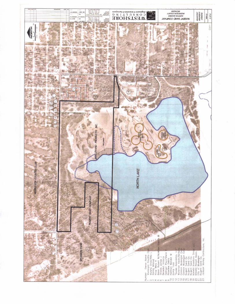
Jackson-Merkey Contractors, Inc. (JMC) wishes to renew their existing Act 637 sand mining permit, Permit No. JMC-SBS-112. The property is located on Sherman Boulevard in the City of Norton Shores, Michigan (the Site). The Site is an active surface sand mine, and has been historically operated by CWC Castings. Figure 1 is a site location map, Figure 2 is an adjacent property owners diagram, and Figure 3 depicts the current mining configuration. The property is presently owned by JMC and has been referred to as the “Sherman Boulevard Site” by the Michigan Department of Environmental Quality (MDEQ). A Sand Dune Mining Permit was issued to JMC on November 10, 1992 and was modified in 2011. Proposed future mining will include mining beneath the water table in a portion of the JMC property leased to Nugent Sand Company, Inc. (Nugent Sand).
CWC Castings had owned the Site for many years and has extracted sand from the property for most of that time. JMC continued to mine sand after they purchased the property, and surface mining is being conducted at the Site to the present time. Three mining cells exist at the Site, and much of the Site has been previously mined. Only a small portion on the southern edge of the property (Cell 1) and the western portion of (Cells 2 and 3) have not been surface mined.
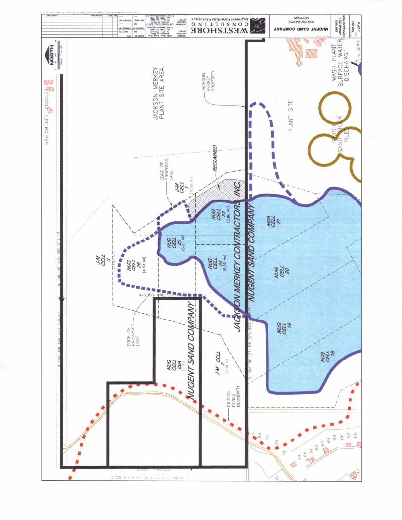
In 2011, JMC leased a portion of their property to the adjacent property owner to the south of their site, Nugent Sand. Both JMC and Nugent Sand wanted to enlarge the existing lake (North Lake) on the Nugent Sand site onto (on the leased property) the JMC property. Since Nugent Sand was mining sand from beneath the water table with an existing Part 301 permit, the two mining companies determined that the most efficient manner to extend the lake to the north would be for Nugent Sand to modify their Part 301 permit and continue mining onto property owned by JMC leased to Nugent Sand. The lease agreement between the two mining companies was executed upon the approval of the Part 301 Joint Permit Application obtained by Nugent Sand in 2011 that requested the expansion of North Lake onto the JMC property. With this document, JMC requests a renewal of their existing permit to allow Nugent Sand to continue mining in their leased portion of the Site only as previously permitted. No new areas or cells are proposed.
Sand dune mining is regulated by Part 637, Sand Dune Mining, of the Natural Resources and Environmental Protection Act, 1994 P.A. 451, as amended. Section 63705 of Part 637 requires that an Environmental Impact Statement be prepared as part of the mining application process. The Environmental Impact Statement follows in Section 3.0.
2.0 Proposed Action
Historically, surface mining has occurred at the JMC site. The adjacent property owner to the south of the JMC site is Nugent Sand. Nugent Sand has an existing sand mining processing plant, and utilizes a barge-mounted hydraulic dredge to remove sand from beneath the water table. Since 2011, Nugent Sand and JMC entered into a lease agreement that allowed Nugent Sand to mine beneath the water table and extend the lake on their site onto the JMC property. JMC and Nugent Sand propose to continue to mine in the leased area only as approved under the previous permit which will continue to enlarge the lake. The proposed mining will add approximately 5.14 additional acres of surface water. The mining

WESTSHORE CONSULTING
Environmental Impact Statement Page 2 Jackson-Merkey Contractors – Permit # JMC-SBS-112 August 18, 2014
will be accomplished and the site restored as discussed in the Progressive Cell Unit Mining and Reclamation Plan (Appendix A).
3.0 Environmental Impact
3.1 Existing Environment
The western edge of the JMC property is situated about 300 feet east of Lake Michigan, and the area nearest to Lake Michigan that will be disturbed by the mining process will be approximately 700 feet from Lake Michigan. The western portion of the JMC site is comprised of sand dunes, and a barrier dune system is present adjacent to the Lake Michigan shoreline. The barrier dune is the first landward dune formation along the shoreline of a Great Lake. The inland boundary of the barrier dune is that landward boundary line at the base of the first dune assemblage which displays the greatest relative relief within two miles of the shoreline. The JMC property lies within the barrier dune designated area, and a permit that allows the mining of sand from the property has been formerly issued by the MDEQ. The topography at the JMC property varies from very hilly terrain situated in the southern and western portion of the Site where surface mining has not occurred to flat sections in the eastern section where surface mining has been completed. Mining of surface sand has been occurring at the Site for many years, and material in all three cells have been excavated and removed from the Site.
3.2 Physical
According to the Muskegon County Soil Survey (1968) the majority of soils covering the property consist of Grayling-Rubicon sands with 25 to 45 percent slopes. Generally, these soils are found on short, steep slopes of sandy uplands of Muskegon County. The surface soil layer is thin and less distinct than typical Grayling and Rubicon soils found in areas with less steep slopes. Both the Grayling and Rubicon series consist of well-drained sandy soils that exhibit very rapid permeability. The natural fertility and available moisture capacity are low. The upper soil profile for both of these series is similar, but the Rubicon has redder subsoil than the Grayling. The Rubicon soils range from very strongly acidic to moderately acidic (pH values of 4.5 to 7.0 in the upper 28 inches of the soil horizon, and pH values of 6.0 to 6.5 below 28 inches to a depth of 66 inches). These soils are subject to water and wind erosion.
Soils discovered during drilling and mining activities are similar across most of the Site. Generally, in areas where trees and vegetation exist, and no sand mining has occurred, a thin one to three inches thick layer of sandy topsoil is present. The topsoil ranges from dark brown to black, and contains some organic material. Below the surficial topsoil, reddish-brown, fine-grained sand that is characteristic of the Rubicon series exists to a depth of approximately three feet below the ground surface (bgs). A tan fine to very fine-grained sand exists below the subsoil horizon.
Topographic elevations in the excavated areas range from approximately 605 to 625 feet USGS, and the top of the water table is located between 20 to 30 feet bgs at an elevation of 590-595 feet USGS. The dune areas that have not been mined have surface elevations of about 640 to 670 feet USGS.
WESTSHORE CONSULTING
Environmental Impact Statement Page 3 Jackson-Merkey Contractors – Permit # JMC-SBS-112 August 18, 2014
Land use adjacent to the mining area is as follows:
North: The entire north side of the site is bounded by Sherman Boulevard and north of Sherman Boulevard is the Muskegon Country Club.
West: The west side of the site includes a parcel leased by Nugent Sand which consists of their mining cells (Cells 23, 24, 25 and 26). The other areas adjacent to the west are the eastern portion of Bronson Park, property owned by the City of Muskegon. Traversing in a general north-south direction is Idlewild Road that connects Sherman Boulevard to the Idlewild Subdivision. Idlewild Subdivision is located southwest of the JMC property and includes 13 residences. Further west from the Idlewild Subdivision and Bronson Park is Lake Michigan.
South: Nugent Sand property is situated along the southern boundary of the JMC property. A surface water body, named North Lake, extends from the Nugent Sand property onto the leased area of the JMC property. Nugent Sand mines sand from North Lake that exists both on the Nugent Sand property and the leased JMC property.
East: The property east of Cell 1 and 3 is part of the parcel that is presently surface mined that is owned by JMC. Further east is a trailer park, a private residence, and a property used for industrial purposes.
The mining activity is not within 500 feet of a commercial development or 2,000 feet of a school. Residences that are within 1,000 feet of the area that will be part of the mining operation include: the Idlewild Subdivision; the southwest portion of the Dunes Associates, LLC trailer park; and the Workman residence on Lincoln Street.
3.3 Groundwater
Groundwater at the property is present in an unconfined aquifer. Dependent upon the elevation of the ground surface, the top of the aquifer was located at 21 to 52 feet bgs (an elevation of 590 to 595 feet USGS). Groundwater migrates in a westerly direction, towards Lake Michigan. Groundwater sampling and analyses have been completed at the JMC property to determine background data, prior to development of North Lake onto the JMC site. The samples were analyzed for a variety of monitoring parameters including volatile organic compounds, metals, polynuclear aromatic hydrocarbons, fatty acids, and other general chemistry parameters. The analytical results showed that both manganese and iron are present in the aquifer in concentrations that exceed the MDEQ residential Part 201 Generic Cleanup Criteria and Screening Levels for drinking water uses. None of the remaining monitoring parameters existed in concentrations above any State clean-up or action levels.
Water well records available within a one-quarter mile radius of the property show that shallow irrigation wells exist at residential properties to the north and east of the site. Figure 7 shows the location of those wells. No irrigation or potable wells were discovered to the south of the property. Southwest of the site is the Idlewild Subdivision. Approximately thirteen (13) homes presently obtain water from the Norton Shores municipal water supply system. The Idlewild Subdivision is located approximately 500 feet southwest of the western edge of the lake that will be enlarged during the proposed mining. Municipal water has been provided to all residences in the Idlewild Subdivision.

WESTSHORE CONSULTING
Environmental Impact Statement Page 4 Jackson-Merkey Contractors – Permit # JMC-SBS-112 August 18, 2014
3.4 Terrestrial
The soil of the dunes is chiefly quartz which has chemical characteristics that strongly effect vegetation. As a rule, sandy soils are poor in plant nutrients and do not develop a rich humus soil because of the rapid oxidation of organic matter. Topography accounts for many differences in rates of organic matter deposition, and subsequently the distribution of plant and animal species. Two distinctly diverse topographic features exist at the site. First is the hilly, unmined area where topsoil still exists and trees have not been removed. The second area is defined by surface mining, with much of the topsoil and vegetation removed. In the wooded area, a one to three inch layer of organic material has developed, providing for a wider variety of plant species.
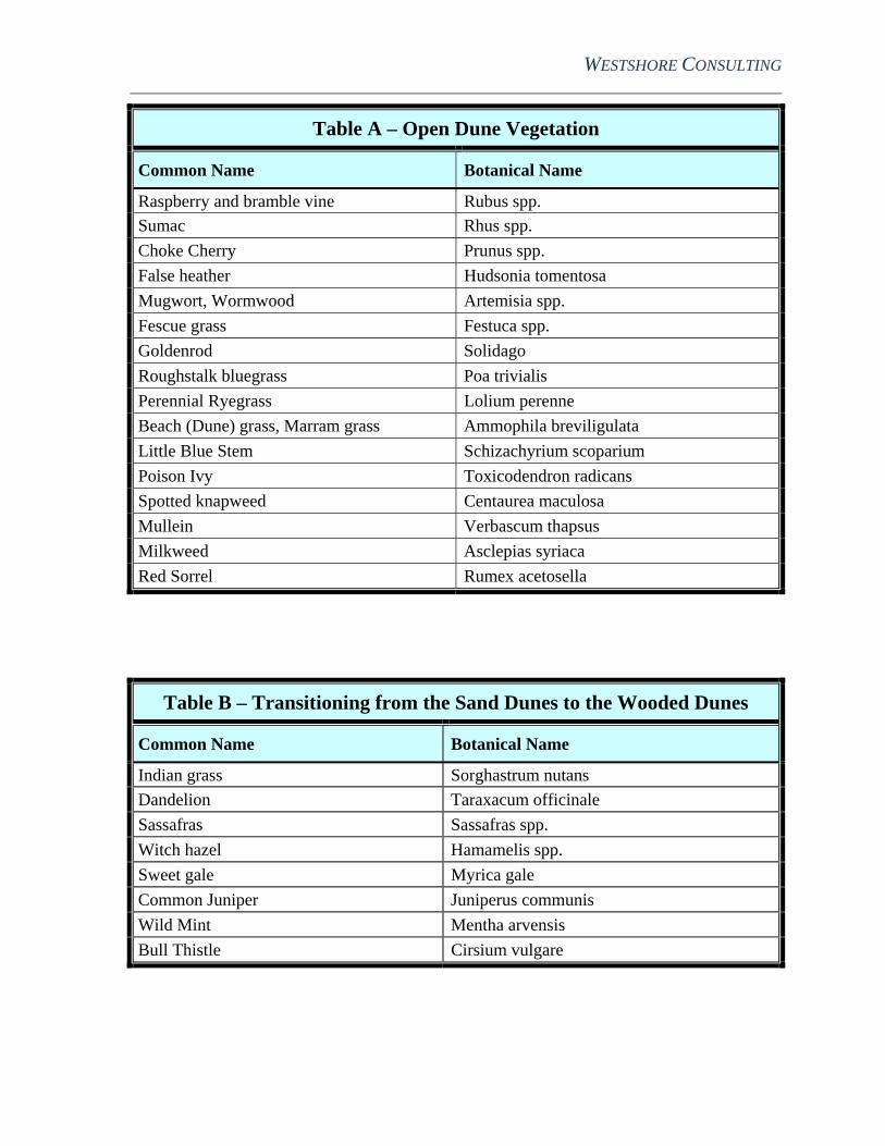
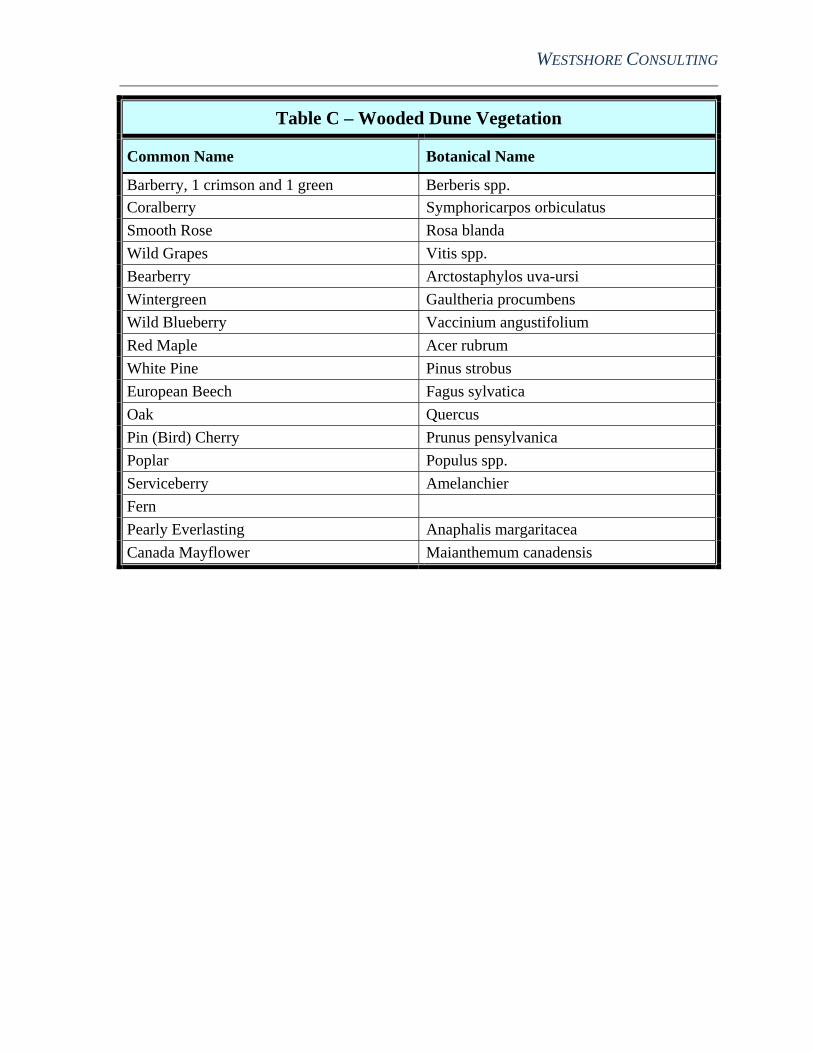
The wooded dunes contain large trees such as Red and Black Oak, Maple, and White Pine with understory plants such as sassafras and groundcovers like ferns. A transition area exists between the open dune and the wooded dune areas. This area is characterized by small plants such as wild mint and understory trees and shrubs. The open dune area consists mainly of dune grasses, scrub oak and sand cherry. Several large areas and slopes are void of vegetation. Tables A, B and C provide a comprehensive list of the plants present at the property.
Animals and signs of animals include opossum, skunk, raccoon, both black and fox squirrels, chipmunks, red fox, and cottontail rabbit. There is a population of whitetail deer in the area, as evidenced by sightings, tracks, trails through the woods, bedding areas, and rubs off the bark of the trees. Among birds sighted in the area are turkeys, red-tailed hawk, robin, blue jay, killdeer, great horned owl, woodpecker, chickadee, white-breasted nuthatch, cardinal, and blackbirds. Numerous small holes in the side of one sand dune indicated the possible presence of bank swallows. No amphibians or reptiles were observed at the site, but likely include the American toad, tree frog, box turtle, garter snake, eastern hognose snake, black rat snake, salamander, and newt.
There is no natural surface water present at the site, hence, no aquatic communities exist.
3.5 Social
The population of Muskegon County has experienced growth, and is expected to into the future. Muskegon County is one of the most populated counties along Lake Michigan. The JMC property is undeveloped, has no residential use, and is fenced as private land. The existing use of the Site is solely for surface sand mining. Aesthetically, the Site has a combination of dune land that has not been developed adjacent to areas that have been mined and display little topographic relief. Economically, the Site provides some employment opportunity for individuals who mine and transport the mined sand material.
WESTSHORE CONSULTING
Environmental Impact Statement Page 5 Jackson-Merkey Contractors – Permit # JMC-SBS-112 August 18, 2014
4.0 Potential Impacts
4.1 Physical
In assessing any project proposing land change, it is necessary to consider the potential impact the project will have to the existing environment. In order to remove the sand from the site, the vegetation and topsoil will be stripped with the use of scrapers or bulldozers. The topsoil will be stockpiled as berms along the outside edge of the disturbed area. Trees that are of sufficient size and quality will be harvested and sold for lumber or pulp. Some of the smaller stock or brush material would provide an excellent source of organic material for use as mulch during the re-vegetation phase of the reclamation plan. The soil and vegetation stockpiles would be located as close as possible to the areas that would require restoration to facilitate the re-spreading of topsoil during the reclamation process.
The extraction of sand will interrupt the geological development of the dunes. The remaining land will be of lower elevation overall, and the existing lake will be enlarged from the continuation of mining from beneath the water table. During the mining process, following removal of vegetation and topsoil, erosion potential will increase at the sloped areas adjacent to the newly formed areas of the lake as the angle of repose is increased temporarily. As the mining process continues, graders or scrapers will be used to push sand into the lake to allow the dredge to remove surficial material also. The erosion concerns will be mitigated following this action, as the slopes to the lake will be significantly reduced.
4.2 Groundwater
Potential for impact to the surface water at the dredge lake and groundwater in the vicinity of the project is minimal during mining operations, and is eliminated once mining has been discontinued.
Natural groundwater conditions at the Site have high concentrations of manganese and iron in the aquifer. Some concern has been expressed that the addition of fatty acids to groundwater may result in the release of manganese and iron from the total to dissolved phase and could result in increasing the concentrations of these elements in the aquifer. Groundwater migrates in a westerly direction, and the northerly portion of the Idlewild Subdivision and Bronson Park are located downgradient of the location of the lake that will be enlarged by the mining process. The concentration of fatty acids in the surface water is minimized by the aeration process that occurs at the south end of North Lake. There is some potential that a small concentration of fatty acids could enter the groundwater system, but the potential for the fatty acids to cause a geochemical condition that would increase the level of manganese and iron in the aquifer is limited.
Figure 7 shows the location of all potable or irrigation wells within a 1,000-foot radius of the area that will be disturbed by the mining operations. Most of the wells are used for irrigation purposes and likely have shallow well screens. The enlargement of the existing lake will alter the elevation of the water table near the water body. In general, groundwater elevations upgradient of the lake (to the east) will be lowered slightly, and groundwater elevations downgradient of the lake (to the west) will be elevated. A computer model has been constructed to evaluate the potential area that would be affected by changing groundwater elevations because a lake had been created. The model shows that at a distance of about 300 feet from the upgradient edge of the lake, the variation of groundwater elevation will be less than one-half foot.
WESTSHORE CONSULTING
Environmental Impact Statement Page 6 Jackson-Merkey Contractors – Permit # JMC-SBS-112 August 18, 2014
4.3 Terrestrial
Most of the biotic communities within the area to be mined will be eliminated during the mining process. The vegetation and soil layer will be removed to accommodate mining. The animal life that is dependent upon the vegetation will move to nearby undisturbed areas. Migrating waterfowl will have a larger lake to use for feeding and roosting. No native aquatic life exists in North Lake, and the continued expansion of the lake to the JMC property will not affect the aquatic life in the surrounding area. Mitigation measures will greatly influence the extent of impact as well as the time required to return the area to conditions similar to pre-mining operations.
4.4 Social
No social impacts will occur during the mining operation. The present number of employees used to mine the sand will not change. No changes in health, income, safety, housing, education, recreation, or other quality of life dimensions will be effected during the period that mining will take place. Land use will continue to be surface mining, and since the Site is privately owned and access is limited, this use will not become a potential impact. The operation of soil moving equipment will occur, but these equipment noises have been ongoing at the JMC property for many years, and the nearest residential property is not located near the operation.
5.0 Mitigation
Reclamation is the key to mitigating many aspects of mining. Angle of slope and stabilization of the dune are key elements in restoring the landform. Specific details regarding reclamation are contained in the Progressive Cell Unit Mining and Reclamation Plan (Appendix A).
5.1 Physical
Upon the completion of dredging/mining, reclamation will begin immediately. Stabilization will be accomplished through grading, planting and mulching. If necessary, snow-fencing will temporarily be placed leeward of disturbed areas. Dune grass and trees will be planted once an area has been graded to final elevation, and eventually, a new soil horizon will be formed.
5.2 Groundwater
The mining operation by Nugent Sand will enlarge the already existing surface water feature in size by an additional approximately 5.14 acres. When mining has been discontinued, the use of North Lake to supply water for washing sand and the subsequent discharge of wash plant water back into North Lake will no longer take place.
5.3 Terrestrial
JMC and/or Nugent Sand will complete stabilization to reduce the disturbances caused by the removal of vegetation during the mining operation. Effective stabilization will include the planting of dune grasses and trees. Once reclamation efforts have commenced, many of the
WESTSHORE CONSULTING
Environmental Impact Statement Page 7 Jackson-Merkey Contractors – Permit # JMC-SBS-112 August 18, 2014
animal species will immediately move back to the previously disturbed area. In a few years, the Site will return to its former land use. The impact to flora, fauna and wildlife will be negligible once restoration has been accomplished.
5.4 Social
Surface sand mining has occurred at the Site for many years. The removal of sand has been accomplished with the use of front-end loaders and dump trucks to obtain the sand that is transported offsite. The noise associated with this type of operation has not disturbed neighboring properties, and future movement of sand into the dredge lake will also be minimal. Nugent Sand barge-mounted hydraulic dredge has operated in the area for many years. The only neighboring property that could be impacted by noise or dust from this operation is the Idlewild Subdivision. Continuation of mining by Nugent Sand on the JMC property will not cause an increase of noise or dust to the Idlewild Subdivision. This is because the JMC property is located a greater distance from the Idlewild Subdivision than the existing operation taking place at Nugent Sand.
The proposed continuation of sand dune mining is compatible with the adjacent existing land uses. Two lakes one south and one partially existing already on the JMC site, have been formed by the extraction of sand from beneath the water table. South Lake, a body of water located south of Winnetaska Drive, has been mined and restored following MDEQ guidance. The area surrounding South Lake will be developed as a residential community. Once mining from North Lake is completed, the proposed future use will be similar, and residential development will be accomplished around North Lake.
No alternatives to the location of the proposed mining activity exist. The removal of sand beneath the water table needs to be accomplished near the Nugent Sand processing plant. The JMC property permits authorize the removal of material both above the aquifer and below, and the enlargement of the water body will only enhance the overall aesthetic appearance and future land use of the property.
Continued sand dune mining will continue to provide a positive economic impact to the Michigan foundry and automotive industries. Allowing mining to continue will provide local employment for workers at JMC. Following restoration of the site, future development will likely include the use of the property for residential purposes. Construction of housing and infrastructure will increase employment in the area. The increase in municipal taxes for residential land use will be a great benefit to the community.

WESTSHORE CONSULTING
Figures
Figure 1 - Site Location Map
Figure 2 - Adjacent Property Owners
Figure 3 - Existing Mining Cell Configuration
Figure 4 - Proposed Site Plan/Cell Configuration
Figure 5 - Cross Section A-A
Figure 6 - Mining Sequence Plan
Figure 7 - Potable Well Map


F
igur
e 7
– P
age
1 of
3
Nuge
nt Sa
nd
JMC
Nuge
nt Sa
nd
Nuge
nt Sa
nd
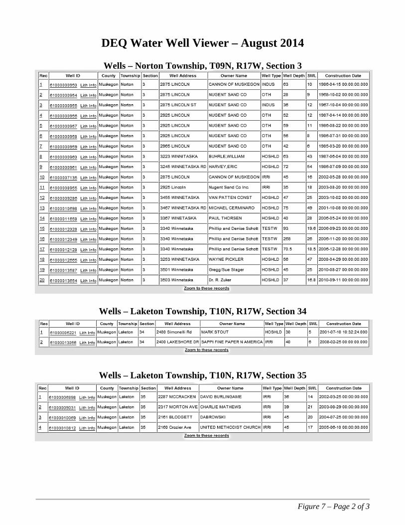
Figure 7 – Page 2 of 3
DEQ Water Well Viewer – August 2014
Wells – Norton Township, T09N, R17W, Section 3
Wells – Laketon Township, T10N, R17W, Section 34
Wells – Laketon Township, T10N, R17W, Section 35
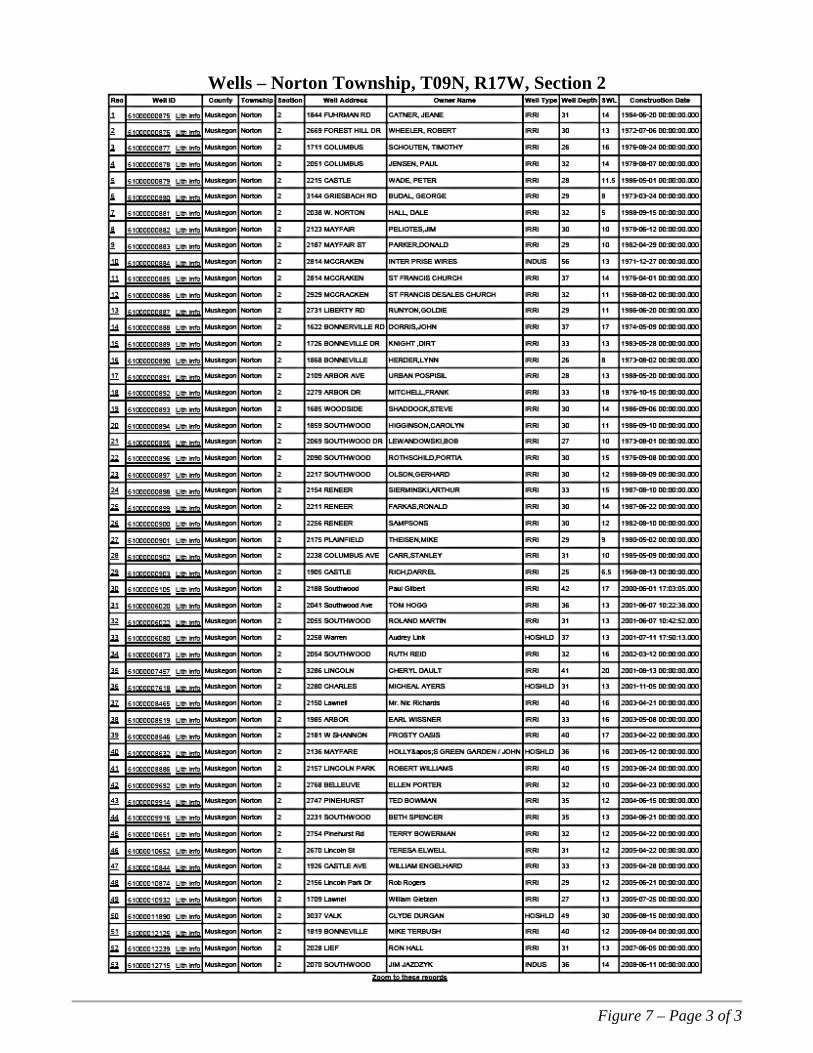
Figure 7 – Page 3 of 3
Wells – Norton Township, T09N, R17W, Section 2
WESTSHORE CONSULTING
Tables
Table A - Open Dune Vegetation
Table B - Transitioning from the Sand Dunes to the Wooded Dunes
Table C - Wooded Dune Vegetation
WESTSHORE CONSULTING
Table A – Open Dune Vegetation
Common Name Botanical Name
Raspberry and bramble vine Rubus spp.
Sumac Rhus spp.
Choke Cherry Prunus spp.
False heather Hudsonia tomentosa
Mugwort, Wormwood Artemisia spp.
Fescue grass Festuca spp.
Goldenrod Solidago
Roughstalk bluegrass Poa trivialis
Perennial Ryegrass Lolium perenne
Beach (Dune) grass, Marram grass Ammophila breviligulata
Little Blue Stem Schizachyrium scoparium
Poison Ivy Toxicodendron radicans
Spotted knapweed Centaurea maculosa
Mullein Verbascum thapsus
Milkweed Asclepias syriaca
Red Sorrel Rumex acetosella
Table B – Transitioning from the Sand Dunes to the Wooded Dunes
Common Name Botanical Name
Indian grass Sorghastrum nutans
Dandelion Taraxacum officinale
Sassafras Sassafras spp.
Witch hazel Hamamelis spp.
Sweet gale Myrica gale
Common Juniper Juniperus communis
Wild Mint Mentha arvensis
Bull Thistle Cirsium vulgare
WESTSHORE CONSULTING
Table C – Wooded Dune Vegetation
Common Name Botanical Name
Barberry, 1 crimson and 1 green Berberis spp.
Coralberry Symphoricarpos orbiculatus
Smooth Rose Rosa blanda
Wild Grapes Vitis spp.
Bearberry Arctostaphylos uva-ursi
Wintergreen Gaultheria procumbens
Wild Blueberry Vaccinium angustifolium
Red Maple Acer rubrum
White Pine Pinus strobus
European Beech Fagus sylvatica
Oak Quercus
Pin (Bird) Cherry Prunus pensylvanica
Poplar Populus spp.
Serviceberry Amelanchier
Fern
Pearly Everlasting Anaphalis margaritacea
Canada Mayflower Maianthemum canadensis
WESTSHORE CONSULTING
Appendix A
Progressive Cell Unit Mining and Reclamation Plan
WESTSHORE CONSULTING
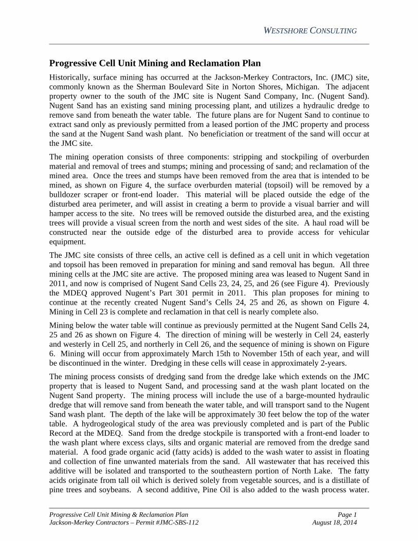
Progressive Cell Unit Mining & Reclamation Plan Page 1 Jackson-Merkey Contractors – Permit #JMC-SBS-112 August 18, 2014
Progressive Cell Unit Mining and Reclamation Plan
Historically, surface mining has occurred at the Jackson-Merkey Contractors, Inc. (JMC) site, commonly known as the Sherman Boulevard Site in Norton Shores, Michigan. The adjacent property owner to the south of the JMC site is Nugent Sand Company, Inc. (Nugent Sand). Nugent Sand has an existing sand mining processing plant, and utilizes a hydraulic dredge to remove sand from beneath the water table. The future plans are for Nugent Sand to continue to extract sand only as previously permitted from a leased portion of the JMC property and process the sand at the Nugent Sand wash plant. No beneficiation or treatment of the sand will occur at the JMC site.
The mining operation consists of three components: stripping and stockpiling of overburden material and removal of trees and stumps; mining and processing of sand; and reclamation of the mined area. Once the trees and stumps have been removed from the area that is intended to be mined, as shown on Figure 4, the surface overburden material (topsoil) will be removed by a bulldozer scraper or front-end loader. This material will be placed outside the edge of the disturbed area perimeter, and will assist in creating a berm to provide a visual barrier and will hamper access to the site. No trees will be removed outside the disturbed area, and the existing trees will provide a visual screen from the north and west sides of the site. A haul road will be constructed near the outside edge of the disturbed area to provide access for vehicular equipment.
The JMC site consists of three cells, an active cell is defined as a cell unit in which vegetation and topsoil has been removed in preparation for mining and sand removal has begun. All three mining cells at the JMC site are active. The proposed mining area was leased to Nugent Sand in 2011, and now is comprised of Nugent Sand Cells 23, 24, 25, and 26 (see Figure 4). Previously the MDEQ approved Nugent’s Part 301 permit in 2011. This plan proposes for mining to continue at the recently created Nugent Sand’s Cells 24, 25 and 26, as shown on Figure 4. Mining in Cell 23 is complete and reclamation in that cell is nearly complete also.
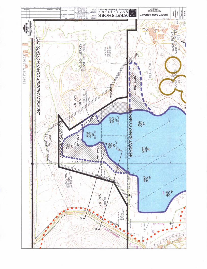
Mining below the water table will continue as previously permitted at the Nugent Sand Cells 24, 25 and 26 as shown on Figure 4. The direction of mining will be westerly in Cell 24, easterly and westerly in Cell 25, and northerly in Cell 26, and the sequence of mining is shown on Figure 6. Mining will occur from approximately March 15th to November 15th of each year, and will be discontinued in the winter. Dredging in these cells will cease in approximately 2-years.
The mining process consists of dredging sand from the dredge lake which extends on the JMC property that is leased to Nugent Sand, and processing sand at the wash plant located on the Nugent Sand property. The mining process will include the use of a barge-mounted hydraulic dredge that will remove sand from beneath the water table, and will transport sand to the Nugent Sand wash plant. The depth of the lake will be approximately 30 feet below the top of the water table. A hydrogeological study of the area was previously completed and is part of the Public Record at the MDEQ. Sand from the dredge stockpile is transported with a front-end loader to the wash plant where excess clays, silts and organic material are removed from the dredge sand material. A food grade organic acid (fatty acids) is added to the wash water to assist in floating and collection of fine unwanted materials from the sand. All wastewater that has received this additive will be isolated and transported to the southeastern portion of North Lake. The fatty acids originate from tall oil which is derived solely from vegetable sources, and is a distillate of pine trees and soybeans. A second additive, Pine Oil is also added to the wash process water.
WESTSHORE CONSULTING
Progressive Cell Unit Mining & Reclamation Plan Page 2 Jackson-Merkey Contractors – Permit #JMC-SBS-112 August 18, 2014
Pine Oil is a natural occurring substance extracted from pinewood, and assists in removing impurities from the sand. The fatty acids and Pine Oil are biodegradable, and removal of these products is accomplished by the use of aerators located in the southern portion of North Lake. The aerators increase the concentration of dissolved oxygen in the water, allowing natural biological activity to assimilate the organic acids. Nugent Sand operates under MDEQ Groundwater Discharge Permit GW1810241. Treatment of the mined material will not occur on the JMC property. Process sand (finished product) will be transported offsite by truck or rail car from the Nugent Sand property.
Areas that will be disturbed by the mining process are shown on Figure 6. Mining will continue in the Nugent Sand Cells 24, 25, and 26. There are no plans to construct roadways (other than the haul road) or buildings on the JMC property. Dredged sand and washed sand will be stockpiled at the Nugent Sand site.
Access to the site will be limited by utilizing fencing along the eastern, western and northern portions of the property. The southern portion of the site is shared with Nugent Sand, and access to the JMC site will be limited to employees of either company; no public access will occur. Access will be allowed through a gate that exists on Sherman Boulevard. The gate will only be unlocked when Nugent Sand and JMC are in operation.
No endangered species were identified during the inspection of the site. If any endangered species are discovered during the mining of the property, plans to protect those species will be formed and enacted, as necessary.
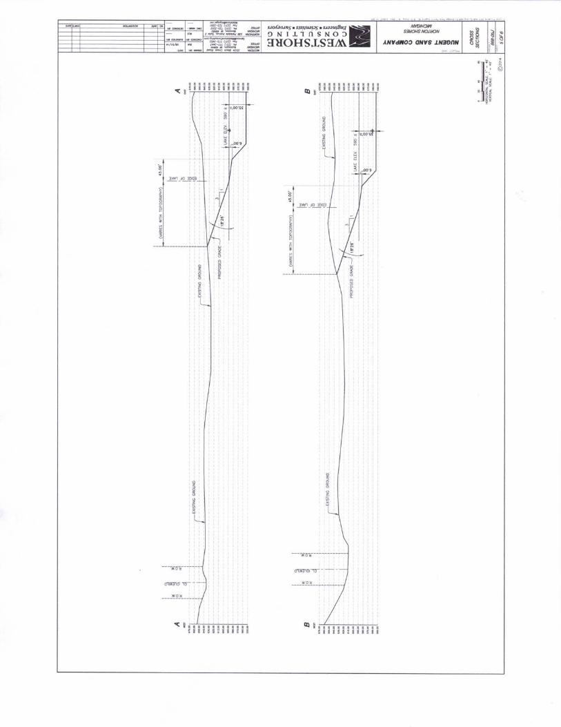
One cross sectional diagram is provided to indicate the final grades that will be used at the termination of the project (Figure 5). All upland reclamation slopes will have grades with an angle not steeper than 1 foot vertically over a horizontal distance of 3 feet. This slope will provide a smooth transition from the disturbed area to the undisturbed topographic features. The water body will be enlarged by approximately 5.14 additional acres on the JMC property, and the submerged grade shall be a 1 foot vertical rise in a 6 foot horizontal distance, or flatter, to a depth of 6 feet.
Cells will be reclaimed once all sand has been removed from an area. Based upon the location of the dredge, reclamation of areas will occur concurrent to the dredging activities or during the three years following the cessation of the dredging activities at the property. Reclamation goals include protection of adjacent properties from blowing sand, the reestablishment of permanent vegetation, and restoration of affected areas to an acceptable aesthetic level
Reclamation will be completed in three phases:
1. All sloped will be graded at an angle not greater than 1 foot vertically over 3 feet horizontally. Topsoil that is stockpiled during the mining operation will be spread over the graded surface.
2. Initial re-vegetation will include the planting of dune grass and trees to stabilize the sloped areas.
3. If necessary, a secondary re-vegetation will occur after the dune grass is established and surface sand movement is reduced. Additional trees and grasses may be planted in areas where the initial re-vegetation was not successful.
WESTSHORE CONSULTING
Appendix B
Fifteen-Year Mining Plan
WESTSHORE CONSULTING
Fifteen-Year Mining Plan Page 1 Jackson-Merkey Contractors – Permit #JMC-SBS-112 August 18, 2014
Fifteen-Year Mining Plan
Surface mining has occurred at the Jackson-Merkey Contractors, Inc. (JMC) property for many years, and has operated under Permit No. JMC-SBS-112 that was issued to JMC. The site is located in the City of Norton Shores, in the Northwest Quarter of Section 3, Township 9 North, Range 17 West. Three active mining cells exist at the site, Cells 1, 2, and 3 (Figure 3).
The present application requests permission to continue to remove sand from beneath the water table only as previously permitted. The existing permit includes 35.6 acres in the three cells. JMC requests to continue to allow Nugent Sand Company, Inc. (Nugent Sand) to mine below the water table, in the area leased to them on the JMC site. Previously Nugent Sand reconfigured the leased area into four new cells (Cells 23, 24, 25 and 26) in a portion of the area formerly occupied by JMC Cells 1, 2 and 3. The area that will continue to be mined below the water table is shown in Figure 4, and totals 5.14 acres. Sand mining has been occurring in these four Nugent Sand Cells since 2011. Mining is now complete in Cell 23 and reclamation is nearly complete. Nugent Sand will continue to extract sand with a barge-mounted hydraulic dredge in the manmade lake, referred to as North Lake. Therefore, this mining plan for the JMC property proposes to continue to allow Nugent Sand only as previously permitted to expand mining in North Lake on the JMC site.
Volume of Sand to be Mined
JMC has removed surface sand from all three existing cells, although the majority of sand has been excavated from Cells 1 and 3. Sand mined from the site has averaged about 200,000 tons per year prior to approximately 2011. Nugent Sand is estimated to have removed approximately 756,371 tons since 2011, from the leased property. Figure 6 shows the area that will be mined, and indicates that JMC will remove minimal sand from above the water table during this permit interval, as Nugent Sand will continue to conduct the active mining operation.
A schedule for mining is shown on Figure 6. The first year of mining will take place in Cells 25, and 26; and then will move to Cell 24 in the second year. Mine reclamation and sand processing will continue after the actual dredging is complete, through years 3-5. The entire mining operation is projected to be discontinued at the conclusion of this five year mining permit.
At the end of this 5-year permit interval, JMC will submit a permit renewal if they desire to continue surface mining activities above the water table.


![[전자기학 jackson 솔루션] 전자기학 jackson 솔루션 65 4000.pdf](https://img.dokumen.tips/doc/110x75/577cb4981a28aba7118c918f/-jackson-jackson-65-4000pdf.jpg)