Embed Size (px)
Citation preview

City of Winnipeg
Jefferson East Combined Sewer Relief Works (Contract 5) Semple Avenue Trunk Sewer Geotechnical Baseline Report
Prepared by: Prepared for:
AECOM Canada Ltd. 99 Commerce Drive Winnipeg, MB R3P 0Y7 Canada T: 204 477 5381 F: 204 284 2040 www.aecom.com
The City of Winnipeg Water and Waste Department 110 - 1199 Pacific Avenue Winnipeg, MB R3E 3S8
Date: December 20, 2019
Project #: 60599385

Distribution List # Hard Copies PDF Required Association / Company Name
City of Winnipeg AECOM Canada Ltd.

RPT-2019-12-20-Jefferson Combined Sewer Relief Phase 2 GBR_60599385-Final.Docx
AECOM Canada Ltd. 200 – 415 Gorge Road East Victoria, BC V8T 2W1 Canada T: 250 475 6355 F: 250 475 6388 www.aecom.com
Mr. Jurgen Friesen, C.E.T. Project Coordinator The City of Winnipeg Water and Waste Department 110 - 1199 Pacific Avenue Winnipeg, MB R3E 3S8
December 20, 2019
Project # 60599385
Dear Mr. Friesen: Subject: Jefferson East Combined Sewer Relief Works – Contract 5 – Semple Avenue Trunk Sewer -
Geotechnical Baseline Report AECOM Canada Ltd. (AECOM) is pleased to submit this Geotechnical Baseline Report for the Jefferson East Combined Sewer Relief Works (Contract 5) to be constructed in Winnipeg, Manitoba. The report represents the baseline subsurface soil, bedrock, and groundwater conditions and descriptions that the proponents shall use for their tender preparation.
This Geotechnical Baseline Report has been prepared in general conformance with the guidelines and practices described in the Geotechnical Baseline Reports for Construction, Suggested Guidelines, published by ASCE, 2007.
If you have any questions concerning this report, please contact the undersigned at (204) 928-7444. Sincerely,
AECOM Canada Ltd. Ryan Harras, B.Sc., EIT Geotechnical Engineer-in-Training
GR:rz Encl.

AECOM City of Winnipeg Jefferson East Combined Sewer Relief Works (Contract 5)
Semple Avenue Trunk Sewer
RPT-2019-12-20-Jefferson Combined Sewer Relief Phase 2 GBR_60599385-Final.Docx
Statement of Qualifications and Limitations The attached Report (the “Report”) has been prepared by AECOM Canada Ltd. (“AECOM”) for the benefit of the Client (“Client”) in accordance with the agreement between AECOM and Client, including the scope of work detailed therein (the “Agreement”).
The information, data, recommendations and conclusions contained in the Report (collectively, the “Information”): is subject to the scope, schedule, and other constraints and limitations in the Agreement and the
qualifications contained in the Report (the “Limitations”); represents AECOM’s professional judgement in light of the Limitations and industry standards for the
preparation of similar reports; may be based on information provided to AECOM which has not been independently verified; has not been updated since the date of issuance of the Report and its accuracy is limited to the time
period and circumstances in which it was collected, processed, made or issued; must be read as a whole and sections thereof should not be read out of such context; was prepared for the specific purposes described in the Report and the Agreement; and in the case of subsurface, environmental or geotechnical conditions, may be based on limited testing and
on the assumption that such conditions are uniform and not variable either geographically or over time.
AECOM shall be entitled to rely upon the accuracy and completeness of information that was provided to it and has no obligation to update such information. AECOM accepts no responsibility for any events or circumstances that may have occurred since the date on which the Report was prepared and, in the case of subsurface, environmental or geotechnical conditions, is not responsible for any variability in such conditions, geographically or over time.
AECOM agrees that the Report represents its professional judgement as described above and that the Information has been prepared for the specific purpose and use described in the Report and the Agreement, but AECOM makes no other representations, or any guarantees or warranties whatsoever, whether express or implied, with respect to the Report, the Information or any part thereof.
Without in any way limiting the generality of the foregoing, any estimates or opinions regarding probable construction costs or construction schedule provided by AECOM represent AECOM’s professional judgement in light of its experience and the knowledge and information available to it at the time of preparation. Since AECOM has no control over market or economic conditions, prices for construction labour, equipment or materials or bidding procedures, AECOM, its directors, officers and employees are not able to, nor do they, make any representations, warranties or guarantees whatsoever, whether express or implied, with respect to such estimates or opinions, or their variance from actual construction costs or schedules, and accept no responsibility for any loss or damage arising therefrom or in any way related thereto. Persons relying on such estimates or opinions do so at their own risk.
Except (1) as agreed to in writing by AECOM and Client; (2) as required by-law; or (3) to the extent used by governmental reviewing agencies for the purpose of obtaining permits or approvals, the Report and the Information may be used and relied upon only by Client.
AECOM accepts no responsibility, and denies any liability whatsoever, to parties other than Client who may obtain access to the Report or the Information for any injury, loss or damage suffered by such parties arising from their use of, reliance upon, or decisions or actions based on the Report or any of the Information (“improper use of the Report”), except to the extent those parties have obtained the prior written consent of AECOM to use and rely upon the Report and the Information. Any injury, loss or damages arising from improper use of the Report shall be borne by the party making such use.
This Statement of Qualifications and Limitations is attached to and forms part of the Report and any use of the Report is subject to the terms hereof. AECOM: 2015-04-13 © 2009-2015 AECOM Canada Ltd. All Rights Reserved.

AECOM City of Winnipeg Jefferson East Combined Sewer Relief Works (Contract 5)
Semple Avenue Trunk Sewer
RPT-2019-12-20-Jefferson Combined Sewer Relief Phase 2 GBR_60599385-Final.Docx
General Statement – Normal Variability of Subsurface Conditions The scope of the investigation presented herein is limited to an investigation of the subsurface conditions as to the suitability of the proposed project. This report has been prepared to aid in the evaluation of the site and to assist the engineer in the design of the facilities. The description of the project represents an understanding of the significant aspects of the project relative to the design and construction of earth work, foundations, and similar. In the event of any changes in the basic design or location of the structures as outlined in this report or plan, AECOM Canada Ltd. should be given the opportunity to review the changes and to modify or reaffirm, in writing, the conclusions and recommendations of this report. The analyses and recommendations represented in this report are based on the data obtained from the test holes drilled at the locations indicated on the site plans and from other information discussed herein. This report is based on the assumption that the subsurface conditions everywhere on the site are not significantly different from those encountered at the test hole locations. However, variation in the soil conditions between the test holes may exist. Also, general groundwater levels and conditions may fluctuate from time to time. The nature and extent of the variations may not become evident until construction. If subsurface conditions different from those encountered in the exploratory borings are observed or encountered during construction, or appear to be present beneath or beyond excavations, AECOM Canada Ltd. should be advised at once so that the conditions can be observed and reviewed and, where necessary, the recommendations reconsidered. Since it is possible for conditions to vary from those identified at the test hole locations and from those assumed in the analysis and preparation of recommendations, a contingency fund should be included in the construction budget to allow for the possibility of variations which may result in modification of the design and construction procedures. In order to observe compliance with the design concepts, specifications, or recommendations and to allow design changes in the event that subsurface conditions differ from those anticipated, it is recommended that all construction operations dealing with earthwork and the foundations be observed by an experienced geotechnical engineer. In addition, it is recommended that a qualified geotechnical engineer review the plans and specifications that have been prepared to check for substantial conformance with the conclusions and recommendations contained in the report

AECOM City of Winnipeg Jefferson East Combined Sewer Relief Works (Contract 5)
Semple Avenue Trunk Sewer
RPT-2019-12-20-Jefferson Combined Sewer Relief Phase 2 GBR_60599385-Final.Docx
Quality Information Report Prepared By: Ryan Harras, B.Sc., EIT
Geotechnical Engineer in training
Report Reviewed By: Hamid Javady, M.Eng., P.Eng.
National Tunneling Lead
Faris Alobaidy, M.Sc., P.Eng.
Senior Geotechnical Engineer

AECOM City of Winnipeg Jefferson East Combined Sewer Relief Works (Contract 5)
Semple Avenue Trunk Sewer
RPT-2019-12-20-Jefferson Combined Sewer Relief Phase 2 GBR_60599385-Final.Docx
Table of Contents page
1. Introduction ......................................................................................... 8
2. Project Description ........................................................................... 10
General ................................................................................................................. 10 Project Location .................................................................................................... 10 Winnipeg Climate .................................................................................................. 10 Project Background ............................................................................................... 10 Key Components of the Project ............................................................................. 10
3. Sources of Information ..................................................................... 12
4. Geologic Setting ................................................................................ 13
Regional Geology .................................................................................................. 13 Topography ........................................................................................................... 13
5. Summary of Subsurface Investigation ............................................ 14
AECOM 2019 Geotechnical Investigation ............................................................. 14 Past Geotechnical Investigations .......................................................................... 15
6. Previous Tunnel Construction Experience ..................................... 16
General ................................................................................................................. 16 Trunk Sewer & LDS Seperation, Contract Two-Cockburn and Calrossie
Combined Sewer Relief Project ............................................................................ 16 Trunk Sewer & LDS Separation, Contract Four-Cockburn and Calrossie
Combined Sewer Relief Project ............................................................................ 17 Jefferson East Combined Sewer Relief - Contract 4 Semple Outfall ..................... 18 Lessons Learned from Previous Tunneling Projects ............................................. 18
7. Ground Characterization .................................................................. 20
General Stratigraphy ............................................................................................. 20 Overburden Characterization ................................................................................ 21
7.2.1 Topsoil ................................................................................................................. 21 7.2.2 Fill ........................................................................................................................ 21 7.2.3 Upper Complex .................................................................................................... 21
7.2.3.1 Upper Complex - Clay ....................................................................................... 22 7.2.3.2 Upper Complex - Silt ......................................................................................... 22 7.2.3.3 Upper Complex - Sand ...................................................................................... 22
7.2.4 Glacio-Lacustrine Clay ......................................................................................... 22 7.2.5 Glacial Till ............................................................................................................ 23

AECOM City of Winnipeg Jefferson East Combined Sewer Relief Works (Contract 5)
Semple Avenue Trunk Sewer
RPT-2019-12-20-Jefferson Combined Sewer Relief Phase 2 GBR_60599385-Final.Docx
7.2.6 Boulders ............................................................................................................... 23 Bedrock Characterization ...................................................................................... 24 Groundwater Observations ................................................................................... 24 Baseline Values .................................................................................................... 24
7.5.1 Overburden .......................................................................................................... 25 7.5.1.1 Swelling Potential of Glacio-Lacustrine Clay ..................................................... 25
7.5.2 Groundwater ........................................................................................................ 25 Frost Penetration ................................................................................................... 26 Frost Susceptibility ................................................................................................ 26
8. Design and Construction Considerations ...................................... 27
General ................................................................................................................. 27 Trenchless Pipe Installation Methods .................................................................... 27 Ground Settlement ................................................................................................ 29
8.3.1 Empirical Calculations for Settlement ................................................................... 29 8.3.2 Settlement Analysis .............................................................................................. 32
8.3.2.1 Settlement Contours and Profile ....................................................................... 32 8.3.2.2 Settlement Sections at Key Locations ............................................................... 33 8.3.2.3 Settlement and Ground Loss ............................................................................. 34
Launching and Receiving Shafts ........................................................................... 35 8.4.1 Base Heave .......................................................................................................... 36 8.4.2 Lateral Pressures ................................................................................................. 36
Tunnelling .............................................................................................................. 37 8.5.1 Tunnel Face Stability ............................................................................................ 37 8.5.2 Stickiness and Clogging Potential ........................................................................ 38
Temporary Excavations ......................................................................................... 39 Impact on Existing Structures ................................................................................ 39 Instrumentation Program ....................................................................................... 40 Groundwater Management and Spoil Disposal ..................................................... 40
Soil Chemistry ....................................................................................................... 41
List of Figures Figure 8-1: 2D (left) and 3D (right) Depictions of Tunnel Induced Ground Settlement Trough (Fargnoli et al.
2013, Attewell et al., 1986) ...................................................................................................................... 29 Figure 8-2: 3D Depiction of Soil Settlement Along Tunnel Alignment at 0.5% Ground Loss ..................................... 32 Figure 8-3: Profile of Ground Settlement Along Proposed Alignment (Various Ground Loss %) .............................. 33 Figure 8-4: Settlement at Sta. 0+775.50 (Left) and Sta. 1+656.60 (Right) (Various Ground Loss %) ....................... 34 Figure 8-5: Calculated Factor of Safety (FS) Against Basal Heave ........................................................................... 36
List of Tables Table 2-1: Summary of Semple Ave. Trunk Sewer Length, Size, and Proposed Installation Methods ..................... 11 Table 5-1: Laboratory Testing – AECOM 2019 Geotechnical Investigation ............................................................... 15

AECOM City of Winnipeg Jefferson East Combined Sewer Relief Works (Contract 5)
Semple Avenue Trunk Sewer
RPT-2019-12-20-Jefferson Combined Sewer Relief Phase 2 GBR_60599385-Final.Docx
Table 7-1: Test Holes Along Semple Avenue Trunk Sewer Alignment ...................................................................... 20 Table 7-2: Recommended Geotechnical Design Parameters for Overburden ........................................................... 25 Table 8-1: Maximum Ground Settlement at Various Ground Loss Ratios [mm] ........................................................ 34
Appendices Appendix A Figures
Figure A1: Site Location Plan and Semple Avenue Trunk Sewer Alignment Figure A2 to A6: Stratigraphic Section of Semple Avenue Trunk Sewer Alignment Figure A7: Undrained Shear Strength vs. Elevation Along Alignment (Glacio-lacustrine Clay) Figure A8: Moisture Content and Atterberg Limits vs. Elevation Along Alignment (Glacio-lacustrine Clay) Figure A9: Plasticity Index vs. Elevation Along Alignment (Glacio-lacustrine Clay) Figure A10: Clogging Potential (Glacio-Lacustrine Clay)
Appendix B Baseline Ground Condition at Shaft Locations Table B1: Baseline Elevations of Expected Soil Units- McKenzie St. Shaft
Table B2: Baseline Elevations of Expected Soil Units- McGregor St. Shaft Table B3: Baseline Elevations of Expected Soil Units- Andrews St. Shaft
Table B4: Baseline Elevations of Expected Soil Units- Powers St. Shaft Table B5: Baseline Elevations of Expected Soil Units- Salter St. Shaft Table B6: Baseline Elevations of Expected Soil Units- Aikins St. Shaft Table B7: Baseline Elevations of Expected Soil Units- Adjacent to Main St. Shaft Table B8: Baseline Elevations of Expected Soil Units- Scotia St. Shaft
Appendix C Tunnelman’s Ground Classification System Appendix D Earth Pressure Distribution for Temporary Shoring
Figure D1: Earth Pressure Distribution for Temporary Shoring – Cohesive Glacio-Lacustrine Clay Soil Units

AECOM City of Winnipeg Jefferson East Combined Sewer Relief Works (Contract 5)
Semple Avenue Trunk Sewer
RPT-2019-12-20-Jefferson Combined Sewer Relief Phase 2 GBR_60599385-Final.Docx 8
1. Introduction AECOM Canada Ltd. (AECOM) has prepared this Geotechnical Baseline Report (GBR) for the Semple Avenue Trunk Sewer Alignment to be constructed within the Mynarski ward in the northern region of Winnipeg, Manitoba (the Project). The purpose of this GBR is to:
• Provide a baseline interpretation of the geotechnical aspects of the design and construction of the works.
• Set clear baselines for subsurface conditions anticipated to be encountered during construction. • Provide all bidders with a single contractual interpretation in preparing bids. • Describe the subsurface conditions along the Semple Avenue Trunk Sewer alignment. • Assist in evaluating the requirements for excavation, temporary support, groundwater control, and
ground movement for shaft and tunnel construction.
The GBR presents the subsurface conditions as baseline values and descriptions that the proponents shall use for their tenders. The GBR should be read in conjunction with the Geotechnical Data Report (GDR) prepared for the Semple Avenue Trunk Sewer Interceptor by AECOM dated November 29, 2019. The baselines presented in this GBR do not provide a warranty that subsurface conditions different from the baselines will not be encountered. The baselines, however, represent a contractual agreement between the City of Winnipeg (the City) and the Contractor to use for the resolution of claims made for “differing ground conditions”.
The baselines in this GBR also provide the City with the opportunity to allocate risks associated with the variability in the subsurface ground conditions during the bidding stage. Risks associated with consistent or less adverse subsurface conditions than baselined subsurface conditions are allocated to the Contractor and risks associated with more adverse subsurface conditions than the baselined subsurface conditions are accepted by the City. The effective use of the baseline conditions will depend on adequate documentation of subsurface conditions encountered during tunnelling.
Proponents must consider this GBR as part of the Contract Documents and it must be read in conjunction with the Specifications and the Design Drawings prepared by AECOM for the City. The hierarchy of this document and other documents is indicated in the Project’s Contract Documents.
The baselines presented in this GBR apply to the excavation limits shown on the Design Drawings and figures provided in this GBR. The baselines presented in this GBR do not apply to Contractor-modified portion(s) of the Project.
Some of the technical concepts, terms and descriptions in this GBR may not be fully understood by bidders. It is required that bidders have a geotechnical engineer with local experience, who is familiar with the topics in this GBR, to carefully review and explain this information so that a complete understanding of the information presented in this GBR can be developed prior to submitting a bid.
The GBR has been prepared in general conformance with the guidelines and practices described in the Geotechnical Baseline Reports for Construction, Suggested Guidelines, published by ASCE, 2007. The GBR has been prepared by AECOM for the City.

AECOM City of Winnipeg Jefferson East Combined Sewer Relief Works (Contract 5)
Semple Avenue Trunk Sewer
RPT-2019-12-20-Jefferson Combined Sewer Relief Phase 2 GBR_60599385-Final.Docx 9
Certain elements of the Project are based on requirements that cannot be varied unless otherwise specified in this GBR. These include, but are not limited to the following:
• One-pass tunneling method including pipe jacking or two-pass construction including construction of a primary support system followed by placement of the carrier pipe and backfill of the cellular grout.
• Final sewer internal diameters. • Alignment and invert of the proposed sewer.
Other elements of the project that are flexible and afford the Contractor latitude in planning its work and selecting means and methods, subject to approval of the City, include, but are not limited to, the following:
• Procurement, selection, and configuration of the tunneling equipment for one-pass tunneling method (if selected).
• Procurement, selection, and configuration of the tunneling equipment and primary support system for the two-pass tunneling method (if selected).
• Upsizing of the 1800 mm pipe to facilitate the selected construction methodology. • Number of shafts to be constructed to facilitate the selected tunneling equipment and methods. • Launch and receiving shafts shape and dimensions. • Design and selection of any jacking pipe, although there are minimum requirements that must be
satisfied.

AECOM City of Winnipeg Jefferson East Combined Sewer Relief Works (Contract 5)
Semple Avenue Trunk Sewer
RPT-2019-12-20-Jefferson Combined Sewer Relief Phase 2 GBR_60599385-Final.Docx 10
2. Project Description
General The description and dimensions for the various components of the project provided in this GBR are approximate and for illustration purposes only. The Contractor should refer to the Contract Documents/Drawings for accurate information on dimensions and project layout.
Project Location The proposed Semple Avenue trunk sewer will be constructed within the Mynarski ward in the northern region of Winnipeg. The proposed alignment extends from the west end of Semple Avenue at McKenzie Street to the east end of Semple Avenue at Scotia Street, as shown on Figure A1 in Appendix A.
Winnipeg Climate Winnipeg is located in central southern Manitoba at the bottom of the Red River Valley, a low-lying flood plain with flat topography. Winnipeg has a humid continental climate with a wide range of temperatures throughout the year. The monthly average temperature ranges from -18°C in January to 20°C in July. Winter is defined as the time which the daily mean temperature remains below 0°C and typically lasts from the beginning of November to the beginning of April. Spring and autumn are defined as the time period the mean daily temperature ranges from 0° to 6°C and are typically short in duration, lasting only a couple of weeks. The average yearly precipitation in Winnipeg is 505 mm of precipitation per year although the precipitation can vary greatly. The average annual snow fall in Winnipeg is 115 cm, with the most snow typically accumulating in January and February.
Project Background The Semple Avenue trunk sewer project is an extension of the Jefferson East Combined Sewer Relief (CSR) Works. The Jefferson East Combined Sewer District was identified as needing upgrade to satisfy five-year level of service (LOS) design criteria. The proposed Semple Avenue trunk sewer upgrade involves disconnecting surface runoff from the existing combined sewer system in the northern portion of the Jefferson district, effectively freeing up capacity in the existing Jefferson Combined Sewer trunk and satisfying the five-year LOS design criteria for the remainder of the district. The outfall for this trunk was constructed in 2017 with the trunk temporarily terminating on Scotia Street at the east end of the proposed Semple Avenue Trunk Sewer. This outfall was installed using an open-face excavator shield and pipe jacking. A trenchless solution is understood to be the preferred method for installation for the Semple Avenue trunk.
Key Components of the Project Construction of the Semple Avenue Trunk Sewer will be between McKenzie Street on the west, and Scotia Street on the east as shown on Figure A1 in Appendix A. A summary of the Semple Avenue Trunk Sewer lengths, sizes and installation methods are provided in Table 2-1.

AECOM City of Winnipeg Jefferson East Combined Sewer Relief Works (Contract 5)
Semple Avenue Trunk Sewer
RPT-2019-12-20-Jefferson Combined Sewer Relief Phase 2 GBR_60599385-Final.Docx 11
Table 2-1: Summary of Semple Ave. Trunk Sewer Length, Size, and Proposed Installation Methods
Location Length (m) Size (Nominal Internal Diameter) (mm)
Installation Method
Start: McKenzie Street End: Andrews Street 400 1800 - Carrier Pipe Tunneling with Pipe
Jacking
Start: Andrews Street End: Scotia Street
(East end of Semple Ave.) 1100 2100 - Carrier Pipe Tunneling with Pipe
Jacking
The proposed Semple Avenue Trunk Sewer alignment will include, at minimum, shafts at the intersection of Semple Avenue and McKenzie Street and at the intersection of Semple Avenue and Scotia Street. Based on the selected tunneling method and equipment, the contractor may consider additional shafts at the following intersections: McGregor Street, Andrews Street, Powers Street, Salter Street, Aikins Street, and adjacent to Main Street (outside of the Main Street right of way). Upsizing of the 1800 mm pipe will be permitted to facilitate construction means and methods.
New manholes will be constructed in shafts. A shaft will be located at the east end of the alignment near the connection to the existing 2100 concrete land drainage sewer (LDS) at Scotia Street. The final location, number, and size of launching and retrieving shafts are dependent on the selected trenchless construction method, as maximum drive lengths vary between each method.
The minimum dimension of shafts and the shape of shafts will vary based on the selected method of construction.

AECOM City of Winnipeg Jefferson East Combined Sewer Relief Works (Contract 5)
Semple Avenue Trunk Sewer
RPT-2019-12-20-Jefferson Combined Sewer Relief Phase 2 GBR_60599385-Final.Docx 12
3. Sources of Information Reference should be made to the AECOM GDR for subsurface exploration and testing sources. The following sources of information and references were referred to in preparation of this GBR.
1. AECOM Canada Ltd. (2012). City of Winnipeg Jefferson East Sub-Surface Investigation Geotechnical Memo.
2. AECOM Canada Ltd. (2015). City of Winnipeg Construction of Outfall Chamber and Piping Jefferson East CSR – Waterway Application – Supplementary Geotechnical Investigation Letter.
3. Bernhardt, Darren (2018). Ghost creeks: Winnipeg buried many waterways that could have changed city’s shape. CBC News.
4. Essex, R.J. (2007). Geotechnical Baseline Reports for Construction, Suggested Guidelines. American Society of Civil Engineers.
5. ASCE/CI 36-15 (2015). Standard Design and Construction Guidelines for Microtunneling. Published by American Society of Civil Engineers.
6. Canadian Geotechnical Society (2006). Canadian Foundation Engineering Manual, 4th edition. 7. Broms, B.B., Bennemark, H. (1967), Stability of clay at vertical openings. ASCE Journal of Soil
Mechanics and Foundation Engineering Division. 8. Peck, R.B. (1969) Deep Excavations and Tunneling in Soft Ground. Proceedings of the 7th
International Conference on Soil Mechanics and Foundation Engineering. 9. Terzaghi, K. (1950). Geologic aspects of soft ground tunneling. Applied Sedimentation Ch 11. 10. Heuer, R.E. (1974). Important ground parameters in soft ground tunneling. ASCE Subsurface
exploration for underground excavation and heavy construction. 11. Baracos, A.G. Shields, D.H., and Kjartenson, B. (1983). Geological Engineering Report for Urban
Development of Winnipeg, University of Manitoba- Department of Geological Engineering. 12. Graham, J., and Shields, D.H (1985). Influence of geology and geological processes on the
geotechnical properties of a plastic clay. Engineering Geology. 13. Hollmaan, F.S., Thewes, M., 2013. Assessment method for clay clogging and disintegration of
fines in mechanised tunneling. Tunneling and Underground Space Technology. 14. Van der Merwe, D.H. (1964). Prediction of heave from the plasticity index and percentage of clay
fraction of soils. Transactions of the South African Institution of Civil Engineers. 15. Taylor, R.K., Smith, T.J. (1986), The engineering geology of clay minerals: swelling, shrinking and
mudrock breakdown. Clay Minerals. 16. Savage, P.F. (2007). Evaluation of possible swelling potential of soil. Proceedings of the 26th
Southern African Transport Conference. 17. O’Reilly, P., New, M. (1991). Tunneling induced ground movements; predicting their magnitude
and effects. Proceedings of Fourth International Conference of ground movement and structures. 18. Aoyagi, Takahiro (1995). Representing Settlement for Soft Ground Tunneling. MIT. 19. Attewell, B., Yeates, J., Selby, A.R. (1986). Soil movements induced by tunneling and their
effects on pipelines and structures. 20. Fargnoli et al (2013). TBM tunneling-induced settlements in coarse-grained soils: the case of the
new Milan underground line 5. Tunneling and Underground Space Technology. 21. Fujita, K. (1989). Special lecture B: Underground construction, tunnel, underground
transportation. 12th International Conference on Soil Mechanics and Foundation Engineering. 22. Roberge, P. (1999). Handbook of Corrosion Engineering.

AECOM City of Winnipeg Jefferson East Combined Sewer Relief Works (Contract 5)
Semple Avenue Trunk Sewer
RPT-2019-12-20-Jefferson Combined Sewer Relief Phase 2 GBR_60599385-Final.Docx 13
4. Geologic Setting
Regional Geology The regional geology of the site has been outlined in the AECOM GDR dated November 29, 2019 and should be referenced in conjunction with Section 4 of this report for a more detailed outline. Additional information for the regional geology within the City of Winnipeg is included in the following references:
1. Baracos, A., Shields, D.H., and Kjartanson, B., 1983. Geological engineering report for urban development of Winnipeg. University of Manitoba.
2. Baracos, A., Graham, J., Kjartanson, B., and Shields, D.H., 1983. Geology and soil properties of Winnipeg. In ASCE Conference on Geologic Environment and Soil Properties, Houston TX: 39-56.
3. Baracos, A., Graham, J., and Domaschuk, L., 1980. Yielding and rupture in a lacustrine clay. Canadian Geotechnical Journal, 17: 559-573.
4. Quigley, R.M., 1968. Soil mineralogy Winnipeg swelling clays. Can. Geotech. J. 5(2), pp. 120-122.
5. Render, F.W., 1970. Geohydrology of the metropolitan Winnipeg area as related to groundwater supply and construction. Canadian Geotechnical Journal, 7(3): 243-274.
6. Skaftfeld, K., 2014. Experience as a Guide to Geotechnical Practice in Winnipeg (Masters of Science Thesis). University of Manitoba, Winnipeg, Manitoba.
Site-specific geotechnical and geological information derived from the AECOM 2019 geotechnical investigation and past investigations (including results of the geotechnical drilling and laboratory test data) are presented in the GDR.
Topography The topography along the Semple Avenue Trunk Sewer alignment has approximately 1.4 m of variation between Station 0+202 (west end of alignment) and Station 1+500. The topography along the alignment between Station 1+500 and Station 1+742 (east end of alignment) has approximately 2.6 m of variation in elevation. This topographic variation between Station 1+500 and Station 1+742 follows a waterway channel shape, likely resulting from infrastructure development over the historic Inkster’s Creek waterway. More detailed information about Inkster’s Creek is provided within the GDR.
The ground surface profile along the Semple Avenue Trunk Sewer alignment is shown on Figure A2 to Figure A6 in Appendix A.

AECOM City of Winnipeg Jefferson East Combined Sewer Relief Works (Contract 5)
Semple Avenue Trunk Sewer
RPT-2019-12-20-Jefferson Combined Sewer Relief Phase 2 GBR_60599385-Final.Docx 14
5. Summary of Subsurface Investigation As described in the GDR dated November 29, 2019, AECOM conducted a geotechnical investigation in 2019 along the proposed Semple Avenue Trunk Sewer alignment with the objective of characterizing the subsurface ground and groundwater conditions along the alignment. The findings of the AECOM 2019 geotechnical investigation are summarized in the GDR, but the pertinent findings of the investigation are also presented below.
Two (2) past geotechnical investigations that have been completed in the vicinity of the project site has also been referenced within the GDR. These past investigations were carried out as part of the Jefferson East Combined Sewer Relief (CSR) sub-surface investigation in 2012 and to support the design of the Semple Outfall in 2015. The findings of these investigations have also been summarized in to the following sections of this report.
AECOM 2019 Geotechnical Investigation From June 20 to 21, 2019 a hydro-vac investigation was completed at seventeen (17) test hole locations to a maximum depth of 3.1 m to confirm that the locations were clear of utilities. From June 24 to 27, 2019, sixteen (16) test holes (TH19-01 to TH19-08, and TH19-10 to TH19-17) were drilled at the approximate locations shown on Figure A1 in Appendix A. Test holes were drilled within the north boulevard of Semple Avenue along the proposed alignment. One (1) proposed test hole (TH19-09) could not be drilled due to the presence of underground and above ground utilities in the area.
Drilling was completed by Maple Leaf Drilling using the following equipment: track-mounted Acker MP-5 drill rig equipped with 125 mm solid stem augers for test holes TH19-02 to TH19-08 and TH19-12 to TH19-17, and a truck-mounted Canterra CT-250 drill rig equipped with 125 mm solid stem augers for test holes TH19-01, TH19-10, and TH19-11. Subsurface conditions observed during drilling were visually classified and documented by AECOM geotechnical personnel. Other pertinent information such as groundwater and drilling conditions were also recorded during the field investigation.
Disturbed soil samples collected from auger cuttings and split-spoon samplers, as well as relatively undisturbed Shelby Tube samples were obtained at regular intervals. Standard Penetration Tests (SPTs) were completed at selected intervals in the test holes and blow counts for 300 mm penetration (SPT “N” blow counts) were recorded.
Piezometers were installed within the glacio-lacustrine or glacial till layers in three of the test holes (TH19-01, TH19-05, and TH19-16) to measure groundwater depths. The test hole logs and groundwater instrumentation details and measurements are provided in the GDR.
Recovered soil samples were transported to Dyregrov Robinson Inc. materials testing laboratory in Winnipeg for further visual examination and moisture content, undrained shear strength, pocket penetrometer, and bulk unit weight testing. A section of all recovered Shelby Tube samples were waxed to preserve them for further testing. Select samples were taken to H. Manalo Consulting materials testing laboratory in Winnipeg for Atterberg Limits, grain size distribution (hydrometer/sieve methods), and permeability testing. Other samples were taken to Wood Environment & Infrastructure Solutions materials testing laboratory in Winnipeg for Atterberg Limits, grain size distribution (hydrometer/sieve methods), and

AECOM City of Winnipeg Jefferson East Combined Sewer Relief Works (Contract 5)
Semple Avenue Trunk Sewer
RPT-2019-12-20-Jefferson Combined Sewer Relief Phase 2 GBR_60599385-Final.Docx 15
swell testing. All electrochemical testing was completed by ALS Environmental’s Winnipeg laboratory. Details of the type and number of tests are presented in Table 5-1. The laboratory test results for test holes along the Semple Avenue Trunk Sewer alignment are provided in the GDR.
Table 5-1: Laboratory Testing – AECOM 2019 Geotechnical Investigation
Laboratory Test Number of Tests Moisture Content 156 Atterberg Limits 11
Grain Size Distribution (Hydrometer Method) 11
Undrained Shear Strength (Unconfined Compressive Strength Method) 26
Pocket Penetrometer 29 Torvane 29
Bulk Unit Weight 27 Permeability
(Hydraulic Conductivity Method) 2
Swell (One-Dimensional Swell or Collapse Method) 5
Electrochemical (pH, Sulphate, Resistivity/Conductivity) 5
Past Geotechnical Investigations As described in the project GDR, two (2) geotechnical investigations have been conducted by AECOM in 2012 and 2015 within the Jefferson East CSR area. Some of these previous test holes were approximately along the proposed Semple Avenue Trunk Sewer alignment, while others were offset from the alignment. These geotechnical investigations comprise of the following:
• AECOM (2012) – Fourteen (14) test holes drilled at various locations around the Jefferson East CSR, including two (2) near the proposed Semple Avenue Trunk Sewer alignment.
• AECOM (2015) – Two (2) test holes drilled near the Semple Outfall.
Detailed information of the previous geotechnical investigations is provided in the GDR.
Based on AECOM’s review of the existing geotechnical investigations, test holes TH11-11 and TH11-12 from the AECOM 2012 investigation are deemed most applicable given that the test holes were drilled near the proposed alignment. The findings of all of the geotechnical investigations and laboratory testing results have been referenced in the review of subsurface soil/rock conditions and groundwater conditions as summarized in the GDR.

AECOM City of Winnipeg Jefferson East Combined Sewer Relief Works (Contract 5)
Semple Avenue Trunk Sewer
RPT-2019-12-20-Jefferson Combined Sewer Relief Phase 2 GBR_60599385-Final.Docx 16
6. Previous Tunnel Construction Experience
General Select case histories which have relevance to the design and construction of the current project and lessons learned from construction of tunnels in the Winnipeg area are presented in the following sections.
While historically in the City of Winnipeg other forms of trenchless technologies have been used in the installation of buried pipe infrastructure, Tunnel Boring Machines (TBM’s) and Micro-Tunnel Boring Machines (MTBM’s) have been increasingly used. The following project examples are considered relevant to the Semple Avenue Trunk Sewer project.
Trunk Sewer & LDS Seperation, Contract Two-Cockburn and Calrossie Combined Sewer Relief Project
The project included installation of approximately 1.3 km of 1.2 m diameter land drainage sewer using an MTBM at approximate depths of 8 m to 9 m below grade within the glacio-lacustrine clay. The project is located on Byng Place, Rockman Street, Parker Avenue and Heatherdale Avenue (approximately 600 m south from Taylor Avenue). The work was carried out by Marathon Drilling Co., using a Herrenknecht AVN1200 MTBM.
The shaft construction was completed using steel sheet piles and walers. The sheet piling was vibrated through the glacio-lacustrine clay to an approximate depth of 12 m below grade.
During shaft construction and pipe installation, the following issues were encountered;
• Unacceptable transfer of vibrations through the glacio-lacustrine clay that negatively impact adjacent structures.
• The separation plant was unable to effectively separate the clay particles from the water. This resulted in a mud spoil too wet to be hauled off-site due to excessive moisture. Reportedly drier material was added to the spoil to allow for disposal. Marathon Drilling Co., modified the separation plant to optimize the water return. Accordingly, modifications to the separation ratios were not successful (which included replacing finer screens with coarser screens) resulting in an excess of excavated material entering the recovery tank and increasing the chute size on the shaker deck. One partially successful solution consisted of the application of sprayer bars to force material through the screens and adding a scalping belt was considered.

AECOM City of Winnipeg Jefferson East Combined Sewer Relief Works (Contract 5)
Semple Avenue Trunk Sewer
RPT-2019-12-20-Jefferson Combined Sewer Relief Phase 2 GBR_60599385-Final.Docx 17
Trunk Sewer & LDS Separation, Contract Four-Cockburn and Calrossie Combined Sewer Relief Project
Contract 4 of the project (Cockburn and Calrossie Combined Sewer Relief) included the installation of approximately 525 m of 2.7 m diameter land drainage sewer by trenchless installation methods. The land drainage sewer was installed within the glacio-lacustrine clay at approximately 8.0 m to 8.5 m below grade. The project is located on land adjacent to Manitoba Hydro and Shindico property along Wilton Street from the north side of Taylor Avenue. The work was carried out by Ward and Burke Microtunnelling. Ltd., using a Herrenknecht AVN2500 MTBM. The MTBM was ‘up-skinned’ to match the outside diameter of the 2.7 m reinforced concrete jacking pipe.
The use of dual centrifuges to remove the clay from the slurry was deemed effective comparatively to the slurry separation used within Contract 2. Lessons learned from Contract 2 of the Cockburn and Calrossie combined sewer relief project (see Section 6.2 of this report) were successfully implemented to mitigate the vibration effects as a result of the caisson installation.
During the tunnelling process, a correlation was measured between the face pressure maintained at the MTBM and recorded surface settlements. Where the machine face pressure was near zero (prior to crossing the CN right-of-way), measured surface settlement along the centreline of the alignment exceeded the settlement tolerances (greater than 25 mm) for the project. Upon reassessment by the MTBM Contractor, an average face pressure of 55 kPa was maintained for the remaining drive length, and the initial settlement values were reduced by approximately 50 percent. Face pressure was increased by pumping bentonite slurry to the machine and tunnel to fully charge the annular overcut.
Contact grouting of the tunnel annulus was observed by the Contractor and Engineer to be highly effective in restoring the surface to pre-tunnelling elevations. It is understood that grout port spacing of 15 m (every 5 pipes) for lubrication was used during the tunnelling process. However, it was reported that the bentonite lubrication initially used was not viscous enough to be displaced through the subsequent set of lubrication ports. Higher grouting pressures were sufficient to result in surface cracking indicating ground heave. This is a result of the friction force being too high, slurry mixture being too thick or the wide spacing of the lubrication ports. Accordingly grout bulkheads were created along the north and south sides of the CN crossing to create a seal and maintain the stabilized annular pressure under each set of the railway tracks. Upon reduction of the lubrication density during the second tunnelling drive, measured surface settlements along the centreline rebounded during contact grouting to 2 mm from the baseline readings.
The access shafts consisted of cast-in-place reinforced concrete caissons with sacrificial steel cutting shoes. The shafts were installed by excavating the soil within the caisson as sinking occurred under the self-weight of the cutting shoe and concrete wall to depths of between 9 m and 9.5 m. Installation of the cast-in-place caissons was achieved without additional point or vibratory loads to sink the shafts. Negligible vibration were measured during the shaft installation.

AECOM City of Winnipeg Jefferson East Combined Sewer Relief Works (Contract 5)
Semple Avenue Trunk Sewer
RPT-2019-12-20-Jefferson Combined Sewer Relief Phase 2 GBR_60599385-Final.Docx 18
Jefferson East Combined Sewer Relief - Contract 4 Semple Outfall
Contract 4 of the Jefferson Combined Sewer Relief Project – Semple Outfall included construction of approximately 110 metres of 2100 diameter reinforced concrete pipe by pipe jacking construction methods, including a river outfall and control chamber. This project is the outlet pipe for the proposed Semple Avenue Trunk Sewer. The pipe was installed by Borland Construction in the winter of 2016, using an Akkerman Excavator shield and pushing pipe using a jacking system. The pipe was approximately 8 metres deep, in high plasticity lacustrine clays. These geotechnical conditions are similar to those on the proposed Semple trunk. The installation included two drives of 70 and 40 metres. Production was slow at 4-6 metres per day due to winter conditions, relatively short drives, and contractor unfamiliarity with the equipment. During construction, there were maintenance issues with equipment due to cold weather. There was also difficulty with contractor selection of belts for mud handling. Due to the high plasticity clays, belt clogging and damage due to dropping large clods of mud on the belts were problematic. Shafts for this project were constructed by soldier piles and timber lagging. No specific concerns were encountered using this construction method. Dewatering was not utilized or required for construction.
Lessons Learned from Previous Tunneling Projects
Using the case histories from the projects above has permitted preparation of the following key lessons from previous tunnelling projects in Winnipeg.
• Adequate geotechnical investigation in accordance with the ASCE guidelines is critical for the successful completion of tunnelling projects
• Sufficient testing should be conducted on soil samples to enable proper estimation of the parameters required for the design of tunnel and shafts, selection of the tunneling equipment and suitable tunnel support system. Inadequate soil testing may result in a conservative design, or selection of tunnelling equipment and shaft systems that are not suited to the soil conditions.
• Unsuitable applied face pressures during the tunnelling process may result in ground settlement within the glacio-lacustrine soils.
• Lubrication port spacing and bentonite lubrication mix design should be given extra considerations when working in the glacio-lacustrine soils which are considered to have a high stickiness potential.
• Contact grouting is an effective means in restoring the ground surface elevation to pre-tunnelling conditions.
• Suitable separation plants should be designed for clay soils when using slurry spoil transport systems.
• Vibrating loading does not quickly dissipate within the glacio-lacustrine soils (i.e., silty clays) and can result in structural damage to adjacent structures. Installation methods for sheet piling should be critically assessed and adequate vibration monitoring programs should be implemented to assess vibration at specific distances relative to the location of sheet piles.

AECOM City of Winnipeg Jefferson East Combined Sewer Relief Works (Contract 5)
Semple Avenue Trunk Sewer
RPT-2019-12-20-Jefferson Combined Sewer Relief Phase 2 GBR_60599385-Final.Docx 19
• The concrete caisson shaft design and self-sinking installation methodology produced negligible vibrations through the glacio-lacustrine soils and was comparatively non-intrusive to the surrounding environment.
• Soldier pile and timber lagging systems for shaft construction can be utilized effectively, depending on depths and requirement for excessive cross bracing.
• Ground monitoring system and review of the data frequently can successfully mitigate any potential risk of movement and negative impact on surface and underground infrastructure.

AECOM City of Winnipeg Jefferson East Combined Sewer Relief Works (Contract 5)
Semple Avenue Trunk Sewer
RPT-2019-12-20-Jefferson Combined Sewer Relief Phase 2 GBR_60599385-Final.Docx 20
7. Ground Characterization
General Stratigraphy The subsurface stratigraphy along the Semple Avenue Trunk Sewer alignment generally comprises of mixed upper complex soils (sand, silt and clay) overlying (in descending order) glacio-lacustrine clay, and glacial till deposits. The bedrock surface was encountered in one test hole offset from the proposed alignment at an elevation of approximately 205.2 m. The composition of the upper complex soils is expected to vary with depth along the proposed alignment. Cobbles and boulders should be expected within and near the glacial till deposit (typical of glacial till soils within the Winnipeg area).
For the purposes of outlining the site-specific subsurface stratigraphy, test holes identified in Table 7-1 are considered applicable for characterization of the subsurface ground and groundwater conditions along the Semple Avenue Trunk Sewer alignment.
Table 7-1: Test Holes Along Semple Avenue Trunk Sewer Alignment
Test Hole Investigation Coordinates (m) Elevation (m) *Pipeline Cover (m)
TH19-01 AECOM 2019 5533995 m N, 634036m E 231.11 5.83 TH19-02 AECOM 2019 5533973 m N, 634084m E 231.28 5.56 TH19-03 AECOM 2019 5533922 m N, 634193m E 231.52 6.05 TH19-04 AECOM 2019 5533885 m N, 634272m E 231.54 6.09 TH19-05 AECOM 2019 5533828 m N, 634394m E 231.32 5.99 TH19-06 AECOM 2019 5533801 m N, 634449m E 231.23 5.43 TH19-07 AECOM 2019 5533750 m N, 634559m E 231.13 5.53 TH19-08 AECOM 2019 5533718 m N, 634627m E 230.97 5.32
**TH19-09 AECOM 2019 5533656 m N, 634757 m E - - TH19-10 AECOM 2019 5533626 m N, 634825m E 230.73 5.10 TH19-11 AECOM 2019 5533577 m N, 634929m E 230.89 5.35 TH19-12 AECOM 2019 5533542 m N, 635003m E 230.76 5.37 TH19-13 AECOM 2019 5533487 m N, 635121m E 230.81 5.33 TH11-11 AECOM 2012 5533432 m N, 635210 m E 230.74 5.40 TH19-14 AECOM 2019 5533421 m N, 635261m E 230.65 5.19 TH19-15 AECOM 2019 5533404 m N, 635298m E 230.08 4.77 TH19-16 AECOM 2019 5533376 m N, 635357m E 228.55 3.39 TH19-17 AECOM 2019 5533349 m N, 635414m E 230.54 5.20 TH11-12 AECOM 2012 5533322 m N, 635426 m E 230.89 5.70
Notes: * Pipeline cover measured vertically from road centerline elevation to pipe crown elevation; ** TH19-09 not drilled due to presence of underground and above ground utilities in the area
Detailed descriptions of the subsurface conditions encountered at the test holes locations are shown on the test holes logs in Appendix B and Appendix C of the GDR. A brief description of the subsurface soil units encountered along the Semple Avenue Trunk Sewer alignment and their engineering properties is

AECOM City of Winnipeg Jefferson East Combined Sewer Relief Works (Contract 5)
Semple Avenue Trunk Sewer
RPT-2019-12-20-Jefferson Combined Sewer Relief Phase 2 GBR_60599385-Final.Docx 21
provided in the following sections. A simplified profile along the Semple Avenue Trunk Sewer alignment is shown on Figure A2 to Figure A6 in Appendix A of this GBR.
Overburden Characterization To simplify the interpretation of the soil deposits within the project boundaries, the overburden soils above the bedrock have been divided into five major soil units (excluding the carbonate bedrock) as follows:
• Topsoil • Fill • Upper Complex
o Clay o Silt o Sand
• Glacio-Lacustrine Clay • Glacial Till
Detailed descriptions of the strata and related field and laboratory data are provided in Section 3 of the GDR.
7.2.1 Topsoil
A layer of topsoil was encountered in all test holes along the alignment. The topsoil ranged in thickness from 0.1 m to 0.3 m. The topsoil was classified as black and moist.
7.2.2 Fill Fill was encountered beneath the topsoil in all test holes along the alignment. The fill ranged in thickness from 0.3 m to 1.0 m. The fill was classified as clay fill in all test holes along the alignment except for TH19-03 where it was classified as silt fill and TH19-14 where it was classified as silt fill underlain by clay fill. The clay fill generally contained some silt to silty, trace to some sand, trace gravel, trace roots, and was brown to dark grey, firm, dry to moist, and of intermediate to high plasticity. The silt fill was generally sandy with trace to some clay, light brown, dry to moist, and of low plasticity.
No undrained shear strength tests or SPT’s were performed in the clay fill or silt fill along the alignment. Boulder and/or cobble are not anticipated within the fill layer.
7.2.3 Upper Complex
Upper complex deposits were encountered beneath the topsoil or fill in all AECOM 2012 and AECOM 2019 test holes along the proposed alignment, ranging in total thickness from 0.5 m to 2.2 m. The upper complex layer was comprised of interlayered clays, silts, and sands, and is discussed further in the subsequent sections. It should be noted that the upper complex deposits are highly variable in composition and distribution along the Semple Avenue Trunk Sewer alignment.

AECOM City of Winnipeg Jefferson East Combined Sewer Relief Works (Contract 5)
Semple Avenue Trunk Sewer
RPT-2019-12-20-Jefferson Combined Sewer Relief Phase 2 GBR_60599385-Final.Docx 22
7.2.3.1 Upper Complex - Clay
An upper complex clay layer approximately 0.3 m to 1.5 m thick was encountered in fifteen (15) test holes drilled along the proposed alignment with base elevations ranging from 227.0 m to 230.0 m. The upper complex clay was generally described as containing some silt to silty, trace to some sand, trace to some gravel, and was brown to grey, soft to stiff, moist, and of intermediate to high plasticity. The upper complex clay was classified as clay and silt in test hole TH19-16.
The consistency of the upper complex clay varied from soft to stiff but was mostly firm. No undrained shear strength tests or SPT’s were performed in the upper complex clay along the alignment.
7.2.3.2 Upper Complex - Silt
An upper complex silt layer approximately 0.3 m to 1.2 m thick was encountered in fourteen (14) test holes drilled along the proposed alignment with base elevations ranging from 226.7 m to 230.3 m. The upper complex silt was generally described as containing trace clay to clayey, trace sand to sandy, trace to some gravel, and was brown to grey, soft to firm, moist to wet, and non-plastic to intermediately plastic. Two (2) silt layers were observed in test hole TH19-06 from elevation 230.2 m to 229.6 m and 229.3 m to 228.5 m. Seepage was observed from the base of the silt layer encountered in test hole TH19-05.
The consistency of the upper complex silt varied from soft to firm but was mostly soft. No undrained shear strength tests or SPT tests were performed in the upper complex silt along the alignment.
7.2.3.3 Upper Complex - Sand
An upper complex sand layer approximately 0.1 to 1.1 m thick was encountered in two (4) test holes drilled along the proposed alignment with base elevations ranging from 226.6 m to 229.9 m. The upper complex sand was generally described as silty containing trace to some clay, and was light brown to brown, and dry to moist.
No SPT’s were performed in the upper complex sand along the alignment.
7.2.4 Glacio-Lacustrine Clay
A highly plastic glacio-lacustrine clay layer was encountered at elevations ranging from 226.6 m to 230.0 m. The thickness of the clay layer ranged from 10.7 m to 15.7 m in test holes that were advanced through the clay layer into the underlying till. This deposit will be encountered during construction of the shafts and along the tunnel alignment. The upper layer of the clay was generally characterized by brown to brown mottled grey colouring and extended to an elevation ranging from 223.8 m to 227.5 m. The upper clay deposit generally contained trace silt to silty, trace sand, and was moist, firm to stiff, and of high plasticity. The consistency of the soil decreased with depth, typically from a firm to stiff clay becoming soft to firm with increasing depth. The lower clay deposit generally contained some silt to silty, trace to some sand, trace gravel, and was grey, moist, soft to firm, and of high plasticity. The glacio-lacustrine clay deposit contained silt inclusions that typically increased in frequency with depth. Silt till inclusions were encountered at elevations ranging from 217.6 m to 222.9 m. Suspected gravel and/or cobble was encountered while pushing a Shelby Tube within the glacio-lacustrine clay in test hole TH19-05 at an elevation of 217.6 m.

AECOM City of Winnipeg Jefferson East Combined Sewer Relief Works (Contract 5)
Semple Avenue Trunk Sewer
RPT-2019-12-20-Jefferson Combined Sewer Relief Phase 2 GBR_60599385-Final.Docx 23
The undrained shear strength measured using the field Torvane ranged from 46 kPa to 61 kPa with an average of 55 kPa in the upper clay, and 25 kPa to 66 kPa with an average of 48 kPa in the lower clay. The undrained shear strength measured using the pocket penetrometer ranged from 36 kPa to 69 kPa with an average of 58 kPa in the upper clay, and 12 kPa to 79 kPa with an average of 47 kPa in the lower clay. Unconfined compressive strength testing was completed on glacio-lacustrine clay samples taken within the proposed trunk sewer alignment at varying depths. The measured undrained shear strength determined from unconfined compressive strength testing ranged from 17 kPa to 63 kPa with an average of 40 kPa. These results are in general agreement with that of the field Torvane and the pocket penetrometer and indicate that the glacio-lacustrine clay is soft to stiff in consistency. Swell testing was completed on five (5) glacio-lacustrine clay samples taken within the proposed trunk sewer alignment. The measured swell pressures ranged from 35 kPa to 120 kPa with an average of 68 kPa, and the measured percent swell ranged from 1.9% to 3.4% with an average of 2.6%. Figure A7 in Appendix A shows variation of undrained shear strength with elevation in the glacio-lacustrine clay deposit from pocket penetrometer, field Torvane, and unconfined compressive strength testing along the alignment. Figure A8 in Appendix A shows variation of moisture content and Atterberg Limits with elevation along the alignment, while Figure A9 in Appendix A shows variation of plasticity index with elevation along the alignment. No SPT’s were performed in the glacio-lacustrine clay along the alignment.
7.2.5 Glacial Till
A glacial till deposit was encountered beneath the glacio-lacustrine clay deposit at elevations ranging from 212.5 m to 218.6 m in test holes along the Semple Avenue Trunk Sewer alignment. The excavation of the shaft or shoring may extend into the till deposit. Test holes completed along the proposed alignment indicate generally decreasing glacial till contact elevation from west to east along the alignment. The thickness of the glacial till was confirmed to be 6.2 m in test hole SI15-01 which was drilled offset from the proposed alignment. The glacial till was generally classified as silt and sand, contained some clay to clayey, some gravel, and was light brown, compact to very dense, dry to wet, and of low plasticity.
Auger refusal was encountered on suspected boulder and/or cobble within the glacial till layer in test holes TH19-05, TH19-14, and TH19-16. Although not verified during the advancement of the AECOM 2012 and AECOM 2019 test holes along the proposed alignment, the glacial till is known to contain cobble and boulder size obstructions.
The compactness of this soil unit varied from compact to very dense. The SPT blow counts for 300 mm ranged from 17 to greater than 50 blows. Insufficient numbers of SPT’s were carried out within the glacial till to perform a meaningful statistical analysis of the results.
7.2.6 Boulders
Boulders and cobbles were not directly observed during the geotechnical investigations (AECOM 2012 and AECOM 2019) within the subsurface soils along the Semple Avenue Trunk Sewer alignment. Geotechnical investigations conducted along the proposed alignment indicate suspected cobble/gravel

AECOM City of Winnipeg Jefferson East Combined Sewer Relief Works (Contract 5)
Semple Avenue Trunk Sewer
RPT-2019-12-20-Jefferson Combined Sewer Relief Phase 2 GBR_60599385-Final.Docx 24
within the glacio-lacustrine clay in test hole TH19-05 at an elevation of 217.6 m (0.6 m above till layer), and suspected cobbles and/or boulders within the glacial till in test holes TH19-05, TH19-14, TH19-16 at an approximate elevation between 211.1 m and 214.8 m.
The proposed trunk sewer pipe will be installed within the glacio-lacustrine clay layer approximately 4 m to 10 m above the glacial till interface. Although not encountered during drilling at this site, occasional cobbles and/or boulders have been encountered during previous tunneling construction projects through the glacio-lacustrine clay layer in the Winnipeg area.
For baseline purposes related to tunneling within the glacio-lacustrine clay layer, the Contractor shall assume that occasional cobbles may be encountered.
It is understood that excavation of the shafts will extend through the upper complex soils and glacio-lacustrine clay unit and may extend into the glacial till.
For baseline purposes related to shaft excavation, the Contractor shall assume that the upper complex and glacio-lacustrine clay soils may contain occasional cobbles and boulders and shall select suitable excavation equipment to progress through these materials. It should be assumed that boulders will be less than 1 m3 in volume.
Bedrock Characterization Bedrock encountered offset from the proposed alignment in test hole SI15-01 was classified as limestone, and was encountered at an elevation of 205.2 m. The bedrock will not be encountered during the tunneling or excavation of launching/receiving shafts.
Groundwater Observations Groundwater instrumentation along the Semple Avenue Trunk Sewer alignment consists of three (3) standpipe piezometers installed in the test holes (TH19-01, TH19-05, and TH19-16) completed during the 2019 investigation. Two (2) of the piezometers were installed within the glacial till unit, and one (1) of the piezometers was installed within the glacio-lacustrine clay unit. The instruments were monitored by AECOM between August 6, 2019 and September 3, 2019. Groundwater levels measured within the glacio-lacustrine clay and glacial till were generally consistent with each other and varied in elevation from 223.6 m to 227.0 m. Variations in groundwater elevations within the glacio-lacustrine clay are mirrored within the glacial till, suggesting that there is a hydraulic connection between the two units.
Groundwater levels fluctuate seasonally, and typically rise during the spring melt and after significant rainfall events and snowmelts.
Baseline Values The following sections provide geotechnical baseline values interpreted from laboratory and field test results along the proposed Semple Avenue Trunk Sewer alignment presented in the GDR. The baseline values presented can be used to assist the Contractor with design of the jacking pipes and shaft support system. Earth pressure distributions for temporary shoring design are provided in Appendix D of this GBR.

AECOM City of Winnipeg Jefferson East Combined Sewer Relief Works (Contract 5)
Semple Avenue Trunk Sewer
RPT-2019-12-20-Jefferson Combined Sewer Relief Phase 2 GBR_60599385-Final.Docx 25
7.5.1 Overburden
For baseline purposes, the unit weight, effective shear strength, undrained shear strength, and lateral earth pressure coefficient values for each soil strata are presented in Table 7-2. The measured and baseline undrained shear strength values for the glacio-lacustrine clay are presented graphically in Figure A7 in Appendix A.
Table 7-2: Recommended Geotechnical Design Parameters for Overburden
Soil Unit γ (kN/m3)
φ’ (deg)
c’ (kPa)
Su
(kPa) Ka Kp Ko
Upper Complex - Clay 18 16 2.0 60 0.57 1.75 0.72 Upper Complex - Silt 18 24 0.0 30 0.42 2.38 0.59 Upper Complex - Sand 18 24 0.0 - 0.42 2.38 0.59 Glacio-Lacustrine Clay 16.7 14 5.0 35 0.61 1.64 0.76 Glacial Till 19 28 0.0 - 0.36 2.78 0.53
γ = bulk unit weight, φ’ = effective friction angle, c’ = effective cohesion, su = undrained shear strength, Ka = active earth pressure co-efficient, Kp = passive earth pressure co-efficient, and Ko = at-rest earth pressure co-efficient
The average liquid and plastic limits of the glacio-lacustrine clay have been selected as the baseline values. Therefore, the baseline liquid and plastic limits of the glacio-lacustrine clay are 72% and 23%, respectively. The baseline permeability of the glacio-lacustrine clay layer should be taken as 1 x 10⁻⁹ m/s.
7.5.1.1 Swelling Potential of Glacio-Lacustrine Clay
The swelling potential of the glacio-lacustrine clay unit was assessed following the criteria presented by Van Der Merwe (1964) and Taylor and Smith (1986) using the plasticity index and percentage of clay size particles provided in the GDR. The swelling potential of glacio-lacustrine clay was also assessed using the chart provided by Savage (2007) and Atterberg limits of the soils provided in the GDR.
The swelling potential of clay is highest when a sample has a percentage of clay size particles and a high plasticity index (see Section 3.2 of GDR). The estimated swelling potential of the glacio-lacustrine clay unit is considered to be of high to very high severity based on the measured Atterberg Limits, plasticity index, and percentage of clay sized particles. Volumetric increases of the glacio-lacustrine clay are usually in the 2 percent range with swelling pressure generally less than 75 kPa according to Graham and Shields (1985). This is in general agreement with the results of swell testing completed on five samples collected from the glacio-lacustrine clay layer within the proposed alignment, which indicated swell pressures in the range of 35 kPa to 120 kPa and volumetric increases in the range of 1.9 % and 3.4%.
For baseline purposes related to selection of the overcut and lubricants for tunneling operations, the glacio-lacustrine clay unit shall be considered to have a high to very high swelling potential.
7.5.2 Groundwater
The results of the AECOM 2019 investigation indicated a groundwater level in the glacial till ranging from EL. 223.6 m on August 6, 2019 at TH19-05 and EL. 227.0 m on August 6, 2019 at TH19-01. Groundwater

AECOM City of WinnipegJefferson East Combined Sewer Relief Works (Contract 5)
Semple Avenue Trunk Sewer
Rpt-2019-12-20-Jefferson Combined Sewer Relief Phase 2 Gbr_60599385-Final 26
levels in the glacio-lacustrine clay from the AECOM 2019 investigation were approximately EL. 225.6 mon for all monitoring dates at TH19-16, corresponding to Section 4 of the alignment (Station 1+500 to1+742).
The baseline groundwater elevation should be taken as 227.0 m.
Frost PenetrationThe depth of frost penetration has been estimated assuming a 50-year return Air Freezing Index of2650°C days and snow free, un-insulated ground/pavement. The estimated maximum depth of frostpenetration for the near-surface soils encountered along the proposed alignment is 2.4 m.
All permanent structures (pipes, foundations, manholes, chambers, etc.) below the finished grade shouldbe protected from lateral and vertical frost heave forces by burial below the estimated maximum depth offrost and/or by providing insulation.
Frost SusceptibilityThe surficial upper complex soils encountered on site are highly frost susceptible. These soils havepropensity to grow ice lenses and heave during freezing, and loss strength during thaw. Silts areparticularly susceptible to frost action due to their grain-size range. The installation depths for the trunksewer or any pipes should be situated below the frost penetration depth. Backfill material should consistof non-frost susceptible granular material.

AECOM City of Winnipeg Jefferson East Combined Sewer Relief Works (Contract 5)
Semple Avenue Trunk Sewer
RPT-2019-12-20-Jefferson Combined Sewer Relief Phase 2 GBR_60599385-Final.Docx 27
8. Design and Construction Considerations
General General design and construction considerations applicable to the proposed shafts and tunnel sections along the proposed Semple Avenue Trunk Sewer alignment are provided in the following sections.
Trenchless Pipe Installation Methods In general, there are two common methods of tunneling for pipe installation: One-pass and two-pass methods.
• One-pass Method: involves installation of a structurally designed carrier pipe that supports the tunnel.
• Two-pass Method: involves initial installation of a primary tunnel support system, followed by installation of the carrier pipe and cellular grouting of the area between primary supports system and the carrier pipe. The primary support system can be steel rib and wood lagging, liner plate, steel pipe casing, precast concrete pipes, or cast-in-place concrete liners. Following construction of the first pass, the carrier pipe is installed in the center of the primary support system, supported by spacers, and the area between the passes is grouted for permanent support. This method is commonly used for watermain construction but may also be used for storm, waste, and combined sewer construction.
Both one-pass and two-pass construction methods are considered feasible for the ground conditions encountered at the project site. For construction of the tunnel, several different types of tunneling equipment and methods may be used, and have been discussed below:
• Excavator Shield Machine: an open-face tunneling solution is to install pipes with the two-pass method. The machine has a small excavator inside of the shield, and the jacking system of the machine pushes against the primary support system to advance forward. The machine shield acts to support the ground while the primary support system is installed. The excavated soil is typically removed by a conveyor (chain or belt) to the disposal area. Following construction and grouting of the primary support system, pipe jacking would be used to install the carrier pipe in the center of the primary support system, supported by spacers, and the area between the passes grouted for permanent support.
This tunneling equipment is typically appropriate when tunneling above the groundwater level or through low permeability soils (such as the high plasticity glacio-lacustrine clay encountered at this project site) where seepage amounts are small and can easily be managed by incorporating drainage and sump pump systems. However, anticipated settlements associated with this tunneling equipment is typically higher in comparison to other equipment as a result of an increased potential for ground loss at the tunnel face.

AECOM City of Winnipeg Jefferson East Combined Sewer Relief Works (Contract 5)
Semple Avenue Trunk Sewer
RPT-2019-12-20-Jefferson Combined Sewer Relief Phase 2 GBR_60599385-Final.Docx 28
• Tunnel Boring Machine (TBM) is equipment that can be operated in open-face or closed-face modes (depending on the type of TBM selected and ground conditions) to install pipes in soft to firm overburden soil, soft rock, hard rock, or mixed conditions. This equipment is suitable for gravity flow pipes wherein precise horizontal alignment and grade must be met, or when tunneling through poor soil conditions. Tunnel boring machines may be used as part of the one-pass or two-pass tunneling methods.
For the two-pass method of construction, a larger TBM diameter than what is proposed for the carrier pipe would be required to overcut and install the primary support system/liner. Following construction and grouting of the primary support system, pipe jacking would be used to install the carrier pipe in the center of the primary support system, supported by spacers, and the area between the passes grouted for permanent support.
For the one-pass method of construction, advancement of the TBM and installation of the carrier pipe would be done using pipe jacking.
o Pressurized Slurry Machine: Pressurized Slurry Machines use a slurry mixture to pressurize the face of the tunnel and to transport the spoil back to the separation plant at the entry shaft. This pressurized slurry is used to counter balance the soil and/or groundwater pressure on the cutter head. The slurry is a mix of water and bentonite and/or polymer additives. Slurry is pumped through to the cutter head via hoses running through the jacked pipe. Excavated soil (spoil) falls into the machine, at the back of the cutter head and is then transported as suspended material in the slurry and transferred to a slurry separation plant at surface. Here, the spoil is filtered from the slurry and the slurry is recycled into the system. Disposed spoil is transported off site in accordance with Contract requirements.
Slurry machines are typically required if difficult ground conditions are present or if there are high permeable ground condition with high water level and groundwater heads. Slurry machines are typically used in higher grain soils such as gravels, sands, and silts, or a mix. For high percentage clay content soils such as the glacio-lacustrine clay along the tunnel alignment, the addition of a cyclone machine to the laydown area is recommended to remove the clay particles from the bentonite slurry via density separation, which would otherwise result in an increasingly thick slurry that may cause slow advance rate or even no advance rate. This machine requires smaller compound areas than conventional TBM tunnelling, which could prove advantageous on this project where it may be difficult to obtain large enough compounds to permit efficient conventional tunnelling operations, or where impacts to traffic or property acquisition are expected.
o Earth Pressure Balance (EPB) TBM: A tunnel boring machine that functions by applying pressure to a rotating cutting head, closing the face and equalizing the pressure against the in-situ ground and water pressures of the soil. In the case of the Semple Avenue Trunk Sewer tunnel, most EPB TBM’s could be readily converted to operate in open mode, which could be utilized for a more rapid advancement of the tunnel construction given that the entirety of the tunnel is to be located within the stable glacio-lacustrine clay formation. In Earth-Pressure Balance mode, the precast concrete segmental liner installed within the can section of the TBM and the TBM move forward by pushing against the segmental liner, or advanced by pipe jacking.
• Pipe Jacking. Pipe jacking involves advancing pipe within the tunnel using jacking apparatus located in the shaft. Pipe jacking can form a part of one-pass or two-pass methods of installation. The type of pipe selected for this method must be round with a smooth uniform outer surface that limits soil skin friction, which can shorten drive lengths considerably. The pipe sections need watertight joints to connect to each other and form a waterproof tunnel. The pipe ends must also

AECOM City of Winnipeg Jefferson East Combined Sewer Relief Works (Contract 5)
Semple Avenue Trunk Sewer
RPT-2019-12-20-Jefferson Combined Sewer Relief Phase 2 GBR_60599385-Final.Docx 29
be flush and smooth to allow for an even distribution of jacking force, as uneven load can cause the pipe to fracture and fail. Jacking pipes for pipe jacking rigs are available in various materials including:
o Reinforced concrete pipe (RCP). o Centrifugally cast glass-fiber-reinforced polymer mortar (CCFRPM). o Polymer concrete pipe (PCP). o Vitrified clay pipe (VCP). o Steel pipe. o PVC Pipe.
Other trenchless methodologies are not considered for construction of the Semple Avenue Trunk Sewer as they either do not meet the proposed carrier pipe sizing (greater than 2100 mm for the two-pass method), maximum drive length (approximately 250 m if shafts at all side streets are proposed), or accuracy requirements for the combined sewer design.
Ground Settlement 8.3.1 Empirical Calculations for Settlement
Tunnel excavation causes ground movements with a settlement trough developing above and ahead of the tunnel. Figure 8-1 shows a visualisation of the settlement induced trough in two and three dimensions.
Figure 8-1: 2D (left) and 3D (right) Depictions of Tunnel Induced Ground Settlement Trough (Fargnoli et al. 2013, Attewell et al., 1986)

AECOM City of Winnipeg Jefferson East Combined Sewer Relief Works (Contract 5)
Semple Avenue Trunk Sewer
RPT-2019-12-20-Jefferson Combined Sewer Relief Phase 2 GBR_60599385-Final.Docx 30
Analysis using various methods (Peck, 1969; O’Reilly, 1991; Fujita, 1989) demonstrates that the resulting transverse settlement trough from tunnel construction can be modelled as a Gaussian distribution curve (Equation 1).
(Equation 1)
where:
Smax is maximum settlement on the tunnel center line [m] VL is the assumed ground loss ratio d is the tunnel diameter [m] i is the horizontal distance from the tunnel center line to the point of
inflection on the settlement trough [m] Ground loss ratio of the tunnel is defined as:
VL,tunnel = V2/V1 (Equation 2) where:
V2 is the volume of the bored tunnel V1 is the volume of ground loss zone around the tunnel face
For tunneling methods, the ground loss ratio varies depending on the size of the bored tunnel and the tunneling method used. Tunneling via TBM’s typically results in ground losses of 0.5% or less, while other methods such as auger boring (“jack and bore”) may result in ground losses up to 2.0%. These ranges will be considered in the calculation of the maximum settlement along the tunnel alignment. The settlement at any distance from the tunnel centerline can be calculated as:
(Equation 3)
where:
S is the settlement at a horizontal distance from the centerline [m] y is the horizontal distance from the centerline [m]

AECOM City of Winnipeg Jefferson East Combined Sewer Relief Works (Contract 5)
Semple Avenue Trunk Sewer
RPT-2019-12-20-Jefferson Combined Sewer Relief Phase 2 GBR_60599385-Final.Docx 31
These equations are based on the assumption that the settlement profile above a single tunnel is of normal probability, modelled by a Gaussian curve. The ground deformation is assumed to take place at a constant volume. O’Reilly/New (1991) expanded on this model, and expressed the trough width parameter ‘i’ as:
i = KZo (Equation 4) where:
K is a dimensionless empirical ratio describing the trough width depending on the soil type Zo is the depth of the tunnel axis below ground level The data used in this analysis covered a range of tunnel axis depths. The variable ‘K’ was assumed to have a constant value, independent of both tunnel depth and diameter. The ‘K’ value for various soils is usually in the following range (Takahiro Aoyagi, 1995): K = 0.25 - 0.35 for sandy, granular, or cohesionless soils K = 0.4 - 0.5 for cohesive soils, such as stiff clay K = 0.7 for soft, silty clay The subsurface conditions along the tunnel alignment predominantly consist of glacio-lacustrine cohesive clay, with some layers of cohesive silt, cohesive fill, and topsoil. The tunnel is not anticipated to hit the underlaying glacial till. For a conservative estimate, the smallest ‘K’ values in the above ranges were selected as baseline values, as smaller ‘K’ values result in smaller ‘i’ (trough widths) which are inversely related to the maximum settlement value:
• 0.25 for topsoil and sand. • 0.4 for cohesive fill and cohesive upper complex soils (clay or silt). • 0.5 for cohesive glacio-lacustrine clay.
As a result of variable soil strata above the tunnel axis along the proposed alignment, a modification to the formula was used to provide a more accurate ‘i’ value and consequent settlement estimates. This modification consists of a summation of the ‘i’ value for all strata according to strata thickness as shown in Equation 5.
(Equation 5)
The above settlement equations do not consider the existing ground surface (e.g. roadways) or underground structures/infrastructure (e.g. pipes, chambers), but will account for changes in topography and overburden cover along the proposed tunnel alignment.

AECOM City of Winnipeg Jefferson East Combined Sewer Relief Works (Contract 5)
Semple Avenue Trunk Sewer
RPT-2019-12-20-Jefferson Combined Sewer Relief Phase 2 GBR_60599385-Final.Docx 32
8.3.2 Settlement Analysis
Settlement calculations were based on the locally available C76 (ASTM C257) jacking pipe (Lafarge and Inland Pipe) which has the following cross-sectional dimensions.
• 1800 nominal pipe: 1828 mm ID, 2223 mm OD, 197 mm wall thickness • 2100 nominal pipe: 2133 mm ID, 2578 mm OD, 222 mm wall thickness
Note that the method of trenchless construction for this project is open to the Contractor, therefore various pipe types may be proposed, as long as the nominal inner diameter of 1800 mm and 2100 mm, and other technical specifications of the pipe are met according to industry and client standards.
8.3.2.1 Settlement Contours and Profile
Figure 8-2 presents a 3D view of the estimated surface settlement along the proposed tunnel alignment, based on the pipe sizing discussed above and relevant borehole data (AECOM 2012, AECOM 2019).
Figure 8-2: 3D Depiction of Soil Settlement Along Tunnel Alignment at 0.5% Ground Loss
From the above visuals, there are two noticeable settlement troughs which will be discussed later in this section. The maximum overburden cover along the tunnel alignment ranges from 3.70 m to 6.43 m. The maximum calculated settlement using Equation 1 along the alignment ranges from 2.6 mm to 7.8 mm (assuming 0.5% ground loss). A graph showing the various maximum settlement estimates along the proposed tunnel alignment for various ground loss values is illustrated in Figure 8-3 below.
0+20
2.3
0+37
1.2
0+59
2.9
0+60
0.1
0+77
5.2
1+06
8.5
1+26
6.0
1+49
9.8
1+59
1.5
1+71
9.7
0.0
1.0
2.0
3.0
4.0
5.0
6.0
7.0
8.0
-13
-11.
5-1
0
-8.5
-7 -5.5
-4 -2.5
-1 0.5
2 3.5
5 6.5
8 9.5
11 12.5
Stationing (m)
Sett
lem
ent
(mm
)
Distance from Centreline (m)
7.0-8.0 6.0-7.0 5.0-6.0 4.0-5.0
3.0-4.0 2.0-3.0 1.0-2.0 0.0-1.0Settlement Ranges

AECOM City of Winnipeg Jefferson East Combined Sewer Relief Works (Contract 5)
Semple Avenue Trunk Sewer
RPT-2019-12-20-Jefferson Combined Sewer Relief Phase 2 GBR_60599385-Final.Docx 33
Figure 8-3: Profile of Ground Settlement Along Proposed Alignment (Various Ground Loss %)
8.3.2.2 Settlement Sections at Key Locations
The following sections shall discuss projected settlement at locations of interest.
• Station 0+775.20 (TH19-07) - This is an area of potential high settlement. A 1.0 m thick sand lens was observed in testhole TH19-07, resulting in a lower ‘K’ value, a reduced ‘i’ value (trough width), and projects a deeper trough with higher settlement. A graphical visual of the settlement at this location for various ground loss values is presented in Figure 8-4.
• Station 1+656.60 (TH19-16) - This is an area of potential localized high settlement. The ground surface at this location is the lowest along the alignment at an elevation of 228.6 m with approximately 3.4 m of cover to the crown of the 2100 mm pipe. A graph of the settlement at this location for various ground loss values is presented in Figure 8-4.

AECOM City of Winnipeg Jefferson East Combined Sewer Relief Works (Contract 5)
Semple Avenue Trunk Sewer
RPT-2019-12-20-Jefferson Combined Sewer Relief Phase 2 GBR_60599385-Final.Docx 34
8.3.2.3 Settlement and Ground Loss
Table 8-1 below presents the ground settlement data at the key locations listed above, assuming various ground loss percentages and using the maximum settlement equation (Equation 1).
Table 8-1: Maximum Ground Settlement at Various Ground Loss Ratios [mm]
Ground Loss % Station 0.5% 1.0% 1.5% 2.0%
0+775.50 5.6 11.4 17.0 22.7 1+656.60 7.8 15.6 23.5 31.3
The City of Winnipeg does not have set standards regarding the limit of settlement or subsidence caused by underground works. For ground loss above 1.0%, settlement values above 10 mm are expected at Sta. 0+775.50 and Sta. 1+656.60. Settlement under this span of the drive can be managed by applying pressure to the excavation face using the modified auger head and by injecting ground improvements additives into the soil as a grout to improve soil stability. Once the pipe is fully driven, additional support will be applied via bentonite slurry to backfill the annular space between the tunnel and ground. Grouting should be completed as soon as possible after the drive is finished in order to permanently fill the annular space and control settlement. Care should be taken to maintain less than 1.0% ground loss in these sections. For baseline purposes, settlements up to 10 mm at 0.5% ground loss should be expected, and settlements in excess of 10 mm at greater than or equal to 1.0% ground loss should be expected. An experienced trenchless tunnelling contractor should be selected in order to maintain control of ground loss during tunnelling operations. It is recommended that the trenchless tunneling contractors be capable of maintaining ground loss of less than 1.0%, and that this should be noted in the contract documents at the issue of tender.
0.0
5.0
10.0
15.0
20.0
25.0
-8 -7 -6 -5 -4 -3 -2 -1 0 1 2 3 4 5 6 7 8
Sett
lem
ent (
mm
)Distance from Tunnel Centreline (m)
0.50% 1.00% 1.50% 2.00%
0.0
5.0
10.0
15.0
20.0
25.0
30.0
35.0
-8 -7 -6 -5 -4 -3 -2 -1 0 1 2 3 4 5 6 7 8 9 10
Sett
lem
ent (
mm
)
Distance from Tunnel Centreline (m)
0.50% 1.00% 1.50% 2.00%
Figure 8-4: Settlement at Sta. 0+775.50 (Left) and Sta. 1+656.60 (Right) (Various Ground Loss %)

AECOM City of Winnipeg Jefferson East Combined Sewer Relief Works (Contract 5)
Semple Avenue Trunk Sewer
RPT-2019-12-20-Jefferson Combined Sewer Relief Phase 2 GBR_60599385-Final.Docx 35
Launching and Receiving Shafts The launching and receiving shafts will be constructed within the glacio-lacustrine clay deposit. General design and construction considerations are outlined below:
• A minimum of two (2) and maximum of eight (8) shafts are planned for construction as part of the proposed Semple Avenue Trunk Sewer. Shafts are to be located at McKenzie Street, McGregor Street, Andrews Street, Powers Street, Salter Street, Aikins Street, adjacent to Main Street (outside of Main Street right-of-way), and Scotia Street. The shafts shall be large enough to accommodate launching and retrieving of the tunneling equipment, while providing space required for carrier pipe installation for construction of the sewer as per Contract Drawings.
• Shafts will be used to launch and/or retrieve the tunneling equipment and provide access and space for construction of the tunnel and permanent structures within the shafts. The shafts will be constructed within the glacio-lacustrine clay deposit. Shaft inverts are shown on the Construction Drawings.
• The approximate depths (measured from top of shaft to invert of pipe) of the shafts to be constructed range from 8.0 m to 8.7 m below ground surface.
• The baseline unit weight, effective shear strength, undrained shear strength, lateral earth pressure coefficient values for each type of soil to be encountered is provided in Section 7.5.1 of this GBR.
• For each shaft location, baseline elevations of each soil unit are presented in Table B1 to Table B8 in Appendix B of this GBR.
• The retrieval shaft constructed as part of the Semple Outfall project was backfilled with pit-run material upon completion and is located directly adjacent to the proposed retrieval shaft at Scotia Street. The shaft design in the vicinity of the 2100 LDS tie-in location at Scotia Street should therefore consider the presence of pit-run backfill material.
• The baseline groundwater elevations are provided in Section 7.5.2 of this GBR.
• The Contractor is responsible for the design of temporary support systems and shoring considered necessary for shafts in accordance with the Contract Documents.
• Temporary support systems are required to be designed for lateral earth pressure, lateral hydrostatic pressures, surcharge of equipment adjacent to the shaft, and should be capable of controlling ground movement in accordance with the Contract Documents. Earth pressure distributions for temporary shoring design are provided in Appendix D of this GBR.
• There are existing utilities (sanitary, storm/waste, gas, electric, fibre communication cables) adjacent to the proposed shaft locations. Ground movements are anticipated around the excavation; therefore, the Contractor shall make an assessment of the potential adverse impacts and, where necessary, adopt suitable measures to prevent any damage to the utilities (underground and overhead) and nearby buildings.
• Shaft walls and base slabs must be designed to resist uplift forces due to buoyancy and basal heave, unless the Contractor is able to demonstrate that heave is not a concern and that buoyancy pressures can be relieved in a controlled manner.
• Occasional cobbles and boulders are anticipated during excavation at the proposed shaft locations. It is anticipated that these cobbles and boulders will be less than 1 m3 in diameter and can therefore be removed using standard excavation equipment.

AECOM City of Winnipeg Jefferson East Combined Sewer Relief Works (Contract 5)
Semple Avenue Trunk Sewer
RPT-2019-12-20-Jefferson Combined Sewer Relief Phase 2 GBR_60599385-Final.Docx 36
• The Contractor shall be prepared to collect and discharge potential seepage within the shafts and meet the discharge requirements indicated in the Contract Documents. Given the low permeability of glacio-lacustrine clays, seepage is expected to be minimal and manageable using sump pumps.
8.4.1 Base Heave
Figure 8-5 provides calculated factors of safety against basal heave for varying groundwater level (GWL) elevations and varying thicknesses of glacio-lacustrine clay beneath the shaft (measured from the base of the shaft to the glacial till interface). Information presented was calculated using an average ground surface elevation of 231.1 m, glacio-lacustrine clay baseline parameters presented in Section 7.5 of this GBR, assumed maximum shaft diameter of 10 m, and an assumed maximum shaft excavation depth of 9.0 m.
The base of the shaft and shoring should be designed to achieve a minimum factor of safety of 1.3 with respect to basal heave. All shafts are required to have a concrete base designed to prevent basal heave and prevent the migration of fines from native soils and infiltration of groundwater into the shaft. It is suggested that groundwater monitoring wells be installed by the Contractor at each proposed shaft location to allow for measurement of piezometric conditions in the vicinity of the proposed shafts during construction. Groundwater conditions present at the time of construction and the thickness of glacio-lacustrine clay beneath the proposed shafts may identify the need for groundwater depressurization in order to satisfy required minimum factor of safety design criteria with respect to basal heave.
8.4.2 Lateral Pressures
The shafts shall be designed to support lateral earth pressure, lateral hydrostatic pressure, utility loads, equipment, traffic load, surcharge load, and basal heave. The excavation of the shafts shall not damage the adjacent structures. The Contractor is responsible for the design of braced/anchored shaft support systems in accordance with the design parameters provided in Table 7-2 and the baseline groundwater
Figure 8-5: Calculated Factor of Safety (FS) Against Basal Heave

AECOM City of Winnipeg Jefferson East Combined Sewer Relief Works (Contract 5)
Semple Avenue Trunk Sewer
RPT-2019-12-20-Jefferson Combined Sewer Relief Phase 2 GBR_60599385-Final.Docx 37
levels provided in Section 7.5.2. Equation 6 can be used to estimate lateral earth and hydrostatic pressure for temporary shoring within cohesive soil units. The lateral pressure on the buried shafts may be estimated using Equation 7 if a permanent dewatering system is provided below the shaft base.
P = K[γ(H-Hw) + γ‘Hw] + K(γd + q) + γwHw (Equation 6) P = KγH + K(γd + q) (Equation 7)
where:
P lateral earth and hydrostatic pressure [kPa] K coefficient of lateral earth pressure, Ko, Ka, or Kp. For rigid shaft, use Ko γ bulk unit weight of backfill soil above groundwater level [kN/m3] H height of shoring above base of the shaft [m] d height of ground surface above shoring [m] γ’ effective unit weight of backfill soil below groundwater level (γ-γw) [kN/m3] Hw height of groundwater above the base of the shaft [m] γw unit weight of water [9.81 kN/m3] q surcharge pressure at ground level [kPa]
Minimum factors of safety against sliding and overturning are 1.5 and 2, respectively.
Tunnelling General design and construction considerations for the proposed tunnel are provided below:
• The Contractor may use one-pass tunneling method that incorporates pipe jacking, or two-pass tunneling method that incorporate construction of a primary support system and subsequent jacking of the carrier pipes and grouting.
• Tunnel is to be constructed within the glacio-lacustrine clay layer approximately 4.5 m to 10.0 m above the glacial till deposit (measured from glacial till interface to carrier pipe invert) and in accordance with the Contract Documents.
• Tunneling equipment selected by the Contractor must be suited to the glacio-lacustrine clay soil conditions discussed in Section 7.5 and presented in the GDR.
• Groundwater flow into the tunnel should be collected by the Contractor and discharged according to the requirements indicated in the Contract Documents. Given the low permeability of glacio-lacustrine clays, seepage is expected to be minimal and manageable using sump pumps.
An assessment of anticipated tunnel face stability, and stickiness and clogging potential of the glacio-lacustrine clay are provided in the subsequent sections.
8.5.1 Tunnel Face Stability
The Tunnelman Ground Classification System (TGCS), developed by Terzaghi (1950) and modified by Heuer (1974) has been adopted for the description of the anticipated behavior of the overburden soil deposits. It should be noted that the TGCS terms provide a description of the behavior of the different soil types at an unsupported vertical tunnel face under atmospheric conditions. Therefore, the TGCS is applicable for open-face tunneling methods but not for pressurized closed-face tunneling methods. A copy of the TGCS has been included in Appendix C to give a general idea of soil face stability behavior

AECOM City of Winnipeg Jefferson East Combined Sewer Relief Works (Contract 5)
Semple Avenue Trunk Sewer
RPT-2019-12-20-Jefferson Combined Sewer Relief Phase 2 GBR_60599385-Final.Docx 38
at an unsupported vertical tunnel face and shall be adopted as the baseline tunneling classification system for this project.
The pipe will be installed in soft to stiff ground consisting, on average, of the following gradation: clay (74%), silt (23%), and sand (3%) (AECOM 2012, AECOM 2019). Based on the ground conditions, the entire tunnel will be installed in highly plastic glacio-lacustrine clay. The groundwater levels measured in summer 2019 range from approximately 2.0 m above the tunnel crown to 1.5 m below the tunnel crown from Sta. 0+202 to Sta. 0+600, and approximately at the tunnel crown elevation from Sta. 1+500 to Sta. 1+742. Therefore, highly saturated soil conditions are expected along the alignment. Data is not available between Sta. 0+600 to Sta. 1+500 but are inferred to be within the above ranges.
For tunneling within the glacio-lacustrine clay layer, the anticipated face stability can be further described through calculation of the fundamental ratio for characterizing the instability of the face, know as the overload factor “Ns”, according to Equation 8 (Broms and Bennemark, 1967):
Ns = (γH - Pi)/Su (Equation 8) where:
γ is unit weight of soil [kN/m3]; H is depth to tunnel axis [m]; Pi is support pressure within tunnel; and, Su is undrained shear strength of soil prior to excavation [kPa].
Typically, field observations have indicated that overload factors ranging from 5 to 7 result in tunnelling difficulties and potential tunnel face instability (Peck, 1969). Calculation of the overload factor using the design undrained shear strength value of the glacio-lacustrine clay and minima/maxima depth to tunnel axis values along the alignment indicate an overload factor ranging from 2 to 4. The estimated overload factor indicates that an unsupported tunnel face through the glacio-lacustrine clay layer may have moderate squeezing potential within the tunneling area.
For baseline purposes related to tunneling through the glacio-lacustrine clay, the Contractor shall assume a moderate squeezing potential within the tunneling area.
8.5.2 Stickiness and Clogging Potential
The excavation of cohesive soils (glacio-lacustrine clay) by means of TBM’s creates the potential for adhesion of clay at the cutterhead, work chamber, transport system (i.e. slurry lines, conveyors, etc.), and may create excessive friction that can potentially prevent advancement of the shield. The adhesion of clay material to each other and metal surfaces is termed stickiness. The stickiness may result in the clogging and blockage of the cutterhead and transport system leading to delays and slower advance rates.
The potential for clogging while tunneling through glacio-lacustrine clay was assessed using charts suggested by Hollmann and Thewes (2013). These charts are considered applicable for the tunneling methods under consideration for this project. Results of Atterberg Limits (plastic limit, liquid limit) and natural moisture content tests presented in the GDR were plotted on this chart to evaluate the clogging

AECOM City of Winnipeg Jefferson East Combined Sewer Relief Works (Contract 5)
Semple Avenue Trunk Sewer
RPT-2019-12-20-Jefferson Combined Sewer Relief Phase 2 GBR_60599385-Final.Docx 39
potential of the glacio-lacustrine clay and has been presented as Figure A10 in Appendix A. Results of this plot indicate the clogging potential of the glacio-lacustrine clay to vary from little to strong.
For baseline purposes, the glacio-lacustrine clay unit encountered at the site shall be considered to have high stickiness and strong clogging potential (Hollman and Thewes, 2013). The Contractor shall select suitable tunneling equipment to handle soils with strong clogging potential.
High clogging potential may result in reduced tunneling progress and increased project costs. The proposed TBM tunnelling for this project should therefore be designed to mitigate the potential clogging problem. The Contractor may consider suggestions by Thewes and Burger (2004) in the design of the TBM to mitigate the risk of clogging:
• Enlarging passages and other obstructions in the slurry transport system from tunnel face to slurry lines.
• Increasing the ratio of suspension flow rate to the volume of the excavated soil to prevent accumulation of clay in the chamber.
• Avoiding clay agglomeration by increasing agitation in areas prone to material settlement; • Avoiding closed-type cutting wheels. • Optimizing the cutting tools to get a favorable clay chip size. • Using suitable anti-clay soil conditioners to reduce the potential for clogging. • Providing high pressure water jets in the cutter head chamber.
Temporary Excavations Temporary excavations will be required to facilitate the construction of the proposed Semple Avenue trunk sewer. All excavation work will be required to be performed in accordance with the Workplace Safety and Health Act and Part 26 of the Manitoba Workplace Safety and Health Regulation M.R. 217/2006.
Excavations performed adjacent to the existing roadway or infrastructure will require temporary shoring or bracing. Excavations deeper than 3.0 m are required to be designed and stamped by an experienced Professional Engineer with an expertise in Geotechnical engineering prior to construction. The shoring design should account for all applicable surcharge loads. Openings and voids behind shoring lagging or sheet piles shall be backfilled with grout.
Upper Complex sands and silts have been known to be water bearing and may be susceptible to seepage and strength loss due to construction activities. Surface runoff shall be directed away from open excavations, and placement of water-proof material on exposed excavation slopes shall be required to prevent saturation of soil.
Baseline soil and groundwater conditions presented in Section 7.5 and information related to seepage from test holes in the GDR should be considered in design of the temporary excavations. Earth pressure distributions to assist with temporary shoring design are provided in Appendix D of this GBR.
Impact on Existing Structures Some degree of settlement, heave, and lateral movement will be an inevitable consequence of the construction of the shafts and tunnels. This may cause movement around the excavation and of nearby

AECOM City of Winnipeg Jefferson East Combined Sewer Relief Works (Contract 5)
Semple Avenue Trunk Sewer
RPT-2019-12-20-Jefferson Combined Sewer Relief Phase 2 GBR_60599385-Final.Docx 40
utilities, roadways and buildings. The Contractor shall undertake construction in a fashion which maintains movements of utilities and adjacent structures within acceptable pre-defined limits, shown on the Contract Drawings, to ensure that there will be no adverse impacts or damage to the adjacent infrastructure.
If a pressurized closed-face TBM (either Slurry or EPB) is used for installation of the Semple Avenue Trunk Sewer, minor ground loss can be expected at the face of the TBM and from some convergence of the soil into the annular gap surrounding the trailing pipes. This would cause some degree of ground movement and settlement longitudinally and transverse to the direction of tunneling, as discussed in Section 8.3.
More settlement is expected if using a Shield Excavator Machine due to the open-face, however as the entire tunnel will be in cohesive clay with high face stability (overload factor < 5), settlement is still expected to be minor along the alignment.
To ensure that ground movements, settlements, and movements of adjacent utilities and buildings are maintained within acceptable limits it is expected that the Contractor will adopt the following measures:
• Maintain the clearances indicated in the Contract Documents when tunnelling below or adjacent to utilities and buildings.
• Minimize the magnitude of ground loss due to trenchless operations by: o Utilizing an appropriate tunnelling machine. o Utilizing appropriate trenchless methods for the stub connections at the shaft locations. o Using experienced tunneling operators who will carefully control machine operating
parameters for optimum results. o Limiting the degree of radial overcut.
• The Contractor should be highly experienced to avoid improper operation of the tunneling machine.
• Install and monitor the instrumentation shown on the Contract Documents and adopt suitable corrective measures in the event that instrumentation readings equal or exceed pre-defined alert levels.
Instrumentation Program The potential impact of tunnel construction on adjacent structures should be monitored by the Contractor and instrumentation implemented to monitor ground movements, settlement of any structures within the zone of influence, tunnel convergence, ground vibration, and level of noise. Details of instrumentation “Review Level” and “Alert Level” thresholds and amount of displacement/distortion allowed are provided in the Contract Documents.
Groundwater Management and Spoil Disposal The Contractor shall be familiar with local spoil disposal regulations, and include the cost of all monitoring, testing, analyses, permits, and treatment necessary to meet the City of Winnipeg disposal guidelines as part of the Tender.
The Contractor’s Environmental Construction Operations (ECO) Plan shall provide the methodology for managing impacted soils and groundwater, if encountered. The Contractor shall be responsible for

AECOM City of Winnipeg Jefferson East Combined Sewer Relief Works (Contract 5)
Semple Avenue Trunk Sewer
RPT-2019-12-20-Jefferson Combined Sewer Relief Phase 2 GBR_60599385-Final.Docx 41
managing and discharging groundwater in accordance with the applicable City of Winnipeg By-Laws and applicable provincial and federal regulatory requirements. Routine monitoring of groundwater discharge quality by the Contractor will be required throughout construction.
In order to maintain safe working conditions in the excavation and to protect against instability of the excavation base, water shall not be allowed to accumulate anywhere within the excavations. Effective drainage and sump pump systems will be required below the base of the excavation to maintain a firm, dry working surface. The Contractor shall design the internal drainage system to efficiently collect groundwater seepage and all water inflow draining in to the excavation shall be pumped out and treated or use a watertight concrete slab designed to resist uplift. The Contractor shall be responsible to prevent surface runoff from entering the excavation.
Disposal of all construction generated spoil shall conform to all applicable laws and regulation and be in accordance with Contract requirements.
Soil Chemistry Soil samples collected from the Upper Complex and Glacio-Lacustrine soil layers tested for percentage of sulphate content indicate a moderate (S-3) class of exposure to sulphate attack according to CAN/CSA A23.1-M94 (Concrete Materials and Methods of Concrete Construction). However, it is known that upper complex and glacio-lacustrine clay soils in the Winnipeg area commonly have a very severe (S-1) class of exposure to sulphate attack.
For baseline purposes related to potential sulphate attack, the upper complex unit and glacio-lacustrine clay unit should be considered to have a very severe (S-1) class of exposure to sulphate attack.
Soil samples collected from the Upper Complex and Glacio-Lacustrine soil layers and tested for resistivity indicate corrosive to extremely corrosive soils (Roberge, 1999).
For baseline purposes related to corrosivity of soils, the upper complex unit and glacio-lacustrine clay unit should be considered as extremely corrosive.

Appendix AFigures
· Figure A1: Site Location Plan and Semple Avenue Trunk Sewer Alignment
· Figure A2 to A6: Stratigraphic Section of Semple Avenue Trunk Sewer Alignment
· Figure A7: Undrained Shear Strength vs. Elevation Along Alignment (Glacio-Lacustrine Clay)
· Figure A8: Moisture Content and Atterberg Limits vs. Elevation Along Alignment (Glacio-Lacustrine Clay)
· Figure A9: Plasticity Index vs. Elevation Along Alignment (Glacio-Lacustrine Clay)
· Figure A10: Clogging Potential (Glacio-Lacustrine Clay)

FIG
UR
E: A
1
SEM
PLE
AVE
NU
E TR
UN
K S
EWER
GEO
TEC
HN
ICA
L B
ASE
LIN
E R
EPO
RT
CIT
Y O
F W
INN
IPEG
, WA
TER
AN
D W
AST
E D
EPA
RTM
ENT

0+20
2.26
MH
.__
223.0
224.0
225.0
226.0
227.0
228.0
229.0
230.0
231.0
232.0
0+20
0
0+25
0
0+30
0
0+35
0
0+40
0
0+45
0
0+15
0
222.0
221.0
220.0
223.0
224.0
225.0
226.0
227.0
228.0
229.0
230.0
231.0
232.0
222.0
221.0
220.0
LEGEND
FILL
SILTY SAND
INTERMEDIATE PLASTIC SILTTOPSOIL
LOW PLASTIC SILT
HIGH PLASTIC CLAY
GLACIAL TILL
NOTE 1: THIS FIGURE SHOULD BE USED FOR BASELINE PURPOSES ONLY AND SHOULD BE READ IN CONJUNCTION WITH THE GEOTECHNICAL BASELINE (GBR) AND DATA REPORT (GDR). THIS FIGURE PROVIDES BASELINE STRATIGRAPHIC CROSS SECTION ALONG THE TUNNEL SECTIONS ONLY. FOR BASELINE STRATIGRAPHIC CONDITIONS AT THE SHAFT LOCATIONS, REFER TO GBR.
SPT (N) VALUES66
NOTE 2: SUBSURFACE CONDITIONS ARE KNOWN ONLY AT THE TEST HOLE LOCATIONS. THE ACTUAL GROUND CONDITIONS BETWEEN THE TEST HOLES MAY VARY.NOTE 3: DETAILED DESCRIPTIONS OF MATERIALS, CHARACTERISTICS AND VARIABILITY ANTICIPATED WITHIN EACH SOIL UNIT ARE PRESENTED IN THE GDR AND GBR. FOR DETAILS OF THE TEST HOLE LOGS AND GROUNDWATER MEASUREMENTS REFER TO GDR.
TH19-01
TH19-02
TH19-03TH19-04219.0 219.0
218.0 218.0
217.0 217.0
216.0 216.0
215.0 215.0
59
50/76 mm
NEW 1800 LDS
ORIGINAL GROUND ALONG CL OF ROADMcKENZIE
ST
NOTE 4: LOCATION OF EXISTING UTILITIES ARE NOT SHOWN. FOR DETAILS ON EXISTING UTILITY LOCATIONS REFER TO DRAWINGS/SPECS.
214.0
213.0
212.0
211.0
214.0
213.0
212.0
211.0
McGREGORST
0+49
0 M
ATC
HLI
NE
SEMPLE AVE McG
REG
OR
ST
McK
ENZI
E ST
NEW 1800 LDS
NEW 300 LDS
N
TH-
1901
TH-
1902
TH-
1903
TH
-19
04
SEM
PLE
AVE
NU
E TR
UN
K S
EWER
GEO
TEC
HN
ICA
L D
ATA
REP
OR
TC
ITY
OF
WIN
NIP
EG, W
ATER
AN
D W
ASTE
DEP
ARTM
ENT
ANSI
B 2
79.4
mm
x 4
31.8
mm
Last
sav
ed b
y: C
OO
PER
KL(2
019-
10-0
8)
Last
Plo
tted:
201
9-11
-28
Proj
ect M
anag
emen
t Ini
tials
:D
esig
ner:
Che
cked
:Ap
prov
ed:
File
nam
e: P
:\605
9938
5\90
0-C
AD_G
IS\9
10-C
AD\2
5-SK
ETC
HES
\B\6
0599
385-
FIG
-30-
0000
-B-1
004.
DW
G
STR
ATI
GR
APH
IC S
ECTI
ON
OF
SEM
PLE
AVE
NU
ETR
UN
K S
EWER
ALI
GN
MEN
TST
N 0
+150
TO
STN
0+4
90FI
GU
RE:
4A
____
___
___
____
_
MA
TCH
LINE A
T STA 0+490
REFER
TO FIG
. 4B
FIG
UR
E: A
2G
EOTE
CH
NIC
AL
BA
SELI
NE
REP
OR
T

0+60
0.11
MH
.__
223.0
224.0
225.0
226.0
227.0
228.0
229.0
230.0
231.0
232.0
222.0
221.0
220.0
223.0
224.0
225.0
226.0
227.0
228.0
229.0
230.0
231.0
232.0
222.0
221.0
220.0
0+50
0
0+55
0
0+60
0
0+65
0
0+70
0
0+75
0
0+80
0
TH19-05
TH19-06
TH19-07
219.0
218.0
217.0
216.0
215.0
219.0
218.0
217.0
216.0
215.0
NEW 1800 LDS
NEW 2100 LDS
ORIGINAL GROUND ALONG CL OF ROAD
214.0
213.0
212.0
211.0
214.0
213.0
212.0
211.0
ANDREWSST
POWERSST
17
50/102 mm
0+49
0 M
ATC
HLI
NE
0+83
0 M
ATC
HLI
NE
LEGEND
FILL
SILTY SAND
INTERMEDIATE PLASTIC SILTTOPSOIL
LOW PLASTIC SILT
HIGH PLASTIC CLAY
GLACIAL TILL
SPT (N) VALUES66
NOTE 1: THIS FIGURE SHOULD BE USED FOR BASELINE PURPOSES ONLY AND SHOULD BE READ IN CONJUNCTION WITH THE GEOTECHNICAL BASELINE (GBR) AND DATA REPORT (GDR). THIS FIGURE PROVIDES BASELINE STRATIGRAPHIC CROSS SECTION ALONG THE TUNNEL SECTIONS ONLY. FOR BASELINE STRATIGRAPHIC CONDITIONS AT THE SHAFT LOCATIONS, REFER TO GBR.NOTE 2: SUBSURFACE CONDITIONS ARE KNOWN ONLY AT THE TEST HOLE LOCATIONS. THE ACTUAL GROUND CONDITIONS BETWEEN THE TEST HOLES MAY VARY.NOTE 3: DETAILED DESCRIPTIONS OF MATERIALS, CHARACTERISTICS AND VARIABILITY ANTICIPATED WITHIN EACH SOIL UNIT ARE PRESENTED IN THE GDR AND GBR. FOR DETAILS OF THE TEST HOLE LOGS AND GROUNDWATER MEASUREMENTS REFER TO GDR. NOTE 4: LOCATION OF EXISTING UTILITIES ARE NOT SHOWN. FOR DETAILS ON EXISTING UTILITY LOCATIONS REFER TO DRAWINGS/SPECS.
SEMPLE AVEAND
REW
S ST
POW
ERS
ST
NEW 2100 LDSNEW 1800 LDS
N
TH-
1906
TH-
1907
TH
-19
05
SEM
PLE
AVE
NU
E TR
UN
K S
EWER
GEO
TEC
HN
ICA
L D
ATA
REP
OR
TC
ITY
OF
WIN
NIP
EG, W
ATER
AN
D W
ASTE
DEP
ARTM
ENT
ANSI
B 2
79.4
mm
x 4
31.8
mm
Last
sav
ed b
y: C
OO
PER
KL(2
019-
10-0
8)
Last
Plo
tted:
201
9-11
-28
Proj
ect M
anag
emen
t Ini
tials
:D
esig
ner:
Che
cked
:Ap
prov
ed:
File
nam
e: P
:\605
9938
5\90
0-C
AD_G
IS\9
10-C
AD\2
5-SK
ETC
HES
\B\6
0599
385-
FIG
-30-
0000
-B-1
004.
DW
G
STR
ATI
GR
APH
IC S
ECTI
ON
OF
SEM
PLE
AVE
NU
ETR
UN
K S
EWER
ALI
GN
MEN
TST
N 0
+490
TO
STN
0+8
30FI
GU
RE:
4B
____
___
___
____
_
MA
TCH
LINE A
T STA 0+490
REFER
TO FIG
. 4A
MA
TCH
LINE A
T STA 0+830
REFER
TO FIG
. 4C
FIG
UR
E: A
3G
EOTE
CH
NIC
AL
BA
SELI
NE
REP
OR
T

223.0
224.0
225.0
226.0
227.0
228.0
229.0
230.0
231.0
232.0
222.0
221.0
220.0
223.0
224.0
225.0
226.0
227.0
228.0
229.0
230.0
231.0
232.0
222.0
221.0
220.0
0+85
0
0+90
0
0+95
0
1+00
0
1+05
0
1+10
0TH19-08
TH19-10
219.0
218.0
217.0
216.0
215.0
219.0
218.0
217.0
216.0
215.0
72
NEW 2100 LDS
213.0
214.0 214.0
ORIGINAL GROUND ALONG CL OF ROAD
212.0
211.0
213.0
212.0
211.0
SALTERST
0+83
0 M
ATC
HLI
NE
1+15
0 M
ATC
HLI
NE
LEGEND
FILL
SILTY SAND
INTERMEDIATE PLASTIC SILTTOPSOIL
LOW PLASTIC SILT
HIGH PLASTIC CLAY
GLACIAL TILL
SPT (N) VALUES66
NOTE 1: THIS FIGURE SHOULD BE USED FOR BASELINE PURPOSES ONLY AND SHOULD BE READ IN CONJUNCTION WITH THE GEOTECHNICAL BASELINE (GBR) AND DATA REPORT (GDR). THIS FIGURE PROVIDES BASELINE STRATIGRAPHIC CROSS SECTION ALONG THE TUNNEL SECTIONS ONLY. FOR BASELINE STRATIGRAPHIC CONDITIONS AT THE SHAFT LOCATIONS, REFER TO GBR.NOTE 2: SUBSURFACE CONDITIONS ARE KNOWN ONLY AT THE TEST HOLE LOCATIONS. THE ACTUAL GROUND CONDITIONS BETWEEN THE TEST HOLES MAY VARY.NOTE 3: DETAILED DESCRIPTIONS OF MATERIALS, CHARACTERISTICS AND VARIABILITY ANTICIPATED WITHIN EACH SOIL UNIT ARE PRESENTED IN THE GDR AND GBR. FOR DETAILS OF THE TEST HOLE LOGS AND GROUNDWATER MEASUREMENTS REFER TO GDR. NOTE 4: LOCATION OF EXISTING UTILITIES ARE NOT SHOWN. FOR DETAILS ON EXISTING UTILITY LOCATIONS REFER TO DRAWINGS/SPECS.
SEMPLE AVE SALT
ER S
T
NEW 2100 LDS NEW 2100 LDS
N
TH-
1908
TH-
1910
TH-
1909
(Not
Drilled
)
SEM
PLE
AVE
NU
E TR
UN
K S
EWER
GEO
TEC
HN
ICA
L D
ATA
REP
OR
TC
ITY
OF
WIN
NIP
EG, W
ATER
AN
D W
ASTE
DEP
ARTM
ENT
ANSI
B 2
79.4
mm
x 4
31.8
mm
Last
sav
ed b
y: C
OO
PER
KL(2
019-
10-0
8)
Last
Plo
tted:
201
9-11
-28
Proj
ect M
anag
emen
t Ini
tials
:D
esig
ner:
Che
cked
:Ap
prov
ed:
File
nam
e: P
:\605
9938
5\90
0-C
AD_G
IS\9
10-C
AD\2
5-SK
ETC
HES
\B\6
0599
385-
FIG
-30-
0000
-B-1
004.
DW
G
STR
ATI
GR
APH
IC S
ECTI
ON
OF
SEM
PLE
AVE
NU
ETR
UN
K S
EWER
ALI
GN
MEN
TST
N 0
+830
TO
STN
1+1
50FI
GU
RE:
4C
____
___
___
____
_
MA
TCH
LINE A
T STA 0+830
REFER
TO FIG
. 4B
MA
TCH
LINE A
T STA 1+150
REFER
TO FIG
. 4D
FIG
UR
E: A
4G
EOTE
CH
NIC
AL
BA
SELI
NE
REP
OR
T

223.0
224.0
225.0
226.0
227.0
228.0
229.0
230.0
231.0
232.0
222.0
221.0
220.0
223.0
224.0
225.0
226.0
227.0
228.0
229.0
230.0
231.0
232.0
222.0
221.0
220.0
1+20
0
1+25
0
1+30
0
1+35
0
1+40
0
1+45
0TH19-11
TH19-12
TH19-13
219.0
218.0
217.0
216.0
215.0
219.0
218.0
217.0
216.0
215.0
NEW 2100 LDS
213.0 213.0
214.0 214.0
ORIGINAL GROUND ALONG CL OF ROAD
212.0
211.0 211.0
212.0
AIKINSST
MAINST
1+15
0 M
ATC
HLI
NE
1+48
0 M
ATC
HLI
NE
LEGEND
FILL
SILTY SAND
INTERMEDIATE PLASTIC SILTTOPSOIL
LOW PLASTIC SILT
HIGH PLASTIC CLAY
GLACIAL TILL
SPT (N) VALUES66
NOTE 1: THIS FIGURE SHOULD BE USED FOR BASELINE PURPOSES ONLY AND SHOULD BE READ IN CONJUNCTION WITH THE GEOTECHNICAL BASELINE (GBR) AND DATA REPORT (GDR). THIS FIGURE PROVIDES BASELINE STRATIGRAPHIC CROSS SECTION ALONG THE TUNNEL SECTIONS ONLY. FOR BASELINE STRATIGRAPHIC CONDITIONS AT THE SHAFT LOCATIONS, REFER TO GBR.NOTE 2: SUBSURFACE CONDITIONS ARE KNOWN ONLY AT THE TEST HOLE LOCATIONS. THE ACTUAL GROUND CONDITIONS BETWEEN THE TEST HOLES MAY VARY.NOTE 3: DETAILED DESCRIPTIONS OF MATERIALS, CHARACTERISTICS AND VARIABILITY ANTICIPATED WITHIN EACH SOIL UNIT ARE PRESENTED IN THE GDR AND GBR. FOR DETAILS OF THE TEST HOLE LOGS AND GROUNDWATER MEASUREMENTS REFER TO GDR. NOTE 4: LOCATION OF EXISTING UTILITIES ARE NOT SHOWN. FOR DETAILS ON EXISTING UTILITY LOCATIONS REFER TO DRAWINGS/SPECS.
SEMPLE AVEAIKI
NS
ST
MAI
N S
T
NEW 2100 LDS
N
TH-
19
11
TH-
1912
TH
-
19
13
SEM
PLE
AVE
NU
E TR
UN
K S
EWER
GEO
TEC
HN
ICA
L D
ATA
REP
OR
TC
ITY
OF
WIN
NIP
EG, W
ATER
AN
D W
ASTE
DEP
ARTM
ENT
ANSI
B 2
79.4
mm
x 4
31.8
mm
Last
sav
ed b
y: C
OO
PER
KL(2
019-
10-0
8)
Last
Plo
tted:
201
9-11
-28
Proj
ect M
anag
emen
t Ini
tials
:D
esig
ner:
Che
cked
:Ap
prov
ed:
File
nam
e: P
:\605
9938
5\90
0-C
AD_G
IS\9
10-C
AD\2
5-SK
ETC
HES
\B\6
0599
385-
FIG
-30-
0000
-B-1
004.
DW
G
STR
ATI
GR
APH
IC S
ECTI
ON
OF
SEM
PLE
AVE
NU
ETR
UN
K S
EWER
ALI
GN
MEN
TST
N 1
+150
TO
STN
1+4
80FI
GU
RE:
4D
____
___
___
____
_
MA
TCH
LINE A
T STA 1+150
REFER
TO FIG
. 4C
MA
TCH
LINE A
T STA 1+480
REFER
TO FIG
. 4E
FIG
UR
E: A
5G
EOTE
CH
NIC
AL
BA
SELI
NE
REP
OR
T
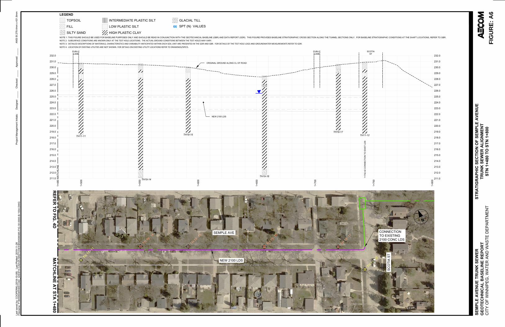
223.0
224.0
225.0
226.0
227.0
228.0
229.0
230.0
231.0
232.0
222.0
221.0
220.0
219.0
218.0
223.0
224.0
225.0
226.0
227.0
228.0
229.0
230.0
231.0
232.0
222.0
221.0
220.0
219.0
218.0
1+50
0
1+55
0
1+60
0
1+70
0
1+75
0
1+80
0
TH11-11
TH19-14
TH19-15
TH19-16
TH19-17
TH11-12
217.0
216.0
215.0
217.0
216.0
215.0
214.0 214.0
213.0 213.0
NEW 2100 LDS
212.0 212.0
1+65
0
ORIGINAL GROUND ALONG CL OF ROAD
211.0 211.0
PUBLICLANE
PUBLICLANE
SCOTIAST
1+48
0 M
ATC
HLI
NE
LEGEND
FILL
SILTY SAND
INTERMEDIATE PLASTIC SILTTOPSOIL
LOW PLASTIC SILT
HIGH PLASTIC CLAY
GLACIAL TILL
SPT (N) VALUES66
NOTE 1: THIS FIGURE SHOULD BE USED FOR BASELINE PURPOSES ONLY AND SHOULD BE READ IN CONJUNCTION WITH THE GEOTECHNICAL BASELINE (GBR) AND DATA REPORT (GDR). THIS FIGURE PROVIDES BASELINE STRATIGRAPHIC CROSS SECTION ALONG THE TUNNEL SECTIONS ONLY. FOR BASELINE STRATIGRAPHIC CONDITIONS AT THE SHAFT LOCATIONS, REFER TO GBR.NOTE 2: SUBSURFACE CONDITIONS ARE KNOWN ONLY AT THE TEST HOLE LOCATIONS. THE ACTUAL GROUND CONDITIONS BETWEEN THE TEST HOLES MAY VARY.NOTE 3: DETAILED DESCRIPTIONS OF MATERIALS, CHARACTERISTICS AND VARIABILITY ANTICIPATED WITHIN EACH SOIL UNIT ARE PRESENTED IN THE GDR AND GBR. FOR DETAILS OF THE TEST HOLE LOGS AND GROUNDWATER MEASUREMENTS REFER TO GDR. NOTE 4: LOCATION OF EXISTING UTILITIES ARE NOT SHOWN. FOR DETAILS ON EXISTING UTILITY LOCATIONS REFER TO DRAWINGS/SPECS.
1+74
2.42
CO
NN
ECTI
ON
TO
EXI
ST L
DS
SEMPLE AVE
SCO
TIA
ST
CONNECTIONTO EXISTING2100 CONC LDS
NEW 2100 LDS
N
TH-
1914
TH-
1915
TH-
1917
TH-
11
12TH-
1111
TH
-19
16
SEM
PLE
AVE
NU
E TR
UN
K S
EWER
GEO
TEC
HN
ICA
L D
ATA
REP
OR
TC
ITY
OF
WIN
NIP
EG, W
ATER
AN
D W
ASTE
DEP
ARTM
ENT
ANSI
B 2
79.4
mm
x 4
31.8
mm
Last
sav
ed b
y: C
OO
PER
KL(2
019-
10-0
8)
Last
Plo
tted:
201
9-11
-28
Proj
ect M
anag
emen
t Ini
tials
:D
esig
ner:
Che
cked
:Ap
prov
ed:
File
nam
e: P
:\605
9938
5\90
0-C
AD_G
IS\9
10-C
AD\2
5-SK
ETC
HES
\B\6
0599
385-
FIG
-30-
0000
-B-1
004.
DW
G
STR
ATI
GR
APH
IC S
ECTI
ON
OF
SEM
PLE
AVE
NU
ETR
UN
K S
EWER
ALI
GN
MEN
TST
N 1
+480
TO
STN
1+8
00FI
GU
RE:
4E
____
___
___
____
_
MA
TCH
LINE A
T STA 1+480
REFER
TO FIG
. 4D
FIG
UR
E: A
6G
EOTE
CH
NIC
AL
BA
SELI
NE
REP
OR
T

212.00
214.00
216.00
218.00
220.00
222.00
224.00
226.00
228.00
230.000.0 20.0 40.0 60.0 80.0 100.0 120.0
Elev
atio
n (m
)Undrained Shear Strength (kPa)
Glacio-Lacustrine Clay - TV (Along Alignment)
Glacio-Lacustrine Clay - PP (Along Alignment)
Glacio-Lacustrine Clay - Cu (Along Alignment)
1800/2100 mm Tunnel Elevation
Baseline Undrained Shear Strength
Figure A7: Undrained Shear Strength vs. Elevation Along Alignment (Glacio-lacustrine Clay)

212.00
214.00
216.00
218.00
220.00
222.00
224.00
226.00
228.00
230.000 10 20 30 40 50 60 70 80 90 100
Elev
atio
n (m
)Moisture Content (%)
Glacio-Lacustrine Clay - MC(Along Alignment)
Atterberg Limits (AlongAlignment)
1800/2100 mm TunnelElevation
Figure A8: Moisture Content and Atterberg Limits vs Elevation Along Alignment (Glacio-lacustrine Clay)

212.00
214.00
216.00
218.00
220.00
222.00
224.00
226.00
228.00
230.000 10 20 30 40 50 60 70 80 90 100
Elev
atio
n (m
)Moisture Content (%)
Plasticity Index (AlongAlignment)1800/2100 mm TunnelElevation
Figure A9: Plasticity Index vs Elevation Along Alignment (Glacio-lacustrine Clay)

Figure A10: Clogging Potential (Glacio-lacustrine Clay)(Hollmann and Thewes, 2013)

Appendix BBaseline Ground Condition at Shaft Locations
· Table B1: Baseline Elevations of Expected Soil Units- McKenzie St. Shaft
· Table B2: Baseline Elevations of Expected Soil Units- McGregor St. Shaft
· Table B3: Baseline Elevations of Expected Soil Units- Andrews St. Shaft
· Table B4: Baseline Elevations of Expected Soil Units- Powers St. Shaft
· Table B5: Baseline Elevations of Expected Soil Units- Salter St. Shaft
· Table B6: Baseline Elevations of Expected Soil Units- Aikins St. Shaft
· Table B7: Baseline Elevations of Expected Soil Units- Adjacent to Main St. Shaft
· Table B8: Baseline Elevations of Expected Soil Units- Scotia St. Shaft

Table B1: Baseline Elevations of Expected Soil Units- McKenzie St. Shaft
Soil Unit Parameter Baseline
Topsoil (1) Top Elevation (m) 231.11
Bottom Elevation (m) 231.01
Total Thickness (m) 0.10
Cohesive Fill(2) Top Elevation (m) 231.01
Bottom Elevation (m) 230.35
Total Thickness (m) 0.66
Upper Complex - Cohesive(Clay or Silt)
Top Elevation (m) 230.35
Bottom Elevation (m) 229.28
Total Thickness (m) 1.07
Glacio-Lacustrine Clay
(High Plastic)
Top Elevation (m) 229.28
Bottom Elevation (m) 218.61
Total Thickness (m) 10.67
Glacial Till Top Elevation (m) 218.61
Bottom Elevation (m) 216.10(3)
Total Thickness (m) 2.51Notes: (1)(2) - Test holes were drilled within boulevard adjacent to road. Topsoil will therefore not be encountered in majority of shaftexcavation area. Fill type likely consists of road pavement structure (asphalt/concrete, granular fill, cohesionless/cohesive fill); (3) -Full thickness of glacial till not proven.

Table B2: Baseline Elevations of Expected Soil Units- McGregor St. Shaft
Soil Unit Parameter Baseline
Topsoil (1) Top Elevation (m) 231.53
Bottom Elevation (m) 231.45
Total Thickness (m) 0.08
Cohesive Fill(2) Top Elevation (m) 231.45
Bottom Elevation (m) 230.52
Total Thickness (m) 0.93
Upper Complex - Cohesive
(Clay or Silt)
Top Elevation (m) 230.52
Bottom Elevation (m) 229.88
Total Thickness (m) 0.64
Glacio-Lacustrine Clay
(High Plastic)
Top Elevation (m) 229.88
Bottom Elevation (m) 217.76
Total Thickness (m) 12.12
Glacial Till Top Elevation (m) 217.76
Bottom Elevation (m) 215.39(3)
Total Thickness (m) 2.37Notes: (1)(2) - Test holes were drilled within boulevard adjacent to road. Topsoil will therefore not be encountered in majority of shaftexcavation area. Fill type likely consists of road pavement structure (asphalt/concrete, granular fill, cohesionless/cohesive fill); (3) -Full thickness of glacial till not proven.

Table B3: Baseline Elevations of Expected Soil Units- Andrews St. Shaft
Soil Unit Parameter Baseline
Topsoil (1) Top Elevation (m) 231.32
Bottom Elevation (m) 231.27
Total Thickness (m) 0.05
Cohesive Fill(2) Top Elevation (m) 231.27
Bottom Elevation (m) 230.41
Total Thickness (m) 0.86
Upper Complex - Cohesive
(Clay)
Top Elevation (m) 230.41
Bottom Elevation (m) 229.19
Total Thickness (m) 1.22
Upper Complex - Cohesionless
(Silt)
Top Elevation (m) 229.19
Bottom Elevation (m) 228.27
Total Thickness (m) 0.91
Glacio-Lacustrine Clay
(High Plastic)
Top Elevation (m) 228.27
Bottom Elevation (m) 216.99
Total Thickness (m) 11.28
Glacial Till Top Elevation (m) 216.99
Bottom Elevation (m) 214.76(3)
Total Thickness (m) 2.23Notes: (1)(2) - Test holes were drilled within boulevard adjacent to road. Topsoil will therefore not be encountered in majority of shaftexcavation area. Fill type likely consists of road pavement structure (asphalt/concrete, granular fill, cohesionless/cohesive fill); (3) -Full thickness of glacial till not proven.

Table B4: Baseline Elevations of Expected Soil Units- Powers St. Shaft
Soil Unit Parameter Baseline
Topsoil (1) Top Elevation (m) 231.05
Bottom Elevation (m) 231.00
Total Thickness (m) 0.05
Cohesive Fill(2) Top Elevation (m) 231.00
Bottom Elevation (m) 230.60
Total Thickness (m) 0.40
Upper Complex - Cohesive
(Clay or Silt)
Top Elevation (m) 230.60
Bottom Elevation (m) 230.60 to 229.53
Total Thickness (m) 0 – 1.07
Upper Complex - Cohesionless
(Sand or Silt)
Top Elevation (m) 230.60
Bottom Elevation (m) 230.60 to 229.53
Total Thickness (m) 0 – 1.07
Glacio-Lacustrine Clay
(High Plastic)
Top Elevation (m) 229.53
Bottom Elevation (m) 216.05
Total Thickness (m) 13.48
Glacial Till Top Elevation (m) 216.05
Bottom Elevation (m) 211.72(3)
Notes: (1)(2) - Test holes were drilled within boulevard adjacent to road. Topsoil will therefore not be encountered in majority of shaftexcavation area. Fill type likely consists of road pavement structure (asphalt/concrete, granular fill, cohesionless/cohesive fill); (3) -Full thickness of glacial till not proven.

Table B5: Baseline Elevations of Expected Soil Units- Salter St. Shaft
Soil Unit Parameter Baseline
Topsoil (1) Top Elevation (m) 230.80
Bottom Elevation (m) 230.71
Total Thickness (m) 0.09
Cohesive Fill(2) Top Elevation (m) 230.71
Bottom Elevation (m) 230.18
Total Thickness (m) 0.54
Upper Complex - Cohesive
(Clay or Silt)
Top Elevation (m) 230.18
Bottom Elevation (m) 228.51
Total Thickness (m) 1.67
Glacio-Lacustrine Clay
(High Plastic)
Top Elevation (m) 228.51
Bottom Elevation (m) 215.34
Total Thickness (m) 13.17
Glacial Till Top Elevation (m) 215.34
Bottom Elevation (m) 211.12(3)
Total Thickness (m) 4.22Notes: (1)(2) - Test holes were drilled within boulevard adjacent to road. Topsoil will therefore not be encountered in majority of shaftexcavation area. Fill type likely consists of road pavement structure (asphalt/concrete, granular fill, cohesionless/cohesive fill); (3) -Full thickness of glacial till not proven.

Table B6: Baseline Elevations of Expected Soil Units- Aikins St. Shaft
Soil Unit Parameter Baseline
Topsoil (1) Top Elevation (m) 230.89
Bottom Elevation (m) 230.79
Total Thickness (m) 0.10
Cohesive Fill(2) Top Elevation (m) 230.79
Bottom Elevation (m) 230.20
Total Thickness (m) 0.59
Upper Complex - Cohesive
(Silt)
Top Elevation (m) 230.20
Bottom Elevation (m) 229.37
Total Thickness (m) 0.84
Glacio-Lacustrine Clay
(High Plastic)
Top Elevation (m) 229.37
Bottom Elevation (m) 214.74
Total Thickness (m) 14.63
Glacial Till Top Elevation (m) 214.74
Bottom Elevation (m) 211.08(3)
Total Thickness (m) 3.66Notes: (1)(2) - Test holes were drilled within boulevard adjacent to road. Topsoil will therefore not be encountered in majority of shaftexcavation area. Fill type likely consists of road pavement structure (asphalt/concrete, granular fill, cohesionless/cohesive fill); (3) -Full thickness of glacial till not proven.

Table B7: Baseline Elevations of Expected Soil Units- Adjacent to Main St. Shaft
Soil Unit Parameter Baseline
Topsoil (1) Top Elevation (m) 230.81
Bottom Elevation (m) 230.73
Total Thickness (m) 0.08
Cohesive Fill(2) Top Elevation (m) 230.73
Bottom Elevation (m) 229.89
Total Thickness (m) 0.84
Upper Complex - Cohesive
(Clay or Silt)
Top Elevation (m) 229.89
Bottom Elevation (m) 228.67
Total Thickness (m) 1.21
Glacio-Lacustrine Clay
(High Plastic)
Top Elevation (m) 228.67
Bottom Elevation (m) 213.45
Total Thickness (m) 15.22
Glacial Till Top Elevation (m) 213.45
Bottom Elevation (m) 211.12(3)
Total Thickness (m) 2.34Notes: (1)(2) - Test holes were drilled within boulevard adjacent to road. Topsoil will therefore not be encountered in majority of shaftexcavation area. Fill type likely consists of road pavement structure (asphalt/concrete, granular fill, cohesionless/cohesive fill); (3) -Full thickness of glacial till not proven.

Table B8: Baseline Elevations of Expected Soil Units- Scotia St. Shaft
Soil Unit Parameter Baseline
Topsoil (1) Top Elevation (m) 230.89
Bottom Elevation (m) 230.59
Total Thickness (m) 0.30
Cohesive Fill(2) Top Elevation (m) 230.59
Bottom Elevation (m) 229.67
Total Thickness (m) 0.91
Upper Complex - Cohesive
(Clay, Silt, or Sand)
Top Elevation (m) 229.67
Bottom Elevation (m) 228.45
Total Thickness (m) 1.22
Glacio-Lacustrine Clay
(High Plastic)
Top Elevation (m) 228.45
Bottom Elevation (m) 212.55
Total Thickness (m) 15.90
Glacial Till Top Elevation (m) 212.55
Bottom Elevation (m) 211.69(3)
Total Thickness (m) 0.86Notes: (1)(2) - Test holes were drilled within boulevard adjacent to road. Topsoil will therefore not be encountered in majority of shaftexcavation area. Fill type likely consists of road pavement structure (asphalt/concrete, granular fill, cohesionless/cohesive fill); (3) -Full thickness of glacial till not proven.

Appendix CTunnelman’s Ground Classification

Table C1: Tunnelman’s Ground Classification for Soils
Classification Performance Typical Soil Types
Firm
Heading can be advanced without initialsupport, and final lining can be constructedbefore ground starts to move.
Loess above the water table;hard clay, marl, cemented sand,and gravel when not highlyoverstressed.
Raveling
SlowRaveling
Chunks or flakes of material begin to dropout of the arch or walls sometime after theground has been exposed. This is causedby loosening or overstress and "brittle"fracture (ground separates or breaks alongdistinct surfaces, as opposed to squeezingground). In fast raveling ground, theprocess starts within a few minutes;otherwise, the ground is slow raveling.
Residual soils or sand with smallamounts of binder may be fastraveling below the water table,slow raveling above. Stifffissured clays may be slow orfast raveling depending upon thedegree of overstress.Fast
Raveling
Squeezing
Ground squeezes or extrudes plasticallyinto tunnel, without visible fracturing or lossof continuity, and without perceptibleincrease in water content. Ductile, plasticyield and flow are caused by overstress.
Ground with low frictionalstrength. Rate of squeezedepends on degree ofoverstress. Occurs at shallow tomedium depth in clay of very softto medium consistency. Stiff tohard clay under high cover maymove in combination withraveling at excavation surfaceand squeezing at depth behindsurface.
Running
Cohesive-Running
Granular materials without cohesion areunstable at a slope greater than their angleof repose /from ±30 to 35 degrees). Whenexposed at steeper slopes they run likegranulated sugar or dune sand until theslope flattens to the angle of repose.
Clean, dry granular materials.Apparent cohesion in moist sandor weak cementation in anygranular soil may allow thematerial to stand for a briefperiod of raveling before itbreaks down and runs, Suchbehavior is cohesive-running.
Running
Flowing
A mixture of soil and water flows into thetunnel like a viscous fluid. The materialcan enter the tunnel from the invert as wellas from the face, crown, and walls and canflow for great distances, completely fillingthe tunnel in some cases.
Below the water table in silt,sand, or gravel without enoughclay content to give significantcohesion and plasticity. May alsooccur in highly sensitive claywhen such material is disturbed
Swelling
Ground absorbs water, increases involume, and expands slowly into thetunnel.
Highly preconsolidated clay witha plasticity index in excess ofabout 30, generally containingsignificant percentages ofmontmorillonite

Appendix DEarth Pressure Distribution for Temporary Shoring
· Figure D1: Earth Pressure Distribution for Temporary Shoring – Cohesive Glacio-Lacustrine ClaySoil Units

0.5
dH
q: Surcharge
hw
w hw ka [ (H-hw) + ( - w) hw] ka ( d + q)
: Unit Weight of Soil
w: Unit Weight of Water
ka: Active Earth Pressure Coefficient
0.2
5H
0.2
5H
NORTHEAST INTERCEPTOR SEWER
AN
SI A
2
15
.9
mm
x 2
79
.4
mm
La
st sa
ve
d b
y: M
AH
EC
(2
01
8-0
3-0
9) L
ast P
lo
tte
d: 2
01
8-0
3-0
9P
ro
je
ct M
an
ag
em
en
t In
itia
ls:
De
sig
ne
r:
Ch
ecke
d:
Ap
pro
ve
d:
File
na
me
: P
:\6
05
09
08
9\9
00
-W
OR
K\9
10
-C
AD
\2
5-S
KE
TC
HE
S\B
\G
EO
TE
CH
NIC
AL
B
AS
EL
IN
E R
EP
OR
T\6
03
38
43
5-F
IG
-0
3-0
00
0-B
-0
0E
2.D
WG
EARTH PRESSURE DISTRIBUTION
FOR TEMPORARY SHORING, COHESIVE
ALLUVIAL AND COHESIVE
GLACIO-LACUSTRINE SOIL UNITS Figure: E-2
JK
AM
AM
SEMPLE AVENUE TRUNK SEWER
Figure: D2LACUSTRINE CLAY SOIL UNITS
EARTH PRESSURE DISTRIBUTION FORTEMPORARY SHORING - COHESIVE GLACIO-
Figure: D1

AECOM City of Winnipeg Jefferson East Combined Sewer Relief Works (Contract 5)
Semple Avenue Trunk Sewer
RPT-2019-12-20-Jefferson Combined Sewer Relief Phase 2 GBR_60599385-Final.Docx 42
aecom.com