Embed Size (px)
Citation preview
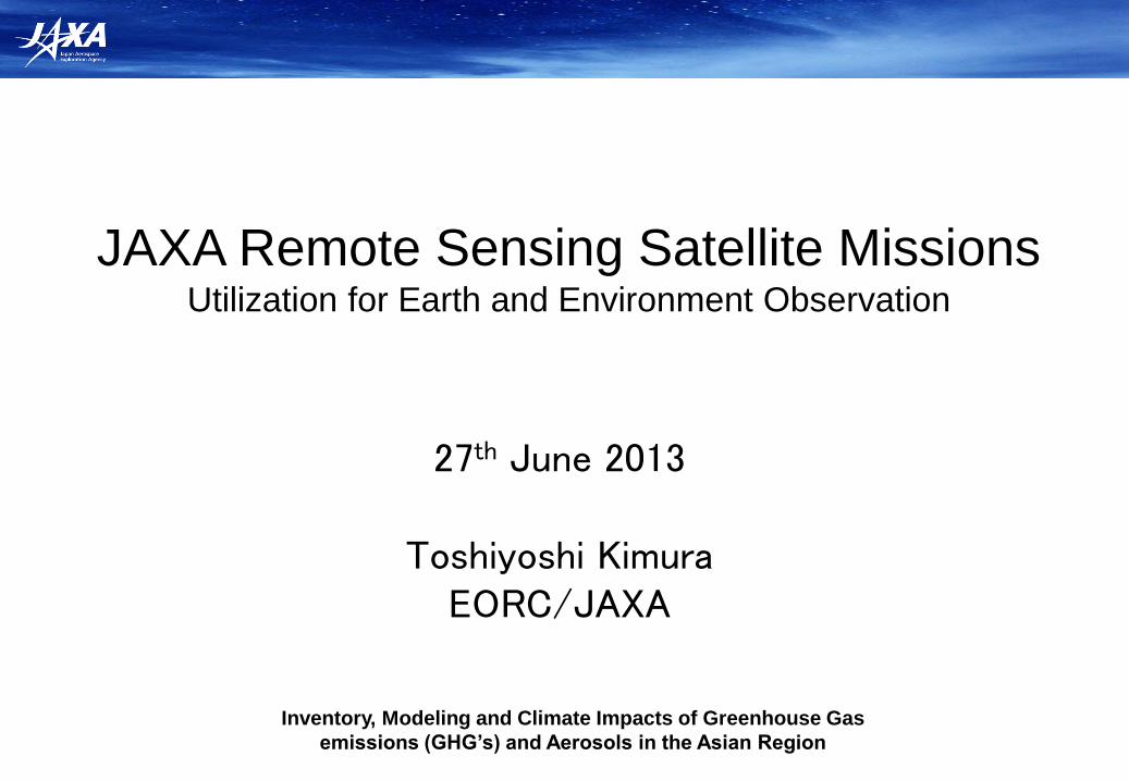
JAXA Remote Sensing Satellite Missions Utilization for Earth and Environment Observation
27th June 2013
Toshiyoshi Kimura EORC/JAXA
Inventory, Modeling and Climate Impacts of Greenhouse Gas
emissions (GHG’s) and Aerosols in the Asian Region
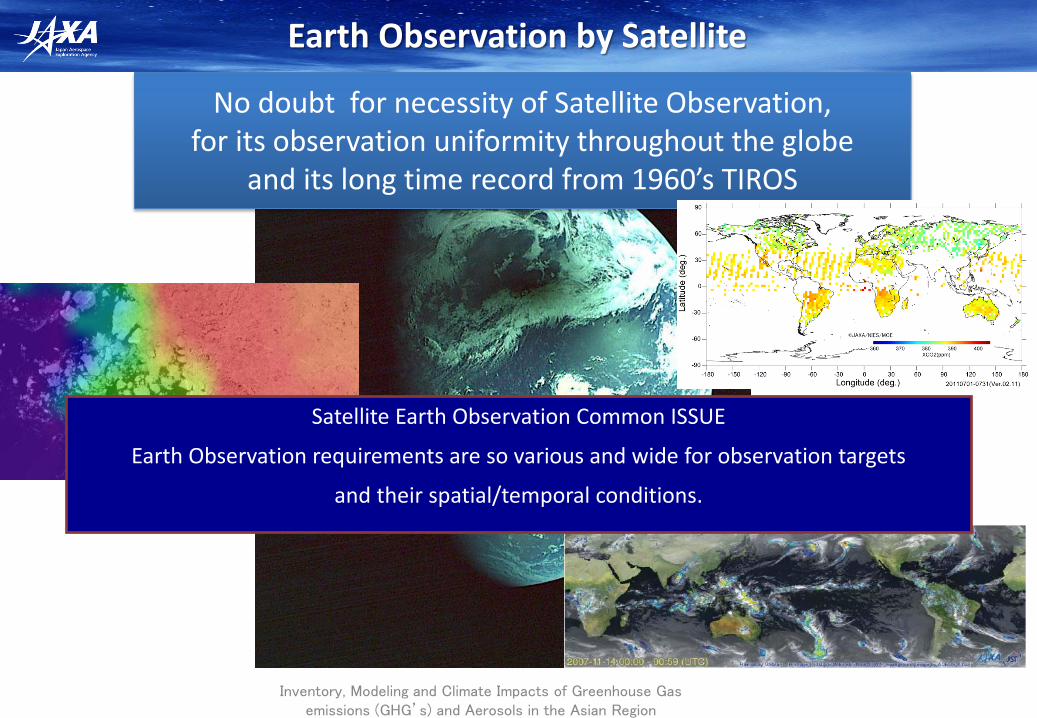
Earth Observation by Satellite
Inventory, Modeling and Climate Impacts of Greenhouse Gas emissions (GHG’s) and Aerosols in the Asian Region
No doubt for necessity of Satellite Observation, for its observation uniformity throughout the globe
and its long time record from 1960’s TIROS
Satellite Earth Observation Common ISSUE
Earth Observation requirements are so various and wide for observation targets
and their spatial/temporal conditions.
2
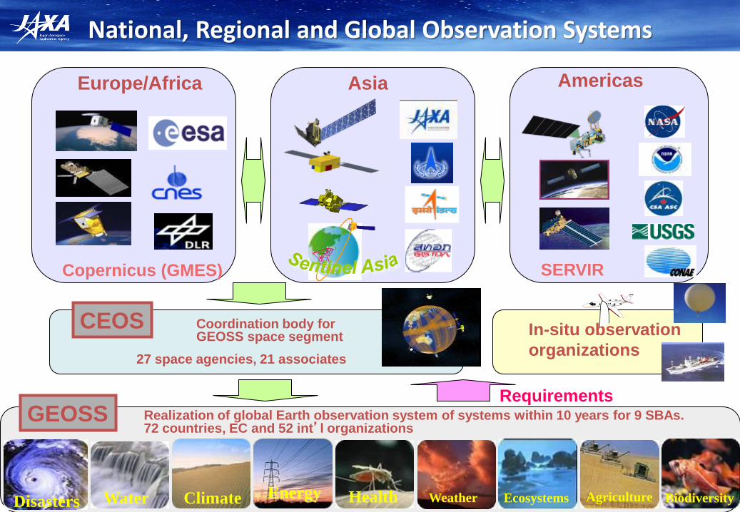
National, Regional and Global Observation Systems
Disasters Energy Climate Water Health Weather Ecosystems Agriculture Biodiversity
CEOS In-situ observation
organizations
Europe/Africa Asia Americas
Requirements Realization of global Earth observation system of systems within 10 years for 9 SBAs. 72 countries, EC and 52 int’l organizations
Coordination body for GEOSS space segment
GEOSS
27 space agencies, 21 associates
Copernicus (GMES) SERVIR
GPM/DPR (2013)
EarthCARE/CPR (2015)
GOSAT Jan. 2009-
GOSAT-2 (2018)
Atmosphere
Land Ocean
Green house gases
Vegetation production
Cloud
discharge
Snow Ice
Precipitation
Soil moisture
Aerosol
sink-source
Carbon cycle and
land cover
Spatial distribution of
cloud and aerosols
3D structure of
precipitation
Ocean primary production
Water vapor
Green house
gases
Sea-surface
temperature
Water cycle
3D structure of cloud
and aerosols
sink-source
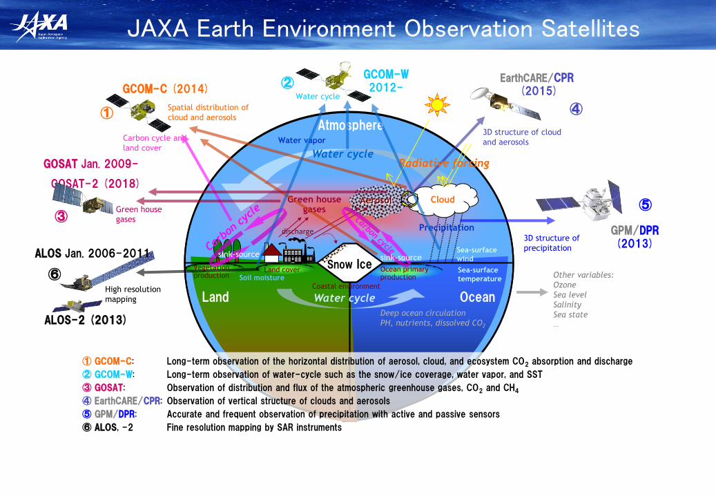
① GCOM-C: Long-term observation of the horizontal distribution of aerosol, cloud, and ecosystem CO2 absorption and discharge
② GCOM-W: Long-term observation of water-cycle such as the snow/ice coverage, water vapor, and SST
③ GOSAT: Observation of distribution and flux of the atmospheric greenhouse gases, CO2 and CH4
④ EarthCARE/CPR: Observation of vertical structure of clouds and aerosols
⑤ GPM/DPR: Accurate and frequent observation of precipitation with active and passive sensors
⑥ ALOS, -2 Fine resolution mapping by SAR instruments
Water cycle
GCOM-W 2012- GCOM-C (2014)
Land cover
Sea-surface
wind
Water cycle
Coastal environment
Deep ocean circulation
PH, nutrients, dissolved CO2
Other variables:
Ozone
Sea level
Salinity
Sea state ...
①
②
⑤
④
③
⑥ High resolution
mapping
Radiative forcing
ALOS Jan. 2006-2011
ALOS-2 (2013)
JAXA Earth Environment Observation Satellites
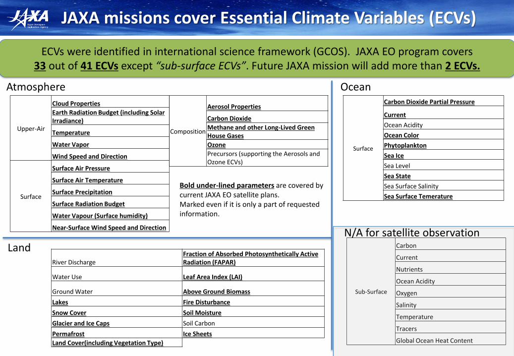
JAXA missions cover Essential Climate Variables (ECVs)
ECVs were identified in international science framework (GCOS). JAXA EO program covers 33 out of 41 ECVs except “sub-surface ECVs”. Future JAXA mission will add more than 2 ECVs.
Composition
Aerosol Properties
Carbon Dioxide
Methane and other Long-Lived Green House Gases
Ozone
Precursors (supporting the Aerosols and Ozone ECVs)
Surface
Carbon Dioxide Partial Pressure
Current
Ocean Acidity
Ocean Color
Phytoplankton
Sea Ice
Sea Level
Sea State
Sea Surface Salinity
Sea Surface Temerature
Sub-Surface
Carbon
Current
Nutrients
Ocean Acidity
Oxygen
Salinity
Temperature
Tracers
Global Ocean Heat Content
Atmosphere
Land
Ocean
River Discharge Fraction of Absorbed Photosynthetically Active Radiation (FAPAR)
Water Use Leaf Area Index (LAI)
Ground Water Above Ground Biomass
Lakes Fire Disturbance
Snow Cover Soil Moisture
Glacier and Ice Caps Soil Carbon
Permafrost Ice Sheets
Land Cover(including Vegetation Type)
Upper-Air
Cloud Properties
Earth Radiation Budget (including Solar Irradiance)
Temperature
Water Vapor
Wind Speed and Direction
Surface
Surface Air Pressure
Surface Air Temperature
Surface Precipitation
Surface Radiation Budget
Water Vapour (Surface humidity)
Near-Surface Wind Speed and Direction N/A for satellite observation
Bold under-lined parameters are covered by current JAXA EO satellite plans. Marked even if it is only a part of requested information.

Target Sensors 2005 2006 2007 2008 2009 2010 2011 2012 2013 2014 2015 2016 2017 2018
Disaster/ Resource
SAR
Optical
Climate Change/ Water Cycle Global Warming
Precipitation Radar
Microwave Radiometer
Optical Sensor
Cloud Radar
Spectrometer
Communi-cation
Mobile Communication
Wideband Internetworking
Data Relay
Navigation Quasi-zenith Research Operation
GPM/DPR
GCOM-C/ SGLI
GCOM-W/ AMSR2
Development
GOSAT-2
EarthCARE/CPR
TRMM/PR
GOSAT
ETS-VIII
JFY
WINDS
DRTS
Next-generation
QZSS
History & Current Mid-term Plan
Next Gen. (Optical)
ALOS-2 (SAR) PALSAR
PRISM, AVNIR2 (Optical)
ALOS
Aqua/AMSR-E
DRTS Follow-on

ALOS
(Optical & SAR) (2006~2011) ALOS-2 (SAR) (Launch: JFY2013)
Next Gene. (Optical) (Launch: JFY2018(TBD))
The Advanced Land Observing Satellite (ALOS) Series
Wide-swath and high-resolution data of ALOS series to contribute to disaster monitoring, land management, global environment monitoring on Earth surface.
To promote public-private partnership
Panchromatic imager with wider swath (50km) and higher resolution (0.8m) than ALOS/PRISM Obtain global 3D geospatial information
• Wide-swath (Max 490km), High-resolution (1-3m)
• L-band SAR (PALSAR-2)
ALOS (Optical & SAR)
ALOS-2 (SAR)
2006 2011 JFY2013 JFY2018 (TBD)
Next Gene. (Optical )

Forest/Non-Forest map by ALOS
Inventory, Modeling and Climate Impacts of Greenhouse Gas emissions (GHG’s) and Aerosols in the Asian Region
Forest/Non-forest map in a typical tropical area (Indonesia) and a 10-meter resolution SAR mosaic image of Central
Kalimantan, Forest/Non-forest map, AVNIR2 image
(JAXA, METI analyzed by JAXA)
Global Forest/Non-forest Map 2009
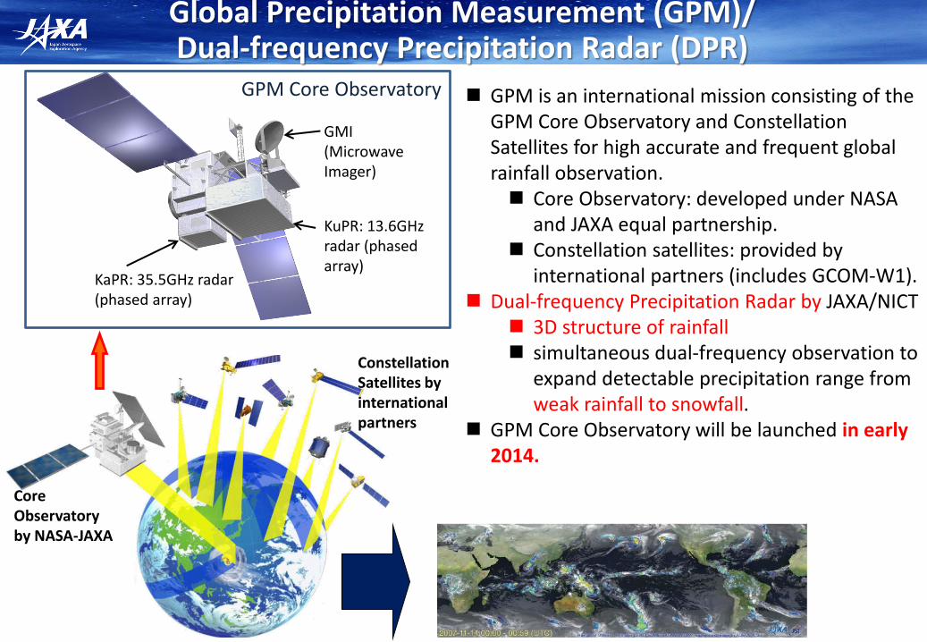
Global Precipitation Measurement (GPM)/ Dual-frequency Precipitation Radar (DPR)
GPM is an international mission consisting of the GPM Core Observatory and Constellation Satellites for high accurate and frequent global rainfall observation. Core Observatory: developed under NASA
and JAXA equal partnership. Constellation satellites: provided by
international partners (includes GCOM-W1). Dual-frequency Precipitation Radar by JAXA/NICT
3D structure of rainfall simultaneous dual-frequency observation to
expand detectable precipitation range from weak rainfall to snowfall.
GPM Core Observatory will be launched in early 2014.
KuPR: 13.6GHz radar (phased array)
KaPR: 35.5GHz radar (phased array)
GMI (Microwave Imager)
Core Observatory by NASA-JAXA
Constellation Satellites by international partners
GPM Core Observatory
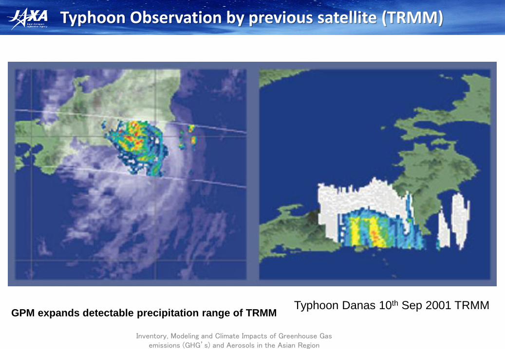
Typhoon Observation by previous satellite (TRMM)
Inventory, Modeling and Climate Impacts of Greenhouse Gas emissions (GHG’s) and Aerosols in the Asian Region
Typhoon Danas 10th Sep 2001 TRMM GPM expands detectable precipitation range of TRMM
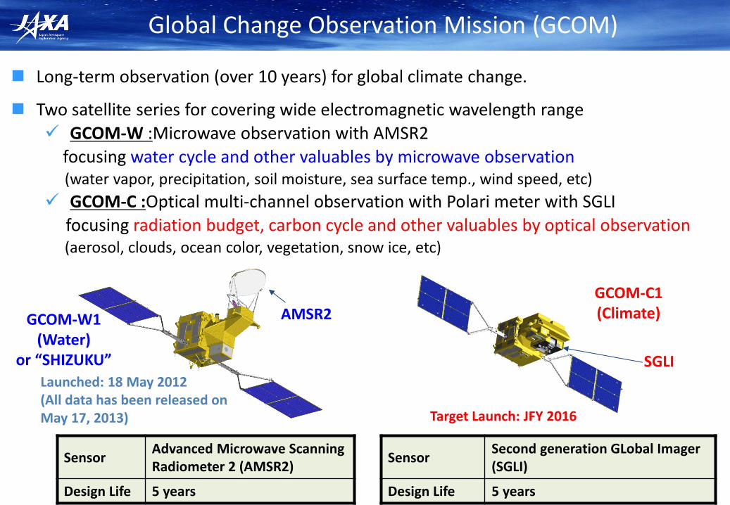
Long-term observation (over 10 years) for global climate change.
Two satellite series for covering wide electromagnetic wavelength range
GCOM-W :Microwave observation with AMSR2
focusing water cycle and other valuables by microwave observation (water vapor, precipitation, soil moisture, sea surface temp., wind speed, etc)
GCOM-C :Optical multi-channel observation with Polari meter with SGLI
focusing radiation budget, carbon cycle and other valuables by optical observation (aerosol, clouds, ocean color, vegetation, snow ice, etc)
GCOM-C1 (Climate) GCOM-W1
(Water) or “SHIZUKU”
AMSR2
SGLI
Global Change Observation Mission (GCOM)
Sensor Advanced Microwave Scanning Radiometer 2 (AMSR2)
Design Life 5 years
Launched: 18 May 2012 (All data has been released on May 17, 2013)
Sensor Second generation GLobal Imager (SGLI)
Design Life 5 years
Target Launch: JFY 2016
Inventory, Modeling and Climate Impacts of Greenhouse Gas emissions (GHG’s) and Aerosols in the Asian Region
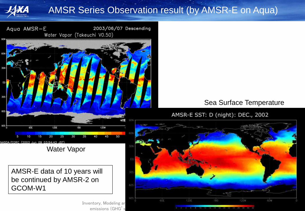
AMSR Series Observation result (by AMSR-E on Aqua)
Sea Surface Temperature
Water Vapor
AMSR-E data of 10 years will
be continued by AMSR-2 on
GCOM-W1
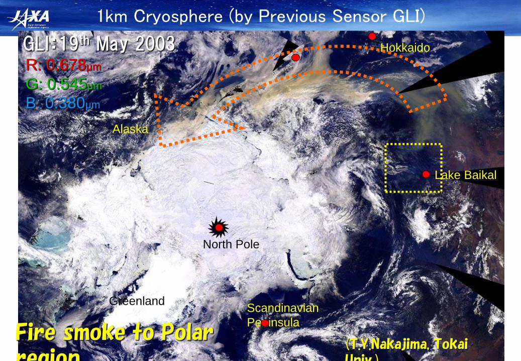
1km Cryosphere (by Previous Sensor GLI)
Greenland
North Pole
Alaska
Hokkaido
Scandinavian
Peninsula
GLI:19th May 2003 R: 0.678μm
G: 0.545μm
B: 0.380μm
Lake Baikal
Fire smoke to Polar region
(T.Y.Nakajima, Tokai Univ.)

EarthCARE/Cloud Profiling Radar (CPR)
Japan (JAXA/NICT)and Europe (ESA) cooperation project
Cloud Profiling Radar (CPR)
ATLID BBR MSI
• Mission
– Vertical profile of clouds, aerosol
– Interaction between clouds and aerosol
– Cloud stability and precipitation
• Orbit
– Sun synchronous
– Equator crossing time 14:00
– Altitude ~400km
• Development Responsibilities
– JAXA/NICT (CPR)
– ESA (LIDAR, MSI, BBR, Spacecraft)
• Target Launch Year
– JFY2015
• Instruments
– CPR (Cloud Profile Radar)-JAXA/NICT
The world’s first spaceborne 94 GHz Doppler radar.
– ATLID (Atmospheric LIDAR)
Hyper Spectral UV Lidar (355 nm)
– MSI (Multi-Spectral Imager)
– BBR (Broad Band Radiometer)
Inventory, Modeling and Climate Impacts of Greenhouse Gas emissions (GHG’s) and Aerosols in the Asian Region
14
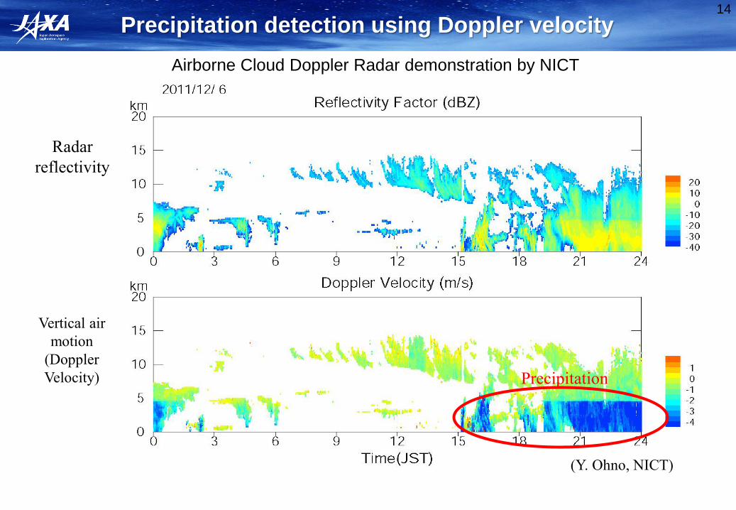
Precipitation detection using Doppler velocity
(Y. Ohno, NICT)
Radar
reflectivity
Vertical air
motion
(Doppler
Velocity) Precipitation
Airborne Cloud Doppler Radar demonstration by NICT
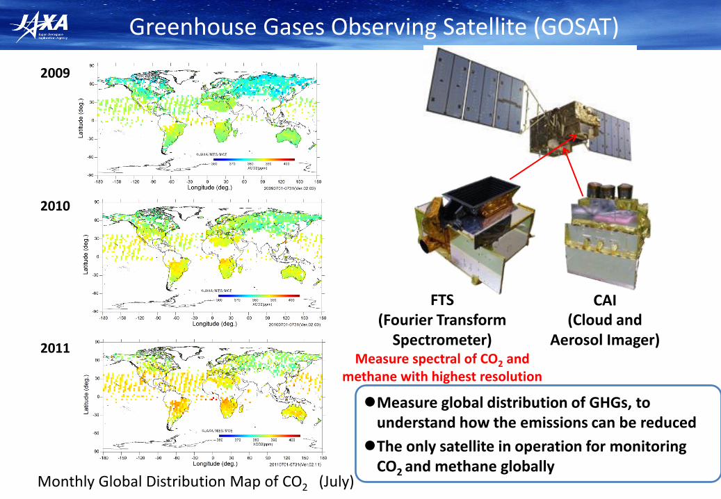
Greenhouse Gases Observing Satellite (GOSAT)
CAI (Cloud and
Aerosol Imager)
FTS (Fourier Transform
Spectrometer) Measure spectral of CO2 and
methane with highest resolution
Monthly Global Distribution Map of CO2 (July)
2011
2010
2009
Measure global distribution of GHGs, to understand how the emissions can be reduced
The only satellite in operation for monitoring CO2 and methane globally

16
Chlorophyll Fluorescence measurement from Space (GOSAT)
Annual average (June 2009 through May 2010)
Frankenberg et al., 2011
Monthly average for July 2009, Guanter et al., 2012
Monthly average for July 2009
Joiner et al., 2011

Seasonal variation of tropospheric ozone column averaged between 120-150E
NH: High ozone belt moves toward higher latitude during spring and summer
SH: High ozone arises periodically
Average every 1.0 latitude December 2009
June 2010
(H. Ohyama JAXA)
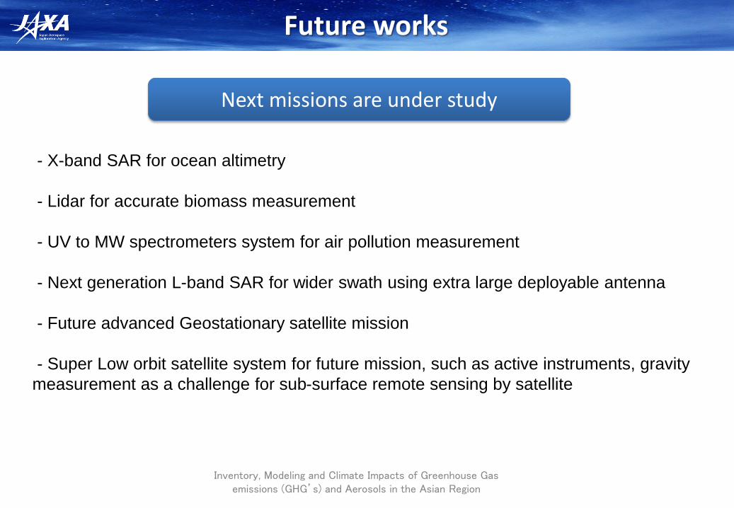
Future works
Inventory, Modeling and Climate Impacts of Greenhouse Gas emissions (GHG’s) and Aerosols in the Asian Region
- X-band SAR for ocean altimetry
- Lidar for accurate biomass measurement
- UV to MW spectrometers system for air pollution measurement
- Next generation L-band SAR for wider swath using extra large deployable antenna
- Future advanced Geostationary satellite mission
- Super Low orbit satellite system for future mission, such as active instruments, gravity
measurement as a challenge for sub-surface remote sensing by satellite
Next missions are under study
Summary
Inventory, Modeling and Climate Impacts of Greenhouse Gas emissions (GHG’s) and Aerosols in the Asian Region
• Earth Observation Satellite for Environment is now getting matured under
international cooperation. Full spectral observation will start from around 2016 in
Japan.
• JAXA’s current Satellite plan is going to cover most of Essential Climate Valuables
which is internationally discussed and agreed.
• New observation results are emerging with new satellite observation technologies,
such as GOSAT, and CPR, SGLI for near future. Fruitful results from long-term
observation are expected from some missions, such as PALSAR-series, PR-series,
AMSR-series. And new observation technologies are in study phase.
• JAXA is making efforts to keep these satellite observation system and contributes to
GEOSS; Global Earth Observation system of systems. Also JAXA is pursing future
operational social infra-structure using such observation satellites and sensor
technologies.