Embed Size (px)
Citation preview
Jamaica:
Country Document on Disaster Risk Reduction
By:
Disaster Risk Reduction Centre
University of West of Indies
For:
HelpAge International
December 2012

FI%AL DRAFT REVISED
ii
Original Title
Jamaica: Country Document on Disaster Risk Reduction
Authors
Dr. Barbara Carby Mr. Dorlan Burrell Ms. Cleonie Samuels
Funding Agency/Organisation
The European Commission Humanitarian Aid department’s Disaster Preparedness Programme (DIPECHO)
Supporting Agencies/Organisations
HelpAge International Office of Disaster Preparedness and Emergency Management Red Cross Jamaica This Country Document was prepared by the Disaster Risk Reduction Centre (DRRC), University of the West Indies on behalf of Help Age International in partnership with the Office of Disaster Preparedness and Emergency Management and Jamaica Red Cross. The views expressed in this publication are those of the authors and do not necessarily represent those of the sponsor organisation(s). Copyright © DIPECHO, December 2012. All rights reserved. Printed in Kingston, Jamaica.

FI%AL DRAFT REVISED
iii
Table of Contents Pages
i. List of Figures vi
ii. List of Tables vii
iii. List of Maps viii
iv. List of Plates ix
v. Terms and Definitions x-xv
vi. Introduction xvi-xvii
vii. Acknowledgments xvii
1. Executive Summary 1-2 2. Acronyms 3-7
3. International and Regional Disaster Risk Reduction Context 8-11
4. National Context 4.1 Physical Environment
4.1.1 Geographic location 12 4.1.2 Physiography 13-15 4.1.3 Climate 15-16
4.2 Socio-Economic Context 4.2.1 Population and Demographics 16-18 4.2.2 The Economy 18-19 4.2.3 Poverty and Unemployment 19-21 4.2.4 Most Vulnerable Groups 21-23
4.3 Governance Structure 4.3.1 Political Structure and Organisation 24-25 4.3.2 Local Government and Levels of Decentralisation 25-28 4.3.3 Coordination Mechanisms between State and Non- 29
Governmental Actors

FI%AL DRAFT REVISED
iv
4.4 Development Context 29-30
4.4.1 National Development Objectives 30-34 4.5 Summary 34-35
5. The Country’s Disaster Risk Reduction Legal, Normative and Institutional Profile
5.1 Legal Framework 36 5.1.1 The Constitution 36 5.1.2 Laws and Legally Binding Provisions 36-39
5.2 Policy Framework 39-40
5.3 Institutional Framework
5.3.1 Organisation of the National System 41-47 5.3.2 National plans and their implementation 47-50
5.4 Summary 50-52
6. The State of Disaster Risk in the Country 6.1 Historical Disaster Analysis 53-61
6.2 Hazards / Threats
6.2.1 Natural 62-66 6.2.2 Anthropogenic/Man-made 66-67 6.2.3 Emergencies affecting Public Health and Safety 67 6.2.4 Transboundary and Regional Hazards 68-69
6.3. Vulnerability 70
6.3.1 Methodology 71-76 6.3.2 Components of Vulnerability 76-77 6.3.3 Vulnerability Analysis Based on Selected Criteria 77-84
6.4. Capacities 84-86 6.4.1. Institutional Aspects 86-92 6.4.2. Disaster Risk Reduction Programmes 92-93 6.4.3. Tool Inventory 93-95
6.5. Reduction of Underlying Risk Factors 95-98
6.6. Summary 98-107 7. Disaster Risk Analysis of the Country
7.1. Methodology 107-110

FI%AL DRAFT REVISED
v
7.2. Definition of Risk Scenarios 110-112 7.3. Summary 112-113
8. Strategic Directions for Disaster Risk Reduction in the Country 114 8.1. Discussion 115-117 8.2. Summary 117
9. Recommendations 118-119
� References � Appendix

FI%AL DRAFT REVISED
vi
LIST OF FIGURES
Figure 1: Parish Disaster Committee Structure, p.27. Figure 2: National Zonal Committees, p.28. Figure 3: Jamaica’s Old Development Model based on the capital stocks of the nation, p.31. Figure 4: Jamaica’s New Development Model based on the higher capital stocks of the nation, p.32. Figure 5: Jamaica’s National Goals, p.34. Figure 6: Structure of the EOC, p.49. Figure 7: Spatial distribution of flood events by month (1884-2000), p.56. Figure 8: Spatial distribution of flood events by month (1884-2000), p.56. Figure 9: Temperature Projections for Jamaica from 1961-90 baseline for A2 and B2 Emission Scenarios, p.68. Figure 10: Percentage changes in rainfall from 1961-90 baseline for A2 and B2 emission scenarios, p.69. Figure 11: Goal 4 - Jamaica has a healthy natural environment and National Outcomes, p. 87. Figure 12: Simulated current and future Category 3-5 storms based on downscaling of an ensemble mean of 18 global climate change models, p.101.

FI%AL DRAFT REVISED
vii
LIST OF TABLES Table 1: Flood exposure by World Bank region as modelled (million people per year), p.8. Table 2: Exposure to tropical cyclones by World Bank region as modeled from observed events (in million people per year), p.8. Table 3: Average annual global GDP exposed to cyclones from observed events (in billion 2000 US$), p.9. Table 4: Climate Change Adaptation and Disaster Risk Reduction Projects, p.44. Table 5: Economic impact of selected storms on Jamaica (1 US$ = 84 JMD$), p.55. Table 6: Estimated losses from drought events (mid 90’s – 2010). NB. Information gathered from multiple sources, p.57. Table 7: Direct and indirect losses resulting from the 1907 Kingston earthquake, p.58. Table 8: Compiled yearly fire statistics for Jamaica, p.61. Table 9: Hazards that have/can affect Jamaica, p.62. Table 10: National Strategies and Responsible Agencies-Hazard Risk Reduction and Adaptation to Climate Change, 89. Table 11: National Strategies and their Selected Sector Strategies, p.90. Table 12: Key Strategies and Actions under the National Outcomes for Years 1-3 (2009-2012). National Outcome #14 - Hazard Risk Reduction and Adaptation to Climate Change, p.91. Table 13: Jamaica’s Disaster Risk Reduction Tool Inventory, p.95. Table 14: Potential Losses from Selected Events, Ocho Rios, Sav La Mar and Black River, p.110. Table 15: Work Programme Results Framework Outcomes and Vision 2030 Strategies, p.114.

FI%AL DRAFT REVISED
viii
LIST OF MAPS Map 1: Map of the Caribbean, p.12. Map 2: Map of Jamaica, p.13. Map 3: Geological Map of Jamaica, p14. Map 4: Jamaica Watershed Classification, p. 15 Map 5: Rainfall Map of Jamaica, p.16. Map 6: Hurricane Gilbert (1988) and Ivan (2004) Tracks, p.53. Map 7: Generalized Tsunami/Storm surge map for Jamaica, p.59. Map 8: Landslide zonation/susceptibility map, p.60. Map 9: Pathways of tropical cyclones within 100km of Jamaica, p.63. Map 10: Recorded earthquakes between 1998-2010, p.64. Map 11: Flood prone areas of Jamaica, p.65. Map 12: Landslide Vulnerability Map, p.65. Map 13: Informal settlements and vulnerable communities, p.79 Map 14: Map showing Rainfall trend slope, p.100.

FI%AL DRAFT REVISED
ix
LIST OF PLATES Plate 1: A homeless man sleeps on a sidewalk along Knutsford Boulevard on July 3, 2011, p.23. Plate 2: Sediments deposited along the Palisadoes roadway after Hurricane Ivan (2004), p.54. Plate 3: Re-enforcement of the Palisadoes roadway, p.54. Plate 4: Flooding in New Market after the passage of tropical storm Nicole (2010), p.55. Plate 5: Inundated house in Wilton, St. Elizabeth in which senior citizens were trapped for four days after the passage of tropical storm Nicole (2010), p.78.
Plate 6: Construction of the Dry River Bridge in Harbour View, St. Andrew, p.106.
Plate 7: Post-construction phase of the Dry River Bridge in Harbour View, St. Andrew, p.106.

FI%AL DRAFT REVISED
x
TERMS A%D DEFI%ITIO%S1
Acceptable risk
The level of potential losses that a society or community considers acceptable given existing social, economic, political, cultural, technical and environmental conditions.
Adaptation
The adjustment in natural or human systems in response to actual or expected climatic stimuli or their effects, which moderates harm or exploits beneficial opportunities. Biological hazard
Process or phenomenon of organic origin or conveyed by biological vectors, including exposure to pathogenic micro-organisms, toxins and bioactive substances that may cause loss of life, injury, illness or other health impacts, property damage, loss of livelihoods and services, social and economic disruption, or environmental damage.
Building code
A set of ordinances or regulations and associated standards intended to control aspects of the design, construction, materials, alteration and occupancy of structures that are necessary to ensure human safety and welfare, including resistance to collapse and damage.
Capacity
The combination of all the strengths, attributes and resources available within a community, society or organisation that can be used to achieve agreed goals. Capacity Development
The process by which people, organisations and society systematically stimulate and develop their capacities over time to achieve social and economic goals, including through improvement of knowledge, skills, systems, and institutions. Climate change
(a) The Inter-governmental Panel on Climate Change (IPCC) defines climate change as: “a change in the state of the climate that can be identified (e.g., by using statistical tests) by changes in the mean and/or the variability of its properties, and that persists for an extended period, typically decades or longer. Climate change may be due to natural internal processes or external forcings, or to persistent anthropogenic changes in the composition of the atmosphere or in land use”. (b) The United Nations Framework Convention on Climate Change (UNFCCC) defines climate change as “a change of climate which is attributed directly or indirectly to human activity that alters the composition of the global atmosphere and which is in addition to natural climate variability observed over comparable time periods”.
1 UNISDR Terminology on Disaster Risk Reduction. 2009. Information obtained from: http://www.unisdr.org/files/7817_UNISDRTerminologyEnglish.pdf

FI%AL DRAFT REVISED
xi
TERMS A%D DEFI%ITIO%S
Contingency planning
A management process that analyses specific potential events or emerging situations that might threaten society or the environment and establishes arrangements in advance to enable timely, effective and appropriate responses to such events and situations. Coping capacity
The ability of people, organisations and systems, using available skills and resources, to face and manage adverse conditions, emergencies or disasters.
Corrective disaster risk management
Management activities that address and seek to correct or reduce disaster risks which are already present.
Critical facilities
The primary physical structures, technical facilities and systems which are socially, economically or operationally essential to the functioning of a society or community, both in routine circumstances and in the extreme circumstances of an emergency.
Disaster
A serious disruption of the functioning of a community or a society involving widespread human, material, economic or environmental losses and impacts, which exceeds the ability of the affected community or society to cope using its own resources.
Disaster risk
The potential disaster losses, in lives, health status, livelihoods, assets and services, which could occur to a particular community or a society over some specified future time period. Disaster risk management
The systematic process of using administrative directives, organisations, and operational skills and capacities to implement strategies, policies and improved coping capacities in order to lessen the adverse impacts of hazards and the possibility of disaster. Disaster risk reduction
The concept and practice of reducing disaster risks through systematic efforts to analyze and manage the causal factors of disasters, including through reduced exposure to hazards, lessened vulnerability of people and property, wise management of land and the environment, and improved preparedness for adverse events.
Disaster risk reduction plan
A document prepared by an authority, sector, organisation or enterprise that sets out goals and specific objectives for reducing disaster risks together with related actions to accomplish these objectives.
Early warning system
The set of capacities needed to generate and disseminate timely and meaningful warning information to enable individuals, communities and organisations threatened by a hazard to prepare and to act appropriately and in sufficient time to reduce the possibility of harm or loss.

FI%AL DRAFT REVISED
xii
TERMS A%D DEFI%ITIO%S cont’d
Ecosystem services
The benefits that people and communities obtain from ecosystems.
El %iño-Southern Oscillation phenomenon
A complex interaction of the tropical Pacific Ocean and the global atmosphere that results in irregularly occurring episodes of changed ocean and weather patterns in many parts of the world, often with significant impacts over many months, such as altered marine habitats, rainfall changes, floods, droughts, and changes in storm patterns. Emergency management
The organisation and management of resources and responsibilities for addressing all aspects of emergencies, in particular preparedness, response and initial recovery steps.
Emergency services
The set of specialized agencies that have specific responsibilities and objectives in serving and protecting people and property in emergency situations. Environmental degradation
The reduction of the capacity of the environment to meet social and ecological objectives and needs. Environmental impact assessment
Process by which the environmental consequences of a proposed project or programme are evaluated, undertaken as an integral part of planning and decision making processes with a view to limiting or reducing the adverse impacts of the project or programme. Exposure
People, property, systems, or other elements present in hazard zones that are thereby subject to potential losses.
Extensive risk
The widespread risk associated with the exposure of dispersed populations to repeated or persistent hazard conditions of low or moderate intensity, often of a highly localized nature, which can lead to debilitating cumulative disaster impacts.
Forecast
Definite statement or statistical estimate of the likely occurrence of a future event or conditions for a specific area. Geological hazard
Geological process or phenomenon that may cause loss of life, injury or other health impacts, property damage, loss of livelihoods and services, social and economic disruption, or environmental damage.

FI%AL DRAFT REVISED
xiii
TERMS A%D DEFI%ITIO%S cont’d
Greenhouse gases
Gaseous constituents of the atmosphere, both natural and anthropogenic, that absorb and emit radiation of thermal infrared radiation emitted by the Earth’s surface, the atmosphere itself, and by clouds.
Hazard
A dangerous phenomenon, substance, human activity or condition that may cause loss of life, injury or other health impacts, property damage, loss of livelihoods and services, social and economic disruption, or environmental damage.
Hydrometeorological hazard
Process or phenomenon of atmospheric, hydrological or oceanographic nature that may cause loss of life, injury or other health impacts, property damage, loss of livelihoods and services, social and economic disruption, or environmental damage.
Intensive risk
The risk associated with the exposure of large concentrations of people and economic activities to intense hazard events, which can lead to potentially catastrophic disaster impacts involving high mortality and asset loss. Land-use planning
The process undertaken by public authorities to identify, evaluate and decide on different options for the use of land, including consideration of long term economic, social and environmental objectives and the implications for different communities and interest groups, and the subsequent formulation and promulgation of plans that describe the permitted or acceptable uses. Mitigation
The lessening or limitation of the adverse - impacts of hazards and related disasters.
%ational platform for disaster risk reduction
A generic term for national mechanisms for coordination and policy guidance on disaster risk reduction that are multi-sectoral and inter-disciplinary in nature, with public, private and civil society participation involving all concerned entities within a country.
%atural hazard
Natural process or phenomenon that may cause loss of life, injury or other health impacts, property damage, loss of livelihoods and services, social and economic disruption, or environmental damage.
Preparedness
The knowledge and capacities developed by governments, professional response and recovery organisations, communities and individuals to effectively anticipate, respond to, and recover from, the impacts of likely, imminent or current hazard events or conditions.
Prevention
The outright avoidance of adverse impacts of hazards and related disasters

FI%AL DRAFT REVISED
xiv
TERMS A%D DEFI%ITIO%S cont’d
Prospective disaster risk management
Management activities that address and seek to avoid the development of new or increased disaster risks. Public awareness
The extent of common knowledge about disaster risks, the factors that lead to disasters and the actions that can be taken individually and collectively to reduce exposure and vulnerability to hazards. Recovery
The restoration, and improvement where appropriate, of facilities, livelihoods and living conditions of disaster-affected communities, including efforts to reduce disaster risk factors. Residual risk
The risk that remains in unmanaged form, even when effective disaster risk reduction measures are in place, and for which emergency response and recovery capacities must be maintained.
Resilience
The ability of a system, community or society exposed to hazards to resist, absorb, accommodate to and recover from the effects of a hazard in a timely and efficient manner, including through the preservation and restoration of its essential basic structures and functions.
Response
The provision of emergency services and public assistance during or immediately after a disaster in order to save lives, reduce health impacts, ensure public safety and meet the basic subsistence needs of the people affected.
Retrofitting
Reinforcement or upgrading of existing structures to become more resistant and resilient to the damaging effects of hazards. Risk
The combination of the probability of an event and its negative consequences.
Risk assessment
A methodology to determine the nature and extent of risk by analyzing potential hazards and evaluating existing conditions of vulnerability that together could potentially harm exposed people, property, services, livelihoods and the environment on which they depend.
Risk management
The systematic approach and practice of managing uncertainty to minimize potential harm and loss.
FI%AL DRAFT REVISED
xv
TERMS A%D DEFI%ITIO%S cont’d
Risk transfer
The process of formally or informally shifting the financial consequences of particular risks from one party to another whereby a household, community, enterprise or state authority will obtain resources from the other party after a disaster occurs, in exchange for ongoing or compensatory social or financial benefits provided to that other party. Socio-natural hazard
The phenomenon of increased occurrence of certain geophysical and hydrometeorological hazard events, such as landslides, flooding, land subsidence and drought, that arise from the interaction of natural hazards with overexploited or degraded land and environmental resources. Structural and non-structural measures
(A) Structural measures: Any physical construction to reduce or avoid possible impacts of hazards, or application of engineering techniques to achieve hazard resistance and resilience in structures or systems; (B) Non-structural measures: Any measure not involving physical construction that uses knowledge, practice or agreement to reduce risks and impacts, in particular through policies and laws, public awareness raising, training and education. Sustainable development
Development that meets the needs of the present without compromising the ability of future generations to meet their own needs.
Technological hazard
A hazard originating from technological or industrial conditions, including accidents, dangerous procedures, infrastructure failures or specific human activities, that may cause loss of life, injury, illness or other health impacts, property damage, loss of livelihoods and services, social and economic disruption, or environmental damage.
Vulnerability
The characteristics and circumstances of a community, system or asset that make it susceptible to the damaging effects of a hazard.
FI%AL DRAFT REVISED
xvi
I%TRODUCTIO%
The Country Document’s purpose is to provide a comprehensive overview of the status of DRR in Jamaica, any progress made in reducing risk, definitions of priorities and strategies, major challenges tackled in reducing not only loss of lives, but also the economic, social and environmental impacts associated with risks. It is expected that the Country Document will be useful to national and local authorities, agencies and stakeholders and actors linked to DRR. It is expected to be used as a national reference document. It was recommended that the review of the document coincide with the two year window of the National Mid-term review. However, if there are any major events in the country outside of the recommended period, an update of the document should be considered.
Objective and Scope
The report provides a snapshot of current efforts in DRR, and should be periodically updated as new information becomes available. The update frequency of the Country Document will depend on Jamaica’s needs and on the information content. However, it is expected that Jamaica will update the document before its information becomes out of date. This requires that the Report not only be flexible, but also adaptable to changing circumstances and to the continuous improvements and innovations. The main objective is that the Country Report becomes the institutional DRR memory of the country.
Method
The process of preparing the country document involved: 1. Workshop which was conducted with key stakeholders on 23 August 2012 2. Preparation of a comprehensive list of documents 3. Comprehensive review and synthesis of the documents 4. Preparation of 1st draft document by the Disaster Risk Reduction Centre 5. Review of 1st draft document and incorporation of feedback 6. Production of Final Draft , Review and finalisation of the document based on
review and input from stakeholders 7. Presentation of the Final document
This Country Report was prepared in December 2012 by the Disaster Risk Reduction Centre, University of the West Indies on behalf of Help Age International in partnership with the Office of Disaster Preparedness and Emergency Management (ODPEM).
Limitations
The writers were unable to schedule interviews with key stakeholders due initially to unavailability of these stakeholders. Interviews were scheduled for some actors but these

FI%AL DRAFT REVISED
xvii
were cancelled because of the Hurricane Sandy response. The direct inputs from some sectors are therefore not reflected in the report. Another limitation is the unavailability of recent hazard maps. The most recent maps could not be procured in time for the report. This lack of recent data and information limited the level of analysis which could be done.
Acknowledgements
The authors wish to thank the stakeholders and agencies for their participation in the process of the Country Report’s development.

FI%AL DRAFT REVISED
1
1. EXECUTIVE SUMMARY Jamaica’s location increases its vulnerability to multiple hazards including earthquakes, landslides, tropical cyclones, floods, droughts and tsunamis. These hazards often cause disasters that affect the lives of men and women, and have a negative impact on the country’s development. Jamaica is especially vulnerable to not only hurricanes because of its location in the north Atlantic hurricane belt, but it is also within a seismically active zone. Several vulnerable groups have been identified in Jamaica, including children, youth-at-risk, the elderly, persons with disabilities (PWDs), women, and poor families. The list also includes both men and women living in rural communities, coastal zones and low-lying areas, people with poor housing and the homeless (UNDP 2009). It is estimated that persons at risk make up 60% of Jamaica’s total population and are generally vulnerable to storm surges, hurricanes and flooding, among other hazards2. The higher level of poverty and increasing vulnerability to poverty of women are tied to their participation in the labour force typified by lower rates of employment and higher rates of unemployment in comparison to men (UNDP 2009a). Jamaica has a high percentage of female-headed households (FHHs), increasing since 1993 from 41.5% to 43.5% in 2002 then 46.7% in 2006 (PIOJ 1998; PIOJ 2007a). FHHs are considered one of the most vulnerable groups in Jamaica (UNDP 2009a). This indicates that gender needs to be taken into account in strategies to deal with poverty. With higher levels of poverty, poor women are more vulnerable to the impact of natural hazards. They are also likely to bear the heaviest burdens when there are disasters
Jamaica’s institutional framework for DRR was examined, including Agencies, Ministries and Parish Councils. Although there is a strong institutional framework, issues of inadequate human resources, technical expertise and funding were unearthed. There are several Laws related to or supporting DRR, however enforcement is weak. Jamaica’s strategic interventions and priorities for DRR are documented in Vision 2030, and the strategies for achieving them are outlined. This is a key factor in integrating DRR into national development planning and demonstrates the government’s recognition of the importance of DRR to national sustainable development. The HFA and Enhanced CDM Strategy are important supporting frameworks which link Jamaica’s DRR programme with regional and international initiatives.
The approach to reducing risk in Jamaica has been more focused on the study of hazards and introduction of mitigation measures in order to reduce the impact of these hazards. Very little work has been done in Jamaica in measuring vulnerability. At national scale, the use of vulnerability indices is mentioned, as well as the ranking index used by
2 (Senior and Dunn 2009; Working Group 1 Vulnerabilities and Capacities 2012; UNDP 2009a)

FI%AL DRAFT REVISED
2
ODPEM and sporadic use of the CVAT method. However there is no systematic coordinated effort to research and understand the drivers of vulnerability in order to ensure systematic reduction of vulnerability. In order for DRR gains to be made, there must be an enabling framework. In this regard there are some encouraging signs of progress, such as the national development plan Vision 2030 which includes DRR and CCA objectives and the inclusion of these in the Socio-economic Policy Framework. These are supported by the Hazard Risk Reduction and Climate Change Policies. The Integrated Disaster Risk Management Action Plan, now being finalized, will operationalize DRR for the country, providing a road map by which DRR multi-sector initiatives can be pursued
It can be concluded that there is recognition of the importance of DRR to achieving Jamaica’s long term development goals; however the traditional constraints which have been documented frequently and are mentioned in this report – inadequate resources, low political will, weak governance to name a few – must be overcome in order for sustained progress to be made.
The report provides a snapshot of current efforts in DRR, and should be periodically updated as new information becomes available. However, it is expected that Jamaica will update the document every two years before the information becomes out of date. This requires that the report not only be flexible, but also adaptable to changing circumstances and to the continuous improvements and innovations. The main objective is that the Country Report becomes the institutional DRR memory of the country.
FI%AL DRAFT REVISED
3
2. ACRO%YMS
ACDI/VOCA Agricultural Cooperative Development International/Volunteers in
Overseas Cooperative Assistance
ADRM Agricultural Disaster Risk Management Plan
AFB Adaptation Fund Board
API Agricultural Production Index
AMO Atlantic Multidecadal Oscillation
CARDIN Caribbean Disaster Information Network
CARICOM Caribbean Community
CBDM Community-Based Disaster Management
CBDRM Community-Based Disaster Risk Management
CBOs Community-Based Organisations
CCA Climate Change Adaptation
CCCCC Caribbean Community Climate Change Centre
CCRIF Caribbean Catastrophe Risk Insurance Facility
CDB Caribbean Development Bank
CDEMA Caribbean Disaster and Emergency Management Agency
CDERA Caribbean Disaster and Emergency Response Agency
CDM Comprehensive Disaster Management
CDMP Caribbean Disaster Mitigation Project
CFLGM Caribbean Forum of Local Government Ministries
CIMH Caribbean Institute of Meteorology and Hydrology
CLLJ Caribbean Low Level Jet
CPACC Caribbean Planning for Adaptation to Climate Change Project
CRID Regional Disaster Information Center for the Latin America and
the Caribbean
CRMI Caribbean Risk Management Initiative
CSGM Climate Studies Group Mona
CTII Connectivity and Technology Infrastructure Index
CVAT Community Vulnerability Assessment Tool

FI%AL DRAFT REVISED
4
ACRO%YMS cont’d
DDI Disaster Deficit Index
DPEM Act Disaster Preparedness and Emergency Management Act
DIPECHO The European Commission Humanitarian Aid department’s Disaster Preparedness Programme
DM Disaster Management
DRM Disaster Risk Management
DRP Disaster Relief Policy
DRR Disaster Risk Reduction
DRRC Disaster Risk Reduction Centre, UWI Mona
ECD Environmental Control Division
EIA Environmental Impact Assessment
ENSO El Niño/La Niña Southern Oscillation
EPI Environmental Performance Index
EWS Early Warning Systems
FAO Food and Agriculture Organisation
FHH Female-headed Households
GAR Global Assessment Report
GCI Global Competitive Index
GDP Gross Domestic Product
GHG Greenhouse Gas
GIS Geographic Information System
GOJ Government of Jamaica
HACCP Hazard Analysis Critical Control Point
HDI Human Development Index
HSI Hospital Safety Index
HFA Hyogo Framework for Action
HM Her Majesty
HRR Hazard Risk Reduction
IDB Inter-American Development Bank

FI%AL DRAFT REVISED
5
ACRO%YMS cont’d
IDNDR International Decade for Natural Disaster Reduction
INISDR United Nations International Strategy for Disaster Reduction
IPCC International Panel on Climate Change
JDF Jamaica Defence Force
JIS Jamaica Information Service
JSN Jamaica Seismograph Network
KMA Kingston Metropolitan Area
KSAC Kingston and St. Andrew Corporation
LDI Local Disaster Index
LSS/SUMA Logistics Support System/Supply Management
MACC Mainstreaming Adaptation to Climate Change Project
MDG Millennium Development Goal
MGD Mines and Geology Division
MGI Mona Geoinformatics Institute
MMI Modified Mercalli Intensity
MP Member of Parliament
NCDs Non-communicable Chronic Diseases
NDC National Disaster Committee
NDCHD National Disaster Catalogue and Hazard Database
NDF National Disaster Fund
NDO National Disaster Organisation/Office
NDP National Disaster Plan
NIE National Implementing Entity
NIS National Insurance Scheme
NEOC National Emergency Operations Centre
NEPA National Environment and Planning Agency
NGOs Non-Governmental Organisations
NHRP National Hazard-Risk Reduction Policy
NOA North Atlantic Oscillation
FI%AL DRAFT REVISED
6
ACRO%YMS cont’d
NOAA National Oceanic and Atmospheric Administration
NPP National Physical Plan
NRCA National Resources Conservation Authority
NSP National Spatial Plan
NSS National Settlement Strategy
NSWMA National Solid Waste Management Authority
NWA National Works Agency
OAS Organisation of American States
ODPEM Office of Disaster Preparedness and Emergency Management
PAHO Pan-American Health Organisation
PATH Programme for Advancement through Health and Education
PCDPPP Pan-Caribbean Disaster Preparedness and Prevention Project
PDCs Parish Development Committees
PEOC Parish Emergency Operations Centre
PDICs Parish Disaster Committees
PFA Priority For Action
PIOJ Planning Institute of Jamaica
PVI Prevalent Vulnerability Index
PPCR Pilot Programme on Climate Resilience
PWD Persons with Disabilities
RMI Risk Management Index
SIDS Small Island Developing States
STATIN Statistical Institute of Jamaica
UDS Unit for Disaster Studies
UNDP United Nations Development Programme
UNECLAC United Nations Economic Commission for Latin America and the
Caribbean
UNEP United Nations Environment Programme
UNFCCC United Nations Framework on Climate Change Convention

FI%AL DRAFT REVISED
7
ACRO%YMS cont’d
UWI University of the West Indies
USA United States of America
WRA Water Resources Authority
FI%AL DRAFT REVISED
8
3. I%TER%ATIO%AL A%D REGIO%AL DISASTER RISK
REDUCTIO% CO%TEXT
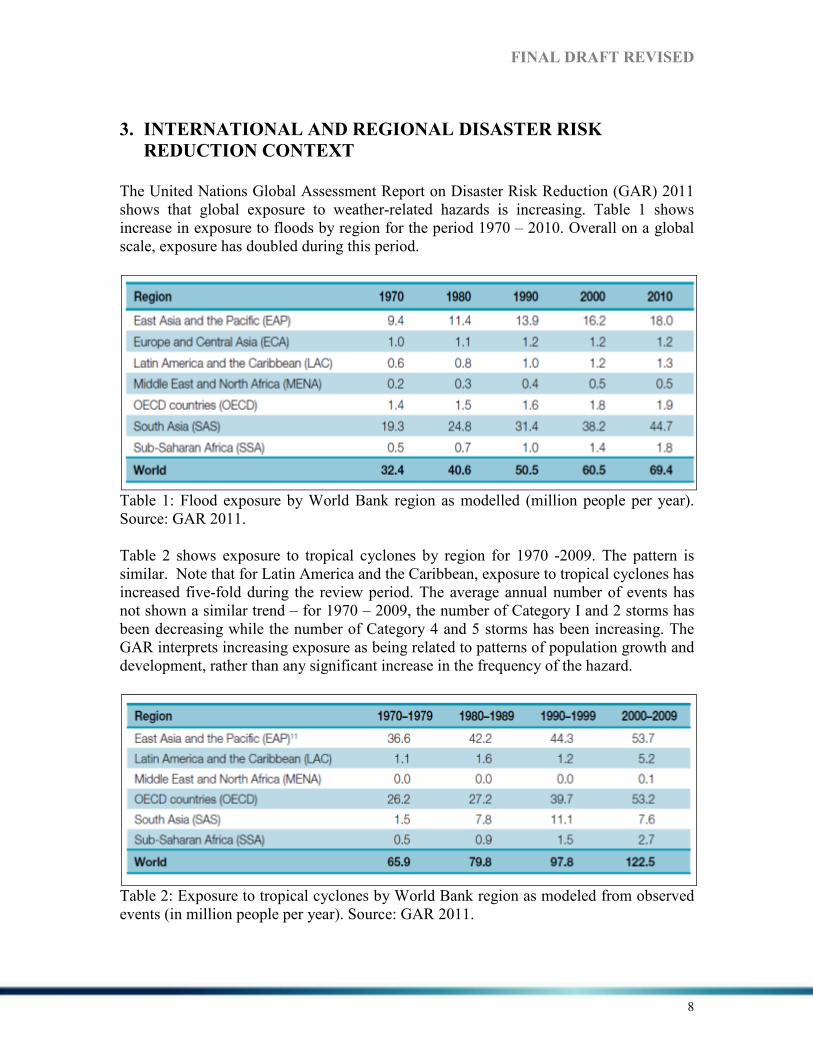
The United Nations Global Assessment Report on Disaster Risk Reduction (GAR) 2011 shows that global exposure to weather-related hazards is increasing. Table 1 shows increase in exposure to floods by region for the period 1970 – 2010. Overall on a global scale, exposure has doubled during this period.
Table 1: Flood exposure by World Bank region as modelled (million people per year). Source: GAR 2011. Table 2 shows exposure to tropical cyclones by region for 1970 -2009. The pattern is similar. Note that for Latin America and the Caribbean, exposure to tropical cyclones has increased five-fold during the review period. The average annual number of events has not shown a similar trend – for 1970 – 2009, the number of Category I and 2 storms has been decreasing while the number of Category 4 and 5 storms has been increasing. The GAR interprets increasing exposure as being related to patterns of population growth and development, rather than any significant increase in the frequency of the hazard.
Table 2: Exposure to tropical cyclones by World Bank region as modeled from observed events (in million people per year). Source: GAR 2011.

FI%AL DRAFT REVISED
9
The GAR also shows that globally, mortality risk for floods and cyclones has decreased since 2000, despite the increase in exposure. It should be noted that this is not true for every country in the analysis. The overall reduction in mortality risk no doubt reflects the improvements in early warning systems and preparedness which have contributed to a welcome reduction in casualties. However, for the same review period, economic loss risk has increased. Additionally, the average annual global GDP exposed to floods and cyclones has increased in every region. For Latin America and the Caribbean, the GDP exposure has increased by a factor of ten (Table 3).
Table 3: Average annual global GDP exposed to cyclones from observed events (in billion 2000 US$). Source: GAR 2011. Although floods and tropical cyclones are treated here, increasing exposure is a fact for several hazards, including earthquakes and droughts. The general conclusion that can be drawn is that unless countries successfully implement risk reduction measures, national development will continue to be compromised and Millennium Development Goals (MDGs) such as poverty eradication and improved health will not be achieved. The continued failure to reduce risk has been attributed variously to weak governance systems and failure to address underlying risk drivers and failure to address vulnerability (GAR 2011). Tracking of global progress in DRM/DRR is done by review of country reports on the Hyogo Framework for Action (HFA) Monitor, an on-line tool which can be completed by countries and uploaded. Over 100 countries used the Monitor to report progress using a self-evaluation method in 2007-2009 (GAR 2011). The most recent 2011 review shows that, generally, countries are finding it difficult to carry out comprehensive assessments of risk and to integrate risk assessment into national development and planning decisions. However, reporting for 2011 indicates an improvement across all priority areas although addressing underlying risk factors seems to be the most challenging of the priority areas. Significantly, the 2011 report reveals that financial mechanisms for disaster management are generally weak, with few countries

FI%AL DRAFT REVISED
10
having contingency funds, particularly at the local level. Fewer than half of the reporting countries indicated comprehensive multi-hazard risk assessments, with the major reasons being limited financial resources, lack of technical capacity and a lack of harmonization of instruments, tools and institutions involved in risk assessments (GAR 2011).
I%TER%ATIO%AL FRAMEWORK
The Jamaican DRM programme is developed within the context of Comprehensive Disaster Management (CDM) as well as the global Hyogo Framework for Action (HFA) which established five (5) Priorities for Action (PFAs) in order to achieve reduction in disaster risk globally:
• PFA 1 - Ensure that disaster risk reduction is a national and a local priority with a strong institutional basis for implementation
• PFA 2 - Identify, assess and monitor disaster risks and enhance early warning
• PFA3 - Use knowledge, innovation and education to build a culture of safety and
resilience at all levels
• PFA4 - Reduce the underlying risk factors
• PFA5 - Strengthen disaster preparedness for effective response at all levels. Jamaica has not established a separate national platform for the HFA as the National Disaster Committee acts as the national focal point for all DRM matters. Jamaica regularly reports on progress in CDM and HFA.
REGIO%AL FRAMEWORK
Jamaica is a Participating State of the Caribbean Disaster Emergency Management Agency (CDEMA) which coordinates DRM on behalf of the Caribbean Community (CARICOM). CDEMA coordinates CARICOM’s regional DRM strategy – The
Enhanced Comprehensive Disaster Management Strategy (CDM) which has the goal: “To strengthen regional, national and community level capacity for mitigation, management, and coordinated response to natural and technological hazards, and the effects of climate change”. This strategy enunciates four Outcomes which are supported by CARICOM Member States.
• Outcome 1 - Enhanced institutional support for CDM Programme implementation at national and regional levels.
• Outcome 2 - An effective mechanism and programme for management and
sharing of CDM knowledge is established and utilized for decision-making.
FI%AL DRAFT REVISED
11
• Outcome 3 - Disaster risk management has been mainstreamed at national levels and incorporated into key sectors of national economies including tourism, health, agriculture and nutrition.
• Outcome 4 - Enhanced community resilience in CDEMA territories to mitigate
and respond to the adverse effects of climate change and disasters. Work programmes of member states are aligned to the CDM Strategy which provides a coherent framework for all DRM programmes in CARICOM. The Caribbean has emphasized the importance of planning for climate change for several years. CARICOM established the Caribbean Community Climate Change Centre (CCCCC) in Belize in 2005 to coordinate and direct climate change efforts. In 2009 the Regional Climate Change Strategic Framework for Achieving Development Resilient to Climate Change was endorsed by CARICOM Heads who decided that the CCCCC should then develop an implementation plan for the strategy across the Region. The implementation plan provides a base for development of projects by governments for funding under climate change initiatives, including the United Nations Framework Convention on Climate Change (UNFCCC). Jamaica has completed and submitted its First and Second National Communications on Climate Change. CDM includes climate change considerations and CDEMA has initiated a number of projects related to climate change adaptation (CCA) and DRR. These include production of a video on climate change adaptation under a climate change and disaster risk reduction project, as well as a ‘Guidance Tool for Mainstreaming Climate Change Adaptation into National CDM Work Programmes’. This Guidance Tool is meant to lead to the development of work programmes which include climate change considerations, according to the authors (Walling, Brown and Smith, 2011).

FI%AL DRAFT REVISED
12
4. %ATIO%AL CO%TEXT
4.1 PHYSICAL E%VIRO%ME%T
4.1.1 GEOGRAPHIC LOCATIO%
Jamaica is located in the Northern Hemisphere at latitude 18° degrees North and 77° degrees West within the West Indies which is characterized by an archipelago (a group of islands) which extends from southeast of the United States of America (USA) to northern South America. Jamaica is surrounded by the Caribbean Sea within the Greater Antilles, which includes Cuba, Puerto Rico and Hispaniola (Dominican Republic and Haiti). Jamaica’s closest neighbours are Cuba 90 miles (140km) to the north and Haiti 118 miles (190km) to the east.
Map 1: Map of the Caribbean. Jamaica is the third largest island is the Caribbean, after Cuba and Hispaniola, with an area of 10,940 square kilometers. The island is 236km (146 miles) in length and 35-82 km (22-51 miles) in width (Richards 2008). The island is divided into fourteen (14) parishes which are grouped by counties namely Cornwall (western parishes), Middlesex (central parishes) and Surrey (eastern parishes).

FI%AL DRAFT REVISED
13
4.1.2 PHYSIOGRAPHY
Jamaica’s topography consists of coastal and inland plains, limestone features (such as plateaus, conical hills and natural depressions) and high interior mountain ranges which extend across the island from east to west (Map 2). The extent of the coastal plains varies in width as those located on the eastern and northern parishes are quite narrow (less than 1km). The Blue Mountain Peak is the highest point at 2,256 meters in the eastern section of the island. It is important to note that more than one-half of the country is at least 305 meters above sea level and over one-half of the land has slopes over 20 degrees (Smith 2007).
Map 2: Map of Jamaica. Source: InterCarto. The geology of Jamaica influences both the landscape and drainage patterns across the island. The aquifer rock, or group of rocks, allows for the movement and storage of groundwater but aquiclude rock or groups of rocks does not allow for such movement of water3 (Map 3). On the island rainfall is usually transported or stored in surface channel or underground systems. Throughout the year, the flow of surface channels is dependent on rainfall intensity and seasonality. During periods of low rainfall the surface channels
3 Information was obtained from: http://www.wra.gov.jm/dynaweb.dti?dynasection=general&dynapage=hydrology

FI%AL DRAFT REVISED
14
experience a reduction in base flow. The permeable zones act as a reservoir for rainfall after which water will flow into surface and sub-surface rivers.
Map 3: Geological Map of Jamaica (see Appendix 1 for enlarged map). Source: Ahmad undated. In Jamaica, the rivers originate from the hilly interior and flow in a northerly or southerly direction. Only the Plantain Garden River in St. Thomas flows in an easterly direction. The rivers and tributaries constitute a major feature of Jamaica’s hydrology and are located within the various watersheds. The island is divided into ten (10) Hydrological Basins which are usually delineated by basin boundaries from the main surface water divides while in other cases the basin boundaries may also be defined by the groundwater divides. In the limestone region, sinkholes and caverns are common and play a vital role in the transfer of surface water into the underground system. Notably, these hydrologic features are sources of flooding across Jamaica when the capacities of such features are exceeded. There are 25 watersheds across Jamaica; these vary significantly from east to west in their state of degradation (Map 4). Most of the degraded watersheds are located in the eastern section of the island and serve more than half the country’s population. The Hope River, Wag Water River, Yallahs River and Rio Minho River watersheds are the most degraded across Jamaica (Map 4).

FI%AL DRAFT REVISED
15
Map 4: Jamaica Watershed Classification (see Appendix 2 for enlarged map). Source: WMU 2007. The morphology of Caribbean islands share comparable characteristics as a result of the geologic formation of the region. As such, the montane streams of the Greater Antilles share several morphological characteristics (Ahmad et al. 1993). The streams in their headwaters flow in narrow valleys with steep gradients while transporting and depositing sediments such as pebbles, coarse materials and boulders downstream. In the lower sections of the stream, multiple channels and depositional surfaces occur at varying locations within the valley floor (Ahmad et al. 1993). Floodplains are a common feature in the middle and lower courses of the river due to the location of fairly flat land. Flooding may occur in these areas if the channel is not able to facilitate the volume of runoff over a short period of time.
4.1.3 CLIMATE
Jamaica has a tropical maritime climate with tropical weather influenced by the prevailing northeast trade winds. There is little variation from one season to the next; however July and August are two of the hottest months while December and January are two of the coolest months. Temperatures are normally consistent throughout the year but will vary in different parts of the island “from a seasonal low of 26°c in February to a high of 30°c in August, on average, the temperature changes by 2°c with every 300m change in altitude4.” Rainfall varies seasonally and spatially, thus influencing different ecosystems across the island. In general, most of the rainfall occurs as relief rainfall in the hilly interior due to 4 Information was obtained from: http://www.wra.gov.jm/dynaweb.dti?dynasection=general&dynapage=hydrology

FI%AL DRAFT REVISED
16
the orography of the island. The island receives an annual average range of 5,080mm - 6200mm from high rainfall regions to the rain shadow regions. The long term mean annual rainfall is 1,981mm5. High rainfall levels are concentrated over the Blue Mountains while most of the south coast is located in the rain shadow region and receives less rainfall than the north coast of the island (Map 5). The annual rainfall pattern for Jamaica exhibits two marked bi-modal peaks with the primary maximum in October and secondary maximum in May. The drier months are January, February, March and July where rainfall is at its minimum. The island’s rainfall pattern may be compromised by the influence of tropical storms and hurricanes during the hurricane season (June to November) or other synoptic weather systems (frontal systems, troughs, etc.) which may produce high intensity and/or prolonged rainfall.
Map 5: Rainfall Map of Jamaica. Source: Meteorological Office of Jamaica.
4.2 SOCIO-ECO%OMIC CO%TEXT
4.2.1 POPULATIO% and DEMOGRAPHICS
Jamaica’s total population in 2011 stood at 2,697,983 of this total 1,363,450 are females and 1,334, 533 males. The younger working age population, ages 15-44 years represented 1.3 million persons (48 %) an increase of over 80,000 persons. The older working
5 Ibid.

FI%AL DRAFT REVISED
17
population, ages 45-64 years, increased by 36 % from 352,861 in 2001 to 480,240 in 2011. In addition, the older working population ages 45-64 years accounted for 18 per cent of the total population in 2011 (STATIN 2012). Jamaica is at the intermediate stage in the demographic transition characterized by decreasing birth rates and low death rates, and displays the following features: a declining 0-14 age group from 27.4 % in 2009 to 27.3 % in 2010, this group is expected to continue to decline over the next twenty (20) years to 23.2% by 2030 (STATIN 2008); an increase in the working population aged 15-64, there is a projected increase to 66.8% by 2020 but it is expected to decline afterwards. Persons in the 15-39 age range made up the highest proportion of workers in this 15-64 age category; the over 60s group which is divided into two groups - the elderly population (60+) and the ‘dependent elderly’ aged (65+). This latter group represented 8.5% of the total population in both 2009 and 2010. The elderly population, (60+), stood at 11.1% of the total population in 2010 at 299,500 (of this total 163,900 were females and 135,600 males) an increase from 11.0% or 298,100 in 2009. The over 60s group (made up of the 60+ and the 65) is expected to continue to increase up to 2050 (STATIN 2008). The 2011 census confirmed that the ageing of Jamaica’s population continues. Of the total population persons 15 years or under declined to 26%, down from 41% in 1960. For the same period those from the 65 years and over group increased from 4.35% to 8.1%. Further evidence of ageing, is the change in average age - in 1970 the median age for men and women was 16 and 18 years respectively. In 2011 the median age for men had increased to 27 years and for women 28 years (STATIN 2012). Another issue that impacts Jamaica’s population is migration. Every year for the last forty years, more than 25,000 persons have emigrated from Jamaica to the USA, Canada and the United Kingdom. This has reduced Jamaica’s population growth by 40 % each year (PIOJ 2012). Jamaica’s overall health status is good. Life expectancy in Jamaica stood at 74.13 years in 2010 (PIOJ, 2012). In general the health of Jamaicans has shown improvement over the last few decades. Additionally, among developing countries Jamaica ranks high with respect to the health status of its population. The island has a good primary health care record and can share a number of best practices in this area. However, financing at both affordable and concessionary rates is needed to stimulate renewal of the primary care model and other support, including partnerships with educational institutions to build capacity and expand the training of health personnel. As a result of migration of qualified health professionals Jamaica has been hit with chronic staff shortages in some areas of health care (PIOJ 2009c).
Jamaica has made progress in eight (8) out of the fourteen (14) MDG targets for 2015 including the targeted reduction in malnutrition and hunger, combating HIV/AIDS, stopping and reducing malaria and tuberculosis outbreaks, access to reproductive health,
FI%AL DRAFT REVISED
18
and provision of basic sanitation and safe drinking water. However, more needs to be done in the area of infant and maternal mortality targets which remains a cause for concern. Despite Jamaica’s progress with respect to most health indicators, there continues to be public dissatisfaction with the public health care system (PIOJ 2009c; PIOJ, 2012).
According to the Economic and Social Survey of 2010 the status of key health indicators in Jamaica were as follows:
• Life expectancy (at birth) – 74.13 years
• Infant Mortality – 15.4/1 000 live births
• Crude birth rate – 17.0/1 000 mean population
• Total fertility rate – 2.4/1 000 women in 15-49 age group
• Maternal Mortality Rate – 94.8/100 000
• Immunization coverage: o DPT,OPV, BCG 0-11 months – 94.7 per cent o MMR 12-23 months – 87.1per cent (PIOJ 2011)
The main causes of mortality and morbidity are chronic non-communicable diseases (NCDs) such as hypertension, cardio-vascular conditions, diabetes, obesity, some cancers and various lifestyle practices such as tobacco smoking, substance abuse, violence, injuries and mental illness. Further, the four (4) leading causes of death for Jamaican men are cancer, homicides, heart disease and cerebrovascular diseases while for women they are cancer, cerebrovascular diseases, diabetes and heart disease. Homicide is the fifth leading cause of death in Jamaica (PIOJ 2009c). Despite making progress globalization has increased the threat of infectious diseases in Jamaica as the 2007 malaria outbreak highlighted. Jamaica continues to grapple with HIV/AIDS which remains a threat to the population. The increasing prevalence of chronic and lifestyle illnesses and environmentally induced illnesses in Jamaica will be tackled under Vision 2030, including strengthening Jamaica’s institutional responsiveness. Other strategies include early screening of the population to encourage timely interventions, and strengthening of primary health care facilities to increase prevention (Vision 2030, p.49-50).
4.2.2 THE ECO%OMY
At the end of 2008 Jamaica’s debt had risen to a total of $1,119.4 billion (US$13.9 billion), representing 106.9 % of GDP, one of the highest debt ratios in the world, and a per capita debt of over US$5,000 (PIOJ 2009). Vision 2030 notes that Jamaica’s debt negatively impacts economic development in a number of ways; including the fact that debt service payment reduces the funds available to Government to address Jamaica’s development challenges in areas such as education, security, health and infrastructure. Between 2007 and 2008 Jamaica’s debt service payment was 54% of the total Government budget compared to 12% for education, 7 % for national security and 5 % for health (Vision 2030).

FI%AL DRAFT REVISED
19
Page 128 “Jamaica, the place of choice to live, work, raise families and do business”
Between 2008 and 2009 the global recession had a negative impact on the Jamaican economy, with several economic indicators showing a decline in performance during the period. Real GDP experienced a negative growth of -3.1% in 2009 and -1.2 % in 2010, compared to growth targets of 3 per cent for each year. Jamaica’s debt to GDP ratio worsened to 130.7 % while the fiscal balance declined to -6.2 per cent of GDP by the end of 2010/11 (PIOJ 2012). Additionally, Jamaica’s annual inflation rate fell to 11.7 % in 2010 a decline from 16.8 % in the baseline year 2007, whereas the nominal GDP per capita increased to US$4,979 in 2010 from US$4,802 in 2007. The Connectivity and Technology Infrastructure Index (CTII) for Jamaica improved significantly to 4.85 in 2010, up from 3.70 in 2007, while the E-readiness Index (ERI) also improved from 5.05 in 2007 to 5.21 in 2010. The Agriculture Production Index (API) was 83.1% in 2008 increasing to 93.67 % in 2009, with a further increase to 93.92 % in 2010 (PIOJ, 2012). Further, Jamaica’s economy contracted by 1.4 % in 2010 with declines of 1.8 % (in Goods) and 2.0 % for (Services) industries. The economy returned to a growth path in 2011; in October to December the economy grew by an estimated 1.7 % relative to the same period in 2010. Between October and December 2011, real value added for the Goods Producing Industry grew by 5.8 % while the Services Industry experienced 0.2 % growth. The strongest growth was recorded in the area of Agriculture, Forestry and Fishing which grew by 16.4 %, Mining and Quarrying grew by 8.2% and manufacturing grew by an estimated 2.1%. For 2011, GDP grew by 1.5 % representing the first annual increase in real GDP since 2007 (PIOJ, 2012).
4.2.3 POVERTY A%D U%EMPLOYME%T
In Jamaica poverty is more widespread in the rural areas [poverty rates of 9.9% in the Kingston Metropolitan area and 25.1% in rural areas], where the economy is predominantly of the extractive and production-type industries such as agriculture, forestry, mining, and natural resource-based tourism (see Appendix 4). The Human Poverty Index (HPI) which is used to measure deprivation in three basic dimensions of long and healthy life, knowledge and a decent standard of living; ranked Jamaica relatively high in 2007, at 34th of 108 developing countries (UNDP 2007). However, since 2008 there has been a general increase in poverty in Jamaica exacerbated by the global increase in food and oil prices and also the onset of the global economic crisis in 2009. Rural parishes show a greater prevalence of poverty than urban areas (see Appendix 4). Notably in 2010 poverty in rural parishes climbed to 23.2% up from 22.0% in 2009; whereas in the Kingston Metropolitan Area (KMA) for instance poverty was at 11.6% compared to 10.2% in 2009 (PIOJ 2012). In Jamaica poverty is not only considered to be cyclical but also inter-generational influenced by a number of issues identified as follows:

FI%AL DRAFT REVISED
20
1. low educational attainment levels 2. low income earning capability 3. inability to access basic social services 4. lack of economic opportunities leading to underemployment, 5. unemployment and low wage employment 6. poor rural development impacting the opportunities and livelihoods of rural
households 7. high levels of risk from exposure to natural hazards and poor environmental
practices. Added to these there are some identifiable features of poverty in Jamaica including: the dollar value of eliminating poverty has increased over the past three years because of deteriorating economic conditions and higher prices, which have helped to maintain the poverty cycle:
1. a higher percentage of female-headed households (14.0 %) vs male-headed (11.0 %) households are poor - a cycle that has persisted over the past decade.
2. households which are poor usually have more adult females and more children 3. children (0-14 years) registered the highest prevalence of poverty at 21.9 %,
compared to the working age population (14-64) at 15.6 % and 16.8% for the dependent elderly (65+) population
4. poverty was predominantly highest in the rural areas but is now increasing in urban areas (see Appendix 4); these pockets of urban poverty have been a driving factor of urban risk.
5. there remain fundamental differences between the rural and urban poor in Jamaica (PIOJ, 2012).
Interventions to reduce poverty in Jamaica are varied and wide reaching ranging from construction of community infrastructure such as roads and schools, water and sanitation projects, rural electrification, and skills building, to cash transfers, residential care and employment programmes. Additional programmes include education, training as well as nutrition support (PIOJ 2012). At April 2009 unemployment was estimated at 11.4% while 6% of the population lived on less than $2.00 a day (IDB 2010). In keeping with the standard international definition, unemployment refers to persons who are without work, available for work, either in search of work or not looking for work. For the period 2010 there were 154,700 unemployed persons (59.2% female; 40.8% male) an increase of 7.2 % which increased the average yearly unemployment rate to 12.4% up from 11.4% in 2009. Unemployment rate for females was 16.2% compared with 9.2% for males in this period. However, by 2011 there was a further increase as the unemployment rate went up to 12.8% up from 9.8% in 2007 (PIOJ 2011 and 2012). According to STATIN (2012) the 161,300 unemployed persons in July 2012 represents an increase of 9,500 (6.3%) over the 151,800 unemployed in July 2011. However, when compared with the previous quarter (April 2012), unemployment decreased by 18,600
FI%AL DRAFT REVISED
21
(10.3%). The unemployment rate for July 2012 stood at 12.8 % up from 12.3 % for the corresponding period in July 2011. However, when compared with the previous quarter (April 2012) the unemployment rate decreased by 1.5 %. By age there were 49,700 youths (a 6.4% increase) and 105,100 adults (a 7.7% increase) unemployed in the labour force. The youth unemployment rate increased to 30.8% up from 27.1% while for adults it moved from 9.7% to 8.9% in 2010, representing the highest since 2002. For the period 2001 to 2010 youth unemployment averaged 27.7% (PIOJ 2012). Youths in Jamaica face a number of issues including lower levels of experience, training and certification, coupled with inadequate job opportunities in the global economic climate (PIOJ 2011). In July 2012 unemployment rate among Jamaica’s youths (14-24 years) stood at 32.2 %, a 3.5 % increase over the corresponding July 2011 period of 38.7 % (STATIN 2012).
4.2.4 MOST VUL%ERABLE GROUPS
Several vulnerable groups have been identified in Jamaica, including children, youth-at-risk, the elderly, persons with disabilities (PWDs), persons impacted by HIV/AIDS, women, and poor families. This list is a demographic characterization, and is not exhaustive (Vision 2030, p.78). In Jamaica the most vulnerable populations also include both men and women living in rural communities, coastal zones and low-lying areas, people with poor housing, the homeless (UNDP 2009). It is estimated that persons at risk make up 60% of Jamaica’s total population and are generally vulnerable to storm surges, hurricanes and flooding6.
Women
Poverty increases the vulnerability of women when there is a disaster because there is often a larger percentage of women amongst the poor population and hence they are often the most at risk (Senior and Dunn 2009). The higher level of poverty and increasing vulnerability to poverty are tied to women’s participation in the labour force typified by lower rates of employment and higher rates of unemployment in comparison to men (UNDP 2009a). PIOJ (2010) documents that despite male employment declining by 2.5% from 638,700 to 622,600 female employment declined even more, by 3.0% from 486,900 to 472,300 in 2010 representing 43.1% of the labour force in comparison to males 56.9%. July 2012 saw a total of 1,094,700 persons in the labour force 619,400 males and 475,300 females. This represents an increase of 11,100 (1.0%) over the 1,083,600 employed in July 2011. When compared to the previous quarter (April 2012) employment increased by 13,400 (1.2%) (STATIN 2012).
Jamaica has a high percentage of female-headed households (FHHs), increasing since 1993 from 41.5% to 43.5% in 2002 then 46.7% in 2006 (PIOJ 1998; PIOJ 2007a). FHHs are considered one of the most vulnerable groups in Jamaica (UNDP, 2009). They tend to 6 (Senior and Dunn 2009; Working Group 1 Vulnerabilities and Capacities 2012; UNDP 2009a)

FI%AL DRAFT REVISED
22
include more children who in turn are considered vulnerable. As noted in a 2010 study the percentage of FHHs remains high and is largest in the poorest section of the population. The high levels of FHHs affects the ability of women, particularly in poorer households, to access healthcare, which is often sacrificed for other economic priorities including food, shelter and education (PAHO 2010).
Children
In the 2011 Census the population under age 15 years numbered approximately 702,800 or 26 % of the total population of 2,697,983 persons. This represents a decline of over 135,000 persons (PIOJ 2011). Children (0-14 years) made up 29.4 % or (782,600) of Jamaica’s total population in 2005, but by 2007 this had declined to 28.3 %. A further decline to 23.2 % or 666,304 by 2030 is expected (Vision 2030, p.39). In Jamaica, underlying vulnerabilities of children are linked to poor families, and FHHs in particular as women tend to earn less than men and are often the poorest in the population. In 2006 the average number of children was 3.6 in female-headed households and 3 in male-headed households (UNESCO 2011). Children’s poverty and their special needs in disasters have been documented (Edwards and Morris 2007; UNICEF 2007).
The Elderly
The younger working age population, ages 15-44 years, represented 1.3 million persons or 48 % of the population, whereas the older working age population, ages 45-64 years increased by 36 % from 352,861 to 480,240 persons and by 2011 accounted for 18 per cent of the total population of 2,697,983 (PIOJ 2011). Jamaica’s elderly population (60 years and over) is the fastest growing age group. The dependent elderly (65 years and over) was estimated at 207,700 (7.8 %) in 2005 and by 2007, had grown to 223,961 (8.4%). Over the period 2007 to 2030, it is estimated that this cohort of Jamaica’s population will increase by 2.8 % to 11.2 % or 321,664 (Vision 2030, p.40).
Persons with Disabilities
The disaggregated figures for persons with disabilities are not yet available from the 2012 census. The 2001 Population Census estimated that 6.3 % or 163,206 of Jamaica’s population had at least one disability. It is generally believed that the level of disability in a population is often understated and as a result, the World Health Organisation (WHO) estimates that for most countries the level of disability would be about 10 % of total population figures. If this estimation is correct in Jamaica “the level of disability as revealed by the census grossly understates the extent of the problem. It may therefore be assumed that persons with disabilities (PWDs) comprise a larger than stated segment of our population and have been marginalized from the mainstream of development in the society” (Vision 2030, p.40).

FI%AL DRAFT REVISED
23
The Homeless
The homeless are simply described as persons without a permanent home who live on the streets. Jamaica’s 2001 population census identified 802 homeless persons: 402 lived on the streets with the other 400 living in shelters across the island (Plate 1). By 2005 there were 835 homeless adults- 635 were males while 248 were females. According to Dr. Wendell Abel about 650 adults are homeless about 60% of that amount are mentally ill and are drug abusers while 10% are deportees in which the majority are males. It is also estimated that about 800 children are homeless in Jamaica. Most of Jamaica’s homeless can be found in Kingston and St. Andrew, Montego Bay, May Pen and in coastal towns like Ocho Rios. In 2012 it was reported that 1097 persons were homeless in Jamaica a third suffered from various types of mental illness (Williams-Raynor 2010; Clarke undated; JIS 2012a.)
The homeless receive help from Missionaries of the Poor, different feeding programs, and drop- in centers. The National Emergency Operations Centre keeps track of the availability of different shelters and safe havens for the homeless during times of disaster (Workshop 2012, Group 1). The plight of the homeless is recognised in Vision 2030. The Social Welfare and Vulnerable Groups Sector Plan-SWVG (2009) was developed to establish:
• a centralized database in order to identify homeless persons;
• finalize and implement a Comprehensive Homeless Strategy;
• provide suitable and safe shelters with adequate sanitary facilities;
• provide adequate nutritional and dietary content of meals provided in approved shelters;
• strengthen Community-based Disaster Management framework (especially regarding evacuation);
Plate 1: A homeless man sleeps on a sidewalk along Knutsford Boulevard on July 3, 2011. Taken by Gladstone Taylor.
Source: The Jamaica Gleaner.

FI%AL DRAFT REVISED
24
• monitor institutions/facilities to ensure there are disaster plans in place (including evacuation strategies).

FI%AL DRAFT REVISED
25
4.3 GOVER%A%CE STRUCTURE
4.3.1 POLITICAL STRUCTURE A%D ORGA%ISATIO%
Jamaica is a unitary constitutional monarchy and a parliamentary democracy with two spheres of government - national and local. H.M. Queen Elizabeth II is Jamaica’s head of state. On the advice of the Prime Minister, she appoints a Governor-General who acts as her representative. Neither the Queen nor the Governor-General has any real authority in conducting the administration of Jamaica. The real legislative and executive responsibilities rest solely with the elected representatives of the people – the Members of Parliament (MPs) (JIS 2012; CFLGM 2012). The legislature, based in the capital Kingston, is bicameral comprising the House of Representatives and the Upper House, the Senate. The House of Representatives is made up of sixty-three (63) members elected by universal adult suffrage by single-member constituencies on the first-past-the-post basis, for terms of no more than five years. A Government can stay in power only if it has the support of the majority of the members of the House of Representatives. In practice this is where Bills are passed. The Senate is made up of twenty-one (21) members nominated/appointed by the Governor-General, thirteen (13) on the advice of the Prime Minister, and eight (8) on the advice of the Leader of the Opposition. Traditionally both parties will nominate some independent members. The Senate usually functions as a review chamber, considering Bills passed by the House of Representatives. However, the Senate may also initiate legislation. The Prime Minister is the Head of Government and he/she presides over and appoints a Cabinet from the House of Representatives and the Senate. He/she advises:
1. the Queen on the appointment of the Governor-General 2. the Governor-General on the appointment of the six (6) members of the Privy
Council, on the dissolution of Parliament and on appointments of the Chief Justice, the President of the Court of Appeal and the three (3) Service Commissions as enshrined in the Constitution.
However, for appointments of the senior members of the Judiciary and the Service Commissions, the Prime Minister consults with the Leader of the Opposition before an appointment is made. The Cabinet is the centre of Jamaica’s system of Government and is responsible for the general direction and control of Government business. It is here Government policies and programmes are initiated. The Cabinet must consist of the Prime Minister and not less than eleven (11) other ministers. Of this eleven not more than four (with portfolio responsibilities) must be appointed from the Senate. The other seven (7) Ministers are appointed from the House of Representatives. Important matters, for instance, those

FI%AL DRAFT REVISED
26
which may be discussed in Parliament, are brought before the Cabinet for discussion and decisions (JIS 2012; CFLGM 2012). Effective governance is an essential foundation of any society as it provides the stability needed for growth and development. Jamaica has been plagued with challenges to governance. On the surface, the country has strong formal institutions with a well-established parliamentary democracy, a vibrant civil society and media and also a strong and competent civil service. Nonetheless, Jamaica continues to show signs of social and political polarization, which makes it increasingly difficult to form consensus on policies. Factors that have contributed to the weakening of governance in Jamaica include:
1. Apathy towards, and alienation from, existing political institutions and processes and an increasing disregard for the norms of civil society by a large number of persons, especially the young
2. Consistent poor performance of the economy and the persistence of poverty 3. Increased criminal activity (e.g. drug trafficking and large number of gangs) 4. The State’s inability to sustain levels of social welfare that were put in place in
the post-independence era 5. An inadequate local governance framework
Jamaica’s Government has a redefined position; arguably, - it has moved from one which operated like a development agency to that of facilitator of market driven policies (PIOJ 2012).
4.3.2. LOCAL GOVER%ME%T A%D LEVELS of DECE%TRALIZATIO%
Traditionally Jamaica has had a single tier system of local government, made up of local authorities called Parish Councils. These have, been reduced over time from twenty-two (22) to fourteen (14), and then to thirteen (13) with the amalgamation of the Parishes of Kingston and St Andrew to form the Kingston and St. Andrew Corporation (KSAC). The 2003 Municipalities Act was an innovation which led to the creation of the Municipality of Portmore, which has responsibility for many functions related to this rapidly growing urban centre. The Municipality however, remains under the jurisdiction of the St Catherine Parish Council. This innovation is major feature of Local Government reform (which started in 1994) in Jamaica and seeks to create a strong, viable and vibrant system of local government in Jamaica (JIS 2012; CFLGM 2012). The Minister of Local Government heads the Ministry which provides oversight for the laws governing the organisation, structure, powers, administration and financing of local authorities in Jamaica. The Ministry also provides technical advice, guidance, and coordinates activities between all local and central government programmes in order to achieve the objectives and common standards. It has four (4) agencies which assist in discharging its responsibilities. These are the Jamaica Fire Brigade (fire prevention and control); the National Solid Waste Management Authority (solid waste collection and disposal); the Board of Supervision (poor relief/welfare services); and the Vineyard Town Golden Age Home (CFLGM 2012).

FI%AL DRAFT REVISED
27
There are currently two hundred and twenty-seven (227) Councillors serving the fourteen (14) Parish Councils, each headed by a Mayor who acts as the Chairperson of the Council. Elections are conducted by universal adult suffrage on a first-past-the-post system for a three year term. The Mayor is elected indirectly for the term of the council. The electoral divisions are each represented by one member. Parish Councils undertake their responsibilities through a committee system. By law they have two main committees: Finance and Poor Relief. Parish Councils have discretionary powers to establish other committees which are usually public health, commercial services, building and town planning, and roads and works. Standing committees have delegated decision-making powers while other committees have powers to recommend. There are also Ad-hoc committees which are formed to address specific issues. Further, some authorities establish Executive Committees to assist the leadership of the Council (CFLGM 2012). Additionally, non-statutory bodies called Parish Development Committees (PDCs) have been established in all parishes to facilitate meaningful participation of all stakeholders in the processes of local governance, local sustainable development, and to facilitate partnership, collaboration and cooperation among all parish groups in seeking to achieve the tenets of good governance. PDCs play an important role, in collaboration with the local authorities, in preparing and implementing local sustainable plans for their parish (CFLGM 2012; JIS 2012). In Jamaica response to emergencies and disasters occurs over four levels: the national, regional, parish and community levels. The island is divided into four regions, and Regional Disaster Coordinators, who are staff members of ODPEM are assigned to these regions and are responsible for monitoring existing disaster preparedness arrangements in the parishes to which they are assigned, to ensure adequacy of relief supplies in times of disaster and to coordinate response to emergencies (NDP 1997). A Regional Disaster Coordinator also chairs the Regional Disaster Planning Group which consists of other regional coordinators and local officials. Disaster Risk Management at the parish level is spearheaded by the Parish Disaster Coordinator who is in charge of developing preparedness and response plans in keeping with ODPEM guidelines as well as coordinating all public awareness, prevention and response activities within the parish. Operations are conducted out of a Parish Emergency Operations Centre (PEOC) operated by the Parish Disaster Committees (PDICs) within the Parish Council Offices. The PDICs forge partnerships with the different response agencies, community groups and community-based organisations within the different parishes. The PDICs are chaired by the Custos and/or Mayor of each parish. Other members include all Parish Councillors and local representatives of the government agencies, NGOs the private sector and other interested groups7. 7 http://www.odpem.org.jm/

At the Community level a national zonal programme developed by island into clusters of communities called zones. The zones are then divided into focal points. A zone chairman monitors each zone and provides information on disasters to the Parish Disaster Committees (PDICsis, personnel, equipment, (like operators in the event they are
Figure 1: Parish Disaster Committee When a disaster occurs the zones will be the first group to render assistance in communities. The zone Headquarters is transformed into a communication, coordination and distribution centre from which agencies like the Red Croamong others give assistance to affected persons. There are a number of focal points the zone chairman. These focal points provide information to zones regarding the state or level of disaster within their communities. Additionallyresources and ensure their availability for use
The Social Development Commission is the government agency which works in community development. Their programme includes development of community priority plans as well as economic development planning. The SDC also includes development of
FI%AL DRAFT REVISED
At the Community level a national zonal programme developed by ODPEMisland into clusters of communities called zones. The zones are then divided into focal
A zone chairman monitors each zone and provides information on disasters or potential disasters to the Parish Disaster Committees (PDICs). He/she must identify resources
(like cellular phones) and also heavy duty equipment and operators in the event they are needed.
Disaster Committee Structure
When a disaster occurs the zones will be the first group to render assistance in communities. The zone Headquarters is transformed into a communication, coordination and distribution centre from which agencies like the Red Cross and the Salvation Army
give assistance to affected persons.
ocal points that operate on a smaller scale and collaborate with ocal points provide information to zones regarding the state or
level of disaster within their communities. Additionally, the focal points also resources and ensure their availability for use during times of need.
The Social Development Commission is the government agency which works in Their programme includes development of community priority
plans as well as economic development planning. The SDC also includes development of
DRAFT REVISED
28
ODPEM divides the island into clusters of communities called zones. The zones are then divided into focal
disasters or potential . He/she must identify resources, that
cellular phones) and also heavy duty equipment and
When a disaster occurs the zones will be the first group to render assistance in communities. The zone Headquarters is transformed into a communication, coordination
ss and the Salvation Army
operate on a smaller scale and collaborate with ocal points provide information to zones regarding the state or
, the focal points also identify
The Social Development Commission is the government agency which works in Their programme includes development of community priority
plans as well as economic development planning. The SDC also includes development of

FI%AL DRAFT REVISED
29
community DRM plans as part of its intervention in communities which have not developed such plans.
The %ational Zonal Committee
The National Zonal Committee is the coordinating body for the National Zonal Programme and is tasked with: monitoring all aspects of the programme including development of public education programmes; fund raising and preparing detailed Policy/Mission Statements. It is made up of an Administrative Chairman and three Sub-committees.
Figure 2: National Zonal Committee Structure
Jamaica has reported to the HFA on community participation and decentralisation. Achievements noted in the report include allocation of funding for DRR to local government authorities and establishment of community development funds. Community participation is included in the current disaster preparedness act and will be strengthened in the new legislation. Constraints include inadequate resources for deployment at community level, need to strengthen the local authorities in order to more effectively carry out DRR activates and establishment of incentives for communities to participate in the Community-Based Disaster Risk Management (CBDRM) programme (HFA 2010).
FI%AL DRAFT REVISED
30
4.3.3. COORDI%ATIO% MECHA%ISMS BETWEE% STATE A%D %O%-
GOVER%ME%TAL ACTORS
As the World Bank (2010) notes, Jamaica has been successful in integrating its approach to DRM. There has been an integration of the public, private, technical, scientific and voluntary sectors as well as local government agencies and communities. These groups are represented on the National Disaster Committee and its sub-committees and their roles are included in the national disaster plan. Vision 2030 not only acknowledges the importance of partnerships between Government (central and local), citizens and the private sector (internal and external) and other partners, but sees them as necessary to ensure that the strategies identified under Vision 2030 are implemented using resources garnered from partners.
4.4 THE DEVELOPME%T CO%TEXT
Over the last 40 years, Jamaica has had prolonged periods of low economic growth, large fiscal deficits, and weak export performance. Between 1973 and 2007 the country’s real GDP grew by only 0.8% per annum but in the last ten years GDP grew by 1.3%. However, Jamaica is heavily indebted and in 2007 had the fourth highest debt-to-GDP ratio of 111.3% in the world. Debt servicing represented 56.5% of the 2009/2010 budget. Wages and salaries for civil servants was 22.5%, education 12.6%, national security 8.2% and health 5.3% - this left very little money for development priorities like infrastructure and social programmes. Importantly, the current debt includes the sum (44% of GDP) absorbed by the Jamaican government following the financial sector crisis of 1995 to 1996. Since January 2009 most of the resulting debt, representing 53.7% of GDP, is held by local creditors (PIOJ 2009). Development in Jamaica has been generally characterised by periods of poor economic performance interspersed with short periods of economic growth. It included structural adjustment measures (liberalization and privatization) in some key sectors including tourism. Development in Jamaica is also hampered by the negative impacts of disasters including hurricanes (2004-Ivan, 2005-Katrina and 2012-Sandy), the terrorist attacks on the USA in 2001, rise in oil prices since 2004 and the global recession. Currently the sugar and banana industries are in decline partly as a result of the ending of trade preferences with Europe, which had formerly guaranteed markets for these products. By 1997 Jamaica had a growing public debt; increasing poverty and environmental deterioration. There is currently a global economic crisis evidenced by the current global recession, rising levels of unemployment, failure of a number of institutions including banks, rise in prices including basic food items and oil. The global recession is now having a significant impact on the Jamaican economy and its development strategy. From November 2008 to February 2009, remittances, which had been steadily increasing, fell by 21%. There was also negative impact as a result of the decreasing demand for alumina

FI%AL DRAFT REVISED
31
which resulted in one thousand eight hundred and fifty (1,850) job losses, and another eight hundred and fifty (850) persons taking a 40% salary cut from a shorter work week. There were job losses totaling fourteen thousand seven hundred and fifty (14,750) in other sectors as well between October 2008 and May 2009. Adding to the rising inflation, the Jamaican dollar devalued against the US$ by 22% from September 2008 to mid-February 2009. Although the social impact of the global crisis has not yet been documented, the police have been reporting an increase in property crimes island wide (PIOJ 2009). Further devaluation in 2012 resulted in the Jamaica dollar being at its lowest by fluctuating in the low-mid 90’s. The challenges in Jamaica are many and varied. In 2007 Jamaica’s GDP per capita was US$4147 versus developed countries which was between US$20,000-120,000 (ranked 103rd out of 210 countries). In 2008 Jamaica was cited as having one of the highest murder rates in the world (60 deaths per 100 000); was ranked 101st out of a total of 177 countries in 2008 by the Human Development Index (HDI) and ranked 54th out of 147 countries in the Environmental Performance Index (EPI). In 2008-2009 the Global Competitive Index (GCI) ranked Jamaica 86th of out a total of 134 countries. Other challenges include migration; debt; decrease in access to capital; low productivity in most sectors; fiscal imbalance; poor export performance; weak infrastructure; weak educational performance; increasing unemployment (especially for persons 15-24 years); insufficient transparency and accountability in government; and high perception of corruption in the society (PIOJ 2009). It is against this backdrop of challenges that Vision 2030 was conceptualised to lead Jamaica unto a transformational path to sustainable prosperity as it seeks developed country status by 2030. This is enshrined in the new vision of: “Jamaica the place of choice to live, work, raise families and do business.”
4.4.1 %ATIO%AL DEVELOPME%T OBJECTIVES
Vision 2030 - National Development Plan - provides “a comprehensive framework in which the linkages among economic, social, environmental and governance sectors are made, and presents a broad strategic thrust for the transformation of the Jamaican economy and society towards sustainable development and prosperity for the Jamaican people” (PIOJ 2009, p. 24). It envisages a Jamaica where there is equal access to education, health care, nutrition, basic amenities, environmental goods and services, and where civility and social order dominate. The Plan acknowledges the importance of transformation and seeks to transform mind sets, improve attitudes and influence behaviour as it embraces a new paradigm shift toward a sustainable society via development that “meets the need of the present without compromising the ability of future generations to meet their own needs” (WCED 1987).

Generally, a developed country bears certain characteristics including high levels of per capita income, advanced productive sectors, well developed infrastructure and social services, involvement in research and innovation. Additionally, human development in countries is often measured using thschool enrolment and per capita GDP.of human development (Vision 2030).
Vision 2030 Jamaica - %ational Development Plan
The Government of Jamaica, in collaboration with the private sector and civil society, prepared a long term National Development Plan: Development Plan which envisages Jamaica achieving developed country status by 2030. The Plan introduces a new development paradigm by redefining Jamaica’s strategic direction. Integration of DRM into project development is also an area of focus as it relates to national development. The old paradigm of development focused on generating prosperity through the exploitation of Jamaica’s natural environmentand exporting sub-soil assets like bauxite and basic agricultural commoditconsidered inadequate if sustained economic and social development was to be realized in Jamaica.
Figure 3: Jamaica’s Old Development Model based on the capital stocks of the nation
FI%AL DRAFT REVISED
lly, a developed country bears certain characteristics including high levels of per capita income, advanced productive sectors, well developed infrastructure and social services, involvement in research and innovation. Additionally, human development in untries is often measured using the HDI which combines life expectancy, literacy,
school enrolment and per capita GDP. A score of 0.80 or higher is equated to high level of human development (Vision 2030).
%ational Development Plan
The Government of Jamaica, in collaboration with the private sector and civil society, prepared a long term National Development Plan: Vision 2030 Jamaica
which envisages Jamaica achieving developed country status by 2030. The Plan introduces a new development paradigm by redefining Jamaica’s strategic direction. Integration of DRM into project development is also an area of focus as it
development.
The old paradigm of development focused on generating prosperity through the exploitation of Jamaica’s natural environment, as it promoted - sun, sea and sand tourism
soil assets like bauxite and basic agricultural commodities. These were considered inadequate if sustained economic and social development was to be realized
: Jamaica’s Old Development Model based on the capital stocks of the nation
DRAFT REVISED
32
lly, a developed country bears certain characteristics including high levels of per capita income, advanced productive sectors, well developed infrastructure and social services, involvement in research and innovation. Additionally, human development in
which combines life expectancy, literacy, A score of 0.80 or higher is equated to high level
The Government of Jamaica, in collaboration with the private sector and civil society, Vision 2030 Jamaica !ational
which envisages Jamaica achieving developed country status by 2030. The Plan introduces a new development paradigm by redefining Jamaica’s strategic direction. Integration of DRM into project development is also an area of focus as it
The old paradigm of development focused on generating prosperity through the sun, sea and sand tourism
ies. These were considered inadequate if sustained economic and social development was to be realized
: Jamaica’s Old Development Model based on the capital stocks of the nation.

In this regard a new development paradigm was is focused on developing the country’s higher forms of capital human, knowledge and institutional capital stocks coupled with a reduction in inequality across Jamaica. These strategies it is of development as there has to be a “shifting from the employment of lower forms of capital to activities driven by higher forms of capital which would boost productivity and establish the basis for a higher st
Figure 4: Jamaica’s New Development Model based on the higher capital stocks of the nation. This new paradigm is shaped by the following seven principles:
1. Transformational leadership:
civil society to chart the course of transformation to developed country status.
FI%AL DRAFT REVISED
In this regard a new development paradigm was created for Jamaica. This new paradigm is focused on developing the country’s higher forms of capital – that is, the cultural, human, knowledge and institutional capital stocks coupled with a reduction in inequality across Jamaica. These strategies it is felt will move Jamaica to the desired higher stages of development as there has to be a “shifting from the employment of lower forms of capital to activities driven by higher forms of capital which would boost productivity and
her standard of living” (Vision 2030, p. 25).
Jamaica’s New Development Model based on the higher capital stocks of the
This new paradigm is shaped by the following seven principles:
Transformational leadership: strong leaders needed in both government and civil society to chart the course of transformation to developed country status.
DRAFT REVISED
33
. This new paradigm that is, the cultural,
human, knowledge and institutional capital stocks coupled with a reduction in inequality d higher stages
of development as there has to be a “shifting from the employment of lower forms of capital to activities driven by higher forms of capital which would boost productivity and
Jamaica’s New Development Model based on the higher capital stocks of the
strong leaders needed in both government and civil society to chart the course of transformation to developed country status.
FI%AL DRAFT REVISED
34
2. Partnership: Partnerships between Government (central and local), citizens and the private sector (internal and external) are necessary to ensure that the strategies identified under Vision2030 can be implemented using resources garnered from partners. These would include financial and technological support which Jamaica needs.
3. Transparency and accountability: important for effective operation of the
economy and enhancing social well-being. This will also improve accountability and measure performance.
4. Social cohesion: influence a sense of nationhood and a sense of belonging in the Jamaican people as they pursue a common goal.
5. Equity: equal opportunities and equal rights for all Jamaicans including access to education and proper health care. Human rights, the plight of the poor and the vulnerable as well as issues of gender will be addressed.
6. Sustainability: an integrated approach to economic, social and environmental issues coupled with good governance will promote sustainable development.
7. Urban and rural development: development of both rural and urban areas will be actively promoted via decentralization of power and decision making and proper use of resources.
Jamaica’s approach to development has changed. The approach is now “broad in scope, participatory in design and implementation, long-term in reach and transformational in character” (PIOJ 2009, p.37). This new approach is built around 4 broad comprehensive and interconnected goals (Figure 5):
1. Jamaicans are empowered to achieve their fullest potential
2. The Jamaican society is secure, cohesive and just
3. Jamaica’s economy is prosperous
4. Jamaica has a healthy natural environment These goals form the pillars of the new development paradigm and will be achieved by a process of developing, preserving and proper use of the nation’s capital stocks in activities driven by what are considered the higher forms of capital namely, cultural, human, knowledge, institutional assets in order to improve Jamaica’s overall productivity and lay the foundation for sustainable standards of living for Jamaicans. At the base of this new thrust is the task of changing the mindset of a nation. Vision 2030 states “the Jamaican economy must be recast through the adoption and infusion of the transformative values to change the attitude of workers and employers, to improve their
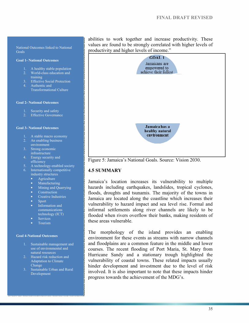
abilities to work together and increase productivity. These values are found to be strongly correlated with higher levels of productivity and higher levels of income.”
Figure 5
4.5
Jamaicahazards including earthquakes, floods, Jamaica are located along the coastline which increases their vulnerability to hazard impact and sea level rise. Formal and informal settlements along river channels are likely to be flooded when rivers overthese ar The morphology of the island provides an enabling environment for these events as streams with narrow channels and floodplains are a common feature in the middle and lower courses. The recent flooding of Port Maria, St. Mary Hurricanevulnerability of coastal towns. These related impacts usually hinder development and investment due to the level of risk involved. It is also important to note that these impacts hinder progress towar
National Outcomes linked to National Goals
Goal 1- %ational Outcomes
1. A healthy stable population 2. World-class education and
training 3. Effective Social Protection 4. Authentic and
Transformational Culture
Goal 2- %ational Outcomes
1. Security and safety 2. Effective Governance
Goal 3- %ational Outcomes
1. A stable macro economy 2. An enabling business
environment 3. Strong economic
infrastructure 4. Energy security and
efficiency 5. A technology-enabled society 6. Internationally competitive
industry structures
• Agriculture
• Manufacturing
• Mining and Quarrying
• Construction
• Creative Industries
• Sport
• Information and communications technology (ICT)
• Services
• Tourism
Goal 4-%ational Outcomes
1. Sustainable management and use of environmental and natural resources
2. Hazard risk reduction and Adaptation to Climate Change
3. Sustainable Urban and Rural Development
FI%AL DRAFT REVISED
abilities to work together and increase productivity. These values are found to be strongly correlated with higher levels of productivity and higher levels of income.”
Figure 5: Jamaica’s National Goals. Source: Vision 2030.
4.5 SUMMARY
Jamaica’s location increases its vulnerability to multiple hazards including earthquakes, landslides, tropical cyclones, floods, droughts and tsunamis. The majority of the towns Jamaica are located along the coastline which increases their vulnerability to hazard impact and sea level rise. Formal and informal settlements along river channels are likely to be flooded when rivers overflow their banks, making residents of these areas vulnerable.
The morphology of the island provides an enabling environment for these events as streams with narrow channels and floodplains are a common feature in the middle and lower courses. The recent flooding of Port Maria, St. Mary Hurricane Sandy and a stationary trough highlighted the vulnerability of coastal towns. These related impacts usually hinder development and investment due to the level of risk involved. It is also important to note that these impacts hinder progress towards the achievement of the MDG’s.
DRAFT REVISED
35
abilities to work together and increase productivity. These values are found to be strongly correlated with higher levels of
Vision 2030.
increases its vulnerability to multiple tropical cyclones,
ajority of the towns in Jamaica are located along the coastline which increases their vulnerability to hazard impact and sea level rise. Formal and informal settlements along river channels are likely to be
, making residents of
The morphology of the island provides an enabling environment for these events as streams with narrow channels and floodplains are a common feature in the middle and lower courses. The recent flooding of Port Maria, St. Mary from
Sandy and a stationary trough highlighted the vulnerability of coastal towns. These related impacts usually hinder development and investment due to the level of risk involved. It is also important to note that these impacts hinder
FI%AL DRAFT REVISED
36
The rainfall pattern in Jamaica is marked by bi-modal peaks in May and October which are defined as the two rainy seasons. Dry conditions usually occur over the period of November to April and results in problems related to water availability and access. An increasing population, location of communities and distribution challenges hinders equitable distribution of water across the island especially during droughts. However, annual rainfall totals might be influenced by tropical cyclones passing over or near the island in a given year. These systems replenish the aquifers and major catchments on which the population depends heavily. It is important to consider the potential impacts of climate change as temperatures and rainfall patterns will be affected. This may result in variable rainfall which can increase the pressure on the existing water system of the country thereby limiting access to water among a greater percentage of the population. Competition from other sectors such as agriculture and tourism should also be considered. Jamaica is currently facing a number of challenges as it relates to its population namely- there is an increase in its ageing population, a decrease in its younger population and the issue of migration which has negatively impacted the population growth, structure and characteristics. As a result Jamaica’s “changing population profile points to the need for greater concentration on programmes for the elderly, and eventually a levelling in the requirements for infrastructure for children and youth” (Vision 2030 p.40) as Jamaica begins to grapple with its ageing population. Jamaica’s working age and elderly population will constitute a higher proportion of the population as a result of declines in fertility and mortality rates and emigration of our younger population. Evidence of aging is seen when increases in the median age are observed over time as indicated previously. . Disasters affect the quality of life of every resident of Jamaica and reaches into areas as diverse as public health and economic growth. In addition, the destruction or degradation of Jamaica's natural assets may reduce the opportunities and choices available for future generations. The Government has established DRM/sustainable development as a national priority, and recognises that many aspects of DRM/sustainable development are more appropriately managed through decentralization where private sector, NGOs, or community groups do their part under the coordinating of central and local government. Vision 2030 objectives, medium term and long term goals can only be accomplished through partnerships at every level of the Jamaican society. The global economy has far reaching effects all around the globe, Jamaica is not immune. As a result negative impacts will continue to be experienced such as limited access to capital markets, and unemployment, disruption in social development plans and meeting MDG targets are only some of the issues Jamaica will have to grapple with (Vision 2030). Additionally, Jamaica’s declining GDP, increasing debt, poverty, weak economic performance, issues of justice, brain drain, limited resources, lack of transparency, declining environmental health, increased vulnerability to disasters and climate change are some other issues to consider. However, it is within this context that the Government has developed this policy document and has set out a clear path to achieving the goals of getting Jamaica to developed world status by 2030.

FI%AL DRAFT REVISED
37
Achieving the national outcomes will be no easy task; political will and action will be key ingredients to Jamaica’s success.

FI%AL DRAFT REVISED
38
5. THE COU%TRY’S DISASTER RISK REDUCTIO% LEGAL A%D
I%STITUTIO%AL FRAMEWORK
5.1 LEGAL FRAMEWORK
Jamaica has several laws and other legal provisions that delineate the reach, structure, functions, roles and responsibilities for organisation/agencies involved in DRR. These laws and legal provisions provide operational and administrative guidelines for reducing disaster related risks. In addition, they are used by the leading agency, its members, and inter-sectoral committees. Jamaica’s main legal authorities relating to disaster risk reduction and emergency management are constitutional and statutory. The Constitution of Jamaica is the main constitutional reference while the Disaster Preparedness and Emergency Management Act (1993) and the Emergency Powers Act (1938) are the main statutes of reference (CELP 2010).
5.1.1 CO%STITUTIO%
The Constitution of Jamaica, developed in 1962, highlights the constitutional authority outlined in Chapter III and speaks to the enforcement of protective provisions and outlines the role of the appointed officials. Chapter III, Section 26 identifies particular events such as major hurricanes and earthquakes as events that can warrant a state of emergency being declared. The limited (30 days) state of emergency can be declared by the Governor General based on the decision of the Cabinet. This initial thirty (30) days can be extended for up to twelve (12) months by a resolution and majority vote of all the members of the House of Representatives (CELP 2010). Similarly, the state of emergency can be revoked with a resolution and majority vote of all the members of the House of Representatives.
5.1.2 LAWS and LEGALLY BI%DI%G PROVISIO%S
As it relates to statutory authority in Jamaica, the Emergency Powers Act (1938) reflects Chapter III of the Constitution and allows the Governor General to make Regulations during a public emergency. This ensures that life and property, both nationally and locally, as well as essential supplies are protected. Under the Emergency Powers Act (1938), the Governor General, if necessary can give any Government Department such powers as necessary during an emergency or disaster event. The Disaster Preparedness and Emergency Management (DPEM) Act (1993) outline guidelines for the development and operation of ODPEM along with its response mechanisms. It gives limited power to the Prime Minister in making disaster declarations including declaring certain areas - disaster zones. The limited power can be exercised by the prime Minister during disaster events or an impending threat based on the advice of ODPEM. This is important as prior to development of the DPEM Act, the Emergency Powers Act was used during disasters. The DPEM Act allows the government to declare disaster areas without having to resort to the Emergency Powers Act. The revised

FI%AL DRAFT REVISED
39
Disaster Management Act will provide guidelines for the declaration of disaster areas, and evacuation orders. It will also give power to ODPEM to create regulations in disaster management and gives legal standing to authorities and documents pertaining to disaster management. A project addressing improvement in the legal framework for international disaster assistance is currently underway. As part of this project, a review of all legislation relating to disaster response is being done. Some preliminary findings from this study are (i) that the national disaster plan is not enshrined in law and is therefore open to administrative changes (ii) there is need for harmonization among the national plan and external plans such as the UN Cluster-based plan as well as among sectoral plans, (iii) operational experiences are not captured in the plan as these plans are not regularly updated. The Kingston and Saint Andrew Corporation Act (1931) outlines “provisions of the KSAC, defines its functions and powers, provides for election in the Corporate Area (as defined in Schedule 1), provides for the organisation and administration of the Corporation and its property and provides for various other matters related to the Corporation and its operations8.” The Act also incorporates regulations on health and environmental issues in which the Corporation can impose penalties/sanctions for particular offences that may or may not influence disaster related risks. The Defence Act (1962) governs the actions, procedures and operations of the Jamaica Defence Force (JDF). The Act outlines the development of the regular and reserve forces along with their names. It also outlines the duties of the Defence Board as defined by the Act and charges the JDF with the defence and maintenance order of Jamaica9. The JDF is deployed during the public state of emergency once declared by the Governor General to ensure that public order is maintained. The Fire Brigade Act (1988) and the Country Fire Act (1942) provide frameworks geared toward reducing risk related to fire hazards. The Fire Brigade Act (1988) governs the establishment and operation of the Jamaica Fire Brigade which aims to minimize loss of lives, injury to persons and damage to property from fires, natural disasters, accidents and other emergencies as necessary10. The Country Fire Act (1942) empowers the Minister to prohibit open fires to crop or trash especially at night. The Act outlines punishment of offences and highlights the negligent use of fire. The Ministry of Local Government and Community Development is governed and operated by legislation such as the Parish Councils Act 1887 (which governs the actions, procedure and operations on the Parish Councils), the Parochial Rates and Finance Act
8 Information was obtained from: http://faolex.fao.org/cgi-bin/faolex.exe?rec_id=071880&database=faolex&search_type=link&table=result&lang=eng&format_name=@ERALL 9 Information was obtained from: http://jdfmil.org/FAQs/faqs8.php 10 Information was obtained from: http://www.jamaicafirebrigade.org/missn.html

FI%AL DRAFT REVISED
40
1900 (governs revenue generation), the Kingston City Corporations Act 1923 (provides provision for the KSAC), the Poor Relief Act 1867 (governs the distribution of poor relief) and the Municipalities Act 2003 (facilitated the creation of the Portmore Municipal Council)11. The Buildings Act 2011 was created to ensure safety in the building environment by the Parish Council. The local government is responsible for the development and maintenance of parochial infrastructure and poor relief where necessary. The provision of essential services such as water supply, environmental health, sanitation and development control is shared with the central government. The local government is assisted by the Jamaica Fire Brigade (fire prevention and control); the National Solid Waste Management Authority (solid waste collection and disposal) and the Board of Supervision (poor relief/welfare services; and the Vineyard Town Golden Age Home). These agencies are assigned different roles and responsibilities aimed at reducing associated risks. The Water Resources Act (1995) outlines the responsibility for planning, development and equitable allocation of water resources of the Water Resource Authority (WRA). The Act gives power to the Minister to guarantee loans to the WRA where needed. Provisions for the abstraction and use of water, control of water quality, control and protection of underground water are all outlined (WRA 1995). The Act allows for punishment of persons who dispose of sewage (especially in limestone areas) and industries with hazardous effluent discharges that would significantly affect water quality. The Act also has provisions dealing with health issues such as dysentery and cholera that are caused from sewage contamination. The Town and Country Planning Act (1958) provides guidelines for land use based on legal instruments known as Development Orders which covers most of the urban and coastal areas of Jamaica. “Development Orders are to control both rural and urban development, ensure proper sanitary conveniences, coordinate building of roads and other public services, and protect public amenities (conservation areas, wetlands, mangroves)”12. The Act outlines specific standards for land use, density and zoning in reducing disaster related risks. The National Solid Waste Management Act (2002) governs the actions, procedures and operations of the National Solid Waste Management Authority (NSWMA) as it relates to the collection and disposal of waste in safeguarding public health. The Act also highlights operational guidelines for hazardous waste as a transboundary hazard. Sanctions are incorporated into the Act and enforcement is the responsibility of various organisations/agencies. The Public Health Act (1974) outlines the provisions and guidelines for the establishment of the Central Health Committee and Local Boards to contain and treat various diseases.
11 Information was obtained from: http://www.clgf.org.uk/userfiles/1/files/Jamaica%20local%20government %20 profile%202011-12.pdf 12 Information was obtained from: http://www.nepa.gov.jm/eias/Kingston_Container_Terminal/chapter9.htm

FI%AL DRAFT REVISED
41
The immunization of children is a major feature of the Act based on their vulnerability to particular diseases. The Act also requires updating of the immunization certificate of children. The Act empowers the Minister to prohibit the assembly of persons and/or to order the closure of public places or schools if necessary (PHA 1985). In 1985, the Act was amended to include monitoring of imported food, food preparation and distribution. Hazard Analysis Critical Control Point (HACCP) system is a procedure utilized by the Ministry of Health to ensure safe food production. Penalties can be applied where provisions and guidelines are not adhered to. The National Resources Conservation Authority (NRCA) Act (1991) was established to protect and manage Jamaica’s natural resources and control pollution. The guidelines provided by this Act cover monitoring and enforcement of environmental laws and regulations with regards to watershed protection and beach control among other issues. “The Environmental Control Division (ECD) of the Ministry of Health and local planning authorities monitor construction work to ensure that all development restrictions and requirements are properly adhered to”13. Sanctions and penalties can be assigned to particular offences based on breaches of the Act. The Parish Building Regulation and Development Orders outline and guide the development process in Jamaica. The Parish Building Regulations provide guidelines to developers based on the existing building codes. The Parish Development Orders are used to ensure that premises in areas of the parish are not used contrary to the purpose provided by developers and residents. Other regulatory and related instruments pertaining to DRR include but are not limited to the Severe Weather Orders, Draft National Building Codes, and international legislative considerations and guidelines. The building code has been updated and awaits passing into law. Although the code has not been passed into law, local authorities are able to enforce building regulations under the Building Act. However as many buildings are constructed without official approval, there are a number of structures which have not benefitted from technical inputs and which do not adhere to the building code or regulations. The drawback is an inadequate number of trained building inspectors at Parish Councils. Few Parish Councils employ structural engineers.
5.2 POLICY FRAMEWORK
Several policies and action plans have been established and utilized within the DRR framework in Jamaica. Based on the impacts of recent hazards, Jamaica has given more focus to DRR by revising and updating the disaster management policies, frameworks and plans.
The National Hazard-Risk Reduction Policy (NHRP) was developed to address the issue of hazard-risk reduction and its relevance to development. The DPEMA (1993) and the
13 Information was obtained from http://www.nepa.gov.jm/eias/Kingston_Container_Terminal/chapter9.htm

FI%AL DRAFT REVISED
42
draft Hazard Mitigation Policy (1999) provided the focus needed on hazard-risk reduction and outlined the pathway for the NHRP. The NHRP provides “a framework for integrating hazard mitigation into all policies, programmes and plans at the national and community levels” (NHRP 2005, p. 4). A key aspect of the CDM strategy, mitigation, is integrated into the policy.
The National Disaster Fund (NDF) offers recovery support after the occurrence of major hazard events. The NDF is managed by the Finance and Administration Sub-committee of the National Disaster Committee which is responsible for the growth and disbursement of the fund through ODPEM (CELP 2010). Funds are usually disbursed for relief and early recovery efforts.
The National Disaster Relief Policy (NDRP) was developed after Hurricane Gilbert in 1988 and highlighted the need for relief support to victims; the Emergency Shelter/Welfare Action Plan for Jamaica, the Relief Clearance Plan, the Overseas Assistance Plan and the Logistics Plan were therefore written in support of the policy. The Action Plan provided operational procedures and guidelines to the government and other sectors in responding to victims of disasters. The concept of relief and welfare management was tested after the earthquake in 1993 in which supplies were distributed at the parish level. Further development in 1995 by the National Welfare/Shelter Sub Committee saw the creation of the document which included victims of minor floods, earthquakes and landslides (NDRP 1995). The DRP defines the roles of emergency management agencies during the recovery stages of a disaster, type and range of assistance given to the impacted, and guidelines for access to short and long term assistance.
The regional framework for achieving resilience to climate change in the Caribbean was developed in 2009 by CCCCC which provides technical assistance to member states such as Jamaica. Several strategies and programmes are outlined within the framework and provide strategic direction for action over the period 2009-2015 by establishing directions to build resilience to climate change among CARICOM states including multi-sector roles (CCCCC 2009). Also, Jamaica is in the process of developing a national framework and communication strategy on climate change to increase awareness and reduce the impacts related to climate change.
The Draft National Climate Change Policy and Action Plan (2012) was developed by the Ministry of Water, Land, Environment and Climate Change (MWLECC) and includes actions relating to DRR. The policy aims to “enhance the resilience and adaptive capacity of Jamaica to cope with climate change impacts and mitigate the causes of climate change in a coordinated, effective and sustainable manner” (MWLECC 2012, p.6). The draft CC policy highlights future threats from climate related hazards and potential impacts in Jamaica on vulnerable sectors such as agriculture, health, energy and tourism as well as key resources such as water. It is important to note that the CC policy is aligned with Goal 4 of Jamaica’s Vision 2030 National Development Plan: “Jamaica has a Healthy Natural Environment” in order to achieve developed country status by 2030 (MWLECC 2012).

FI%AL DRAFT REVISED
43
5.3 I%STITUTIO%AL FRAMEWORK
5.3.1 ORGA%ISATIO% OF THE %ATIO%AL SYSTEM
The institutional Framework for DRM is based on a three tiered system – national level, parish level and community level. The general structure is that of a committee divided into sub committees which function as working groups. This structure is adjusted to the level at which it is being implemented. The head of government, Prime Minister has ultimate responsibility for DRM in Jamaica; s/he is the Chair of the National Disaster Committee (NDC) which is the body responsible for approving policy and strategic plans for DRM. The Minister with portfolio responsibility for DRM is the Vice-Chair of the NDC. ODPEM provides secretariat services to the NDC and the Director General of ODPEM is designated as National Disaster Coordinator. The National Disaster Committee is divided into six sub-committees. Health – chaired by the Ministry of Health, Emergency Operations, Communications and Transport chaired by the Jamaica Fire Brigade, Public Information and Education chaired by the Jamaica Information Service, Administration, Finance and Planning chaired by the Ministry of Finance, Welfare, Shelter and Relief chaired by the Ministry of Labour and Social Security and Damage Assessment, Recovery and Rehabilitation chaired by the Ministry of Transport. Membership of these committees includes public and private sectors, NGOs and donor partners. These committees contribute to policy, programme and plan development, review plans and give technical guidance where necessary. Members of the NDC are drawn from the public and private sectors, donor partners, NGOs and faith-based groups. The NDC meets at least once per year to review the status of the country’s disaster risk management programme. It can also be convened as required by the Prime Minister. Importantly The composition of the NDC and its sub-committees and its comprehensive mandate encompassing all aspects of DRM reflect the integrated approach to DRM practised in Jamaica. DRM in each parish is managed by a Parish Disaster Committee which mirrors the National Disaster Committee in its composition. The PDC is chaired by Custos or Mayor of the parish. Each parish appoints a Parish Disaster Coordinator who has day to day responsibility for the parish programme and acts as liaison with ODPEM. The structure at community level varies, but generally community based disaster risk management groups (CBDRM) are encouraged to elect a chair, vice chair, secretary and treasurer. The final structure depends on the resources available in the community; sub-committees for public education and training, communications and transport and welfare are usually established. Community groups are also responsible for community early warning systems where these exist.

FI%AL DRAFT REVISED
44
The Office of Disaster Preparedness and Emergency Management (ODPEM)
The national DRM programme is led by the Office of Disaster Preparedness and Emergency Management (ODPEM) which by law is assigned responsibility for coordinating DRM in Jamaica. The national system designates lead agencies or organisations which assume responsibility for appropriate subject areas. ODPEM leads the process of development and implementation of the national DRM programme. Additionally, it leads the process in developing national policies, plans and the development and revision of DRM legislation.
Government Ministries
Government Ministries retain responsibility for management of DRM matters under their portfolios. Each Ministry is represented on the National Disaster Committee by its Permanent Secretary or designate. Government Ministries are responsible for integrating DRR into their programmes and plans. Scientific and Technical Agencies
These agencies are represented on the National Disaster Committee and its sub-committees. Generally, they are responsible for forecasting and warning, hazard mapping, risk analysis, scenario development, development and updating of building codes and zoning laws as well as technical support for response operations. First Responders
The Jamaica Fire Brigade, the Jamaica Constabulary Force, the Jamaica Defence Force and the Ministry of Health lead responses during hazard events. Private Sector
The private sector ensures that business continuity plans are in place and lends support to ODPEM and the NDC, often providing sponsorship for certain aspects of the national DRM programme. !on-Governmental Organisations (!GOs)
A variety of NGOs are involved in interventions and training mainly at the community level. The Jamaica Red Cross and the Adventist Disaster Relief Agency are both part of the Welfare Team in place for disaster response. Donor Partners
Donor partners give support to the national programme, usually through grants and soft loans. The United Nations Development Programme (UNDP) acts as coordinator for the donor and international communities. Community Based Organisations (CBOs)
Community Based Organisations including community-level preparedness and response teams carry out CBDRM programmes at the community level. Community-based DRM

FI%AL DRAFT REVISED
45
groups are monitored by the Parish Disaster Committees but also receive support from ODPEM. Academic Institutions
These carry out research and provide technical support to ODPEM in the area of DRR in Jamaica.
Disaster Risk Reduction and Climate Change Adaptation Jamaica recently announced the establishment of a Ministry with responsibility for Climate Change, which is separate from the Ministry with responsibility for DRM. However under the country’s National Development Plan – Vision 2030 – a national working group on Hazard Risk Reduction and Climate Change Adaptation (HRR-CCA) was established to coordinate interaction in these areas. The working group is jointly chaired by ODPEM and the National Meteorological Service, and includes representation from academia, NGOs, the public sector and donor partners. Vision 2030 enunciates four national strategies for Hazard Risk Reduction and Climate Change Adaptation. These are:
• Improve resilience to all forms of hazards • Improve emergency response capability • Develop measures to adapt to climate change • Contribute to the effort to reduce the global rate of climate change
These are to be achieved by sector strategies including:
• Use of predictive tools for modeling, hazard mapping and risk assessment • Modernising the legal framework • Inclusion of hazard risk reduction in the education curricula and research agenda • Incorporate hazard risk reduction in environmental and natural resources
management • Establish mechanisms for increasing resilience of the poor and most vulnerable • Establish measures to incorporate hazard risk reduction in land-use practices and
human settlements • Design human settlements that are not vulnerable to hazards based on
construction and rehabilitation techniques that enhance the long term usability Other strategies include inclusion of civil society and the private sector and promotion of business continuity planning, regulation of hazard materials, expansion of early warning systems, among others. In 2011 Sector Planning Workshops were convened to prepare the new Medium Term Socio-Economic Policy Framework 2012-2015. The HRR-CCA Thematic Working Group was part of the planning process and priorities for HRR and CCA were included.

FI%AL DRAFT REVISED
46
The importance of the DRR-CCA nexus is recognised as many projects include both climate change adaptation and disaster risk reduction elements. For example the PIOJ recently successfully submitted a project to the Adaptation Fund which addresses livelihoods security for small farmers comprising elements such as provision of water for irrigation, improved land husbandry and soil management techniques as well as development of disaster risk reduction plans taking into account climate variability and climate change. Table 4 shows a list of select CCA-DRR related projects. Table 4: Climate Change Adaptation and Disaster Risk Reduction Projects.
Projects and
Programmes
Objectives and Outcomes Potential Synergies overlaps with the
AF Programme
Climate Change Adaptation and Disaster Risk Reduction (CCADRR) Project GOJ/EU/UNEP 2010-2013
Objective: To adapt to climate change and contribute to sustainable development in Jamaica, particularly in vulnerable communities, through increasing resilience and reducing risks associated with natural hazards Results: 1. Rehabilitated watersheds through
slope stabilization measures such as reforestation of denuded hillsides
2. Increased resilience of selected coastal areas against potential climate change impacts
3. Climate change capacity building and awareness raising
This project will undertake complementary activities in Negril as outlined in the Negril Plan of Action. Among the activities are installation of data loggers for monitoring important variables, restoration of seagrass beds and restoration of coral reefs. The AF Programme activities fall under the Plan of Action, so all the activities are complementary. Restoration of seagrass and coral. RiVAMP II to begin identifying the impact of the terrestrial activities on the ecosystem.
Capacity Building for Sustainable Land Management (UNDP-GEF) 2010-2012 (30 months)
Objective: To enhance effective sustainable land management (SLM) by building capacities for SLM in appropriate government and civil society institutions and user groups and mainstreaming SLM into government planning and strategy development. Outcomes: 1. SLM is mainstreamed into
national institutions, policies, strategies and plans
2. Capacity for management, application and adaptation of SLM is enhanced
3. Effective management and adaptive learning is achieved.
Project will provide learning for the Ministry of Agriculture and RADA officers and guidance to the capacity building proposed under the AF programme.
Coastal Multi-Hazard Mapping & Vulnerability assessments towards
Objectives include: Complete Multi-Hazard Assessment & develop multi-Hazard Maps; carry out vulnerability & risk assessments; Produce
This recently concluded study focused on three communities which were severely impacted in past storm events, particularly Hurricane Dean in 2007.
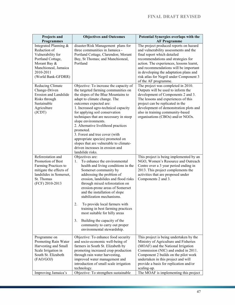
FI%AL DRAFT REVISED
47
Projects and
Programmes
Objectives and Outcomes Potential Synergies overlaps with the
AF Programme
Integrated Planning & Reduction of Vulnerability for Portland Cottage, Morant Bay & Manchioneal, Jamaica 2010-2011 (World Bank-GFDRR)
disaster/Risk Management plans for three communities in Jamaica - Portland Cottage, Clarendon; Morant Bay, St Thomas; and Manchioneal, Portland
The project produced reports on hazard and vulnerability assessments and the final report which detailed recommendations and strategies for action. The experiences, lessons learnt, and recommendations will be important in developing the adaptation plans and risk atlas for Negril under Component 3 of the AF programme.
Reducing Climate Change-Driven Erosion and Landslide Risks through Sustainable Agriculture (JCDT)
Objective: To increase the capacity of the targeted farming communities on the slopes of the Blue Mountains to adapt to climate change. The outcomes expected are: 1. Increased agro-technical capacity for applying soil conservation techniques that are necessary in steep slope environments. 2. Alternative livelihood practices promoted. 3. Forest and tree cover (with appropriate species) promoted on slopes that are vulnerable to climate-driven increases in erosion and landslide risks.
The project was completed in 2010. Outputs will be used to inform the development of Components 2 and 3. The lessons and experiences of this project can be replicated in the development of demonstration plots and also in training community-based organisations (CBOs) and/or NGOs.
Reforestation and Promotion of Best Farming Practices to mitigate the effects of landslides in Somerset, St. Thomas (FCF) 2010-2013
Objectives are: 1. To enhance the environmental
health and living conditions in the Somerset community by addressing the problem of erosion, landslides and flood risks through mixed reforestation on erosion-prone areas of Somerset and the installation of slope stabilization mechanisms.
2. To provide local farmers with training in best farming practices most suitable for hilly areas
3. Building the capacity of the community to carry out proper environmental stewardship.
This project is being implemented by an NGO, Women’s Resource and Outreach Centre over a 3 year period ending in 2013. This project complements the activities that are proposed under Components 2 and 3.
Programme on Promoting Rain Water Harvesting and Small Scale Irrigation in South St. Elizabeth (FAO/GOJ)
Objective: To enhance food security and socio-economic well-being of farmers in South St. Elizabeth by promoting increased crop production through rain water harvesting, improved water management and introduction of small scale irrigation technology.
This project is being undertaken by the Ministry of Agriculture and Fisheries (MOAF) and the National Irrigation Commission (NIC) and ended in 2011. Component 2 builds on the pilot work undertaken in this project and will provide a basis for replication and/or scaling-up.
Improving Jamaica’s Objective: To strengthen sustainable The MOAF is implementing this project

FI%AL DRAFT REVISED
48
Projects and
Programmes
Objectives and Outcomes Potential Synergies overlaps with the
AF Programme
Agricultural Productivity (GOJ/CIDA)
agriculture productivity in Jamaica by improving the productivity of Jamaican farmers and fisher folks, through the use of more durable greenhouses and improved environmental management in small scale fisheries. Components: 1. Green-house development 2. Beach rehabilitation component
with funding from the Canadian International Development Agency (CIDA). Outputs and outcomes will be incorporated in the development of relevant components of the AF programme.
Rain Water Harvesting (RWH) (WRA)
Objective: To increase awareness of government and the public as to the potential for RWH as a sole water supply source in areas of Jamaica presently without access to water and as an augmentation source in areas regularly affected by drought
This project, which is being implemented by the Water Resources Authority (WRA), will provide useful information for Component 2 of the programme.
Risk and Vulnerability Assessment Methodology Project (RiVAMP) (UNEP)
Objective: The pilot testing of a methodology that takes environmental factors into account when analysing disaster risk and vulnerability, with special focus on climate change
Negril was selected for the pilot site based on the state of ecosystems, human-based activities, climate change factors, socio-economic vulnerability and environmental governance. The AF programme will implement recommendations of the RiVAMP study. Furthermore, Phase II of this project will be undertaken; the coastal ecosystems as well as the Negril/Orange River watershed will be addressed. Initial funding is made under the CCADRR Project.
Pilot Program for Climate Resilience (PPCR)
In the design stage. To establish Climate Information Platform through which range of information will be made available and facilitate awareness building and make resources available to finance adaptation at the community level
Consistent with priority sectors identified under the PPCR. Expected to produce downscaled climate scenarios that will improve climate change planning in the project areas.
Assistance to Improve Local Agricultural Emergency Preparedness in Caribbean Countries (GOJ, FAO)
Project Goal: To contribute to community based disaster management planning and community level risk management within the agricultural sector through, among other things: i) Improvements in institutional frameworks and technical options for hurricane-related disaster preparedness. ii) Emergency response and post-emergency agricultural assistance.
The project was completed in 2008. The Rural Agriculture Development Authority (RADA) was an important partner in the project. The lessons learnt and experiences gained will be incorporated in the AF programme, particularly as RADA will be an important partner in its development and implementation.
Negril Beach Restoration Programme
Objective: To implement measures that will mitigate against further coastal erosion of the Negril area, by
Comprehensive programme for the rehabilitation of the Negril Coastline inclusive of detailed sand surveys
FI%AL DRAFT REVISED
49
Projects and
Programmes
Objectives and Outcomes Potential Synergies overlaps with the
AF Programme
NEPA/GOJ
implementing appropriate coastal restoration/rehabilitation works.
(building on previous studies); installation of hard engineering structures(including breakwaters, etc.) based on outputs of surveys; and rehabilitation of coastal and marine ecosystems (including seagrass beds, mangroves) Component 1 of the AF concept will implement an element of the programme. The remaining elements will be implemented on a phased basis as funds become available.
Rehabilitation of the Negril Wastewater Treatment Plant GOJ/EU (12-month commenced February 2011)
Objectives: Raising and connecting the embankments of the stabilisation ponds; installing flow control devices; improving the outlet structure Outcome: preservation of the coastal, natural environment; improved quality of the sea water and beaches; growth in aquatic biodiversity; and improved sanitary condition in the local communities
This project directly complements Component 1 as it addresses some of the human-based activities which contribute to the degradation of the ecosystems in Negril.
Increasing the Resilience of Coastal ecosystems to Climate Change
Replanting of sea-grass and mangroves Installation of data loggers to record sea surface temperatures Preparation of a management plan for the marine protected area
Reducing beach erosion Baseline data recording Sustainable natural resource management practices
Marketing and Agriculture for Jamaican Improved Competitiveness (MAJIC) (ACDI/VOCA)
Advancing the development of a modern, efficient and internationally competitive agricultural sector in Jamaica through support to specific crops.
Farmer Field Schools methodology Climate change awareness programme and risk reduction planning
Source: PIOJ and DRRC 2012.
5.3.2 %ATIO%AL PLA%S A%D THEIR IMPLEME%TATIO%
The National Disaster Plan provides the framework for mitigation, preparedness, response and recovery for hazards to which Jamaica is exposed (NDP 1997). Although the NDP provides guidelines for disaster management in Jamaica, there is still need for a comprehensive policy on disaster management. There are several Sub Plans of the National Disaster Plan, these include but are not limited to the following:
• National Hurricane Plan
• National Earthquake Plan

FI%AL DRAFT REVISED
50
• National Drought Management Plan
• National Oil and Hazardous Materials Spill Plan
• National Aircraft Crash Plan
• Hazardous Materials Response Plan
• Joint-Portmore Evacuation Plan
• National Fire Management Plan
• National Damage Assessment Plan
• National Mass Casualty Plan
• Major Epidemic Plan
• National Animal Diseases Plan
• Recovery Plan
• Overseas Assistance Plan
• Hazard Response Plans
• Shelter and Welfare Plan and Policy
• Parish Disaster Plans
• Community Disaster Plans
• National Influenza Pandemic Preparedness Plan
Under the CBDRM programme, community DRM groups develop their community plans. ODPEM provides a model plan which communities use as a guide in writing their plans. A notable omission from the NDP is a plan covering continuity of government after a major disaster.
Operational Framework
Management of Emergencies and Disasters is coordinated by Emergency Operations Centres (EOCs) staffed by multi-organisational teams. At the national level the National Emergency Operations Centre (NEOC) is located at ODPEM headquarters. At the parish level the Parish Emergency Operations Centres (PEOCs) are located at the offices of the Parish Councils. Representatives of public and private sectors, NGOs and CBOs comprise the teams which manage impact of hazard events in Jamaica.
Structure
The EOC is managed by an EOC Director which at national level is an ODPEM senior staff member. The EOC Staff is divided into six groups:
1. Health and Welfare coordinated by the Ministry of Health and Ministry of Social
Security
2. Public Utilities coordinated by the Ministry of Works
3. District Committees coordinated by a District Coordinator (ODPEM)
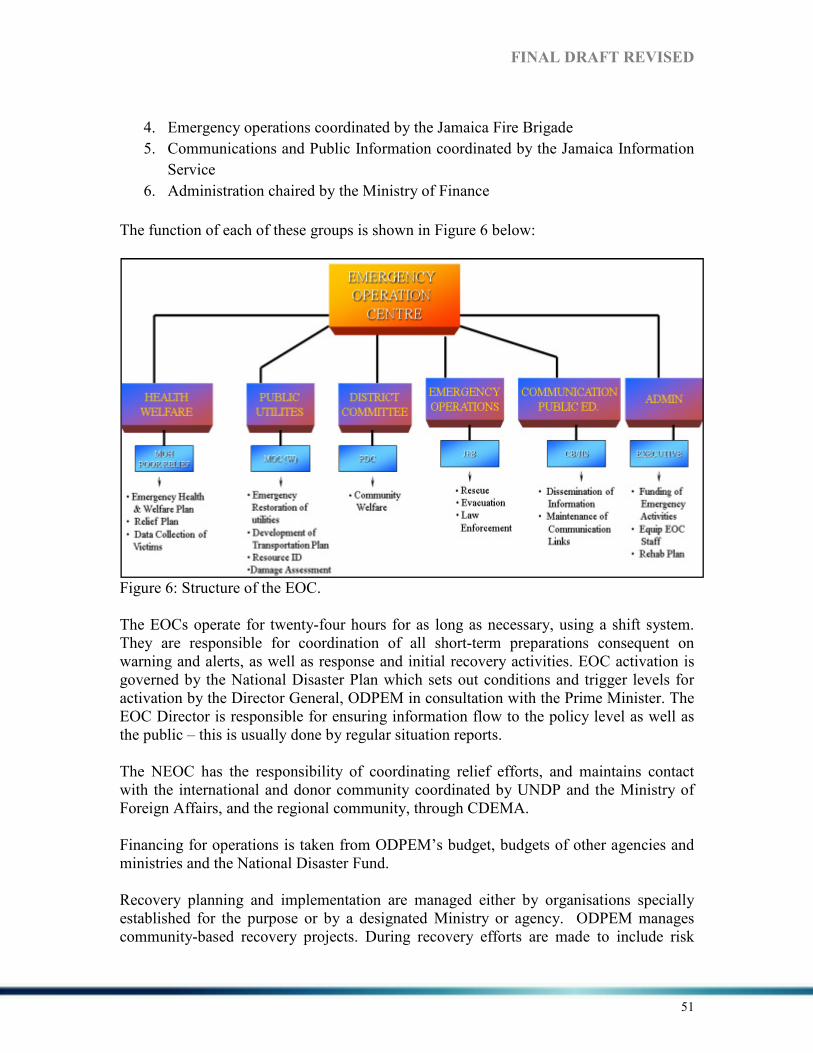
FI%AL DRAFT REVISED
51
4. Emergency operations coordinated by the Jamaica Fire Brigade
5. Communications and Public Information coordinated by the Jamaica Information
Service
6. Administration chaired by the Ministry of Finance
The function of each of these groups is shown in Figure 6 below:
Figure 6: Structure of the EOC. The EOCs operate for twenty-four hours for as long as necessary, using a shift system. They are responsible for coordination of all short-term preparations consequent on warning and alerts, as well as response and initial recovery activities. EOC activation is governed by the National Disaster Plan which sets out conditions and trigger levels for activation by the Director General, ODPEM in consultation with the Prime Minister. The EOC Director is responsible for ensuring information flow to the policy level as well as the public – this is usually done by regular situation reports. The NEOC has the responsibility of coordinating relief efforts, and maintains contact with the international and donor community coordinated by UNDP and the Ministry of Foreign Affairs, and the regional community, through CDEMA. Financing for operations is taken from ODPEM’s budget, budgets of other agencies and ministries and the National Disaster Fund. Recovery planning and implementation are managed either by organisations specially established for the purpose or by a designated Ministry or agency. ODPEM manages community-based recovery projects. During recovery efforts are made to include risk

FI%AL DRAFT REVISED
52
reduction measures, such as ensuring that replacement roofs are designed to the correct pitch and built with hurricane straps, and that replacement housing sites undergo technical evaluations before being approved. There is no dedicated risk reduction or recovery fund. Funds for recovery must be taken from re-allocation of budgeted GOJ funds or external grants.
5.4 SUMMARY Several laws and other legal provisions are used by various agencies to achieve their roles and responsibilities in DRM/DRR. DRM/DRR programmes are led by ODPEM and guided by the Disaster Preparedness and Emergency Management Act (1993) which provides operational and administrative procedures for reducing disaster related risks as well as regional and international frameworks such as CDM and the HFA. The other legally binding provisions such as the Kingston and Saint Andrew Corporation Act (1931), the Defence Act (1962), the Fire Brigade Act (1988), the Country Fire Act (1942), Parish Councils Act (1887), Water Resources Act (1995), Town and Country Planning Act (1958), National Solid Waste Management Act (2002), Public Health Act (1974), National Resources Conservation Authority Act (1991), the Parochial Rates and Finance Act (1900), the Kingston City Corporations Act (1923), the Poor Relief Act (1867), the Municipalities Act (2003) and the Buildings Act (2011) provide support to the main legal authorities. However, the enforcement of these provisions is often lacking. Effective enforcement of these provisions is required for DRR to be achieved. In addition, coordination among and within the responsible agencies and organisations is lacking and in some instances to result in duplication. The formation of teams with trained inspectors and key persons with specific responsibilities should be facilitated to increase enforcement across the island. A number of the laws and other legal provisions identified can be considered as outdated. The DPEMA (1993) is currently being revised to address the gaps and challenges identified after its enactment based on the demands of a changing environment. “Shifts in government priority, changes in the parent ministry of the national disaster office caused a temporary lag in the review of the Bill” (ODPEM 2011a, p.5). The DPEMA revision will make it more applicable to changing disaster management practices as it does not address some elements of risk management, evacuation, no build zones and sanctions for breaches of the Act (ODPEM 2011a). Similarly, other laws and legal provisions should be revised especially where sanctions and fines for particular offences are concerned. In addition, laws and/or legal provisions awaiting enactment such as the National Building Code should be passed in to law. The research being done under the review of disaster-response related laws will identify gaps which should be addressed. The results of the research from this project should be useful in informing the revision of the current DPEM Act as well as other legislation. PFA 1 is aimed at ensuring that DRR is a national and local priority with a strong institutional basis for implementation. As highlighted, a legal framework for DRR exists
FI%AL DRAFT REVISED
53
with decentralized responsibilities and capacities at all levels. While progress has been made in DRR limitations such as financial resources and/or operational capacities have hindered such progress (ODPEM 2011a). However, continuous effort is being given to the integration of DRR into development plans and strategies to reduce risk. Varying policies, frameworks and action plans have been developed for Jamaica relating to DRM/DRR. These plans and policies outline procedures for pre and post hazard impact as well as recovery support. Most of these plans are utilized by ODPEM which the central authority during disaster events. The plans also address several of the hazards affecting Jamaica. The main agency and the supporting agencies/ organisations are identified along with their defined roles and responsibilities The NDP, the overarching plan related to DRM/DRR in Jamaica, is more than 15 years old and requires updating to address pertinent issues such as the relocation of informal settlements, evacuation of vulnerable groups (children below 15 years, elderly over 65 years and the disabled) and communities during hazard events and the related impacts of climate change. It is important to note that the Hazard Mitigation Policy has been drafted since 1999 and is yet to be fully implemented. However several projects and programmes on DRR and CCA have been implemented. The NHRP provides support to the NDP at all levels including the community, parish and national level. Community level mitigation projects have focused on the building of resilient communities, preparedness and emergency response teams and support to CBDRM. Parish level mitigation projects have focused on DM training for Parish Councils and hazard/risk assessments and hazard mapping in several parishes. The national level projects have focused on natural hazard management in urban coastal areas that are vulnerable to multiple hazards. ODPEM encourages partner agencies and organisations to incorporate mitigation into their planning activities. Although the NHRP is successful is addressing some of the key areas related to risk reduction, the policy has not been disseminated on a large scale. However, ODPEM “has been implementing a three year strategic plan for DRR. This strategy while comprehensive is not fully integrated in key sectors and agencies” (ODPEM 2011a, p.6) The National Pandemic Plan and the National Framework for Pandemic Management are important in addressing health-related threats and airborne diseases. Within the framework of the national plan, work is on-going at the parish level to develop pandemic plans in Westmoreland, Hanover and St. James. Efforts will be made to ensure that pandemic plans are also developed for the eastern parishes including St. Thomas, St. Mary and Portland. Substantial achievement has been attained with regards to mechanisms for DRM, disaster preparedness plans and contingency plans but efforts are limited by challenges such as financial resources and/or operational capacities of agencies. National plans and sub plans have been developed to address key areas of the disaster cycle such preparedness, prevention, mitigation, recovery and response.

FI%AL DRAFT REVISED
54
The draft Climate Change Policy and Action Plan developed by the MWLECC is currently receiving feedback from stakeholders. Jamaica is a signatory to the United Nations Framework Convention on Climate Change (UNFCCC) and its Kyoto Protocol geared at reducing GHG emissions (MWLECC 2012). However, Jamaica is a non-Annex 1 country and does not have GHG restrictions or targets under the Kyoto Protocol. The draft policy assess future threats and potential impacts of climate change in Jamaica while highlighting the vulnerability of key sectors such as agriculture, health and tourisms as well as key resources such as water and land. The institutional framework highlights key stakeholders such as the Meteorological Office of Jamaica, ODPEM, PIOJ, WRA and the Climate Studies Group Mona (CSGM) that are equipped to monitor, mitigate and respond to potential climate change impacts. Challenges facing Jamaica in addressing climate change in the short, medium and long-term were identified and discussed within the policy. Some of the challenges include but not limited to, high incidence of poverty, limited financial resources, limited legislative and regulatory support for the integration of climate change considerations in laws and policies, limited institutional and individual capacity, weak physical planning system and limited research capacity and technological development (MWLECC 2012). There is a National Disaster Fund but is not adequate to address events of a significant nature due to its limited capacity (ODPEM 2011a). As such, financial efforts towards recovery after hazard events result from budgetary diversions, the sourcing of loans/grants and support from the private sector are sometimes used to respond to large scale events. Jamaica is a subscriber to the Caribbean Catastrophe Risk Insurance Facility (CCRIF) which uses a parametric scale to provide risk insurance to cover catastrophic events. However, after impacts from Hurricane Dean (2007), tropical storm Nicole (2010) and Hurricane Sandy (2012), Jamaica has been unable to access the CCRIF since all the parameters for a payout were not triggered during these events. This creates economic constraints on the NDF and the economic growth of the country as there is no sub-national risk transfer arrangement in place (ODPEM 2011a).
The National Hazard Mitigation Policy provides the framework for the national approach to DRM/DRR. This is supported by sectoral plans such the national ADRM plan and the tourism sector plan. In addition DRM is integrated into other policies such as the national security policy and national food security policy. This suggests an increasing awareness of DRR and its cross-cutting nature. Jamaica has well developed plans for DRM. The plans reflect a comprehensive approach to disaster risk management as they include not only preparedness and response, but also mitigation and recovery. They also reflect an integrated approach as the roles of all players are captured, including the private sector, NGOs and donor partners. The challenge of keeping plans updated must be addressed; however this may better be done after the updating of the DPEM legislation in order to reflect the changes in that Act relating to the national plans.

FI%AL DRAFT REVISED
55
6.0 THE STATE OF DISASTER RISK I% THE COU%TRY
6.1. HISTORICAL DISASTER A%ALYSIS
Jamaica has been impacted by several natural disasters and emergencies caused by extreme weather events, earthquake and diseases (NDP 1997). Meteorological hazards in the form of tropical cyclones (hurricane and tropical storms), storm surges, floods and drought are frequent recurring hazards with high potential impacts. Although there has been no major earthquake since 1907, the impact of such an event could be devastating.
Storms and Floods
The hurricanes of 1722, 1744, 1780, 1880, 1920, 1903, 1944, 1951 (Charlie), 1963 (Flora) 1988 (Gilbert), 2004 (Ivan), 2005 (Emily and Charley) and 2007 (Dean) caused severe damage and loss of lives in Jamaica. Storms occurring over the last decade have caused significant property damage resulting in millions of losses (Table 5).
Map 6: Hurricane Gilbert (1988) and Ivan (2004) Tracks. Source: NOAA 2012. Hurricane Gilbert passed directly over Jamaica as a Category 3 hurricane on September 12, 1988. The entire island was affected with critical facilities such as hospitals, schools and water pipelines being damage by strong winds, heavy rainfall and storm surge along coastal areas. This resulted in wide scale flooding, landslides and loss of roofing for the majority of buildings. All sectors of the economy were affected. It was estimated that “between 200mm and 250mm of precipitation fell on September 12 and this reached

FI%AL DRAFT REVISED
56
more than 400mm in central areas” (PAHO 1989, p3). Damage resulting from Hurricane Gilbert was estimated at US$4 billion, with agriculture accounting for over 40% of this total (PAHO 1989). Hurricane Gilbert claimed 49 lives, affected 810,000 people and became one of the most expensive natural disasters in Jamaica’s history (GFDRR 2010). Hurricane Ivan passed south of Jamaica on September 10, 2004 as a category 4 storm (Map 6). Between September 10 -12, 2004, rainfall, ranged from 0mm to 720mm across the island (ECLAC 2004). Impacts from Hurricane Ivan were caused by strong winds, heavy rainfall and storm surge especially on the south coast of the island (Plate 2 and 3). These resulted in varying impacts on the economy with losses equivalent to 8% of GDP for 2003 (Table 5); damage resulting from Hurricane Ivan was estimated at JA$35,931 million (US$580 million), with physical assets accounting for over 62% of this total (ECLAC 2004). Hurricane Ivan claimed 17 lives, affected 369,685 people across the island and damaged 14% of the housing stock mostly in Clarendon, St. Elizabeth, Westmoreland, Kingston and St. Andrew, and Manchester (GFDRR 2010).
Plate 2: Sediments deposited along the Palisadoes roadway after Hurricane Ivan (2004). Source: JIE 2010
Plate 3: Reinforcement of the Palisadoes roadway.
Source: NWA 2012.

Table 5: Economic impact of selected storms on Jamaica (1 US$ = 84 JMPIOJ 2010.
Flood events resulting from heavy or prolonged rainfall in 1979, 1986, 1991, 1996, 2001 and 2002 are significant based on the extent of damage in the parishes of Portland, Clarendon, Manchester St. Catherine and St. Elizabeth2001 flood event were estimated at J$2000 GDP (Table 5), while the flood events in 1991 and 1996 killed 69 persons and affected a total of 591,340 people (GFDRR 2010).
FI%AL DRAFT REVISED
: Economic impact of selected storms on Jamaica (1 US$ = 84 JM
Flood events resulting from heavy or prolonged rainfall in 1979, 1986, 1991, 1996, 2001 and 2002 are significant based on the extent of damage in the parishes of Portland,
St. Catherine and St. Elizabeth (Figure 7). The impacts of the 2001 flood event were estimated at J$2,470 -2,521 million representing 0.7
while the flood events in 1991 and 1996 killed 69 persons and affected a total of 591,340 people (GFDRR 2010).
Plate 4: New Market after the passage of tropical storm NicoleSource: POIJ 2010. !B. !ew Market was
flooded in October
2010 and ponded
water was still evident
in February of 2011.
DRAFT REVISED
57
: Economic impact of selected storms on Jamaica (1 US$ = 84 JMD$). Source:
Flood events resulting from heavy or prolonged rainfall in 1979, 1986, 1991, 1996, 2001 and 2002 are significant based on the extent of damage in the parishes of Portland,
. The impacts of the 0.7-0.8% of the
while the flood events in 1991 and 1996 killed 69 persons and
: Flooding in New Market after the passage of tropical storm Nicole (2010). Source: POIJ 2010.
!B. !ew Market was
flooded in October
2010 and ponded
water was still evident
in February of 2011.

FI%AL DRAFT REVISED
58

FI%AL DRAFT REVISED
59
Figure 7: Spatial distribution of flood events by month (1884-2000). Source: Smith 2007.
Figure 8: Spatial distribution of flood events by month (1884-2000). Source: Smith 2007.

FI%AL DRAFT REVISED
60
Droughts
Droughts are usually viewed as the sustained occurrence of below average natural water availability, sourced either from precipitation, river runoff or groundwater14. Droughts are classified based on the nature of the event. As such, droughts are usually classified as agricultural, hydrological or meteorological drought. A drought event may be considered to be normal, severe or extreme based on the percentage change of the calculated mean over an eight week period compared to the 30yr mean for the same period.
Droughts experienced in the 1930’s, 1980’s, 1997-1998 and 2009-2010 affected agriculture and water availability across Jamaica. However documentation of drought impact is not as comprehensive as that for other meteorological hazards. The 2009-2010 drought was experienced regionally as several islands received below average rainfall for the period. The drought occurred over the predominant dry season but a reduction in rainfall during the preceding wet season influenced a prolonged period of dry conditions. Droughts also lead to an increase in bush fires, although the cost of managing these fires is not usually captured in loss estimates. Table 6: Estimated losses from drought events (mid 90’s – 2010). NB. Information gathered from multiple sources.
Period Impact/Comments Total Estimated Losses
November 1996 – April 1998
Extensive meteorological drought across a number of parishes.
JA $331.6 million
December 1999 – August 2000
Prolonged conditions affecting agriculture in several parishes.
JA $250 million
January – March 2004
Extensive drought across a number of parishes.
JA 70 million
November – April 2005
Prolonged drought conditions. JA $296 – 345.9 million
December 2007 – March 2008
Extensive drought across a number of parishes.
JA $34.8 million
November 2009 – April 2010
Extensive drought across Jamaica which affected the agricultural sector.
N/A
Impacts (direct and indirect) resulting from drought events are quite costly as indicated by Table 6. The agriculture sector is vulnerable to drought as most farmers depend on rainfall for their production. The unavailability of water during a drought event also affects activities within households and business establishments, as trucking operations and purchasing of water are very costly.
14 http://www.nicjamaica.com/Drought.htm

FI%AL DRAFT REVISED
61
Earthquakes
The earthquake of June 7, 1692 estimated at 7.5 on the Moment Magnitude Scale (maximum MMI of X) is the strongest earthquake in the recorded history of the island (Smith 2007). Sections of Port Royal, which at the time was the commercial capital, sank as a result of liquefaction and several other sections of the island were affected by landslides and collapsed buildings. Secondary hazards resulting from this event included ground liquefaction, landslides, tsunamis and fires. It was reported that “(a)n estimated 2000 persons were killed immediately by the earthquake and the seismic waves that followed. An additional 3000 citizens died of injuries and disease in the following days”15. The January 13, 1907 earthquake event estimated at 6.5 on the Moment Magnitude Scale (maximum MMI of IX) caused widespread building collapse and fire to commercial properties in Kingston and St. Andrew (Ahmad undated). The property losses were estimated between 1.5 and 2.5 million pounds (1907 value) and at that time Jamaica’s export earnings were less than 1.5 million pounds (Ahmad 2001a). Losses resulted from severe damage to houses, utilities, agricultural and industrial activities in the parishes of Kingston and the lower sections of St. Andrew (Table 7). Landslides, liquefaction, tsunamis, fires and shoreline changes were among the secondary hazards. An estimated 1000 persons were killed and thousands left homeless or without basic amenities (Ahmad undated). Table 7: Direct and indirect losses resulting from the 1907 Kingston earthquake. Source: Ahmad and Green 2005)
Damage (1907) Cost (£)
Loss of buildings in the burnt area 500,000
Losses on private buildings in Kingston and suburbs of St. Andrew 900,000
Ecclesiastical buildings in Kingston 60,000
Merchandise and personal property in the burnt area 500,000
Ecclesiastical buildings out of Kingston 30,000
Other buildings in other parishes 20,000
2,010,000
Tsunami
Tsunami impacts on Jamaica have been recorded from earthquakes (1692 & 1907), submarine landslide (within the Kingston Harbour) and from distant sources within and outside of the Caribbean. The tsunami resulting from a submarine landslide within the
15 The information was received from: http://earthquake.usgs.gov/earthquakes/world/events/1692_06_07.php

FI%AL DRAFT REVISED
62
Kingston Harbour caused by the 1692 earthquake destroyed ninety percent of the buildings in the city16. “A 1.8m wave crossed the bay, at the coast of Liganee (possibly Liguanea Plain) the sea withdrew 274m and 1.6km at Yallhouse (possibly Yallahs) exposing the sea bottom but the returning water overflowed most of the shore”17. Tsunamis affecting Jamaica can originate outside of the Caribbean Region. A tele-tsunami generated off the coast of Lisbon in Portugal impacted Jamaica on November 1, 1755 (Smith 2007); “the tsunami had maximum observed amplitude of 6m, and an estimated return period of greater than 200 years” (Smith 2007 p. 38). Map 7 shows the potential inundation of Jamaica’s coastline based on varying wave heights.
Landslides
Landslides in Jamaica usually occur in the hilly interior of the country or along steep slopes (Map 8; Appendix 3). Major landslides in Jamaica include, but not limited to, the Judgement Cliff (1692), Preston (1986) and the White Hall (2005 and 2009). The Portland landslide disaster resulted from prolonged and heavy rainfall from a weather system. Four persons were buried by the debris and were killed (Ahmad 2001b). The National Works Agency (NWA) indicates that the cost of recovery initiatives for landslides is increasing. Since 2001 the cost for clearing landslide debris and constructing retaining walls averaged between JA$230 and JA$400 million per year (Smith 2007).
Map 7: Generalized tsunami/storm surge map for Jamaica. Source: Miller 2004.
16 Information was obtained from: http://earthquake.usgs.gov/earthquakes/world/events/1692_06_07.php 17 Ibid.

FI%AL DRAFT REVISED
63
Map 8: Landslide zonation/susceptibility map. Source: MGI 2012.
Health and Plant Diseases
As reported “the small pox and cholera epidemic of 1852, the polio epidemics of 1953 and 1981; the past incidence of Yellow Fever, Malaria and Typhoid, coupled with Newcastle Disease (which decimated the chicken population of Jamaica in the early 1930’s), leafspot, Panama Disease, Rust and Lethal Yellowing, are reminders of some of the diseases that have and can still affect Jamaica” (NDP 1997, p.13). Immediately following the passage of Hurricane Gilbert a total of nine (9) typhoid incidents were reported (PAHO 1989).
Accidents
Although Jamaica has experienced major marine, aircraft, railway and road transportation accidents, the Kendal train accident is significant based on the number of lives lost. The Kendal accident in Manchester on September 1, 1957 resulted in the death of one hundred and eighty (180) persons and was the second worst rail accident in the world at the time (NDP 1997). Road transportation accidents have claimed the lives of hundreds yearly. Road accidents are quite frequent and account for the 307 deaths in 2011, 319 deaths in 2010 and 347 deaths in 200918.
Fires 18 Information was obtained from: http://www.nationalroadsafetycouncil.org.jm/statistics/reports/docs/pdf/CrashStats1991-2011.pdf

FI%AL DRAFT REVISED
64
Domestic Fires have resulted in loss of lives, one of the worst being the fire at the Eventide Golden Age Home on May 20, 1980 which claimed the life of 150 elderly women (Reid 2011). Although industrial fires are less frequent than domestic fires, the potential for significant damage to property and lives remains high. Between 1995 and 2012 four hundred and fifty adults and one hundred and sixty-nine children died in domestic fires and over ten thousand adults and six thousand children were made homeless (Table 8). Table 8: Compiled yearly fire statistics for Jamaica. Source: Fire Prevention Unit 2012.
YEARS
FIRE RELATED
DEATHS
FIRE
RELATED
I%JURIES
HOMELESS
FF AD. CH. FF AD CH FF AD CH
1995 - 33 4 - 47 -
1996 - 49 - - 47 -
1997 - 23 8 - 5 34
1998 - 23 10 - - -
1999 - 13 9 10 140 12
2000 - 17 5 6 37 12
2001 - 21 12 13 11 1
2002 - 11 14 23 67 2
2003 - 17 12 7 128 1
2004 - 28 4 8 89 74
2005 - 26 8 8 95 11 - 1462 713
2006 - 26 18 30 57 12 - 1377 881
2007 - 35 6 24 50 11 1 1180 798
2008 - 34 10 23 81 18 1 1397 879
2009 - 33 19 16 52 25 - 1446 826
2010 - 34 12 15 56 2 1188 663
2011 9 11 15 34 10 1402 811
Jan-Sept12 18 11 13 62 3 1266 707
Key: FF – Fire Fighter, AD. – Adult and CH. – Children. NB. Figures for 2012 are not complete.

FI%AL DRAFT REVISED
65
6.2. HAZARDS/THREATS
6.2.1 %ATURAL HAZARDS/THREATS
Jamaica, by virtue of its location in the Caribbean Basin, its topography and geology is exposed to several hazards (Table 9). The most damaging and recurring hazards include tropical cyclones, floods, landslides and droughts. These hazards have had significant impact on economic activities, property values, human welfare and natural resources in Jamaica (PIOJ 2012). It is expected that Climate Change will exacerbate the effects of climate-related hazards (Table 9).
Table 9: Hazards that have and/or can affect Jamaica. Source: DIPECHO 2012.
Type of hazards Climate Change Related Influence
on existing hazards
%atural
� Geological hazards: including earthquakes, seismic related geophysical processes, such as mass movements, landslides, rockslides and surface collapses, debris or mud slides, and tsunamis. Hydrometeorological factors are important contributors to some of these processes.
� Hydrometeorological hazards: including tropical cyclones (also known as typhoons and hurricanes), thunderstorms, hailstorms, coastal storm surges, floods including flash floods, heat waves, drought, El Niño Southern Oscillation (ENSO) and La Niña.
� Increase strength and/or
frequency of Hydrometeoro-
logical hazards: including tropical cyclones (hurricanes), thunderstorms, hailstorms, coastal storm surges, floods including flash floods, heat waves, drought, El Niño Southern Oscillation (ENSO) and La Niña
� Increase in temperatures, variable rainfall and prolonged drought
Anthropogenic/
Man-made
� Socio-natural hazards: High population density in urban areas with inadequate basic-service provision (water, electricity, health, education, transportation) e.g. Maryland, Cassia Park and August Town where informal settlements are located; deforestation.
� Technological hazards: Pollution, fires, explosions, toxic spills, mining extraction in highly sensitive environmental areas, among others.
� Pollution from garbage disposal � Armed conflict, civil unrest and related consequences, especially internal displacement and migrations.
� Lack of water for domestic purposes due to drought
� Increase in urban density � Civil unrest or internal conflict over basic amenities
� Increase in squatting leading to the development of more informal settlements
Emergencies
affecting Public
Health and
Safety
� Illnesses and epidemics of major occurrence. Examples include: avian flu, dengue fever, malaria.
� Phytosanitary emergencies. � Heat waves
� Increased occurrence of epidemics such as dengue fever and malaria
� Contamination of water supplies � Introduction of non-endemic diseases to Jamaica
� Heatstroke (especially elderly)
Trans-boundary
and Regional
Hazards
� Sea level rise, endemic diseases, infectious diseases, terrorism, hazardous waste (e.g. lead acid batteries and chemicals), oil spills, invasive species and mass movement of refugees.
� Increase in sea level rise, endemic diseases, invasive species and mass movement of refugees.
� Introduction of non-endemic diseases to Jamaica

FI%AL DRAFT REVISED
66
Tropical cyclones have the potential to affect the entire island, as exemplified by Hurricane Gilbert in 1988. Coastal areas are more vulnerable to tropical cyclones passing over or near the shore and would be subject to high winds and storm surges (Map 9). The hilly interior of the island would receive high wind speeds based on the wind potential in those areas. These cyclones are formed throughout the hurricane season which extends from June 1 to November 30 each year in which more than one storm could affect the island.
Map 9: Pathways of tropical cyclones within 100km of Jamaica (see Appendix 5 for enlarged map). Source: MGI 2012.
Jamaica is traversed by major fault lines which are often associated with seismic activity across the island. Its position on the northern Caribbean Plate Boundary Zone increases its exposure earthquakes. The strongest earthquake in the country’s recorded history was the 1692 event which destroyed Port Royal and parts of Kingston (Smith 2007). Earthquakes can affect the entire island but most of the earthquakes recorded have occurred on the eastern section of the island (Map 10). Coastal areas across Jamaica would experience higher intensities based on the sub-surface material (alluvium) which amplifies earthquake waves. During 2010, a total of 327 earthquakes were recorded. Of these, approximately 88 or 27% were local on land and 120 or 37% were near shore (PIOJ 2012, p.97). Although the data suggest a great deal of earthquake activity, only
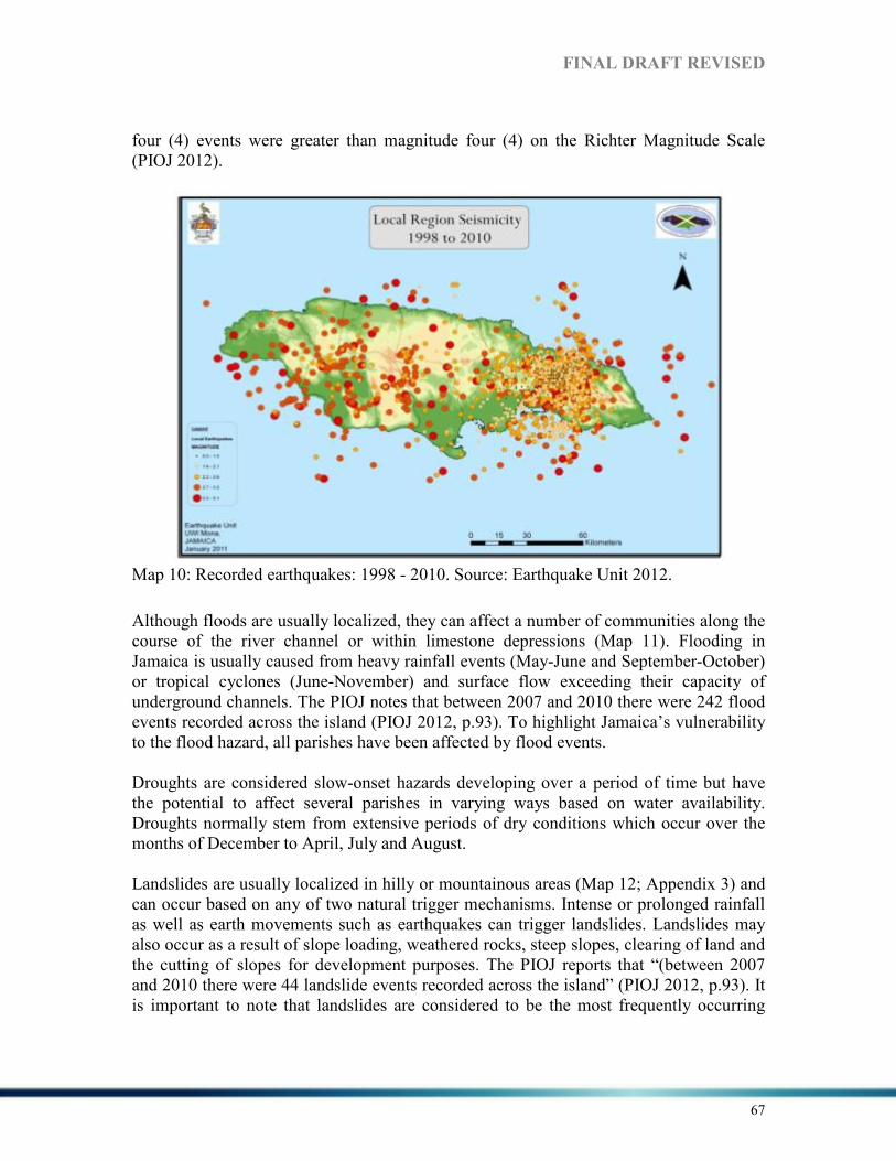
FI%AL DRAFT REVISED
67
four (4) events were greater than magnitude four (4) on the Richter Magnitude Scale (PIOJ 2012).
Map 10: Recorded earthquakes: 1998 - 2010. Source: Earthquake Unit 2012.
Although floods are usually localized, they can affect a number of communities along the course of the river channel or within limestone depressions (Map 11). Flooding in Jamaica is usually caused from heavy rainfall events (May-June and September-October) or tropical cyclones (June-November) and surface flow exceeding their capacity of underground channels. The PIOJ notes that between 2007 and 2010 there were 242 flood events recorded across the island (PIOJ 2012, p.93). To highlight Jamaica’s vulnerability to the flood hazard, all parishes have been affected by flood events. Droughts are considered slow-onset hazards developing over a period of time but have the potential to affect several parishes in varying ways based on water availability. Droughts normally stem from extensive periods of dry conditions which occur over the months of December to April, July and August. Landslides are usually localized in hilly or mountainous areas (Map 12; Appendix 3) and can occur based on any of two natural trigger mechanisms. Intense or prolonged rainfall as well as earth movements such as earthquakes can trigger landslides. Landslides may also occur as a result of slope loading, weathered rocks, steep slopes, clearing of land and the cutting of slopes for development purposes. The PIOJ reports that “(between 2007 and 2010 there were 44 landslide events recorded across the island” (PIOJ 2012, p.93). It is important to note that landslides are considered to be the most frequently occurring

FI%AL DRAFT REVISED
68
hazard in Jamaica after floods (Smith 2007). The occurrences of flood and landslide events in most cases are associated with the same rainfall event.
Map 11: Flood prone areas of Jamaica. Source: Smith 2007.
Map 12: Landslide Vulnerability Map. Source: MGI 2012.
FI%AL DRAFT REVISED
69
The risk associated with natural hazards can be partially managed with effective warning mechanisms. Floods, droughts, hurricanes and landslides (to a lesser extent) can be monitored before impact and their onset forecast. These warning mechanisms can be used for effective planning for evacuation and/or preparedness initiatives that are aimed at reducing disaster related loss of life and damage. Earthquakes still provide a great level of challenge to disaster managers as they provide little or no warning before impact.
6.2.2 A%THROPOGE%IC/MA%-MADE
Fires, accidents, explosions, toxic spills, pollution, deforestation, mining extraction in highly sensitive environmental areas, among others can be considered technological hazards. Similar to other developing countries, Jamaica has urban and rural fire treats which may result in property damage and loss of lives. Fires occur very frequently therefore the potential occurrence and impact of future fires should not be overlooked. The most recent major fire event took place on September 26, 2012 at the intersection of Beeson and Regent Streets in Downtown, Kingston. Thirty families were left homeless as fire destroyed the building where they lived. It required three Fire Brigade units to put out the blaze (Walker 2012, Spaulding 2012). Landfill fires and pollutions are also dangerous as air and water quality is often compromised and can lead to health problems. This was evident in the 2012 Riverton Landfill fires which affected the air quality of neighbouring communities in St. Catherine, and the KMA for several days.
Industrial accidents are not common and Jamaica has been fortunate in having only a few. The industrial accidents that have occurred in the past are minor in that they did not occur in potentially more dangerous industries. These industrial accidents include gas explosions, boiler explosions and equipment/structure collapse (NDP 1997). However, the potential exists for future accidents including but not limited to factory explosions and fires, the release of toxic fumes/gasses including landfilling and equipment/structure collapse. Transportation accidents recorded in Jamaica are related to sea, rail, air and road in which the latter has occurred more frequently. Most road accidents are associated with the nature of road transport in Jamaica (NDP 1997), speeding and reckless driving. A total of 7640 persons died because of road accidents over the period 1991-201119. The road networks in rural and mountainous areas are usually narrow which creates the potential for serious road accidents. Industrial trucks carrying items such as petrol have also been involved in road accidents accompanied by explosions in some cases. For rail accidents, the threat has been significantly reduce as less railway systems are now in operation. Although it is possible for rail accidents to occur, the chances of such accidents occurring are few. Socio-natural hazards result from high density urban areas with inadequate basic-service provision (water, electricity, health, education, transportation). In Jamaica, these areas are 19 Information was obtained from: http://www.nationalroadsafetycouncil.org.jm/statistics/reports/docs/pdf/CrashStats1991-2011.pdf
FI%AL DRAFT REVISED
70
referred to as ‘inner city communities’ which are often times among the most vulnerable population. High levels of poverty also contribute to the living conditions of these persons based on their economic instability. In addition, unemployment rates are usually above normal which contributes to the level of vulnerability that exists. Civil unrest has also resulted in deaths and injuries. The May 2010 unrest resulted in some one hundred and eight (180) persons being treated for moderate to severe injuries and another seventy-two (72) persons treated for minor injuries. The death toll ranged between seventy-six (76) to ninety (90) including two (2) members of the security forces (ECLAC 2010). The potential for future civil unrest in Jamaica remains moderate as crime levels remain high.
6.2.3 EMERGE%CIES AFFECTI%G PUBLIC HEALTH A%D SAFETY
Since 1852, Jamaica has experienced major outbreaks of illnesses and epidemics, examples include: small pox and cholera (1852), polio (1953 and 1981), malaria, yellow fever, dengue and typhoid among others (NDP 1997). The number of dengue cases reported were at 3,830 (with 1 confirmed death) as of November 17, 2012 compared to 3,202 the total number of cases reported in 2010 (The Gleaner 2012). The current distribution of the population across Jamaica could influence increase impacts from these epidemics. Densely populated towns could facilitate transmission of the epidemics. In addition, the larger percentage of the population would be at risk in the event of an outbreak in those particular locations based on human contact. It is important to note that public health and safety can also be affected as a result of hurricane, earthquake, tsunami and drought hazards as secondary hazards where diseases can develop after the event. It is important to note that emerging hazards such as heat waves will affect the elderly population and children under 3 years of age. Vector borne diseases are also likely to increase with projected increase in temperature from a warmer climate. Decrease in water availability due to prolonged drought and variable rainfall will increase the occurrence of hygiene - related illnesses. The development of the Jamaica National Food and Nutrition Security Policy seeks to encourage government policy based on macroeconomic stability and competitive markets that can improve food availability (GOJ 2012). Food security is essential in providing access to food of good quality to ensure that nutritional requirements are fulfilled especially among children and the elderly. This is essential in eliminating all forms of malnutrition in order to have well-nourished and healthy population that can contribute effectively to national economic development (GOJ 2012). The policy will also seek the address underlying vulnerabilities of food security such as climate related/natural hazards, lack of agricultural practices, plant disease and restriction on trade.

FI%AL DRAFT REVISED
71
6.2.4 TRA%SBOU%DARY, REGIO%AL A%D GLOBAL HAZARDS
Transboundary and regional hazards in the Caribbean include but are not limited to the movement and dumping of hazardous waste (e.g. lead acid batteries and chemicals), oil spills, hurricanes, tsunami, volcanic eruption, climate related risks, infectious diseases, invasive species and mass movement of refugees. Transboundary hazards as used here, refers to those hazards which originate outside Jamaica, but which can affect the island. The frequency of transboundary and regional hazards is low; however the potential exists for threats to health through communicable diseases as well as hazardous materials events arising from trans-Caribbean traffic. Climate Change is a global phenomenon that is expected to affect temperature, rainfall patterns, drought periods and the intensity of hurricanes across the globe. A number of future scenarios for 2030-40, 2050-60 and 2070-2080 have been created for the Caribbean to increase climate change awareness and guide development planning in vulnerable areas. These scenarios are usually created using only temperature and rainfall patterns in which drought, floods and hurricane impacts are dependent. “For the next two decades, a warming trend of about 0.20C is projected for a range of greenhouse gas (GHG) emission scenarios. As a consequence, it is anticipated that sea levels and global sea surface temperature will increase; weather patterns will change resulting in an increase in the frequency and intensity of extreme weather events, such as droughts, floods, and possibly hurricanes” (CCCCC 2009, p.iii). Figures 9 & 10 highlight the related impacts of the A2 and B2 scenarios on the temperature and rainfall projections for Jamaica in the year 2080.

FI%AL DRAFT REVISED
72
Figure 9: Temperature projections for Jamaica from 1961-90 baseline for A2 and B2 emission scenarios. Changes in the climate of Jamaica will most likely result in increased temperatures (min, max and range), variable rainfall (increase or decrease over particular seasons), more intense hurricanes, prolonged drought, sea level rise as well as an increase in the incidence of pests and diseases. Increase prevalence of non-endemic illnesses in the Caribbean might exist due to changes in local and regional climate. “Considering all models and scenarios, the Caribbean as a region is expected to warm by between 1.4 and 3.2 degrees by the end of the current century. In comparison for Jamaica, projected mean annual temperature increase across all models in the 15 Global Climate Models (GCM) ensemble and across all scenarios is 1.1 to 3.2 degrees by the 2090s (SOJC 2012, p.6-3). It is important to note that all predictions have a particular level of uncertainty that should be considered when discussing future climates. Similarly “GCM projections of future rainfall for the Caribbean span overall increases and decrease, but most models project decreases, especially by the end of the century (-39% to +11%). The projections of rainfall extreme are mixed across the ensemble, ranging across both decreases and increases in all measures of extreme rainfall (SOJC 2012, p.6-2).
Figure 10: Percentage changes in rainfall from 1961-90 baseline for A2 and B2 emission scenarios.

FI%AL DRAFT REVISED
73
6.3. VUL%ERABILITY Vulnerability as defined within UNISDR terminology refers to “the characteristics and circumstances of a community, system or asset that make it susceptible to the damaging effects of a hazard” (UNISDR 2009). Vulnerability is multidimensional and can be reflected in various contexts, for instance, physical, social, economic, and environmental. Poor design and construction of buildings, inadequate public awareness programs, limited recognition of risk, inadequate preparedness measures, and a general disregard for sound environmental management can all cause increased vulnerability to hazards. For Jamaica a small island developing state (SID) vulnerability is often seen as inherent in its geographic location, small size, insularity and remoteness (high external transport costs etc.) and economic factors (small economies, dependence on natural resources etc.), demography (limited human resource base) among other issues (Pantin 1994). Coupled with these intrinsic problems is the impact of globalization and the attendant global pressures. Jamaica like other SIDS must practice DRR to protect lives, livelihoods, fragile economies and to achieve sustainable development goals. According to the World Bank (2010), Jamaica has the second highest economic risk exposure to two or more hazards coupled with exposure of 96.3% of the national population, 94.9% of the national territory and 96.3% of the GDP to two or more hazards, including floods, tropical storms, hurricanes, landslides and earthquakes. Vulnerability in Jamaica is also linked to poverty. The Human Development Index (HDI) for Jamaica is 0.766, which gives the country a rank of 100th out of 182 countries with data. The Human Poverty Index (HPI-1) value of 10.9% for Jamaica ranks it 51st among 135 countries for which the index has been calculated (UNDP 2009). Other drivers of vulnerability in Jamaica have been identified as, the country’s debt burden, health status, vulnerable population- the disabled, children under 14 years, adults 65+, insufficient enforcement of building code and zoning regulations, land degradation, unplanned urban growth in areas unsuitable for building/squatting, inadequate infrastructure (e.g. poorly built roads), poor governance, lack of knowledge (Risk and Disaster Information), culture, geographic location and climate change20.
According to Dasgupta et al (2009) the impact of sea level rise and intensified storm surges in Latin America and the Caribbean will be highest in Jamaica – noting an increase of 56.8% - with 28.49% of the coastal population exposed and potential losses of coastal GDP projected to exceed 26.62%. Furthermore, the inundation risk in Jamaica from storm surges will cover 36.55% of the coastal wetlands (Dasgupta et al 2009, in World Bank 2010).
20 (GFDRR 2010; National Disaster Risk Reduction Workshop - Working Group 1, 2012)
FI%AL DRAFT REVISED
74
6.3.1 METHODOLOGY
All methodologies have limitations therefore tradeoffs are often unavoidable. A number of different methodologies have been used in Jamaica to assess vulnerability including the ODPEM’s Vulnerability Ranking Methodology (VRM) used in the parish of Clarendon, Risk and Vulnerability Assessment Methodology Development Project (RiVAMP) used in Negril, and the Community Vulnerability Assessment Tool (CVAT) adapted from the National Oceanic and Atmospheric Administration (NOAA) used in Black River, Ocho Rios and Savanna-la - mar. Below is a brief synopsis of each.
6.3.1.1 THE VUL%ERABILITY RA%KI%G METHODOLOGY (VRM)
The Vulnerability Ranking Methodology (VRM) developed by the ODPEM focuses on ranking vulnerable communities. It seeks to reveal high risk communities with the aid of hazard maps and Geographic Information Systems (GIS) technology used to perform geo-spatial vulnerability analyses for hazard planning and mapping. The ranking assists ODPEM in deciding which communities should be prioritized for DRM programmes. The goals of the VRM methodology are to:
1. develop a framework to support DRR based on a systematic and generic approach to the ranking of vulnerable communities;
2. support current vulnerability assessments and demonstrate the use of geo-spatial analyses;
3. allow for comprehensive and cohesive integration of measureable indicators at the local level into the broader national scope for DRR;
4. develop greater emphasis on mitigation measures that address community wide vulnerabilities;
5. assess the potential for long-term disaster impacts and provide a foundation for sustainable disaster preparedness, response and recovery.
6. equip communities with the tools for determining and ranking multi-hazard susceptibilities.
Results derived from the methodology will be used at the national level and community level to:
- promote the development & prioritization of hazard mitigation strategies - improve disaster response capabilities - advance disaster recovery initiatives - enhance the enforcement of current land use policies and hazard mitigation policies (ODPEM, undated and A. Tucker, undated).
Analytical methods applied in the VRM:
• Hazard identification: review internal hazard database etc. • Hazard analysis: evaluate ODPEM’s list of areas of high risk, identify
geographically defined risks areas etc.
FI%AL DRAFT REVISED
75
• Critical facilities analysis- how many there are and their proximity to the community
• Socio-Economic analysis: highlight areas of high risk versus areas with minimum resources to address disaster recovery needs.
• Economic analysis: used to identify the main economic sectors in the community; and impact on the community’s livelihood and how this in turn impact the given sectors
• Environmental analysis: indicators to assess a community’s vulnerability would be highlighted e.g. land use, types of ecosystems etc.
In the VRM the seven vulnerability indicators used are:
1. The Dependency Ratio focuses on the community’s dependent population that is, the elderly (those above 64 years) and children-14 years and under. The disabled are however, not independently captured. Here the population is vulnerable due to age, inability to access the necessary resources and often physical challenges.
2. The Population Density focuses on the number of persons occupying a given area in relation to size of the area. Population density is usually calculated as the number of persons per sq. km.
3. The Poverty Index focuses on the community’s access to basic amenities (clean water, health services etc.), issues of malnutrition, and the poverty level of each community (informed by the UN’s Poverty Index).
4. Hazard Frequency focuses on the frequency of hazard impacts within the community over 10 year period.
5. Housing Type focuses on materials used in construction of most of the houses in the community.
6. Hazard Impact Area focuses on the extent of impact area usually measured in average kilometres.
7. Capacity to Respond focuses on the ability of the community to respond to the needs of persons within it using its own resources following a disaster (ODPEM, undated).
Criteria and Weighting in the VRM
In the VRM weighted values are assigned to each indicator using a standard interval of 1 - 5. The higher the weighting applied (e.g. 5) the more vulnerable the community being measured and the lower the weighting (e.g. 2) the less vulnerable the community. A Vulnerability Score is applied to the matrix to calculate the total weighted values for the

FI%AL DRAFT REVISED
76
indicators. The scores are then ranked and the level of vulnerability is then determined.
6.3.1.2 THE RISK A%D VUL%ERABILITY ASSESSME%T METHODOLOGY
(RiVAMP) Project
Jamaica was selected for a project using this method this project because of the country’s diverse ecosystems, rich biodiversity considered a tourist “hotspot”, high economic dependence on ecosystems, development pressures on natural environment and exposure to sea level rise, storms and storm surges. The methodology:
1. Analyses disaster risk while taking natural environment/ecosystems into account 2. Highlights ecosystem protection as ‘no regrets’ option
- Cost effective - Relatively easy and fast installation (can be done with local population) - Low to moderate maintenance - Aesthetical and cultural value - Support biodiversity in providing food, livelihoods - Carbon storage - Pollution control - Emphasizes ecosystems goods and services
3. Approaches used for analyses are evidence based, scientific and qualitative 4. Targets SIDS and Coastal areas 5. Focuses on climate related hazards and their secondary effects e.g. flooding,
storm surge, sea level rise (Kelly and Roper 2012)
Description and Application of the RiVAMP Methodology
Stage I: Scoping
1. Scoping Mission by UNEP Team (Feb. 2009) 2. Introduce methodology to national level partners and get buy-in 3. PIOJ selected as implementing partners 4. Multi-sectoral Advisory and Technical Committees established 5. Coastal resources identified as being in a critical state 6. Selection of Negril as main study area in consultation with national partners
Stage II: Desk Study
1. Identified existing data, research conducted on the study area, gaps in existing data
2. Types of Data collected: - Spatial (e.g., satellite imagery) - Quantitative (e.g., distance of beach retreat in km) - Qualitative (e.g., governance systems and issues)
3. PIOJ coordinated data collection, working with ministries, agencies, departments and UNEP

FI%AL DRAFT REVISED
77
Stage III: Field Work
Consultations national, parish and community levels 1. Types of information collected from stakeholders 2. Knowledge on the types, roles, threats to, rate of change and state of ecosystems 3. Level of degradation observed 4. How livelihoods are linked to ecosystems 5. Local coping and adaptation strategies 6. Knowledge of/Perceptions of governance systems 7. Key issues and potential/proposed solutions
Stage IV: Analysis
1. Numerical Modelling 2. Multiple Regression Analyses 3. Tropical Cyclone Exposure Models
- Derives wind speed, storm surges (Note: landslide data was not available for inclusion in analysis)
- Based on 6m elevation model - Exposure of population, assets assessed for 10- and 50-year return period
storm events
Stage V: Outputs
1. Numerical Modelling 2. Multiple Regression Analyses 3. Coastal morphodynamic models 4. Tropical Cyclone Exposure Models
Stage VI: Evaluation Benefits:
1. Re-enforcement of existing knowledge that ecosystems are critical to DRR 2. Greater awareness of ecosystems goods and services in communities, through
media 3. Capacity building of national and local groups: exposure to technologies, new
tools for consultations 4. Data: high resolution satellite imagery, community maps, outputs of study area,
stakeholder perceptions on ecosystem services, threats, drivers of degradation
Enabling factors:
1. Timeliness of RiVAMP (as ecosystems-based tool taking climate change into account)
2. Data availability (spatial, socio-economic, meteorological datasets; studies on erosion)
6.3.1.3 THE COMMU%ITY VUL%ERABILITY ASSESSME%T TOOL (CVAT)
The National Oceanic and Atmospheric Administration (NOAA) developed the Community Vulnerability Assessment Tool. It involves an assessment of the physical,

FI%AL DRAFT REVISED
78
social, environmental and economic vulnerabilities of a selected area, and includes recommendations for mitigation measures for the area selected. An important feature of the CVATs model is that the vulnerability assessment builds on previous work conducted regarding the development of a Caribbean response to disaster management planning and involved community participation. For its study on risk assessments and the development of risk management plans in three (3) Jamaican communities of Black River, Ocho Rios and Savanna-La-Mar the decision was taken to use the CVAT methodology since the study focused on housing and critical facilities in the 3 towns. It was felt that the CVAT was systematic, relevant and appropriate to the needs of understanding vulnerabilities in these 3 locations. The methodology focuses on the types of hazards to be assessed, critical facilities in the communities, social vulnerability and environmental vulnerabilities (ODPEM, 2011). The steps for CVAT are outlined below: Step 1: Identify Hazards and Establish relative priorities for these hazards Step 2: Identify critical facilities categories and Complete critical facilities inventory
Identify intersections of critical facilities and high-risk areas and Conduct vulnerability assessment on all critical facilities
Step 3: Identify areas of special consideration
1. Identify intersections of special consideration areas and high-risk areas 2. Conduct a general inventory of special consideration/high-risk locations
Step 4: Identify primary economic sectors and locate economic centers
1. Identify intersections of economic centers and high risk areas 2. Conduct a general inventory of high-risk areas 3. Identify large employers and their intersection with hazard risk areas 4. Conduct vulnerability analysis on structures of large employers as critical
facilities Step 5: Identify secondary hazard risk consideration sites and key environmental resource sites
1. Identify intersections of secondary risk sites, environmentally sensitive areas and natural hazard risk consideration areas
2. Identify key environmental resource locations and their proximity to secondary sites
3. Conduct vulnerability analysis on priority secondary risk sites as critical facilities Step 6: Identify areas of undeveloped land and their intersection with high-risk areas
1. Inventory high-risk undeveloped land 2. Access the status of your existing insurance program participation

FI%AL DRAFT REVISED
79
Scoring in the CVAT
NOAA’s scoring methodology depends more on field observation and less on regional databases which allows more flexibility in using a wide range of data sources. The methodology can be expanded to include more in-depth analyses or contracted to focus on fewer vulnerability factors. This was felt to be especially useful in the case of Jamaica where data quality and data availability was often a constraint. Additionally, Jamaica’s legal and institutional framework, political organisation, social structure and cultural norms are different from those in the United States (ODPEM, 2011). NB many databases have US figures as their base. NOAA explains the scoring system as follows. “The ideal method for assigning priorities to various hazards would be a scientific, quantifiable probability assessment. Unfortunately, probability data are not consistent among the different hazard types, nor are they always available or useable at the local level. As an alternative, communities can develop a relative priority matrix to use as a general guide for addressing different hazards” (ODPEM 2011, p.45).
6.3.2 COMPO%E%TS OF VUL%ERABILITY
Vision 2030 Jamaica-National Development Plan promises an economy that is prosperous and recognizes that Jamaica’s vulnerability to natural and man-made hazards is a major threat to achieving that prosperity. “Natural hazards …lead to natural disasters” …which …“have dire consequences for economic activities, infrastructure, human welfare and natural resources management” (Vision 2030). Vulnerability cuts across social, environmental and economic boundaries. Wilches-Chaux (1993) suggested a number of approaches to identifying vulnerability. These were:
• Physical vulnerability: refers to the location of a population in an area of physical
risk; • Economic vulnerability: refers to income levels, unemployment, exploitation,
work instability, difficulty in accessing educational services, health and leisure activities.
• Social vulnerability: refers to the level of organisation and internal cohesion of the society at risk.
• Political vulnerability: refers to the concentration of decision-making power, centralization in governmental organisations and weaknesses in political autonomy at the regional, local and community levels.
• Ideological and cultural vulnerability: refers to a particular worldview and a readiness to face problems. These could include-passivity, fatalism, belief in myths, etc.
• Educational vulnerability: refers to the lack of educational programmes, inadequate instruction or instructors, capacity and materials, unavailability of

FI%AL DRAFT REVISED
80
education programmes that include DRR at local and regional levels, the community’s level of understanding of the issues involved in DRR.
• Environmental vulnerability: refers to humans coexisting with the environment without domination and destruction. It also takes into account the vulnerability of ecosystems to direct and indirect human action, and the high risk associated with communities that exploit or inhabit them.
• Institutional vulnerability: refers to the obsolete and or rigid institutions in which bureaucracy, political power resides.
These are all interrelated and cannot be easily separated. We will now focus on social, economic and environmental in the context of Jamaica.
6.3.3 VUL%ERABILITY A%ALYSIS BASED O% SELECTED CRITERIA
Economic Vulnerability
The Jamaican economy is highly vulnerable to hazards. Exposure of national assets stood at US$ 18.6b in 2009 (IDB 2009). Jamaica’s chief economic earners are tourism and agriculture. Both are highly dependent on Jamaica’s natural resource base but are also vulnerable to hazards. According to the Natural Disaster Hotspot study Jamaica has the second highest economic risk exposure to two or more hazards (GFDRR 2010; World Bank 2008). Between 1980 and 2008 Jamaica was affected by 27 natural hazards with economic losses estimated at US$2.599 billion. Storms accounted for US$2.425 billion while floods accounted for US$168.44 million21. Between 2004 and 2008, five major storm events caused damage and losses in Jamaica estimated at US$1.2 billion and in 2004 hurricanes Charley and Ivan left behind damage to the tune of US$580 million (ECLAC 2004; PIOJ 2012). In 2008, Jamaica was ranked 13th with losses caused by weather related hazard events of 0.79% of GDP and ranked 55th for the 10 years with overall losses in GDP at 0.96% (Harmeling 2009). The Jamaican government has not engaged in a systematic programme of risk transfer for its vulnerable assets, although some government agencies do insure their assets. It contributes to the parametric Caribbean Catastrophic Risk Insurance Fund. This fund makes payments based on a hazard reaching certain pre-determined trigger points rather than on loss or damage (IDB 2009). 21 http://www.preventionweb.net/english/
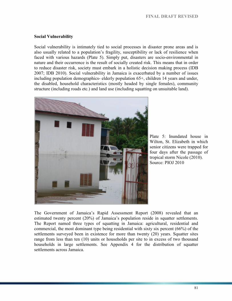
FI%AL DRAFT REVISED
81
Social Vulnerability
Social vulnerability is intimately tied to social processes in disaster prone areas and is also usually related to a population’s fragility, susceptibility or lack of resilience when faced with various hazards (Plate 5). Simply put, disasters are socio-environmental in nature and their occurrence is the result of socially created risk. This means that in order to reduce disaster risk, society must embark in a holistic decision making process (IDB 2007; IDB 2010). Social vulnerability in Jamaica is exacerbated by a number of issues including population demographics- elderly population 65+, children 14 years and under, the disabled, household characteristics (mostly headed by single females), community structure (including roads etc.) and land use (including squatting on unsuitable land).
The Government of Jamaica’s Rapid Assessment Report (2008) revealed that an estimated twenty percent (20%) of Jamaica’s population reside in squatter settlements. The Report named three types of squatting in Jamaica: agricultural, residential and commercial, the most dominant type being residential with sixty six percent (66%) of the settlements surveyed been in existence for more than twenty (20) years. Squatter sites range from less than ten (10) units or households per site to in excess of two thousand households in large settlements. See Appendix 4 for the distribution of squatter settlements across Jamaica.
Plate 5: Inundated house in Wilton, St. Elizabeth in which senior citizens were trapped for four days after the passage of tropical storm Nicole (2010). Source: PIOJ 2010

FI%AL DRAFT REVISED
82
Map 13: Informal settlements and vulnerable communities. Source: ODPEM. Figure 12 shows the exposure of informal settlements and other communities to hazards. Communities which are vulnerable to hazards are shown as shaded areas, the shading matching community boundaries as defined by the Social Development Commission (SDC). Individual communities are not depicted. The informal settlements, indicated by red dots are found in all parishes. The map shows the exposure of both formal and informal settlements to hydrometeorological and geological hazards. Social vulnerability in Jamaica is also linked to poverty. The HDI for Jamaica as highlighted before (0.766) is below that of Barbados and Trinidad. Household insurance does not have very high penetration in Jamaica. The authors were unable to access differentiated figures for household and other types of insurance, and no figures were available for the level of penetration for the country. Anecdotal evidence suggests that many householders, and small and medium enterprises do not insure because the cost is considered to be too high. Lack of insurance or any other risk transfer mechanism, can reduce the ability to recover after a disaster and can increase vulnerability of householders as well as the small and medium business sector. Mortgage and financial institutions require insurance of mortgaged properties, but these are sometimes allowed to lapse once the mortgage payments are completed.

FI%AL DRAFT REVISED
83
Environmental Vulnerability
Jamaica’s natural environment- biodiversity, ecosystems, marine and coastal resources, fresh water resources, and forests and watersheds- continue to come under pressure from climate change related pressures. These include extreme weather events, sea level rise and coastal erosion among others. Over the past 25 to 30 years, Jamaica has experienced an increase in the frequency of natural events, mainly floods (as a result of tropical depressions, tropical storms and hurricanes), droughts and landslides (PIOJ 2012). The adverse impacts of hurricanes include a decline in the health of coral reefs; loss of sea grass beds; severe beach erosion and loss of forested areas. It is projected that the island has, and will continue to be affected by increased frequency and intensity of tropical weather systems, which can partly be attributed to climate change (PIOJ 2012). Jamaica’s location, geography and geology make the island prone to several natural hazards. There is recognition that healthy, productive and protective environments, social systems and economies are the bases of development, sustainability and human welfare. In 2010, Jamaica’s ranking as measured by the Environmental Performance Index (EPI) dropped by over 20 points, placing the country at 89th out of 163 countries with a score of 58, down from a ranking of 54th out of 149 countries in 2008. In 2009 there were no hazards which caused damage but in 2010 there was significant damage (representing 1.9% of GDP) and losses mainly from floods associated with tropical storm Nicole (PIOJ 2012).
When developing DRR strategies or guidelines there are a number of factors that must be considered in order for the desired result of reducing risk among vulnerable groups and ensuring that these groups maintain their health and retain functional capacity. These factors include:
1. Communication – where timely, accurate, understandable and practical information is provided.
2. Coordination – sets the stage for complementary action. 3. Education – which seeks to increase general awareness and knowledge of
disasters including how to act or defines what to do in the different phases of a disaster.
4. Accommodation/inclusion – ensuring that policies and activities take into account the needs, capacities, vulnerabilities and perspectives of all age groups (PAHO 2012).
MOST VUL%ERABLE GROUPS
Several vulnerable groups have been identified in Jamaica - these include children, youths-at-risk, the elderly, persons with disabilities (PWDs), women, and poor families. This list is a demographic characterization, and is not exhaustive (Vision 2030, p.78). In Jamaica the most vulnerable populations also include both men and women living in rural

FI%AL DRAFT REVISED
84
communities, coastal zones and low-lying areas, people with poor housing, the homeless (UNDP 2009). It is estimated that persons at risk make up 60% of Jamaica’s total population and are generally vulnerable to storm surges, hurricanes and flooding22.
Women
Women are usually overlooked and as a result are often invisible in disaster management (UNDP 2009a). Poverty increases the vulnerability of women when there is a disaster because there is often a larger proportion of a woman amongst the poor population and hence they are often the most at risk (Senior and Dunn 2010). The higher level of poverty and increasing vulnerability to poverty are tied to women’s participation in the labour force typified by lower rates of employment and higher rates of unemployment in comparison to men (UNDP 2009a). Jamaica has a high percentage of female-headed households (FHHs), increasing since 1993 from 41.5% to 43.5% in 2002 then 46.7% in 2006 (PIOJ 1998; PIOJ 2007a). FHHs are considered one of the most vulnerable groups in Jamaica (UNDP 2009a). They tend to have more children who in turn are considered vulnerable. As noted in a 2010 study the percentage of FHHs remains high and is largest in the poorest section of the population. The high levels of FHHs affects the ability of women, particularly in poorer households to access healthcare, which is often sacrificed for other economic priorities including food, shelter and education (PAHO 2010).
Children
In the 2011 Census the number of people under age 15 years numbered approximately 702,800 or 26 % of the total population of 2,697,983 persons. In Jamaica children’s vulnerability is linked to being in poor families in general and FHHs in particular as women tended to earn less than men and is often poorest in the population. In 2006 the average number of children was 3.6 in female-headed households and 3 in male-headed households (UNESCO 2011).
The Elderly
The vulnerability of a person or group will affect their ability to not only cope but survive in a disaster. Older persons, as a group, are often identified as among the most vulnerable segments of any population. According to PAHO (2012) a large segment of the 60 + population (approximately 20-30%) has one or more disability, that is, physical, mental or sensory, and this percentage increases by each five-year age group, to more than 50% in the 80+ group.
Jamaica’s elderly population (60 years and over) is the fastest growing age group in Jamaica’s population. The dependent elderly (65 years and over) was estimated at 207,700 (7.8 %) in 2005 and by 2007, had grown to 223,961 (8.4%). Over the period 2007 to 2030, it is estimated that this cohort of Jamaica’s population will increase by 2.8
22 (Senior and Dunn 2012; Working Group 1 Vulnerabilities and Capacities 2012; UNDP 2009a).
FI%AL DRAFT REVISED
85
% to 11.2 % or 321,664 (Vision 2030, p.40). The elderly are often at risk during and after disasters have occurred. The Active Ageing Framework presents one approach to mainstreaming the consideration of older persons into the disaster management process. The process seeks to optimize opportunities for health, participation and security to enhance an individual’s quality of life as he/she ages. The framework integrates not only he needs but also the contributions of older persons into disaster management programmes and processes. It should be noted that an advanced age alone does not constitute vulnerability, but it is the problems associated with old age that increases a person’s vulnerability. These issues may include deteriorating physical and mental ability, decreased strength, low tolerance for physical activity, functional limitations and decreased sensory awareness (PAHO 2012).
For the aged, chronic diseases, mental health issues, limited mobility, and special nutritional requirements all play a major role in their ability to access healthcare and social services such as shelter, water and food during and after a disaster. They are also impacted by social factors including poverty, educational levels, gender, life changes, family living arrangements and home ownership (PAHO 2012). In addition, elderly persons without a pension or other source of income will find it more difficult to prepare for, respond to and recover from disasters.
Elderly without Pension
Under Vision 2030 (PIOJ, 2009) National Goal # 1 states Jamaicans are empowered to
achieve their fullest potential and National Outcome #3 is Effective Social Protection. There are currently two (2) government programmes to protect the elderly in Jamaica namely, the National Insurance Scheme (NIS) and the Programme of Advancement through Health and Education (PATH). One of the five categories of beneficiaries’ under the PATH is the elderly 60 years and over and not in receipt of a pension. Since 1999 the pension’s scheme has been continuously reassessed to ensure equity for beneficiaries. Despite ongoing efforts, lack of or inadequate pension benefit is a factor that increases the elderly’s vulnerability to disasters in Jamaica (PAHO 2012; UNPF/HAI 2011). According to UNPF/HAI (2011) at the end of 2010 there were 51,846 older beneficiaries under PATH this represented 16% of programmes total beneficiaries. In general PATH beneficiaries made up 17.3% of persons 60 and over. In combination with NIS pensioners, coverage for older persons in Jamaica totaled 119,177 persons or 39.8% from this there is a coverage gap of 180,323 or 60% of Jamaica’s older population. At the end of December 2010, 67,331 persons were in receipt of pension benefit from the National Insurance Scheme (PIOJ 2011). The Government of Jamaica is now examining the matter of pension reform with a view to making pension contributions compulsory.

FI%AL DRAFT REVISED
86
Persons with Disabilities
From the 2001 Population Census it was estimated that 6.3 % or 163,206 of Jamaica’s population had at least one disability. It is generally believed that the level of disability in a population is often understated and as a result, the World Health Organisation (WHO) estimates that for most countries the level of disability would be about 10 % of total population figures. If this estimation is correct in Jamaica “the level of disability as revealed by the census grossly understates the extent of the problem. It may therefore be assumed that PWDs comprise a larger than stated segment of our population and have been marginalized from the mainstream of development in the society” (Vision 2030, p.40). Limitations related to the visual and the hearing impaired is particularly significant in coping in disasters. In Latin American and Caribbean cities 35% of the population reports some form of visual impairment. This results in persons being unable to read or understand warnings and evacuate buildings safely without injuring themselves. The visually impaired elders sometimes do not want to leave their homes to go to shelters because they feel less comfortable in the space. Loss of hearing aids during a disaster also makes it harder for these persons to access information, which leads to anxiety and stress which then impacts their ability to respond (PAHO 2012). Jamaica reports progress in reducing the vulnerability of populations most at risk, but achievements are not comprehensive (ODPEM 2011a).
Description:
A framework has been developed to minimize risk to vulnerable populations impacted by disasters. This forms part of the national development plan, Vision 2030 spearheaded by the PIOJ. The Government of Jamaica through the Ministry of Labour and Social Security (MLSS) has implemented several programmes to address the needs of vulnerable populations who are affected by disasters: that is, the Programme for Advancement through Health and Education (PATH); Post disaster rehabilitation programmes which include compassionate grants and rehabilitation grants. There are other programmes that are operated by NGOs such as the Red Cross, Food for the Poor, Salvation Army and ADRA that provide assistance to vulnerable persons (housing, skills training, healthcare, food assistance and clothing).
Achievements in Reducing Vulnerability
Jamaica has reported achievements and constraints in reducing vulnerability (HFA
2010)
• Rehabilitation grants to assist with rebuilding are provided after evidence of the ability to relocate to safer locations. In recent times, this has been supported by No Build Orders by the local authority and public education drives spearheaded through community-based organisations.
FI%AL DRAFT REVISED
87
• A National Shelter and Welfare Action Plan developed by the National Disaster Office in conjunction with the National Shelter and Welfare Committee, which clearly outlines the roles and responsibilities of the welfare agencies in responding to emergencies along a three tiered response strategy.
• A squatter management unit has also been implemented with the mandate of coordinating the national response to existing informal settlements as well as those which are emerging.
• A draft Homeless Policy (conceptual framework to become Green Paper) has also been developed.
• Ministry of Labour and Social Security and Ministry of Agriculture grants. • Crop and property insurance - PC Banks, Co-operatives, partner schemes
Constraints:
• Absence of dedicated budget for the lead agency/ministry to reduce the vulnerability of populations most at risk. Budgetary allocations lean more towards addressing poverty alleviation strategies through the Government’s Public assistance programme rather than adopting a socio-cultural approach to reducing risk.
The Relief Policy, Emergency Relief Clearance Policy and Shelter and Welfare Action Plan provide the framework for providing assistance to the vulnerable population post disaster.
6.4 CAPACITIES
In the UNISDR Terminology 2009 capacity development is defined as “the process by which people, organisations and society systematically stimulate and develop their capacities over time to achieve social and economic goals, including through improvement of knowledge, skills, systems, and institutions”. For the UNDP (2010, p.2) capacity development is “the process through which individuals, organisations and societies obtain, strengthen and maintain the capabilities to set and achieve their own development over time”. This kind of development is not only locally driven but seeks to bring transformation across societies, it sees individuals, organisations and societies themselves as indispensable in the process of reducing and managing disaster risks (UNDP 2010). Capacity can be built on a number of levels firstly at the individual level where the focus is on training/skills building. Training however, cannot be done in isolation as it is only one aspect of capacity building. Secondly, the organisational level which focuses on organisation development and the application of its internal policies, procedures, and frameworks instrumental in driving disaster management. Thirdly, societal level where the focus is on how to lower society’s vulnerability while boosting its capacity to cope with hazards. Lastly, the sectoral level where sectors such as education, health and housing become the focus of intervention and assessment.

FI%AL DRAFT REVISED
88
For the UNDP (2010) the following assumptions are vital to building DRR capacities both at the national and local levels:
• The development of DRR capacity is the concern of an entire society, rather than any single agency, professional discipline, or stakeholder group.
• An enabling environment- i.e. strong political ownership and commitment at the highest levels of authority, extensive participation, transparency and clear public accountability-is essential for translating capacity into performance.
• Locally generated, owned and sustained capacity is essential to the success of any DRR enterprise.
• The development of technical capacities associated with professional disciplines or functions-such as environmental management or land-use management- needs to be combined with other types of capacity development that include the promotion of leadership and other managerial capacities and performance-enhancing measures.
Jamaica, generally, has adequate technical capacity for risk reduction at national level spread across public and private sectors. Where there are gaps, such as in seismic risk assessment, the country has access to such capacity through the University of the West Indies which completed the recent seismic risk assessment of Kingston.
Gaps
According to the Jamaica’s Progress Report (2011) Jamaica’s DRR capacity is weak at the national, community and local levels. Lack of resources be it human, financial, technical or operational and lack of institutional commitment remains Jamaica’s greatest challenge. Jamaica’s preparedness capacity is expected to be bolstered in the area of earthquake and hazardous materials/waste under the local governance mechanism. ODPEM’s institutional capacity will be strengthened to tackle ongoing issues such as informal settlements in vulnerable areas. There are plans identify and strengthen capacities for risk reduction in Jamaica for example through the development of a framework for action to address issues on capacity building in DRR. It was noted that there was a lack of buy in from key stakeholders. Hazard mapping will be done for all hazards affecting Jamaica. A multi-sector approach to disaster management will be developed and continued improvement in the collection, management, use and dissemination of technical data as it relates to DRR. The Progress Report (2011) notes that
• The National Hazard Risk Reduction policy has not been widely disseminated and currently there is no implementation or action plan in place.
• The current Disaster Preparedness and Emergency Management Act needs revision to make it more applicable to changing disaster management practices.

FI%AL DRAFT REVISED
89
• Absence of a finalised Risk Mitigation Strategy and Action Plan
• Absence of local action plans for DRR
• Too much dependency on overseas development assistance for DRR activities
• The Parish structure needs strengthening so that community involvement is effectively employed to support the DRR Planning and Response at the Municipal Level thereby strengthening the governance process for DRR at the Local Authorities.
• Resource constraints exist which sometimes affects resources deployed at the community level.
• Capacity Assessment of the national and parish mechanism and reporting to the National Disaster Committee is necessary.
• A general lack of resources to address capacity building in all vulnerable communities that exists.
• Information provided is generally not translated into action because of lack of resources
• While the link has been made in terms of Disasters and Environmental Protection there needs to be greater collaboration among agencies especially as it relates to monitoring and enforcement, sharing of data and public education strategies.
• The Local Authorities lack the adequate capacity to administer its Disaster Management Responsibility.
• Not enough drills and simulation exercises are conducted across all administrative levels.
• Contingency plans in place - but not gender sensitive.
• Contingency Plans are not in place in all agencies.
• Economic constraints serve as a hindrance to keeping the National Disaster Fund adequately resourced.
• No Sub-National Risk Transfer Fund in place outside of the poorly-resourced National Disaster Fund.
• No Catastrophe Bonds currently exists
6.4.1 I%STITUTIO%AL ASPECTS
In general, disaster management has been in focus in Jamaica for more than 28 years but government economic and spatial development policies still do not fully address the issues involved. Clear guidelines are necessary to facilitate the integration of DRM in sustainable development policies and plans and also project development (World Bank 2010). Under Vision 2030 capacity building as it relates to DRR is considered fundamental to Jamaica’s development. Historically there has been little integration of DRR in socio-economic decision making. However, the recent Growth Inducement Strategy includes considerations of resilience (Carby, 2012), and Vision 2030 includes as one of its goals that Jamaica will have a healthy natural environment by 2030 (Vision 2030).
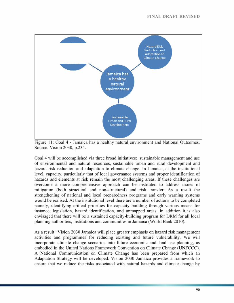
Figure 11: Goal 4 - Jamaica has a healthy natural environment and National OutcomesSource: Vision 2030, p.234. Goal 4 will be accomplished via three broad initiatives: sustainable management and use of environmental and natural resources, sustainable urban and rural development and hazard risk reduction and adaptation to climate change. In Jamaica, alevel, capacity, particularly that of local governance systems and hazards and elements at risk overcome a more comprehensive approach can be instituted to address ismitigation (both structural and nonstrengthening of national and local preparedness programs and early warning systems would be realised. At the institutional level there are a number of actions to benamely, identifying critical priorities for capacity building through various means for instance, legislation, hazard identification, and unmapped areas. In addition it is also envisaged that there will be a sustained capacityplanning authorities, institutions and communities in Jamaica (World Bank 2010). As a result “Vision 2030 Jamaica will place greater emphasis on hazard risk management activities and programmes for reducing existing and future vulnerincorporate climate change scenarios into future economic and land use planning, as embodied in the United Nations Framework Convention on Climate Change (UNFCCC). A National Communication on Climate Change has been prepared from which an Adaptation Strategy will be developed. Vision 2030 Jamaica provides a framework to ensure that we reduce the risks associated with natural hazards and climate change by
FI%AL DRAFT REVISED
Jamaica has a healthy natural environment and National Outcomes
Goal 4 will be accomplished via three broad initiatives: sustainable management and use of environmental and natural resources, sustainable urban and rural development and hazard risk reduction and adaptation to climate change. In Jamaica, at the institutlevel, capacity, particularly that of local governance systems and proper identification of hazards and elements at risk remain the most challenging areas. If these challenges are
hensive approach can be instituted to address ismitigation (both structural and non-structural) and risk transfer. As a result the strengthening of national and local preparedness programs and early warning systems
. At the institutional level there are a number of actions to benamely, identifying critical priorities for capacity building through various means for
legislation, hazard identification, and unmapped areas. In addition it is also envisaged that there will be a sustained capacity-building program for DRM for all local planning authorities, institutions and communities in Jamaica (World Bank 2010).
As a result “Vision 2030 Jamaica will place greater emphasis on hazard risk management activities and programmes for reducing existing and future vulnerability. We will incorporate climate change scenarios into future economic and land use planning, as embodied in the United Nations Framework Convention on Climate Change (UNFCCC). A National Communication on Climate Change has been prepared from which an Adaptation Strategy will be developed. Vision 2030 Jamaica provides a framework to ensure that we reduce the risks associated with natural hazards and climate change by
DRAFT REVISED
90
Jamaica has a healthy natural environment and National Outcomes.
Goal 4 will be accomplished via three broad initiatives: sustainable management and use of environmental and natural resources, sustainable urban and rural development and
t the institutional proper identification of
remain the most challenging areas. If these challenges are hensive approach can be instituted to address issues of
structural) and risk transfer. As a result the strengthening of national and local preparedness programs and early warning systems
. At the institutional level there are a number of actions to be completed namely, identifying critical priorities for capacity building through various means for
legislation, hazard identification, and unmapped areas. In addition it is also or DRM for all local
planning authorities, institutions and communities in Jamaica (World Bank 2010).
As a result “Vision 2030 Jamaica will place greater emphasis on hazard risk management ability. We will
incorporate climate change scenarios into future economic and land use planning, as embodied in the United Nations Framework Convention on Climate Change (UNFCCC). A National Communication on Climate Change has been prepared from which an Adaptation Strategy will be developed. Vision 2030 Jamaica provides a framework to ensure that we reduce the risks associated with natural hazards and climate change by

FI%AL DRAFT REVISED
91
integrating hazard considerations into our country’s development planning” (Vision 2030, p.246).
Under national Outcome #14: Hazard Risk Reduction and Adaptation to Climate Change a number of challenges have been identified as follows:
1. Jamaica’s location, geology and geography: Jamaica’s location, geology and geography make the island prone to natural hazards resulting in frequent damage to infrastructure etc. (See Section 1 for more details).
2. Settlement Patterns: Increase in population, urbanization and poverty have led to the growth of squatter settlements in environmentally sensitive areas. Many of these are located in vulnerable areas including flood plains, on steep unstable slopes and along the coastline. Notably, 82% of Jamaica’s population lives along the coast and within 5 km of the coast which increases vulnerability to hazard impacts.
3. Weaknesses in the Physical Planning System and Land Use Practices: past hazards have exposed Jamaica’s vulnerability, highlighted weaknesses in physical planning, land use and building practices. Current land use policy and practice do not incorporate current scientific, technical, and local knowledge about the relationship between hazard risk and socio-economic vulnerability.
4. Inadequate Emphasis on Hazard Risk Management Activities: Too little emphasis placed on hazard risk management activities and programmes to reduce existing and future vulnerability. There is urgent need for hazard data collection and mapping, vulnerability assessment, risk assessment, watershed management and the use of risk transfer measures for example, insurance.
5. Environmental Degradation: due to increased environmental degradation there has been increased risk of impact from hurricanes and intense rainfall. For example, in Negril loss of seagrass cover has been instrumental in the erosion of several tens of metres of beach. Heavy rain causes numerous landslides on steep slopes, often damaging roads and power and water lines.
6. Climate Change: Climate change is expected to amplify the effects of several natural hazards to which Jamaica is exposed. Extreme weather events are expected to become more frequent and more severe. Sea level rise is also expected to lead to saline intrusion into Jamaica’s fresh water resources.
Further, due to the consistent shortfall in human, financial and technical resources, the Jamaican Government and the lead agency ODPEM have used collaboration nationally and internationally to address on-going needs and priorities in Jamaica. The PIOJ was accredited as a National Implementing Entity (NIE) under the Adaptation Fund by the Adaptation Fund Board (AFB). As the NIE, the PIOJ can access grants directly from the AFB to finance concrete climate adaptation projects instead of having to work through a multilateral agency in order to address Jamaica’s mounting problems (PIOJ 2011 and PIOJ 2012).

FI%AL DRAFT REVISED
92
On the prescribed path to developed world status in order to build DRR capacity in Jamaica there are a number of national strategies that have been articulated under Vision 2030. These are highlighted, along with the Agencies responsible for carrying them out in Table 10 below. Table 10: National Strategies and Responsible Agencies-Hazard Risk Reduction and Adaptation to Climate Change. Source Vision 2030, p.248. %ational Strategies Responsible Agencies
14-1 Improve resilience to all forms of hazards Office of Disaster Preparedness and Emergency
Management
Office of the Prime Minister
Ministry of Agriculture
Ministry of Health and Environment
National Environment and Planning Agency
Ministry of Education
Ministry of Finance and the Public Service
Public Broadcasting Commission
Local Authorities (Parish Councils)
Meteorological Office
14-2 Improve emergency response capability Ministry of Health and Environment
Fire Services
Red Cross
Jamaica Defence Force, Coast Guard
Jamaica Constabulary Force
Office of Disaster Preparedness and Emergency
Management
National Environment and Planning Agency
14-3 Develop measures to adapt to climate change National Environment and Planning Agency
Local Authorities (Parish Councils)
Forestry Department
Ministry of Agriculture
Ministry of Health and Environment
University of the West Indies
University of Technology, Jamaica
Office of the Prime Minister
Meteorological Office
14-4 Contribute to the effort to reduce the global
rate of climate change
Petroleum Corporation of Jamaica
Ministry of Energy
Ministry of Transport and Works
Ministry of Health and Environment
Ministry of Industry, Investment and Commerce
Meteorological Office
Ministry of Foreign Affairs and Foreign Trade
These national strategies will be accomplished via a number of sector strategies. Vision 2030 pledges to “build capacity across the country to limit the impact of hazards and incorporate hazard risk considerations into development planning” (p.249). A rational

FI%AL DRAFT REVISED
93
framework for hazard mitigation will be developed and the overall development objectives will be pursued through cooperation, coordination and support between government, the private sector and civil society over the long term (Vision 2030). The national strategies and their selected sector strategies are shown below in Table 11. Table 11: National Strategies and their Selected Sector Strategies %ATIO%AL STRATEGIES A%D THEIR SELECTED SECTOR STRATEGIES
14.1 Improve Resilience to all Forms of Hazards
Selected Sector Strategies
• Create and strengthen national platforms and establish the foundation for hazard risk reduction by engaging in multi-stakeholder dialogue
• Use predictive tools for modelling, hazard data mapping and risk assessment
• Modernize the legal framework related to hazard risk reduction
• Create and introduce economic and financial market instruments for risk transfer
• Use knowledge, innovation and education to build a culture of safety and resilience at all levels by integrating hazard risk reduction in the early childhood, pre-primary, primary, secondary and tertiary education syllabuses and research community; and develop hazard risk reduction training for different groups of stakeholders
• Adopt a community-based approach to hazard risk reduction
• Expand early warning systems to reduce the risk of hazards
• Incorporate hazard risk reduction in environmental and natural resources management
• Establish mechanisms for increasing resilience of the poor and most vulnerable
• Establish measures to incorporate hazard risk reduction in land-use practices and human settlements
• Create opportunities for private sector involvement in hazard risk reduction, including business contingency planning
• Design housing settlements that are not vulnerable to hazards based on construction and rehabilitation techniques that enhance the long term usability
• Regulate the importation, storage, distribution, use and disposal (the management cycle) of hazardous materials
14.2 Improve Emergency Response Capability
Selected Sector Strategies
• Build adequate emergency response capability and early warning systems
• Develop institutional capacity to respond to potential emergencies such as fires
• Develop a larger core of trained volunteers to effectively manage emergency response
• Build capacity of state agencies and facilities (e.g. hospitals, fire services) to manage any potential disasters
• Increase capacity for search and rescue
• Develop mass casualty plans
• Develop procedures to cope with potential disasters (e.g. continuous education simulation exercises and drills)
• Strengthen the regional mechanisms for emergency response
14.3 Develop Measures to Adapt to Climate Change
Selected Sector Strategies
• Create mechanisms to fully consider the impacts of climate change and ‘climate proof ’ all national policies and plans
• Identify strategic priorities for adaptation to climate change
• Undertake research to identify sector-specific strategies for adaptation
• Promote education and discussion about climate change through local and community media
• Adopt best practices for climate change adaptation
• Infuse climate change issues into the physical planning system

FI%AL DRAFT REVISED
94
• Create and introduce economic and financial market instruments for risk transfer
• Apply disaster risk reduction framework to build on climate change mitigation measures
14.4 Contribute to the Effort to reduce Global Rate of Climate Change
Selected Sector Strategies
• Promote energy conservation and non-carbon-based forms of energy (see National Outcome # 10 on Energy Security and Efficiency)
• Reduce deforestation rate through mechanisms such as reforestation programmes
• Conduct research on Jamaica’s levels and sources of greenhouse gas emissions with a view to further reducing the emissions
• Promote the use of clean technologies in the manufacturing sector (related to National Strategy 12-5)
• Maximize the benefits of the Clean Development Mechanism (CDM) under the Kyoto Protocol
• Lobby at the international level for high greenhouse gas-producing countries to become more energy
• and resource efficient
In order to tackle the issue of DRR in Jamaica a number of national strategies were identified, the responsible agencies named, and the priority sector strategies and the key actions to be taken over 3 years (2009-2012) formulated. See details below including the outcome/output of the strategies implemented.
Table 12: Key Strategies and Actions under the National Outcomes for Years 1-3 (2009-2012). National Outcome #14 - Hazard Risk Reduction and Adaptation to Climate Change. Source: Vision 2030; ODPEM, 2011a. %ATIO%AL
STRATEGIES PRIORITY
SECTOR
STRATEGIES
FOR YEARS 1- 3
KEY ACTIO%S FOR
YEARS 1- 3 RESPO%SIBLE
AGE%CIES OUTCOME/Output
14-1 Improve resilience against all forms of hazards
Create and strengthen national platforms and establish the foundation for hazard risk reduction by engaging in multi-stakeholder dialogue
Undertake hazard risk management for coastal communities Undertake comprehensive mapping of the flood plains throughout the island Strengthen Democracy and Governance in Communities related to Disaster Response (including gender issues) Undertake Storm Surge Hazard Mapping for Coastal Communities
ODPEM, NEPA WRA ODPEM, SDC ODPEM, SDC JSIF
IDB/Smith Warner report ODPEM Report on 3 coastal communities In process Identification of gender focal point (National Disaster Committee) In process
14-3 Develop measures to adapt to
Create mechanisms to fully consider the impacts of climate change and ‘climate
Create mechanisms to infuse climate change considerations into planning and legislative
MOHE ,OPM ODPEM, Met Office
Draft Climate Change Policy and Action Plan

FI%AL DRAFT REVISED
95
climate change proof’ all national policies and plans
frameworks Establish a National Climate Change Committee Develop a Climate Change Communications Strategy
MOHE, OPM, MET Office248 MOHE, OPM, MET Office National Environmental Education Committee
Draft Climate Change Policy and Action Plan Done
Adopt best practices for climate change adaptation
Develop sector-specific action plans to assist with the mitigation and adaptation of climate change in all sectors Develop public awareness programmes on climate change
MOHE Met Service OPM ODPEM NEPA MOHE NEPA Met Service NGOs OPM
Done On going
14-4 Develop mechanisms to influence the global rate of climate change
Lobby at the international level for high greenhouse gas producing countries to become more energy and resource efficient
Prepare 2nd National Communication to the UNCCCF
MOHE Met Service OPM
Done
6.4.2 DISASTER RISK REDUCTIO% PROGRAMMES
Despite the number of constraints Jamaica continues to place emphasis on the implementation of various activities, projects and programmes in an attempt to reduce or prevent the impact and incidence of disasters. Most of the initiatives are focused on increasing the ability of Jamaicans to withstand hazard impacts, by reducing their vulnerability, while developing their capacity to anticipate, cope with, resist and recover from hazard impacts. Some of these initiatives include:
• Revision of the DPEM Act; • Implementation of the Building Resilient Communities Project; • Development of the Vulnerability Ranking Methodology by ODPEM which
reveals high risk communities with the aid of hazard maps; • The development of a disaster emergency plan for Jamaica’s 41 child care
institutions; • Pilot testing of the Risk and Vulnerability Methodology developed by UNEP.
Through the Risk and Vulnerability Assessment Methodology Project (RiVAMP) a methodology was developed to include the role of ecosystems in reducing risk and vulnerability associated with natural hazards particularly with the impending threats of climate change in Jamaica (PIOJ 2012).

FI%AL DRAFT REVISED
96
Additionally, since Jamaica is party to the UNFCCC and the Kyoto Protocol of 2010, climate change adaptation activities included the development of a number of projects to build climate resilience, namely:
• the Pilot Program for Climate Resilience (PPCR) and • the Climate Change Adaptation and Disaster Risk Reduction Project which will
be implemented over a thirty (30) month period at a cost of 4.8 million dollars aimed at rehabilitating and increasing the reliance of Jamaica’s watersheds, forested areas and coastal ecosystems and generally increasing the capacity of Jamaicans at the local and national levels to address climate change by raising awareness (PIOJ 2012).
The project was designed to assist vulnerable small farmers strengthen their livelihoods security and to undertake adaptive activities. The project will also address a long-standing issue of beach erosion in Negril. Sectoral DRM programmes have been implemented in Agriculture, Education, Health and Tourism ministries. The agricultural sector has a National Agricultural Disaster Risk Management Plan (NADRM) which sets out a strategic framework for disaster risk management for the sector. The Plan lists the following components:
1. Mitigating, preventing and preparing for the impact of disasters on the agricultural sector
2. Promoting appropriate and effective emergency response to the impact of hazards and disasters
3. Ensuring timely and effective recovery and rehabilitation from the impacts of disasters
4. Establishing a monitoring and evaluation framework that will effectively measure progress in ADRM.
The Plan also proposes operational linkages between national and parish structures and lists standard procedures for management of disasters and hazard impacts. Furthermore, NGOs such as Oxfam, ACDI/VOCA, FAO and other organisations work with small farmers in disaster risk management and climate change adaptation.
6.4.3 TOOL I%VE%TORY
According to the Methodological Guide on the Systemization of Tools for Disaster Risk Management (DIPECHO 2011, p.9) a tool is "a guide, product or instrument that has resulted from a project, initiative, program, experience or intervention, and serves to improve the ability to design, develop and implement an action or actions in the field of disaster risk management.” The Guide suggests that when tools are being selected, it is important to estimate the impact the tool has had on practical development in communities, institutions, organisations or particular countries. Furthermore, tools that are selected must meet certain criteria for instance, they must be:

FI%AL DRAFT REVISED
97
• Functional: That is, tools must have been implemented before and seen to work. Otherwise, they should be assessed according to the contribution, impact or knowledge gained through its application.
• Tangible: Based on access to the product, results and or information on their application in particular contexts.
• Applicable, Adaptable, Replicable: Must be both adaptable and applicable and have the potential for replication in other contexts or settings.
• Validated: Testable because they have been used and / or tested. Tools are also required to comply with other common sense criteria, such as cost efficiency, degree of sustainability, innovation, participation, applicability among others. To ensure that systemization can be accomplished and the tools selected are relevant, it must be ensured that the selected tool also meets the following criteria:
• Effective, meaning its application has been made within the last five years. • There is access to basic information about the tool and its application may be
verified through different sources and people (who designed, implemented, or benefited from the tool’s application).
• There is access to contact users and people who designed / implemented the tool. • There is sufficient information both for gathering information and verification of
the tool (Guide, 2011). Examples of tools: - Safe Hospitals: Hospital Safety Index (HIS);
- Monitoring (surveillance): Rainfall Measurement Equipment, technologies for the monitoring of environmental variables etc.;
- Communications: Communication equipment, communication protocols etc.; Manuals, guides, response protocols, documents, training; drills and simulations; hazard mapping methodologies, guide design and use of evacuation signs and labels.
- Education: Guides, community education, materials and training, indigenous
languages or cultural elements of a community or region; games education- dramas; culture is important and educational programs are aimed at people with specific needs (e.g. disabilities, minority languages, the elderly, illiterate and others);
- Disclosure: Community Alert manuals.
- Other: CD containing software or a database (Example: hospitals virtual) methodology for vulnerability analysis; methodology for mapping risk sites.
The tools used in DRR are geared toward promoting best practices and increasing resilience. There are a number of tools currently being used in Jamaica. These are highlighted in Table 13 below. This table is not an exhaustive list of tools used in Jamaica.

FI%AL DRAFT REVISED
98
Table 13: Jamaica’s Disaster Risk Reduction Tool Inventory. Source: Created from multiple sources.
6.5 REDUCTIO% OF U%DERLYI%G RISK FACTORS
Reduction of underlying risk factors is HFA Priority 4 and includes Environment and Natural Resources Management, Social and Economic Development Practices and Land Use Planning and Other Technical Measures. There are six core indicators related to the PFA.
1. Priority for action 4: Core indicator 1 Disaster risk reduction is an integral objective of environment related policies and plans,
including for land use natural resource management and adaptation to climate change. Jamaica benefits from legislation namely, the National Resource Conservation Act (1991) and the Protected Areas Act which protects natural resources and provides for delineation of protected areas. Management of some protected areas is carried out by NGOs. Regulatory aspects fall under the remit of NEPA.
%ame Institution Status
Vulnerability Assessment
Benchmarking Tool
ODPEM, UWI In use
Health Sector Self-Assessment Tool MOH In use
Safe Hospitals Programme PAHO
Hazard Maps ODPEM,MGD, WRA, NEPA In use
Local Government Assessment
Tool
Portmore In use
National HFA Monitor ODPEM, MOH, MOE, PIOJ In use
RiVAMP PIOJ in use
Disaster Risk Indices PIOJ
Vulnerability Indices ODPEM In use
Booklets ODPEM, PIOJ, MOE, MOH In use
Brochures ODPEM, PIOJ, MOE, MOH In use
Guides ODPEM, PIOJ, MOE, MOH In use
CVAT ODPEM In use
School Safety Programme USAID
NOAA ODPEM In use
HAZUS MH UWI
Safe Cities Programme Portmore Municipal Council In use
Hospital Vulnerability Assessment MOH
Guidance Tool for Mainstreaming
Climate Change Adaptation
CDEMA In use
Damage and Loss Assessment
Methodology
PIOJ In use
Caribbean Climate Change
Adaptation Toolkit for Jamaica
ODPEM, RED Cross, UWI, PIOJ,
International Federation of Red Cross

FI%AL DRAFT REVISED
99
The National Environment and Planning Agency (NEPA) is charged with the responsibility for regulating environmental and planning matters in Jamaica. In addition there are strong Environmental NGOs which promote sound environmental management practices. There is linkage between DRR and environmental management as hazard impact assessments are required as part of all Environmental Impact Assessments (EIAs) for large projects. The link is less strong at parish level as smaller developments do not necessarily require EIAs as part of the approval process. The development approval process requires applications to be reviewed by a number of technical agencies including the Mines and Geology Division (MGD), Water Resources Authority (WRA), ODPEM and the NWA. These agencies include hazard and risk assessments as part of the review process, and can require mitigation measures to be enacted as a condition for approval. These agencies have access to flood, seismic and storm surge hazard maps as well as landslide susceptibility maps. The situation at parish level is less clear. Parish Disaster Coordinators are not included in the development approval process. However, each Parish Council employs a physical planner who has access to advice from technical agencies, and technical agencies in the parish review applications.
2. Priority for action 4: Core indicator 2
Social development policies and plans are being implemented to reduce the vulnerability
of populations most at risk. Some social programmes for vulnerable populations exist. The PATH programme which assists poor families with cash assistance for food and for education was launched in 2001 and assists some four hundred thousand (400,000) persons including children from primary to tertiary level, single mothers and the elderly. All government employees benefit from a non-contributory pension scheme. The NIS also provides benefits for contributors and covers self-employed persons. Contributions are made into a pool by employers and employees until retirement. At age and 65 beneficiaries receive a small fortnightly subvention. Death benefits are also available. The Government also manages a contributory Widows and Orphans Fund. Various disaster preparedness projects have targeted vulnerable populations such as persons with disabilities, children and the elderly either as discrete projects or as elements of CBDRM projects. There is however, no sustained national programme in disaster risk reduction for vulnerable populations. Post-disaster assistance in cash or kind is made available for persons earning below the tax threshold. Assistance, in cash or kind, is also made available for small farmers and fisher-folk after disasters, the amounts depending on available resources. After Hurricane

FI%AL DRAFT REVISED
100
Dean in 2007, potential beneficiary families were not provided with Government assistance grants until they could provide evidence of ability to relocate to safer areas. The Parish Councils (local authorities) issued no-build orders in affected high risk zones and there was a strong public education drive to sensitize residents to the benefits of relocating. Illegal occupation of marginal high risk lands such as river valleys, flood plains, fringes of urban waterways and unstable slopes continues to be a problem. There have been organised post-disaster relocation exercises, but not at a scale which has made a great difference in numbers. The government established a squatter management unit to coordinate a national response to existing informal settlements as well as those which are emerging. A draft Homeless Policy has also been developed.
3. Priority for action 4: Core indicator 3
Economic and productive sectoral policies and plans have been implemented to reduce
the vulnerability of economic activities
Disaster Risk Reduction is being increasingly included in sectoral planning and programmes. The Agriculture and Tourism sectors which were prioritized under the CDM Strategy have incorporated DRR into their programming, and have identified DRR focal points. The Tourism sector participated in a project coordinated by CDEMA which developed standard procedures for hazard mapping and economic valuation for the sector.
4. Priority for action 4: Core indicator 4 Planning and management of human settlements incorporate disaster risk reduction
elements, including enforcement of building codes.
There is a strong legal and regulatory framework for management of human settlements, including:
• A revised building code currently awaiting passing into law • The Town & Country Planning Act • The Local Improvements Act • The Parish Council’s Act • The NRCA Act
As well as a systemized development approval process which includes the reviewing of applications by technical agencies and ODPEM. The national disaster office considers that substantial achievement has been made in this area, while recognising limitations in key aspects, such as financial and operational capacities. Investment in DRR for settlements includes planned drainage systems, slope stabilization programmes, relocation to less hazard-prone areas and provision of land in safer areas for low income housing. For infrastructure the NWA is modifying its road and drainage design specifications to take into account the effects of climate change.

FI%AL DRAFT REVISED
101
A Draft Hillside Development Policy is now being circulated for review and discussion; the process includes meeting with local authorities, sectoral interests and community organisations. Training of artisans in safe building techniques has also been carried out by the national disaster office as part of reconstruction programmes. Enforcement of the building code and/or building regulations is inconsistent. A major challenge is the number of informal structures which are constructed without approval. Another challenge is the constraint of adequate human resources.
5. Priority for action 4: Core indicator 5 Disaster risk reduction measures are integrated into post disaster recovery and
rehabilitation processes
The absence of a Recovery and Reconstruction Policy hinders wide-scale and systematic incorporation of DRR into recovery and reconstruction. The ‘Building Back Better’ principle is widely accepted, but the number of actors which take part in reconstruction, especially of human settlements is large and there is no certainty that all the NGOs, CBOs, faith-based organisations and other actors implement mitigation measures as part of their efforts. One positive development is that some local authorities have refused permission for reconstruction in affected areas. Also, recently, following the impact of Hurricane Sandy, there has been public discussion on ‘no-build zones’, some of it in support of the idea.
It should be noted that there is no official requirement for any portion of reconstruction funds to be allocated to risk reduction.
6. Priority for action 4: Core indicator 6 Procedures are in place to assess the disaster risk impacts of major development
projects, especially infrastructure.
Environmental Impact Assessments (EIAs) are required for major projects and those in environmentally sensitive areas, and hazard impact assessments are included in EIAs. In addition all development applications over a prescribed size, must undergo a review by technical agencies, including ODPEM, which use scientific data on hazards and vulnerability, as well as hazard maps and risk analyses to inform their decisions. Applications for developments under nine lots are submitted to local authorities for review.
6.6 SUMMARY
The location and setting of Jamaica within the Caribbean Basin increases the exposure of the island to numerous natural hazards as highlighted in SECTIONS 4.1, 6.1 and 6.2. The
FI%AL DRAFT REVISED
102
recent passage of Hurricane Sandy (2012), Dean (2007) and Ivan (2004) highlighted the vulnerability of Jamaica to hurricane effects.
Flooding is the most frequently occurring hazard affecting Jamaica. These events occur in riverine flooding, coastal flooding, inland flooding, flash floods, ponding and mud flow to a lesser extent. Flood events associated with hurricanes, troughs and frontal systems tend to affect a wider area. Landslides are also frequent resulting from slope instability caused by a combination of geological, climatic and anthropogenic factors (Smith 2007). Deforestation in hilly/mountainous areas exacerbates the occurrence of landslides. Although rare, tsunamis have been reported after the 1692 and 1907 earthquakes, which caused submarine landslides (Smith 2007).
Although most of the hazards experienced have been natural, man-made and technological hazards have also affected the island. Small pox, cholera, polio, yellow fever, malaria and typhoid, coupled with Newcastle Disease, leafspot, Panama Disease, Rust and Lethal Yellowing, are reminders of some of the diseases that have and can still affect Jamaica (NDP 1997). Jamaica has also experienced marine, aircraft, railway and road transportation accidents. Road accidents account for the averaged death of 382 persons annually over a 20 year period23.
Hazards and changes in the climate affect the livelihoods of the most vulnerable groups disproportionately. Damage to property and loss of income exacerbate poverty among the most vulnerable groups which include the elderly (persons over 65), disabled and children below 15 years of age. These groups are also highly dependent on the working class and can also be affected indirectly if impacts such as loss of jobs are wide-scale. Various agencies, both public and private, such as the Society for the Blind, Jamaica Association for the Deaf, and the Child Development Agency among others have been working with these vulnerable groups. However, there is no specific plan for post assistance tailored to these groups.
Climate variability usually refers to average weather behaviour over a period of time which may include month(s), season(s) or year(s). When climate values deviate from the mean it results in anomalies which are considered over short periods as variability and long periods as trends (SOJC 2012). Climate variability for Jamaica and the Caribbean at large is dependent on specific drivers. These drivers include but not limited to the El Niño/La Niña, sea surface temperatures, the North Atlantic Oscillation (NAO), Atlantic Multidecadal Oscillation (AMO) and the Caribbean Low Level Jet (CLLJ). However, climate variability and trend calculations in Jamaica are often affected by lack of available data (SOJC 2012).
There is evidence to suggest that there has been a 0.1 degrees Celsius/decade change in the temperature based on data collected from the two international airports (SOJC 2012). However, this is less that than the value (0.27 degrees Celsius/decade) recorded for the
23 Information was obtained from: http://www.nationalroadsafetycouncil.org.jm/statistics/reports/docs/pdf/CrashStats1991-2011.pdf

FI%AL DRAFT REVISED
103
island. It is important to note that the “annual and seasonal rate of temperature increase ranges from 0.20 – 0.31 Degrees Celsius/decade” (SOJC 2012, p.4-7). Unlike temperature, there is a greater deal of variability in rainfall between months, seasons and years which are often triggered by the drivers mentioned above. The mean rainfall trend of Jamaica has experienced minute change in values. However, “there are small percentage decreases in the annual rainfall and summer rainfall per decade. The decrease in the June – August period is the strongest. A small increasing rainfall trend is evident for the drier seasons of the year (December – May)” (SOJC 2012, p.4-11). In addition, most of the reduction in rainfall has occurred over eastern and western parishes (Map 14).
Map 14: Map showing Rainfall trend slope. Positive slope suggest increasing rainfall, and negative slope suggest decreasing rainfall. Data Source: Meteorological Service of Jamaica. Source: SOJC 2012. Although the impacts relating to hydrometeorological hazards are projected to increase, enough evidence is not available to scientists to confirm that the frequency of hydrometeorological hazards will increase. There has been a significant increase in the tropical cyclone activity in the Caribbean and wider North Atlantic since 1995, however, the link between warmer sea surface temperatures and the increase in the number of storms/hurricanes is inconclusive (SOJC 2012). It is important to note that while a change in the frequency in the occurrence of tropical cyclones is inconclusive, the number of intense storms (category 4 and 5) are projected to increase. However, in relating to the climate change stressors and enhanced impact, there is always a degree of uncertainty. The level of uncertainty is derived from the fact that the future cannot be predicted by one scenario based on the different parameters and situations that will have to be considered.
With more intense storms being forecast, key sectors/resources include but not limited to water quality and availability, energy supply distribution, tourism, agriculture and food

FI%AL DRAFT REVISED
104
security, health, fisheries, coastal infrastructure and settlements, community livelihoods and development within urban and rural areas will continue to be adversely affected, with a likely increase in cost of damage. Although a member of CCRIF, Jamaica has not received any allocation (pay-out) from the organisation for hazard events over the last 5 years as the parameters were not triggered. The cost of reconstruction has been met by the Government.
Figure 12: Simulated current and future Category 3-5 storms based on downscaling of an ensemble mean of 18 global climate change models. The figure shows nearly a doubling
of the frequency of category 4 and 5 storms by the end of the 21st century, despite a
decrease in the overall frequency of tropical cyclones. Source: Bender et al. 2010. The tourism sector and development along coastal areas will be affected by sea level rise which is estimated to have been 0.17 + 0.05m over the 20th century globally similar to that of the Caribbean (SOJC 2012). The advent of climate change will influence a gradual increase in sea level which will affect the low-lying coastal areas of most SIDS. Current predictions suggest that the rate of sea level rise will increase over the 21st century in which a maximum rise of 1.4m might be achieved (SOJC 2012). “Two socio-economic scenarios were modelled; one without climate change variables (control scenario) and another with assumptions about a changed climate. An independent model was also developed to examine visitor arrivals over time. For the control scenario, visitor arrivals

FI%AL DRAFT REVISED
105
are expected to increase to 3.1 million by 2050. For the scenario with a changing climate, the number of visitors falls to 2.7 million by 2050, resulting in declines in earnings (GOJ 2011, p. 17).
Communication Mechanisms
The communication of DRR information is an important factor in achieving resilience. Information relating to DRR/DM initiatives in Jamaica can be found on a number of platforms including the National Disaster Catalogue and Hazard Database, DesInventar and the Caribbean Disaster Information Network (CARDIN). Information on DRR/DM in Jamaica can also be accessed on the internet portal of ODPEM, CDEMA, PIOJ, Unit for Disaster Studies (UDS) and Regional Disaster Information Center for the Latin America and the Caribbean (CRID) as well as in hard copies at varying agencies and public libraries.
National Disaster Catalogue and Hazard Database (NDCHD) is a physical database located at ODPEM, which is also responsible for updating the database. The NDCHD contains written records of hazard and disaster events in Jamaica from as early as the 19th century. The reports are recorded with specific date, time and location of particular events. It is important to note that not all the reports are written refer to a specific date or an identifiable location (Smith 2007). Information on hazards such as floods, landslides, hurricanes, earthquakes and droughts can be assessed from the NDCHD. Efforts were made to incorporate the NDCHD into a web-based platform but online users had difficulties accessing the information.
DesInventar acts as a disaster information system that has an arrangement of datasets which can be analyzed to increase the understanding of disaster trends and their impacts24. Information provided on Jamaica by DesInventar accounts for events from 1973 to 2012. ODPEM is currently preparing information based on the datasets required for the updating of DesInventar with more recent information. It should be noted that DesInventar does not provide written reports or assessments but rather quantitative data on particular events and the affected population. The section on Jamaica contains very little quantitative data on damages and losses for local level events i.e. events at the parish and community level.
CARDIN was developed in 1999 and has since been fulfilling its role as a virtual library platform for regional data. Unlike DesInventar, CARDIN provides information in the form of reports (including post disaster assessments), presentation, manuals, articles and maps. The main priority of CARDIN is the dissemination of disaster related information on the Caribbean and individual countries25. CARDIN is currently being hosted by the University of the West Indies (UWI) and is responsible for the updating and maintenance of the database for the virtual library. Several agencies/organisations and desktop research have provided much of the information for the platform of CARDIN. However,
24 Information was obtained from: http://www.desinventar.net/what_is.html 25 Information was obtained from: http://www.mona.uwi.edu/cardin/about.asp

FI%AL DRAFT REVISED
106
the database is not being upgraded as required due to lack of financial support and information sharing from the key stakeholders.
Lessons Learnt
Jamaica has a history of thirty two (32) years of disaster management. The national disaster organisation (NDO) has been reviewed with a view to its restructuring to be more able to lead DRR efforts. In addition, a number of lessons and good practices from hazard events impacting Jamaica, as well as those affecting other countries have been adopted. However efforts are constrained by inadequate resources, competing priorities and inconsistent budgetary support. Jamaica was a rarity in including a mitigation branch in its organisational structure from its inception, and historically ODPEM has coordinated several mitigation initiatives. However, over the past two decades more emphasis has been placed on the integration of hazard impact assessments and risk reduction measures into DRM programming and physical and economic planning.
A number of poverty reduction projects and initiatives have been established to reduce disaster impacts and environmental degradation which can exacerbate disaster impacts. Public awareness programmes and campaigns have also played a vital role in changing the attitude of selected groups towards natural hazards and disaster risks. In addition, education and training for DRR should be promoted by various sectors through integration into existing programmes.
Focus on land use planning saw the creation of medium term developments plans in the 1940s which had a predominant economic focus. The National Physical Plan (NPP) for Jamaica (1970-1990) attempted to address the need for spatial planning and long term national development planning. Owing to the inadequacies of the first document, the existing NPP (1978-1998) was developed in a more comprehensive manner. The NPP was designed with the National Settlement Strategy (NSS) which aimed to achieve better balance among social, economic and physical development across Jamaica (JIEP 2011).
Challenges with the National Physical Plan include relatively short planning horizons, inadequate systems to support implementation, weak synergies between objectives, strategies and budgets along with the absence of targets, indicators, monitoring and evaluation framework (JIEP 2011). The need for future planning and updating of the NPP as there is increasing pressure on coastal zones, limited land resources and climate change considerations. The Draft National Spatial Plan (NSP) done by OPM and NEPA seeks to address spatial planning issues and guiding principles needed for sustainable development at the national and regional level. It is important to note that the NSP and the Vision 2030 Plan share similar goals and priorities especially in the area of sustainable urban and rural development (JIEP 2011).
There are a number of challenges which hinder coordination and the sharing of experiences for environmental management, disaster risk reduction and adaptation to climate change. One of the major challenges is the lack of Local Government systems to support and sustain the existing efforts at national level and to institutionalize the
FI%AL DRAFT REVISED
107
inclusion of the use of hazard information into the planning process and improving the disaster emergency event registry (ODPEM 2011a). In addition, gaps evident in communication with key ministries and agencies such as (but not limited to) the Ministry of Health and NWA affect coordination and efforts geared at reducing disaster related risks.
Personnel are important and play a vital role in DRR in the various agencies and organisations. ODPEM notes that communication with liaison persons within the ministries and organisations can be challenging at times due to changes in personnel. It is also important that DRR/DRM is included in job descriptions which denote some amount of responsibility among individuals.
Support from Technical and Scientific Institutions
Technical and scientific institutions and local universities have made progress in monitoring hazards in Jamaica. The Meteorological Service of Jamaica, WRA, CSGM, MGI, MDG, Earthquake Unit and the Caribbean Institute for Meteorology and Hydrology (CIMH) among others have done extensive research on hazards including floods, droughts, tropical cyclones, landslides and earthquakes. The Meteorological Service of Jamaica uses Doppler radar and satellite images to support their forecasting capabilities. CIMH produces quarterly reports on precipitation and drought outlooks for the region, and the Meteorological Service of Jamaica will be producing such outlooks on a national level.
The CSGM and CCCCC have played a vital role in downscaling global climate change models and creating frameworks and/or actions plans necessary to combat the effects of climate change. These efforts have resulted in drought, rainfall and sea-level rise forecasting which can help in effective planning. Similarly, the WRA has established a number of flood early warning systems in watersheds to reduce the risk of flooding.
The Earthquake Unit (UWI) continues to conduct research on identifying active faults in order to monitor those faults for potentially large earthquakes. Research is being conducted in Kingston Harbour to identify submarine faults which could increase the vulnerability of critical infrastructure located in Kingston or along the Kingston Harbour. The Earthquake Unit is also responsible for the operation, monitoring and maintenance of the Jamaica Seismograph Network aimed at identifying the location of inland and offshore earthquakes. Jamaica, a member of the Adjacent Regions Tsunami and Other Coastal Hazards Early Warning System, receives tsunami warnings after major earthquake events. There is a regional project to develop a Caribbean Tsunami Early Warning System. A simulated test of the system was carried out in the community of Old Harbour, St. Catherine in February 2012. A number of stakeholders were included in the simulation such as the community members, ODPEM, Fire Brigade, JDF, Police and Red Cross among others. A number of challenges were identified and will be addressed for future simulations.

FI%AL DRAFT REVISED
108
The Post Disaster Recovery process is coordinated by the Planning Institute of Jamaica (the government economic planning arm) and ODPEM. While the concept of “building back better” is widely accepted by most agencies that function in the recovery phase, greater work is needed in this area. There is the absence of a Comprehensive Recovery Plan and a Policy for post disaster replacement housing. ‘No Build’ Orders in affected communities have in instances been carried out by some Local Authority to ensure that areas such as wetlands remain uninhabited. Since Hurricane Dean in 2007, five coastal communities have been identified where their most vulnerable populations will be relocated in an effort to ensure that persons do not return to reside in the affected areas. Some NGOs and the national disaster office have included basic risk reduction measures in the re-building of homes and have trained community level personnel in safer building practices.
The Jamaica Progress Report (ODPEM 2011a) concluded that systematic incorporation of risk reduction approaches into the design and implementation of emergency preparedness, response and recovery programmes and in the reconstruction of affected communities is done. The capacity of Local Governance systems remains inadequate; however over the next 3 years, mechanisms for harnessing skills at the community level will be improved. The National Disaster office will expand its programme of building community resilience by strengthening its volunteer programme and the partnerships between state and non-state actors in an attempt to build national resilience and establish a culture of safety in Jamaica.
There is a lack of sex disaggregated data on vulnerability and DRM in Jamaica. Data collection instruments used by Government, NGOs among others do not often facilitate this, thereby leaving women ‘invisible’ in disasters in Jamaica. Poverty, lack of education and unemployment have increased women’s vulnerability in Jamaica in fact it was suggested that poverty in Jamaica was feminized (UNDP 2009a). Female headed households continue to be vulnerable. Women continue to lose ground in the workforce as many remain unemployed and unable to adequately care for their families including children who become vulnerable due to parental circumstance. Although there have been studies carried out and programmes put in place to govern treatment of children in disasters many children continue to be affected by disasters.
The elderly, the disabled, persons living in vulnerable areas be it on the coasts or on unstable slopes continue to be affected when there is disaster in Jamaica because measures are not always in place and enforcement of existing laws is not carried out due to inadequate staffing. In addition, there is inadequate funding and or lack of institutional capacity among the key stakeholders.
Vulnerability remains a serious issue in Jamaica. Not only vulnerable populations are at risk; but also infrastructure-roads, buildings, water supplies, food chain, etc. come under serious threat. However, the construction of the new Dry River Bridge in Harbour View (Plate 6 and 7) to withstand flood impact from a 100 year flood event is a step in the right

FI%AL DRAFT REVISED
109
direction26. Projects implemented by NWA in White Horses in St. Thomas, Bog Walk in St. Catherine and Rio Grande in Portland can also be commended. Although there some achievements, Jamaica’s vulnerable populations continue to be vulnerable because many achievements may be made under projects which are not sustained.
Despite some progress, there continues to be weaknesses in how Jamaica tackles issues of vulnerability at all levels of the society, due in part to the number of actors engaged in finding solutions to problems, as well as uncoordinated projects. Efforts need to be complementary and mutually beneficial at all levels and undertaken within a guiding framework which ensures synergy. For example improvements in how shelters are built, organised and managed. Schools used as shelters often are not disabled-accessible, and there is not enough staff to adequately assist persons needing special care. Programmes 26 http://www.jis.gov.jm/news/archive/23339-trans_works-contract-signed-for-reconstruction-of-harbour-view-bridge
Plate 6: Replacement of the Harbour View Bridge, St. Andrew. The original bridge was severely damaged during tropical storm Gustav.
Source: NWA 2010.
Plate 7: Post-construction phase of the bridge at Harbour View, St. Andrew.
Source: OPM 2011.

FI%AL DRAFT REVISED
110
and projects need to be targeted to specific groups be they women, the visually impaired, the physically disabled or persons living in vulnerable communities, and these programmes should include planning for crises and emergencies. The national strategies identified previously require collaboration and team work and the pooling of Jamaica’s limited resources. It indicates the large number of players responsible for DRR in the country and goes across constituencies, ministries and sectors. All the major Government agencies have been identified as having a role to play in accomplishing the national strategies identified. The challenge will be to coordinate activities in order to eliminate duplication of efforts, data management and sharing, and continuity. The level of interaction and collaboration may be challenging due to limited resources both human and capital. Considering that the objectives to be reached can be daunting in any society Jamaica having been severely affected by the global recession, increasing poverty, unemployment, vulnerable population and issues of health will continue to grapple with issues of capacity within its resource constraints. The Progress Report (ODPEM 2011a) states that capacity development in DRR in Jamaica is not only lacking at the national, parish and community levels but also in all sectors, except tourism and agriculture. Through Vision 2030 and other initiatives there is commitment to address this issue. Despite lack of adequate resources human, financial, technical, operational, etc., capacity building through training, programmes, projects and workshops continues to remain in focus. So far most of the 3 year goals have not been met because of the constraints-economic, human etc. Jamaica’s biggest challenge is lack of resources. Capacity building at all levels including the institutional and community levels remain a challenge (ODPEM 2011a). There are however, other areas including identification of hazards and elements at risk. If these issues are solved it will lead to the strengthening of national and local preparedness programmes and early warning systems. There is a commitment to use legislation and hazard identification in areas that have not yet been mapped in order to prioritise areas for capacity building. There will also be a capacity building programme in DRR for all local planning authorities, institutions and communities. Additionally, the capacity of Local Governance systems in DRR will be improved to include the use of hazard information in the planning process and the improvement of the disaster or emergency registry.

FI%AL DRAFT REVISED
111
7.0 DISASTER RISK A%ALYSIS OF THE COU%TRY
7.1 METHODOLOGY
In 2005 the IDB developed a system of indicators to measure risk and vulnerability using indicators at the national level for the Latin American and Caribbean region. It was felt that DRM should be comprehensive in its assessment and should therefore include a wide range of factors including expected physical damage, victims, economic loss, social, and organisational and institutional impacts. The IDB felt that most techniques did not address the issue of risk which was important in assessing vulnerability and devising an effective DRM strategy (IDB 2007). The system of indicators had a number of objectives, namely, improved use and presentation of risk information; providing a measurement tool for elements of vulnerability to natural hazards; and use of the methodology would promote the exchange of technical information in the formulation of public policy and risk management programmes in Latin America and the Caribbean at the national level including Jamaica (IDB 2007; IDB 2010). The Indicators proposed are transparent, easy to periodically update, easily understood by policy makers, has 4 indicators that represents the main elements of vulnerability and also highlights each countries progress in managing risks (IDB 2007). The four indicators (IDB 2007; IDB 2010) are listed below.
1. The Disaster Deficit Index (DDI)
This index measures the country’s risk from a macroeconomic and financial point of view according to possible catastrophic events. The DDI requires the estimation of critical impacts during a given period of exposure, as well as the country’s financial ability to cope afterwards. It relies on scientific predictions.
2. The Local Disaster Index (LDI)
This index identifies the social and environmental risks resulting from what are considered recurrent lower level events (which are often chronic at the local and subnational levels). These events have a disproportionate impact on more socially and economically vulnerable populations, and have highly damaging impacts on national development. It relies on historical data.
3. The Prevalent Vulnerability Index (PVI)
This index is made up of a series of indicators that characterize the country’s prevalent vulnerability conditions which are reflected in the exposure prone areas, socioeconomic weaknesses and lack of social resilience in general. The index relies on aggregate scores of quantitative and qualitative indicators.

FI%AL DRAFT REVISED
112
4. The Risk Management Index (RMI)
This index brings together a group of indicators that measure a country’s risk management performance. These indicators reflect the country’s organisational, development, capacity and institutional actions taken to reduce vulnerability and losses, to prepare for crisis and to recover efficiently and effectively from disasters. The index relies on aggregate scores of quantitative and qualitative indicators.
The system of indicators covers different areas of the risk problem, including:
• potential damage and losses resulting from extreme events; • recurrent disasters or losses; • social and environmental conditions that make particular countries or regions
more • disaster prone; • the capacity of the economy to recover; • the operation of key services; institutional capacity and the effectiveness of basic
risk management instruments (such as risk identification, prevention and mitigation measures, financial mechanisms and risk transfer);
• emergency response levels; and • preparedness and recovery capacity (IDB 2007).
This system of indicators has been designed to:
• permit measurement and monitoring over time • identify risks and their causes and to facilitate comparisons across countries by
using criteria related to hazard levels and the socioeconomic conditions that affect vulnerability.
• provide a holistic approach to evaluation that is also flexible and compatible with other evaluation methods.
The indicators main advantage is in its ability to disaggregate results and to identify factors that should take priority in risk management actions, while at the same time measuring the effectiveness of those actions. The main objective is to facilitate the decision-making process (IDB 2007; IDB 2010).
Risk Analyses for Three Towns
In 2011, risk assessments and risk management plans were completed for Savanna-la-Mar, Black River and Ocho Rios. The risk profiles developed were based on assessing the vulnerability of community assets to multiple hazards and estimating the level of damage which would be suffered by the assets and then applying a monetary value to the damage. The method used involved:
• Development of multi hazard maps for the towns for flood, storm surge, earthquakes, wind and landslides
• Identifying critical facilities, critical infrastructure and economic centres • Identifying elements at high risk to the hazards identified
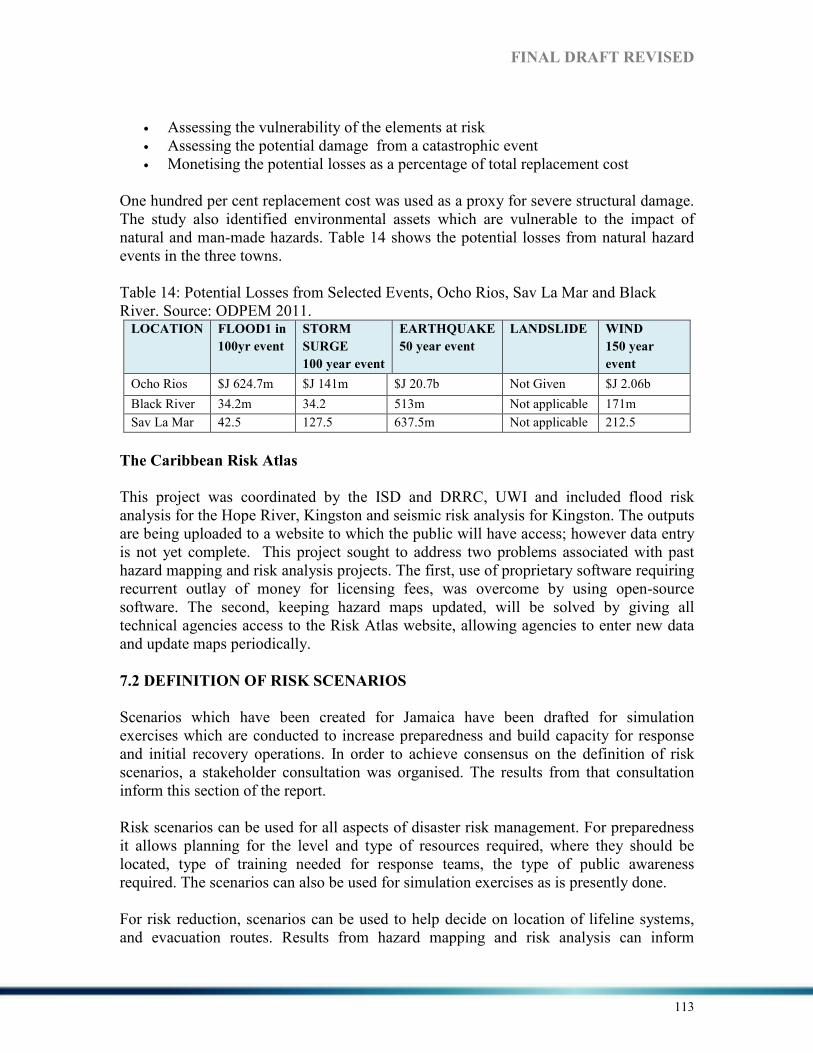
FI%AL DRAFT REVISED
113
• Assessing the vulnerability of the elements at risk • Assessing the potential damage from a catastrophic event • Monetising the potential losses as a percentage of total replacement cost
One hundred per cent replacement cost was used as a proxy for severe structural damage. The study also identified environmental assets which are vulnerable to the impact of natural and man-made hazards. Table 14 shows the potential losses from natural hazard events in the three towns. Table 14: Potential Losses from Selected Events, Ocho Rios, Sav La Mar and Black River. Source: ODPEM 2011. LOCATIO% FLOOD1 in
100yr event
STORM
SURGE
100 year event
EARTHQUAKE
50 year event
LA%DSLIDE WI%D
150 year
event
Ocho Rios $J 624.7m $J 141m $J 20.7b Not Given $J 2.06b
Black River 34.2m 34.2 513m Not applicable 171m
Sav La Mar 42.5 127.5 637.5m Not applicable 212.5
The Caribbean Risk Atlas
This project was coordinated by the ISD and DRRC, UWI and included flood risk analysis for the Hope River, Kingston and seismic risk analysis for Kingston. The outputs are being uploaded to a website to which the public will have access; however data entry is not yet complete. This project sought to address two problems associated with past hazard mapping and risk analysis projects. The first, use of proprietary software requiring recurrent outlay of money for licensing fees, was overcome by using open-source software. The second, keeping hazard maps updated, will be solved by giving all technical agencies access to the Risk Atlas website, allowing agencies to enter new data and update maps periodically.
7.2 DEFI%ITIO% OF RISK SCE%ARIOS
Scenarios which have been created for Jamaica have been drafted for simulation exercises which are conducted to increase preparedness and build capacity for response and initial recovery operations. In order to achieve consensus on the definition of risk scenarios, a stakeholder consultation was organised. The results from that consultation inform this section of the report. Risk scenarios can be used for all aspects of disaster risk management. For preparedness it allows planning for the level and type of resources required, where they should be located, type of training needed for response teams, the type of public awareness required. The scenarios can also be used for simulation exercises as is presently done. For risk reduction, scenarios can be used to help decide on location of lifeline systems, and evacuation routes. Results from hazard mapping and risk analysis can inform
FI%AL DRAFT REVISED
114
building codes and zoning laws and regulations, as well as structural designs and physical and macro-economic planning. In the response phase scenarios allow projections of impact, casualties, damage to the built environment including critical facilities, as well as damage to the natural environment. For the recovery phase, economic rebuilding, rehabilitation and relocation planning can all be informed by disaster risk scenarios.
Gaps
In discussing the need for scenario development some gaps were identified which must be seen as priorities to be addressed in support of development of the disaster risk scenarios:-
1. Lack of detailed building inventories – There is some building inventory data in private hands, and the recent Caribbean Risk Atlas project collected detailed data on buildings in areas of Kingston
2. Lack of specific damage data for buildings types 3. Lack of detailed information on value of buildings – There is no comprehensive
inventory on value of buildings. It may be possible to derive some of this data from the insurance sector.
4. Lack of data on value of natural resources, agriculture resources, government assets
5. Lack of standardised methods – there should be a national consensus on the method to be used.
Priorities
Priorities for disaster risk scenarios were identified as: Priority 1: Earthquakes and secondary hazards – Magnitude 7.5 originating on the Plantain Garden Fault and Magnitude 6.5 with epicentre near Montego Bay. These would provide information on the probable impact of large earthquakes on the capital and second city. Priority 2: A Category 5 hurricane traversing east – west across the island. This is or is close to a worst case scenario for a hurricane affecting Jamaica. It is modeled on Hurricane Gilbert which affected the country as a Category 3 hurricane. Priority 3: a) The 150 year flood in a location to be decided and b) prolonged drought affecting the entire island. This scenario is based on the anticipation of the effects of climate change.

FI%AL DRAFT REVISED
115
Priority 4: Hazardous materials release in the Kingston Harbour zone. There have been a number of small releases in 2012. Greater attention is to be paid to technological hazards. Priority 5: a) Flu-like pandemic and b) disease in the banana, sugar and poultry industries. National simulation exercises have been run for influenza, but not for diseases affecting agriculture. Food security considerations will become increasingly important under climate change.
%ext Steps
1. Ownership of the process of developing, updating and implementing disaster risk
scenarios is to be decided. 2. The target time frame for completing the scenarios is to be decided. 3. Standardised methods are to be decided. 4. A source of funding is to be identified. 5. A training programme is to be developed for the stakeholders who would be
involved in development of the scenarios. It was unanimously agreed that local knowledge from communities should be included in the scenarios.
7.3 SUMMARY
Information on hazards has become increasingly available thanks to the use of technology aids such as websites and social media sites. There is challenge in reaching rural areas where there is no internet service, although CBDRM programmes help to disseminate information on preparedness and planning. Access to products which would help in educating the public about risk reduction, such as hazard maps is more restricted. It should be noted too, that availability and use of hazard maps at parish level is inconsistent, and many maps are outdated. The approach by the UWI in making the outputs of the Caribbean Risk Atlas available on the internet for consultation and updating should be an example for future projects.
The projected impact of sea level rise on Caribbean countries has been calculated for scenarios of one and two metre rises in sea level (Caribsave 2010). For Jamaica, a one metre rise in sea-level will affect 1% of agricultural land, 8% of major tourism resorts, 20 per cent of airports, 2% of the road network and 100% of port lands. For a 2m rise, 2% of agricultural land, 18% of tourism resorts, 60% of airports and 80% of power plants would be affected. Other scenarios to be considered is the superimposing of storm surge on sea level rise. Modelling from the Caribsave project suggests surges of up to 5m in such a scenario. It should be noted however, that storm surge of greater than 5m has been recorded in Hurricane Allen, for example. The level of storm surge inundation is dependent on bathymetry, coastal topography as well characteristics of the approaching hurricane. The scenario projects damage for 38% of major tourism resorts which has
FI%AL DRAFT REVISED
116
grave implications for the economy. Damage to the coastline and beaches will also be severe. Calculation of DRM indices in 2008 showed that there was some progress made since 2005, though not in all areas. The risk identification index showed improvements in public information and community participation with an advance from significant to outstanding (IDB 2008). Vulnerability and risk assessment and training and education in risk management showed improvement from incipient to significant. (IDB 2008).
For risk reduction the review notes that there were no advances in the majority of activities except reinforcement and retrofitting of assets which moved from low to incipient. Disaster management showed a slight improvement in availability of equipment and rehabilitation and reconstruction planning, while coordination of emergency operations changed from optimal to outstanding. (IDB 2008)
One of the advantages of this system of indices is that they can be disaggregated and progress in a number of sub-areas can be measured and tracked. The work done in 2005-2007 established baseline conditions which can be measured for progress, as was done in 2008.

FI%AL DRAFT REVISED
117
8. STRATEGIC DIRECTIO%S FOR DISASTER RISK REDUCTIO%
I% THE COU%TRY Long term DRR strategic priorities and strategies for achieving them are stated in Vision 2030. In discussions with public sector stakeholders, the consensus was that these priorities are still relevant. The National Work Programme Results Framework 2011 – 2014, coordinated by ODPEM, lists four Outcomes designed to achieve the Impact of ‘Increased Resilience of Jamaica to Hazards’. The work programme is developed within the Comprehensive Disaster Management framework agreed to by all CARICOM states, and is consistent with the priorities of the Hyogo Framework for Action. National Work Programme Outcomes:
1. Outcome 1 – Enhanced community capacity to mitigate and respond to the adverse effects of climate change and disasters.
2. Outcome 2 – Disaster Risk Management mainstreamed at national and Parish levels and incorporated into key sectors.
3. Outcome 3 - Disaster Risk Management information utilized to build a culture of safety at all levels
4. Outcome 4 - Preparedness, Mitigation, Response and Recovery Systems Strengthened.
A Performance Measuring Framework, with indicators was developed for monitoring progress of the work programme, however much of the baseline data has not yet been collected. The Work Programme Results Framework Outcomes are compatible with the priorities of Vision 2030 to which they are mapped in Table 15. Table 15: Work Programme Results Framework Outcomes and Vision 2030 Strategies
%ATIO%AL STRATEGIES Vision 2030 WORK PROGRAMME OUTCOMES -
ODPEM
Improve resilience to all forms of hazards Disaster Risk Management mainstreamed at national and parish levels and incorporated into key sectors.
Improve emergency response capability Preparedness, mitigation response and recovery systems strengthened
Develop measures to adapt to climate change
Enhanced community capacity to mitigate and respond to the adverse effects of climate change and disasters
Contribute to the effort to reduce the global rate of climate change
-
- Disaster Risk management information utilized to build a culture of safety at all levels

FI%AL DRAFT REVISED
118
8.1 DISCUSSIO%
Disaster risk is a function of the probability of occurrence of a hazard, and vulnerability to that hazard. Risk can be reduced by reducing the probability of occurrence of the hazard and or reducing vulnerability. Technological hazards are more susceptible to interventions. It is possible, for example, to prevent hazardous materials leaks and spills. Since it is virtually impossible to reduce the probability of occurrence of most natural hazards, reducing vulnerability represents the best approach to reducing risk from these hazards. The approach to reducing risk in Jamaica has been more focused on the study of hazards and introduction of mitigation measures in order to reduce the impact of these hazards. Very little work has been done in Jamaica in measuring and addressing vulnerability. At national scale, the use of vulnerability indices has been mentioned, as well as the ranking index used by ODPEM and sporadic use of the CVAT method. However there is no systematic coordinated effort to research and understand the drivers of vulnerability in order to ensure systematic reduction of vulnerability. In addition although the existence of vulnerable populations – the elderly, female-headed households, persons with disabilities, elderly without pensions, is recognised, many disaster plans do not include procedures for these populations. In order for DRR gains to be made, there must be an enabling framework. In this regard there are some encouraging signs of progress. Mention has already been made of the national development plan Vision 2030 which provides the national enabling framework for DRR. This is supported by the draft Hazard Risk Reduction Policy. The Integrated Disaster Risk Management Action Plan, now being finalized, will operationalize DRR for the country, providing a road map by which DRR multi-sector initiatives can be pursued. In addition DRR is given priority during the GOJ budget process by a system of points in which DRR related projects, or projects including DRR, score more points thus giving them priority in the budget allocation process. The integration of DRR and CCA in projects and programmes is also a positive step. Despite the progress which has been made, there are gaps which must be addressed related to systematic inclusion of DRR in all planning, including macro-economic planning. There has been no comprehensive multi-hazard risk analysis for Jamaica. In order to carry out such an assessment there is need for detailed information on exposure, vulnerability and hazards. The country lacks such detailed data bases. The most comprehensive risk analysis to date is the 2009 Catastrophe Risk Profile which calculates Probable Maximum Loss and Average Annual Loss for hurricanes and earthquakes. The authors of that study point out that because of data constraints, in most cases proxies are developed using indirect variables and correlations. For example there is inadequate data for building status and value, two elements which are critical to calculating the level of damage a building will sustain from a particular event, and the cost of that damage. In the case of public services and infrastructure where unit values are not available the authors used typical values from other countries in the region for the calculations.

FI%AL DRAFT REVISED
119
Further limitations are introduced when the hazard profiles are calculated. For example, the data used for calculation of seismicity was obtained in the late 1990s and as stated by the authors, ‘the effects of local seismic response are not taken into account’. Despite the constraints this study provides important information. It is the first time that a probabilistic risk assessment was done for Jamaica. Importantly the assessment covers national and parish levels, thus covering the entire country. The total exposure for earthquakes and hurricanes is 18.65 billion US dollars (IDB 2010). It must be noted that the exposure to flooding as a result of hurricanes or intense rainfall is not included in the analysis, so this figure must be viewed as being conservative. The study represents the most comprehensive set of data on risk. Its utility is increased as the risk is expressed by geographical units – parishes - as well as by sector, and is aggregated at national level. This data is particularly useful to the GOJ in guiding its risk transfer and investment policies. Integration of DRR into physical planning has made improvements with inclusion of technical agencies in the development approval process. The process requires all major developments to be reviewed by technical agencies at national level. Capacity for technical review at parish level is limited, and many parishes do not have hazard maps, vulnerability assessments or risk analyses to guide decision making. At the sectoral level, the Tourism Ministry participated in a regional project on developing a hazard mapping standard for the tourism sector. The project also included establishment of plans for emergency operations centres for the tourism industry and integration of the sector’s plans into parish and national plans. The Ministry of Agriculture has also included DRM in its work programme which includes development of the national ADRM plan and inclusion of DRM and CCA in several projects aimed at supporting sustainable livelihoods for small farmers. Integration of Disaster Risk Reduction in Natural Resource Management is achieved mainly through the inclusion of hazard impact analyses in EIAs. Impact of disasters on natural systems is included in post-impact assessments which use the ECLAC assessment method. Degradation of natural systems through development and overuse of resources, however, continues to be a challenge. Over the last three years there has been training of the public sector in natural resource valuation. This is also included in the MSc Natural Resource Management Degree at UWI, Mona campus. Both these initiatives should over time, lead to a cadre of technical personnel who can effectively lead the process of better integrating DRR in natural resource management. The role of ecosystems in reducing the impact from natural hazards has been recognised and rehabilitation of natural systems has been included in some projects related to DRR and CCA, for example. All examples of risk assessments shown here are the result of projects funded by donor partners. Government and municipal agencies do not have adequate budgets to undertake a systematic programme of hazard mapping, vulnerability assessment and risk analysis. There are several negative aspects to this resource constraint. Existing hazard maps are

FI%AL DRAFT REVISED
120
outdated and do not reflect latest scientific or population and development data. Risk analyses based on these maps are therefore likely to be inaccurate. This must be recognized in the use of the maps and in any derivations from the maps. There is no standard approach to either hazard mapping or risk analysis, making any attempt at comparisons across time futile. Since there is no national hazard mapping programme, there has been no agreed prioritization of areas to be mapped. There are therefore gaps in information for areas which could be considered critical. For example despite having suffered a recent damaging earthquake in 1957, no detailed seismic study of Montego Bay, the second largest city, has been done. Another noticeable gap is that some methods for climate-related hazard assessment such as flooding and storm surge are based exclusively on historical data and do not factor climate variability and climate change in the analyses. Analysis of climatic data suggests that use of historical data does not adequately account for variations being experienced in precipitation (Carby et al. 2012).
8.2 SUMMARY
The long term goals for disaster risk reduction and the strategies for achieving them are articulated in the country’s long term development plan. This is a key factor in integrating DRR into national development planning and demonstrates the government’s recognition of the importance of DRR to national sustainable development. The national work programme developed by ODPEM is a consensus document, written with the input of key stakeholders. This approach ensures that elements of DRR are incorporated into the work plans of government entities – an important step if DRR is to be achieved. The HFA and Enhanced CDM Strategy are important supporting frameworks which link Jamaica’s DRR programme with regional and international initiatives. It can be concluded that there is recognition of the importance of DRR to achieving Jamaica’s long term goals; however the traditional constraints which have been discussed in many reports and mentioned in this report – inadequate resources, low political will, weak governance to name some – must be overcome in order for sustained progress to be made.

FI%AL DRAFT REVISED
121
9.0 RECOMME%DATIO%S The National Disaster Plan is a comprehensive document which sets out pre and post disaster actions, roles and responsibilities for hazards which threaten Jamaica. However the plan must be updated to reflect the experiences of responding to more recent disaster events, increased focus on DRR as well as advances in technology. A plan for Continuity of Government Operations should be included in the national disaster plan. The Draft Hazard Risk Mitigation and Climate Change Policies should be finalised, approved by Cabinet and circulated. The discussion among stakeholders related to data collection, management and sharing, and which includes standardisation of methods for hazard mapping and risk analysis as well as developing disaster risk scenarios should continue. Consideration should be given to including requirements for data collection, management and sharing in the revised disaster legislation. There should be examination of current data collection approaches to ensure that data related to women, children and vulnerable groups is adequately collected and analysed. A national hazard and risk mapping programme with clearly stated priorities should be developed and funded. Hazard mapping has so far focussed on natural hazards. Other hazards such as bush fires, which can be expected to become more of a threat under some climate change scenarios, and hazardous materials should be included in the hazard mapping and risk analysis programme. The research into downscaling of global models by the Mona Climate Studies Group should be supported and the outputs should be factored into all physical planning, development planning, socio-economic planning, hazard mapping and risk analyses as part of climate change adaptation and disaster risk reduction planning. There should be immediate examination of set-back requirements in light of projections for climate change impacts and a re-evaluation of the way in which coastal development as well as placement of infrastructure takes place. Planning for diversification of the tourism product should also be looked at. The CARDIN database is effective for archiving information and academic papers on DRM. However, lack of financial and document support are gaps that should be addressed. The database should be widely publicised and authors should be encouraged to submit their publications to CARDIN to increase information dissemination and sharing. The value of ecosystems in disaster risk reduction seems to be under-appreciated, although this is slowly changing. Protection of ecosystems should be included in DRR plans at all levels and CBDRM programmes should include protection of ecosystems.

FI%AL DRAFT REVISED
122
The oft-repeated recommendations on enforcing existing legislation on land use planning, physical planning, illegal occupation of land, and construction of buildings, fire safety and public health, among others remains valid. The Building Code should be passed into law as a matter of urgency.
Several projects are implemented annually relating to DRM, DRR and CCA. The creation of a project inventory data base for DRM, DRR and CCA related projects in Jamaica would ensure that efforts would not be duplicated and that gaps would be addressed.
The government should consider investing in risk transfer mechanisms other than CCRIF for national assets. Risk transfer options are also needed at sub-national and community levels. The projected continuing increase of elderly persons, especially those without social support and economic means, within the population must be taken into account during disaster risk management planning. Significantly, many self-employed persons do not contribute to a pension plan, leaving them without a source of income in retirement, and thus vulnerable to the effects of disasters. This suggests that future disaster plans will have to be made for this group in addition to other vulnerable groups such as children and persons with disabilities. Gender issues are also under-represented in disaster plans and should be included. Most DRM/DRR interventions do not currently include livelihoods considerations. The DRR community could learn from climate change adaptation projects many of which include a sustainable livelihoods component. It is self – evident but worth repeating that DRR cannot be separated from national development and societal issues. Wider social issues such as poverty, unemployment, land tenure, adequate social safety nets for the most vulnerable, law enforcement and economic growth must be addressed if Jamaica is to see permanent gains in DRR.

FI%AL DRAFT REVISED
123
REFERE%CES Ahmad, R., F.N. Scatena and A. Gupta. 1993. Morphology and sedimentation in Caribbean montane
streams: examples from Jamaica and Puerto Rico. In: C.R. Fielding (Editor), Current Research in Fluvial Sedimentology. Sedimentary Geology, 85: 157-169.
Ahmad, Rafi. 2001a. Earthquakes in Jamaica are inevitable but earthquake disaster need not be?
University of the West Indies. Kingston: Jamaica. Information accessed on September 1, 2012 from: http://www.mona.uwi.edu/uds/GEOHAZARDS_2001/EQprep-20010612b.html
Ahmad, Rafi. 2001b. Landslides in Jamaica. University of the West Indies. Kingston: Jamaica. Information
accessed on September 1, 2012 from: http://www.mona.uwi.edu/uds/GEOHAZARDS_2001/LandslideJAM-20010612a.html
Ahmad, Rafi. Undated. Earthquake Hazards, Risks, and Disasters in Jamaica. University of the West
Indies. Kingston: Jamaica. Information accessed on September 2, 2012 from: http://www.mona.uwi.edu/cardin/virtual_library/docs/1136/1136.pdf
Carby, B., C. Burgess, D. Myers and M. Henry. 2012. Vulnerability of Jamaica’s infrastructure to the
impact of climate change. University of the West Indies/CEAC Solutions Limited/Thermatics Solution Co. Limited. Kingston: Jamaica
Carby, B. Enhancing National Resilience: Focus on the Built and Natural Environments. University of the
West Indies. Kingston: Jamaica. Carby, Barbara. 2011. Mid-term Review of the Hyogo Framework for Action in the Caribbean. University
of the West Indies. Kingston: Jamaica. in PIOJ, 2012a. A Growth-Inducement Strategy for
Jamaica. Gladstone Hutchinson and Donald Harris, Eds. Planning Institute of Jamaica. Kingston: Jamaica.
CCCCC, 2009. Climate Change and the Caribbean: Regional Framework for Achieving Development
Resilience to Climate Change in the Caribbean 2009-2015. Caribbean Community Climate Change Centre. Belmopan, Belize.
CFLGM, 2012. Country Profile Jamaica - Local Government System. Information accessed on September
5, 2012 from: http://www.clgf.org.uk/userfiles/1/File/2008_Country_Files/JAMAICA.pdf. Clarke, D. undated. Abuse of the homeless rampant in the west. The Jamaica Gleaner. Retrieved January
2013 from Jamaica-gleaner.com/pages/street people/story2.htm. CLEP, 2010. Caribbean Emergency Legislation Project !ational Workshop Draft Report. Organisation of
American States. Kingston: Jamaica. Dasgupta, S., B. Laplante, S. Murray and D. Wheeler. 2009. Sea-level Rise and Storm Surges: A
comparative Analysis of Impacts in Developing Countries. Policy Research Working Paper 4901. Development Research Group. Environment and Energy Team. The World Bank. Washington: USA. in World Bank. 2010. Disaster Risk Management in Latin America and the Caribbean Region: GFDRR Country Notes Jamaica. Washington: USA.
DIPECHO, 2011. Guía Metodológica Para La Sistematización Herramientas para La Gestions de Riesgo.
Information accessed on September 20, 2012 from: http://www.eird.org/wikiesp/images/Gu%C3%ADaMethodol%C3B3gica_para_la Sistematizaci%C3%B3n_de_Herramientas_para_la_Gesti%C3%B3n_del_Riesgo Noviembre_2011.pdf (available in spanish only).

FI%AL DRAFT REVISED
124
ECLAC, 2004. Assessment of the Socioeconomic and Environmental Impact of Hurricane Ivan on
Jamaica. United Nations Economic Commission for Latin American and the Caribbean. Kingston: Jamaica.
ECLAC, 2010. Report of the Macro Socio-economic Effect of the Events of Western Kingston Area, 22 May
– 7 June 2010. United Nations Economic Commission for Latin American and the Caribbean. Kingston: Jamaica.
ECLAC, 2011. An Assessment of the Economic Impact of Climate Change on the Tourism Sector in
Jamaica. United Nations Economic Commission for Latin American and the Caribbean. Kingston: Jamaica.
Edwards, M.T. and K.N. Morris. 2007. Disaster Risk Reduction and Vulnerable Populations in Jamaica
Protecting Children within the Comprehensive Disaster Management (CDM) Framework. Kingston: Jamaica.
GAR, 2011. Global Assessment Report on Disaster Risk Reduction: Revealing Risk, Redefining
development. Geneva: Switzerland. GFDRR, 2010. Disaster Risk Management in Latin America and the Caribbean Region: GFDRR Country
!otes – Jamaica. Washington: DC. GOJ, 2008. Rapid Assessment of the Problem of Squatting in Jamaica. Government of Jamaica. Kingston:
Jamaica. GOJ, 2011. The Second !ational Communication of Jamaica to the United !ations Framework Convention
Climate Change. National Meteorological Service Jamaica. Kingston: Jamaica. GOJ, 2012. Draft Food and !utrition Security Policy. Ministry of Agriculture and Fisheries. Kingston:
Jamaica. Harmeling, S. 2009. Global Climate Risk Index 2010: Who is most vulnerable? Weather-related loss events
since 1900 and hoe Copenhagen needs to respond. Germanwatch. Berlin: Germany.
IDB, 2005. Indicators of Disaster Risk Management: Program for Latin America and the Caribbean. Inter-
American Development Bank. Washington: USA.
IDB, 2007. Indicators of Disaster Risk Management: Program for Latin America and the Caribbean. Inter-
American Development Bank. Washington: USA. IDB, 2008. Indicators of Disaster Risk Management: Program for Latin America and the Caribbean. Inter-
American Development Bank. Washington: USA. IDB, 2009. Country Specific Risk Evaluation Bolivia, Guatemala, Jamaica and Peru: Catastrophe Risk
Profile – Jamaica. Inter-American Development Bank. Washington: USA. IDB, 2009. Application of the System of Indicators of Disaster Risk and Disaster Risk Management 2005-
2007. Inter-American Development Bank. Washington: USA. IDB, 2010. Indicators of Disaster Risk and Risk Management: Program for Latin America and the
Caribbean – Jamaica. Technical Notes IDB-TN-169. Inter-American Development Bank. Washington: USA.

FI%AL DRAFT REVISED
125
Jackson, Ronald. 2005. Managing !atural Hazards in Jamaica. Office of Disaster Preparedness and
Emergency Management. Kingston: Jamaica. JIEP, 2011. Towards Strategic Spatial Planning in Jamaica: The !ational Spatial Plan. JIEP 5th Biennial
Conference June 6, 2011 on the Environment: “Balancing National Development and Environmental Protection”. Kingston: Jamaica. Information accessed on October 24, 2012 from: http://www.jiep.org/drupal/sites/default/files/Conference_Presentations/Day%201/McCulloch,%20S-edited-final.pdf
JIS, 2012. Overview of the Government of Jamaica. Information accessed on September 5, 2012 from:
http://www.jis.gov.jm/government/about-government. JIS, 2012a. Strategies in Place to Address Homelessness. Information accessed on January 2013 from:
http://www.jis.gov.jm/news/opm-news/31649-strategies-in-place-to-address-homelessness. Kelly, R. and L. Roper. 2012. Risk and Vulnerability Assessment Methodology Development Project
(RiVAMP). Planning Institute of Jamaica. Kingston: Jamaica. McLean, T., S. Goffe, C. Gomes and S. Wilkinson. 2009. Report on the Situation of Children in the Care of
the Jamaica State. Jamaican of Justice. Kingston: Jamaica. Information Accessed on December 11, 2012 from: http://lib.ohchr.org/HRBodies/UPR/Documents/Session9/JM/JFJ_Jamicansforjustice_Annex12.pdf
MWLECC, 2012. Draft Jamaica !ational Climate Change Policy and Action Plan 2012. Government of
Jamaica. Kingston: Jamaica. NDP, 1997. !ational Disaster Plan. Office of Disaster Preparedness and Emergency Management.
Kingston: Jamaica. NDRP, 1995. !ational Disaster Relief Policy. Office of Disaster Preparedness and Emergency
Management. Kingston: Jamaica. NHRP, 2005. !ational Hazard-risk Reduction Policy for Jamaica. Office of Disaster Preparedness and
Emergency Management. Kingston: Jamaica. Hydrology of Jamaica. Information accessed on August 28, 2012 from:
http://www.wra.gov.jm/dynaweb.dti?dynasection=general&dynapage=hydrology ODPEM, 2005. Guidelines for Child-Friendly Disaster Management and Response. Office of Disaster
Preparedness and Emergency Management. Kingston: Jamaica. ODPEM, 2008. Vulnerability Ranking Methodology. Office of Disaster Preparedness and Emergency
Management. Kingston: Jamaica. ODPEM. 2011. Risk Assessments and the Development of Risk Management Plans for Ocho Rios, Black
River and Savanna-la-Mar, Jamaica. Office of Disaster Preparedness and Emergency Management. Kingston: Jamaica.
ODPEM, 2011a. !ational progress report on the implementation of the Hyogo Framework for Action
(2009-2011) – Jamaica. Office of Disaster Preparedness and Emergency Management. Kingston: Jamaica.
ODPEM, 2012. Annual Report: April 2011 – March 2012. Office of Disaster Preparedness and Emergency
Management. Kingston: Jamaica.

FI%AL DRAFT REVISED
126
ODPEM, Undated. Vulnerability Ranking Methodology: Introductory Phase Pilot-Clarendon, Jamaica.
Kingston: Jamaica. PAHO, 1989. Disaster Reports !umber 5: Hurricane Gilbert in Jamaica, September 1988. Pan American
Health Organisation. Kingston: Jamaica. PAHO, 2010. Jamaica Country Cooperation Strategy 2010 – 2015. Pan American Health
Organisation/World Health Organisation. Washington: USA. PAHO, 2012. Guidelines for Mainstreaming the !eeds of Older Persons in Disaster Situations. Pan
American Health Organisation. Washington: USA. Pantin, Dennis. 1994. The economics of sustainable development in small Caribbean Islands. University of
the West Indies. St. Augustine: Trinidad. PHA, 1985. Public Health Act. Government of Jamaica. Kingston: Jamaica. PIOJ, 1998. Jamaica Survey of Living Conditions 1997. Planning Institute of Jamaica. Kingston: Jamaica. PIOJ, 2007. The Poverty-Environment !exus: Establishing an Approach for Determining Special
Development Areas in Jamaica. Planning Institute of Jamaica. Kingston: Jamaica.
PIOJ, 2007a. Jamaica Survey of Living Conditions 2006. Planning Institute of Jamaica. Kingston: Jamaica.
PIOJ, 2008. Economic and Social Survey. Planning Institute of Jamaica. Kingston: Jamaica. PIOJ, 2009a. Vision 2030 Jamaica: !ational Development Plan. Planning Institute of Jamaica. Kingston:
Jamaica. PIOJ, 2009b. Medium Term Socio-Economic Policy Framework 2009-2012. Planning Institute of Jamaica.
Kingston: Jamaica. PIOJ, 2009c. !ational Report of Jamaica on Millennium Development Goals for the U! Economic and
Social Council Annual Ministerial Review, Geneva, July 2009. Planning Institute of Jamaica. Kingston: Jamaica.
PIOJ, 2011. Economic and Social Survey 2010. Planning Institute of Jamaica. Kingston: Jamaica. PIOJ, 2012. Jamaica Country Assessment – Preliminary Draft. Planning Institute of Jamaica. Kingston:
Jamaica. PIOJ, 2012a. A Growth-Inducement Strategy for Jamaica. Gladstone Hutchinson and Donald Harris, Eds.
Planning Institute of Jamaica. Kingston: Jamaica. Richards, A. 2008. Development Trends in Jamaica’s Coastal Areas and the Implications for Climate
Change. Planning Institute of Jamaica. Kingston: Jamaica. Reid, Tyrone. 2011. Disgraceful – disabled residents at the Golden-Age Home ill-treated, tied up,
neglected. The Jamaica Gleaner. Information accessed on December 11, 2012 from: http://jamaica-gleaner.com/gleaner/20110403/lead/lead1.html
FI%AL DRAFT REVISED
127
Senior, K. and L. Dunn. 2009. Enhancing Gender Visibility in Disaster Risk Management and Climate
Change in the Caribbean: Country Assessment Report for Jamaica. University of the West Indies. Kingston: Jamaica
Smith, D. 2007. Information on Disaster Risk Management. Case Study of Five Countries: Jamaica. United
Nations and International Development Bank. Mexico City: Mexico. Spaulding, Gary. 2012. Fire Leaves More Than 60 Homeless. The Jamaica Gleaner. Information Accessed
on September 28, 2012 from: http://jamaica-gleaner.com/gleaner/20120927/lead/lead2.html SOJC, 2012. Draft State of the Jamaican Climate: Information for Resilience Building. Planning Institute
of Jamaica/Climate Studies Group Mona. Kingston: Jamaica. STATIN, 2008. Population Projections Jamaica 2000-2050. Planning Institute of Jamaica and Statistical
Institute of Jamaica. Kingston: Jamaica. STATIN, 2012. 2011 Census of Population and Housing – Jamaica: General Report Volume 1. Statistical
Institute of Jamaica. Kingston: Jamaica. The Gleaner, 2012. More Dengue Cases Recorded. The Jamaica Gleaner. Information Accessed on
December 11, 2012 from: http://jamaica-gleaner.com/latest/article.php?id=41537 Tucker, A. Undated. Vulnerability Ranking Methodology: Introductory Phase Pilot-Clarendon, Jamaica.
Kingston: Jamaica. Senior, K. and L. Dunn. 2009. Enhancing Gender Visibility in Disaster Risk Management and Climate
Change in the Caribbean: Country Assessment Report for Jamaica. University of the West Indies. Kingston: Jamaica
United Nations, 2007. The Millennium Development Goals Report, 2007. New York: USA. UNDP, 2007. Human Development Report 2007/2008: Fighting climate change: Human solidarity in a
divided world. United !ations. !ew York: USA. Accessed on September 28, 2012 from: http://hdr.undp.org/en/media/HDR_20072008_EN_Complete.pdf
UNDP, 2009. Human Development Report 2009 – Jamaica. in World Bank. 2010. Disaster Risk
Management in Latin America and the Caribbean Region: GFDRR Country !otes Jamaica. Washington: USA.
UNDP, 2009a. Enhancing Gender Visibility in Disaster Risk Management and Climate Change in the
Caribbean: Country Assessment Report, Jamaica. Barbados.
UNDP, 2010. Capacity Development for Disaster risk Reduction. United Nations Development
Programme. New York, USA. UNESCO, 2011. Early Childhood and Family Policy Series N° 21 – 2011: Caring and Learning Together:
A Case Study of Jamaica. United Nations Education and Scientific Council. Paris: France. UNICEF, 2007. Situation Analysis on Gender Disparities in Jamaica Update 2007. Information accessed on
October 8, 2012 from: http://www.unicef.org/jamaica/resources_10852.htm. UNISDR, 2009. U!ISDR Terminology on Disaster Risk Reduction. United !ations Office for Disaster Risk
Reduction. Geneva: Switzerland. Information accessed on July 28, 2012 from: http://www.unisdr.org/files/7817_UNISDRTerminologyEnglish.pdf

FI%AL DRAFT REVISED
128
UNPF/HAI, 2011. Desk Review-The Situation of Older Persons in Jamaica. Information accessed on
January, 17 2013 from http://caribbean.unfpa.org/public/Home/Publications/pid/9729 Vision 2030, 2009. Vision 2030 Jamaican !ational Development Plan. Planning Institute of Jamaica.
Kingston: Jamaica. Walker, Karyl. 2012. 30 Families homeless in Beeston Street fire. Jamaica Observer. Information accessed
on September 28, 2012 from: http://www.jamaicaobserver.com/news/30-families-homeless-in-Beeston-Street-fire
Walling, Brown and Smith. 2011. The Guidance Tool: A Manual for Mainstreaming Climate Change
Adaptation into the CDM Country Work Programme. Caribbean Disaster Emergency Management Agency. St. Michael: Barbados.
Wilches-Chaux, G. 1993. La Vulnerabilidad Global. Information accessed on September 20, 2012 from:
http://www.desenredando.org/public/libros/1993/ldnsn/html/cap2.htm. Williams-Raynor, P. 2010. 1,500 Jamaicans homeless and counting. Jamaica Observer. Information
accessed on January 2013 from: www.jamaicaobserver.com/news/1500-Jamaicans-homeless-and-counting.
World Bank, 2008. Climate Resilient Cities: A Primer on Reducing Vulnerabilities to Climate Change
Impacts and Strengthening Disaster Risk Management in East Asian Cities. Washington: USA. World Bank, 2010. Disaster Risk Management in Latin America and the Caribbean Region: GFDRR
Country !otes Jamaica. Washington: USA. WCED, 1987. Our Common Future. World Commission on Environment and Development. Oxford
University Press. Oxford: London. WRA, 1995. Water Resources Act. Government of Jamaica. Kingston: Jamaica.

FI%AL DRAFT REVISED
129
APPE%DIX

FI%AL DRAFT REVISED
130
Appendix 1: Geological Map of Jamaica. Source: Ahmad undated.

FI%AL DRAFT REVISED
131
Appendix 2: Map showing Jamaica Watershed Classification. Source: WMU 2007.

FI%AL DRAFT REVISED
132
Appendix 3: Map of flood and landslide occurrences across Jamaica.
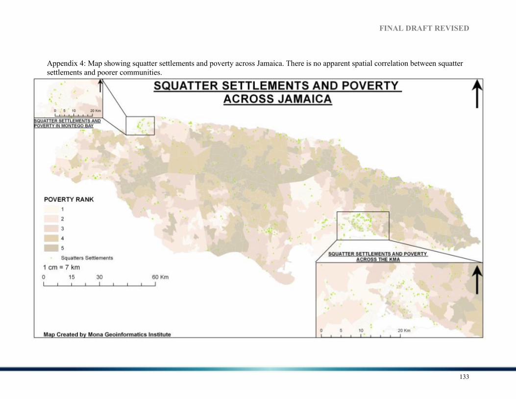
FI%AL DRAFT REVISED
133
Appendix 4: Map showing squatter settlements and poverty across Jamaica. There is no apparent spatial correlation between squatter settlements and poorer communities.
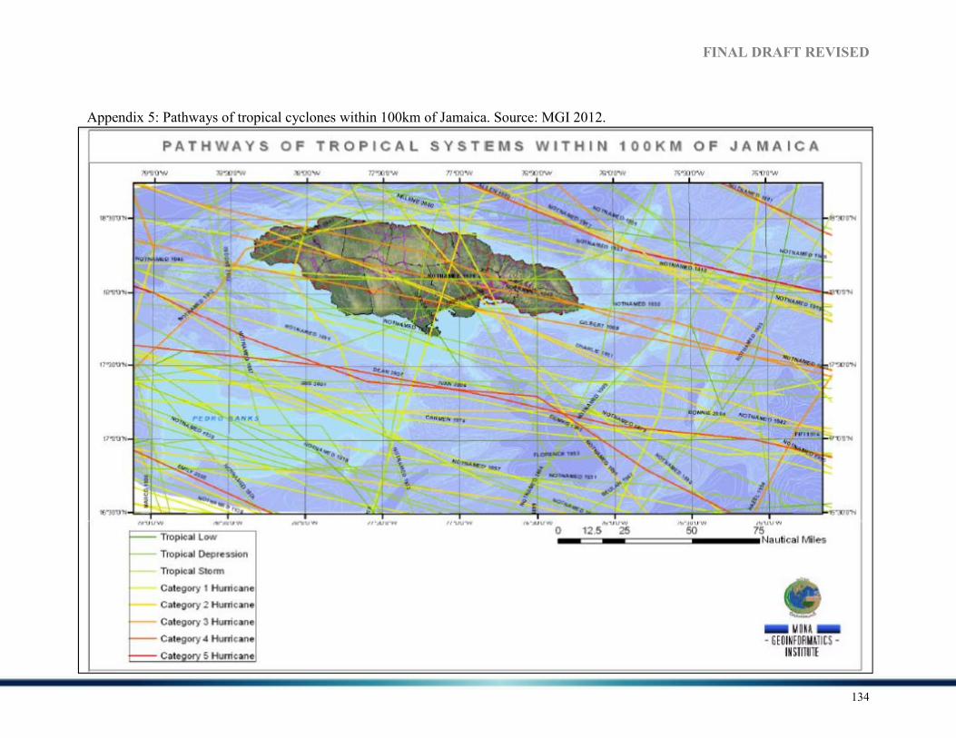
FI%AL DRAFT REVISED
134
Appendix 5: Pathways of tropical cyclones within 100km of Jamaica. Source: MGI 2012.

FI%AL DRAFT REVISED
135