Embed Size (px)
Citation preview

JAIME A. MIYASHIRO TSukAzAn
Vulnerabilidad físicohabitacional:tarea de todos.¿responsabilidad de alguien?

JAIME A. MIYASHIRO TSukAzAn
Estudiosurbanos
Vulnerabilidad físicohabitacional:tarea de todos.¿responsabilidad de alguien?

La publicación de este trabajo ha contado con el apoyo de CORDAID de Holanda, MISEREOR de Alemania y LUND UNIVERSITY de Suecia.
Tirada: 1000 ejemplares. Primera edición.
Equipo técnico de investigación: Componente territorial:Ing. Geo. César Orejón RodríguezComponente social:Arq. Jaime A. Miyashiro TsukazanComponente vivienda:Ing. Civil. Rafael Maraví CuttiComponente organizacional y normativo:Soc. Eduardo Narváez Espino / Adm. Ramiro García Quispe
Fotos de carátula e interiores: Archivo Programa Urbano de descoIniciativa Social Blanco y Negro
Mapas: Observatorio Urbano de desco
Corrección de estilo: Annie Ordóñez
PHYSICAL HOUSING VULNERABILITY Everyone’s business. Whose responsibility?Traducción al inglés: Rosmery Underhay
ISBN:978-612-4043-07-9Hecho el Depósito Legal en la Biblioteca Nacional del Perú Nº 2009-11666
Diagramación e impresión: SINCO Editores SACDirección: Jr. Huaraz 449 - Lima 5 - Breña
© desco Centro de Estudios y Promoción del Desarrollo León de la Fuente 110. Lima 17 Perú. (511) 6138300 www.desco.org.peSetiembre de 2009
Código 13538
MIYASHIRO TSUKAZAN, Jaime A.
Vulnerabilidad físico habitacional: tarea de todos ¿responsabilidad de alguien?. -- Lima: desco. Programa Urbano, 2009.112 p. (Serie: Estudios Urbanos; 5).
Urbano / Desastres naturales / Sismos / Villa El Salvador / Villa María del Triunfo

86 87
Jaime Miyashiro T.
1. introduction
2. bacKground: earthQuaKe in southern Peru andthe growth of lima 2.1. disasters are not naturaL: Lessons Learned in the south 2.2. unresoLved probLems: risK mitigation and Lima’s urban groWth 2.3. earthQuaKes: a recurrent phenomenon in peru
3. analysis of the neighbourhoods in southern lima: a methodological ProPosal to assess Physical housing Vulnerability to earthQuaKes 3.1. methodoLogy used for mapping 3.1.1. components for seismic risK vuLnerabiLity mapping 3.1.2. the housing seismic vuLnerabiLity risK map 3.2 the resuLts obtained in the southern Lima study areas 3.2.1. the terrain component: the probLem of settLing beyond the soiL QuaLity study 3.2.2. the sociaL component: an essentiaL eLement in terrain assessment 3.2.3 the housing component: usuaL probLems, usuaL soLutions? 3.3. the housing seismic vuLnerabiLity map
4. unresolVed Problems: beyond the two study areas 4.1. technicaL aspects and risK 4.2. the institutionaL frameWorK, distribution of responsibiLities
5. final recommendations 5.1. three additionaL factors 5.2. the importance of mapping housing seismic risK vuLnerabiLity 5.3. risK and disaster mitigation: commitment and everyone’s business 5.4. in concLusion
urban study nº 5: Physical housing Vulnerability everyone’s business. whose responsibility?
0
88
89
899193
94
9495969696
98
100102
103104107
108108109110111
í n d i c e

88
Physical Housing Vulnerability
89
On August 15, 2007 the south of Peru was hit by an earthquake on a scale which sadly left a toll of 596 dead, over 1292 injured, more than 48,000 houses damaged and nearly 435,000 victims.1 Almost two years after the disaster, on balance the solutions applied show us a rather discouraging panorama, since the same mistakes are repeated in organizational, technical and construction aspects in the process of rebuilding the damaged structures. The essential criteria which would make it possible to tackle future earthquakes adequately are absent. We cannot ignore this possibility, since Peru is in one of the areas of the planet with greatest seismic activity, and hence it is of vital importance to analyze the effects this natural phenomenon may have on our cities.
This Urban Study will show what effects an earthquake similar in size to that which occurred in the south could have, but in a different geographical context, the city of Lima. We have taken as research sites some neighbourhoods built in recent decades: the neighbourhood of Santa Maria, in the district of Villa Maria del Triunfo and that of Brisas de Pachacámac, in the district of Villa El Salvador (see Map N°1). This will help us to understand the diverse effects which an earthquake can have in one same city in which there are areas with very different geomorphological characteristics.
The study will also show the problems which arise in the aftermath of an earthquake, and the limited chances of mitigating them in advance. This is due to the weak organization and lack of interest on the part of those involved. Hence it is important to make clear the fact that most activities carried out are geared to rebuilding cities after an earthquake in order to try and get back to “normality” and alleviate the effects of the loss of this condition, with the idea that there will not be another earthquake for a long time and that there will be plenty of time later on to get prepared. The problem is that after a certain time people forget this and the work of getting ready to deal better with any future earthquakes is never finally done.
In this sense the National Civil Defence System motto: “Civil Defence, Everyone’s Business” is wrongly understood by all parties involved, since many assume that since it is everyone’s business, there must be someone who does the work. The trouble is that both the authorities and the business sector and civil society in general feel that it will be “the other fellow” who will be doing the work and in the end no one does anything.
1 Figures from the National Civil Defence Institute (INDECI), in its Emer-gency Report Nº 557 31/12/2008/ COEN SINADECI / 18:00 hours (Re-port Nº 90).
This lack of organization is evident in the existence of numerous plans of action and research studies drafted to tackle and prepare for the threat of an earthquake. Just to mention a few, we have the National Plan, the sector plans in the ministries and the provincial disaster prevention and response plans.2 The Sustainable Cities Programme also has a study of a number of cities nationwide, including some of those hardest hit by the earthquake in the south, like Ica, Pisco and Cañete.3 We might also mention the seismic vulnerability studies conducted by the CISMID.4 Unfortunately these documents are not inter-connected and worse still, the institutions which work on the issue often feel rather concerned to protect the information they have, and as a result research studies overlap and information is often duplicated.
Although what we have written above describes structural problems of function and coordination, the chief snag lies in the fact that the general public is unaware of these studies and it is often unfortunately the authorities themselves who keep hold of the information and do not recognise its importance. One example is Tambo de Mora — the coastal district in the Chincha province which was also seriously affected by the earthquake in August 2007. It had a risk map5 which had been
2 Each of the plans can be found by visiting the National Civil Defence Institute web page. http://www.indeci.gob.pe/planes_proy_prg/planes_estrat.htm
3 The Sustainable Cities Programme operates with a general view geared to achieve cities which are safe, healthy, attractive, well-ordered, which respect the environment and their historical and cultural heritage. They should also be governable, competitive and be run and devel-oped efficiently, so that their inhabitants can live in a comfortable atmosphere, facilitating increased productivity, so that future genera-tions can inherit cities and towns which are not severely affected by intense and anthropic natural phenomena. http://www.cismid-uni.org/quienes_somos.php
4 The Peruvian-Japanese Centre for Seismic Research and Disaster Miti-gation (CISMID) was founded in 1986 by the Civil Engineering Faculty (FIC) of the National Engineering University (UNI) and funded thanks to Japanese government cooperation through its International Coop-eration Agency (JICA). The CISMID is an academic and research centre whose objective is to study, develop and systematically improve tech-nologies and techniques to reduce drastically the number of victims and material damage caused by the most frequent natural disasters in Peru, such as: earthquakes, floods, landslides, avalanches, flash floods, land faults etc. These studies are multidisciplinary and are conducted in coordination with other organizations interested in natural disasters in Peru. http://www.cismid-uni.org/quienes_somos.php
5 The proposal was drafted by INDECI in the framework of the Sustain-able Cities Programme. The aim of its first stage is to place “…emphasis on the ‘physical security of the cities, since the effects of intense natural and anthropic (man-made) phenomena can cause considerable dam-age in the cities, which would lead to a sudden drop in the standard of living of their inhabitants and make the sustainable development of the city impossible unless adequate preventive measures be taken.”
1. introduction

88 89
Jaime Miyashiro T.
on a shelf in the city hall for many years. Local government turnover and the lack of interest in the question left this information hidden away in some file until after the disaster. The most lamentable part of this story is that the map shows with painful accuracy the zones most likely to collapse in the event of an earthquake, information which life demonstrated implacably.
Two questions arise immediately: Did anyone know that this information existed? And if we knew it was there, why didn’t we do anything? The answers appear without needing an in-depth analysis, since what people know of they do not disseminate since it is “not a priority”, and society does not have the capacity to get organized. The facts and information are not disseminated nor do they give priority to the risks faced. What is worse, the community that will suffer the effects of the natural phenomenon never finds out about the magnitude of the danger it is exposed to until after the disaster has occurred.
Therefore, the Urban Study we are presenting appeals to all the parties involved in the question of risk prevention and disaster mitigation, calling particularly on the authorities, since they are responsible for leading these processes. It is they who should embark on concrete actions geared to reversing the current lethargy due to the lack of common awareness for planning unified actions in the framework of a functional system for reducing the effects of a potential earthquake, the activities to implement during the earthquake and the reconstruction in its aftermath.
We feel that we can take the fist steps in the quest for change by mapping the physical housing vulnerability to earthquakes using a simple methodology, which needs reasonable economic and human resources, to be carried out by the municipal governments. They could consider this job to be the foundation or the essential tool for any planning or territorial zoning process they want to conduct anywhere, and hence it must be shared by local and national authorities, not forgetting specialists in the field. Community participation in this is also fundamental, since this process has also demonstrated the leading role of the people who live in the vulnerable areas, who are never taken into account in the attempt to prevent and mitigate the effects of the lack of preparedness for tackling natural phenomena (in this study, earthquakes) or the vulnerabilities produced by human activity and which subsequently set off disasters which we do not more than bewail.
2. background: earthquake in southern peru and the growth of Lima
2.1. disasters are not naturaL: Lessons Learned in the south
The first lesson the earthquake in the south teaches us6 is that unfortunately people are used to understanding the terms ”natural phenomenon” and “natural disaster” as synonyms, and hence in theory no mitigation measures could be possible, since it is the uncontrollable forces of nature which decide if an earthquake will or will not damage the urban context where people carry out their activities. This argument leads to a lack of interest in suggested preventive measures given the likelihood of earthquakes, but above all it is a perfect justification for not averting a tragedy, since it is a natural and unquestionable consequence in the face of which we have no ability to act.
Hence it is a priority to make it clear that a natural phenomenon, like an earthquake, a tidal wave or hurricane, does not become a disaster by itself; but rather through the actions of people when settling on land or altering the conditions of the land, plus their lack of interest in mitigation measures. Together these constitute the chief cause of hazard areas, which have a direct influence on the fact that a natural phenomenon produces a disaster.
This general statement can be demonstrated with a single example of what happened in the earthquake in the south, as shown in Chart N°1, which shows that a large number of houses were badly damaged or destroyed. These were mainly in the Ica department, on very weak terrain, even in the old centre of Pisco, where most building were destroyed.
We can also see in Diagram N°1 that of all the houses in the three departments hardest hit by the earthquake in the south, almost one third needed to be completely rebuilt; another third is composed of those houses which suffered less or no damage, while the remaining third is those houses which need to be surveyed to see whether they need to be rebuilt or if their present structures only need to be reinforced. Unfortunately local people began to rebuild their homes the day after the tragedy and worse still, without any specialist technical assistance, making the same construction mistakes made in
6 In this study we will use the term earthquake in the south to refer to the earthquake of August 15, 2007 at 18:41 hours (23:41 GMT), which had the following characteristics: epicentre: 60 Km to the west of Pisco (in the sea) / Depth (hipocentre): 40 Km / Magnitude: 7.0 local magni-tude (Richter): 7.9 Mw – Moment magnitude Intensity: (Modified Mer-calli - MM): VII Pisco, VI Lima, V Huancavelica, IV Huaraz and Huánuco, III Abancay, Cajamarca, Mollendo and Camana, II Chachapoyas, Arequipa and Chiclayo.

90
Physical Housing Vulnerability
91
the past and in many cases building on the same poor-quality land, under the misapprehension that it would be a long time before another earthquake would affect their homes.
It is also true that wherever the issue of risks and disasters is discussed, the natural disaster argument is defended with the explanation that these occur when a natural phenomenon is of a magnitude considerably above the normal standard. Given this attitude, the question of what denominates a normal standard must be asked. Since if the question is concerned with the level of destruction, damage or death caused by the phenomenon in a particular area, perhaps it is acceptable to use the term natural disaster. But this is only valid as long as the phenomenon occurs in particular natural geographical areas, i.e. those areas and ecosystems in which people have not intervened and altered the natural cycle of things. This statement is based on the fact that humans are the only beings living on the Earth able to make marked changes to a particular territory, by creating an artificial habitat, generally called anything from village to city, places created to meet their needs and enable them to live comfortably.
For this reason this study does not use the term natural disaster, since the term disaster is directly associated with the manner in which an earthquake can affect movable and immovable goods, of the people and their activities, causing damage and destruction and producing all kinds of losses.
The earthquake in the south helps us to understand the implications of giving the name natural disaster to its consequences. Again, the attitude commonly encountered among victims was resignation, since the events were seen to be natural and inevitable, and hence impossible to mitigate. The authorities also forget the role they play as leaders in prevention and risk mitigation, prior to the earthquake, which is why afterwards they devoted their efforts specifically to the recovery, rehabilitation and reconstruction of the affected areas.
This produced and continues to produce a large number of problems, saturating the chances of providing efficient response, since the situation had not been duly anticipated. Chart N°2 shows the total number of people affected. This leads us to another lesson learned from the last earthquake in the south of Peru, since it demonstrated organizational difficulties for tackling the disaster from the point when the president made his announcement, a few moments after the event: he thanked God because there had not been “a great loss of life” hardly appropriate at a time when no one knew what exactly had happened, or where the epicentre had been nor the full magnitude of the earthquake. While the number of dead and injured does not represent a considerable proportion of the total population of the inhabitants of the affected areas, the number of victims who lost their homes and workplaces is considerable. And the death of thousands is no more regrettable than the death of just one person if the causes of death are lack of foresight, planning and risk mitigation.
The total lack of planning is seen in the scant capacity for responding to the injured, since at 8 p.m. the day after the earthquake 940 of those injured were in hospitals in Lima and El Callao, of whom 886 (94%) came from the Ica Region and 39 from the Lima Region (Cañete).7. While it is true that such a situation could have overwhelmed the health system, Chart N°3 shows that eleven health units were damaged and unable to provide the required health services. It should also be taken into consideration that since the number of injured and dead was low it was easier for them to be taken to other health centres, and this would have been impossible if the number of victims had been higher.
The slow process of the reconstruction of damaged services and buildings is another factor which also brings to the fore the lack of operational capacity in the reconstruction process. Chart N° 4 below indicates the amount of rubble removed to August 2008, and the amount still pending removal, over three quarters of the total.
Although the total figure is not great, it does show that many plots of land are now cleared and ready for reconstruction. Unfortunately however, the large majority of the inhabitants are still living in temporary housing modules or tents donated by international cooperation, companies and the state, because they have still not been able to get the bonds offered by the government (US$ 2142.00) owing to a legal problem with their properties which has to be sorted out, since they had no title deeds to the house or land where they lived prior to the earthquake and this means they cannot take advantage of the economic resource.
The Pan-American Health Organization systematization document states the following: Lessons learned and to be learned from the earthquake in Pisco on August 15 2007 from the perspective of the health Sector:
The Building Materials Bank issued 18 700 ‘60008 Sol Bonds’ by August 2008, of which 5439 were given out in Pisco. But there are almost 9 thousand victims who cannot apply for this benefit, because they have no title deeds which certify that they are victims. To receive the bond, a person must demonstrate their ownership of the property with the title deeds, which the majority of people do not posses. As a result, many people lack this support to start rebuilding their homes … the national government’s report on the response to the earthquake shows that to July 2008 it has invested
7 Pan American Health Organization systematization: Lessons learned and to be learned from the earthquake in Pisco on August 15, 2007, from the perspective of the Health Sector.
8 A compensation voucher for S/. 6000 (US$ 2142) granted to the victims who lost their homes.

90 91
Jaime Miyashiro T.
US$401mn. It has invested US$135mn on emergency response and US$266mn on reconstruction. Of these resources, the expenditure in Pisco exceeds US$ 91mn (23%).
Chart N°5 shows the amount of resources necessary for reconstruction. In theory there are still considerable resources to be spent in the zones affected. The question to be answered is: How efficiently are the resources for reconstruction being invested?
Nearly ten months after the earthquake which made a wound in Peru which has still not healed, on May 12, 2008 in China —on the other side of the world— there was another major earthquake with the devastating death toll of over 70,000 - counted to June 2008.9 Despite the fact that the earthquake in the south of Peru was greater in magnitude that that in China,10 it is clear that the numbers of lives lost are very different in each case. This shows us that the consequences of an earthquake once it has occurred have a greater or lesser impact depending on the conditions in the place where it occurs. A series of factors contribute to producing a disaster, apart from the force of the event itself. Although it is impossible to decide whether a disaster is lesser or greater by the amount of material damage or lives lost, since a disaster is a disaster whether a single person or a thousand people die as a result of the structural deficiencies for tackling the natural phenomenon adequately, it should be mentioned that the earthquake in the south of Peru suffered fewer losses in comparison with examples like that of China. But this cannot be seen as a plus, since it is due more to chance than prior preparedness by the whole population.
To conclude, there are three fundamental problems that the earthquake in the south has taught us: inadequate organizational structure at every level; the appalling location of some buildings in the city and the bad quality of their construction.
9 A point worth stressing here is that nearly all the schools built by the state in the areas affected by the earthquake in China, in which thou-sands of pupils died, collapsed due to the poor quality of their materi-als and the lack of supervision during their construction.
10 The equivalent of an earthquake of 7.9 degrees on the Richter scale, like the one in the south of Peru in August 2007, is comparable with the energy freed by 1,255,000 tonnes of TNT (trinitrotoluene, a high-powered explosive). An earthquake of 7.8 degrees on the Richter scale, like the one in China in May, 2008 is comparable with the energy freed by 1,250,000 tonnes of TNT. If we consider that 6 tonnes of TNT are the equivalent of the energy freed by a low-power atomic bomb, the dif-ference of 0.1 degree on the Richter scale equivalent of 4,994 tonnes, we can see that there is considerably less difference between one earthquake and the other.
2.2 unresoLved probLems: risk mitigation and Lima’s urban growth
In the extensive bibliography produced for risk and vulnerability assessment, there are terms and definitions which are slowly beginning to become standardised. They were useful for defining the scope and constraints of this study. Two formulae helped us to define and understand the way in which risk, vulnerability and threat interact:
The first formula: Risk = vulnerability x threat
In the first formula risk represents an estimate or mathematical assessment of the probable loss of life, material damage, harm to the environment, property, to the various activities carried out by people and to the economy of a particular area. This value is the result of a situation of vulnerability. This is defined as the degree of resistance of an element or combination of elements to the simulation of a phenomenon of a magnitude which could be considered harmful. This is multiplied by a threat factor—defined as the probability of the occurrence of the phenomenon be it natural or anthropic (induced by human activity). This formula helps to conduct a diagnostic of the level of risk or hazard the area is exposed to, and contributes towards preventive measures being taken prior to the occurrence of a natural phenomenon of considerable magnitude.
The second formula: Disaster = vulnerability x action of the phenomenon
Here the disaster is interpreted differently from the above case, since this formula represents the quantification of loss of life, material damage, harm to the environment, property and the economy, caused by the action of a natural or anthropic phenomenon. It is the result of the situation of vulnerability defined as the degree of resistance of an element or combination of elements to the occurrence of the phenomenon; multiplied by the action of the phenomenon — which represents the magnitude of the phenomenon— showing us the subsequent effects and consequences.
Both formulae can have positive variations if we apply a reduction factor to them which we will call mitigation, with the following result:
Risk < vulnerability x threat / mitigation
Disaster < vulnerability x action of phenomenon / mitigation
Clearly, both the risk and the disaster have a reduced impact with the application of a mitigation factor. In practical terms, it is much simpler to apply these mitigation actions on the vulnerability over the threat or over the action of the

92
Physical Housing Vulnerability
93
phenomenon. The idea of inducing constant earthquakes in order to free the pressure between the tectonic plates and artificially generating hurricanes are possibilities scientists are undoubtedly researching, but which to date are not common procedures applied regularly. Hence, having an effect by mitigating vulnerability is the simplest way to generate the formulae mentioned above.
The formulae are fairly generic, since there are various types of risk or hazard (earthquakes, hurricanes, tidal waves, floods etc.), which are the result of natural and anthropic phenomena,11 as shown in Figure Nº 1 designed by the National Emergency Operations Centre (COEN).12 Each one has its own characteristics and hence its own means of mitigation. The effects of these phenomena on particular urban contexts are directly related to the quality of the constructions (dwellings, schools, markets, main roads, parks etc.), in which the actions of people (building on river banks, using poor quality materials, building over landfills etc.) determines the degree of housing vulnerability13 to which they are exposed.
If we consider the information above, this study centres on the quality of the buildings in the city and how a seismic event can demonstrate the degree of vulnerability in Lima. Hence it is necessary to know the way in which the city has been consolidated.
The first Urban Study (Riofrío; Ramírez. 2006)14 provides a succinct reading of Lima’s rapid growth over the last fifty years,
11 The phenomena induced by human activity, such as fires and environ-mental pollution.
12 The area physically implemented and used by INDECI — part of the National Civil Defence System— where information about phenom-ena and disasters in the country is collated, processed, monitored and analyzed, in order to integrate all the national efforts in disaster prevention and response. It is the channel where technical and policy decisions can be taken during emergencies, and therefore facilitates the response to the emergency or hazard to be efficient and effective, through optimum inter-institutional coordination with public and non-public and national and international entities. http://sinadeci.in-deci.gob.pe/PortalSINPAD/Default.aspx?ItemId=132
13 The concept of vulnerability is rather complex in itself. Etymologically, ac-cording to the dictionary of the Spanish Royal Academy, it refers to the “vul-nerable quality”; and if we look up the meaning of the word “vulnerable”, we find it is defined as “that which can be wounded or injured, physically or morally”. Clearly the definitions refer to the amount of damage a particular object, element, factor or being can suffer, able to affect its original oper-ating structure or existence. So we can discuss vulnerability from various focuses and perspectives; from physical, social, environmental or economic vulnerability, to sanitary and food vulnerability and even vulnerability to stress which often affects a large number of people.
14 Riofrío, Gustavo; Ramírez, Daniel. Formalización de la propiedad y me-joramiento de barrios: bien legal, bien marginal. Estudios Urbanos Series Nº 1. Lima: desco, 2006.
stressing its main characteristic: “the informal occupation of land for subsequent building …”. The State, realizing it had been “overwhelmed”,15 opted for a policy of giving out land with a “certain level of planning”, which involved road planning, public areas and basic urban equipment which at the time Gustavo Riofrío called “assisted shanty towns”.16 These are the neighbourhoods of the Sixties, Seventies and part of the Eighties, when areas where built up en masse becoming entire cities17 and which are today a fundamental part of the city’s urban fabric.
This policy, geared to the poorest of the population and which consists of “outlining” what is to be built in the future (inhabit in order to build later), was successful while there was land available with characteristics which to an extent were apt for urbanization. But once the city ran out of such land and had no where further to grow, the population chose to settle in the remaining space, the least appropriate because it is very hilly (it has gullies) or has soil with low resistance (sand dunes). As a result, the neighbourhoods established in the last few decades settled the land with the worst characteristics for building and getting basic services, and in addition are sparse, some having only 9 plots,18 according to a research study conducted for the first Urban Study on new neighbourhoods in three districts in southern Lima. As shown in Chart Nº 1, there are even 270 new neighbourhoods which have fewer than 100 plots. In this context the question is whether these groups of homes can be called neighbourhoods at all and above all if it is feasible to plan deliberately when facing such a level of atomization.
The whole process of the city’s consolidation which we have described reveals the complex difficulties which have emerged in the planning and zoning of Lima, generating problems in the buildings in the neighbourhoods —both recent and earlier ones— since their development and construction were left in the hands and empirical knowledge of construction foremen and the will of the population to improve their residential conditions, but without the technical support necessary to ensure the quality of the construction. Unfortunately, both
15 In the book by José Matos Mar: Desborde popular y crisis del Estado the au-thor expresses the idea of the overwhelming numbers originating with the mass migration from the countryside which began in the Fifties.
16 Riofrío, Gustavo. Producir la ciudad popular de los 90. Entre el mercado y el Estado. Lima: desco 1990.
17 In Estudio Urbano Nº 1, Formalización de la propiedad y mejoramiento de barrios: bien legal, bien marginal, built-up areas are mentioned such as San Martín de Porres, Collique, Pamplona, Villa El Salvador, Huáscar and Huaycán (Riofrío; Ramírez, 2006).
18 For reference, a block of a zone of the first or second sector of Villa El Salvador is composed of 24 lots, while in Villa María del Triunfo one block in the zone of José Carlos Mariátegui can have from 18 or 20 lots maximum.

92 93
Jaime Miyashiro T.
the authorities and construction professionals (architects and engineers) were (and remain) unconnected to this process of growth and consolidation of the city, due to lack of capacity in some cases and lack of interest in others. The upshot is that most of the city has been produced by people building by themselves. The houses’ deficiencies in construction techniques are evident, and this, added to the fact that they are on low-resistance land or vulnerable to landslides, presents us with a rather discouraging panorama if there were to be an earthquake of considerable proportions.
2.3. earthquakes: a recurrent phenomenon in peru
Besides the classic rotation movements (the movement of the Earth itself producing day and night) and translation (the movement of the Earth around the Sun, producing the seasons of the year), which one way or another people learn about during their schooldays, there is another series of movements which affect the Earth, above all those which use the surface crust of the planet which forms the continents.19 Peru is on the South American plate; opposite this in the Pacific Ocean is the Nazca plate, which runs along practically the whole western coast of South America, from Chile, up past Peru, Ecuador and Colombia, as far as Panama in Central America. Both plates are on an inevitable collision course because the South American plate is moving from east to west — at the rate of 2 to 5 centimetres per year— while the Nazca plate is trying to stop its progress.20 This perspective of the Earth’s movement tends
19 The Earth is composed of three main layers: the core, the mantle and the crust. The total diameter of these exceeds 12,000 kilometers. The crust, which is the layer of earth on which humans live, is no more than 65 kilometers thick, and this in turn, added to the upper part of the mantle, is what experts call the lithosphere, which is an average of 150 kilometers thick and expands to the whole terraqeous globe and di-vides it into a group of tectonic plates, fifteen to be exact, similar to a great jigsaw puzzle. The plates are constantly moving, due to a pro-cess called plate subduction, through which the plates try to enter the Earth’s mantle; while the depth is greater this movement is smoother as within the mantle the plates gradually melt, but in the surface of the lithosphere the process is tense and subject to friction, since in these zones they keep their solid properties that form the sea bed and the continents, producing enormous tension which is visible when one plate collides with another in an attempt to move it. If there is no constant movement of one plate against another, there will be an ac-cumulation of energy which at some point will produce an aggressive rupture of the contained tension, producing the liberation of energy of great magnitude which is what in the end produces earthquakes, which are simply the abrupt movements made when the plates ac-commodate themselves again.
20 Many of those who have studied the planet’s evolution have postu-lated theories about the existence, some 225 million years ago, of a single continental surface called “Pangaea”, which with the passage of time and the movement of the tectonic plates has given way to what
to get lost from view, since the process in which the eastern part of the South American coast is moving away from the western part of the African coast because of the movement of the tectonic plates producing slow changes in the topography of the continents is almost imperceptible. It has taken place over thousands and even millions of years. With just a quick calculation we can state that the American continent has shifted about 20 meters from East to West since the arrival of Christopher Columbus — over 500 years ago. The movement is not constant or consistent, and when it does not occur in any part of the continental coasts, energy accumulates creating tension between the plates, which when freed suddenly produces what are commonly called earthquakes.
There are also theories of “earthquake storms” through which one earthquake can activate others within one single tectonic plate or all along a particular geological fault, since what the Earth always tries to achieve is to accommodate itself completely again in its process of constant movement. On the basis of this data, we could argue that there is a greater likelihood of the city of Lima suffering an earthquake of considerable magnitude, since the one whose epicentre was off the city of Pisco over a year and a half ago was some 180 kilometres to the south of the capital. If in addition we recognise the fact that there has been no major earthquake in the capital for over 30 years,21 the panorama is hardly encouraging: it is a very troubling probability that a seismic event occur.
Earthquakes are thus one of the most dangerous natural phenomena which affect humans and their habitat, since it is currently impossible to predict accurately when and with what magnitude they will strike. Hence the fact that on August 15, 2007 there was a large earthquake in the south of Peru is not a decisive point for believing that the phenomenon will not occur again for many years in the affected area, for that same earthquake might be just one of the many other and greater ones which must occur in the areas due to the constant process of reaccomodating the tectonic plates. The uncertainty which arises around this natural phenomenon confers on it qualities not found in hurricanes, droughts or floods. These other phenomena can in fact be tackled better, since most of them are preceded by signs which provide an opportunity for preparedness before the phenomenon hits.
we know today as the continents of the planet.
21 The last large earthquake in the city of de Lima occurred on October 3, 1974. It registered 7.6 on the Richter scale and caused the death of 78 people. Over 2,500 people were injured and there was considerable material loss.

94
Physical Housing Vulnerability
95
On the contrary, an earthquake always comes as a surprise, since there are no signs prior to the phenomenon itself, the movement of the earth, and no one knows if it will be a big, medium or small earthquake, since it can only be measured when it happens.
In view of all the information presented above, this study emphasises the seismic condition of Peru, the main threat to which we are currently exposed, but whose due importance is not recognised unfortunately despite what happened a few months ago in Pisco, three years ago in Moquegua, seven in Arequipa, some twelve in Nazca, thirty-four in Lima and thirty-eight years ago in Chimbote. And we could go on enumerating them, because earthquakes have always happened and will happen on the coast of Peru as long as the continent of America exists.
3. anaLysis of two neighbourhoods in southern Lima: a methodoLogicaL proposaL to evaLuate housing seismic risk vuLnerabiLity
We realize that we must take into account both the positive and negative experiences of the earthquake in the south. With the knowledge of the facts about the neighbourhoods built up in Lima in the last few decades, there is a pressing need for an instrument to evaluate the risk faced. It must be fast to formulate, require the funds feasible for local governments and above all be designed in a participatory manner, so that both the authorities and technical experts and above all the whole community can be engaged in designing it.
The essential objective of mapping is to highlight the risks that people in a particular territory may be exposed to; but above all to take the first of a number of subsequent steps, geared to risk mitigation mapping in which each of the actors makes the commitment to carry out the actions necessary to their own benefit, to avoid major disasters.
3.1 the mapping methodoLogy empLoyed
The above framework demonstrates that the problems originate in the fact that there is no clearly defined line of action prior to a seismic event. With this premise, the study formulated a methodological proposal geared to assessing the vulnerability of the buildings in two specific neighbourhoods in southern Lima: Santa Maria, en Villa Maria del Triunfo, and Brisas de Pachacámac, in the district of Villa El Salvador, in order to be able to analyze the consequences that an earthquake of similar proportions to the one which occurred in the south could entail. The neighbourhoods were not chosen randomly, since the study
used the principle that each territory should have different characteristics, in shape22 and soil composition.23
The first zone the study addressed was the “Santa Maria” neighbourhood, one of the 6 neighbourhoods situated on the Santa Maria gully in the district of Villa Maria del Triunfo. The physical territorial context of the district is much more complex, since it is made up of a system of gullies, where the foothills of the Andes rise. These gullies, like the majority of those close to the coast, are dry washes, which means that they are not active since there is no form of water coming into them.24 See Map Nº 3.
The second study zone covered the “Las Brisas” neighbourhood which is one of the 11 neighbourhoods in area VIII of the Villa El Salvador district, known as the Parque Metropolitano. The physical context of the territory in this district is not as complex as that of the previous case, since most of it is made up of a large sandy mantle: in short, Villa El Salvador could be described as lying on a low valley and sandbank or dune25 which determine its morphology. See Map Nº 4.
To draft the preliminary assessment of housing seismic risk vulnerability, the study researched earlier information and methodologies in various institutions which work exclusively on risk and vulnerability, to find a way to unify the methodologies used by the Peruvian-Japanese Centre for Earthquake Research and Disaster Mitigation (CISMID), the Civil Defence Institute (INDECI) and others formulated by international organizations which specialize in the field.
22 Morphology: Peru has mountain chains which make up the cordilleras, large deserts and plains. etc.
23 Edaphology: the physical and chemical composition of soil: sandy, rocky, clay, peat, silt, etc.
24 Dry washes will not always be dry, because nature is unpredictable. Hence is should be borne in mind that these gullies could at some point become active as a result of some natural phenomenon, an “El Niño” for example. Thus it is not nature that should adapt to humans but humans to the conditions that nature offers.
25 Dune near the sea, sandbank which is practically at the water’s edge. This great sandbank, which is called “Lomo de Corvina”, characterizes the area; it lies at a maximum height of 160 masl and separates the built-up urban zone of the coastal strip. The area borders onto the Parque Metropolitano and has new neighbourhoods on the slopes, where there is sandy terrain and slopes of almost 45 degrees, which should be considered uninhabitable.

94 95
Jaime Miyashiro T.
This analysis produced a unified methodology for mapping housing seismic risk vulnerability in the two study areas. This proposal took as its foundation the basic manual for risk assessment,26 which was used for choosing the components and for prioritizing them, in accordance with the objective.
The study took three components into consideration: the housing, territory and social components. They were chosen through screening the information considered. In the geological aspect of the territory component for example, it was more important to find out about the resistance of the material the territory was composed of than its age. In this way the mapping was adapted to the specific needs of the study.
To unify and choose the variables necessary for each component, the study used a tool for collating, analyzing and presenting geo-referenced data. This tool was the Geographical Information System (GIS) which was an efficient mechanism for analyzing and processing information regarding seismic risk.
The GIS helped to process the information of the three components established according to the methodology proposed, as Diagram N° 2 below shows. This presents the structure of the data collection for the housing seismic risk vulnerability maps.
3.1.1 components for the seismic risk vuLnerabiLity maps
The diagram shows each of the maps developed per component, which were evaluated separately according to the criteria described below:
a. The territory component : the objective was to bring to the fore the problem of the shanty town and the way in which the characteristics of soil resistance have a direct influence on the magnification of the seismic effect. To reach this objective, the study drafted a vulnerability map of the territorial component, which was built on the basis of three maps:
The geological map, drafted to get a description of •the Earth’s crust and show the spatial distribution of the various types of rock in the territory studied. This information was classified taking as a variable the degree of geological stability determined by the composition of the rock, the presence of diaclases,27
26 Manual básico para la estimación del riesgo, Instituto Nacional de De-fensa Civil, DINAPRE (Dirección Nacional de Prevención), UEER (Uni-dad de Estudios y Evaluación del Riesgo). http://www.indeci.gob.pe/prev_desat/pdfs/man_bas_est_riesgo.pdf
27 Crack or fissure in a rock caused by forces tangential to the Earth’s sur-face.
meteorisation,28 erosion – both anthropic and natural - and the hardness of the rock.
The soil map was drafted to determine the geotectonic •condition of the study area, taking the Construction Technical Standard E.03029 classification as a reference. In this way five types of soil were detected, according to their properties and behaviour during low-width vibration, to which weight was assigned depending on the degree of weakness to an earthquake.
The slope map, drafted to indicate the degree of •steepness of the terrain, which is very important since the steeper the terrain the more complex the system necessary to build the housing and hence it will be more expensive than building on flat or slightly sloping terrain.
Once the information was processed and each of these maps drafted, the study unified the criteria for weighting the three factors and giving them a percentage value according to their level of importance, as follows:
As Diagram Nº 3 shows, the study gave priority to information gathered while drafting the soil map (40%), since this information tells us what soil resistance there is where the building is to be constructed; while in the case of the other two, the geological map (30%) and slope map (30%), were given a similar percentage value, since the former helped to determine the characteristics of the material of which the study zone is composed, while the second helped to give an idea of its morphological characteristics. By cross-referencing the information, the study obtained a territorial vulnerability map.
b. The social component : this aims to show the level of organization and knowledge local people have about the area they live in, since it is they who know about the difficulties with organization and how the local area organizations have developed. For this objective, the study drafted a social component vulnerability map, based on two maps:
The territorial workshop map was drafted on the •basis of the maps in old registers from the creation and development of the neighbourhood. These maps were made in workshops, both in the Santa Maria
28 Erosion, alteration or decomposition of a rock because of atmospheric effects, like sharp changes in temperature.
29 This is a standard of the National Construction Regulations published in the government gazette El Peruano, 8 June, 2006 in Section III ‘Build-ings’ Sub-section III.2. Structures.
96
Physical Housing Vulnerability
97
gully (VMT) and in the Parque Metropolitano (VES), with the participation of local people from the various neighbourhoods in these areas. They provided additional information to that collated in the territorial component, for example related to places which decades ago were landfills or quarries. The result was a consolidated map of hazard zones known by the community.
The two zones of the study drafted on the basis of •meetings with the whole community, in order to be able to determine via maps the level of organization in each of the neighbourhoods in the zones mentioned, which helped to determine the level of representation the leaders have in the community and the degree of commitment the people could assume in mitigating vulnerabilities in the two zones of the study.
After drafting the two maps, the study unified the criteria for carrying out the respective weighting. Diagram Nº 4 shows the information given priority for drafting the social component vulnerability map illustrating the neighbourhood organizational level (60%), since while it is important to know about the history of the risk areas in a territory (40%), the degree of coordination which has to exist between a community through its leaders with authorities, municipal officials, NGOs and companies, and the various actors who may wish to take part in the risk mitigation processes, it is fundamental for achieving high-impact results.
c. The housing component : this was aimed at demonstrating the structural problems of the buildings, showing that in most cases the type of faults are the same, due to the lack of proper technical supervision. A map was made of the position of the houses based on a methodology proposed to determine the rate of vulnerability;30 this methodology can make an analysis of the design, quality of materials used and the overall construction process. In the case of this component the study did not draft other maps to establish priorities so the housing situation map represents the same values as the housing component vulnerability map.
3.1.2 the housing seismic risk vuLnerabiLity map
After establishing the vulnerability maps for each of the three components, the study put them together, producing as a final result the housing seismic risk vulnerability map, with the following weighting or ranking process:
30 This methodology was created in 1984 by two young Italian re-searchers (Benedetti D. and Petrinni B.) to find the vulnerability in-dex in unreinforced masonry buildings, and which is currently used officially by the Italian government department in charge of civil protection (Gruppo Nazionale per la Difesa dei Terremoti, GNDT).
As Diagram N° 5 shows, the percentage value favours the territorial component. This is because mapping the territorial component vulnerability (40%) involved a higher number of variables, such as the analysis of the degree of geological instability (geological map), the soil geotectonic conditions (soil map) and the steepness of the slope (slope map). The housing component, despite its enormous importance for mapping the physical housing earthquake risk vulnerability, was given a lower percentage value (35%) since it had one single variable based on the vulnerability index for the corresponding vulnerability map, so it was impossible to consider a percentage value similar to that given to the territorial component. The social component was given the lowest percentage value of all (25%), since the vulnerability map for it was based on the knowledge and perception of the people who took part in the workshops, which makes it substantially different from the procedures employed to map the other two components.
3.2 the resuLts from the zones studied in southern Lima
3.2.1 the territoriaL component: the probLem of settLement beyond the soiL quaLity study
As we have said, Metropolitan Lima has suffered an urban explosion with no order or control over the past five decades, and a large amount of the population has moved into areas which are not suitable and in some cases are technically uninhabitable. Many of these have been built on the hillsides, beside rivers, in dry washes, on sand dunes or marshy areas. Hence it is essential prior to assessing the construction quality of the houses to have a clear idea of the characteristics of the terrain where they are built, since the territorial characteristics have a direct influence in the manner and impact a natural phenomenon will have on a particular territory. Below we present the results obtained in accordance with each of the maps drafted:
Geology• : the material of the first study zone, the Santa Maria gully, has basically two types of predominantly igneous rock31: on the left side of the gully some gabbro-diorite (a type of rock generally used for building because it is hard). The right side of the gully is made of monzogranite, not as hard as grabbo-diorite, but very resistant. Besides these two types of rock found mainly in the gully, the bed (the low part of the gully in the
31 Igneous or magmatic rocks are formed through the solidification of melted silicate or magma. The solidification of the magma and sub-sequent crystallization can occur inside the crust at deep or surface levels or on the outer surface of the crust.
http://www.uam.es/personal_pdi/ciencias/casado/GEORED/Endoge-nas/igneas.htm

96 97
Jaime Miyashiro T.
Santa Maria neighbourhood) is composed of alluvial deposits,32 with acceptable characteristics of instability, since although they do have a high level of compaction, during the field visit it was found to be mainly made of small fragments of the two types of rock mentioned above. We can generally say that the conformation of the Santa Maria gully is fairly good because of its geological characteristics, as shown on Map Nº 5.
The other zone studied is different. Map N° 6 shows how the Parque Metropolitano is mainly composed of aeolic deposits,33 since 10 of the 11 neighbourhoods in it have this geological characteristic. The field trip demonstrated that these deposits are basically composed of fine sands (approximately 0.1mm in diameter) swept up by the wind over the years wherever it met a natural obstacle (Lomo de Corvina) which stopped it and produced the conformation of a large swathe of sand. Only the Lomas de Mamacona neighbourhood has different characteristics, since it has an area composed of aeolic deposits and another composed of alluvial deposits in the area bordering on the district of Lurin. Here it was verified in situ that both the alluvial and the aeolic deposits were mainly sandy in origin, which demonstrated a high level of instability in accordance with their geological characteristics.
If we took only the geological variable into account, we could maintain that the Santa Maria gully has very good characteristics for construction, while the Parque Metropolitano to the contrary, has none at all.
We should say that this information was based on material published by the Geological, Mining and metallurgy Institute (INGEMMET), the national regulator for geological issues, and hence we used the geological quadrangles on a scale of 1:50.000, complementing this with direct observation from field trips. As a result, we offer information about the two districts where the neighbourhoods studied are found. The district map can be found in the cartographic annexe.
The soil• : the study of the soil was based on the stipulations of the Building Technical Standard (E.030), which defines soil seismic resistance standards.
The study found that the Santa Maria gully (see Map 7) falls into two categories: one is the FR category, the
32 These are masses of detritic deposits (non-organic deposits made of sand, rocks, etc., with different physical and chemical characteristics) which have been carried and sedimented by a water flow (rivers, land-slide, mudslide etc.).
33 These are banks of sand and silt which have basically been carried by the wind. The dunes are the best-known aeolic deposits.
zones where the soil is made up of solid rock and covers practically the whole zone and one S1 area basically in the Santa Maria neighbourhood, where there is soil composed of very hard rock or very rigid soils. This soil is considered the best quality in the event of an earthquake, since they make the speed of the vibration wave extend at lower than 0.25s. On the field trip it was possible to verify to a great extent what has been detailed above, but also that in Av. Unión (the only access road to the Santa Maria gully) there was loose matter which had become detached from the rocks in small fragments, due to natural or anthropic action, and has become compacted by the traffic along the road.
In the Parque Metropolitano the soil is completely different from that in the other study area (See Map Nº 8). According to the same analysis established for the previous case, the category was found to be S3, which corresponds to highly flexible soils, ideal for making the propagation speed of seismic waves for low vibrations to be greater than 0.6s. This means that such soils, basically sandy, magnify the strength of the seismic wave, which affects the structural behaviour and resistance of the buildings constructed in the area.
As in the previous case, if we take into account only the geotechnical soil condition variable, it could be concluded that the Santa Maria gully is an excellent zone for building; while in the Parque Metropolitano the conditions are not helpful and even increase the vulnerability of the buildings.
For mapping, we used the “Study of Seismic risk and Vulnerability in 42 districts of Lima and Callao” conducted by CISMID as a basis. This study is also largely based on the classification of the Building Technical Standard E.030 for the earthquake-resistant design drafted by INDECI; For this reason there is a soil study for the two districts, as in the case of the geological map. This district-wide map is in the cartographic annexe.
The • slope: here the results are radically different from those obtained in the analysis and the two previous maps (geological and soils).
In the Santa Maria gully (see Map Nº 9), the study determined that most of the study area had large slopes at angles of 12 degrees from horizontal on the gully sides. On the field trip zones highly likely to suffer from landslides were found, where there were slopes at over 27 degrees. Following the course of the dry bed of the gully, Av. Union has less steep slopes, which rise to 11 degrees, so the zone is flatter and smaller vehicles can enter (combi buses and motor-taxis). In sum, this zone has a number of complications, particularly the question of buildings settling because

98
Physical Housing Vulnerability
99
there are no flat plots, which hampers the basic settling process for the building to be stable, and requires special structural criteria to be followed due to the complex profile of the area, which was in fact never done.
The Parque Metropolitano is a generally flat zone; in some neighbourhoods there is a gentle slope with a minimum slant, offering optimum ranges for housing, since it is simple to prepare the land without cutting or filling. There is only one small zone on a steeper slope in the neighbourhood called “Lomas de Mamacona”, where it would be recommendable to build retention walls. See Map Nº 10.
In this case, if the study only analyzed the slope, the Parque Metropolitano could be considered the best area, since in this aspect it has ideal characteristics for building, while if we look at the Santa Maria gully zone, it is difficult to construct a building somewhere where there are adequate conditions because it is so steep.
For mapping the slopes the study used the information processed by the Urban Observatory – desco, of the level curves every five meters, based on the National Charts of Metropolitan Lima to the scale of 1:10,000 of the National Geographical Institute (IGN). This map of the district map is in the Cartographic Annexe.
The territorial vulnerability map• : after cross-referencing and weighting the geology, the soil and slope, the study had a consolidated map which provides useful information for each of the two zones studied.
In the Santa Maria gully (see Map N° 11) the level of vulnerability varies from low, with a minimum non-representative percentage (5%), medium, which is the main level (75%) and high, also representing a considerable percentage (20%), since although the geological stability and the rocky soils are important factors for being prepared for earthquakes, it is the morphology of the terrain composed of very steep slopes which is the fundamental obstacle to the area being habitable, since in some zones on the left side for example (seen from southeast to northeast), rock and other materials which are not fully settled could fall.
The specific case of the Santa Maria neighbourhood has high levels of vulnerability, because it is geologically formed by rocky alluvial deposits and the slopes profile shows that it is the narrowest zone in the whole gully, like a bottleneck, which causes grave problems in the event of landslides or rock falls.
In the Parque Metropolitano (see Map N° 12), the study found that the whole zone is highly vulnerable because the
geological and soil factors are too flexible and unstable. Although the zone has gentle slopes, they should never have been built on by urban housing, like many other areas in the Villa El Salvador district. One such example is Lomo de Corvina which has a further disadvantage since it is in an area with very steep slopes.
In conclusion, the territorial vulnerability maps show us that specific studies are needed for each of the zones where the city should grow, is growing and has grown. Each territory has different geological, soil and slope characteristics, which considered independently provide a merely partial view of the territory. The study of this component helps to determine which areas are less apt for housing in a particular territory. This will help the authorities to decide what areas to relocate and to redesign their urban growth, which must be respected by the community to avoid further risk and threats being generated.
3.2.2 the sociaL component: an essentiaL eLement for evaLuating a territory
While it is true that the territorial component provides some fundamental elements for determining the vulnerability of a particular territory, this is not enough in the urban context where we are conducting the research, and we need an evaluation of the people living in the area.
The territorial workshop map• : The study held a number of participatory workshops to carry out the mapping. Members of the community from the Santa Maria gully and the Parque Metropolitano identified the safe, hazardous and very hazardous zones.
In the Santa Maria gully (see Map 13) the neighbours identified as very hazardous some areas which were landfills years ago and now form part of the Rafael Chacon and Heroes del Cenepa neighbourhoods. They also identified as very hazardous zones those on steep slopes where rock falls are likely in the neighbourhoods of “Villa de Lourdes”, “Virgen de las Mercedes”, “Santa Maria” and “Juan Valer”, recognizing that this area used to be a quarry which provided stone for building. The population therefore stressed that many zones are weakened and retention walls should be built.
Other hazardous areas the population helped to identify were the seepage areas on the upper sides of the “Santa Maria” neighbourhood. Since there are no sanitation mains, household waste water from the upper parts are thrown out near the houses there, affecting the stability of the zones compacted and in some cases almost generating streams which go down to the lower part of the hillside. As in the previous case, they identified safe zones in the open areas like public areas and sports fields.

98 99
Jaime Miyashiro T.
Similarly, in the Parque Metropolitano (see Map Nº 14) the neighbours identified as very hazardous zones the landfills in the Victor Chero neighbourhood, the rubble landfills in the 20 de Octubre neighbourhood, a sewage overflow pipe which affects the Ampliacion Los Aires de Pachacámac neighbourhood and an area occupied by the Conchan oil refinery which they described as environmental pollution which is very harmful to health. As hazardous zones, they identified a petrol station near Av. Maria Reiche and some zones on steep slopes in the neighbourhood of Las Lomas de Mamacona and Victor Chero. They also identified the safe zones in the event of an earthquake as open areas like sports fields, main parks, a school and the Pachacámac archaeological site.
While the information provided by local people is perceptual (information not scientifically proven), this work was very valuable for the study, since it helped determine changes in the territory which had not been perceived when mapping the territorial component vulnerability, and with this is was possible to determine other vulnerability factors, which are often difficult to identify if there is no historical record of the settlement in either neighbourhood. To summarize, this kind of information can only be built up with the participation of the local people themselves.
Organizational workshop map• : (see Maps Nº 15 and Nº 16) a series of workshops were held to draft these maps. The worEo identify the level of organization in the neighbourhood, and the degree of rapport between the authorities and specialists in disaster mitigation and prevention. The results were very similar in both of the study zones and pointed to a series of problems as follows:
There is a limited level of organization in the •community. The leaders often do not tell the rest of the community the information provided by the authorities or institutions which want to support them in various ways.
The community’s participation in community work •was also questioned. In both study zones people recognized that the community was unwilling to get involved in solving problems “outside their own homes”.
In both cases, relations with the local government are •described as bad, since the authorities only appear from time to time. One example of this was given by one of the participants from the Santa Maria gully, who described how after spending money on numerous telephone calls to the municipal Urban Development Department, he had to bring the officials in a taxi for them to evaluate the risk zone, which they simply
carried out with a personal inspection. The furious resident exclaimed: “Who is going to pay me back the time and money I spent just for that man to say ‘it looks as if these piles of stones might fall ”.
Relations with other actors like private enterprise or •NGOs34 are also viewed with certain reticence, since people feel that private enterprise generally provides support in its own interests, while NGOs may have good intentions but this is not enough to provide real and constant support.
Last but not least, the participants were asked generally •what they knew about the SINADECI and if they knew about its competence and work in the system. It is interesting that the answer was the same in both cases: “We haven’t met them yet”, which clearly shows that while the local people are not aware of the risks they are exposed to, the authorities are not interested in raising awareness and organizing the community to carry out disaster mitigation activities.
This shows clearly the poor connections between all those involved in the risk mitigation processes, which increases the chances of a disaster.
The social component vulnerability map• : built on the base of neighbourhood organizational level and the community’s historical knowledge of the risk zones in their territory, this helped to highlight some fundamental problems:
The local population’s low appreciation of their •knowledge of the territory: unlike what might be assumed, many vulnerability and risk studies conducted by experts in the field do not consider the people in the study zone as a determining factor for formulating tools and action plans.
Deficient organization for proposing strategies •for disaster mitigation linking the authorities and specialists to the whole community: this is clear for example, if we look at a survey35 conducted by the Lima Catholic University Public Opinion Institute, which indicates that 48 per cent of the interviewees are “poorly or not informed” of the Civil Defence recommendations for disaster prevention. It also mentions that 74 per cent have not taken part in drills, at least up to 6 months prior to the survey.
34 Non-governmental organisations.
35 Source: Catholic University IOP survey made of 534 people interviewed in Metropolitan Lima. Date: 8 to 10 August 2008.

100
Physical Housing Vulnerability
101
3.2.3 the housing component: the usuaL probLems, the usuaL soLutions?
The earthquake in the south off the shores of Pisco was bigger than 480 cm/s2 of soil peak acceleration in the zones closest to the epicentre, while in Lima the maximum acceleration recorded only reached 104 cm/s2, which represents less than one quarter of that in the hardest hit areas. This means that if the soil acceleration in Lima had been the same as that in Pisco, we might have had a similar experience.
The earthquake in the south was greater than the parameters established for the coast by the Building Technical Standard E.030, which indicates the parameters for earthquake-proof designs. We can explain this if we look at the following formula which gives us the value of the seismic force:
Seismic force = Z x K x (Weight of house)
Factor K is found by multiplying the various factors like the geometry of the structure, the soil type, the use of the structure etc. The weight of the house is the total weight of the structure, i.e. the construction materials plus people, furniture and other elements in the building. Factor Z is the soil peak acceleration. The anti-seismic standard assigns the coast a value of 0.4 (400 cm/s2), which was considerably overcome by the earthquake in the south, since in this zone the acceleration reached 0.488 (488 cm/s2).
Hence all the homes built on the coast, in accordance with the anti-seismic standard prior to the earthquake, have become more vulnerable, and it would be recommendable to reformulate it with new parameters, taking this new maximum acceleration recorded into account.
Desco’s urban program has long experience of over fifteen years working to improve the quality of homes and the security of the households, emphasizing those built by the people themselves which are the majority of the buildings in the city of Lima. Since the Nineties, this vision has guided desco’s work in view of the proposed greater housing density in order to meet the needs of the poorer families, with technical assistance for building as an essential element, providing adequate solutions from the point of view of engineering and architecture.
This is why we gave particular interest to this component, since today more than ever there is an urgent need to be covered: to ascertain the technical quality of the homes built in Lima is a problem with no solution which most probably shows us its more unpleasant face when there is a large earthquake in the capital. The World Bank conducted studies in February 2008 and its estimates state that the housing deficit in Peru totalled 2,200,000 homes, of which 1.5 million are in the category of qualitative
deficit, and 700,000 the quantitative deficit.36 This situation presents a troubling panorama, since what should be evaluated is the quality of what has already been built, which represents the vast majority and which we never consider, since we are not used to foreseeing risk situations as the result of a seismic threat.
The housing situation: the field work was carried out specifically in the neighbourhood of Santa Maria in the Santa Maria Gully (VMT) and in the Las Brisas de Pachacámac neighbourhood in the Parque Metropolitano (VES). The study conducted a survey of the quality of the homes built. First the houses were grouped together according to their characteristics through an analysis of the typology, according to the degree of consolidation of the ‘do-it-yourself’ built home in Lima,37 proposed by the desco team to explain the greater housing population density, adjusting this to the study requirements. However, the classification was too wide, since many variables which establish greater or lesser vulnerability in the houses are more closely related to construction and structure than to the degree of physical consolidation. The foundations and walls for example, present in 3 of the 4 degrees of consolidation, could be made into one since they are aimed at evaluating the quality of the construction and not so much the process of growth. This study will therefore only consider the following organizational forms (See Illustration Nº 3):
A. Provisional housing (including Grade A of the typology according to degrees of consolidation): these are houses which still have no definitive construction and are made of precarious materials. They have no foundations and their structure is based on wood, nordex or plywood, and they have zinc or rush matting roofs.
B. Definitive housing (which includes the Grades B, C and D of the typology according to the degrees of consolidation): these are the houses which have some definitive construction, from those which have at least foundations and some definitive walls on the first story to houses which are completely finished.
The study mapped the housing situation on the basis of the parameters established in accordance with the vulnerability index. This helped us to determine what houses might collapse in an earthquake. The vulnerability index38 was formulated to
36 Article published in the ANDINA de No-ticias news agency on 17 February, 2008. http://www.andina.com.pe/Espanol/Noticia.aspx?id=S0M89BItR70=
37 For more information about this type of housing, see: ZOLEZZI, Mario; TOKESHI Juan; NORIEGA, Carlos. Densificación habitacional: una prop-uesta de crecimiento para la ciudad popular. Serie: Alternativas para el desarrollo. Lima: desco, 2005.
38 This methodology was created in 1984 by two young Italian research-

100 101
Jaime Miyashiro T.
evaluate the design, the quality of the materials and the overall building process of the houses made with masonry.39 This means the definitive houses, in accordance with 11 parameters which determine the level of resistance of a house, having analyzed its design, the quality of the materials used and the overall building process. In this particular case, since in our research areas there are definitive houses but also provisional ones, the study formulated two differentiated tables according to the typology of the houses mentioned above:
Results obtained• : the housing situation map presented below illustrates that in the Santa Maria gully (VMT), specifically the neighbourhood of Santa Maria, most houses have a high vulnerability (40%), followed by the houses with medium vulnerability (28%) and very high (23%). The number of houses with low vulnerability is not more than 9%, which demonstrates the great qualitative deficit of the built houses. (See Map Nº 17).
In the Brisas de Pachacámac neighbourhood (See Map Nº 18) in the Parque Metropolitano (VES), the result is the same as in the study’s other zone. The highest percentage is of houses with high vulnerability (60%), followed by medium vulnerability (34%) and high (6%). An important point to bear in mind on considering this case is that there are no houses with low vulnerability, which is very troubling.
If we take the results arrived at in both maps into account, in the event of an earthquake, most of the houses will need considerable structural repairs. This shows that we are still in time to reinforce and suggest solutions for most of the houses. These maps, as we said above, are the only ones which determine the values of the housing component, which represent the same values as the housing component vulnerability map.
The qualitative housing deficit is constant, not only in the neighbourhoods considered in this study but in the production of most of the houses in the city. This is a fact which desco’s urban program has recognized since the Nineties in its housing design program (See Chart Nº 7, formulated by desco).
Our experience over the years shows us that this is the product of a lack of the necessary technical assistance when drafting architectural plans, structure, electrical and sanitation installations, which should be the job
ers (Benedetti D. and Petrinni B.) to find the vulnerability index in un-reinforced masonry buildings, and which is currently used officially by the Italian government department in charge of civil protection (Gruppo Nazionale per la Difesa dei Terremoti, GNDT).
39 Constructions made of various materials: stone, brick, etc., joined with some type of mortar, mud, concrete, etc.
of specialists in architecture or engineering; or on the other hand, when there are plans, but no one technically qualified to supervise the construction. Hence we can say that the mistakes found are typical and generally well-known. We can highlight the following:
Unnecessary or bad investment in materials• . In the Santa Maria gully for example, the soil is stable and rigid because it is mainly of a rocky composition. Many of the houses there have columns or beams with wide bases, the result of a mistaken idea, since for those soil characteristics the most recommendable system for house design is solid dividing walls; it is recommendable for these to have full-length foundations instead of the slab bases used in the partition wall system, because the latter raises the costs unnecessarily, since more material is used. The materials used are also of poor quality (hand-made bricks) or have no structural function (‘pandereta’ bricks, with holes through them) as a base for the building’s structural system, which will produce faults in the event of an earthquake. It is important that there be plans offering the best alternative to streamline the investment in the construction, but above all have technical workers in charge of the construction, who ensure the quality and efficiency of the materials used.
Deficient building procedures• . While building is in progress, the necessary building procedures are often not followed. So for example, when building a column the fact that it is monolithic should be taken into account for it to work efficiently. Frequently when the upper foundation is built, it invades the area which is the base of the column. When the column is subject to seismic forces, this area — which bears most of the force— tends to fail. To understand better, we could imagine that we are on a beach and buried up to our knees and at some point, someone pushes us. Where would we feel most pain or stretching? In this example, the push represents the earthquake, our feet under the sand represent the upper foundation and our legs the columns. Another example of this is the inadequate positioning of the braces,40 since their main function is to resist the shear force caused by an earthquake and can damage the structure.
Lack of knowledge of the elements’ structural •functions. This directly related to the fact that there
40 These are structural elements which help to form the structure of the columns, beams, slab bases, etc. Above all they absorb the shear force of seismic events.

102
Physical Housing Vulnerability
103
are no skilled technical workers, since this kind of deficiency undermines the structural quality of the building. We could mention a large number of examples. One is when the final layer of cement is put on the roof and the electricity connections are placed on the joists; this weakens the structure of the roof, because the right place is the roof brick. Another common case is when tubes are put through a solid wall41 and divide it up into several parts, generating probable faults because of the cut in the wall where the tubes go through. Another common fault is an excess number of openings in the solid walls, since this weakens the whole structure.
Lack of knowledge of the consequences of seismic •effects. Many construction mistakes arise from the fact that the builders lack knowledge about the effects an earthquake might have on the building, and avoid procedures like making embrasures42 in connecting walls independent or putting two beams and a joist framing the parapets to avoid them falling in an earthquake, just to give two common examples.
Constructions do not adhere to regulation standards• . This is very common, because often people do not understand what the standards establish. An example of this is that when the standard establishes that bricks should have a space of 1.5 cm. between them. Builders do not generally follow the procedure, which produces grave problems, since if the space is greater, the wall is less resistant and can easily fall down. Another related problem is when the walls have no indentation where they meet the columns, since the structure does not behave in a uniform manner and does not move together in the event of seismic movement.
Bad structural configuration in the house design• . This problem occurs in houses when the volume increase with the height, increasing the mass in the upper storeys with corbels which produce displacement and greater forces, and can cause faults because they cut through walls. They can even cause the collapse of the structure.
Structural discontinuity• . It is indispensable to have structural continuity in the constructions, for the proper transmission of weight and force. A building with no structural continuity will probably collapse, with little resistance in the event of an earthquake.
41 Pipes, generally PVC, used as drains from the upper storeys to the ground floor.
42 The embrasure is part of a construction in the lower part of a window, it is the parapet under the lower frame of a window.
All the problems mentioned above are directly related to the lack of technical assistance when the building process starts, since often the people hired to do this do not understand much about the structural foundations of buildings. Unfortunately in most cases the people who decide to build think that they can save on the supervision and technical assistance of architects and engineers, so that they will be able to build more. But the problem is that this way the quality of the construction completed is impossible to guarantee, since while the foremen act as the skilled workers in charge of the construction, very often their years of experience are not enough, if they do not have a clear idea of the structural conditions which the building will be subject to and what solution they could use.
This does not only happen however when people build their own houses. In the Parque Metropolitano area a house built by a construction company working with the government “Techo Propio” program has similar deficiencies, from badly laid bricks, irregular joins and poor mortar used in the bricklaying. Unfortunately, many of the construction companies which are participating in the government programs do not respect the anti-seismic and structure regulations, because if they did so their costs would be higher and they would not get the profits they want.
The government should supervise the construction of the housing offered through its programs. Yet again, the problem is obvious but no one does anything about it. There will have to be an earthquake for the faulty construction to be evident, because otherwise no one gives priority to the question.
The saddest thing of all is to see the sacrifice people make in trying to improve and make their houses bigger, only in the end to make a bad investment, since these buildings do not have an adequate standard of quality, and so it is very likely that in future more money will have to be spent on trying to repair the structural mistakes, which would have been fewer had the work been done with the proper technical assistance.
3.3 the housing seismic risk vuLnerabiLity map
From everything written so far in this chapter, it is clear how important it is to have a broad reading of the factors which influence the vulnerability of the houses people have built and which are liable to bear the effects of a big earthquake. Hence it is extremely important to cross-reference the highest possible number of variables, to show the problems of settlement, organization and the construction quality of the building, since the results from mapping each component separately only gives a partial reading.
Only when cross-referencing, establishing hierarchy and the weighting of the territorial, social and housing vulnerability maps, can we have a useful housing seismic risk vulnerability map.

102 103
Jaime Miyashiro T.
In the Santa Maria gully, specifically in the Santa Maria •neighbourhood (see Map Nº 19), in the district of Villa Maria del Triunfo, a relevant point is that over half the houses have a high degree of vulnerability (58.1% of all the plots studied). Here, one decisive factor was the steepness of the slopes, which obliges people to construct terraces to build their homes on. In most cases, these are built with no technical criterion. In this zone the question of seismic acceleration is not decisive for vulnerability, since as the geological characteristics are rocky and very stable, it is highly likely that in the event of an earthquake the problems would be caused by the collapse of the terraces, as they are the base on which almost all of the houses in the gully are built. In percentage terms it is followed by the houses with a medium degree of vulnerability (23.4% of all the plots studied) and the houses with a very high degree of vulnerability (18.2 % of all the plots studied). In both cases this is due to their location in the Santa Maria gully, since the houses with a medium degree of vulnerability are those on the less steep areas, while the very highly vulnerable houses are on the upper slopes. In the Santa Maria neighbourhood there are no houses with a low degree of vulnerability, which shows that this zone should not be considered apt for urban growth.
In the case of the Parque Metropolitano, specifically the •Las Brisas de Pachacámac neighbourhood (see Map Nº 20) in the district of Villa El Salvador, one most important fact is that almost all the plots have a high degree of vulnerability (90.1% of all the plots studied) in this zone. Unlike the Santa Maria gully, here seismic acceleration is decisive because of the appalling quality of the soil where the houses are built. Because of the sandy and unstable soil characteristics, it would probably be badly damaged in an earthquake, since terrain of this type tend to magnify seismic force. In the same way, if for example a receptacle full of jelly is shaken, we will see that it is still moving some time after its container has stopped being shaken; unstable, sandy soils behave in the same way.
There are no houses with a medium or low degree of vulnerability. Those with a very high degree of vulnerability (5.3% of all the plots studied) are the ones which have visible construction problems, if emergency mitigation measures are not taken.
This mapping is key to starting a process of planned mitigation of the potential effects of an earthquake in this city. They are a useful and indispensable tool in the planning and territorial zoning processes.
As a general conclusion to this chapter, we can say that mapping the physical housing seismic risk vulnerability helps to identify the zones and houses which are more likely to
be affected in a seismic event, but above all it shows us that despite the fact that both of the study zones are considered to have high vulnerability levels, the variables which make them so are different in each case.
So while in the Santa Maria gully most buildings have a high degree of vulnerability due to the morphology of the terrain and not so much to unstable soil, in the Parque Metropolitano the situation is the complete opposite, since in this case the instability of the terrain is the decisive factor for the high level of vulnerability.
Hence there are zones in a single city with different geographical characteristics. Construction solutions should therefore be adjusted to these conditions. Unfortunately it is not generally understood that every house must be built according to the conditions of the terrain where it is being constructed and houses should not be built automatically in one particular way, in which the structure and type of material used is already decided. This is where another fundamental problem arises, since after conducting the analysis, it is clear that the houses in both study zones are constructed with the same procedure. This involves structural walls, but which unfortunately does not obey the structural logic which produced it, since generally these procedures are carried out by foremen who do not have the necessary capacity or the support of professionals (architects and engineers) who could evaluate the appropriateness and quality of the construction. Clearly, an essential problem which must be resolved is directly related to the level of technical assistance necessary to guarantee the quality of the construction. If this aspect is not taken into account, the likelihood of a major disaster occurring increases considerably.
4. probLems to be soLved: beyond the two study areas
This study has made it possible to find two very serious situations which occur all over Lima, since although the research was limited to two neighbourhoods in southern Lima, in the Villa El Salvador and Villa Maria del Triunfo districts, the problems encountered reflect a situation repeated in many parts of Lima. They are as follows:
First, the houses which have been built over the last •few decades and which are still being built, do not offer the level of safety necessary to cope adequately with a seismic event. This process was begun by families in the poorest and most neglected sectors of Peru, who built – and continue to build - their homes on the strength of their own efforts and determination, since public policy did not and still does not respond to their housing needs. Unfortunately however these buildings are constructed in conditions of serious risk, mainly due to the lack of adequate technical assistance.

104
Physical Housing Vulnerability
105
Second, it has been demonstrated that the new shanty •towns are built on bad quality terrain, since it is precisely the left-over lands which are inappropriate for adequate urban growth. This is a situation which is produced with the complicity of the authorities, which do not hesitate to grant title deeds, simply solving the problem of papers and rights to land ownership, but ignoring the responsibility for technical aspects like basic services supply, above all water and sewerage; and also neighbourhood security, like building retention walls, work which is often done by the households themselves, since the authorities assume that their role is limited to registering the property ownership. People are only prevented form occupying those plots for overriding reasons, for example if they are on private land or are on areas the State has set aside as archaeological sites etc.
Below are some of the factors which produce the problems mentioned above and which require immediate attention:
4.1 technicaL and risk issues:
To be able to determine the housing vulnerability of constructions in a particular territory it is indispensable to bear in mind that there is a direct relationship between the construction process and the place where this occurs; if one of these two factors is not taken into account, the technical building aspects and risk mitigation cannot be adequately proposed.
A further problem arises from this, which has become widespread over the years: large areas of the city are built on bad terrain. It is not that the city never had this bad terrain, but that due to the explosion in urban growth it was used for urban expansion, reflected in the fundamental characteristic of Lima which is that it is a city with little population density. It is horizontal, a household per house: “one plot, one family” and according to the first study of the Potential market for denser housing in poor sectors43 represents about 70% of the over 970,000 homes among the socio-economic groups C and D in Metropolitan Lima.
This situation has led people to occupy all kinds of terrain, since while in the Nineties, as stated above, the houses began to be built up at the top of the hills, in this new decade and millennium urban expansion is already coming down the other side, and settling any land which is still empty. To take the two neighbourhoods of the study as an example — which
43 Study entitled Potential market for denser housing in poor sectors, con-ducted by the ½ de Construcción company in 2002, which collated information from 36 districts in the urban area of Metropolitan Lima, with a universe focused on the socio-economic levels C and D, with an average income of US$300.
may be representative of other neighbourhoods in the city—it is clear that despite being territories with different geo-morphological characteristics, they have very high territorial vulnerability levels. So even if only those neighbourhoods with characteristics similar to those of the two districts in southern Lima where we conducted the study are taken into account (see Chart Nº 8), over 130,000 people live in terrain with conditions similar to those in the areas studied.
This situation demands equally widespread action to provide a solution to a grave problem, beginning by identifying all the territories which present a high level of vulnerability, and not just in certain districts but throughout the whole city.
The problem of the bad quality of the terrain requires different measures: the earthquake in the south has shown that what happened in Tambo de Mora and Pisco Playa — two examples of disaster—where the terrain suffered a process of liquefaction44 which caused many of the houses there practically to sink into their terrain, demonstrating that it was not necessarily a structural fault of the house itself, but that the type of base for the construction was not considered in terms of the specific characteristics of the terrain. In such cases, the constructive solution concerns essentially the quality and type of terrain to be built on, since a standard configuration of foundations will not behave adequately in an earthquake.
Mitigation action is urgent if we take into account that there are 226 new neighbourhoods with considerable characteristics of vulnerability (see Map Nº 21), in the two Lima districts mentioned alone, which need city-wide action.
Specific instruments are needed to evaluate the real conditions of the terrains where the buildings are being put up, determining the real chances of constructing in those places being acceptable. The instruments, such as seismic risk vulnerability mapping, should be carried out in a participatory manner, and include community knowledge. This knowledge has advantages since it provides information which cannot be obtained simply by analysing particular elements in a laboratory. One example is the territorial mapping workshop, which provided a historical record of highly vulnerable zones which had not been detected with CISMID’s scientific sampling soil mapping for Metropolitan Lima, to mention just one case. But also, these experiences involve the people who ought to putt the recommendations
44 Liquefaction is a type of running motion, caused by instability in a slope. It is one of the most dramatic and destructive phenomena which exists; but it is also one of the most polemical and worst ex-plained, which can occur in saturated silt, sandy deposits or in very fine sand rounded by seismic action. http://es.wikipedia.org/wiki/Licuefacci%C3%B3n_(inestabilidad).

104 105
Jaime Miyashiro T.
into practice, since it is they who live or will live in those territories and who will be directly affected by the lack of foresight for mitigating the effects of an earthquake.
We also need to be aware that the so-called world of “informal” building, which the State has never really addressed despite the fact that it constitutes the main building sector in Peru,45 is composed of the families themselves who solve the problem of habitat through their own efforts, building by themselves. They see in the master builder the person who can make their housing needs a concrete reality. In Peru, the “do-it-yourself” buildings, understood as a construction supervised by a technical level builder (master builder) and built – unlike in other Latin American countries and the rest of the world – by the members of the families themselves. It is the family that administers the resources with which “the home of their dreams” will be built, and hence they avoid paying for something which does not seem to be justified, and avoid the work of engineers and architects, which in most cases is by-passed in order to make the most of the money in the actual building, since people do not understand the importance of the role of these professions. It is the master builders who play the technical role which decides the procedures that will guide the course of the construction.
After a brief process of information gathering through interviews and focus groups held with master builders, it was clear that most of them started working as such accidentally, because their father worked in construction or because a friend or relative suggested they work in the sector. As a result, their information is entirely based on practice. None of the interviewees stated that they had any prior “theoretical” knowledge before beginning to work in construction, and the few who managed to get some professional theory subsequently mentioned that it was only when they were being trained that they were able to understand what they had been doing for years in practice. This shows that in the case of many master builders, the constructions they make are built in a ‘standard’ way, according to pre-established procedures, without understanding the reasons or the theory behind the structural behaviour of buildings. They build “by memory”, with standard solutions for problems they believe
45 “…..with regard to cement, a priority material for building, President Alan Garcia, in his presidential speech on July 28 this year (2007), said: …. Ce-ment sales have risen by 14% in the first six months; this growth is in the houses built by poor owners, and in the government’s hous-ing projects. The construction sector is composed of state production of infrastructure and equipment; by the private construction business sector (with or without public support) and finally by people building their hous-es by themselves. For this last large segment there is no public policy …” Quote from the study ‘Un mercado paso a paso “Autoconstrucción en la Ciudad Popular” published in Perú Hoy entitled: “Mercados Globales y (des) articulaciones internas” desco. Lima, December, 2007.
to be standard, when in fact our study has shown that the structural behaviour of a house will not be the same in the Santa Maria gully as in the Parque Metropolitano and that therefore the type of building solution to be used must also be different.
This is not to ignore the professionalism of the master builders in their work, but the problem lies in the fact that often they could construct a good building but which unfortunately does not have the characteristics necessary for it to function properly because of the conditions of the place where it is to be built. This is a task for engineers and architects, but it is not appreciated by poor people to the extent it should be.
But it is not the families alone who are responsible here, since the profesional people in the construction field in their respective professional colleges – both engineering and architecture— have not shown much interest or concern about the widespread urban development in Lima throughout the fifty and more years in which this has been and is still appearing. This is due to the fact that often construction is seen more as a business which seeks to optimize large-scale investment, than a concern for the conditions in which the city grows and is consolidated.
They work with smaller groups who can afford to pay for the design and qualified supervision of the building, but not with the housing of the great majority in the city. It is no surprise then that the study Potential market for denser housing in poor areas, based on 500 interviews, indicates that only 11.4% of families stated that they had had technical guidance in building their homes. And despite the fact that it is the professional college of engineers (68.8%) and architects (61.1%) which should do this work, of all the technical assistance the population received, most of it was provided by the Construction Materials Bank (56.8%), followed by the construction companies (15.1%) and ENACE (12.2%). This shows that this large sector of the population is not an attractive market for most engineers or architects.
It is also therefore surprising that at the moment the professional colleges of architecture and engineering are very concerned about Law Nº 29090,46 which suppresses
46 Law Nº 29090, the new law for urban development and buildings, passed 25 September, 2007, with the aim of promoting and facilitat-ing “property investment “. A lot has been written about this law and its regulations, which were passed 27 September, 2008 by Supreme Decree Nº 024-2008-housing (Regulations for Urban Development Li-cences and Construction Licences), Nº 025-2008-housing (Regulations for Urban Inspectors), Nº 026-2008-housing (Regulations for Adminis-trative and Technical Inspection). The first conclusion we draw is that the regulations have broken the law since, the first of the law’s final provisions gave a period of 180 calendar days after the publication of the law for the regulations to be passed. This was not done: on the

106
Physical Housing Vulnerability
107
the competences of the municipal technical commissions, composed of representatives of both professional colleges, who charge to grant construction licences and permits. We firmly believe in the justice of the strong protests against this law, since like the professional colleges we believe that it will be harmful to the quality of construction. Unfortunately, this argument loses credence when the facts show us that for decades the problem of people building their own houses has never been addressed on the scale it deserves by these same professional people, and they have never shown a real commitment to seek solutions to this problem which is now seen city-wide.
In fact it is the authorities themselves that encourage these initiatives, promoting “property investment”, but without certifying the quality of the proposed construction. In the city of Lima there are three times as many ‘informally’ built houses than those that complied with a licence from the local
contrary, the regulations were passed one year and two days after the law was published. Article 3º, the Definitions, defines urban develop-ment in Clause 1, and stipulates that there are number of contributions the developer will give to the community living there. It mentions re-served areas for the Ministry of Education, parks and other purposes, but states that there must be a minimum of 800 m2 for recreation grounds, with no reference to the size of the development. This is am-biguous since it does not specify if the area includes the areas for parks or if these are understood as ‘other purposes’.
Article 9 on Exceptions refers to those works exonerated from obtain-ing building licences. One section of the Article stipulates that no ex-tra paperwork needs to be done involving structural safety studies or plans giving details of the kind of alterations to be made, which means that no technical construction supervision will be required. This too is susceptible to multiple interpretations, remembering that according to the definitions given Article 3 of the law considers conditioning al-terations made to rooms to the needs of the occupier, through fittings like partition walls, false ceilings, finishing and installations. It could be argued that a change in the use of a house to that of a combination of uses (a house with a small business) would not need to be submit-ted to the commission, while in the regulation and the law (Article 10 Clause 3 Section f ) stipulates that all mixed-use projects must go be-fore the technical commission or the urban inspectors.
Similarly in Article 27 of the regulations on Licences for Urban Devel-opment and Building Licences (D.S. nº 024-2008-housing), Clause 27.3 stipulates that rough terrain for urban development can be divided up during the development process, but does not stipulate whether if both procedures are in course at the same time the technical commis-sions’ reviewing and evaluation time will increase.
The regulations for Licences for Urban Development and Building Li-cences (D.S. nº 024-2008-housing) also stipulate in Article 34 Clause 34.8 (obtaining an urban development licence for types C and D) and Article 53 Clause 53.7 (obtaining a Building Licence for types C and D with prior assessment by the technical commission) certain periods are established for the decisions of “rejected”, but nowhere does it say what would happen if the problems which caused the rejection could not be resolved, and whether there is a possibility of an extension to submit the project again at a later date, as could be done in the admin-istrative procedures previous to the enactment of this law.
government and have paid the technical committees. Despite the fact that Law Nº 29090 will expedite the procedure for getting a construction licence, this will be detrimental to the quality of the buildings, since the supervision capacity will be decimated. It should be remembered that with the previous regulations the municipal construction supervisors often went to check buildings when they were almost completed. Under the new law, the supervisors will probably never go at all. The law also defines responsibilities which local government neither can nor should take on with regard to urban development and the constructions going up in their districts. Under the new regulations, the municipalities act as a clearing house, exempt from responsibility, since the paperwork comes in as a sworn declaration from the “owners benefitted”. This could be seen to be giving the owners permission to build what they want and after having effectively “encouraged property investment”, as the law stipulates, the municipality may tell them if what they have built is badly constructed and they have to make changes or even demolish the building.
The worst point is that if the house falls down or suffers damage due to bad construction practices, it is the exclusive responsibility of the owner. In effect, this encourages more but not better construction. On the contrary, such construction will produce a number of uncertain factors for the future, since any evaluation of the quality of a completed building is supplementary. So while the previous regulations were markedly deficient because they were slow and complicated, this new proposal is no better than the previous one because it has no coherent technical basis and does not ensure construction quality.
In view of this, the demand for new construction procedures must be formulated with reference to the type of soil where the house is to be built and be based on pre-existing procedures and actors. The solution is not to eliminate the master builders from the process, but to re-think the current procedures, adding actors key to the process, such as professional surveyors and construction experts, who with the backup of the authorities should guarantee the quality of the city’s buildings.
Hence it is paramount to know which areas are highly vulnerable in a territory and determine the sustainability of supporting the urban development in those areas. If it is feasible, there should be clear indications regarding the specific construction technical procedure to follow for that particular area, and so specialist technical guidance is indispensable to decide the number of storeys, the materials and the construction system which should be used. It is essential to produce adequate technical construction parameters for the geographical situations and vulnerabilities depending on the location of each resident of a particular territory and the most important thing is that the population must be informed of this. All of this must and can be done.

106 107
Jaime Miyashiro T.
4.2 the institutionaL framework, the distribution of responsibiLities
As we have shown, most people in Peru build their own homes. Apart from the families themselves, there is only the master builder present at home improvements, reinforcement, extensions and building. This is the way the community builds its houses and is responsible for the homes of most people. It continues to be the normal method and unfortunately has not produced the best of results in most cases. The fact is that the people involved do not have the support of construction technical workers, or of the authorities, and leaves a lot to be desired. Something must be done to help the process, which is mainly a city phenomenon, but nevertheless has still not been considered a problem which deserves a well-defined strategy to be tackled as part of public policy.
The authorities are not involved in this process, they are simply observers and have no interest in the consequences it might occasion. This is why no specific regulations exist to deal with the problem either.
Unfortunately these problems are well known, but are never dealt with by the authorities, since this would involve a serious and efficient job of coordination, monitoring and accounting, which could in turn produce a number of further problems to be solved, apart from the fact that this sort of work doesn’t usually get political credit. This is why no serious efforts have been made to encourage people to change the way they do things and stop acting in the same way in the same circumstances.
In some cases the State is involved when the terrain is a hazard, and it is decided to relocate and rebuild the affected areas immediately. In other cases, the households are allowed to solve the problems as they can and the authorities wash their hands of it and do not assume any responsibility. This has been clearly demonstrated with the earthquake in the south. Aid was given unequally to the victims for similar cases.47 If the place is inappropriate, the authority should relocate the people and not simply ban building, with no explanation of the reasons, encouraging unplanned evictions. If the families cannot be relocated, then they should be given guidelines regarding what steps to take and the actions monitored to ensure that they are complied with. There is no point in designing plans, processes, courses and media campaigns about facing risks if there is no back-up in the form of monitoring and coaching for these processes to be sustainable over time.
47 In the two areas which suffered liquefaction in the territory in the earthquake of 15 August, 2007, Tambo de Mora and Pisco playa, where destruction was total, the entire population was relocated.
The problem is not generally tackled as a whole, but in fragments and hence many studies conducted do not provide comprehensive interpretations of it. The Santa Maria gully for example, has good quality soil, but its geographical configuration with its steep slopes is a disadvantage. The good quality soil is not even throughout the territory, since there are areas which used to be used as rubbish dumps years ago and today there are houses built on them. This information was not taken into account, for example, when CISMID mapped the soils, as said above. Taking all of this into consideration, it is clear that everyone complies with a specific function, gearing their efforts to isolated subjects and not following systems which would give a comprehensive reading of the problem.
An example of the way this is handled unsystematically is an article published in Agua magazine,48 where it is explicit in the words:
…during the earthquake and in the immediate aftermath, it was clear that the country did not have its emergency response systems up to date and that most of the population did not have the information or minimum guidance to act appropriately. The National Civil Defence System (Sinadeci) was clearly not ready to act at times of crisis or emergency.
In Peru, inter-institutional, multi-sector and decentralised organisation is described in the expression it all looks fine on paper, since SINADECI49 has an organisational structure which in theory functions efficiently. In its organisation chart (see diagram Nº 6), all the government levels are linked and in theory all staff have a clear idea of their competencies and functions. The entity in charge of providing policy lines and coordinating the action to address the possible effects of disasters, the Multi-sector Commission for Disaster Prevention and Response (CMPAD), is not currently in the organisation chart of the Prime Minister’s Office (see Diagram Nº 7), despite
48 Agua Magazine Nº 25. quarterly magazine published by the Sector Committee on Water and Sanitation, composed of DNS MVCS, CEPIS- OPS-OMS, SUNASS, DIGESA - MINSA, PAS UNDP-World Bank, CIDA, AGUASAN SDC, UGP PRONASAR, SANBASUR, CARE-PROPILAS, CENCA, CESAL, SUM CANADA, APDES, PLAN INTERNATIONAL, INTERVIDA-SOLARIS, PRISMA, KALLPA, SER, CONSORCIO CASMA. Lima, November 2005. (http://www.agualatina.net/9/pdf-febrero/1129200742358_Agua25.pdf ).
49 SINADECI is a coordinating committee of entities from the public and non-public sector, standards, resources and ideas, for protecting the community through prevention measures, providing timely and ad-equate aid for attaining the basic conditions for rebuilding so that the activities affected can continue. It acts in accordance with the policies and plans of the National Defence. The National Civil Defence System (SINADECI) is a member of National Defence. Its aim is to protect the population, preventing damage, providing timely and appropriate aid and ensuring rebuilding in the event of any kind of disaster or calamity, whatever its cause may be (Art. 1º D.L. Nº 19338).

108
Physical Housing Vulnerability
109
the fact that it is the Prime Minister who chairs the commission. This shows the scant interest the authorities have (CMPAD) for linking up with their technical and executive branch INDECI,50 which acts as its technical secretariat as stipulated by Supreme Decree Nº 081-2002-PCM. In fact, the picture is of a brain which does not give the order for what the hand should be doing.
Another gap in SINADECI’s regulations is in Article 5º, an amendment to the law, which states:
The director of the Civil Defence institute depends on the President of the National Defence Council and is appointed by the President of the Republic via supreme resolutions seconded by the Prime Minister.
However, a regulation of lower status, the Regulations for the Organisation and Functions of the Civil Defence Institute, in Article 3º states that the institute is a decentralised public department of the Prime Minister’s Office, with an autonomous budget. Article 8º indicates that the Chief of the Civil Defence Institute has the status of a Deputy Minister and answers to the Prime Minister. To summarise, the law says one thing and the regulation says another, the two assertions are incompatible since regulations establish and guide their rules without contradicting the law which gave rise to them, far less amending it. This all simply establishes that perhaps the organisation may well be interinstitutional, multi-sector and decentralised, but that it works as a system or logically is a moot point.
If the political authorities do not link up the processes in a systematic manner, with clearly defined public policies, the technical authority (INDECI) cannot be expected to lead the process of risk mitigation and response.
To corroborate this, the study held interviews with officials at the municipalities of Villa Maria del Triunfo and Villa El Salvador, with the aim of evaluating the level of linkage SINADECI has in the local area for assessing vulnerability and disaster mitigation and prevention. While these municipalities have offices for dealing with civil defence matters as part of the National Civil Defence System (SINADECI), as the law stipulates, these have minimal resources, both human and logistical. In Villa Maria del Triunfo, the Civil Defence office is in the Private Construction Works section, which in turn depends on the Urban Development department, and has a team of four. In the Villa El Salvador municipality the office is in the Special Citizen Security Programme and has a staff of two. Both have various functions, from reviewing which commercial
50 The National Civil Defence Institute (INDECI) is the central department, the regulator and directing body of the National Civil Defence System, in charge of organising the population, coordinating, planning and monitoring the activities of Civil Defence.
establishments must comply with the field assessment of new neighbourhoods, to issuing certificates to residents for them to continue the procedure for obtaining title deeds.51 The Civil Defence offices are in charge of coordinating with the community to make observations particularly regarding the construction of retention walls, reinforcement of terraces and/or opening roads and paths for people to evacuate the areas fast in the event of a disaster. The technical staff inspect the areas, verify the state of them and train the population in practices in the event of earthquakes, placing signs in the safe areas in accordance with current regulations.
However, once the local people have complied with the procedures and got the Civil Defence certificate, they forget the matter and never hold any activities again. The municipalities are the same. They feel that this work covers the actions they must take to mitigate the effects of potential disasters. What is alarming is that should there be a disaster of certain magnitude in southern Lima, these offices would have to aid nearly 400,000 people in their districts alone, and for the reasons given above would not have the capacity necessary for tackling the consequences adequately.
Clearly the principle of authority has been lost. Everyone does what they have to do to achieve certain objectives which do not help to solve the root problem.
With this diagnosis we offer a proposal for recovering the principle of authority and reversing this process of fragmentation.
5. finaL recommendations
5.1 three additionaL factors
Some additional factors would have provided a broader view of the risks faced in a particular territory, since one important conclusion to be drawn from the vulnerability mapping is that the more elements there are in the analysis the more comprehensive the final product is. Three factors which it was impossible to study in greater depth but which we feel to be extremely important are the following:
51 This study emphasises the subjects of housing and soil, with frequent reference to response to the new neighbourhoods, because they are built on the remaining land on the periphery of the city, landfills, hill-sides and gullies, which are not fit for housing construction. The fact is however that most of the new neighbourhoods are built on this type of land. The Urban Study Nº 01, Formalización de la propiedad y mejo-ramiento de barrios: bien legal, bien marginal, 2006, by desco’s Urban Programme showed that from 1992 to 2005 68,593 people moved to Villa Maria del Triunfo and 53,140 to Villa El Salvador, and live in areas which are hardly or not at all suitable for housing.

108 109
Jaime Miyashiro T.
The analysis of the territorial component: the analysis of building on terraces should be considered. This is a special case, because it is sometimes considered to be part of the construction and sometimes as part of the place where the building is constructed. For his study in the Santa Maria gully, it would have been good to consider the terraces as an additional variable to help map the vulnerability of the territorial component, since the buildings are located there.
The analysis of the social component: this should •contemplate more than the problems of organisation, since although unfortunately this study has not been able to research in depth some factors which determine human vulnerability, we feel that the structure used by the Red Cross International concerning risk reduction1 is a good basis for contributing to disaster mitigation studies. It considers the following factors:
Poverty: many areas of Lima have a very low socio-•economic level and the few resources the residents have only enable them to subsist. This is why they give little priority to the construction quality of their houses; they prefer to save as much as possible on engineers and architects and trust to the experience of the master builders.
Population density increase: this factor is •particularly important, since as we have said above in this study, cities like Lima with low density and horizontal expansion have produced urban expansion which has settled all the flat land, good or bad, has moved up the hills and is now coming down the other side.
Rapid urbanisation: specifically in the case of Lima, •the general urbanisation occurred without any planning and has been uncontrollable, and today we are seeing the consequences. The main difficulty in such accelerated processes is that it is harder to solve the problems of basic services supply and urban equipment. For cities as large as Lima, it is very complicated to provide comprehensive solutions, considering that greater efforts and investment must be made to solve the problems of a population so widespread. It will never be the same to give priority to the construction of 20 retention walls in a hazardous area of a district as 1 retention wall for each of the 20 hazardous areas in a district.
Lifestyle changes: While this factor may be felt •not to be decisive, over a number of years it has become evident that it can have direct implications on the way housing is consolidated, since the “house grows with the family” and hence the rooms
are built depending on the needs of the family: an additional room when the children grow and need their own rooms, for example, or a wider living room for the daughter’s coming-of-age birthday party, to the construction of the flat on the second floor for the son when he marries. These are changes which modify the building and not always in the best way.
Environmental degradation: global warming is an •issue which is coming to the fore: it also has some influence, since the gullies which have been dry for a long time can become active again and bring flash floods to area where today there are new neighbourhoods.
Lack of awareness and information: this has already •been mentioned, when we suggested that the population does not take very seriously the latent threat that the city of Lima faces as it is in a seismic area, like the other cities in the south of Peru.
Wars and social conflicts: this is another important •aspect, since it can give us an idea of how the people settle the high-risk areas. Those displaced by the violence of the time, as a way of escaping it chose to live with a risk which was the lesser of two evils.
On examining the housing component, it is also important •to consider the analysis of the damage rate. This was not possible either due to limited logistical capacity, since to conduct this type of diagnostic a detailed plan needs to be made, house to house, with measurements like the structural and non-structural elements. The damage rate is calculated on the basis of the damage caused to a construction by a particular seismic force; i.e. cracks, collapses, fissures, settling in the house structure and other faults. This damage can be identified in two ways: in the field after the earthquake or with a simulation using software.
5.2 the importance of participatory mapping of housing seismic risk vuLnerabiLity
This study demonstrates that housing seismic risk vulnerability can be mapped with a basic staff composed of an architect, a civil engineer and a geographical engineer. This instrument can be implemented in each municipality, taking into account the limited human and financial resources the municipalities have to tackle this sizeable problem. The study also shows that while the maps made have a limited scope of analysis, given the amount of resources available, they serve as a first instrument for evaluating the conditions of vulnerability of

110
Physical Housing Vulnerability
111
each neighbourhood in a particular territory. In time, they might serve as an input for more detailed vulnerability maps.
Our reference here is the two risk maps for the Pisco zone drafted by INDECI, one in 2001 as part of its sustainable cities programme and the other in 2008, as one of the studies conducted of the areas affected by the earthquake of August 15, 2007. The results for each map were very similar, despite the great difference in the amount of information and the degree of specificity between cases, but above all in the amount of resources allocated for each research study. Hence the importance of optimizing the resources available. While the specificity and detail of the results obtained can be questioned, this mapping is a much more valid reference for starting disaster mitigation processes, than for waiting for a disaster to happen before drafting specific maps during reconstruction.
Participatory mapping with authorities, municipal officials and the whole community is also the only way to raise interest and awareness among those who will have to take the next steps in the risks and vulnerability mitigation process.
It is viable to propose a risk assessment system in owner-built houses in southern Lima as the basis for planning the mitigation of possible disasters. As long as Lima has no big earthquakes, there is still time to prevent the tragedies we will have to regret if we do not take prior mitigation and prevention measures.
5.3. risk and disaster mitigation: a commitment and task for everyone
While it could be said that the problems arise because there is no risk mitigation and prevention culture on the part of the authorities or the general public, to justify the statement there must be a clear idea of the role and function of each of the parties involved, beginning by stating that there is no coherent strategic planning linked to actions for creating an efficient vulnerabilities and risk mitigation system.
SINADECI does not have a process which is easy to understand and integrate into disaster management planning. Each ministry for example develops its own action plan to be implemented top-down according to its jurisdiction and scope of action. In the region, each region sets up a committee which formulates its own plans of action. The processes are not coordinated, and this produces a duplication of activities and in some cases activities which are counterproductive, confusing and detrimental at local level. The population is very confused about INDECI and SINADECI. Both the press and INDECI’s own publicity eclipses the existence of SINADECI, leaving civil defence associated exclusively with the former.
When there is no prior planning, it is impossible to get efficient responses to an emergency. Reconstruction and rehabilitation,
despite having the support of central government, the international cooperation agencies and even the solidarity of all Peruvian society — as in the case after the earthquake of August 15, 2007 when all Peruvians clearly collaborated with something, regardless of their economic, political or religious situation— unfortunately tend to have bad results, since the good will of all those who want to help is not enough, if there is no adequate way of channelling this aid. And it is only possible to do this as part of a disaster risk mitigation system, which has a clearly-defined plan of action to be applied before, during and after the disaster.
The local authorities lack commitment. Mayors do not consider the question of disasters to be their responsibility, although the law assigns them functions as chairs of the district civil defence committees. This lack of interest on the part of the authorities is reflected in the fact that they have no risk mitigation and management plans to complement the local development plans. The local governments have a limited number of technical and logistical staff to work with their population and make a prior assessment of the risk zones.
In 2007, a few months after the earthquake in the south,52 the municipalities to the south of Lima promoted a pledge for disaster prevention. The municipalities which compose the Association of Municipalities of the Area South of Lima and the Community of the Districts on the Coasts of South Lima signed an agreement to form an “Inter-municipal Civil Defence Committee”. Its aim is that each district should have a contingency plan and a joint disaster prevention plan. It is essential that work should begin to develop mechanisms for prevention and the mitigation of existing vulnerabilities.
Unfortunately people are not aware either of the threat faced until they suffer an earthquake. Since no precautions are taken, such an event will definitively produce tragic disasters. Actions generally take the form of reaction. Once the disaster and/or events have occurred, areas are reconstructed, but people never think ahead about what might happen in the future.
The events following the 2007 earthquake demonstrate that there are structural problems in the rehabilitation and reconstruction of the damaged areas, since the stress is on palliating immediate needs without paying attention to the fact that earthquakes are recurrent in the area. Once again the planning problem and rehabilitation and reconstruction, taking into account basic technical aspects and in some
52 The earthquake of considerable proportions which hit the southern coast of Peru on August 15, 2007. The epicentre was 150 km to the southeast of the city of Lima and at a depth of 38 km in the sea and an intensity of 7.5 on the Richter scale. Source: http://enlacenacional.com/2007/08/15/terremoto-de-75-grados-sacude-la-costa-y-el-cen-tro-del-pais/

110 111
Jaime Miyashiro T.
cases even common sense, are at the end of the queue. In the time since then, local people have begun to build their own houses. They did so the day after the disaster, repairing their houses superficially, giving the structural problems a cosmetic change. They give the construction a solid look, but since they did not repair the buildings with acceptable technical standards, they probably will not withstand another earthquake of the same size.
5.4. in concLusion
It should not be forgotten that when central government, international aid and NGOs withdraw from the area, only the local government and the community will be left. The local government and the community must be engaged in coordinated work, so that the reconstruction is more efficient, since it is they who remain to face the consequences of bad planning or the lack of disaster mitigation. The local government authorities affected by the earthquake in the south have personal experience of this situation and hence they know that it is they from whom local people demand immediate solutions.
There are no standard solutions for problems which are not standard. While it is true that “every house is a special case”, meaning that each technical construction solution should take into consideration the characteristics of the family and the place where they build their homes, it is also true that each territory has its own risks and vulnerabilities. Perhaps in some areas, rather than mitigating earthquakes, it is floods, tsunamis or droughts which should be mitigated; the point is to realise that each risk has its own form of mitigation. So it is fundamental to consider the characteristics of each territory, since this also determines the form and the structure of the buildings to be constructed there, without taking the easy way out and using pre-determined construction sketches which in the long run will probably cause more problems than they solve.
Unfortunately, many of the events following the earthquake show that we are still walking backwards. With international aid for example, risk maps of the areas affected by the earthquake in the south have been updated. The problem lies in the fact that they have been handed over once again to the local authorities and they are yet again on the shelves of the local town hall, revealing the general lack of interest in using these documents as instruments for improving the planning and disaster mitigation processes. If we have learned nothing from the past so far, we will continue to take more steps back, and not sideways like a crab, but like people who have not learned from their mistakes.
The role of the NGOs in this complex process involves showing that it is possible to conduct diagnostics, involving
local people. We should also help to indicate the more risky areas of the city, where the poorer people live, which need more response that an area considered “normal” or “formal”. Studies show that the areas that deserve more response are those who get least support from the authorities, and this leaves patently clear the unequal treatment given to the different areas and residents of the city.
We have also shown that it is feasible to propose practical methodologies that work dynamically, stressing the fact that the fundamental value of information that many State experts and NGOS handle is realised when it is circulated. If it is not disseminated, everything will lose its true value.
This is a way to help build a global process on the basis of our specific experiences, as presented in this study, showing the implications of not possessing a systemic process, because this fact produces many overlapping actions, but each one follows its own logic and does not solve the fundamental problem.
The chaos in the transport system for example, is a combination of the proposed public transport, technical tests and traffic accidents, and is an example of what happens when a problem is not analysed as a whole. All the parties involved are expected to fulfil their obligations, but without seeing the real objective of making the city more agreeable to live in.
NGOs are not in a position to implement strategies and public policies. This is not their job and does not correspond to them. They can accompany the processes, but it is the State authorities which must propose the measures necessary to avoid disasters occurring. Systematic and inter-linked action by the authorities will in theory eliminate and/or reduce the impact of the threats and vulnerabilities of the cities. These policies should be geared to planning the organisation of the public (in the form of brigades), so that people are able to respond adequately to a major natural phenomenon, and so reduce the losses in human life, the economy and the environment.
Finally, acting for our own safety is, in the words of the INDECI motto, everyone’s job, but this means that the responsibility is shared among all the parties involved: the government – national, regional and local; private companies, the NGOs and the whole community, because this is the only way to ensure its sustainability over time.


cartográficoanexo


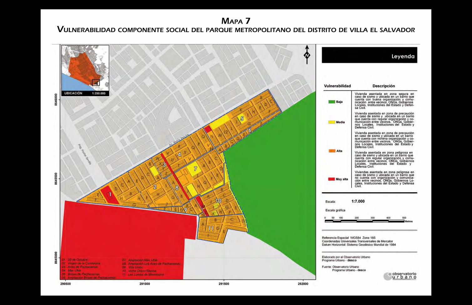


25 años trabajando por una ciudad equitativa