Embed Size (px)
Citation preview

REVIEW DRAFT: SAND92.2671C
RECENT DEVELOPMENTS IN STOCHASTIC MODELING ANDUPSCALING OF HYDROLOGIC PROPERTIES IN TUFF
Christopher A. RautmanC-eoscience Assessment and Validation Dept. S AND- - 9 2 - 2 6 71 C
Sandia National Laboratories
Albuquerque, NM 87185 DE93 008358(505)844-4584
2:"DJ3
ABSTRACT the three-dimensionalblock of rock thatcontainsan engineeredfacility suchasa repository,the resultsof thosecalculationsand
A set of detailed geostatistical simulations of porosity models should reflectgeologic uncertainty.Licensingrequire-has been producedfor a layeredstratigraphicsequenceof welded mentsmandatethatthis uncertaintybe addressedin a quantita-
' and nonweldedvolcanic tufts at Yucca Mountain,Nevada. The tive and objectivemanner.slm:rationsareproducedusing a compositemodelof spatialcon-tiny'5, and they are highly conditioned to abundantdrill hole In thispaper,we present the resultsof recent modeling(core) information. A set of derivative simulationsof saturated activitiesfocusedon a small portionof theYuccaMountainsitehydraulicconductivityhasbeen produced,in the absenceof con- todemonstratethe developmentof capabilitiesto modeldetailedditioning data, using a cross-variable relationship developed geology in astochasticfashion,andto upscale thatdetail to rep-fromsimilardata elsewhere. The detailedsimulationsreproduce resenteffectivepropertiesof blocks suitablefor flow (process)both themajorstratigraphicunits andfinerscale layeringindic.at- modeling. Themethodologyis well suitedto assess uncertaintycd by the drill hole data.These simulationshave beenscaled up thatresults fromincomplete sitecharacterization.severalorders of magnitudeto representblock-scaleeffectivehy-drologic propertiessuitable for use in numericalmodeling of GEOSTATISTICAL SIMULATIONgroundwaterflow and transport.The up_g process involvesthe reformulationof a previouslyreportedmethodthatiteratively Geestatistical simulation comprises a diverse set ofadapts an initial arbitrarygrid to "homogenize" the detailedhy- techniquesfor producingnumericadmodels of geologic materi-
• draulicpropertiescontainedwithin the adjustedcell limits andto als and rock properties,s'4_ Simulationis distinct fromestima-minimize the sizeof cells in highly heterogeneousregions. AI- rien -- often betterknownby its geostatisticalnamekriging --fl_oughthe computation of the block-effectivepropertyinvolves which is simplya meansof interpolatingbetweenmea_red val-simple numericalaveraging,the blocksoverwhich these averag- ues. In contrast with krigingandother interpolationtechniqueses arecomputedare relatively homogeneous, which reducesthe thatmerely smooth the transition from one measuredvalue tonumericaldifficulties involved in averagingnon-additiveproper- another, simulationfallsin between measurementswithrandomties, such as permeability. The entire process of simulationand values sampledfromsome typeof probabilitydensity function.upscaling is rapidand computationallyefficient compared with Simulated models are designed to reproducemeasuredcondi-alternative techniques. It is thus suitable for the Monte Carlo tioning values at their spatial location, tend to reproducethe
, evaluationof the uncertaintyin site characterizationas it affects modelof spadalcontinuity providedas input,and appearto varytheresultsof groundwaterflow and transport calculations, more realisticallyon a small scale than an equivalent kriged
model. Joumel and Alabert,6 among others, have demonstratedINTRODUCTION the "excessive" smoothnessof krigedmodels in contrastboth to
simulationsandto an exhaustivelyknownset of data.Such ex-Assessing the performanceof a potentialhigh-level nu- cessive smoothnessmay produceanunwarranteddegr_ of spa-
clear waste repository,such as thatproposed for constructionat tial connectedness.If used in a physical process model, such" YuccaMountain,Nevada,requirescalculatinggroundwater spatialcon_uitymaysuggestmore(orless)rapidmovementof
i travel times and ratesof radionuclidereleases, amongothermea- ground waterandcontaminantsthan is justified in reality.
sures of repositoryperformance.These hydrologic calculationsrequirea descriptionof thegeology and materialpropertiesof the The probabilisticmechanism underlyinggeostatisticalsite itself. Cli_, _:algeologic depictionsof a site, such as verbal simulation gives rise to the interpretationof simulations aslithologicdescriptionsz andgraphical portrayalsofgeometryzare equally likelyalternative realizations.Because each realization
i inadequateinthemselves.Numericalprocessmodelsnecessitate isconsistentwithagivenstateofknowledge(conditioningdata
' numericaldescriptions of the hydrologicpropertiesof a site.Ad- and variograrn),there is no obvious objective meansfor decid-ditionally, because the total quantity of material actually ob- ing which one of a setof simulations"best" representsthe true,ser,,ed _,_dsn._m_pledinevitably will be a very minutefraction of but unknown,reality.The uncertaintythat resultsfromless than
I
:[[ M__1__ BSTI:IIBUTION OF TH,_
UNU_OQGUMF-NT IS
I*
I

t
,z
t
exhaustive characterization of a site can thus be assessed in a cross-variable regression (described below). Following simula-probabilistic, Monte Carlo fashion. The technique of Monte-Car- tion of a detailed porosity model conditioned to data from ddU1ostyle uncertainty assessment in hydrology is well known. Gee- holes, a similardetailed model of hydraulicconductivity was pro-statistical simulation merely provides a more sophisticatednu- duced using the porosity-conductivity relationship.tactical model of the underlying site geology than is usually im-plemented. 7's Sequential Gaussian Simulation
MODELING OF YUCCA MOUNTAIN The simulation process used in this studys entails defin-ing a block-stylegrid covering the modeled region and determin-
The application of geostatistical simulationtoflow rood- ing a random path to each and every grid node within that grid.cling of the Yucca Mountain site is not necessarily straighffor- Measured data to condition the simulationeither may be mappedwar& Many applications of simulation involve a single geologic onto the nearest grid node or mat be left in their proper spatialunit9a°(a porous sandstone aquifer, for instance). In contrast, the position with respect to thegrid. Simulationof a new node is ini-Yucca Mountain region consists of an apparently simple, but tiatedby searching for conditioningdatawithin a specified searchgeostatistically complex, layered sequence of welded and non- pattern and by estimating the complete probability density func-welded tufts. The rocks are characterized bypronounced changes rien at thatgrid node, given surrounding nearby information. Inin mappable features2 and corresponding changes and gradations Gaussian-based algorithms, that probability distribution is as-in hydrologic properties.11Additionally, the potential repository sumed to be bivariatenormal. Ahydrologicproperty value is thenat Yucca Mountain is located within the unsaturated zone above sampled from that probability distribution and assigned to thatthe water table and process modeling of unsaturated flow and grid location, andthe simulationprocess moves to the next nodetransport is a difficult issue at best.J2Nonlinearity of permeabil- along the random path. A node completely isolated from condi-ity as a function of (partial) saturationstate increases the com- tioning data may either he left unsimulated (flagged as "miss-plexity of the modeling effort. Although the geometric problem ing") or be simulated based on themarginalprobability distribu-is potentially solvable simplyby breaking the complex stratigra- tion, or overallprobabilityof occurrence.In the sequential meth-phy at Yucca Mountain into its various components and model- od, once simulated,a grid nodecounts as part of the data uponing them separately, it is apparent that the computational effort which the remainderof thesimulation is conditiored.involved in generating a large number of geostatistical simula-tions for Monte Carlo-style evaluation of flow and transport For poorly condil:ioned simulations, including gridsquickly expands beyond reason as the number of separate "lay- within which theconditioning data areparticularlyunevenly dis-ors" ordistinct zones to be modeled increases.H tributcd spatially, early simulation of nodes far removed from
conditioningdata and basedsolely upon the marginalprobability
Strategic Approach distributioncan lead to propagationof these randomlyselectedvalues in accordance with the inputmodel of spatial continuity.
We are developing tools and approaches suitable for This process can lead to the productionof models that may ap-practical geostatistical simulation atYucca Mountain.In this ox- pearunrealistic in that bodiesof one type of materialmay ran-ercise, we attemptto simulate a diverse lithologic interval con- domly appearin an"improper"geologic context. These geologicsisting of both welded and nonwelded tuff in one computational odditiesdo not indicatea failureof the simulationmethodology;pass. This modeling is a small-scale example of what Rautman rather the results are simplyreflecting uncertainty in the factualand Flintzl termed a "highly conditioned simulation approach" information. A "surprised"humanobservermost likely has addi-using "major stratigraphicunitq." Under this approach, the mod- tional soft information that has not been incorporated into theeled region contains an abundance of actual site data that act to simulatedmodel.The challengein these cases is to quantify thatconstrain the resulting simulationof unsampled locations. In the soft informationin some manneranduse it to reduceuncertainty.presence of abundant fielddata, the simulation algorithmis less The issue of soft data in gcostatistical modeling is beyond thesensitive to errorsor purposefuldistortions in the modelof spatial scopeof this discussion.continuity used tocontrol the generation of in-fill values; thesim-ulation is constantly"brought back"to reality by theconditioning l_w_.ationand Geology of the Modeled Regioninformation.A generalizedmodel of spatial continuitydevelopedfor a composite stratigraphy,such as in the currentexample, may The modelregionselected to develop and evaluate gee-necessarily be a compromise among more accurate,models that statisticalcapabilitiesis locatedin the southeasternportionof thecould be developed for a more finely divided layered sequence region proposedfor the potentialrepositoryat Yucca Mountain(compare,forexample, Figures7 and 8 of Rautmanand FlintZ#). in the vicinityof tworecentlydrilledholes (Figure1). In thispor-
tionof Yucca Mountain,welded and nonweldedtufts of the Mi-We have chosen to create ourpreliminarymodels using ocene PaintbrushTuffhave beengently tilted towardthe eastby
a fast, sequential Gaussian simulationalgorithm, SGSIM.s The Basin-and-Range-s_,leblockfaulting. Surfaceexposures of thehydrologic propertyof primaryfocus is relative-humidity-oven- PaintbrushTuff consist of welded ash flows belonging to thedry porosityla because the set of drill hole datausedto condition Tiva Canyon Member.The Tiva Canyonbecomes gradationallythe simulations does notyet containpermeabilityvalues. Because nonweldedat its base, andoverlies a sequenceof nonweldedashthese simulationsare intendedto supportmodelingof groundwa- flows andair fall tufts typicallylumpedtogetheras the "Paint-tor flow and transport, models of penneabi.lityareessential. An brush nonwelded interval."These porous and permeable rocksindependentdataset containing values of both porosityandsatu- areunderlainby a very thick sequenceof densely to moderatelyrated hydraulicconductivity was used to develop a quantitative welded ash flows assignedto the TopopahSpringMember.
I 12/i i/92 i3:18 ""' ..... "_"' _'"1
j i
t ..
t
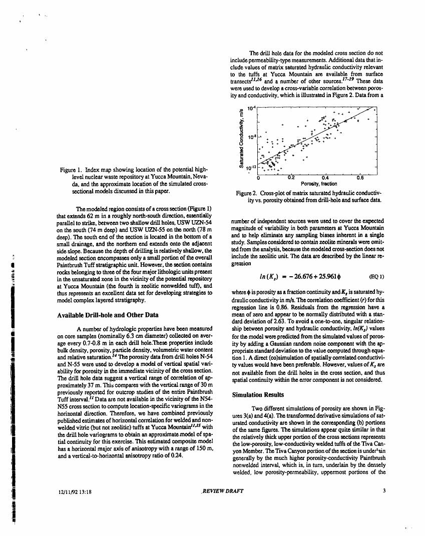
The drill hole data for the modded cross section do notincludepermeability-typemeasurements.Additionaldata that in-clude values of matrix saturatedhydraulicconductivityrelevantto the tufts at Yucca Mountain are available from surfacetransectsH'16 and a number of other sources.17"19These datawere used to develop a cross-variablecorrelation betweenporos-ity andconductivity,which is illustrated in Figure 2. Datafrom a
10-'=1 , , .+ ,, /;...- +'!
i .,.+..,. !
+ +. 4. +
In.8 + at .,,,,++ +/ + + "*" .i-_ + ++t. + + ..,.+.+..,._+++_+..,.,+++-I++ + +++_'¢" :'++
++"_ "++ + . +
'_W +- + .+ .+,
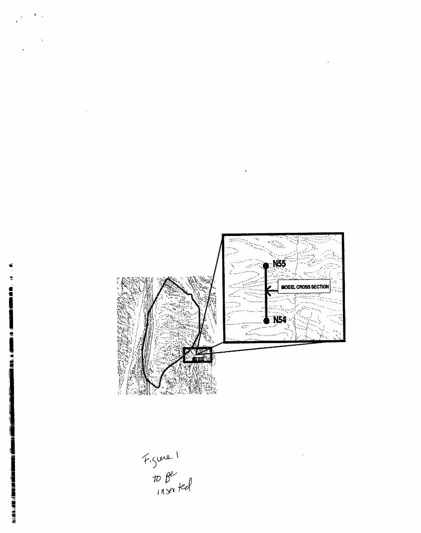
Figure 1. Index map showing location of the potential high- m 1042 _ _ +_.; + + .• l l . .i.. + . , , 1 , , , .i. •
level nuclear waste repository at YuccaMountain,Neva- 0 0.2 0.4 0.6da, and the approximate location of the simulated cross- Porosity,tmolion
sectional models discussed in thispaper. Figure 2. Cross-plot of matrixsaturatedhydraulicconductiv-ity vs. porosity obtained fromdrill-hole and surface data.
Themodeled region consists of a cross section (Figure 1)thatextends 62 m in a roughly north-southdirection,essentiallyparallel to strike,between twoshallowdrillholes, USW UZN-54 numberof independentsourceswere used to cover the expectedonthesouth(74m deep)andUSW UZN-55onthenorth(78m magnitudeofvariabilityinbothparametersatYuccaMountaindeep). The south end of the section is locatedin the bottomof a and to help eliminateany samplingbiases inherent in a singlesmall drainage, and the northern end extends onto the adjacent study.Samplesconsideredto containzeolite minerals wereomit-sideslope. Because the depthof dr[ilingis relativelyshallow,the tedfromtheanalysis,becausethe modded cross-sectiondoesnot
: modeled section encompasses only a smallportion of theoverall include the zeoliticunit. The data aredescribedby the linear re-
PaintbrushTuff stratigraphicunit.However, the section contains gressionrocksbelonging to threeof the fourmajorlithologic unitspresent
i in the unsaturatedzone in the vicinity of the potential repository In (K,) = - 26.676 + 25.961_ (EQ1)
atYuccaMountain(thefourthiszeoliticnonweldedtuf0,andthus represents an excellent data set for developing strategies to where_ is porosityasa fractioncontinuityandKs is saturatedhy-model complex layered stratigraphy, draulicconductivityinm/s. The correlationcoefficient (r) for this
regression line is 0.86. Residuals from the regression have aAvailable Drill-hole and Other Data mean of zero and appear to be normallydistributedwith a stan-
darddeviationof 2.63. To avoida one-to-one, singularrelation-A numberof hydrologic propertieshave beenmeasured ship betweenporosity andhydraulicconductivity,lh(Ks) values
on core samples (nominally6.3 cm diameter)collected on aver- for the modelwerepredictedfrom the simulatedvaluesof pores-age every 0.7-0.8 m in each drill hole.These propertiesinclude ity by addinga Gaussianrandom noise componentwith the ap-bulkdensity, porosity, particledensity, volumetricwatercontent propriatestandarddeviationto the valuecomputedthroughequa-and relativesaturation,s4The porosity data fromdrillholes N-54 tion1. A direct(co)simulationof spatiallycorrelatedconductivi-and N-55 were used to develop a model of verticalspatialrad- ty values wouldhave beenpreferable.However,values elk s areability forporosity in the immediatevicinity of thecross section, not availablefrom thedrill holes in the cross section, and thusThe drill hole data suggest a vertical range of correlationof ap- spatialcontinuitywithinthe errorcomponent is not considered.proximately37 m. This compares with theverticalrangeof 30 mpreviouslyreportedfor outcrop studies of the entirePaintbrush Simulation ResultsTuff interval.H Data are not available in the vicinityof the N54-
N55 cross section to compute location-specificvariogramsin the Twodifferentsimulationsof porosityare shown in Fig-horizontal direction. Therefore, we have combined previously ures3(a)and 4(a). The tran,fformedderivativesimulationsof sat-publishedestimatesof horizontalcorrelationforwelded and non- uratedconductivityare shown in the corresponding(b) portionsweldedvitric (butnot zeolitie) tufts at Yucca Mountaidl'ts with of the same figures.The simulationsappearquite similar in thatthe dr[lihole vadograms to obtain an approximatemodel of spa- the relativelythickupperportionof the cross sectionsrepresentstialcontinuityfor this exercise. This estimatedcompositemodel the low-porosity,low-conductivitywelded tuftsof theTiva Can-has a horizontalmajoraxis of anisotropywith a rangeof 150 m, yonMember.TheTiva Canyonportionof thesection is under1_inand a vertical-to-horizontalanisotropy ratioof 0.24. generallyby the much higher porosity-conductivityPaintbrush
nonweldedinterval, which is, in turn,underlainby the denselywelded, low porosity-permeability,uppermostportions of the
12/11/9213:18 .REVIEW DRAFT 3
IIJl!
Mi ,

,i
Topopah Spring Member. Differences in detail between the twosimulations represent uncertainty, because there are no samples N-54 a N-55
in the undrilled middle portion of the section to prove or disprove 0any of the modeled values.
N.54 a N-55
o
E
E
75 0 meters
N-54 b N-Ss750 meters 60 0
N-54 b N-55
0
t9O
E
E
750 meters 60
Figure 4. Simulated model of (a) porosity and (b) In saturat-
75 ed hydraulic conductivity for random number seed0 meters 6O 1723.
Figure 3. Simulated model of (a) porosity and (b)/n saturated generate models that simply consist of larger grid blocks. Thetype of samples and measurements used to construct the modelshydraulic conductivity for random number seed 1711. must be considered.
Note that the transformed conductivity simulations (Fig- Data Supportures 3b and 4b) have a more erratic "pepper-and-salt" appearancethan the primary porosity simulations from which they are de- Support is the typical geostatistical term used to denoterived. This effect is attributed to the addition of a random, regres- the "size" of the measurements under consideration. The support
sion-error component to the primary regression prediction (Equa- for the geostatistical models presented in the previous section istion 1) that describes the correlation between these two variables, the centimeter-sized core pieces on which porosity and the otherThe gross lithologic layering of the stratified tuff sequence is well hydrologic properties were measured. The geostatistical modelspreserved, however. Had the conductivity data been available to just presented (Figures 3 and 4) consist of blocks of approximate-create a direct simulation, the final result might have been some- ly 0.38 m2. This change of support is not particularly extreme.what similar, in that permeability-type properties might be ex-pected to be more variable spatially than porosity. Hydrologic modeling of this small portion of Yucca
Mountain using the fractional-meter grid cells of the geostatisti-
UPSCALING cal simulations would be feasible; however, modeling such pro-cesses on a repository scale using this amount of detail almost
The models of hydrologic properties presented in the certainly is impossible. We must the|efore change the support ofpreceding section are too detailed for general use in hydrologic the hydrologic process model many orders of magnitude from theflow and transport calculations. However, it is not sufficient to support of the actual data. The hydrologic literature is replete
12/11/92 13:18 REVIEW DRAFT 4

i
with examples of the difficulty of performing this change of sup- to-block correlation structure has been approximated, it is a rela-port in a realistic and reasonable manner,zs tively simple matter todirectly simulate a large field of blockval-
ues conditioned to data measured on the smaller scale.Practitioners of geostatistics have invested a significant
effort in identifying the effects of changes in support, and a num- Both of these potential solutions to the issue of upscalingber of approaches and algorithms have been proposed. However, flow properties possess serious difficulties when applied to Yuc-this effort has focused on "additive" properties, principally ore ca Mountain. Although to some extent the welded-nonweldedgrades in mining applications, other compositional measure- distinction relevant toash-flow tuftsconstitutes a binary litholog-ments, and (by extension) porosity. The critical flaw in the con- ic system, the two lithotypes are not interspersed in the classicalventional geostatistieal approach is that the various correction al- manner of a deltaic or fluvial sand-shale depositional system.gorithms leave themean of the distribution unchanged.26The ap- Thus, it appears unlikely that the effective permeability of tuff isproach simply is not applicable in general to flow properties such related to the proportion of welded and nonwelded material.as hydraulic conductivity. Although it is a relatively simple mat-ter to scale up the porosity simulations of Figures 3a and 4a to The direct simulationof block-scaleeffective permeabil-whatever flow-simulation grid sea.leis desired, the equivalent ities offered by the second methodology could be used at Yuccacomputation for the conductivity simulations is a completelydi.f- Mountain in certain limited instances. The requisite microsealeferent issue. This issue assumes major proportions in modeling realizations of, for example, hydraulicconductivity can be gener-unsaturated flow systems, because there currently is no large- ated(i.e.. Figure 3b). It is alsopossible to perform the numericalscale unsaturatedpermeability measurement similar to the classi- upscaling of block-sized volumes located within a microseale re-cal aquifer well test that can be used to calibrate upsealing of the alization. Finally, the methodology and techniques for inferringmodel from what are essentially point measurements, thenecessary covariances andcross-covariancesexist. The diffi-
culty is a practical one, in that the Yucca Mountain problem isProposed Solutions to the Sealing of Permeability f_re,e-dimensional (implies more complex numerical upscaling
computations) and multi-layered(each layer presumably wouldA number of approaches to the upsealingof permeabili- need to be sealed-up separately).H In addition, a major focus
ty-type data have been proposed, and thesehave been implement- within the Yucca Mountain project is on assessing uncertainty,: ed with varying degrees of success in certain applications, which implies that numerous realizations must be produced,| sealed-up, and evaluated.Evenif the generationof "production"
A simple, but geologically common, binary lithologic Monte Carlo stochasticimages for final flow calculations is re-
system consisting of sandand shale is of significant interest in the stricted to the direct simulationof blocks basedon a single infer-petroleum industry. In certain sedimentary environments andfor ence of the point-to-block relationship,the methodology wouldpurposes of predicting the effective permeability of large reser- appear to be eomputationally intensive. What is needed is a fast,voir blocks, it has been demonstrated that an empirical power- approximate method that is applicable to the unsaturated-zonelaw average based on the sand-shale ratiocan produce reasonable setting of Yucca Mountain, the large number of discrete layers,estimates of block-scale effectivepermeability over theeconom- anda reasonablesite-characterizationprogram. The adaptivegridically important range of values.27'2s'29The technique relies on methodology, described below,offers a potential solution to thisthe fact that in a given geologic context, "sand" tends to have a need.relatively constant permeability, particularly by comparison (inhydrocarbon production) to "shales" of near-zero permeability. Adaptive GridBlock-scale effective permeability is essentially an "average" ofthe relative proportions of sandand shale. The value of thepow- An adaptivegrid algorithmhas been developed basedoner-law exponent for a given field can be developed in an empiri- concepts originally described by Garcia and others,ss The con-cal manner, cept is toecastruet a meshcovering thearea (or volume) of inter-
est, for which the sides of eachcell are conceptually and mathe-Another major approach to theupsealing of permeability matically represented as springs with an appropriate coefficient
data hasfocused onthe"direct" simulationof block effective per- of elastiei_, (Figure 5). By setting each coefficient of elasticitymeabilities in a manner similar to the generation of the stochastic proportional to some measure of heterogeneity of the detailedimages in Figure 3 and 4. The generation of the images is not dif- geostatistical simulationcomposing the adjoiningcells, it is pos-fieult; rather the problem here focuses on determining the proba- sible to have " ", "the spr_,.gy sidesof the cells expand or contract tobility distribution and spatialcorrelation structure of those block- minimize some aspectof that heterogeneity.J3Alternatively, thescale values. Current solutions to this problem_v'3t'32have fo- area (volume) of particularly heterogeneous cells can be mini-cused on numerical computation of the effective permeability of mized. Presumably the impact of a "bad" estimate of effe,:tivea "limited" number of block-scale cells positioned within a large permeability for a small grid cell on the entire simulation is rela-mieroscale simulation, similar to Figure 3, conditioned to exist- tively small. The effect of this algorithm is that the final griding well data. The assumption, appropriate for most enhanced- adapts to follow geological features reflected in the underlyingrecovery applications in the petroleum industry, is that flow will geostatistieal simulationof amaterialproperty, and that the indi-be in a particular known direction (i.e., stratigraphieally horizon- vidual cells are as "homogeneous" as possible. Because the de-tal from injector well toproducer well). The effective permeabil- tailed hydrologic properties within a given cell tend to resembleities of a number of such block-scale cells are computed, and the each other more than would be the ease for an arbitrary grid, thevariograms and cross variograms for the (exhaustive) point val- numericaldifficulties encountered incomputing an average, "ef-ues and (sparser) block values can be computed. Once the point- fective" property for the cell are reduced.
12/11/9213:18 REVIEW DRAFT 5

i
(max(oi)). Fournormsdescribingtheoverallheterogeneityof the"Spring"formsboundary nowgrid arecomputed.Thesearc:betweenadjacentcells
InitialState/ AdjustedState IIOi - max(oi) (EQ2)• o
n 0.5
" o o
, ' i 1, ksideI °,
Figure 5. Conceptual diagramof elastic adaptivegrid layoutand adjustmentmechanism. I_is proportionalto some °Jail oo - max (oiai) _0 4)measureof heterogeneity, and 91> _2. The ksiaesare afunction of I_Lfor the enclosed cell and the equivalent
I_ for the cells across each spfingboundary (net . i n ]0.5shown). See text for discussion. [aiai 2 = E (°iai) 2 (EQ 5)The grid adaptation process is divided into three parts, i - 1
The first part is the actual adjustment or movement of the cell-bounding nodes, which proceeds in several individual steps. In The last norm (equation 5) is recommended, but the others maythe second part, the heterogeneities of the adjustedcells are com- beadvantageousfor particularmeshes.For _eh element, a mea-puted and these are translated into coefficients of elasticity for sure of heterogeneity,[_i,is calculated:each cell boundary. A set of norms, or measures of the effective-ness of the grid-adjustment process in reducing overallheteroge-
o neity of the grid is also computed during this portion of the pro- °iaminease. The third part is to accept or reject the newmesh. lithe new 13i - (EQ6)
| grid is accepted asan improvement over thepreviousversion, the amaxai
process begins again to see if additionalimprovement canbeob-tained. If the grid is rejected, a new "relaxation factor" may be The elasticities, k, foreach sideor link are computed ascomputed or the grid may be considered "frozen" and the pro-
gram exits. = _j [_i (EQ7)kside 1 + (r)
For a given problem, the number of nodes in thex andy, nadj a iand, for three dimensions, the z directions are fixed, as are thecomer nod_ that define the region underconsideration.The ex- for those nadj elements adjacentto ksiae.The relaxationfactor, r,
i tca'nal sides are not fixed, but are adjusted to user-specified andthe elasticities, k, initially are set equal to 1.
boundary functions. Adjustments in thex andy directions areper-formed separately.Thus the steps in the adjustmentprocess are: In the third and f'mal step, acceptance of the computed
grid depends on the value of the selected norm. The new norm1. adjust thex coordinates of the nodes using the current computed after adjustmentof thegrid iscompared to the smallest
elasticities; norm previouslyencountered.If the newnorm is smaller,indicat-
2. adjust the y coordinates of the top and bottom of the ing that the adjustedgrid blocks aremore homogeneous internal-mesh to the specified boundary functions; ly or that the heterogeneityis confined to smaller grid cells, thenew grid is accepted and the relaxationfactor is set equal to 1. If
3. adjust the y coordinates of the nodes using the current thegrid is not accepted, the relaxation factor is reduced by half,elasticities; and the evaluationprocess repeated. If the relaxation factor be-
comes less than 0.001, the adjustmentprocess terminates, retain-4. adjust the x coordinates of the left andfight sidesof the ing thegrid with the lowest normencountered. A minimum num-
mesh to the specified boundary functions, ber of 10 detaileddata points are requiredwithin each element toAt the end of the adjustment process, ali nodes on the exterior of prevent ti_eformation of excessively small grid blocks.the mesh lie on the specified boundary.
Hydrologic Properties and UpscalingThe second part of the adaptation process requires find-
ing in which element each datapoint of the underlying geostafis- Adapting the grid to the geostatistical simulation mini-tical simulation lies. Then, the numericalaverage, standarddevi- mizes the heterogeneityof hydrologicproperties containedwith-ation and number of data points for each grid element is eomput- in each element. In regions of relatively high heterogeneity, thecd. The area, ai, of each element is also determined, as are the adaptivegrid algorithm using the norms given byEquations 4 orminimum element area and maximum cell standard deviation 5 will tend to reduce the sizeof elements within that region. Al-
though the grid adaptation creates grid Necks that are by no
_'i 12/11/9213:18 REVIEW DRAFT 6
!!i
means completely homogeneous, the elements thus created dotendtobeeither(a)morehomogeneousthanageneral,arbitrary N.s4 a N-SSgridand/or(b)relativelysmallerinsizeandpresumablyoflesserimportancetotheoverallflowcalculation, o
Atthistime.upscalingofhydrologicpropertieswithinthefinal,adjustedgridblocksisaccomplishedthroughsimplenumericalaveragingofthecomprisedgeostatisticallygeneratedvalues (note: the arithmetic mean is computed for porosity; thegeometric mean is computed for conductivity). The effect of hU- Emericalproblems related to the averaging of widely varying val-ues (such as permeability data) are inherently less pronouncedbecause values withirleach adjusted cell are less variable than foran arbitrary grid, or the size of the cell(s) containing the widelydisparate values is small. Although they have not been imple- 75mented at present, we are investigating other computational 0 motors 60methods for averaging/upscaling that are less sensitive to a fewextreme values within the detailed simulated values.34
Because the scaled-up hydrologic property within each N-54 b N-sSgrid block is computed as asimple numerical average,the implic-it assumption is that intra-bloek spatial correlation of pore sizes 0andother factors that affect thehydrologic pathways do not exist.
Correlations that exist within the underlyingdetailed geostatisti-
eal simulation at less than the block scale are discarded.
If the scale of the flow phenomena of interest is smallerthan the block sea.le,it can not be captured; this is a fundamental _*
,, computational limitation. Significant spatial structure is retained ®Eif the range of correlation extant in nature and reproduced in thedetailed simulation is large by comparison with the average scaleof the final grid blocks. Such long-range spatial correlation pat-terns will be preserved in the admittedly simplified block-scalemodels. However, as theactual range of correlationconverges to-ward the.dimension of the individual blocks, more and moreof 75
0 motors 60the spatial structure will be intentionally (and unfortunately)dis-
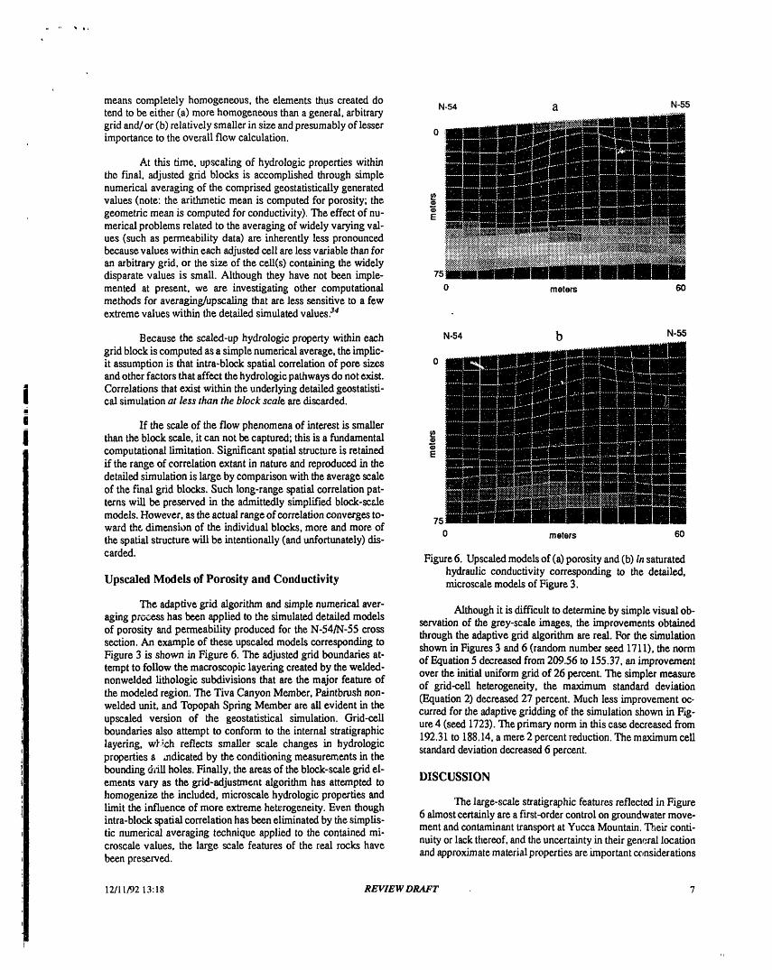
carded. Figure 6. Upsealed modelsof (a)porosity and (b) Insaturatedhydraulic conductivity corresponding to the detailed,
Upsealed Models of Porosity and Conductivity microseale modelsof Figure 3.
The adaptive grid algorithm and simple numerical aver- Although it isdifficult todetermine bysimple visual ob-aging prc.,cesshas been applied to the simulated detailed models servation of the grey-scale images, the improvements obtainedof porosity and permeability produced for the N-54/N-55 cross through the adaptive grid algorithm are real. For the simulationsection. An example of these upscaled models corresponding to shown in Figures3 and 6 (randomnumber seed 1711), the normFigure 3 is shown in Figure 6. The adjusted grid boundaries at- of Equation5 decreased from 209.56 to 155.37, an improvementtempt to foUowthe macroscopic layeringcreated by the welded-nonwelded lithologie subdivisions that are the major feature of over the initialuniform grid of 26 percent. The simpler measurethe modeled region. The Tiva Canyon Member, Paintbrush non- of grid-ceil heterogeneity, the maximum standard deviationwelded unit, and Topopah Spring Member are ali evident in the (Equation 2) decreased 27 percent. Much less improvement oc-
curred for the adaptivegridding of the simulation shown in Fig-upscaled version of the geostatistical simulation. Grid-cell ure 4 (seed 1723). The primary norm in this ease decreased fromboundaries also attempt to conform to the internal stratigraphie 192.31 to 188.14,a mere2 percent reduction.The maximum celllayering, wF;,ch reflects smaller scale changes in hydrologic standard deviation decreased 6 percent.properties s indicated by the conditioning measurements in thebounding d_ii holes. Finally, the areas of the block-scalegrid el-ements vary as the grid-adjustment algorithm has attempted to DISCUSSION
homogenize the included, microscale hydrologic properties and The large-scale stratigraphic features reflected in Figurelimit the influence of more extreme heterogeneity. Even though 6 almostcertainlyare a first-order control on groundwatermove-intra-block spatial correlation has beeneliminated bythe simplis-tic numerical averaging technique applied to the contained mi- ment and contaminant transport at YuccaMountain. Their conti-croseale values, the large scale features of the real rocks have nuity or lack thereof, and theuncertainty in their general locationbeen preserved, and approximatematerial properties are important considerations
12/11/9213:18 REVIEW DRAFT 7
VIli
,r

in assessing the hydrologic performance of the site. Uncertainty simulation algorithm, andsimple numerical averaging techniqueresulting from the inevitably "incomplete" site description will Ior upscaling non-additive properties such as hydraulic conduc-be an important consideration in assessing the performance of tivity arenot trivial. However, thedifficulty and additional effortany potential repository at Yucca Mountain. inherent in more accurateand theoretically_legant approaches to
thesame problem may preclude themfrom use on aroutine basis.The modelsdeveloped in thisexercise areadmittedly lm- If adequate conditioningdata areavailablefrom site characteriza-
perfect representations of the real Yucca Mountain; however, tion, the limits toour approximate approach may be sufficientlythey possess a numberof significant advantagesovermodels cre- small to justify their use in initial performancecalculations. Moreated by many other techniques. First, creadon of the underlying sophisticated simulation algorithms and techniques for estimat-detailed models is fast. The sequential Gaussian algorithm re- ing block-scale effective permeability-type properties exist, andquired onlyone model of spatial variability and onecomputation- these can then be applied to resolve freer-scale performance is-al pass to represent a composite of three separate lithologic units, sues and sensitivities.Second, creation of the conductivity models in this instance wasaccomplished by a simple algebraic transform based on an inex- ACKNOWLEDGMENTpensive, easy-to-measure, and spatially abundant mater"al prop-erty: porosity. Third, the block-scale grid, which ultimately will This work was supported by the U. S. Department of En-be used for hydrologic calculations, is quickly adapted to the ergy, Yucca Mountain Site CharacterizationProject Office, un-unique spatial characteristics of each individual realization.The der contract DE-AC04-76D00789.adaptation of the grid is based directly upon the simulated hydro-logic properties, thus minimizing the errors introduced by the REFERENCESfast, simple numerical averaging technique applied to thevaluescontained in each cell, which is a fourth important characteristic 1. R.W. SPENGLER,F. M. BYERS, 1r.,and J. B.WARREN,of this methodology. "Stratigraphy and Structureof VolcanicRocks in DrillHole
USW G-l, Yucca Mountain, Nye County, Nevada," U. S.Finally, the methodology described in thispaper is ame- Geol. Surv, Open-FileReport 81-1349, 50 p. (1981).
nable to incremental improvement at several points in the pro-eess. Actual hydraulic conductivity measurements could be used 2. R.B. SCOTt andJ. BONK, "Preliminary Geologic Map ofto create and condition the microscale simulationsof thatproper- YuccaMountain,Nye County,/'Tevada,with Geologic Sec-ty. More sophisticated nonparametric techniques5'6can be substi- tions," U. S. Geol. Survey Open-FileRetmrr '_4-494(1984).
tuted for ali or part of the proees:#of creating the underlying, de- 3. A. MANTOGLOU, and J. WILSON, "The Turning-Bandstailed hydrologic-property models. Techniques such as indicator Method For SimulationOf Random Fields Using Line Gen-simulation maybe particularly suitable for representing theprop- eration By A SpectralMethod," WaterResources Research,erties of relatively disparate lithologies within a single computa- 18, 5, (1982).tional (simulation) environment. They may also be relevant inevaluating the performance impacts of various scenario-related 4. P.R. KING, and P. J. SMITH, "Generation of Correlateddistortions of the expected spatial continuity patterns.6Addition- Properties in Heterogeneous Porous Media," Math. Geol.,ally, the various norms (Equations 2 through 5) associated with 20, 863 (1988).the adaptive grid algorithmcould be adapted to distinguish gridblocks for which simple numerical averaging is a "reasonable" 5. C.V. DEUTSCH, and A. G. JOURNEL, "G.C.,IB:Geo-approximation from those that might need to be represented by a statistical Software Library and User's Guide," New York:more sophisticated form of numerical upscaling,perhaps involv- Oxford University Press, 340 p. (1992).
ing numerical flow computations. 6. A.G. JOURNEL, and F. ALABERT, "Non-Gaussian DataExpansion in the Earth Sciences," Terra Nova, I, 123
CONCLUSIONS (1989).
We have demonstrated that Monte-Carlo-style simula- 7. A.L. DUDLEY, R.R. PETERS,J. H. GAI.YTHIER,M. L.tions of important hydrologic rock properties can be generated in WILSON, M. S. TIERNEY,and E. A. KLAVETTER, "To-a labor- and computationally efficient manner, even for a litho- tal System Performance Assessment Code (TOSPAC) Vol-logically diverse geologic setting. The key to using simplifying ume 1: Physical and Mathematical Bases," Sandia Reportassumptions and simulation techniques in a composite strati- SAND85-O002,SandiaNationalLaboratories, Albuquerque,graphic interval is the presence of adequate conditioning data.tr NM, 204 p. (1988).We have also scaled-up these detailed, microseale simulations,for which the data support and the model values areapproximate- 8. C.A. RAUTMAN, andA. H. TREADWAY,"Geologic Un-ly equivalent, to represent block-effective properties suitable for certainty in a Regulatory Environment: An Example fromflow calculations in a tractable, computationally efficient, if ap- the Potential Yucca Mountain Repository Site," Environ.proximate manner. Geol. WaterSci., 18, 171 (1991).
Major stratigraphic andhydrologic features of the Yucca 9. P. CLIFTON, and S. NEUMAN, "Effects of kriging and in-Mountain region are preserved in these fast, approximate sto- verse modeling on conditiona_simulation of the Avra Val-chastic images of block-scale effective properties. The limita- Icy Aquifer in Southern Arizona," Water Resources Re-
=-- tions imposed by the composite stratigraphy, Gaussian-related search, 18,5 (1982).
12/11/92',3:18 REVIEW DRAFT 8
10. J. P. DELHOMME, "Spatial Variability in Groundwater 23. F. E. RUSH, W. THORDARSON, and L. BRUCKHE-Flow Parameters: A Geostatistical Apprcach," Water Re- IMER, "Geologic and Drill-hole Data for Test Well USW
sources Research. 15, 269 (1979). H-l, Adjacent to the Nevada Test Site, Nye County, Neva-da," U. S. Geol. Survey Open-File Report 83-141. 38 p,
11. C.A. RAISFMAN, and A. L. FLINT, "Deterministic Gee- (1983).logic Processes and Stochastic Modeling," High-Level Ra-dioactive Waste Management, Proceedings of the Third ln- 24. W. THORDARSON, "Geohydrologic Data and Test Re-ternational Conference, 2, 1617 (1992). suits from Well J-13, Nevada Test Site, Nye County, Neva-
da, U. S. Geol. Survey Water-Resources Invest. Report 83-12. R. G. HILLS, I. PORRO, D. B. HUDSON, and P.J. 4171,63 p. (1983).
WIERENGA, "Modeling One-Dimensional hf'titration IntoVery Dry Soils 1. Model Development and Evaluation," 25. G. DEGAN, "Statistical Theory of Groundwater Flow andWater Resources Research, 26, 1259 (1989). Transport: Pore to Laboratory, Laboratory to Formation,
and Formation to Regional Scale," Water Resources Re-13. D. C. BUSH, and R. E. JENKINS, "Proper Hydration of search, 22,120S (1986).
Clays for Rock Property Determir."fions," Jour. Petrol.
Tech, July, 800 (1970). 26. E. H. ISAAKS, and R. M. SRIVASTAVA, "Applied Geo-statistics," New York, Oxford University Press, 561 p.
14. YUCCA MOUNTAIN PROJECT, "Data Resulting from (1989).Data Acquisition," Technical Data Information Form, DTNGS920508312231.012, 7 p. (1992). 27. A.G. JOURNEL, C. DEUTSCH, and A. J. DESBARATS,
:, "Power Averaging for Block Effective Permeability." Soc.15. J.D. ISTOK, A. L. FLINT, and L. E. FLINT, "Spatial Vari- Petrol. Eng Paper 15128 (1986).
ability in Rock Matrix Properties from Surface OutcropSampling," Agronomy Abstracts, 1991 Annual Meetings, 28. A. J. DESBARATS, "Numerical Estimation of EffectiveAm. Soc. Agronomy, Crop Sci. Soc. Am., Soil Sci. Soc. Am., Permeability in Sand-Shale Formations," Water Resourcesp. 222 (1991), Research, 23, 272 (1987).
16. C.A. RAUTMAN, A. L. FLINT, M. P. CHORNACK, AND 29. C. DEUTSCH, Calculating Effective Absolute PermeabilityM. P. McGRAW, "Microstratigraphic Units and Spatial in Sandstone/Shale Sequences,' Soc. Petrol. Eng PaperCorrelation of Hydrologic Prop,.,fies in Tuff, Yucca Moun- 17246 (1987).tain, Nevada," Geol. Soc. Am. Abstracts with Programs, 23,
, 5, A119 (1991). 30. Y. RUBIN, and J. J. GOMEZ-HERNANDEZ, "A Stochas-tic Approach of the Problem of Upscaling of Conductivity
17. YUCCA MOUNTAIN PROJECT, "Data Resulting bom in Disordered Media: Theory and Unconditional Numerical.I Data Acquisition," Technical Data information Form, DTN Simulations," Water Resources Research, 26, 691 (1990)..
1 GS920508312231.010, 6 p. (1992).i 31. J.J. GOMEZ-HERNANDEZ, "Simulation of Block Perme-, 18. B.M. RUTHERFORD, I. J. HALL, R. R. PETERS, R.G. abilities Conditioned upon Data Measured at a Different
=, EASTERI.,ING, and E. A. KLAVE'Iq'ER, "Statistical Anal- Scale," Stanford (University) Center for Reservoir Fore-ysis of Hydrologic Data for Yucca Mountain," Sandia Re- casting, Report 3, (1990).
port SAND87-2380, 256 p. (1992). 32. J.J. GOMEZ-HERNANDEZ, "Direct Stochastic Modeling19. A.K. STOKER, W. D. PURTYMUN, S. G. MeLIN, and M. of Block Effective Absolute Permeability: A Geostatistical
N. MAES, "Extent of Saturation in Mortendad Canyon," Approach," Stanford (University) Center for ReservoirLos Alamos Report LA-UR-91-1660, 137 p. (1991). Forecasting, Report 5, (1992).
20. L.E. FLINT and A. L. FLINT, "Preliminary Permeability 33. M.H. GARCIA, A. G. IOURNEL, AND K. AZIZ, "An Au-md Water-Retention Data for Nonwelded and Bedded Tuff tomatie Grid Generation and Adjustment Method for Mod-Samples, Yucca Mountain Area, Nye County, Nevada," cling Reservoir Heterogeneities," Stanford (University)
: U.S. Geol. Survey Open-File Report 90-569, 57 p. (1990). Center for Reservoir Forecasting Report 3, (199(}).
21. I.C. YANG, A. K. TURNER, T. M. SAYRE, and P. MON- 34. J.L. JENSEN, "Use of the Geometric Average for EfffectiveTAZER, "Triaxial Compression Extraction of Pore Water Permeability Estimation." Math. Geology, 23, 833 (1991).from Unsaturated Tuff, Yucca Mountain, Nevada," U. S.
Geol. Sure. Water Resources Investigations Report 88-4189, (1988).-
22. R.R. PETERS, E. A. KLAVETTER, I. I. HALL, S. C.BLAIR, R. R. HELLER, AND G. W. GEE, "Fracture andMatrix Hydrologic Characteristics of Tuffaceous Materials DISCLAIMER
_ from Yucca Mountain, Nye County, Nevada," Sandia Re-
port SAND84-1471, 178 p. (1984). This report was prepared as an account of work sponsored by an agency of the United StatesGovernment. Neither the United States Government nor any agency thereof, nor any of their
- employees, makes any warranty, express or implied, or assumes any legal liavility or responsi-bility for the accuracy, completev.'_ss,or usefulness of any information, apparatus, product, or
12/11/92 13:18 process disclosed, or represents that its use would not infringe privately owned rights. Refer-cnec herein to any specific commercial product, process, or service by trade name, trademark,manufacturer, or otherwise does not necessarily constitute or imply its endorsement, recom-
= mendation, or favoring by the United States Government or any agency thereof. The viewsand opinions of authors expressed herein do not necessarily state or reflect those of theUnited States Governmentor any agency thereof.

"ql