Embed Size (px)
Citation preview

It’s GHSGT Time!

Why VOCABULARY?
• Social Studies is all about MAKING CONNECTIONS
• Key Terms provide relational clues to guide you in answering test questions!
• The more WORDS you know, the smarter you are


When you approach a GHSGT question that contains a MAP, be sure to:
• Read the map TITLE first• Check the LEGEND or KEY for symbols• “Read” the map – see where and how the
symbols are used• Remember, “to” is where you are going; “from” is
where you started!• Read all maps carefully, follow any arrows and
other clues provided• WRITE ON THE TEST!!! (Remember to DO this)

Sample
Map Legends

Find these Map Features on the next slide…
• Map Title
• Legend/Key
• Directional Indicator
• Scale


Find on this Map
1. The TITLE
2. Information shared in the LEGEND/KEY
3. The DIRECTIONAL INDICATOR
4. Region of this country with the highest elevation
5. Two cities located in the lowest elevation region
6. Body of water that borders this country
7. City that is further north: Rustavi or Poti
8. City that is further east: Gori or Batumi
9. Two countries that border Georgia
10. Importance of Mt. Elbrus
11. Capital city of Georgia
12. Approximate distance in miles from Sokhumi to Rustavi

LATITUDE = imaginary lines that measure distance north and south of the Equator
LONGITUDE = imaginary lines that measure distance east and west of the Prime Meridian

TROPICALZONE
ARCTIC ZONE
ARCTIC ZONE
TEMPERATE ZONE
TEMPERATE ZONE

Climate Zones Explained• TROPICS
– North and south of Equator, between 22.5°N and 22.5°S– Warmest climate region– Sun’s direct rays always shine here
• ARCTIC ZONES– North of 66.5°N and south of 66.5°S– Coldest climate regions– Sun’s rays are never direct/winter season has very long
nights/summer has very long days
• TEMPERATE ZONES– Between Tropics and Arctic Zones in both hemispheres– Temperatures are moderate – neither extremely cold nor
extremely hot for long periods of time

Equator
Tropic of Capricorn
Tropic of Cancer
North Pole
South Pole
Antarctic Circle
Arctic Circle
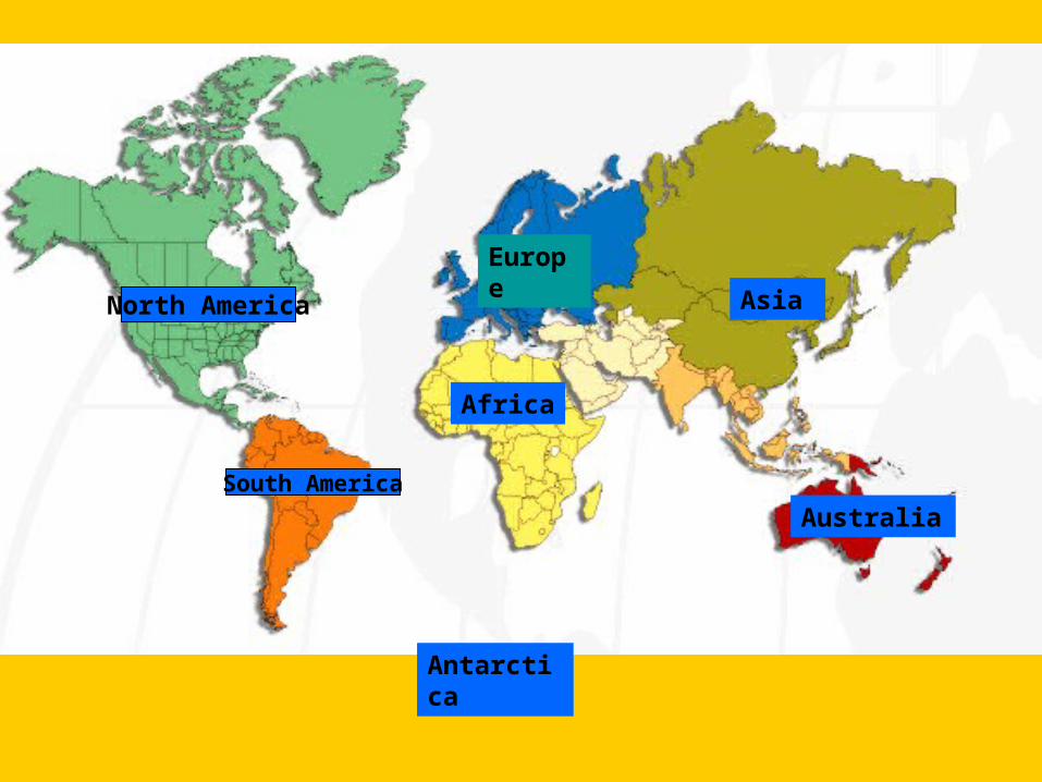
North America
South America
Africa
Europe
Asia
Australia
Antarctica

Compass Directions
CardinalCardinal• Never Eat Soggy Never Eat Soggy
Waffles!!Waffles!!– NorthNorth– SouthSouth– East East – WestWest
IntermediateIntermediate• NortheastNortheast• SoutheastSoutheast• NorthwestNorthwest• SouthwestSouthwest
NENENWNW
SWSW SESE

• Which continent is south of Which continent is south of Europe?Europe?
• Which ocean is north of Europe? Which ocean is north of Europe? • Which continent is east of Europe? Which continent is east of Europe? • What continent is southwest of What continent is southwest of
Asia?Asia?
GreenlandGreenland
North North AmericaAmerica
South South AmericaAmerica
AfricaAfrica
AsiaAsia
AustraliaAustralia
EuropeEurope
Arctic OceanArctic Ocean
Atlantic Atlantic OceanOcean
Indian Indian OceanOcean
Pacific OceanPacific Ocean
Pacific Pacific OceanOcean
• What direction is Africa from South America?What direction is Africa from South America?• What direction is South America from EuropeWhat direction is South America from Europe• What island is northeast of North America? What island is northeast of North America? • Which ocean lies east of Asia?Which ocean lies east of Asia?

The Global Grid

1.1. What body of water is at 105°W longitude?What body of water is at 105°W longitude?
2.2. Is Mexico north or south of the equator?Is Mexico north or south of the equator?
3.3. Is Mexico east or west of the Prime Meridian?Is Mexico east or west of the Prime Meridian?
4.4. Estimate the longitude of these cities: Monterrey, Estimate the longitude of these cities: Monterrey, Chihuahua, Mexico City.Chihuahua, Mexico City.
30°N30°N
25°N25°N
20°N20°N
15°N15°N
115°W115°W 110°W110°W 105°W105°W 100°W100°W 95°W95°W 90°W90°W
. . Tijuana Tijuana Juarez Juarez ..
Chihuahua .Chihuahua .Monterrey .Monterrey .
. Tampico. Tampico
* Mexico City* Mexico City
. Merida. MeridaLake ChapalaLake Chapala

__ Indian Ocean__ Indian Ocean __ Isthmus of Panama__ Isthmus of Panama __ Europe__ Europe __ S. America __ S. America
__ Pacific Ocean__ Pacific Ocean __ Arabian Peninsula__ Arabian Peninsula __ Africa __ Africa __ Asia__ Asia
__ North America__ North America __ Island of Greenland__ Island of Greenland __ Atlantic Ocean__ Atlantic Ocean __ Arctic Ocean__ Arctic Ocean
__ Pacific Ocean__ Pacific Ocean __ Australia__ Australia __ Andes Mts.__ Andes Mts. __ Bay of Bengal__ Bay of Bengal
__ Amazon River__ Amazon River __ Strait of Gibraltar __ Strait of Gibraltar __ Nile River __ Nile River __ Sea of Japan__ Sea of Japan
__ Mississippi River__ Mississippi River __ Himalayan Mountains__ Himalayan Mountains __ Gulf of Mexico__ Gulf of Mexico __ Rocky Mts.__ Rocky Mts.
__ Island of New Guinea__ Island of New Guinea
11
2525
2222
1616
1414
771313
1010
1919
55
2424
99
1717
22
2020
4488
1212
1818
212133
1515
66
2323
1111

_12_ Indian Ocean_12_ Indian Ocean _14_ Isthmus of Panama _14_ Isthmus of Panama _2__ Europe_2__ Europe _5__ S. America _5__ S. America
_11_ Pacific Ocean_11_ Pacific Ocean _8__ Arabian Peninsula _8__ Arabian Peninsula _4__ Africa_4__ Africa _21_ Asia _21_ Asia
_1__ North America_1__ North America _7__ Island of Greenland _7__ Island of Greenland _10_ Atlantic Ocean _13_ Arctic Ocean_10_ Atlantic Ocean _13_ Arctic Ocean
_9__ Pacific Ocean_9__ Pacific Ocean _6__ Australia _6__ Australia _24_ Andes Mts._24_ Andes Mts. _15_ Bay of Bengal _15_ Bay of Bengal
_5__ Amazon River_5__ Amazon River _17_ Strait of Gibraltar _17_ Strait of Gibraltar _20_ Nile River_20_ Nile River _3__ Sea of Japan _3__ Sea of Japan
_25_ _25_ Mississippi RiverMississippi River _18_ Himalayan Mountains _18_ Himalayan Mountains _16_ Gulf of Mexico_16_ Gulf of Mexico _22_ Rocky Mts. _22_ Rocky Mts.
_23_ Island of New Guinea_23_ Island of New Guinea
11
2525
2222
1616
1414
771313
1010
1919
55
2424
99
1717
22
2020
4488
1212
1818
212133
1515
66
2323
1111

Time Zones: a division of the earth’s surface in which standard time is kept. Time zones are generally 15° of longitude in width. There are
24 time zones.

Tips on How to pass the GHSGT (Social Studies)
•Review the study Review the study guide on the Hillgrove guide on the Hillgrove website.website.
•Attend review Attend review sessions offered by sessions offered by teachers. teachers.
•Practice tests on USA Practice tests on USA Test Prep.Test Prep.

More Review Options
• Social Studies Review that is installed on all Social Studies Review that is installed on all school computers.school computers.
• See See Mrs. DixonMrs. Dixon in room in room 23092309 for a review for a review booklet.booklet.
• See Mrs. Dixon to set up tutoring with a See Mrs. Dixon to set up tutoring with a Social Studies teacher.Social Studies teacher.
• Use the Social Studies Review packet that is Use the Social Studies Review packet that is located on the located on the Hillgrove High School – Hillgrove High School – GHSGT Review Social Studies site.GHSGT Review Social Studies site.

Test Day!!
• Get plenty of sleep, Get plenty of sleep, at least 8 hours.at least 8 hours.
• Eat a good Eat a good breakfast.breakfast.
• Dress comfortablyDress comfortably• Think positively!Think positively!• Remember! You Remember! You
can write on your can write on your test booklet.test booklet.

But First…
…a quick Pre-test

Learning & Studying Words
• Option #1
Note Card Set
Front = WORD
Back = Definition &
Connection
deficit
Spending more money than you take in; opposite of a surplus

Learning & Studying Words
• Option #2
WORD WEBS
Use template on wiki(or I can make copies)
• Includes:– Word– Definition– Synonym– Picture/Link– Sentence/Description
http://plcsocialstudies.pbwiki.com/GHSGT+PREP