Embed Size (px)
Citation preview

Item No.
6.1
Classification OPEN
Decision Level PLANNING COMMITTEE
Date DECEMBER 1 2009
From Head of Development Management
Title of Report DEVELOPMENT MANAGEMENT
Proposal (09-AP-1870) Erection of a series of buildings comprising a 26 storey tower, with ground floor mezzanine (maximum height 92.95m AOD), and 9 individual buildings ranging from 4 to 8 storeys in height to provide 668 residential units, 958sqm of retail (Class A1, A2 and A3), and 268sqm of community use (Class D1), creation of a new open space and construction of new roads, pedestrian and cycle routes and new access to the highway, together with associated works including the provision of public cycle facility, basement car parking for 166 cars and cycle parking, servicing, landscaping and plant areas.
Address SITE A, CANADA WATER, SURREY QUAYS ROAD, LONDON SE16 Ward Rotherhithe
Application Start Date 14-09-2009 Application Expiry Date PPA APPLICATION (no statutory expiry date)
PURPOSE
1 To consider the application which is for Planning Committee consideration due to the strategic importance of the development, the number of objections received and that it is referable to the Greater London Authority (GLA) and Secretary of State for Communities and Local Government.
RECOMMENDATION
2 a) That planning permission is GRANTED subject to conditions and the applicant
entering into an appropriate legal agreement, and subject to referral to the Mayor of London and the Secretary of State for Communities and Local Government; b) If it is resolved to grant planning permission that it is confirmed that the environmental information has been taken into account as required by Regulation 3(2) of the Town and Country Planning (Environmental Impact Assessments) Regulations 1999; c) That it is confirmed that following issue of the decision that the Head of Development Management should place a statement on the Statutory Register pursuant to Regulation 21 of the Town and Country Planning (Environmental Impact Assessments) Regulations 1999 which contains the information required by Regulation 21 and that for the purposes of Regulation 21(1)(c) the main reasons and considerations on which the Planning Committee’s decision was based shall be set out as in this report.
3 In the event that the requirements of paragraph 2 are not met by 01 March 2010, the Head of Planning be authorised to refuse planning permission for the reasons set out
under paragraph 323.
4 Summary
This section summarises the main report which begins on paragraph 19. The application includes the following elements:
• Nine residential blocks of between three and eight storeys • 26 storey landmark tower, with ground floor mezzanine • 668 dwellings, with a mix of unit sizes and types • 69 wheelchair accessible units • 955sqm of retail space • 268sqm of community floorspace • Basement parking for 166 cars • Public and private amenity space • 1032 resident cycle parking spaces • Public cycle storage facility with 78 enclosed and 22 open cycle spaces • 70 visitor cycle spaces and 10 cycle spaces in association with retail units.
5 6
The residential blocks will be grouped around communal courtyards of various sizes. The housing will be split between the private, shared ownership and social rented sectors and provide a mix of dwelling sizes. The tenure mix will provide 31.7% affordable habitable rooms. Just over 10% of the homes will be designed to wheelchair accessible standards. Vehicle access to the site will be from Swan Road via Needleman Street and Clack Street via Surrey Quays Road. Servicing of the residential uses will take place from the basement with retail servicing occurring from a dedicated bay off Surrey Quays Road. A car club will be provided in the scheme, which will also serve the wider area.
7 8 9
The scheme will provide new highway infrastructure to offer access from the existing road network to the various buildings for servicing and deliveries. A new cycle route will be created along the north western edge of the Site, which can also be used by pedestrians. A public cycle facility will be provided for use by the wider community. A new public open space will be located to the north of plot A2. Roof top gardens are also provided on top of some of the buildings, including the tower.
10 Consultation Consideration of this application has involved extensive consultation with a wide range of consultees including local residents and statutory bodies such as GLA, TfL and the Environment Agency. The full list of consultees is listed in the report together with all responses. Objections have come in the form of 72 individual letters from a wide spread of properties, a petition of 13 names, Hawkstone Tenants and Residents association and Southwark Cyclists. The key concerns raised by local residents likely to be affected by the proposal area are as follows:
• The height of buildings proposed, particularly the tower and the related impact upon the character of the area;
• The increase in population and related strain upon local infrastructure and
services (including cumulative impact of development in Canada Water); • The limited number of car parking spaces; • Loss of daylight, sunlight and outlook; • Adverse impacts upon the environment in terms of open space, biodiversity
and pollution. All of these issues are addressed in the main report.
11 12
Principle of Development The Southwark Plan identifies the site as being within the Canada Water Action Area with Policy 7.2 iii calling for the area to be developed as a mixed use area with appropriate densities to enable the most efficient use of land and to reduce the need to travel. The site is allocated in the Southwark Plan as proposal site 27P, giving Class C3 residential as the use required and Classes A and D as other acceptable uses. The allocation states that the site could be considered for PTAZ densities. The existence of the outline permission is also a material consideration in determining this current application, since it established land use and design principles.
13 14
Impacts The proposal is considered to be in keeping with the vision for this area. The higher density of the development is appropriate due to the high quality of design that is proposed. The general heights of buildings are reflective of those included within the neighbouring regeneration sites known as Canada Water sites B and C and also of the existing context. Sufficient evidence has been submitted to demonstrate that there is no significant loss of daylight or sunlight as a result of the proposal. While a number of surrounding residents may experience a change in their outlook, this alteration to outlook is not considered to be so significant or adverse to warrant a refusal of the proposal.
15 Surrounding occupiers have detailed concern surrounding the impact that the proposed tower has upon the character of the area. The site is considered appropriate for a tall building, satisfying the policy requirements of 3.20 Tall Buildings of the Southwark Plan, and further assessment is detailed below. The high quality design of the tower, coupled with the location adjacent to transport hubs and in an area identified as suitable for high density development, render the tower proposal appropriate for this site.
16 While a number of concerns relate to the limited number of car parking spaces proposed with this development, this is reflective of the high PTAL in this area and the need to reduce parking and associated reliance on the private car. The original submission of this application detailed 174 parking spaces and TfL suggested that this be reduced, the application in its current form provides 166 parking spaces for residential use.
17 The Environmental Statement (ES) submitted with this application includes a full assessment of the impacts of the proposal on the area in which it is located. It is considered that sufficient evidence and mitigation has been included to demonstrate that the proposal will not result in significant adverse impacts upon the surrounding environment in terms of biodiversity, pollution and townscape character.
18 The ES also includes an assessment of the impacts upon infrastructure and community facilities including health facilities as a result of the increase in population

of the area. This is undertaken with a view to the cumulative impacts of other developments alongside this proposal in the area. It concludes that the increase in population associated with this proposal will generate requirements for additional community, health and education facilities. Existing primary school places will be able to support the uplift in population however provision of secondary school places and health services will need to take account of the proposed increase in population. Of relevance is the redevelopment of Canada Water as a whole, providing new public spaces and facilities such as new community facilities including the Library and the creation of a civic square and public open space. The contribution to sustainable transport by improving pedestrian and cycle ways is also of note. In terms of those concerns raised regarding the impact upon the tube line here, it is of relevance that upgrading works on the Jubilee line are currently underway to allow trains to run more frequently and therefore increase line capacity.
19 The application scheme demonstrates compliance with policies of the Southwark Plan 2007, being designed to a high quality standard in accordance with policy 3.12 Quality in Design and ensuring that possible impacts upon adjoining occupiers are identified and mitigated against or prevented in accordance with policy 3.2 Protection of Amenity. The submitted Environmental Statement provides a full assessment of impacts resulting from the proposal. The proposal also presents an acceptable mix in the size of units proposed, which is in compliance with policy 4.3 Mix of Dwellings within the Southwark Plan 2007, providing a majority of 2 bed plus units and less than 5% being studio units. Furthermore, the proposal makes a significant contribution to affordable housing, providing 31.7% overall, which is in accordance with policies 4.4 Affordable Housing and 4.5 Wheelchair Housing given the wheelchair concession which allows for the reduction in 59 affordable habitable rooms given the 59 wheelchair accessible affordable units provided.
A full assessment of the proposal and its compliance with policies within the Southwark Plan 2007 is undertaken below. MAIN REPORT
BACKGROUND
20
Site location and description Canada Water is located within the former Surrey Commercial Docks area and is part of London's wider historic docklands area. Site A, according to historic maps has been vacant since the former docks were filled in the late 1960's and 1970's. The site was used as a construction site for the London Underground Jubilee Line Extension and associated works to construct Canada Water Underground Station between 1995 and 1999 and it has remained undeveloped since this time.
21 The site is characterised by grassland and overgrown scrubland with some trees with informal pedestrian routes across the site from Albion Estate, but no formal footpaths. A temporary marketing suite was erected on part of the site in 2008 to market the homes coming forward at Site A and Site B (opposite). The site contains no listed buildings and is close to Canada Water Basin and Albion Channel which are Borough Open Land and Sites of Importance for Nature Conservation.
22 The site is bounded by the Canada Water Underground station and Bus Station and a private residential development within a Listed former pump house building to the west, the residential Albion Estate to the north west, Albatross Way to the north and Needleman Street and Surrey Quays Road to the south and east. The surrounding residential buildings demonstrate a range of building heights between 3 and 8 storeys, with newer developments on Surrey Quays Road tending to be higher, including the

Watergardens development which has one building of 10 storeys.
23 The site is designated as within the Urban Density Zone, Air Quality Management Area and the Canada Water Action Area. The site is approximately 2.13 hectares in area.
24
Details of proposal The proposal will consist of 668 residential units, comprising 498 private units and 170 affordable units. The development is split into four parcels:
25 Block A1 occupies the most northerly section of the site, and two blocks ranging from five to seven storeys in height are proposed. This block fronts onto Needleman Street and Albatross Way, as well as the newly created Swan Road where it is separated from Block A2. On the corner of Swan Road and Needleman Street the proposal reaches its maximum 7 storey height, onto the rest of Needleman Street and the corner of Swan Road and Albatross Way the proposal is maximum 6 storeys, with the remainder of the building being 5 storeys high. The block has a mix of private and affordable units, 20 being shared ownership and 19 social rented, the remainder being private units for sale Number and type of units – Block A1 Studio 1 bed units 2 bed units 3 bed units TOTAL UNIT
NUMBER 13 59 70
23 165
26
Block A2 occupies the middle section of the site, and four blocks ranging from five to eight storeys in height are proposed. This block fronts onto Surrey Quays Road and Needleman Street as well as being opposite the Albion Estate. Onto Surrey Quays Road the proposal reaches its maximum height of 8 storeys before dropping to 7 storeys onto Needleman Street; opposite the Albion Estate the proposal is 6 storeys while the remainder of the block is 5 storeys. The block is located between blocks A1 and A3, with the creation of the Swan Road and Clack Street extensions through the site on either side of the block. Block A2 is separated from the Albion Estate by the proposed Needleman Gardens, which is available to be accessed by all members of the public including both existing and future occupiers of this site and the surrounding area. The block has a mix of private and affordable units, 14 being shared ownership and 60 social rented. The remainder being private units for sale. Number and type of units – Block A2 Studio 1 bed units 2 bed units 3 bed units TOTAL UNIT
NUMBER 13 100 64
32
220
27
Block A3 occupies the southerly part of the site, and three blocks ranging from four to eight storeys in height are proposed. It is located opposite the Albion Estate and Pump House Close and also fronts onto Surrey Quays Road. Onto Surrey Quays Road it is proposed to be a maximum 8 storeys high, while opposite Albion Estate it is 5-6 storeys high, the remainder of the block being 4-5 storeys high, apart from the linking element to the tower on block A4 which is single storey. The block has a mix of private and affordable units, 13 being shared ownership and 44 social rented. The remainder being the private units for sale.

Number and type of units – Block A3 Studio 1 bed units 2 bed units 3 bed units 4 bed units TOTAL
UNIT NUMBER
3 56 46
13 5 139
28
The above blocks, A1, A2 and A3 all include internal courtyards which form the semi-private, communal amenity space for occupiers of the respective blocks. Further amenity space for each of these blocks is also provided in the form of roof terraces. The roof terraces also form semi-private, communal space, but can be utilised by only specific units within the blocks. All (except two) of the units benefit from private terrace or balcony space, being a minimum of 3sqm for 1 bedroom units, 6sqm for 2 bedroom units and 10sqm for 3 bedroom units.
29 Block A4 is proposed to be a 26 storey tower, with ground floor mezzanine level, giving the overall appearance of a 27 storey building. It is located to the southern most tip of Site A opposite the Canada Water Station, bounded by Surrey Quays Road, the access road for buses associated with the station, and block A3. All of the apartments within this block are private and benefit from private balconies, in addition to this, the occupiers of block A4 are afforded access to a roof garden on top of the tower as well as the internal courtyard for block A3. The roof terrace atop block A4 is afforded with screening to secure the garden as well as reduce wind, and winter gardens are also proposed for the individual flats so that access is available all year round without experiencing adverse weather conditions. This block is made up entirely of private units. Number and type of units – Block A4 (tower) 1 bed unit 2 bed unit TOTAL UNIT NUMBER
72 72 144
30
Total dwelling mix: 29 Studios (4.3%) 287 one bed (43%) 274 two bed (41%) 73 three bed (10.9%) 5 four bed (0.7%) (N.B:- Of which, 26 one bed units, 38 two bed units and 5 three bed units are wheelchair accessible.)
31 32
At ground floor level, Site A will offer 958sqm of Class A retail use and a 268sqm community facility. These uses will create an active frontage along Surrey Quays Road. Vehicular access will take place from Swan Road via Needleman Street and Clack Street via Surrey Quays Road. Three separate basements are proposed under A1, A2 and A3, which will be accessed from the newly created Clack Street and Swan Road.
33 There are 93 cycle spaces provided at grade level within the site for visitors and users of the retail and community spaces proposed. An additional 1,032 bicycle spaces are provided in the basement level for residents.
34 In addition to the cycle spaces referred to above, a public cycle facility is provided as part of the development proposal which is located on the south-west part of the site. It is proposed to provide 78 enclosed and 22 covered cycle spaces, aimed at people

who would commute to the adjacent tube and bus stations by bike and store their bike at the facility before using public transport. The 22 covered spaces will be free to use and openly accessible. The 78 enclosed spaces will be leased out as part of a membership scheme and the shed will require swipe card access.
35 36
Refuse holding areas are located at grade within the site along Clack Street and Swan Road, and refuse will be delivered to these collection points by the Estate Management from each basement for collection. The three basements accommodate 166 car parking spaces. The basements will also contain refuse storage areas and bulk storage for some residents.
37 Following submission of the application, an initial assessment of the scheme by officers has lead to a number of alterations to the proposal, these include revised layouts to residential units and landscaping adjustments to the proposed blocks, as well as alterations to the detailed design of block A1; the number of residential car parking spaces has reduced from 174 to 166, as have the number of residential cycle spaces from 1,088 to 1,032; and in the public cycle facility, the number of spaces is increased to 100 (78 being within an enclosed building and 22 within an open but covered part of the building). These changes, as well as other additional information, have been incorporated into an addendum to the Environmental Statement submitted with the application. A further consultation was undertaken on November 3rd 2009 as set out in paragraph 55 below.
38 Further details of the proposal are included within this report in the assessment of the development below.
Planning history
39 40 41 42 43
Full planning permission was granted on 4 May 2007 for Public realm development works comprising new open spaces, road infrastructure works, landscaping and environmental improvement at land at Canada Water Sites A and B Surrey Quays Road, SE16. (Ref 05-AP-2530). Outline consent was granted on 4 May 2007 for the Development of the site for mixed-use purposes comprising residential dwellings, Community use (Class D1) and retail (Class A) in buildings up to a maximum of 10 storeys in height; creation of new open space; construction of new roads, pedestrian and cycle routes and new access to the public highway; together with associated works including the provision of parking, servicing and plant areas and a replacement entrance to the London underground station. (Ref 05-AP-2538). The scheme for the site is significantly different to the form of the building agreed under the Outline consent, and therefore is was necessary to bring forward the current development as a fresh, full application. However, the existence of the outline permission is a significant material consideration in determining the current application. Temporary planning permission was granted on 17 October 2008 for the erection of a two storey marketing suite with six car parking spaces. A request for a Scoping Opinion in relation to the proposed ES was submitted in May 2009: Application 09-AP-0972 – Request for a scoping opinion for the redevelopment of Site A Canada Water to provide a residential development (affordable and market housing) with a retail and community space component, ancillary underground car parking, new vehicular and pedestrian access points and other ancillary works incidental to the development of the site.
44 The determination of the Scoping Report by the Council found it to be acceptable subject to the demonstration of additional information and mitigation; it concluded that the Environmental Statement detailing the results of the EIA should provide a detailed verification of potential beneficial and adverse environmental impacts in relation to the proposed development. The ES submitted with this application has been prepared on this basis.
Planning history of adjoining sites
45 The existing developments on Sites C, E, the Surrey Quays (Mast) Leisure Site, and the Surrey Quays Shopping Centre were approved by the London Docklands Development Corporation during the mid to late 1980's.
In 2002 the Council granted permission for the following development at Site D (01-AP-1095): Construction of 2x7 storey, 3x8 storey and 1x10 storey blocks comprising of 224 residential units, 18 live/work units, business and retail units and a health and fitness club with associated car parking.(Revised scheme).
This development is now complete and is known as the Watergardens. In May 2007, the following was granted Outline permission at Site B (05-AP-2539):
Development of the site for mixed use purposes comprising residential flats, community use/public library (Class D1), offices , studio workshops and retail, in buildings up to a maximum of 10 storeys in height; creation of new areas of open space, construction of new roads, pedestrian and cycle routes and new access to the public highway together with associated works including the provision of parking, servicing and plant areas and a replacement entrance to London Underground Station
In July 2007 the Council granted permission within Site B (07-AP-1174) for:
Erection of a Library building on northern edge of the Dock (within Site B), comprising a public library, cafe, community and performance space, and incorporating a new entrance to Canada Water Underground Station; laying out of an adjacent Civic Plaza; together with associated enabling works and highway alterations.
Construction of the library commenced earlier in 2009.
Reserved Matters were approved by the Council in January 2008 at Site B1 (07-AP-2588) for: External appearance, internal layout, and access to buildings, following Outline Planning Permission dated 4 May 2007 (05-AP-2539) for the erection of an eight storey building comprising 63 dwellings and Class A1 (retail) and B1(office/commercial) accommodation within the ground floor.
Site B1 has recently been completed and is currently being occupied.
An application was made for full planning permission at Site B2 which was granted in December 2009 (08-AP-2388) for: Erection of a part 7, part 8 storey building to provide 169 residential units (Class C3), 938sqm of retail and/or food/drink (Class A1/A3) and 300sqm of ancillary residential floorspace (residents gym), 46 basement car parking spaces, together with access, hard and soft landscaping, and other associated works incidental to the development.

This development is now under construction and has topped out at 8 storeys.
An application has been submitted for detailed permission at Site C - Decathlon (09-
AP-1783) for: Redevelopment of existing retail warehouses and erection of 6 buildings varying in height from 4 to 10 storeys comprising 430 residential units (Class C3), 9104sqm retail store (Class A1), 1287sqm of other Class A1/A3/A4/A5 space, 644sqm of office space (Class B1a), 528sqmm of Class D1 community space, access, basement car park for 340 cars, public realm, landscaping and communal amenity space.
This application is pending determination.
An application has been submitted for Outline planning permission at Surrey Quays (Mast) Leisure Site (09-AP-1999) for: Application made under the provisions of the Town and Country Planning (Environmental Impact Assessment) (England and Wales) Regulations 1999 seeking Outline permission for demolition of all existing buildings and erection of buildings ranging from 2 to 10 storeys comprising 11,105sqm leisure floorspace (including cinema) (Class D2), 2,695sqm retail floorspace (Class A1-A3), 49,276sqm of private and affordable residential accommodation (approximately 509 flats) (Class C3), 495 car parking spaces (142 for residential and 350 for leisure uses) and associated works including public and private open space, as well as detailed design for 123 rooms (4,250sqm) of student housing (Class Sui Generis), 2,500sqm commercial floorspace (Class B1), 86 residential units (included in the 509 flats referenced above) (Class C3) and the external appearance of any elevation facing Harmsworth Quays Printworks.
This application is set out for consideration elsewhere in this agenda.
FACTORS FOR CONSIDERATION
Main Issues
46 The main issues in this case are: • principle of the proposed development in terms of land use and conformity with
development plan policies • suitability of the site for a tall building; • design issues including layout, heights, massing and elevations; • affordable housing; • housing mix and type; • quality of accommodation; • traffic issues; • impact on the amenities of occupiers of adjoining properties; • assessment of the Environmental Statement; • planning obligations; and • energy and sustainability
47
Planning Policy The site is designated in the Southwark Plan as being located within the Canada Water Action Area, Canada Water District Town Centre, within the Urban Density Zone, an Air Quality Management Zone and is designated as a Proposals Site (27P). The site is also within a Public Transport Accessibility Zone (PTAZ). The site is within
a designated Area for Intensification under the London Plan.
48 Southwark Plan 2007 [July] The relevant policies include: Section 2 Life Chances - Preserving and Creating Community Assets Policy 1.1 Access to Employment Opportunities Policy 1.7 Development within Town and Local Centres Policy 2.5 Planning Obligations Section 3 Clean and Green - Protecting and Improving Environmental Quality Policy 3.1 Environmental Effects Policy 3.2 Protection of Amenity Policy 3.3 Sustainability Assessment Policy 3.4 Energy Efficiency Policy 3.5 Renewable Energy Policy 3.6 Air Quality Policy 3.7 Waste Reduction Policy 3.9 Water Policy 3.11 Efficient Use of Land Policy 3.12 Quality in Design Policy 3.13 Urban Design Policy 3.14 Designing Out Crime Policy 3.15 Conservation of the Historic Environment Policy 3.18 Setting of Listed Buildings, Conservation Areas and World Heritage Sites Policy 3.19 Archaeology Policy 3.20 Tall Buildings Policy 3.28 Biodiversity Policy 3.31 Flood Defences Section 4 Housing Policy 4.1 Density of Residential Development Policy 4.2 Quality of Residential Development Policy 4.3 Mix of Dwellings Policy 4.4 Affordable Housing Policy 4.5 Wheelchair Affordable Housing Section 5 Sustainable transport - Improving Access and Convenience Policy 5.1 Locating Developments Policy 5.2 Transport Impacts Policy 5.3 Walking and Cycling Policy 5.6 Car Parking Policy 5.7 Parking Standards for Disabled People and the Mobility Impaired Policy 7.2 Canada Water Action Area
49 London Plan (consolidated with alterations since 2004) 2A.6 Areas for Intensification 3A.1 Increasing the overall supply of housing 3A.2 Borough housing targets 3A.3 Maximising potential of sites 3A.5 Housing choice 3A.6 Quality of new housing provision 3A.9 Affordable housing targets 3A.10 Negotiating affordable housing 3C.23 Parking strategy 3C.2 Matching Development to Transport Capacity 3C.1 Integrating Transport and Development 3D.3 Retail facilities 3D.8 Open space provision 3D.13 Children and young people’s play 4A.1 Tackling climate change

4A.3 Sustainable design and construction 4A.4 Energy assessment 4A.6 Decentralised energy 4A.7 Renewable energy 4A.11 Living roofs and walls 4A.12 Flooding 4A.14 Sustainable drainage 4A.16 Water supply and resource 4A.19 Improving air quality 4A.20 Reducing noise 4B.1 Design principles for a compact city 4B.3 Enhancing the quality of the public realm 4B.5 Creating an inclusive environment 4B.8 Respect local context and communities 4B.9 Tall buildings 4B.10 Large-scale buildings- design and impact 4B.11 London’s built heritage 4B.15 Archaeology 6A.5 Planning Obligations
50 Planning Policy Guidance [PPG] and Planning Policy Statements [PPS] Planning Policy Statement 1: Sustainable Communities; Planning Policy Statement 3: Affordable Housing; Planning Policy Statement 6: Planning for Town Centres; Planning Policy Statement 9: Biodiversity and Geological Conservation; Planning Policy Statement 10: Sustainable Waste Management; Planning Policy Guidance Note 13: Transport; Planning Policy Guidance Note 15: Planning for the Historic Environment; Planning Policy Guidance Note 16: Planning and Archaeology; Planning Policy Statement 22: Renewable Energy; Planning Policy Statement 23: Planning and Pollution; Planning Policy Guidance Note 24: Planning and Noise; Planning Policy Statement 25: Development Flood Risk.
51 Supplementary Planning Guidance/Documents English Heritage/CABE Guidance on Tall Buildings 2007 Accompanying documents to the Southwark Plan 2007: Canada Water Supplementary Planning Guidance 2005 Sustainable Design and Construction Supplementary Planning Document 2008 Design and Access Statements Supplementary Planning Document 2007 Residential Design Standards Supplementary Planning Document 2008 Draft Sustainable Transport Supplementary Planning Document 2008 Planning Obligations Supplementary Planning Document 2007 Sustainability Assessment Supplementary Planning Document 2008 Affordable housing Supplementary Planning Document 2008 Accompanying documents to the London Plan: Supplementary Planning Guidance Housing Draft interim Supplementary Planning Guidance Housing Supplementary Planning Guidance Providing for Children and Young People’s Play and Informal Recreation Supplementary Planning Guidance View Management Framework Supplementary Planning Guidance Accessible London: achieving an inclusive environment Supplementary Planning Guidance Planning for Equality and Diversity in meeting the

spatial needs of London’s diverse communities Supplementary Planning Guidance Sustainable Design and Construction Supplementary Planning Guidance Children and Young People’s Play and Recreation
52 Relevant Emerging Policy Documents A number of policy documents are emerging as a result of the production of Southwarks Local Development Framework which is currently underway. These documents and policies or guidance contained within them, have little weight or influence on the determination of applications until adopted, but are illustrative of the Councils aspirations for the area. The Council is currently preparing its Core Strategy and an Area Action Plan for Canada Water. These are due to be published for formal consultation between January and March 2010. Submission to the Secretary of State is also expected in March 2010. Planning Policy Statement 1 advises that while emerging policies are material considerations in the determination of planning applications, they have relatively little weight until formal consultation has closed. Following formal consultation, the weight which can be attached to emerging plans will depend on the number and significance of representations which have been received. Consultation is also currently taking place on the draft replacement London Plan. Consultation closes in mid January. As in the case of the Council's local development framework, the draft replacement London Plan has relatively little weight until consultation has closed.
53 Applicant Consultation In order to ensure that all parties have been fully engaged in the process the applicants have undertaken public consultation with key stakeholders and the local community. Since March 2009, a detailed programme of targeted consultation has taken place, using a variety of different consultation mechanisms including:
• landscaping workshops with local schools • discussions, updates and presentations to established groups and forums • public exhibitions at Surrey Quays Shopping Centre, Seven Islands
Leisure Site and Rotherhithe library • the website (www.canadawater-southwark.co.uk) • dedicated telephone/email addresses for feedback, and • stalls at the Rotherhithe festival
54 A Statement of Community Involvement is submitted with the planning application
which sets out the details of the consultative work undertaken.
55
Council Consultation The council commenced the statutory consultation on the planning application and accompanying ES on September 21 2009 once the application had been validated. This comprised sending letters to local residents and businesses as well as writing to statutory and non-statutory consultees. Site notices have been displayed and the application has been advertised in the local press. Consultation was also undertaken on the Scoping Opinion which was received by the Council in May 2009. This involved consultation letters being sent to English Heritage, the Environment Agency and Natural England, and the comments provided were incorporated into the ES. As a result of the receipt of amendments to the application a further re-consultation of all of the original consultees was undertaken on November 3 2009, this involved the same process described above.
Site notice date: 29.9.09 and 6.11.09 Press notice date: 24.9.09 and 5.11.09
Neighbour consultation letters sent: 21.9.09 and 3.11.09 Case officer site visit date: Numerous dates over the past year, most recent on 29.9.09 (unaccompanied).
Internal consultees Access officer, Housing, Environmental Protection Team, Archaeology, Policy, Waste Management, Transport Group, Economic Development, Arboricultural officer, Highways Infrastructure, Property, Ecology Statutory and non-statutory consultees CABE, Metropolitan Police, English Heritage, London Fire and Emergency Planning, Greater London Authority, London Underground, Thames Water, Environment Agency, Transport for London, BAA, BBC, London City Airport, Government Office for London, Natural England, British Waterways, Canada Water Forum, Canada Water Campaign Group, Southwark Cyclists, Garden History Society, Arqiva (digital communications) London Borough of Lambeth, London Borough of Tower Hamlets, London Borough of Greenwich, London Borough of Lewisham, City of London, Design Review Panel.
Neighbour consultees 2247 letters were sent to adjoining occupiers and a map of this consultation area is appended to the report.
The scheme was also presented to Planning Committee and Ward Members at an informal briefing on February 10 2009
Consultation replies
56
Internal consultees Transport Group: Raised concerns due to the location of the Public Cycle facility and that the facility is neither convenient, accessible nor weather proof in line with Southwark Plan policy. Suggest conditions concerning detail of parking arrangements, a service management plan and Travel Plan.
• The PTAL of the site at present varies between 6 and 5. However, the East London Line will be re-opened and improvements to the Jubilee Line made prior to the developments completion which will likely improve the PTAL even further.
• Pedestrian Access is considered adequate and the Transport Group welcomes the improved links through the site for both pedestrians and cyclists.
• The details of how the one way access ramps are to be controlled to avoid queuing are required and marked segregation would be preferable. The height and gradient of the access ramps are in line with the Design Recommendations for multi-storey and underground car parks.
• The reduction in parking spaces is welcomed although a further reduction taking into account the excellent public transport accessibility of the site would be encouraged. Occupiers should be exempt from applying for parking permits within the existing zone and future extensions of the zone.
• Full details of parking levels, including disabled bays are required, no specific disabled parking bays have been identified for the retail uses (staff etc.) and further details are required on this. There appear to be doors between lift lobbies and the parking area and to be ramped access to the lift lobbies, further details are required.
• 2 car club bays are provided on site which is considered acceptable. • Detailed design of cycle storage areas needs to be secured by way of

condition. The additional 80 spaces at ground level for visitors and staff should be separate.
• Residential loading bays appear to block through access to the site. This potential conflict can be managed, with regard to servicing vehicles, but not residential vehicles and further details are required within a Service Management Plan.
• Refuse management is acceptable. • The Transport Group note TfL’s concern about the design of the inset bay on
Surrey Quays Road and agrees that further design work is necessary to allow the bay to operate successfully. Full details can be conditioned as part of the Service Management Plan. The bay has been provided at the insistence of the LBS Transport Group as an alternative to servicing on the street itself.
• Further work is required to the Travel Plan and should be secured by way of condition.
Policy Team
• The scheme is compliant with affordable housing targets; • Considering the density of the scheme and the need for exemplary design,
minimum standards should all be met, but also exceeded in some areas; • The proposal should demonstrate an exemplary standard of design, an
excellent standard of living accommodation and contribution to environment improvements in the area;
• It should be noted that the emerging Canada Water AAP envisages heights of between 4 and 8 storeys on this site with the opportunity for a landmark tower comparable in height to Canada Water Estate Towers (although this does not currently have enough significant weight to influence decision making);
• The layout of the proposed scheme is consistent with the emerging AAP; • A 26 storey building is proposed in the southern corner of the site adjacent to
the tube station. Assessment against London Plan Policy 4B.10 and the Southwark Plan Policy 3.20 criteria is required, and also review of the LMVF and the English Heritage guidance on tall buildings.
• The location of the proposed public space, located to the north of the site adjacent to the proposed green route is also welcomed;
• The scheme should be conditioned to ensure that Code level 4 is met; • A car free development is encouraged in this area; • Given the location of the site within a PTAZ and the findings of the Rotherhithe
Multi-Modal Study parking provision should be below the council’s maximum standards;
• The emerging AAP seeks to create a genuine town centre at Canada Water which has a distinctive identity and which is highly accessible by sustainable modes of transport;
• The proposal includes a public cycle facility in the south west of the site, to service the bus and tube stations which is welcomed in principle;
• The scheme should make a significant contribution to the public realm; • There is concern that additional units will generate increased trips by walking,
cycling in the public realm, consideration should be given to secure additional funding to improve cycling, walking facilities and routes.
Environmental Protection Team
No objection – recommend that conditions relating to the investigation of possible contamination of land at the site and related mitigation / treatment, as well as controlling noise levels between premises, be attached to any grant of consent for the scheme.
Archaeology Officer There are concerns raised by the Archaeology Officer with regard to the conclusions

reached within the ES that there is good potential for archaeological remains but that no archaeological evaluation is undertaken prior to the commencement of development works, and that only observation of site investigation works are carried out during construction, is considered to be unsound. It is recommended therefore, that conditions be attached to any grant of consent which will require site investigations prior to commencement of works, thereby allowing a suitable programme of mitigation to be designed.
Ecology Officer No objections – recommend that conditions relating to further details regarding a method statement for the relocation of the Bee Orchid, the locating of 20 house sparrow boxes and the incorporation of SUDs into the development, be attached to any grant of consent for the scheme. A new bat survey is required as amendments to habitat legislation occurred in January 2009 which makes the relied upon survey out of date.
Access Officer The principle entrance to the residential accommodation will be at street level, round the perimeter of the courtyard blocks and the base of the tower. Due to the constraints of the site some secondary entrances will have steps. All dwellings conform to Lifetime Homes standards. The Design and Access Statement mentions that 10% will meet wheelchair housing standards or be ‘easily adaptable’, any adaptability other than final fit of kitchen and bathroom and the installation of grab-rails is unacceptable. The development is in accordance with part M of Building Regulations.
57
Statutory and non-statutory consultee Greater London Authority: The Mayor considered that the proposed development was acceptable in strategic planning terms, but did not fully comply with the London Plan. Commenting on the height of the 26-storey tower, the Mayor indicated that he would give appropriate consideration to local opinion in reaching his final decision on the application.
Principle of Development The principle of mixed-use development on the application site is supported from a strategic policy perspective. It is also in line with the Southwark UDP site allocation and the subsequent grants of planning permission issued in respect of sites within the Canada Water masterplan area.
Housing issues The density of the proposal is in the upper end of the range expected but it is acceptable in strategic planning terms given the close proximity of the development to a choice of public transport facilities. The mix of housing demonstrates that only 78 (11.6%) of the 668 units have three or more bedroom units. Though more than half (56%) of those would be for social renting rather than market sale, the overall proportion of larger family units falls well short of the Mayor’s Housing SPG target, which aims to secure 30% of all new homes as family units. With 49 three bed units, forming 36% of the total 123 units allocated for social renting, the proposal also falls short of the Housing SPG and the Draft Housing Strategy target, which seeks 42% of all social rented units as family units. It is evident from this, that the development would provide a high proportion of one and two-bed units and a correspondingly low number of family-sized units. As such consideration should be given to increasing the number of family-sized units within the scheme.

Affordable Housing
The applicants’ proposal for 25% affordable housing by unit (30% by habitable room) falls significantly short of the 35% affordable housing target for Canada Water set by the Southwark UDP. As such the proposal does not comply with policy 3A.10 of the London Plan.
Children’s play space Using the methodology within the Mayor’s supplementary planning guidance ‘Providing for Children and Young People’s Play and Informal Recreation’ it is anticipated that there will be approximately 208 children within the development. The guidance sets a benchmark of 10sqm of useable child playspace to be provided per child, with under 5 child playspace provided on-site. As such the development should make provision for 2,080sqm of playspace. The development would provide 8,914sqm of private amenity space, including children’s playspace. The provision comprises three courtyards, private terraces, balconies and roof gardens. An additional 838sqm of landscaped open space is available in nearby Needleman Gardens. It is clear from this that the aggregate of spaces provide adequate scope to meet the Mayor’s SPG requirement in respect of children’s play space.
Urban design and architectural quality The scale and massing of the courtyard blocks (A1-A3) respond appropriately to the surrounding building heights, the street network and general location of the site. The progressive increase in height at the southern end of the southern end of the site culminates in a bold, freestanding, 26-storey landmark tower, sited to add legibility to the transport hub and proposed public plaza (Deal Porter’s Plaza / Canada Water Square) that will form a gateway to Canada Water as a whole. The proposals are a positive response to the challenge of optimising the development density of a highly accessible site, whilst maximising the provision of amenity space, the public realm and general security.
Access / Social Inclusion A total of 69 wheelchair-housing units would be provided, of which 39 would be fully adapted prior to first occupation. The blocks containing wheelchair-adapted units would be served by two lifts, with all other low-rise blocks served by at least one. The wheelchair units would be distributed across the various types, sizes and tenure of accommodation, taking into account the phasing of the development. Level access from the street perimeter is provided and over 20% of the total of parking provision would be wheelchair accessible and sited close to the lift cores.
Transport (Refer to comments from TfL below)
Climate Change mitigation and adaption The applicant has partially applied the energy hierarchy in the London Plan. However, the proposals cannot be considered acceptable until a revised energy strategy is submitted providing further clarification and information.
Flood Risk The development results in an increase in permeable ground cover on the site and as such a reduction in surface water runoff is expected.
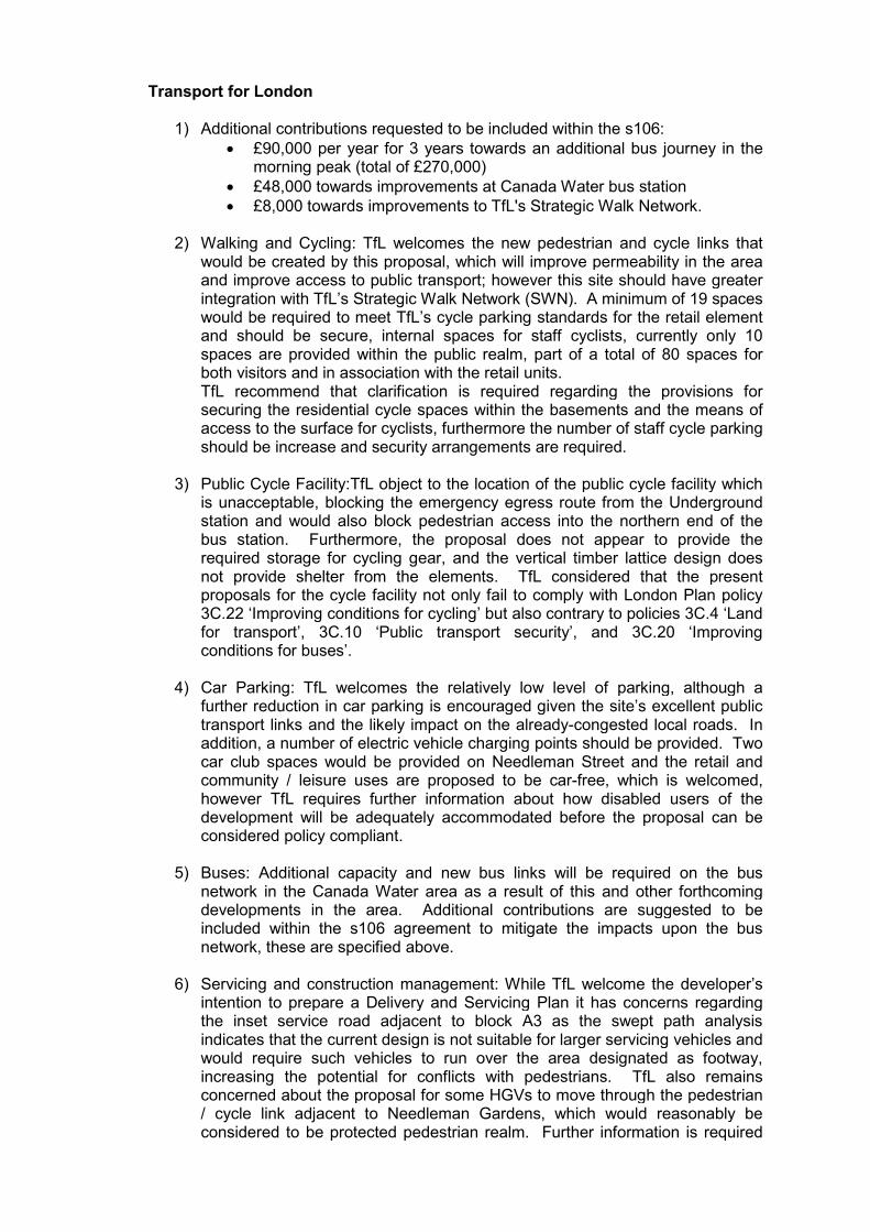
Transport for London
1) Additional contributions requested to be included within the s106: • £90,000 per year for 3 years towards an additional bus journey in the
morning peak (total of £270,000) • £48,000 towards improvements at Canada Water bus station • £8,000 towards improvements to TfL's Strategic Walk Network.
2) Walking and Cycling: TfL welcomes the new pedestrian and cycle links that would be created by this proposal, which will improve permeability in the area and improve access to public transport; however this site should have greater integration with TfL’s Strategic Walk Network (SWN). A minimum of 19 spaces would be required to meet TfL’s cycle parking standards for the retail element and should be secure, internal spaces for staff cyclists, currently only 10 spaces are provided within the public realm, part of a total of 80 spaces for both visitors and in association with the retail units. TfL recommend that clarification is required regarding the provisions for securing the residential cycle spaces within the basements and the means of access to the surface for cyclists, furthermore the number of staff cycle parking should be increase and security arrangements are required.
3) Public Cycle Facility:TfL object to the location of the public cycle facility which is unacceptable, blocking the emergency egress route from the Underground station and would also block pedestrian access into the northern end of the bus station. Furthermore, the proposal does not appear to provide the required storage for cycling gear, and the vertical timber lattice design does not provide shelter from the elements. TfL considered that the present proposals for the cycle facility not only fail to comply with London Plan policy 3C.22 ‘Improving conditions for cycling’ but also contrary to policies 3C.4 ‘Land for transport’, 3C.10 ‘Public transport security’, and 3C.20 ‘Improving conditions for buses’.
4) Car Parking: TfL welcomes the relatively low level of parking, although a
further reduction in car parking is encouraged given the site’s excellent public transport links and the likely impact on the already-congested local roads. In addition, a number of electric vehicle charging points should be provided. Two car club spaces would be provided on Needleman Street and the retail and community / leisure uses are proposed to be car-free, which is welcomed, however TfL requires further information about how disabled users of the development will be adequately accommodated before the proposal can be considered policy compliant.
5) Buses: Additional capacity and new bus links will be required on the bus
network in the Canada Water area as a result of this and other forthcoming developments in the area. Additional contributions are suggested to be included within the s106 agreement to mitigate the impacts upon the bus network, these are specified above.
6) Servicing and construction management: While TfL welcome the developer’s
intention to prepare a Delivery and Servicing Plan it has concerns regarding the inset service road adjacent to block A3 as the swept path analysis indicates that the current design is not suitable for larger servicing vehicles and would require such vehicles to run over the area designated as footway, increasing the potential for conflicts with pedestrians. TfL also remains concerned about the proposal for some HGVs to move through the pedestrian / cycle link adjacent to Needleman Gardens, which would reasonably be considered to be protected pedestrian realm. Further information is required
regarding how this space works. The developer’s agreement to securing a construction logistics plan (CLP) is also welcomed; this should be prepared in line with the London Freight Plan and approved in consultation with TfL prior to the commencement of works on the site.
7) Travel Plan: A travel plan covering both the residential and commercial
elements has been submitted with this application. The submitted travel plan is generally of good quality and shows a commitment to encouraging sustainable travel. However, further work is needed on funding and mode shift targets in order to be considered to be compliant with policies in the London Plan.
Environment Agency Raise no objections to the proposal however request that conditions be attached to any grant of consent for the scheme concerning finished floor levels, details of surface water drainage, detail of incorporation of SUDs, assessment of contamination to land and details of piling and foundation design.
Lambeth Borough Council Raise no objections to the proposal.
Greenwich Council Raise no objection to the proposal.
Lewisham Council
The site is in excess of 1,000 metres from Lewisham's north western boundary, so the impact of the proposed development on Lewisham's nearest townscape would be relatively minimal. In terms of traffic generation there are only 166 car parking spaces shown which Lewisham LPA does not consider would have a significant impact on the local traffic network. Most of the car parking spaces will be sold at a price to the owners of the most expensive flats in the development and vehicle use will likely be limited to the weekends and outside peak hour times. The development is extremely close to Canada Water tube and bus station so the incentive to utilise public transport over the car for local travel is large. The development will not impact on designated strategic views. Accordingly, Lewisham Council offers no objection to the proposal.
Metropolitan Police
Request that anti-terrorism officers be consulted – Following consultation with anti-terrorism officer, no objections were raised.
Tower Hamlets Council
No response.
British Waterways No comments.
Thames Water No objections – recommend the imposition of conditions, including the submission of a drainage strategy and an impact study of the existing water supply infrastructure. In relation to surface water drainage, it is recommended that the applicant should ensure that storm flows are attenuated or regulated into the receiving public network through on or off site storage. Thames Water Developer Services will need to be contacted and provide approval prior to connecting to public sewers. A Trade Effluent Consent will also be required for any Effluent discharge other than domestic discharge. Thames Water recommends that petrol / oil interceptors be fitted in all car parking / washing / repair facilities and that there are properly maintained fat traps on all
catering establishments.
Design Review Panel: The scheme was presented to the Design Review Panel on two occasions, the most recent in March 2009. The Panel made the following comments:
• single/dual aspect flats – the Panel raised concerns with definition of dual aspect flats and noted that those flats that did not have at least 90 degrees between facades would not normally be considered as dual aspect;
• the Panel noted that, in a number of areas, the courtyards did not reach the minimum overlooking distances as required by the SPD and advised that the courtyards seemed very claustrophobic;
• the tower should work harder; the aspirations and sense of quality that were evident in the earlier presentation appear have been lost;
• the Panel questioned the way that the architectural language had been developed and it was hoped that the warehouse precedent would generate a solid aesthetic with deep reveals and a variety and vitality of facades within a clear set of principles;
• the Panel were disappointed that the landscaping plans were only a sketch and wanted to know more about the courtyards; and
• The Panel felt there needed to be a clearer understanding of sustainability measures and how these would be integrated into the scheme.
CABE
Do not wish to comment since scheme has been presented to Southwark’s DRP.
Natural England The proposal does not affect any priority interest areas for Natural England; therefore there is no objection to the proposal.
English Heritage Have no comments – This application should be determined in accordance with national and local policy guidance and on the basis of your specialist conservation advice.
BAA Airports – Heathrow Airport No objections.
Arqiva Arqiva is responsible for providing the BBC and ITV’s transmission network and is responsible for ensuring the integrity of Re-Broadcast Links (RBLs). Based on the information provided, analysis shows that the proposal is unlikely to affect any RBLs and hence do not wish to object.
Southwark Cyclists Object to the application for the following reasons:
• The 60 spaces provided in the cycle shed nowhere near meet current demand, let alone provide for inevitable growth;
• The interior of the building should not be open to the rain – a simple baffled roof would let gas escape, and keep rain out;
• We do not feel walls and swipe card access to be necessary – cyclists should be encouraged to lock their bikes securely;
• The unit cost is prohibitive. The cycle parking here should be exemplary and economical for copying elsewhere;
• Southwark Cyclists would like to see parking for 400 bicycles using Josta double-decker racks;
• Cycle parking should be under a roof to keep rain off;
• There should be good CCTV coverage and regular patrols by site security staff;
• The facility should have no side walls and open access with regularly maintenance.
• Following amendments to the scheme the following comments were made by Southwark Cyclists: Welcome the reduction in car parking; Require 400 covered cycle parking spaces.
58 Neighbour consultees
In total 71 responses received in objection to the proposal including a petition of 13 names.
60 responses received in objection from the following addresses:
• 58 Dock Hill Avenue • Flat 554, 565 Giverny House Water Gardens Square • Pump House Close, Renforth Street • (x2) The Pumphouse, 70 Renforth Street • 4, 18 & 41 The Pump House, 70 Renforth Street • 2, 70, 134 & 138 Basque Court, Garter Way • 57 Renforth Street • 1 Baltic Court • Walter Langley Court, 14 Brunel Road • 14 Brunel Road • 2 Galleon Close, Kinburn Street • 11, 12, 15, 16, 20, 21, 31, 40, 48, 59, 60 & 61 Kinburn Street • ANON, 1, 6, 9 & 20 Eleanor Close • 10 Grantham Court, Eleanor Close • 5 Colette Court, Eleanor Close • 20 Walker House • 5 Windrose Close (petition of 13 names, no signatures) • 69 Canon Beck Road • 18 Woodland Crescent • 15 Poplar House, Woodland Crescent • 11 Sycamore House, Woodland Crescent • Spruce House, Woodland Crescent • 2 Spruce House, Woodland Crescent • 6 Cypress House, 5 Woodland Crescent • 14 Hull Close • 15 St Christopher Close • 32 Orchard House • 19 & 26 Wolf Crescent • Surrey Quays Road • 28 Albion Estate, Swan Road • 21 Farringdon Road • 2 Hardy Close • 31 & 36 Toronto House • 9 Larch House • Resident Hawke Place • Resident Columbia Point • plus 11 anonymous responses.
The concerns raised are summarised as the following with the number of respondents who commented on each point noted in brackets, where there is only one response the number is not noted:
1) Tower not appropriate for the area – The 26 storey tower is not in character
with the suburban / green character of the area and will block clear skyline. The Canada Water library on Site B is opposite the proposed location for the tower and the tower will dwarf the library; (48 responses)
2) Congestion during construction and after development with increased traffic and noise – All ready experience congestion since building work began, Needleman Street and Surrey Quays Road will have traffic increased significantly; (23 responses)
3) Pressure on existing services from increased population – More emphasis should be put upon providing facilities for shopping, transport links, local GPs, upgraded sports centre, parks, childcare services, independent shops; (18 responses)
4) Loss of Daylight, Sunlight and Outlook – Adjoining residents will be adversely impacted by the tower and the other 4-8 storey buildings; (17 responses)
5) Adverse impact upon the green environment – The site should be left vacant and made into a green space for residents to enjoy, need more open spaces and parks; (15 responses)
6) Public transport is at capacity – It is already difficult to use public transport, particularly the tube here, due to overcrowding the development will increase the population further without improving transport links; (13 responses)
7) Overcrowding – Already overcrowded in this area and other estates in the Elephant and Castle, Aylesbury are being demolished; noise from increased population; Not enough shops to cope with increase population; (12 responses)
8) Not enough parking spaces – Even though the tube is nearby it is irrelevant, people park in the surrounding areas instead; (13 responses)
9) Adverse impact upon character of the area – The erection of buildings more than 6 storeys high will ruin the open space of Canada Water, concern a canyon effect will result; (7 responses)
10) Density – The developments sites should be spread to reduce the noise and air pollution; (8 responses)
11) Construction will obstruct access to tube station – Via Albatross Way; (5 responses)
12) Object to the location and lack of cycle spaces provided in the public facility – Will provide a climbing wall to access the Pumphouse grounds; (4 responses)
13) The tall buildings will create adverse weather and light pollution; The building will cast shadows, create a micro-climate and be lit up at night; (4 responses)
14) Destruction of natural habitat and animals – There should be preservation of the site as a wildlife area; (3 responses)
15) Cumulative impact of developments in Canada Water. (3 responses) 16) Objection to the short consultation period given – Too many applications for
the area at once; (3 responses) 17) More family homes should be built rather than flats – 3-4 bed town houses
would be welcomed, the development does not provide the necessary dwelling mix; (3 responses)
18) There should be a taxi rank and drop-off point provided by the station; (3 responses)
19) Object to the level of affordable housing provided – Privately owned houses are generally better looked after; (3 responses)
20) Oppose the placement of block A3 next to the Pump House – Concerned at the number of social housing units to be situated together creating an isolated environment for the Pump House; (2 responses)
21) Noise pollution during construction – No analysis of the impact upon the Albion Estate and Pumphouse which are the closest adjoining buildings; (2 responses)
22) Redevelopment of the area will require extensive period of construction – Adverse impact upon the amenity of residents from constant noise and air pollution raised by the construction works;
23) Size of the development could flood the market with properties; 24) Not affordable for local people; 25) The proposed Needleman Park is too small – The park also fails to include
mature trees; 26) Will reduce the value of existing properties in the area; 27) Increased risk of crime; 28) Contaminated Land – This has potential to harm human health; 29) The development of site B coupled with this development of site A will create
enclosure – The pedestrian walkways are very narrow and high buildings right up onto them creates a sense of enclosure;
30) The Affordable Units should not be prevented from accessing communal gardens;
31) Lack of employment opportunities; 32) A number of units are single aspect – 34 of the 668 units are single aspect; 33) Pedestrian and cycle permeability and sight lines are a cause for concern –
Throughout the site there are obstructions to pedestrian and cycle movement created by alterations to roads;
34) Insufficient number of family units which are private / market rent – There are no 4 bed houses available to those who are not eligible for an affordable home;
35) The tower will create interference with television signals. 36) The development will provoke wind effects in the immediate vicinity. 37) The tower will be a focus for potential terrorist attacks. 38) Should meet Code Level 6 (for sustainable homes). 39) Unsafe pedestrian crossing. 40) Buildings leave little space for pedestrian movement. 41) Where is the leisure facility in this proposal? 42) Lack of children’s playspace. 43) Retail units should be preserved for small businesses. 44) The fire strategy appears unsafe. (responses received following reconsultation did not raise any new points and are
noted above)
59 1) The Hawkstone Tenants & Residents Association made the following objections:
2) Our response is informed by over 120 CW APP questionnaires; 3) Referring to 2007 data is not appropriate for the Masterplan, being out of date; 4) Question the indication that the majority of residents are in support of the tall
building, only 45.6% indicated support which is a minority; 5) Object to the development on the grounds of pollution; 6) Question the accuracy and independence of studies in documents submitted
with the application; 7) The cumulative effects have not been taken into account; 8) The biomass power adds more pollution; 9) Object to the development of traffic noise, nuisance, vibration etc.
Improvements to infrastructure must come hand in hand with development applications;
10) Object to the development because green places and open space will be reduced;
11) Object to the development on grounds of density and open space provision per intended inhabitant;
12) Against the community facility becoming Council offices and the facility should be for all local groups managed by Southwark Council;
13) The development should reach Code for Sustainable Homes Level 6; 14) 400 cycle spaces should be provided;
Following amendments to the scheme the residents association had further
comments: • The applicant should meet with Southwark Cyclists; • Reduction in car parking is not welcome; • Would like to see increase in parking for electric cars; • On 30-10-2009 127 questionnaires delivered to the council. 60 In total 8 responses received in support of the proposal.
5 responses received from the following addresses in support of the proposal.
• 95 Basque Road • 18 Courthope House, Lower Road • 35 Pump House Close • 10 Quilting Court, Garter Way • 54 Regina Road • plus 2 anonymous response
In summary they detail the following comments:
• Tall buildings are welcome; • Is a benefit to the community; • The area needs more retail outlets and leisure facilities, cafes etc.; • The proposal is practical and affordable; • New library; (officer comment: This application does not provided a library) • New homes for tenants within the neighbourhood.
61
The Rotherhithe Housing Forum Sub Group made the following representation:
• Support the planned number of RSLs units, the new community facilities and the inclusion of the new 26 storey high rise living facility.
PLANNING CONSIDERATIONS
62
Principle of development The site is located within the strategically identified Area of Intensification within the London Plan. The London Plan states that these areas have significant potential for increases in residential, employment and other uses through development or redevelopment of available sites and exploitation of potential for regeneration, through higher densities and more mixed and intensive use. The Southwark Plan identifies the site as being within the Canada Water Action Area and Policy 7.2 includes a list of 16 points which development should seek to achieve including at point (iii) that the area be developed as a mixed use area with appropriate densities to enable the most efficient use of land and to reduce the need to travel. Key sites in Canada Water have been designated on the Proposals Map for particular uses. It is necessary to protect these sites for particular uses to create the type of place envisaged in the Action Area. The form of development at Canada Water should be at an appropriate density to make the best use of this highly accessible area and be sufficient to support local public transport infrastructure and facilities. Development should also be sensitive to the scale and character of the local area.
63
The vision for Canada Water outlined in Policy 7.2 is to create a new focus for community and commercial activity for the Rotherhithe peninsula and neighbouring areas with an urban environment of the highest standards and a mix of uses with appropriate densities of development to enable the most efficient use of land and to reduce the need to travel. Development should seek to improve accessibility particularly for pedestrians, cyclists and users of public transport, while extending and improving the existing shopping centre and maintaining its viability whilst expanding the range and variety of retail activity. Development should also seeks to create

attractive, safe and secure public realm areas, while enhancing existing environmental assets to create a distinctive sense of place and protect and enhance Canada Water dock basin and its value for wildlife and other special environmental features of the area.
64
The site is allocated in the Southwark Plan as proposal site 27P, giving Class C3 residential as the use required and Classes A and D as other acceptable uses. The allocation states that the site could be considered for Public Transport Accessibility Zone (PTAZ) densities.
65 The Canada Water Area Action Plan (CWAAP) has been consulted upon but is not adopted. The Preferred Option Report (July 2009) suggests the required uses on Site A as being residential and retail, with the provision of a cycle station and public open space. It also considers the site as being appropriate for a tall building. This document is not adopted and therefore is limited in its influence on the determination of applications. This proposal is therefore assessed primarily in accordance with relevant adopted policies within the Southwark Plan 2007, London Plan 2008 and related Supplementary Planning Documents.
66 The Canada Water Supplementary Planning Guidance 2005 identifies the vision for Canada Water as being a mixed use district town centre providing an attractive public realm and community facilities, new retail and additional residential dwellings are also encouraged. The Supplementary Planning Guidance will ultimately be replaced by the Canada Water Area Action Plan.
67 Mix of uses The scheme demonstrates a mix of uses, namely a retail unit, community facility space and residential accommodation. A total of 958sqm of retail (unrestricted A class use, being A1 retail, A2 financial / professional and A3 cafe / restaurant but not for bar or takeaway uses) is proposed which will activate the ground floor fronting the Surrey Quays Road. This floorspace is included within the ground and mezzanine level to the tower block A4 and the ground floor of block A3. This use is appropriate for this town centre location which together with the street furniture and lighting should create a vibrant atmosphere.
68 In addition to the retail uses, 268sqm of community use space has been proposed. This is a reduction from the 430sqm provided at outline stage (which was to be built to shell and core with 215sqm at market rent and 215sqm at peppercorn rent). The applicant has carried out consultation with the local community which reveals they would wish to see a fully fitted out space (rather than to shell and core) at a peppercorn rent, even if this is provided with a smaller floorspace area. The consultation also revealed that there was support for the space to be used as a playgroup or crèche, but that other uses such as a community hall or youth club would also be desirable. This smaller space does limit the options for potential users but in the absence of information suggesting that a larger space is needed, it is recommended that the proposed amount be accepted. Take up of the space is more likely if the unit is fully fitted and the rental level will not discourage potential users. It is also worthy of note, that surrounding development is providing additional community facilities close to the site, for instance the new library within Site B which provides a significant contribution to community facilities here.
69 The proposal also creates of 668 residential units in a mix of private, social rented and intermediate tenures. This is a required use under the site designation. Furthermore, policy 7.2 Canada Water Action Area specifies at point (xi) that 3,378-5,008 new high quality homes are required to meeting housing needs. The application is a significant contribution to the achievement of these numbers.

70
Environmental impact assessment (EIA) Applications where an EIA is required will either be mandatory or discretionary, depending on whether they are found in Schedule 1 (mandatory) or Schedule 2 (discretionary) of the 1999 Regulations. In this case, the proposal is considered to constitute a ‘Schedule 2’ ‘urban development project’ in accordance with Section 10(b) of Schedule 2 of the Regulations. In order for an EIA to be submitted, the area of the site should exceed 0.5ha and be located within a sensitive area and generate significant environmental effects. The area of the site is approximately 2.10 ha. Whilst not located within a defined 'sensitive area', the scheme will include a tall building. The previously approved outline scheme for the site was also submitted with an EIA and this current scheme involves a larger quantum of development. It is on this basis that the applicant has voluntarily submitted the application with an EIA.
71 Where EIA is required, the EIA Regulations require the submission of an Environmental Statement (ES) to assess the likely significant environmental effects of the proposed development at each stage of the development programme (in this case construction and occupation) . The ES must provide an outline of any alternative sites and options considered.
72 The likely significant environmental effects have been predicted for each relevant environmental topic by comparing baseline environmental conditions (i.e. the situation without the scheme) with the conditions that would prevail during construction and were the scheme to be constructed and occupied. The ‘reasonable worst case’ scenario has been utilised to identify the likely impacts in relation to each effect.
73 The environmental effects have been predicted in relation to environmental receptors, that is: people (e.g. residents of the buildings, users of facilities, employees of businesses etc); built resources (e.g. a listed building); and natural resources (e.g. site of ecological interest). A set of significance criteria has been developed for each environmental topic. In this ES, significant effects have been reported and categorised as appropriate. Impacts can either be site-specific or scheme-wide; positive or negative; and temporary or permanent. They can also be direct effects from the activities comprising the Scheme or indirect effects from activities not explicitly forming part of the scheme (e.g. additional traffic on parts of the road network not forming part of the scheme). In addition, there is potential for cumulative effects to arise from the combination of different effects, the recurrence of effects to arise from the combination of different effects, the recurrence of effects of the same type at different locations and the interaction of different effects over time.
74 The ES must also include an assessment of potential impacts arising from the construction and operation of other schemes which have overlaped in terms of either location, or timing. Measures to avoid, reduce, and if necessary, mitigate environmental impacts have also been considered, and can be controlled through conditions and planning obligations. Residual effects (i.e. effects of the scheme once mitigation has been applied) have been identified for each topic area. Where effects are still considered significant, the level of significance i.e. major, moderate or minor and extent of any amelioration is explained. These statements are used to indicate the following level of impact:
• Major significant – intensive change to the land use; • Moderate significant – clearly identifiable changes to the land use; • Minor significant – slight or short term changes to the land use; and • Negligible or no impacts to the land use.
75
Alternatives The site is identified within the London Plan, Southwark Plan and the draft Canada

water AAP as an area for regeneration. A 'no action' alternative would see the site remain redundant and the need for development and regeneration remain unfulfilled. An alternative site has not been assessed as this site is a strategic area marked for regeneration. The land use is also consistent with the UDP, the use for housing is needed to meet housing targets.
76 Various alternative site layouts have been considered as part of the planning process. These have been summarised below.
Option 1: This considered the outline scheme; the scheme did not optimise use of the site and did not clearly define the town centre. Option 2: The second option introduced a tall building and enclosed perimeter blocks. Option 3: The pocket park was relocated to the rear of the site and created a green link to the wider area. Retail use was also introduced into the corner section of Block A3. Option 4: This option involved a change in the design of the landmark building together with a reduction in height. Option 5 (preferred option): Heights of blocks A1 and A2 were reduced and townhouses introduced.
77
Land use This section sets out the existing surrounding land uses and identifies the planned and committed developments in close proximity to the site.
78
Impacts During the construction phase there will be some short term and minor negative impacts on land use associated with the introduction of construction activities within the area. The ES states that the scheme will have a moderate positive impact on land use, as the site will have a clear identifiable change in land use from its current vacant use. The impact has been considered to be positive as it will provide mixed tenure dwellings, local retail facilities and a small community facility.
79
Mitigation measures and residual impact As there are positive impacts, no mitigation has been proposed.
80
Cumulative impacts The scheme has to be considered in the context of surrounding development to understand the cumulative impact planned development will have on land uses within the area (including Canada Water sites B, C, E and the Surrey Quays Leisure Site). The scheme would have a major positive effect on land use in the area as it would deliver a comprehensive new development with mixed tenure housing, retail and community facilities.
81
Officer Conclusion It is considered that the ES has appropriately dealt with this area of impact such that no significant adverse impacts are likely to result from the development.
82
Planning Policy This section provides an appraisal of the relationship between the scheme and planning policy at the national, regional and local level with respect to four themes; the principle of sustainable development; residential development; economy and regeneration and the principles of design.
83 This part of the ES has set out the main relevant planning policies and thus has been dealt with appropriately.
84
Air Quality and Dust This section considers the potential from emissions and dust during both the construction and operational phases of the scheme. This part of the borough is within an Air Quality Management Area.
85
Emissions during construction There are a number of activities during construction that have the potential to generate dust, which have the potential to cause nuisance both within the site and outside the site boundary. The quantity of dust varies and is dependant on a number of factors. The two main emissions from vehicles are Nitrogen dioxide (NO2) and fine particulate matter (PM10), which are already high in the borough.
86 The applicant has indicated that, subject to planning permission, it is anticipated that construction will last four years, with the following sequence:
• Block A1 – January 2010 - January 2012; • Block A2 – June 2010 – February 2013 • Block A3 – January 2011 – December 2013 • Block A4 – January 2011 – December 2013
87 The impacts from the additional vehicles on the road network during construction have
been assessed as a worst case, the increase in pollutant concentrations is considered to have a ‘negligible’ to ‘slightly adverse’ impact on receptors and an insignificant impact with respect to PM10 concentrations. These impacts will decrease rapidly away from the roadside and will be temporary, lasting only for the period of construction, albeit that period of construction in this instance will be for 4 years.
88 In terms of dust, the impacts have the potential to be significant, particularly to the Albion Estate to the north-west and Needleman Road residential estates as these are within 50m of the site boundary. This should be reduced through the implementation of mitigating measures: monitoring of vehicles that enter and leave the site; provision of wheel washing facilities; water-spray dampening of soils to prevent dust-blow during hot and dry weather conditions and sheeting of lorries during transportation of friable construction materials and spoil.
89
Operational impacts The results of additional traffic volumes generated by the operation of the Scheme show that the incremental traffic flows will make a minor difference to the predicted baseline pollutant concentrations, which have been classed as an extremely small change in concentration.
90
Cumulative impacts The scheme is part of the wider redevelopment of Canada Water area. The ES has assumed that construction of other sites (B, C, E, F, G and the Mulberry Business Centre) will occur simultaneously. It also states that no impacts from dust will be experienced between the site and Fisher Athletic FC and Downtown (neither of which have consent) as they are separated from the site by a large distance. However, dust is likely to be experienced as a result of the cumulative construction of sites A, B, C, E, F, G and the Mulberry Business Centre. With the mitigation measures in place, dust should be reduced to the greatest extent possible.
91 In terms of impacts from construction vehicles, it is likely that there will be overlap between some of the roads that used to access the sites, which will lead to additional emissions from vehicles. The ES assessment carried out, comments that the impacts will not be significant, but it is clear that the background concentrations of NO2 and

PM10 are already high.
92 The energy centre provided as part of Site B will serve the wider development area, including this site. It will include a CHP plant, biomass plant and gas boilers. The biomass boiler has the potential to generate high emissions of particulate matter, in particular, over short term periods. This has been assessed and the conclusion was that it will have no impacts significant impacts on local air quality.
93 The cumulative impacts have also been assessed with regard to the ventilation shaft immediately south of site B2 which is equipped with fan systems to provide ventilation and emergency smoke extraction capabilities for the stretch of the underground system at Canada Water. The ES states that the particles emitted from this shaft are unlikely to have an adverse effect on the Site receptors as site B2 is located in between the shaft and the site.
94 95
PPS23 Planning and Pollution Control states it is not the case that all planning applications for developments inside Air Quality Management Zones (AQMA) should be refused if the development would result in a deterioration of local air quality as this has the potential of seriously hindering a development. Therefore, while during construction there is likely to be some impact upon air quality, this being minor and temporary, it would not be considered appropriate to refuse on this ground alone. Officer Conclusion The site is located within an Air Quality Management Zone; therefore any new developments should be designed to include mitigation measures to ensure that the air quality is not reduced as a result of the individual scheme. Following assessment of the study of the site within the ES, it is considered that the ES has appropriately addressed possible impacts and subject to mitigating measures being implemented, officers are satisfied that that the identified impacts of emissions are acceptable.
96
Noise and vibration This chapter of the ES evaluates noise and vibration impacts arising from the scheme. A detailed noise and vibration survey was carried out to establish the baseline noise and vibration levels around the site.
97 Construction noise The anticipated core working hours will be 0800-1800 Monday and Friday; 0800-1300 on Saturday with no work proposed on Sundays and public holidays. No night time works are expected but some deliveries and certain works (e.g. erection of tower cranes) may need to be undertaken at the weekends. The exact plant and equipment to be used are not known at this stage and assumptions have been made. Southwark Council will be consulted and prior approval will be sought under the Control of Pollution Act. In terms of vehicles, they will approach from Surrey Quays Road and up to 45 HGVs per day are expected during the peak construction period, an average of 5 per hour. As existing, there are up to 440 vehicles per hour along Surrey Quays Road, up to 12% of which are HGV’s. The volume of construction traffic is not considered to be significant given existing volumes of traffic and the ES reports that they will not give rise to a significant noise increase, subject to the implementation of mitigating measures being adopted.
98 Piling will be required for the construction of foundations. The ES concludes that it is not expected that the majority of construction works will give rise to significant impacts.
99
Operational phase It will be necessary to ensure the buildings are designed with sufficient acoustic

mitigation to ensure that the residential units are protected against road and traffic noise. This can be dealt with by condition. Given the proximity of the underground lines, mitigating design measures need to be put in place to limit vibration transfer.
100
Cumulative impacts During the construction period, the ES has not examined cumulative impacts with any degree of certainty given that it is not known whether the surrounding schemes will proceed. During operation, cumulative noise and vibration may occur due to additional traffic generated by the other Canada Water sites.
101 102
The ES concludes that the impacts from construction and operation can be mitigated through the imposition of mitigating measures and conditions. The cumulative impacts have not been assessed in any great detail on account of the unknowns as to whether surrounding schemes will be built and when. Officer Conclusion The ES has not included a full assessment of cumulative impacts of the scheme during construction. The worst case scenario would be that all developments within Canada Water undergo construction at the same time. This is unlikely given the fact that site B has begun construction, a number of details would be required for this site and other sites prior to their commencement of development and the different sizes of sites dictate different construction periods. The argument brought forward by the ES is therefore accepted and it is considered that the ES has dealt with this issue in the best manner possible.
103
Ecology and Nature Conservation This chapter of the ES assesses the ecological and nature conservation impacts that may result from the proposed scheme. It describes the baseline nature conservation interests of the site and the proposed impacts as a consequence of the development proposals. Detailed ecological surveys were undertaken, findings of which are reported below.
104 The clearance of part of the site to provide temporary car parking for Site B and the marketing suite on the site has resulted in a short term ecological impact as a result of the loss of neutral grassland area, however with the proposed mitigation, no long term significant impacts are predicted.
105 Site A demonstrates an avenue of trees bordering the north eastern edge of the site, and the site is currently vacant forming an undesignated grassed area.
106 The closest Site of Importance for Nature Conservation (SINC), Canada and Surrey Waters, is located 40m from the southern boundary of the site.
107
Construction impacts No direct impacts are expected to occur which would affect the SINC but there is risk of indirect impacts, such as water contamination. Mitigating measures will be implemented to minimise the risk, including ensuring the construction work is undertaken in accordance with EA Pollution Prevention Guidelines.
108 The scheme will result in a loss of all of the remaining habitats within the site boundary including ephemeral (thin layers of short vegetation on hard standing that has degraded) and ruderal (low ecological value) habitats, species-rich neutral grassland, scrub and woodland. The loss will be mitigating by the introduction of plant species to the garden areas, green roofs and tree planting along the street corridors. The site was not considered as being of interest for roosting, commuting and foraging bats. Common bird species were recorded for using the site for foraging and shelter;
the loss of which will be mitigated through gardens and tree planting.
109
Operational impacts No significant impacts are predicted on designated sites, grassland areas or on species once the scheme is complete.
110
Cumulative impacts No cumulative impacts are predicted.
111 The ES advises that no significant impacts on designated sites are predicted to occur, provided that mitigating measures are implemented. The scheme will impact on habitats and woodland but provided that mitigating measures are put in place no significant impact is predicted. Provided that details of landscaping and green roofs will be required by condition, the impacts on Ecology have been dealt with appropriately.
112
Officer Conclusion While the ES has included a fully assessment of the impacts upon ecology at the site, it is not considered that the findings have been well concluded. It will be necessary to assess the evidence of bats on the site further and how the loss of trees will impact upon them. It is possible to include conditions on any grant of consent which will adequately address this, and along with other suggested mitigation levels in the ES, Officers are satisfied that no significant adverse impacts on Ecology will result.
113
Transport and Access This chapter provides an assessment of the predicted traffic and transport impacts of the scheme. In particular, it describes existing traffic conditions, access routes for the transportation of materials (during construction), and the estimated numbers of construction and operational vehicles.
114 Short term impacts – construction Construction will take place over a period of approximately four years. As a worst case scenario, 45 vehicles per day are expected. Employees will be encouraged to use public transport to access the site. The short term impacts are not expected to be significant, with the largest traffic percentage change being 2.72% on Surrey Quays Road from 0900 to 1000 hours. Pedestrian and cycle facilities in the area have been identified as being good and will be kept open throughout the works.
115 In terms of mitigation, routes for construction traffic should be agreed. This can be controlled through the imposition of condition requiring a construction management plan. Traffic should be restricted during peak hours and at night in sensitive areas.
116 Long term impacts - operation Parking levels in the scheme are lower than in the outline scheme, therefore no additional modelling has been carried out as the Rotherhithe Multi Modal study would represent the worst case scenario.
117 The scheme is considered to have a negligible impact on public transport trip generation. The impacts to pedestrian and cycle facilities are considered to have significant positive impacts, given the cycle spaces proposed and local linkages. Two car club bays are also proposed.
118 Provided that mitigating measures are introduced, construction vehicles should not cause significant impacts. A travel plan should also be required to encourage sustainable forms of travel.

119 Officer Conclusion Officers are satisfied that the ES has identified the relevant issues and has been dealt with satisfactorily.
120
Townscape and Visual This section assesses the impact upon townscape and visual character, which may be positive or negative according to the nature, quality and sensitivity of the existing baseline environment. The following categories have been used to evaluate the existing townscape and streetscape character of the surrounding area. The scale is a value based system with regard to the character, condition, appearance, designation and aesthetic appeal of the area.
• Exceptional – Recognised important townscapes with exceptional quality, highly valued and rare features, where a high level of human comfort is experience with strong hierarchies to public amenity and civic spaces;
• High – Distinctive spaces with rich cultural associations containing many attractive and harmonious townscape features;
• Medium-high – Locally valued spaces (possibly designated) with attractive and / or historical features within the townscape;
• Medium – Townscapes with numerous blemishes, lacking indication of local distinctiveness, where remnant distinctive features may persist but there is no longer indication of contextual design expressions;
• Low – Townscape in poor condition or decline with unattractive and derelict buildings, poor pedestrian movements which may be inhibited by transport barriers.
121 A number of further descriptions to evaluate impact are then also used which are
categorised from low to high and assess the ‘Receptor Sensitivity’ namely being the inherent quality of the townscape and its associated ability to accommodate change, this will include the sensitivity of viewpoints. The viewpoint locations were suggested by Council Officers and have been incorporated into the assessment. Categorisations of imperceptible / no noticeable change, low, moderate or high are then used to assess ‘Magnitude of Impact’ which will depend upon the nature and scale of the development.
122 Combining these assessments, specifically the ‘sensitivity’ of the landscape or viewer with the ‘magnitude’ of change expected as a consequence of the development, then allows the ‘Impact Significance’ to be concluded. This is classified on a scale of not significant to major.
123 For the purposes of this assessment the precinct areas have been categorised and grouped into different character areas depending on their location, connectivity to the site, use, built form and similarities. The quality of townscape and sensitivity to change is then determined using the levels described above.
124 The scheme will introduce changes to the existing townscape views to the surrounding area, most notably but not exclusively due to the height of the tower proposed as part of the development. Assessments on the impact upon views are then carried out, with fieldwork, walkover surveys and consultation with Council Officers informing the selection of viewpoints.
125 There are three strategically important views identified in the adopted and draft revised London View Management Framework, these are from Greenwich Park looking towards St Paul’s Cathedral from the General Wolfe statue and looking north east of the statue, and from Blackheath Point looking towards St Paul’s Cathedral. The site does not come within any of these aforementioned viewing corridors and

there are no local vistas or designated local views across the site.
126 A number of ‘Close Range Views’ and ‘Long and Medium Range Views’ were then identified and assessed. The ‘Close Range Views’ comprised six viewpoints where open and direct views are available to residents nearby the Canada Estate buildings as well as residents within medium rise buildings and pedestrians within streets. A further thirteen ‘Long and Medium Range Views’ have then been identified and are available to residents, workers, travellers and recreational users of nearby parks, these views are distinguishable because of the location of the Canada Estate towers.
127 Long Term Impacts The ES concludes that the townscape and visual impacts will vary between minor to moderate significance and are mainly beneficial. The conclusion that the scheme is mainly beneficial results from the appraisal of the scheme to be the most appropriate development of a high design standard for this area.
128 Of significance are the long term impacts upon views in the low rise residential areas and on views of the Grade II Listed Pumphouse located close to the site, as well as the long and medium range views from recreational areas surrounding the site and St Mary’s Rotherhithe Conservation Area. While generally the impact upon views are determined to be minor / not significant, views from those aforementioned areas are all impacted moderately except viewpoint 14 adjacent to the conservation area which has a minor impact. These impacts are all considered to be acceptable however, due to the high quality design of the scheme which is largely beneficial to all these views. While concerns have been raised in neighbour consultation responses that St Mary’s Rotherhithe Conservation Area would experience an adverse impact as a result of the view, the location of the Brunel Engine House (Brunel Museum) in the foreground of views in and adjacent to the conservation area forms the prominent visual impact, the significance of impact from the scheme being reduced, the proposed scheme forming a secondary influence.
129 As there are no significant long term adverse impacts upon the townscape and views, no mitigation measures are required.
130 Short Term Impacts There are expected short term visual impacts and impacts upon the townscape as a result of the proposal, generated during the phased construction of the development. These impacts due to their association with the construction period are themselves phased, temporary and confined to the construction period. They include the installation of fencing, temporary buildings sign boards, temporary facilities, digging, storage, movement of heavy construction vehicles, construction lighting, cranes and piling works. There will be disruption to the townscape and intrusion into views as a result of these short term impacts. However, due to their temporary nature the impacts are only to be moderately significant.
131 The ES suggests mitigation measures are required in order to minimise these impacts and can be secured by way of legal agreement or condition. These measures should include the submission of a Construction Management Plan, Construction Servicing and Access Plan and Construction Logistics Plan are submitted in order to approve arrangements for vehicle movements and construction management on the site during construction phases.
132 Lighting Impacts There is expected to be a degree of impact upon surrounding residents as a result of the change of lighting in the area created by the proposed scheme. These would be most prominent for those residents in the surrounding area which currently look onto open areas of the site which are dark and unlit as well as some areas around the

station which are lit to high levels.
133 It is possible to include mitigation measures such as preventing uplight and providing required levels of illumination without compromising the requirements for adequate lighting to ensure security and safety. The ES suggests that a condition be attached to any grant of consent for this scheme that would require further details of the lighting of the development in order to ensure that significant adverse impact does not result.
134 Cumulative Impacts The site forms part of a wider area designated as within the Canada Water regeneration masterplan, which aims to deliver a new vibrant town centre for Rotherhithe. As development here is considered within this masterplan proposal, it is considered that the cumulative impact of developments will harmonise and enhance the quality of the townscape here.
135 Officer Conclusion Officers are satisfied that the quality of townscape is enhanced by the proposal due to the high quality of the design proposed. The sections of the report below in the Design Section outline the Officer assessment of the design of the scheme.
136
Archaeology and Cultural Heritage This chapter of the ES addresses the archaeological and built heritage issues in order to consider the likely effects of the proposed development on features of cultural heritage interest.
137 The ES concludes that there are no likely significant adverse impacts upon the conservation area, listed buildings and schedule ancient monument (Brunel Pumping Station) surrounding the application site as a result of the proposal. However the document also concludes that there is good potential for archaeological remains to be found on the site during construction from the Neolithic, bronze age and Roman periods, but the only mitigation recommended is the evaluation of this potential through the observation of site investigation works.
138 Officer Conclusion Officers are not satisfied that this would appropriately mitigate against the risk of harm to any archaeological finds. Policy requires that archaeological evaluation should be undertaken prior to the commencement of development works on the site and not be made up of observations during development works.
139 In conclusion, while officers are satisfied with the evaluation contained within the ES and agree with the likely impacts, it is not considered that the mitigation levels are suitable and therefore a condition would be required improving upon the expected mitigation levels described in the ES.
140
Water Resources and Flood Risk This chapter presents the results of the hydrological environmental impact assessment. The increase in area covered by hard standing is given as 50%.
141
Construction During construction, there is considered to be the potential for impacts to the water environment, including the introduction of contaminants in association with construction and the release of sediments. The site is considered to be at low risk from flooding, and therefore, other than local ponding, no flooding would occur during construction. These are expected to be managed through the implementation of measures agreed with the Environment Agency and commitments to recording,

treatment of waters and required remediation.
142 Operation There is potential for impacts to ground and surface water during operation. This could occur for many reasons including incorrect or insufficiently designed drainage systems or run-off from roads. These impacts would be mitigated through control features as agreed with the Environment Agency.
143 Cumulative Cumulative impacts are expected to occur given the developments proposed within the surrounding area. Again, these are anticipated to be minimised through planning conditions and utilities controls.
144 Officers Conclusion Through the imposition of planning conditions and controls required by utility companies and the Environment Agency, the impact on water resources and flood risk would be mitigated. This aspect of the ES has therefore been assessed correctly and appropriate mitigation measures have been identified.
143
Land quality/contamination This section provides an assessment of the geology, hydrogeology and potential contamination in the area of the scheme and considers the wastes that will be produced as a result of the scheme.
144
Short term The potential impacts to geology are considered negligible. Contamination may be encountered during construction activities and therefore there is a risk of harm to the environment and/or human health. Mitigation measures will therefore be required. The impact on waste will be relatively small as small volumes of spoil and other construction wastes are expected to be disposed of to landfill. Removal of other solids and liquids will be handled in a controlled manner with necessary mitigation measures put in place.
145 Long term There should be no long-term or permanent impacts on geology. There will be a minor negative impact associated with the replacement of soft ground in some areas with buildings reducing infiltration of precipitation to the groundwater table. Any contaminated land issues arising will be removed leading to no long term impact.
146 147
Cumulative It is unlikely that there will be any cumulative impact on geology from the proposed scheme. There may be a cumulative impact on the overall infiltration of precipitation to the groundwater table as the schemes replace areas of soft cover with hard standing and buildings. The cumulative impact on geology, hydrogeology and contamination is considered to be a minor negative impact. Mitigating measures have been proposed and conditions such as requiring waste management plans and land contamination and remediation will be attached to the decision. Officers Conclusion It is considered that the above matters have been addressed and the potential impacts identified, appropriate mitigation can be put in place and therefore officers are satisfied that this section has been assessed correctly.
148
Wind and Microclimate This chapter in the ES considers the effects of the scheme on the local wind

microclimate within and around the scheme. In particular it considers the potential effects of wind upon the pedestrian comfort and safety and summarises the findings of a wind tunnel testing exercise.
149 Impacts: – the completed scheme The completed scheme was tested with the consented Site B buildings to the southeast of the scheme. The results show that all locations around the proposed development and immediate surrounding area are suitable for strolling throughout the year and most locations will be suitable for long-term sitting and opening entrance doors. The ES states that in most locations the proposed scheme has improved the wind climate from the baseline conditions by increasing the shelter around the site.
150 For the whole year, five locations have been given where conditions are unsuitable for long term sitting and opening entrance doors. During the summer period, this reduces to two locations and during the winter, it increases to nine locations. These locations are all concentrated around the base of the tower. Of these windy locations all but two are on footpaths or circulation areas where the expected pedestrian activity will be strolling. The wind conditions at these locations will therefore be suitable for the expected pedestrian activity.
151 The two locations where wind conditions will be unsuitable for entrances and long term sitting are at the main entrance to the tower and at a residential unit at the west of the site. In terms of mitigation, defensible landscaping is to be introduced into the front garden of the residential unit. The options for mitigating at the entrance to the tower are limited but the most effective solution is to recess the entrance into the facade to provide a draft lobby or to provide a revolving door.
152 The ES states that there should be no areas where distress would be caused to pedestrians. Subject to mitigating measures being introduced at the two locations described above, the impacts on wind and microclimate should be acceptable.
153 In relation to conditions on roof terraces, the ES has been amended to include an assessment of those conditions that would be experienced by users of the terraces. In relation to the lower rise buildings, a 1100mm edge protection is provided as well as planting to ensure safety as well as comfort for users. The Tower has a roof terrace protected by a 8.5m glazed screen on three sides, further to this, three wintergarden areas are proposed within the middle of the roof terrace. The roof terrace on the tower will be well shielded from wind by the 8.5m screen and the roof will be suitable for use throughout most of the year. The wintergarden areas allow year round use of the area. It is recognised that all of the roof terraces will be unsuitable for use during wind storms, or for long term activities in the winter months, however it is unlikely that people would wish to sit on the roof terraces at these times and therefore no harm is generated.
154 155
In terms of mitigation, the scheme has been designed to include mitigation measures such as screening and planting as well as recessed entrances to the ground floor of the tower. Officers Conclusion The study includes detailed analysis of possible impacts and the proposal has included within the design mitigation measures where appropriate. Therefore Officers are satisfied that there will be no significant adverse impacts in terms of wind generation at the site, subject to conditions relating to detailed design features.
156
Sunlight and Daylight This section contains an assessment of the potential effects of the project on daylight,
sunlight and overshadowing in the area surrounding the site. This impact is discussed below in the assessment on the impact upon adjoining occupiers’ amenity that would result from the proposal.
157 Previously, it was considered for the Outline approval, that 99% of rooms surrounding the development site meeting BRE Guidelines in terms of daylight requirements and 87% of windows for properties surrounding the development site meeting sunlight requirements as set out in the BRE Guidelines was acceptable.
158 Baseline Conditions Sunlight availability was assessed on 7 ground and 78 facade locations and results of this indicate that on an annual basis the recommended level of sunlight is achieved during winter for all ground and facade locations.
159 Daylight availability was assessed at the same 78 facade locations and results indicate that the recommended level of daylight is received for the majority of locations, with 17 facade locations not experiencing daylight availability greater than 27%
160 Impacts Upon Surrounding Properties The same 7 ground and 78 facade locations were assessed to determine impacts following construction of the proposal. The results showed that the proposed scheme has a minimum impact on the sunlight availability on the surrounding buildings.
161 Best practice guidelines for daylight availability were achieved at 50 of the 78 facade assessment locations on the surrounding buildings. However, internal daylight analysis shows that the level of internal daylight which would be experienced in these effected facades would be sufficient for any intended use, therefore mitigation measures are not considered to be required.
162 In conclusion the impact of the development is marginal upon the daylight and sunlight levels of surrounding properties and Officers are satisfied that the daylight and sunlight assessment adequate demonstrates that surrounding properties will not suffer any significant adverse impact to daylight and sunlight levels as a result of the proposal.
163 Impact Upon the Scheme Best practice recommendations for sunlight availability are met at 86% of the assessed facades and for best practice guidelines for daylight availability it was found that 61 out of 230 facades achieved recommended levels. All of the locations that do not meet guideline daylight availability are ground floor locations and most are associated with facades in close proximity to neighbouring blocks or face internal courtyards. For those cases were the daylight availability at a facade location was not met, an internal daylight assessment was undertaken and demonstrated that the average daylight factor was achieved an adequate level of daylight for the room intended use.
164 Overshadowing Acceptable levels of overshadowing are found of the schemes amenity spaces, therefore no mitigation measures are required.
165 Officers Conclusion In conclusion, the intended room use for all locations has been demonstrated to have sufficient daylighting for its purpose. Therefore Officers are satisfied that the scheme demonstrates satisfactory sunlight and daylight levels for proposed units.
Television and Radio

166 This section of the study is the assessment of the potential impact of the proposed development on reception of terrestrial and satellite television and radio. Terrestrial television reception in the London area is mainly from signals received from the Crystal Palace and Croydon transmitters.
167 Impacts No interference is likely to be caused to radio or cable reception. In terms of satellite television, it is likely that a signal shadow would be created for a maximum of 140m to the northwest of the development. The number of satellite dishes likely to be affected is expected to be small. However, those that are affected would find satellite services permanently interrupted.
168 In terms of terrestrial reception, both analogue and digital television transmissions are affected by shadows at the north east of the development, and thus it is likely that terrestrial television services will be affected. The ES advises that due to the increase in uptake of cable and satellite television, the number of households affected is likely to be less. The Government plans to switch off analogue terrestrial television once the availability and affordability of digital television has reached certain criteria. This is scheduled to occur in London from January 2012.
169 In terms of mitigation for satellites, this could be overcome by relocating the satellite to other areas on the building. Where this does not work, it may be necessary to install cable television. In terms of terrestrial television, higher gain antennas or mast head amplifiers could be installed. The ES advises that where deterioration has occurred as a result of this development, implementing mitigating measures would be the responsibility of the developer.
170 Officers Conclusion Where any deterioration occurs it will be the developer’s responsibility to resolve these circumstances for residents. A condition is recommended that requires the developer to provide, at their cost, any necessary mitigation.
171
Socio-Economics This section describes the potential economic and social impacts of the construction and operation of the scheme.
172 Construction Construction is expected to last for four years, and it is anticipated that there will be need to account for the provision of 432 full time employees during the construction period, of which 158 will be employed within the Immediate Impact Area and 274 in the Wider Impact Area.
173 Permanent The scheme, once complete will support a number of jobs, mainly in the retail sector. It is predicted that around 57 permanent jobs within the retail and community developments will be created and that these are likely to go to local people.
174 In terms of education, the scheme will require 154 primary school places and 63 secondary school places. There are a projected 463 surplus primary school places in the borough and a projected 11 surplus secondary school places in the borough. Given this, the need for primary school places can be met. The new Rotherhithe secondary school will be needed to meet the demand for secondary school places. It is expected that this school would begin construction in 2011, and open in 2013. The impacts on housing are seen as positive as the scheme would be providing affordable housing, which meets an identified need.
175 The ES concludes that in terms of health, an additional GP would be required and this additional need should be provided. Considering the current strain on the overstretched primary care health provisions in the local area currently, the uplift in population would have a negative effect on social infrastructure for health care provision without additional facilities.
176 The application also includes provision of a community facility of 268m². The uplift in population will mean that there will be additional demand for community facilities. As there are other new community facilities provided within the wider Canada Water regeneration, it is not considered that the uplift in population will have any negligible effect on ancillary community infrastructure.
177 Cumulative In terms of population, there would be an additional 4,592 people living in the area and this is considered to have positive impacts. The retail and community spaces provided will generate employment opportunities in the wider area. The ES advises that there are plans to provide a new surgery as part of the Downtown development, though it should be noted that this has not received planning permission.
178 Officer Conclusion Overall the scheme will have a minor positive impact on the economy and social infrastructure, and a neutral effect on health facilities and education. There are no mitigation measures proposed where there are positive socio-economic impacts. However, the increase in population associated with the scheme will generate requirements for access to community, health and education facilities in the area. Therefore it is important that sufficient levels of provision are planned for to meet this need. Reference should be made to paragraph 301 of this report in relation to mitigation on the impact of services for the local population.
179
Conclusion – overview and mitigation The ES concludes that an overall general improvement of the area will result, this arises from the interaction of impacts associated with the development, including the improved habitats, amenity spaces, townscape, pedestrian and cycle improvements as well as new housing and jobs. It is however necessary for mitigation measures to be put into place in order to ensure that the scheme will have a positive impact upon the area.
180 The necessary mitigation measures have been described above and it is considered key that impacts during construction be mitigated against, the construction of the scheme increasing the level of construction activity in the area and causing a degree of disruption, albeit these impacts are only in the short term. The potential for cumulative noise, traffic and dust impacts can be mitigated using a Construction Environmental Management Plan.
181 Officers are satisfied that the scheme has employed appropriate mitigation where necessary and that further mitigation can be secured through a legal agreement and imposition of conditions attached to any grant of consent for the scheme. Therefore overall the proposed development has a positive impact upon the area, giving rise to new jobs, with an improved townscape, with the site contributing to the regeneration of the wider Canada Water Area.
182
Design issues Within the submitted ES with this application, an assessment has been undertaken of the impact on views into the site as a result of the proposal, as well as the impact upon the character of the townscape. This section should be read in conjunction with

183
the assessment of townscape within the ES outlined above. Suitability for a Tall Building The application includes a 26 storey tower with mezzanine level which is proposed to be located in the southern most part of the site, opposite the Canada Water Station. The tower is 92.95 AOD with a triangular footprint of approximately 568m², and has retail elements to the ground and mezzanine levels with residential on upper floors. It is important to assess the range of impacts that the inclusion of a tall building has on the area. Throughout this report the impacts upon amenity of both existing and proposed residents, the impacts upon views of the area and the appropriateness of the design of the tower are discussed. However, the principle of providing a tall building in this location must be considered in relation to relevant policy.
184 London Plan policy 4B.9 Tall Buildings recognises the importance that tall buildings can have for creating attractive landmarks and providing a coherent location for economic clusters, related activities and / or act as a catalyst for regeneration. Tall buildings will only be appropriate in certain areas and should encompass the highest quality of design without significant adverse impact upon the locality. The London Plan also explains that tall buildings can be a very efficient way of using land, where plan policies are to acheive housing targets.
186 The tower would become the tallest building in the locality and is designed to form a
landmark for the area. Views of it will, at certain angles, encapsulate both the Canada Estate Towers and The Pumphouse chimney which together currently form the tallest built elements in Canada Water.
187 Southwark Plan policy 3.20 Tall Buildings requires that planning permission may be granted for buildings significantly taller than their surroundings on sites which have excellent accessibility to public transport and are located in the Central Activities Zone. The suitability of this location with respect to its close proximity to the transport hub is already recognised, however the site is not located within the Central Activity Zone but within the Urban Zone. This does not render the location necessarily inappropriate, the policy indicating that it would normally be appropriate to locate buildings in the Central Activity Zone but this is not indicated as the only appropriate zone. Of more significance are the points that the policy goes on to list, specifically that the tall building should ensure that it achieves the following:
• Makes a positive contribution to the landscape; and • Is located at a point of landmark significance; and • Is of the highest architectural standard; and • Relates well to its surroundings, particularly at street level; and • Contributes positively to the London skyline as a whole consolidating a cluster
within that skyline or providing key focus within views.
188 The location of the proposed tower within Site A is the most suitable point within Canada Water for a tall building being located conveniently close to the transport hubs for the area. The area is also not within any strategic view corridors or identified local views. It is recognised that tall buildings play an important role in raising population density around transport nodes, avoiding urban sprawl and contributing to an area’s regeneration. A detailed assessment of how the tower satisfies the above criteria is included below:
• Makes a positive contribution to the landscape: The triangular footprint creates a successful relationship with the surrounding landscape, responding to the

sites geometry and generating interest on all elevations with continuity to the elevational form while also producing interest through the equilateral shape, making a positive contribution to the landscape.
• A point of landmark significance: The building will act as an attractive landmark
in the area, making it easier to navigate around by marking the town centre and key locations such as the new plaza and the tube station.
• Of the highest architectural standard: The design is considered to be of the
highest quality (further assessment of this is undertaken below). The quality of the facade, the subtle change in its proportions and the incorporation of a roof garden mean that it demonstrates what is expected of quality contemporary architecture, especially that of a tall building. The townscape views show that it has a complimentary relationship to the existing towers and, as a composition of three towers at a major new town centre, they work well together.
• Relates well to its surroundings, particularly at street level: At street level, the
tower provides activity on all sides, utilising the triangular footprint to provide active retail areas along its frontage at ground floor, interacting with pedestrians at street level, marking the entry point for this part of Canada Water and forming a focal point in the public realm. This interaction is further enhanced by the detailed design of the tower, with a double height space at the base of the tower which is fully glazed, increasing views through the building as well as enhancing its permeability. This is coupled with the use of hard landscaping materials running through to the interior spaces and guiding a clear relationship with the building and the surrounding public realm spaces. The nearest listed buildings include the London Hydraulic Power Company Former Pumping Station. The dominant feature of this listed building is its chimney. In its form and materials, the proposed tower offers an interesting counterpoint and a form that compliments this local landmark. The scale of the development at the northern end, nearest the listed building does not dominate the pumping station. It is made up largely of a terrace of houses and offers a sensitive interface between the listed building and the development beyond.
• Contributes positively to the London skyline as a whole consolidating a cluster
within that skyline or providing key focus within views: The proposed tower successfully relates to surrounding tall buildings here, with studies of the proportions of the Regina Point and Columbia Point buildings directly influencing the proportions of the proposed building. Therefore, not only does the location inform this ‘cluster’ arrangement to the tall buildings, but also the form and massing to the proposed tower which balances with the height to width differential currently exhibited on the existing Canada Estate towers. While the proposed tower is taller, it is also wider, and generates solidity between the three towers, forming a cohesive backdrop for the Plaza with the proposed tower being taller and leading the cluster arrangement that follows from the view of the three towers together.
189 In accordance with a full and complete study of the impact that the proposal has upon
views, the Environmental Statement (ES), includes within section 10 a study of the impact upon views previously agreed with the council within the surrounding area. The ES concludes that the townscape and visual impacts vary from minor to moderate impact and are mainly beneficial given the appropriateness of the scheme in the current urban context and the high quality design proposed. Further assessment of this section of the ES is undertaken above.
190
In addition to the above policy requirements, CABE have produced guidance on Tall Buildings (July 2007) which is intended to provide advice and guidance for good

practice in relation to tall buildings that can be of assistance to those working within the planning process in the assessment of the suitability of a proposal. This guidance includes a list of criteria for evaluating the appropriateness of a tall building:
• The relationship to context: The location is adjacent to the transport hub for the area and as a result demonstrates a high public transport accessibility level, which is most appropriate for increased densities. The building will also be viewed in context with the Canada Estate towers and Pumphouse chimney.
• The effect on the historic context: An assessment of views of the proposed
tower within its wider context has appropriately demonstrated that the nearby St Marys Conservation Area and listed building will not be adversely affected by the tower. It being located a sufficient distance away to ensure that the immediate character of the conservation area is unaltered. Studies of views from Southwark Park have also been included and demonstrate that views of the tower only appear as part of a small cluster with the towers of Canary Wharf, or are negligible through existing tree cover.
• The effect on World Heritage Sites: The nearest world heritage sites are the
Tower of London and Maritime Greenwich. Studies of views have found that the tower is obscured from views out of Maritime Greenwich by the Aragon Tower and that it is located a sufficient distance and orientation for the Tower of London to ensure that it does not impact upon its wider setting.
• The Relationship to transport infrastructure: The site has excellent public
transport links being located adjacent to the Canada Water tube station, bus station and walking distance to the East London Line.
• The architectural quality of the building: The design of the tower is of the
highest standard as discussed above.
• Sustainable Design and Construction: The building reaches code level 4 for Sustainable Homes, using both passive design techniques through its orientation and glazing as well as incorporating energy efficiency standards and renewable energy generation through its connection to a bio-mass generator for site B.
• The credibility of design: The applicant has included technical teams during
the design generation to give assurance that the design as proposed can be constructed and officers are satisfied that the proposal is deliverable.
• The contribution to public space and facilities: The tower is sited adjacent to
the Canada Water plaza and the transport hub for the area. The proposal includes a green route which provides pedestrian and cycle access through the site to the transport interchange and the tower marks this point of significance within the public realm.
• The effect on local environment: The proposed tower has been assessed in
terms of micro-climate generation, overshadowing and loss of daylight / sunlight. Further details are provided below, and it has been demonstrated that the scheme does not have a detrimental impact upon the micro-climate of the area.
• Contribution to the permeability of a site and the wider area: Two new internal
streets and pedestrian / cycle routes successfully allow increased permeability to the area and links to the wider area from the site.
• The provision of a well-designed environment: The design of the tower seeks to interact well at ground floor level, with an active frontage and high quality public realm area.
The proposed tower has sought to incorporate all of the above criteria into its design, the applicants specifically applying this and demonstrating how the scheme responds to each point appropriately.
191 A number of concerns have been raised by members of the public concerning the appropriateness of a tall building in this location. In relation to concerns that the tower could become a focus for terrorist attacks, it should be noted that Anti-terrorism Officers were consulted on the application and concluded that due to its mainly residential character it was unlikely to be a focus for attack and that therefore would not require any mitigation included within its design beyond normal 'designing out crime' criteria. In relation to its impact upon the newly approved library, it is not considered that any conflict would occur between these buildings since their form, and relationship with the space are very different. The tower serves as a landmark within the wider area and contributes to the area as outlined above while the library forms a locally important building and community facility.
192 The Supplementary Planning Guidance for Canada Water details that in general, the area is not expected to accommodate tall buildings. This guidance was however adopted in 2005 and the vision for the area continues to evolve. The Southwark Plan was adopted in 2007 and illustrates the evolving vision for Canada Water including the density levels expected, and does not contain a specific restriction on heights in the area. The Supplementary Planning Guidance does however specify the general acceptability of taller buildings in locations with high PTAL levels and the public transport accessibility of the site PTAL level 6 with improvements to the Jubilee line expected to create a further increase in capacity here. The guidance advises that because Canada Water is designated as a Public Transport Accessibility Zone, additional density on some sites may be allowed in exceptional circumstances where exemplary design and excellent public transport accessibility can be demonstrated. The proposal satisfies this requirement, and in light of the above assessment the site is suitable for a tall building. The SPG is in the process of being replaced with the Canada Water Area Action Plan which is currently under consultation. The Preferred Option version identifies site A as being appropriate for accommodating a tall building of comparable height to the Canada Estate Towers, and while this document is of limited weight, being unadopted, it is worthy to note as an indication of the direction of emerging policy for this area.
193 194
In conclusion, the London Plan and Southwark Plan provide an appropriate framework for the consideration of tall buildings and following an application of this criteria it has been established that this is an appropriate location for a tall building. More specifically, it is considered that the tall building proposed appropriately addresses those specific criteria needed to produce a successful tall building that makes sense not only in its locality but also in its wider aspect. While the Area Action Plan for Canada Water is unadopted and therefore has little weight, as an emerging document it suggests the future vision for this site as incorporating a tall building in the location proposed for the tower in this application. This is to help signify the location of the transport hub and add variety to the character of the area, as well as helping make the skyline appear more interesting.
195 Character of the area The proposal has sought to relate to the existing character of this area while fulfilling the aspirations that the Southwark Plan describes for development in Canada Water.

196 The character of Canada Water is created to by the tree lined residential areas and larger scale retail and commercial buildings of Surrey Quays. In the wider are, the remnants of the network waterways provide an important amenity and give a distinguishable quality to this character. But it is well recognised in the SPG for Canada Water that the area lacks an overall quality to the built environment and that development should seek to improve this by providing new structuring elements to provide legibility; focus pedestrian movement; enliven public spaces and provide the necessary footfall to sustain the expanded retail and leisure provision that the town centre currently lacks.
197 The proposal has included a high level of landscaping to be included within the scheme. The tree lined boulevards to be created will complement this existing character in Canada Water. Buildings are proposed to be finished in brick, reflecting predominate material used in the area, while incorporating a range of brick types to harmonise with the range of different designs that appear within the scheme and the surrounding area. New pedestrian and cycle routes are created through the site and join the area with the wider Rotherhithe peninsular. The Needleman Gardens pocket park, in particular contributes to the creation of high quality public open space which is currently lacking in the area. The site in its current form is not designated as open space within the Southwark Plan and has been designated as a site for development since at least 1995. While the site is currently utilised for an informal and sporadic level of leisure by local people, it has no formal role or facilities, nor any properly laid out routes across the land.
198 The variation to the heights of the proposed buildings seek to reflect the established hierarchy demonstrated to building heights here. The highest buildings appear on Surrey Quays Road with buildings then lowering in height as they appear on Needlemen Street and side roads. Blocks A1, A2 and A3 relate well to their surroundings in mass and bulk, reflecting the heights of neighbouring developments, and the proposal uses the variation of height in this lower rise group before culminating with the inclusion of the Tower. The residential urban character is well formed by the lower rise buildings, which present clear faces to the street with individual front doors to ground floor units as well as communal entrances. The tower and new retail elements located close to the transport hub for the area firmly establishes the mixed use nature with new public realm areas and community uses to contribute towards the creation of a town centre character here.
199 The area currently lacks a legible centre, and the SPG concludes that the location of the Canada Water bus and tube stations is disorientating for passengers emerging into an open expanse of undeveloped land. The development seeks to mark the centre of the Canada Water Area in its location in close proximity to the transport hub, and new facilities such as the library and plaza. The tower lends itself particularly to providing legibility and identity to this space.
200
The scheme is not located in a conservation area but due to its scale, the tower will be visible from within the nearby St Marys Rotherhithe Conservation Area as well as the Grade II Registered Southwark Park. Its distinctive cladding materials and confident geometry will need to be viewed in contrast to the brick-faced character of the conservation area and the lush historic parkland nearby. The views submitted with the application address this policy and consider the impact of this proposal on the views into and out of the conservation area. The main impact is that of the tower and the views illustrate that whilst it can be glimpsed form certain locations in the conservation area, as it does not dominate the views of St Marys Church itself or the scheduled monument at the Brunel Museum, this does not have a harmful impact on the conservation area. The conservation area itself is varied in character and changes dramatically to a modern residential character immediately outside its boundary. As such, whilst the tower can be technically viewed from inside the conseervation area,
201
its impact is not harmful. The Townscape impact assessment illustrates the impact of this scheme on the Grade II Registered Southwark Park where it can be viewed in the distant background from the main entrance and the traditional carriage approach. This view is interrupted by other tall buildings in the area and brings into sharper focus the qualities of the proposed tower and its capping. The architectural quality of the tower, the quality of its finishes and the success of it capping will not dominate this registered park unnecessarily.
202 Site layout The proposal has incorporated a clear layout to the building footprints, with all buildings respecting building lines and demonstrating regular patterns to the layout and building arrangements around central courtyard designs.
203 The site layout successfully caters for both existing and new routes through the site while also laying the ground for accommodating future routes, particularly through the extensions of Swan Road and Clack Street. New pedestrian and cycle routes are located through the length of the site, while the two new access roads accommodate the servicing and access to parking arrangements for the site. The inclusion of courtyards within the centre of each of the three blocks aids the creation of a clear character to the development, as well as the inclusion of the Needleman Gardens which contributes to this greening of the development.
204 The site arrangement with three blocks, broadly in line with an internal courtyard arrangement gives a strong character and an urban presence on all sides. Residential units are provided with appropriate set backs allowing privacy and defensible space. Enclosed communal space within the central courtyard area also provides a semi-private garden space that clearly defines these residential spaces in their location adjoining more public uses and spaces.
205 As described above, the location of the tower in close proximity to the tube and bus stations creates a landmark for the area and improves the identification of this area as forming part of the centre for Canada Water.
206 207
Building heights and massing • The perimeter blocks: The heights and massing proposed to blocks has been
used to help establish the distinct characters to each of these blocks, while giving them a residential character which responds to its context and gives a consistent urban rationale to the development's form. As noted above, particular regard has been had to the character of the area in the development of the proposal, which responds to this established character and heights to existing buildings. While objections have been received to the height of Block A1, it is considered that it appropriately responds to the streetscene and neighbouring buildings, and whilst slightly higher than its immediate neighbour across Albatross Way, the new buildings are not of such a scale that they could be considered to be overbearing, or to adversely affect residential amenity or the character of the townscape.
• The Tower (Block A4): The tower is located at the natural gravitation point of
the site and relates to the public square at the Canada Water Basin and the other residential towers in the area in its scale and profile. Whilst it relates to the existing Canada Estate towers when seen from a distance, at the ground level it is physically separated from them by, among other things, the Tube and bus stations. With the exception of the double-height ground floor retail accommodation, it has been separated from the perimeter blocks to allow the tower to ‘land’ properly and address the public space with confidence. The
proposed tower will be visible in the local views, however its slender proportions, its distinctive top, middle and base and confident use of materials will mean it sits comfortably with the neighbouring residential towers and forms the focus of a notional ‘cluster’ in the area. In the local views it takes prominence by its distinctive elevational treatment and its increased height and rightly signals the importance of the emerging town centre and the transport hub at its base. At its top the large planted communal amenity space not only offers occupants panoramic views of the area but articulates its capping with a double-height framed transparent feature .
207 Landscaping
A Landscaping Statement was submitted with the application and explains the aim of the application to ‘design a variety of landscape environments that respond to the local setting and the proposed townscape.’ It is sought to enhance the quality of open space with new public hard and soft landscaped areas, including the linking up to the plaza to be provided in Site B and the provision of a new pocket park in Needleman Gardens. Full landscaping is also proposed to the existing Surrey Quays Road and Needleman Street which will include the planting of trees and inclusion of street furniture within the footways. The scheme also includes a number of private terrace areas at ground floor, communal courtyard areas and roof gardens.
208 The general strategy applied to the child play spaces is the provision of naturalistic features of play rather than ‘catalogue equipment’ to enhance the setting whilst offering facilities to the wider age groups throughout the day and evening. However, it may be necessary to reinforce these areas as playspaces by including recognisable play equipment and further details of this could be requested by way of condition. It is proposed to improve pedestrian links to the surrounding areas through the introduction of new links and gateways, as well as the refurbishment of existing links, such as the new Needleman Lane and Gardens which will extend the green link of Deal Porters Walk.
209 In summary, the proposal creates the following levels of space: • 2598sqm of open communal space, including play space areas; • 2072sqm of roof top garden areas for informal activity; • 838sqm of informal play area within Needleman Garden; and • 160sqm of naturalistic play area with play features. This is in addition to private balconies and garden areas.
210 The development contains landscaping throughout and the areas can be divided into eight key parts.
1. Needleman Gardens This is proposed to be a ‘pocket park’ which is accessible to all members of the public. The park is a mixture of hard and soft surfaces with the Needleman Lane cycle path continuing through the park and paved with resin bound gravel. A central lawn feature allows for recreation and socialising. Healthy existing trees are to be retained here and new trees planted. In the process of designing the park, the applicant has consulted with the local community; in particular with school children of two nearby schools, and Southwark Leisure were also consulted.
The Garden is set within an open access area, with raised planters at each end with ornamental shrubs, a children’s zone and open lawn space between, with raised timber decking areas with benches. It is proposed to include pleached box trees to distinguish the areas of the park.
Needleman Gardens is intended to be used as a central meeting and informal leisure space, with a specified area for children’s playspace. As detailed above, it is

considered that the inclusion of recognisable play equipment is advisable and further details of this would be required. However, the arrangement is considered successful, with the central lawn area able to be utilised for a range of leisure activities, informal play / sport or relaxing, and the surrounding seating and decking areas providing additional spaces that provide opportunities for gatherings or events. The gardens are a significant benefit for both existing and future occupiers of Canada Water, providing much needed quality open space in an area which lacks well planned and maintained public spaces.
2. Needleman Lane This is a non-trafficked route which creates pedestrian and cycle links to the underground and bus stations. The public cycle facility is provided to the south of the lane, situated between the transport hubs and cycle way. Access to the existing Pumphouse Gate is to be retained.
3. Swan Road and Clack Street Two new internal streets are proposed to be created; Swan Road and Clack Street, provide vehicular access to the basement car parks and for delivery and refuse vehicles. Soft landscape planting beds, tree planting and shrub planting beds will be included to the peripheries of the streets. Swan Road includes a new pedestrian and cycle link through towards Albion Street.
4. Surrey Quays Road, Tower Concourse and Needleman Street It is proposed to line the streets of Surrey Quays Road and Needleman Street with new and retained trees, together with robust street furniture and lighting. At ground floor retail uses such as cafes, restaurants and shops will provide activity. It is proposed to undertake repair works to the paving and street areas along Surrey Quays Road, but also outside of the site up to the new plaza area, relevant licenses will be obtained to undertake this work, which will ensure that a fully joined up public realm area results to the base of the tower to the plaza.
5. Semiprivate Communal Gardens All of the communal gardens have been created based on a similar concept. Each will include a central flexible lawn feature with timber decked area with seating overlooking the central space. An informal play space for young children using naturalistic forms is also proposed as are circuit footpaths around the edge of gardens. A specialised tree planting programme is proposed, with each garden having a feature tree of a native species and a line of non-native trees.
6. Tower Gardens The proposed tower garden provides the opportunity not only for recreation but also to provide residents with views over London. A recreational pavilion is located within the centre of the roof garden with winter garden areas. Screens are also provided which are high enough to provide shelter from winds at this site, but also transparent enough to allow views across London. Species such as semi-mature pine trees and bamboo hedges will be planted which will be appropriate for the weather conditions.
7. Roof Gardens The roof gardens located to blocks A1, A2 and A3 are proposed to create amenity spaces for residents and also provide a layer of ecological benefits to the scheme. Wildflower and shrubs are proposed to be planted along the boundary of the gardens together with a balustrade to the edge, preventing residents and visitors getting too close to the edge. Central areas are proposed to be planted with ornamental grasses, sedum and specimen shrubs. Further details would be required of this planting scheme, particularly how it is proposed to protect the sedum from being walked on and how shrubs could be accommodated in such low soil levels.

8. Private Terraces These are provided at ground floor and upper levels and demonstrate a range of sizes, however a minimum width of 1.5m has been included. Residents are expected to personalise these areas with planting.
211 The scheme has incorporated interesting and diverse techniques which not only recognise the specific characteristics of the Canada Water area, such as tree lined streets and canal networks within the wider Rotherhithe Peninsula, but also seek to reflect and extend these characteristics through the use of planting and paving. The ‘wave’ formations in particular are reflective of the flowing forms that shape the character of the area. However, it is considered that further development and details are required of some areas in order to assess the actual contribution and practicality that these elements will have for the scheme, in particular in relation to the roof gardens and how it is sought to combine a sedum green roof with a recreational area, as well as the informal play spaces. Overall, it is considered that the scheme successfully creates recreational spaces and green links for both existing occupiers surrounding the site as well as future occupiers of the proposal.
212 223 224 225
Elevations and materials The perimeter blocks: These blocks have been designed with a distinct architectural and urban character, which has emerged from an understanding of each part of the site, its proximity to key urban spaces like Canada Water Plaza and the Surrey Quays Road and the relationship of the built forms to their surroundings. In this way a civic character has been defined for the Surrey Quays Road and to a lesser degree the Needleman Street frontage. On its northern and eastern faces, furthest from the main thoroughfares the development takes on a more residential character whilst a homezone-type character is proposed in the Swan Road and Clack Street frontages. These distinct characters of each façade have been established, not just by the scale and massing of the proposed forms but also by the geometry and materials of the facades. This gives the development a character that responds to its context in an appropriate way. Varying window and balcony forms have been used to each block in order to create interest and variety which celebrates the character that each area creates. This is then highlighted with various materials which seek to harmonise with the established brick types in the surrounding area while introducing new brick types and materials in order to establish the character of these new residential blocks and retail area. The blocks also employ materials to create engaging entrances giving an appropriate level of complexity to the design which is coupled with the warehouse aesthetic that is used as the typology for these buildings. The design of the blocks has employed geometrically ordered facades with a combination of brick and timber cladding and limited use of concrete. The choice of materials is appropriate and is altered subtly across the site to reflect the urban context. The geometry of the perimeter blocks is established through the use of repetitive patterns to windows, balconies and winter gardens, expressing each urban type with a combination of brick, timber and glass. Overall the detailed design for the perimeter blocks is considered to be successful, however the success is largely dependent upon appropriate material use and detailing therefore conditions should be used to ensure that materials can be approved prior to the commencement of each block. The Tower (Block A4):The fabric of the tower is distinctive and will be clad in anodised aluminium and glass. At its narrow edges, the triangular plan has been animated by winter gardens that cascade down its full height and emphasise its verticality. The new edges to its triangular form and its distinctive capping give the tower a deeper

façade treatment and a more solid feel to the accommodation. The top of the tower is to be largely glazed with the framed feature of the facade extended vertically. The facade itself is complex with larger openings indicating the more public living and dining rooms at the narrow ends of the triangular plan shape. The smaller windows to the centre of the tower indicate the more private rooms like bedrooms. It is considered that the design of the tower is a success, responding well to the context well, and striving to appear as a landmark for the area. The use of materials will again have to be approved to ensure the success to this part of the scheme.
226 Designing out crime The applicant has included a secure by design statement with the submitted documents with the application. Policy 4B.6 Safety, security and fire prevention and protection of the London Plan, asks developments to take into account crime prevention and prevention of fear of crime, including terrorism and potential risks such as fire in the design of proposals. Policy 3.14 of the Southwark Plan 2007 details some of the specific design solutions that should be incorporated into schemes to ensure that the development is designed to improve community safety and aid crime prevention in both the private and public realms. A number of passive solutions have been included within the design, in particular natural surveillance, with the proposed buildings demonstrating windows overlooking all communal and public areas. The layout and arrangement of both private and public realms with footpaths and cycle paths allowing visually open and direct routes within public realm areas, provides further permeability of these areas; these mechanisms coupled with the use of planting and design to prevent the climbing of buildings as well as street lighting providing the right level of illumination, all correspond with national guidance as well as the measures suggested in policy 3.14 to reduce the risk of crime.
227 Concern has been raised by residents of the Pump House that the location of the cycle facility will represent opportunities for anti-social behaviour, allowing people to access the Pump House residential area through climbing the cycle shed. The secure by design statement submitted with the application details the intention to include within the landscaping scheme a hedgerow buffer between the cycle station structure and the Pump House wall, which will be planted densely with thorny species such as hawthorn, blackthorn, holly and Pyracantha to prohibit public access to the wall.
228 The statement submitted with the application also specifies that the development will benefit from 24 hour onsite management, which will be able to monitor all public spaces through the CCTV system located within the Concierge; there will also be provision of CCTV coverage to all basement areas, as well as within the public cycling facility. The section 106 attached to any grant of consent for the scheme, will include provision for the covering of cost for CCTV to be located in public areas. Details of the CCTV provision to be included can be secured by a condition attached to any grant of permission for the scheme.
229 Sustainable Design and Construction Policy 4A.3 Sustainable Design and Construction of the London Plan details the measures that should be considered in the design of buildings to ensure that they maximise their energy efficiency and policy 4A.6 Decentralised Energy: Heating, Cooling and Power of the London Plan asks developments to evaluate combined cooling, heat, and power and combined heat and power systems with a view to utilising them in preference to the following order:
• connection to existing CCHP/CHP distribution networks; • site-wide CCHP/CHP powered by renewable energy; • gas-fired CCHP/CHP or hydrogen fuel cells, both accompanied by
renewables; • communal heating and cooling fuelled by renewable sources of energy; • gas fired communal heating and cooling.

230 Southwark Plan policies 3.4 Energy Efficiency and 3.5 Renewable Energy similarly
asks developments to incorporate measures to reduce carbon emissions. The scheme has sought to respond to these requirements through the use of both passive design techniques such as the orientation of buildings and positive features such as the connection of the development to the Biomass boiler / energy centre provided on Site B. The Energy Statement submitted with the application explains that the increase in running hours of the CHP means that the site is able to create some substantial carbon savings through the generation of ‘free’ electricity from the CHP. The combination of an Energi 425kWe CHP unit and 200kW biomass equates to:-
• 7.08% reduction in canon due to the employment of renewable technologies against the total site carbon demand for block B1 and B2;
• 13.91% reduction in carbon due to the employment of renewable technologies against the total site carbon demand for site A and B.
The latter equates to a 42.63% carbon reduction across the scheme compared against a Part L1a:2006 scheme.
231 The Sustainability Statement submitted with the application explains that the scheme has aimed to achieve ‘future proofing', with consideration given to the quality and sustainability of construction materials. Where possible it is intended that the scheme uses sustainable materials and that recycled or FSC certified timber will be used for site purposes such as formwork and hoardings, in support of sustainable forestry. The scheme will also incorporate a surface-water drainage network comprising a gully and carrier pipe system to collect rainwater for attenuation and for use in servicing hard landscaped areas.
232 233
A number of energy-efficiency process and technologies are listed within the Sustainability Statement to be used to minimise energy consumption during construction and operation including:
• Use of energy efficient plant and equipment during construction; • Use of significantly enhanced insulation; • Construction detailing that achieves low air leakage; • High performance ventilation systems; • Installing low energy appliances and light fittings; • At least 75% of lightbulb fittings will be low energy types; • Every dwelling will have over-bath drying lines and suitable ventilation so that
clothes can be dried without the use of a tumble dryer; • Dwellings to be supplied with ‘best in class’ appliances or if not supplied, to be
given an information sheet encouraging purchase of ‘best in class’ for energy performance;
• All internal and external common area lighting, including lighting to the bin and cycle stores will be low energy, and be controlled by PIR or daylight cut-off devices; and
• High thermal mass of buildings to help summer time cooling. The submitted documents clearly explain how the proposal achieves Code Level 4 Sustainable Homes and satisfies policy requirements to maximise energy efficiency through design and generation of energy. It is necessary in the event that the scheme is approved to secure these measures through conditions and require further assessment following completion of the scheme.
234
Housing Mix and Type Mix of Dwellings Policy 4.3 of the Southwark Plan requires development to provide a mix of dwellings.

In particular, the majority of units should have two bedrooms or more, 10% of units should have 3 or more bedrooms with direct access to private outdoor space, and at least 10% of units should be suitable for wheelchair users. The policy also stipulates that the number of studio units should not exceed 5%. The table below demonstrates the current proposed mix of unit sizes for the scheme: Table 1: Dwelling Schedule by Unit Size Mix No. of units Percentage
by mix Studio 29 4.4 1 bed 287 42.9 2 bed 274 41 3 bed 73 10.9 4 bed 5 0.7 Total 668
235
Whilst the mix complies with current policy requirements, it is just within the limits of the policy; the number of 2 bed plus units is just 52.6%, the number of three bed plus just 11.6% and the number of studios high at 4.4%. It is disappointing to see the low numbers of family sized units and the high numbers of studios and 1 bedroom units.
236 The London Plan requires a high percentage of family units in new developments. Its requirements are higher than Southwark’s current adopted policy. The GLA have, as a result, lodged an objection to the mix of unit size that this development offers. However, the London Plan requirements are a guide for Local Authorities within the whole of London and it influences the production of individual Borough requirements, but the standards that Local Authorities apply are based upon local characteristics. These local requirements are what are used to determine what the mix of units within developments should be. The London Plan is obviously of influence in the creation of Local Policy and accordingly, future policy requirements are likely to require an increase in the number of family units that a development provides.
237 The thrust of the vision for the Canada Water Action Area is towards creating an area which is attractive to families and which will complement the investment that Southwark is making in schools and leisure facilities. In light of this, emerging policy in the form of the Canada Water Area Action Plan is being developed with a view to encouraging an increase in family dwellings in the area. Throughout the pre-application process, officers have consistently requested that the mix to be amended in the light of emerging policy, and it is disappointing that the mix does not reflect emerging policy. However, the application does satisfy current policy requirements, which state that development should provide a majority of units with 2 or more bedrooms, at least 10% with three or more bedrooms and no more than 5% of units should be studios. While the emerging Canada Water Area Action Plan will, if adopted in its current form, change these requirements, this document is currently unadopted and therefore is limited in the influence it can have upon the determination of applications. What is clear is that the proposal does satisfy the current adopted policy requirements, and therefore the mix of units while disappointing, is not contrary to policy requirements.
238 Affordable Housing Policy 3A.9 of the London Plan Policy requires Boroughs to set an overall target for affordable housing. Policy 3A.10 of the London Plan asserts that Boroughs should seek the maximum reasonable amount of affordable housing when negotiating on individual private mixed use schemes, having regard to affordable housing targets, the need to encourage rather than restrain residential development, and the individual circumstances of the site. This policy is reinforced by the Mayors SPG on Housing.

239 In this location within the Urban Density Zone, Policy 4.4 ‘Affordable Housing’ of Southwark Plan requires at least 35% of all new housing to be affordable housing. Of this 35%, the policy requires 70% to be provided as social rented and 30% as intermediate (shared ownership). Policy 4.5 Wheelchair Affordable Housing states that for every affordable housing unit which complies with the wheelchair design standards, one less affordable habitable room will be required.
240 The Greater London Authority have objected to the application due to the level of affordable housing, however their calculations appear to be based on unit numbers rather than on habitable rooms and in any case they do not appear to have made the allowance for the provision of wheelchair units which are affordable in the scheme, as allowed under policy 4.5
241
The proposal provides 31.7% of the habitable rooms (170 units) as affordable housing. This is in accordance with Policies 4.4 and 4.5 given the wheelchair concession which allows for the reduction in 59 affordable habitable rooms given the 59 wheelchair accessible affordable units provided. The applicant has advised that this level of provision is subject to HCA grant being available at the levels applied for but this grant has yet to be confirmed. The following table illustrates the tenure by mix split of the application: Table 2: Dwelling Schedule by Tenure and Unit Size Split: Social rented Shared
ownership Total Percentage
of overall unit mix
Studio 0 0 0 0 1 bed 26 27 53 7.9 2 bed 43 20 63 9.4 3 bed 49 0 49 7.3 4 bed 5 0 5 0.7 Total 123 47 170 25.4
242
The tenure split proposed is 72.4% social rent and 27.6% intermediate. The shortfall in intermediate units has not been specifically justified, but as the split is in general conformity to the 70:30 policy requirement, no objection is raised. Policy 4.4 ‘Affordable Housing’ also states that particular regard should be had to providing affordable housing which is suitable for larger households. Table 3: Dwelling Schedule: Unit Size Mix with Breakdown of Private and Affordable Units
Private Affordable Studio 29 (5.8%) 0 1 bed 234 (47%) 53 (31.2%) 2 bed 211 (42.8%) 63 (37%) 3 bed 24 (4.8%) 49 (28.8%) 4 bed 0 5 (2.9%) Total 498 170
243
It is interesting to note that the large percentage of the 3 bedroom plus units have been specified to be affordable rather than private. While overall the number of larger family size units maybe considered disappointing, the percentage of these family units allocated as affordable is welcomed and in accordance with the purposes of policy 4.4 ‘Affordable Housing’.
244
Wheelchair housing and Lifetime Homes As referred to above, 59 (26 x 1 bed, 38 x 2 bed, 5 x 3 bed) wheelchair accessible flats are provided. Whilst this is in accordance with Policy 4.3 (which requires 10% of
the units to be wheelchair accessible), most of the wheelchair flats are provided in the one and two bed sectors, rather than the three beds where there is the most need. However, while this is disappointing, since the policy does not stipulate a required mix it could not form the basis of a sustainable objection.
245 Policy 4.2(ii) of the Southwark Plan, Section 2.9 of the SPD on Residential Design Standards and Policy 3A.5 of the London Plan require all new housing to be built to ‘Lifetime Homes’ standards. All of the units have been designed to meet these standards, and further details will be required by condition to ensure that these standards are incorporated into all units, and that the particular requirements for wheelchair units are achieved.
246
Quality of accommodation Policy 4.2 of the Southwark Plan asserts that planning permission will be granted provided the proposal achieves good quality living conditions, and includes high standards of accessibility, privacy and outlook, natural light, ventilation, space, safety and security, and protection from pollution. This policy is reinforced by Southwark's Supplementary Planning Document on Residential Design Standards (September 2008), adopted Supplementary Planning Document for Residential Development, Mayors Housing SPG and Policy 3A.6 of the London Plan.
247 Section 2.4 of the SPD on Residential Design Standards sets out the requirements for the internal layout of dwellings. They include that habitable rooms should have access to natural light, rooms should be designed to take advantage of natural sunlight and ventilation, where practical dwellings should be provided with an entrance lobby or hall, and that access to bedrooms should be from a circulation area rather than another room. In addition, developments should provide a majority of dual aspect flats. This section of the report will assess the quality of accommodation against these standards in the Supplementary Planning Document.
248 Size of units
Section 2.3 of the Residential Design Standards SPD sets out the minimum floor areas for different sized dwellings. For studio, 1, 2, 3 and 4+ bed flats the minimum floor areas of 32.5m², 45m², 60m², 75m², and 95m² are respectively sought. The SPD also sets out the individual room sizes that would be sought for bedrooms, kitchens, living areas and bathrooms. It also requires that storage areas are provided. All flats within the development, excluding studios, provide entrance halls or lobbies, have sufficient access to natural light and bedrooms are accessed off circulation space. Further to this, all flats incorporate bulk storage in the entrance hall in the flats, with some units benefiting from additional bulk storage within basements.
249 All of the proposed units meet those minimum floorspace standards set out in the councils Residential Design Standards SPD, and a number exceed these minimum standards. However, due to the high density of the scheme, it is expected to achieve excellence in design, and further information of what excellence in design entails is found below in the section of this report dealing with density. In the assessment of what would be considered excellence for flat size, it is necessary to establish that flats significantly exceed minimum standards. The Emerging Core Strategy and Canada Water AAP both set out higher minimum floorspace standards expected in schemes, it is useful to compare the scheme to these likely requirements in the assessment of whether it can be considered excellent. It must be noted, of course, that these new standards currently have little weight, but are being referred to purely as a suggested test of 'excellence'.
250 The Core Strategy minimum floorspace standards, currently subject to consultation, are 36m² for studio, 50m² for 1 beds, 70m² for 2 beds, 86m² for 3 beds and 95m² for 4 plus bedroom units. For these standards, once the larger wheelchair units are

removed from calculations, being a larger unit by default, only 49.6% of the proposed units meet the new minimums expected to be adopted in the Core Strategy next year. This is of particular significance when considering the phased delivery of this scheme which in the main will be completed once the new standards are programmed to be adopted.
251 Those units which are only marginally in excess of the minimum floorspace standards are found within both the affordable and private tenure mixes for the scheme. The table below demonstrates the average unit size for each tenure: Dwelling Schedule: Average room size in square metres by tenure Number of Bedrooms
Private Social Rented Intermediate
Studios
33.2
1 beds
50.5 47.3 49.2
1 beds WC
59.9 57.1 59.1
2 beds
69.8 62.9 70.5
2 beds WC
76.6 73.5 77.2
3 beds
89.6 82.8
3 beds WC
114.6
(As the only 4 bedroom units are for the social rented tenure, an average is not required).
252 Layout As detailed above, a number of the studio and one bedroom units are considered to be quite small, only marginally surpassing the minimum floorspace standards. In addition to this, the building layouts with irregular angles, has meant that a small number of units incorporate this into their layout arrangement. A number of units within block A1 have been altered following officer comments concern awkward room layouts that would restrict access to natural light, however there are still two bedroom types featured in block A2, which appear on all except the top floor, which have a triangular shape, which as a result of the arrangement of the walls, restricts access to light to parts of the room from the small window proposed. This is demonstrated in section A2.3 and A2.4 of the block facing onto the inner courtyard. However, overall rooms generally present good layouts which are practical and logically laid out, providing good living standards.
253 In conclusion, it is disappointing that there are awkward arrangements to some bedrooms, and units which do not significantly exceed minimum standards using the test against emerging policy as detailed above.
254 Dual aspect units Overall the proposal provides 65% of the units with a dual aspect outlook. This can be broken down for the individual blocks to be the following: A1 – 57.6% dual aspect 42.4% single aspect – (section A1.2 of block A1 has a northerly face with 22 single aspect units) A2 – 50.5% dual aspect 49.5% single aspect A3 – 60.4% dual aspect 39.6% single aspect A4 – 100% dual aspect
255 It is clear that all blocks experience a majority of units which are dual aspect; however
it is disappointing that within a scheme of such high density, blocks A1, A2 and A3 present such low numbers of dual aspect units, particularly block A2 which presents a narrow majority of dual aspect units over single aspect units.
256 Refuse Storage and Collection arrangements Refuse and recycling storage should also be conveniently located. Individual domestic refuse stores are found adjacent to each core in the basements of blocks A1, A2 and A3. It is proposed that the management company will transfer the waste from the basements to street level at collection points along Clark Street and Swan Road on collection day. It is intended that refuse collectors will not have to walk more than 15m to collection points. The five townhouses are located more than 30m away from basement refuse stores and therefore refuse and recyclable bins will be provided in enclosed storage cupboards in the garden of the residential units. The refuse will be taken by management services to collection points on collection day.
257
Conclusion of Quality in Design This should be read in conjunction with the sections of this report below concerning density and also daylight and sunlight. The development provides a mix and standard which meets current but not emerging policy, but the scheme must be determined in line with adopted development plan policies since the Core Strategy and Area Action Plan have little weight in relation to determining applications. This should be noted in accordance with the further consideration of excellence in the density section of this report below.
258 Density Policy 3A.3 of the London Plan notes that development should achieve the maximum intensity of use compatible with local context, Development Plan design principles, and with public transport capacity. Policy 3.11 of the Southwark Plan asserts that all development should maximise the efficient use of land whilst protecting amenity, ensuring a satisfactory standard of accommodation, positively responding to the local context, not compromising development on adjoining sites, make adequate provision for servicing, circulation and site access, and be of a scale appropriate to the accessibility of the site.
259 In the Southwark Plan the site is located within a Public Transport Accessibility Zone (PTAZ). Policy 4.1 advises that in a PTAZ, developments may exceed 700 habitable rooms/hectare if the development provides an exemplary standard of design, with an excellent standard of living accommodation and a significant contribution to environmental improvements in the area particularly relating to public transport / cycle / pedestrian movement, safety and security and public realm improvements. The proposal demonstrates a density of 843 habitable rooms per hectare, based on the method of calculation set out in the Southwark Plan 2007.
260 In order for a development to be considered to demonstrate an exemplary standard of design and as having an excellent standard of living environment, the scheme would need to exceed the minimum standards set out in the Residential Design Supplementary Planning Document 2008. These are detailed below, with a response to how the development has responded to each of them.
261 Significantly exceed minimum floorspace standards The proposal does not significantly exceed minimum floorspace standards for all units, specifically when compared to new emerging standards coming forward in the Core Strategy for Southwark, which are influenced by the new Mayors Standards included within the draft replacement London Plan 2009. The Core Strategy

standards which are currently subject to consultation, ask for 36m² for studios, 50m² for 1 beds, 70m² for 2 beds, 86m² for 3 beds and 95m² for 4 bedroom units. When comparing to these standards, 45.9% of the development is below the new minimums, and following removal of the larger wheelchair units which are by default a bigger size, 50.4% do not meet the new minimums. The applicant has noted however, that on average units are 15% above the current minimum floorspace standards. While there is no specific definition of what ‘significantly exceed’ means, it is considered that a common sense approach would say that this would be reflective of expected revised standards included within emerging policy documents, in that any floor area less than the proposed new 'minimum' could not be considered excellent. It must be noted however, that objections have been received to these new floorspace standards, which would further reduce the weight which could be attached to them. On balance, officers suggest that the accommodation is in many cases 'good' rather than 'excellent'.
262 Provide for bulk storage Storage areas are provided for units within the basement area.
263 Include a predominance of dual aspect units in the development The development demonstrates 65% as dual aspect units, although this average arises out of a considerable range of figures, form 100% on the tower to 50.5% on Block A2. However, the acheivement of 65%, albeit as an average, is an indication of excellence.
264 Exceed the minimum ceiling height of 2.3m required by the Building Regulations All of the units meet but do not all exceed this requirement.
265 Have natural light and ventilation in kitchens and bathrooms Most of the bathrooms do not have natural light or ventilation, but most kitchens do, within open plan living / kitchen / dining spaces.
266 Exceed amenity space standards Communal amenity space standards are exceeded but not private standards. The majority of units have only the minimum provision of private amenity space, this is of particular concern for wheelchair units, where narrow balconies and garden areas will limit easy access and usability.
267 Meet good sunlight and daylight standards A minority of rooms demonstrate awkward layouts which prevent good access for daylight and sunlight. Also worthy of note is that out of the facades assessed only around 26% met the recommended levels of daylight in terms of vertical sky component as specified by BRE, and while further study of the internal average daylight factor revealed sufficient daylighting for the intended room use, this is not demonstrative of meeting excellence, the standard of daylighting being more satisfactory than excellent.
268 Have excellent accessibility within dwellings including meeting Lifetime Homes standards All units have been designed to meet lifetime home standards.
269 For larger developments, include more than one lift within the development Each block has lifts and where there are wheelchair units above ground floor, two lift cores are included for each building.
270 Minimise corridor lengths by having an increased number of cores Satisfactory corridor lengths are achieved.

271 Minimise noise in flat developments by stacking floors
As a whole, floors are stacked, with living spaces above living spaces and bedrooms above bedrooms.
272 Obtain Secured by Design certification This can only be achieved once the development is completed, however full consultation has been undertaken with Association of Chief Police Officers (ACPO).
273 Have exceptional environmental performance that exceeds the standards set out in the Sustainable Design and Construction Supplementary Planning Document The environmental performance of the building meets minimum standards.
274 Maximise the potential for the site Due to the high density of the scheme and the inclusion of a mix of uses, good potential has been achieved.
275 Make a positive contribution to local context, character and communities, including contributing to the streetscape The design of the proposal has been assessed above and it is considered that it is of a high quality, contributing to the local setting and character of Canada Water.
276 It is clear form the above assessment that the proposal does not fully meet all of the required criteria to be considered of ‘excellent design’ and thus justify the higher density proposed. However, the scheme does provide a number of benefits for the borough, contributes a substantial number of dwellings to assist the Council in achieving its housing targets including a high proportion of affordable housing which meets policy requirements, which in the current economic climate is of particular benefit to the borough. It should also be considered that this scheme is actually deliverable, which in the current market is an issue of substantial relevance. It will be possible to ensure that the affordable housing units be sequenced in order to ensure, through the s106 agreement, that the affordable units are delivered in conjunction with the construction of private units for the scheme. Of further note is the delivery of open space within the proposed scheme, the creation of Needleman Park will benefit both future and existing occupiers of this part of Canada Water. On balance, it is considered that the benefits of the scheme outweigh the less positive features of the proposal and it is also important to recognise that these elements do not apply to all units. Therefore, it is considered that the scheme meets minimum policy requirements and provides additional benefits, which on balance creates acceptability within the scheme.
277 Amenity space Policy 4.2(ii) of the Southwark Plan and Section 3.2 of the SPD on Residential Design Standards states that development should provide high standards of outdoor/green amenity space. The draft SPD advises that development should as a minimum meet and seek to exceed the following standards: • 50m² of communal space per development; • For units containing 3 or more bedrooms, 10m² of private amenity space; • For units containing 2 or less bedrooms, ideally 10m² of private amenity space,
and where this is not possible the remaining amount should be provided to the communal amenity space requirement.
The development provides: Ground floor terraces – 1,545sqm Communal courtyards – 2,568sqm Balconies and private roof terraces – 4,162sqm Communal roof terraces – 1,639sqm

Needleman Gardens – 838sqm
278 For Block A1 646sqm of semi-private useable space is provided, including an informal play space of 111sqm Block A2 1046sqm of semi-private useable space is provided, including 208sqm of informal play space Block A3 876sqm of semi-private useable space is provided, including 122sqm of play space
279 Following concerns raised by officers regarding the size of balconies these have been increased to meet minimum standards. The proposal is now compliant with the minimum standards set out in the SPD. All except two of the apartments within the 4 blocks has access to both private and shared amenity space. The private amenity space is provided in the form of either a balcony or terrace and while some apartments exceed the minimum targets, all meet as a minimum 3sqm for 1 bed units, 6sqm for 2 bed units and 10sqm for 3 bed units. There are however two units within block A1 that do not meet these minimum standards, due to their locations above a gas easement, rendering them unable to benefit from a private balcony amenity space, these units do however have access to communal amenity areas as part of the proposal. The SPD requires that developments provide a minimum of 50sqm of communal amenity space on top of this private provision, and where 10sqm of private provision is not possible for each unit with two of less bedrooms, the outstanding amount is required to be added to this 50sqm provision. The proposal exceeds the required levels for communal amenity space provided within the central courtyard areas and roof terraces, however in terms of private amenity space which is provided in the form of balconies and ground floor terraces, these meet minimum standards, relying on the excess provision of amenity space provided in communal courtyards to account for 2 bedroom units that provide less than 10m² of private balcony space.
280 In addition to the above, the SPD also requires the provision of 10sqm of play space per child, in accordance with Policy 3D.13 of the London Plan. Using the calculations set out in the Residential Design Standards SPD this equates to 1,550sqm of play space in total to be provided within the scheme. The scheme details a number of areas for informal and naturalistic play space within communal courtyard areas as well as Needleman Gardens, and the combined levels of amenity space exceeds the requirements.
281 The children’s playspace has not been segregated from the communal amenity areas in which it is located and therefore, not only is it unclear how the areas will appear, but it is also unclear how the use of these areas specifically for play will be protected. The inclusion of actual play equipment gives a clear and enduring message that an areas’ purposes is for play and by consequence the area will be protected and preserved as such. Further details are required in order to ensure that the area is preserved for play and not incorporated into more formally landscaped areas and it is considered that the inclusion of actual play equipment alongside naturalistic play features should be considered to achieve this. Conditions are recommended to require further details of the play areas and both informal and formal play equipment.
282 The width of some of the terraces serving wheelchair units on the ground floors of blocks is very narrow at 1.2m. The intention to include the planting of dense hedges to secure the boundaries here only exacerbates the narrow width and it is considered that practical utilisation of the terrace by a person in a wheelchair would be difficult. Therefore, further details of these terraces would be required should this application be granted. It is considered necessary to have details of the enclosure of wheelchair terraces approved by way of condition, with further details provided of the enclosure of these terraces as well as details of levels between the unit and the terrace, ensuring full accessibility into the amenity space.

283 The proposal provides a good mix of public, communal and private amenity space,
with levels of communal and public open space sufficient to offset the small shortfalls in some private balconies.
284
Transport issues Policy 3C.1 Integrating Transport and Development and 3C.2 Matching Development to Transport Capacity of the London Plan outline that development should be assessed in light of its location and proximity to public transport as well as the likely trip generation it will create and related impact upon public transport capacity in that location.
285 286
The application site is located within an area with very high public transport accessibility, demonstrating a PTAL level 6. This is reflective of its location adjacent to the Canada Water tube station served by the Jubilee line as well as the Bus Station. The Rotherhithe Multi Model study has been developed to assess the impact upon transport caused by development in the Rotherhithe peninsular, and demonstrates a cumulative study of developments in the Canada Water area and their impacts upon public transport. It demonstrates that there are no significant adverse impacts upon capacity as a result of these developments. A number of consultee responses have raised concern regarding the capacity of the Jubilee line at Canada Water tube station to cope with the increase in population created by the development, however it is noted that improvements to signalling on this line is being carried out, which increases the frequency of trains, therefore there will be capacity to accommodate additional passengers without a negative impact upon capacity.
287 TfL did request a contribution of £90,000 per year for 3 years towards an additional bus journey in the morning peak (total of £270,000) and £48,000 towards improvements at Canada Water bus station, but the applicant has concluded that this is not necessary, and declined to offer the contribution. While a contribution to improving capacity of the bus network would be welcomed, it is not considered that the failure to provide this sum alone is sufficient grounds for refusal of the scheme, particularly since the application will be referred back to the Mayor for his further consideration.
288 It is necessary to assess the scheme against the relevant policies for transport in the Southwark Plan 2007, specifically the following: Policy 5.1 of the Southwark Plan requires major developments to be located near transport nodes; Policy 5.2 states that planning permission will be granted unless there is an adverse impact on the transport network or if provision for adequate servicing is not made; and policy 5.3 requires that provision is made for pedestrians and cyclists within the development while policies 5.6 and 5.7 relate to car parking.
289 Vehicle Access and Servicing A transport assessment and travel plan were submitted with the application as well as layouts for vehicle access and servicing being detailed on the submitted plans. Signal controlled ramps are provided to access the three basement parking areas which, while not ideal, has been agreed as the appropriate mechanism to control access. However, further details are required concerning how the ramps are to be controlled to avoid queuing on the highway, and this can be secured by way of condition.
290 A Service Management Plan will be required for the scheme, currently there are concerns that potential conflict may occur between servicing vehicles and residential vehicles, therefore further information would need to be provided within this plan to

explain how this would be managed.
291 Both TfL and the Councils own Transport Group have raised concern that the design of the service inset bay adjacent to Block A3 will not be able to accommodate larger servicing vehicles and would require such vehicles to run over the area designated as footway. The details of this servicing bay can be requested by way of condition and access arrangements should be included within the Service Management Plan for the scheme.
292 293 294
Impact upon the Highway Network The outline permission allowed for around 2.5 times the proposed level of car parking than is currently proposed. The traffic impacts of that initial level was assessed using recognised methodology and was accepted by both LBS and TfL. the findings of that study helped to inform the base figures used in the Rotherhithe Multi Modal Study (RMMS) which is used to assess subsequent new development transport impacts on the Canada Water peninsula. The methodology is based around using comparable databases, called TRAVL and TRICS (where TRAVL does not contain adequate data as it is a newer database). The databases provide empirical comparative data of different sites in similar locations, in the case of the TRAVL data set, information is matched to an application site by similar PTAL, use, car parking and CPZ details. Logically, with 2.5 times less parking proposed, the traffic movements and generations associated with this application will have less of an impact on the road network than the proposal approved in the outline permission. However, to test the robustness of the original trip generation assessment the transport consultant acting on behalf of the developer carried out further tests, including assessing the traffic generation of Woodland Crescent, a new development opposite the development site. The number of vehicle and person trips associated with that development were then factored up in size to predict movements associated with Site A. The resultant assessment showed less trips associated with Woodland Crescent than predicted by the TRAVL database. The assessment showed that the AM peak (08.00 0-900) would see a maximum of 8 vehicle trips into the site and 38 out. The PM peak (17.00 - 18.00) would be 27 trips in to the site and 18 out and the midday Saturday peak (13.00-14.00) is 25 into the site and 26 out of the site.
A cumulative study of all other consented and proposed schemes was also undertaken to ensure that the cumulative transport impacts were assessed at all the major junctions within the area and, although an increase in traffic flows is predicted (as expected with some much development in the area) it is considered that the network would be able to cope with such increases. Both TfL and LBS accept the findings of this assessment. The highways assessment shows that the greatest increase in traffic flows during the AM peak is predicted to occur westbound along Surrey Quays Road on the approach to the junction with Deal Porters Way. It is estimated that westbound vehicle flows at this point will increase by 15%, which equates to 31 vehicles over the hour, around 1 vehicle every two minutes. In the PM the greatest increase in traffic flows is predicted to occur at Surrey Quays Road at the same location, with a predicted increase of 7%, which equates to 15 vehicles over the hour. It should be noted that traffic generation and, therefore, the likely impacts would be higher with the scheme consented at outline stage.
A separate public transport capacity assessment was also undertaken, as the residential element of the scheme increases, as well as an assessment of increased footfall on the pedestrian network. The public transport capacity analysis showed an increase in the trip generation over the previous scheme, due in the main to more residential provision and less car parking, but TfL have not raised any major concerns at this stage.
295 Car Parking A number of objectors have raised concerns that the scheme will not have sufficient provision of car parking spaces for future residents. However, policies seek to reduce

reliance upon the private car in areas which have good public transport access. It is recognised that overspill parking can generate numerous problems for residents and therefore it is important to control and prevent such overspills occurring. Parts of the area are currently designated as a CPZ, but others, nearby, are not. The applicant has offered £80,000 towards investigation into the potential implications of an extended CPZ. Matching sums have also been agreed by developers of site C and the Leisure site, subject to planning permission being granted. Implementation of a CPZ together with exemption from parking permits would effectively mitigate against additional on-street parking and consequent impact on amenity for existing residents.
296 The application site has excellent public transport accessibility, and as such both TfL and the Councils Transport Group have advised that the provision of car parking could be further reduced below the level currently proposed. It is not considered that there will be any adverse impact upon the local highway networks as a result of proposed parking levels. Occupiers will be exempt from applying for parking permits within the existing zone and any future extensions to the zone. Two car club bays are also proposed on Needleman Street and can be secured by way of legal agreement.
297 Pedestrian and Cycle Access Residential cycle storage is provided within the basement of each block, with a shared ramp access for both cyclists and car drivers. Further details of provision of a safe, segregated route for cyclists will be required by way of condition. Further details will also be required for all of the final cycle storage arrangements in order to ensure that they meet policy requirements.
298 299
In terms of pedestrian and cycle routes through the site, the extension of the cycle route and inclusion of pedestrian areas is welcomed. The scheme demonstrates an increase in pedestrian networks, linking up the site with the wider area as well as creating new routes through the site which will improves permeability of the site area. Needleman Lane in particular provides an improved joined up link for pedestrians and cyclists to the tube and bus stations, as well as providing a link from the Albion Estate to these areas via Needleman Lane adjoining Needleman Gardens. Further details of the proposed Travel Plan for the site will be required which will ensure that these sustainable methods of transport are encouraged by the applicant. It is disappointing that the applicant is unwilling to accommodate TfL's request for a payment of £8,000 towards improvements to TfL’s Strategic Walk Network, given the importance of improving the sustainable transport links for this site, however it is not considered that this is sufficient grounds for refusal of the scheme.
300 Public Cycle Facility The scheme includes within it a public cycle facility which is intended to be utilised by users of the public transport hubs for the area. The facility is located close to the tube and bus station and is made up of 100 cycle spaces, 78 within an enclosed shed which will require users to join a membership scheme which will include a fee but allows users to benefit from a locked enclosure in which to store their bikes, and 22 spaces that are provided within an open but covered section of the shed which will not require any membership.
301 During early pre-application discussions the applicant included this public cycle facility within the ground floor of one of the blocks for the scheme, the intention being to partner the storage facility with a retail unit here. The facility has subsequently been removed from the ground floor following studies that suggest its association with a retail unit is not viable. The application provides a stand alone facility to which TfL has objected and Southwark’s Transport Officers have raised concerns. Both wish to see the facility provided in the original ground floor location partnered with a retail unit, as well as see it provide showers, changing and locker facilities.
302 The first submission of this application only provided 70 cycle storage spaces,
following responses from local representatives and initial Officer assessments, the applicant elected to increase this provision to 100. Resident objectors are still concerned that this is insufficient provision, however a study submitted with the application on the existing and expected rise in need for cycle storage here, demonstrates that this need is closer to 60 storage spaces. Residents have also requested that spaces all be open but undercover.
303 In light of the objections from Southwark Cyclists, residents, TfL and the concerns of Southwark’s Transport Group, it is considered prudent that a condition be placed upon this aspect of the scheme requiring further details prior to its construction. The cycle facility will be delivered as part of the final phases of the development and therefore it is considered appropriate to assess level of need and appropriate provision i.e. open or enclosed, at this later date when changes in expectations may alter how this part of the scheme should appear. However, the s106 should include provision for making membership access affordable, simple to separate and open to all.
304 For the purposes of this assessment, at this time, it is considered that the provision of 78 enclosed and 22 open spaces seeks to provide a comprise of competing needs and that the increased number of spaces to 100 is of sufficient benefit to future users of the facility. Therefore no objections are raised regarding this part of the scheme.
305
Impacts on amenities of occupiers of adjoining properties Policy 3.2 relates to the protection of amenity and states that permission will not be granted where a loss of amenity would be caused. The potential effects on daylight, sunlight and overshadowing have been considered within the submitted ES. The assessment includes a summary of the existing daylight and sunlight available to surrounding properties and identifies mitigation measures where appropriate. The assessment also considers the sunlight and daylight availability for the units within this scheme itself. Where the daylight availability at the facade assessment locations does not meet recommended guidelines, an internal daylight assessment (ADF) is carried out to demonstrate there is sufficient natural light for the room’s intended use. The assessments have been carried out with reference to the Building Research Establishments ‘Site Layout Planning for Daylight and Sunlight’.
306 Sunlight Sunlight availability was assessed at 7 ground and 78 facade locations. The results show that the proposed scheme has a minimum impact on the sunlight availability on the surrounding buildings.
307 Daylight The Vertical Sky Component (VSC) was assessed at the same 78 facade locations on the surrounding buildings. The scheme was shown to have 28 of these facade locations which did not achieve recommended daylight levels following the proposed development, but the majority of locations only sustained a marginal impact being a reduction between 20% and 30% with the impact being strong adverse which is a reduction of more than 40% for only two locations within Christopher Close (to the rear of Albatross Way). These windows are in close proximity to Block A1, however following an assessment of the internal average daylight factor (ADF), it was found that these affected rooms all achieved sufficient daylight for the room intended use. The two facades that presented the worst case results are associated with kitchen windows. Previously, for the outline scheme it was found that those properties that would suffer the most adverse impact would be within the Albion Estate and similarly to this scheme, it was at that time considered that the impact would not be so adverse as to warrant a refusal of the scheme. The difference in impact results from the
alteration in footprint to the scheme, the creation of Needleman Gardens which creates distance from the proposal and the increase in height of buildings within block A1.
308 The scheme has demonstrated within this daylight and sunlight assessment that BRE recommendations would be achieved for 86% of facades for sunlight and 64% of facades for daylight in relations to the vertical sky component. Worthy of note is the Outline permission on this site which demonstrated that 99% of rooms surrounding the scheme met BRE guidelines for daylight and 87% for sunlight. Therefore, the current scheme only represents a 1% reduction on this sunlight impact and while there is a substantial drop in the impact upon daylight, it has been demonstrated through the internal ADF that all of those rooms below guideline amounts would achieve adequate daylight for the intended room use which in the case of kitchens is in excess of the 2% required.
309 Within the scheme itself, the study demonstrates that 86% of assessed facades met recommended sunlight levels while only 26.5% of facades meet the recommended daylight levels measured through the VSC method. However, the study does demonstrate that the internal ADF was achieved for all the proposed facade locations assessed, therefore it is considered that these levels are satisfactory. As recognised above within the density section of this report, this is not considered to be reflective of an excellent design.
310 In terms of overlooking, the scheme achieves appropriate separation distances to surrounding existing dwellings as specified in policy, being 21m between rear habitable room windows and 12m between front windows. These distances only fall short within the scheme itself, particularly between blocks A1.4 and A1.5 where distances are only between 4 and 5m in some places. While not ideal, future occupiers will be aware of this situation prior to occupation and this is not illustrative of a deterioration of an existing level of quality. This is also an impact that occurs to a minority of units, and units which are dual aspect. However it is disappointing that for some of the units which demonstrate these short distances and are dual aspect, the window with the predominant outlook is sometimes affected, when this could have been altered to be the secondary window for the room.
311
Flood Risk The site lies within an area of higher ground and there is some variation in the level of flood risk to the site. A significant proportion of the site lies within flood zone 1, the low risk flood zone, while the remainder is within flood zone 2 or 3. A Flood Risk Assessment (FRA) was submitted with the application to assess the impact of this zoning on the development. Officers are satisfied that appropriate mitigation has been provided and that appropriate conditions can secure any further mitigation. Following consultation with the Environment Agency detailed above, no objections were raised to the proposal in terms of flood risk, provided sufficient mitigation is put in place.
312
Additional Issues Matters concerning air quality, waste reduction, water, biodiversity and archaeology have been discussed above within the section of this report for the Environmental Statement. The resulting impacts upon these areas from the application are considered to be acceptable given the mitigation measures proposed where relevant. While the application does result in the loss of existing trees on the site, it should be noted that the outline application resulted in a similar loss of trees, and that this proposal includes the replacement and re-planting of trees within all of the new

proposed amenity and garden areas. 313 314 315 316 317
Planning obligations [S.106 undertaking or agreement] Policy 2.5 of the Southwark Plan and Policy 6A.5 of the London Plan advise that planning obligations should be secured to overcome the negative impacts of a generally acceptable proposal. Policy 2.5 of the Southwark Plan is reinforced by the Supplementary Planning Document (SPD) on Section 106 Planning Obligations, which sets out in detail the type of development that qualifies for planning obligations, and Circular 05/05, which advises that every planning application will be judged on its merits against relevant policy, guidance and other material considerations when assessing planning obligations. The Outline planning permission for Sites A and B, granted in May 2007 ( following a Committee resolution in August 2006), pre-dated the adoption of the S106 SPD, which for the first time brought in a tariff system for calculating standard S106 contributions. This 2007 Agreement was therefore negotiated and agreed based on the best understanding, at that time, of the impacts of the development and the local priorities to secure regeneration of the wider Canada Water area. The Agreement secured works and contributions, relating to the developments on Sites A and B, totalling around £3,110,317.0, works in addition to this totalled £10 million. Based on an estimated development capacity of 828, this would have broadly equated to £12,077 per residential unit. Some works and payments within that S106 were triggered by the implementation of the building on plot B1. At this time, payments were made towards the Rotherhithe Multi Modal Study. Some payments were made in full, where they were triggered by "first implementation" (eg the Multi Modal Study payment) and others were paid in part, being pro-rated against the assumed proportion of the final development. The development on Site B2, which commenced at the start of this year, came forward as a fresh, full application, since its footprint and layout differed significantly from the Outline scheme. However, it was agreed, in the report to the Planning Committee in December 08, that the broad terms of the existing S106 agreement would be carried forward to the new development, subject to additional payments, based on the now adopted SPD, being payable on the increased number of flats in the approved scheme. This development has now been implemented, and additional payments made where triggered by implementation of development on that plot. It is recommended that a similar approach be taken for the current, full, application on Site A. Table 5 below sets out a schedule of contributions. Column 1 sets out the contributions contained in the original S106 agreement. Column 2 sets out the "standard" contributions for a development of this scale which would be required under the adopted SPD. Column 3 sets out the proposed contributions, which are based on the proportion of contributions from the original agreement which would be attributable to Site A indexed from May 08, plus the uplift, calculated in relation to the SPD toolkit, required for the 72 additional units now proposed.
Table 5: Schedule of s106 contributions proposed: Topic Area Site A Outline s106
Agreement SPD Calculations Current Application
s106 for Site A Education £301,711 £1,032,846 £403,393. Employment (training and support in completed development)
0
Employment (WPC and training during
£95,200 £442,935 £108,387

318 319
construction phase) Public open space and sports development
On site provision of Needleman Park plus £1,171,969 (pro-rata) payment to BLCQ for Civic Plaza Works
£652,098 £1,1719,969 + Needleman Park to value of £235,000
Archaeology £3,414 (pro-rata / PAID)
£13,500 £3,414
Transport (strategic) £204,111 (pro-rata / PAID)
£268,990 £266,522.9
Transport (site specific)
£37,111 (pro-rata / PAID)
£334,000 indicative default
£37,111 + £80,000 for CPZ investigation
Health £37,111 (pro-rata) £642,073 £101,983 Community facilities (standard charge)
£37,111 (pro-rata PAID) and provision of site specific floorspace
£87,102 £45,686.3 plus £2,613.7 Fit out cost of £125,000 proposed for the Community Facility
Public realm Site specific works in kind
£501,000 indicative default
Public Realm works in kind costs Streetworks - £2,200,000 CCTV – £119,000 Cycle Station - £50,000
Leisure and Library £1,141,512 (based on s106 no more than £1,700,000)
Not required £1,141,512
Administration fee/monitoring
£33,400 (pro-rata / PAID)
£69,970 £48,445.8
Public Art 55,667 No requirement £60,454. TOTAL £3,110,317.0 plus
on-site works £4,066,927 £3,352,327 +
£2,604,000 (public realm works / open space) + £125,000 (Community Facility Fit Out Payment) + £80,000 (CPZ investigation) £61,61,327
The proposed contributions clearly vary from the SPD levels in several important respects. Some contributions are significantly lower than the SPD tariff amounts, notably Education, Employment and Training During Construction, and Health. Other contributions are substantially higher that the Toolkit amounts, notably public realm and community facilities, and a significant contribution is being made to the Library, which falls outside the normal SPD requirements. As the totals show, the contributions, in cash and in kind, are substantially above the default totals from the SPD Toolkit. The higher contributions were secured in response to identified local priorities. The contribution to the new Library, which is a key component in the town centre, is necessary to complete this scheme. The new Plaza space is being funded by a contribution of £1,171,969, to provide a setting for the Library, an events and activity space, and an improved link between Canada Water station and the Basin. The community facility on site would be provided as a fitted out space at peppercorn rent for 99 years. The Cycle Station ( part of the public realm contribution) has been a long standing objective to provide secure, covered bike storage related to Canada Water station. The Public Realm in kind works have a value attributed of £2,200,000,
which is significantly in excess of the SPD Toolkit figure of £501,000, although it must be noted that the works themselves, which include the formation of new roads at Clack Street and Swan Road, would be necessary to access and serve the development itself, and this is their primary purpose. A brief summary of the contributions and the related issues is set out below. Education: This is a cash payment totalling £377,610. This would be used to fund new school places within the local catchments. Employment During Construction: The original S106 agreement gives the developer the option of providing their own Workplace Co-ordinator, or to make a payment to the Council. It is understood that Barratt Homes would carry out this role directly, and appropriate outputs would need to be set out in the new agreement. Public Open Space and Sports Development: Contributions under this "Head" fund the Civic Plaza, and the in kind works to provide the new "Needleman Park" to the rear of the development. The cost of these items are far in excess of the standard contributions for these headings, but it is noted that there is no specific provision for sports. Archaeology: This contribution is below the level currently expected. Strategic Transport: The original contribution funded the Rotherhithe Multi Modal Transport study, which is now being used to assess the transport impacts of proposed developments. A small additional sum would be available for other transport works. Site Specific Transport: This includes an additional payment of £80,000 towards the investigation and implementation of a CPZ, but the contribution remains significantly below the SPD figure. Health: The original sum (of £50,000 for the entire development, pro-rata to £37,111 for Site A) was agreed when work by the Primary Care Trust to inform the SPD was not available. The applicant has agreed to pay the £64,872 required by the uplift in numbers, but this remains very low compared to SPD amount, particularly when the ES has identified the need for an additional GP generated by this development. Community Facilities: The development offers a new community space of 250 sq m, fitted out at a cost of £125,000 and available to the end user at a peppercorn rent for 99 years. The end use/user would need to be agreed with the Council. This total cost (which does not include any lost rental income from the space) is well in excess of the standard community facility payment. There is also a payment of £48,300 towards projects in the Community Project bank, possibly for improvements to the pedestrian route up towards the River. Library/Leisure: The payment of £1,141,512 ( based on a proportion of the £1,700,000 in the original agreement) provides funding towards the construction of the Canada Water Library. No equivalent "Head" exists in the S106 Toolkit, and therefore no uplift has been suggested. This substantial sum is important in the funding of this priority project. Public Realm: The original agreement required the developer to lay out new road and footways, and to improve existing routes. It also required them to provide CCTV coverage for the area, and the creation of a Bike Station facility close to the Station. These works, as they relate to Site A, have been costed by the developer at £2,369,000. This is well in excess of the SPD Toolkit default figure, although it is noted above that part of the works are a necessary part of the development itself.
320 321 322
Public Art: A contribution of £60,454 is being proposed; there is no standard requirement under the SPD. Monitoring Fee: The applicant has agreed to pay a monitoring fee of £48,446, which is slightly below the standard amount. As noted above, the applicant has agreed to pay £80,000 as a contribution to the review and potential implementation of a new CPZ for the Canada Water area, in order to control overspill parking from this and other planned developments. Matching contributions would be made by Site C (Decathlon) and the Mast Leisure Site, should their current planning applications be agreed. The original s106 agreement made residents of Site A exempt from being able to secure on street parking permits in either existing, or future, CPZ's, and this provision would be carried forward into the new agreement. In the GLA's Stage 1 response to the application, Transport for London requested additional contributions totalling £270,000 for transport projects, including funding for one additional bus for 3 years. The applicant has declined to offer these contribution, citing the payments already agreed as set out above. This response is disappointing, especially since the scheme provides a low level of car parking on the basis of good public transport services being available to the new residents. In conclusion, the schedule of payments total more than the S106 SPD standard contributions, and generally meet local priorities. The precedent of using the original S106 as the basis for a new agreement was established when the full permission for Site B2 was granted, although it is recognised that this was a much smaller scheme. As well as the above contributions and works in kind, the scheme will provide a policy-compliant level of affordable housing, which will be secured through the S106 agreement. It is considered that the proposed schedule of works and contributions would enable the development to mitigate its impacts, and therefore comply with the requirements of Policy 2.5 of the Southwark Plan.
323 In the absence of a legal agreement being completed by 01 March 2010, the applicant has failed to adequately mitigate against the impacts of the development and, in accordance with Article 22 of the Town and Country Planning (General Development Procedure) (England) (Amendment) Order 2003, it is recommended that the application be refused for the following reasons:
1. The development fails to adequately mitigate against the adverse impacts of the development in accordance with London Plan policies 6A.4 Priorities in Planning Contributions and 6A.5 Planning Contributions and Southwark Plan policies 2.5 Planning Obligations, SP10 Development Impacts and Supplementary Planning Document 'Section 106 Planning Obligations' 2007.
2. The development fails to contribute towards increasing the availability of
school places or improving accessibility to high quality education in schools and other channels in accordance with London Plan policies 3A.15 Protection and enhancement of social infrastructure, 3A.21 Education Facilities and Southwark Plan policies 2.1 Enhancement of Community Facilities, 2.3 Enhancement of Educational Establishments and 2.4 Educational Deficiency, SP 9 Meeting Community Needs;
3. The development fails to contribute towards increasing accessibility to
employment through training and other schemes in accordance with London Plan policy 3B.12 Improving the Skills and Employment Opportunities for Londoners and Southwark Plan policy 1.1 Access to Employment
Opportunities, SP5 Regeneration and Employment Opportunities;
4. The development fails to contribute towards increasing the quality and quantity of open spaces and associated facilities in accordance with London Plan policies 3D.7 Realising the Value of Open Space, 3D.10 Open Space Provision in UDPs, 3D.11 Open Space Strategies and Southwark Plan policies 3.1 Environmental Effects, 3.2 Protection of Amenity, 3.11 Efficient Use of Land, 3.13 Urban Design, SP15 Open Space and Biodiversity;
5. The development fails to contribute towards increasing the capacity of public
transport provision and improving accessibility to the development in accordance with London Plan policies 3C.1 Integrating Transport and Development, 3C.3 Sustainable Transport in London, 3C.16 Tackling Congestion and Reducing Traffic, 3C.17 Allocation of Street Space, 3C.20 Improving Walking Conditions, 3C.21 Improving Conditions for Cycling and Southwark Plan policies 5.1 Locating Developments, 5.2 Transport Impacts, 5.3 Walking and Cycling, 5.4 Public Transport Improvements, 5.5 Transport Development Areas, 5.6 Car Parking, SP6 Accessible Services, SP18 Sustainable Transport;
6. The development fails to contribute towards increasing the quality and quantity
of the public realm, community and leisure facilities and improving community safety and reducing crime, in accordance with London Plan policies 3A.15 Protection and Enhancement of Social Infrastructure and Community Facilities, 4B.4 Enhancing the Quality of the Public Realm and 4B.5 Creating an Inclusive Environment and Southwark Plan policies 2.1 Enhancement of Community Facilities, 2.2 Provision of new Community Facilities, 3.1 Environmental Effects, 3.13 Urban Design and 3.14 Designing out Crime;
7. The development fails to contribute towards increasing the quantity of health
facilities in accordance with London Plan policy 3A.15 Protection and Enhancement of Social Infrastructure and Community Facilities and Southwark Plan policies 2.1 Enhancement of Community Facilities and 2.2 Provision of new Community Facilities;
8. The development fails to contribute towards the provision of affordable housing
in accordance with London Plan policies 3A.2 Borough Housing Targets, 3A.7 Affordable Housing Targets, 3A.8 Negotiating Affordable Housing and Southwark Plan policy 4.4 Affordable Housing and SP17 Housing.
324
Other matters - Third Party Representations Objection to short consultation period and number of applications in the area at once The Council has followed the statutory obligations in terms of consultation periods for this application and have accepted any late representations from both residents and statutory / non-statutory consultees. The Council cannot prevent the submission of applications for the same area coming in for assessment at the same time. In the case of this and the other current applications, the applicants have carried out their own informal consultation over a period of several months. Objection to the Lack of a Taxi-rank and drop off point Current policy seeks to discourage car use and therefore such provision would be contrary to both national and local guidance. Objection to the Level of affordable housing provision & placement next to the Pumphouse
Affordable housing provision is required for all major schemes in order to meet the housing needs of the borough. The affordable units are split between social rent and intermediate housing and are located throughout the different block, they are not concentrated within one block alone or next to the Pumphouse alone. Comments regarding the upkeep of properties which are occupied by social housing or intermediate housing tenants are not material planning considerations. Flood the market with properties This is not a material planning consideration. Reduction in value to surrounding properties This is not a material planning consideration. Leisure Facility There is no leisure facility provided as part of this scheme and no requirement for one, other schemes within the masterplan area may include plans for a leisure facility. Fire Strategy Appears Unsafe Officers are content that the fire strategy submitted is suitable.
325 326 327 328
Conclusion
The development of Site A is a crucial element in achieving the regeneration objectives for Canada Water. It is one of the largest sites available, and is capable of delivering a significant proportion of the homes needed to meet the Council’s challenging housing targets.
The development is well-conceived, with a logical layout creating a positive relationship with the streets and good quality amenity spaces within enclosed courtyards. The new routes and public spaces created by the development would add to the legibility and connectivity of Canada Water, improving links from the Albion Estate, and northern Rotherhithe, through to Canada Water town centre.
The inclusion of a 26/27 storey tower has been the focus of much of the objection to the application, and was not included in the earlier Outline scheme. However, it is considered to be a well designed building, compliant with Policy 3.20 ‘Tall Buildings’ in terms of its location and its design, and would have an important role in identifying and defining the town centre. It is not considered to detract from the local townscape, or the appearance of the area in longer range views, and if well detailed would make a positive contribution to the character of the area.
The proposed density is above the normal Urban Zone maximum of 700hrh, but given the location of the site within a Public Transport Accessibility Zone, with a PTAL of 6, and the identification of Canada Water as an Area for Intensification in the London Plan, the density is not considered to be excessive. Paras 134 to 152 of the report detail the performance of the scheme in terms of the excellence of the living accommodation. The low number of family sized units it is very disappointing, and this is noted in the Mayors Stage 1 report, although the mix does meet the currently adopted Southwark Plan policy. All units meet the Southwark Plan/Residential Design Standards SPD minimum flat and room sizes. Some do this by a considerable amount, others more marginally. On average, the units are 15% above the Plan minimums, although this average does mask a range of sizes. Similarly, the proportion of dual aspect units is, on average, well above 50%, although performance on a plot by plot basis varies considerably.
However, flats are generally well designed, with efficient internal layouts and good

329 330 331
amenity spaces, and are considered, on balance, to provide very good quality accommodation. The design is considered to be exemplary, and the contribution through S106 for new facilities and spaces, is considerable. On balance, therefore, the scheme is considered to meet the requirements of Policy 4.4 relating to density. Car parking levels have been reduced significantly since the Outline permission, consistent with the objective of reducing car use and encouraging travel by public transport or other more sustainable modes. Congestion on local roads, and particularly on Lower Road and the Rotherhithe Tunnel approaches, is widely recognised, and there is a clear need for traffic restraint. It is considered that the proposed residential parking level, provided in three basement areas, provides the appropriate balance between traffic restraint and limiting potential additional on-street parking. All new occupiers would be exempt from acquiring on street parking permits, and the developer has agreed to pay, jointly with other potential developers, towards the investigation and potential implementation of an extended Controlled Parking Zone.
In summary, the scheme would provide a large number of new homes, including, critically, 170 new affordable homes, being delivered at a time when many other major housing developments have stalled. The S106 contributions and projects are significant in delivering key projects such as the Library and related Civic Plaza. On balance, therefore, it is recommended that there are no significant unresolved issues which would warrant withholding planning permission, and that permission should be granted subject to referral to the Mayor and to the Government Office for London, and to the completion of a S106 agreement.
COMMUNITY IMPACT STATEMENT
332 In line with the Council's Community Impact Statement the impact of this application
has been assessed as part of the application process with regard to local people in respect of their age, disability, faith/religion, gender, race and ethnicity and sexual orientation. Consultation with the community has been undertaken as part of the application process. The impact on local people is set out above.
SUSTAINABLE DEVELOPMENT IMPLICATIONS 333
Policy 3.3 of the Southwark Plan asserts that development will not be granted unless the economic, environmental and social impacts of a development have been addressed through a Sustainability Assessment. Policies 3.4 and 3.5 of the UDP seek energy efficient development and renewable energy technology in new development. Policy 3.6 seeks to maintain air quality. Policy 3.9 advises that all development should incorporate measures to reduce the demand for water supply. These policies are reinforced by the London Plan which requires a demonstration that the scheme has applied the Mayor's energy hierarchy and that a reduction in carbon dioxide emissions of 20% can be gained from onsite renewable energy generation (required by London Plan policies 4A.1 and 4A.7). In addition, the SPD on Sustainable Design and Construction advises that the major developments should achieve a Code Level 4 in the Code for Sustainable Homes (CSH). The application proposes to connect to the biomass boiler approved as part of Site B. An energy statement has been submitted with this report. The CSH report has been prepared by Bespoke Builder Services. The report has assessed an earlier version of the scheme which contained 681 residential units. The report achieves a score of 71.24%, which equates to a Code Level 4 rating and thus complies with the SPD requirement.
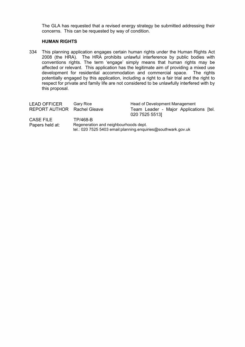
The GLA has requested that a revised energy strategy be submitted addressing their concerns. This can be requested by way of condition.
334
HUMAN RIGHTS This planning application engages certain human rights under the Human Rights Act 2008 (the HRA). The HRA prohibits unlawful interference by public bodies with conventions rights. The term ‘engage’ simply means that human rights may be affected or relevant. This application has the legitimate aim of providing a mixed use development for residential accommodation and commercial space. The rights potentially engaged by this application, including a right to a fair trial and the right to respect for private and family life are not considered to be unlawfully interfered with by this proposal.
LEAD OFFICER Gary Rice Head of Development Management REPORT AUTHOR Rachel Gleave Team Leader - Major Applications [tel.
020 7525 5513] CASE FILE TP/468-B Papers held at: Regeneration and neighbourhoods dept.
tel.: 020 7525 5403 email:[email protected]
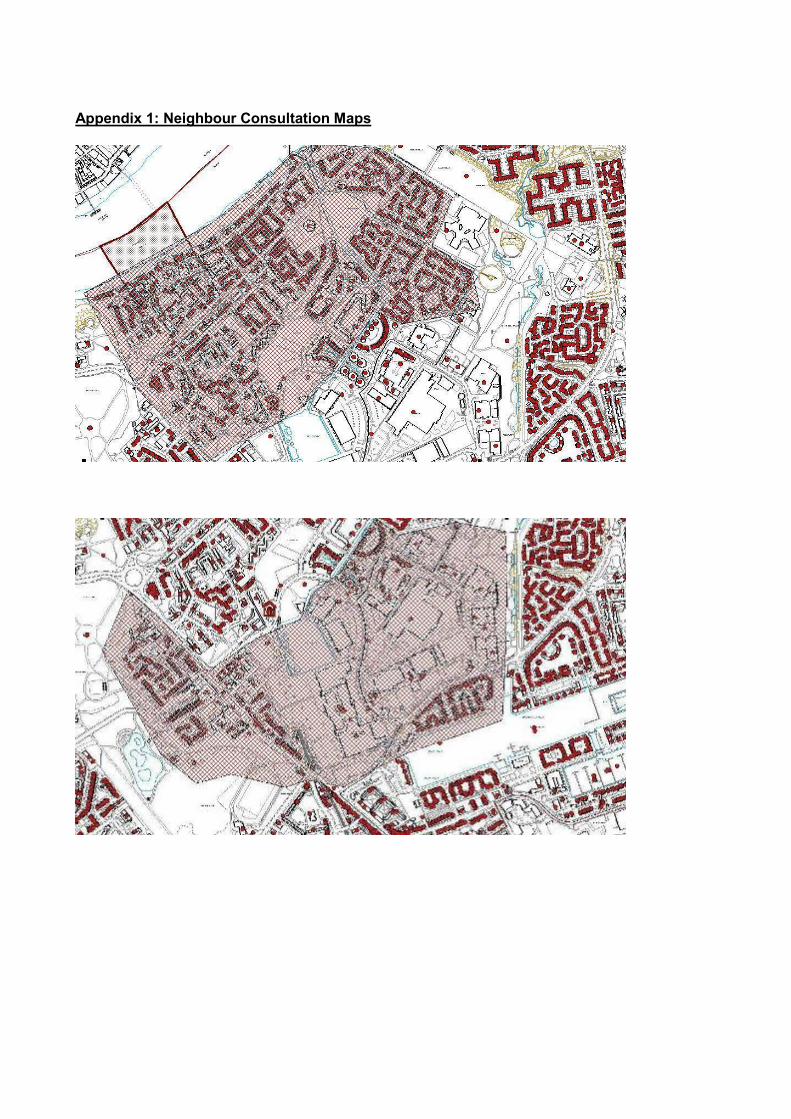
Appendix 1: Neighbour Consultation Maps