Embed Size (px)
Citation preview

! ! !!
Event Program

! ! Event!Locations!!
Event Locations

! ! Registration/Schedule!!
Event Registration Registration: opens on Saturday September 28th from 9:00 am at Canberra Grammar School. Follow signage to the registration room in the assembly area. On all other days, registration is available at the Information Tent in the assembly area.
Event Schedule
Saturday 28th September – Event 1, Australian Sprint Distance Championships
Silva National League Event, World Ranking Event
Canberra Grammar School, Monaro Cres, Red Hill.
Starts: elites from 11:00am, other classes from 12:30pm.
Sunday 29th September - Event 2, Australian Long Distance Championships
Silva National League Event, World Ranking Event
Slap Up Station, Jerangle
Starts from 9:30am.
Monday 30th September – Australian Schools Championships Opening Ceremony and Launch of the “capital O”
Canberra Girls Grammar School, Melbourne Avenue, Deakin
11.00am: Opening Ceremony and Launch; 12.00-12.30: capital O maps available
Tuesday 1st October – Event 3, Schools Individual Championships & Event 4, Wild Deer Chase
13km east of Bungendore
Starts: Schools Individual from 10:00am, Public Event from 2:00pm.
Wednesday 2nd October – Event 5, Schools Relay Championships & Event 6, Macca’s Maze
13km east of Bungendore
Schools Relay from 10:00am, Public Event wave starts from 1:30pm.
Friday 4th October – Event 7, Centenary of Canberra Flashback
Antill St, Watson
Starts from 10:30am.
Saturday 5th October – Event 8, Australian Middle Distance Championships
3 km east of Bungendore
Starts from 10:00am.
Sunday 6th October – Event 9, Australian Relay Championships
3km east of Bungendore
Mass start from 9:30am.

! ! Technical!!&!General!Information!!
Technical & General Information
Applicable Rules and Guidelines: Current editions of Competition Rules for IOF Foot Orienteering Events, Guidelines for World Ranking Events, Orienteering Australia Competition Rules, National Orienteering League Guidelines, School Sport Australia Orienteering Championships Rules and Guidelines.
Start Procedures: It is the competitor’s responsibility to be on time at the start. You will be called to the pre-start 3 minutes before your start time. The start layout is illustrated in the diagram below:
Clear and Check
before entering
Box 1
Manual bib check
Box 2
Control descriptions
SI unit check
Box 3
Start box
Clock 1
Race time + 3 mins
Clock 2
Race time
a) Competitors are to Clear and Check their SI card before entering Box 1 at three minutes before their Start time.
b) On entering Box 1, an official checks each competitor’s chest number/name. The clock will show their start time, but it will actually be three minutes ahead of their Start time.
c) On entering Box 2, competitors collect their control descriptions. An official uses a SI unit to check that a competitor’s SI card has been cleared.
d) On entering Box 3, competitors must go to the map box labelled with the correct course. They write their name on the back of the top map in their map box.
e) At the final beep on the start clock competitors pick up their map and start.
Late Starts: Competitors who are late for their allocated start must report to the Late Start official and start when advised to. They will be regarded as having started at their official start time, unless the organisers are at fault. This should not be discussed with start officials but with the designated Finish official after they have completed their race; see the paragraph regarding Mispunches.
Start Times for Officials. All competitors have been assigned an official Start Time for each event, but some competitors who will be event officials will be permitted to start at an alternative time to suit the needs of their official duties. This will generally be before or after the other competitors.
Competitor Chest Numbers: All competitors will be issued with a chest number. This must be worn in Events 1, 2, 4, 7, 8 and 9. There will be different numbers for the relay events. If a chest number is lost or damaged please obtain a replacement from the Information Tent.

! ! Technical!!&!General!Information!!Control Descriptions: The relevant descriptions will be printed on maps, and will also be available loose in the start lanes as part of the start procedure (except for relays).
Maps: Maps for all courses will be printed on waterproof, tear-resistant material. Maps will not be bagged.
Punching System: SportIdent will be used for all events. It is the competitor’s responsibility to clear their SI card prior to competition, and failure to do so will result in disqualification if the SI card fills prior to the completion of the course. Competitors who do not use the SI card indicated in the start program may be disqualified.
SI box failure: If an SI box fails, record your passage through the control by punching in the reserve boxes on the map using the back-up punch on the control stand.
Downloading results: It is essential that you report to the Finish tent and download your result, even if you have not completed your course, as this is the means by which the organisers check you have returned safely. If you lose your SI card on the course, and hence cannot download, please proceed through the Finish chute and report to the Finish officials; see next paragraph. You will be asked to download twice: firstly for your splits (see next paragraph for mispunches) and secondly for your results label. Please attach your results label to a tile and hang your result on the results stand.
Mispunch/Lost SI card/Late Starts: If your download indicates a mispunch or other error, before you move to the second download, you will be asked to discuss your result with a designated Finish official who will investigate the matter before you download a second time. If there is a need to make a correction that correction will be made to both relevant computers. Irrespective of the outcome, you will be asked to download into the second computer for your results label. If you lose your SI card on the course, or started late, a designated Finish official will investigate your result.
Map Return: Maps of early finishers will be collected, and then returned (sorted into boxes by course number) as soon as possible after the last start time.
Complaints and Protests: Complaints and protests will be handled in accordance with Orienteering Australia Competition Rules sections 27 and 28, and if necessary a Jury will be appointed in accordance with section 29 from available Level 3 controllers. Complaints must be lodged at the Information Tent no later than one hour after the scheduled course closure for an event. Protests against the organiser’s decision about a complaint should be lodged in writing with an official at the Information Tent and clearly marked “Protest” as soon as possible after the organiser’s decision about the complaint.
Shadowing Children: Shadowing is only permitted for entrants in the M/W10 Novice classes. These children will not be allocated start times and may start at any time during the overall start window when convenient for their shadowers. Note that parents/guardians must have completed their own course before shadowing.
Photography during the carnival: There will be photographers during the carnival taking photographs and TV footage for promotion of orienteering and possible publication in the

! ! Technical!!&!General!Information!!Australian Orienteer, national, state and club websites and newsletters, and local media. Orienteering Australia will only use appropriate images of a child or groups of children, relevant to our sport and ensure that the child is suitably clothed in a manner that promotes the sport, displays its successes, etc.
There are some circumstances where publication of a named image of a child may place that child in danger. Orienteering Australia and its clubs and associations seeks the assistance of parents and guardians in being advised if they do not want images of their children taken or published.
Enter-on-the-Day: Available at the Information Tent at the following events:
Long Distance Championships: EOD registrations will close at 10.30 am and the EOD competitors will be allocated a Start time by registration officials. The entry fees will be Senior $30, Junior $20, and Sub-junior $15.
Centenary of Canberra Flashback: EOD registrations will close at 12.00 pm and EOD competitors will follow the same start procedures as pre-entered competitors. The entry fees will be Senior $17, Junior $11, and Sub-junior $6. Middle Distance Championships: EOD registrations will close at 10.30 am and the EOD competitors will be allocated a Start time by registration officials. The entry fees will be Senior $30, Junior $20, and Sub-junior $15. Daylight Saving: All competitors need to be aware that daylight saving commences on Sunday 6 October 2013 at 2:00 am, when clocks are put forward one hour.
Please note that Orienteering ACT follows a NO DOGS policy at all events. Please do not bring dogs to any event.
! ! Event!1!–!Australian!Sprint!Distance!!Event 1 – Australian Sprint Championships
Saturday 28th September
Silva National League Event
World Ranking Event
Location: Canberra Grammar School
Map: Canberra Grammar School, 1:4000, 2.5m Contours
Mapper: Matthew Purcell
Organising Club: Parawanga Orienteers
Course Planner: Matthew Purcell
Controller & IOF Event Adviser: Blair Trewin
Day Organiser: Jill Walker
Landowners: Orienteering ACT gratefully acknowledges the considerable support of the Canberra Grammar School administration, staff and students in holding this event, providing access to the campus and assisting with event logistics.
World Ranking Event: This event is an IOF World Ranking Event and hence the World Ranking categories will be run under IOF Foot Orienteering Competition Rules. In particular, these competitors are not permitted to carry GPS devices with a display visible to the competitor. As the 17-20E and 35A classes will be run on the same courses as 21E and will qualify for World Ranking points, in this event, this applies to all competitors in M/W17-20E, 21E and 35A.
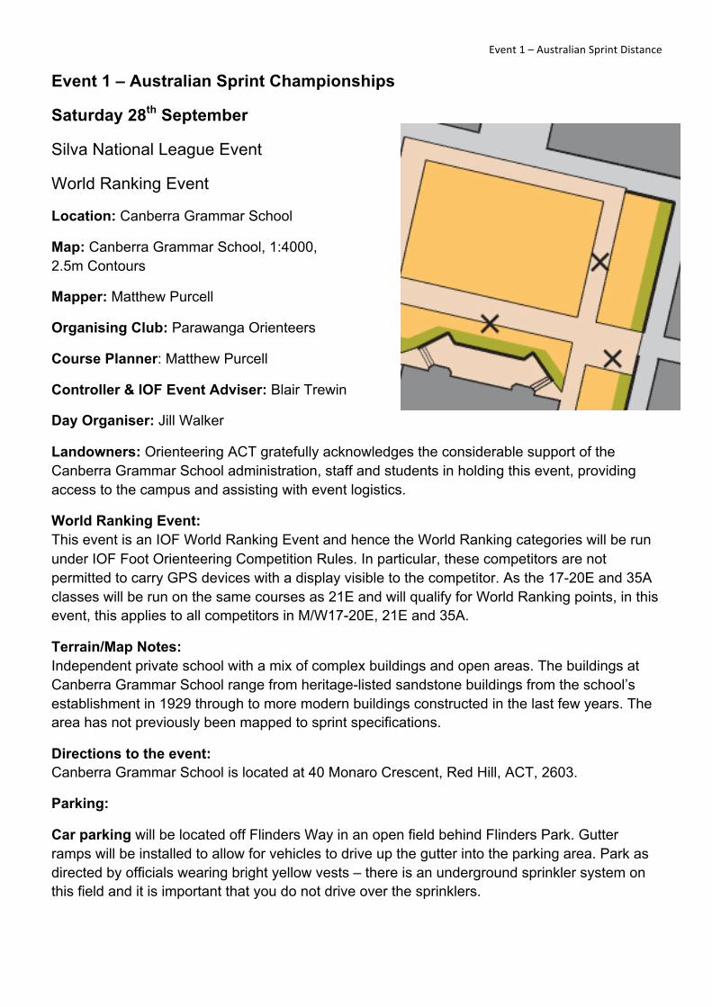
Terrain/Map Notes: Independent private school with a mix of complex buildings and open areas. The buildings at Canberra Grammar School range from heritage-listed sandstone buildings from the school’s establishment in 1929 through to more modern buildings constructed in the last few years. The area has not previously been mapped to sprint specifications.
Directions to the event: Canberra Grammar School is located at 40 Monaro Crescent, Red Hill, ACT, 2603.
Parking:
Car parking will be located off Flinders Way in an open field behind Flinders Park. Gutter ramps will be installed to allow for vehicles to drive up the gutter into the parking area. Park as directed by officials wearing bright yellow vests – there is an underground sprinkler system on this field and it is important that you do not drive over the sprinklers.

! ! Event!1!–!Australian!Sprint!Distance!!Bus parking will be located in the Canberra Grammar School main car park off Monaro Crescent. The main school driveway will have barriers to all vehicle traffic and will be manned to permit buses and official vehicles through to the parking area.
IMPORTANT: Please only park in the areas designated below. There are multiple car parks on the Canberra Grammar School campus, but to avoid transiting through the embargoed competition area you must NOT park anywhere else apart from the approved parking areas.
Assembly: From the car park there is a short walk across Flinders Park onto the CGS campus. Walk up the school driveway to the event arena in the main school quadrangle.
Catering: Canberra Grammar School will provide a BBQ sausage sizzle together with cold drinks for purchase. A coffee van will provide coffee/tea/hot chocolate etc and cakes/snacks.
First aid: St John Ambulance will be in attendance
Toilets: Toilets will be available in the event arena, along with portaloos at the start.
Spectator viewing: There will be a spectator control in the event arena allowing views of competitors on several courses, including the elite courses 1 and 2. The finish is also in the event arena.
Out of Bounds/ warm-up areas: The entire Canberra Grammar School campus is out of bounds. Please follow all directional signage from the car park to the event arena to avoid
CAR PARKING ENTRY
BUS/OFFICIAL PARKING ENTRY
CAR PARK
! ! Event!1!–!Australian!Sprint!Distance!!straying into the embargoed areas. You may warm-up along the main school driveway or outside the school boundary – there is no elite quarantine (but see comments below on access to the arena).
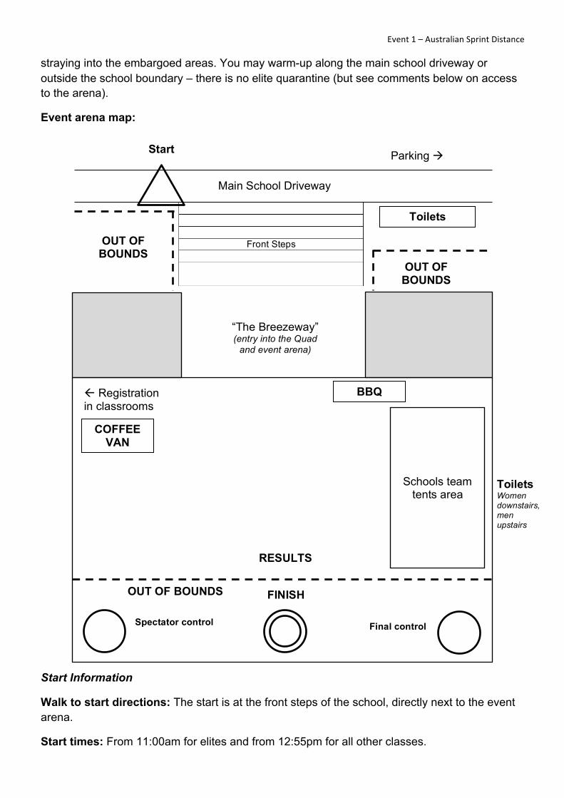
Event arena map:
Start Information
Walk to start directions: The start is at the front steps of the school, directly next to the event arena.
Start times: From 11:00am for elites and from 12:55pm for all other classes.
Main School Driveway
Parking ! Start
!!!!
Front Steps !!!!
OUT OF BOUNDS
Toilets
“The Breezeway” (entry into the Quad
and event arena)
" Registration in classrooms
Toilets Women downstairs, men upstairs
FINISH
Spectator control Final control
OUT OF BOUNDS
Schools team tents area
RESULTS
BBQ
COFFEE VAN
OUT OF BOUNDS

! ! Event!1!–!Australian!Sprint!Distance!!Safety information: Canberra Grammar School is bounded by roads on all five sides.
Elite quarantine: All M/W21E and 17-20E competitors must be out of the event arena by 11:00am. (As registration is in the arena, this means they will either have to register before 11 or get someone else to do it for them.) Elites are not permitted to re-enter the arena until they have completed their course.
Warm-up area: Competitors may warm-up along the school main driveway, which will be closed to vehicle traffic, or outside the school boundary.
Special notes:
• The event arena is in the main school quadrangle – please treat this area with respect given it is the central hub of the school. Future access to the grounds depends on this aspect.
• There is an underground sprinkler system in the quad. The sprinkler heads will be spray painted for ease of identification. If you intend to put up a shade tent or club banner then please make certain that you do not hammer anything into the ground where the sprinklers are located.
• Please observe all tapes indicating out of bounds areas.
• Canberra Grammar School is a non-smoking campus.
Course setter notes:
• Courses 1-4 and 7 have a map change. At the map change, discard your first map and collect another map from the box labelled for your course. Officials will be available to assist if required.
• Some controls with heavy traffic will have multiple Sportident units. All units are the same and you only need to punch one of the available units.
• A large portion on the eastern side of the campus is marked as out of bounds – this is part of a major new building construction. There is a narrow passage which allows competitors to pass through the works – this is clearly denoted on the map.
• Spikes are not to be worn – competitors may be running across some wooden flooring surfaces during the competition.
• The following items are not mapped (due to their frequency reducing legibility of the map): garbage bins, light poles, shade sails, railings along steps, and all log barriers which are not integral to parts of the map.
• Tanbark areas are mapped as paved.
• Astroturf is mapped as open land.
• Vegetable patches and vineyards are mapped as orchards (yellow background with green dots).
• Canberra Grammar School is a residential campus. Boarding students and staff live on-site. Under no circumstances are competitors to enter the residential areas of the campus. These areas are clearly denoted on the map with purple hatching.

! ! Event!1!–!Australian!Sprint!Distance!!• Some areas of the campus are multiple stories – only the main running level (the lower
level) has been mapped. The upper levels will be physically taped-off.
• Some of the passageways are quite narrow. Please be careful of other competitors who may be running in the opposite direction.
• Walls and fences which are mapped as uncrossable (heavy black line) are forbidden to cross even if it’s physically possible to do so. Additionally, olive green areas which refer to garden beds and private areas are also out of bounds. Any competitors seen crossing these areas will be disqualified. Some garden beds have also been taped-off to clarify that they are not to be crossed. Where garden beds are used as control locations, the description ‘thicket’ is used.
• Man-made features such as tables, seats, and signs are denoted with an X symbol on the map.
• Competitors should be familiar with the following special symbols used on the control descriptions:
Radio control (time check)
Monument or statue
Building pass through
Stairway
!Thicket which is also used to denote garden beds in this event
Presentations: will be made to all placegetters when results are finalised. This is expected to be between 3.00 and 3.30pm.
Course Information:
Australian Sprint Distance Championships – Sunday 29th September Course Classes Distance*
(km) Controls Navigation
1 M21E, M20E, M35A 2.7 27 Hard 2 W21E, W20E, M20A, M21A, M40A, M45A,
M50A, W35A 2.4 24 Hard
3 M16A, M55A, W21A, W40A, W45A, 2.1 22 Hard 4 M60A, M65A, W16A, W20A, W50A, 2.0 22 Hard 5 M70A, M75A, W55A, W60A, W65A, W70A, 1.5 18 Hard 6 M80A, M85A, W75A, W80A, W85A, 1.2 16 Hard 7 M14A, MJuniorB, MOpenB, W14A, WJuniorB,
WOpenB, 2.0 26 Moderate
8 M12A, W12A 1.5 20 Easy 9 M10, W10 1.2 21 Very Easy
* Please note that distances are straight-line and the running distance will be longer on all courses. W16 and W55 are on different courses to those originally advertised on the website.

! ! Event!2!–!Australian!Long!Distance!!Event 2 – Australian Long Distance Championships
Sunday 29th September
Silva National League Event
World Ranking Event
Location: Jerangle
Map: “Slap Up Creek”, 2013
1:15000 with 5m contours for Courses 1 and 2
1:10000 with 5m contours for all other courses
Mapper: Alex Tarr
Organising Club: Bushflyers
Course Planner: Ross Stewart
Controller & IOF Event Adviser: Andy Hogg
Day Organiser: Jenny Hawkins
Landowners: OACT gratefully acknowledges landowners Lisa Phillips & Dick Walker, Charles Lezaros, Warren Ashley and Geoff Evans.
World Ranking Event:
This event is an IOF World Ranking Event and hence the M21E and W21E categories will be run under IOF Foot Orienteering Competition Rules.
Terrain Notes:
The area is a granite plateau between 1200m and 1300m elevation. There are sections of lightly timbered farmland as well as forested areas. The farmland is very runnable though steep in parts. The forest is almost flat with pleasant running through numerous granite boulders, knolls, minor streams and gullies.
Setter’s Notes:
The courses have been designed to use all the terrain types on the map – including the flatter complex granite in forested areas and steeper open granite terrain.
Fence crossings marked on the map are for the convenience of competitors; they are not compulsory.
Please report any damage to fences to the organiser after finishing your course.
Maps:
Maps for courses 1 and 2 will be printed using an offset process.
! ! Event!2!–!Australian!Long!Distance!!Directions to the event:
From central Canberra either
i. Take the Kings Highway to just beyond Queanbeyan and turn right onto Captains Flat Road. Travel approximately 40 km to Captains Flat. When entering the town turn right into Foxlow Street which turns into Jerangle Road. Travel approximately 32 km (there is some bitumen but mostly gravel) and turn left into Slap Up Road.
NOTE: The bridge at Captains Flat has recently been repaired and is subject to a 5 tonne limit.
ii. Travel south along the Monaro Highway towards Cooma for approximately 80 km to the village of Bredbo. Turn left at the end of the village onto Braidwood Street and after 300m bear right onto Jerangle Road. Travel approximately 34 km (there is some bitumen but mostly gravel) and turn right onto Slap Up Road. (You will pass through the village of Jerangle 3.7 km before this turn).
Travel 8.2 km along Slap Up Road. This is a narrow, unfenced, gravel road and some portions are in poor condition, there are narrow cattle grids and gutters across the road. Please drive to the conditions and take particular care if encountering stock on the road.
Allow two hours minimum for travel from central Canberra.
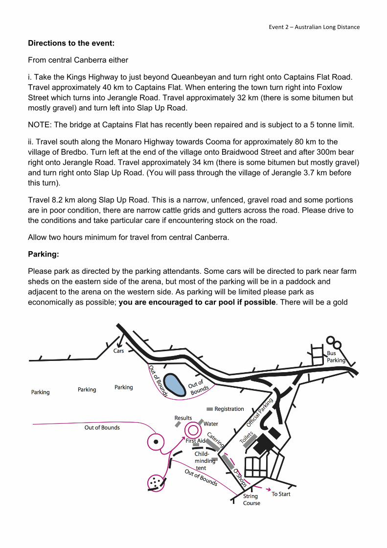
Parking:
Please park as directed by the parking attendants. Some cars will be directed to park near farm sheds on the eastern side of the arena, but most of the parking will be in a paddock and adjacent to the arena on the western side. As parking will be limited please park as economically as possible; you are encouraged to car pool if possible. There will be a gold
! ! Event!2!–!Australian!Long!Distance!!coin collection for parking to contribute to the landowner’s upkeep of the access road.
Buses will be directed to a special parking area just beyond the general car parking areas.
Assembly:
The arena is approximately 150m from parking. Being mostly cleared, this area is somewhat exposed so if the weather is very cold and windy you should bring adequate warm, windproof clothing. Club tents can be erected in an area close to the last control or on a slope slightly further away, overlooking the arena.
Out of Bounds:
Areas to the south and west of the walk from the parking paddock to the arena are out of bounds.
There are sheep pens near where the toilets are located and where some cars will be parked. All farm equipment in this area and the pens are out of bounds. Please ensure that your children are kept away from any equipment in this area.
There is a dam to the north west of the arena on the way to the main parking area. This will be taped off but please ensure that your children keep well away. The dam area is out of bounds also.
There are sheep with lambs on the property. Areas of the map marked as out of bounds must be strictly observed. Competitors seen in out of bounds areas will be disqualified.
Warm-up & Competition Areas:
Competitors are permitted to warm-up between the arena & the paddock car park as well as on the way to the start.
All forested areas (i.e. not open paddocks) should be considered out of bounds. Warming up along the road is not permitted.
Catering:
Catering will be provided by the Jerangle School P&C committee. They will be selling soup, steak sandwiches, sausages, veggie burgers and wraps with tandoori chicken, beef or roast vegetables. They will also be serving cakes and there will be tea and cold drinks.
A coffee van will also be in attendance.
Activities for children:
A tent for child-minding purposes will be provided at the arena. It is the responsibility of parents to supervise their children whilst using this area.
A string course for small people will be provided near the commencement of the walk to the start. Participants should register at the start of the course.
First aid: St John Ambulance will be in attendance.

! ! Event!2!–!Australian!Long!Distance!!Toilets: will be located to the east of the arena, close to the beginning of the walk to the start.
Walk to start:
The walk to the start is approx 800m, a gentle uphill walk across open paddocks. Allow fifteen minutes.
There will be an area where warming up is allowed at the start area. The southern side of the walk to the start is strictly out of bounds.
Start times: from 9:30am
Course closure:
Courses will close at 2.30 pm. All competitors who have not completed their courses by this time should abandon their course and report to the finish as soon as possible.
All competitors who do not complete their courses for any reason should report to the finish officials so that their safe return is recorded.
Safety information:
For all courses the safety bearing is north to farmland areas, or Slap Up Road.
Because of the remote nature and elevation of this area all competitors are reminded of the need to go to the aid of anyone in difficulty during the event. All competitors are required to carry a whistle.
Competitors are also reminded that if the weather is inclement they should wear protective clothing that provides sufficient warmth for the conditions. In particular, they should wear full body cover.
There are plenty of tiger snakes in the area. Hopefully at the end of September these will not be too active but take care.
Clothing return:
A clothing return from the start will be offered and will return clothing to the assembly area at approximately one hour intervals. Please place clothing in the bags provided.
Water:
Water will be provided at the start and at the finish. To assist the organising team it would be helpful if you could bring your own drinking water.
Water will be available on courses at individual control sites as indicated in control descriptions.
Enter on Day:
Courses 9, 14, 15 and 16 will be available to enter on the day.
! ! Event!2!–!Australian!Long!Distance!!Presentations:
The presentation of awards will be made as soon as the placegetters are finalised, probably around 1.30pm, and will include the following trophies:
• The Howden Trophies to the Resident winners of the M21E and W21E classes.
• The Silva Trophy and the Swedish Ambassador’s Trophy, respectively, to the winning Senior Elite teams (M21E and W21E) in the Australian Long Distance Championship.
• The OA Shield to the State with the best performing team in all age classes in the Australian Long Distance Championships, ascertained in accordance with Clause 25.7 of the Competition Rules for Orienteering Australia Foot Orienteering Events.
Certificates shall be awarded to Resident Individual Champions in Australian Championships classes where the winner is a non-resident according to Clause 6.3 of the Competition Rules for Orienteering Australia Foot Orienteering Events. The Resident Individual Champion certificates shall be prepared by Orienteering Australia in accordance with Clause 25.4 of the Competition Rules for Orienteering Australia Foot Orienteering Events.
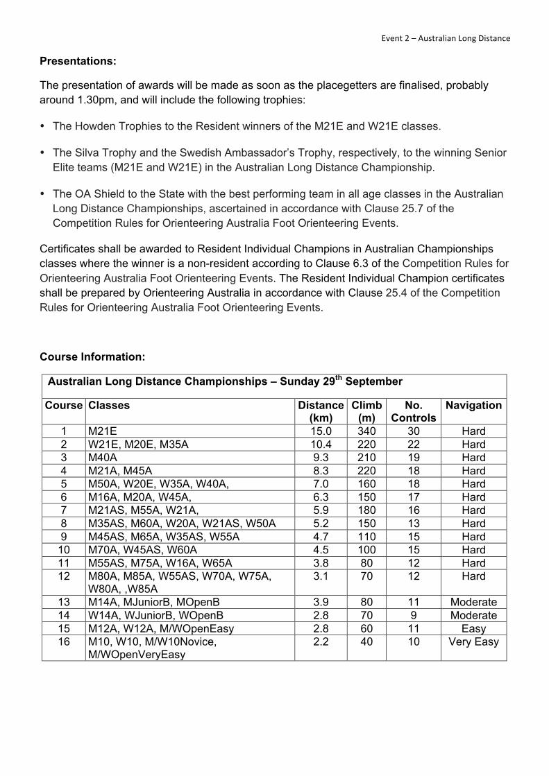
Course Information:
Australian Long Distance Championships – Sunday 29th September
Course Classes Distance (km)
Climb (m)
No. Controls
Navigation
1 M21E 15.0 340 30 Hard 2 W21E, M20E, M35A 10.4 220 22 Hard 3 M40A 9.3 210 19 Hard 4 M21A, M45A 8.3 220 18 Hard 5 M50A, W20E, W35A, W40A, 7.0 160 18 Hard 6 M16A, M20A, W45A, 6.3 150 17 Hard 7 M21AS, M55A, W21A, 5.9 180 16 Hard 8 M35AS, M60A, W20A, W21AS, W50A 5.2 150 13 Hard 9 M45AS, M65A, W35AS, W55A 4.7 110 15 Hard
10 M70A, W45AS, W60A 4.5 100 15 Hard 11 M55AS, M75A, W16A, W65A 3.8 80 12 Hard 12 M80A, M85A, W55AS, W70A, W75A,
W80A, ,W85A 3.1 70 12 Hard
13 M14A, MJuniorB, MOpenB 3.9 80 11 Moderate 14 W14A, WJuniorB, WOpenB 2.8 70 9 Moderate 15 M12A, W12A, M/WOpenEasy 2.8 60 11 Easy 16 M10, W10, M/W10Novice,
M/WOpenVeryEasy 2.2 40 10 Very Easy

Capital!O!Launch! ! Events!3!&!4!–!Schools!Individual!and!Wild!Deer!Chase!!Schools Championships Opening Ceremony and capital O Launch
Monday 30th September
The opening ceremony for the Australian Schools Orienteering Championships, also incorporating the launch of the capital O, will be held from 11.00 am to 12.00 pm in the Auditorium at Canberra Girls Grammar School, Melbourne Avenue, Deakin.
capital O is an orienteering activity associated with the 2013 Australian Championships Carnival and is proudly supported by the ACT Government Community Centenary Initiatives Fund. You are invited to take a photo and map tour of Canberra’s parliamentary triangle. You will be given a detailed map of the Parliamentary triangle and surrounding area; the map will have a series of checkpoints, with the corresponding number of photos, each with a unique code. The goal is to visit each checkpoint, and match the location with the corresponding photo. You may start wherever you like and, with no time limit, you can take as long as you like to enjoy the sights.
Maps will be available to the public from 12.00 – 12.30 pm, directly after the launch of capital O. They will also be available at the Information Tent from Tuesday, for the duration of the carnival.
Event 3 – Australian Schools Individual Championships
Event 4 – Public Event – Wild Deer Chase
Tuesday 1st October
Location: near Bungendore
Map: previous maps covering the area - Timber Tops, Wild Deer Sands, The Sandhills / Birkenburn. Map Scale 1:10,000, Contour interval 5m
Course Planner: Grant McDonald
Controller: Phoebe Dent
Day Organiser: Heather McDonald
Supporting Club: Red Roos
Landowners: We are grateful to the landowners, Tom Gordon ‘Wild Deer Sands‘ and Ennio Morello ‘Timber Tops’, for the use of this area for these events.
Terrain Notes: The majority of the terrain is open spur gully forest with areas of open and semi-open land. The main point features are scattered termite mounds and log piles. The area is gently undulating or moderately steep. There are two other terrain types in the area. The first is

! ! Events!3!&!4!–!Schools!Individual!and!Wild!Deer!Chase!!more detailed with many small knolls, with thicker vegetation that is slower running and has lower visibility and small clearings. It is an old sand mining area but not with complex contour detail. The second is a steeper area of spur gully with large areas of rocky/stony ground and occasional small boulders as point features. There is only one road through the area but there are a few smaller tracks ranging from well formed to indistinct. The fences tend to bound the area with only a few sub-dividing the area. There are cows grazing in the forest and you might come across them while competing.
Directions to the event: Travel east from Canberra to Bungendore. Follow the Kings Highway towards Braidwood for approximately 13 km. Turn left and enter ‘Timber Tops’ property and follow farm road to parking. Allow 50 minutes travel from the centre of Canberra.
Safety information for leaving the event: On departure, it is not safe to turn right towards Canberra as traffic is travelling at highway speed in both directions and there is an overtaking lane coming from the west below the crest of the hill. It is strongly recommended that you turn left onto the highway, travelling a short distance further east along the King's Highway until you are able to execute a safe U-turn.
Parking: as directed in the paddocks beside the farm road.
Assembly: approximately 250m from parking
Catering: ‘Here’s the Coffee’ will provide tea, coffee, cakes, muffins and egg & bacon rolls

! ! Events!3!&!4!–!Schools!Individual!and!Wild!Deer!Chase!!
First aid: St John Ambulance will be in attendance.
Toilets: Port-a-loos adjacent to parking.
Out of Bounds/ warm-up areas: All forested areas are out of bounds. Warm-up will be available on the walk to the start, and immediately adjacent to the start. All farmland on the way to the start is out of bounds.
Walk to start directions: There is one start for all courses located 1.7km from the parking area, or 2.0km from the assembly area. From the parking area head north on the well-formed dirt road and follow signs/streamers to the start.
Start times: (Schools Individual) from 10:00am, (Public Event) from 2:00pm
Course closure: (Schools Individual) at 1:30pm, (Public Event) at 4:30pm
Water: will be available at the start, on the courses and at the finish.
Enter on Day: none
Presentations: Presentations for the Schools competitors will be held at the Australian Schools Orienteering Championships presentation dinner. The dinner is attended by only the team members and officials. Thank you to Orienteering Service of Australia (www.osoa.com.au) for their donation of prizes.
Course Information:
ASOC Individual & Wild Deer Chase – Tuesday 1st October
Course Classes Distance (km)
Climb (m)
No. Controls
Navigation
1 Senior Boys 7.6 190 27 Hard 2 Senior Girls 5.4 105 22 Hard 3 Junior Boys 5.3 105 21 Moderate 4 Junior Girls 4.4 80 17 Moderate
1 Hard1-Men, Hard1-Women 7.6 190 27 Hard 2 Hard2-Men, Hard2-Women 5.4 105 22 Hard 5 Hard3-Men, Hard2-Women 4.6 70 18 Hard 3 Mod1-Men, Mod1-Women 5.3 105 21 Moderate 4 Mod2-Men, Mod2-Women 4.4 80 17 Moderate 6 Easy-Men, Easy-Women 3.7 60 20 Easy 7 VeryEasy-Men, VeryEasy-Women 2.5 40 13 Very Easy

! ! Events!5!&!6!–!Schools!Relay!and!Macca’s!Maze!!Event 5 – Australian Schools Relay Championships
Event 6 – Public Event – Macca’s Maze
Wednesday 2nd October
Location: near Bungendore
Map: previous maps covering the area - Timber Tops. Map Scale 1:10,000, Contour interval 5m
Course Planner: Grant McDonald
Controller: Phoebe Dent
Day Organiser: Heather McDonald
Supporting Club: Bushflyers
Landowner: We are grateful to the landowner, Ennio Morello ‘Timber Tops’, for the use of this area for these events.
Terrain Notes: The majority of the terrain is open spur gully forest with areas of open and semi-open land. The main point features are scattered termite mounds and log piles. The area is gently undulating or moderately steep. There is only one road through the area but there are numerous smaller tracks, ranging from well formed to indistinct. The fences bound the area. There are cows grazing in the forest and you might come across them while competing.
Directions to the event: Travel east from Canberra to Bungendore. Follow the Kings Highway towards Braidwood for approximately 13 km. Turn left and enter ‘Timber Tops’ property and follow farm road to parking. Allow 50 minutes travel from the centre of Canberra.
Safety information for leaving the event: On departure, it is not safe to turn right towards Canberra as traffic is travelling at highway speed in both directions and there is an overtaking lane coming from the west below the crest of the hill. It is strongly recommended that you turn left onto the highway, travelling a short distance further east along the King's Highway until you are able to execute a safe U-turn.
Parking: as directed in the paddocks beside the farm road
Assembly: approximately 250m from parking
Catering: ‘Here’s the Coffee’ will provide tea, coffee, cakes, muffins, egg & bacon rolls
First aid: St John Ambulance will be in attendance.
Toilets: Port-a-loos adjacent to parking.

! ! Events!5!&!6!–!Schools!Relay!and!Macca’s!Maze!!Spectator viewing: !Competitors in the Schools Relay will be visible from the arena at various stages of their courses. There is a common spectator control for all courses to the east of the arena, plus competitors will pass through a taped route on the southern edge of the arena before a final loop, which is approximately 700m in length. This is the only warning that second and third leg runners will have of their previous leg runner.
Out of Bounds/ warm-up areas: All forested areas are out of bounds. Limited warm up will be available in the arena or on the walk from the parking.
Walk to start directions: The Start is in the arena.
Start times: (Schools Relay) Briefing for all competitors at 9:45am, mass start for first leg runners at 10:00am, second mass start for all remaining runners at 12:00 noon, (Public Event) wave starts from 1:30pm (see below)
Course closure: (Schools Relay) at 1:30pm, (Public Event) at 4:00pm
Special information: The format of the public event is a 'One Person - One Leg Relay' with a number of mass starts of small groups. Looping will be used on hard and moderate courses to split runners. Competitors will be called up 4 minutes before their nominated start time.
Water: will be available on the courses and at the finish.
Enter on Day: none

! ! Events!5!&!6!–!Schools!Relay!and!Macca’s!Maze!!Course Information:
ASOC Relays & Macca’s Maze – Wednesday 2nd October
Course Classes Distance (km)
Climb (m)
No. Controls
Navigation
1 Senior Boys 5.4 135 22 Hard 2 Senior Girls 4.3 100 18 Hard 3 Junior Boys 4.5 90 19 Moderate 4 Junior Girls 3.4 65 15 Moderate ! ! ! ! ! !
5 Hard1-Men, Hard1-Women 5.4 130 20 Hard 6 Hard2-Men, Hard2-Women 4.2 95 17 Hard 7 Hard3-Men, Hard2-Women 3.6 65 16 Hard 8 Mod1-Men, Mod1-Women 4.6 95 19 Moderate 9 Mod2-Men, Mod2-Women 3.5 65 16 Moderate
10 Easy-Men, Easy-Women 2.9 70 14 Easy 11 VeryEasy-Men, VeryEasy-Women 2.2 40 14 Very Easy

! ! Event!7!–!Flashback!!Event 7 – Centenary of Canberra Flashback
Friday 4th October
The Centenary of Canberra Flashback is intended to give orienteers an experience of what orienteering was like in Canberra when it was first introduced here on a regular basis in 1971. The map is the one that was used for the second event, which was held in August 1971, with a few basic updates in the interests of fairness to show selected major features that have been constructed since that time. All courses using that map are regarded as ‘hard’, particularly in terms of navigation. For those who prefer something less challenging, conventional moderate, easy and very easy courses will be available using a current map.
1971 2013
Location: Mt Majura
Map:
Ainslie – Majura Range, 1:25,000, 25 foot contours, black and white, oriented to true north – hard courses. (While there are no magnetic north lines shown on the map, competitors are permitted to add these by hand before they start, if they wish. The magnetic declination is approximately 13 degrees east.)
Hackett Hill, 1:10,000, 5m contours, coloured – moderate, easy and very easy courses
Mapper: Ainslie – Majura Range: David Hogg (1971) with limited updating to show selected new major features, although many features remain unmapped.
Hackett Hill: Existing OACT map prepared by various mappers with selective updating, September 2013.
Organising Club: Parawanga Orienteers
Course Planner: David Hogg

! ! Event!7!–!Flashback!!Controller: Rob Jessop
Day Organiser: Ann Ingwersen
Terrain/Map Notes: Spur–gully eucalypt woodland and forest, generally open with some dense patches, pine forest with thinnings on the ground on Hard 1 course, steep in places.
Directions to the event: From Central Canberra, travel along Antill Street to the edge of Hackett and turn left through a bus turnaround into the parking area.
From the Federal Highway, turn south along Antill Street at the roundabout, travel about 1.7 km then turn right through a bus turnaround into the parking area.
From the back of the Carotel, it is about 900 metres walk to the parking area entrance.
If arriving by bicycle or on foot from the south, you can reach the assembly area from the gate on Rivett Street opposite Hackett Reservoir.
Parking: Park as directed in the open area beside powerlines west of Antill Street. Please do not park in residential streets in Hackett or in the public car park at the entrance to Mount Majura Nature Reserve.
Assembly: Near Hackett Reservoir. From the parking area, cross Antill Street to enter the Mount Majura Nature Reserve and follow signs for about 600 metres to the assembly area.
Assembly: Approx. 500m walk from parking.
Catering: Blue Lightning will be selling cakes and cold drinks and there may be a coffee van.
First aid: St John Ambulance will be in attendance.
Toilets: Portaloos will be provided.

! ! Event!7!–!Flashback!!Start directions: At assembly area.
Start times:!Competitors can start anytime between 10.30am and 1pm. The normal start arrangements for the carnival will not be used. The start official will ensure that starts with the same first control are at least 1 minute apart. Maps and control description lists/control cards will be available at the registration tent prior to starting. Competitors using the black and white maps are on trust not to gain extra information from the coloured maps used for the conventional courses.
Course closure: 3 pm
Out of bounds areas: The local parkcare group (Friends of Mount Majura) has been undertaking native revegetation plantings in areas close to the assembly area and in fenced areas around two wildlife dams on the course. Do not enter these areas, which will be marked as out of bounds on the coloured maps. Competitors on the Hard 1 course must keep clear of a large obvious construction area on the eastern edge of the map. Courses have been set to avoid logical route choices through these out of bounds areas.
Safety information: Walk west to Antill Street or the edge of the suburbs.
Water: On longer courses and at the finish.
Enter on Day: Hard, moderate, easy and very easy courses will be available. Register at the Information Tent.
Course Information:
Centenary of Canberra Flashback – Friday 4th October
Course Classes Distance (km)
Climb (m)
No. Controls
Navigation
1 Hard1-Men, Hard1-Women 6.7 260 10 Hard 2 Hard2-Men, Hard2-Women 4.6 195 9 Hard 3 Hard3-Men, Hard3-Women 3.3 70 7 Hard 4 Moderate1-Men, Moderate1-Women 4.9 190 11 Moderate 5 Moderate2-Men, Moderate2-Women 3.2 105 8 Moderate 6 Easy-Men, Easy-Women 3.3 85 10 Easy 7 VeryEasy-Men, VeryEasy-Women 2.3 35 10 Very Easy
Other Flashback information:
Other features of the Flashback courses (Courses 1 to 3) that are in keeping with 1971 practice are as follows:
• The control markers will be red and white plastic buckets (see picture on the back cover of this program) with coloured pencils attached. Competitors use a pencil (different colours for each bucket) to copy the letter written on the bucket onto their control description sheets. A sample marker will be displayed at the assembly area.

! ! Event!7!–!Flashback!!• Control descriptions will be in English only. If a control feature is described as ‘The .......’,
it is visible on the map. If a control feature is described as ‘A .......’, it is not, but may be inferred from the contours (e.g. a knoll or saddle on a broad ridge). There is no code number to confirm that you are at the correct control, but controls will be well separated (at least 300m apart).
Features which will differ from the 1971 event include the following:
• SportIdent timing will be used on all courses, but only at the start and finish.
• Courses will be preprinted on the maps, i.e. you won’t have to spend five minutes before you start, copying controls from a master map.
• Water will be provided on the longer courses.
The conventional courses (moderate, easy, very easy) will use conventional cloth markers with hanging punches. There are no common controls between the Flashback courses and the conventional courses, but some controls for the different types of courses may be quite close to each other. You should ignore any control markers that are of the wrong type for your course.

! ! Event!8!–!Australian!Middle!Distance!!Event 8 – Australian Middle Distance Championships
Saturday 5th October
Silva National League Event
Location: Bungendore
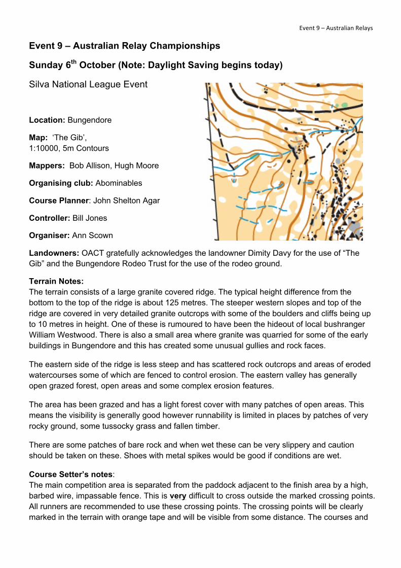
Map: ‘The Gib’, 1:10000, 5m Contours
Mappers: Bob Allison, Hugh Moore
Organising club: Red Roos
Course Planners: Robert Walter & Allison Jones
Controller: Bob Allison
Organiser: Mace Neve
Landowners: OACT gratefully acknowledges the landowner Dimity Davy for the use of “The Gib” and the Bungendore Rodeo Trust for the use of the rodeo ground.
Terrain Notes: The terrain consists of a large granite covered ridge. The typical height difference from the bottom to the top of the ridge is about 125 metres. The steeper western slopes and top of the ridge are covered in very detailed granite outcrops with some of the boulders and cliffs being up to 10 metres in height. One of these is rumoured to have been the hideout of local bushranger William Westwood. There is also a small area where granite was quarried for some of the early buildings in Bungendore and this has created some unusual gullies and rock faces.
The eastern side of the ridge is less steep and has scattered rock outcrops and areas of eroded watercourses some of which are fenced to control erosion.
The area has been grazed and has a light forest cover with many patches of open areas. This means the visibility is generally good, however runability is limited in places by patches of very rocky ground, some tussocky grass and fallen timber.
There are some patches of bare rock and when wet these can be very slippery and caution should be taken on these. Shoes with metal spikes would be good if conditions are wet.
Course Setter’s notes: The main competition area is separated from the paddock adjacent to the finish area by a high, barbed wire, impassable fence. This is very difficult to cross outside the marked crossing points. Courses 1-11 cross this fence at compulsory crossing points shown on the map with the line bent to pass through these points. All runners must use these crossing points and most people

! ! Event!8!–!Australian!Middle!Distance!!will not be able to cross this fence outside these. The crossing points will be clearly marked in the terrain with orange tape and will be visible from some distance.
Courses 12 and 13 go around this fence and do not need to use these crossing points.
Parts of the terrain used for the middle distance race will also be used for the Australian Relays the following day. You may notice pink tapes marking control sites for the relays, please disregard these.
Lastly there is a magnificent view from the top of the ridge north towards Lake George. It is worth taking a second whilst on your course to appreciate it!
Directions to the event: From Canberra, travel to Bungendore either via The Federal Highway and Macs Reef Road or via Queanbeyan and the Kings Highway.
Once in Bungendore travel east on the Kings Highway towards Braidwood.
3 km from Bungendore turn right into the rodeo ground. This turn is shortly after the end of the first overtaking lane and will be well signposted. Please take care making this right hand turn. Once inside the gate to the rodeo ground, follow the gravel road several hundred metres and park as directed.
Allow 45minutes from central Canberra.
Parking: Parking is adjacent to the assembly area. Please follow the directions given when parking.
Assembly: The assembly area is at the Bungendore rodeo ground and adjacent to the parking. The area can be extremely windy at times and although the rodeo ground offers some

! ! Event!8!–!Australian!Middle!Distance!!protection from the wind it is advisable to come prepared with warm clothes.
The finish area has a good view of the rocky ridgeline down which most courses finish and competitors will be visible at times. Binoculars would be useful for watching other competitors negotiate this part of the course, once you have finished your own course.
The rodeo ground is surrounded by a fence that marks out the assembly area. The yards to the east and the area outside the fence to the west and south are out of bounds.
Catering: Hartley Life Care and a coffee van will provide catering.
First aid: St John Ambulance will be in attendance.
Toilets: Portaloos will be provided at the arena.
Water: Water will be provided in the Assembly/Finish area and on the way to the Start, approximately 200m before both starts.
Courses 1 – 3 will have water provided on the course as these include elite classes with winning times greater than 30 minutes.
Start Information
Walk to start directions: There are two starts approximately 200m from each other.
Start 1: courses 1-11 follow red streamers 900m (85m climb) from the assembly area.
Start 2: courses 12-13 follow blue streamers 850m (40m climb) from the assembly area.
From the assembly area, use the crossing point across the finish chute to access the route to the start. Take care to watch for runners when crossing the finish chute!
For the first 700 m, both starts follow a common route marked with red and blue streamers, south from the assembly area.
After 700m the routes to the starts split. Water will be available at this splitting point.
From this point:
For Start 1 (courses 1-11) follow the red streamers a further 200m and 45m climb up the hill.
For Start 2 (courses 12 and 13) follow the blue streamers 150m along the fence.
Clear and check units will be located at each start.
Warming up is possible along the route to the start.
Start times: from 10:00 am

! ! Event!8!–!Australian!Middle!Distance!!Course closure: Courses will close at 3.00 pm. All competitors who have not completed their courses by this time should abandon their course and report to the finish as soon as possible. After this time, controls will be brought in to allow the relay controls to be put in place.
All competitors who do not complete their courses for any reason should report to the finish officials so that their safe return is recorded.
Safety information: North to the Highway then return to the Assembly area.
Enter-on-the-Day: There are 3 enter-on-the-day courses:
Course 5: Hard navigation, 3.0km, 125m climb
Course 10: Medium Navigation, 2.4km, 75m climb
Course 12: Easy navigation, 2.2km, 70m climb
Presentations: Will be made for championship classes as soon as results are finalised.
Course Information:
Australian Middle Distance Championships – Saturday 5th October
Course Classes Distance (km)
Climb (m)
No. Controls
Navigation
1 M21E, M20E 5.0 240 24 Hard 2 W21E, M21A, M35A 4.1 185 20 Hard 3 M20A, M40A, M45A, W21A, W20E, 3.4 155 18 Hard 4 M16A, M50A 3.2 140 17 Hard 5 M55A, W20A, W35A, W40A 3.0 125 16 Hard
6 M60A, W16A, W45A, 2.6 90 16 Hard 7 M65A, W50A, W55A 2.5 90 15 Hard 8 M70A, W60A, W65A 2.2 70 14 Hard 9 M75A, M80A, M85A, W70A, W75A,
W80A, W85A 1.6 50 11 Hard
10 M14A, MJuniorB, MOpenB 2.4 75 11 Moderate 11 W14A, WJuniorB, WOpenB 2.0 90 10 Moderate 12 M12A, W12A, M/WOpenEasy 2.2 70 12 Easy 13 M10, W10, M/W10Novice
M/WOpenVeryEasy 1.9 65 11 Very easy
Please note: Last official changes to teams for the Australian Relay Championship are due by 2:00pm on Saturday 5th October at the Australian Middle Distance Championships.
! ! Event!9!–!Australian!Relays!!Event 9 – Australian Relay Championships
Sunday 6th October (Note: Daylight Saving begins today)
Silva National League Event
Location: Bungendore
Map: ‘The Gib’, 1:10000, 5m Contours
Mappers: Bob Allison, Hugh Moore
Organising club: Abominables
Course Planner: John Shelton Agar
Controller: Bill Jones
Organiser: Ann Scown
Landowners: OACT gratefully acknowledges the landowner Dimity Davy for the use of “The Gib” and the Bungendore Rodeo Trust for the use of the rodeo ground.
Terrain Notes: The terrain consists of a large granite covered ridge. The typical height difference from the bottom to the top of the ridge is about 125 metres. The steeper western slopes and top of the ridge are covered in very detailed granite outcrops with some of the boulders and cliffs being up to 10 metres in height. One of these is rumoured to have been the hideout of local bushranger William Westwood. There is also a small area where granite was quarried for some of the early buildings in Bungendore and this has created some unusual gullies and rock faces.
The eastern side of the ridge is less steep and has scattered rock outcrops and areas of eroded watercourses some of which are fenced to control erosion. The eastern valley has generally open grazed forest, open areas and some complex erosion features.
The area has been grazed and has a light forest cover with many patches of open areas. This means the visibility is generally good however runnability is limited in places by patches of very rocky ground, some tussocky grass and fallen timber.
There are some patches of bare rock and when wet these can be very slippery and caution should be taken on these. Shoes with metal spikes would be good if conditions are wet.
Course Setter’s notes: The main competition area is separated from the paddock adjacent to the finish area by a high, barbed wire, impassable fence. This is very difficult to cross outside the marked crossing points. All runners are recommended to use these crossing points. The crossing points will be clearly marked in the terrain with orange tape and will be visible from some distance. The courses and

! ! Event!9!–!Australian!Relays!!crossing points have taken into account the difficult nature of the fence when being set and placed.
As with all relay courses there are numerous controls in the forest, competitors are urged to check they have found the correct controls.
Lastly there is a magnificent view from the top of the ridge north towards Lake George, south to Capitan’s Flat, east to Braidwood and west to Bungendore. It is worth taking a second whilst on your course to appreciate it!
Directions to the event: From Canberra travel to Bungendore either via The Federal Highway and Macs Reef Road or via Queanbeyan and the Kings Highway.
Once in Bungendore travel east on the Kings Highway towards Braidwood.
3 km from Bungendore turn right into the rodeo ground. This turn is shortly after the end of the first overtaking lane and will be well signposted. Please take care making this right hand turn. Once inside the gate to the rodeo ground follow the gravel road several hundred metres and park as directed. !
Allow 45 minutes from central Canberra.
Parking: Parking is adjacent to the assembly area. Please follow the directions given when parking.

! ! Event!9!–!Australian!Relays!!
Assembly: The assembly area is at the Bungendore rodeo ground and adjacent to the parking. The area can be extremely windy at times and although the rodeo ground offers some protection from the wind it is advisable to come prepared with warm clothes.
The finish area has a good view of the rocky ridgeline down which most courses finish and competitors will be visible at times. Binoculars would be useful for watching other competitors negotiate this part of the course, once you have finished your own course.
The rodeo ground is surrounded by a fence that marks out the assembly area. The yards to the east and the area outside the fence to the west and south are out of bounds.
Catering: Hartley Life Care and a coffee van will provide catering.
First aid: St John Ambulance will be in attendance
Toilets: Portaloos will be provided at the arena.
Event and Start Information
Last official changes to Australian Relay Championship teams must be made on Saturday 5th October by 2:00pm at the Australian Middle Distance Championships.
A number of blank maps from the previous day will be displayed until the Mass Start; these will be removed when the Australian Relay Championships race begins. No competitor is to bring a map from the Middle Distance Championships to the Australian Relay Championships arena. Any Middle Distance Championships maps not collected at that event will be distributed with collected Relay maps after the second Mass Start for the remaining second and third leg competitors.
Walk to start directions: The start will be located near the assembly area.
Start times: (Note: Daylight Saving begins today)
Relay briefing at 9:15am.
Mass start at 9:30am.
Mass start for all second and third leg runners at 11:00am.
Course closure: Courses close at 2:00pm.
Safety information: North to the Highway then return to the Assembly area.
Water: Water will be provided in the Assembly area and as required on courses.

! ! Event!9!–!Australian!Relays!!
Presentations: The presentation of awards will be made as soon as the placegetters are finalised, and will include the following trophies:
• Mementos to the winners of the 2013 National Orienteering Series: Senior Men’s, Senior Women’s, Junior Men’s and the Junior Women’s divisions.
• Trophies to the winning teams of the 2013 National Orienteering League: Senior Men’s, Senior Women’s, Junior Men’s and the Junior Women’s divisions.
• The Xanthorrhea Trophy to the State with the best performing team in all age classes in the Australian Relay Championships, ascertained in accordance with Clause 25.9 of the Competition Rules for Orienteering Australia Foot Orienteering Events.
Course information:
Australian Relay Championships — Sunday 6th October
Course Classes Distance (approx. km)
Climb (approx. m)
No. Controls (approx.)
Navigation
1 M21E 7.4 310 15 Hard 2 M20E, M35A 6.7 235 16 Hard 3 W21E, M45A 5.9 250 15 Hard 4 W20E, W35A 5.2 215 11 Hard 5 M21AS M55A, W45A, 4.9 190 12 Hard 6 W21AS, W55A, 3.9 160 11 Hard
7 M65A, W65A, MWMedium, M/W-LMS, 2.8 125 11 Hard
8 M16A, MOpenB 4.5 145 15 Moderate 9 W16A, M/W-LMS, WOpenB 3.7 120 14 Moderate
10 M/W-LMS, M/W12A 2.7 85 11 Easy

! ! Major!Sponsors!
! ! !
Auschamps 2013 – Orienteering in and around the national capital
Schools Relay – Macca’s Maze
Schools Individual – Wild Deer Chase
Long – Slap Up Creek
Sprint – Canberra Grammar School
Flashback – 1971 Style
Middle and Relay – The Gib