Embed Size (px)
Citation preview
Irwin Coastal Hazard Risk Management
and Adaptation Plan (CHRMAP)
Literature review
22nd
April 2015
Table of Contents 1. Introduction .................................................................................................................................... 5
1.1. Project Background ................................................................................................................ 5
1.2. Purpose of the Project............................................................................................................ 5
1.3. Objectives ............................................................................................................................... 6
2. Literature Review ........................................................................................................................... 6
2.1. State Government Policy and CHRMAP Guidelines Context ................................................ 6
2.2. CHRMAP Studies Available in the Literature ......................................................................... 7
2.3. Information on the Study Area .............................................................................................. 8
2.4. Literature on Data Availability ............................................................................................... 9
2.5. Literature on Modelling Methods ....................................................................................... 10
3. Study Area .................................................................................................................................... 10
3.1. Significance of the Study Area ............................................................................................. 12
3.2. Pressures and Stress in the Study Area ............................................................................... 13
4. Identification of Coastal Hazards ................................................................................................. 13
4.1. Freshwater Point .................................................................................................................. 14
4.2. Port Denison Foreshore ....................................................................................................... 14
4.3. Granny’s Beach ..................................................................................................................... 15
4.4. Granny’s/Surf Beach ............................................................................................................ 16
4.5. Seaspray Beach ..................................................................................................................... 16
4.6. Seven Mile Beach ................................................................................................................. 17
4.7. Recorded Anthropogenic Hazards in the Coastal Area ....................................................... 17
4.8. Irwin River and the Dongara-Port Denison Bridge .............................................................. 18
5. Review of Available Data ............................................................................................................. 18
5.1. Proposed Inundation and Erosion Modelling Methodology .............................................. 18
5.2. Data Requirements /Availability ......................................................................................... 19
Data ....................................................................................................................................................... 19
Source ................................................................................................................................................... 19
Status .................................................................................................................................................... 19
Bathymetry ........................................................................................................................................... 19
6. Conclusion .................................................................................................................................... 20
7. References .................................................................................................................................... 21

List of Figures and Tables Figure 1. Study area: Shire of Irwin coastal zone (Source: Coastal Sediment Cells for the Mid-West
Coast) ........................................................................................................................................ 12
Table 1: Data requirements and availability ............................................................................... 19
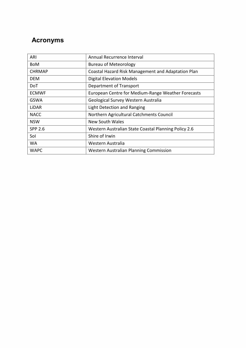
Acronyms
ARI Annual Recurrence Interval
BoM Bureau of Meteorology
CHRMAP Coastal Hazard Risk Management and Adaptation Plan
DEM Digital Elevation Models
DoT Department of Transport
ECMWF European Centre for Medium-Range Weather Forecasts
GSWA Geological Survey Western Australia
LiDAR Light Detection and Ranging
NACC Northern Agricultural Catchments Council
NSW New South Wales
SPP 2.6 Western Australian State Coastal Planning Policy 2.6
SoI Shire of Irwin
WA Western Australia
WAPC Western Australian Planning Commission

1. Introduction
1.1. Project Background
The Shire of Irwin coastline has significant environmental, economic and social assets with
the Port Denison harbour area holding a large socio-economic significance. Residential
growth over the next 10 to 20 years has been defined within the Shire’s Local Planning
Strategy (2008); and is likely to occur on the land to the north of the Harbour. This may
result in the strengthening of the local economy through the creation of further tourism and
recreational opportunities.
The most significant coastal asset for the Shire is the Port Denison Harbour, which was
largely constructed between 1977 an 1979 (Paul 1981). Over the years, the foreshore
beaches within the harbour, Granny’s Beach and Surf Beach have been subject to coastal
erosion. A sea wall has been constructed at Granny’s Beach to protect the adjacent tourist
park. The dunes near the Irwin River mouth have shown evidence of erosion as a result of
fluctuations in the sand-barred river mouth, further the alluvial flats adjoining the River
have been identified as being vulnerable to inundation. The fishermen’s/tourist nodes south
of Port Denison have also experienced erosion, as has Seven Mile Beach, north of Dongara.
A major problem with previous management plans is that they have been temporary
and/or ad hoc, focusing on short term measures, the Shire feels that these may be
inadequate and costly in the long term.
The Irwin Coastal Hazard Risk Management and Adaptation Plan (CHRMAP) is an
outstanding planning task from the Shire of Irwin’s Local Planning Strategy. The CHRMAP
will enable the Shire to provide a consistent management approach, whilst being more
informed and prepared for coastal issues and hazards in relation to the natural environment
and the Shire’s assets.
1.2. Purpose of the Project
The CHRMAP is intended to update and provide for a consistent management and
adaptation plan across the Shire’s coast. Its purpose is to update and provide strategic
guidance on coordinated, integrated and sustainable management and adaption for land
use and development in the coastal zone likely to be affected by coastal hazards. The
CHRMAP will further provide a consistent approach to coastal management, by ensuring an
appropriate risk assessment and management planning framework is used to incorporate
coastal hazard considerations in the decision-making processes of the Shire of Irwin.
Specifically the CHRMAP will:
Provide information on the effects of coastal hazards;
Present a decision-making framework to assess the associated risks;
Highlight coastal hazard vulnerability zones;

Highlight coastal hazard risk zones; and
Suggest possible adaptation options.
1.3. Objectives
The objectives of the CHRMAP are to:
Increase knowledge of coastal features, processes and hazards in the Shire.
Include stakeholders and community in the planning and decision-making process.
Identify and value assets (both natural and man-made) impacted by coastal hazards
and their functions.
Determine sensitivity and exposure of impacts from coastal hazards on assets and
assign a level of vulnerability.
Determine likelihood and consequence of impacts from coastal hazards on assets
and assign a level of risk.
Identify relevant management/adaptation actions and how these can be
incorporated into short and long term planning.
2. Literature Review As the first step of the project, a literature review process has been conducted aiming to
collect and review all available information, whilst identifying data gaps and project
requirements.
The literature review was conducted under several sub topics including state government
policy and CHRMAP guidelines, CHRMAP studies conducted nationally and internationally,
information on the study area, literature on data availability and literature on modelling
methods.
2.1. State Government Policy and CHRMAP Guidelines Context
There are several documents relevant to the study and include State Planning Policy 2.6
(SPP 2.6) (State Coastal Planning), SPP2.6 Guidelines and the Status of Coastal Planning in
Western Australia (2012) report. These policies and guidelines provide guidance for
decision-making within the coastal zone including managing development and land use
change; establishment of foreshore reserves; and to protect, conserve and enhance coastal
values.
The study aims to strictly follow the guidelines and specifications recommended by relevant
authorities and agencies. Special care has been taken to highlight the recommendations
from SPP2.6 (WAPC, 2013) in relation to; the planning time frame; storm event for
modelling; allowance for sea level rise; allowance for storm surge inundation; and allowance

for erosion. Further recommendations on an appropriate allowance for mean sea level
change to be used in coastal planning in Western Australia are given by Bicknell (2010).
As the vulnerability of land use and development within the Western Australian coastal zone
to physical process hazards is expected to increase in the future the Department of
Planning, on behalf of the Western Australian Planning Commission, prepared the Coastal
Hazard Risk Management and Adaptation Planning Guidelines for Western Australia (WAPC,
2014) to support the implementation of SPP2.6. The publication is designed to assist
statutory decision-makers (e.g. local governments, State government agencies, the Western
Australian Planning Commission and the State Administrative Tribunal) to:
a) Consider coastal hazards and to evaluate their likelihood and the consequence for
specific assets;
b) Identify realistic and effective management and adaptation responses to those risks;
and
c) Prioritise the management and adaptation responses.
From a national perspective guidelines have been prepared by other states and include
Guidelines for Preparing Coastal Zone Management Plans, NSW (NSW Government, 2010),
Victorian Coastal Hazard Guide (The Victorian Government Department of Sustainability and
Environment, 2012) and Guideline for Preparing a Coastal Hazard Adaptation Strategy,
Queensland (Queensland Government, 2013).
2.2. CHRMAP Studies Available in the Literature
Numerous CHRMAP studies have been undertaken focusing on the potential impacts of
coastal inundation and erosion hazards on the Western Australian coastline. These studies
such as the Gingin-Dandaragan Coastal Hazard Risk Assessment (NACC, 2015) follow the
objectives of SPP 2.6 and the guidelines provided within the Coastal Hazard Risk
Management and Adaptation Planning Guidelines for Western Australia. This study
considers both present extremes of climate and also projected changes in future climates
until the year 2100 for the Gingin-Dandaragan coastline.
A CHRMAP for Yanchep Surf Life Saving Club (YSLSC) was done for the redevelopment of the
YSLSC facilities (Cardno, 2014). This report is to be used for the decision-making process for
the entire 50 years (2070) design life of the Club’s facilities.
Cockburn Sound Coastal Vulnerability Values and Risk Assessment Study (2014) identified
the cost of risk to the coastal assets and presented an approach to managing these coastal
risks. The study further provided a strategy for coastal management, incorporating present
and future coastal hazards to develop an adaptation plan (BMT, 2014).

The Coastal Adaptation Decision Pathways Project initiated to develop flexible pathways for
the Peron-Naturaliste Coastal Region of WA. The project consisted of three phases; a
synthesis of coastal hazards affecting the region; a regional-based assessment of impacts,
comparing present day conditions with those projected at snapshots in time up to 2110; and
a detailed locally-based assessment at four case study areas of impacts and potential
responses, which will change over time(Peron Naturaliste Partnership, 2012). This project
was largely innovative and has generated a great deal of new learning’s, knowledge and
sharing of information and resources for the partnership (Peron Naturaliste Partnership,
2012).
2.3. Information on the Study Area
A desktop review shows that there is a large amount of background information for the
study area including studies on the natural attributes of the coastal environmental; climate
change and oceanography, cultural attributes and issue based management strategies
(Peter H & A, Landvision, 2000).
The potential impacts of climate change in Mid-West region such as sea level rise presents a
significant issue for the region’s ports and coastal towns, home to the majority of the
region’s population and vital infrastructure (AECOM, 2010).
The beach erosion process in Dongara- Denison beach, adjacent to the Caravan Park (the
Dongara Denison Holiday Park ) was investigated taking several aspects into account; shore
line movement; relationship between ocean water levels with beach erosion and other
factors; and option for managing the beach erosion (M J Paul, 2001). Findings and
recommendations are in Section 4.2 in this report.
Further investigation on coastal erosion at Dongara Denison Beach Holiday Park was
conducted and a seawall was constructed to protect the Dongara Denison Beach Holiday
Park. (M.P. Rogers, 2012).
The Shire of Irwin undertakes coastal erosion monitoring at along the coastline by taking
photographs at appropriate locations. This monitoring has been opportunistic and covers
the years from 2009 to 2013. The monitoring has identified erosion issues at Freshwater
Point, Port Denison foreshore, Granny’s beach, Surf Beach, Seaspray Beach and Seven Mile
Beach (Shire of Irwin, 2013).
The Irwin River Estuary Coastal Management Plan was prepared in 2005 to document
management measures and to recommend passive and active facilities for the Irwin River
Estuary and the coastal foreshore area to Granny’s Beach. The Plan acknowledges the

regional significance of the site with regards to its cultural heritage and environmental
values. By providing and implementing the Plan for the Irwin River, the Shire aimed to
maximise the potential for public access and facilities to the area, without compromising its
current cultural, environmental, heritage and recreational value. This plan has recently been
superceded by the Irwin River Estuary Management Plan 2014. The priority of 2014 plan is
to facilitate improved access, signage and low-key recreational facilities which blend into
the natural environment to enable residents and visitors to enjoy this highly valued asset.
In 2000, Shire of Irwin Coastal Development Strategy was completed. The purpose of this
Strategy was to provide a framework for rehabilitation of coastal lands following the
removal of squatter shacks, whilst providing for the establishment of ecologically sensitive
small development nodes and coastal access points. The Strategy was somewhat successful,
however several issues still remain such as the squatter shacks at Knobbies Head,
Freshwater Point, and Cliff head.
2.4. Literature on Data Availability
Several reports have investigated coastal data availability to date in Western Australia such
as Climate Change Risk to Busselton( Evelyn ,2013), Coastal Inundation Modelling for
Busselton (Martin ,2014), Data and Information Gap Analysis: Coastal Hazard & Risk
Assessment, Gingin-Dandaragan Coast, Hill Primary Coastal Compartment (NACC ,2013). and
Gingin-Dandaragan Coastal Hazard Risk Assessment (NACC ,2015).
Predicted sea levels along the Western Australian coast are analysed by Bicknell within Sea
Level Change in Western Australia: Application to Coastal Planning (2010). It was noted
within this report that there is undisputable evidence that the global mean sea level will
continue to rise over the 21st century as a direct result of anthropogenic climate change, and
the regional projects indicate that the rate of sea level rise along the Western Australia
coastline will be similar to the global mean (Bicknell, 2010).
Maximum water levels for different average recurrence intervals (ARI) have also been
assessed for the coastline subject to this CHRMAP (Haigh et al. 2012). Further this study
presents some statistical water level data in Geraldton, which is useful for the present study.
These reports highlight the main data sources such as water levels, wave data and
bathymetry are available from the Department of Transport (DoT), and Meteorological data
for the Irwin coastline can be accessed from Bureau of Meteorology (BoM). A. The
effectiveness of the data and information that is currently available for assessing and
mapping coastal hazards, at a scale that is useful for local planning and decision-making, is
highlighted in Data and Information Gap Analysis: Coastal Hazard & Risk Assessment, Gingin-
Dandaragan Coast, Hill Primary Coastal Compartment (NACC, 2013).
Further, studies such as Coastal Sediment Cells for the Mid-West Coast in (Damara, 2014),
The Coast of the Shires of Coorow to Northampton, Mid-West, Western Australia (2012) and
Dongara to Cape Burney Coastal Geomorphology (2011) have produced a number of
available data sets such as light detection and ranging (LiDAR), digital elevation models
(DEM) and aerial photographs.
2.5. Literature on Modelling Methods
There are different models for inundation, with two main models mentioned in the
literature. Those are the simplified bathtub model and the dynamic model (Storlazzi, et al
2013). Most of the literature shows “bath tub” approach is a reliable method when the
analysis is limited only to inundation modelling., Considering Tidal Modification when
Mapping Inundation Hazards in NSW Estuaries (Foulsham, et al, 2013), and Mapping &
Responding to Coastal Inundation (McInnes, 2012).
When the study is for both inundation and erosion modelling, researchers used bath tub
approach for inundation and another model (usually XBEACH and/or SBEACH) for erosion
(Cockburn Sound Coastal Alliance, 2013, Martin, et al., 2014).
Advantage of MIKE21, as identified through several pieces of literature (Evelyn, 2013,
Kulkarni, 2013, Pattiaratchi and Wijeratne, 2011) is that it is capable of modelling both
inundation and erosion processes.
None of the reports mentioned/discussed the calibration/verification of the model. This
may be due to lack of data. Therefore calibration could be done only if historical
observations data is available and sourced.
3. Study Area
The Shire of Irwin coastal belt is the main focused study area. The study area is composed of
a 75 km long continuous stretch of land from Illawong to the south, through to Bookara
which is northern boundary of the Shire. The twin towns of Dongara and Port Denison are
located on either side of the Irwin River mouth. The Shire of Irwin is in the Mid-West region
of Western Australia and covers an area of over 2, 370 km2. Fig 1 shows the study area and
main important landmark locations.
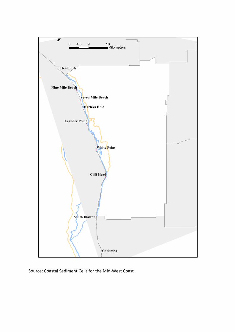
Source: Coastal Sediment Cells for the Mid-West Coast
Coolimba
Headbutts
Cliff Head
White Point
Harleys Hole
Leander Point
South Illawong
Nine Mile Beach
Seven Mile Beach
´ 0 9 184.5Kilometers

3.1. Significance of the Study Area
Environmental
The Shire’s coastline has various areas of environmental significance. These include the
internationally recognised wildcatch rock lobster fisheries, two nationally recognised Nature
Reserves (including Beekeepers Nature Reserve which is approximately 25% of the Shire’s
area and has National Heritage Listing due to its exceptionally diverse flora, the and Dongara
Nature Reserve), numerous state recognised environmental assets (Irwin River, Irwin River
Estuary Foreshore Reserve and Thungara Trials) as well as locally important areas (Granny’s
Beach, Surf Beach, Seven Mile Beach and South Beach).
Further, a large proportion of the Shire’s coastline is undeveloped and contains intact native
vegetation. This area has extraordinarily diverse flora (much of which is endemic to the
region) and provides critical habitat for native fauna species. Lack of development which
may represent an opportunity for natural coastal landscapes and ecological values to be
preserved and managed in advance of potential development pressures.
Cultural heritage
The Shire’s coastline holds mythological and historical significance to the local indigenous
people (Yamaji). The Heritage Council of Western Australia place register lists the mouth of
the Irwin River as a heritage site (Place No. 12480). The Shire of Irwin Municipal Inventory
Place Records also lists the Irwin River mouth as a heritage site due to its connection to the
establishment of the first port and harbourmaster’s house dating from the early 1850’s. The
area also has two quarries and a shipwreck site just beyond the estuary.
Social
The coastal zone in the Shire holds a ‘sense of place’ for residents and tourists alike. The
Port Denison Harbour is largely considered as the place that holds the largest social
significance within the Shire, with many different people associating this asset with
recreational activities (swimming, snorkelling, fishing and kayaking), community events
(Larry Lobster Festival, Blessing of the Fleet and Australia Day activities) and sporting events
(Kitestock: the premier kitesurfing event in WA). Several beaches (Granny’s Beach, Surf
Beach Seven Mile Beach and South Beach) also hold important social significance, being
associated with popular recreational activities.
Key economic drivers
Agriculture, fishing, mining, residential and tourism are prominent and valuable sectors in
the Shire’s diverse economy. The Port Denison harbour is the key coastal infrastructure of

economic significance. The Shire believes that in general, these economic and employment
sectors are sustainable and have the potential to generate income in the future. However,
shortfalls in recreation, tourism accommodation and aged care/ housing facilities have been
identified.
3.2. Pressures and Stress in the Study Area
The Shire of Irwin’s coastal zone is experiencing various pressures due to natural and
anthropogenic activities. These include substantial population growth, increased
construction, a rise in tourism numbers, increased pollution, modification of sediment
transport processes, sea-level rise, storm surges, tides and wave action. As there is
development along the Shire’s coastal zone, coastal erosion and inundation also present a
significant pressure. These pressures can separately and/or accumulatively impact of coastal
assets and diminish the assets’ functionally.
Each of the current pressures operate at different spatial (local to regional), temporal and
economic scales. For example the Shire’s population is gradually increasing over time and
extending further along the coastline. The scale of increased construction reflects this
pattern throughout the region. There is an influx in tourism numbers during peak holiday
times (school holidays, Easter and Christmas), bringing with it a surge in the local economy.
The popular Granny’s Beach is subject to coastal erosion (from wave movements and ocean
swell), at varying levels throughout the year. In particular during periods where northerly
winds predominate the pressure from erosion is greater.
Without effective management these current pressures will continue into the future.
Furthermore, climate change will exacerbate these pressures through rising seas levels,
increased number of extreme events, increased temperature and decline in rainfall. In the
face of this predicted global climate change the Shire of Irwin will be presented with a set of
challenges pertaining to the management and maintenance of its valuable coastal resources
and infrastructure. The diversity and conservational significance of the Shire’s natural
environments and the expanse of ‘coastal living’ throughout the area, mean the effects of
climate change are likely to have a significant impact on the natural/social balance within
the Shire in years to come.
4. Identification of Coastal Hazards
After review of the available literature the following coastal issues have been identified
throughout the study area. The following sections present the coastal issues recorded in the

literature and other historical records. Information is listed for each location and supported
by the relevant literature.
The locations highlighted here are; Freshwater Point, Port Denison Foreshore, Granny’s
Beach, Granny’s/Surf Beach, Seaspray Beach and Seven Mile Beach.
4.1. Freshwater Point
Erosion occurred in 2011 and fisherman’s shacks were damaged by erosion. Tamarisk (athel
pine) trees are being up rooted due to erosion.
Remediation actions: Seaweed accumulation in the erosion zone has probably prevented
more erosion. In 2011, limestone Marl fill was being placed in the eroded areas. (Reference:
Monitoring of Coastal Erosion in 2013)
4.2. Port Denison Foreshore
The Shire of Irwin has been experiencing erosion of the beach adjacent to the Dongara
Denison Holiday Parkwhich is located immediately north of the Port Denison Boat Harbour
in 2001. The results obtained from beach profile monitoring confirm that the beach erosion
was limited to a 400m long section of the beach extending from about 50m to 450m north
of the Port Denison Harbour. The worst erosion occurs at a point about 250m north of the
Harbour where about 12m of erosion has occurred over a period of 24 years, i.e. at an
average erosion rate of 0.5m per year. There may have been more sand losses in deeper
water. However, in view of the relatively small differences in water depth observed
between the 1973 and 2001 using near-shore hydrographic surveys, the additional sand loss
was believed to be less than 6,000m3. Allowing for this possible additional sand loss, the net
sand loss south of chainage 600m (within 600m, from port to north side) was conservatively
estimated to be less than 22,100m3. i.e. an average erosion rate of about 920m3 per annum
over the 24 year period since April 1977. This is relatively small rate of littoral sand
movement. (Reference: Shire of Irwin- Department of Transport, Port Denison, Beach
Erosion Investigations Report, 2001 July)
The sediment cell from Leander Point to Dongara North is located south of the study area. It
influences coastal processes and stability further north through discharge from the Irwin
River and erosion of the beach immediately north of Port Denison Harbour. (Reference:
Dongara to Cape Burney, Western Australia: Coastal Geomorphology, October 2011)
In December 2009, the height of the erosion was approximately 180cm. Erosion has been
continually damaging Port Denison area with the Shire having to replenish each year,
concrete blocks weighing 350kg each were used to build a wall to protect the area however,
these remedial actions were unsuccessful, due to the ongoing impacts of coastal processes.

Erosion problems occurred again in September 2012. Concrete blocks that were used to
prevent further erosion have been washed out in September 2012. Sand placed on the flex
mat had been eroded, however the mat has remained unscathed due to high tide events in
2012. (Reference: Monitoring of Coastal Erosion in 2013)
Remediation actions:
The Shire had placed about 600m3 of sand (sourced from the sand dune) on to the beach in
October –November 2000. (Reference: Shire of Irwin- Department of Transport, Port
Denison, Beach Erosion Investigations Report, 2001 July)
The Shire arranged to replenish each year, concrete blocks weighing 350Kg each were used
to build a wall to protect the area. Flex Mat was placed in the Port Denison foreshore. After
laying of all the mat, good quality sand was distributed over the top and grass were
encouraged to grow over the top (Reference: Monitoring of Coastal Erosion in 2013)
4.3. Granny’s Beach
Stormy conditions that caused the erosion problems in August 2009 and the beach erosion
occur during winter in 2010. Erosion caused by large ocean swell and seaweed build up. The
seaweed buried in the corner of the retaining wall has forced the water to swirl around
cutting out the sand from under the footings of the wall and exposed footing in October
2013. Further, the retaining wall has sunk and there was some extensive cracking in the
brickwork in this general area. (Reference: Monitoring of Coastal Erosion in 2013)
Remediation actions:
In 2008/2009 sand replenishment was undertaken at Grannies Beach. Approximately
13000m3 of sand added to the beach. Irwin River Mouth was looked at to move sand from
this area and replaced it back onto Granny’s beach for nourishment in 2009.
Retaining wall repair was undertaken in October 2009. Old limestone blocks were used to
build up the foundations before the wall was re-built. Sections of the wall that were still
standing, were supported with brackets. They were then pegged and additional concrete
was added to strengthen the wall in October 2009. Again, sand replenishment was
undertaken in December 2010.
The limestone retaining wall was re-built in November 2011 and the Eroded area was
covered with sand in October 2013. Footing has been covered and seaweed has been
pushed over the top, compacted and in turn covered with fresh sand to stabilize it and
excess seaweed has been moved back into the water to disperse it further north in October
2013. (Reference: Monitoring of Coastal Erosion in 2013)

4.4. Granny’s/Surf Beach
The first recorded major erosion problem was in October 2009. The limestone rocks were
placed along the beach in approximately 1997. The footpath was damaged after winter
storm events and extensive erosion occurred at Surf Beach in May 2011.
(Reference: Monitoring of Coastal Erosion in 2013)
Based on observed trends in the historical shoreline movement, two major contributors to
the erosion are likely to be:
The construction of Port Denison in 1978, which increased reflected wave energy to
the north.
The large number of extreme water level events that have occurred since the mid
1990’s, increasing cross-shore transport of sediment to deeper water.
(Reference: Shire of Irwin Dongara Beaches - Concept Development, M P Rogers &
Associates, April 2012)
Remediation actions:
The seawall protecting infrastructure with geo-fabric was been completed in 2011 with the
exception to the tie in to Surf Beach. (Reference: Monitoring of Coastal Erosion in 2013)
In 2010, the Shire commissioned the staged construction of a rubble mound seawall in front
of the caravan park. The first stage involved the construction of approximately 30 m of
seawall at the southern end of the caravan park and was completed in 2010. The second
stage was completed in 2011 and extended the wall by approximately 170 m. Further
seawall stages of approximately 150 m length are required to complete the coastal
protection structure and protect the remainder of the caravan park and the car park at
Surfers Beach. (Reference: Shire of Irwin Dongara Beaches - Concept Development, M P
Rogers & Associates, April 2012)
River sand replenishment was undertaken to reduce the erosion problems on Surf Beach.
After the erosion problems in 2010/2011, quarry rock was added to prevent further erosion.
Under guidance from the Department of Transport and Landcare, the Shire removed up to
half of the existing car park and the footpath and commenced battering down the dune to
give better and safer access to the beach. Armour rocks were placed to prevent future
erosion and dunes were cut down to allow better gradients and safer access to the beach.
Armour rocks were also placed to the sides of the newly constructed surf beach and
concrete blocks were used as a border to define the beach from the car park and also to
prevent vehicle access to the beach. (Reference: Monitoring of Coastal Erosion in 2013)
4.5. Seaspray Beach
Erosion issues at the Seaspray Beach have unearthed infrastructure placed during the days
of the crayfish factory. Pipes and cabling were washed out of the sand dune and rusted off

star pickets, which were used to secure the pipes in place. A suction pipe was exposed by
erosion and rusted and unsafe in May 2013. (Reference: Monitoring of Coastal Erosion in
2013)
4.6. Seven Mile Beach
Beach access was eroded away and had a 1.5m drop to the beach in October 2013. The
dune heading south has under gone extensive erosion through the winter months.
Remediation actions:
Sand replenishment works have helped to protect the adjoining car parking area and fill up
the drop caused by winter storms in 2013. Rocks were placed on site in October 2012 to
stabilize the access onto the beach. Rocks were topped up with limestone marl during the
next two years to allow that access to the beach. Sign boards were added in September
2013 to preserve the dune system in the area. The car park was cut down and imported
materials were removed away from the beach in October 2013. Re-shaping the beach was
done to prevent safety problems with erosion and cutting out the roundabout system to
construct a new parking area in October 2013. The old roundabout has been gravelled and
water bound. (Reference: Monitoring of Coastal Erosion in 2013)
4.7. Recorded Anthropogenic Hazards in the Coastal Area
In addition to the issues due to natural reasons, the available literature also recorded some
anthropogenic impacts on the coastal zone.
Fluctuations in shoreline adversely impact upon use of the coast in some locations.
An example is the steepening of the beach and fore-dune area at Carson’s Beach.
This makes it necessary for off-road vehicles to travel onto the fore-dunes during
periods of high tide causing substantial damage to the vegetation of the fore-dunes.
Where fore-dunes have been dissected by off-road vehicles, (including trail bikes and
heavy machinery) there is a need for immediate rehabilitation to prevent further loss
of vegetation through deflation. Access to beaches by tracks which are in the same
alignment as the prevailing wind direction have been exacerbated by wind erosion.
Dune erosion and migration is a natural process that is often exacerbated by the
reduction of vegetation cover and density as a result of;
Off-road vehicle use
The trampling of dunes by uncontrolled pedestrian activity
Stock and feral animal grazing
Inappropriate placement of infrastructure, such as carpark, boat launching
areas, buildings (including squatters shacks) which interrupt natural
processes; and.
Destruction of vegetation by fire
(Reference: Irwin Coastal Plan- Environmental Assessment and Management
recommendations, Shire of Irwin, 2000)

4.8. Irwin River and the Dongara-Port Denison Bridge
The Irwin River Estuary Coastal Management Plan (2005) states that “the estuary and lower
river are affected by tides when the seasonal sand bar is breached”. Observations by local
people in March 2015 indicate that the tidal impact extended upstream beyond the
Dongara-Port Denison Bridge, following a breach in the sandbar.
The original bridge was built in 1889 by Mr Grosse and Matthew Price Snr, and was
demolished and a new bridge was built using concrete piers in 1964. Sir David Brand,
Premier of Western Australia, officially opened the new bridge on 14/11/1964. The bridge
approaches were washed away 1971 when a 1 in 100 year flood was said to be 1m higher
than the level of the bridge. The structure suffered from concrete cancer and was closed for
some time in 1975. The deck was upgraded in 1996. Following the 1999 flood, the bridge
was repaired and strengthened, and the road on the south side of the bridge was lowered.
The land on either side of the road here was re-shaped to allow the river to flow round the
Bridge on the south side during significant flood events, instead of backing up.
Two 100 year ARI Flood Maps were produced by the State Government’s Department of
Water in 2012. They demonstrate that part of the town centre and some other adjoining
areas will be affected such floods (Shire of Irwin’s District Water Management Strategy
2014) and are used to inform the Shire’s approach to flood risk. As the river will be
vulnerable to the 0.9m sea level rise over the next 100 years and there will likely be an
increase in the frequency and intensity of storms, the Shire is concerned about the
combined impacts of coastal inundation and flooding on the town centre and adjoining
residential areas.
5. Review of Available Data
5.1. Proposed Inundation and Erosion Modelling Methodology
Most of the literature shows “bath tub” approach is a reliable method when the analysis
is limited only to inundation modelling. When the study is for both inundation and
erosion modelling, researchers used the bath tub approach for inundation and another
model (usually XBEACH and/or SBEACH) for erosion. Further, the literature highlights
that the advantage of dynamic wave models, such as MIKE21, is that they are capable of
modelling both inundation and erosion process.
Based on this information, the proposed modelling method of the project is to:
Conduct bathtub based modelling (contour plotting) of the water level for each
sea level rise scenario and find the extent of inundation in the study area;
This outcome will also show the areas which have high probability of
inundation/high risk areas to give careful consideration in detailed modelling;
Then the inundation process will be modelled the using MIKE21 (dynamic wave
modelling). The model grids will be arranged to portray fine resolution
(condensed grids) for the areas shown as high risk (in bathtub model) and other
important locations (such as town of Dongara, Port Denison and other highly
interested locations identified by the Shire/NACC);
Conduct the erosion model using integrated approach of MIKE21 and SBEACH
models, as MIKE21 is capable of modelling long-shore sediment transport, but
SBEACH has more capacity in modelling cross-shore sediment transport
phenomena; and
Calibration and verification of the simulations could be done ONLY if relevant
historical observation data is available. Otherwise model will be verified against
historical information/records/experience.
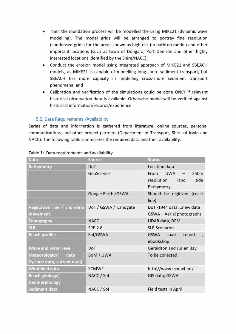
5.2. Data Requirements /Availability
Series of data and information is gathered from literature, online sources, personal
communications, and other project partners (Department of Transport, Shire of Irwin and
NACC). The following table summarizes the required data and their availability.
Table 1: Data requirements and availability
Data Source Status
Bathymetry DoT Location data
GeoScience From UWA – 250m
resolution land side
Bathymetry
Google Earth /GSWA Should be digitized (coast
line)
Vegetation line / shoreline
movement
DoT / GSWA / Landgate DoT -1944 data….new data
GSWA – Aerial photographs
Topography NACC LiDAR data, DEM
SLR SPP 2.6 SLR Scenarios
Beach profiles SoI/GSWA GSWA coast report ,
ebookshop
Wave and water level DoT Geraldton and Jurien Bay
Meteorological data (
Cyclone data, current data)
BoM / UWA To be collected
Wind field data ECMWF http://www.ecmwf.int/
Beach geology/
Geomorphology
NACC / SoI GIS data, GSWA
Sediment data NACC / SoI Field tests in April
6. Conclusion
The literature review has provided an overview of the background information that is
available, the significance of the project and the pressures and stressors of the study area.
The review has also helped to increase the understanding of the basics of the project
specifically in regards to other CHRMAP studies conducted nationally and internationally
and how they relate to the current study, information on the study area, data availability
and modelling methods.
Based on this information, the modelling approach of the project will be to conduct bathtub
based inundation modelling initially, and then expand the model to a dynamic model using
MIKE 21. The erosion model will be conducted as an integrated approach of MIKE 21 and
SBEACH models. This integrated approach will be more successful as MIKE21 is capable of
modelling long-shore sediment transport, but SBEACH has more capacity in modelling cross-
shore sediment transport phenomena.
Also it is clear that calibration and verification of the simulations has not been done in any
of the projects found in the literature. Therefore calibration and verification of the
modelling could be done only if relevant historical observation data is available. Otherwise
model will be verified against historical information/records/experience.
7. References
AECOM Australia Pty Ltd, 2010, Climate Change Adaptation Action Plan, Batavia Regional
Organisation of Councils.
Bicknell, C., 2010, Sea Level Change in Western Australia: Application to Coastal Planning,
the Department of Transport, Western Australia.
BMT Oceanica Pty Ltd, BMT WBM Pty Ltd, Coastal Zone Management Pty Ltd, SGS
Economics and Planning Pty Ltd and Damara WA Pty Ltd, 2014, Cockburn Sound Coastal
Vulnerability Values and Risk Assessment Study ,Revision-1,Cockburn Sound Coastal
Alliance.
Cardno (WA) Pty Ltd.,2014, Yanchep Surf Life Saving Club -Coastal Hazard Risk
Management and Adaption Plan, City of Wanneroo .
Cockburn Sound Coastal Alliance, 2013, Coastal Vulnerability Study-Erosion and inundation
hazard assessment report.
Damara WA Pty Ltd and Geological Survey of Western Australia, 2012, The Coast of the
Shires of Coorow to Northampton, Mid West, Western Australia: Geology, Geomorphology
and Vulnerability, Western Australian Planning Commission.
Damara WA Pty Ltd, 2011, Dongara to Cape Burney Coastal Geomorphology, Western
Australian Planning Commission.
Evelyn, M. K. H., Climate Change Risk to Busselton, Western Australia. (2013) The University
of Western Australia.
Foulsham, E., Bradley, M. and Hanslow, D., 2013,Considering tidal modification when
mapping inundation hazard in NSW estuaries, Office of Environment and Heritage,
Newcastle, NSW.
(http://www.coastalconference.com/2013/papers2013/Brad%20Morris%20Full%20Paper.pdf)
Goji . J. and Coughlan. P, 1988, Irwin River Flood at Dongara, Main Roads WA.
Haigh, I.D., Wijeratne, E.M.S., MacPherson, L.R., Pattiaratchi, C.B., Mason, M.S., Crompton,
R.P. and George, S.,2012, Estimating present day extreme water level exceedance
probabilities around the coastline of Australia, Antarctic Climate & Ecosystems
Cooperative Research Centre.
Kulkarni, R., 2013, Numerical Modelling of Coastal Erosion Using Mike21, Norwegian
University, Norway.
Landvision, 2000, Shire of Irwin Coastal Development Strategy, Shire of Irwin
MJ Paul, 1981, Denison Fishing Boat Harbour, Engineer, Harbours and Rivers Branch,
Department of Public Works, Western Australia.

M J Paul and Associates Pty Ltd., 2001, Port Denison Beach Erosion Investigations Report,
Shire of Irwin-Department of Transport.
M P Roger & Associates Pty Ltd, 2012, Dongara Beaches- Concept Development, Shire of
Irwin
Martin, S., Moore, D., and Hazelwood, M., 2014, Coastal Inundation Modelling for
Busselton, Western Australia, Under Current and Future Climate, Geoscience Australia.
McInnes, K., Lipkin, F, O’Grady, J. and Inman, M., 2012, Mapping & Responding to Coastal
Inundation, Sydney Coastal Councils & CSIRO.
Northern Agricultural Catchments Council, 2013, Data and Information Gap Analysis:
Coastal Hazard & Risk Assessment, Gingin-Dandaragan Coast, Hill Primary Coastal
Compartment, Shire of Gingin and the Shire of Dandaragan.
Northern Agricultural Catchments Council, 2015, DRAFT Gingin-Dandaragan Coastal Hazard
Risk Assessment, Northern Agricultural Catchments Council and Department of Transport.
NSW Government, 2010, Guidelines for Preparing Coastal Zone Management Plans.
Pattiaratchi, C., Wijeratne, S., 2011, Port Geographe: Sand and Seagrass Wrack Modelling
Study, Western Australia, UWA.
Peron Naturaliste Partnership, 2012, Coastal Adaptation Decision Pathways Project,
Developing flexible pathways for the Peron-Naturaliste Coastal Region of WA.
Peter Hammon and Associates and Landvision –Urban and environmental Planners, 2000,
Irwin Coastal Plan- Environmental Assessment and Management recommendations, Shire
of Irwin.
Queensland Government, 2013, Guideline for Preparing a Coastal Hazard Adaptation
Strategy.
Seashore Engineering Pty Ltd and Geological Survey of Western Australia, 2014, Coastal
Sediment Cells for the Mid-West Coast: Between the Moore River and Glenfield Beach,
Western Australia. Department of Transport.
Shire of Irwin, 2005, Irwin River Estuary Coastal Management Plan.
Shire of Irwin, 2013, Monitoring: Coastal Erosion.
Shire of Irwin, 2014 Irwin River Estuary Management Plan.
Storlazzi, C.D., Berkowitz, P., Reynolds, M.H., and Logan J.B., 2013, Forecasting the Impact
of Storm Waves and Sea-Level Rise on Midway Atoll and Laysan Island within the
Papahānaumokuākea Marine National Monument—A Comparison of Passive Versus
Dynamic Inundation Models, U.S. Geological Survey Open-File Report 2013-1069.
The Victorian Government Department of Sustainability and Environment, 2012, Victorian
Coastal Hazard Guide, Melbourne.
Waldron, N., 2005, Coastal Risk Profile-Sector4 -Avon-Midland Zone and Northern Country
Zone, Part 1 of 2,Surf Life Saving Western Australia.
Western Australian Planning Commission, 2013, SPP 2.6 - State Coastal Planning Policy.
Department of Planning.

Western Australian Planning Commission, 2014 Coastal hazard Risk Management and
adaptation planning guidelines, Department of Planning.


![COASTAL HAZARDS, CLIMATE CHANGE AND ADAPTATION, … · Coastal hazard lines and options for ... EDEN WAVE BUOY. ... Microsoft PowerPoint - A655965.pptx [Read-Only] Author: dbellamy](https://img.dokumen.tips/doc/110x75/5cd77e2288c993dc268cab25/coastal-hazards-climate-change-and-adaptation-coastal-hazard-lines-and-options.jpg)