Embed Size (px)
Citation preview
Iranica Journal of Energy and Environment 6(1): 39-46, 2015
Iranica Journal of Energy & Environment
Journal Homepage: www.ijee.net
IJEE an official peer review journal of Babol Noshirvani University of Technology, ISSN:2079-2115
1 Faculty of Geography, University of Mamasani, Iran 2 Department of GIS and Remote Sensing, University of Tabriz, Iran
3 Department of Geoinformatics, University of Salzburg, Austria and Department of GIS
P A P E R I N F O
Paper history: Received 12 November, 2014 Accepted in revised form 22 December 2014
Keywords: Bioenvironmental Evaluation
Satellite Image Land Use/Cover Change
Sattarkhan Dam Detrimental Index Post-Classification Comparison
A B S T R A C T
doi: 10.5829/idosi.ijee.2015.06.01.08
bridges and roads). In the course of carrying out these
activities, the environment is degraded and thereby
damaging the ecosystem and the landscape, and
offsetting the already fragile ecological balance [1].
Obviously, LUCC studies provide a great and
significance information to strengthen the protection of
land resources, determent unreasonable exploitation,
improve ecological environment and promote
integration development [2].
In order to monitor the LUCC during time, Earth
Observation satellite images provide a powerful
methodology for assigning the trends of LUCC by
means of comparing time series of satellite images to
recognize the LUCC. Remote sensing technology has
greatly facilitated investigation and monitoring of
LUCC [3]. One of the major advantages of remote
sensing system is its capability for repetitive coverage,
which is necessary for change detection studies at global
and regional scales. Jenson has suggested that detection
L. Sharifi1, S. Kamel2*, B. Feizizadeh3
Please cite this article as: L. Sharifi, S. Kamel, B. Feizizadeh, 2015. Monitoring Bioenvironmental Impacts of Dam Construction on Land Use/Cover Changes in Sattarkhan Basin Using Multi-Temporal Satellite Imagery , Iranica Journal of Energy and Environment, 6 (1): 39-46.
*Corresponding author: Samira Kamel.
E-mail: [email protected] Phone: 09148449651
Monitoring Bioenvironmental Impacts of Dam Construction on Land Use/Cover
Changes in Sattarkhan Basin Using Multi-temporal Satellite Imagery
INTRODUCTION
Dam construction has caused pressure upon land use/land cover change (LUCC) which is a major
cause of bio-environmental changes. In this paper, the environmental impacts of Sattarkhan dam
construction from 1987 to 2010 were monitored and recent changes are analyzed, using the Landsat
Thematic Mapper (TM) and Enhanced Thematic Mapper plus (ETM+) images of 1987 and 2010; the
time before and after the dam construction. The methodology consists of two main stages. In the first
stage, image process techniques were employed to classify satellite images using the post-
classification comparison change detection method. Results indicate that irrigated agriculture, bare
lands, and dry agriculture were reduced in the study period, while water bodies and built-up areas
increased. Based on this finding, significant changes in land use/land cover have occurred in
Sattarkhan dam basin. In the second stage the bioenvironmental indices were applied to evaluate the
bioenvironmental impacts of LUCC and it revealed that the maximum detrimental indices were
concerned with conversion of agricultural land use and orchards to built-up lands and water bodies.
As an overall evaluation, dam construction has a positive impacts rather than negative environmental
impacts.
Land use/land cover change (LUCC) detection is
considered as one of the significant and fundamental
techniques for evaluation of the bioenvironmental
effects. Evaluating LUCC is necessary for natural
resource management decision making for land use
planning and bioenvironmental studies. Based on this
assumption, investigation on LUCC has been assigned
as an important concept in environmental studies. This
important is remarkable when it comes into account of
assessing the impacts of dam construction on LUCC.
One of the serious challenges associated with dam’s
construction is about its environmental degradation such
as rapid expansion, growth and developmental activities
(for instance: LUCC changes in agriculture lands,
deforestation, irrigation, fishing, and construction of
Iranica Journal of Energy and Environment 6(1): 39-46, 2015
40
In order to model LUCC, the Landsat Thematic
Mapper (TM) and Enhanced Thematic Mapper plus
(ETM+) data have been widely applied in for land use
and change detection studies[7, 8]. The accuracy of the
resulting change maps is subjected to error propagation
and is dependent on the accuracy of the input
classification maps, the individual classified images
constitute a historical series that can be used in
applications other than change detection[9]. Reviewing
related literature indicates that remote sensing together
with Geographic Information System (GIS) have been
applied to LUCC detection all over the world. In this
regard, Adeniyi and Omojola [10] have used aerial
photographs, Landsat MSS, Spot XS/Panchromatic
Image Transparency and Topographical maps to study
LUCC in Sokoto and Guronyo dams in Nigeria for a
period of time 1962 to 1986. Results of their work
revealed that settlement covered most part of the area
before and after the construction of the dam. Zhao et al.
[11] have investigated the effect of construction of
Manwan dam in Yunnan, China on land use change
during 1974-2004. Ahadnejad [12] has recognized the
LUCC in the basin of Alavian dam using GIS and
remote sensing. In order to evaluate the land use
changes from the bioenvironmental point of view, he
used the detrimental index. Similarly, Rostamzadeh [13]
has investigated the bioenvironmental effects of
Sattakhan dam by using satellite images of ETM and
TM for time period of 1987 to 2002. This study has
been carried out in order to detect the land use changes
due to Sattarkhan dam construction and its water
channel and evaluation of its bioenvironmental effects
during the period of 1987 to 2002.
Within this research we aim to determine the trends,
rates, nature, location and magnitudes of LUCC under
impacts of dam construction in Sattarkhan basin using
remote sensing and GIS techniques. We also aim to
evaluate the environmental and socioeconomic
implications of the LUCC. For this to happen, the multi-
temporal satellite dataset in Sattarkhan dam basin has
been analyzed to understand LUCC as a consequence of
driving factors.
Sattarkhan dam was constructed in 1998 to provide
water for drinking, irrigation, mining and industrial use
in the region. This dam covers a watershed area of
950 . This dam is one of the major dams which are
important in terms of agricultural activities and in
particular orchards activities. Our study focused on the
following two aspects: (1) to estimate LUCC from 1987
to 2010 in the study area, being the time before and after
the dam construction using post-classification
comparison change detection, and (2) to analyze the
bio-environmental effects of these changes in the study
area using detrimental index. Based on TM and ETM+
images in period 1987 to 2010 and by the support of
GIS, we analyzed the spatial-temporal changes of land
use pattern in the study area which can provide the basis
for further research driving factors and change
mechanism of LUCC.
MATERIAL AND METHODS
Data set and preprocessing
Supervised classification
The principle of image classification is that a pixel is
assigned to a class based on its feature vector, by
comparing it to predefined clusters in the feature space.
In doing so for all image pixels results in a classified
image[15]. The classic image classification method that
classifies remote sensing images according to the
spectral information in the image and the classification
manner is “pixel by pixel” and one pixel can only
belong to one class. In pixel-based classification, there
are two kinds of traditional classification methods-
unsupervised classification and supervised
classification[16].
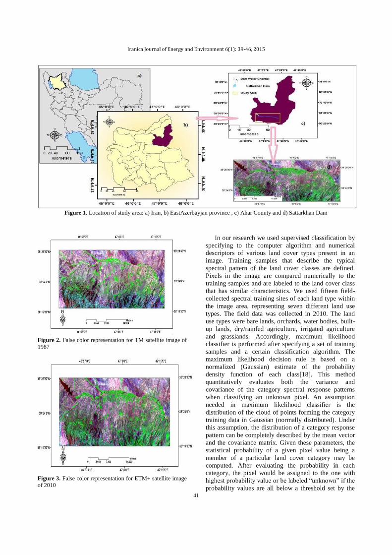
The study area and aim of this study The study area was Satarakhan dam basin which is sub basin of Aharachei. This area is located in the North-western Iran in East Azerbaijan province (see Figure 1).
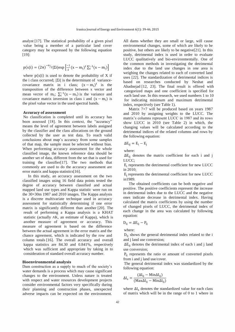
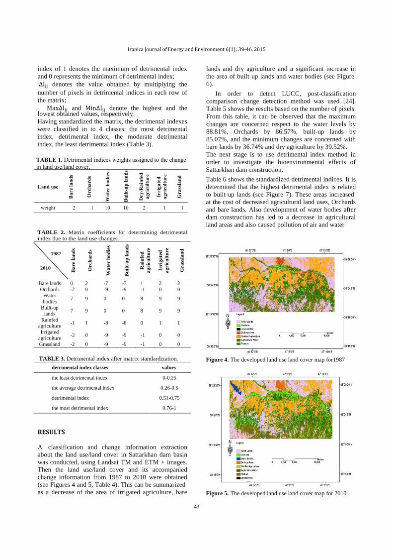
In this study, we used TM and ETM+ satellite images
(see Figures 2 and 3). The TM image was acquired on
July 19, 1987 and the Landsat ETM+ data was acquired
on August 14, 2010. In order to start data processing at
first step we performed geo-referencing process on our
satellite images. For this to happen, the 50,000
topographic maps were used to select 22 ground control
points and correct satellite images geometrically.
Satellite images got geo-referenced and projected to the
Universal Transverse Mercator (UTM) zone 38,
WGS84. The estimated resulting root-mean-square
error (RMSE) was 0.47 pixels which was an acceptable
error [14].
Unsupervised classification is used when there is little
or no external information about the distribution of land
cover types. The results of unsupervised classification
are spectral classes. It is by the analyst associate the
spectral classes with the land cover types using
reference data [17].
of changes in the land use/land cover involves use of at
least two period data sets [4]. A practical approach to
study changes in land use/land cover, which may be
caused due to natural/human activities, can be
accomplished using current and archived remotely
sensed data [5]. With the availability of multi-sensor
satellite data at very high spatial, spectral and temporal
resolutions, it is now possible to prepare up-to-date and
accurate land use/land cover maps in less time, at lower
cost and with high accuracy [6].
Iranica Journal of Energy and Environment 6(1): 39-46, 2015
41
Figure 1. Location of study area: a) Iran, b) EastAzerbayjan province , c) Ahar County and d) Sattarkhan Dam
Figure 2. False color representation for TM satellite image of
1987
Figure 3. False color representation for ETM+ satellite image
of 2010
In our research we used supervised classification by
specifying to the computer algorithm and numerical
descriptors of various land cover types present in an
image. Training samples that describe the typical
spectral pattern of the land cover classes are defined.
Pixels in the image are compared numerically to the
training samples and are labeled to the land cover class
that has similar characteristics. We used fifteen field-
collected spectral training sites of each land type within
the image area, representing seven different land use
types. The field data was collected in 2010. The land
use types were bare lands, orchards, water bodies, built-
up lands, dry/rainfed agriculture, irrigated agriculture
and grasslands. Accordingly, maximum likelihood
classifier is performed after specifying a set of training
samples and a certain classification algorithm. The
maximum likelihood decision rule is based on a
normalized (Gaussian) estimate of the probability
density function of each class[18]. This method
quantitatively evaluates both the variance and
covariance of the category spectral response patterns
when classifying an unknown pixel. An assumption
needed in maximum likelihood classifier is the
distribution of the cloud of points forming the category
training data in Gaussian (normally distributed). Under
this assumption, the distribution of a category response
pattern can be completely described by the mean vector
and the covariance matrix. Given these parameters, the
statistical probability of a given pixel value being a
member of a particular land cover category may be
computed. After evaluating the probability in each
category, the pixel would be assigned to the one with
highest probability value or be labeled “unknown” if the
probability values are all below a threshold set by the
Iranica Journal of Energy and Environment 6(1): 39-46, 2015
42
( ) ( )
⁄ [
( )
∑ ( ) ]
where ( ) is used to denote the probability of X if
the i class occurred; is the determinant of variance-
covariance matrix in i class; ( ) is the
transposition of the difference between x vector and
mean vector of ; ∑ ( ) is the variance and
covariance matrix inversion in class i and ( ) is
the pixel value vector in the used spectral bands.
Accuracy of assessment No classification is completed until its accuracy has
been assessed [18]. In this context, the “accuracy”
means the level of agreement between labels assigned
by the classifier and the class allocations on the ground
collected by the user as test data. To reach valid
conclusions about map’s accuracy from some samples
of that map, the sample must be selected without bias.
When performing accuracy assessment for the whole
classified image, the known reference data should be
another set of data, different from the set that is used for
training the classifier[17]. The two methods that
commonly are used to do the accuracy assessment are
error matrix and kappa statistics[16].
Bioenvironmental analysis Dam construction as a supply to much of the society’s
water demands is a process which may cause significant
changes to the environment. Unless nature is treated
with respect and water resources development projects
consider environmental factors very specifically during
their planning and construction phases, unexpected
adverse impacts can be expected on the environment.
Matrix 7×7 will be produced based on years 1987
and 2010 by assigning weights to the LUCC. The
matrix’s columns represent LUCC in 1987 and its rows
show LUCC in 2010 (see Table 2) in which, the
changing values will be calculated according to the
detrimental indices of the related columns and rows by
the following equation:
where:
denotes the matrix coefficient for each i and j
LUCC;
represents the detrimental coefficient for new LUCC
in 2010;
represents the detrimental coefficient for new LUCC
in1989.
The obtained coefficients can be both negative and
positive. The positive coefficients represent the increase
in detrimental index due to the LUCC and the negative
ones indicate decrease in detrimental index. Having
calculated the matrix coefficients by using the number
of changed pixels of LUCC, the detrimental index of
each change in the area was calculated by following
equation:
where:
shows the general detrimental index related to the i
and j land use conversion;
denotes the detrimental index of each i and j land
use conversion;
represents the ratio or amount of converted pixels
from i and j land use/cover.
The general detrimental index was standardized by the
following equation:
( )
( )
where denotes the standardized value for each class
of matrix which will be in the range of 0 to 1 where in
analyst [17]. The statistical probability of a given pixel
value being a member of a particular land cover
category may be expressed by the following equation
[19]:
In this study, an accuracy assessment on the two
classified images using 16 field data points tested the
degree of accuracy between classified and actual
mapped land use types and Kappa statistic were run on
the 30×30m 1987 and 2010 images. The Kappa analysis
is a discrete multivariate technique used in accuracy
assessment for statistically determining if one error
matrix is significantly different than another [20]. The
result of performing a Kappa analysis is a KHAT
statistic (actually ∧K, an estimate of Kappa), which is
another measure of agreement or accuracy. This
measure of agreement is based on the difference
between the actual agreement in the error matrix and the
chance agreement, which is indicated by the row and
column totals [16]. The overall accuracy and overall
kappa statistics are 84.30 and 0.841%, respectively
which was sufficient and appropriate by taking in to
consideration of standard overall accuracy number.
All dams whether they are small or large, will cause
environmental changes, some of which are likely to be
positive, but others are likely to be negative[21]. In this
study, detrimental index is used in order to evaluate
LUCC qualitatively and bio-environmentally. One of
the common methods in investigating the detrimental
index due to the land use changes in one area is
weighing the changes related to each of converted land
uses [22]. The standardization of detrimental indices is
based on researches conducted by Neshat and
Ahadnejad [12, 23]. The final result is offered with
categorized maps and one coefficient is specified for
each land use. In this research, we used numbers 1 to 10
for indicating minimum and maximum detrimental
index, respectively (see Table 1).
Iranica Journal of Energy and Environment 6(1): 39-46, 2015
43
index of 1 denotes the maximum of detrimental index
and 0 represents the minimum of detrimental index;
denotes the value obtained by multiplying the
number of pixels in detrimental indices in each row of
the matrix;
and denote the highest and the lowest obtained values, respectively.
Having standardized the matrix, the detrimental indexes
were classified in to 4 classes: the most detrimental
index, detrimental index, the moderate detrimental
index, the least detrimental index (Table 3).
TABLE 2. Matrix coefficients for determining detrimental
index due to the land use changes.
1987
2010
Bare l
an
ds
Orc
ha
rd
s
Wa
ter b
od
ies
Bu
ilt-
up
la
nd
s
Ra
infe
d
agric
ult
ure
Irrig
ate
d
agric
ult
ure
Gra
ssla
nd
Bare lands 0 2 -7 -7 1 2 2
Orchards -2 0 -9 -9 -1 0 0 Water
bodies 7 9 0 0 8 9 9
Built-up lands
7 9 0 0 8 9 9
Rainfed
agriculture -1 1 -8 -8 0 1 1
Irrigated
agriculture -2 0 -9 -9 -1 0 0
Grassland -2 0 -9 -9 -1 0 0
TABLE 3. Detrimental index after matrix standardization.
detrimental index classes values
the least detrimental index 0-0.25
the average detrimental index 0.26-0.5
detrimental index 0.51-0.75
the most detrimental index 0.76-1
In order to detect LUCC, post-classification
comparison change detection method was used [24].
Table 5 shows the results based on the number of pixels.
From this table, it can be observed that the maximum
changes are concerned respect to the water levels by
88.81%, Orchards by 86.57%, built-up lands by
85.07%, and the minimum changes are concerned with
bare lands by 36.74% and dry agriculture by 39.52%.
The next stage is to use detrimental index method in
order to investigate the bioenvironmental effects of
Sattarkhan dam construction.
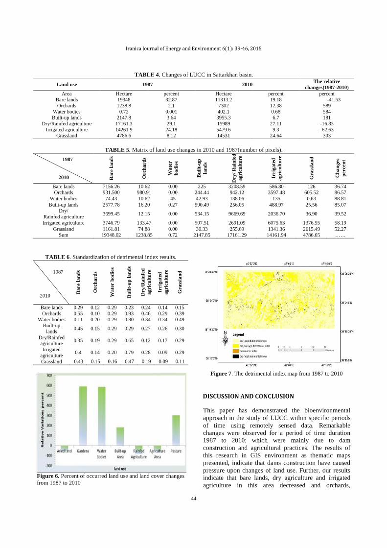
Figure 4. The developed land use land cover map for1987
Figure 5. The developed land use land cover map for 2010
Table 6 shows the standardized detrimental indices. It is
determined that the highest detrimental index is related
to built-up lands (see Figure 7). These areas increased
at the cost of decreased agricultural land uses, Orchards
and bare lands. Also development of water bodies after
dam construction has led to a decrease in agricultural
land areas and also caused pollution of air and water
RESULTS
A classification and change information extraction
about the land use/land cover in Sattarkhan dam basin
was conducted, using Landsat TM and ETM + images.
Then the land use/land cover and its accompanied
change information from 1987 to 2010 were obtained
(see Figures 4 and 5, Table 4). This can be summarized
as a decrease of the area of irrigated agriculture, bare
lands and dry agriculture and a significant increase in
the area of built-up lands and water bodies (see Figure
6).
TABLE 1. Detrimental indices weights assigned to the change in land use/land cover.
Land use
Bare
land
s
Orc
hard
s
Wat
er b
odie
s
Built
-up
land
s
Dry
/Rai
nfed
ag
ricu
lture
Irri
gate
d ag
ricu
lture
Gra
ssla
nd
weight 2 1 10 10 2 1 1
Iranica Journal of Energy and Environment 6(1): 39-46, 2015
44
TABLE 4. Changes of LUCC in Sattarkhan basin.
Land use 1987 2010 The relative
changes(1987-2010)
Area Hectare percent Hectare percent percent Bare lands 19348 32.87 11313.2 19.18 -41.53
Orchards 1238.8 2.1 7302 12.38 589
Water bodies 0.72 0.001 402.1 0.68 584 Built-up lands 2147.8 3.64 3955.3 6.7 181
Dry/Rainfed agriculture 17161.3 29.1 15989 27.11 -16.83
Irrigated agriculture 14261.9 24.18 5479.6 9.3 -62.63 Grassland 4786.6 8.12 14531 24.64 303
TABLE 5. Matrix of land use changes in 2010 and 1987(number of pixels).
1987
2010 Bare l
an
ds
Orc
ha
rd
s
Wa
ter
bo
die
s B
uil
t-u
p
lan
ds
Dry
/ R
ain
fed
agric
ult
ure
Irrig
ate
d a
gric
ult
ure
Gra
ssla
nd
Ch
an
ges
perce
nt
Bare lands 7156.26 10.62 0.00 225 3208.59 586.80 126 36.74 Orchards 931.500 980.91 0.00 244.44 942.12 3597.48 605.52 86.57
Water bodies 74.43 10.62 45 42.93 138.06 135 0.63 88.81
Built-up lands 2577.78 16.20 0.27 590.49 256.05 488.97 25.56 85.07 Dry/
Rainfed agriculture 3699.45 12.15 0.00 534.15 9669.69 2036.70 36.90 39.52
Irrigated agriculture 3746.79 133.47 0.00 507.51 2691.09 6075.63 1376.55 58.19
Grassland 1161.81 74.88 0.00 30.33 255.69 1341.36 2615.49 52.27
Sum 19348.02 1238.85 0.72 2147.85 17161.29 14161.94 4786.65 ……
TABLE 6. Standardization of detrimental index results.
Bare l
an
ds
Orc
ha
rd
s W
ate
r b
od
ies
Bu
ilt-
up
la
nd
s
Dry
/Ra
infe
d
agric
ult
ure
Irrig
ate
d
agric
ult
ure
Gra
ssla
nd
Bare lands 0.29 0.12 0.29 0.23 0.24 0.14 0.15
Orchards 0.55 0.10 0.29 0.93 0.46 0.29 0.39
Water bodies 0.11 0.20 0.29 0.80 0.34 0.34 0.49 Built-up
lands 0.45 0.15 0.29 0.29 0.27 0.26 0.30
Dry/Rainfed agriculture
0.35 0.19 0.29 0.65 0.12 0.17 0.29
Irrigated
agriculture 0.4 0.14 0.20 0.79 0.28 0.09 0.29
Grassland 0.43 0.15 0.16 0.47 0.19 0.09 0.11
Figure 6. Percent of occurred land use and land cover changes
from 1987 to 2010
Figure 7. The detrimental index map from 1987 to 2010
DISCUSSION AND CONCLUSION
This paper has demonstrated the bioenvironmental
approach in the study of LUCC within specific periods
of time using remotely sensed data. Remarkable
changes were observed for a period of time duration
1987 to 2010; which were mainly due to dam
construction and agricultural practices. The results of
this research in GIS environment as thematic maps
presented, indicate that dams construction have caused
pressure upon changes of land use. Further, our results
indicate that bare lands, dry agriculture and irrigated
agriculture in this area decreased and orchards,
1987
2010
Iranica Journal of Energy and Environment 6(1): 39-46, 2015
45
grasslands, built-up lands and water levels increased.
Evaluation of matrix of changes shows that the highest
alterations are related to the water bodies and the least
ones are concerned with dry agriculture.
It is figured out that area of orchards have increased
dramatically. Finally, having calculated the detrimental
index, it was determined that the highest detrimental
index is related to the converting of the agricultural
land uses, orchards, grasslands, bare lands to water
bodies and built-up lands and the minimum detrimental
index is related to converting of these land uses to
orchards and irrigated agriculture. Thus, the occurring
changes in this area and after the construction of dam
and its water channel indicated that even though the
natural tranquility of this area disrupted in dam
construction area. The results of this research will be
important for decision makers and, in particular, for
government departments such as the Ministry of
Agriculture, the Ministry of Water Resource
Management, and the Ministry of Natural Resources of
the East Azerbaijan Province of Iran. Initial discussions
have already been triggered about how to enhance
further the level of detail portrayed in the LUCC maps.
This enhancement will be carried out for Sattarkhan
basin in collaboration with the decision-making
authorities. It will include actions to designate specific
areas in agricultural land use planning. However, in
cultural landscapes the ecological and socio-economic
realms are intricately linked [25, 26].
1. Ikusemoran, M., 2009. Landuse And Landcover Change
Detection In The Kainji Lake Basin Nigeria Using Remote Sensing And GIS Approach. Bayero Journal of Pure and Applied
Sciences, 2(1): 83-90.
2. Zhou, Q., X. Ou, Z. Zhang and M. Yang, 2008. Spatial-Temporal Land Use Pattern Changes in Manwan Hydropower
Station Reservoir of Lancang River, Yunnan, China. Journal of
Mountain Science, 26(4): 481-489.
3. Esam, I., F. Abdalla and N. Erich, 2012. Land Use and Land
Cover Changes of West Tahta Region, Sohag Governorate,
Upper Egypt. Journal of Geographic Information System, 4: 483-493.
4. Jensen, J.R., Introductory digital image processing: a remote
sensing perspective,1996: Prentice-Hall Inc: xi-318.
5. Luong, P.T., 1993. The detection of land use/ land cover changes
using remote sensing and GIS in Vietnam. Asian Pacific Remote
Sensing Journal,, 5: 63-66.
6. Dhorde, A., S. Das and A. Dhorde, Evaluation of Land Use/Land
Cover Change in Mula-Mutha Watershed, Pune Urban
Agglomeration, Maharashtra, India, Based on Remote Sensing Data,5(3):108-121
7. Green, K., D. Kempka and L. Lackey, 1994. Using remote
sensing to detect and monitor land-cover and land-use change. Photogrammetric Engineering and Remote Sensing, 60(3): 331-
337.
8. Kaufmann, R.K. and K.C. Seto, 2001. Change detection,
accuracy, and bias in a sequential analysis of Landsat imagery in the Pearl River Delta, China: econometric techniques.
Agriculture, ecosystems & environment, 85(1): 95-105.
9. Yuan, F., K.E. Sawaya, B.C. Loeffelholz and M.E. Bauer, 2005. Land cover classification and change analysis of the Twin Cities
(Minnesota) Metropolitan Area by multitemporal Landsat
remote sensing. Remote sensing of Environment, 98(2): 317-328.
10. Adeniyi, P.O. , A., Omojola, 1999. Land use/Land cover Change
Evaluation in Sokoto-Rima Basin of N.W. Nigeria Based on Archival Remote Sensing and GIS Techniques in P.O. . Adeniyi
(Ed) Geoinformation Technology Applications for Resource and
Environmental Management in Nigeria,AARSE, 143 – 172.
11. Zhao, Q., S. Liu and S. Dong, 2010. Effect of dam construction
on spatial-temporal change of land use: a case study of Manwan,
Lancang River, Yunnan, China. Procedia Environmental Sciences, 2: 852-858.
12. Ahadnejad, M., Evaluation and modeling of land use changes
using multitemporal satellite imagery and GIS. Dissertation,, 2000, University of Tarbiyat Modares.
13. Rostamzadeh, H., Evaluation of large dam impacts on land use
changes using Remote Sensing and GIS,, 2004, University of Tarbiyat Modares.
14. Alavipanah, S.K., Application of Remote Sensing in
Geosciences, , 2003, Tehran University Press, 478.
15. Janssen, L.L. and G. Huurneman, Principles of remote sensing,
2001: ITC, International Institute for Aerospace Survey and
Earth Sciences, Enschede, The Netherlands, second edition.
16. Yan, G., 2003. Pixel based and object oriented image analysis
for coal fire research. Dissertation. University of Twente.
17. Lillesand, T.M., R.W. Kiefer and J.W. Chipman, Remote sensing and image interpretation2004: John Wiley & Sons Ltd.
18. Pedroni, L., 2003. Improved classification of Landsat Thematic
Mapper data using modified prior probabilities in large and complex landscapes. International Journal of Remote Sensing,
24(1): 91-113.
19. Richards, J.A. and J. Richards, Remote sensing digital image analysis. Vol. 3. 1999: Springer.
20. Bishop, Y.M., S.E. Fienberg and P.W. Holland, Discrete multivariate analysis: theory and practice,2007: Springer.
21. Manouchehri, G. and S. Mahmoodian, 2002. Environmental
Impacts of dams constructed in Iran. International Journal of Water Resources Development, 18(1): 179-182.
22. Lunetta, R.S. and C.D. Elvidge, Remote sensing change
detection: environmental monitoring methods and applications1999: Taylor & Francis Ltd.
23. Neshat, A.H., A. , nalysis and evaluation of LUCC using
Remote sensing and GIS in Golestan province, 2002, University of Tarbiyat Modares.
24. Serra, P., X. Pons and D. Sauri, 2003. Post-classification change
detection with data from different sensors: some accuracy considerations. International Journal of Remote Sensing, 24(16):
3311-3340.
25. Blaschke, T., 2006. The role of the spatial dimension within the framework of sustainable landscapes and natural capital.
Landscape and urban planning, 75(3): 198-226.
26. Feizizadeh, B., T. Blaschke, H. Nazmfar, E. Akbari and H.R. Kohbanani, 2013. Monitoring land surface temperature
relationship to land use/land cover from satellite imagery in
Maraqeh County, Iran. Journal of Environmental Planning and Management, 56(9): 1290-1315.
REFERENCES

Iranica Journal of Energy and Environment 6(1): 39-46, 2015
46
Persian Abstract DOI: 10.5829/idosi.ijee.2015.06.01.08
چکیده
( ضذه است که عامل اصلی تغییرات زیست محیطی است. دراین مقاله، اثرات زیست LUCC)Land use/Land coverوسازسذسثة ایجاد فطارتر ساخت
،یعنی دوره 0272و7891درزمان های (+ETM)و TMتررسی ضذه وتغییرات اخیرتااستفاده ازعکس های 0272تا7891محیطی ساخت وسازسذستارخان ازسال
ترای دسته تنذی عکس های زمانی قثل وتعذ از ساخت سذتررسی ضذنذ. روش تررسی ضامل دومرحله اساسی است. درمرحله ی اول، تکنیک های پردازش تصویر
می کنذکه کطاورزی تاآب وزمین های تایروکطاورزی انجام ضذ. داده هامطخص post-classificationماهواره ای تااستفاده از روش تطخیص تغییرات مقایسه
ته LUCC تذون آب دراین دوره ی مطالعاتی کاهص یافته است درحالی که ساخت وسازآتی افسایص یافته است. تراساس این مفهوم، تغییرات قاتل توجهی در
ی کطاورزی وتاغ هاته ساخت وسازهای آتی توده است. ته عنوان یک کارگرفته ضذه ونطان داده که تیطترین نطانه های خسارت آور، مرتوط ته تثذیل زمین ها
ارزیاتی کلی، ساخت وساز سذتاثیرات مثثت تیطتری نسثت ته اثرات منفی زیست محیطی داضته است.