Embed Size (px)
Citation preview

VOL. 2
EA-2025lRP-74311 PP-325
DRAFT FINAL REPORT (ANNEXURE TO THE REPORT)
ON
INTEGRATED SOCIAL AND ENVIRONMENTAL ASSESSNIENT STUDY FOR COMPLETE REHABILITATION AND
MODERNIZATION OF NAGARJUNASAGAR PROJECT
SUBMITTED
TO
PROJECT DIRECTOR, PPMU, APWSIP JALASOUDHA, ERRAMANZIL, HYDERABAD
4 EPTRI
ENVIRONMENT PROTECTION TRAINING & RESEARCH INSTITUTE 9114, Gachibowli, Hyderabad - 500032.
Phone Nos: 23001241,23001242,23000489 Fax: +40-23000361
IPP325v2
Pub
lic D
iscl
osur
e A
utho
rized
Pub
lic D
iscl
osur
e A
utho
rized
Pub
lic D
iscl
osur
e A
utho
rized
Pub
lic D
iscl
osur
e A
utho
rized
Pub
lic D
iscl
osur
e A
utho
rized
Pub
lic D
iscl
osur
e A
utho
rized
Pub
lic D
iscl
osur
e A
utho
rized
Pub
lic D
iscl
osur
e A
utho
rized


ANNEXURE 1A-DISTRICT PROFILES
Nalgonda
Nalgonda l~cs to the south east of the famous south Indian city. Hyderabad. Nalgonda is prcscnt as a s~nall district in thc Andhra Pradesli state. The profile sc\icals rural characteristics with thc placc holdlng as many as 1 150 small villages. Thc rcgion is boundcd by other important districts like Mcdak, Mahabubnagar, Khamniam and Rangarcddy. Thc placc is about 65 kilomctrcs from Hyderabad city and access to the rcgion is providcd by road and railway services.
Environmental Status
Physical Characteristics
Latitude: 16" 25' N and 17" 50' N Longitude: 78" 40' and 80" 50' of E. Area : 142 17 Sq. Kms.
j . Ra~lways / * Dlslrlcl HoaJsuarto~
lrralor Town 1 r Other Tour:
-.L~lvsrf--
Climate
The climate of 1Valgonda district is characterized by a hot summer and general dryness except during the South-West monsoon. On an average, there are about 46 rainy days i.e. days with rainfall of 2.5 mm or more in a year in the district. The average normal rainfall
0
is 753 mm. May is the hottest month with mean daily maximum temperature at about 40 0
C and with mean daily minimum temperature at about 20 C. The day temperature may 0
occasionally go to about 45 C during May or in June, prior to the onset of the monsoon. 0
December is the coldest month with mean daily maximum temperature at about 30 C and 0
night temperature may drop to below 10 C.
Soil Type
The district is characterized by three major soil types. Loamy sands constitute 47%, Red soils 44% while the black cotton soils form 9%. Red calcareous gravelly clay soils occupy large area followed by equal proportions of red shallow gravelly loam, deep calcareous black soils in Damarcherla. Red shallow gravelly loose soils occur followed by alluvio-colluvial clay soils in Garidepally. Red shallow gravelly loam soils occupy large areas followed by saline, sodic soils in Huzumagar. Red clayey, medium deep

cal.black and red shallow gravelly loam soils in that order are predominant in Nereducherla.
Surface Water
The district is drained by rivers Krishna, Musi, Alair, Peddavagu, dindi and haliya. Krishna river is the most important river forms the southern boundary.
Ground Water
The Ground water Potential of the district is 569MCum and the Ground Water Utilization is 64MCum. Out of the total 65 blocks, 3 blocks are facing over exploitation of groundwater, 27 blocks are in the safe category, 30 are semi critical and 5 are critical
Pollution
Paraboiled rice mills located in close viscinity to the branch canals are discharging their effluents into majors and field channels in Miryalguda and Neredcherla mandals. Partially treated or un-treated effluents find their way into natural water courses polluting surface water, thereby affecting the agriculture in these areas. Cement industries are located in Damarcherla, Mellacheruvu, Kodad mandals in the command area. Dust emanating from these industries is not only affecting the agriculture but causing severe respiratory problems in the people in the surrounding areas
Biodiversity
The total forest cover is 154 sq.km which is only 1.08% of the total geographical area of the district
Social Status
Demography and Social Characteristics
The total population of the district is 32.48 lakhs out of which the urban population is 4.33 Lakhs and the rural population is 28.15 lakhs. The female population is 15.95 lakhs and the sex ratio is 966. The district has 5.76 lakhs (17.7 %) Scheduled Castes out of which there are 2.8 lakhs females and 2.9 lakhs males. The district also has population of 3.4 Lakhs (10.6 %) belonging to Scheduled Tribes out of which there are 1.6 lakhs females and 1.8 lakhs males. The total literacy rate is 49.13 and the number of literate males and females are 9.82 (59.4 percent) and 6.14 lakhs (38.5 percent) respectively. There are a total number of 68,23,29 land holdings accounting an area of 24.99 lakh Acres and the average area per holding is 3.66 Acres. Maximum number of land holdings is 1.23 Acres.

Tribals
The major tribal groups in the district are Sugali, yerukula, chenchu, yanadi, savara, koya, thoti, kammara, bagatha, gondlnaikpod The tribal population is 342676 which is 10.55% of the state population. The literacy of the tribals in the district is 14.5%
Economic Status
Nalgonda is typically a rural district and as such house a great number of villages. Agriculture and small scale industries are main avenues wherein the population is engaged. There are very few regions that can be said as comparable to the city outskirts. Main industries established at Nalgonda deal with silk, leather, Cotton and Jaggery.
The major crop in Nalgonda is paddy. The gross area irrigated including both food and non-food crops in 2000-01 is 538605 hectares, whereas in 2005-06 is at 606429 hectares. During 2000-01 the productivity was 9704 kglhectare and in 2005-06 the productivity was 9168 kglhectare and cropping intensity is 96 percent. ID crops are grown in only 11 % of the area in the command area under this district. The total area is 96079 Ha for cultivation of horticulture crops.
Fisheries
The fish Production of the District is mainly by Inland, which contributes the bulk quantity wise 16328 tonnes in 2003-04 whereas 18038 tones in 2004-05 of Inland fish production.. The most common species of inland fish are Barbus, Carps, Cat fishes, Murrel, Mullets, Prawns, and Hisa etc., The total no. of small tanks are 272, production is 250 tonnes and the yield is 250 Kgsl ha, the total no. of medium tanks 180, production is 7650 tonnes and the yield is 750 Kgsl ha and the total no. of large tanks are 172, production is 7950 tonnes and the yield is 850 Kgsl ha
Industries
The South East part of Nalgonda District, along the Krishna belt is rich in high grade limestone, which is the main raw material to cement industry and as such many cement industries in Large and Medium Sector as well as clinker grinding units have come up in that area. Due toabundance of granite many granite cutting and polishing units have been established in Suryapet area and also in the district border nearer to Hyderabad. Because of Nagarjunasagar project and SLBC, agriculture output has increased and has resulted in establishment of raw rice mills and parboiled rice mills. Nalgonda has the largest cluster of parboiled rice mills in Andhra Pradesh.
Tourism
Nalgonda feature many tourist attractions in the forin of popular religious and heritage sites. The popular religious sites in Nalgonda include Matampalli. Wadapally.

Yadagirigutta, Kolanupaka. Pangal, Sunkishala, Gajulabanda, Yelcswaram. Phanigiri, ctc. Nagarjuan Sagar. thc place housing thc tallest masonly dam is a sacrcd placc for thc Buddhists. Thc placc derived its name from a known Buddhist scholar Nagarjuna. 111 thc iniddlc of thc lake spread over hcrc is Nagarjuna Konda that features tlic excavations of an ancient Buddhist civilization.
Khammam
The Khammam District of Andhra Pradesh is situated in the south east India. Its location is between 16-45 and 18-35 North Latitude and 79-47 and 80 -47 East Latitude. Khammam is bordered by Krishna district in the north, by East and West Godavari districts in the east. It is limited by the Krishna district in south and in west by Nalgonda and Warangal Districts. Khammam's total area is 16,029 Sq. Kms. It is the district headquarters.
Environmental Status
A l b w .
Edra
Physical Characteristics
16-45 and 18-35 North Latitude and 79-47 and 80 -47 East Latitude.
Climate
The climate of Khammam district is comparatively equitable and although it is very hot 0
in May with mercury rising upto 52 C. The normal rainfall is 1124.0 mm, and 79.2 % of the total rainfall is received through Southwest Monsoon, which is fairly reliable
Soil Types
Red clayey soils are predominant followed by saline sodic and red gravelly loam soils in Madhira. In Wyra mandal, deep cal. black soils occupy large area followed by red gravelly loam and saline sodic soils. Red clayey and red calcareous clayey soils are extensive in Yerrupalem. Rock lands and red clayey soils occur in equal proportions in large area followed by red shallow gravelly clay soils in Kallur. Saline-sodic and red

clayey soils occur predominantly in Penubally mandal. Red clayey followed by red gravelly clay soils is predominant in Vemsoor.
Pollution
Sugar factory effluents are entering into the branch canal at Kallur.
Biodiversity
The total forest cover is 7,180 sq.km
Social Status
Demography and Social Characteristics
The total population of the district is 25,78,927 The female population is 12,73,384,. The district has 4,26,692 Scheduled Castes. The total literacy rate is 50.13%.
Tribals
The major tribal groups in the district are Koya, sugali, nayak, yerukula, gondlnaikpod, konda reddi, konda dora, yanadi, valmiki, kammara, goudu
Econonlic Status
Nalgonda is typically a rural district and as such house a great number of villages. Agriculture and small scale industries are main avenues wherein the population is engaged. There are very few regions that can be said as comparable to the city outskirts. Main industries established at Nalgonda deal with silk, leather, Cotton and Jaggery.
Agriculture
The major crop in Khammam is Paddy. The gross area irrigated including both food and non-food crops in 2000-01 is 422 1 16 hectares, whereas in 2005-06 is 4357 19 hectares. During 2000-01 the productivity was 202603 kglhectare and in 2005-06 the productivity was 216658 kglhectare and cropping intensity is 106-138 percent. ID crops are grown in 57% of the command area in this district. Figure 25 represents the cropping pattern in Khammam District.
Fisheries
The fish Production of the District is mainly by Inland, which contributes the bulk quantity wise 14002.00 tonnes in 2003-04 whereas 17480 tones in 2004-05 of Inland fish production. The most common species of inland fish are Barbus, Carps, Cat fishes, Murrel, Mullets, Prawns, and Hisa etc.
Industries

There are some medium and small industries located in the command area. About 25 paraboiled rice mills are in the mandals of Khammam rural, Nelakondapalli and Sathupalli and three sugar factories are in Kallur and Nelakondapalli mandals of the district
Tourism
The tourist Places in Khammam include Munneru River side, GuntuMallanna Temple,Quila of Khammam , Narasimha Swamy Temple, Lakaram cheruvu Resorts and Krishna Mandir
Krishna
The Krishna District is situated in the east ' m l ~ I Tirururu 1 D i G z G J of Andhra Pradesh, India. The borders of w ~ a W U
: UlllplbgOL*Xn. Jswxlldnavdrdvl
this district are West Godavari district in M~~ l \ \ tiambha:pndu . V I W ~ ~ ~ B ~ ~ . 4
the East, Bay of Bengal in the South, J*wmT"uga*~b' \ R ~ ~ I I ~ ~ .
Guntur and Nalgonda districts in the West 9 \ wlp.mc \
.~*yuvlpu*n) . m r m ="'W' and Khammam district in the North . Oh"lPro(rpsdl + M .-+ . directions. The total area is 8,727 square 4 .., ,.-a* p-- &+f
.Li"amaDe(lo kilometers and its Head Quarters is at _&- - ~ ~ - I I L * D *tcl.ctaru i * • - Machilipatnam. ,. h n a k r M b l l l t U ~ f.jp a lldnd **'
) I y .MUaWsls Wbualurr
4 ' .8mumdh* rjrsqu r *""lyp.n~)(sr~~ I Environmental Status 8 Koll ,,.&*. I
"*"b *hd-
Physical Characteristics
I Dslnct Bwndaq The global location of Krishna District is ~ ~ . ~ ~ ~ ~ a . u ~ BEffiAL
Maor Rwds *wSWnfka between 1 5" 43' N and 1 7" 10' N Latitude mTalagawrn
The climate of Krishna district is tropical in nature with hot summers and moderate winters. April to June are the summer months with temperatures ranging from a minimum of 27 OC to 45 OC. The temperatures during the winter months range from 28 to 17 "C. The area is very humid, the average humidity ranges from 68% during summer season. The average annual rainfall in the district is 890 mm.
and 80" 0' and 8 1 " 33' of E Longitude.
Soil Types
Dtsslo Hoedquafler Major Town Omor Town RIV~IS
Red clayey soils occur in large area followed by red calcareous clayey soils in A. Konduru and Gampalagudem mandals. In Tiruvuru mandal, red clayey soils alone are predominant. In Penuganchiprolu red clayey soils occupy large area followed by red
Climate

calcarious clay soils. Red calcareous clayey followed by red gravelly clay soils are predominant in Vatsavai mandal. Red calcareous clay soils followed by red clayey soils occur in large area in Nandigama
Ground M'ater
The areas of high salinity waters are found in Mylavaram, Jaggayyapeta, Vemsoor, Nandigama, Nuziveedu, Tiruvuru and Kanchikacherla mandals

Biodiversity
The total forest cover is 25 1 sq.km
Social Status
Demography and Social Characteristics
The district has a population of 4 1.87 lakhs out of which 2 1.17 lakhs are males and 20.70 lakhs are females. There are 978 females per 1000 males. The urban population is 32.08 Percent and rural population is 67.92 percent. The district has a total number of 746832 (17.83 %) of Scheduled Caste population and 10761 l(2.57 %) of Scheduled Tribe Population. The Scheduled Castes population has 49 percent female population and Scheduled Tribes have 48 percent of female population. The total literacy rate is 60.65 percent which includes total male literacy of 65.47 percent and total female literacy of 55.72 percent.
Tribals
The major tribal groups in the district are Sugali, yerukula, yanadi, konda reddi, Chenchu, konda kapu, konda dora, manne dora, koya, redid dora, katunayakan, gondhaikpod, kammara, gadaba.
Economic Status
Agriculture
The major crops in Krishna are Paddy and Chillies. The gross area irrigated including both food and non-food crops in 2000-01 is 604271hectares, whereas in 2005-06 is 59995 1 hectares. During 2000-01 the productivity was 142893 kglhectare and in 2005-06 the productivity was 146795 kg/hectare and cropping intensity is 100-200 percent. ID crops are dominant in this district with 84% of crop area. Figure 26 represents the cropping pattern in Krishna District.
Fisheries
The major crops in Krishna are Paddy and Chillies. The gross area irrigated including both food and non-food crops in 2000-01 is 604271hectares, whereas in 2005-06 is 59995 1 hectares. During 2000-01 the productivity was 142893 kghectare and in 2005-06 the productivity was 146795 kghectare and cropping intensity is 100-200 percent. ID crops are dominant in this district with 84% of crop area. Figure 26 represents the cropping pattern in Krishna District.

Industries
The 60 industries located in the command area of this district are small scale ones and are mostly cement, agro based and textile industries. Cement and textile industries are located in Jaggayyapeta mandal of the command area.
Tourism
The Krishna district has a large number of Tourist Spots like Bhavani Island Leisure Spots Vijayawada, Ghantasala Buddhist Centres Ghantasala, Hazarat Bal Mosque Piligrim Centres.
Guntur - - ~ v r u R -. . .-
Guntur is one of the I"!s!!c'.@P
latryscd districts of Andhra Pradesh Liada. \ Acltarnvsl.
bounded by Krishna district ,,,,,,,,,. ,Mw3mt;l~~*~ ,. . +$Muraca c 4'amsw1P , .RIIULU pnlaruiae nrLi5mu
and Bay of Bengal in the ,,,,,, ,,,,. ) p e w Kurapaac. ~mIT&eLwlB tmdlLond. .wYanetaei:l I 'Dug .Kamnaudl East, while on its south lies \
Mduku~u NekaNuBa. $[,~adda Yudln:auil~
~ l ~ d u n l . A' \ sa*mr~lQ
Prakasam district, in the . . . M a U e v w ' S W f w d u RfmMrhena
/ 1, west Mahabubnagar district
; Kolakdur~
.. , .I*-mpt 9 b * ..CCy , .Kull~para
*, t and Krishna and Nalgonda : "
- p?IL.u
Am*. ~:"CIC aS i Ic.*uw " ! ' ,,,,&" , :* ,-. , ,\ districts in the North. The ' .:
' '~oll*ru sawwammf'. 4
- .J ,,..-. , ., . ,,. . .
1 'innu-. ' 1 BhStUprulkl.
rivers Krishna, ~ m n w * ) ~ ~ l ( b r r A
ym% ' wumanu R.W.8 Chandravanka, Naagileru, ) -waram. , . I m."%mkr . P.,,,,,.,,, , .' N.LLIII~I~III,II,,.\
and Gundla Kamma flow j ~ ~ c l ~ * . R , /.ip.u w~runwmunl
through the district. The r 8 , / . l.4dll* :un,i : 4 BAY OF
major places of the district . F ~ ~ ~ 2.11' -:.c - - M L ~ ~ . DENGAL . : ~
are Guntur, Bapatla, Tenali, Narasaraopeta and Ponnur. It is spread over an area of 1139 1 Sq.kms. According to 2001 Census the population of the district is 4405.52 comprising of 2220.30 males and 2 185.2 1 females.
Environmental Status
Physical Characteristics
Guntur district is situated between 15"-16" and 16"-50" of Northern Latitude and 70" - 10" and 80"-55" of Eastern Longitude.
Climate
The climate of Guntur district is tropical in nature with hot summers and moderate winters. April to June are the summer months with temperatures ranging from a minimum of 27 "C to 50 OC. The temperatures during the winter months range from 24 to

18 "C. The area is very humid, the average humidity ranges from 68% during summer season. The average annual rainfall in the district is 890 mm.
Soil Types
Red shallow calcareous gravelly loam soils occur in large area followed by deep black soils in Gurazala. Deep calcareous / non calcareous black soils are extensive in Rentachintala mandals. Red clayey and red calcareous clayey soils are extensive in Vinukonda and Savalyapuram mandals while they are in reverse order in Nuzendla mandal. Deltaic calcareous black soils occupy large area followed by seed clayey soils in Prathipadu and Padanandipadu mandals. Medium deep calcareous black soils are extensive followed by red calcareous clay soils in Tadikonda and Thulluru mandals. Medium deep calcareous black soils and red clayey and red gravelly clay soils are predominant in Amaravathi mandal
Ground Water
The areas of high salinity waters are found in Rajupalem, Prattipadu, Medikonduru, Phirangipuram, Sattenapally, Muppalla, Edlapadu, Nadendla, Vinukonda, Ipur, Uppalapadu, Pedakakani mandals
Social Status
Demography and Social Characteristics
The total population of the district is 44.65 lakhs. The female population is 22.15 lakhs and the sex ratio is 984. The district has a total of 8.18 lakhs (18.32% ) Scheduled Caste.The total literacy rate is 55% and the male literacy is 62.5 percent percent and female literacy is 47 %.
Tribals
The major tribal groups in the district are Yerukula, sugali, yanadi, Chenchu, manne dora, konda kapu, reddi dora, koya, savara, kammara, jatapu, hill reddy.
Economic Status
Agriculture
The major crops in Guntur are Cotton, Chillies and Paddy. The gross area irrigated including both food and non-food crops in 2000-01 is 563000 hectares whereas in 2005- 06 is 600000hectares and cropping intensity is 132 percent. ID crops are grown in 63% of the area.
Fisheries

The most common species of inland fish are Barbus, Carps, Cat fishes, Murrel, Mullets, Prawns, and Hisa etc., whereas the most common species of marine fish are Elasm branches, cat fishes, lesser sardines, mackerel, seer fish, ponfiets, sards & saneless etc. The total no. of small tanks are 5 14, production is 1532 tonnes and the yield is 950 Kgsl ha, the total no. of medium tanks are 159, production is 685 tonnes and the yield is 1200 Kgsl ha and the total no. of large tanks are 30, production is 286 tonnes and the yield is 1500 Kgsl ha
Industries
Lime kiln and stone crushing industries are predominant in the command area in this district. They are located in Piduguralla, Macherla and Pericherla mandals.
Tourism
Amaravati Museum, Bapatla Beach(Surya1anka) Beaches Ethipothala Water falls, NagarjunasagarGuthikondaCaves at Guthionda Kondaveedu Monumens, Nagarjuna Sagar Dam, Undavalli Cave Caves Undavalli Uppalapadu Birds Sanctuary
Prakasam
Situated in the south-eastern India, Prakasam is an administrative district in Andhra Pradesh. The district headquarters are located at Ongole. It is one of the nine coastal districts of Andhra Pradesh. According to the 2001 census, the total area of Prakasam District is 17626sq.km. The population in Prakasam is 3054.94 (in thousands), in accordance to the census done in 2001. The Literacy Rate of Prakasam is 57.86%.
Environmental Status
Climate
& D~stncl Map
*
The climate of Prakasam district is moderate both in winter and summer seasons in the coastal areas and in the non coastal areas, it is very hot especially in the tracts of uplands and adjoining hills. The normal minimum and maximum temperatures in the district are 19°C and 39 "C. The district receives rainfall mostly and predominantly from South West as well as North East monsoon. The average annual rainfall in the district is 782 mm.
Soil Types

Red clayey and red loamy soils occur in equal proportions over large area, followed by small extent of deltaic calcareous black soils in Karamchedu. Deltaic calcareous black and red loamy soils are predominant in Parchur. In Yellampudi deltaic calcareous black soils are extensive followed by a small extent of saline-sodic soils. Deltaic calcareous black soils, saline sodic and alluvial soils in that order are dominant in Kothapatnam. In Ongole deltaic black soils are predominant in area. Laterite and deltaic calcareous black soils in that order are dominant in Santhanutalapadu. Deltaic calcareous black and red clay soils occur in nearly equal proportions in Tanguturu. Red calcareous clay soils occupy large area in Addanki, Thallur and Mundlamuru.
Ground Water
The areas of high salinity waters are found in Cheemakurthi, Nagulauppalapadu, Santhanuthalapadu, Addanki, Martoor, Parchuru,Inkollu, Darsi, Thripuranthakam, Tangutur mandals. In Ongole, Chimakurthy, Addanki, Tripurantakam, Balikurava, Inkolu, Darsi, Karamchedu, Talluru, Mundlamuru, Santanuthalapadu mandals the groundwater is alkaline in nature and the pH value varies from 8.1 to 8.49. The ground water has high fluoriude levels in Ongole, Addanki, Cheemakurthy, Darsi, Talluru and Tripurantakam Mandals. The total dissolved solids, chlorides, nitrates and total hardness are within the permissible limits.
Biodiversity
The total forest cover is 3,104 sq.km
Social Status
Demography and Social Characteristics
The total population of the district is 30,59,423. It accounts for 4.20% of the total population of the State and is ranked 1 4 ' ~ in the size of the population. The female population of the district is 15,07,091 and this forms 49.27% of the district and 4.02% of the State female population. The literacy rate of the district is 50.08% which is lower than the State literacy rate of 61.55%. The total literacy rate in the district is 57.4 percent which includes total male literacy of 69.4 percent and total female literacy of 69.4 percent. The total literacy rate in rural is 54.5 percent which includes total male literacy 67% and total female literacy rate is 41.5 %. The total literacy rate in urban is 73.3 percent which includes 82.2% male literacy and female literacy is 64.3%.
Tribals
The major tribal groups in the district are Yanadi, yerukula, sugali, Chenchu, koya, savara, kammara, pardhan, jatapu
Economic Status

Agriculture
The major crops in Guntur are Cotton, tobacco and Paddy. The gross area irrigated including both food and non-food crops in 2000-01 is 279795 hectares whereas in 2004- 05 is 427981 hectares and cropping intensity is 94 %.ID crops are grown in 58% of the area.
Fisheries
The fish Production of the District is mainly by Inland and marine fisheries, which contributes the bulk quantity wise 16758 tonnes in 2003-04 whereas 13516 tones in 2004-05 of marine fish production. Inland fish production in 2003-04 is 6206.65 Metric tones whereas in 2004-05 it is 5623.70 Metric tones. The most common species of inland fish are Barbus, Carps, Cat fishes, Murrel, Mullets, Prawns, and Hisa etc., whereas the most common species of marine fish are Elasm branches, cat fishes, leaser sardines, mackerel, seer fish, ponfiets, sards & saneless etc.,
Industries
There are 20 large and medium scale industries in the command area. Granite industries are predominantly located in Chimakurthy mandal and there are around 45 small and medium scale industries located in the command area. Some of them are in close viscinity to Ongole branch canal. Apart from this, there are cotton yarns, tobacco processing and milk chilling units in S.N. Padu, Mundlamur and Maddipadu mandals.
Tourism
Markapur is India's main slates manufacturing town and it is where the historic temple of god Chennakesava is situated. Chimakurthi is famous for granite and Dornala is known as diguva Srisailam, since it is very near the historic pilgrimage of Srisailam.

ANNEXURE 1B- MAPS
MAP 1: NS COMMAND AREA
Legend - R. Krishna
0 District Boundary

MAP2: NS MAIN AND BRANCH CANALS
10 0 10 20 Kilometers Nagarjuna Sagar Main and Branch Canals I

MAP3: GROUND WATER LEVELS-PRE MONSOON-AP
Depth to Grou~id Water levels in Andhra Pradesh N A
meters
~undary

MAP4: GROUND WATER LEVELS-POST MONSOON-AP
Ground Water level -Ructual:ion in Andhra Pradesh N
m a y - 2006 and May-2007
B" apatnam
Legend G W level flucteatio~i h
Rise(+) Fdl ( - 1
n o - 2
1 2 - 4 m2- l ' 4 1 > 4
( District boundary District Hq.

MAPS: GROUND WATER FLUCTUATIONS-AP
Ground Water level fluctuation in Andhra Pradesh N I
: bound: t Hq.

MAP6: WATER LOGGED AREAS IN LMC
PUT?! - ql) MAP SHOWING WATER LOGGED AREAS .~ ... .. ... FOR PREMONSOON NSP LEFT CANAL COMMAND
KHAMMAM DISTRICT
NALGONDA DISTRICT
GUNlUR DISIWCT
4- hezaneter
DTW Contour - Main canal
Area Prone to Water logging

MAP7: WATER LOGGED AREAS IN RMC
""
of NS-ESA Study area during February 1997 I

n '?' -.? "4 PLATE - 6(b) MAP SHOWING WATER L066ED AREAS I.-, '*. b.'... s,
I FOR PREMONSOON NSP RIGHT CANAL COMMAND - . - . -. -.s4
I .,-*' 1,
I
MAPS: WATER LOGGED AREAS-PREMONSOON-RMC

MAP9: LAND USE PATTERN IN NS COMMAND AREA-1997

oz 0 oz
ewe Kpnvs 0 eeJe po66ol~e)el(((
se!Poq JeFM rn )q/Sq30J )eBl(S/e)SeM Kuo)~
dora el6u!s :%;$; VSwoJ qwas rn sleueapelr!y eele Bu!u!l(y -
sqwas )noqa!wa!M puel rn suo!)e)ueld )sarod
spuel moiled dola elqnoq
)seloJ esueq rn spuel dn)l!ng
le6ueg )o Keg rn suo~e)ueld le~n)lnauBv rn
u! ralroa puey asn

MAP1 1: DRAINAGE PATTERN-NS COMMAND AREA 79.30' 80:00' 80.30'
I
20 0 20 40 Kilometer

MAP12: TYPICAL BRANCH CANAL LAYOUT-RMC
Typical Branch Layout
RIGHT Bank Canal M 126 - 0 -060
Veerayapalem Major M-16-000
-- -..- ,.- -...-.-... Chintala cheruvu Major
Mukkellapadu Major
4
Veerayapalem Major M-164351 -
DBC M 16-1-196 4
3arsi Branch M - 0-0-000
Double lane bridgeM-2-0- 51 5
Agriculture research station M-
+

MAP12: TYPICAL BRANCH CANAL LAYOUT-LMC
Typical Branch Layout
Left Bank Canal
Huktyala Branch 5 - A1 m
Y = 8 a P
R7 Major b E E
L m o
MatlaPal~ Major
Gundtapadu Major
Mukteswaram Major
Rampur Major b
Buggamedhavaram Majar
b g

ANNEXURE IIA- PROJECT BASELINE DATA
1.1 Ground water
Table 1: Stage of Ground Water Exploitation in Krishna District
Stage of GW exploitation
Konduru
1 Gampalagudem 1 Safe 1 Safe
7 Jagayapeta Safe Safe
3
4
5
1 9 I I I I Vastal ( Safe / Safe
Tiruvuru
G.Konduru
Ibrahimpatnam
I I
8
Safe
Safe
Safe
I I I
1 13 ( Vissanapeta
Penuganchiprolu
1 1
12
I Safe
Safe
N. A
Safe
10
1 Safe I
I
Safe
Safe Ganavaram
Agripally
Reddygudem
Safe
Safe
Safe
Safe
1 14 I I I
NA
NA
Chandralapadu
15
16
*Stage of Ground Water Exploitation: Safe < 70 % Semi Critical 70 - 90% Critical 90- 100% Over Exploitation > 100%
I I I
Safe
Kanchikacherla
Nandigamma
17
Safe
Safe
Safe
Veerullapadu
Safe
Safe
Safe Safe

Table 2: Stage of Ground Water Exploitation in Guntur District
1 3. 1 Rentachintala I 4 1 Safe I
1 SI.No.
1.
2.
1 5. 1 Nuzendia I 2 1 Safe 1
Mandal
Gurajala
Macherla
I I I I
Stage of GW exploitation (%) 2004
5
12
Safe 4.
6.
7.
Category
Safe
Safe
I I I I
I pur
Vinukonda
Savlypuram
1 8. I Guntur
m n a n d i p a d u i I
I 1 Vatticherukune 1 Safe
13
4 1 Safe
1 I I I
7
4
Safe
10.
Safe
Safe
I I I
1 15. / Rajupalem I 20
Prattipadu
13.
14.
13 12.
4
Achampet
Bellamkonda
Krosur
16.
1 17.
Safe
Manchavaram
Nakrekallu
7
Dachepally ---
Karampudi
1 20. Piduguralla I I I
[ 23. 1 Nadendla I 3
Safe
18
14
14 I
I I
25. Narsaropet 5
9
10
19
Safe
Safe 1 Safe
I
21. I Chilkaluripeta I 1 1
Safe
Safe
Safe
1 27. 1 Muppala 1 3 I Safe I 1 26.
I I
) 29. ( Phirangipuram 1 3 I Safe I
Safe I Medikonduru
-ueddakurapadu i I
4
4 Safe
I I I
Safe 30. 1 Sattenapally 2

31. / Amaravathi
*Stage of Ground Water Exploitation: Safe < 70 % Semi Critical 70 - 90% Critical 90- 100% Over Exploitation > 100%
32.
33
I 34
Table 3: Stage of Ground Water Exploitation in Prakasam District
15
Sl No.
safe 1 Tadikonda
Tulluru
Kakumanu
( Gangavaram l o 1 Safe ) ground water
11
34
1
Safe ~ Safe
I Safe
Mandal
Inkollu
Village
Duddukuru
I Inkollu
Remarks Stage of GW
exploitation
development I I
Bheemavaram
Idupulapadu
Safe
Category of GW exploitation
Koniki I
Suitable for
0
50
20
Safe 1 Not suitable for
0
Safe
Safe
I Pusapadu / 25 ( Safe I
Safe
Nagandla
Pavuluru
Parchur Not suitable for
ground water Upputuru Safe
development Veerannapalem Safe
3 7
4 3
I I I I
Parachuru
Safe
Cherukuru 0 1 Safe
I I
1 ground water
conjunctive use
Nuthalapadu I I I I
1 development
Safe 1
Nagulappapadu
I I I I I Darsi ( Devavaram I
I / Safe ) Suitable for
3 Safe
Maddirala Muppalla
I I Tanachintala I 9 1 Safe I
I I
Pothavaram 1 70 1 Semi-critical
7
conjunctive use
Safe Not suitable for

t z i i ~ z b a p u r a m ~ l Safe
( Annavaram I l 3 I Safe
1 Darsi I Safe
E.Veerayapalem 2 5 1 Safe I
1 Kottapalli I I
12 Safe Suitable I I I
1 Lankojipalli 1 39 I Safe conjuncti
Mohiddinpuram ' Pothakamuru 55 Safe
Rajampalli 5 5 Safe
I Ramchandrapuram 1 79 I Semi-critical
( Samanthapudi i 1 Safe I
I I Safe
Kurichedu 1 Avulamanda 1 l 5 I Safe I
Yerra Obanapalli 88 1 Semi-critical
Danakonda Battipadu 5 8 Safe Suitable
Chandavaram
1 Kalluru ) 27 I Safe I Suitable
Bayyavaram
Jagannadapuram
conjuncti
conjuncti Polepalli 16
43
1 Mustlagangavaram 1 ",3 1 S a ~ l
Naidupalem I
Safe
12
I P.VeerayapaIem I 25 I Safe 1
Safe
2 5 I Safe
I I I I
Guntupalli
Kopparapalem
Kopperapadu Safe I
Ballikurva 1 Ballikurva I 66 1 Safe I I I 1 Chennupalli 1 16 1 Safe ve use 1 Suitable
conjuncti

1 Kukatlapalli / 39 1 Safe I
Vallapalli 1 117 1 OverExploitation (conjunctiveuse
Marturu
I I I
Muktheswaram 1
Uppumaguluru
Vaidana Safe Suitable for
Alavalapadu 1 88 I Semi-critical 1 Suitable for
I I
Vemavaram
Budavada I / Safe 1 Not suitable for
160
conjunctive use I I
development
Over Exploitation
Bayatamanjuluru
ground water I I
14
Chandaluru I o I I
Muppavaram
Safe
Safe
J.Panguluru
Kondamuru
Kotapadu
Safe conjunctive use
34
42
44
Nujellapalli I 2 I Safe I
Safe
I I
Ramakuru 235 I Over Exploitation
Safe
Safe
Renangivaram ) 96 / Critical 1
Suitable for
I I
Takkellapadu 1 44 1 Safe I I 1
Dronadula I 41 ( Safe I
Bollapalli
Bobbepalli
Darsi
I I
Jangameswarapuram 73 Semi-critical
Jonnathali
94
Over Exploitation
conjunctive use I
Kolalapudi 1 161 I Over Exploitation 1
Critical
129
94
I I
Konanki 137 Over Exploitation 1
Suitable for
Over Exploitation
Critical I
Lakkavaram 1 105 1 Over Exploitation ( Marturu I 81 I Semi-critical 1
I I
Nagarajupalli 48 Safe

I Vallaparla
1 Chandrapadu 1 54 I Safe I
7 7 1 Semi-critical I e ~ a n d lamudi
I 1 I
1 Cheemakurthy I I
1 146 Over Exploitation 1 15 1 Over Exploitation 1
I
1 Manchikalapadu I 26 1 Safe I
Ilapavuluru
K.Agraharam
1 Pallamalli 1 112 1 Over Exploitation 1
77
100
1 Rangasaipuram 1 161 ( Over Exploitation 1
Semi-critical I Critical 1
Suitable for Nekunambad
1 P.Naidupalem 354
I I 1 Yerragudipadu 1 34 1 Safe
8 3
1 T.Gudipadu I I 1
/ Busarlapalli ) 76 I Semi-critical I
Semi-critical
204
I I
Devarapalem 1 148 I Over Exploitation
Over Exploitation
1 Mylavaram 2 2 1 Safe / conjunctive use
Suitable for I I
I
Safe G.Lakshmipuram
Nippatlapadu
1 ~ a v i ~ a d u 1 77 1 Semi-critical 1
8
104
Safe
Safe
Pidathalapudi
Pulikonda
PPuram 1 Ramchandrapuram
9
25
65
40
Kotapatnam
1 Kothapatnam I Safe 1 conjunctive use
Safe
Safe
I Ethamukkala
I I ( 56 1 Safe
Gonuguntla 38 ---
Alum
57
Padarthi 1 37 1 Safe
32
development
Safe 1 Suitable for
I I I
7
1 P.kandrika 6 1 Safe I
Safe Not suitable for
ground water

I ( Rajupalem 1 124 / Over Exploitation 1
I , I I conjunctive use
I I I I
Ongole
1 Devarampadu I I
I Malleswarapuram l o 1 Safe 1 Not suitable for
Cheruvukommupalem
2
Koppulu
60 1 Safe I Suitable for I
Safe
2
I I
Safe I
Kothamamidipalem 1
Narasapuram
I Ongole
Safe
ground water Mangladripuram
Pelluru
Sarvareddypalem
1 Gudimendlapadu I 1 Safe 1 Not suitable for
9
7 3
Vengamukkapalem
Yerrajerla
I Mukthinuthalapadu ( 2 ( Safe 1 ground water
57
6
15
Safe
Safe
Semi-critical I
Safe
Safe
183
109
development
1 1 1 1 ground water
Over Exploitation
Over Exploitation
development I I
Santanutalapadu
I I I 1 development
Suitable for
conjunctive use
Throvagunta
Endluru
Guravareddipalem
Lakshmipuram
Mangamuru
6
Minampadu
Rudravaram
B. Machavaram Safe Suitable for
Chilakapadu Safe conjunctive use
Safe
16
27
2 1
8
I I I
2 1
Pernamitta
( P.Takkellapadu 1 l 5 / Safe 1
I
Safe
Safe I
Enikapadu
Gummalampadu
Konaganivaripalem
Suitable for
14 Safe I
8
5
49
Safe
Safe
Safe
Safe I
Safe
Safe
conjunctive use
Not suitable for

I Safe
1 Kanduluru 1 15 1 Safe
I conjunctive use
27 Ponduru 14
Suitable for
I Mallavarappadu I l6 1 Safe I I
Safe Tangutur
1 Marlapadu I I 1 91 1 Critical 1 Suitable for
1 conjunctive use
Somavarappadu I Safe
1 Turpu naidupalem 1 5 1 Safe 1 Not suitable for
1 Valluru I I
2 Safe ground water
) Valluru kavali manyam 0 I Safe I development I I I
Vasepallipadu I 3 1 Safe
Adanki 1 Bommanapadu 1 49 1 Safe I
1 China Kothapalli 8 6 Semi-critical
Denuvukonda I 82 Semi-critical
Semi-critical
F - f e J 1 Kalavakuru Safe
Koticalapudi 64 Safe
Kunkupadu 28 Safe Suitable for
Manikeswaram 2 6 Safe pp conjunctive use , Modepalli 1 04 1 Mylavaram 1 ;3 1 ;:: , Nannurupadu
1 Narasimhapuram 1 l 2 1 Safe I 1 Nonh Addanki i
33
1 Ramayapalem ( 15 ( Safe I
Upalapadu 24 Safe --
Vemparala 7 8
Korisapadu Anamanamuru
Bodduvaripalem
P.Gudipadu
59 1 43
29 I
Safe
Safe
Suitable for
conjunctive use
Safepi

Maddipadu
I Ravinuthala
I Doddavaram 1 64 I Safe 1 Suitable for
conjunctive use
46 Safe
I Maddipadu
Garlapadu
Lingamguntla
ground water
development
7 3
( Nelaturu I ) Safe ( Not suitable for
Semi-critical
Mallavaram
I , I I development
I
11
I I
Venkateswarapuram 1 5 1 1 Safe
7
ground water
1 Chinnaullagallu I 1 Safe I
I
Safe
I I
Mundalamur
Safe
Suitable for
conjunctive use
Not suitable for
Avisanavaripalem
Chintalapudi
Kellampalli
1 Pasupugal lu I 90 1 Semi-critical I
I Basavpuram
Mundlamur
N.V.Kandrika
I I
Peddaravipadu 1 30 1 Safe 1 Suitable for
2
14
8
Safe
13
Safe
Safe
88
1 Polavaram I l6 I Safe I
Safe
Semi-critical
I I
Peddaullagallu 1 24 1 Safe
0 1 Safe 1
conjunctive use
I 22 1 Thammaluru 1 Safe I 1 Sankarapuram
1 I
( Umamaheswarapuram ) 8 1 Safe I
29 Safe
1 Vemulabanda 1 Safe
Vempadu
Vemula
44
17
Brindavanam
Safe
Safe - ~
22 / Safe I I I
Pulipadu
Singanapalem 1 285 Over Exploitation
Bhimavaram ' 15
Safe
Safe
35

Edara 12 Safe
Jammulamadaka 13 Safe
Kambhampadu 25 Safe
Kommavaram
1 Marella I 42 I Safe I
I
Talluru I Boddikurapadu 1 29 1 safe
Purimetla
I I
S.N.Puram 0 1 Safe
) Suryapalem I I Safe I
15
1 Dosakayalapadu 1 Critical 1
Safe conjunctive use
P
Over Exploitation
1 Malkapuram 1 84 I Semi-critical 1 Suitable for I I
Mannepalli 9 8 1 Critical conjunctive use
1 Nagambotlapalem 1 243 I Over Exploitation 1 I I
Ramabhadrapuram ( 772 I
1 Sarvamitta I 49 1 Safe I
1 Sivaramapuram I
185 i Over ~ x ~ l o i t a t i o n l
1 Somavarappadu 1 119- I Over ~ x ~ l z a t i o n ] I
Talluru 3 13 Over Exploitation
Over Exploitation Suitable for
conjunctive use Manepalli Safe
Narsapuram r l I I
Tripurantakam I Kanakalapalli 1 l 7 1 s a f e s
1 Miriyampalli I I
1 44 1 Safe I I
1 Rajupalem 1 69 1 Safe I

I Tripurantakam 1 141 1 Over Exploitation conjunctive use
( Annasamudram I 6o / Safe I I
1 I I Viswanathapuram
1 Medapi I 47 1 Safe I
I I
121
Ganapavaram
Gollapalli 143 I coEO")~"c'ive use
Over Exploitation i
I 1
*Stage of Ground Water Exploitation: Safe < 70 % Semi Critical 70 - 90% Critical 90- 100% Over Exploitation > 100%
129
Table 4: Safe area (3-6 m b.g.1) Observation Wells in Krishna District
Over Exploitation
Suitable for Dupadu 89 Semi-critical
1 Icode no.) ) I 1 1
Sl.No. Well No r(HNS 1 patsavai Polam&
K T a
+pa -p Ja gaiahpet G a r i k s u 5.75
---I L 2. -- - - - - - - !
----
Location of Observation well ~ o t a l Depth f r o d Mandal ivillage Ground Level 1
Table 5: Deeper water table area (>6 m b.g.1)
4. 5. 6. 7.
9 13 15 38
9. 10. 11. 12.
14 16 17 19
: -- -A 5.00 ~ 5.35 --
Vatsavai [ ~ a k k a ~ e t a Jaggaiahpet A.Konduru Mylavaram
Jaggaiahpet A.Konduru Vissannapet Chatrai
Chillakallu A.Kondum M y l s a m
Chillakallu A.Konduru Putrela Chatrai
6.55 7.30 13.95 7.00

Table 6: Water logging (2-3 m b.g.1) Observation Wells in Guntur District

Table 7: Safe area (3-6 m b.g.1)
from Ground
1 2 lgiven Medikonduru Korrapadu
1 : 1 *a;na;:ly Ph ran i uram Ponugupadu 5.1
Dhulipalla 5.2
1 ~h r-uram Nudurupadu m g i p u r a m -- Bethapudi -~ -- -
,Pedakurapadu Talluru 8 I 1 ~ r o s u r u Dodleru
1 4 . 8 I5
Bellamkonda Machayapalem '4.55 1 Kandipadu Bollavaram 4.75
r9 i Krosuru 0
( ~ a r a s a r a o ~ e t Ravipadu Narasaraopet Kotappakonda Narasaraopet Kattubadivari &m de' 5.5 --PI --
Ananthavaram A t c h a p - ; - 1
Chinakondayapalem

Table 8: Deeper water table area (>6 m b.g.1)


Table 9: Safe area (3-6 m b.g.1) Observation Wells in Prakasam District
- - - - - - -
Table 10: Deeper water table area (>6 m b.g.1)
1 S1.No I Well No 1 Location of Observation Well Total Depth from Ground Level
1 I ( Mandal 1 Village I I 1 2
3 4
1 71 / Venkatarajupalem 1 6.30
199 66 67
1 ( 101
~ ~
/ Chavatapalem 1 9.57
Ongole Tanguturu
69 72 -- 97
5 153 I Cheemakurthy 1 Pallamalli 1 8.82 1
Kothapatnam Alluru N.G.Padu Nidarnanuru
N.G.Padu 9.65
Ongole Valluru Koniiedu
7.50 7.10 8.06
I

6.30 1 1.40
881 10.58 13.46
I
Maddipadu Gundlapalli -- Chilakapadu ---- Santhanuthalapadu Pemamitta
7
/
11
8
9
10
12
142 233 63 64 65
143 3 04 75
58 174 175 176
S.N.Padu
6 8 138 3 02 303 74 202 73 202 95 96
179 265 3 04 76 77
Ballikurava
Veluguvaripalli Chintalapudi Ailapalem Dosakayalapadu
Addanki
---- Korisa p a d ~
J.Panguluru I
S.Maguluru
7.30 9.50 7.75 6.05
Kopperapadu
Mangamuru Sandrapalem ---- P.Takkellapadu Gummalampadu Vemparala Addanki
8.00
Gorrapadu ----- Kopperapadu S.L.Gudipadu Kommalapadu Eluchuru
11.95 9.20 7.50 11.50 7.59 10.10
7.80 Vaidana
6.20 6.20 6.40 6.38 7.20
1 I
Medarametla Korisa padu Muppavaram Alavala~adu

I
171 172 193 222 235 311 35 3 6 165 3 12 330 3 0 33
I
223 224
1 226 310 4 1 44 46 48
Kurichedu
34 106 197 214 -- 3 2
Mundlamuru
Umamaheswarapuram Brundavanam Pasupugallu Reddynagaram Vempadu Pd.Ravipadu Avulamanda Kurichedu Chandavaram
7.30 9.30 9.40 7.35
Thripuranthakam
Gollapalli Medaui
Pullalacheruvu I.T.Varam 1315 I316
8.30 8.00 9.65 9.00 10.5 7.00 12.75 10.10 9.10 I
Vengayapalem Kandrika G.Umrnadivaram Thri~uranthakam
9.05 9.40
Boddikurapadu
1 Gangavaram Bheemavaram Sankarapuram Chintalapudi Naiduualem
Medanepalli Siddannapalem
8.75
8.70 1 1.05 10.6 6.95 9.80
12.00 9.80


Table 12:
Mandal
A.Konduru mandal A.Konduru
Cheemalapadu
Garnpalagudern rnandal Gampalagudem
Konijerla
Vutukuru
Tiruvuru Mandal Kakarla
Peddavaram (tvr)
Tiruvuru
G.Konduru mandal Sunnampadu
Ibrahimpatnam Mandal Kondapalli
Mylavaram Mandal Chandragudern
Mylavaram
Pulluru
Jaggaiahpeta mandal Chillakallu
Garikapadu
Gowravaram
Jaggaiahpeta
Ground
Well no. (hns- kr)
15
20
10
02
06
11
03
04
43
54
33
38
25
13
07
19
12
Water
Well type
Dug well Dug well
Dug well
Dug well Dug well
Dug well
Dug well
Dug well
Dug well
Dug well
Dug well
Dug well
Dug well
Dug well
Dug well Dug well Dug well
Quality in Krishna District for the year 2002
TH EC pH TDS Na C0, HC03
200 1500 8.95 960 263 99 280
200 600 8.25 384 45 0 110
300
180 824 8.88 527 116 80 2 10
620 3720 8.56 2381 456 80 190
160
440
400
220
280
180
240
200
260
240
500
240
1400
1789
1260
1243
2020
990
1968
884
825
1306
1826
762
9.04 1 896 258
130
116
181
313
143
335
105
70
145
187
73
8.65
7.85
8.9
8.77
8.81
8.88
8.67
8.15
8.75
8.07
8.64
1145
806
796
1293
634
1260
566
528
836
1169
488
99
80
0
99
80
60
80
60
0
99
0
60
330
170
368
280
220
220
280
280
170
170
110
170


Table 13: Ground Water Quality in Prakasam District for Pre Monsoon 2004
L
17.
Village Mandal mgll ' mg 11 mgll I mg/l
NO3 Na K Ca ppm epm ppm epm ppm epm
All constituents in ppm. EC in micromhos/cm at 25OC
Itavaram
Konayapalem
Munagacherla
Muppala
Nandigama
Peddavaram (ng)
Veerullapadu
Alluru
Nitrate
42
30
24
36
31
23
32
Sodium
Dug well Dug well
Dug well
Dug well
Dug well
Dug well
Dug well
Potassium Calcium I
180
200
840
140
180
380
180
940
780
3000
528
1517
2070
1185
8.49
7.93
7.99
8.22
8.64
8.13
8.77
602
499
1920
338
971
1325
758
140
87
331
64
170
201
185
40
0
0
44.8
142
19.4
220
120
110
0
60
0
80
5
5
11
105
74
473
210
120
120
139
227
82.3
166
180
20
168
410
126

Table 14: Ground Water Quality in Prakasam District for Post Monsoon 2005
) 8169 1 8176
Pullalacheruvu Konijedu
l~articulars of 1 I Results
S.NO
Pullalacheruvu Tanguturu
sample
Village
9.20 38.00
Sp.cond micro
siemans
60 152
TDS (Sp*0.64)
2.61 6.61
35 41
Sulphate mgll
Chloride mgll C 1
0.90 1.05
ppm ppm
Nitrate Mgll
No3 as N epm epm ppm
56 72
epm
2.8 3.6


Table 15: Ground Water Quality in Prakasam District for Pre Monsoon 2005


9495 9496
9497
Mottumala Gundayapalem
Kanaparthi
0.27 0.19
0.25
110 291
5 134
4.7826087 126.73913
5.826087
75 105
72
1.9181586 2.685422
1.8414322
56 320
72
2.8 16
3.6
24 680
34
1.9736842 55.921053
2.7960526

1.2 Agriculture
Table 16: Area, Production and Productivity of the crops for the year 2000 -01 in Khammam
I
,
Table 17: Area, Production and Productivity of the crops for the year 2005 -06 in Khammam District
District
7
8 Cowpea 0 0 0 2517 485 9 Groundnut 43 9 1614 708 4906 2270 10 Sesamum 6420 736 4725 2243 736 11 Sun-flower 0 0 0 934 650 1 12 Chillies 4255 7440 31657 55 19 7522 13 Sugarcane 3787 75000 284025 2524 75000 --
I 14 Cotton 95840 967 92677 Lint 0 0 15 Tobacco (N) 0 0 0 3501 12889 16 Tobacco (V) 0 0 0 1147 6524 7483
SI.No
1 - 2 3 4 5 6 7
Kharif 2005 - 06 Crop
Rice Jowar Maize Redgram Greengram Blackgram Horsegram
Rabi 2000-01 S1. No 1 - 2
3 4 5
Rabi Area
137962 1326
2934 1 29068 ----- 25339
518 0
Kharif 2000 - 01 Area
7458 --
13810 --
2559
Crop
Paddy Paddy UI Total Jowar Bajra Maize
Area
34577 428 1
11448 4165
11036 12436
136
1 6 7 8 9 10 1 1 12 13 14 15 16 17
Productivity KgiHect .
3901 125 1 2243 1241 558 520
0
Production '000'M.T~. 692 108 800 2.0 0.2 8 8
Productivity Kg./Hect. 5200 --
550 0 4850
Redgram Greengram -- Blackgram Horsegram Cowpea Groundnut Sesamum Sun-flower Chillies Sugarcane Cotton Tobacco Total
Area
136845 35693 172538 2409 367 18985
ppppp
Productivity KgIHect.
3 147 128 1 2243 906 556 599 523
Production '000'M.T~.
538189 1658
6581 1 36073 14139
269 0
Production '000'M.T~. 38.78 --
7.6 0 13.0
Productivity Kg./Hect. 5060 3050
740 5 85 4650
25490 29703 328 0 0
Production '000'M.T~.
108820 5484
54858 3773 6136 7449
7 1
580 550 520 0 555
15.0 16.0 0.2 0 0
1 1 14 7554 0 16407 ---- 3743 82875
-- 361513
1594 1830 6796 586 5032
700 pp
335 590 58 1 560 pp
1055 350 760 3300 76000 1250
-- --
1.1 0.6 4.0 0.7 3.0
1301 200 750
1.12 2.6 0
, 54.0 284.1 103 .O -- --
3400 --- 83000 0 1581 --
7678 5 10 60 8142 1545 --
2814 60603
27.7 128.0 0 4.5

Table 18: Area, Production and Productivity of the crops for the year 1996-97 in Krishna District
SI. No
1 food crops 1
Crop
I
Area in lakh ha. Kharif I Rabi I Total
Production in lakh MT. Kharif 1 Rabi ( Total
Productivity in kglha. Kharif 1 Rabi I Ann.

Table 19: Area, Production and Productivity of the crops for the year 2006-07 in Krishna District
Crop Area in lakh ha. Production in lakh MT. Productivity in kglha. Kharif 1 Rabi I Total Kharif ] Rabi 1 Total Kharif I Rabi ) Ann.
I crops
Table 20: Area, Production, and Productivity for the year 1996-97 in Nalgonda District
17 Total food
20 2 1 22 - 23
18 19
crops Ground nut Sesamum
-- 2790 581
SL. No
1
0.06 5768 246
0.39 Castor Cotton
Tobacco Other non- food crops
0
0.06 0.000
8558 827
29438 115 4859
Crop
Rice
0 0.39 0.00
pppppp-
0
0 29553 4859
0
Area in Hects.
Kharif I Rabi ( Total 162340 1 120013 1 282353
2126
Production in lakh M.Ts
- I - I
-
1313
Productivity in Kgs /ha Kharif 1 Rabi 2933 1 2496
-
- I
Ann. avg
2715 Total 7.756
Kharif 4.761
Rabi 2.995

25 Gross area 446762 176387 623149 5.9525 3.3493 9.3018 14023 12870 1344 irrigated 7

Table 21: Area, Production, and Productivity for the year 2005-2006 in Nalgonda District
Crop Area in Hects. Production in lakh M.Ts Productivity in Ann.av Kgs /ha g
Kharif Rabi Total Kharif Rabi Total Kharif Rabi Rice 149755 140305 290060 8.354 6.597 14.951 5579 4702 5141 Wheat 0 0 0 0.000 0.000 0.000 0 0 0 Jowar 7635 7635 16577 0.0524 0.0697 0.122 687 780 1 734 Baira 7879 7879 7879 0.0544 0.000 0.054 69 1 0 346 Maize 1 698 1 0.0000 1 0.000 1 0.000
crops Total food 244308 160500 404808 8.4608 6.68764 7732 7577 crops ---- - - Groundnut 1 6539 21604 38143 0.1309 0.222 0 792 1029 911 Seasamum 0 0 0 0.000 0.000 0 0 0 0 Castor - 78709 0 78709 0.2644 0.000 0 336 0 168 Cotton 841 12 0 841 12 0.8621 0.000 0 1 1025 0 ) 513 Tobbaco 0 0 0 0.000 0.000 0 1 0 0 1 0 Other non 0 657 657 food crops --- Total non- 179360 22261 201621 food c r o p l Gross area / 423668 1 182761 1 606429 1 9.71824 1 6.90994 15.14844 ) 9575 1 8761 1 9168 irrigated -

Table22: CROP WISE AREAS - KHARIFF - FROM 1997-98 TO 2006-07 (HECT)
Table 23: KHARIF SEASON - PRODUCTIVITY 1997 - 98 TO 2006-07
Note: Cotton: Productivity in Lint' Productio in Bales of each 170 kgs.
SI.No
1
Crop
Paddy
1997- 9 8
2,951
1998- 99
3,181
1999- 2000 3,297
2000- 01
3,371
2001- 02
3,432
2002- 03
3,187
2003- 04 2833
2004- 05 3469
2005- 06 3090
2006- 07 2838

Table 24: KHARIF SEASON - PRODUCTION 1997-98T0 2006-07
Note: Cotton: Productivity in; Lint' Productio in Bales of each 170 kgs.
Table 25: CROP WISE AREAS - RABI - FROM 1997-98 TO 2006-07 (HECT)
Name of No the crop I i
Table 26: RABI SEASON - PRODUCTIVITY IN KgsIHectare 1997 - 98 TO 2006-07
8 9
1997-
Cower Others Total
1998- 1999
4300 24100
98 2000-
02 2001-
5000 23100
99 I - 2002- 2003
o I 03 I -04
3700(
2004 2005- -05
3200i
06 I 2006-07
209004 230004 25100( 3500
26100) 20100( 19400
900 4400(
213004 25600
22004 2004 2004 100 3000( 5000 43004 5300(

Table 27: RABI SEASON - PRODUCTION IN Tonnes. 1997 - 98 TO 2006-07
Table 28: Area, Production and Productivity for the Year 1996-97 of Pedapadu & Pedavegi Mandals in West Godavari District
SI.No
Table 29: Area, Production and Productivity for the Year 2005-06of Pedapadu & Pedavegi Mandals in West Godavari District
Name of the crop
1997- 2002- 1998- 9 8
2005- 1999- O o 3 04 1 2p- 2006- 99
2000- 06 2000
2001- 07 0 1 02 , 03

Table 30: Relationship between irrigation, Fertilizer use and Agricultural Productivity in Krishna District
S1. 1 Mandal No 1
1.
Total Area Irrigated
1 2.
3.
4.
Konduru
5.
6.
) 12. / Reddygudem 1 4869 1 250 1 1.5 1 4875 1
Fertilizer Consumption
Gampalagudem
Tiruvuru
G.Konduru
9.
10.
11.
Pesticide Food grain 1 Consumption ( yield per ha. 1
(ha.) 5687
Ibrahimpatnam
My lavaram
11689
8006
8074
Vastal
Ganavaram
Agripally
I I I I I I
43 7
663 1
14.
1 15.
Table 31: Common pests in Krishna District
kg 4500
per ha. kg per ha. kg
250
200
5826
3898
5068
13.
16.
17.
1 S1. No. I Name of the Pest Name of the Crop I
25 0
250
200
Vissanapeta
Chandralapadu
Kanchikacherla
1 ) Stemborer, Leaf folder, Brown Plant Hopper 1 Paddy 2 1 Maruca Pod borer, Tobacco Cater pillar, Thrips, 1 Pulses I
1 .O
2.0
1.5
250
300
300
630
Nandigamma
Veerullapadu
1 1 Aphids
4875
4875
250 , 1.5
1 .O
1 .O
200 1 .O
9083
) 3 Bollworms. Tobacco Cater pillar. Thrips, I Cotton 1
4125
4500
4500
1.5
1 .O
1.5
4875
4500
1536
1088 1
4125
4875
4875
I Aphids
4500
4500
250 2.0 I
200
Maize 4
1.5
Stemborer, Whorl maggot

Table 32: Relationship between Irrigation, Fertilizer use and Agricultural Productivity in Nalgonda District
Table 33: Common Pests in Nalgonda District
Total area irrigated hects
Table 34: Departmental officials District wise number of training programmes conducted 2006-2007
Cropping intensity %
S1.No Name of the pest Name of the crop
2 3 4
Fertilizer I Pesticide Consumption Consumption per ha.kg per ha.kg
I S1.No
I 2 I Extension Officer on IPM Cotton ( 3 ( 45
Foodgrain yield per ha.kg
Tungro Virus, Sheath blight Helicoverpa. Spodoptera Helicoverpa Botrietis
1
Cotton Redgram Castor
Type of training programme conducted 1 No. of Training 1 programmes
No. of officials
1 conducted Season Long Training Programme(SLTP) I 1
I
trained 3 5

Table 35: WUAs, Farmers Organization, Farmers etc. 2006-07
1 1 I Season Long Training Programme( 1 2 / go I 1
0rga.Farmers etc.trained
S1.No 1 Type of training programmes
I conducted
3 I Gender Cell( Women) ( 20 1 1750 4 1 Skill based ( Women) 1 5 1 255
No. of Training programmes conducted
2
Table 36: Relationship between irrigation, Fertilizer use and Agricultural Productivity in West Codavari District
SLTP) ISOPOM 23 1 1150
( S.No
Table 37: Common pests in West Godavari District
1. 2.
S.No. Name of the est Name of the Cro BPH,Stemborer,Blast,Sheath bli ht Leaf and sheath bli ht Maize Leaf webber, Tikka leafs ot Groundnut Masuca Pulses
Mandal
Pedapadu 1 12255 Pedavegi 1 15346
Total area irrigated (ha)
86.4% 87.4%
Cropping Intensity (%)
335 ( 8 1 4200 850
Fertilizer consumption per.ha.kg
Pesticide Food grain

1.3 Horticulture
Table 38: MANDAL WlSE CROP WlSE STATISTICAL AREA OF HORTICULTUR CROPS DURING 2005 - 2006 IN KRISHNA DISTRICT
S.NO
1 2 3 4 5 6 7 8 9 10 11 12 13 14 15 16 17
I-
Name of the Mandal
Konduru gampalagudem Tiruvuru G Konduru Ibrahimpatnam My lavaram Jagayapeta Penuganjiprolu Vastal Ganavaram Agripall y Reddygudem Vissanapeta Chandralapadu Kanchikacherla Nandigamma Verullapadu
corriander
-- -- -- -- -- -- -- -- --
3 -- -- -- I
--
-- --
Banana
15 -- -- -- 17 10 13 -- -- --
18 -- --
9 1 3 0 4
onion
-- -- -- 2 3 --
-- -- -- 2
-- -- -- -- -- --
papaya
-- -- -- -- -- -- -- -- --
--
-- -- -- -- -- --
Cucumber
-- -- --
58 12 2 6 16 16 5 2 13 5 -- --
4
18 --
chillies
--
-- -- -- --
25
8
3 8 24 14 36 --
-- -- --
Bitter gourd
--
-- -- -- 5
4 -- -- -- 5 -- --
-- -- -- --
B
-- -- --
18 14 19 13 -- -- 6
12
2
5 --
Green leafy veg.
14 -- -- -- 9 -- 16 -- --
10 -- -- -- -- -- -- --
--
-- -- -- 2 -- -- -- -- -- -- -- -- --
-- -- -- --
Cabbage
-- -- -- -- -- -- -- -- -- -- -- -- -- -- --
--
--
Brinjal
3 -- --
5 1 14 18 2 0 15 -- -- 15 -- -- 5 --
2 1 --
Cauliflower
-- -- -- --
6 1 -- 7 -- -- -- -- -- -- -- -- -- --

Table 39: MANDAL WISE CROP WISE STATISTICAL AREA OF HORTICULTUR CROPS DURING 2005 - 2006 IN KRISHNA DISTRICT

Table 40: Mandal Wise Area Production and Productivity in West Godavari District in Pedavegi Mandal
S1.No.
1 Vegetables
Year
1996-97 250 1 2500 / 10
condiments Plantation Crops Flowers Medicinal Plants Total
2
Crop
Fruits
Spices &
2425 10 4
3834 1997-98 Fruits
Spices & Condiments Plantation Crops Flowers Medicinal Plants
0 1 0 ( 0
1998-99
Area in Lakh Ha.
1145
0 5 0 8
3060 10 4
1
I
0 5 2
Total Fruits Vegetables Spices &
, Condiments Plantation Crops 3730 1 0 ( 0 1
4
Production in Lakh Mt.
13736
0 5 0
8
5
Productivity Kg/ Ha.
12
1999- 2000
6
0 5 2
12 10 0
4492 1192 3 00
0
2000-01
1
14300 3000
0
Flowers Medicinal Plants Total Fruits Vegetables
2001 -02
1 Spices & condiments Plantation Cro p s Flowers Medicinal Plants Total Fruits Vegetables
10 4
5236
3 00
1 Spices & condiments Plantation Crops Flowers Medicinal Plants Total Fruits Vegetables
0
37841 10 4
53 14 1241 3 00
50 8
3000
0
3799 10 4
5354 1266 300
5 2
12 10
0
0 5 0
8
14888 3000
0
0
0 50 8
15194 3000
0
0 5 2
12 10
I 0 5 2
12 10
1

7
Medicinal Plants
1 1 Spices 8~ i 0 1
4 /
8
0
0 5 2
12 10 0
0 5
0
3884 10 4
5464 1292 300
o
3992 10
1 2Ei:mtnts
Total 5598 1
0
0 5 0
8
15500 3000
o
0 50
,
2002-03
1
9
1 1 condiments
Plantation Crops Flowers Medicinal Plants Total Fruits Vegetables Spices 8~ Condiments Plantation Crops Flowers
- -
10
-
1318 2003-04
2004-05
Table 41: Mandal Wise Area Production and Productivity in West Godavari District in Pedapadu Mandal
Vegetables 250 Fruits
2005-06
Plantation Crops -- Flowers Medicinal Plants Total
15817
Condiments -- Plantation Crops Flowers Medicinal Plants Total Fruits Vegetables Spices & Condiments
5946 10 24
7590
12 2500
44395 Flowers - Medicinal Plants Total Fruits Vegetables Spices &
10
41 10 I0 8
5696 1345 250
0
Productivity Kg1 Ha.
20 10
S1.No. Year Crop
Condiments Plantation Crops
0 10 20
6020 1372 238
0
0 5 0 16
- 16135 2500
0
4
Area in Lakh Ha.
3 0 24
213
P
0 5 2
12 10 0
5 0 0
16464 2380 1
0 I 0
Production in Lakh Mt.
600 240
5 0
12 10
0 1 0
0
0
0

Flowers
Ve etables 10 Spices & I 4 1 o ( o 1
0 1 0 1 0 1 Medicinal Plants Total Fruits
P 271
3 0
Plantation Crops Flowers Medicinal Plants Total Fruits Vegetables
600
Condiments 220
0
Spices & Condiments Plantation Crops
0
20
1 0 2 78
30 24
Flowers
Spices & Condiments
Flowers
0 0
4
255
Total
Medicinal Plants 0 ( 0 ( Total 384 /
0 0
0
600 240
0
313 1
0 1
20 10
0 l 0 '
0 1 0 1
Fruits 30 1 600 ( 20 ,
0
0 1 0 1 Medicinal Plants
Fruits Vegetables Spices &
0
0
30 24 4
Condiments
Flowers
Table 42: No. of Traing Programmes conducted for farmers in West Godavari District
0 Plantation Crops
0 1 0 1 0
Total
600 ' 20 '
0 367
425 (
240 0
Medicinal Plants
10 0
0 1 0 1 0
Type of training Programme conducted
No. of training Programme Conducted
5
10
40
44
No. of farmers Trained
200
400
1600
1760
Production technologies on various Horticulture Crops Production technologies on various 0
Production technologies on various Horticulture Crops and Mushrooms Production technologies IPMIINM.,
1~ 2000-0 1
2
-
3
4
200 1-02
2002-03
2003-04

4 5
4 5
Seminar on Cocoa and Mushrooms Production technologies IPMIINM., Seminar on Cocoa and Mushrooms and campaigns on Cashew Production technologies IPMIINM., Seminar on Cocoa and Mushrooms and campaigns on Cashew
5
6
1800
1800
2004-05
2005-06

Table 43: HORTICULTURE CROPS AREA PRODUCTION & PRODUCTIVITYDETAILS FROM 1998-99 TO 2005-06
I Plants I Total 1 2.176 5.615 1 25265.9501 1.00j 4.841 1 33824.2531 0.88j 5.477 1 36448.3251 4.964 4.969 1 42511.534
S1.Nc
1 2
Crop 2002-2003 2003-2004 2004-2005 2005-2006 Area in Lakh 0.13: 0.08: 0.46(
O.OO(
0.00' 0.00;
Fruits Vegetables
Plantation
Flowers Medicinal
-- Productivi? in KgIHa
17128 12500 2800
0.000
3270 750
Productio in Lakh Mt.
2.410 1.131 1.380
0.000
0.045 0.003
Area in Lakh 0.15' 1.30( 0 .70~
0.00(
0.01: 0.00
- Productivit Productio in Kg/Ha in Lakh
1386
0.000
0.010 0.004
Productivi? in KgIHa
18120 13963 3000
0.000
6429 1000
16730 11500
Productio in Lakh Mt.
2.578 1.538 1.438
0.000
0.058 0.003
0.61d
O.OO(
0.01( 0 .00~
1.725
0.000
0.033 0.003
0.12: 0.12e
Productivit: in KgIHa
16740 1183 2043
0.000
0.01 1 0.003
2.141 1.575
Area in Lakh 0.155 0.091 0.73(
O.OO(
0.01. 0.00:
Productio in Lakh Mt.
2.660 1.127 1.01 2
0.000
3655 554

Table 44: Status of Vermi compost, Organic farming, INM, IPM and MNM activities
S1.No
I 1
Table 45: Area, Production and Productivity of Horticulture Crops in Prakasam District
2 3 4 5
1 S1. Crop / Area in Ha. I Production in lakh MTs. ) Productivity in I
Name of scheme/Component Vermicompost Organic Farming --- --- --. Integrated Pest Management 1200 Micro Nutrient Management --- ---
No.of UnitsMectares I Area of Operation 300 1 32 Mandals
1 I condiments
No. 1 2 3
6 I Medicinal Plants 1 1603 ( 24790.7 1 55.08 / Total I 86526 1 742371.2 1 326.48
Fruits Vegetables Spices &
( 4 15
Table 46: Status of Vermi Compost, Organic farming, INM, IPM and MNM activities
Name of Scheme1 Component pq-
471 16 19860 17312
Plantation Crops I 200 (
-
Area of Operation Hectares
Flowers
Markapur, Tarlupadu, Pedaraveedu, Ardhaveedu, B. Peta, Giddalur, Kanigiri, C.S.Puram, Veligandla, Pamuru, Chirala, Kothapatnam
469080.5 208220
40280
435 1
Organic farming
MTsIha. 163.4
99 9
Integrated Nutrient Management
l 4 1 Integrated Pest Management
Chillies - Kandukuru, Jarugumalli, Ponnaluru, V.V.Palem, Korisapadu
Sweet Orange - Y.Palem, Tripurantakam, Pullalacheruvu, Domala, Pedaraveedu, Markapur, Tarlupadu, Giddalur, B. Peta, Ardhaveedu, Kanigiri, C.S.Puram, Pamuru, Veligandla
Mango - Gudluru, Kandukur, V.V. Palem, Ulavapadu Sweet Orange - Y. Palem, Tripurantakam, Pullalacheruvu, Domala, 1
) Pedaraveedu, Markapur, Tarlupadu,

Giddalur, B. Peta, Ardhaveedu, Kanigiri, C.S.Puram, Pamum, Veligandla
5
Table 47: Department officials Training programmes conducted in Prakasam District for Department Officials, Farmers and WUA's
Micro Nutrient Management 2000 Ha
Sweet Orange - Y. Palem, Tripurantakam, Pullalacheruvu, Dornala, Pedaraveedu, Markapur, Tarlupadu, Giddalur, B. Peta, Ardhaveedu, Kanigiri, C.S.Puram, Pamuru, Veligandla
Animal Husbandary
S. Type of training programme conducted
I
Table 48: LIVESTOCK CENSUS DURING THE YEAR 1996-97 IN KRISHNA DISTRICT
No. of training No. of Officials No 1
I 2
programmes conducted I - 1.I.HR B Bangalore Sustainability of agriculture 1 Organic
Farming Better Management of Citrus and
3
trained I
1 2 3 4 5
I 1 - 1.I.HR B Bangalore ) 1
Papaya Nursery Management and Production of Plant Material Total
Ibrahimpatnam Mylavaram Jaggaihpegta Penuganchiprolu
1 - I.I.HR B Bangalore 1
3
498 605
8396 5 126
15124 8006
24324 20724
6422 7024 3906 91 17
2598 2134 6494 1926
0 0 0 0
0 0 0 0
75 98
214 157
14987 1 13298 27624 25324

Table 49: LIVESTOCK CENSUS DURING THE YEAR 2005-2006 - Krishna District

Table 50: Mandal Wise Livestock census from 1996-2007 in Nalgonda Disrtict
Table 51: Mandal Wise Livestock Census in West Godavari District
Buffaloes
10155 Pedapadu as per 950 1 6Ih Livestock Census Pedapadu as per I 7Lh Livestock Census Pedavegi as per 1 61h Livestock Census Pedavegi as per 1 7Ih Livestock Census
Sheep
1 122
2 149
2592
Poultry
178
Goat
408
Horses & Ponies 1 -
Donkeys Pigs

Table 52: MANDAL WISE 17th QUINQUENNIAL LIVESTOCK CENSUS in PRAKASAM DISTRICT
15 1 ONGOLE 1 141 1 6894 1 4812 1 798 / 0 I 0 l o l o I ONGOLE
Mandal Name
1 2 3
, 4 5
6 7 8 9
1 10 11 12 13 14
1 16 ( MUNICIPALITY 1 298 1 4827 I 2 8 6 1 601 1 0 I 0 l o l o
Cattle
Hors
Goat I es ' 1 Poni
ADDANKI BALLIKURAVA CHIMAKURTHY CHINNAGANJAM CHIRALA CHIRALA MUNICIPALITY INKOLLU J.PANGULUR KARAMCHEDU KORISAPADU KOTHAPATNAM MADDIPADU MARTUR N.G.PADU
1 I KANDUKUR I I I I 1 1 I I
Don Mules
17 18 19 20 2 1 22
23 , 24
25 26 27 28
Came Buffaloes
658 315 68 1 476 867
878 2625 240 4 12 564 610 559 598 1027
Pigs keys I Is Sheep
PARCHUR SANTHAMAGULUR S.N.PADU TANGUTUR YEDDANAPUDI VETAPALEM ONGOLE DIVISION C.S.PURAM DARSI GUDLUR H.M.PADU K.K.MITTLA KANDUKUR
1
229 16 8222
22 185 11371 14492
14850 14272 17572 141 19 12930 12329 11983 15474 19283
1151 1666 305 434 518 5 74
15597 6279 1590 563 1148 4776 8 13
29 30 31 32 33 34 35 36 37 38
19187 2863
35723 16262 15693
15693 16799 1281 1 286 1 14023 6132 15170 2231 1 14935
15414 28965 17340 9246 8739 9827
313250 35264 39427 13532 19965 27248 18339
MUNICIPALITY KANIGIRI KONDEPI LINGASAMUDRAM MARRIPUDI P.C.PALLI PAMURU PODILl PONNALURU TALLURU
1732 507
7067 1487 1231
123 1 151
101 1 385 1730
0 3056 2323 2276
1373 20076 14578 13360 4725 7440
2771 13 70599 20500 26524 3672 1 25071 16015
204 1908 513 1034 3641 714 1215 2158 1136 576
es 0 0 0 0 0
0 0 0 0 5 0 1 0 2
424 3065 2957 1032 476 1558
35098 19983 6533 5576 9623 12440 1539
6254 25864 10273 28675 19168 20 193 32587 20130 14984 27671
0 0 0 0 0
0 0 0 0 0 0 0 0 0
0 0 0 0 0 0 8 0 0 2 0 0 0
10566 43826 22662 20392 21637 21763 38424 19578 14266 31261
0 0 0 0 0
4 0 0 0 1 0 0 0 0
0 0 0 0 0
0 0 0 0 0 0 0 0 0
0 0 0 0 0 0 0 0 0 0 0 0 0
879 8414 2868 3049 11975 7422 9499 9583 4232 2628
0 0 0 0 0 0 5 0 0
42 0 0 0
0 0 0 0 0 0 0 0 1 0
0 0 0 0 0 0 0 0 0 0 0 0 0
0
0 1 0 0
0 1 0 0 0 0 0
0 53
1 0 0
15 4 0 0 0 0
0 0 0 0 0
0 - 0 0 0 0

1 DIVISION I DISTRICT TOTAL
67958 117809
244873 1024156
344943 1177880
112334 ) 4 293695 ( 15
0 0
577 696
0 0
5604 18120

Table 53: MANDAL WISE LIVESTOCK DEVELOPMENT IN KRISHNA DISTRICT - 1996-97
Name of the Mandal
NUZVJD DIVISION
Gampalawdem Timvuru
A.Kondum Vissannapeta Reddigudem
Agiripalli NANDIGAMA
DIVISION
Jaggaiahpeta
Penuganchiprolu
Vety'Poly Vety.Hospitals Clinics
Institutions catering to Veterinary Aid
Nandigama I 0 1 1 I 1 ( 2 1 0 1 4 1
Chandralapadu Kanchikacherla Veerullavadu
KANKIPADU 1 DIVISION
I
Ibrahimpatnam
G.Konduru
My lavaram
0 0 0
0
0
0
0 1
0
Gannavaram
Total
0
0
1 1
1 7
0 0
4 1
1
3
3 ----- 1
1 3 1
3 2 3
1
2
2
7 53
0 0 0
7 4 4
0
0
0 0
4
5
9 91
0

Table 54: MANDAL WISE LIVESTOCK DEVELOPMENT IN KRISHNA DISTRICT - 2005-06
No.of Veterinary Institutions catering to Veterinary Aid
DIVISION
Name of the Mandal
NUZVID
Vety'Poly Clinics
NANDIGAMA DIVISION
/ 16 ( Mylavaram I 0 1 1 I 1 ( 3 ( 2 ( 7 1
7 8 9 10 1 1 12
' 13 14 15
1 KANKIPADU I DIVISION
Vety.Hospitals
Jaggaiahpeta Penuganchiprolu
Vatsavai Nandigama
Chandralapadu Kanchikacherla Veerullapadu
Ibrahimpatnam G .Konduru
Table 55: Mandal wise Livestock development in Nalgonda District
Vety.Dispensaries
' 17
0 0 0 0 0 0 0 0 0
Rural I Livestock
Others
Units
Gannavaram Total
Total
1 0 0 I 0 1 0 0 0
SI.No
1 Damercherla 0
3 Huzurnagar 0
0 0
Mandal No. of Veterinary Institutions catering to Veterinary aid
4 5 6 7
2 3 2 1 4 1 1 3 3
Veterinary poly clinic
0 6
Miryalguda Nereducherla Vemulapally Chilkur
7 1 8 4 3 3 3 1 3
1 3 1
Veterinary
0 0 0 0
0 2 2 5 4 1 5 2 1
Veterinary Rural Livestock
10 6
12 11 11 6 9 6 7
8 60
Hospitals Dispensaries
1 1 0 0
Others( specify)
1 49
Total
1
1 1 2 2
10 146
5 4 2 2
2 4 0 0
9 10 4 4

I Kodad 0 1 10 1 12
Table 56: Mandal Wise Livestock Development in West Godavari District
Mandal
Pedavegi - 1 .Pedavegi 1 .Vijayarai 1 .Munduru 9No's 2,Ghandinagaram 2.Pedakadimi 2.Ankannagu
dem
Pedapadu
No of veterinary Institutions catering to veterinary Aid
4. Satyavolu 5 .Mupparm 6.Kalapam
Pedapadu
Veterinary Poly Clinics
Others (Specify) Gopalamitra centres
1 .Vtluru 2.Vasanthavada 3 .Naidugudem
Total
7No's
Rural Livestock Units
Veterinary Hospitals
Veterinary Dispensaries

1.5 Fisheries
Table 57: INLAND FISH PRODUCTION DISTRICT: KRISHNA
YEAR: 1996-97-2005-06
I Common I S1.No. 1
I I I I I I
2. 1 Gampalagudem I Major Corp & / 214.25 1 113.7 1 530 1 232
Mandal
Konduru
3
4
5
6
7
8
Name of the Species
Major Corp &
I Common Tiruvuru 1 Major Corp &
10
1 1
12
I I Common I I I I I
Production Tonslyr
108.687
Total Inland Fresh Water Spread Area
Ha
306.80
1 G .Konduru
Ibrahimpatnam
Mylavaram
Jagayapeta
penuganjiprolu
( Common
I ~ ~
I I I I
14 ( Chandralapadu Major Corp & ( 56.00 / 30.00 1 635 1 552
3 14.00
Ganavaram
Agripally
Reddygudem I
Inland Fish yield in Kglha 3 54
Common Major Corp & Common
Major Corp & Common Major Corp & Common Major Corp & Common Major Corp &
13 I Vissanapeta 1 Major Corp & 1 207.00 ( 78.4 1 34.0 [ 127
I Common 16 I Nandigamma / Major Corp & 1 10.00 1 7.00 1 700 / 150
No.of Fishermen Community
200
126.2
Common Major Corp & Common Major Corp & Common Major Corp &
15
90.00
10.00
158.00
210.00
90..00
( Common
402
358.30
184.06
208.75
17
332
48.3
4.50
68.2
77.00
38.00
Kanchikacherla
104.0
30.05
121.70
10.00 Common Major Corp & 1 23.00
Veerullapadu
5 14
450
443
3 66
422
434 ( 149
73
493
3 72
750
188
450
482
456
Common Major Corp &
216
3 00
216
19.00 ( 10.5 5 62 5 7


Table 59: Inland Fish Production District: Guntur Year: 2005-06
S1. Mandal Name of the Total Inland Production Inland Fish No.of No. Species Fresh Water Tonslyr yield in Fishermen
Spread Area Kglha Community Ha
33. Gurajala Catla, Rohu, 25.2 1 1.25 450 45 Mrigala, Common
3 1 Macherla 650 1 513 I Mrigala, Common I -
Carp 35. Rentachintala Catla, Rohu, 35 12.25 350 2 1
Mrigala, Common -
Carp 36. Ipur Catla, Rohu, 164 440 2 16
Mrigala, Common I Carp
37. Nuzendia Catla, Rohu, 530 265 ( 500 150 I I Mrigala, Common ( 1 1 1
Carp I
38. Vinukonda I Catla, Rohu, 1510 724 480 / 402 I I Mrigala. Common ( 1 1 1
Carp 39. Savlypuram Catla, Rohu, 312 149.76 480 96
Mrigala, Common Carp
40. Guntur Catla, Rohu, 70 3 1 450 74 Mrigala, Common
Carp I 4 1. Pedanandipadu Catla, Rohu, I 37 22.94 620 45
Mrigala, Common 1 Carp
42. Prattipadu Catla, Rohu, 2 5 15 600 27
1 Mrigala, Common I Carp
43. Catla, Rohu, 52 40.56 780 53 Vatticherukune Mrigala, Common
Carp 44. Achampet Catla, Rohu, 64 35.84 560 3 99
Mrigala, Common Carp
45. Bellamkonda Catla, Rohu, 2 3 10.8 1 470 8 3 Mrigala, Common
Carp 46. Krosur Catla, Rohu, 140 109.2 780 114
Mrigala, Common Carp
47. Rajupalem Catla. Rohu, 25 116.25 650 24

48.
49. I Mrigala, Common
Carp Catla, Rohu,
Mrigala. Common
Dachepally
I I Mrigala, Common Carp
Catla, Rohu, Mrigala, Common
Karampudi
670 29
Carp Catla, Rohu,
Mrigala, Common Ca
Catla, Rohu, Mrigala, Common
Ca Catla, Rohu,
Mrigala, Common Ca
54. Edlapadu Catla, Rohu, Mrigala, Common
Carp 55. Nadendla Catla, Rohu,
Mrigala, Common Carp
56. Rompicherla Catla, Rohu, Mrigala, Common
Carp 57. Narsaropet Catla, Rohu,
Mrigala, Common
Carp 58. Medikonduru Catla, Rohu,
Mrigala, Common Carp
59. Muppala Catla, Rohu,
14
60.
1 Mrigala, Common Carp
, 61. , Phirangipuram , Catla, Rohu,
Peddakurapadu
62. Sattenapally Catla, Rohu, Mrigala, Common
Catla, Rohu, Mrigala, Common
Mrigala, Common Carp
Catla, Rohu, Mrigala, Common
Carp

Tadikonda Catla, Rohu, 89.38 Mrigala, Common
Tulluru Catla, Rohu. Mrigala, Common
Carp Kakumanu Catla, Rohu, 48 20.64
Mrigala, Common Carp (
Total 5101.2 1 2503.35
Table 60: INLAND FISH PRODUCTION-Nalgonda Year: 1996-97 to 2005-06
S.No
Area Ha
Garede all Huzurna ar Catta ,rohu 254
Mandal Name of the Species
4 I Miryalaguda 1 Catta ,rohu 1 1075 5 1 Nareducherla I Catta .rohu 1 480
Total Inland Fresh
Kodad Catta, rohu
10
Water 1 Spread
Anumula Catta ,rohu 14 Nidamanoor 15 ( Tripuraram I Catta, rohu 1 332
1 Total 1 7735
Tonslyr Fishermen yield in Community 1 Kglha
Table 61 : Reservoir Fisheries
Small Reservoirs Number / Production 1 Yield(
I I I I I I I I I Total ( 04 1 950 ) 500 1 03 1 1250 1 450 ( 01 ( 1200 1 250
I
I ( Small Tanks ( Medium Tanks I Large Tanks I
1 Number 1 Production / Yield( 1 Number ( Production ) Yield( 1 Number 1 Production I Yield(
Medium Reservoirs Number 1 Production I Yield(
L I I (t) I Kglha) ) / ( t ) I Kglha) 1 I ( t ) ( Kglha) 1
Large Reservoirs Number I Production 1 Yield( I
04 (t)
1 950 Kglha)
( 500 1 03 ( t) 1250 ---
Kglha) 450 0 1

Forestry
Table 62: Forest Data -Krishna
Mandal
7650
7650 Total
Damercherla
250
250
2 72
272
Garedepally Huzurnagar Miryalguda
Nereducherla
850
850
250 ~~~~~~
250
172 --
750 172
Vemulapally Chilkur Kodad Mattampally
180
180
7950
7950
Mellacheruvu
Munagala Nadigudem Anumula Nidmanoor Tripuraram
Type of species Endangered1
sq.km Redlisted threatened
southern dry deciduous scrub forest
49.455 5AIC3IDS 1 Nil southern dry
scrub forest
southern dry deciduous scrub forest
300.42 5AIC3IDS I Nil southern dry
1 deciduous 1 scrub forest
353.44 1 5AIC3IDS I Nil southern dry deciduous scrub forest
Type of forest produce
No forest produce except firewood
-- No forest produce except firewood No forest produce except firewood
No forest produce except firewood No forest produce except firewood

Table 63: Forest Data-Krishna
Total Forest Cover sq.km
Mandal Type of forest
Type of species Endangered1 Redlisted threatened Nil
Type of forest produce
Area for canal bank plantations Ha.,
No. of vana Sarnraskhna Samithies
Damercherla 5A/C3/DS1 southern dry deciduous scrub forest
No forest produce except firewood
Garedepally Huzurnagar Miryalguda 5A1C31DS 1
southern dry deciduous scrub forest 5A/C3/DSl southern dry deciduous scrub forest
Nil No forest produce except firewood No forest produce except firewood
Nil
Chilkur Kodad
SAIC3IDS I southern dry deciduous scrub forest 5AIC31DS 1 southern dry deciduous scrub forest
No forest produce except
I firewood No forest
I produce except firewood
Nil Mattampally
Nil
Munagala Nadigudem Anumul a Nidmanoor Tripuraram
Table 64: No of VSS in Khammam
SI.No
1 2 3 4 5 6 7 8
Mandal
Chintakani Konijerla Madhira Wyra Yerupalem Kallur Penubally Tallada
No. of vanasamrakshana smithies
I
9 2 11 3
1

9 ( Vemsoor 10 I Khammam
13 I Mudigonda
Table 65: Forest Data-Khammam Year: 1996-97 to 2005-06
' 14 15
Nelakondapally Enkoor
Mandal
Chintakani Konijerla
Madhira
Yerupalem
8
1 Southern dry mixed Tuniki,Bamboo.Karaka.Musti, deciduous forests (5alc3) Beedi leaves Boom
Total Forest Cover
Sq.km/Ha
7256.89
I -
Nil Nil Wyra
Southern dry mixed
Type of Forest
Nil Southern dry mixed deciduous forests (5alc3)
1 Nil
Kallur
lVil Tuniki,Bamboo,Karaka.Musti,
Type of Type of Species Forest
Endageredhe Produce dlisted
Threatened Ni 1 Nil Nil Tuniki,Bamboo,Karaka.Musti,
Beedi leaves Boom gross,Honey,Tamarind
deciduous forests (5alc3) 1 Beedi leaves Boom
497.22
Penubally 13562.34 --+ Tallada
Kusumanchi Mudigonda Nelakondapally Enkoor, Tallada. Chandrugonda, Penubally,Kallur
deciduous forests (5alc3)
Southern dry mixed deciduous forests (5alc3)
Southern dry mixed deciduous forests (5alc3)
Southern dry mixed deciduous forests (5alc3)
Southern dry mixed deciduous forests (5alc3)
Vemsoor
Khammam(R)
Southern dry mixed Beedi leaves Boom gross,Honey,Tamarind
Nil Tuniki,Bamboo,Karaka.Musti. Beedi leaves Boom gross,Honey,Tamarind
Nil Tuniki,Bamboo,Karaka.Musti, Beedi leaves Boom gross,Honey,Tamarind
Nil Tuniki,Bamboo,Karaka.Musti. Beedi leaves Boom gross,Honey,Tamarind
Nil Nil
283.3
-
20923.2
gross,Honey,Tamarind Nil Tuniki,Bamboo,Karaka.Musti,
Nil Tuniki,Bamboo,Karaka.Musti, Beedi leaves Boom
Khammam (U) 1700.5 I Southern dry mixed
deciduous forests (5alc3)
Nil Nil Nil Southern dry mixed deciduous forests (5alc3)
gross,Honey,Tamarind Nil Nil Nil Nil Nil Nil Nil Tuniki,Bamboo,Karaka.Musti,
Beedi leaves Boom gross,Honey,Tamarind

Table 66: Forest Data PRAKASAM Year: 1996-97to-2005-06
Cover
2. I Karamchedu I I
3. 1 Parachuru I I
4. Chinaganjam
Markapur Division
I 5 . Darsi I
1 6. Danakonda I
/ 7. 1 Kurichedu
1 8. 1 Ballikurva I I
9. Mundalamur
( 10. / Tallunr I I
1 1. ( Pullalacheruvu I
12. ( Tripurantakam
forest Endangeredlred - listedlthreatened Exixting Species
No forest area I
Casurina, Cashew, Artificial man
Eucalyptus species made in Sandy Soils
Dry Thorny Scrub
Zigipus, Jailopyrus, Dodonia viscosa, Grievia rotandropolia, Randia bumatorium, Canthium parviforium, Carissa Canrnda opuntiadelni
produce
Casurina, Cashew, I Eucalyptus ~
13.
- P
1 16. Santanutalapadu No forest area
I I I I I I I J.Pungalur
14. 1 Kotapatnam
( 20. / Maddipadu 1 1 NO forest area 1 I I I
No forest area
1 NO forest area I
I
17. Tangutur No forest area --
18. Adanki No forest area
I I I I I
19.
21. 1 Nagulappapadu ( 1 NO forest area I 22.
I
Korisapadu
Martur
No forest area
8 Dry Thorny S c n ~ b
Zigipus, Jailopyrus,

Chimakuty
Dry Thorny Scrub
Dodonia viscosa, Grievia rotandropolia, Randia bumatorium, Canthium parviforium, Carissa Carunda opuntiadelni, Diospyros chloroxylon, Zymnosporia montena, Acacia, Tencoplea lacteanum
1.7 Industries
Table 67: Number of industries in Nalgonda
Table 68: Number of industries in Krishna

1 14 ( Chandarlapadu 1 0 1 0 1 0 1 0 1
Table 69: Number of industries
23 ' 2
15 / Kanchikacherla 1 27 1 2 1 2
17 I Veerullapadu ( 01 1 1 I 0 1 0
DISTRICT: West Godavari YEAR: 1996-97 to 2005-06
16 I Nandigama
/ Total
02 1 0 1 0
208 1
S1.No 1 Mandal , No. of industries --. 1 Large / Medium 1 Small
1
Table 70: Category of Industries with respect to Pollution
1 2 ( Pedavegi I 4
I Total Pedapadu ( 1
Pedapadu l 1
1
Mandal
Pedavegi 1
0
No. of Industries
Name & Type of industry
MIS. Cream Line Diary
(P) Ltd., Epuru -
Milk Pasteurization
3
MIS. A.P.Co- operative Oils
Seeds & Growers
Federation Ltd., Pedavegi - Crude Palm
Oil.
0 0
M/s.Godhami Agro
Industries,
1
Year of establishment
Oct, 1995
1992
Nov, 1997
Pollution I Type of Category ( waste
as per I generated APPCB 1
I Can washings
Red I and Waste 1 lubricant oil
Plant
Red
End point of Disposal of Effluents
Washings and Waste
lubricant oil
Washings - Onland for irrigation in its own land after treatment. Waste lubricant oil - Sold out to oil reclamation units Washings - Onland for irrigation in its own land after treatment. Waste lubricant oil - Sold out to oil reclamation units Washings - Onland for irrigation in

regeneration effluent
and waste lubricant oil
Washings and Waste
Maize Cobs and waste
lubricant oil
Maize cobs , Domestic
effluent and waste
lubricant oil
Vanguru - IMFL bottling
M/s.Kusuma Hamatha
Agro Furfural (P) Ltd.,
Aliveedu, Vijairai. -
Furfural Oil
M/s.Monsanto India (P) Ltd.,
Nadipalli. - Maize seed processing
unit
Feb. 2002
Mar, 2002
Red
-- Orange
after treatment. Waste lubricant oil - Sold out to oil reclamation units Washings - Onland for irrigation in its own land after treatment. Waste maize cobs - Used as a fuel for boiler. Waste lubricant oil - Sold out to oil reclamation units Maize cobs - Sold out to Agro h rh ra l oil manufacturing units and Bio- mass Power Plants. Domestic - Septic tank followed by soak pit Waste lubricant oil - Sold out to oil reclamation units

ANNEXURE 11- B
ISEA Field Study -Main & Branch canals
A total of 90 villages were selected for the comprehensive study, out of which 42 villages are from the Left main canal and 48 villages from Right main canal command area.
The list of villages surveyed are given in the following table
NS Left main CanalIBranch canals
Total number of villages surveyed: 42
Muktyala Branch
Head
Head
Head
Middle
Tail
Tail
Head
Middle
Middle
Tail
Tail
Musivaddi Tanda
Rarnakrishna Tanda
Jagannada Tanda
Palakaveedu
Sajjapurarn Tanda
Janpadu
Redlakunta
Yethirajapurarn Tanda
Mu ktyala
Vellatur
Tarnmavaram

NS Right main CanaUBranch canals
Total number of villages surveyed: 48
Nandigama Branch
Bonakal Branch
Madhira Branch
Nuzivid Branch
Mylavaram Branch
Middle ( Chirumamilla Tail I Nemalikallu
Tail
Head
Middle
Middle
Tail
I Head
Head
Middle
Tail
Head
Middle
Middle
Tail
Head
Middle
Tail
Head
Middle
Tail
Peekalanayak Tanda
Singaram
Venkatapuram
Subbaigudem
Chndrapuram
Tanikella
Konijerla
Peddagopathi
Bonakal
Khankhanpeta
Chandrupatla
Vennavalle
Atukuru
Reddigudem
Ramachandrapuram
Seetaramapuram
Annavaram
Chandragudem
Ganapavaram


Tribal Population-LMC
1 District Mandal Total Population
I
I
I Kodad 1 1 16358 / 10170 / Huzurnagar 1 99290 1 13420
Miryalguda Garidepali Chilkur
Nalgonda
67388 54515 37770
Khammam
Nadigudem Munagala Penpahad Vemulapalle Peddavura Anumula Nidamanur Tripuraram
16079 4758 4198
Mellacheruvu Neredcherla Total Penuballi Enkuru Kusumanchi Khammamrural
-
1
39543 431 16 31 587 43003 45869 61922
pp
Khamanurban A o n d a
( Tallada 1 54266 1 2880
1877 1694 4351 865 17218 9822
50590 856 81 7729 431 08 25402 41603
pppp
58563 59234 1 18228 57847 1 2830
Nelakondapalli Chintakani Konijerla
I Kallur 1 63336 1 6279 Wyra Madhira Yerrupalem Vemsoor
52454 73468 17886
I
I Gampalagudem / 68108 ( 1155 ( Tiruvur 1 71411 / 1669
7463 8067 120702 6753 91 02 10468
62220 26705 55888
94 1 94 65086 48253 42908
1 Total
Penuganchiprolu Nandigama M y lavaram
14.76
751 1 465 8577
3252 1977 1453 2006
79861 3 58282 6691 7
Krishna
!
570 1
87482 3347 7491
Vatsavai Jaggaihpeta
50695 85705 61 461
A.Kondur Reddigudern Vissanapeta Chatrai
1995 3559 4082
44930 42976 56732 51 558
,
10957 1738 3622 1943 -

I Nuzvid ( 67245 / 3071 I
1 Agripalle 1 57900 ( G.Kondur ( 53499
648 2493
Kanchikacherla Chanderlpadu Total
Tribal Population-RMC
Total LMC
67662 56885 961 966
2578308
District
1 Bellarnkonda / 30791 1 4427 I Atchampeta 1 55722 1 4874
1360 1575 50705
I Mandal Total Population 1 Tribal population /
Guntur 1
(
5.27
258889
O h ~ I
10.04
Macherla Karernpudi Dachepalli Pidyguralla
Nakarikalu Bollapalle Vinu konda Nuzendla
I Narsaraopeta ) 84339 1 3248 I Muppala 1 41507 1 1574
55523 2221 Edlapadu 49492 1979
Pedanandipadu 44042 1267
I
Machavararn 48808 3808
50997 50317 68062 105870
61859 55378 4721 9 521 30
1591 1085 2675
Kakumanu I 43871
I Total 1 1313620 1 85640 1 6.52 Prakasam Pullalacheruvu p %
4478 14556 2543 1929
Savalyapurarn l ~ u r
8597 3285 3724 5590
36857 43453
I
1853 329 1109 2282
Tripuranthakam 55061
1
Donakonda / Kurichedu Santhamagulur
42002 38110 53608

Parchur 1 55840 / 2746 Karamchedu 1 39356 1 1224
Ballikurava Martur
Thallur 1 44881 1 809 Chimakurti 1 64590 1 1823
r
( SN Padu 1 57104 1 905 1 1
63954
I Ongole / 49312 / 1099 1 958116 1 37223 1 Total 1 3.89
31 13
Adanki Mundlamuru Darsi
74904 531 32 74862
2438 1592 2635
5.41 Total RMC 2271736 122863

Zulakallu Branch Canal
Table 1 : Criteria for selection of villages in Zulakallu Branch Canal
Reach of the canal Thangeda major
AKP major
Key Findings
Village / Mandal Thangeda / Dachepalli
Mutyalampadu / Dachepalli
Morjampadu / Piduguralla
Caste distribution
24%
SC
2% ST
0 Others I
74%
Criteria i) Tail end village under Thangeda major of ZBC ii) NSP water does not reach this part of the canal reach due to lack of repairs to structures, improper maintenance and water regulation and no regular supervision from Irrigation department. i) NSP water does not reach this part of the canal reach due to lack of repairs to structures, improper maintenance and water regulation and no regular supervision from Irrigation department.
ii) Dependant on canal water for drinking purpose i) Village at the tail end reaches of AKP major where farmers are not getting NSP canal water from the past 15 years. ii) NSP water does not reach this part of the canal reach due to lack of repairs to structures, improper maintenance and water regulation and no regular supervision from Irrigation de~artment

Category of farmers
Marginal
Small
Medium
Large
Cropping pattern
Income levels of farmers( in lakh rupees p.a)

Livestock dependancy
Bellamkonda Branch Canal (BBC)
Fig 1: Absence of gauges fixed to read the water levels
Table 2: Criteria for selection of villages in Bellamkonda Branch Canal
1 1 1 I breaches and lack of water
S.No 1
Ganapavaram r Middle Peesapadu
Reach of the canal Head
management in the head reaches. i) Tail end village under Rajupalem major of BBC where NSP canal water does not reach due to severe withdrawal, breaches and improper water regulation in the head reaches. ii) Fluoride concentration above uermissible limits in ground water
Village / Mandal Uppalapadu
i) Lack of repairs and maintenance in
Criteria i ) Village at the end reaches of BBC where NSP canal water does not reach due to severe withdrawal,
the canal reaches. ii)Water for irrigation is being lifted

Tail Velpuru 7
Utukuru r from Edduvagu for ID crops. iii) Dependant on canal water for drinking purpose i) Tail end villagc under Chintapalli major of BBC which does not get NSP water due to lack of repairs, damaged structures and unauthorized Ayacut. ii) Due to change in cropping pattern from ID to wet in the head reaches of the BBC, this farmers at this reach are not getting sufficient water. i) Tail end village under chintapalli major of BBC which does not get NSP water for the past 20 years ii) Presently water for irrigation is being lifted from Edduvagu but due to power shortage, this scheme is not functioning properly. iii) Due to change in cropping pattern from ID to wet in the head reaches of the BBC, this farmers at this reach are not nettine sufficient water.
Key Findings
Caste distribution
- - - - ---
Category of farmers
21 Others I

Income levels of farmers (lakh rupees p.a)
7% 3%
a < 0 5 42% , n 0 5-1 0
25% I 0-3 0
0 3 0-5 0
m > 5 0 - - -,
23%
Livestock dependancy
Cuntur Branch Canal (CBC)
Fig 3: Damaged lining and weeds observed in the canal

Fig 4: Weakened Canal Bunds
Table 3: Criteria for selection of villages in Guntur Branch Canal
Middle
D
Ponugupadu
Reach of the canal Head
the head reach villages ii) Leakages and seepages are more due to damaged siphones iii) Water does not reach the tail because of the leakages, seepages and weeds. iv) Very high Fluoride concentration in the ground water v) Change in cropping pattern vi) Approximately 70% of the population are marginal and medium farmers i) Insufficient rclcase of water during cropping season ii) Frequent Breaches iii) Canal lining is collapsed totally iv) Due to unauthorized lifting of water at the head reaches, there is water scarcity in this village
Village / Mandal Rentapalla
-
v)Very high concentration of fluoride in ground water vi) Weeds and siltation problem vii) Poor health services viii) Seasonal migration ix) Approximately 70% of the population are marginal and medium farmers
Criteria i) Severe withdrawal of water from

Tail
Clhirumamilla
Nemalikallu
Vunnava
Edlapudu
i) Breaches are very high ii) Water scarcity iii) Lack of departmental regulation iv) Total damage of structures v) Approximately 70% of the population are marginal and medium farmers Unauthorized lifting of water Siltation in the canals Groundwater scarcity and water is saline Damaged structures Very high concentration of fluoride in ground water Seasonal migration due to low crop yield and decline in the irrigation area Rain fed irrigation Lack of departmental regulation Approximately 70% of the population are marginal and medium farmers i) Collapse of the canal structures ii) Siltation iii) Presence of weeds (Prosophis julifora) in the canal bank had blocked the canal road iv) Due to non- availability of canal water since 5 years the canal has been encroached and converted inta irrigated area v) Approximately 70% of the population are marginal and medium farmers i) Water scarcity ii) Non-availability of canal water since 6 years iii) Conversion of cropping patterr from wet to ID due to water scarcity iv) Non-availability of drinking water v) Rain fed irrigation vi) Approximately 70% of the population are marginal and medium farmers

Caste distribution
Others
Category of farmers
I Small
--
Cropping pattem
Income levels of farmers (lakh rupees p.a)

Peddanandipadu Branch Canal (PBC)
Pig 5: Absence of canal bunds
Fig 6: Damaged shutters at Kakumanu major

Table 4: Criteria for selection of villages in Peddanandipadu Branch Canal
- - - - -
Reach of the canal Head
village t ~ a n d a l Dondapadu
- -
Criteria i) Mixing of polluted water from the surrounding tanks in the middle reach of the canal ii) Wastage of canal water since it is let open during rainy season iii) Unaware about the proposed project iv) Approximately 70% of the population are marginal and medium farmers
Middle Jaggapuram
Key Findings I
Caste distribution
i) Breaches ii) Groundwater is saline iii) Rain fed irrigation iv) Wastage of canal water since it is let open during rainy season v) Non-availability of drinking water vi) Most of the children's are employed as laborers in the spinning mill i) Tail end village under Malayapalem major of PBC ii) NSP canal water does not reach this part of the canal reach due to lack of repairs to structures, improper maintenance and water regulation iii) Dependent on canal water for drinking purposes iv) Approximately 70% of the population are marginal and medium farmers
IT- -, I I ST
Others 1 1 I

Category of farmers
1 rn Marginal I
Large
I
Cropping pattern
Income levels of farmers (lakh rupees p.a)
- 0%
21% FcC15]
0.5-1.01
1.0-3.0
3.0-5.0
35%
Livestock depe ndancy
fa Yes
1.k

Addanki Branch Canal (ABC)
Fig 26: Weakened canal bunds in the middle reach
Fig 27:Hydro Power plant at the mid reach
Fig 28: Head regulator at Addanki major

Fig 29: Encroachments on the canal bund of Addanki major (N.Addanki)
Table 36: Criteria for Reach of the canal
Middle I
;election of villages in Addanki Branch Canal
portions of the head reach due unauthorized breaching, seepage losses and damaged structures. ii) Tail end villagc under Pamidipadu major of ABC does not get NSP water for the past 15-20 years iii) Only ID crops are being cultivated iv) Migration due low crop yield and
Village I Mandal Konanki
Kopparapalem
Chandaluru
water scarcity v) Fluoride concentration in ground water above nennissible limits
Criteria i) Presently, 570 acres of land is irrigated by lifting water from Konanki vagu, which is regenerated water from the canal but due to power shortagc, this scheme is not functioning properly. ii) Major problem is the agricultural run off which is entering the streams due to which cattle are being affected i) Silt and aquatic weeds ii) Lack of repairs and maintenance of canal structures iii) Dependent on rain fed irrigation i) Water does not reach the tail end

Kopparam i) Tail end village under Kopparam major of ABC does not get sufficient NSP water due to damaged canal structures and lack of maintenance ii) Erosion of canal banks iii) Migration due water scarcity iv) Groundwater is saline
Key Findings
Caste distribution
SC
w ST
Others '
Category of farmers
Marginal
Small
Medium I
Large

Cropping pattern
Wet . D
Wet/lD (
-- -- - - -- - - --- - - -- -
Income levels of farmers( in lakh rupees p.a)
rn Yes 1
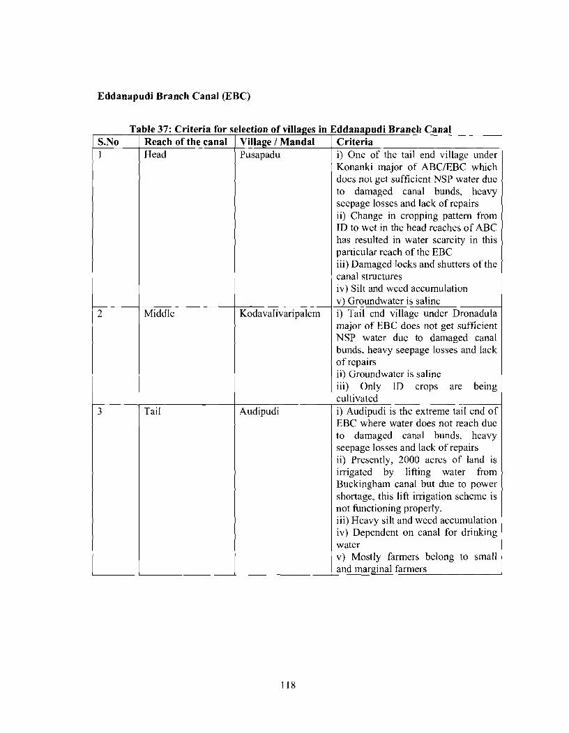
Eddanapudi Branch Canal (EBC)
Table 37: Criteria for selection of villages in S.No I Reach of the canal I Village / Mandal
Head Pusapadu
I
Kodavalivaripalem 2
{ddanapudi Branch Canal Criteria i) One of the tail end village under Konanki major of ABCIEBC which does not get sufficient NSP water duc to damaged canal bunds, heavy seepage losses and lack of repairs ii) Change in cropping pattern from ID to wet in the head reaches of ABC has resulted in water scarcity in this particular reach of the EBC iii) Damaged locks and shutters of the
Middle
canal structures iv) Silt and weed accumulation v) Groundwater is saline i) Tail end village under Dronadula major of EBC does not get sufficient NSP water due to damaged canal bunds, heavy seepage losses and lack of repairs ii) Groundwater is saline iii) Only ID crops are being cultivated i) Audipudi is the extreme tail end of EBC where water does not reach due to damaged canal bunds, heavy seepage losses and lack of repairs ii) Presently, 2000 acres of land is irrigated by lifting water from Buckingham canal but due to power shortage, this lift irrigation scheme is not functioning properly. iii) Heavy silt and weed accumulation iv) Dependent on canal for drinking water v) Mostly farmers belong to small

Key Findings
Caste distribution
1::; Others
- -- - - - - -
Category of farmers
Cropping pattern

1 Income levels of farmers( in lakh rupees p.a)
Livestock dependancy
El Yes
No
Darsi Branch Canal (DBC)
Fig 30: Damaged lining in some parts at the head reach

Iarsi Branch Canal Criteria i) Wastage of water due to damaged canal structures like siphones ii) Water is being released during rainy season iii) Fluoride concentration in ground water is above permissible limits and has resulted in gastroenteric problems iv) Groundwater is saline v) Rainfed irrigation vi) Agricultural runoff is mixing with nearby lakes and tanks leading to water pollution vii) Lack of infrastructure facilities
Brindavanam i) Tribal village located near Brindavan major of DBC where water does not due to breaches and
, Tail
Middle ii) Lack of accessibility to veterinary hospital iii) ~ a c k of repairs and maintenance i) Fluoride concentration in ground water is above permissible limits ii) Silt accumulation iii) Weakening of canal bunds due to cattle movement iv) Rainfed irrigation v) Water docs not reach the tail end portions due to unauthorized breaching in the head reaches. vi) Since 10 years water is not reaching the Vitlapuram village vii) Encroachment of canal in
Chintalapudi damaged structures i) Unauthorized lifting
Mundlamuru Vitlapuram i) Fluoride concentration in ground water is above permissible limits ii) Rainfed Irrigation iii) Most of them are small farmers

Key Findings
-- - - --
Caste distribution
Others
Category of farmers
1 Marginal
1. Small
Mdiurn
Cropping pattern
1 Large
I Wet
I ID i Wet/ ID I
- I

1 Income levels of farmers( in lakh rupees p.a)
Livestock dependancy

Pamidipadu Branch Canal (PBC)
Fig 31: Off take regulator at the start of PBC
Fig 32: Lined canal at the start of PBC
Table 39: Criteria for selection of villages in Pamidipadu Branch canal
Criteria canal I
Thimmapuram i) Since 8 years water is not reaching this village ii) Rainfed irrigation
I I iii) Decrease in Groundwater tables

Middle
Tammaluru
Tail
iv) Migration due to water scarcity and lack of agricultural works v) Fluoride concentration in ground water is above permissible limits had resulted in health problems like stomach ache, swelling of legs, etc i) Since 10 years water is not reaching this village ii) Rainfed irrigation iii) Migration due to water scarcity and lack of agricultural works iv) Fluoride concentration in ground water is above permissible limits I
Edara v) Decrease in Groundwater tables i) Damaged canal structures ii) Lack of repairs and maintenance iii) Shutters of the TP major have been removed iv) Majority of the individuals are agricultural labourers v) Weakening of canal bunds vi) Lack of infrastructure facilities
Marella
Umamaheshwarapuram and lack of agricultural works ii) Bore well irrigation iii) Silt accumulation
vii) Severe drought since 2 years i) Migration due to water scarcity
iv) Reduction in Groundwater table i) Rainfed irrigation ii) Since 10-15 years there is no NSP water iii) Migration due to water scarcity and lack of agricultural works iv) Water scarcity due to unauthorized lifting of water in the head reaches

Key Findings
Caste distribution
- - - -- - - -
Category of farmers
SC
ST
Others
1 H Marginal 1
Cropping pattern

Income levels of farmers( in lakh rupees p.a) 1 %
- - - - .-
Livestock dependancy

Ongole Branch Canal (OBC) Fig 33: Lined canal in the head reach
Fig 34: Construction of Ramathirtham balancing reservoir@ M-16
Fig 35: Damaged lining in the mid reaches

Fig 36: Damaged canal bunds in the head reaches
Fig 37: Koppolu major in the tail reach
1 S.No 1 Reach of the canal I Village 1 Mandal 1 Criteria Head Pulikonda i) Damaged canal structures
ii) Silt accumulation iii) Migration due to water scarcity and lack of agricultural works iv) Source for drinking water is from open wells, which has rcsulted in water borne diseases

Middle Obechettapalem (Hamlet)
Madhavaram
i) Loss of 770 acres of Ayacut under NSP due to the construction of Ramathirtham balancing reservoir. Howcvcr, compensation has been paid for only 1 10 farmers out of 220 ii) Village is at the downstream side of the proposed Ramathirtham balancing reservoir iii) Damaged drops and pipes in the Budavada major of OBC iv) Fluoride concentration in ground water above permissible limits i) Tail end village under Karuvadi major of OBC ii) Water does not reach to this village due to damaged canal structures, heavy seepage losses and lack of repairs and maintenance iii) Fluoride concentration in ground
Nagarjunasagar water ii) Majority of them are agricultural
Tail
major of OBC, which does not get sufficient NSP water since 6 years due to damaged canal structures, eroded banks and lack of repairs and maintenance
Vallur
Chilakapadu
water above permissible limits i) Since 10 years there is no
labourers i) Tail end village under Chilakapadu
canal structures ii) Majority of them are agricultural labourers iii) Since 10 years there is no
Mallavarapadu
1 Nagarjunasagar water
ii) Migration due water scarcity i) Wastage of water due to damaged
Key Findings - -- ---
Caste dlstrlbutlon
I O Others
I l

Category of farmers
( Large
Cropping pattern
Ei Wet
Income levels of farmers( in lakh rupees p.a)

Cropping pattern
-~ ~ -
Livestock dependancy

Janpahad Branch Canal (JBC)
Fig 38: Lined canal in the head reach
Fig 39: Damaged shutters at the off take
Table 42: Criteria for selection of villages in Janpahad Branch Canal
and rice mill effluents into R3 major of JBC due to which water does not reach some portions of the canal reach. ii) High number of tribal people who have land holdings under the command area.
S.No - 1
Reach of the canal Head
Village 1 Mandal Neredcherla
Criteria i) Severe load of domestic sewage

major of JBC where water does not reach the tail end portions.
Jagannada Tanda i) Tribal hamlet located near R3
Middle
Sajjapuram Tanda
I 1 water does not reach the fields I
ii) Existence of tribal hamlets i) Tribal hamlet at the tail end of JBC 1
I
Key Findings
Palakaveedu
Caste distribution
major of JBC where water does not reach the tail end portions. i) Water does not reach the tail portions
Janpadu
Others -- --
where water does not reach the fields. i) Village at the tail end of JBC 1 where
Category of farmers
1
Q Marginal I
I Small
Medium 1 o Large 1 ,

Cropping pattern
Income levels of farmers (lakh rupees p.a)
4%
0 < 0 5
0 5 - 1 0
1 0-3 0
77%
- - - -. - - - - - - - - - - - - - - - - - - - - - -
Livestock dependancy
Yes
I

5.5.12 Mukthyala Branch Canal (MBC)
Fig 40: Damaged lining in the head reaches to human activities
Fig 41: Damaged shutter and walls at R8 major
Table 43: Criteria for selection of villages in Mukhthyala Branch Canal S.No 1
Village / Mandal Redlakunta
Reach of the canal Head
Criteria i) Village at the end reaches of MBC where NSP canal water does not reach due to severe withdrawl, breaches and lack of water management in the head reaches. ii) Air pollution from the existing cement industries within 2 km radius of the village due to which health of farmers is affected

Middle
Tail
Muktyala
Yethirajapuram Tanda
Peekalanayak Tar
Tammavaram
Vellatur
iii) Fluoride concentration in ground water above permissible limits due to which people are getting drinking water from mineral water plants at g i) NSP canal water does not reach this village due to severe withdrawal, breaches and lack of water management in the head reaches Cropping pattern is mostly ID and dependant on rain. Due to lack of ground water, people . .
are drawing drinking water from Krishna river. i) Tribal hamlet located near MP major of MBC where water does not reach the tail end portions i) Silt formation. Since 2002, there is no water availability in the canal ii) Non-availability of canal water iii) Vents, Under tunnels, escapes, drops have collapsed totally iv) Scarcity of drinking water vi) Dependent on rain fed irrigation i) Water scarcity and improper discharge of water ii) Silt and aquatic weeds iii) Total collapse of canal structures iv) Dependent on rain fed irrigation i) Since 2002, there is no water availability in the canal ii) Dependent on rain fed irrigation iii) Lack of departmental regulation iv) Silt is not being removed since 2002 v) Due to the presence of single stone, there is no ground water availability vi) Severe damages of canal structures

Key Findings
Category of farmers
0 Marginal 1 ) D Small
O Med~urn / / Large 1 1
Income levels of farmers (lakh rupees p.a)
1 %
27% --- -
38% @ < 0.5
1 0.5-1 .O
1 .O-3.0 '
3.0-5.0
1 5.0 -- -~ --
28%
Caste distribution
I SC 1 IST j
Others /

5.5.13 Nandigama Branch Canal (NBC)
Fig 42: Shutters at one of the off take
Middle
Table 44: Criteria for selection of villages in Nandigama Branch canal
Venkatapuram dependant on rain. i) Water logging areas from Mullapadu to Venkatapuram due to ovcr siltation. ii) Due to the water logged areas, water borne diseases are being sprcad iii) Water overflows from the existing Mullapadu vagu during rainy season
, and enters the canal due to which the
Criteria i) Water does not reach thc tail end portions of the head reach due unauthorized breaching, seepage losses and damaged structures. ii) Cropping pattern is mostly ID and
I village may be submerged. 1
Village / Mandal Singaram
S.No I
Reach of the canal Head

Subbaigudem
Key Findings
i) Watcr does not reach the tail end portions of the head reach due unauthorized breaching, seepage losses and damaged structures. ii) Village at the end reaches of NBC where NSP canal water does not reach due to severe withdrawal, breaches and lack of water management in the head reaches. i) It is tail end village of Kanchcla and Etum Major where water does not reach the fields ii) Dependent on rainfed irrigation iii) Non- availability of canal water since 5 years due to which the wet crop has been converted into ID
1 crops. '
I Caste distribution
Q SC
ST
o Others
- - - - - - - - - -
Category of farmers
19% 1 I
23% - ---
Small 1
27% Large
I 31 % I

- - -- - -
Cropping pattern
Income levels of farmers (lakh rupees p.a)
7 O h
34% rn < 0.5
0.5-1 .O
13 1 .O-3.0
34%
-- --
17%
Livestock dependancy
I Yes

5.5.14 Bonakal Branch Canal (BBC)
Table 45: Criteria for selection of villages in Bonakal Branch Canal
Reach of the canal Head
Middle
Village / Mandal Tanikclla 1
Criteria Water does not reach the tail end
Konijerla
portions of the head reach due unauthorized breaching, seepage
portions of the head reach due unauthorized breaching, seepage
KonijerlaIKonijerla losses and damaged st&ctures- Water does not rcach the tail end
Peddagopathi 1 Konijerla
( ( structures-
losses and damaged stkctures- i) NSP water does not reach this part of the canal rcach due to lack of repairs to structures, improper maintenance and water regulation and no regular supervision from Irrigation department.
3
Key Findings
Tail BonakalIBonakal
i i ) Dependant on canal water for drinking purpose Water does not reach the tail end portions due unauthorized breaching, scepage losses and damaged

- - - -- - - - - - - - - --
Category of farmers
Q Marginal
Small
Med~um
Large - ---
Cropping pattern
- - - - - - - - - - - - -- - - - -
Income levels of farmers( in lakh rupees p.a)

Livestock dependancy
'a Yes . No
5.5.1 5 Madhira Branch Canal (MBC)
Table 46: Criteria for selection the villages in Madira Branch Canal
Kallur
I
Middle I Chandmpatla 1 kallur
Criteria Watcr does not reach the tail end portions of the head reach due unauthorized breaching, seepage losses and damaged structures i) lVSP water does not reach this part of the canal reach due to lack of repairs to stmcturcs, improper rnaintcnance and water regulation and no regular supervision from Irrigation department.
I I 1 ii) Dependant on canal water for (
Vennavalle/Kallur NSP water does not reach this part of 1 thc canal reach due to lack of repairs
to structures, improper maintenance and water regulation and no regular supervision from Irrigation
Water does not reach the tail end portions due unauthorized breaching, secpage losses and damaged structures --

Key Findings
Caste distribution
fa SC w ST
Others
Cropping pattern
pp - ppp . p- -- - -. .-
Income levels of farmers( in lakh rupees p.a)

- - - - - - -
Category of farmers
' Marginal 1
Small
I Medium
Large
5.5.16 Nuzvid Branch Canal (NBC)
Table 47: Criteria for selection of the villages in Nuzvid Branch Canal
S.No I Reach of the canal 1 1 Head
Middle
Tj
Village / Mandal Reddigudem / Reddigudem
Ramachandrapuram
Criteria Water does not reach the tail end portions of the head reach due unauthorized breaching, seepage losses and damaged structures i) NSP water does not reach this part of the canal reach due to lack of repairs to structures, improper maintenance and water regulation and no regular supervision from Irrigation department.

1 ii) Dependant on canal water for
3
Key Findings
Reddigudem
-- - -- - - - - - - - pp
Caste distribution
tai 1 the canal reach due to lack of repairs to structures, improper maintenance and water regulation and no regular supervision from Irrigation department
- - -- - - -
Category of farmers
EI Marginal
I Small
Medium
Large
Srirampuraml 1 drinking purpose NSP water does not reach this part of

-- - - -
Cropping pattern
Income levels of farmers( in lakh rupees p.a)
Livestock dependancy
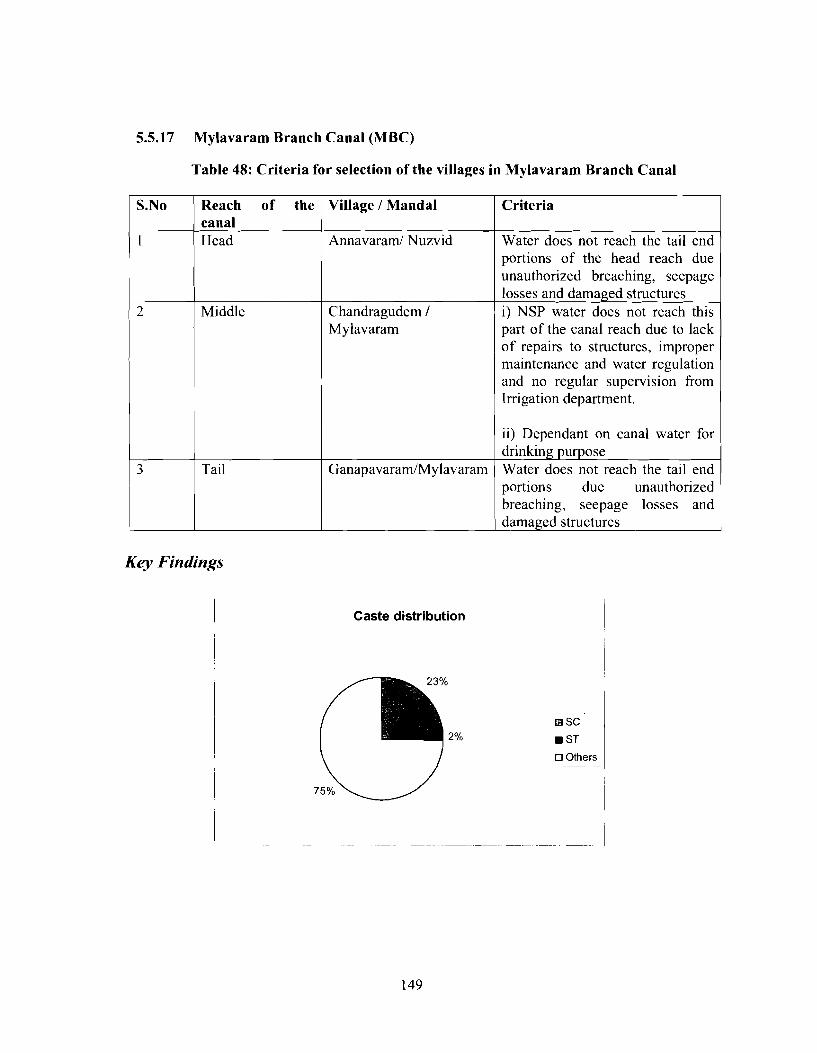
5.5.17 Mylavaram Branch Canal (MBC)
Table 48: Criteria for selection of the villages in Mylavaram Branch Canal
S.No
1
My lavaram Middle
part of the canal reach due to lack of repairs to structures, improper maintenance and water regulation and no regular supervision from Irrigation department.
Reach of the canal Head
I 1 1 ( i i ) Dependant on canal water for I
Chandragudem /
Village / Mandal
Annavaraml Nuzvid
losses and damaged structures i) NSP water does not reach this
portions due unauthorized breaching, seepage losses and damaged structures , Criteria
Water does not reach the tail end portions of the head reach due unauthorized breaching, seepage
3
Key Findings
Caste distribution
I
Tail
Others ~ -~
Ganapavaram/Mylavaram drinking purpose Water does not reach the tail end

-- -
Cropping pattern
Category of farmers
Marginal
Small
Medium
Large
--- - pp --
Income levels of farmers( in lakh rupees ~ . a )


ANNEXURE 111
ORGANIZATION CHART - WALAMTARI
gig I I m . 2 I

ORGANIZATION CHART - AMR APARD
Professional
Accmdltatlon

nnnex - V
ORGANIZATION CHART - ANGRAU

Annex - VI
TI Head
Faculty
ORGANIZATION CHART - EPTRl
BOARD OF ( OQVlRNOR*
DIRECTOR QLNERAL
I L DIRECTOR A -7-

ANNEXURE 4 SEMF FORMS
SEMF FORMS TO BE USED AT THE PACKAGE LEVEL
Pre-Planning Stage: Checklist for SENZF - Form -1
Package:
Basic Characteristics
1. Location ( include map & T-diagram of package system)
2. Estimated Value (Rs. Cr.):
3. Related Command Area (hectares):
4. Average Rainfall (mrnlyr):
5. Water table depth in Command (range in m): Pre-monsoon: Post-monsoon:
6. Major Problems with Canal System:
7. Major Problems with Drainage System:
8. Area under driplsprinkler (hectares):
9. Net Silt Disposal Requirement (m3):
10. Weeds (type and extent):
11. Identification of Silt and Weed Disposal Sites ( attach map)
12. Any Land Acquisition: YesINo
13. Any R&R issues (such as encroachment and squatters)? Yes 1 No
If Yes in both 12 & 13 above, please identify on map
14. Comments -
15. Are there tribals in the area? YeslNo
If Yes, assess the percentage to the total population
16. Soil Type (e.g. sandy loam, black cotton, etc.):

17. Tube wells in Command Area (approx.no):
18. Waterlogged Area Estimate (hectares):
19. Salinized I Sodic Land Estimate (hectares):
20. Cultural Property (e.g. tank bund shrines, sacred trees, burial sites, etc.) that could be affected by project activities: Yes I No
If Yes Type of Cultural Property
2 1. Water User Associations related to Package Area (also locate on mapisketch of system):
Agriculture:
I
Comments Name of WUA No. of Members
Pesticide Use Major Type Average Consumption
Irrigated Area (hectares) season 1
Fertilizer Use Major Types & Average consumption

Pre-Planning Stage: Checklist for SEMF-Form -11
Canal length (chainagetkms)
Checklist to assess the PAFs along the Canal
Commercial
Any LA (yestno)
Others
Any encroachments/ squatting (yestno)
Present use of Project Land (encroached/
pp
squatted land)
Agriculture

Package wise Work Plan Appraisal by PPMU - Planning Stage Form SEM-I11
S1. NO 1
2
3
/ discussed with relevant stakeholhers 1 I Reasons 1 1
Items Was the collection of baseline data for
Yes OK
4
and their views incorporated? Does the work plan for the package include relevant social and environment management plans?
proposed plan and identification of stakeholders done at pre-planning and planning phase? Were joint walkthrough and stakeholder consultations undertaken'? Does the final work plan deviate from
Indicate safeguard measures required and prepare mitigation
No State
the first version of the work plan? If yes in 3, then was the work plan
State Reasons
Remarks
OK
State
Reasons 1
State Reasons OK
Reasons OK State
6
7
8
1 I learning sufficiently elaborated in the ~ r o ~ o s e d dan? I Reasons 1 I
Are the costs of implementation of social and environmental management plans include in the budget of the work plan of the package? Have the responsibilities of implementing social and environmental plans been assigned?
9
Certificate of appraisal /plans submitted by package level unit ------- is found in order and apprised for implementation of the package activities
Does the MoU with WUA contain adequate provision for O&M of the
Reviewed and recommended by (PPMU) Appraised by ----- (PPMU) PPMU Authorized Signatory (PPMU)
plans OK
OK
system rehabilitated? Are the provisions for monitoring and
State Reasons
State Reasons and explain alternate arrangements made
OK State Reasons 1
OK State

EPTRI ISEA Annexure
Implementation of Measures relating to Construction Stage -- Form SEMP-IV
Form to be completed by I&CAD / WUA - for use by Package Unit during construction
SEMF Activities 1 Identification and Assessment I Reason
Wage rate
Labour camps established Use of local labour Skilled / Unskilled
First aid available at labour cam^ I I I I I
Status
Information about the project
Proper drainage to avoid water stagnation Site clearance Dumping place cleared I Disposal of Excavated 1
Men Women
earth disposed in environmental suitable sites
Partially completed
Completed
Arrangement for 1 1 1 I 1
Not started
-
removal/reinstatement of points of access to the ~ community Obstructions in drainage channel cleared (if any) Closing of dug pits Inspection of land fill sites as per agreement Cultural relics (if found) - information to concerned department ~

EPTRI ISEA Annexure
Safeguard Measures for Minimization of Construction Stage Impacts - Form SEMP- V
Construction Stage 1 Imoacts Activities
1 Site clearance [ Ensure not to dump material on private lands 1
Site accesses and
1 ( Proper and timely upkeep of construction premises 1
Vegetation to be removed only in the required areas Cultivated lands should not be disturbed if crop is grown
cleanliness - -
Site of labour camp to selected in consultation with community
Participation
Borrow pitstquarries for construction
1 excavations 1 Dispose surplus excavated materials at identified sites 1
Construction materials should be kept in orderly manner Participation of marginal sections should be encouraged at all stages No employment of children as child labourers Not to be done in the catchments areas Ensure materials are not dumped on private lands
materials Earth Work
~ccumulation of excavated earth, silt and debris
Ensure unobstructed natural drainage
Ensure minimum hindrance to normal local activities Avoid damage to permanent structures Use if silt quality is found good and required by local farmers or for bund improvement. If not, should be disposed in borrow pits Transport and dispose all debris to environmentally suitable sites Daily inspection at work sites for construction debris for safe collection and disposal Awareness and sensitization program
I / a Ensure active involvement of stakeholders I I I Involve community based organizations to mobilize I
1 1 Provision of protective care to labour force
Water stagnation and associated health problems Increased air, noise, water pollution
community Dress the sites for proper and natural drainagc
Restrict noisy operation to normal working hours Avoid construction works in night if close to habitation
Suspended dust particulates Loss of top soils in agricultural fields
Prior information to local community regarding operations Remove excavated materials to identified sites Frequent sprinkling of water Preserve top 30 cm layers for restoration after completion of construction
EPTRI ISEA Annexure
Avoid any temporary works near natural canals natural drainage Control the silt entry to ponds, streams, canals by
construction of silt traps Provision of by-pass arrangements for natural drainage during construction
Damage to works, Take necessary precautions to avoid any damage to structures etc irrigation works, canals, roads, tress and other features Cultural relics If found, should be handed over to concerned department
and work should be stopped till further instructions Planning of labour Contractor shall setup the labour camp with adequate camps facilities before starting of works in consultation with
local community minimize stress on natural resources Facilities should confirm to labour standards. No child labour Equal wages for equal work
1 Awareness generation among labours on HIVIAIDS, I Health, Education, Sanitation and other issues
Social disruption Preference to local labourlskilled persons Ensure wages at least at prevailing local minimum wage
1 rates

EPTRI ISEA Annexure
Summary Status of SEMF Actions - Post Implementation Stage Form SEM-VI
To be filled by I&CAD/WUA as part of SEMF
Activities Identification and sensitization of all Stakeholder (in the package command
SEMF
1. Command area farmers
2. Ground water users
Status I Completed ( Partially ; Not Reason
area) Assessing WUA for contribution
Identifying key environmental and social aspects requiring safeguards
Plan Preparation of Dam Safety
completed
Willingness of stakeholders to participate in
Planning Implementation O & M Preparation of Integrated Pest Management Plan Preparation of Intcgratcd Nutrient Management
Plan Preparation of
started
I Cultural I I I I
Tribal Development Plan Preparation of Gender Development Plan
Property Plan Preparation of
1

EPTRI ISEA Annexure
RAP
Agreement on MoU
Signing of MoU Integration of all plans
finalization of Social and Environmental Management -
Plan Completion of Land acquisition and disbursal of compensation Finalization of livelihood options Extension of R&R assistance
I
Agreement on Draft ~ MoU between WUA and Package Unit MoU between WUA and Package unit Consolidation all plans into Integrated Social and Environmental Management Plan (ISEMP)
A- -

EPTRI
Project Implementation Feedback: Form SEM-VII
ISEA Annexure
Project Activities that worked well:
Project Activities that did not work well (with brief reasons):
Suggestions for how to do this work better in other areas that follow:
Suggestions for Additional Work Required in this area:
Sample Beneficiary Contact Information (for follow-up):

EPTRI ISEA Annexure
ANNEXURE V: LIST OF PARTICIPANTS - STAKEHOLDERS CONSULTATIVE MEETING
KONIJERLA, KHAMMAM DISTRICT 12.3.2007
Name K. Venkateshwar Rao M.Nageswara Rao K.ChinaVenkateshwarlu T.Kumaraswamy J.Pollaiah P.Somi Reddy CH.Satyam J. Saydaya T.Tirupathi Shiakmerasahab B.Mohan Rao D.Venkateshwarlu V. RaviKumar P.Laxmaiaha R.Ramesh B . Bhadrayya P.Muttaiaha Abdul Hameed Khan Ch.Srinivasa Rao Y .Mohan Rao S.Krishnamurthy, K. Koteshwar Rao B.Rambabu G.NageswarRao Y .Ravikumar V.Veer Raju Md.Lalamiya K.Venkateshwarlu D.Tatamma M. AppaRao A. Satyanarayana N.Krishna Murthy B. Badrya N.V.Prasad K. Tirupatya K.Srinivasa Rao KondraSatyam
Department/Occupation AEE NSLBC,O&M Section President,WUA 1 59 President,WUA 1 17 DYEE/NSLBC Office sub-division WUI AE/NSC O&M Sub Division-I Tekullapally Horticulture Officer AEO Horticulture Distribution Committee vice President WUA 152, Committee Member WUA TC Member WUA 122 WUA. 147 DC 17 DC 139 WUA 132 WUA 140 WUA137 AE, NSC, O&M Section- I1 WUA President Dy.EE, O&M Sub Division DE O&M Sub-Division Dc 18 WUA 128 WUA125 WUA124 EE,NSLBC O&M Division Forest Officer Farmer Farmer Farmer Farmer Fanner Farmer President 143 WUA , Farmer Farmer Fam~er Farmer

KALLUR, KHAMMAM DISTRlCT
Name of the Participants T.Nageswara Rao T. Seeta Reddy SK. Nagur Meena N. Ranapratap R. Pulliaha M. Sreenivasa Rao V.Gopi Reddy K.NarasimhaRao AB. Sagar AG. Ramalinga Reddy Y. Prasad G. Anjaiaha K. Chandra Sekhar L. Srinivas Rao K.Srinivas T. Sheshagiri Rao N. Lokeshwar Rao P. Seetha Ramaiaha G. Achutha Rao N. Rama Rao K. PapaRao K. Venkata Rao R. AppaRao S. Satynarayana Reddy D. Narayana Reddy Swarna Prahalada Rao V. Krishna Rao B. Narasimha Reddy P. Mohan Rao K. Ajay Kumar M. Vcnkateshwar Rao D. Badraya
IS EA Annexure
13.3.2007
Department/Occupation DEE AE AE Fisheries Development Officer WUA 194 President AE WUA 176 WUA 175 WUA 170 WUA 179 WUA 185 WUA 177 WUA 173 WUA 169 DC 21 WUA 183 WUA 181 WUA 196 WUA 195 WUA 174 AE AE WUA WUA 177 WUA 167 WUA 165 WUA 162 WU A WUA 178 WUA 182 WUA 173 DC 20

EPTRI ISEA Annexure
MIRYALAGUDA, NALGONDA DISTRICT 14.3.2007
Name of the participant C.Subramanyam G.S. Goud V.San.. .. V.Kshetrabaga A. Maha Reddy P.D.Bhaskar B.Sanjeeva Rao Dr.G. Manju vani K. Dhananjaiah S.Ramraju V.Hemarajan M.Yadagiri N.V.Jayanthi Babu S .Murali R. Ravindar Reddy S. Ramraju D. Ram Reddy V. Krishnayya P.Srinivas Reddy Sundara Basavayya G. Janaki Ramayya Y .Ranga Reddy B Srinivas K.Narein Reddy A.Govinda Reddy
Designation 1 Occupation AD Fisheries R.O. Forestry PDD W&CDA DSE NSLBC E.E / O&M DEE / O&M DEE, NSP JD Animal Husbandry DD Ground water WUA President AE / NSC O&M I.P.0 DFO Social Forestry AE EE APPCB Farmer Farmer Farmer Farmer Farmer Farmer Farmer Farmer Farmer Farmer
KODADA, NALGONDA DISTRICT 15.3.2007
Name of the Participant V.Kshetrabala K. Dhananjaiah A. venkateswar Rao V. Murali Krishna M. Venkanna C. Subramanyam D. Badhya V. Upender D. Raghu U. Sayeed Reddy Kollu Swamy Pammi Venkat Reddy Kccta Dhanamuri
Designation / Occupation (EE, NSC O&M) (DD Ground water) (Dy. EE, O&M) (AEE O&M) (AEE, APPCB) (AD Fisheries) (AEE, NSP) (W.1 NSC O&M) (I.P.O. DIC) DC 9 DC 8 DC 10 WU A

]SEA Annexure
Bitu Ajay B .Veera Reddy G. Lakshman Rao J. Srinivas Rao K.Narsimha Rao P. Santhaiah K. Ambarish V. Mahesh Kumar P.Rangaiah K. Balakrishna B. Upendar G. Srinivas Rao MA. Rasool N. Narsimha Rao B. Venkateswar M.Venkateswara Rao R.V. Rao K. Keerti Reddy K. Hanmi Reddy M. Ran Kumar K. Pratap Reddy Hameed A. Ram Babu S. Venna babu G. Rama Rao U. Chakradhar Rao
VISSANNAPETA, KRISHNA DISTFUCT
Name of the Parcipants D.Rajeswara Prasad D.Ramachandra Rao B.Bhanu Babu R.Lakshmana Rao N.V.Sreedhar V.Sanjeeva Rao V.V.S.P.R.V.Prasad A.Chamundeswari N.Ashok Dr.D.Srinivasa Rao P.Satyanarayana V.Srinivasa Reddy T.Lakshrnana Rao K.Venkata Rao CH.Srinivasa Rao, A.Narasimha Rao
WUA Farmer Farmer Farmer Farmer Farmer Farmer Farmer Farmer Farmer Farmer Farmer Farmer WUA president DC Vice President WUA president Sarpanch Ex DC WUA T.CW - 60 Chairman 69 NSP Farmer Farmer Farmer T.C T.C
Designation/Occupation Executive Engineer Dy.EE
AE/MI AEE AEE AEE Asst. Director Agricultural Officer Horticulture Officer Asst.Director, Animal Husbandry. Regional Office, PCB WUA-234 V.M-4,WUA W UA President WUA WUA-224

EPTRI ISEA Annexure
S.V.Reddy B.V.Mallikharjuna Rao K.Papa Rao M.Rama Rao R.Shyam Prasad M.V.Seshagiri Rao G. S. Srirama Murthy CH.Radhakrishna Murthy BH.Sanjeeva Reddy M.V. Padmayya V.Chinavenkateswara Rao CH.Venkateswara Rao V.Srinivasa Reddy P.Seetaram Reddy M.Venkatesh S. JayaRaju P.Radhakrishna G. Kundanlal G.Krishna Murthy B.Ravindra D.Veera Baabu P.Radha Krishna G.L.Narasimha Rao
WUA-207 Farmer Farmer Farmer Farmer Farmer Farmer Farmer Farmer Farmer Farmer Farmer Farmer Farmer Farmer Farmer Farmer Farmer Farmer Farmer Farmer Farmer Farmer
MYLAVARAM, KRISHNA DISTRICT 15.3.2007
Name of the Parcipants P.Srinivasa Rao M.Ranga Rao B.Govardhana Reddy G.Karuna Rekha D.Rajeswra Prasad D .Ramachandra Rao D.Vijaya Saradhi V.Malla Reddy Dr.K.Kotilinga Sarma M.Sunee1 AKarunakara Rao P.J.Benarjee A.Nagamaheswari Rao V.V.S.P.R.V.Prasad G .Muniratnam J.Prasad J.Venkateswara Reddy M.Lalitha Kumari CH.V.Somasekhara Rao
Designation AEE, APPCB Executive Engineer Executive Engineer AEE, APPCB Executive Engineer, Quality Control Deputy Executive Engineer Hydrologist. Ground Water Department Farmer Animal Husbandry Department Agricultural Officer WUA President Forest Range Officer. WUA President WUA President WUA President WUA President WUA President -2 15 1.C.D.S Deputy Executive Engineer

EPTRI ISEA Annexure
G.V.R.Mohan Rao P.Srinivasa Prasad K.Srinivasa Rao E. Subrahmanyam Y .Radha Krishna B.V.Narasimha Rao M.Sriramavara Prasad M.Vijaya Nirmala P.Mohan Rao G.Vijay Kumar G.Ajay Kumar CH.Srinivasa Rao 1.Satyanarana Rao CH.V.Rama Raju K.Ramamurthy A.V.Mohana Rao J.Srinivasa Rao N.Veladri K.Salmon Raj G.Ramulu G.Ramesh Emmanuel Ganta CH.Jamalaiah Y .RadhaKrishna K.Ramamurthy A.Nirmala K.Gowri N.Ramulu M.KrishnaMurthy P.Kumar CH.Nagendra K.V.Satyanarayana
A.E,Q.C Sub Division No.4 A.E Q.C Sub Division No.3 Deputy Executive Engineer Deputy Executive Engineer Deputy Executive Engineer Assistant Engineer Assistant Engineer Horticultural Officer AEO WUA President WUA President - 246 WUA President - 249 WUA President - 21 5 WUA President Work Inspector Work Inspector AEE Farmer Farmer Farmer Farmer PSIEO Farmer Farmer W.1 Farmcr Farmer Farmer Farmer Farmer Farmer Farmer

EPTRI
VATLUR, WEST GODAVARl DISTRICT
Name of the Parcipants V.V.Siddartha M.Vijayarama Raju B.Subba Rao D.Ragendra Prasad S.Adiseshagiri Rao P.Balaji Kumar N.Ranga Rao K.S.S.Raju P.Venkateswara Rao K.Jagan Mohan V.Mutyalu P.Venkata Rao A.Jaganmohan Rao K.S.S.Rao V.V.Subba Rao V.Seetaramaiah G.Krishna Rao
ISEA Annexure
16.3.2007
Designation/Occupation Superintending Engineer Deputy Executive Engineer Executive Engineer Executive Engineer Deputy Executive Engineer Horticulture Officer A.D,Ground Water Department Tech.Officer, NSC Circle Assistant Engineer Jr.Assitant Jr.Assitant S.T.0, RTO Work Inspector Farmer Farmer Farmer Farmer

LINGAMGUNTLA, GUNTUR DlSTRICT
ISEA Annexure
6.8.2007
Name of the participant P.V. Ramalimgeswar Dr G. Venkat Reddy G. Kishore babu U. Vijayalakshmi Y. Adiseshaiah G. Prasad
MD.K. Rahman
P. Ramanjaneyulu V.V. Konda Reddy
Shaik Adam Shahi
E. Sri Rami Reddy
N. Ganesh
Kundur Anjaneyulu G. Ram anjaneyulu S. Anjaneyulu CH. Edukondalu D. Ramayya M. Satyanarayana R. Laksminarayana Raju
P. Vcnkaya P. Subbarao M. Laxmi Narayana P. Venkateshwarlu K. Ramarao 0 . Vecrayya M. Edukondalu Y. Papayya S. Chenchayya N. Narasayya K. Edukondalu CH. Ramachandrarao M. Brahma Reddy SK. Mahaboob Basha K. Bala Brahwad
DepartmentIOccupation Chi lakaluripet,Muncipality A.D ( A H) NRT Fisheries (FDO) Irrigation& CAD, Vinukonda D.D Agriculture,Guntur Executive Engineer, O&M Division,Lingamguntla Deputy Executive engineer, O&M Subdivision, Lingamguntla WUA TC Mcmber Assistant Executive Engineer, Municipality, Sattenapalli Assistant Engineer, Vinukonda Municipality Assistant Enginccr. O&M division, Vinukonda Assistant Executive Engineer, O&M division, Vinukonda Farmer Farmer Farmer Farmer Farmer Farmer Assistant Engineer (Field training)O&M sub division WUA 2 1 1, Sanampudi WUA 207, Polluru W UA 2 1 2, Karumanchi 1 WUA 158. Rayipadu WUA 2 12, President,Karumanchi I WUA Potlum WUA 2 14, Enugupalem 11 WUA 1561 L , Ravipadu WUA 164/D, Gonipudi WUA 156, Ravipadu WUA 1 6 1 ,Pratlavaripalem WUA, Kamavaripalem WUA, Madavaram Assistant Engineer, Vinukonda Assistant Engineer, Koticherla

EPTRI ISEA Annexure
G. Anjinayelu B. Sriramulu V. Venkatakotaiah N. Subaramulu M. Chenchu Reddy G. Ramadasu Y. Laxmi Rcddy M. Srinivas Rao Ci. Chandrasekhar D. Nageshwar Rao K. Damodar Rao G. Srinivasulu C. Subba Reddy U. Shivaramayya M. Varanjeneyulu G. Venkateshwarlu
SATTENAPALLI, GUNTUR DISTRICT
Name of the participant S.A.Rajeshwara Rao
B. Vijaya Kumar
A. Lohi Kumar
B. Samba Siva Rao
T. Srinivas Rao M. Ramalingaiah B. Syam Prasad V. S. Evans Dr. G V Narayana M. Sivasambaiah Y. Varaprasad Reddy B. Veera Reddy Yarragundla Ramesh Kota Hanumanth Rao Doda Narsi Reddy Baptu Rosi Reddy Somina Chandishwara Rao Komara SubbaReddy P SubbaRao Amala Shivayyalu N. ZammaReddy
WUA, Andugulapadu WUA, Andugulapadu WUA, Chinakancherla W UA, Sanampudi WUA 199, Mutranalapalli WUA, Ravipadu W UA Vice president, Uppalapadu W UA 2461 1 , Nuzandla WUA 248, Kambampadu WUA 244, Jadavaripalem W UA, Kamavaripalem WUA 243, KJaddavaripalem Anavaripadu WUA 165, Kavur WUA, Kavur Forest Department
DepartmentlOccupation Assistant Engineer, N.S.J.C 0 &M Section Muppala Assistant Engineer, N.S.J.C 0 &M Guntur Assistant Engineer, 0 &M Satennapalli No. I11 Assistant Executivc Engincer, 0 &M Section, Perechrla Forest Range Officer ADA & JDA, Agriculture Dept. Deputy Ex. Engineer, O&M, Guntur DEE, Sattenapalli AD (AHS), Guntur Assistant Engineer O&M Section Sattenapalli I1 WUA 98 Nandigama Farmer Farmer Farmer WUA 136 Swalasa WUA 112, Bhimavaram WUA 89, Todapi WUA 109 WUA 6 WUA 137, Pedapalukuluru

EPTRI ISEA Annexure
Mallala Laxminarayana Nadendla Venkatanarasayya Kondaveti Sharayya P. Adinarayana Nakka Darmaraju Shakamuri Srinivas Gogireddy BhupalReddy Rayudi Purnayya Koncheti Nageshwar Rao Sati Sambasiva Rao Gudae Sambayya A.Srinivas Rao D. Durga Reddy Ontipula Dannaya CH Jerssy Batula SitaramiReddy Peravalli Shivayya Rusum Rajeshwar Rao Kataveli Sambi Reddy V. Devender A. Sambayya P. Mehabubsha B. Sreenivas Rao D. Srinivas Reddy M. Venkatalayya R. Punna Reddy P. Chinnaya M. Punnaya A.S. Rao S. Khaubi Sher Kammi
WUA 124, Kasipadu WUA 90, Dullapalla Farmer AEI PDRL WUA 64, Uyyandana WUA 70, Utkuru WUA 127, Amaravathi Farmer Farmer WUA 93, Pakalapadu WUA 145, Bandampalli Laskar DC I1 Farmer Attender WUA 105 WUA 107 Siripuram Farmer WUA 152, Pedaparimi WUA 128 WUA 128 I1 WUA 88 G Mudvalla WUA 1 18-1, Pedakurapadu WUA 66, Mundlapalla WUA 65, Uyyandakrosum WUA 133 WUA 131 WUA 1 1 3, Nandigama Farmer Farmer Farmer

EPTRI ISEA Annexure
ADDANKI, PRAKASAM DISTRICT 6.8.2007
Name of the participant S. Raghu Ramnaiah T. Ramesh T. Panakalaiah M. Rosaiah M. Govinda Reddy M. RadhKrishna Murty Kuli Rama Krishna Bachina Hanumantha Rao K. Surendra Babu Ravi Ammaiah A. Brahmanandam M. Haribabu G. Lakshmi Narayana D. Venkateshwar Rao Buchina Rama Rao Annabatuni Subbaiah M. Venkateswarlu G. CH. A. Chowdary Koyi Subbaiah Bajwada Punnaiah P. Ranganayakulu D. Nageswara Rao E. Sanjeeva Rcddy Amameni Venkat SubbaRao Kallur Anjaiaha Maddineni Ragavaiah
B. Subba Reddy V. Ramakrishna Reddy K. Uma Maheshwara Rao S. Shah Ahmed M. Ramaiah Bandaru Sharabandi P. Nagi Reddy M. Ravi Pramod
Department/Occupation Deputy Executive Engineer Deputy Executive Engineer Assistant Executive Engineer WUA Addanki 111 WUA Dronadula WUA Vaidana. WUA Chandaluru I1 WUA Kodavlivaripalem WUA Inkolu I WUA Kondamanguluru 1 WUA Duddkur W UA J.Panguluru I WUA Addanki I1 WUA J.Panguluru I1 WUA Gorrepadu I1 WUA Addanki I WUA Idupulapadu WUA Ballikurva WUA Koralapudi WUA Swarna I WUA Addanki IV WUA Ravinutala WUA Uppumoguluru WUA Isuka Darsi WUA Chandaluru I WUA
Kalavakuru WUA Nuthalapadu WUA Adipudi WUA Daggupadu Chinakothapalli I WUA Swarna I1 WUA Chinakothapalli I1 WUA Asst. Director, Ground Water Department.

EPTRI ISEA Annexure
DARSI, PRAKASAM DISTRICT
S1.No. Name of the Participant 1 K. Ekambareswara Babu
2. M. Rama Prasad
3 M. RaviKumar
Dr.C. Venkata Reddy K. Venkateshwarlu R. Nagalaxmi P. Vijaya Kumar Marella Seshaiah CH. Ramadandu M. Venkateshwarlu M. Nagi Reddy K. Umamaheswara Rao D. Elia Reddy R. Subba Reddy N. Anjayya B. Venkata Subba Reddy J. Guravaiah G. Srinivas T. Narasaiah CH. Adinarayana M. Kondal A. Veeranj aneyulu M. Subramanyeshwar Rao J.V. Subbaiah G. Koti Reddy Devineni Murtayya K. Yosepu D. Subba Reddy T. Vami Prasad Rao M. Ram Mohan Rao M. Suneetha M. Rami Reddy N. Koti Reddy P. Chowda Reddy K. China Subbarayadu Nagabhushanam V. Anjaneyulu SreeRamulu B. S. V. Prasad Rao
Department/Occupation NSJC, O&M Division, Executive Engineer Asst. Director, Ground Water Department(GWD) Ongole Deputy Executive Engineer, O&M Sub-division, Tripuranthakam Veterinary Assistant Surgeon NSJC, O&M Sub-Division, Darsi Training Co-ordinator A.P.0 DW&DA Ongole TC Member President President Mohcdinapuru President Manepalli I1 WUA Umamaheshwar Rao President Manepalli I President Mullamur Minor Chintalapudi WUA Zellagatur WUA TC Member, Zellagatur Eadhara, WUA Edara, WUA President WUA President, Kambalapadu WUA President, Veerayapalem Kambalapadu Minor, WUA A.D.A (R), Darsi AEO, Darsi WUA Polavaram I Nandupalem WUA President, Mushnagangaram Farmer AO, Darsi JDA, Ongole JDA Rtd Ongole A.O(Tech), 010 JDA Ongole WUA President, Kankalapalli I1 Kankalapalli I11 WUA President, 1.T Varam WUA President, Viswanthapuram WUA President, Medapi K.Annasamudra, WUA President P.Annasamudra, WUA president DEE, KCD

ISEA Annexure
ANNEXURE VI LIST OF PESTICIDES
Table 1. Extremely hazardous (Class IA) technical grade active ingredients of pesticides (Common name) - Not permissible in the project
1 Brodifacoum I Difethialone 1 Parathion 1
Aldicarb
I
Bromethalin Disulfoton 1 ~ h e n ~ l m e r c ~ l
Di fenacoum
Bromadiolone
Mevinphos
1 Sodium fluoroacetate
Diphacinone
Calcium cyanide Ethoprophos
1 Chlormephos Hexachlorobenzene I Sulfotep I
Parathion-methyl
acetate Phorate
Terbufos
Chlorophacinone
Table 2. Highly hazardous (Class Ib) technical grade active ingredients of pesticides (Common name) - Not permissible in the project
Mercuric chloride
1
Ally1 alcohol 1 Fenamiphos 1 Paris green [ c ] )
Tebupirimfos
I Acrolein Famphur
Azinphos-ethyl
Oxydemeton-methyl
Azinphos-methyl
Flucythrinate
I I
Pentachlorophenol
Fluoroacetamide
1 Butocarboxim
I I Sodium arsenite I
Pindone
Pirimiphos-ethyl Blasticidin-S
Butoxycarboxim Cadusafos
1 Formetanate
Furathiocarb Propaphos
I
Heptenophos Isazofos
Propetamphos

EPTRI ISEA Annexure
1 Flucythrinate I Pentachlorophenol
Acrolein
Ally1 alcohol
I Fluoroacetamide 1 Pindone
Blasticidin-S 1 Formetanate 1 Pirimiphos-ethyl
Famphur
Frnamiphos
Oxydemeton-methyl
Paris green [C]
Butocarboxim
Calcium arsenate
Butoxycarboxim Cadusafos
Furathiocarb
Carbofuran
Propaphos
Heptenophos Isazofos
lsofenphos
Chlorfenvinphos
Propetamphos
Sodium arsenite
Sodium cyanide
Te fluthrin
3-chloro- 1,2-propanediol
Coumaphos
Mecarbam
Coumatetralyl
I I Demeton-S-methyl ( Methiocat-b ( Vamidothion
Thallium sulfate
Mercuric oxide
I I
Thiofanox
Methamidophos
Zeta-cypermethrin
Dicrotophos ( Monocrotophos ( Zinc phosphide
Thiometon
Dichlorvos
Dinoterb 1 Nicotine
Methidathion Triazophos
Methomyl
Elhio fencarb I Oxamyl
Warfarin
Edifenphos Omethoate

EPTRI ISEA Annexure
Table 3. Moderately hazardous (Class 11) technical grade active ingredients of pesticides (Common name) - Not permissible in the project
Nabam Naled Paraauat
Alanycarb Anilofos Azaconazole
Bendiocarb Benfuracarb
Endosulfan Endothal-sodium Esfenvalerate
Bensulide
Etrimfos Fenazaquin
Bronopol Butamifos
Permethrin Phenthoate
Bilanafos Fenpropidin Phoxim Bioallethrin Fenpropathrin Piperophos
Pirimicarb Bromuconazole Fentin acetate Prallethrin
Fenitrothion
Butylamine Carbary 1
Phosalone
Fentin hydroxide Fenvalerate
Cartap Chloralose Chlordane Chlorfenapyr Chlorphonium chloride Chlorpyrifos
Pro poxur Prosulfocarb
Carbosulfan Formothion
Fipronil Fluxofenim
Cyphenothrin
Prothiofos Pyraclofos
F~rberidazofe Gamma-HCH Guazatine 1 Haloxyfop Heptachlor lmazalil
Methasulfocarb I Trichlorfon ~ M e t h y l c l a z o l e
Diazinon Difenzoquat Dime thoate Dinobuton Diquat
Pyrethrins Pyroquilon Quinalphos Quizalofop-p-tefuryl Rotenone Sodium fluoride
Clomazone Sodium hexafluorosilicate Copper sulfate Cuprous oxide Cyanazine Cyanophos Cyfluthrin Beta-cyfluthrin
Metolcarb Metribuzin Molinate Pro fen0 fos Propiconazole
Tridemorph Vemolate Xylylcarb
Cyhalothrin Metaldehyde Thiocyclam Thiodicarb
Alpha-cypermethrin Methacrifos
Iminoctadine Ioxynil Toxynil octanoate Isoprocarb Lambda-cyhalothrin 1 Mercurous chloride I
Spiroxamine Sulprofos Terbumeton Tetraconazole Thiacloprid Thiobencarb

EPTRI TSEA Annexure
Table 4. Slightly hazardous (Class 111) technical grade ingredients of pesticides (Common Name) - Permissible under IPM
Acephate Acetochlor Acifluorfen
Alnet n 1 Amitraz 1
Alachlor 1 Dimethametryn Allethrin I Dimethipin
Azamethiphos ( Dinocap ( Meturnitrun Bensultap I Diphenamid ( Metconazole
Difenoconazole Dimepiperate Dimethachlor
Mecoprop-P Mefluidide
Malathion 1 MCPA-thioethyl Mecoprop
- -
Cliinometkionat Esprocarb 2-Napthyloxyacetic acid Chlorme uat chloride
Bentazone Bromofenoxim Butroxydim
1 I I dicarboximide I
Dithianon Dodine Empenthrin
Chloroacetic acid Chlorthiamid Copper hydroxide
Methylarsonic acid Metolachlor Myclobutanil
Fenothiocarb Ferimzone Fluazifop-p-butyl
Copper oxychloride Cycloate Cyhexatin
Nuarimol Octhilinone N-octylbicycloheptene
Cymoxanil Cyproconazole
Fluchloralin Flufenacet Fluoroglycofen
Dazomet
Table 5. Technical grade active ingredients of pesticides unlikely to present acute hazard In normal use (Common name) - permissible
Oxadixyl Paclobutrazol Pendimethalin
Flurprimidol Flusilazole
Dichlorobenzene Dichlorophen Dichlorprop Diclofop Dienochlor Diethyltoluamide
Pimaricin Pirimiphos-methyl
Desmetryn Fomesafen Propachlor Dicamba Dichlormid Glufosinate P r o ~ a r ~ i t e
Flutriafol Prochloraz
Hexazinone Hydramethylnon
1 Iprobenfos Isoprothiolane Isoproturon Isouron
Aclonifen Acrinathrin Alloxydim Amitrole Ammonium sulfamate Ancymidol Anthraquinone Asularn
- Pyrazoxy fen Pyridaben
A Pyridate P yrifenox Quinoclamine Quizalofop
Dirnethirirnol Dimethomorph Dimethyl phthalate Dinitramine Dipropyl isocinchomerate Dithiopyr Diuron Dodemorp h
Metosulam Metoxuron Metsulfuron methyl Monolinuron 2-(1 -Naphthyl) acetamide 1 -Naphthylacetic acid Napropamide Naptalam

EPTRI ISEA Annexure
~ t r az ine I Ethalfluralin I Neburon I Azimsulfuron 1 Ethephon 1 Niclosamide
Benfuresate I Fenarimol I Oryzalin Benomvl 1 Fenbutatin oxide 1 Oxabetrinil
Azoxystrobine Benalaxyl Benazolin Benfluralin Famoxadone Ofurace
Ethirimol Ethofumesate E tofenprox
Benoxacor Bensulfuron-methyl Bifenox Bioresmethrin
Butachlor Flufenoxuron
Nicosulfuron Nitrothal-isopropyl Norflurazon
Bromopropylate Bupirimate
Fenchlorazole Fenclorim Fenfuram
pp
Fenhexamid
Oxadiazon Oxine-copper Oxycarboxin Oxyfluorfen
Flamprop Flucarbazone-sodium
Butralin
Chlorimuron C]
Penconazole Pencycuron Pentanochlor Phenmedipham Phenothrin
Fenoxy carb
Phosphorus acid Phthalide
Butylate Captan Carbendazim Carbetamide Carboxin Carpropamid Chlomethoxyfen Chloramben Chloransulam methyl Chlorbromuron Chlorfluazuron Chloridazon
Phenylphenol
Bispyribac Bitertanol Borax Bromacil
Fenpiclonil Fenpropimorph Fenuron Fenuron-TCA
Flumetsulam Fluometuron Flupropanate Flupyrsulfuron Flurenol Fluridone Flurochloridone Fluroxypyr Fluthiacet Flutolanil tau-Fluvalinate Folpet
~ -
~hlorothalonil Chlorotoluron
Primisulfuron Probenazole Procymidone Prodiamine Prometon Prometryn Propamocarb p r o p a q u Y Propazine Propham Propineb Propyzamide
Fosetyl ( Pyrazosulfuron Gibberellic acid 1 Pyrimethanil
Chlorpropham Chlorpyrifos methyl Chlorsulfuron
Chlozolinate Hy droprene Cinrnethylin Hymexazol Cinosulfuron Clo fentezine Imazapyr Clomeprop Imazaquin Siduron Clopyralid Imazethapyr Cloxyfonac 177 Spinosad
Glyphosate Hexaconazole Hexaflumuron
Pyriminobac Pyriproxyfen Pyrithiobac sodium

EPTRI ISEA Annexure

ISEA Annexure
ANNEXURE VII QUESTIONNAIRES FOR ISEA STUDY
I. Questionnaire for WUA Meetings
Name of the Branch Canal:
Reach Head / Middle / TailIMajor
1. Water User's Association:
No. of WUA's:
I SI. I Name of the Water User's 1 Number of voters 1 Total Ayacut (in acres) Association I
1 Wet 1 Irrigated I
2. Whether regular elections are being held for WUA's Yes/No
If No, Specify reasons
3. Whether regular meetings are being held between WUA members?
Yes/No
a) If Yes, frequency of meetings
b) If No, Specify reasons
4. Are there any women members in WUA's
Yes/No
i) If Yes, how many women members are involved and their
roles
ii) Do they have any landholdings in the command area Yes/No

EPTRI
If Yes acres.
5. Whether small and marginal farmers have a role in WUA?
YesfNo
If No, specify reasons
6. Are there any SCs and STs in the WUA's
Yes/No
If No, specify reasons
7. Whether any fishermen arc mcmbers in the WUA
Yes/No
If No, specify reasons
8. Time and period of water release
a) 1s the released water sufficient?
If No, specify reasons
ISEA Annexure
b) Are you satisfied with the present water supply system Y esmo
If No, specify reasons
9. Whether any of the following problems exist in the head/middle/tail reach'?
a) Unequal distribution of water
b) Unauthorized breaching
c) Water wastage
d) Unauthorized lifting of water
e) Damages to the structures (Under tunnels, vents, weak bunds etc)
f) Others(Specify)
10. Whether water charges being collected from the farmers Yes/No

ISEA Annexure
If Yes, amount paidlacre:
If No, specify reasons
1 1. Whether there is conjunctive use of surface and ground water in canal reach?
Yes/No
If No, Specify reasons
12. Category of farmers:
a) Marginal (Less than 2.5 acres) b) Small (2.5 acres to 5 acres)
c) Medium (5 to 12.5 acres) d) Large (More than 12.5 acres)
13. Daily wages:
a) Agricultural labour: i) Men
b) Non-agricultural labour: i) Men
14. Whether children are employed as labour?
Rs. ii) Women Rs.
Rs. ii) Women Rs.
If yes, what kind of works are they involved in?
a) Agriculture
b) Construction
C) Others (specify)
1 5. Tanks
(a) Total number of tanks:
(b) Tank irrigation area ---------------- acres
(c) Whether tanks are used for aquaculture Yes/No
If Yes, Number of acres under aquaculture:
16. Cropping pattern
Any other Crop ( Acres
Kharif Crop I Acres
I I I
Rabi Crop 1 Acres

EPTRI ISEA Annexure
17. Annual productivity and income from agriculture
18. Whether mechanized agricultural practices are being followed during different stages of:
a) Sowing Yes/No
b) Transplanting Yes/No
Total Income per annum
c) Mechanized agriculture (Machines for harvesting) YesfNo
Ratelunit Crop
d) Pod crushers Yes!No
Yield per acre
19. What are the soil management practices adopted by the farmers?
a) Clayisiltisand addition
b) Saline soil reclamation (Thellachoudu)
c) Alkali soil reclamation (Nallachoudu)
20. Whether the farmers are adopting organic farming? Yes/No
a) If Yes, what kind of biopesticideslorganic manure used
b) If No, Specify reasons
2 1. Whether there is any loss of agriculture land due to modernization of canal works Yes/No
If Yes,
a) Extent of land loss Ha
b) Population to be displaced: Tribalslothers
22. Are you aware of the proposed modernization of canal systems? Yes/No
If Yes, What benefits are you anticipating from the Project?

ISEA Annexure
23. During what period you want the canal to be closed for undertaking the
modernization works:
a) Is there any village going to be affected due to modernization activities Yes/No
If Yes, name of the village:
Nature of affects:
24. Whether there is any migration of households from the village? Yes/No
If Yes,
a) specifj7 reasons:
b) Period of migration: -
c) Temporary or Permanent
25. Other important problems in the villages
11. Questionnaire for Socio-economic assessment
Name of the Village: Total Households:
Total Population:
1. Personal Details
(a) Name of the respondent:
(b) Age:
(c) Sex: 1 Male 2 Female
(d) Marital Status: 1.Married 2.Unmarried 3.Widowedl divorced
(e) Religion: (1) Hindu (2) Muslim (3) Christian (4) others
(f) Caste: 1.Forward Caste 2.OBC 3. Scheduled Caste 4.Scheduled Tribe 5. Others

ISEA Annexure
(g) Literacy: ( I ) llliterate (2) (1-5 Standard) (3) (5- 10 Standard) (4) Intermediate (5) Graduate (6) Post-graduate (7) Technical (8) Professional (9) Others
(h) Occupation: ( 1 ) Farmer (2) Agri-Labourtother labour (3) Business (4) Service (5) Others (Specify)
i) If farmer, then which category
a) Marginal (Less than 2.5 acres) b) Small (2.5 acres to 5 acres) c) Medium (5 to 12.5 acres) d) Large (More than 12.5 acres)
ii) If labour, specify the daily wages for
a) Men Rs. b) Women Rs.
iii) If non-agricultural labour. specify the daily wages
a) Men Rs. b) Women Rs.
iv) Whether children are employed as labour?
If Ycs, what kind of works are they involved in?
d) Agriculture e) Construction f) Others (specify)
2. Family
a) Type 1 .Joint Family
b) Total Family Members:
c) Total number of males:
d) Total number of females:
3. Land
2. Nuclear Family
(d) Total land under the command area ----------------- acres
( e ) Total irrigated land ---------------- acres
(f) Total land under aquaculture under thc command area --------------- acres

ISEA Annexure
4. Cropping pattern
Kharif
5. Annual productivity and income from agriculture
Rabi Crop
6. Details of aquaculture productivity and income (if any)
Anv other Acres Crop
Crop
7. Annual income from any other occupations (Services etc) in the family
Crop Acres
Rate1 bag ---
Yield per acre
Aquaculture type
Occupation
Acres
Total Income per annum
8. Whether any loans being taken from banks
Yield per acre
If Yes, Purpose of taking loans
Total income per annum
a) Agricultural expenses
b) Purchase of livestock
c) Purchase of land
d) Others (Specify)
9. Whether mechanized agricultural practices are being followed during different stages

ISEA Annexure
o f e) Sowing
f) Transplanting
g) Mechanized agriculture (Machines for harvesting)
h) Pod crushers
YesINo
Yes/No
YesINo
YesINo
10. What are the soil management practices adopted by the farmers?
d) Clay/silt/sand addition
e) Saline soil reclamation (Thellachoudu)
f) Alkali soil reclamation (Nallachoudu)
1 1 . Whether the farmers are adopting organic farming? YesINo
c) Jf Yes, what kind of biopesticides/organic manure used -
d) If No, Specify reasons
12. Whether seeds and fertilizers are being supplied to the farmers? YeslNo
If Yes, type of seeds and fertilizers-
13. Whether the farmers are aware about the adverse impact of chemical fertilizers on the environment? YesINo
14. Whether the farmers are using modem irrigation techniques Yes/No
If Yes, type of techniques
15. Whether the farmers are willing to pay for the enhanced irrigation facilities k'esmo
If Yes, Amount they are willing to pay:
If No, Specify reasons:
16. House status
(a) House type: 1 .Kutcha 2.Pucca 3.Semi-pucca
(b) Wall types: 1 .Mud 2.Stone with mud 3.Bricks with stone + mud
4. Bricks with cement plastering

EPTRI ISEA Annexure
(c) Roof types: 1 .Thatched 2 .Country tiles 3 .Mangalore tiles
4,Stone slab 5.RCClRBC
(d) Ownership of thc housc: 1 .Own house 2.Rented house
17. Livestock position
Livestock Number
I Any other
Nearest veterinary hospital:
18. Infrastructure:
a) Type of Roads i) Concrete ii) Cement Concrete
iii) Black Top iv) Earthen
b) Nearest bus station:
c) Nearest railway station:
d) Marketing facilities: i) Nearest Rhythu Bazar:
ii) Nearest Market yard:
e) Financial institutions: i) National banks ii) Rural Banks
iii) Commcrcial Banks iv) Cooperative Banks
f ) Powcr Supply: i) Town feeder ii) Rural feeder
19. DrinkingIDomestic water sources:
a) Bore well/ hand pump b) Water tanker c) Open wells d) Rural water supply
20. Sanitary outlets: a) Open channels b) Septic tanks c) Open defecation
21. Domestic sewage outlets:
a) Open drainage channels b) Open fields c) Closed drainage

ISEA Annexure
22. Solid waste disposal:
a) Landfill b) Incineration c) Open dumping d) Other methods (Specify)
23. Location of final discharge of sewage:
a) Green Belt b) Agriculture land c) Lake1 River1 Any other water bodies
24. Medical Facilities:
i) Ncarest PHCIHospital:
ii) Diseases occurred so far in the family:
iii) Whether the ANMs are visiting the villages regularly for providing medical
assistance to women? Y es/No
If Yes, what kind of nutritional supplements are providing?
S1. No
25. Are you aware of the proposed modernization of canal systems? Yes/No
If Yes, What benefits are you anticipating from the Project?
1.
2.
a) During what period you want the canal to be closed for undertaking the
modernization works:
Disease & Year of occurrence
Targeted population
26. 1s there any village going to be affected duc to modernization activities YesINo
If Yes, Name of the name
Nature of effects:
Male adults Female adults Children

ISEA Annexure
Self Help Groups (SHG's)
27. Number of Sclf Hclp groups in the village:
28. Number of members in each group:
29. List activities taken up by SHGs for income generation?
i) ii) iii)
30. Fund rotation in the SHG's:
3 1. What is the role of SHG's in water management
a) Active Participation
b) Moderate
c) No Change
32. Whether any training programs are being conducted to SHG's? YesINo
111. Questionnaire for Field Data Collection
1. Name of the Main Canal:
2. Name of the Branch Canal:
3. Village / Mandal / District:
4. Topography: a) Plain b) Undulating c) Partly undulating d) Hilly
5. Geographical coordinates of the area:
Latitude: Longitude:
6. Reach of the Canal: a) Head b) Middle c) Tail
7. Total length of the canal: Km
8. Length of distributaries Km
a. Lined

ISEA Annexure
b. Unlined
9. Right of way of canal: m
10. Activities proposed under modernization:
a) Lining b) Bund strengthening c) Cross drainage works
d) Minor repairs to sluices e) Others (Specify)
I I . Length of the canal proposed under modernization: m
12. Name of the village(s) selected along the canal reach:
13. Status of the canal system:
a. Minimum damage and require minor repairs
b. Degraded with serious seepage losses and require repairs in next 2 years
c. Sevcrcly degraded and require immediate repairs
14. Efficiency of canal water delivery:
a. Reliable with moderate canal losses
b. Unreliable with moderate canal losses
c. Unreliablc and tail end receiving minimum or no water
d. Completely unreliable with high canal losses and middle reach receiving
minimum water
15. Whether there is supplemental irrigation other than canal? YesiNo
If Ycs, spccify the source
a) Bore wells
b) Tanks
c) Check dams
16. Whether the canal water is used for alternate purposes?

ISEA Annexure
If Yes, specify the purpose
a) Water supply
b) Fisheries
c) Others
17. During what period you want the canal to be closed for undertaking the
modernization works
If No, please specify the reasons
18. Whether there is waterlogging problem?
If Y cs, Area already under water logging
19. Whether any of these exist within 10 kms radius of the canal
a) Cement industries
b) Spinning mills
c) Rice mills
d) Chemical plants
e) Others (specify)
ii) Reserve ForestIWild life sanctuary1 Habitat for migratory birds Yes/No
iii) Places of archaeological importance Y es/No
20. Whether any industrial effluentldomestic sewage is Let into thc canal Y es/No
If Yes, Point of entry into the canal
2 1. Raw materials used during construction

EPTRI [SEA Annexure
a) Nearest sand mining quarry
b) Nearest stone quarry
22. Whether the proposed activity leads to cutting of trees? Yes/No
,
1 2 3 4 5
If Yes,
List of construction materials to be used
at all stages of construction
Cement Stone Steel Sand Others (Pl. specify)
a) Any endangeredlthreatened species
Source of material
Quantity (tonnes /month)
In case of stonelsand quarries details of site & surroundings
23. Green Belt
Means of transportation
( Source to storage site)
with justification
I
a) Whether the area already afforested (for existing projects) YesINo
If Yes,
Peak
Area under afforestation in Ha
Average
b) Proposed area of green belt under modernization (minimum, in m.)
i) Periphery of the reservoir ii) Canal bank iii) Village
24. RehabiIitation & Rcscttlement
a) Whether there is any loss of agriculture land due to modernization of canal works for creating additional ayacut Y es/No
If Y es, b) Extent of land loss Ha
c) Village(s) affected by the project

EPTRI ISEA Annexure
annum
Tribal Mixed Others Tribals Others Tribals Others Tribals Others
c) Population to be displaced
Population S. No
Occupation
d) Rehabilitation Plan for oustees
Villages Average Income per
Name of Village
e) Details of site where the people are proposed to be resettled
f) Compensation package with full details (tribals and others, separately)
Population
g) AgencyIAuthority responsible for their resettlement
Land oustees only
Tribal I Others
h) Whether the cost of Rehabilitation measure is included in the project cost?
Y es1No
If No, How the expenditure on rehabilitation measure is to be met?
Homestead oustees only
Tribal I Others
Land and Homestead only
Tribal I Others

EPTRI
WATER USER ASSOCIATIONS (WUA's)
1 . Number of WUA's in the canal reach:
2. Total ayacut under each WUA i) acres ii) acres iii) acres iv) acres V) acres vi ) acres
3 . Whether regular elections are being held for WUA's YesINo
If No, Specify reasons
4. Whether water charges being collected from the farmers
If Yes, amount paidlacre:
If No, specify reasons
5. Whether regular audit is being conducted for the WUAs
6. Whether any of the following problcms exist in the canal reach?
g) Unauthorized breaching
h) Water wastage
i) Lifting of water
j) Damages to the structures
k) Others(Specify)
7. Coordination of WUA's with the following
a) Irrigation department - Good/Moderate/Poor
b) Panchayat - Good/Moderate/Poor
c ) AgricultureIHorticulturelAnimal husbandary departments -
ISEA Annexure
YesINo

EPTRI ISEA Annexure
8. Whether regular meetings are being held between WUA members?
YesiNo
c) If Yes, frequency of meetings
d) If No, Specify reasons
9. Are there any women members in WUA's
Yes/No
i) If Yes, how many women members are involved and their
roles
ii) Do they have any landholdings in the command area Ycs/No
If Yes acres.
10. Whether small and marginal farmers have a role in WUA?
Yes/No
If No, specify reasons
11. Are there any SCs and STs in the WUA's
YesiNo
If No, specify reasons
12. Whether any fishermen are members in the WUA
YesiNo
If No, specify reasons
13. Whether any training programs are being conducted?
YesNo
If Yes, Number of training programs conducted

EPTRI ISEA Annexurc
14. Whether there is conjunctive use of surface and ground water in canal reach? Yes/No
If No, Specify reasons
IV Questionnaire for Census Survey of Project Affected Families
1. General identification
Location : RuralISemi-urbanlurban
Chainage of the canal
Which side of the canal? (LeftIRight)
Name of the Revenue village
Panchayat 1 Municipality
Taluka
District
2. Household identification
Name of Head of HH:
Name of the Respondent:
Ration Card No.
Social Status: (a) ST (b) SC (c) OBC (d) OC
2.5 Religion: a) Hindu b) Muslim c) Christian d) Others
2.6 Type of Family
1 . Joint 2. Nuclear 3. Individual
3. Type of Loss due to Project :
(i) Structure
a) Residential
b) Commercial
c) Others (specify)
(ii) Land

ISEA Annexure
a) House site
b) Agriculture land
c) Others (specify)
3.4 If loss of structure is mentioned, ask whether the structure is on
a) Own land b) Allotted site c) Encroachcd d) Rented e) Others (specify)
3.5 Give details of the structure expected to be lost:
Kiosk Work shed Farm house Cattle shed
Usage of Structure
Residence Commercial
*Roof-I- concrete, 2- stone slab 3- asbestos/Zinc sheet, 4- tiles 5- thatched 6- others Wall :- 1- mud, 2- brick 3- stone, 4- bamboo/leaves 5-others ( specify) Floor :-1- mud, 2- cement 3- stone slabs 4- mosaic 5- tiles 6- marble 7- others (specify) NOTE: Some examples are openltube well, hand pump, threshing floors, septic tanks, etc.
3.6 If loss of land is indicated, get the following information
Present usage
Affected
portion Roof Wall
-
1 Leased 1 1 1 1 1
Type of land Own Encroached D 4 ~ a t t a
4. Household information
of the Family Relationship Age Sex Education Main Members With HH (MIF) Occupation
I I
Ownership Whether irrigated Area Affected area

EPTRI ISEA Annexure
5. Assets owned ( Land & structure) - -
6. Household income
6.1 Please indicate your house hold income from various sources during the last one year
Source Agriculture Ag. Allied activities HH industry Service( govt./private) Farm Wages Remittances Tradehusiness Rent Others (specify) Total
Income ( Rs)

EPTRI ISEA Annexure
ANNEXURE VIII LIST OF OFFICIALS MET DURING ISEA STUDY
l&CAD, Jalasoudha, Erramanzil, Hyderabad
Sri L.Prema Chandra Reddy, IAS
Chief Engineer, Nagarjunasagar Project, Camp Office Jalasoudha, Erramanzil, Hyderabad. Sri.Prasad, PPMU, Nagarjunasagar Pro-ject, Camp Office Jalasoudha, Erramanzil, Hyderabad.
Sri.Mohammed Hasan, Senior Social Development Specialist,
Sri. Y .Abdul Basheer, Deputy Executive Engineer, Nagarjunasagar Project, Camp Office Jalasoudha, Erramanzil, Hyderabad. - Mrs.Vasanthi, Assistant Engineer, Nagarjunasagar Project, Camp Office Jalasoudha, Erramanzil, Hyderabad.
Environment and Social Unit (SASES), 1 The World Bank
New Delhi Sri.Radhakrishna,
Nagarjunasagar Dam Circle, Hill Colony, Nalgonda and NSP O&M Circle, Miryalaguda
Sri.C.Krishnaiah, B,E, Superintending Engineer, Nagarjunasagar Dam Circle, Hill Colony - 508202,
Mr. Apparao, Assistant Engineer, Nagarjunasagar Dam Circle, Hill Colony - 508202,
m o n d a District 1 Sri T. Narasinga Rao, Superintending Engineer, NS left Bahadur Canal,
Executive Engineer NSP O&M Division, Nadigama, 1Valgonda District Sri.P.Bhaskar, Deputy Executive Engineer, NSP O&M Division, Miryalaguda, Nalgonda District
Nalgonda District Sri.Narsi Reddy, Deputy Superintending Engineer, NSP O&M Division,
O&M Circle, Miryalguda Sri.Kshetrabala
Deputy Executive Engineer, NSP O&M Division, Miryalaguda, Nalgonda District Sri.Ramesh, Deputy Executive Engineer, NSP O&M Division, Huzurnagar, Nalgonda District
Nadigama, Nalgonda District Sri.Sanjeeva Rao,

E PTR 1 ISEA Annexure
Line Departments Officials, Nalgonda District
Sri.N.Srikanth Naidu, Junior Engineer, NSP O&M Division, Nandigama, Nalgonda District Sri .Md.Khaleel, Work Inspector, NSP O&M Division, Miryalaguda, Nalgonda District
Sri .Srinivasa Reddy, Junior Engineer, NSP O&M Division, Miryalaguda, Nalgonda District Sri.Sri Ramulu Work Inspector, NSP O&M Division, Nadigama, Nalgonda District
Sri.K.Govinda Reddy, Joint Director, Agriculture Department,
Joint Director Animal Husbandry Dcpartment
Sri. K.Dhanunjaiaha, Deputy Director, Ground Water Department,
~ a l ~ o n d a , ~ist-rict Dr.G.Manju Vani
Nalgonda District Sri. Mohd. Arifuddin,
Near Collectorate, Nalgonda District Sri.P.Ragendra Reddy
Deputy Director, A.P. Horticulture Department,
Divisional Forest Officer, Forest Department, ~ a l ~ o n d a - ~ i s t r i c t --
Sri P. Ravinder Reddy, E.E A. P. Pollution Control Board Regional Office,
NSP O&M Circle, Khammam District
Nalgonda District Sri.K.Krishnayya, Deputy Director, Department of Fisheries, Nalgonda District
Nalgonda District Sri.B.Gopal, M.A, Chief Planning Officer, Collecterate Compound. Nalgonda District
Sri T. K.B.Rajendra prasad, Superintending Engineer, NSP, O& M Circle, Tekulapally, Khammam District Sri.Kumar Swamy, Deputy Engineer, NSP, O& M Circle, Tekulapally , Khammam District Sri.Mohan Rao, Deputy Engineer, NSP, O& M Circle, Tekulapally, Khammam District
Sri.V.Veeraju, Executive Engineer, NSP, O& M Circle, T ckulapally , Khammam District Sri.Nageswara Rao, Deputy Executive Engineer, NSP O&M CircIe, Kallur, Khammam District SriKVenkateswara Rao, Assistant Executive Engineer, NSP, O& M Circle, Tekulapally, Khammam District

EPTRI ISEA Annexure
Sri.Ashok Kumar, Assistant Executive Engineer, NSP, O& M Circle,
Assistant Engineer, Assistant Engineer, NSP, O& M Circle, NSP, O& M Circle,
Junior Engineer, NSP, O& M Circle,
Tekula all , Khammam District Sri.Krishna Murty, I-----
Line Departments Officials, Khammam District
Tekulapally, Khammam District Sri .Surya Narayana
Sri.K.Dhanunjaiaha, Joint Director, Deputy Director, Agriculture Department, Ground Water Department,
Sri. B.SuryaPrakash Divisional Forest Officer, Asst. Deputy Director Forest Department, Department of Fisheries,
NSP O&M Circle, Krishna District
Sri B.V.Siddhartha, Superintending Engineer (IIC), NS Left Canal Circle Nuzuvidu, Krishna District Sri.B.Subba Rao Executive Engineer, N.S.Construction Circle, NSP Circle Office, Nuzividu, Krishna District Sri.Shyam Prasad, Deputy Executive Engineer, NSP Circle Office, Nuzividu, Krishna District Sri.G.Muniratnam Assistant Engineer, NSP O&M Circle,
d .
1 Assistant Engineer (Technical), I Assistant Engineer, 1 I
Sri.Rajendra Prasad, Executive Engineer, NSP O&M Circle, Vissannapeta, Krishna District Sri.D.Ramachandra Rao, Deputy Executive Engineer, NSP O&M Circle, Vissannapeta, Krishna District Shri W.V.Sridhar, Assistant Engineer, NSP O&M Circle, Vissannapeta, Krishna District Sri.M.V.Seshagiri Rao, Assistant Engineer, NSP Circle Office,
Mylavaram, Krishna District Sri.G.Veera Reddv.
Nuzividu, Krishna District Sri Ch. Radha Krishna Murthy,
NSP Circle Office, Nuzividu, Krishna District
NSP Circle Office, Nuzividu, Krishna District

EPTRI ISEA Anr~exure
Line Departments Officials, Krishna District
Sri.M.Venkateswarlu, Work Inspector, NSP O&M Circle, Vissannapeta Krishna District
Sri.Gafur Basha, Work Inspector, NSP Circle Office, Nuzividu, Krishna District
Krishna District
Sri.J. Jagadeswar Reddy, M.Sc (Ag), PGDC Joint Director of Agriculture, Machilipatam,
Dr.S.Bhaskar Rao Joint Director Animal Husbandry Department Vijayawada, Krishna District Sri. M.V.Madhusudhan Dcputy Director AP Horticulture Department
Sri.D.Dhoraswami Naidu, Deputy Director Ground Water Department,
Divisional Forest Officer, Forest Department
Sri 1.Anjaneya Prasad, E.E., , A.P. Pollution Control Board,
Regional Office, Vij ayawada Sri.B. Sudarshanam,
Line Departments Officials, West Godavari District
Vijayawada Sri.M.Mohan Rao,
Deputy Director, Department of Fisheries, Machilipatnam, Krishna District Sri.P.Venkateswara Rao, Superintendent, Tribal Welafare Department, Machilipatnam, Krishna District
Assistant Director, Chief Planning Office, Machilipatnam, Krishna District Sri.V. S.P.R.V.Prasad, Department of Fisheries, Poranki, Vijayawada, Krishna District
Sri.C.Rameswaraiah, Joint Director, Agriculture Department, Eluru, West Godavari District Dr.K.Subba Rao Joint Director Animal Husbandry Department Eluru, West Godavari District Sri.R.Himabindu (FAC) Deputy Director AP Horticulture Department Eluru, West Godavari District Sri. M.Rajsekhar Reddy, Deputy Director, Department of Fisheries, Eluru, West Godavari District.
Sri.M.Satyanarayana, M.Sc, M.Sc (Tech), Deputy Director, Ground Water Department, Eluru. West Godavari District Sri.J.S.N.Murthy Divisional Forest Officer, Forest Department Eluru , West Godavari District Sri Usman Ali Khan,E.E A. P. Pollution Control Board, Regional Office, Eluru, West Godavari District Sri.R.Rambabu. Chief Planning Officer, Eluru, West Godavari District.

ISEA Annexure
NSP O&M Circle, Guntur District
Sri A.Raja Reddy (Retd), Superintending Engineer, NSJ Canal, O&M Circle,
Sri.K.Rayulu, Superintending Engineer, NSJ Canal, O&M Circle,
Lingamguntla, Narsaraopeta, Guntur District Sri.M.Narendar Rao, Executive Engineer, NSP O&M Division, Lingamguntla, Narsaraopeta, Guntur District Sri.V.Venkataratnam, Executive Engineer, NSP O&M Division, Sattenapalli Division, Guntur District Sri.V.Jala Chandra Rao, Executive Engineer, Vinukonda Division, Guntur District
Sri.M.Madhusudhan Rao, Deputy Executive Engineer, NSP O&M Division, Lingamguntla, Narsaraopeta, Guntur District Sri.Evans, Deputy Executive Engineer, NSP O&M Division, Sattenaualli Division,
Lingamguntla, Narsaraopeta, Guntur District Sri.D.Subba Rao, Executive Engineer, NSP O&M Division, Macherla Division, Guntur District Sri.M.Basavayya, Executive Engineer, NSP O&M Division, Lingamguntla. Narsaraopeta, Guntur District Sri P.B.V.S. Prasad, Deputy Executive Engineer, NSJ Canal, O&M Circle, Lingamguntla, IVarsaraopeta, Guntur District Sri.M.Hanumantha Rao, Deputy Executive Engineer, IVSP O&M Division, Lingamguntla, Narsaraopcta, Guntur District Sri. Jabbar, Deputy Executive Engineer, NSP O&M Division, Chilakaluripeta Division,
Guntur District Sri.Rahman,
Guntur District Sri.Y .B.V.Sastry,
Deputy Executive Engineer, NSP O&M Division, Lingamguntla, Narsaraopeta, Guntur District Sri.Venkata Rao, Assistant Engineer, NSP O&M Division, Lingamguntla, Narsaraopeta, Guntur District
Assistant Engineer, NSP O&M Division, Lingamguntla, Narsaraopeta, Guntur District Sri.Anil Kumar, Assistant Executive Enginecr, NSP O&M Division, Chilakaluripeta Division, Guntur District

EPTRI ISEA Annexure
Line Departments Officials, Guntur District
Sri.P.Ajith Kumar, Joint Director, Agriculture Department, Guntur District Dr.P.D.Kondala Rao
NSP O&M Circle, Prakasam District
Sri.D.Dhoraswami Naidu, Deputy Director Ground Water Department, Ramannapeta, Guntur District Sri.K. Subramanyam
Joint Director Animal Husbandry Department Kothapeta, Guntur District Sri. Balaji Naik Deputy Director, A.P. Horticulture Department, Guntur District Sri. B.Muralidhar, Deputy Director, Department of Fisheries, Guntur District
Sri T. Siva Prasad, Superintending Engineer, Irrigation Circle Office, Pellur Colony, Ongole,
Divisional Forest Officer, Forest Department, Guntur District Sri D. Ravinder Babu, E.E., A.P. Pollution Control Board, Regional Office, Chandramouli Nagar, Guntur District Sri.K.Satya Narayana, Chief Planning Officer, Guntur District
Sri.M.L.Raja Rao, Deputy Superintending Engineer, NSP O&M Circle, Pellur Colony, Ongole,
Deputy Chief Engineer, (Ilc), Executive Engineer, Veligonda Project, Pellur Colony, Ongole, Prakasam District Sri.K.Ekambareswara Babu, Executive Engineer, NSP O&M Division, Darsi, Prakasam District Sri.Mohan. Executive Engineer, NSP O&M Division, Addanki, Prakasam District --
~rakasam District Sri V.Koteswara Rao.
Executive Engineer, NSP O&M Division, Chimakurthi, Prakasam District
Prakasam District Sri.D.Venkateswarlu,
Sri.Raghuramayya, Deputy Executive Engineer, NSP O&M Division, Addanki, Prakasam District Sri.Shyam Sundar Reddy, Deputy Executive Engineer, NSP O&M Circle, Pellur Colony, Ongole, Prakasam District

EPTRI ISEA Annexure
Deputy Executive Engineer, NSP O&M Division,
Deputy Executive Engineer, NSP O&M Circle, Santamaguluru, Prakasam District. Sri.Ravi Kumar, Deputy Executivc Engineer, NSP O&M Division, Tripurantakam, Prakasam District Sri.K.Linga Murty, Assistant Enginner, NSP O&M Division, Chimakurthi, Prakasam District - Sri.Someswara Rao, Work Inspector, NSP O&M Sub Division, Mundlamuru, Prakasam District
Deputy Executive Engineer, NSP O&M Division, Darsi, Prakasam District SriRaghuramaiah, Deputy Executive Engineer, NSP O&M Division, 0 Sri.Ratna Raju, Deputy Engineer, NSP O&M Division, Ongole, Prakasam District Sri.T. Srinivasa Murthy, Junior Assistant, NSP O&M Division, Tripurantakam, Prakasam District Sri Yogayya, NSP O&M Sub Division, Mundlamuru, Prakasam District
Line Departments Officials, Prakasam District
Sri .M.Sudershan, Joint Director, Agriculture Department, Ongole, Prakasam District Dr.D.V.Patnaik, Joint Director, Animal Husbandry Department, Ongole, Prakasam District. Sri. M.Venkateswarlu
Sri.K.V.Subba Rao, Deputy Director, Ground Water Department, Ongole, Prakasam District Sri.V.Govinda Rao Divisional Forest Officer, Forest Department. Ongole, Prakasam District Sri. Laxmi Narayana
Deputy Director, Deputy Director
Ongole, Prakasam District Sri.P.B.K.Murty Chief Planning Officer, Ongole, Prakasam District
A.P. Horticulture Department, Department of Fisheries . .
Ongole, Prakasam D~s t r~c t Mrs.Vijaya Kumari, Assistant Project Officer, Women & Child Welfare Department Ongole, Prakasam District

ISEA Annexure
ANNEXURE IX NGO'S IN THE PROJECT AREA
Mr.P.V.R. S.Anjaneyulu, MADA, Nalgonda District
Mr.V. Amarlingeswara Rao, Secretary, Society of Science Students, Vidyanagar Colony, NUZUVO~U, Krishna District
MIS. Chitanya Bharathi, PO Muppalla, Ipur Mandal, Guntur District
Sri.D.Roshan Kumar,
Mr.B.Dasharath, ITDA, K.R.Puram, West Godavari District Mr. Y Ramakrishna, President, Regional Manager - Vijayawada APMAS, D.No: 4- 1-24, Poineer House 3rd Floor, Labbipct, M.G. Road Vijayawada - 520010 Krishna District Mr.P.Prasad Kumar, President, Community Development Society, PO Jaladi, Edlapadu Mandal Guntur District Dr. S. John David,
Social Education and Economic Development Society (SEEDS), P.O. Box # 249, 3rd Lane, Srinagar Colony, Guntur District Sri.J.Ranga Rao, President, ASSIST, Chilakaluripeta, Guntur District Sri.K. Premanandam, Executive Secreatry, NEEDS, Guntur District
Secretary, Praja Seva Samstha
Director, Advancing The Ministries Of The Gospel (AMG), Chilakaluri Pet, Main G.T. Road, Guntur District Ushodaya Yuvajana Samskhena Sargharan, 4th line, Gunturvari Thota, Guntur District --
Sri.T.Vijay Benjamin & Sri.T.Anand Benjamin, Executive Members, Hands of Compassion,
Sri.G.Suvarna Raju, Prseident, Agronomy, Lam Farm (Post),
Guntur District Dr,E.Narayana,
President. Society for Integrated Rural Development (SIRD),
Guntur District Sri.K.R.Pradeep,
Prsident, Global Environmental & Ecology Protection Services,
Guntur District Sri.Chelikani Sitaramaiah,
1 President, I Secretary, 1 - Guntur~is t r ic t Sri.K Navaneetha Raju,
Guntur District Sri. M.Ramachandra Rao,

EPTRI ISEA Annexure
1 Guntur District ( Sri.B.S.D.Prasad, -*, Sudhakar, --I r/ntegrated Rural and Tribal 1 Development Society (IRTDS)
Secretary, Grama Siri,
Green Life Society Guntur District
President, RADDES,
Guntur District ) Guntur District Sri.B. John Parkar 1 Sri.N.S.V.Prasada Rao, Social Worker, Praja Seva Samstha, Guntur District Sri.B.K.Ratnakar Babu & Sri.K.Mathur Kumar, President and Secretary, Kavitha Rural Development Society, Guntur District Sri.P.S.Kumar, President, Guntur Social Service and Welfare
president, Guild of Service,
Secretary, RUPPS, Guntur District Mrs.G.Saroj Sudha & Sri. N.Sumanth, President and Secretary, Sarvodaya Sneha Seva Samaj Society, Guntur District Mrs.S.Janaki, Annapooma Weaker Section Mahila Mandali,
Guntur District Mr. Puppala Chitti Sai Babu,
President, Consumer Education Society,
Society, ( Koleru Road, Nallacheruvu R.Agraharam, Guntur District Mr V.D Gali,
Mr.Ch.Peter Paul, President, President. AIRTDS, Bharath Abhyudaya Seva Samithi, Kattevaram, Tenali, Th Lane, Srinivasa Rao Thota,
PO Box No.336, Guntur District Action for Collective Tribal Improvement
H.No 9- 1 - 18012, Shantinagar, and Vocational Education Bhadrachalam, Khankhan Pet, Kalloor, Khammam District
Khammam District Areas, Khammam District
I w n m h a v , Sri.M.D.Rahim, President, SECURE, President, H.No. 8-25, Battaigudem, Palvoncha, Ongole District
Sri.K.Somasekhar, President, p 1

EPTRI ISEA Annexure
Rural Development Society (RDS), Ongole, Prakasam District
Mr. K.Somasekhar, Executive Secretary, Rural Development Society (RDS), Ongole, Prakasam District Mr.K.V.Subba Rao, President, Rural Development Organization, Chandaluru, Via Inkollu, Prakasam District
RAKSHANA, D.No. 22-1 5-22, Heyerpet, Chirala, Prakasam District Mr. R. Kondaiah, Secretary, Krushi, Vasantha Nilayam,Kothapet Kanigiri, Prakasam District Sri.Ch.Surya Prakash, SNIRD, Ongole, Praksam District

ISEA Annexure
ANNEXURE X- PHOTOGRAPHS
View of Nagarjunasagar Dam
Downstream view of spillway and non overflow section as seen from right bank
Downstream view of the river course on left bank , power house Bucket, end sill
2 14

Damage to spillway glacis block 26/25 close up view
Damages to spillway apron adjacent to left side power house
ISEA Annexure

ISEA Annexure
General vie he plumb bob device and accelerometers in foundation gallery 1-250.00
Exc : seepage from PH3 drain hole in block no 24 + 450.00 Gallery

ISEA Annexure
Close up view of LIS chute spillway
General view of DIS of Gravity dam where excessive seepage is observed (RIS)

DIS flume and damages to sides
ISEA Annexure
DIS canal view with RIS power house
~f canal rock excavation and tunnel inlet and confluence point of Lls power house- outlet penstock
218

EPTRI ISEA Annexure
Encroached NSP lands used for agriculture in Kallur, Khammam dt
Unauthorized lifting o f water from the main canal in Kusumanchi, Khammam dt
Paraboiled rice mill effluents polluting R3 major of Janpahad Branch Canal
219

EPTRI ISEA Anne
Deteriorated canal embankments of Muktyala branch canal
R3 major of Janpahad branch canal
Hydro power plant on Addanki branch canal

ISEA Annexure
Interaction with tribals of Musivaddi thanda of Janpahad Branch Canal
Illegal Sand mining from the canal bund, Khammam

EPTRI ISEA Annexure
Stakeholders meeting at Kallur, Khammam
Stakeholders meeting at Konijerla, Khammam
Stakeholders meeting at Kodad, Nalgonda
222

EPTRI ISEA Annexure
Stakeholders meeting at Miryalguda, Nalgonda
Stakeholders meeting at Vatlur, W.Godavari
Stakeholders meeting at Lingamguntla,Guntur

EPTRI ISEA Annexure
Stakeholders meeting at Darsi, Prakasam
Stakeholders meeting at Sattenapalli,Guntur