Embed Size (px)
Citation preview
Scientific Drilling, No. 12, September 2011 15
IODP Expedition 318: From Greenhouse to Icehouse at the Wilkes Land Antarctic Margin
by Carlota Escutia, Henk Brinkhuis, Adam Klaus, and
the IODP Expedition 318 Scientistsdoi: 10.2204/iodp.sd.12.02.2011
������������
Abstract
Integrated Ocean Drilling Program (IODP) Expedition
318, Wilkes Land Glacial History, drilled a transect of sites
across the Wilkes Land margin of Antarctica to provide a
long-term record of the sedimentary archives of Cenozoic
Antarctic glaciation and its intimate relationships with global
climatic and oceanographic change. The Wilkes Land drill-
ing program was undertaken to constrain the age, nature,
and paleoenvironment of the previously only seismically
inferred glacial sequences. The expedition (January–March
2010) recovered ~2000 meters of high-quality middle
Eocene–Holocene sediments from water depths between 400
m and 4000 m at four sites on the Wilkes Land rise (U1355,
U1356, U1359, and U1361) and three sites on the Wilkes
Land shelf (U1357, U1358, and U1360).
These records span ~53 million years of Antarctic history,
and the various seismic units (WL-S4–WL-S9) have been
successfully dated. The cores reveal the history of the
Wilkes Land Antarctic margin from an ice-free “green-
house” Antarctica, to the first cooling, to the onset and ero-
sional consequences of the first glaciation and the subse-
quent dynamics of the waxing and waning ice sheets, all the
way to thick, unprecedented “tree ring style” records with
seasonal resolution of the last deglaciation that began
~10,000 y ago. The cores also reveal details of the tectonic
history of the Australo-Antarctic Gulf from 53 Ma, por-
traying the onset of the second phase of
rifting between Australia and Antarctica,
to ever-subsiding margins and deepening,
to the present continental and ever-wide-
ning ocean/continent configuration.
Introduction
Polar ice is an important component of
the modern climate system, affecting
among other things global sea level, ocean
circulation and heat transport, marine pro-
ductivity, air-sea gas exchange, and plane-
tary albedo. The modern ice caps are, geo-
logically speaking, a relatively young
phenomenon. Since mid-Permian times
(~270 Ma), parts of Antarctica became
reglaciated only ~34 m.y. ago, whereas full-
scale, permanent Northern Hemisphere
continental ice began only ~3 m.y. ago
(Zachos et al., 2008; Fig. 1). The record of
Antarctic glaciation, from the time of first
ice-sheet inception through the significant
periods of climate change during the
Cenozoic, is not only of scientific interest
but also is of great importance for society.
State-of-the-art climate models (DeConto
and Pollard, 2003a, 2003b; Huber et al.,
2004; DeConto et al., 2007; Pollard and
DeConto, 2009) combined with paleocli-
matic proxy data (Pagani et al., 2005) sug-
gest that the main triggering mechanism
for inception and development of the
������������
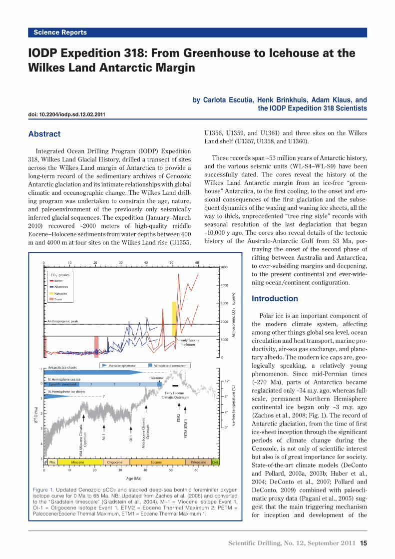
Figure 1. Updated Cenozoic pCO2 and stacked deep-sea benthic foraminifer oxygen
isotope curve for 0 Ma to 65 Ma. NB: Updated from Zachos et al. (2008) and converted
to the “Gradstein timescale” (Gradstein et al., 2004). Mi-1 = Miocene isotope Event 1,
Oi-1 = Oligocene isotope Event 1, ETM2 = Eocene Thermal Maximum 2, PETM =
Paleocene/Eocene Thermal Maximum, ETM1 = Eocene Thermal Maximum 1.
-1
0
1
2
3
4
5
0 10 20 30 40 50 60
Miocene OligocenePlio.Plt.
4°
0°
8°
12°
Ice-
free
tem
pera
ture
(°C
)
Full-scale and permanentPartial or ephemeral
PETM
(ETM
1)
Atm
osph
eric
CO
2 (p
pmv)
4000
0
1000
2000
3000
5000
Age (Ma)
CO 2 proxies
Boron
Alkenones
0 10 20 30 40 50 60
Anthropogenic peak
early Eoceneminimum
PaleoceneEocene
Early EoceneClimatic Optimum
Nahcolite
Trona
Cret.
ETM
2
Antarctic ice sheets
N. Hemisphere ice sheets?
N. Hemisphere sea ice??Episodic perennial
Seasonal
?
Mid
-Mio
cene
Clim
atic
O
ptim
um
Mid
-Eoc
ene
Clim
atic
O
ptim
um
δ18O
(‰)
Oi-1M
i-1
16 Scientific Drilling, No. 12, September 2011
������������
estimates have not been experienced since before the ice
sheets in Antarctica formed.
Since their inception, the Antarctic ice sheets appear to
have been very dynamic, waxing and waning in response to
global climate change over intermediate and even short
(orbital) timescales (Wise et al., 1991; Zachos et al., 1997;
Pollard and DeConto, 2009). However, not much is known
about the nature, cause, timing, and rate of processes invol-
ved. Of the two main ice sheets, the West Antarctic Ice Sheet
(WAIS) is mainly marine based and is considered less stable
(Florindo and Siegert, 2009). The East Antarctic Ice Sheet
(EAIS), which overlies continental terrains that are largely
above sea level, is considered stable and is believed to
respond only slowly to changes in climate (Florindo and
Antarctic ice sheet was the decreasing levels of CO2 (and
other greenhouse gases) concentrations in the atmosphere
(DeConto and Pollard, 2003a, 2003b; Figs 1, 2). The opening
of critical Southern Ocean gateways played only a second-
ary role (Kennett, 1977; DeConto and Pollard, 2003a; Huber
et al., 2004). With current rising atmospheric greenhouse
gases resulting in rapidly increasing global temperatures
(Intergovernmental Panel on Climate Change [IPCC], 2007;
www.ipcc.ch/), studies of polar climates are prominent on
the research agenda. Understanding Antarctic ice-sheet
dynamics and stability is of special relevance because, based
on IPCC (2007) forecasts, atmospheric CO2 doubling and a
1.8°C–4.2°C temperature rise is expected by the end of this
century. The lower values of these estimates have not been
experienced on our planet since 10–15 Ma, and the higher
Ice-
shee
t thi
ckne
ss (
m)
4000
3500
3000
2500
2000
1500
1000
500
0
Δ Sea level (m)
0 20 40 60
Δ δ18 O0.0 0.2 0.4 0.6
Ice volume (106 km 3)
0 10 20
Tim
e (1
06
mod
ely)
2
4
6
8
10 2.0
2.2
2.4
2.6
3.0
3.2
3.4
3.6
2.8
CO
2 (P
AL)
60°S
70°
80°
PB
WL
LG
0E
0E
0E
0E
Figure 3. Combined IODP Expedition 318 transit and drill sites.
Figure 2. Simulated initiation of East
Antarctic glaciation in the earliest
Oligocene using a coupled general
circulation model (GCM) ice-sheet
model (from DeConto and Pollard,
2003a). These results are principally
fo rced by gradual lower ing of
atmospheric levels of CO2 in the
simulated atmosphere. Note that the
glaciation takes place in a “two-step”
fashion reminiscent of the two-step
�18O increase recorded in benthic
foraminiferal carbonates across the
Eocene–Oligocene transition (Coxall
et al., 2005). The first step results in
glaciation in the Antarctic continental
interior, discharging mainly through
t h e L a m b e r t G ra b e n ( LG) t o
Prydz Bay (PB). The second step
results in the initial connection and
subsequent rapid expansion of the
ice sheet, reaching sea level in the
Wilkes Land (WL) at a later stage.
PAL = Preindustrial Atmospheric
Level.
Scientific Drilling, No. 12, September 2011 17
-10123450
10
20
30
40
50
60
Mio
cene
Olig
ocen
ePl
io.
Plt.
δ18O (‰)
U13
59
4°0° 8° 12°
Ice-free temperature (°C)
Full-scale and permanent
Partial or ephemeral
PETM (ETM1)
Age
(Ma)
Pale
ocen
eEo
cene
Early
Eoc
ene
Clim
atic
Opt
imum
Cre
t.
ETM2
Ant
arct
ic ic
e sh
eets
N. H
emis
pher
e ic
e sh
eets
?N
. Hem
isph
ere
sea
ice
?
?
Epis
odic
per
enni
al
?
Mid-Miocene Climatic Optimum
U13
55
U13
57
U13
60
U13
58
U13
56
U13
61
Shelf sites Rise sites
Seas
onal
WL-U8?
Iceh
ouse
Gre
enho
use
WL-U5
WL-U4
WL-U3
51.06 Ma
51.90 Ma
Clay/Silt
Sand
Diatom ooze
Nannofossil ooze
Sandy mud
Limestone
Lithology
RiseSite
U1356
RiseSite
U1359
RiseSite
U1361
ShelfSite
U1358
ShelfSite
U1360
Clast-richsandy diamict
Clast-poorsandy diamict
Timescale
25
30
35
40
45
50
55
Age
(Ma)
0
5
10
15
20
Eoce
neO
ligoc
ene
Pale
o-ce
neM
ioce
ne
Plio-cene
cene
Holocene
C18
C17
C16
C15
C13
C12
C11
C10
C9
C8
C7A
C7
C6C
C6B
C6AA
C6A
C26
C25
C24
C23
C22
C21
C20
C19
C5E
C5D
C5C
C5B
C5A D
C5A C
C5ABC5AAC5A
C5
C4A
C4
C3B
C3A
C3
C2A
C2
C1 C1n
C3n
C2An
C3An
C4n/C4An
C5n
C5r.2n
C5An
C5An
C3An
C2An
C3n
C1n
C2n
C5n
1000
975
950
925
900
875
850
825
800
775
750
725
700
675
650
625
600
575
550
525
500
475
450
425
400
375
350
325
300
275
250
225
200
175
150
125
100
75
50
250
Dep
th (m
bsf)
C24n
C12n
C9n
C8n
C7An
C5Dn
C5Cn
C5AAn
C5ABnC5ACnC5ADn
C23n.2n
C11n.1n
C10n
C5Bn.2n
600
575
550
525
500
475
450
425
400
375
350
325
300
275
250
225
200
175
150
125
100
75
50
250
375
350
325
300
275
250
225
200
175
150
125
100
75
50
250
250
Insufficient paleomagnetic data
C5AB
C5AA
C5A
C5
C4A
C4
C3B
C3A
C3
C2A
C2
C1
0
5
10
Mio
cene
Plio
-ce
nePl
eist
o-ce
ne
Holo-cene
1
2
3
7
8
9
6
4
13
11
12
h
h
Pleist.
Plio.
C12r
C23n.2n
50
250
Pleist.
C12r
14.3 m
h
h
U5
U3
Timescale
A
B
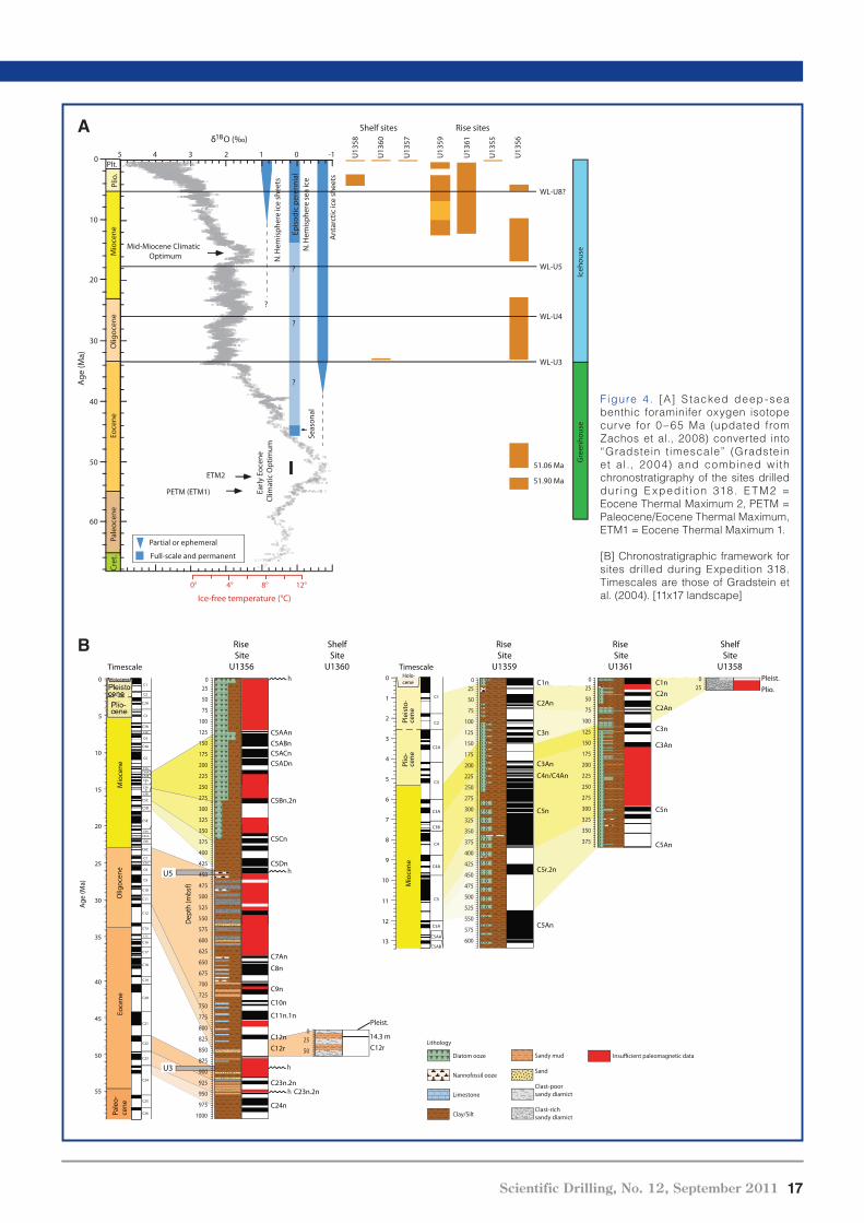
Figure 4. [A] S tacked deep-sea
benthic foraminifer oxygen isotope
curve for 0–65 Ma (updated from
Zachos et al., 2008) converted into
“Gradstein timescale” (Gradstein
et al., 2004) and combined with
chronostratigraphy of the sites drilled
dur ing E xpedi t ion 318. E TM2 =
Eocene Thermal Maximum 2, PETM =
Paleocene/Eocene Thermal Maximum,
ETM1 = Eocene Thermal Maximum 1.
[B] Chronostratigraphic framework for
sites drilled during Expedition 318.
Timescales are those of Gradstein et
al. (2004). [11x17 landscape]

18 Scientific Drilling, No. 12, September 2011
������������
Wilkes Land margin also includes sites with ultrahigh accu-
mulation rates of sediments that document the Holocene
deglaciation and subsequent climate and sedimentological
variability extending over the past 10,000 y. In general, our
strategy was to core and analyze sedimentary records along
the inshore-offshore transect to constrain the age, nature,
and environments of deposition, until now only inferred from
seismic surveys of the Wilkes Land continental shelf, rise,
and abyssal plain (Escutia et al., 1997; De Santis et al., 2003;
Escutia et al., 2005).
The Expedition
IODP Expedition 318 (January–March 2010; Wellington,
New Zealand, to Hobart, Australia), occupied seven sites
(Fig. 3) across the Wilkes Land Margin at water depths be-
tween ~400 mbsl and 4000 mbsl. Together, we retrieved
~2000 meters of high-quality upper Eocene–Quaternary
sedimentary cores (Fig. 4a, b). Sites U1355, U1356, U1359,
and U1361 are on the Wilkes Land rise, and Sites U1358,
U1360, and U1357 are on the Wilkes Land shelf. The cores
span ~53 m.y. of Antarctic history, revealing the history of
the Wilkes Land Antarctic margin from an ice-free “green-
house Antarctica,” to the first cooling, to the onset and ero-
sional consequences of the first glaciation and the subse-
quent dynamics of the waxing and waning ice sheets (Fig. 4).
Furthermore, we also were able to capture the record of the
last deglaciation in terms of thick, unprecedented “tree ring
style” records with annual to seasonal resolution taken in the
Adélie depression (U1357) (Fig. 5).
Initial studies now
also reveal details of the
tectonic history of the
Australo-Antarctic Gulf
(at 53 Ma), the onset of
the second phase of
rifting between Australia
and Antarctica (Colwell
et al., 2006; Close et
al., 2009), ever-subsiding
margins and deepen-
ing, to the present
ocean/continent configu-
ration. Tectonic and cli-
matic change turned the
initially shallow, broad
subtropical Antarctic
Wilkes Land offshore
shelf into a deeply
subsided basin with
a narrow ice-infested
margin (Fig. 6).
Siegert, 2009). However, reports of beach gravel deposited
20 m above sea level in Bermuda and the Bahamas from
420 ka to 360 ka indicate the collapse of not only the WAIS
(6 m of sea-level equivalent, SLE) and Greenland ice sheet
(6 m of SLE), but possibly also 8 m of SLE from East Antarctic
ice sources (Hearty et al., 1999). Therefore, during episodes
of global warmth, with likely elevated atmospheric CO2 con-
ditions, the EAIS may contribute just as much or more to
rising global sea level as the Greenland ice sheet. In the face
of rising CO2 levels (Pachauri, R.K., and Reisinger, A., 2007),
a better understanding of the EAIS dynamics is therefore
urgently needed from both an academic as well as a societal
point of view.
A key region for analysis of the long- and short-term beha-
vior of the EAIS is the eastern sector of the Wilkes Land mar-
gin, located at the seaward termination of the largest East
Antarctic subglacial basin, the Wilkes subglacial basin. The
base of the portion of the EAIS draining through the Wilkes
subglacial basin is largely below sea level, suggesting that
this portion of the EAIS can potentially be less stable than
other areas of the EAIS (Escutia et al., 2005). Numerical
models of ice-sheet behavior (Huybrechts, 1993; DeConto
and Pollard, 2003a, 2003b; DeConto et al., 2007; Pollard and
DeConto, 2009) provide a basic understanding of the cli-
matic sensitivity of particular Antarctic regions for early
ice-sheet formation, connection and expansion, and eventual
development of the entire ice sheet. For example, in these
models glaciation is shown to have begun in the East
Antarctic interior, discharging mainly through the Lambert
Graben to Prydz Bay. These models imply that the EAIS did
not reach the Wilkes Land margin until a later stage. These
models can only be validated through drilling and obtaining
direct evidence from the sedimentary record.
Scientific Objectives
The overall objectives of Expedition 318 were to date the
identified seismic units and to obtain long-term records of
Antarctic glaciation to better understand its relationships
with global paleoclimate and paleoceanographic changes.
Of particular interest is testing the sensitivity of the EAIS
to episodes of global warming and detailed analysis of criti-
cal periods in Earth’s climate history, such as the
Eocene–Oligocene and Oligocene–Miocene glaciations, late
Miocene, Pliocene, and the last deglaciation. During these
times, the Antarctic cryosphere evolved in a step-wise fashion
to ultimately assume its present-day configuration, charac-
terized by a relatively stable EAIS. Conceivably even more
important than the history of the Antarctic glaciations are
past lessons of deglaciations and periods of exceptional
warmth. We therefore planned to core several sequences
from the Pleistocene and Pliocene that formed during inter-
glacial intervals of exceptional warmth, periods that may pro-
vide valuable information about Antarctica’s response to
warming predicted in the centuries ahead. Furthermore,
seismic reflection and shallow coring data indicate that the
Figure 5.Example of a core section
from Holocene diatomaceous ooze,
Site U1357. Note the distinct seasonal
laminations.
cm
125
115
120
110
Scientific Drilling, No. 12, September 2011 19
activity related to the commencement of rapid seafloor
spreading in the Australia-Antarctic Basin (AAB), reported
to initiate around the same time (~50 Ma; Colwell et al.,
2006). Also, combined Site U1356 and ODP Leg 189 dinocyst
distribution patterns suggest earliest through-flow of South
Pacific Antarctic waters through the Tasmanian Gateway to
be coeval with this tectonic phase. Sedimentological and
microfossil information from this interval from Hole U1356A
also suggest some deepening during the early middle
Eocene.
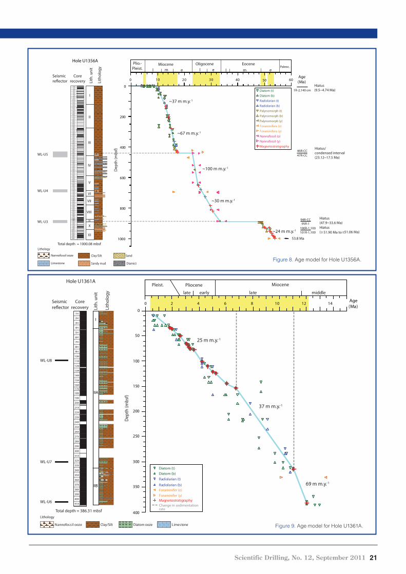
At Site U1356, the upper middle Eocene to the basal
Oligocene is conspicuously missing in a ~19-m.y. hiatus at
~890 bsf (~47.9–33.6 Ma) marking unconformity WL-U3
based on dinocyst and paleomagnetic evidence. Despite
ongoing tectonic reorganizations, it appears likely that the
erosive nature of unconformity WL-U3 is notably related to
the early stages of EAIS formation. The impact of ice-sheet
growth, including crustal and sea-level response, and major
erosion by the ice sheets, is proposed as the principal mecha-
nism that formed unconformity WL-U3. This is supported by
the abrupt increase in benthic foraminiferal �18O values and
coeval sea-level change globally recorded
in complete marine successions (Oligocene
isotope event Oi-1; Miller et al., 1985; Coxall
et al., 2005). Progressive subsidence—the
large accommodation space created by ero-
sion in the margin (300–600 m of missing
strata; Eittreim et al., 1995)—and partial
eustatic recovery allowed sediments of
early Oligocene age to accumulate above
unconformity WL-U3.
Microfossils, sedimentology, and geo-
chemistry of the Oligocene sediments
from Site U1356, at present occupying a
distal setting (i.e., lowermost rise-abyssal
plain) and immediately above unconfor-
mity WL-U3, unequivocally reflect ice-
house environments with evidence of ice-
berg activity (dropstones) and at least
seasonal sea-ice cover. The sediments,
dominated by hemipelagic sedimentation
with bottom current and gravity flow
influence, as well as biota, indicate deeper
water settings relative to the underlying
middle Eocene environments. These find-
ings imply significant crustal stretching,
subsidence of the margin, and deepening of
the Tasman Rise and the Adélie Rift Block
(ARB) between 47.9 Ma and 33.6 Ma
(Fig. 6).
Record of EAIS Variability
Drilling at continental rise Site U1356
also recovered a thick section of Oligocene
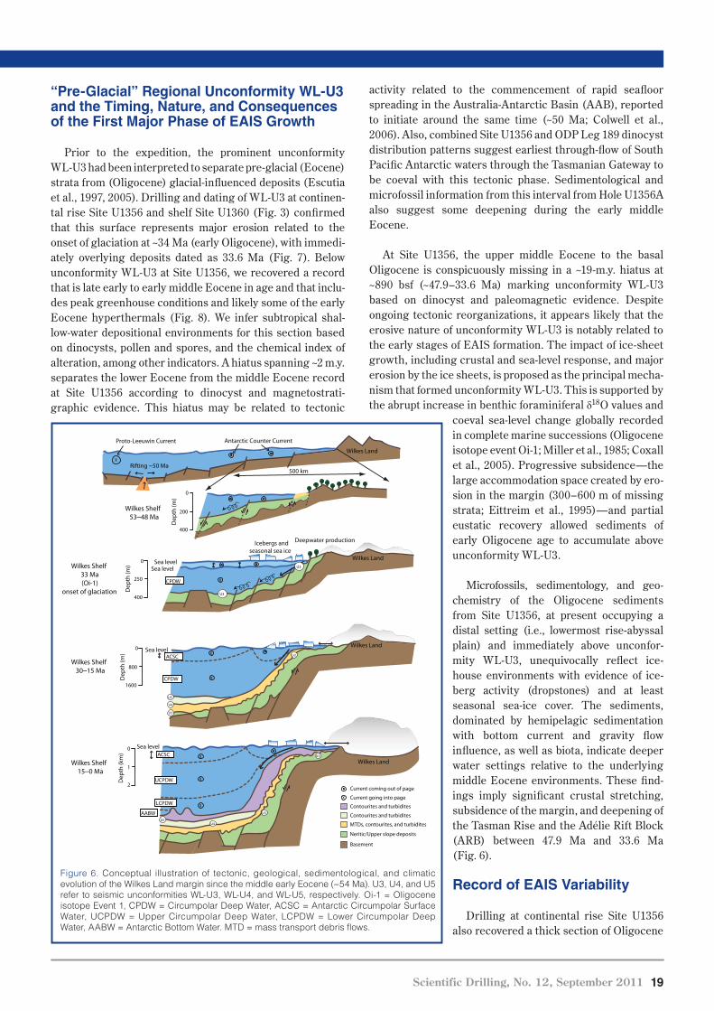
“Pre-Glacial” Regional Unconformity WL-U3 and the Timing, Nature, and Consequences of the First Major Phase of EAIS Growth
Prior to the expedition, the prominent unconformity
WL-U3 had been interpreted to separate pre-glacial (Eocene)
strata from (Oligocene) glacial-influenced deposits (Escutia
et al., 1997, 2005). Drilling and dating of WL-U3 at continen-
tal rise Site U1356 and shelf Site U1360 (Fig. 3) confirmed
that this surface represents major erosion related to the
onset of glaciation at ~34 Ma (early Oligocene), with immedi-
ately overlying deposits dated as 33.6 Ma (Fig. 7). Below
unconformity WL-U3 at Site U1356, we recovered a record
that is late early to early middle Eocene in age and that inclu-
des peak greenhouse conditions and likely some of the early
Eocene hyperthermals (Fig. 8). We infer subtropical shal-
low-water depositional environments for this section based
on dinocysts, pollen and spores, and the chemical index of
alteration, among other indicators. A hiatus spanning ~2 m.y.
separates the lower Eocene from the middle Eocene record
at Site U1356 according to dinocyst and magnetostrati-
graphic evidence. This hiatus may be related to tectonic
Figure 6. Conceptual illustration of tectonic, geological, sedimentological, and climatic
evolution of the Wilkes Land margin since the middle early Eocene (~54 Ma). U3, U4, and U5
refer to seismic unconformities WL-U3, WL-U4, and WL-U5, respectively. Oi-1 = Oligocene
isotope Event 1, CPDW = Circumpolar Deep Water, ACSC = Antarctic Circumpolar Surface
Water, UCPDW = Upper Circumpolar Deep Water, LCPDW = Lower Circumpolar Deep
Water, AABW = Antarctic Bottom Water. MTD = mass transport debris flows.
500 km
Antarctic Counter CurrentProto-Leeuwin Current
Wilkes Shelf53–48 Ma
0
200
400
Wilkes Shelf15–0 Ma
0
800
1600
Rifting ~50 MaX
0
250
400
Icebergs andseasonal sea ice
Sea levelSea level
Wilkes Shelf33 Ma(Oi-1)
onset of glaciation
Wilkes Shelf30–15 Ma
0
1
2
U3
U3
U4
U3
U4U5
U3
U3
U5
ACSC
X
X
X
X
CPDW
Sea level
Sea level
X
AABW
UCPDW
X
X
Current coming out of page
Current going into page
Wilkes Land
U3
Deepwater production
Wilkes
Contourites and turbidites
Contourites and turbidites
MTDs, contourites, and turbidites
Neritic/Upper slope deposits
Basement
Wilkes Land
Wilkes Land
Wilkes Land
LCPDW
ACSC
CPDW
Dep
th (m
)D
epth
(m)
Dep
th (m
)
Dep
th (k
m)
20 Scientific Drilling, No. 12, September 2011
������������
Ocean open cold-water taxa, with variable abundances of
sea-ice-associated diatoms were recovered, indicating a
high-nutrient, high-productivity sea-ice-influenced setting
throughout the Neogene. Combined sedimentological and
microfossil information indicates the ever-increasing
influence of typical Antarctic Counter Current surface
waters and intensifying AABW flow. Furthermore, the
preservation of calcareous microfossils in several intervals
indicates times when bottom waters were favorable to the
preservation of calcium carbonate. These observations point
to a very dynamic ice-sheet/sea-ice regime during the late
Miocene through the Pleistocene. Detailed postcruise
studies in sediments from the late Neogene will provide a
history of glacial-interglacial climate and paleoceano-
graphic variability, including a history of AABW produc-
tion that can be linked to sea-ice variations in this margin.
Ultrahigh Resolution Holocene Record of Climate Variability
Coring at Site U1357 yielded a 186-m section of contin-
uously laminated diatom ooze as well as a portion of the
underlying Last Glacial Maximum diamict. Based on much
shorter piston cores recovered from adjacent basins and
banks, the onset of marine sedimentation during the degla-
cial interval began between 10,400 y and 11,000 y ago. The
site was triple cored, providing overlapping sequences that
will aid in the construction of a composite stratigraphy span-
ning at least the last 10,000 y. The Site U1357 sediments are
unusual for Antarctic shelf deposits because of their high
accumulation rate (2 cm y -1), lack of bioturbation, and excel-
lent preservation of organic matter as well as calcareous,
opaline, phosphatic, and organic fossils. The sediments are
profoundly anoxic, with levels of H2S as high as 42,000 ppm
at 20 mbsf. Larger burrowing organisms are completely
to upper Miocene sediments (Figs. 4, 8) indicative of a rela-
tively deep-water, sea-ice-influenced setting. Oligocene to
upper Miocene sediments are indicative of episodically redu-
ced oxygen conditions either at the seafloor or within the
upper sediments prior to ~17 Ma. From the late early Miocene
(~17 Ma) onward, progressive deepening and possible inten-
sification of deep-water flow and circulation led to a transi-
tion from a poorly oxygenated low-silica system (present
from the early to early middle Eocene to late early Miocene)
to a well-ventilated silica-enriched system akin to the modern
Southern Ocean. This change coincides with one of the
major regional unconformities in the Wilkes Land margin,
unconformity WL-U5, which represents a ~3 m.y. latest
Oligocene–early Miocene hiatus (Figs. 4, 8). This unconfor-
mity marks a change in the dominant sedimentary proces-
ses at this site, which are dominated by mass transport pro-
cesses below the unconformity and by hemipelagic, turbidity
flow, and bottom-current deposition above.
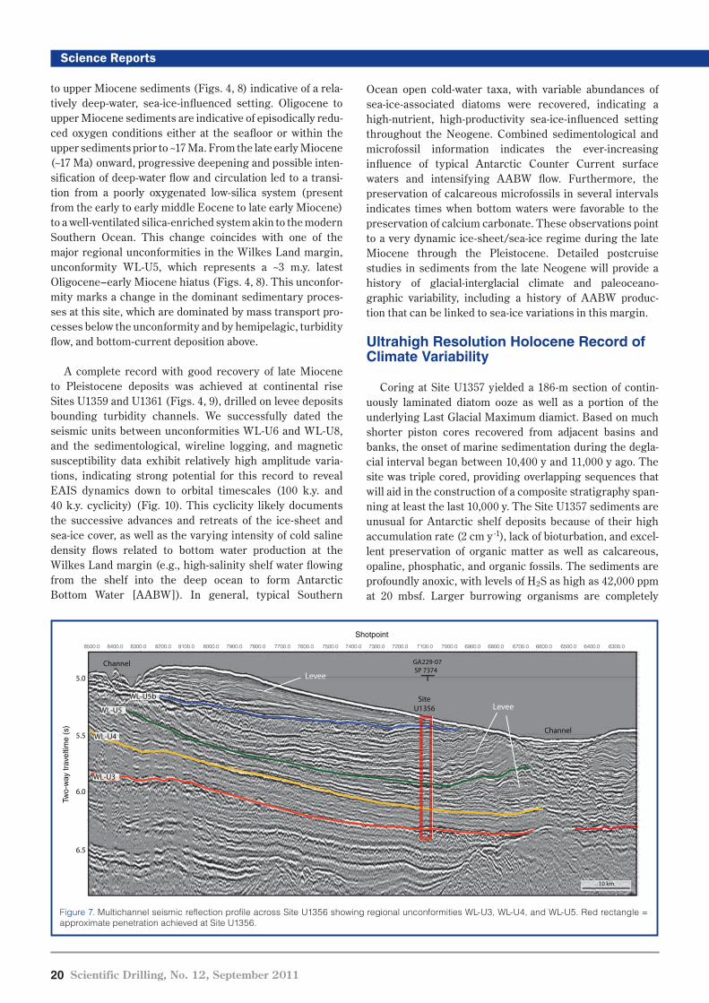
A complete record with good recovery of late Miocene
to Pleistocene deposits was achieved at continental rise
Sites U1359 and U1361 (Figs. 4, 9), drilled on levee deposits
bounding turbidity channels. We successfully dated the
seismic units between unconformities WL-U6 and WL-U8,
and the sedimentological, wireline logging, and magnetic
susceptibility data exhibit relatively high amplitude varia-
tions, indicating strong potential for this record to reveal
EAIS dynamics down to orbital timescales (100 k.y. and
40 k.y. cyclicity) (Fig. 10). This cyclicity likely documents
the successive advances and retreats of the ice-sheet and
sea-ice cover, as well as the varying intensity of cold saline
density flows related to bottom water production at the
Wilkes Land margin (e.g., high-salinity shelf water flowing
from the shelf into the deep ocean to form Antarctic
Bottom Water [AABW]). In general, typical Southern
Figure 7. Multichannel seismic reflection profile across Site U1356 showing regional unconformities WL-U3, WL-U4, and WL-U5. Red rectangle =
approximate penetration achieved at Site U1356.
WL-U3
WL-U4
WL-U5
WL-U5b
5.0
5.5
6.0
6.5
SiteU1356
GA229-07 SP 7374
10 km
Levee
Levee
Channel
Channel
Two-
way
trav
eltim
e (s
)
Shotpoint8500.0 8400.0 8300.0 8200.0 8100.0 8000.0 7900.0 7800.0 7700.0 7600.0 7500.0 7400.0 7300.0 7200.0 7100.0 7000.0 6900.0 6800.0 6700.0 6600.0 6500.0 6400.0 6300.0
Scientific Drilling, No. 12, September 2011 21
MiocenePliocene
elddimetalearly
Pleist.
late
25 m m.y.-1
69 m m.y.-1
37 m m.y.-1
Age(Ma)Li
thol
ogy
Hole U1361A
Dep
th (m
bsf)
1H
2H
3H
4H
5H
6H
7H
8H
9H
10H
11H
12H
13H
14H
15H
16H17X
18X
19X
20X
21X
22X
23X
24X
25X
26X
27X
28X
29X
30X
31X
32X
33X
34X
35X
36X
37X
38X
39X
40X
41X
0
50
100
150
200
250
300
350
400
0 2 4 6 8 10 12 14
Lith
. uni
t
I
IIA
IIB
Total depth = 386.31 mbsf
WL-U8
WL-U7
Seismicreflector
WL-U6
Corerecovery
Diatom (t)Diatom (b)
Radiolarian (t)
Radiolarian (b)
Magnetostratigraphy
Foraminifer (o)
Foraminifer (y)
Clay/Silt enotsemiL ezoo lissofonnaN
Lithology
Diatom ooze
Change in sedimentationrate
Figure 9. Age model for Hole U1361A.
0
200
400
600
800
1000
020 30 40 60
Hiatus(9.5–4.74 Ma)
Hiatus/condensed interval(23.12–17.5 Ma)
47R-CC46R-CC
1R-2,140 cm
Hiatus(47.9–33.6 Ma)95R-1
94R-CC
Hiatus(≥ 51.90 Ma to ≤51.06 Ma)101R-1,100
100R-1,100
~37 m m.y.-1
~67 m m.y.-1
~30 m m.y.-1
~24 m m.y.-1
Miocene Oligocene Eocenel m e l m e
Plio.-Pleist. Paleoc.
l e
53.8 Ma
~100 m m.y.-1
Hole U1356A
Age(Ma)
Diatom (t)
Diatom (b)
Radiolarian (t)
Radiolarian (b)
Palynomorph (t)
Palynomorph (b)
Magnetostratigraphy
Foraminifera (o)
Foraminifera (y)
Nannofossil (o)
Nannofossil (y)
0301
Palynomorph (y)
50
Dep
th (m
bsf)
Corerecovery
1R2R3R4R5R6R7R8R9R
10R11R12R13R14R15R16R17R18R19R20R21R22R23R24R25R26R27R28R29R30R31R32R33R34R35R36R37R38R39R40R41R42R43R44R45R46R47R48R49R50R51R52R53R54R55R56R57R58R59R60R61R62R63R64R65R66R67R68R69R70R71R72R73R74R75R76R77R78R79R80R81R82R83R84R85R86R87R88R89R90R91R92R93R94R95R96R97R98R99R
100R101R102R103R104R105R106R
Total depth = 1000.08 mbsf
I
VI
V
IV
III
II
VII
VIII
IX
X
WL-U5
WL-U4
WL-U3
Lith
. uni
t
Seismicreflector
XI
Lith
olog
y
Clay/Silt SandNannofossil ooze
Sandy mud DiamictLimestone
Lithology
Figure 8. Age model for Hole U1356A.
22 Scientific Drilling, No. 12, September 2011
������������
The IODP Expedition 318 Scientists
C. Escutia (Chief Scientist), H. Brinkhuis (Chief Scientist),
A. Klaus (Staff Scientist), J.A.P. Bendle, P.K. Bijl, S.M.
Bohaty, S.A. Carr, R.B. Dunbar, J.J. Gonzàlez, A. Fehr, T.G.
Hayden, M. Iwai, F.J. Jimemez-Espejo, K. Katsuki, G.S.
Kong, R.M. McKay, M. Nakai, M.P. Olney, S. Passchier, S.F.
Pekar, J. Pross, C. Riesselman, U. Röhl, T. Sakai, P.K.
Shrivastava, C.E. Stickley, S. Sugisaki, L. Tauxe, S. Tuo, T.
van de Flierdt, K. Welsh, T. Williams, M. Yamane .
References
Close, D.I., Watts, A.B., and Stagg, H.M.J., 2009. A marine geophysi-
cal study of the Wilkes Land rifted continental margin,
Antarctica. Geophys. J. Int., 177(2):430–450, doi:10.1111/j.
1365-246X.2008.04066.x.
Colwell, J.B., Stagg, H.M.J., Direen, N.G., Bernander, G., and
Borisova, I., 2006. The structure of the continental margin
off Wilkes Land and Terre Adelie Coast, East Antarctica. In
Futterer, D.K., Damaske, D., Kleinschmidt, G., Miller, H.,
and Tessensohn, F. (Eds.), Antarctica: Contributions to
Global Earth Sciences, Berlin (Springer-Verlag), 327–340.
excluded from this ecosystem, yet the regu-
lar occurrence of benthic foraminifers sug-
gests that some oxygen is present at the
sediment-water interface. These sediments
provide an excellent sample set for geomicro-
biology and sedimentary geochemistry stu-
dies. In fact, the upper 20 m of one of the
three holes was intensively sampled for inte-
grated pore water and microbiological stu-
dies.
A paramount achievement from a paleocli-
matic standpoint was the retrieval of this
continuously laminated deposit (Fig. 5). Spot
checks of laminae from top to bottom
of the split Hole U1357A sections suggest
that paired light-dark laminae sets range in
thickness from ~1 cm to 3 cm. Based on
radiocarbon dating of a piston core taken ear-
lier from this site (Costa et al., 2007), our
own preliminary secular paleomagnetic find-
ings, and the thickness of the deposit combi-
ned with the expected age at its base, it is
very likely each laminae pair represents
one year. If supported by our shore-based
research, this will be the first varved sedi-
mentary sequence extending through the
Holocene recovered from the Southern
Ocean. Analysis at the annual timescale will
permit us to examine decadal to subdecadal
variability in sea ice, temperature, and wind
linked to the Southern Annual Mode (SAM),
Pacific Decadal Variability, and possibly
ENSO. We will also be able to address ques-
tions regarding rates of change during the
Hypsithermal Holocene neoglacial events and the time
immediately following the first lift-off and pull-back of ice at
the end of the last glacial interval. In addition, we now have
an excellent opportunity for ultrahigh resolution correlation
to the nearby Law Dome Ice Core, one of the most important
Holocene ice cores in Antarctica.
Acknowledgements
We thank the captain and crew of the JOIDES Resolution,
the IODP 318 operation superintendent, ice pilot, weather-
man, all technicians, and videographer who were instrumen-
tal in the success of Expedition 318. They allowed and as-
sisted us in drilling, documenting, sampling, and onboard
sample analyses during Expedition 318. Numerous people at
IODP-TAMU as well as USIO provided their dedicated effort
supporting us, including preparation of the expedition and
publication of the proceedings. The USIO curatorial team
provided us with their able support during the sampling
party at College Station. We also thank the co-PIs of the
Proposal 482 and APL 638 and the master of the R/V
Astrolabe for his support.
Figure 10. Downhole geophysical logs, Hole U1361A. HSGR = total spectral gamma ray,
MAD = moisture and density, IDPH = deep induction phasor-processed resistivity, IMPH =
medium induction phasor-processed resistivity, PWS-X = x-direction caliper.
Dep
th (m
bsf)
Dep
th (m
bsf)
0
50
100
150
200
250
300
350
400
0
50
100
150
200
250
300
350
400
0.5 1.2(Ωm)
IMPH
0.5 1.2(Ωm)
IDPH
(m s-1)
Pass 1
(m s-1)Lab, PWS-X
1500 2000
1500 2000
Gamma ray (HSGR)0 100(gAPI)
Hole diameter10 30(inch)
Bulk density (MAD)(g cm-3) 1.2 2
Density1.3 2(g cm-3)
Porosity90 30(%) (m s-1)
Pass 21500 2000
Corerecovery
1H
2H
3H
4H
5H
6H
7H
8H
9H
10H
11H
12H
13H
14H
15H
16H17X18X
19X
20X
21X
22X
23X
24X
25X
26X
27X
28X
29X
30X
31X
32X33X
34X
35X
36X
37X
38X
39X
40X
41X
Resistivity
Velocity

Scientific Drilling, No. 12, September 2011 23
Costa, E., Dunbar, R.B., Kryc, K.A., Mucciarone, D.A., Brachfeld, S.,
Roark, E.B., Manley, P.L., Murray, R.W., and Leventer, A.,
2007. Solar forcing and El Niño-Southern Oscillation
(ENSO) influences on productivity cycles interpreted from
a late Holocene high-resolution marine sediment record,
Adélie Drift, East Antarctic margin. In Cooper, A.K., and
Raymond, C.R., and the ISAES Editorial Team. (Eds.),
Antarctica: A Keystone in a Changing World - Proceedings for
the Tenth International Symposium on Antarctic Earth
Sciences. USGS Open File Rep., 2007–1047. Washington, DC
(The National Academies Press), 1–6, doi:10.3133/of2007-
1047.srp036.
Coxall, H.K., Wilson, P.A., Pälike, H., Lear, C.H., and Backman, J.,
2005. Rapid stepwise onset of Antarctic glaciation and
deeper calcite compensation in the Pacific Ocean. Nature,
433(7021):53–57, doi:10.1038/nature03135.
DeConto, R.M., and Pollard, D., 2003a. A coupled climate–ice sheet
modeling approach to the early Cenozoic history of the
Antarctic ice sheet. Palaeogeogr., Palaeoclimatol.,
Palaeoecol., 198(1–2):39–52, doi:10.1016/S0031-0182(03)
00393-6.
DeConto, R.M., and Pollard, D., 2003b. Rapid Cenozoic glaciation of
Antarctica induced by declining atmospheric CO2. Nature,
421(6920):245–249, doi:10.1038/nature01290.
DeConto, R., Pollard, D., and Harwood, D., 2007. Sea ice feedback and
Cenozoic evolution of Antarctic climate and ice sheets.
Palaeoceanography, 22(3):PA3214, doi:10.1029/2006PA
001350.
De Santis, L., Brancolini, G., and Donda, F., 2003. Seismo-
stratigraphic analysis of the Wilkes Land Continental
Margin (East Antarctica): influence of glacially driven proc-
esses on the Cenozoic deposition. Deep Sea Res. Part II,
50(8–9):1563–1594, doi:10.1016/S0967-0645(03)00079-1.
Eittreim, S.L., Cooper, A.K., and Wannesson, J., 1995. Seismic strati-
graphic evidence of ice-sheet advances on the Wilkes Land
margin of Antarctica. Sediment. Geol., 96(1–2):131–156,
doi:10.1016/0037-0738(94)00130-M.
Escutia, C., De Santis, L., Donda, F., Dunbar, R.B., Cooper, A.K.,
Brancolini, G., and Eittreim, S.L., 2005. Cenozoic ice sheet
history from East Antarctic Wilkes Land continental mar-
gin sediments. Global Planet. Change, 45(1–3):51–81,
doi:10.1016/j.gloplacha.2004.09.010.
Escutia, C., Eittreim, S.L., and Cooper, A.K., 1997. Cenozoic sedimen-
tation on the Wilkes Land continental rise, Antarctica. In
Ricci, C.A. (Ed.), The Antarctic Region: Geological Evolution
and Processes. Proc. Int. Symp. Antarct. Earth Sci.,
7:791–795.
Florindo, F., and Siegert, M., 2009. Antarctic Climate Evolution.
Developments in Earth and Environmental Sciences, Vol. 8:
Amsterdam, The Netherlands (Elsevier).
Gradstein, F.M., Ogg, J.G., and Smith, A., 2004. A Geologic Time Scale
2004: Cambridge (Cambridge University Press).
Hearty, P.J., Kindler, P., Cheng, H., and Edwards, R.L., 1999. A +20 m
middle Pleistocene sea-level highstand (Bermuda and
the Bahamas) due to partial collapse of Antarctic ice.
Geology, 27(4):375–378, doi:10.1130/0091-7613(1999)027
<0375:MMPSL>2.3.CO;2.
Huber, M., Brinkhuis, H., Stickley, C.E., Döös, K., Sluijs, A., Warnaar,
J., Schellenberg, S.A., and Williams, G.L., 2004. Eocene cir-
culation of the Southern Ocean: was Antarctica kept warm
by subtropical waters? Paleoceanography, 19(4):PA4026,
doi:10.1029/2004PA001014.
Huybrechts, P., 1993. Glaciological modelling of the Late Cenozoic
East Antarctic Ice Sheet: stability or dynamism? Geograf.
Ann., 75(4):221–238m, doi:10.2307/521202.
Intergovernmental Panel on Climate Change (IPCC), The AR4
Synthesis Report 2007: http://www.ipcc.ch/
Kennett, J.P., 1977. Cenozoic evolution of Antarctic glaciation, the
circum-Antarctic Ocean, and their impact on global pale-
oceanography. J. Geophys. Res., 82(27):3843–3860,
doi:10.1029/JC082i027p03843.
Miller, K.G., Aubry, M.-P., Kahn, M.J., Melillo, A.J., Kent, D.V., and
Berggren, W.A., 1985. Oligocene–Miocene biostratigraphy,
magnetostratigraphy, and isotopic stratigraphy of the west-
ern North Atlantic. Geology, 13(4):257–261, doi:10.1130/009
17613(1985)13<257:OBMAIS>2.0.CO;2.
Pagani, M., Zachos, J.C., Freeman, K.H., Tipple, B., and Bohaty, S.,
2005. Marked decline in atmospheric carbon dioxide con-
centrations during the Paleogene. Science, 309(5734):600–
603, doi:10.1126/science.1110063.
Pollard, D., and DeConto, R.M., 2009. Modelling West Antarctic ice
sheet growth and collapse through the past five million
years. Nature, 458(7236):329–332, doi:10.1038/
nature07809.
Wise, S.W., Jr., Breza, J.R., Harwood, D.M., and Wei, W., 1991.
Paleogene glacial history of Antarctica. In Müller, D.W.,
McKenzie, J.A., and Weissert, H. (Eds.), Controversies in
Modern Geology: Evolution of Geological Theories in
Sedimentology, Earth History and Tectonics: Cambridge
(Cambridge University Press), 133–171.
Zachos, J.C., Dickens, G.R., and Zeebe, R.E., 2008. An early Cenozoic
perspective on greenhouse warming and carbon-cycle
dynamics. Nature, 451(7176):279–283, doi:10.1038/
nature06588.
Zachos, J.C., Flower, B.P., and Paul, H., 1997. Orbitally paced climate
oscillations across the Oligocene/Miocene boundary.
Nature, 388(6642):567–570, doi:10.1038/41528.
Authors
Carlota Escutia, Instituto Andaluz de Ciencias de la Tierra,
CSIC-Universidad de Granada, Campus de Fuentenueva s/n,
18002 Granada, Spain, e-mail: [email protected].
Henk Brinkhuis, Biomarine Sciences, Institute of
Environmental Biology, Laboratory of Palaeobotany and
Palynology, Utrecht University, Budapestlaan 4, 3584 CD
Utrecht, The Netherlands, e-mail: [email protected].
Adam Klaus, Staff Scientist/Expedition Project Manager,
United States Implementing Organization, Integrated Ocean
Drilling Program, Texas A&M University, 1000 Discovery
Drive, College Station, TX 77845-9547, U.S.A., e-mail:
and the IODP Expedition 318 Scientists
Related Web Link
http://publications.iodp.org/preliminary_report/318/
http://www.stratigraphy.org/